development&application ecologica networks uicn
TRANSCRIPT

8/6/2019 Development&Application Ecologica Networks UICN
http://slidepdf.com/reader/full/developmentapplication-ecologica-networks-uicn 1/137
The Development
and Application of
Ecological Networks
A Review of Proposals, Plans and Programmes
Graham Bennett & Piet Wit
July 2001

8/6/2019 Development&Application Ecologica Networks UICN
http://slidepdf.com/reader/full/developmentapplication-ecologica-networks-uicn 2/137
1
The Development
and Application of
Ecological Networks
A Review of Proposals, Plans and Programmes
Graham Bennett* & Piet Wit*
July 2001
*The authors can be contacted at Syzygy, the Netherlands.

8/6/2019 Development&Application Ecologica Networks UICN
http://slidepdf.com/reader/full/developmentapplication-ecologica-networks-uicn 3/137
CONTENTS
Acknowledgements
Summary
1 Introduction
2 The Ecological Network Model
2.1 The Development of the Model
2.2 The Operational Scope of the Model for the
Purposes of the Inventory
2.3 Scale Issues
3 The Inventory
3.1 Design of the Inventory
3.2 The Ecological Networks Described in the Inventory3.3 Summary Findings
3.3.1 The Status of the Initiatives
3.3.2 The Objectives of the Initiatives
3.3.3 The Ecological and Environmental Context of the Networks
3.3.4 The Socio-Economic Context of the Initiatives
3.3.5 Institutional and Legal Frameworks
3.3.6 Implementation
3.4 Concluding Comments
Appendix 1. The Ecological Networks
1 Global 200 Programme2 Pan-European Ecological Network
3 Bonn Convention: Memorandum of Understanding Concerning
Conservation Measures for the Slender-Billed Curlew
4 Bonn Convention: Memorandum of Understanding Concerning
Conservation Measures for the Siberian Crane
5 Bonn Convention: Agreement on the Conservation of African-
Eurasian Migratory Waterbirds
6 Bonn Convention: Agreement on the Conservation of Bats
in Europe
7 Bonn Convention: Agreement on the Conservation of Cetaceans
of the Black Sea, the Mediterranean and the Contiguous Atlantic
Area
8 Bonn Convention: Agreement on the Conservation of Small
Cetaceans of the Baltic and North Seas
9 Bonn Convention: Agreement on the Conservation of Seals in
the Wadden Sea
10 Western Hemisphere Shorebird Reserve Network
11 Ecological Corridor of the Americas
12 Mesoamerican Biological Corridor
13 East Asian-Australasian Shorebird Site Network
14 Natura 2000
15 European Coastal and Marine Ecological Network
16 Carpathian Ecoregion Initiative17 Transnational Ecological Network
18 Wallonia, Belgium: Ecological Network
19 Rhineland-Palatinate, Germany: Interwoven Biotope System
2 4
5
14
15
15
16
17
18
18
18
20
20
22
23
23
25
27
28
30
3032
33
34
36
37
38
39
40
41
42
43
44
49
51
52
53
56
59

8/6/2019 Development&Application Ecologica Networks UICN
http://slidepdf.com/reader/full/developmentapplication-ecologica-networks-uicn 4/137

8/6/2019 Development&Application Ecologica Networks UICN
http://slidepdf.com/reader/full/developmentapplication-ecologica-networks-uicn 5/137
ACKNOWLEDGEMENTS
This review could not have been prepared without the support of the many groups
who responded to a request for information on their ecological network initiatives.
They did this willingly despite an exceptionally heavy burden of other work.The authors gratefully acknowledge their efforts and trust that they will also benefit
from the results of the exercise.
The study was carried out in cooperation with IUCN – The World Conservation Union,
who made their resources available to the project team. The authors are especially
grateful to Jean-Yves Pirot at IUCN headquarters for his support throughout the
duration of the project.
Funding for the study was kindly provided by the Dutch Ministry of Agriculture,
Nature Management and Fisheries and the Dutch Ministry of Foreign Affairs
(Matra Fund).
The views expressed in the report are those of the authors and do not necessarily
reflect those of the Dutch government or IUCN.
4

8/6/2019 Development&Application Ecologica Networks UICN
http://slidepdf.com/reader/full/developmentapplication-ecologica-networks-uicn 6/137
SUMMARY
This report comprises a worldwide review of 38 ecological network initiatives that are
currently being developed or implemented. It includes an inventory of a wide range
of proposals, plans and ongoing programmes to establish ecological networks atscales varying from the regional to intercontinental, and summary findings on the
main features of the initiatives. The report is intended as a contribution to IUCN's
review of experience in developing and applying ecological networks which was
initiated through a resolution adopted at the 1996 World Conservation Congress.
For the purposes of the study, an ecological network is regarded as a coherent system
of natural and/or semi-natural landscape elements that is configured and managed
with the objective of maintaining or restoring ecological functions as a means to
conserve biodiversity while also providing appropriate opportunities for the
sustainable use of natural resources. Many different names are used to describe this
broad approach, the most common being ecological network, reserve network,
bioregional planning and ecoregion-based conservation. However, all of the modelsare characterised by five key elements, namely:
Ω a focus on conserving biodiversity at the ecosystem, landscape or regional scale
Ω an emphasis on maintaining or strengthening ecological coherence, primarily
through providing for ecological interconnectivity
Ω ensuring that critical areas are buffered from the effects of potentially damaging
external activities
Ω restoring where appropriate degraded ecosystems
Ω promoting complementarity between land uses and biodiversity conservation
objectives, and particularly by exploiting the potential biodiversity value of
associated semi-natural landscapes.
In total, 119 initiatives were originally identified as ecological networks. During
the course of the study, this number rose to over 150. Detailed information was
subsequently collated on 38 of these networks: 17 international networks, 10 national
in scope and 11 sub-national. In terms of geographical distribution, eight of the
networks are intercontinental initiatives, 25 are located in Europe, two in North
America, one in South America, one in Asia and one in Australia. The strong bias
towards European networks is primarily the combined result of the relatively large
number of ecological networks in Europe and the high response rate from these
initiatives.
Of the 38 networks, 13 have progressed to the stage of an implementing programme,
although none had been fully implemented at the time of writing. A detailed plan
was being, or had been, prepared for all but five of the initiatives. There was a virtual
balance in the number of networks that had been initiated by governmental
organisations and those by non-governmental organisations.
The stated objectives of the various initiatives can be distilled into six generic
objectives, namely:
Ω the conservation of species
Ω the conservation of habitats
Ω the conservation of ecological and evolutionary processes
Ω facilitating the sustainable use of natural resources
Ω facilitating sustainable developmentΩ the conservation of cultural heritage (including indigenous culture).
5

8/6/2019 Development&Application Ecologica Networks UICN
http://slidepdf.com/reader/full/developmentapplication-ecologica-networks-uicn 7/137
Virtually all the initiatives aim to conserve species and habitats, and the majority also
aim to facilitate the sustainable use of natural resources. Less common as explicit
objectives are the conservation of ecological and evolutionary processes and theconservation of cultural heritage.
With the exception of the intercontinental and larger international initiatives, which
all cover a wide range of climatic zones, phyto-geographical/vegetation zones and
ecosystems, the majority of the networks are located entirely or in part in warm,
humid climatic zones, primarily temperate. Nevertheless, all of the major climatic
zones are represented in at least one network. With regard to the ecosystems, all
major types are represented in the networks, although coastal and pelagic ecosystems
are significantly less common.
A notable finding of the review is that all of the initiatives for which information on
the socio-economic context on the networks was available explicitly incorporateeconomic activities in their planning. Indeed, most networks encompass a wide
range of land uses: most common are various types of farming. Only about one-third
of the initiatives explicitly incorporate the conservation of cultural values into their
mission, in practice the conservation of cultural landscapes and historic sites and
provision for indigenous peoples.
Almost half of the networks have been initiated by societal interest groups, mainly
environmental organisations or applied research institutes. In turn, half of these
initiatives have attracted the support of government in developing and establishing
the networks. If these networks are added to the networks that are government-
driven, only nine of the initiatives are currently without any form of governmentsupport. However, the majority of the networks are still in the planning stage and
none has yet been fully implemented. Several are due to be realised within five years,
although for most establishment is likely to take a further 10–20 years.
Three key conclusions can be drawn from the information presented in the review:
1. It is clear that a generic network model is being increasingly applied to the task of
conserving biodiversity, and it is being applied in a wide variety of environmental
and socio-economic circumstances, at different scales and by both government
and non-governmental organisations.
2. Virtually all of the networks have the twin focus of conserving biodiversity and
accommodating to some degree the exploitation of natural resources. The
reconciliation of the sustainable use of natural resources with the conservation of
biodiversity is being driven by the needs of both developed and developing
countries. In developed countries, the greatest potential for enhancing biodiversity
conservation can generally be found in the extensive semi-natural habitats which
would benefit enormously from actions to promote compatible forms of land use
or to develop nature restoration projects; in the developing countries and the
countries in transition, increasing emphasis is being placed on strategies which
can meet the legitimate economic needs of disadvantaged populations through
sustainable forms of development which respect the integrity of the many almost
pristine ecosystems.
3. The extent to which ecological networks are succeeding in securing the desired
degree of compatibility between natural resource exploitation and biodiversityconservation has not yet been demonstrated: so few networks have yet progressed
to an advanced stage of implementation that the opportunities to demonstrate the
conservation results that can be achieved in practice through applying the network
6
8/6/2019 Development&Application Ecologica Networks UICN
http://slidepdf.com/reader/full/developmentapplication-ecologica-networks-uicn 8/137
model are severely limited. However, the fact that so many ecological network
initiatives are now underway, and that this number is rapidly increasing, suggests
that the initiators are fully confident that the benefits that this approach promisescan ultimately be delivered.
These observations lead to a number of suggestions concerning the implications of
this study for further actions to assess the value of the ecological network model:
1. Although the review presents for the first time systematic information on a
relatively large number of ecological networks, the even larger number of
networks currently under development represent an enormous and growing
reservoir of expertise and experience in developing and applying the ecological
network model. There would be substantial benefits for both biodiversity
conservation and sustainable development if a practicable means could be found
to extend this inventory to cover a larger proportion of the known initiatives and to
institute a periodic review process.2. The potential benefits of broadly disseminating information on the initiatives
argues for the creation of a global online database. Such a facility would offer the
additional advantage of permitting continual updating as new information
became available.
3. Since most network initiatives are still at the planning stage, it would be beneficial
to analyse the various ecological network methodologies which have been or are
being developed and to make the results available to the many groups working on
networks around the world.
4. Only a small number of ecological networks have progressed to the point where
implementation on the ground is relatively advanced. It is therefore essential that
action be taken at an appropriate time to examine critically the experience gainedin implementing the networks and to disseminate the results of this assessment.
5. Although several ecological network initiatives in developing countries are known,
these initiatives were not in a position to provide the information necessary for
this review. It is therefore recommended that supplementary action be taken to
collect information on these initiatives and to make it available in appropriate
form, especially to the groups working in developing countries.
6. Since the majority of network initiatives are being developed independently of
each other, there could well be substantial value in creating interconnectivity
between proximate networks and thereby developing larger-scale constellations of
networks.
7

8/6/2019 Development&Application Ecologica Networks UICN
http://slidepdf.com/reader/full/developmentapplication-ecologica-networks-uicn 9/137
RESUME
Ce rapport brosse un tableau de 38 projets de réseaux écologiques actuellement en
cours d'élaboration ou de réalisation par le monde. Il englobe un inventaire d'une
gamme variée de propositions, de plans et de programmes en cours visant à la miseen place de réseaux écologiques à l'échelon régional jusqu'à l'échelon intercontinental,
ainsi qu'un résumé des principales caractéristiques de ces initiatives. Ce rapport
vise à apporter une contribution au bilan que veut dresser l'UICN des expériences
acquises dans le domaine de l'élaboration et de la mise en place de réseaux écolo-
giques, consécutivement à la résolution adoptée lors du Congrès mondial de la
Nature en 1996.
Pour les besoins de cette étude, un réseau écologique est considéré comme un
système cohérent d'éléments paysagers naturels et/ou semi-naturels, qui est agencé
et géré dans l'objectif de maintenir ou de rétablir les fonctions écologiques afin de
protéger la biodiversité, tout en offrant des moyens adéquats de réaliser une utilisation
durable des ressources naturelles. De nombreux termes différents sont utilisés pourdéfinir une approche aussi large, les plus courants étant réseau écologique, réseau de
réserves naturelles, planification biorégionale et conservation écorégionale.
Néanmoins, tous les modèles se caractérisent par cinq éléments clé, à savoir:
Ω le souhait de protéger la diversité biologique au niveau de l'écosystème,
du paysage ou de la région
Ω l'accent sur le maintien et le renforcement de la cohérence écologique,
essentiellement en prévoyant une interconnexion écologique
Ω s'assurer que les zones critiques sont protégées des effets d'activités extérieures
potentiellement nuisibles
Ω restaurer des écosystèmes dégradés là où c'est opportun
Ω promouvoir la complémentarité des objectifs de l'utilisation des sols et desobjectifs liés à la conservation de la biodiversité, notamment en exploitant la
valeur potentielle en biodiversité de paysages semi-naturels associés.
Au départ, 119 initiatives furent identifiées comme réseaux écologiques. Au cours
de l'étude, ce nombre franchit la barre des 150. Des renseignements détaillés furent
ensuite rassemblés sur 38 de ces réseaux: 17 réseaux internationaux, 10 nationaux et
11 régionaux. Sur le plan de la répartition géographique, 8 de ces réseaux résultent
d'initiatives intercontinentales, 25 sont situés en Europe, 2 en Amérique du Nord,
1 en Amérique du Sud, 1 en Asie et 1 en Australie. Le penchant marqué pour les
réseaux européens est essentiellement le résultat combiné du nombre relativement
élevé de réseaux écologiques en Europe et de leur taux de réponse élevé.
Parmi les 38 réseaux, 13 ont atteint le stade d'un programme d'application, bien
qu'aucun n'eût été entièrement mis en pratique au moment de la rédaction de ce
rapport. Un plan détaillé avait été élaboré (ou était en cours d'élaboration) pour tous
les projets à l'exception de 5. On observe que le nombre de réseaux mis en place par
des organisations gouvernementales et ceux créés par des organisations non
gouvernementales s'équilibrent pratiquement.
Les différentes initiatives poursuivent six grands objectifs communs, à savoir:
Ω la sauvegarde des espèces
Ω la sauvegarde des habitats
Ω la protection des processus écologiques et d'évolutionΩ faciliter une utilisation durable des ressources naturelles
Ω promouvoir un développement durable
Ω la sauvegarde de l'héritage culturel (y compris la culture indigène).
8

8/6/2019 Development&Application Ecologica Networks UICN
http://slidepdf.com/reader/full/developmentapplication-ecologica-networks-uicn 10/137
Pratiquement toutes les initiatives visent à sauvegarder les espèces et les habitats,
et la majorité tendent également à faciliter une utilisation durable des ressources
naturelles. Il est plus rare que la protection des processus écologiques et d'évolutionet la sauvegarde du patrimoine culturel soient cités explicitement au chapitre des
objectifs de leur mission.
Outre les programmes intercontinentaux et internationaux d'envergure, qui couvrent
tous une grande diversité de zones climatiques, de zones de végétation, de zones
phytogéographiques et d'écosystèmes, la majorité des réseaux se situent entièrement
ou en partie dans des zones climatiques chaudes et humides, essentiellement
tempérées. Néanmoins, toutes les zones climatiques importantes sont représentées
dans un réseau au moins. En ce qui concerne les écosystèmes, tous sont représentés
dans les réseaux, même si les écosystèmes côtiers et pélagiques sont nettement
moins courants.
Une conclusion remarquable de l'inventaire est que tous les projets qui disposaient
d'informations sur le contexte socio-économique des réseaux, intègrent explicitement
des activités économiques dans leur stratégie. En effet, la plupart des réseaux englo-
bent une grande variété d'utilisations des sols, les différents types de culture étant les
plus courants. Un tiers seulement des initiatives prend explicitement en compte la
sauvegarde des valeurs culturelles dans leur mission, ce qui revient dans la pratique à
sauvegarder les paysages culturels et les sites historiques et pourvoir aux besoins des
populations indigènes.
Presque la moitié des réseaux ont été mis sur pied par des organismes non gouverne-
mentaux d'intérêt public (O.N.G.), principalement des organismes de défense del'environnement ou des instituts de recherche appliquée. La moitié de ces initiatives
bénéficient du soutien de l'Etat pour l'élaboration et la réalisation des réseaux. Si l'on
fait abstraction des réseaux financés par l'Etat et des réseaux d'O.N.G. bénéficiant
d'une aide publique, on dénombre seulement neuf initiatives ne bénéficiant d'aucune
forme d'aide gouvernementale. Cependant, la majorité des réseaux sont encore à
l'état d'ébauche et aucun n'est encore entièrement opérationnel. Si plusieurs doivent
être réalisés d'ici cinq ans, la phase de mise en œuvre de la majorité des projets
devrait encore durer 10 à 20 ans.
Les données présentées dans ce rapport permettent de tirer trois conclusions
principales:
1. Il est évident qu'un modèle générique est de plus en plus souvent appliqué dans
la tâche de sauvegarde de la diversité biologique, et ce dans un grand nombre de
contextes environnementaux et socio-économiques, à différentes échelles et tant
par l'Etat que par les organisations non gouvernementales.
2. Pratiquement tous les réseaux poursuivent le double objectif de protéger la
biodiversité et d'adapter dans une certaine mesure l'exploitation des ressources
naturelles. L'impératif de concilier une utilisation durable des ressources
naturelles et la sauvegarde de la diversité biologique est dicté par les besoins des
pays développés et par ceux des pays en voie de développement. Dans les pays
développés, les pistes les plus prometteuses pour améliorer la protection de la
biodiversité se situent généralement dans les habitats semi-naturels étendus, qui
profiteraient énormément de mesures visant à promouvoir des formes compatiblesd'occupation des sols ou de projets de réhabilitation de la nature ; dans les pays en
voie de développement et les pays de l'Europe centrale et de l'Europe de l'Est en
transition, on met de plus en plus l'accent sur les stratégies capables de satisfaire
aux besoins économiques –légitimes– des populations désavantagées, passant par
9

8/6/2019 Development&Application Ecologica Networks UICN
http://slidepdf.com/reader/full/developmentapplication-ecologica-networks-uicn 11/137

8/6/2019 Development&Application Ecologica Networks UICN
http://slidepdf.com/reader/full/developmentapplication-ecologica-networks-uicn 12/137
RESUMEN
Este informe comprende un análisis de 38 iniciativas de redes ecológicas que están
siendo desarrolladas o implementadas actualmente. Incluye un inventario de toda
una serie de proposiciones, planes y programas continuos para establecer redes eco-lógicas a una escala que varía de regional a intercontinental, así como los resúmenes
de los resultados de los principales aspectos de los proyectos.
El informe pretende ser una contribución al análisis de las experiencias adquiridas
por la UICN en el desarrollo y la aplicación de las redes ecológicas, análisis que se
inició a través de una resolución adoptada en el Congreso Mundial de Conservación
celebrado en 1996.
Para los fines del estudio, se considera una red ecológica como un sistema coherente
de elementos de paisaje naturales y/o semi-naturales, que es formado y manejado
con el objetivo de mantener o restaurar las funciones ecológicas como medio para
conservar la biodiversidad, creando al mismo tiempo oportunidades apropiadas para
el uso sostenible de los recursos naturales.Se usan diferentes nombres para describir este amplio enfoque, siendo los más
comunes: la red ecológica, la red de reservas, la planificación bioregional y la
conservación ecoregional.
Sin embargo, todos los modelos se caracterizan por los cinco elementos clave:
Ω concentrarse en conservar la biodiversidad a nivel del ecosistema, el paisaje o la
región
Ω poner énfasis en mantener o fortalecer la coherencia ecológica, principalmente
manteniendo la conexión ecológica interactiva
Ω asegurar la protección de las áreas críticas contra los efectos de posibles
actividades externas perjudiciales
Ω restaurar ecosistemas degradados donde sea necesarioΩ promocionar la complementariedad entre los objetivos del uso de la tierra y los de
la conservación de la biodiversidad; principalmente mediante la explotación del
valor potencial de la biodiversidad de las áreas paisajísticas asociadas semi-
naturales.
En un principio se identificaron como redes ecológicas 119 iniciativas. Durante el
estudio, este número ascendió hasta más de 150. Posteriormente se comparó infor-
mación detallada de 38 de estas redes: 17 redes internacionales, 10 redes nacionales
en desarrollo y 11 redes sub-nacioneles. En términos de distribución geográfica, ocho
de las redes son iniciativas intercontinentales, veinticinco se encuentran en Europa,
dos en América del Norte, una en América del Sur, una en Asia y una en Australia.
La fuerte tendencia hacia las redes europeas es primariamente el resultado combinado
de la existencia de relativamente muchas redes ecológicas en Europa y la buena
acogida de estas iniciativas.
De las 38 estructuras, 13 han llegado a la fase de implementación del programa,
aunque ninguna había sido implementada por completo en el momento de escribir
este informe. Para todas las iniciativas, menos cinco, se prepararon o se estaba
preparando un plan detallado. Había un equilibrio virtual entre las redes que habían
sido iniciadas por las organizaciones gubernamentales y las iniciadas por las
organizaciones no-gubernamentales.
11
8/6/2019 Development&Application Ecologica Networks UICN
http://slidepdf.com/reader/full/developmentapplication-ecologica-networks-uicn 13/137
Los objetivos formulados por las diferentes iniciativas pueden ser divididos en seis
objetivos generales:
Ω la conservación de las especiesΩ la conservación de los hábitats
Ω la conservación de los procesos ecológicos y evolutivos
Ω promover el uso sostenible de los recursos naturales
Ω promover el desarrollo sostenible
Ω conservar la herencia cultural (incluyendo la cultura indígena).
Prácticamente, todas la iniciativas pretenden conservar las especies y los hábitats y la
mayoría también pretende promover el uso sostenible de los recursos naturales.
Menos corrientes como objetivo explícito son la conservación de los procesos
ecológicos y evolutivos y la conservación de la herencia cultural.
Con excepción de las iniciativas intercontinentales y las iniciativas internacionalesmás grandes, que cubren una amplia gama de zonas climáticas y phytogeográficas/
vegetales y ecosistemas, la mayoría de las redes está ubicada entera o parcialmente
en zonas climáticas calientes y húmedas, principalmente templadas. No obstante,
las zonas climáticas más importantes están representadas en por lo menos una red.
En cuanto a los ecosistemas, todos los tipos están representados en las redes, aunque
los ecosistemas costales y pelágicos son mucho menos comunes.
Un resultado notable del inventario es que todas las iniciativas que tenían acceso a la
información respecto al contexto socio-económico de las redes, explícitamente
incorporan las actividades económicas en su planificación. Efectivamente, la mayoría
de las redes abarca una amplia variedad de usos de la tierra: de éstas, las máscomunes son las diferentes formas de agricultura. Solamente una tercera parte de las
iniciativas incorpora explícitamente la conservación de los valores culturales en su
misión, es decir, la conservación de paisajes culturales y sitios históricos, y la
asistencia a los pueblos indígenas.
Casi la mitad de las redes fue iniciada por grupos sociales, sobre todo organizaciones
ecológicas o institutos de investigación aplicada. Sucesivamente, la mitad de estas
iniciativas ha logrado conseguir el apoyo del gobierno en el desarrollo y la implemen-
tación de las redes. Junto con las redes apoyadas por el gobierno, solamente nueve de
las iniciativas están actualmente sin forma ninguna de apoyo gubernamental.
Sin embargo, la mayoría de las redes todavía se encuentra en la fase de planificación
y ninguna ha sido aún completamente implementada. Algunas de ellas serán
realizadas dentro de un plazo de cinco años, aunque para la mayoría es más probable
contar con unos 10-20 años más.
Se puede llegar a tres conclusiones clave partiendo de la información presentada en
el informe:
1. Queda claro el uso, cada vez más frecuente, de un modelo genérico en la tarea de
la conservación de la biodiversidad, que se está aplicando en diferentes circun-
stancias medioambientales y socio-económicas, a diferentes niveles y a través
de organizaciones gubernamentales y no-gubernamentales.
2. Prácticamente todas las redes tienen el doble enfoque de conservar la biodiversidad
y adaptar, hasta cierto grado, la explotación de los recursos naturales. Las necesi-dades de los países desarrollados y de los países en vías de desarrollo, impulsan la
reconciliación del uso sostenible de los recursos naturales y la conservación de la
biodiversidad. En los países desarrollados, las mejores posibilidades para mejorar
12

8/6/2019 Development&Application Ecologica Networks UICN
http://slidepdf.com/reader/full/developmentapplication-ecologica-networks-uicn 14/137
la conservación de la biodiversidad, generalmente están dentro de los hábitats
semi-naturales extensivos, que podrían beneficiarse enormemente de las acciones
tomadas para promover maneras compatibles de uso de la tierra o para desarrollarproyectos de restauración de la naturaleza. En los países en vías de desarrollo y los
países en transición se pone cada vez más énfasis en estrategias que pueden
satisfacer las necesidades económicas legítimas de los pueblos perjudicados a
través de formas de desarrollo sostenibles que respetan la integridad de muchos y
extensivos ecosistemas originales.
3. El grado en que las redes ecológicas logran asegurar el nivel deseado de compati-
bilidad entre la explotación de los recursos naturales y la conservación de la
biodiversidad, no ha sido mostrado todavía: muy pocas redes han pasado a una
fase avanzada de implementación, por lo que las oportunidades de mostrar los
resultados de conservación que pueden ser logrados en la práctica aplicando el
modelo de la red, son muy limitadas. Sin embargo, el hecho de que existan tantas
iniciativas ecológicas de la red en desarrollo, y que este número esté creciendorápidamente, indica que los iniciadores están convencidos de, a largo plazo, poder
aprovechar de los beneficios que promete este enfoque.
Estas observaciones llevan a algunas sugerencias en cuanto a las consecuencias de
este informe para llevar a cabo más acciones con el fin de evaluar el valor del modelo
de la red ecológica:
1. Aunque el resumen incluye por primera vez información sistemática sobre la
cantidad relativamente grande de redes ecológicas, el número, aún más elevado,
de redes que hace poco se están desarrollando, representa una enorme reserva de
conocimiento y experiencia en el desarrollo y la aplicación del modelo ecológico de
la red. Tanto la conservación de la biodiversidad como el desarrollo sosteniblepodrían beneficiarse de manera considerable si se encontrara un una manera
práctica de ampliar este inventario para poder cubrir más iniciativas conocidas
y para introducir un proceso de evaluación periódico.
2. Los beneficios potenciales que surgen de la amplia difusión de la información
sobre las iniciativas, aboga por la creación de una base de datos global en Internet.
Tal facilidad ofrecería la ventaja adicional de actualizar continuamente la informa-
ción disponible.
3. Ya que la mayor parte de las redes ecológicas todavía se encuentra en la fase de
planificación, sería beneficioso analizar los diferentes métodos ecológicos que han
sido desarrolladas y que se están desarrollando ahora mismo y poner los resultados
a disposición de los grupos que trabajan en las redes en todo el mundo.
4. Solamente algunas de las redes ecológicas han llegado hasta el punto en que la
implementación práctica es relativamente avanzada. Por eso, es muy importante
que en un momento adecuado se examine críticamente la experiencia adquirida
en el proceso de implementación de las redes y se hagan conocer los resultados
de esta evaluación.
5. Aunque se conocen diferentes iniciativas de redes ecológicas en los países en vías
de desarrollo, estas iniciativas no tenían la posibilidad de facilitar la información
necesaria para este análisis. Por eso se recomienda hacer el esfuerzo de recopilar
información sobre estas iniciativas y ponerla a disposición, en una forma adecuada,
especialmente de los grupos que trabajan en países en vías de desarrollo.
6. Debido a que la mayoría de las iniciativas de las redes se están desarrollando
independientemente la una de la otra, es muy probable que haya un valor sustancialen la creación de una interconectividad entre las futuras redes, desarrollando así
constelaciones de redes a mayor escala.
13
8/6/2019 Development&Application Ecologica Networks UICN
http://slidepdf.com/reader/full/developmentapplication-ecologica-networks-uicn 15/137
1 INTRODUCTION
The conservation of biodiversity has in recent years been confronted with two crucial
challenges: first, the need to develop environmental management approaches that are
effective in conserving biodiversity and, second, the need to accommodate theexploitation of natural resources where this is necessary to meet legitimate socio-
economic needs. Efforts to meet these challenges have encouraged the development
of models that extend the scope of conservation actions beyond the traditional
emphasis on the protection of threatened species and valuable sites. Significantly,
despite the wide diversity of situations, means and perspectives in which
conservation actions are being taken, two generic goals can be discerned in many of
the newer approaches, namely (1) a focus on maintaining the functioning of
ecosystems as a means of facilitating the conservation of species and habitats and (2)
promoting the sustainable use of natural resources in order to reduce the impacts of
human activities on biodiversity (or to increase the biodiversity value of man-
managed landscapes1 ).
Various operational models have been devised to meet these generic goals. These
models are known by a variety of appellations. Most common are ecological network,
reserve network, bioregional planning and ecoregion-based conservation. To some
extent these terms represent differences in scope or emphasis of the different
models. However, all of these models aim to achieve the two generic goals noted
above and can therefore be regarded as comparable approaches to the conservation of
biodiversity. In this report, ‘ecological network’ will be used as a generic term to refer
to this broad category of conservation model. The use of a single term should not be
understood as indicating a preference for a particular model, rather as a matter of
convenience and also as a reflection of the terminology used by IUCN, which is
giving special attention to this approach in its efforts to conserve biodiversity.
Indeed, IUCN, recognising the potential value of these approaches as a means of
improving the conservation of biodiversity, adopted at the 1996 World Conservation
Congress a resolution on ecological networks that:
Ω called on all IUCN members to further the development of ecological networks at
national, regional and intercontinental level as a means of strengthening the
integrity and resilience of the world's biological diversity
Ω requested the Director General to prepare a review of experience in developing
and applying ecological networks, to promote cooperation in the further
development of ecological networks at regional and international level – with a
special focus on ecosystems and species that extend across national frontiers –
and to report on these issues to the next World Conservation Congress (held in
Jordan in October 20002 ).
This report is intended as a contribution to the review of experience. It comprises an
inventory of a wide range of proposals, plans and ongoing programmes to establish
ecological networks that are currently being developed or implemented. The
information, drawn in all cases from original sources, is presented in standardised
form. Summary findings on the main features of the various initiatives are also
presented.
14
1 Unless explicitly indicated,the term landscape is used
throughout this document
to include aquatic areas.
2 See Appendix 1 for the full
text of the resolution.

8/6/2019 Development&Application Ecologica Networks UICN
http://slidepdf.com/reader/full/developmentapplication-ecologica-networks-uicn 16/137

8/6/2019 Development&Application Ecologica Networks UICN
http://slidepdf.com/reader/full/developmentapplication-ecologica-networks-uicn 17/137
Ω a focus on conserving biodiversity at the ecosystem, landscape or regional scale
Ω an emphasis on maintaining or strengthening ecological coherence, primarily
through providing for ecological interconnectivityΩ ensuring that critical areas are buffered from the effects of potentially damaging
external activities
Ω restoring where appropriate degraded ecosystems
Ω promoting complementarity between land uses and biodiversity conservation
objectives, and particularly by exploiting the potential biodiversity value of
associated semi-natural landscapes.
These approaches do not, therefore, stake a claim to the landscape in a way that
fences off the entire countryside from all human activities. They aim, rather, to focus
conservation action on those areas and on those species communities that harbour
environmental values which are crucial to the maintenance of ecological functions
and, in the long term, to human welfare and also to delineate human activities insuch a way that they are both economically viable and ecologically sustainable.
Although the first manifestations of the ecological network model date from the
1970s, it is only during the past decade that the approach has attracted sufficient
attention and credibility to become widely applied. Today, well over a hundred
examples of proposals, plans or projects for ecological networks are known to be
under development or in course of implementation. These initiatives can be found on
all continents, in a wide range of biogeographic zones and in landscapes varying from
highly exploited to virtually pristine. Indeed, although originally conceived as a
means of reconciling the needs of biodiversity conservation with those of economic
development in man-exploited landscapes in the developed countries, recent yearshave seen increased attention for the potential value of the model in the developing
countries where there is an urgent need to secure sustainable development in regions
characterised by a rich biodiversity and economically valuable natural resources, but
where local populations are dependent for their welfare on the continued functioning
of ecosystems.
2.2 The Operational Scope of the Model for the Purposes
of the Inventory
In order to be able to select initiatives for inclusion in the inventory, an operational
definition of an ecological network had to be formulated. Thus, for the purposes of
the study, an ecological network can be regarded as:
A coherent system of natural and/or semi-natural landscape elements that is
configured and managed with the objective of maintaining or restoring ecological
functions as a means to conserve biodiversity while also providing appropriate
opportunities for the sustainable use of natural resources.
Note that, as discussed above, this definition has two key components: the
maintenance of ecological functions as a means of conserving biodiversity and the
sustainable use of natural resources. An ecological network aims to achieve these
twin objectives by creating an infrastructure that facilitates ecological functioning butalso accommodates a degree of human exploitation of the landscape where this is
compatible with, or contributes to, the conservation of biodiversity.
16
8/6/2019 Development&Application Ecologica Networks UICN
http://slidepdf.com/reader/full/developmentapplication-ecologica-networks-uicn 18/137
2.3 Scale Issues
One of the most interesting aspects of the ecological network model is the variety of scales at which it is being applied. The majority of networks described in this review
are being applied to a geographical region, such as a watershed, a mountain range or
a natural community; in many of the cases where the initiative is part of government
policy or planning, the region may be delineated by a sub-national administrative unit
or an entire country. However, the model is also being used to frame conservation
actions at both lower and higher scales. At one extreme, networks are being
developed to conserve biodiversity at the local level, such as the many municipal
projects in Denmark and the Netherlands. At the other extreme are cases where the
model has been used as the basis for a strategic approach to biodiversity conservation
at the supra-continental scale, such as the Pan-European Biological and Landscape
Diversity Strategy for the Eurasian region and the Western Hemisphere Shorebird
Reserve Network.
There are also several examples where networks at different scales are being
integrated into a coherent whole, such as in Europe where the development of the
Pan-European Ecological Network was not only inspired by examples of ecological
networks developed at the local, national and regional scale but in turn is inspiring a
number of European countries to develop national networks within the pan-European
framework.
This diversity of scales is reflected to an important extent in the inventory, although
for reasons of practicability no local networks have been included. One complication
that follows from this diversity is that the different character of initiatives taken atlocal, regional and supra-regional scale – in terms of the level of detail, the range of
biodiversity to be conserved and the implementing frameworks – limits the extent to
which direct comparison between different initiatives is feasible. On the other hand,
the variety of scales at which ecological networks are being applied is indicative of the
potential value of the model in terms of biodiversity conservation and the sustainable
use of natural resources.
17

8/6/2019 Development&Application Ecologica Networks UICN
http://slidepdf.com/reader/full/developmentapplication-ecologica-networks-uicn 19/137
3 THE INVENTORY
3.1 Design of the Inventory
The information presented in this report is intended to provide a succinct picture of all relevant aspects of as wide a range of ecological networks as possible. Potentially
relevant initiatives were identified on the basis of information that was already
available to the project team and through an IUCN network mailing. Each potentially
relevant initiative was contacted and requested to complete and return a
questionnaire if it was determined that the initiative fell within the scope of the
review. In some cases where the respondents were not in a position to provide the
information, the project team collated the relevant information from original sources.
The information requested included, as far as possible, details on the following topics:
Ω General information on the initiative:
– the geographical location and extent of the network
– the organisations involved in the initiative
– the strategic and specific objectives of the initiative– the physical configuration of the network.
Ω Environmental characteristics of the network:
– the main environmental units within which the network is located
– the major ecosystems which are the focus of the network
– the ecological and environmental objectives of the network.
Ω The natural resources exploited in the network.
Ω The main conflicts and opportunities associated with the development
of the network.
Ω Institutional aspects of the plan or proposal:
– details of the plan or proposal
– the institutional and legal framework for the initiative– the data used in the initiative
– related research
– budget, resources and funding
– the planning schedule
– other relevant information.
Not all of the respondents were in a position to supply all of the requested
information. In some cases the response was therefore limited to the provision of
basic information on the initiative.
3.2 The Ecological Networks Described in the Inventory
On the basis of existing information and the use of the IUCN network, 119 initiatives
were originally identified as ecological networks as defined for the purposes of the
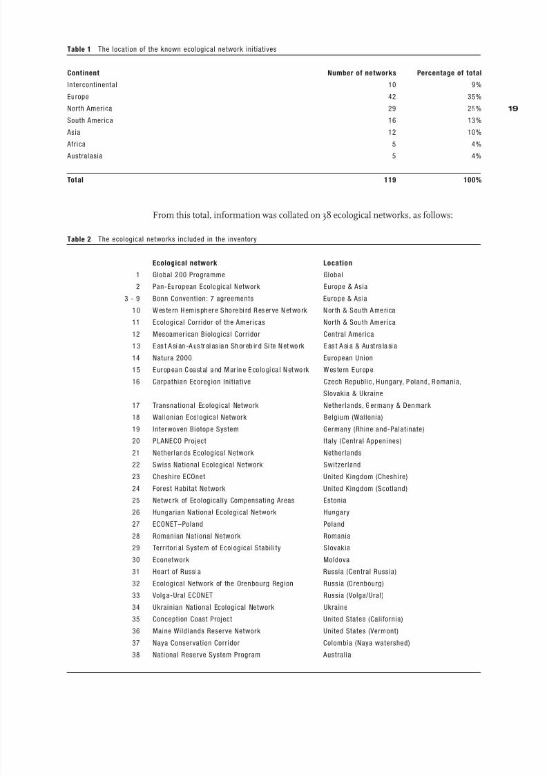
review. The locations of these initiatives were as follows:
18
8/6/2019 Development&Application Ecologica Networks UICN
http://slidepdf.com/reader/full/developmentapplication-ecologica-networks-uicn 20/137
Table 1 The location of the known ecological network initiatives
Continent Number of networks Percentage of total
Intercontinental 10 9%
Europe 42 35%
North America 29 25%
South America 16 13%
Asia 12 10% Afr ica 5 4%
Australasia 5 4%
Total 119 100%
From this total, information was collated on 38 ecological networks, as follows:
Table 2 The ecological networks included in the inventory
Ecological network Location
1 Global 200 Programme Global
2 Pan-European Ecological Network Europe & Asia
3 - 9 Bonn Convention: 7 agreements Europe & Asia
1 0 W es te rn H em is ph er e S ho re bi rd R es er ve N et wo rk N or th & S ou th A me ri ca
11 Ecological Corridor of the Americas North & South America
12 Mesoamerican Biological Corridor Central America
1 3 E as t A si an -A us tr al as ia n Sh or eb ir d Si te N et wo rk E as t A si a & Au st ra la si a
14 Natura 2000 European Union
1 5 E ur op ea n C oa st al a nd M ar in e E co lo gi ca l N et wo rk W es te rn E ur op e
16 Carpathian Ecoregion Initiat ive Czech Republic, H ungary, P oland, R omania,
Slovakia & Ukraine
17 Transnational Ecological Network Netherlands, G ermany & Denmark 18 Wallonian Ecological Network Belgium (Wallonia)
19 Interwoven Biotope System Germany (Rhineland-Palatinate)
20 PLANECO Project Italy (Central Appenines)
21 Netherlands Ecological Network Netherlands
22 Swiss National Ecological Network Switzerland
23 Cheshire ECOnet United Kingdom (Cheshire)
24 Forest Habitat Network United Kingdom (Scotland)
25 Network of Ecologically Compensating Areas Estonia
26 Hungarian National Ecological Network Hungary
27 ECONET–Poland Poland
28 Romanian National Network Romania
29 Terr itorial System of Ecological Stabili ty Slovakia
30 Econetwork Moldova
31 Heart of Russia Russia (Central Russia)
32 Ecological Network of the Orenbourg Region Russia (Orenbourg)
33 Volga-Ural ECONET Russia (Volga/Ural)
34 Ukrainian National Ecological Network Ukraine
35 Conception Coast Project United States (California)
36 Maine Wildlands Reserve Network United States (Vermont)
37 Naya Conservation Corridor Colombia (Naya watershed)
38 National Reserve System Program Australia
19

8/6/2019 Development&Application Ecologica Networks UICN
http://slidepdf.com/reader/full/developmentapplication-ecologica-networks-uicn 21/137
Of these 38 initiatives, 17 are international networks, 10 are national in scope and 11
are sub-national. In terms of geographical distribution, eight of the networks are
intercontinental initiatives, 25 are located in Europe, two in North America, one inSouth America, one in Asia and one in Australia. The strong bias towards European
networks is primarily the combined result of the relatively large number of ecological
networks in Europe and the high response rate from these initiatives. The high rate
of response can in all probability be attributed to the fact that, in contrast to the other
continents, many of the European networks are the initiative of government
organisations, which in general responded more readily to the questionnaire than
non-governmental and private organisations.
3.3 Summary Findings
3.3.1 The Status of the Initiatives
Any programme to develop and establish an ecological network will proceed through
several phases. The first key step is to identify the need for such a network. On the
basis of the information collected, it would seem that many of the known initiatives
are currently still in this initial phase and have not yet proceeded to become
operational programmes. Of the 38 networks that are described in this review, a
further three phases were distinguished, as follows (see Table 3):
Ω a strategic proposal, which may or may not include an indicative map of the
proposed network
Ω a detailed plan, in which the biodiversity elements to be conserved are identified,
the scope for other land uses is clarified and the spatial configuration of the
network is determined, usually in map formΩ an implementing programme, in which the specific actions, actors, management
requirements and instruments are laid down.
20

8/6/2019 Development&Application Ecologica Networks UICN
http://slidepdf.com/reader/full/developmentapplication-ecologica-networks-uicn 22/137
Table 3. The status of the ecological networks
Ecological network Status
Proposal Plan Programme Organisation
1 G lobal 200 Programme • > NGO
2 Pan-European Ecological Network • > Govt.
3-9 Bonn Convention: 7 agreements • • > Govt.
10 Western Hemisphere Shorebird Reserve Network • • > NGO11 Ecological Corr idor of the Americas • NGO
12 Mesoamerican Biological Corridor • • > Govt./NGO
13 East Asian-Australasian Shorebird Site Network • • > NGO
14 Natura 2000 • • > Govt.
15 European Coastal and Marine Ecological Network • > NGO
16 Carpathian Ecoregion Initiative • > NGO
17 Transnational Ecological Network > NGO
18 Wallonian Ecological Network • > Govt.
19 Interwoven Biotope System • • > Govt.
20 PLANECO Project > NGO
21 Netherlands Ecological Network • • > Govt.
22 Swiss National Ecological Network > Govt.
23 Cheshire ECOnet • > Govt.
24 Forest Habitat Network • > Govt.
25 Network of Ecologically Compensating Areas • • > Govt.
26 Hungarian National Ecological Network • > Govt.
27 ECONET–Poland • > NGO
28 Romanian National Network • > Govt.
29 Territorial System of Ecological Stabili ty • • > Govt.
30 Econetwork • > NGO
31 Heart of Russia • > NGO
32 Ecological Network of the Orenbourg Region • • > Govt./NGO
33 Volga-Ural ECONET • • > Govt./NGO34 Ukrainian National Ecological Network • • > Govt.
35 Conception Coast Project • > NGO
36 Maine Wildlands Reserve Network • NGO
37 Naya Conservation Corridor • > NGO
38 National Reserve System Program • • > Govt.
Legend • completed > in progress
Of the 38 networks, 13 have progressed to the stage of an implementing programme,
although none had been fully implemented at the time of writing. A detailed plan was
being, or had been, prepared for all but five of the initiatives.
With regard to the type of organisation which was leading each initiative, two broad
categories can be distinguished, namely governmental and non-governmental. For
the purposes of the inventory, non-governmental organisations include, in addition to
environmental organisations, research institutes, independent resource management
agencies and commercial enterprises. Table 3 lists the type of organisation that is the
prime mover in each initiative. Although in most cases only one type of organisation
is listed, the majority of initiatives are of such scope that a wide range of
organisations are involved in developing, elaborating and implementing the
programmes. Interestingly, there is a virtual balance between the networks that havebeen initiated by governmental organisations (15) and those by non-governmental
organisations (14).
21
8/6/2019 Development&Application Ecologica Networks UICN
http://slidepdf.com/reader/full/developmentapplication-ecologica-networks-uicn 23/137
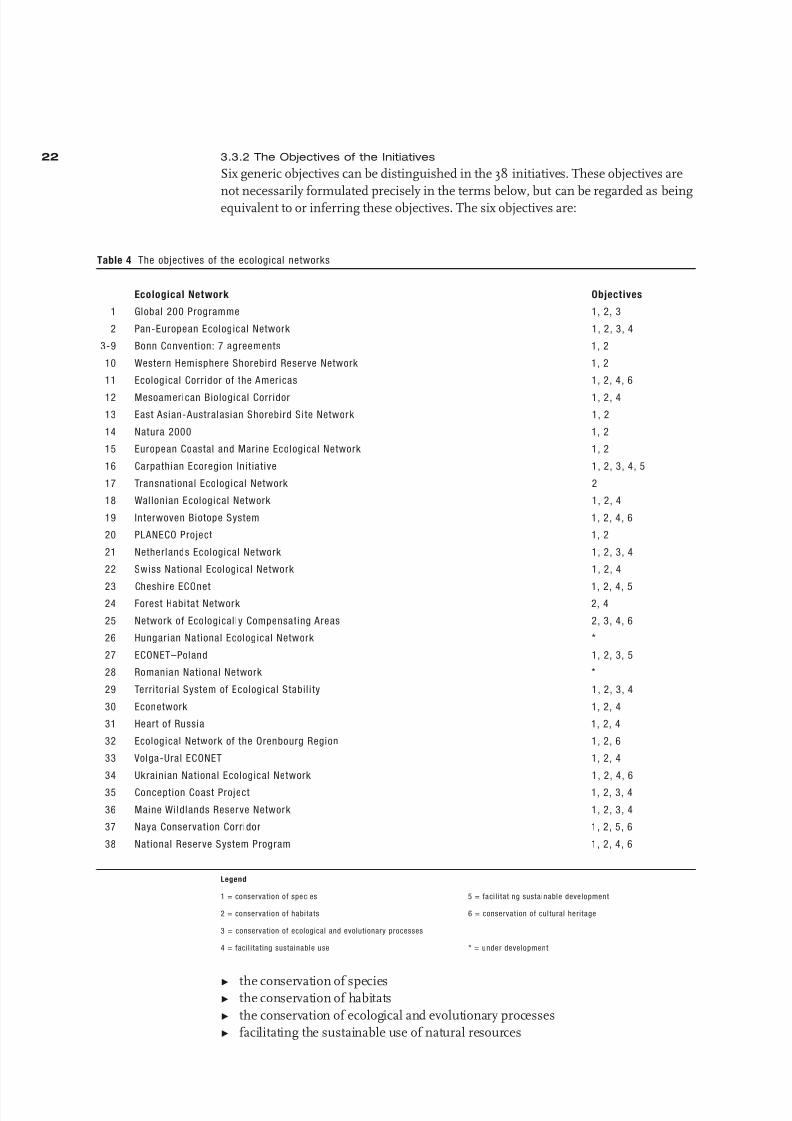
3.3.2 The Objectives of the Initiatives
Six generic objectives can be distinguished in the 38 initiatives. These objectives are
not necessarily formulated precisely in the terms below, but can be regarded as beingequivalent to or inferring these objectives. The six objectives are:
Table 4 The objectives of the ecological networks
Ecological Network Objectives
1 Global 200 Programme 1, 2, 3
2 Pan-European Ecological Network 1, 2, 3, 4
3-9 Bonn Convention: 7 agreements 1, 2
10 Western Hemisphere Shorebird Reserve Network 1, 2
11 Ecological Corr idor of the Americas 1, 2, 4, 6
12 Mesoamerican Biological Corr idor 1, 2, 4
13 East Asian-Australasian Shorebird Site Network 1, 2
14 Natura 2000 1, 2
15 European Coastal and Marine Ecological Network 1, 2
16 Carpathian Ecoregion Init iative 1, 2, 3, 4, 5
17 Transnational Ecological Network 2
18 Wallonian Ecological Network 1, 2, 4
19 Interwoven Biotope System 1, 2, 4, 6
20 PLANECO Project 1, 2
21 Netherlands Ecological Network 1, 2, 3, 4
22 Swiss National Ecological Network 1, 2, 4
23 Cheshire ECOnet 1, 2, 4, 524 Forest Habitat Network 2, 4
25 Network of Ecologically Compensating Areas 2, 3, 4, 6
26 Hungarian National Ecological Network *
27 ECONET–Poland 1, 2, 3, 5
28 Romanian National Network *
29 Territor ial System of Ecological Stabil i ty 1, 2, 3, 4
30 Econetwork 1, 2, 4
31 Heart of Russia 1, 2, 4
32 Ecological Network of the Orenbourg Region 1, 2, 6
33 Volga-Ural ECONET 1, 2, 4
34 Ukrainian National Ecological Network 1, 2, 4, 6
35 Conception Coast Project 1, 2, 3, 4
36 Maine Wildlands Reserve Network 1, 2, 3, 4
37 Naya Conservation Corridor 1, 2, 5, 6
38 Nat ional Reserve System Program 1, 2, 4, 6
Legend
1 = conservation of species 5 = faci li tating sustainable development
2 = conservation of habitats 6 = conservation of cultural heritage
3 = conservation of ecological and evolutionary processes
4 = facil i tating sustainable use * = under development
Ω the conservation of speciesΩ the conservation of habitats
Ω the conservation of ecological and evolutionary processes
Ω facilitating the sustainable use of natural resources
22

8/6/2019 Development&Application Ecologica Networks UICN
http://slidepdf.com/reader/full/developmentapplication-ecologica-networks-uicn 24/137
Ω facilitating sustainable development
Ω the conservation of cultural heritage (including indigenous culture).
As Table 4 indicates, virtually all the initiatives aim to conserve species and habitats,
and the majority also aim to facilitate the sustainable use of natural resources. Less
common as explicit objectives are the conservation of ecological and evolutionary
processes and the conservation of cultural heritage.
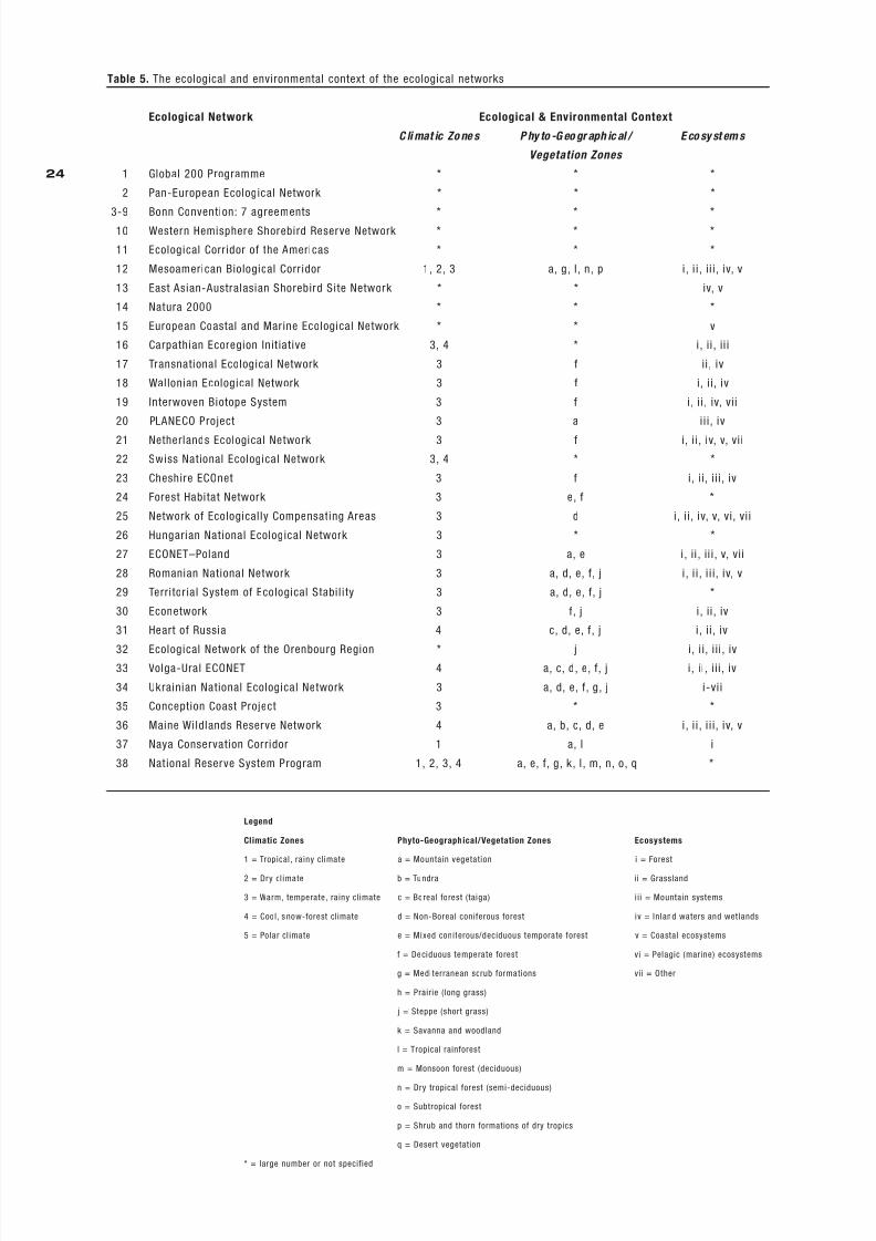
3.3.3 The Ecological and Environmental Context of the Networks
With the exception of the intercontinental and larger international initiatives, which
all cover a wide range of climatic zones, phyto-geographical/vegetation zones and
ecosystems, the majority of the networks are located entirely or in part in warm,
humid climatic zones, primarily temperate (see Table 5). Nevertheless, all of the
major climatic zones are represented in at least one network. The predominant
phyto-geographical/vegetation zones in the networks are mountain vegetation, non-boreal coniferous forest, mixed coniferous/deciduous temperate forest, deciduous
temperate forest and steppe. With regard to the ecosystems, all types are represented
in the networks, although coastal and pelagic ecosystems are significantly less
common.
3.3.4 The Socio-Economic Context of the Initiatives
A notable finding of the inventory is that all of the initiatives for which information
on the socio-economic context on the networks was available explicitly incorporate
economic activities in their planning. Indeed, most networks encompass a wide
range of land uses: most common are various types of farming, but recreation,
habitation and infrastucture works are also widespread. Only about a third of theinitiatives explicitly incorporate the conservation of cultural values into their mission,
namely the conservation of cultural landscapes and historic sites and provision for
indigenous peoples.
23
8/6/2019 Development&Application Ecologica Networks UICN
http://slidepdf.com/reader/full/developmentapplication-ecologica-networks-uicn 25/137
Table 5. The ecological and environmental context of the ecological networks
Ecological Network Ecological & Environmental Context
C li mat ic Zo ne s P hy to -G eo gr aph ic al / E co sy st em s
Vegetation Zones
1 Global 200 Programme * * *
2 Pan-European Ecological Network * * *
3-9 Bonn Convention: 7 agreements * * *10 Western Hemisphere Shorebird Reserve Network * * *
11 Ecological Corr idor of the Americas * * *
12 Mesoamerican Biological Corr idor 1, 2, 3 a, g, l , n, p i, i i , ii i , iv, v
13 East Asian-Australasian Shorebird Site Network * * iv, v
14 Natura 2000 * * *
15 European Coastal and Marine Ecological Network * * v
16 Carpathian Ecoregion Init iative 3, 4 * i, ii , ii i
17 Transnational Ecological Network 3 f ii , iv
18 Wallonian Ecological Network 3 f i, i i, iv
19 Interwoven Biotope System 3 f i, i i , iv, vii
20 PLANECO Project 3 a ii i, iv
21 Netherlands Ecological Network 3 f i, i i, iv, v, vi i
22 Swiss National Ecological Network 3, 4 * *
23 Cheshire ECOnet 3 f i, i i, i ii , iv
24 Forest Habitat Network 3 e, f *
25 Network of Ecologically Compensating Areas 3 d i, i i , iv, v, vi, vi i
26 Hungarian National Ecological Network 3 * *
27 ECONET–Poland 3 a, e i, ii , ii i , v, vii
28 Romanian National Network 3 a, d, e, f, j i , i i , i i i, iv, v
29 Territor ial System of Ecological Stabil i ty 3 a, d, e, f, j *
30 Econetwork 3 f, j i , ii , iv
31 Heart of Russia 4 c, d, e, f, j i , ii , iv
32 Ecological Network of the Orenbourg Region * j i , i i, i ii , iv33 Volga-Ural ECONET 4 a, c, d, e, f, j i , ii , i ii , iv
34 Ukrainian National Ecological Network 3 a, d, e, f, g, j i-vi i
35 Conception Coast Project 3 * *
36 Maine Wildlands Reserve Network 4 a, b, c, d, e i, i i , i i i, iv, v
37 Naya Conservation Corridor 1 a, l i
38 Nat ional Reserve System Program 1, 2, 3, 4 a, e, f, g, k, l , m, n, o, q *
Legend
Climatic Zones Phyto-Geographical/Vegetation Zones Ecosystems
1 = Tropical, rainy climate a = Mountain vegetation i = Forest
2 = Dry cl imate b = Tundra i i = Grassland
3 = Warm, temperate, rainy climate c = Boreal forest (taiga) i ii = Mountain systems
4 = Cool, s now-forest cl imate d = Non-Boreal coniferous forest iv = Inland waters and wet lands
5 = Polar cl imate e = Mixed coniferous/deciduous temporate forest v = Coastal ecosystems
f = Deciduous temperate forest vi = Pelagic (marine) ecosystems
g = Mediterranean scrub formations vii = Other
h = Prairie (long grass)
j = Steppe (short grass)
k = Savanna and woodland
l = Tropical rainforest
m = Monsoon forest (deciduous)
n = Dry tropical forest (semi-deciduous)
o = Subtropical forest
p = Shrub and thorn formations of dry tropics
q = Desert vegetation
* = large number or not specified
24

8/6/2019 Development&Application Ecologica Networks UICN
http://slidepdf.com/reader/full/developmentapplication-ecologica-networks-uicn 26/137
Table 6. The land uses and cultural values associated with the ecological networks
Ecological Network Land Uses Cultural Values
1 Global 200 Programme * *
2 Pan-European Ecological Network 1-9 a
3-9 Bonn Convention: 7 agreements * *
10 Western Hemisphere Shorebird Reserve Network * *
11 Ecological Corr idor of the Americas 1-9 a, b, c12 Mesoamerican Biological Corridor 1-9 *
13 East Asian-Australasian Shorebird Site Network * *
14 Natura 2000 * *
15 European Coastal and Marine Ecological Network * *
16 Carpathian Ecoregion Initiative 1, 2, 3, 5, 6, 7, 8, 9 a
17 Transnational Ecological Network 1, 2, 4, 6, 8 *
18 Wallonian Ecological Network 1-9 *
19 Interwoven Biotope System 1, 2, 3, 4, 6, 7, 8, 9 a
20 PLANECO Project * *
21 Netherlands Ecological Network 1, 2, 3, 4, 6, 7, 8, 9 a
22 Swiss National Ecological Network * *
23 Cheshire ECOnet 1-9 *
24 Forest Habitat Network 1-9 *
25 Network of Ecologically Compensating Areas 1-9 *
26 Hungarian National Ecological Network * *
27 ECONET–Poland 1, 3, 4, 5, 6, 7, 8, 9 *
28 Romanian National Network 1-9 *
29 Territorial System of Ecological Stabili ty 1-9 b
30 Econetwork 1, 2, 3, 4, 6, 7, 8, 9 a, b
31 Heart of Russia 1, 2, 3, 4, 6, 7, 8, 9 a, b
32 Ecological Network of the Orenbourg Region 1-9 a, b
33 Volga-Ural ECONET 1-9 a, b
34 Ukrainian National Ecological Network 1-9 a, b35 Conception Coast Project * *
36 Maine Wildlands Reserve Network 3, 4, 5, 6, 7, 8, 9 *
37 Naya Conservation Corridor 2, 3, 7, 9 *
38 National Reserve System Program 1, 2, 3, 5, 6, 7, 8 b, c
Legend
Land Use Cultural Values
1 = Arable farming and/or horticulture a = Cultural landscapes
2 = Animal husbandry and/or rangelands b = Historic sites
3 = Product ion forestry c = Indigenous peoples
4 = Fisheries
5 = Industry, mining and/or energy production
6 = Recreation and/or tourism
7 = Habitation
8 = Infrastructure
9 = Hunting
* = not precisely specified/unknown
3.3.5 Institutional and Legal Frameworks
Table 7 indicates the primary institutional means through which each ecological
network is to be realised, that is to say, the type of organisation which is the primemover in promoting the establishment of the network. Two main options are
distinguished, namely a coalition of non-government societal interests, such as
research institutes, environmental organisations, land owners and private foundations
(but which may include governmental bodies, which is indicated where this is
25

8/6/2019 Development&Application Ecologica Networks UICN
http://slidepdf.com/reader/full/developmentapplication-ecologica-networks-uicn 27/137
applicable) or through government-driven action (that in most cases includes the
funding of research, which is not regarded for the purposes of the table as an activity
initiated through a societal coalition). Where the establishment of the network is also
specifically required by legislation, this is also indicated (although legislation which islimited to the delineation of protected areas is not regarded as sufficient to provide
for the establishment of an ecological network). Some initiatives have not yet reached
the stage of securing formal commitments from other partners.
Almost half of the networks have been initiated by societal interest groups, mainly
environmental organisations or applied research institutes. In turn, half of these
initiatives have attracted the support of government in developing and establishing
the networks. In combination with the networks that are government-driven, only
nine of the initiatives are currently without any form of government support.
Table 7. The institutional framework of the ecological networks
Ecological Network Coalition Government Policy Legislation
1 Global 200 Programme •
2 Pan-European Ecological Network •
3-9 Bonn Convention: 7 agreements • •
10 Western Hemisphere Shorebird Reserve Network •
11 Ecological Corr idor of the Americas •
12 Mesoamerican Biological Corr idor • •
13 East Asian-Australasian Shorebird Site Network • •
14 Natura 2000 • •
15 European Coastal and Marine Ecological Network •
16 Carpathian Ecoregion Init iative • •17 Transnational Ecological Network • •
18 Wallonian Ecological Network •
19 Interwoven Biotope System •
20 PLANECO Project •
21 Netherlands Ecological Network •
22 Swiss National Ecological Network •
23 Cheshire ECOnet •
24 Forest Habitat Network •
25 Network of Ecologically Compensating Areas • •
26 Hungarian National Ecological Network •
27 ECONET–Poland • •
28 Romanian National Network •
29 Territor ial System of Ecological Stabil i ty • •
30 Econetwork • •
31 Heart of Russia •
32 Ecological Network of the Orenbourg Region • •
33 Volga-Ural ECONET • •
34 Ukrainian National Ecological Network •
35 Conception Coast Project •
36 Maine Wildlands Reserve Network •
37 Naya Conservation Corridor •
38 Nat ional Reserve System Program •
26

8/6/2019 Development&Application Ecologica Networks UICN
http://slidepdf.com/reader/full/developmentapplication-ecologica-networks-uicn 28/137
3.3.6 Implementation
Given the scale and complexity of ecological networks, it is clear that their conception,
design and realisation is likely to require decades rather than a few years. Even the
projected date of realisation for the oldest of the initiatives in the inventory – theEstonian ecological network – is still uncertain. Of course, no network is completely
designed in a single operation and fully established through a one-off implemen-
tation programme: design always proceeds from an original indicative configuration
through successively more detailed and revised drafts, methodologies evolve, improved
data become available, new insights emerge, the coalition of partners and stakeholders
may vary over time, funding may fluctuate, the socio-economic context will change
and the institutional framework may be reorganised. Table 8 should not therefore
be understood as indicating fixed dates on which the design of a network is finalised
or its realisation is fully completed. The design date represents the time at which
a reasonably representative configuration was first determined (or is likely to be
determined) and the realisation date is a prognosis for when the main elements
of the network – in terms of protected or managed areas, compatible land uses oreffective planning procedures – are in place.
Table 8. The implementat ion schedules of the ecological networks
Ecological Network Design Realisation
1 Global 200 Programme – –
2 Pan-European Ecological Network 2003* 2005
3-9 Bonn Convention: 7 agreements – –
10 Western Hemisphere Shorebird Reserve Network 1986 –
11 Ecological Corr idor of the Americas – –
12 Mesoamerican Biological Corr idor 1994 –13 East Asian-Australasian Shorebird Site Network 1998 2000
14 Natura 2000 2000 2004
15 European Coastal and Marine Ecological Network – –
16 Carpathian Ecoregion Initiative 2001 –
17 Transnational Ecological Network – –
18 Wallonian Ecological Network 2000 –
19 Interwoven Biotope System 1991 –
20 PLANECO Project – –
21 Netherlands Ecological Network 1989 2018
22 Swiss National Ecological Network – –
23 Cheshire ECOnet 2001 2020
24 Forest Habitat Network 1999 2050
25 Network of Ecologically Compensating Areas 1983 –
26 Hungarian National Ecological Network – –
27 ECONET–Poland 1995 –
28 Romanian National Network – –
29 Territorial System of Ecological Stabil i ty 1992 –
30 Econetwork 2001 –
31 H eart of Russia 2001 2005
32 Ecological Network of the Orenbourg Region 1998 –
33 Volga-Ural ECONET 1995 2005
34 Ukrainian National Ecological Network 2000 –
35 Conception Coast Project – –
36 Maine Wildlands Reserve Network 1999 2100
37 Naya Conservation Corridor – –
38 National Reserve System Program 1999 2002
Legend – = not known or not yet determined * = estimated date
27

8/6/2019 Development&Application Ecologica Networks UICN
http://slidepdf.com/reader/full/developmentapplication-ecologica-networks-uicn 29/137
3.4 Concluding Comments
Although this review was undertaken with the sole purpose of collating and presenting
in a systematic way information on a large number of ecological network initiatives,the information collected is of sufficient import to prompt a number of concluding
comments.
Perhaps the most striking finding of the review is the large number of ecological
networks that are being developed around the world. During the initial survey, 119
network initiatives were found that are being developed at the regional scale or higher,
and during the course of the study this number increased to over 150 (and it would
have been considerably greater if local networks had also been included in the review).
Although it only proved feasible to collate information on 38 initiatives, the fact that
such a large number of ecological networks are being developed is of considerable
importance for biodiversity conservation: it is clear from the review that a generic
model is being increasingly applied to the task of conserving biodiversity, and it isbeing applied in a wide variety of environmental and socio-economic circumstances,
at different scales and by both government and non-governmental organisations.
A second notable feature of the initiatives is that virtually all the networks focus not
only on the conservation of biodiversity but also accommodate to some degree the
exploitation of natural resources. That is to say, serious efforts are being made both
to buffer sites of high conservation value from potentially damaging forms of land
use and to find ways of reconciling the exploitation of natural resources with bio-
diversity conservation. Common examples are the maintenance of certain forms of
agriculture which have biodiversity value, such as extensive grazing, and the pro-
motion of ecotourism. This represents a distinct departure from the traditionalapproach of physically segregating and protecting sites of high conservation value
from areas which are predominantly exploited by various form of human exploitation.
This evolution is being driven by the needs of both developed and developing
countries which, although in many ways stem from contrasting challenges, lead to
a common approach. In developed countries, the greatest potential for biodiversity
conservation lies not in the relatively limited area of high-value natural habitats,
which to a large extent are already under strict protection, but in the far more
extensive semi-natural habitats which would benefit enormously from actions to
promote compatible forms of land use or to develop nature restoration projects.
In the developing countries, including the countries in transition, meeting the
legitimate economic needs of disadvantaged populations is not compatible with the
strict protection of the many and extensive pristine ecosystems that are under threat
from rapid economic development, but it can be reconciled with sustainable forms
of development which respect the integrity of these ecosystems.
However, the extent to which the ecological networks are succeeding in securing the
desired degree of compatibility between natural resource exploitation and biodiversity
conservation is not yet clear: not only are the majority of the networks covered by this
review still in the planning stage, but the inventory did not provide the opportunity to
study this aspect in the depth necessary to be able to draw conclusions on this issue.
Indeed, the fact that so few networks have yet progressed to an advanced stage of
implementation limits the opportunities to demonstrate the conservation results that
can be achieved in practice through applying the network model. Currently, any suchassessment would have to be based on the experience of a small number of advanced
networks – which are also those that are relatively limited in geographical scale – and
on fragmentary evidence drawn from the partial implementation of other networks.
And even then it can be expected that the main conservation results will be achieved
28

8/6/2019 Development&Application Ecologica Networks UICN
http://slidepdf.com/reader/full/developmentapplication-ecologica-networks-uicn 30/137
over a long period rather than immediately following the establishment of a network.
But the fact that so many ecological network initiatives are now underway, and that
this number is rapidly increasing, suggests that the initiators are fully confident that
the benefits that this approach promises can ultimately be delivered.
These observations lead to a number of suggestions concerning the implications
of this study for further actions to assess the value of the ecological network model:
First, although the review presents for the first time systematic information on a
relatively large number of ecological networks, the even greater number of networks
currently under development and which could not be inventoried in this review
represent an enormous and rapidly growing reservoir of expertise and experience in
developing and applying the ecological network model. Yet this expertise and experience
has not yet been made available to a broader audience. It is likely that there would be
substantial benefits for both biodiversity conservation and sustainable development
if a practicable means could be found to extend this inventory to cover a largerproportion of the other known initiatives and to institute a periodic review process.
Second, the need to ensure as broad as possible dissemination of the information
collated through such a review process argues for the creation of a global online data-
base to present standardised information on ecological network initiatives. Such a
facility would offer the additional advantage of permitting continual updating as new
information became available.
Third, most network initiatives are still at the planning stage and are being developed
relatively independently of each other. This suggests that there are substantial potential
benefits to be gained from analysing the various ecological network methodologieswhich have been or are being developed and making the results available to the many
groups working on networks around the world.
Fourth, only a small number of ecological networks have progressed to the point
where implementation on the ground is relatively advanced. Since it is the results that
are achieved in practice that will determine the value of the network model, it is
essential that action be taken at an appropriate time to examine critically the experience
gained in implementing the networks and to disseminate the results of this assessment.
Fifth, although several ecological network initiatives in developing countries are
known, these initiatives were not in a position to provide the information necessary
for this review. Given the urgent need to develop effective strategies for biodiversity
conservation and the sustainable use of natural resources in these countries, it is
recommended that supplementary action be taken to collect information on these
initiatives and to make it available in appropriate form, especially to the groups
working in developing countries.
Finally, since the majority of network initiatives are being developed independently of
each other, there could be potential value in creating interconnectivity between proxi-
mate networks. The added value in terms of biodiversity conservation that would be
generated by such linkages, both as a result of physical interconnection and through
the exchange of regionally specific expertise and experience, could generate an
exceptionally high return in relation to the investment required. Some of the inter-continental networks covered by this review already exploit existing conservation
initiatives to achieve their goals, but there would seem to be considerable scope for
utilising many of the other ecological networks as building blocks to develop larger-
scale constellations of networks.
29

8/6/2019 Development&Application Ecologica Networks UICN
http://slidepdf.com/reader/full/developmentapplication-ecologica-networks-uicn 31/137
APPENDIX 1. The Ecological Networks
Note: respondents who, due to time constraints or because the respective network
was insufficiently developed, were not in a position to answer the entire
questionnaire were requested to provide, at a minimum, general information on thenetwork. Unless otherwise stated, the information included is precise. Where precise
information was not available, a best estimate is given and indicated by ‘approx.’.
The information presented is in most cases summarised to some extent from the
more detailed information received.
1 Global 200 Programme
GENERAL INFORMATION ON THE NETWORK
Location of the Network
All 7 continents.
Responsible Organisation
World Wide Fund for Nature (WWF).
Main Objectives of the Network
To conserve the broadest variety of the world's species and the ecological and
evolutionary processes that maintain the web of life.
Main Components of the Network
233 ‘ecoregions’ (a relatively large unit of land or water that is characterised by
distinctive climate, ecological features and plant and animal communities).Each ecoregion includes core areas, corridors and restoration areas.
Ecosystems Included in the Network
The 233 ecoregions are classified into 19 groups, as follows:
Ω Terrestrial ecoregions:
– Tropical and subtropical moist broadleaf forests (53 ecoregions).
– Tropical dry forests (10).
– Tropical and subtropical conifer forests (2).
– Temperate conifer and broadleaf forests (17).
– Boreal forests and taiga (5).
– Arctic tundra (5).
– Temperate grasslands, savannas and shrublands (5).
– Tropical and subtropical grasslands, savannas and shrublands (11).
– Flooded grasslands and savannas (5).
– Tropical montane grasslands and savannas (7).
– Deserts and xeric shrublands (11).
– Mediterranean shrublands and woodlands (5).
Ω Freshwater ecoregions:
– Small rivers and streams (18).
– Large rivers (6).
– Lake and closed basin freshwater ecosystems (12).
Ω Marine ecoregions:
– Large deltas, mangroves and estuaries (17).– Coral reefs and associated marine ecosystems (23).
– Coastal marine ecosystems (16).
– Polar and subpolar marine ecosystems (5).
30

8/6/2019 Development&Application Ecologica Networks UICN
http://slidepdf.com/reader/full/developmentapplication-ecologica-networks-uicn 32/137
Species Protected Through the Network
No specific species.
Natural Resources Exploited Within the Network
Varies according to region.
Relevant Government Policy
To be promoted by WWF at the ecoregion level.
Status of Network Plan
Initiated by WWF in 1997. By mid-2000 31 ecoregion projects had been initiated, as
follows:
Ω Latin America:
Chihuahuan Deserts and Springs
Galapagos IslandsNorthern Andean Montane Forests
Southwest Amazon Moist Forest
Valdivian Temperate Forest
Meso-American Caribbean Reef
Varzea Flooded Forests
Atlantic Forests
Pantanal
Sea of Cortez/Gulf of California
Ω Africa:
Congo Basin Forests
Zambezian Woodlands and SavannasEast Africa Marine
Fynbos
African Rift Valley Lakes
Madagascar Dry Forest
Cameroon Montane Forests and Lakes
Ω Asia:
Lower Mekong Forests
Eastern Himalayan Broadleaf and Conifer Forests
Sulu-Sulawesi Sea
Sichuan-Yunan Temperate Forest
Tibetan Plateau Steppe
Ω Europe:
Mediterranean Shrublands and Woodlands
Northern Atlantic Shelf (Celtic and Wadden)
Barents Sea
Carpathians
Russian Far East Temperate Forests
Ω North America:
Bering Sea
Klamath-Siskiyou Forests
South Florida Ecosystem
Southeast Rivers and Streams Complex
31

8/6/2019 Development&Application Ecologica Networks UICN
http://slidepdf.com/reader/full/developmentapplication-ecologica-networks-uicn 33/137
2 Pan-European Ecological Network
GENERAL INFORMATION ON THE NETWORK
Location of the Network
Pan-Europe: 52 countries in Europe and northern Asia.
Responsible Organisations
United Nations Environment Programme, Council of Europe.
Main Objectives of the Network
Ensuring that a full range of ecosystems, habitats, species and their genetic diversity,
and landscapes of European importance are conserved; habitats are large enough to
place species in a favourable conservation status; there are sufficient opportunities for
the dispersal and migration of species; damaged elements of the key systems arerestored and the systems are buffered from potential threats.
Main Components of the Network
Ω Core areas.
Ω Corridors.
Ω Buffer zones.
Ω Restoration areas.
Ecosystems Included in the Network
Characteristic ecosystems of European importance, including natural and semi-
natural habitats and natural and cultural landscapes of European importance.
Species Protected Through the Network
Species of European importance (not yet specified, but to an important extent the
species already listed under existing international agreements such as the EU Birds
and Habitats Directives and the Bern and Bonn Conventions).
Natural Resources Exploited Within the Network
Not yet determined.
Relevant Government Policy
The development of the network will make use of the various international
agreements, the most important of which are:
Ω Pan-European Biological and Landscape Diversity Strategy
(Sofia, 1995, of which it is a part).
Ω Convention on Wetlands of International Importance (Ramsar, 1971).
Ω Convention of the Conservation of Migratory Species of Wild Animals
(Bonn, 1979), including the separate agreements.
Ω Convention on Biological Diversity (Rio de Janeiro, 1992).
Ω Convention on the Conservation of European Wildlife and Natural Habitats
(including the Emerald Network, Bern, 1979).
Ω Convention for the Protection of the Mediterranean Sea Against Pollution
(Barcelona, 1976, including the Protocol concerning Specially Protected Areas
in the Mediterranean, Geneva, 1982; the Convention for the Protection of theMarine Environment and the Coastal Region of the Mediterranean, Barcelona,
1995; and the Protocol concerning Specially Protected Areas and Biological
Diversity in the Mediterranean, Barcelona, 1995).
32

8/6/2019 Development&Application Ecologica Networks UICN
http://slidepdf.com/reader/full/developmentapplication-ecologica-networks-uicn 34/137
Ω Alpine Convention (Salzburg, 1991, including the protocols, 1994).
Ω EU Directive on the Conservation of Wild Birds (Birds Directive, 79/409/EEC,
1979, as amended by EU Directives 91/224/EEC and 94/24/EEC).Ω EU Directive on the Conservation of Natural Habitats and of Wild Fauna and
Flora (Habitats Directive, 92/43/EEC, 1992).
Ω Man and Biosphere Programme (UNESCO, 1971).
Ω European Diploma of Protected Areas (Council of Europe, 1965).
Ω European Network of Biogenetic Reserves (Council of Europe, 1976).
Status of Network Plan
International agreement (part of the Pan-European Biological and Landscape
Diversity Strategy, endorsed by the 54 member states of the United Nations
Economic Commission for Europe in Sofia, 1995). The implementation of the
network is the responsibility of the countries which are party to the Pan-European
Ecological Network. Implementation is scheduled for completion in 2005.
3 Bonn Convention: Memorandum of
Understanding Concerning Conservation
Measures for the Slender-Billed Curlew
GENERAL INFORMATION ON THE NETWORK
Location of the Network
The potential breeding, migration and wintering area of the slender-billed curlew inAlbania, Algeria, Austria, Bosnia and Herzegovina, Bulgaria, Croatia, Cyprus, Egypt,
the EU, Georgia, Greece, Hungary, Iran, Iraq, Italy, Kazakhstan, Malta, Morocco,
Oman, Romania, Russian Federation, Spain, Tunisia, Turkey, Turkmenistan,
Ukraine, United Arab Emirates, Uzbekistan, Yemen and Yugoslavia.
Responsible Organisation
Convention on the Conservation of Migratory Species of Wild Animals, Bonn,
Federal Republic of Germany.
Main Objectives of the Network
To improve the conservation status of the slender-billed curlew throughout its
potential breeding, migrating and wintering range, by means of the close cooperation
of the range states.
Main Components of the Network
Ω Core areas.
Ω Corridors.
Ecosystems Included in the Network
The habitat of the slender-billed curlew.
Species Protected Through the Network
Slender-billed curlew (Numensius tenuirostris).
Natural Resources Exploited Within the Network
Not specified.
33

8/6/2019 Development&Application Ecologica Networks UICN
http://slidepdf.com/reader/full/developmentapplication-ecologica-networks-uicn 35/137
Relevant Government Policy
The range states are obliged to:
Ω Provide strict protection for the slender-billed curlew and identify and conservethe wetlands and other habitats essential for its survival.
Ω Implement in their respective countries the Action Plan annexed to the
Memorandum.
Ω Develop a longer-term Action Plan in cooperation with the Secretariat for possible
inclusion in the Agreement on the Conservation of African-Eurasian Migratory
Waterbirds (AEWA).
Ω Impose a ban on hunting of similar looking wader species and initiate educational
programmes for hunters to enable them to distinguish between different species.
Ω At appropriate times, deny hunters access to sites frequented by slender-billed
curlews.
Ω Intensify research and facilitate the collection of scientific, technical and legal
information required by appropriate authorities and experts for effectivecoordinated conservation measures.
Status of Network Plan
A Memorandum of Understanding under Article IV, paragraph 4 of the Convention,
was adopted in July 1994 and signed by 17 range states (1997). The range states are to
provide the secretariat with a report on the implementation of the Memorandum at
least annually following its signature. The secretariat is to transmit to each of the range
states all of the reports received, together with a general report which it shall compile
on the basis of the information at its disposal. The secretariat has encouraged the
initiation of conservation projects for the slender-billed curlew in several range states
and is maintaining close contact with various organisations, scientific institutions andnational authorities already engaged in such activities.
4 Bonn Convention: Memorandum of
Understanding Concerning Conservation
Measures for the Siberian Crane
GENERAL INFORMATION ON THE NETWORK
Location of the Network
The range states of the western and central Asian populations of the Siberian Crane,
that is India, Iran, Kazakhstan, Pakistan, the Russian Federation, Turkmenistan and
Uzbekistan.
Responsible Organisation
Convention on the Conservation of Migratory Species of Wild Animals, Bonn,
Federal Republic of Germany.
Main Objectives of the Network
To ensure the survival of the West and Central Asian populations of the Siberian
Crane throughout its potential breeding, migrating and wintering range, by means
of the close cooperation of the range states.
34

8/6/2019 Development&Application Ecologica Networks UICN
http://slidepdf.com/reader/full/developmentapplication-ecologica-networks-uicn 36/137
Main Components of the Network
Ω Core areas.
Ω Corridors.Ecosystems Included in the Network
The habitat of the Siberian crane.
Species Protected Through the Network
Siberian crane (Grus leucogeranus).
Natural Resources Exploited Within the Network
Not specified.
Relevant Government Policy
The range states are obliged to:
Ω Provide strict protection for the Siberian crane and identify and conserve thewetlands and other habitats essential for its survival, if necessary through enacting
and enforcing legislation.
Ω Implement in their respective countries the Action Plan which is annexed to the
Memorandum.
Ω Develop a longer-term Action Plan in cooperation with the secretariat of the
Convention for possible inclusion in the Agreement on the Conservation of
Asian/Australian Waterfowl being developed under the auspices of the Bonn
Convention.
Ω Protect traditional breeding, staging and wintering areas and identify key sites.
Ω Prepare national action plans.
Ω Prepare detailed proposals for monitoring, research and practical measures torestore populations.
Ω Develop proposals for a funding mechanism for conservation measures.
Ω Raise awareness through education programmes among people living in areas
frequented by Siberian cranes of the urgency of conserving them.
Ω Cooperate in the development of a concerted international mass media campaign,
focusing primarily on the range states.
Status of Network Plan
A Memorandum of Understanding under Article IV, paragraph 4 of the Convention
was adopted in June 1993 and has been signed and ratified by seven of the nine range
states, namely India, Iran, Kazakhstan, Pakistan, the Russian Federation,
Turkmenistan and Uzbekistan. A detailed Conservation Plan was one of the outputs
of the meeting of national representatives and experts held in India in 1996, setting
out three basic objectives:
Ω The reduction of mortality rates in remaining populations.
Ω An increase in numbers and genetic diversity.
Ω Enhanced cooperation among the range states and agencies.
Implementation of the Memorandum and the Action Plan are to be assessed at
annual meetings convened by the Convention's secretariat and attended by
representatives of the governments of the range states and technically qualified
agencies and experts.
35

8/6/2019 Development&Application Ecologica Networks UICN
http://slidepdf.com/reader/full/developmentapplication-ecologica-networks-uicn 37/137
5 Bonn Convention: Agreement on the
Conservation of African-Eurasian
Migratory Waterbirds
GENERAL INFORMATION ON THE NETWORK
Location of the Network
117 range states. The Agreement covers waterbirds ecologically dependent on wetlands
in Africa and Eurasia, including the Middle East, Greenland and parts of Canada.
Responsible Organisation
Convention on the Conservation of Migratory Species of Wild Animals, Bonn,
Federal Republic of Germany.
Main Objectives of the Network
To maintain in, or to restore to, a favourable conservation status 170 species of
migratory waterbirds.
Main Components of the Network
Ω Core areas.
Ω Corridors.
Ecosystems Included in the Network
The habitats of the 170 species.
Species Protected Through the Network The 170 species include divers, grebes, pelicans, egrets, herons, storks, ibises,
spoonbills, flamingos, ducks, geese, cranes, plovers, sandpipers, gulls and terns.
Natural Resources Exploited Within the Network
Not specified.
Relevant Government Policy
The range states are obliged to:
Ω Prohibit the taking of endangered waterbird species (including their eggs), protect
and where possible restore their habitat, eliminate, prevent or minimise impedi-
ments to their migration and prevent, reduce or control factors endangering them.
Ω Ensure that the use of waterbirds is sustainable both in terms of the species and
the ecosystem that supports them.
Ω Identify sites and habitats for migratory waterbirds within their territory and
encourage the protection, management, rehabilitation and restoration of these sites.
Ω Coordinate their efforts to ensure that a network of suitable habitats is
maintained, and in particular where wetlands extend over the area of more than
one party to the Agreement.
Status of Network Plan
An agreement under Article IV (3) of the Convention adopted in June 1995. 53 states
and the EU were signatories to the Final Act. The Agreement has been signed by 32
states and the EU and ratified by 24 states. The Agreement Action Plan identifies thefollowing actions:
Ω The establishment of protected areas to conserve important habitats for the
populations listed in the Agreement's Action Plan and the development and
implementation of management plans.
36

8/6/2019 Development&Application Ecologica Networks UICN
http://slidepdf.com/reader/full/developmentapplication-ecologica-networks-uicn 38/137
Ω The development of strategies, following an ecosystem-based approach, for the
conservation of those habitats, including the habitats of dispersed populations.
6 Bonn Convention: Agreement on the
Conservation of Bats in Europe
GENERAL INFORMATION ON THE NETWORK
Location of the Network
The territory of the 20 parties to the Convention (Belgium, Bulgaria, Czech Republic,
Denmark, Finland, France, Germany, Hungary, Ireland, Luxembourg, Macedonia,
Monaco, Netherlands, Norway, Poland, Portugal, Slovakia, Sweden, Ukraine, United
Kingdom.
Responsible Organisation
Convention on the Conservation of Migratory Species of Wild Animals, Bonn,
Federal Republic of Germany.
Main Objectives of the Network
To achieve and maintain a favourable conservation status of bat populations in
European and non-European range states and to counteract the threat posed to these
species from habitat degradation, disturbance to roosting sites and certain pesticides.
Main Components of the Network Ω Core areas.
Ω Corridors.
Ecosystems Included in the Network
The habitats of the listed species.
Species Protected Through the Network
European populations of Microchiroptera (Molossidae, Rhinolophidae and
Vespertilionidae).
Natural Resources Exploited Within the Network
Not specified.
Relevant Government Policy
Each party is obliged to:
Ω Prohibit the deliberate capture, keeping or killing of bats (spp Rhinolophidae and
Vespertilionidae) except with a permit from a competent authority.
Ω Identify the sites within its own area of jurisdiction that are important for the
conservation of bats, protect such sites from damage or disturbance and identify
and similarly protect important feeding areas for bats.
Ω Adopt and enforce such legislative and administrative measures as may be
necessary to give effect to the Agreement.
Status of Network Plan
An agreement under Article IV(3) of the Convention, adopted in September 1991 and
signed by 20 parties.
37

8/6/2019 Development&Application Ecologica Networks UICN
http://slidepdf.com/reader/full/developmentapplication-ecologica-networks-uicn 39/137
7 Bonn Convention: Agreement on the
Conservation of Cetaceans of the
Black Sea, the Mediterranean Sea and
the Contiguous Atlantic Area (ACCOBAMS)
GENERAL INFORMATION ON THE NETWORK
Location of the Network
The Black Sea, the Mediterranean Sea and the contiguous area of the Atlantic Ocean
west of the Straits of Gibraltar.
Responsible Organisation
Convention on the Conservation of Migratory Species of Wild Animals, Bonn,
Federal Republic of Germany.
Main Objectives of the Network
To achieve and maintain a favourable conservation status for those species of
cetaceans listed in Annex I of the Agreement.
Main Components of the Network
Marine areas.
Ecosystems Included in the Network
Marine ecosystems of the Black Sea, the Mediterranean Sea and the contiguous area
of the Atlantic Ocean.
Species Protected Through the Network Cetacean species of the Black Sea, the Mediterranean Sea and the contiguous area of
the Atlantic Ocean, the most important being:
Ω Harbour porpoise Phocena phocoena
Ω Bottlenose dolphin Tursiops truncatus
Ω Common dolphin Delphinus delphis
Ω Long-finned pilot whale Globicephala melas
Natural Resources Exploited Within the Network
Not specified.
Relevant Government Policy
The parties to the Agreement are required to:
Ω Prohibit any deliberate taking of cetaceans (with a few clearly defined exceptions).
Ω Create and maintain a network of specially protected areas to conserve cetaceans.
Annex I consists of a list of indicative species to which the Agreement applies. It also
applies to any other cetaceans not listed in the Annex, but which may frequent the
Agreement area accidently or occasionally. Annex II (the Conservation Plan) specifies
actions which parties shall take in the following areas:
Ω Adoption and enforcement of national legislation.
Ω Assessment and management of human-cetacean interactions.
Ω Habitat protection.
Ω Research and monitoring.
Ω Capacity-building.Ω Collection of information.
Ω Training and education.
Ω Responses to emergencies.
38

8/6/2019 Development&Application Ecologica Networks UICN
http://slidepdf.com/reader/full/developmentapplication-ecologica-networks-uicn 40/137
In implementing the measures, the parties shall apply the precautionary principle.
In implementing the Plan, the parties are required to carry out the actions to the
maximum extent of their economic, technical and scientific capacities. Regarding
habitat protection, specially protected areas for cetaceans corresponding to the areaswhich serve as habitat and/or which provide important food resources for them
should be established within the framework of the Convention for the Protection of
the Marine Environment and the Coastal Region of the Mediterranean or within the
framework of other appropriate instruments.
Status of Network Plan
An agreement under Article IV of the Bonn Convention, adopted in November 1996
and signed by 15 parties (including the EU) but not yet in force.
8 Bonn Convention: Agreement on theConservation of Small Cetaceans of the
Baltic and North Seas (ASCOBANS)
GENERAL INFORMATION ON THE NETWORK
Location of the Network
The Baltic and North Sea marine area of the parties to the Agreement: Belgium,
Denmark, Finland, Germany, Netherlands, Poland, Sweden, United Kingdom.
Responsible Organisation
Convention on the Conservation of Migratory Species of Wild Animals, Bonn,Federal Republic of Germany.
Main Objectives of the Network
To achieve and maintain a favourable conservation status for the small cetaceans
species covered by the Agreement.
Main Components of the Network
Marine areas.
Ecosystems Included in the Network
Marine ecosystems of the Baltic and North Seas.
Species Protected Through the Network
The whale and dolphin species that enter the North and Baltic Seas, with the
exception of baleen and great sperm whales. The most important species are:
Ω Harbour porpoise Phocena phocoena
Ω Bottlenose dolphin Tursiops truncatus
Ω White-beaked dolphin Lagenorrhynchus albirostris
Ω Atlantic white-sided dolphin Lagenorrhynchus acutus
Ω Common dolphin Delphinus delphis
Ω Striped dolphin Stenella coeruleoalba
Ω Risso's dolphin Grampus griseus
Ω Killer whale OrcinusorcaΩ Long-finned pilot whale Globicephala melas
Ω Northern bottlenose whale and Hyperoodon ampullatus
other beaked whales (Ziphiidae)
39

8/6/2019 Development&Application Ecologica Networks UICN
http://slidepdf.com/reader/full/developmentapplication-ecologica-networks-uicn 41/137
Natural Resources Exploited Within the Network
Not specified.
Relevant Government Policy
Each Party shall apply within the limits of its jurisdiction and in accordance with its
international obligations, the conservation, research and management measures
prescribed in the Annex, namely:
Ω Habitat conservation and management.
Ω Surveys and research.
Ω Use of by-catches and strandings.
Ω Legislation.
Ω Information and education.
Status of Network Plan
An agreement under Article IV (3) of the Bonn Convention, adopted in March 1992and to which 8 countries are party.
9 Bonn Convention: Agreement on the
Conservation of Seals in the Wadden Sea
GENERAL INFORMATION ON THE NETWORK
Location of the Network
The area of the Wadden Sea, including all sandbanks, the shore of the North Seacoast of Denmark, Germany and the Netherlands and the adjacent off-shore area
within the three-nautical-mile zone.
Responsible Organisation
Convention on the Conservation of Migratory Species of Wild Animals, Bonn,
Federal Republic of Germany.
Main Objectives of the Network
To achieve and maintain a favourable conservation status for the population of seals
in the Wadden Sea.
Main Components of the Network
Marine areas.
Ecosystems Included in the Network
The Wadden Sea marine ecosystem.
Species Protected Through the Network
Harbour/common seal Phoca vitulina
Natural Resources Exploited Within the Network
Not specified.
Relevant Government Policy
On the basis of scientific knowledge, the parties are required to develop a conservation
and management plan for the seal population. This plan is to contain a comprehen-
40

8/6/2019 Development&Application Ecologica Networks UICN
http://slidepdf.com/reader/full/developmentapplication-ecologica-networks-uicn 42/137
sive statement of actions to be undertaken by the parties to achieve the goals of the
Agreement. The parties shall review the plan and amend it as necessary, and
particularly as a result of scientific research and shall coordinate their researchprogrammes and projects and the monitoring of the seal populations. They are also
required to prohibit the taking of seals from the Wadden Sea. The parties shall pay
due regard to the necessity of creating and maintaining a network of protected areas,
including migration areas and those areas essential to the maintenance of the seals'
vital biological functions. They shall protect habitats and the seals from undue
disturbance and changes resulting from human activities and are encouraged to
explore the possibility of restoring degraded habitats and creating new ones.
Status of Network Plan
An agreement under Article IV of the Bonn Convention, adopted in October 1990
and with 3 parties: Denmark, Germany and the Netherlands.
10 Western Hemisphere Shorebird
Reserve Network
GENERAL INFORMATION ON THE NETWORK
Location of the Network
North and South America.
Responsible OrganisationManomet Center for Conservation Sciences, Manomet, Massachusetts, USA.
Main Objectives of the Network
The conservation of critical shorebird habitats throughout the Americas.
Main Components of the Network
Ω Core areas (40 critical sites).
Ω Corridors.
Ecosystems Included in the Network
Shorebird habitats.
Species Protected Through the Network
47 species of migratory shorebirds, including:
Ω Sandpipers
Ω Plovers
Ω Avocets
Ω Oystercatchers
Natural Resources Exploited Within the Network
Not specified.
Relevant Government Policy
40 sites are officially designated in Argentina, Brazil, Peru, Suriname, Mexico, USA
and Canada.
41
8/6/2019 Development&Application Ecologica Networks UICN
http://slidepdf.com/reader/full/developmentapplication-ecologica-networks-uicn 43/137
Status of Network Plan
Voluntary, non-regulatory coalition of over 140 private and public organisations in 7
countries, established in 1985.
Dimensions of the Network
Area: 4.5 million ha (40 core areas).
11 Ecological Corridor of the Americas
(EcoAméricas)
GENERAL INFORMATION ON THE NETWORK
Location of the Network
The territory of North and South America.
Responsible Organisation
Wildlife Conservation Society, Gainsville, Florida, USA.
Main Objectives of the Network
To contribute to the social, economic, cultural and scientific development of the
western hemisphere through the conservation and restoration of biological diversity
along the mountain backbone of the Americas.
Main Components of the Network Ω Core areas.
Ω Corridors.
Ω Buffer zones (multiple resource-use lands).
Ω Restoration areas.
Ecosystems Included in the Network
Mainly mountain ecosystems with multiple links to Pacific and Atlantic lowland
ecosystems.
Species Protected Through the Network
Not specified, but aim is to ensure protection of 50% of the total biodiversity of the
two continents.
Natural Resources Exploited Within the Network
Not specified.
Relevant Government Policy
Existing protected area policies in the countries along the corridor.
Status of Network Plan
Independent initiative of the Wildlife Conservation Society. The draft proposal was
circulated in February 2000.
Dimensions of the Network
North-south: Approx. 40,000 km.
42

8/6/2019 Development&Application Ecologica Networks UICN
http://slidepdf.com/reader/full/developmentapplication-ecologica-networks-uicn 44/137
12 Mesoamerican Biological Corridor/
Paseo Pantera
GENERAL INFORMATION ON THE NETWORK
Location of the Network
The territory of Central America, extending into Belize, Costa Rica, El Salvador,
Guatemala, Honduras, Mexico, Nicaragua and Panama.
Responsible Organisations
Central American Council for Forests and Protected Areas, Tegucigalpa, Honduras;
Wildlife Conservation Society, Gainsville, Florida, USA; Caribbean Conservation
Corporation, Gainsville, Florida, USA; University of Florida, Gainsville, Florida, USA.
Main Objectives of the Network
To avoid the deterioration and loss of biodiversity through conservation of
representative samples of the region's environments, preventing the fragmentation of
ecosystems with the conformation of a set of interconnected areas that will permit the
possibility of genetic and biological interchange between fragmented populations, the
continuity of biological processes and the integration of these areas within a regional
planning process that is oriented towards sustainable development.
Main Components of the Network
Ω Core areas.
Ω Corridors.
Ω Buffer zones (multiple use areas).
Ecosystems Included in the Network
Ω Moist lowland rain forests of the Atlantic slope.
Ω Pacific slope dry forests.
Ω Marine habitats.
Ω Highland pine-oak forests.
Species Protected Through the Network
Not specified.
Natural Resource Exploitation Within the Network
Timber, agriculture, coastal fishing, ecotourism.
Relevant Government Policy
The Convention on Biological Diversity and the Protection of Priority Natural Areas,
1992 provided a regional framework for developing cooperation to establish the
corridor. The conceptual framework for the corridor was approved by the
governments of the participating countries in 1997 through the Central American
Alliance for Sustainable Development, which has as one of its key commitments the
establishment of the corridor. Also relevant is the Regional System of Protected
Areas, developed by United Nations Development Programme (UNDP) and the
United Nations Environment Programme (UNEP) in cooperation with the Central
American Council for Environment and Development.
Status of Network Plan
In 1997 the governments of the participating countries defined the corridor as
43

8/6/2019 Development&Application Ecologica Networks UICN
http://slidepdf.com/reader/full/developmentapplication-ecologica-networks-uicn 45/137
‘a territorially organised system composed of natural areas under special admini-
strative regimes, core areas, buffer zones, areas of multiple use and interconnection,
organised and consolidated to offer a variety of environmental products and servicesto the Central American and global societies, allowing for social harmonisation to
promote investment in the sustainable use of natural resources, with the aim of
contributing towards improving the life of the inhabitants of the region’. 16 regional
projects to help establish the corridor are underway. In 1997 the World Bank
approved a project to improve institutional capacity and participatory protection for
protected areas, to improve natural resource management and to strebgthen the
national biological monitoring capacity. NASA and the Central American Commission
for Environment and Development have initiated a joint project to strengthen
scientific research, data exchange and training, including mapping of the region
through remote sensing. A joint UNEP and UNDP project to support the implemen-
tation of the corridor was launched in April 2000.
Dimensions of the Network
North-south: Approx. 2400 km.
13 East Asian-Australasian Shorebird
Site Network
GENERAL INFORMATION ON THE NETWORK
Location of the Network Russian Federation, Republic of Korea, Japan, People's Republic of China, Philippines,
Indonesia, Papua New Guinea, Australia, New Zealand. The boundaries for the
network are primarily defined on an ecological basis, determined by the pattern of
migration of the species involved. The western, northern and eastern margins overlap
with adjacent flyways. Some consideration has been given to regional geo-political
considerations in deciding how to define national involvement on the eastern margin
of the flyway. Coordinates:
Ω Moroshechnaya Estuary, Russian Federation, 56 21 156 15
Ω Tonggin River Lagoon and mudflat, Republic of Korea, 35 37 126 31
Ω Yatsu tidal flats, Japan, 35 41 140 00
Ω Yoshino Estuary, Japan, 34 05 134 36
Ω Manko, Japan, 26 10 127 40
Ω Yalu Jiang Nature Reserve, China, 39 40 123 50
Ω Shuangtaihekou National Nature Reserve, China, 40 57 121 45
Ω Huanghe National Nature Reserve, China, 37 50 118 50
Ω Yancheng Biosphere Reserve, China, 33 20 120 30
Ω Chongming Dongtan, China, 31 30 121 45
Ω Mai Po–Inner Deep Bay, China, 22 30 114 00
Ω Olango Island, Philippines, 10 16 124 03
Ω Wasur Game Reserve, Indonesia, 8 35 140 45
Ω Tonda Wildlife Reserve, Papua New Guinea, 8 45 141 23
Ω Kakadu National Park, Australia, 12 40 132 45
Ω Parry Lagoons, Australia, 15 15 128 22Ω Thomsons Lake, Australia, 32 09 115 52
Ω Moreton Bay, Australia, 27 20 153 10
Ω Kooragang Nature Reserve, Australia, 32 51 151 47
44

8/6/2019 Development&Application Ecologica Networks UICN
http://slidepdf.com/reader/full/developmentapplication-ecologica-networks-uicn 46/137
Ω Corner Inlet, Australia, 38 45 146 32
Ω The Coorong, Australia, 35 40 139 00
Ω Orielton Lagoon, Australia, 42 47 147 30Ω Logan Lagoon, Australia, 40 10 148 17
Ω Firth of Thames, New Zealand, 37 13 175 23
Ω Farewell Spit, New Zealand, 40 32 172 50.
Responsible Organisation
Wetlands International–Oceania, Canberra, Australia.
Main Objectives of the Network
To ensure the long term conservation of migratory shorebirds in the East Asian-
Australasian Flyway through recognition and appropriate management of a network
of internationally important sites.
Main Components of the Network
The Network now has 25 sites in nine countries. The management status of these
sites is as follows:
Ω Category Ia: 9 sites
Ω Category Ib: 1 sites
Ω Category II: 6 sites
Ω Category IV: 3 sites
Ω Category VI: 6 sites
A number of these sites have management zones and the core area is much smaller
then the area included in the network (especially in China).
Ecosystems Included in the Network
Sites of international importance for migratory shorebirds.
Species Protected Through the Network
Ω Migratory shorebirds Charadriiformes
Natural Resource Exploitation Within the Network
Fisheries, subsistence hunting and gathering.
Relevant Government Policy
Australian Commonwealth Wetlands Policy.
Status of Network Plan
Action Plan for the Conservation of Migratory Shorebirds in Asia Pacific: 1998–2000
(1999).
Dimensions of the Network
Ω Area: 3,138,589 ha.
Ω North-south: 14,000 km.
Ω East-west: 10,000 km.
Ω Altitude range: Approx. 0–100 m.
Ω Longest distance between core areas: 3,000 km.
Ω Shortest distance between core areas: Adjacent across international border.Ω Areal percentage of core areas in relation to entire network: Greater than 50%.
45

8/6/2019 Development&Application Ecologica Networks UICN
http://slidepdf.com/reader/full/developmentapplication-ecologica-networks-uicn 47/137
ENVIRONMENTAL CHARACTERISTICS
Main Environmental UnitsΩ Climatic zones: Tropical, rainy climate; dry climate; warm, temperate, rainy
climate; cool, snow-forest climate; polar climate.
Ω Phyto-geographical/vegetation zones: The geographic coverage of the Network
includes all vegetation types, although most sites in the Network are tidal flats.
Ω River basins/marine areas: Many.
Main Ecosystems Within the Network
Ω Inland waters and wetlands: 10%.
Ω Coastal ecosystems: 90%.
Main Environmental Functions of the Network
Ω Maintaining or increasing the area of certain habitats.Ω Maintaining or improving the dispersal, migration and/or genetic exchange of
certain species.
Ω Restoring habitat quality.
NATURAL RESOURCE EXPLOITATION
Main Types of Land and Water Use
Type of Land System or Sector Main Products Extent (% area of No. o f Persons
or Water Use or Services network/length) Directly InvolvedΩ Arable farming/ Small-scale intensive Rice, wheat 10–25% 10,000's
horticulture cropping
Ω Animal husbandry/ Traditional, e xtensive, Sheep, g oats, b uffalo <10% 1000's
rangelands sedentary
Ω Production forestry Plantation forests – <10% 100's
Ω Fisheries Artisanal, small-scale, Shellfish, prawns, ell fry – 10,000's
inland; artisanal,
small-scale, coastal;
fish-farming
Ω Industry/energy Energy production Oil, renewable energy – 1000's
production
Ω Recreation/tourism Tourism Ecotourism/ nature – 100's
observat ion, recreat ional
hunt ing/fishing, cultural
experiences
Ω Habitation – – – 1000's in core areas,
100,000's in buffer
zones
Ω Infrastructure – – Roads 1000's km,
railways 10's km,
canals 100's km –
46

8/6/2019 Development&Application Ecologica Networks UICN
http://slidepdf.com/reader/full/developmentapplication-ecologica-networks-uicn 48/137
THE PLAN
Proposal/Plan/ProgrammeΩ Type of plan: Regional plan, focused on the East Asian-Australasian Flyway. Part
of a larger Asia-Pacific Migratory Waterbird Conservation Strategy, 1996–2000.
Ω Reference: Shorebird Working Group of Wetlands International–Asia Pacific
(1999) Action Plan for the Conservation of Migratory Shorebirds in Asia Pacific:
1998–2000, Environment Australia, Canberra.
Ω Responsible organisation: Coordinated by Wetlands International.
Ω Plan comes into effect: 1998.
Ω Implementation complete: End 2000.
Ω Implementing parties: Implementation is being coordinated by a Shorebird
Flyway Officer working for Wetlands International–Oceania. There is an
international advisory group that meets once a year to review implementation
(Shorebird Working Group) and this reports to a Migratory Waterbird ConservationCommittee which is a sub-committee of the Wetlands International–Asia Pacific
Council. Core funding for this work is from the Australian Government.
Ω Results achieved: End 2000.
Ω Plan revised: 1999.
Ω Plan evaluated: By Shorebird Working Group.
Data Collected
Ω Type of data: Up to individual sites. Has been a program to collect baseline
information at sites in developing countries. Participation in the Asian Waterfowl
Census is being promoted.
Ω Methods: Surveying and mapping.
Monitoring and Evaluation Arrangements
Ω Plan monitored/evaluated by: Annual reporting to the Shorebird Working Group
and the Australian Government (Environment Australia).
Ω Monitoring/evaluation of results: Not yet – the real test is ‘are populations of
migratory shorebirds in the Flyway being maintained’. At present there is not
sufficient infrastructure and institutional capacity to make these assessment.
The Action Plan and development of the Network are seeking to address this need.
Associated Research
Ω Develop statistically robust methodologies to monitor shorebird populations and
develop projects for implementation in priority countries (Australia, New Zealand
and Japan).
Ω Develop and implement projects to identify internationally important sites for
shorebirds in countries where knowledge is incomplete, notably the Peoples
Republic of China, Republic of Korea, Vietnam, The Philippines and
Papua New Guinea.
Ω Support existing and initiate new projects on shorebird migration with a special
focus on the use of colour leg flags and public involvement in resightings.
Seek to maximise community involvement in these projects.
Ω Compile and publish an overview of the status of shorebirds and internationally
important sites in the East Asian-Australasian Flyway. Assess the adequacy of the
Shorebird Reserve Network to conserve species.
47

8/6/2019 Development&Application Ecologica Networks UICN
http://slidepdf.com/reader/full/developmentapplication-ecologica-networks-uicn 49/137
Educational/Communication Activities
Ω Activities carried out: Communication Strategy developed.
Ω Aim of activities: The communication activities will promote the followingelements of the Shorebird Action Plan: nomination of additional sites for the
Shorebird Site Network, gain the involvement of additional countries, site
dedication ceremonies, involvement on the implementation and review of the
Action Plan, knowledge and participation in training initiatives, involvement in
shorebird migration studies, exchange of information on shorebird conservation
and habitat management between site managers, researchers and non-government
organisations. The main messages to be delivered through this strategy are:
shorebird migration, internationally important sites for shorebirds, shorebird
Action Plan, shorebird Site Network, joining the Site Network, training
opportunities for staff at network sites, management planning, migration
research activities, update of the Shorebird Action Plan. Desired outcomes:
1. A high level of knowledge of the Shorebird Action Plan and Shorebird SiteNetwork by the key staff of international Convention Secretariat's, National
Government Agencies, international non-government Organisations and key
national non-government organisations.
2. A high level of awareness of the key sites for shorebirds at the national level by key
staff of National Government Agencies and key national non-government
organisations.
3. A high level of knowledge of the nomination process for the Shorebird Site
Network by the key staff of National Government Agencies and key national non-
government organisations.
4. Recognition of the value of conducting site dedications by staff at Network Site.
5. A high level of awareness of training opportunities by staff at Networks Sites.6. A high level of awareness of the diversity of site management planning by key
staff at Network sites.
7. A high level of awareness of migration research activities by National Government
Agencies, international non-government Organisations and key national non-
government organisations.
8. A high level of knowledge of the update of the Shorebird Action Plan for 2001 -
2005 by the key staff of international Convention Secretariat's, National
Government Agencies, international non-government Organisations and key
national non-government organisations.
Ω Activities directed at: To achieve the identified outcomes five specific and one
general audience have been identified:
1. Key staff in international Convention Secretariat's (Ramsar, Bonn, CAFF).
2. Key staff in national Government Agencies in the East Asian-Australasian Flyway.
3. Key staff in international non-government organisations active in
shorebird/wetland conservation in the East Asian-Australasian Flyway.
4. Key national non-government organisations in the East Asian-Australasian Flyway.
5. Staff at Shorebird Network Sites.
6. General public.
Legal Status of Network
Ω Status: Voluntary cooperative initiative.
48
8/6/2019 Development&Application Ecologica Networks UICN
http://slidepdf.com/reader/full/developmentapplication-ecologica-networks-uicn 50/137
Budget and Resources
Ω Funding: Approximately US$1 million has been raised for implementation of the
plan. Most of this funding is from the Australian Government. Funding for sitemanagement is not included in this figure.
Ω Available resources: Staff supporting the implementation of the
plan/development of the Network = 1 person; staff involved in management of
sites in the Network = approx. 100.
Ω Increase in funding for biodiversity conservation stimulated by network: About
US$1 million.
Relation to Other Networks
Ω Other known networks: Migratory waterbird networks, MAB programme.
Ω Benefits gained from other networks: The network in this flyway has been
modelled on the Western Hemisphere Shorebird Reserve Network.
Further Information
Ω Related initiatives: Asia-Pacific Migratory Waterbird Conservation Strategy
1999–2000.
Ω Complementary activities: The development of a multilateral legal framework
would assist in getting national government funding for migratory waterbird
conservation.
14 Natura 2000
GENERAL INFORMATION ON THE NETWORK
Location of the Network
The European territory and coastal waters of the 15 EU member states.
Responsible Organisation
European Commission.
Main Objectives of the Network
To maintain at or restore to a favourable conservation status natural habitats and
species of wild fauna and flora of Community interest.
Main Components of the Network
Ω Core areas.
Ω Corridors (optional).
Ecosystems Included in the Network
The habitat types of Community interest and the habitats of species of Community
interest listed in the 4 annexes to the EU Habitats Directive (92/43/EEC, supple-
mented in 1997 by Decision 97/266/EC and amended in 1997 by Directive 97/62/EC),
of which there are 253 habitat types, and the habitats of the bird species listed in
Annex I to the EU Birds Directive (79/409/EEC, amended in 1981 by Directive
81/854/EEC, in 1985 by Directive 85/411/EEC, in 1986 by Directive 86/122/EEC,in 1991 by Directive 91/244/EEC, in 1994 by Directive 94/24/EC and in 1997 by
Directive 97/49/EC).
49

8/6/2019 Development&Application Ecologica Networks UICN
http://slidepdf.com/reader/full/developmentapplication-ecologica-networks-uicn 51/137
Species Protected Through the Network
Ω 175 bird species:
– Species in danger of extinction.– Species vulnerable to specific changes in their habitat.
– Species considered rare because of small populations or restricted local
distribution.
– Other species requiring particular attention for reasons of the specific nature of
their habitat.
Ω 200 animal species and 434 plant species:
– Animal and plant species of Community interest and whose conservation
requires the designation of Special Areas of Conservation (SACs).
– Animal and plant species of Community interest and in need of strict protection.
– Animal and plant species of Community interest and whose taking in the wild
and exploitation may be subject to management measures.
Natural Resources Exploited Within the Network
Not specified.
Relevant Government Policy
The Habitats Directive requires the EU member states to identify, designate and
conserve areas that are necessary to maintain or restore habitats and species of
Community interest at a favourable conservation status. Each member state shall
contribute to the creation of Natura 2000 in proportion to the representation within
its territory of the natural habitat types and the habitats of species. For these areas
member states shall establish the necessary conservation measures. The process of
selecting sites begins with the submission of lists of potential sites by member statesto the Commission, with a deadline of June 1995. It proceeds to the adoption by June
1998 of a list of Sites of Community Importance (SCIs) by biogeographical region and
is completed with the designation of SCIs as SACs in individual member states by
2004. Member states shall bring into force the laws, regulations and administrative
provisions necessary to comply with the Directive within two years of its notification
(that is, by 5 June 1994).
Status of Network Plan
The establishment of Natura 2000 – ‘a coherent European ecological network’ – is a
legally binding obligation under the Birds and Habitats Directives and will comprise
the SACs designated under the Habitats Directive and the Special Protection Areas
designated under the Birds Directive. In addition to proposals by member states for
the designation of SACs, there is also a procedure to allow the ‘designation in
exceptional cases of a site which has not been proposed by a Member State but which
the Community considers essential for either the maintenance or the survival of a
priority habitat type or a priority species’.
50

8/6/2019 Development&Application Ecologica Networks UICN
http://slidepdf.com/reader/full/developmentapplication-ecologica-networks-uicn 52/137
15 European Coastal and Marine
Ecological Network
GENERAL INFORMATION ON THE NETWORK
Location of the Network
Coastal and marine areas in Europe.
Responsible Organisation
European Union for Coastal Conservation.
Main Objectives of the Network
Ω Raise awareness of the importance of ecological networks to the conservation of
habitats and species at a pan-European level and thereby encourage their
development.Ω Identify gaps in the current approaches to site and species conservation.
Ω Provide the necessary scientific information to inform the process of network
development.
Ω Provide support for local and national initiatives in network building.
Main Components of the Network
Not specified.
Ecosystems Included in the Network
Coastal typology:
Ω Hard rock cliffed coasts.Ω Hard rock coastal plains.
Ω Soft rock cliffed coasts.
Ω Tide-dominated sediment plains.
Ω Wave-dominated sediment plains.
Species Protected Through the Network
Illustrative species studied in the first phase:
Ω Minke whale Balaenoptera acutorostrata
Ω Atlantic salmon Salmo salar
Ω Mediterranean monk seal Monachus monachus
Ω Knot Calidris canutus islandica
Illustrative species studied in the second phase:
Ω Loggerhead turtle Caretta caretta
Ω Grey seal Halichoerus grypus
Ω Puffin Fratercula arctica
Ω Common scoter Melanitta nigra
Ω Barnacle goose Branta leucopsis
Ω Eleonora's falcon Falco eleonorae
Natural Resources Exploited Within the Network
Not specified.
Relevant Government Policy
The development of the network is to be based on existing policies, such as:
Ω Protected areas, such as the sites making up Natura 2000.
Ω Regional management units, such as the Wadden Sea, the Oder delta and the
Dnjestr delta.
51

8/6/2019 Development&Application Ecologica Networks UICN
http://slidepdf.com/reader/full/developmentapplication-ecologica-networks-uicn 53/137
Ω Coastal zone management plans for individual estuaries, deltas, open coasts and
catchment areas.
Ω National biodiversity strategies.Ω Regional seas programmes, such as Helcom.
Status of Network Plan
Independent initiative. The European Coastal and Marine Ecological Network (ECMEN)
was conceived and launched in 1991 at the European Coastal Conservation Conference
in Scheveningen. ECMEN was subsequently included in the Pan-European Biological
and Landscape Diversity Strategy as an element of the Pan-European Ecological
Network. Phase I of the three-phase programme for ECMEN comprised an Ecological
Assessment Study Report that is to lead to the development of guidelines and criteria
for the establishment of ECMEN. The report reviewed the parameters for establishing
the network, and specifically the identification of the main coastal landscape types
based on geomorphological criteria. Four illustrative species were also used asillustrations of how ECMEN might be developed. Phase II of the study aims to extend
the analysis of the species habitat requirements from Phase I, to identify and
elaborate an additional series of species that are representative of different types of
network, to consider the importance of landscape components in networks for
conserving widely dispersed and common species and to propose a mechanism for
developing ECMEN.
16 Carpathian Ecoregion Init iative
GENERAL INFORMATION ON THE NETWORK
Location of the Network
The Carpathian mountain range, extending into 6 countries: the Czech Republic,
Hungary, Poland, Romania, Slovakia and the Ukraine.
Responsible Organisation
WWF Danube-Carpathian Programme.
Main Objectives of the Network
To initiate and facilitate a process through which the key stakeholders collaborate to
secure biodiversity conservation and sustainable development in the Carpathians.
Main Components of the Network
Ω Core areas.
Ω Corridors.
Ω Restoration areas.
Ecosystems Included in the Network
Southern European montane forests, including approx. 300 plant communities.
Species Protected Through the Network
Current attention is being paid to keystone species, species of special concern andfocal species (area-sensitive species and seasonal migrants). These include:
52

8/6/2019 Development&Application Ecologica Networks UICN
http://slidepdf.com/reader/full/developmentapplication-ecologica-networks-uicn 54/137
Ω Large carnivores:
– Brown bear Ursus arctos
– Wolf Canis lupus– Lynx Lynx lynx
– Wild cat Felis silvestris
Ω Approx. 200 endemic plant species
Ω Over 100 endemic animal species
Natural Resource Exploitation Within the Network
Agriculture, forestry, hunting, mining, tourism.
Relevant Government Policy
Ω Pan-European Biological and Landscape Diversity Strategy.
Ω Environmental Programme for Europe.
Ω EU Birds, Habitats and Environmental Impact Directives for the EU accessioncountries (all Carpathian countries except the Ukraine).
Ω National protected area policy and legislation.
Ω Financial assistance programmes of the EU and international financial
institutions.
Status of Network Plan
Independent initiative. To be implemented in cooperation with all key stakeholders
in the region. Reconnaissance phase completed March 2000. Preparation of
biodiversity vision is due to be completed in 2001.
Dimensions of the Network Ω Area: 200,000 sq. km (total area of Carpathians).
Ω Altitude range: Max. 2665 m.
17 Transnational Ecological Network (TEN)
GENERAL INFORMATION ON THE NETWORK
Location of the Network
South Jutland (Denmark); Schleswig-Holstein, Niedersachen, Bremen (Germany);
Friesland, Groningen, Overijssel, Drenthe (Netherlands); Norfolk, Suffolk (United
Kingdom). The network boundaries coincide with ecological boundaries (of the
wetlands and waters).
Responsible Organisation
Friesian Provincial Council, Leeuwarden, the Netherlands.
Main Objectives of the Network
Re-establishment of an ecological network of wetlands and waters by solving cross-
border fragmentation problems.
Main Components of the Network
Corridors between wetlands, ranging from strict nature reserves (Category Ia) to
multifunctional watersystems (Category VI).
53
8/6/2019 Development&Application Ecologica Networks UICN
http://slidepdf.com/reader/full/developmentapplication-ecologica-networks-uicn 55/137
Ecosystems Included in the Network
Wetland and aquatic ecosystems.
Species Protected Through the Network
Ω Otter (as flagship species) Lutra lutra
Natural Resources Exploited Within the Network
Water, grassland.
Relevant Government Policy
The project is cofinanced by governments involved.
Status of Network Plan
GIS map, completed end 1999.
Dimensions of the Network
Ω North-south: 600 km.
Ω East-west: 600 km.
Ω Longest distance between core areas: 200 km.
Ω Shortest distance between core areas: 10 km.
Ω Areal percentage of core areas in relation to entire network: Less than 25%.
ENVIRONMENTAL CHARACTERISTICS
Main Environmental UnitsΩ Climatic zones: Warm, temperate, rainy climate.
Ω Phyto-geographical/vegetation zones: Deciduous forests of temperate latitudes.
Ω River basins/marine areas: Around the North Sea.
Main Ecosystems Within the Network
Ω Grasslands (area relation not yet known.
Ω Inland waters and wetlands (area relation not yet known).
Main Environmental Functions of the Network
Ω Maintaining or increasing the area of certain habitats.
Ω Maintaining or improving the dispersal, migration and/or genetic exchange
of the otter.
Ω Restoring habitat quality.
Ω Protecting threatened, endangered, vulnerable, keystone or umbrella species.
Ω Maintaining or improving hydrological functions.
Ω Maintaining or improving environmental quality.
54

8/6/2019 Development&Application Ecologica Networks UICN
http://slidepdf.com/reader/full/developmentapplication-ecologica-networks-uicn 56/137

8/6/2019 Development&Application Ecologica Networks UICN
http://slidepdf.com/reader/full/developmentapplication-ecologica-networks-uicn 57/137
Legal Status of Network
Ω Status: Non-binding government policy initiative.
Budget and Resources
Ω Funding: EU (Interreg IIc), project partners.
Ω Available resources: ¤280,000.
18 Wallonia, Belgium:
Ecological Network (Réseau écologique)
GENERAL INFORMATION ON THE NETWORK
Location of the Network
The region of Wallonia, Belgium.
Responsible Organisations
Ministry of the Wallonia Region, Nature Directorate, Jambes, Belgium.
Main Objectives of the Network
The objective of the network is the overall improvement of the status of Wallonia's
biodiversity. Mapping the network should make it possible to determine the area that
potentially can be used by wild fauna and flora. The network is also considered to be
an instrument capable of involving the non-nature conservation actors (farmers, localinterests, enterprises) and thus of ensuring that biological and landscape diversity is
taken into account in their sectoral policies.
Main Components of the Network
Core areas, nature development areas, corridors. The configuration of these areas is
not yet determined.
Ecosystems Included in the Network
All existing ecosystems in the region.
Species Protected Through the Network
No priority species.
Natural Resource Exploitation Within the Network
Water, forests, quarries.
Relevant Government Policy
Being developed: Nature Action Plan, a regulatory framework under the competence
of the Nature Directorate.
Status of Network Plan
Ω Main ecological structure: 1:500,000 scale (1992).
Ω Ecological Network: 1:10,000 scale for the sectors of land management(in progress).
Ω Ecological Network: 1:25,000 scale for the community plans for nature
development – PCDN (in progress).
56

8/6/2019 Development&Application Ecologica Networks UICN
http://slidepdf.com/reader/full/developmentapplication-ecologica-networks-uicn 58/137
Dimensions of the Network
Ω Area: 1,684,400 ha.
Ω North-south: 140 km.Ω East-west: 220 km.
Ω Areal percentage of core areas in relation to entire network: greater than 50%.
ENVIRONMENTAL CHARACTERISTICS
Main Environmental Units
Ω Climatic zones: warm, temperate, rainy climate.
Ω Phyto-geographical/vegetation zones: deciduous forests of temperate latitudes.
Ω River basins/marine areas: Meuse River basin.
Main Ecosystems Within the Network
Ω Forests: 30%.
Ω Grasslands: 30%.
Ω Inland waters and wetlands: 5%.
Main Environmental Functions of the Network
Ω Maintaining or increasing the area of certain habitats.
Ω Maintaining or improving the dispersal, migration and/or genetic exchange
of certain species.
III NATURAL RESOURCE EXPLOITATION
Main Types of Land and Water Use
Type of Land or System or Sector Main Products or Extent (% area of No. of Persons
Water Use Services network/length) Directly Involved
Ω Arable farming/ All types of cropping Wheat, maize, >25% –
horticulture sugar beet
Ω Animal husbandry/ – Bovids 10–25% –
rangelands
Ω Production forestry Plantation forest (50%), – >25% –
managed ‘natural’
forests/ secondary
forest (50%)
Ω Fisheries Artisanal, small-scale, Trout – –
inland
Ω Industry/energy – – – –
production
Ω Recreation/tourism Mass recreation, – – –
ecotourism/nature
observation
Ω Habitation – – – –
Ω Infrastructure – – – –
57

8/6/2019 Development&Application Ecologica Networks UICN
http://slidepdf.com/reader/full/developmentapplication-ecologica-networks-uicn 59/137
THE PLAN
Proposal/Plan/ProgrammeΩ Type of plan: Strategic government policy.
Ω Reference: Plan d'action pour la Nature (in preparation).
Ω Responsible organisation: Ministry of the Wallonia Region, Nature Directorate.
Ω Plan comes into effect: End 2000/early 2001.
Ω Implementation complete: Not yet known.
Ω Implementing parties: Government agencies.
Ω Results achieved: Not yet known.
Ω Plan revised: Every five years.
Ω Plan evaluated: Yes, date not yet known.
Data Collected
Ω Type of data: Not yet known.Ω Methods: Not yet known.
Ω Data collected by: Not yet known.
Monitoring and Evaluation Arrangements
Ω Plan monitored/evaluated by: Not yet known.
Ω Monitoring/evaluation of results: Not yet known.
Legal Status of Network
Ω Status: To be legally binding (decree).
Ω Competent authority: Nature Directorate.
Ω Degree of adequacy of legislative framework: Sufficient.
Budget and Resources
Ω Funding: Not yet known.
Ω Available resources: Not yet known.
Ω Increase in funding for biodiversity conservation stimulated by network:
Yes, amount not yet known.
Relation to Other Networks
Ω Other known networks: Flemish Ecological Network, Netherlands Ecological
Network.
Ω Benefits gained from other networks: Methods to configure core areas and nature
development areas.
Ω Benefits provided to other networks: General experience has benefited
Luxembourg ecological network through the Benelux cooperative arrangements.
Further Information
The originality of the Ecological Network planned for Wallonia lies in its multiple
aspects:
1. Improving the status of biodiversity
2. Involving non-nature conservation actors
3. Working at the communal level in order to meet the requirements of 1 and 2
4. Coverage of the entire regional territory.
58

8/6/2019 Development&Application Ecologica Networks UICN
http://slidepdf.com/reader/full/developmentapplication-ecologica-networks-uicn 60/137
19 Rhineland-Palatinate, Germany:
Interwoven Biotope System
(Planung vernetzter Biotopsysteme)
GENERAL INFORMATION ON THE NETWORK
Location of the Network
The entire state of Rhineland-Palatinate. Coordinates:
Ω 51°56N–48°58N
Ω 6°06E–8°30E.
Responsible Organisations
State Agency for Environmental Protection and Labour Conditions, Oppenheim,
Federal Republic of Germany.
Main Objectives of the Network
Conservation of regional species and characteristic habitats, including the historic
and cultural heritage.
Main Components of the Network
Habitat preservation areas, habitat development areas, sustainable use areas.
Ecosystems Included in the Network
Various regional ecosystems.
Species Protected Through the Network
Ω Aves
Ω Lepidoptera
Ω Carabidae
Ω Odonata
Ω Orthoptera
Ω Makrozoobenthon
Ω Pisces
Ω Amphibia
Ω Reptilia
Ω Mammalia
Ω Spermatophyta
Natural Resources Exploited Within the Network
Groundwater, timber, soil, minerals.
Relevant Government Policy
Nature conservation policy, traffic management policy, spatial planing policy.
Status of Network Plan
Indicative plan, 1991–1999.
Dimensions of the Network
Ω Area: 19,846 sq. km.
Ω Altitude range: Approx. 60–816 m.
Ω Areal percentage of core areas in relation to entire network: Less than 25%.
59

8/6/2019 Development&Application Ecologica Networks UICN
http://slidepdf.com/reader/full/developmentapplication-ecologica-networks-uicn 61/137
ENVIRONMENTAL CHARACTERISTICS
Main Environmental UnitsΩ Climatic zones: Warm, temperate, rainy climate.
Ω Phyto-geographical/vegetation zones: Deciduous forests of temperate latitudes.
Ω River basins/marine areas: Rhine river basin.
Main Ecosystems Within the Network
Ω Forests: Approx. 50%.
Ω Grasslands: Approx. 15%.
Ω Inland waters and wetlands: Approx. 1–2%.
Main Environmental Functions of the Network
Ω Maintaining or increasing the area of certain habitats.
Ω Maintaining or improving the dispersal, migration and/or genetic exchangeof certain species.
Ω Restoring habitat quality.
Ω Protecting threatened, endangered, vulnerable, keystone or umbrella species.
Ω Conserving valuable landscapes.
NATURAL RESOURCE EXPLOITATION
Main Types of Land and Water Use
Type of Land or System or Sector Main Products or Extent (% area of No. of Persons
Water Use Services network/length) Directly InvolvedΩ Arable farming/ Small-scale, extensive; Cereals, maize, >25% –
horticulture small-scale, intensive; potatoes, wine,
l ar ge -s ca le , i nt en si ve v eg et ab le s, s ug ar b ee t
Ω Animal husbandry/ Modern, intensive, Cattle, sheep, horses – –
rangelands market-oriented
Ω Production forestry Plantation forest, – >25% –
managed ‘natural’
forests (secondary forest)
Ω Fisheries Recreat ional fishing – – –
Ω Industry/energy Hydropower, – – –
production renewable energy
Ω Recreation/tourism Mass recreation, – – –
ecotourism/nature
observat ion, recreat ional
hunting/fishing,
cultural experiences
Ω Infrastructure – – – –
CONFLICTS AND OPPORTUNITIES
Main Conflicts Between Biodiversity Conservation and Other Activities
Ω Agriculture: nutrification, habitat destruction, chemical pollution and disruptionof natural aquaticand soil processes.
Ω Forestry: habitat destruction.
Ω Infrastructure: expansion of infrastructure leading to habitat loss.
Ω Water management: disruption of natural aquatic processes.
60

8/6/2019 Development&Application Ecologica Networks UICN
http://slidepdf.com/reader/full/developmentapplication-ecologica-networks-uicn 62/137
Main Opportunities for Mutually Strengthening Biodiversity
Conservation and Other Activities
Ω Forestry, water management, agriculture: improved habitat quality, creation of new habitats.
THE PLAN
Proposal/Plan/Programme
Ω Type of plan: State regional strategic plan.
Ω Responsible organisation: State Agency for Environmental Protection and
Labour Conditions.
Ω Plan comes into effect: 1991.
Ω Implementation complete: Not yet known.
Ω Implementing parties: Government agencies.Ω Results achieved: Not yet known.
Ω Plan revised: Not yet known.
Ω Plan evaluated: In preparation.
Data Collected
Ω Type of data: Habitats, key species, potential vegetation.
Ω Methods: Surveying, mapping, analytical methods, literature studies.
Ω Data collected by: State Agency for Environmental Protection and Labour
Conditions.
Associated ResearchMinimum viable population studies planned.
Educational/Communication Activities
Ω Activities carried out: Provision of information through various media.
Ω Activities directed at: All users.
Legal Status of Network
Ω Status: Non-binding government policy.
Budget and Resources
Ω Funding: US$2.2 million.
Ω Increase in funding for biodiversity conservation stimulated by network: None.
Relation to Other Networks
Ω Other known networks: Various.
Ω Benefits gained from other networks: Methodological expertise and strategic
lessons of Interwoven Biotope Network in Bavaria.
Ω Benefits provided to other networks: Methodological expertise and strategic
lessons.
Further Information
Ω Related initiatives: Implementation of the EU Habitats Directive.
Ω Complementary activities: Development of State structure plan and spatial plans,other nature conservation projects.
61

8/6/2019 Development&Application Ecologica Networks UICN
http://slidepdf.com/reader/full/developmentapplication-ecologica-networks-uicn 63/137
20 Central Appenines, Italy:
PLANECO Project
GENERAL INFORMATION ON THE NETWORK
Location of the Network
Central Appenines (Marche-Umbria-Abruzzo-Lazio-Molise).
Responsible Organisation
University of Aquila, l'Aquila, Italy.
Main Objectives of the Network
To develop and implement methods and criteria for incorporating the environmental
continuity concept into the regional action plan.
Main Components of the Network
4 Category II sites, 1 buffer zone, 1 regional park, 10 regional reserves.
Ecosystems Included in the Network
Mountain and river ecosystems.
Species Protected Through the Network
Ω Brown bear Ursus arctos
Ω Wolf Canis lupus
Ω Ungulates (various) –
Natural Resources Exploited Within the Network
Forest, water.
Relevant Government Policy
Regional government policy.
Status of Network Plan
Non-binding.
Dimensions of the Network
Ω Area: Approx. 7 million ha.
Ω Areal percentage of core areas in relation to entire network: 25–50%.
62

8/6/2019 Development&Application Ecologica Networks UICN
http://slidepdf.com/reader/full/developmentapplication-ecologica-networks-uicn 64/137
21 Netherlands: Ecological Network
(Ecologische Hoofdstructuur)
GENERAL INFORMATION ON THE NETWORK
Location of the Network
Territory of the Netherlands.
Responsible Organisation
Ministry of Agriculture, Nature Management and Fisheries, The Hague, Netherlands.
Main Objectives of the Network
Ω To create a coherent network of areas and a sustainable basis for ecosystems and
species of national and international importance.Ω To stimulate nature to become self-sustaining and self-developing.
Ω To develop or restore connectivity between areas of high ecological value.
Main Components of the Network
Ω Core areas: Areas where the ecological value is of national or international
importance provided they cover at least 500 ha (in the case of natural areas at least
250 ha, in the case of coniferous forests at least 1000 ha). These areas include
agricultural areas of historical and scenic value, large lakes and parts of the
Wadden Sea and North Sea.
Ω Ecological corridors: Areas that facilitate migration and dispersal between
core areas.Ω Buffer zones: Areas that help to create sustainable conditions that will enable the
desired ecological value to be reached or maintained within the ecological network.
Ω Nature development areas: Areas that offer realistic prospects for the development
of ecological values of national or international significance.
Ecosystems Included in the Network
Ω In the higher (sandy) areas: dunes, heaths, pools, carr peat.
Ω Along the rivers Rhine and Meuse: bypassed meanders, scour holes, marshes.
Ω In the low-lying peatland areas: grasslands, marshes, pools, canals.
Ω In the marine clay area: wet grasslands, marshes, woodlands.
Ω In the inland dune area: young dunes, poor grasslands, scrub, forests.
Ω Cut-off arms of the sea and estuaries.
Ω Tidal areas (mudflats, estuaries).
Ω North Sea.
Ω In the rolling landscape of southern Limburg: brooks, poor grasslands, scrub.
‘Target nature types’ have been drawn up for most important ecosystems found in
the Netherlands. These are elaborated in a series of ‘model ecosystem’ descriptions
(heather, forests, dunes, low-lying peatland areas, grasslands, rivers, raised peatlands,
delta, brooks). Objectives for the total area of each target nature type have also been
set and indicated in more detail in area-based strategies.
Species Protected Through the Network
Priority groups of species:Ω Threatened or vulnerable species.
Ω Species for which the Netherlands carries a special international responsibility.
Ω Species which have seriously declined due to loss of biotope.
Ω Rare species in biotopes characteristic of the Netherlands.
63

8/6/2019 Development&Application Ecologica Networks UICN
http://slidepdf.com/reader/full/developmentapplication-ecologica-networks-uicn 65/137
Species to which special attention will be given:
Ω Bats
Ω BadgerΩ Otter
Ω Seal
Ω Common porpoise
Ω Tundra vole
Ω Spoonbill
Ω Barn owl
Ω Geese
Ω Kingfisher
Ω Grey partridge
Ω Crane
Ω Black grouse
Ω CorncrakeΩ Yellow-bellied toad
Ω Midwife toad
Ω Tree frog
Ω Great crested newt
Ω Wall lizard
Ω Grass snake
Ω Weatherfish
Ω Spined loach
Ω Salmon
Ω Sea trout
Ω Brown troutΩ Bitterling
Ω Pike
Ω Ray
Ω Dogfish
Ω Butterflies
Ω Dragonflies
Ω Crayfish
Ω Arable weeds
Ω Marsh marigold
Ω Water soldier
Ω Snake's head fritillary
Ω Bardfield oxlip
Ω Yew
Ω Lime
Ω Orchids
Ω Wall plants
Ω Scurvy grass
Ω Chanterelle
Natural Resources Exploited Within the Network
Ω Transport, recreation, fishing (rivers and lakes).
Ω Fishing, recreation, transport, natural gas (North Sea and tidal area).
Ω Recreation, tourism, military exercises (natural areas such as heather,dunes and peatlands).
Ω Farming.
Ω Timber.
64
8/6/2019 Development&Application Ecologica Networks UICN
http://slidepdf.com/reader/full/developmentapplication-ecologica-networks-uicn 66/137
Ω Drinking water (rivers, lakes and aquifers).
Ω Minerals (river basins and higher ground).
Relevant Government Policy
Ω Nature Policy Plan 1990
Ω Strategic Action Plan for Biodiversity 1995
Ω Flora and Fauna Act 1997
Ω Nature Protection Act 1998
Ω National Structure Plan for the Countryside 1995.
Status of Network Plan
Configuration 78% complete (1999). Approx. 28% is subject to an appropriate form
of protection or management (1998).
Dimensions of the Network
Ω Area: Ultimately approx. 700,000 ha (= 17% of the territory of the Netherlands).
Ω North-south: Approx. 300 km.
Ω East-west: Approx. 180 km.
Ω Altitude range: 0–approx. 400 m.
ENVIRONMENTAL CHARACTERISTICS
Main Environmental Units
Ω Climatic zone: Warm, temperate, rainy climate.
Ω Phyto-geographical/vegetation zone: Deciduous forests of temperate latitudes.Ω River basins: Estuaries of the Rhine, Meuse and Scheldt.
Ω Marine areas: North Sea and Wadden Sea.
Main Ecosystems Within the Network
Ω Forests: 71.5%.
Ω Grasslands: 6.6%.
Ω Inland waters and wetlands: 7.0%.
Ω Coastal ecosystems: 5.3%.
Ω Raised peat: 1.9%.
Ω Inland sand dunes: 0.4%.
Ω Heathland: 7.2%.
Main Environmental Functions of the Network
Ω Maintaining or increasing the area of certain habitats.
Ω Maintaining or improving the dispersal, migration and/or genetic exchange of
certain species.
Ω Restoring habitat quality.
Ω Protecting threatened, endangered, vulnerable, keystone or umbrella species.
Ω Maintaining or improving hydrological functions.
Ω Maintaining or improving environmental quality.
Ω Conserving valuable landscapes and cultural heritage.
Ω Protecting geomorphological and geological structure.
65
8/6/2019 Development&Application Ecologica Networks UICN
http://slidepdf.com/reader/full/developmentapplication-ecologica-networks-uicn 67/137
NATURAL RESOURCE EXPLOITATION
Main Types of Land and Water UseType of Land or System or Sector Main Products or Extent (% area of No. of Persons
Water Use Services network/length) Directly Involved
Ω Arable farming/ – – Approx. 14% –
horticulture, (in 2018)
animal husbandry/
rangelands
Ω Production forestry Managed natural – Approx. 40% –
(secondary) forest, ( in 2018)
plantation forest
CONFLICTS AND OPPORTUNITIES
Main Conflicts Between Biodiversity Conservation and Other Activities
Ω Recreation and tourism.
Ω Urbanisation.
Ω Agriculture (acidification, eutrophication, soil contamination and disturbance,
lowering of water tables).
Ω Industry.
Ω Infrastructure.
Ω Defence.
Ω Mineral exploitation.
Ω Certain forms of forestry.Ω Groundwater extraction.
Ω Fishing and hunting.
Main Opportunities for Mutually Strengthening Biodiversity
Conservation and Other Activities
Ω Agriculture: Management agreements.
Ω Recreation/tourism: Landscape conservation.
Ω Infrastructure: Ecological development of roadsides, ecotunnels.
Ω Mineral extraction: nature development along rivers.
THE PLAN
Proposal/Plan/Programme
Ω Type of plan: Indicative national government policy.
Ω Reference: Ministry of Agriculture, Nature Management and Fisheries (1990)
Natuurbeleidsplan, Ministry of Agriculture, Nature Management and Fisheries,
The Hague.
Ω Responsible organisation: Ministry of Agriculture, Nature Management and
Fisheries.
Ω Plan comes into effect: 1990.
Ω Implementation complete: 2018.
Ω Implementing parties: Ministry of Agriculture, Nature Management and Fisheriestogether with the provinces.
Ω Results achieved: 2018.
Ω Plan revised: 2000.
Ω Plan evaluated: Every four years.
66

8/6/2019 Development&Application Ecologica Networks UICN
http://slidepdf.com/reader/full/developmentapplication-ecologica-networks-uicn 68/137
Data Collected
Ω Type of data: Ecological, socio-economic.
Ω Methods: Surveying, mapping, GIS.Ω Data collected by: National Institute for Public Health and Environmental
Protection, Alterra.
Monitoring and Evaluation Arrangements
Ω Plan monitored/evaluated by: Ministry of Agriculture, Nature Management
and Fisheries.
Ω Monitoring/evaluation of results: National Institute for Public Health and
Environmental Protection, Alterra (annually).
Associated Research
Ω Biogeography and population dynamics.
Ω Fixing standards in relation to the natural environment.Ω Reference systems.
Ω Ecohydrology.
Ω Monitoring systems.
Educational/Communication Activities
Ω Activities carried out: Nature and environmental education programme,
website (www.minlnv.nl).
Ω Activities directed at: Various target groups.
Legal Status of Network
Ω Status: Indicative government policy.Ω Competent authority: Ministry of Agriculture, Nature Management and Fisheries.
Budget and Resources
Ω Funding: National government budget approx. US$400,000 for site purchase,
management and land consolidation (2000).
Ω Available resources: National and provincial nature conservation agencies,
research institutes.
Relation to Other Networks
Ω Other known networks: Various in Europe, international flyways.
Ω Benefits provided to other networks: Develoment of Pan-European Ecological
Network.
67

8/6/2019 Development&Application Ecologica Networks UICN
http://slidepdf.com/reader/full/developmentapplication-ecologica-networks-uicn 69/137
22 Switzerland: National Ecological Network
(Réseau écologique national)
GENERAL INFORMATION ON THE NETWORK
Location of the Network
Territory of Switzerland.
Responsible Organisation
National Office for Environment, Forests and Landscape, Nature Division, Bern,
Switzerland.
Main Objectives of the Network
Ω To establish at the national and regional level an adequate system of interconnected zones of high biological and landscape priority by means of a
‘landscape continuum’ of the hydrographic network and ecological corridors.
Ω The integration of protected area management and nature, landscape and
environmental protection objectives into sectoral economic activities.
Main Components of the Network
Ω Core areas of national and supra-regional importance.
Ω Corridors of national and supra-regional importance.
Ω Nature development zones.
Ω ‘Landscape continuum’.
Ω Buffer zones.
Ecosystems Included in the Network
To be determined. Wetlands will be one of thr priority ecosystems.
Species Protected Through the Network
Endangered Swiss species will have priority, such as bats.
Status of Network Plan
In preparation.
ENVIRONMENTAL CHARACTERISTICS
Main Environmental Units
Climatic zones: Warm, temperate, rainy climate; cool, snow-forest climate.
Main Ecosystems Within the Network
To be determined.
68
8/6/2019 Development&Application Ecologica Networks UICN
http://slidepdf.com/reader/full/developmentapplication-ecologica-networks-uicn 70/137
THE PLAN
Proposal/Plan/ProgrammeΩ Type of plan: Government policy (in preparation).
Ω Responsible organisation: National Office for Environment, Forests and
Landscape, Nature Division.
Ω Plan comes into effect: Not yet known.
Ω Implementation complete: Not yet known.
Ω Implementing parties: National Office for Environment, Forests and Landscape,
Nature Division together with the cantons.
Ω Results achieved: Not yet known.
Ω Plan revised: Not yet known.
Ω Plan evaluated: Not yet known.
Data Collected
Methods: Surveying, mapping, GIS. Maps will be prepared at 1:300,000 and
1:25,000.
Associated Research
Ω A study has been undertaken by two expert consultancies in order to prepare
synoptic maps of protected areas and potential corridors, as well as a proposal for
the establishment of a provisional network. Two cantons are preparing regional
landscape development plans.
Ω Study on ecological compensation in the agricultural zone of the plain.
Ω Study on large corridors for the large fauna of Switzerland.
Relation to Other Networks
Benefits provided to other networks: The network will be designed to contribute to
the Pan-European Ecological Network.
23 Cheshire, United Kingdom:
Cheshire ECOnet
GENERAL INFORMATION ON THE NETWORK
Location of the Network
Territory of the County of Cheshire. Coordinates (UK Grid):
Ω 324000–402000 E–W
Ω 338000–398000 S–N.
Responsible Organisation
Cheshire County Council, Chester, United Kingdom.
Main Objectives of the Network
Ω Halt and reverse deterioration of the natural environment and reverse
fragmentation.Ω Promote sustainable development and integrate environmental issues in land use
planning and management.
69

8/6/2019 Development&Application Ecologica Networks UICN
http://slidepdf.com/reader/full/developmentapplication-ecologica-networks-uicn 71/137
Main Components of the Network
Ω Core areas: Category Ia and IV sites, and sites with critical natural capital
(heathland, peatland, grassland, ancient woodland and glacial meres).Ω Corridors.
Ω Buffer zones.
Ω Nature restoration areas.
Ecosystems Included in the Network
Ω Heathland.
Ω Peatland.
Ω Unimproved grassland.
Ω Ancient woodland.
Ω Glacial meres.
Species Protected Through the Network
To be identified.
Natural Resource Exploitation Within the Network
Ω Farming.
Ω Mineral extraction (sand quarries).
Ω Forestry.
Relevant Government Policy
Ω Cheshire County Structure Plan.
Ω County Planning Policy.
Status of Network Plan
Indicative plan (in preparation, due 2001).
Dimensions of the Network
Ω North-south: 50 km.
Ω East-west: 77 km.
Ω Altitude range: 0–549 m.
ENVIRONMENTAL CHARACTERISTICS
Main Environmental Units
Ω Climatic zones: Warm, temperate, rainy climate.
Ω Phyto-geographical/vegetation zones: Deciduous forests of temperate latitudes.
Ω River basins/marine areas: Dee and Mersey river basins.
Main Ecosystems Within the Network
Ω Forests: Approx. 5%.
Ω Grasslands: Approx. 85%.
Ω Mountain systems: Approx. 5%
Ω Inland waters and wetlands: Approx. 5%.
Main Environmental Functions of the Network
Ω Maintaining or increasing the area of certain habitats.
Ω Restoring habitat quality.
Ω Conserving valuable landscapes.
70

8/6/2019 Development&Application Ecologica Networks UICN
http://slidepdf.com/reader/full/developmentapplication-ecologica-networks-uicn 72/137
NATURAL RESOURCE EXPLOITATION
Main Types of Land and Water UseType of Land or System or Sector Main Products or Extent (% area of No. of Persons
Water Use Services network/length) Directly Involved
Ω Arable farming/ Small-scale, i ntensive Winter barley, winter 10-25% –
horticulture wheat
Ω Animal husbandry/ Modern, intensive, Dairy cattle, some >25% –
rangelands market-oriented sheep pigs and poultry
Ω Production forestry Plantation forest – <10% –
Ω Fisheries Artisanal, small-scale, Shellf ish, coarse fishing – –
coastal; recreational
Ω Industry/energy Thermal power, – – –
production mineral extraction,
chemical industry
Ω Recreation/tourism Mass recreation, – – –
ecotourism/nature
observat ion, recreat ional
hunting/ fishing,
cultural experiences
Ω Habitation – – – –
Ω Infrastructure – – – –
CONFLICTS AND OPPORTUNITIES
Main Conflicts Between Biodiversity Conservation and Other Activities
Ω Agriculture: Habitat loss, fragmentation.
Ω Industrial development: Habitat loss, fragmentation.
Ω Infrastructure: Habitat loss, fragmentation.
THE PLAN
Proposal/Plan/Programme
Ω Type of plan: Regional government plan.
Ω Responsible organisation: Cheshire County Council.
Ω Plan comes into effect: 2001.
Ω Implementation complete: 2020.
Ω Implementing parties: All stakeholders.
Ω Results achieved: 2020.
Ω Plan revised: Not yet known.
Ω Plan evaluated: Not yet known.
Data Collected
Ω Type of data: Ecological, environmental and planning data.
Ω Data collected by: Cheshire County Council.
Associated Research
GIS and landscape analysis techniques.
Educational/Communication Activities
Activities carried out: Presentations, articles.
71

8/6/2019 Development&Application Ecologica Networks UICN
http://slidepdf.com/reader/full/developmentapplication-ecologica-networks-uicn 73/137
Legal Status of Network
Ω Status: Non-binding regional government policy.
Ω Competent authority: Cheshire County Council.
Budget and Resources
Funding: Provided by Cheshire County Council, English Nature and EU LIFE
programme.
Relation to Other Networks
Ω Other known networks: Netherlands (national ecological network and provincial
networksin Gelderland and North Brabant).
Ω Benefits gained from other networks: Expected as part of LIFE project (the
Netherlands and Italy).
Ω Benefits provided to other networks: Expected as part of LIFE project (the
Netherlands and Italy).
Further Information
Ω Related initiatives: Local Agenda 21.
Ω Complementary activities: Cheshire Biodiversity Action Plans.
24 Scotland, United Kingdom:
Forest Habitat Network
GENERAL INFORMATION ON THE NETWORK
Location of the Network
Network is expected to be developed nationally. At present plans exist for the
Cairngorm area of Scotland incorporating the Forest of Spey, Strathdon and
Glenlivet, the Deeside Forest, the Angus Glens and Atholl and Glenshee.
Responsible Organisation
Scottish Natural Heritage, Edinburgh, Scotland.
Main Objectives of the Network
Ω To create a woodland resource of relatively limited percentage land cover which,
in terms of biodiversity, has the coherence of a larger forested area. It will serve to
guide the restoration, expansion and enhancement of native (and other)
woodlands in Scotland.
Ω In line with UK Forest Policy, the multiple objectives of woodlands are promoted
and opportunities to realise concomitant objectives through strategic network
planning are being sought. These may include recreational access and transport
corridor objectives, landscaping, water and riparian management and potentially
resource catchment and socio-economic issues. The Cairngorm example takes
account of these other objectives and works to integrate the forest network with
other land uses.
Main Components of the Network
The network in the Cairngorms incorporates EU Habitats Directive SACs, National
Nature Reserves (IV), and Sites of Special Scientific Interest. Throughout Scotland
72

8/6/2019 Development&Application Ecologica Networks UICN
http://slidepdf.com/reader/full/developmentapplication-ecologica-networks-uicn 74/137
such protected areas will be key features for native woodland expansion with a view to
consolidating core forest areas. Corridors will be developed and reinforced by policies
to expand and link areas of native woodlands. Often these will be associated withriparian woodlands. The corridors will provide habitat connectivity or stepping stones
of habitat within other managed or semi-natural habitats. With the emphasis on
habitat restoration and expansion, buffer zones are less of a feature. However, sensi-
tive management of surrounding land uses will be sought, e.g. of exotic woodland
plantations, and grazing of domestic stock and open hill deer.
Ecosystems Included in the Network
The forest habitat network will prioritise all native woodland habitats, particularly
those listed within the Habitats Directive (Atlantic oakwoods, Caledonian pinewoods,
floodplain and bog woodlands and Tilio-Acerion gorge woodlands) and the UK Native
Woodland Biodiversity Action Plans which encompass most of Scotland's native
woodland types.
Species Protected Through the Network
A list of woodland associated UK Biodiversity Action Plan species is available. In the
Cairngorms the most notable species are red squirrels, Scottish crossbills and caper-
caillie.
Natural Resources Exploited Within the Network
Throughout Scotland:
Ω Improved agricultural land (arable and grazing).
Ω Semi or unimproved heath, moor and grasslands for sheep, cattle and deer
(stalking).Ω Plantation forestry using exotic species.
Ω Water and water for hydro-electric/freshwater fishing (game).
Relevant Government Policy
Ω EU: Habitats Directive Article 10.
Ω Scottish Office Development Department: Natural Heritage Planning.
Ω Forestry Commission : UK Forestry Standard.
Ω Scottish Natural Heritage: Forestry Statement.
Ω Cairngorm Partnership: Cairngorm Forestry and Woodland Framework.
Status of Network Plan
Conceptual Framework development (national) 1995. Cairngorm Forestry and
Woodland Framework 1999.
Dimensions of the Network
Altitude range: 0–700 m.
ENVIRONMENTAL CHARACTERISTICS
Main Environmental Units
Ω Climatic zone: Warm, temperate, rainy climate.
Ω Phyto-geographical/vegetation zones: Mixed coniferous/deciduous forests of temperate latitudes, deciduous forests of temperate latitudes.
Ω River basins/marine areas:
73

8/6/2019 Development&Application Ecologica Networks UICN
http://slidepdf.com/reader/full/developmentapplication-ecologica-networks-uicn 75/137
Main Ecosystems Within the Network
Forests: 100%.
Main Environmental Functions of the Network
Ω Maintaining or increasing the area of certain habitats.
Ω Maintaining or improving the dispersal, migration and/or genetic exchange of
certain species.
Ω Restoring habitat quality.
Ω Protecting threatened, endangered, vulnerable, keystone or umbrella species.
Ω Maintaining or improving hydrological functions.
Ω Maintaining or improving environmental quality.
Ω Controlling erosion.
Ω Conserving valuable landscapes.
The network is seen as a mechanism for helping to deliver multi-objective forestry
and will thereby encompass many of these environmental functions in the design of individual areas of woodland within the network. The network is seen as a mechanism
for recreating a functioning native forest ecosystem across Scotland. At present native
woodland cover is approx. 2% and is often present as small, fragmented and isolated
woods.
NATURAL RESOURCE EXPLOITATION
Main Types of Land and Water Use
Type of Land or System or Sector Main Products or Extent (% area of No. of Persons
Water Use Services network/length) Directly InvolvedΩ Production forestry Plantation forest, – – >10,000
managed ‘natural’
forests (secondary forest),
degraded semi-natural
remnants
CONFLICTS AND OPPORTUNITIES
Main Conflicts Between Biodiversity Conservation and Other Activities
Ω Agriculture: Drainage, overgrazing.
Ω Plantation forestry: Displacement.
Main Opportunities for Mutually Strengthening Biodiversity
Conservation and Other Activities
Ω Agriculture: Grazing management.
Ω Stalking: Deer management.
Ω Plantation forestry: Habitat restoration and sensitive plantation management.
THE PLAN
Proposal/Plan/Programme
Ω Types of plan: Conceptual (national plan), indicative strategic plan (Cairngorms).
Ω References: Forest Habitat Network for Scotland, Cairngorms Forest and
Woodland Framework.
74

8/6/2019 Development&Application Ecologica Networks UICN
http://slidepdf.com/reader/full/developmentapplication-ecologica-networks-uicn 76/137
8/6/2019 Development&Application Ecologica Networks UICN
http://slidepdf.com/reader/full/developmentapplication-ecologica-networks-uicn 77/137
Main Objectives of the Network
To create an optimal terriorial infrastructure and to maintain balanced distribution
and dynamics of biodiversity. Network planning is oriented at achieving the followinggoals:
Ω to maintain the natural self-regulation of the environment at the level necessary
for human existence
Ω to protect valuable natural associations
Ω to allow sustainable economic management, way-of-life and recreation as well as
guarantee the availability of natural zones to the public
Ω to maintain and promote historical, cultural and esthetical identity and awareness
of the areas of natural and cultural inheritance
Main Components of the Network
Core areas, corridors, buffer zones.
Ecosystems Included in the Network
Those which ensure the preservation of viable populations of local plant and animal
species and natural and semi-natural communities that are characteristic of Estonia.
Species Protected Through the Network
No priority species selected to date.
Natural Resources Exploited Within the Network
Forests, peat, fresh water.
Relevant Government Policy Ω Environmental Action Plan.
Ω Estonian Forest Policy.
Status of Network Plan
Environmental planning at state and regional levels since 1983, partly completed.
Estonian legislation has indirectly supported the ecological network since the 1970s.
The legislation provides opportunities to conserve core areas and buffer zones for the
protected areas as part of the ecological network, and also natural and semi-natural
areas outside protected areas. But the need for natural corridors as pathways for
species distribution is not addressed in the legislation yet. However, current
legislation supports only selected aspects of a potential ecological network (e.g.
coastal areas, shores and banks, sites of species conservation value, areas of existing
legal protection etc.) and no comprehensive operational mechanism has not yet been
elaborated. The ecological network concept is much better reflected in the strategic
planning system. The need for formation and improvement of the network of
protected areas can be found in the Estonian Environmental Strategy (1997) as the
objective ‘to establish […] by the year 2010 […] a network of nature reserves
corresponding to EU recommendations where zones of strict protection have to cover
up to 5% of the terrestrial area of Estonia’. The Estonian Environmental Action Plan
(1998) sets out for the period 1998–2000 actions such as the development of the
Landscape Act, setting principles for ecological network design and defining
elements of the ecological network, and for the period 2001–2006 updating and
developing the ecological network concept at the national and regional level, makingan economic analysis of the implementation scenario and developing GIS for
analytical purposes.
76

8/6/2019 Development&Application Ecologica Networks UICN
http://slidepdf.com/reader/full/developmentapplication-ecologica-networks-uicn 78/137
Dimensions of the Network
Ω Area: 45,000 sq. km.
Ω North-south: 500 km.Ω East-west: 500 km.
Ω Altitude range: approx.
Ω Longest distance between core areas:
Ω Shortest distance between core areas:
Ω Areal percentage of core areas in relation to entire network: Less than 25%.
ENVIRONMENTAL CHARACTERISTICS
Main Environmental Units
Ω Climatic zone: Warm, temperate, rainy climate.
Ω Phyto-geographical/vegetation zones: Non-Boreal coniferous forests.
Main Ecosystems Within the Network
Ω Forests: 35%.
Ω Grasslands: 15%.
Ω Inland waters and wetlands: 20%.
Ω Coastal ecosystems: 10%.
Ω Pelagic (marine) ecosystems: 5%.
Main Environmental Functions of the Network
Ω Maintaining or increasing the area of certain habitats.
Ω Maintaining or improving the dispersal, migration and/or genetic exchange of certain species.
Ω Restoring habitat quality.
Ω Protecting threatened, endangered, vulnerable, keystone or umbrella species.
Ω Maintaining or improving hydrological functions.
Ω Maintaining or improving environmental quality.
Ω Controlling erosion.
Ω Conserving valuable landscapes.
Ω Saving material and energy, minimise pollution, recycle resources.
Ω Providing refuges for wildlife.
Ω Providing opportunities for migration of biota.
Ω Providing barriers or filters for fluxes of material and energy.
Ω Providing a support framework for human settlements.
Ω Providing recreation areas.
Ω Compensating impacts from human society.
77

8/6/2019 Development&Application Ecologica Networks UICN
http://slidepdf.com/reader/full/developmentapplication-ecologica-networks-uicn 79/137
NATURAL RESOURCE EXPLOITATION
Main Types of Land and Water UseType of Land or System or Sector Main Products or Extent (% area of No. of Persons
Water Use Services network/length) Directly Involved
Ω Arable farming/ In transition Cereals, potatoes 10–25% –
horticulture
Ω Animal husbandry/ Modern, intensive, Cattle 10–25% –
rangelands market-oriented
Ω Production forestry Managed ‘natural’ – >25% –
forests (secondary forest)
Ω Fisheries – – – –
Ω Industry/energy Hydropower, – – –
production thermal power
Ω Recreation/tourism Mass recreation, – – –
ecotourism/nature
observat ion, recreat ional
hunt ing/fishing, cultural
experiences
CONFLICTS AND OPPORTUNITIES
Main Conflicts Between Biodiversity Conservation and Other Activities
Ω Agriculture: Intensification/abandonment.
Ω Forestry: Intensive management.Ω Transport: Fragmentation.
Ω Industry.
Ω Tourism.
Main Opportunities for Mutually Strengthening Biodiversity
Conservation and Other Activities
Ω Agriculture: Extensification.
Ω Forestry: Multifunctional management.
Ω Transport: Ecological planning.
THE PLAN
Proposal/Plan/Programme
Ω Type of plan: Strategic and regional, local and area plans.
Ω References: The Scheme on Nature Protection and Sustainable Use of the
Estonian SSR, Eesti Maaehitusprojekt, Tallinn, 1983 (in Estonian);
Nature Conservation Scheme for the Tallinn Region, Eesti Maaehitusprojekt,
Tallinn, 1985 (in Estonian).
Ω Responsible organisations: Consortium of organisations cooperating through the
project organisation ‘Eesti Maaehitusprojekt’.
Ω Plan comes into effect: End 1980s.
Ω Implementation complete: Not yet known.Ω Implementing parties: Ministry of Environment.
Ω Results achieved: Not yet known.
Ω Plan revised: Not yet known.
Ω Plan evaluated: Not yet known.
78

8/6/2019 Development&Application Ecologica Networks UICN
http://slidepdf.com/reader/full/developmentapplication-ecologica-networks-uicn 80/137
Data Collected
Ω Type of data: Ecological, socio-economic, institutional, cultural.
Ω Methods: Surveying, mapping, analytical methods.
Monitoring and Evaluation Arrangements
Ω Plan monitored/evaluated by: Will be done as part of evaluation process.
Ω Monitoring/evaluation of results: No.
Legal Status of Network
Ω Status: The term ‘ecological network’ is used in several items of legislation,
but the establishment of the network is not legally binding.
Ω Competent authority: Ministry of Environment.
Further Information
The historical development of the Network of Ecologically Compensating Areasin Estonia:
The first principles of the concept of ecological networks at regional level in Estonia
were developed already in late 1960s. (Parker, Eilart, 1969; Jagomägi, 1983).
The following studies can be mentioned:
Ω The map of the compensating areas in the North-East Estonia was compiled by
Heino Luik and Veljo Ranniku in late 1960s.
Ω The system of green corridors in Tartu region was worked out (Parker, Eilart, 1969).
At the state level a concept of functional zoning was recognised (Raik, 1971) and the
first maps of functional zoning at the national level worked out by the planninginstitutions (Institute of Building Research, State Project Institute of Amelioration,
State Project Institute of Rural Building). The theoretical bases of these maps came
from the concept of polarised landscape, which brings together the development of
nature and human culture (Rodoman, 1974). In 1979–1985 the Department of Geo-
graphy, University of Tartu had a project on sustainable use of nature resources and
development of plan on nature conservation. For this purposes the comprehensive
methodology on network of compensating areas (ecological network) was developed
(Jagomägi, 1983; Jagomägi, Raik et al., 1985), inspired by the polarised landscape
concept.
The polarised landscape concept means a functional zoning of the landscape elements
into natural zones (or ecologically compensating areas) that polarise the antagonistic
poles of intensive land use and centres for human activity. The aim of the strongly
polarised system is to reduce entropy and increase the self-regulation of a region.
In the Estonian case the ‘ecological compensation’ of the network areas is understood
in a broad sense in a variety of functions, i.e.:
Ω saving material and energy, minimise pollution, recycle resources
Ω provide refuges for wildlife, give possibilities for migration of biota
Ω be a barrier or filter for fluxes of material and energy
Ω support framework for human settlements
Ω provide recreation areas
Ω compensate outputs from human society.
This does not mean that the ‘ecologically compensating areas’ can achieve all
environmental and biodiversity objectives. It is one of several approaches to
environmental protection. Three general objectives for optimisation are stated:
79

8/6/2019 Development&Application Ecologica Networks UICN
http://slidepdf.com/reader/full/developmentapplication-ecologica-networks-uicn 81/137
Ω The principle of compensation: changes to the ecological network caused by
human exploitation should be compensated by an equally created amount of
biotopes. However, under present economic condition this goal is not at allexpected to be reached.
Ω Landscape polarisation: the increasing contrasts between the centres of human
activity and the large natural areas must be ‘smoothed out’ and regulated by buffer
zones.
Ω Connectivity: due to a planned renewal of the traffic system there is a need for
compensating measures, such as bridges and tunnels for migration.
The ecologically compensating areas are a hierarchical multilevel system, with on the
macro scale e.g. large natural core areas, buffer zones and wide corridors, on the
meso scale e.g. small core areas, river valleys and semi-natural recreation areas and
on the micro scale e.g. wetlands, patches, ponds, hedgerows and ditches. It can then
be understood as fairly close to the Estonian NECONET concept of core areas, bufferzones of core areas, corridors and stepping stones, and nature development areas that
support resources, habitats and species (Mander et.al., 1995). The ecologically
compensating areas in Estonia cover a great deal of the total area, between 20% and
60% in the 15 separate regions, and about 55% of the whole Estonian territory.
26 Hungary: National Ecological Network
GENERAL INFORMATION ON THE NETWORK
Location of the Network
The territory of Hungary. Coordinates:
Ω 45 48' and 48 35' N
Ω 16 05' and 22 58' E.
Responsible Organisation
Ministry of Environment, National Authority for Nature Conservation, Budapest,
Hungary.
Main Objectives of the Network
To be determined.
Main Components of the Network
Core areas, corridors, buffer zones. Final configuration to be defined.
Ecosystems Included in the Network
Ω All rivers, streams and their floodplains.
Ω Wetlands.
Ω Grasslands/steppes.
Ω Peats, bogs and marshes.
Ω Deciduous forests.
Final configuration to be determined.
Species Protected Through the Network
To be determined.
80

8/6/2019 Development&Application Ecologica Networks UICN
http://slidepdf.com/reader/full/developmentapplication-ecologica-networks-uicn 82/137
Natural Resources Exploited Within the Network
Forests, grasslands, wetlands.
Relevant Government Policy
Act of Parliament no. LIII, 1996.
Status of Network Plan
In preparation. Completion due 2000.
Dimensions of the Network
Area: >800,000 ha.
27 Poland: ECONET–Poland (ECONET–Polska)
GENERAL INFORMATION ON THE NETWORK
Location of the Network
The territory of Poland.
Responsible Organisation
Foundation IUCN Poland, Warsaw, Poland.
Main Objectives of the Network Ω To protect, maintain and enhance biodiversity at species, habitat and landscape
structure levels that are representative for Poland as well as endangered and
under threat.
Ω To facilitate the dispersal of animal and plant species.
Ω To provide ecological guidelines for the national sustainable development strategy.
Main Components of the Network
Ω Core areas:
– Category Ia: 105 sites (4682 ha).
– Category II: 20 sites (28,817 ha).
– Category III: 1099 sites (125,679 ha).
– Category IV: 111 sites (2,205,000 ha).
– Category V: 286,000 ha (protected forests).
– Category VI: 110 sites (46,000 sq. km, of which 13,000 sq. km protected).
Ω Corridors: 59,500 sq. km.
ECONET-Poland covers 46% of the territory of Poland. The network consists of 78
core areas and 110 ecological corridors. It was build up on the basis of a hierarchical
model of landscape structure. Spatial connectivity among core areas is a crucial
element.
Ecosystems Included in the Network
Ω Forests.
Ω Peatbogs.Ω Grassland (especially xerothermic, extensive meadows and pastures, heath).
Ω Dunes.
Ω River and lakes.
81

8/6/2019 Development&Application Ecologica Networks UICN
http://slidepdf.com/reader/full/developmentapplication-ecologica-networks-uicn 83/137
Ω Mountain ecosystems, alpine and sub-alpine.
Ω Traditional, extensive cropland with weeds.
Ω Rare and endemic ecosystems.
Species Protected Through the Network
Ω Butterflies Parnadius mnemosyne
Ω Minnow Phoximus percnurus
Ω Powan Coregonus lavaretus
Ω Lamellilostral Charadriiformes
Ω Crane Grus grus
Ω White-tailed eagle Haliaeetus albicilla
Ω Bats –
Ω Otter Lutra lutra
Ω Lynx Lynx lynx
Ω Wild cat Felis silvestrisΩ Wolf Canis lupus
Ω Orchid Orchis
Natural Resources Exploited Within the Network
Timber, peat, game animals.
Relevant Government Policy
Management planning at national and regional scale. 43% of ECONET–Poland is
under legal protection, although the establishment of the network as a whole is not
a legislative requirement.
Status of Network Plan
The main structure of the network is configured at a scale of 1:500,000 (1995).
Dimensions of the Network
Ω Area: 143,700 sq. km.
Ω North-south: 1000 km.
Ω East-west: 690 km.
Ω Altitude range: Up to 2499 m.
Ω Longest distance between core areas: Approx. 150 km.
Ω Shortest distance between core areas: Adjacent.
Ω Areal percentage of core areas in relation to entire network: 25–50%.
ENVIRONMENTAL CHARACTERISTICS
Main Environmental Units
Ω Climatic zone: Warm, temperate, rainy climate.
Ω Phyto-geographical/vegetation zones: Mountain vegetation; mixed
coniferous/deciduous forests of temperate latitudes.
Ω River basins/marine areas: Baltic Sea area, Vistula and Odra river basins.
Main Ecosystems Within the Network
Ω Forests: 36%.Ω Grasslands: 13%.
Ω Mountain systems: 3%.
Ω Coastal ecosystems: 1%.
Ω Arable land: 40%.
82

8/6/2019 Development&Application Ecologica Networks UICN
http://slidepdf.com/reader/full/developmentapplication-ecologica-networks-uicn 84/137
Main Environmental Functions of the Network
Ω Maintaining or increasing the area of certain habitats.
Ω Maintaining or improving the dispersal, migration and/or genetic exchange of certain species.
Ω Restoring habitat quality.
Ω Protecting threatened, endangered, vulnerable, keystone or umbrella species.
Ω Maintaining or improving hydrological functions.
Ω Conserving valuable landscapes.
NATURAL RESOURCE EXPLOITATION
Main Types of Land and Water Use
Type of Land or System or Sector Main Products or Extent (% area of No. of Persons
Water Use Services network/length) Directly Involved
Ω Arable farming/ Small-scale, extensive; Cereals, potatoes >25% Approx. 400,000
horticulture large-scale, extensive Pigs, cows, horses – –
Ω Animal husbandry/ Tradit ional, extensive,
rangelands sedentary
Ω Production forestry Managed ‘natural’ – >25% –
forests (secondary forest)
Ω Fisheries Artisanal, small-scale, Cod, herring , t rout – 13,600
inland; industrial,
large-scale, coastal;
fish-farming
Ω Industry/energy Hydropower, – – –production thermal power
Ω Recreation/tourism Mass recreation, – – 21,000,000
ecotourism/nature tourists/year
observation
Ω Habitation – – – Protected areas or
core areas : 30–90
persons/sq. km
(average 76)
Ω Infrastructure – – Railways: approx. –
10,725 km,
canals : 360 km
CONFLICTS AND OPPORTUNITIES
Main Conflicts Between Biodiversity Conservation and Other Activities
Ω Transport: Loss of habitats, barriers.
Ω Agriculture: Amalgamation habitats, drainage system.
Ω Tourism: Pollution, noise.
Main Opportunities for Mutually Strengthening Biodiversity
Conservation and Other Activities
Ω Agriculture: Extensive farming protection schemes, wetland recreation.Ω Forestry: Ecological forestry management, afforestation.
Ω Fisheries: Reintroduction of endangered species.
83

8/6/2019 Development&Application Ecologica Networks UICN
http://slidepdf.com/reader/full/developmentapplication-ecologica-networks-uicn 85/137
THE PLAN
Proposal/Plan/ProgrammeΩ Type of plan: Strategic and regional and local plans.
Ω Reference: National Ecological Network ECONET-POLAND, 1995, Liro (ed.),
Foundation IUCN-Poland, Warsaw.
Ω Responsible organisations: Foundation IUCN, Institute of Physical Planning
and Municipal Economy.
Ω Plan comes into effect: 1997.
Ω Implementation complete: Not yet known.
Ω Implementing parties: Not yet known.
Ω Results achieved: Probably following implementation of Natura 2000.
Ω Plan revised: Not yet known.
Ω Plan evaluated: Not yet known.
Data Collected
Ω Type of data: Ecological ((bird, bats, wetlands, CORINE biotopes, vascular plants,
forest, red data books), Atlas of Poland, protected areas.
Ω Methods: surveying, mapping, analytical methods, GIS.
Ω Data collected by: Various experts.
Monitoring and Evaluation Arrangements
None.
Associated Research
Ω Wetland analyses within ECONET.Ω Afforestation plan.
Ω Ecological corridors for main rivers.
Ω Endangered coastal habitats.
Ω Bird populations in river valleys.
Educational/Communication Activities
Ω Activities carried out: Information papers, brochures, several presentations,
lecturing, articles in newspapers, radio and television, Internet.
Ω Activities directed at: Teachers, planners, students.
Legal Status of Network
Ω Status: 46% is already protected, but the network as such does not have any legal
status.
Ω Competent authority: Ministry for Environment, Natural Resources and Forestry.
Ω Degree of adequacy of legislative framework: Not adequate, especially concerning
ecological corridors and protection traditional farming against intensification and
land consolidation.
Budget and Resources
Ω Funding:
– Designing and developing the network: US$30,000.
– Establishing the network: US$110,000.
– Managing the network: US$43.83 million (1994).Ω Available resources: 4069 site wardens, 131 field posts.
84

8/6/2019 Development&Application Ecologica Networks UICN
http://slidepdf.com/reader/full/developmentapplication-ecologica-networks-uicn 86/137
Relation to Other Networks
Ω Other known networks: Natura 2000, Emerald Network, Parks for Life.
Ω Benefits gained from other networks: General ideology and methodologicalapproach, data basis.
Ω Benefits provided to other networks: Experiences utilised by other project teams
involved in delimitation of ECONET network, e.g. the Baltic States.
Further Information
Ω Related initiatives: Wetland protection, development of promotional forest
complexes for promotion of the pro-ecological forest policy, agri-environment
measures.
Ω Complementary activities: Natura 2000.
28 Romania: National Network
GENERAL INFORMATION ON THE NETWORK
Location of the Network
The territory of Romania.
Responsible Organisation
Ministry of Waters, Forests and Environmental Protection, Bucharest, Romania.
Main Objectives of the Network
To be determined.
Main Components of the Network
Core areas (Category II, III, IV and V sites), water corridors and passes across
Carpathian mountains, marine areas, nature restoration areas.
Ecosystems Included in the Network
Danube delta, mountains, dunes, sea shores, fresh waters, peat bogs, marshes,
forests, ponds, lakes, caves, grasslands/steppes, sylvo steppes, bushes, rocky
formations.
Species Protected Through the Network
Fauna:
Ω Oystercatcher Himantopus himantopus
Ω White pelican Pelecanus onocrotalus
Ω Dalmatian pelican P. crispus
Ω Great white egret Egretta alba/Casmerodius albus
Ω Little egret E. garzetta
Ω Ruddy shelduck Casarca ferruginea
Ω Common shelduck Tadorna tadorna
Ω Eurasian spoonbill Platalea leucorodia
Ω Capercaillie Tetrao urogallisΩ Black grouse Lyrurus tetrix
Ω Monk vulture Aegypius monachus
Ω Golden eagle Aquila chrysaetos
Ω Egyptian vulture Neophron percnopterus
85

8/6/2019 Development&Application Ecologica Networks UICN
http://slidepdf.com/reader/full/developmentapplication-ecologica-networks-uicn 87/137
Ω Griffon vulture Gyps fulvus
Ω Lammergeier Gypaetus barbatus
Ω Great bustard Otis tardaΩ Little bustard O. tetrax
Ω Spur-thighed Mediterranean land tortoise Testudo graeca ibera
Ω Spur-tailed Mediterranean land tortoise T. hermanni hermanni
Ω Chamois Rupicapra rupicapra
Ω Eurasian lynx Felis lynx
Flora:
Ω Pine species Pinus cembra
Ω Larch species Larix decidua var.polonica
Ω Globe flower Trollius europaeus
Ω Alpenrose species Rhododendron kotschyi
Ω Vanilla orchid species Nigritella rubraΩ Black vanilla N. nigra
Ω Lady’s slipper Cyprepedium calceolus
Ω Lily of the valley Convallaria majalis
Ω Grass-leaved iris Iris graminea
Ω Crocus species Crocus moesicus (?=maesiacus)
Ω Snake’s head fritillary Fritillaria meleagris
Ω Butcher’s broom Ruscus aculeatus
Ω Daphne species Daphne blagayana
Ω Garland flower D. cneorum
Ω Peony species Paeonia peregrina var. romanica
Ω Great yellow gentian Gentiana luteaΩ Angelica species Angelica arhangelica
Ω Yew Taxus baccata
Ω Edelweiss Leontopodium alpinum
Ω Water-lily species Nymphea lotus thermalis
Ω Pea-tree species Caragana arborescens
Natural Resource Exploitation Within the Network
Agriculture, fisheries, tourism.
Relevant Government Policy
Government policy under development.
Status of Network Plan
Indicative plan (in preparation).
Dimensions of the Network
Not yet determined.
ENVIRONMENTAL CHARACTERISTICS
Main Environmental Units
Ω Climatic zone: Warm, temperate, rainy climate.Ω Phyto-geographical/vegetation zones: Mountain vegetation; non-Boreal coniferous
forests; mixed coniferous/deciduous forests of temperate latitudes; deciduous
forests of temperate latitudes; steppe (short grass).
Ω River basins/marine areas:
86

8/6/2019 Development&Application Ecologica Networks UICN
http://slidepdf.com/reader/full/developmentapplication-ecologica-networks-uicn 88/137
Main Ecosystems Within the Network
Ω Forests.
Ω Grasslands.Ω Mountain systems.
Ω Inland waters and wetlands.
Ω Coastal ecosystems.
Main Environmental Functions of the Network
Ω Maintaining or increasing the area of certain habitats.
Ω Maintaining or improving the dispersal, migration and/or genetic exchange of
certain species.
Ω Restoring habitat quality.
Ω Protecting threatened, endangered, vulnerable, keystone or umbrella species.
Ω Maintaining or improving hydrological functions.
Ω Maintaining or improving environmental quality.Ω Controlling erosion.
Ω Conserving valuable landscapes.
NATURAL RESOURCE EXPLOITATION
Main Types of Land and Water Use
Type of Land or System or Sector Main Products or Extent (% area of No. of Persons
Water Use Services network/length) Directly Involved
Ω Arable farming/ – Wheat, maize, technical – –
horticulture crops, grapes, fruit(orchards) , vegetables
Ω Animal husbandry/ Traditional, extensive Sheep, horned cattle, – –
rangelands (semi-)nomadic; horses, pigs, poultry
tradit ional, extensive,
sedentary; modern,
intensive, market-
oriented
Ω Production forestry – – – –
Ω Fisheries Artisanal, small-scale, – – –
inland; art isanal, small-
scale, coastal; industr ial,
large-scale, inland;
industr ial, large-scale,
coastal; f ish-farming
Ω Industry/energy Hydropower – – –
production
Ω Recreation/tourism Mass recreation, – – –
ecotourism/nature
observat ion, recreat ional
hunting/fishing
Ω Habitation – – – –
Ω Infrastructure – – – –
Ω Cultural/rel igious – – – –
values
87

8/6/2019 Development&Application Ecologica Networks UICN
http://slidepdf.com/reader/full/developmentapplication-ecologica-networks-uicn 89/137
THE PLAN
Proposal/Plan/ProgrammeΩ Type of plan: Strategic, regional and local plans, management plan (Danube delta).
Ω Responsible organisation: Ministry of Waters, Forest and Environmental
Protection.
Ω Plan comes into effect: Not yet known.
Ω Implementation complete: Not yet known.
Ω Implementing parties: Not yet known.
Ω Results achieved: Not yet known.
Ω Plan revised: Not yet known.
Ω Plan evaluated: Not yet known.
Data Collected
Type of data: Ecological, socio-economic, institutional, cultural.
Educational/Communication Activities
Ω Activities carried out: Publications, natural monument appeals, exhibitions
of posters, books, brochures, excursions, films etc.
Ω Activities directed at: All levels of education, NGOs, general population.
29 Slovakia: Territorial System of
Ecological Stability
GENERAL INFORMATION ON THE NETWORK
Location of the Network
The territory of the Slovak Republic. Coordinates:
Ω Between 16° 50’ 05’ and 22° 34’ 04’ E.
Ω Between 47° 43’ 54’ and 49° 36’ 52’ N.
Responsible Organisations
Ω Ministry of Environment, Bratislava, Slovakia.
Ω Slovak Environmental Agency – Centre for Nature and Landscape Protection,
Banská Bystrica, Slovakia.
Main Objectives of the Network
Protection of representative and unique ecosystems; conservation of biodiversity in
its variability in natural conditions; maintenance of unique landscape fenomena;
establishment of positive influence on agriculture and forest cultivations and urban
areas; support of possibility of multifunctional land use.
Main Components of the Network
Core areas (164), corridors (2700 km).
Ecosystems Included in the Network
Forest ecosystems have priority.
88

8/6/2019 Development&Application Ecologica Networks UICN
http://slidepdf.com/reader/full/developmentapplication-ecologica-networks-uicn 90/137
Species Protected Through the Network
Priority species:
Ω Large mammals Canis lupusLynx lynx
Ursus arctos
Ω Trees Fagus sylvatica
Ω Game species Cervus elaphus
Capreolus capreolus
Ω Fish Hucho hucho
Salmo trutta
Salmo salar
Ω Mammals Mammalia
Castor fiber
Lutra lutra
Rupicapra rupicapraΩ Birds Ardea purpurea
Aquilla heliaca
Bubo bubo
Egretta alba
Egratta garzetta
Tichodroma muraria
Ω Reptiles Emys orbicularis
Elaphe longissima
Amphibia:
Triturus monrtadoni
Ω Insects Saga pedoParnassius apollo
Vaccinia optilete
Mantis religiosa
Ω Molluscs Trichia bielzii
Tricia filicina
Planoprbis carinatus
Belgrandiella slovenica
Chondrina tatrica
Deroceras fatrense
Ω Plants Abies alba
Amelanchier ovalis
Dryas octopetala
Draba klastersky
Gentiana clusii
Ophrys apifera, Orchis coriophora
Pinus cembra
Ranunculus illyricus
Natural Resources Exploited Within the Network
Forests, water (hydropower), wetlands, grasslands, game.
Relevant Government Policy
Ω Resolution of the Slovak government No 394/1991 on the proposal of the TSESconcept.
Ω Resolution of the Slovak Government No 319/92 which approved Supraregional
TSES of SR and prepared regional level.
89

8/6/2019 Development&Application Ecologica Networks UICN
http://slidepdf.com/reader/full/developmentapplication-ecologica-networks-uicn 91/137
Status of Network Plan
Ω General Framework of the Territorial System of Ecological Stability.
Ω 38 Regional Territorial Systems of Ecological Stability.Ω Local Territorial Systems of Ecological Stability.
Dimensions of the Network
Ω Area: 2716 sq. km.
Ω North-south: 197 km.
Ω East-west: 429 km.
Ω Altitude range: 94–2655 m.
Ω Areal percentage of core areas in relation to entire network: >50%.
ENVIRONMENTAL CHARACTERISTICS
Main Environmental Units
Ω Climatic zones: Dry climate; warm, temperate, rainy climate.
Ω Phyto-geographical/vegetation zones: Mountain vegetation; non-Boreal coniferous
forests, mixed coniferous/deciduous forests of temperate latitudes; deciduous
forests of temperate latitudes; steppe (short grass).
Ω River basins/marine areas: Danube and Wisla rivers, Baltic Sea, Black Sea.
Main Ecosystems Within the Network
Ω Arable farming/horticulture: 5%.
Ω Forests: 70%.
Ω Grasslands: 10%.Ω Mountain systems: 10%.
Ω Inland waters and wetlands: 5%.
Main Environmental Functions of the Network
Ω Maintaining or increasing the area of certain habitats.
Ω Maintaining or improving the dispersal, migration and/or genetic exchange of
certain species.
Ω Restoring habitat quality.
Ω Protecting threatened, endangered, vulnerable, keystone or umbrella species.
Ω Maintaining or improving hydrological functions.
Ω Maintaining or improving environmental quality.
Ω Controlling erosion.
Ω Conserving valuable landscapes.
90

8/6/2019 Development&Application Ecologica Networks UICN
http://slidepdf.com/reader/full/developmentapplication-ecologica-networks-uicn 92/137
NATURAL RESOURCE EXPLOITATION
Main Types of Land and Water UseType of Land or System or Sector Main Products or Extent (% area of No. of Persons
Water Use Services network/length) Directly Involved
Ω Arable farming/ Small-scale, extensive Potatoes, cereals >10% –
horticulture
Ω Production forestry Managed ‘natural’ – 10–25% –
forests (secondary forest),
primary forests not yet
exploited
Ω Fisheries Artisanal, small-scale, Carp, trout – –
inland; fish-farming
Ω Industry/energy Hydropower – – –
production
Ω Recreation/tourism Mass recreation, – – –
ecotourism/nature
observat ion, recreat ional
hunt ing/ f ishing, spas
Ω Habitation – – – –
Ω Infrastructure – – Roads: 150 km, –
ra i lways: 20 km
CONFLICTS AND OPPORTUNITIES
Main Conflicts Between Biodiversity Conservation and Other Activities
Ω Forest management: Logging practices.
Ω Agriculture: Reduction of green vegetation, inappropriate land reclamation.
Ω Water management: Water management structure.
Main Opportunities for Mutually Strengthening Biodiversity
Conservation and Other Activities
Ω Forest management: Planting native species.
Ω Agriculture: Traditional management of meadows, pasture and grass
improvement.
Ω Water management: Revitalising watercourses.
THE PLAN
Proposal/Plan/Programme
Ω Type of plan: Strategic, regional and local plans.
Ω Reference: General Framework of the Territorial System of Ecological Stability,
1992. Revision 1998/99.
Ω Responsible organisations: Ministry of Environment, regional and local
authorities, Slovak Environment Agency.
Ω Plan comes into effect: 1992 (national framework).
Ω Implementation complete: Not yet known.Ω Implementing parties: National, regional and local government authorities.
Ω Results achieved: Not yet known.
Ω Plan revised: 1998/99.
Ω Plan evaluated: Not yet known.
91

8/6/2019 Development&Application Ecologica Networks UICN
http://slidepdf.com/reader/full/developmentapplication-ecologica-networks-uicn 93/137
Data Collected
Ω Type of data: Ecological, socio-economic, institutional, cultural.
Ω Methods: Surveying, mapping, analytical methods, GIS, remote sensing.Ω Data collected by: Scientific and government agencies.
Monitoring and Evaluation Arrangements
Ω Plan monitored/evaluated by: Ministry of Environment.
Ω Monitoring/evaluation of results: Ministry of Environment, regional and local
authorities.
Associated Research
Studies on corridors for (Comenius University, Faculty of Natural Sciences).
Educational/Communication Activities
Ω Activities carried out: Articles, television programmes, excursions, exhibitions,competitions, information materials, slides, videos, curriculum biodiversity
conservation/ecological networks at Comenius University.
Ω Activities directed at: Wide range of groups.
Legal Status of Network
Ω Status: Legally binding, amended Territorial Planning Act (no. 50/1976), Nature
and Landscape Protection Act (no. 287/1994).
Ω Competent authority: Ministry of Environment.
Ω Degree of adequacy of legislative framework: Adequate for establishing basic
framework.
Relation to Other Networks
Other known networks: Natura 2000.
Further Information
Additional remarks: Biodiversity conservation is one of the objectives of the spatial
planning system.
30 Moldova: Econetwork
GENERAL INFORMATION ON THE NETWORK
Location of the Network
The territory of Modova. Coordinates:
Ω Latitude approx. 46o 20'–46o 46' N.
Ω Longitude approx. 29o 33'–29o 57' E.
Responsible Organisation
BIOTICA Ecological Society, Kishinev, Moldova.
Main Objectives of the Network
Ω Creation of a system for integral management of totality of diverse protected andunprotected habitats for conservation of endangered and other species including
mass and very rare transboundary migrating birds.
Ω To restore some natural resources, to help achieve sustainable land use and to
strengthen water protection.
92

8/6/2019 Development&Application Ecologica Networks UICN
http://slidepdf.com/reader/full/developmentapplication-ecologica-networks-uicn 94/137
Main Components of the Network
Ω Core areas, including 4 Category IV sites (335 ha) and 1 Category V site (224 ha).
Ω Corridors.Ω Nature restoration areas, including fish spawning sites, protected fragments of
rivers, productive forestry, etc.
Ecosystems Included in the Network
Wetlands, steppe.
Species Protected Through the Network
Ω Wetland vertebrates –
Ω Otter Lutra lutra L.
Ω Black stork Ciconia nigra L.
Ω Corn crake Crex crex L.
Ω Upland vertebrates: Hieraaetus pennatus L.Coronella austriaca Laur.
Elaphe longissima Laur.
Ω Insects Lucanus cervus L.
Scolia maculata Drury
Callimorpha quadripunctaria Poda
Ω Plants Achillea coarctica Poir
Euonumus nana Bieb.
Ornithogallum orioides Zahar
Natural Resources Exploited Within the Network
Soil, water, forests.
Relevant Government Policy
Ω National Environmental Action Plan (Ministry of Environment).
Ω GEF project programme (in preparation).
Ω The new reserve ‘Talmaza wetland’ is planned to be linked by ecological corridors
with the Ukrainian protected areas in the Dniester river delta in the proposed
Moldavian–Ukrainian [inter]national park.
Status of Network Plan
Dimensions of the Network
Ω Area: 2500–3000 ha. network components extending over an area of
approx. 240 sq. km.
Ω North-south: Approx. 30 km.
Ω East-west: Approx. 30 km.
Ω Altitude range: 0–200 m.
Ω Longest distance between core areas: 16 km.
Ω Shortest distance between core areas: 2 km.
Ω Areal percentage of core areas in relation to entire network: 25-50%.
ENVIRONMENTAL CHARACTERISTICS
Main Environmental Units
Ω Climatic zone: Warm, temperate, rainy climate.
Ω Phyto-geographical/vegetation zones: Deciduous forests of temperate latitudes,
steppe (short grass).
Ω River basins/marine areas: The Dniester river basin.
93
8/6/2019 Development&Application Ecologica Networks UICN
http://slidepdf.com/reader/full/developmentapplication-ecologica-networks-uicn 95/137
Main Ecosystems Within the Network
Ω Forests: 80% (including 60–65% floodplain forest).
Ω Grasslands: 10% (including meadows and steppe remains).Ω Inland waters and wetlands: Approx. 5%.
Ω Secondary weed associations, substitute meadows: Approx. 5%.
Main Environmental Functions of the Network
Ω Maintaining or increasing the area of certain habitats.
Ω Maintaining or improving the dispersal, migration and/or genetic exchange of
certain species.
Ω Restoring habitat quality.
Ω Protecting threatened, endangered, vulnerable, keystone or umbrella species.
Ω Maintaining or improving hydrological functions.
Ω Maintaining or improving environmental quality.
Ω Controlling erosion.Ω Conserving valuable landscapes.
NATURAL RESOURCE EXPLOITATION
Main Types of Land and Water Use
Type of Land or System or Sector Main Products or Extent (% area of No. of Persons
Water Use Services network/length) Directly Involved
Ω Arable farming/ Small-scale, extensive; Sunflowers, w heat, >25% 20–30,000
horticulture large-scale, extensive; g rapes, vegetables
transitional stages fromlarge-scale intensive
system to small-scale
extensive on arable lands
Ω Animal husbandry/ Sedentary, with grazing Cattle, sheep <10% –
rangelands mainly in mixed style;
private livestock in
collective herds; grazing
on the state lands
Ω Production forestry Plantation forest; – >25% –
managed ‘natural’ forests
(secondary forest);
irregularly exploited
primary forest
Ω Fisheries Artisanal, small-scale, – – Approx. 1000
inland; fish-farming
Ω Industry/energy Canning, wine-making – – –
production
Ω Recreation/tourism Ecotourism/nature – – Approx. 300
observation; recreational
hunting/ fishing; irregular
short-time rest in the
natural and seminatural
sites
Ω Habitation – – – Zero in core areas
Ω Infrastructure – – Roads approx. –
100 km
94

8/6/2019 Development&Application Ecologica Networks UICN
http://slidepdf.com/reader/full/developmentapplication-ecologica-networks-uicn 96/137
CONFLICTS AND OPPORTUNITIES
Main Conflicts Between Biodiversity Conservation and Other ActivitiesΩ Political: Moldavian-Transdniest-rian conflict, starting in 1991.
Ω Forestry: Mass illegal logging by local population, forestry land withdrawn for
conservation, landowners conflict between local authorities and state forestry
company.
Ω Agriculture: No control over grazing, absence of legal controls.
Main Opportunities for Mutually Strengthening Biodiversity
Conservation and Other Activities
Ω Agriculture: Sustainable agriculture.
Ω Agro-ecotourism: Development of agro-ecotourism in protected areas.
Ω Forestry: Forestry investment and sustainable development.
Ω Civil society: Public participation in decision making on environmental matters.
THE PLAN
Proposal/Plan/Programme
Ω Type of plan: Independent strategic and management plans.
Ω Reference: In preparation.
Ω Responsible organisation:BIOTICA Ecological Society (NGO),
supported by GEF in agreement with Ministry of Environment.
Ω Plan completed: 2001.
Ω Implementation complete: 2004 (proposes).Ω Implementing parties: Not yet known.
Ω Results achieved: Not yet known.
Ω Plan revised: 2010 (proposed).
Ω Plan evaluated: Not yet known.
Data Collected
Ω Type of data: Ecological, socio-economic, institutional, cultural.
Ω Methods: Surveying and mapping, analytical methods, GIS, remote sensing.
Ω Data collected by: BIOTICA Ecological Society.
Monitoring and Evaluation Arrangements
Ω Plan monitored/evaluated by: Not yet known.
Ω Monitoring/evaluation of results: Not yet known.
Legal Status of Network
Status: Non-binding independent initiative.
Relation to Other Networks
Other known networks: None.
Further Information
Related initiatives: Biodiversity Conservation Strategy (GEF project, in preparation).
95

8/6/2019 Development&Application Ecologica Networks UICN
http://slidepdf.com/reader/full/developmentapplication-ecologica-networks-uicn 97/137
31 Central Russia, Russian Federation:
Heart of Russia
GENERAL INFORMATION ON THE NETWORK
Location of the Network
The network boundaries coincide with administrative boundaries of the Tver,
Yaroslavl, Vladimir, Ryazan, Kaluga and Smolensk regions of the Russian Federation
and include the Moscow region surrounded by the six regions mentioned above as
well as the Moscow City region within the Moscow region. Coordinates:
Ω 58° 55' N, 52° 55' N.
Ω 42° 58' E, 30° 43' E.
Responsible Organisation
Laboratory for Applied Ecology, Moscow, Russian Federation.
Main Objectives of the Network
Ω The conservation of native biodiversity.
Ω To provide the possibility of ecological stability and sustainable development by
means of maintaining or restoring the native biodiversity.
Main Components of the Network
Ω Core areas:
– Category Ia sites (Zapovedniks = strict scientific nature reserves).
– Category II sites (national parks, nature parks).– Category III sites (natural monuments).
– Category IV sites (Zakazniks/natural refuges and wildlife sanctuaries, forest
reserves, forests of scientific value).
– Category VI sites: Zakazniks/game preserves).
Ω Corridors:
– Water protection zones (along rivers, around lakes and reservoirs) as linear
landscape features.
– Forests in the First Category as landscape matrix.
– Legally protected ‘natural monuments’ as stepping stones for migratory species.
– Core areas that function as stepping stones in the ecological network at the
higher level (transregional and transcontinental).
Ω Buffer zones:
– Protection zones adjacent to zapovedniks, national parks, natural monuments
and zakazniks.
– Forest parks.
– Historical and cultural reserves (those with a natural or semi-natural character).
Ecosystems Included in the Network
Natural and semi-natural ecosystems with rich native biodiversity: broad-leaved,
spruce and pine forests, meadow steppe, different kinds of meadows, bogs and
wetlands, lakes.
96

8/6/2019 Development&Application Ecologica Networks UICN
http://slidepdf.com/reader/full/developmentapplication-ecologica-networks-uicn 98/137
Species Protected Through the Network
Several hundreds of species are entered
on the Russian Federation and regionalRed Lists, including:
Ω Mammals (≥10), including:
– Russian Desman Desmana mochata
– Giant noctule Nyctalus lasiopterus
– Brown bear Ursus arctos
– Eurasian otter Lutra lutra
– Northern lynx Lynx lynx
– Great jerboa Allactaga major
Ω Birds(≥62), including:
– Black-throated diver Gavia arctica
– Little grebe Podicipes ruficollis– Red-necked grebe Podicipes grisegena
– Black stork Ciconia nigra
– Mute swan Cygnus olor
– Whooper swan Cygnus cygnus
– Osprey Pandion haliaetus
– Short-toed eagle Circaeetus gallicus
– Spotted eagle Aquila clanga
– Golden eagle Aquila chrysaetos
– White-tailed eagle Haliaeetus albicilla
– Common crane Grus grus
– Oyster catcher Haematorus ostralegus– Great snipe Gallinago media
– Half (jack) snipe Lymocryptes minima
– Curlew Numenius arquata
– Eagle owl Bubo bubo
– Great (grey) shrike Lanius excubitor
– Aquatic warbler Acrocephalus paludicola
– Yellow-breasted bunting Emberiza aureola
Ω Reptiles (≥5), including: Coronella austriaca
Ω Amphibians (≥3) Amphibia
Ω Fish (≥10), including:
– European grayling Thymallus thymallus
– Freshwater sculpin Cottus gobio
– Seven-eyes Lampetra planeri
Ω Insects (≥291 taxa), including:
Ω Dragonflies Odonatoptera
Ω Grasshoppers, including:
– – Poecilimon intermedius
– – Oedipoda coerulescens
Ω Beetles, including:
– Common stag beetle Lucanus cervus
– – Osmoderma eremita
– Ground beetle Carabus menetriesiΩ Butterflies, including:
– Apollo Parnassius apollo
– Large blues Maculinea spp. (5)
– Scarce heath Coenonympha hero
97

8/6/2019 Development&Application Ecologica Networks UICN
http://slidepdf.com/reader/full/developmentapplication-ecologica-networks-uicn 99/137
Ω Moths, including:
– Emperor Moth Eudia pavonia
– – Lemonia spp. (2)– Scarlet tiger Callimorpha dominula
Ω Bees, including:
– – Orussus abietinus
– Carpenter bee Xylocopa valga
– Bumblebee Bombus fragrans
Ω Shellfish (≥13) Crustacea
Ω Spiders(≥1), including:
– Wolf spider Lycosa singoriensis
Ω Millipeds (≥1) Diplopoda
Ω Annelid worms Annelides (≥1)
Ω Molluscs (≥8), including:
– Gastropods Vertigo moulinsiana– – Merdigera obscura
Ω Vascular plants of the dark coniferous
taiga forests (≥250), including:
– – Diplasium sibiricum
– Woodreed Cinna latifolia
– Coralroot Corallorhiza trifida
– – Goodyera repens
– – Coeloglossum viride
– – Moneses uniflora
Ω Vascular plants of the pine forests with
‘green mosses’, including:– – Gymnadenia conopsea
– Houseleek Jovibarba sobolifera
– Woodwaxen Genista germanica
Ω Vascular plants of the pine forests with
Festuca polesica, including:
– Sandwort saxatilis Arenaria saxatilis
– Sand pink Dianthus arenarius
– Sand wetch Astragalus arenarius
– Centaury Centaurea marschalliana
Ω Vascular plants of the coniferous/broad-
leaved (sub-Boreal) forests, including:
– Yellow lady's slipper Cypripedium calceolus
– Helleborine Cephalanthera longifolia
– Currant Ribes spicatum
Ω Vascular plants of the European broad-
leaved forests, including:
– – Laserpitium latifolium
– Stickly sage Salvia glutinosa
– Thistle Cirsium pannonicum
Ω Vascular plants of the oak forests within
the forest-steppe zone, including:
– Martagon lily Lilium martagon
– – Adenophora lilifolia
98
8/6/2019 Development&Application Ecologica Networks UICN
http://slidepdf.com/reader/full/developmentapplication-ecologica-networks-uicn 100/137
Ω Vascular plants of the lakes, including:
– Quillwort (lycopohyta) Isoëtes lacustris
– – Isoëtes setacea– – Najas tenuissima
– Fen featherfoil Hottonia palustris
– Caltrop Trapa natans s.l.
Ω Vascular plants of the fens and marshes, including:
– Sedge Carex dioica
– Fen epipactis Epipactis palustris
Ω Vascular plants of the peat moss bogs,
including:
– White beak sedge Rhynchospora alba
– Traunsteiner's orchis Dactylorhiza traunsteineri
– English sundew Drosera anglica
– Bog (wild) cranberry Oxycoccus microcarpusΩ Vascular plants of meadow steppes,
including:
– Feather grass Stipa pennata
– – Stipa pulcherrima
– – Stipa tirsa
– Flax Linum perenne
– Aster Aster amellus
Ω Vascular plants of forest-steppe ecotones, including:
– Fritillary Fritillaria ruthenica
– Monkshood Aconitum nemorosum
– – Cotoneaster alaunicus– Vetchling Lathyrus pallescens
– – Galatella rossica
Ω Mosses (≥37) Musci
Ω Algae (≥3) Algae
Ω Lichens(≥24), including:
– – Lobaria pulmonaria
– – Usnea spp. (≥8)
Ω Fungi (≥23) Fungi
Natural Resources Exploited Within the Network
Forest for timber, meadows for grazing and haymaking, natural areas for recreation.
Relevant Government Policy
Ω Protected area system development plans of Moscow City, Moscow, Twer,
Yaroslavl, Kaluga regions (to be adopted by regional authorities).
Ω Plans under development in the Vladimir, Ryazan, Smolensk regions.
Status of Network Plan
Non-governmental plan based on regional governmental plans and additional
research: first draft 1997, elaborate network plan 2001, develop network 2005.
Regional conservation agencies work in their administrative regions. The group of
the NGOs and research centres are developing the common network plan incoordination with correspoding conservation agencies in each region and are
assisting them realising the appropriate part of the plan.
99

8/6/2019 Development&Application Ecologica Networks UICN
http://slidepdf.com/reader/full/developmentapplication-ecologica-networks-uicn 101/137
Dimensions of the Network
Ω Area: 210,000 sq. km.
Ω North-south: 668 km.Ω East-west: 781 km.
Ω Altitude range: 67–343 m.
Ω Areal percentage of core areas in relation to entire network: Less than 25%.
ENVIRONMENTAL CHARACTERISTICS
Main Environmental Units
Ω Climatic zone: Cool, snow-forest climate.
Ω Phyto-geographical/vegetation zones: Boreal forests (taiga); non-Boreal coniferous
forests; mixed coniferous/deciduous forests of temperate latitudes; deciduous
forests of temperate latitudes; sSteppe (short grass).Ω River basins/marine areas: Volga river (Caspian basin), Don river (Azov Sea
basin), Dnieper river (Black basin), West Dwina/Daugava river and Neva river
(Baltic Sea basin).
Main Ecosystems Within the Network
Ω Forests: 69%.
Ω Grasslands: meadows and meadow steppes: 20%; shrubs between grasslands: 3%.
Ω Inland waters and wetlands: inland waters: 4%; wetlands: 4%.
Main Environmental Functions of the Network
Ω Maintaining or increasing the area of certain habitats.Ω Maintaining or improving the dispersal, migration and/or genetic exchange of
certain species.
Ω Restoring habitat quality.
Ω Protecting threatened, endangered, vulnerable, keystone or umbrella species.
Ω Maintaining or improving hydrological functions.
Ω Maintaining or improving environmental quality.
Ω Controlling erosion.
Ω Conserving valuable landscapes.
Ω Maintaining and improving biological resources (game, medicinal plants, genetic
forest resources).
100

8/6/2019 Development&Application Ecologica Networks UICN
http://slidepdf.com/reader/full/developmentapplication-ecologica-networks-uicn 102/137
NATURAL RESOURCE EXPLOITATION
Main Types of Land and Water UseType of Land or System or Sector Main Products or Extent (% area of No. of Persons
Water Use Services network/length) Directly Involved
Ω Arable farming/ Small-scale, extensive; Wheat, rye, barley, <10% –
horticulture small-scale, intensive; maize, buckwheat, oats,
l ar ge -s ca le , i nt en si ve s un fl ow er s, c ab ba ge s,
car ro ts, potatoes , peas,
beets , apples , cherr ies,
pears , p lums
Ω Animal husbandry/ Traditional, extensive, Cows, sheep <10% –
rangelands sedentary; modern,
intensive, market-oriented
Ω Production forestry Plantation forest; – 10-25% Up to 100,000
managed ‘natural’ forests
(secondary forest)
Ω Fisheries Artisanal, small-scale, Carp – Up to 10,000
inland; fish-farming
Ω Recreation/tourism Mass recreation; – – –
ecotourism/nature
observation; recreational
hunting/fishing; cultural
experiences
Ω Habitation – – – Protected areas/core
areas : approx .1–10,000;
buffer zones:
approx.10–50,000
Ω Cultural/rel igious – 2 historic battle sites, – –
values 2 orthodox monasteries,
several dozens of sacred
springs
CONFLICTS AND OPPORTUNITIES
Main Conflicts Between Biodiversity Conservation and Other Activities
Ω Forestry: Felling, forest plantations.
Ω Arable farming: Ploughing up meadows, draining wetlands.
Ω Recreation: Tramping down grassy cover, building country houses on sites with
important natural communities.
Ω Animal husbandry: Overgrazing.
Ω Infrastructure: Buiulding railways and roads on sites with important natural
communities.
Main Opportunities for Mutually Strengthening Biodiversity
Conservation and Other Activities
Ω Recreation/tourism: Native biodiversity strengthens the stability of naturalcommunities and so makes possible the sustainable use of the recreational areas.
Ω Hunting: Native biodiversity strengthens the stability of the natural communities
and so makes possible the sustainable use of the game resources.
Ω Arable farming: Field-margin hedgerows make agriculture more productive.
101

8/6/2019 Development&Application Ecologica Networks UICN
http://slidepdf.com/reader/full/developmentapplication-ecologica-networks-uicn 103/137
THE PLAN
Proposal/Plan/ProgrammeΩ Type of plan:
– Strategic plan.
– 8 regional plans and 1 local plan.
– Approx. 2000 area plans.
– 1 management plan for national park.
Ω Reference: Dr. N.Sobolev (ed.), 1998, Ecological Network of the Central Russian
plain, Moscow,. 80 pp.
Ω Responsible organisation:
– The Laboratory for Applied Ecology.
– Biodiversity Conservation Centre.
– Ryazan Laboratory for Ecological Problems.
– Tver Ecological Club.– Yaroslavl Laboratory ‘Landscape’.
– Vladimir branch of the All-Russian Society for Nature Conservation.
– Movement for Protection of the Ugra River.
– Ugra National Park.
– Tula group Zaseka.
– Obninsk Club ‘Sledopyt’.
– in co-ordination with regional conservation agencies.
Ω Plan comes into effect: 2001.
Ω Implementation complete: 2005.
Ω Implementing parties: Regional conservation agencies.
Ω Results achieved: Not yet known.
Data Collected
Ω Type of data: Ecological, socio-economic, institutional, cultural.
Ω Methods: Surveying and mapping, analytical methods, questionnaires.
Ω Data collected by: Research institutes, NGOs.
Monitoring and Evaluation Arrangements
Ω Plan monitored/evaluated by: Research institutes, NGOs.
Ω Monitoring/evaluation of results: Research institutes, NGOs.
Associated Research
Ω Assessment of the landscape structure based on the map analysis.
Ω Rapid assessment of the nativeness of biodiversity in the expected core areas and
determining indicator species.
Ω Assessment of the buffer zones and ecological coridors as elements providing the
stability of the core areas.
Ω Assessment of the state of the natural communities and other appropriate natural
objects in the protected areas.
Educational/Communication Activities
Ω Activities carried out:
– Course of territorial conservation in the Tver State University; optioinal course
of territorial conservation in the Moscow State University (for volunteer NatureProtection Group); courses on regional conservation policy and practicies in the
Ryazan State Pedagogical University and the International Autonomous
University of Ecology and Policies; courses on regional conservation for teachers
in the Ryazan Institute of Education Development.
102

8/6/2019 Development&Application Ecologica Networks UICN
http://slidepdf.com/reader/full/developmentapplication-ecologica-networks-uicn 104/137
– In several districts school naturalist circles are involved in conservation
activities.
– The first issue of the ‘Criteria and methods of establishment of the EcologicalNetworks’ was published in 1998 and re-edited in 1999. Plans to expand the
scope of conservation courses and publish future issues of the‘Criteria and
methods of establishment of the Ecological Networks’.
Ω Activities aimed at: Students, local teachers and scool children, officials of
conservation agencies.
Legal Status of Network
Ω Status: The entire network has no legal status, but 26 natural sites have the legal
status of federal protected areas and approx. 2000 natural sites, approx. 100
buffer zones and several tens of thousands of kilometres of water protection zones
have the status of regional protected areas.
Ω Competent authority: Government conservation agencies.
Budget and Resources
Ω Funding:
– Designing and developing the network: Approx. US$60,000.
– Establishing the network (e.g. land purchase): Approx. US$20,000.
– Managing the network: Approx. US$10,000.
– Monitoring and evaluation: Approx. US$10,000.
Ω Available resources: Every zapovednik, national park and most of game preserves
have staff.
Ω Increase in funding for biodiversity conservation stimulated by network: The
development of the network encouraged an increase in funding for biodiversityconservation within the Central Russian plain from regional ecological funds
(approx. USD$50,000), federal budget (approx. USD$10,000), foreign funds
(approx. US$100,000), GEF (approx. US$120,000).
Relation to Other Networks
Ω Other known networks: In Russia: ECONET of the Volga-Ural region, including
ECONET of the Orenburg region (first draft is developed); ECONET of the
Bryansk, Orel, Kaluga adm. regions (first draft is developed); ECONET of the
Volga–Viatka region (first draft should be prepared in early 2000, but the
ECONET of the Nizhni Novgorod adm. region is already well developed), ECONET
of the Lower Volga region (first draft should be prepared in early 2000), ECONET
of the Central Cernozem zones, ECONET of the Mountain Altai (both first drafts
should be prepared in early 2001), ECONET of the Novosibirsk adm. region (just
developing), ECONET of the entire Volga basin, ECONET of the Northern Eurasia
(only first drafts of conceptions are prepared).
Ω Benefits gained from other networks: We have very useful discussions on
principles and methods of the establishment and supporting ECONET with
leaders of the projects mentioned in the previous point.
Ω Benefits provided to other networks: The programme ‘Volga–Ural ECONET’
followed the example of the ‘Heart of Russia’. The ECONETs of the Volga–Viatka
region and the Lower Volga region are being established using the experience of
the ‘Heart of Russia’ and realised within the common project by regional and
‘Heart of Russia’ experts. The work on the ECONETs of the Northern Eurasia,of the Volga basin, of the Central Chernozem zone, of the Bryansk, Orel, Kaluga
adm. regions benefits fron the scientific expertise that was developed during
realisation of the ‘Heart of Russia’.
103

8/6/2019 Development&Application Ecologica Networks UICN
http://slidepdf.com/reader/full/developmentapplication-ecologica-networks-uicn 105/137
Further Information
Ω Related initiatives: The ecological network should become the part of the Pan-
European Ecological Network.Ω Complementary activities: Supervision of forestry and agriculture; maintaining
green belts along rivers and roads; development of ecologically based buisness
(tourism, game).
32 Orenbourg, Russian Federation:
Ecological Network
of the Orenbourg Region
GENERAL INFORMATION ON THE NETWORK
Location of the Network
Orenbourg Region, Russian Federation. Coordinates:
Ω 54° 50’ 21’ N, 50° 50’ 30’ N.
Ω 50° 50’ 00’ E, 62° 50’ 30’ E.
Responsible Organisation
Steppe Institute, Russian Academy of Sciencies (Urals Branch), Orenbourg,
Russian Federation.
Main Objectives of the Network Ω To conserve biodiversity by maintaining landscape diversity. The network includes
all landscape and administrative districts (1030 sites) and the entire diversity of
sites of scientific and information value.
Ω The conservation of the culture and historic heritage sites.
Main Components of the Network
Ω Core areas: Category Ia, II, III, IV, V and VI sites.
Ω Corridors.
Ω Buffer zones.
Ecosystems Included in the Network
Characteristic and rare ecosystems, including semi-natural refuges.
Species Protected Through the Network
Species included in IUCN, Russian Federation and Orenbourg region Red Data
Books, especially characteristic species for steppes, endemics and relicts.
Ω Plants: Stipa sp.
Trapa natans
Juniperus sabina
Orhis sp.
Pinus silvestris
Quercus robur
Iris sp.Hedysarum sp.
Tulipa schrenkii
104

8/6/2019 Development&Application Ecologica Networks UICN
http://slidepdf.com/reader/full/developmentapplication-ecologica-networks-uicn 106/137
Ω Mammals: Desmana moschata
Vormela peregusna
Marmota bobac Ochotona pusilla
Ω Birds: Oxyura leucocephala
Circus macrourus
Buteo rufinus
Aquila heliaca
Aquila rapax
Falco naumanni
Anthropoides virgo
Otis tarda
Tetrax tetrax
Himantopus himantopus
Numenius arquataBubo bubo
Ω Fish: Acipenser ruthenus
Salmo trutta morpha
Stenodus leucichthys
Thymallus thymallus
Ω Insects: Saga pedo
Bombus fragrans
Parnassius apollo
Natural Resources Exploited Within the Network
Oil and gas, non-ferrous metals, soil.
Relevant Government Policy
Ω The order of Orenbourg regional administration has been adopted. Zapovedniks
have a federal status; natural monuments have a regional status.
Ω Project ‘Green Book’: first phase 1980, second phase 1997.
Status of Network Plan
Dimensions of the Network
Ω Area: Approx. 124,000 sq. km.
Ω North-south: 435 km.
Ω East-west: 750 km.
Ω Altitude range: 27–668 m.
Ω Areal percentage of core areas in relation to entire network: Less than 25%.
ENVIRONMENTAL CHARACTERISTICS
Main Environmental Units
Ω Climatic zone: Warm, temperate, rainy climate.
Ω Phyto-geographical/vegetation zones: Steppe (short grass).
Main Ecosystems Within the Network
Ω Forests.
Ω Grasslands.
Ω Mountain systems.
Ω Inland waters and wetlands.
105

8/6/2019 Development&Application Ecologica Networks UICN
http://slidepdf.com/reader/full/developmentapplication-ecologica-networks-uicn 107/137
Main Environmental Functions of the Network
Ω Maintaining or increasing the area of certain habitats.
Ω Maintaining or improving the dispersal, migration and/or genetic exchange of certain species.
Ω Restoring habitat quality.
Ω Protecting threatened, endangered, vulnerable, keystone or umbrella species.
Ω Maintaining or improving hydrological functions.
Ω Controlling erosion.
Ω Conserving valuable landscapes.
Ω Conserving aesthetic and cultural landscape values, including archaeological
elements.
NATURAL RESOURCE EXPLOITATION
Main Types of Land and Water Use
Type of Land or System or Sector Main Products or Extent (% area of No. of Persons
Water Use Services network/length) Directly Involved
Ω Arable farming/ Large-scale, extensive Wheat, sunflowers >25% Approx. 300,000
horticulture
Ω Animal husbandry/ Traditional, extensive, Cows, sheep >25% –
rangelands sedentary
Ω Production forestry Plantation forest – <10% –
Ω Fisheries Fish-farming Carp, Crucian carp – –
Ω Industry/energy Thermal power – – –
productionΩ Recreation/tourism Recreational hunting/ – – <50,000
fishing
Ω Habitation – – – Protected areas/ core
areas : approx . 30,000;
buffer zones approx.
2,000,000
Ω Infrastructure – – Railways: 2100 km –
Ω Cultural/religious – >2000 archaeological – –
values monuments
CONFLICTS AND OPPORTUNITIES
Main Conflicts Between Biodiversity Conservation and Other Activities
Ω Mining industry (oil, gas, non-ferrous metals): Open-cast mining, pollution.
Ω Farming: Soil and vegetation degradation.
Main Opportunities for Mutually Strengthening Biodiversity
Conservation and Other Activities
Ω Medium-scale grazing/stock-breeding: Grazing that imitates the impact of wild
ungulates is favourable for steppe ecosystems.
Ω Afforestation: Restoring natural forests, stabilising sandy soils.
106

8/6/2019 Development&Application Ecologica Networks UICN
http://slidepdf.com/reader/full/developmentapplication-ecologica-networks-uicn 108/137
THE PLAN
Proposal/Plan/ProgrammeΩ Type of plan: Regional plan.
Ω Responsible organisation: Steppe Institute, Urals Branch, Russian Academy of
Sciencies.
Ω Plan comes into effect: 1998.
Ω Implementation complete: 2000.
Ω Implementing parties: Steppe Institute.
Ω Results achieved: Not yet known.
Ω Plan revised: Not yet known.
Ω Plan evaluated: Not yet known.
Data Collected
Ω Type of data: Ecological.Ω Methods: Surveying and mapping, GIS, aerial photography.
Associated Research
Focused on landscape, botanical, zoological, soil, geological, archaeological.
Educational/Communication Activities
Activities carried out: Steppe Insitute and Orenbourg State University (OSU)
postgraduates and undergraduates carry out the research mentioned above under the
supervision of geographers from the Educational and Scientific Centre. This Centre
has been established within the Steppe Institute as a branch of the Geography and
Regional Studies Department of the OSU.
Legal Status of Network
Status: Independent initiative.
Relation to Other Networks
Benefits provided to other networks: The Orenbourg experience is used in
Kamchatka, Samara, Lipetsk, Voronez, Volgograd and other regions as well as in
Kazakhstan.
Further Information
Ω Related initiatives: Another biodivesity conservation measures that the Steppe
Institute proposes to develop include the ecological network of the Northern
Eurasia Steppe Zone, development of the ecological network near the frontier of
Russia and Kazakhstan and the establishment of the ecological network within the
Ural river basin (Russia and Kazakhstan).
107

8/6/2019 Development&Application Ecologica Networks UICN
http://slidepdf.com/reader/full/developmentapplication-ecologica-networks-uicn 109/137
33 Volga/Ural, Russian Federation:
Volga-Ural ECONET
GENERAL INFORMATION ON THE NETWORK
Location of the Network
Bashkortostan Republic, Tatarstan Republic, Samara region and Orenburg region of
the Russian Federation. Coordinates:
Ω 570 30' N–510 10' N.
Ω 470 05' E–620 15' E.
Responsible Organisation
‘The Volga-Ural ECONET’ Assistance Centre, Togliatti, Russian Federation.
Main Objectives of the Network
To conserve biodiversity.
Main Components of the Network
Ω Core areas:
– Category Ib sites: 5 legally protected (680,000 ha total area), 2 in a project
(70,000 ha total area).
– Category II sites: 6 legally protected (420,000 ha total area), 5 in a project
(210,000 ha total area).
– Category III sites: 1780 legally protected, 450 in a project.
– Category IV sites: 67 legally protected.Ω Corridors (water protection zones, mountainous forests, field-margin forest belts).
Ω Buffer zones.
Ecosystems Included in the Network
Primary coniferous and mixed forests, steppe, wetlands.
Species Protected Through the Network
More than 300 species. Most important group are the large predators
Natural Resources Exploited Within the Network
Forest, minerals, game species.
Status of Network Plan
Non-governmental programme initiated in 1997.
Dimensions of the Network
Ω Area: 389,200 sq. km.
Ω North-south: 700 km.
Ω East-west: 1000 km.
Ω Altitude range: 43–1640 m.
Ω Longest distance between core areas: 50 km.
Ω Shortest distance between core areas: Adjacent.
Ω Areal percentage of core areas in relation to entire network: 25-50%.
108

8/6/2019 Development&Application Ecologica Networks UICN
http://slidepdf.com/reader/full/developmentapplication-ecologica-networks-uicn 110/137
ENVIRONMENTAL CHARACTERISTICS
Main Environmental UnitsΩ Climatic zone: Cool, snow-forest climate.
Ω Phyto-geographical/vegetation zones: Mountain vegetation (3%), Boreal forests
(taiga) (5%), non-Boreal coniferous forests (7%), mixed coniferous/deciduous
forests of temperate latitudes (15 %), deciduous forests of temperate latitudes
(35 %), steppe (short grass) (35%).
Ω River basins/marine areas: Volga, Ural, Tobol river basins.
Main Ecosystems Within the Network
Ω Forests:
– Coniferous forests: 5%.
– Mixed coniferous/deciduous forests: 35%.
– Deciduous forests: 60%.Ω Grasslands:
– Steppe: 50%.
– Meadows-steppe: 40%.
– Meadows: 10 %.
Ω Mountain systems:
– Mountain tundra: 20%.
– Mountain meadows: 80%.
Ω Inland waters and wetlands:
– Rivers and streams: 60%.
– Lakes and reservoirs: 25%.
– Wetlands: 15%.
Main Environmental Functions of the Network
Ω Maintaining or increasing the area of certain habitats.
Ω Maintaining or improving the dispersal, migration and/or genetic exchange of
certain species.
Ω Restoring habitat quality.
Ω Protecting threatened, endangered, vulnerable, keystone or umbrella species
(15–20 species).
Ω Maintaining or improving hydrological functions.
Ω Maintaining or improving environmental quality.
Ω Controlling erosion.
Ω Conserving valuable landscapes.
Ω Conserving cultural heritage.
109

8/6/2019 Development&Application Ecologica Networks UICN
http://slidepdf.com/reader/full/developmentapplication-ecologica-networks-uicn 111/137
NATURAL RESOURCE EXPLOITATION
Main Types of Land and Water UseType of Land or System or Sector Main Products or Extent (% area of No. of Persons
Water Use Services network/length) Directly Involved
Ω Arable farming/ Small-scale, intensive Cereals, grains <10% 10,000
horticulture
Ω Animal husbandry/ Traditional, extensive, sedentary Cows >25% 50,000
rangelands
Ω Production forestry Managed ‘natural’ forests (secondary forest) – >25% 50,000
Ω Fisheries Artisanal, small-scale, Freshwater fish – 500
inland
Ω Industry/energy Hydropower – – 500
production
Ω Recreation/tourism Mass recreation, – – 1000
recreational hunting/
f ishing, ecotourism/
nature observation
Ω Habitation – – – Protected areas:
1 / sq . km;
buf fer zones: 2/sq. km
Ω Infrastructure – – Roads: 0.05 km/sq. km; –
ra i lways: 0.005 km/sq. km
CONFLICTS AND OPPORTUNITIES
Main Conflicts Between Biodiversity Conservation and Other Activities
Ω Forestry: Logging of primary forests.
Ω Agriculture: Transformation of grassland and forest ecosystems
Ω Communication infrastructure: Increasing human access.
THE PLAN
Proposal/Plan/Programme
Ω Type of plan: 1 strategic plan, 4 regional/local plans, 126 area plans.
Ω References:
– Governmental agencies of the Bashkortostan Republic (Ministry of Forestry),
Programme for the Development of a Protected Area System for Bashkortostan
Republic, 1996, Ufa.
– Laboratory of Natural Ecosystems, Ecological Framework for the Samara
Region, 1995, Toghliatti, Samara Region.
– Biodiversity Conservation Centre, Steppe Programme, 1998, Moscow.
Ω Responsible organisations: Ministry of Forestry, Laboratory of Natural
Ecosystems, Biodiversity Conservation Centre, local and regional authorities.
Ω Plans come into effect: 1995–1998.
Ω Implementation complete: 2000–2005.
Ω Implementing parties: Government agencies, research institutes and NGOs.Ω Results achieved: 2003–2005.
110

8/6/2019 Development&Application Ecologica Networks UICN
http://slidepdf.com/reader/full/developmentapplication-ecologica-networks-uicn 112/137
Data Collected
Ω Type of data: Ecological, socio-economic, institutional.
Ω Methods: Surveying and mapping, analytical methods, GIS, field research.Ω Data collected by: ‘The Volga-Ural ECONET’ Assistance Centre, Bashkortostan
Academy of Science, Bashkortostan State University, Kazan State University,
Samara State University, Steppe Institute, Laboratory of Natural Ecosystems,
Biodiversity Conservation Centre, NGOs.
Monitoring and Evaluation Arrangements
Ω Plan monitored/evaluated by: ‘The Volga-Ural ECONET’ Assistance Centre,
Laboratory of Natural Ecosystems, Biodiversity Conservation Centre.
Ω Monitoring/evaluation of results: ‘The Volga-Ural ECONET’ Assistance Centre,
Bashkortostan Academy of Science, Samara State University, Steppe Institute,
Laboratory of Natural Ecosystems, Biodiversity Conservation Centre.
Associated Research
Field research.
Educational/Communication Activities
Activities carried out: Articles in newspapers and magazines, television programmes.
Legal Status of Network
Ω Status: Approx. 30% of core areas are legally protected.
Ω Competent authority: Federal, regional and local government.
Ω Degree of adequacy of legislative framework: Not sufficient to ensure
establishment of entire network.
Budget and Resources
Ω Funding:
– Designing and developing the network: US$150,000/300,000.
– Establishing the network: US$50,000/700,000.
– Managing the network: US$500,000/3,000,000.
– Monitoring and evaluation: US$50,000/150,000.
Ω Available resources: Every zapovednik and national park have staff.
Ω Increase in funding for biodiversity conservation stimulated by network:
Approx. 50%.
Relation to Other Networks
Benefits gained from other networks: Methodological experience of ECONET
of Nizhniy Novgorod region, ECONET of Moscow and nearby regions
(‘Heart of Russia’ programme), ECONET of Novosibirsk region.
111

8/6/2019 Development&Application Ecologica Networks UICN
http://slidepdf.com/reader/full/developmentapplication-ecologica-networks-uicn 113/137

8/6/2019 Development&Application Ecologica Networks UICN
http://slidepdf.com/reader/full/developmentapplication-ecologica-networks-uicn 114/137
Dimensions of the Network
Ω Area: 22,825,000 ha.
Ω North-south: 900 km.Ω East-west: 1300 km.
Ω Altitude range: 0–2061 m.
Ω Longest distance between core areas: 450 km.
Ω Shortest distance between core areas: 110 km.
Ω Areal percentage of core areas in relation to entire network: Approx. 24% (in 2015).
ENVIRONMENTAL CHARACTERISTICS
Main Environmental Units
Ω Climatic zone: Warm, temperate, rainy climate.
Ω Phyto-geographical/vegetation zones: Mountain vegetation, non-Boreal coniferousforests, mixed coniferous/deciduous forests of temperate latitudes, deciduous
forests of temperate latitudes, Mediterranean shrub formations, steppe (short
grass), savanna and woodlands.
Ω River basins/marine areas: Marine areas: the Black and Azov Seas; river basins:
Dnieper, Danube, Dniester, South and West Bougs, Siverskyi Donetsk, Prypyat',
Desna.
Main Ecosystems Within the Network
Ω Forests: 43%.
Ω Grasslands: 37%.
Ω Mountain systems: 2%.Ω Inland waters and wetlands: 15%.
Ω Coastal ecosystems: 1%.
Ω Pelagic (marine) ecosystems: 2%.
Main Environmental Functions of the Network
Ω Maintaining or increasing the area of certain habitats.
Ω Maintaining or improving the dispersal, migration and/or genetic exchange of
certain species.
Ω Restoring habitat quality.
Ω Protecting threatened, endangered, vulnerable, keystone or umbrella species.
Ω Maintaining or improving hydrological functions.
Ω Maintaining or improving environmental quality.
Ω Controlling erosion.
Ω Conserving valuable landscapes.
Ω Maintaining biocenosis on radioactive-contaminated land.
The network also provides interconnectivity with adjacent transboundary areas.
113

8/6/2019 Development&Application Ecologica Networks UICN
http://slidepdf.com/reader/full/developmentapplication-ecologica-networks-uicn 115/137
NATURAL RESOURCE EXPLOITATION
Main Types of Land and Water UseType of Land or System or Sector Main Products or Extent (% area of No. of Persons
Water Use Services network/length) Directly Involved
Ω Arable farming/ Small-scale, e xtensive; Cereals, m aize, s un- <10% 200,000
horticulture small-scale, intensive; flowers, beet
large-scale, extensive;
collective large-scale,
intensive
Ω Animal husbandry/ Traditional, extensive Cattle, p igs, sheep 38% 30,000
rangelands (semi-) nomadic;
modern, intensive,
market-oriented
Ω Production forestry Plantation forest; – 20% 110,000
managed ‘natural’
forests (secondary forest);
primary forests not yet
exploited
Ω Fisheries Industrial, large-scale, – – 30,000
inland; industr ial, large-
scale, coastal; f ish-farming
Ω Industry/energy Hydropower, renewable – – 2000
production energy
Ω Recreation/tourism Mass recreation; – – 500,000
ecotourism/natureobservation; recreational
hunting/fishing; cultural
experiences
Ω Habitation – – – Protected areas or
core areas: 8000;
buffer zones:
1,000,000
Ω Infrastructure – – Roads: 150,000 km; –
railways: 2000 km;
canals : 1000 km
Ω Cultural/religious – Values related to – –
values Orthodox church
CONFLICTS AND OPPORTUNITIES
Main Conflicts Between Biodiversity Conservation and Other Activities
Ω Water management (irrigation, drainage, reservoir construction): loss of valuable
meadow and wetlands.
Ω Fisheries: Overfishing of native fish species.
Ω Road construction: Fragmentation.
Main Opportunities for Mutually Strengthening Biodiversity
Conservation and Other Activities
Ω Forestry: Increasing forest biodiversity.
Ω Reduction in area of arable land: Increasing grassland biodiversity.
114
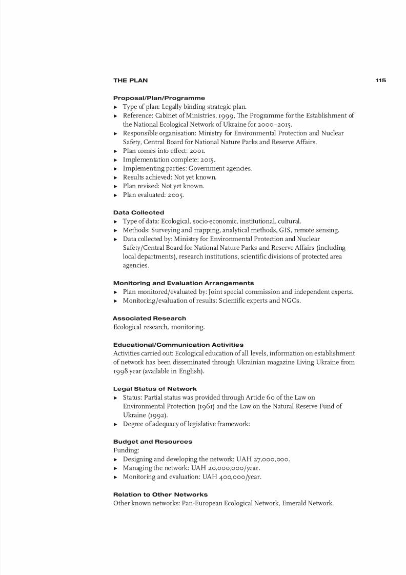
8/6/2019 Development&Application Ecologica Networks UICN
http://slidepdf.com/reader/full/developmentapplication-ecologica-networks-uicn 116/137
THE PLAN
Proposal/Plan/ProgrammeΩ Type of plan: Legally binding strategic plan.
Ω Reference: Cabinet of Ministries, 1999, The Programme for the Establishment of
the National Ecological Network of Ukraine for 2000–2015.
Ω Responsible organisation: Ministry for Environmental Protection and Nuclear
Safety, Central Board for National Nature Parks and Reserve Affairs.
Ω Plan comes into effect: 2001.
Ω Implementation complete: 2015.
Ω Implementing parties: Government agencies.
Ω Results achieved: Not yet known.
Ω Plan revised: Not yet known.
Ω Plan evaluated: 2005.
Data Collected
Ω Type of data: Ecological, socio-economic, institutional, cultural.
Ω Methods: Surveying and mapping, analytical methods, GIS, remote sensing.
Ω Data collected by: Ministry for Environmental Protection and Nuclear
Safety/Central Board for National Nature Parks and Reserve Affairs (including
local departments), research institutions, scientific divisions of protected area
agencies.
Monitoring and Evaluation Arrangements
Ω Plan monitored/evaluated by: Joint special commission and independent experts.
Ω Monitoring/evaluation of results: Scientific experts and NGOs.
Associated Research
Ecological research, monitoring.
Educational/Communication Activities
Activities carried out: Ecological education of all levels, information on establishment
of network has been disseminated through Ukrainian magazine Living Ukraine from
1998 year (available in English).
Legal Status of Network
Ω Status: Partial status was provided through Article 60 of the Law on
Environmental Protection (1961) and the Law on the Natural Reserve Fund of
Ukraine (1992).
Ω Degree of adequacy of legislative framework:
Budget and Resources
Funding:
Ω Designing and developing the network: UAH 27,000,000.
Ω Managing the network: UAH 20,000,000/year.
Ω Monitoring and evaluation: UAH 400,000/year.
Relation to Other Networks
Other known networks: Pan-European Ecological Network, Emerald Network.
115

8/6/2019 Development&Application Ecologica Networks UICN
http://slidepdf.com/reader/full/developmentapplication-ecologica-networks-uicn 117/137
Further Information
Related initiatives: Ukraine is participating in the development of Biosphere Reserves
and Ramsar wetlands, collecting data on the network of Biogenetic Reserves (Councilof Europe) and World Heritage sites, and is commencing work on creating the
Emerald Network and the Pan-European Ecological Network.
35 California, United States:
Conception Coast Project
GENERAL INFORMATION ON THE NETWORK
Location of the Network
The watersheds of the Cuyama/Sisquoc/Santa Maria, the Santa Ynez, the Santa Clara
and the Ventura rivers, the Channel Islands, the Santa Barbara Channel and the
coastal waters on the south-central coast of California.
Responsible Organisations
Conception Coast Project.
Main Objectives of the Network
To protect and restore the ecological integrity of the Conception Coast region through
infusing conservation science into the community through communication and
cooperation and facilitating implementation of a long-term biodiversity protectionstrategy. This will involve:
Ω Restoring large carnivores, ungulates and other focal species native to the region.
Ω Maintaining viable populations of all native species in natural patterns of
abundance and distribution.
Ω Representing and protecting in a system of buffered core reserves all native
ecosystem types and stages of succession across their natural range of variation.
Ω Maintaining ecological and evolutionary processes.
Ω Protecting and restoring functional habitat connectivity.
Ω Eliminating or controlling exotic species.
Ω Accommodating human land use and occupancy consistent with these
requirements.
Main Components of the Network
Ω Core areas.
Ω Corridors.
Ω Buffer zones.
Ecosystems Included in the Network
River basins and coastal ecosystems.
Species Protected Through the Network
Focal species and other rare species.
Natural Resources Exploited Within the Network
Not specified.
116
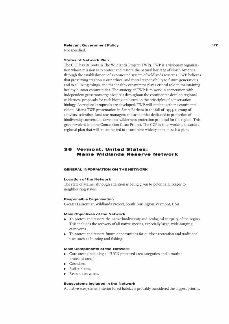
8/6/2019 Development&Application Ecologica Networks UICN
http://slidepdf.com/reader/full/developmentapplication-ecologica-networks-uicn 118/137
Relevant Government Policy
Not specified.
Status of Network Plan
The CCP has its roots in The Wildlands Project (TWP). TWP is a visionary organisa-
tion whose mission is to protect and restore the natural heritage of North America
through the establishment of a connected system of wildlands reserves. TWP believes
that preserving creation is our ethical and moral responsibility to future generations
and to all living things, and that healthy ecosystems play a critical role in maintaining
healthy human communities. The strategy of TWP is to work in cooperation with
independent grassroots organizations throughout the continent to develop regional
wilderness proposals for each bioregion based on the principles of conservation
biology. As regional proposals are developed, TWP will stitch together a continental
vision. After a TWP presentation in Santa Barbara in the fall of 1995, a group of
activists, scientists, land use managers and academics dedicated to protection of biodiversity convened to develop a wilderness protection proposal for the region. This
group evolved into the Conception Coast Project. The CCP is thus working towards a
regional plan that will be connected to a continent-wide system of such a plan.
36 Vermont, United States:
Maine Wildlands Reserve Network
GENERAL INFORMATION ON THE NETWORK
Location of the Network
The state of Maine, although attention is being given to potential linkages to
neighbouring states.
Responsible Organisation
Greater Laurentian Wildlands Project, South Burlington, Vermont, USA.
Main Objectives of the Network
Ω To protect and restore the native biodiversity and ecological integrity of the region.
This includes the recovery of all native species, especially large, wide-ranging
carnivores.
Ω To protect and restore future opportunities for outdoor recreation and traditional
uses such as hunting and fishing.
Main Components of the Network
Ω Core areas (including all IUCN protected area categories and 4 marine
protected areas).
Ω Corridors.
Ω Buffer zones.
Ω Restoration zones.
Ecosystems Included in the Network
All native ecosystems. Interior forest habitat is probably considered the biggest priority.
117

8/6/2019 Development&Application Ecologica Networks UICN
http://slidepdf.com/reader/full/developmentapplication-ecologica-networks-uicn 119/137
Species Protected Through the Network
Ω Mammals:
– American marten Martes americana– Lynx Lynx canadensis
– Eastern timber wolf Canis lupus lycaon
– Eastern cougar Felis concolor
– River otter Lutra canadensis
Ω Birds:
– Northern goshawk Accipiter gentilis
– Red-shouldered hawk Buteo lineatus
– Black tern Chlidonias niger
– Common loon Gavia immer
– Bicknell's thrush Cathanus bicknelli
Ω Fish:
– Atlantic salmon Salmo salar
Natural Resources Exploited Within the Network
Timber, rivers (hydro-electric), minerals/rock.
Relevant Government Policy
None.
Status of Network Plan
In preparation.
Dimensions of the Network Ω Area: 41,000 sq. km (excluding potential buffer zones).
Ω North-south: 490 km.
Ω East-west: 320 km.
Ω Altitude range: 0–1606 m.
Ω Longest distance between core areas: 28 km.
Ω Shortest distance between core areas: 2.2 km.
Ω Areal percentage of core areas in relation to entire network: Greater than 50%.
ENVIRONMENTAL CHARACTERISTICS
Main Environmental Units
Ω Climatic zone: Cool, snow-forest climate (cold, snowy winters and warm,
humid summers).
Ω Phyto-geographical/vegetation zones: Mountain vegetation, tundra, Boreal forests
(taiga), non-Boreal coniferous forests, mixed coniferous/deciduous forests of
temperate latitudes.
Ω River basins/marine areas: Multiple river basins, marine area: Gulf of Maine.
Main Ecosystems Within the Network
Ω Forests: Approx. 70%.
Ω Grasslands: Approx. 5%.
Ω Mountain systems: Approx. 5%.Ω Inland waters and wetlands: Approx. 15%.
Ω Coastal ecosystems: Approx. 5%.
118

8/6/2019 Development&Application Ecologica Networks UICN
http://slidepdf.com/reader/full/developmentapplication-ecologica-networks-uicn 120/137
Main Environmental Functions of the Network
Ω Maintaining or increasing the area of certain habitats.
Ω Maintaining or improving the dispersal, migration and/or genetic exchange of certain species.
Ω Restoring habitat quality.
Ω Protecting threatened, endangered, vulnerable, keystone or umbrella species.
Ω Maintaining or improving hydrological functions.
Ω Conserving valuable landscapes.
NATURAL RESOURCE EXPLOITATION
Main Types of Land and Water Use
Type of Land or System or Sector Main Products or Extent (% area of No. of Persons
Water Use Services network/length) Directly Involved
Ω Arable farming/ Small-scale, intensive Potatoes, b lueberries <10% –
horticulture
Ω Animal husbandry/ – – <10% –
rangelands
Ω Production forestry Managed ‘natural’ – >25% –
forests (secondary forest)
Ω Fisheries Industrial, large-scale, Salmon, clams, trout, – –
c oa st al ; f is h- fa rm in g m us se ls , o ys te rs
Ω Industry/energy Hydropower – – –
production
Ω Recreation/tourism Ecotourism/ nature – – –observation; recreational
hunting/fishing; snow-
mobiling
Ω Habitation – – – Protected areas/
core areas : <1/sq. km;
buffer zones: <1/sq. km
Ω Infrastructure – – – –
Ω Cultural/rel igious – – – –
values
CONFLICTS AND OPPORTUNITIES
Main Conflicts Between Biodiversity Conservation and Other Activities
Ω Private-property proponents: Opposition to any regulation or land purchases.
Ω Timber base: Loss of ‘working forest to protected areas’.
Main Opportunities for Mutually Strengthening Biodiversity
Conservation and Other Activities
Ω Communities: Loss of timber-based economy may result in more ecologically
based industry.
Ω Recreation: Possibilities for increased ecotourism.
119

8/6/2019 Development&Application Ecologica Networks UICN
http://slidepdf.com/reader/full/developmentapplication-ecologica-networks-uicn 121/137
THE PLAN
Proposal/Plan/ProgrammeΩ Type of plan: Independent strategic, regional plan.
Ω Reference: Maine Wildlands Reserve Network: A Science Informed Conservation
Plan for Maine (draft), July 1999.
Ω Responsible organisation: Greater Laurentian Wildlands Project.
Ω Plan comes into effect: Not yet known (public release of plan 2000).
Ω Implementation complete: Not before 2010.
Ω Implementing parties: Multiple parties.
Ω Results achieved: Not yet known.
Ω Plan revised: Continually.
Ω Plan evaluated: Group of independent reviewers.
Data Collected
Ω Type of data: Ecological, socio-economic, institutional, cultural.
Ω Methods: Surveying and mapping, analytical methods, GIS, remote sensing.
Ω Data collected by: Greater Laurentian Wildlands Project.
Associated Research
Various.
Educational/Communication Activities
Planned following publication of plan.
Legal Status of Network Status: No legal status.
Budget and Resources
Ω Funding: Designing and developing network US$50,000.
Ω Available resources: 2 persons, GIS equipment.
Relation to Other Networks
Ω Other known networks: A2A (Algonquin to Adirondacks Conservation Initiative).
Ω Benefits gained from other networks: The experience gained through other
networks associated with The Wildlands Project.
Ω Benefits provided to other networks: Shared information with other Wildlands
Project cooperators.
Further Information
Ω Related initiatives: Part of a planned reserve network for the entire Greater
Laurentian Region (New York, New England, Eastern Canada) which will
eventually connect with other Wildlands Project networks to the South and West.
Ω Additional remarks: The network we propose is very large scale, therefore,
answers provided are estimates only. Further, the network will not be
implemented under one programme or campaign. We are currently fundraising
to contract a socio-economic study of our reserve network design for Maine.
120

8/6/2019 Development&Application Ecologica Networks UICN
http://slidepdf.com/reader/full/developmentapplication-ecologica-networks-uicn 122/137
37 Colombia: Naya Conservation Corridor
GENERAL INFORMATION ON THE NETWORK
Location of the Network
The proposed corridor is located in the northwestern part of the Cauca department
and the southwestern part of the Valle department found in the western Andean
cordillera. The Andean part of the corridor stretches between Tambito (Cauca) to the
south and Aguaclara (Valle) to the north, extending attitudinally from the peaks of the
cordillera, westward to the Pacific Ocean. The Naya river flows from the peaks of
Colombia's Andean western cordillera to the lowlands of the Pacific region and forms
the backbone of the Naya conservation corridor. Coordinates:
Ω North 3° 40’ N–76° 55’ W (Aguaclara), South 2° 30’ N–77° 00’ W (Tambito).
Ω West 77° 32’ W–3° 11’ N (Boca del Naya), East 76° 35’ W–3° 20’ N (Melendez).
Responsible Organisations
Pro-Selva Foundation, Popayan, Colombia; Conservation International–Colombia,
Bogota, Colombia.
Main Objectives of the Network
Ω Conserve biological diversity and ensure its sustainable use.
Ω Provide safe passage for the migration of species and genes between the Tambito
Private Reserve, the Farallones and Munchique national parks.
Ω Provide globally significant benefits from the sequestration of carbon dioxide and
the preservation of species with pharmacological and industrial properties.Ω Enhance the community and cultural cohesion of indigenous and Afro-
Colombian groups inhabiting the Naya river watershed.
Ω Provide environmentally sound development opportunities for local communities.
Main Components of the Network
Ω Core areas: Category II sites. The proposed Naya Conservation Corridor includes
the University of Cauca land concession (located in the Naya river watershed) and
three existing protected areas (the Munchique National Park, Farallones de Cali
National Park and the Tambito Private Reserve) which would bring the protected
land total to 420,000 ha.
Ω Corridors.
Ω Buffer zones.
Ecosystems Included in the Network
Ω The University of Cauca land concession extends attitudinally from the peaks of
Colombia's Andean western cordillera westward to the Pacific Ocean and
encompasses the full range of Chocoan and Andean ecosystems. The Chocoan
ecosystems include the Mangrove, Natal, and Guandal forests and the Andean
ecosystems are dominated by the Basal, Sub-Andean, Andean and High-Andean
forests (i.e. cloud forest). As the altitude increases the trees and their leaves get
smaller and epiphytes become more abundant. Then, at altitudes above 3000 m
the trees of the High-Andean forests are replaced by an endemic and relatively
homogenous ecosystem called the Paramo. The Naya River has its source in theParamo at 4300 m and this ecosystem regulates the amount of water that is used
by local communities living in the lowlands. It should be noted that the High-
Andean forest is extremely important for the water balance, productivity and
climatic behaviour of the region.
121

8/6/2019 Development&Application Ecologica Networks UICN
http://slidepdf.com/reader/full/developmentapplication-ecologica-networks-uicn 123/137
Ω WWF ecoregions: Choco/Darien moist forests (39), Northwestern Andean
montane forests (41).
Species Protected Through the Network
Ω Animals Tremarctos ornatus (flagship species)
Panthera onca (flagship species)
Puma concolor (flagship species)
Felis pardalis
Pandion haliaetus
Felis yagouaroundi
Felis wiedii
Tinamus tao
Spizaetus ornatus
Oroaetus isidori
Falco peregrinusFalco deiroleucus
Rupicola peruviana
Cephalopterus penduliger
Lutra longicaudis
Cerdocyon thous
Ω Plants Cedrela odorata
Juglans neotropica
Podocarpus oleifolius
Podocarpus montana
Swietenia macrofila
Aniba perutilisGorgoglossum spp.
Oreomunnea munchiquensis
Ornitocephalus bisccoglossus
Natural Resources Exploited Within the Network
Timber, fish, gold mining.
Relevant Government Policy
The Naya corridor itself is not included in government policy. However, the two
national parks (Farallones and Munchique) that the corridor will connect are part of
the national park system of Colombia.
Status of Network Plan
A pre-proposal for the design of a management plan for the Naya Conservation
Corridor was developed. Based on this pre-proposal, local communities, the ProSelva
Foundation, Cauca University and Conservation International will develop the final
draft of a proposal for the design of a management plan, with completion due in 2000.
Dimensions of the Network
Ω Area: 420,000 ha.
Ω Altitude range: 0–4300 m.
Ω Longest distance between core areas: Approx. 30 km.
Ω Shortest distance between core areas: Approx. 24 km.Ω Areal percentage of core areas in relation to entire network: 25–50%.
122

8/6/2019 Development&Application Ecologica Networks UICN
http://slidepdf.com/reader/full/developmentapplication-ecologica-networks-uicn 124/137
ENVIRONMENTAL CHARACTERISTICS
Main Environmental UnitsΩ Climatic zone: Tropical, rainy climate.
Ω Phyto-geographical/vegetation zones: Mountain vegetation, tropical rainforests.
Ω River basin: Naya river.
Main Ecosystems Within the Network
Forests: Approx 1.5% of total area (tropical rainforests and Andean forests).
Main Environmental Functions of the Network
Ω Maintaining or increasing the area of certain habitats.
Ω Maintaining or improving the dispersal, migration and/or genetic exchange of
certain species.
Ω Restoring habitat quality.Ω Protecting threatened, endangered, vulnerable, keystone or umbrella species.
Ω Maintaining or improving hydrological functions.
NATURAL RESOURCE EXPLOITATION
Main Types of Land and Water Use
Type of Land or System or Sector Main Products or Extent (% area of No. of Persons
Water Use Services network/length) Directly Involved
Ω Arable farming/ Small-scale, extensive; Subsistence crops: r ice, 10-25% Approx. 10,000
horticulture collective agricultural bananas, plantain,practices chontaduro, sugar cane,
tree fruits, papachina,
coconuts
Ω Animal husbandry/ Traditional, semi- Cows, p igs, chickens <10% Approx. 8,000
rangelands extensive
Ω Production forestry Managed ‘natural’ forests – 10-25% Approx. 10,000
(secondary forest); primary
forests not yet exploited;
managed mangrove
Ω Fisheries Artisanal, small-scale, Sardines – Approx. 10,000
inland; art isanal, small-
scale , coasta l
Ω Industry/energy –
production
Ω R ec re at io n/ to ur is m E co to ur is m/ n at ur e –
observation
Ω Habitation – – – Protected areas or
core areas approx.
2,300; buffer zones
approx . 6,700
Ω Infrastructure – – –
Ω Cultural/rel igious – – – –
values
Productive activities are carried out on a seasonal basis. This means that mining activities are carried out in the dry season and
fishing and agriculture are practised during the wet season. Afro-Colombian and indigenous communities have carried out these
and other practices in a sustainable way. This has contributed to the conservation of the region´s biodiversity.
123

8/6/2019 Development&Application Ecologica Networks UICN
http://slidepdf.com/reader/full/developmentapplication-ecologica-networks-uicn 125/137
CONFLICTS AND OPPORTUNITIES
Main Conflicts Between Biodiversity Conservation and Other ActivitiesΩ Forestry: Deforestation.
Ω Illegal crops: Deforestation, pollution, violence.
Ω Mining: Pollution.
Main Opportunities for Mutually Strengthening Biodiversity
Conservation and Other Activities
Ω Local community council: Design and implementation of the management plan
for the corridor.
Ω Cauca University: Design and implementation of the management plan for the
corridor.
Ω National Parks Unit: Design and implementation of the management plan for the
corridor.
THE PLAN
Proposal/Plan/Programme
Ω Type of plan: Independent initiative.
Ω Reference: Designing and Implementing A Community-Based Management and
Monitoring Plan for the Proposed Naya Conservation Corridor.
Ω Responsible organisations: Pro-Selva Foundation, Conservation International and
Cauca University.
Ω Plan comes into effect: 2000.Ω Implementation complete: Not yet known.
Ω Implementing parties: Pro-Selva Foundation, Conservation International,
Cauca University, Naya Community Council.
Ω Results achieved: Not yet known.
Ω Plan revised: Not yet known.
Ω Plan evaluated: Not yet known.
Data Collected
Ω Type of data: Ecological, socio-economic, institutional, cultural.
Ω Methods: Surveying and mapping, analytical methods, GIS, remote sensing,
workshops.
Ω Data collected by: Pro-Selva Foundation.
Legal Status of Network
Status: No legal status.
124

8/6/2019 Development&Application Ecologica Networks UICN
http://slidepdf.com/reader/full/developmentapplication-ecologica-networks-uicn 126/137
38 Australia:
National Reserve System Program
GENERAL INFORMATION ON THE NETWORK
Location of the Network
The territory of Australia.
Responsible Organisation
National Reserve System Program, Environment Australia, Canberra, Australia.
Main Objectives of the Network
The National Reserve System Program (NRSP) has a national objective to work with
all levels of government, industry and the community to:Ω Establish and manage new ecologically significant protected areas for addition to
Australia's terrestrial National Reserve System.
Ω Provide incentives for Indigenous people to participate in the National Reserve
System through voluntary declaration of protected areas on their lands and
support for greater involvement of indigenous people in the management of
existing statutory protected areas.
Ω Provide incentives for landholders (both private landholders and leaseholders) to
strategically enhance the National Reserve System.
Ω Develop and implement best practice standards for the management of
Australia's National Reserve System.
Other objective:Ω To develop a comprehensive, adequate and representative reserve system of all
'ecosystems' as defined within each State and Territory.
NB: the 'network' is defined as the terrestrial areas of Australia that are potentially
available for inclusion in a comprehensive, adequate and representative reserve
system and managed equivalent to Categories Ia–IV of IUCN's protected area
system.
Main Components of the Network
Ω Core areas: The NRSP requires all funded land acquisitions or covenant
agreements to comply with one of the IUCN protected area categories. Wetlands and
Biosphere reserves are often a component of lands acquired.
Ω Corridors.
Ecosystems Included in the Network
The NRSP utilises the Interim Biogeographic Regionalisation of Australia as its
planning framework to create a National Reserve System. The regions have been
prioritised and efforts are made to concentrate funding on these areas. However, the
objective is to develop a comprehensive, adequate and representative reserve system
of all ecosystems.
Species Protected Through the Network
All Australian flora and fauna/vegetation communities, associations etc. as per State
and Territory scale mapping/description.
Natural Resources Exploited Within the Network
Arable land, grassland, forests, minerals.
125

8/6/2019 Development&Application Ecologica Networks UICN
http://slidepdf.com/reader/full/developmentapplication-ecologica-networks-uicn 127/137
Relevant Government Policy
Australia Natural Heritage Trust Act, Convention on Biodiversity.
Status of Network Plan
The NRSP operates under three plans:
Ω The Natural Heritage Trust Partnership Agreements 1997.
Ω The National Reserve System Operation Plan 1999.
Ω The Scientific Guidelines for Developing a National Reserve System 1999.
Dimensions of the Network
Ω Area: Encompasses continental Australia.
Ω Altitude range: 0–2229 m.
Ω Areal percentage of core areas in relation to entire network: Less than 25%.
ENVIRONMENTAL CHARACTERISTICS
Main Environmental Units
Ω Climatic zones: Tropical, rainy climate; dry climate; warm, temperate, rainy
climate; cool, snow-forest climate.
Ω Phyto-geographical/vegetation zones: Mountain vegetation, mixed
coniferous/deciduous forests of temperate latitudes, deciduous forests of
temperate latitudes, Mediterranean shrub formations, steppe (short grass),
savanna and woodlands, tropical rainforests, monsoon forests (deciduous), dry
tropical forests (semi-deciduous), subtropical forests, desert vegetation, dry and
wet sclerophyll forest, eucalypt woodland, mallee.
Main Ecosystems Within the Network
Ω Forests.
Ω Grasslands.
Ω Mountain systems.
Ω Inland waters and wetlands.
Ω Coastal ecosystems.
Main Environmental Functions of the Network
Ω Maintaining or increasing the area of certain habitats.
Ω Maintaining or improving the dispersal, migration and/or genetic exchange of
certain species.
Ω Protecting threatened, endangered, vulnerable, keystone or umbrella species.
126
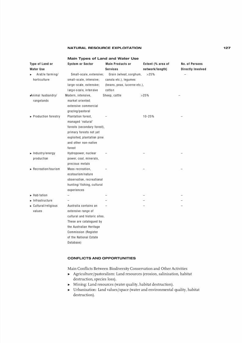
8/6/2019 Development&Application Ecologica Networks UICN
http://slidepdf.com/reader/full/developmentapplication-ecologica-networks-uicn 128/137
NATURAL RESOURCE EXPLOITATION
Main Types of Land and Water UseType of Land or System or Sector Main Products or Extent (% area of No. of Persons
Water Use Services network/length) Directly Involved
Ω Arable farming/ Small-scale, e xtensive; Grain (wheat, s orghum, >25% –
horticulture small-scale, intensive; canola etc.), legumes
large-scale, extensive; (beans, peas, lucerne etc. ) ,
l arg e-s cal e, in ten sive cotto n
ΩAnimal husbandry/ Modern, intensive, Sheep, cattle >25% –
rangelands market or iented;
extensive commercial
grazing/pastoral
Ω Production forestry Plantation forest, – 10-25% –
managed ‘natural’
forests (secondary forest),
primary forests not yet
exploited, plantat ion pine
and other non-native
forest
Ω Industry/energy Hydropower, nuclear – – –
product ion power, coal, minerals,
precious metals
Ω Recreation/tourism Mass recreation, – – –
ecotourism/nature
observat ion, recreat ionalhunt ing/ f ishing, cultural
experiences
Ω Habitation – – – –
Ω Infrastructure – – – –
Ω Cultural/rel igious Australia contains an – – –
values extensive range of
cultural and historic sites.
These are catalogued by
the Australian Heritage
Commission (Register
of the National Estate
Database)
CONFLICTS AND OPPORTUNITIES
Main Conflicts Between Biodiversity Conservation and Other Activities
Ω Agriculture/pastoralism: Land resources (erosion, salinisation, habitat
destruction, species loss).
Ω Mining: Land resources (water quality, habitat destruction).
Ω Urbanisation: Land values/space (water and environmental quality, habitat
destruction).
127

8/6/2019 Development&Application Ecologica Networks UICN
http://slidepdf.com/reader/full/developmentapplication-ecologica-networks-uicn 129/137
Main Opportunities for Mutually Strengthening Biodiversity
Conservation and Other Activities
Ω Agriculture/pastoralism: Protecting remnant vegetation.Ω Forestry: Expand native forest.
Ω Mining: Protecting remnant vegetation.
THE PLAN
Proposal/Plan/Programme
Ω Type of plan: Strategic (NRSP), regional and local plans (prepared by State and
Territory government agencies), management plans (prepared by State, Territory
and NGOs).
Ω Reference: National Reserve System Program Strategic Plan, July 1999;
Environment Australia, Canberra.Ω Responsible organisation: Environment Australia.
Ω Plan comes into effect: 1997.
Ω Implementation complete: 2002.
Ω Implementing parties: Environment Australia.
Ω Results achieved: Not yet known.
Ω Plan revised: Annually.
Ω Plan evaluated: 1999.
Data Collected
Ω Type of data: Ecological (flora and fauna survey, biological inventory,
biodiversity/vegetation analysis/assessment – determination of gaps inState/Territory reserve systems).
Ω Methods: Surveying and mapping, analytical methods, GIS, remote sensing,
verbal communication/expert advise.
Ω Data collected by: State and Territory government agencies.
Monitoring and Evaluation Arrangements
Ω Plan monitored/evaluated by: NRSP.
Ω Monitoring/evaluation of results: NRSP, State and Territory lead agency.
Associated Research
Ω Regional planning, bioregional assessments.
Educational/Communication Activities
Ω Activities carried out: Public education brochure on the programme's function,
press releases, journal articles.
Ω Activities directed at: Broader community knowledge and implementation of the
programme.
Legal Status of Network
Ω Status: All acquisitions funded through the NRSP require legal gazettal of the
land under State/Territory legislation as a protected area and identified IUCN
Category I–IV.
Ω Competent authority: States and Territories.Ω Degree of adequacy of legislative framework: Adequate.
128
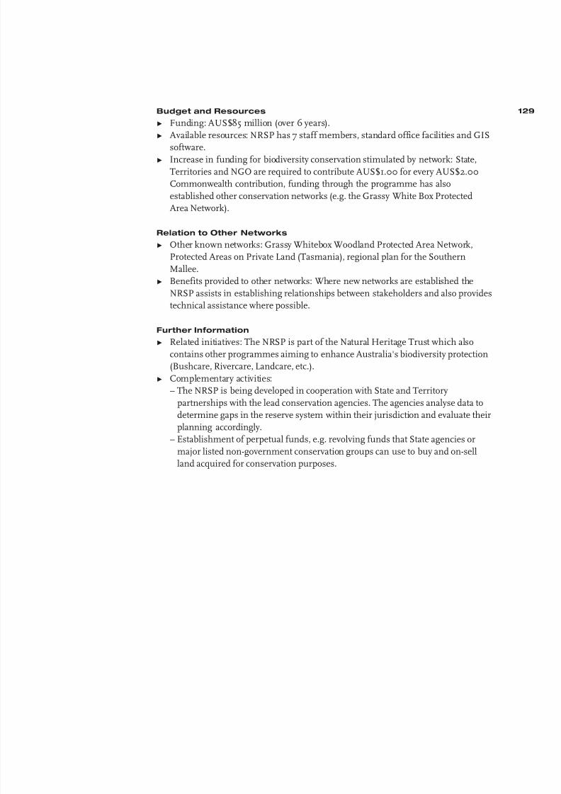
8/6/2019 Development&Application Ecologica Networks UICN
http://slidepdf.com/reader/full/developmentapplication-ecologica-networks-uicn 130/137
Budget and Resources
Ω Funding: AUS$85 million (over 6 years).
Ω Available resources: NRSP has 7 staff members, standard office facilities and GISsoftware.
Ω Increase in funding for biodiversity conservation stimulated by network: State,
Territories and NGO are required to contribute AUS$1.00 for every AUS$2.00
Commonwealth contribution, funding through the programme has also
established other conservation networks (e.g. the Grassy White Box Protected
Area Network).
Relation to Other Networks
Ω Other known networks: Grassy Whitebox Woodland Protected Area Network,
Protected Areas on Private Land (Tasmania), regional plan for the Southern
Mallee.
Ω Benefits provided to other networks: Where new networks are established theNRSP assists in establishing relationships between stakeholders and also provides
technical assistance where possible.
Further Information
Ω Related initiatives: The NRSP is part of the Natural Heritage Trust which also
contains other programmes aiming to enhance Australia's biodiversity protection
(Bushcare, Rivercare, Landcare, etc.).
Ω Complementary activities:
– The NRSP is being developed in cooperation with State and Territory
partnerships with the lead conservation agencies. The agencies analyse data to
determine gaps in the reserve system within their jurisdiction and evaluate theirplanning accordingly.
– Establishment of perpetual funds, e.g. revolving funds that State agencies or
major listed non-government conservation groups can use to buy and on-sell
land acquired for conservation purposes.
129

8/6/2019 Development&Application Ecologica Networks UICN
http://slidepdf.com/reader/full/developmentapplication-ecologica-networks-uicn 131/137
APPENDIX 2. Resolution 1.38 of the World
Conservation Congress, Montreal, 1996:
Ecological Networks and Corridors of Natural
and Semi-Natural Areas
Having regard to the shared responsibility in conserving the Earth's biological
diversity;
Acknowledging that governments, non-governmental organizations and individuals
are making important efforts to conserve this biological diversity but that it is still
under serious threat from the continuing loss and fragmentation of habitats and the
deteriorioration in environmental quality;
Reaffirming the need for government policies to be sustainable and to be developed
and implemented on the basis of collaboration and a common understanding of
problems, needs and priorities;
Recognizing that there is a growing body of experience being gained around the
world by farmers, foresters, indigenous groups, public agencies, and other interested
stake-holders, who are seeking institutional mechanisms that will encourage, enableand empower them cooperatively and voluntarily to manage their bioregions in ways
that ensure their livelihoods and lifestyles, while building stewardship for the
bioregion's biodiversity and protected areas;
Reaffirming the importance of incorporating coherent ecological objectives into all
policies, and particularly those in the fields of nature conservation, environmental
protection, agriculture and land-use planning;
Recognizing the scientific underpinning from the field of conservation biology that
emphasizes the importance of large bioregions in which national parks and other
protected areas are linked by broad connecting habitat or conservation corridors toaccommodate climate change impacts and wide-ranging species;
Noting also that parts of or entire mountain ranges still offer good opportunities to
create wildland bioregional-scale corridors, extending over hundreds or even
thousands of kilometers, such as the southeastern Australia Great Dividing Range,
the Rocky Mountains from Yellowstone to Yukon, and the Andean Bear corridor
from Venezuela to Ecuador;
Recognizing that ecological networks to conserve, restore and complement valuable
protected and non-protected natural and semi-natural habitats are being developed in
many countries around the world as a means of achieving these objectives, such as
the Pan-European Ecological Network (EECONET), the Central American Biological
Corridor, the Western Hemisphere Shorebird Reserve Network, the East Asian-
Australian Shorebird Reserve Network and the network of flyway areas under the
African-Eurasian Waterbird Agreement;
Noting that these ecological networks often contain core areas, buffer zones,
corridors and rehabilitation areas, are adapted to the needs of many kinds of
ecosystems, habitats and species, are applied at different scales, and can
accommodate compatible sustainable land uses and provide various forms of
protection;
130
8/6/2019 Development&Application Ecologica Networks UICN
http://slidepdf.com/reader/full/developmentapplication-ecologica-networks-uicn 132/137
The World Conservation Congress at its 1st Session in Montreal, Canada,
14-23 October 1996:
1. Calls upon all IUCN members to further the development of ecological networks
at national, regional and intercontinental level as a means of strengthening the
integrity and resilience of the world's biological diversity;
2. Requests the Director General, within available resources:
a) to review experience in developing and applying ecological networks;
b) to promote cooperation in the further development of ecological networks at
regional and international level, with a special focus on ecosystems and species
that extend across national frontiers;
c) to report on these issues to the next World Conservation Congress.
131

8/6/2019 Development&Application Ecologica Networks UICN
http://slidepdf.com/reader/full/developmentapplication-ecologica-networks-uicn 133/137
First published by:
AIDEnvironment, Amsterdam
Designed by:
Marc Hegemans, Haarlem
© 2001 AIDEnvironment
132

8/6/2019 Development&Application Ecologica Networks UICN
http://slidepdf.com/reader/full/developmentapplication-ecologica-networks-uicn 134/137
1
Figure 1 The Netherlands
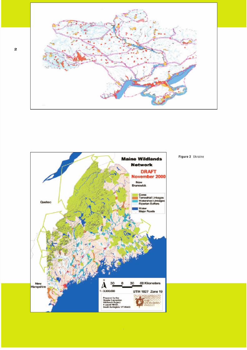
8/6/2019 Development&Application Ecologica Networks UICN
http://slidepdf.com/reader/full/developmentapplication-ecologica-networks-uicn 135/137
2
Figure 2 Ukraine
Figure 3 Maine Wildlands Network

8/6/2019 Development&Application Ecologica Networks UICN
http://slidepdf.com/reader/full/developmentapplication-ecologica-networks-uicn 136/137
3
Figure 4 The Mesoamerican Biological CorridorFigure 5 Naya River Watershed

8/6/2019 Development&Application Ecologica Networks UICN
http://slidepdf.com/reader/full/developmentapplication-ecologica-networks-uicn 137/137
4
Figure 6 Poland
Figure 7 The Transnational Ecological Network