cruising the canal everything you always wanted to know about
TRANSCRIPT

“DO THE DISMAL” We highly recommend it!!!
Cruise the oldest continually operating hand-dug waterway in the country. Enjoy beautiful scenery, free dockage, and “convenience” stops. The Deep Creek, VA, lock is located about 11 miles from Hospital Point and Waterside Marina, off the southern branch of the Elizabeth River. There is an anchorage in a cove about 2 miles north of the lock and a FREE DOCK between the lock and the highway bridge. On the south side of the bridge, there are cleats on the east bulkhead. A nearby shopping strip offers various shopping opportunities
From Deep Creek to the southern lock at South Mills, NC, is 22 miles, where boats can tie up to the west bulkhead and visit a convenience store with food service. The Welcome Center, located 17 miles south of Deep Creek and 5 miles north of South Mills, offers FREE DOCKAGE, potable
water, picnic tables, grills, and clean restrooms open 24 hours/day. A friendly staff, Book Ex-change, Boater’s Log, NC Coastal Boating Guide, vid-eos on the Dismal Swamp Canal, and a small GIFT SHOP are also available. An 18-mile trip along the beautiful Pasquotank River ends at Elizabeth City, “Harbor of Hospital-ity” and home of the famous Rose Buddies. The City offers 48 hours of FREE DOCKAGE.
BOTH LOCKS OPERATE ON THE
SAME SCHEDULE:
8:30am, 11:00am, 1:30pm and 3:30pm
NOTE: Locking times vary in times of drought. NOTE: Welcome Center monitors channels 13 & 16 for navigation
Cruising the Canal Everything you always wanted to know about the
GREAT DISMAL SWAMP and DISMAL SWAMP CANAL
Dismal Swamp Canal Welcome Center 2356 US Highway 17 North
South Mills, NC 27976 252.771.8333 ~ 877.771.8333
[email protected] www.dismalswampwelcomecenter.com
DISMAL SWAMP CANAL WELCOME CENTER
“Your Information Center for Northeastern NC”
The Dismal Swamp Canal Welcome Center is located in Camden County on US Highway 17, approximately 18 miles north of Elizabeth City, NC, and 3 miles south of the NC/VA line. Camden County is adjacent to the Hampton Roads, VA, metropolitan area (Norfolk, Virginia Beach, Chesapeake, Portsmouth, Suffolk, Newport News, and Hampton), only a short distance from Williams-burg, Jamestown and Yorktown. The county is con-veniently located near the beaches of North Caro-lina’s Outer Banks (Corolla, Duck, Kitty Hawk, Kill Devil Hills, Nags Head, Hatteras, and Ocracoke).
CAMDEN COUNTY, NC “An Opportunity Awaits You”
Entered in the National Register of Historic Places Designated a National Historic Civil Engineering Landmark Recognized as part of the National Underground Railroad Network
to Freedom Program Part of North Carolina Civil War Trail

The Dismal Swamp Canal, which connects the Eliza-beth River in Virginia and the Pasquotank River in North Carolina, is the oldest continually operating canal in the United States. Now a historic landmark, the canal has experienced numerous changes and periods of prosperity and neglect. The Dismal Swamp posed a formidable obstacle to early settlers and explorers. In 1728, Colonel Wil-liam Byrd II of Virginia noted the hazards of traveling in the swamp, describing it as a “vast body of dirt and nastiness.” His miserable experience prompted him to consider a canal that would connect the Albemarle Sound to the Elizabeth River. George Washington and five fellow inves-tors saw the rich potential of Dismal Swamp timber and invested in 40,000 acres of swampland. By 1764, the Virginia Assembly had given this company permission to build a canal, if needed, to remove timber, but only a preliminary ditch was dug. The re-turn on Washington’s investment was not what he had hoped and by 1795 he had withdrawn his interest. By this time, plans were underway for a canal that would allow trade between Vir-ginia and the relatively isolated region of northeastern North Carolina. In 1784, Governor Patrick Henry of Virginia pro-posed a canal, and in 1784, the Dismal Swamp Canal Company was created. Dig-ging by hired slave labor began in 1793 and pro-gressed slowly. A road running parallel to the canal was completed in 1804 and by 1805 flat-bottomed vessels could be admitted into the 22-mile long ca-nal. Tolls were charged for road and canal traffic to allay the continual expense of improvements and maintenance. Before the advent of the steam en-gine, the shortage of laborers to dig the canal was a persistent problem; it was backbreaking work under highly unfavorable conditions. The first Dismal Swamp roadhouse was established
History of the Dismal Swamp Canal in 1802, approximately 2-1/2 miles south of the North Carolina/Virginia border. This inn and the Lake Drum-mond Hotel or Halfway House (established in 1829) be-came an infamous rendezvous for lovers wanting to take advantage of the lenient North Carolina marriage laws and fugitives seeking the isolation of the swamp. These houses were notorious as sites of duels and lover’s trysts. By 1820, the canal was recognized as an important part of commercial traffic between Virginia and North Carolina. In 1826, the United States government acknowledged this
by purchasing 600 shares of Dismal Swamp Canal Com-pany stock, which made needed improvements possible. Prior to 1829, the canal was limited to flat-bottomed ves-sels, but with improvements, enough water could be re-leased to accommodate deeper drafts. The canal and nearby towns saw a period of prosperity from 1830 -1860. The 1860s and the onset of the Civil War put the canal in an important strategic position for Union and Confederate forces. For Confederates caught in the Union blockade of coastal North Carolina in 1862, the canal offered a convenient supply route to Confeder-
ate strongholds in Virginia. The wartime activity left the canal in a terrible state of repair. The Canal Company requested assistance from the federal government but this was to no avail, and the canal was sold in 1878. Although the canal had some traffic in the 1870 -1890 period, it could not compare to its previous prosperity. The repairs and maintenance needed by the canal made travel difficult, if not hazardous.
A new era for the canal came in 1892 when the Lake Drummond Canal and Water Company assumed operations. This com-pany launched rehabilitation efforts in 1986 and by 1899 the first vessels were admitted into the “new” Dismal Swamp Canal. Once again, a steady stream of vessels carrying lumber, farm products, and passengers made the canal a bustling interstate thor-oughfare. With 20th century improvements in modes of transportation, the canal gradually en-tered another bleak period in its history. By the 1920s, commercial traffic had sub-sided except for passenger vessels. The infrequent use and poor maintenance of the canal resulted in its sale in 1929 to the fed-eral government for $500,000. The canal was then and is today operated and main-tained by the U.S. Army Corps of Engi-neers.
Though once a vital commercial link from Virginia to North Carolina, the canal is quieter now and plays host to pleasure boaters on the Atlantic Intracoastal Waterway. Its designation as a National Historic Landmark serves to remind canal visitors of its contri-butions to the economic and social development of northeastern North Carolina. It’s inclusion into the National Register of Historic Places, designation as a National Civil Engineering Landmark, and recognition as part of the National Underground Railroad Net-work to Freedom Program, are honors worthy of it’s colorful past.

Dismal Swamp Canal Welcome Center In April 1989, the NC Dept. of Transportation be-came pioneers in the travel industry with the open-ing of the Dismal Swamp Canal Welcome Center. It is the first Visitor/Welcome Center built off an In-terstate in our state and the only such facility in the country greeting visitors by both a major highway and historic waterway. Over 600,000 travelers visit the Center each year by highway, while nearly 2,000 boats transit the waterway annually. EDUCATION ON NORTH CAROLINA Maps and publications are available for assistance in planning trips or vacations in the state. A knowl-edgeable staff is ready and willing to be of assistance. EDUCATION ON REGION Several brochures are available on the Dismal Swamp environs, along with two videotapes. Staff will make special presentations to groups when noti-fied in advance. NATURE TRAIL At the north end of the property, a short quar-ter-mile Nature Trail is available for stretching the legs and observing local flora and fauna. Beginning behind the last picnic table, the trail me-anders along the Dismal Swamp Canal, then back through the trees to the parking lot. Ten native trees are identified along the trail: Sassa-fras, Sweet Gum, Pignut Hickory, Red Mulberry, Black Cherry, Virginia Red Cedar, Red Maple, Syca-more, Loblolly Pine, and Pin Oak. A couple of benches provide a shady respite overlooking the waterway. NOTE: A Bird List is available in the Welcome Center.
DISMAL SWAMP CANAL TRAIL Located at the south end of the site, the 4.5 mile long trail is about 10’ wide with a hard surface. It meanders along the canal for approximately three miles before becoming a 5’ extension of Hwy. 343 and Mullen Road, to the South Mills bridge. It is handicapped accessible and birder friendly, offering picnic tables and benches. The trail is a great place for hik-ing, biking, photography and birding. It is a part of the North Carolina Birding Trail, East Coast Greenway and National Recreation Trail. Trail Do’s
Hiking, biking, birding, photogra-phy, picnicking, fishing (NC fish-ing license), rollerblading, and dogs on leash, are permitted. Trail Don’ts
Motorized vehicles, skateboards, alcohol, swimming, camping, open fires, littering, and projectiles, are pro-hibited. Wildlife
Bobcats, bears, snakes, deer, birds, nutria, fox, butter-flies, ‘possums, raccoons, and otters, might be seen. NOTE: BIKES ARE AVAILABLE AT THE WELCOME CENTER FOR USE ON THE TRAIL
PADDLING ON THE CANAL Access is provided for both canoes and kayaks be-side the pedestrian bridge adjacent to the southern parking lot. The site is located 5 miles north of the South Mills locks and 17 miles south of the Deep Creek locks. The 3-mile long Feeder Ditch into Lake Drummond is 7 miles north of the Center. DISMAL SWAMP STATE PARK Adjacent to the Welcome Center to the south, the NC Division of Parks & Recreation has developed the Dismal Swamp State Park, ac-cessed by a pedestrian swing bridge across the Dismal Swamp Canal. A 6,500-square-foot Visitor Center serves to open the Great Dismal Swamp to public use. The Center contains a recep-tion area, exhibit area, auditorium, administrative offices, and inside and outside classrooms. Board-walks and hiking trails are adjacent to this area.
NOTE: State Park monitors channel 13 for navigation DISMAL SWAMP GIFT SHOP Where else in the country could you purchase a shirt that says “I survived the Dismal Swamp Canal”?
Other T-shirts are available, along with a selection of hats and denim shirts. Various addi-tional items for sale include: books on the swamp and canal, navigational books, jewelry, hat pins, magnets and sundry items.
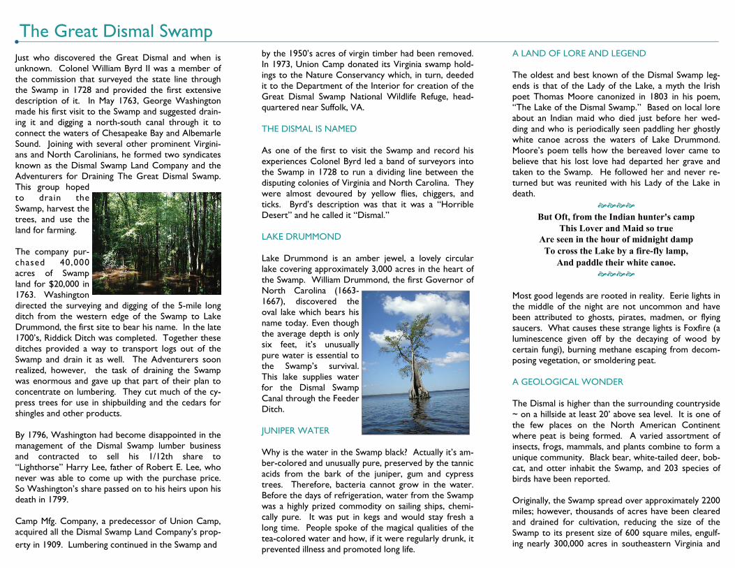
Just who discovered the Great Dismal and when is unknown. Colonel William Byrd II was a member of the commission that surveyed the state line through the Swamp in 1728 and provided the first extensive description of it. In May 1763, George Washington made his first visit to the Swamp and suggested drain-ing it and digging a north-south canal through it to connect the waters of Chesapeake Bay and Albemarle Sound. Joining with several other prominent Virgini-ans and North Carolinians, he formed two syndicates known as the Dismal Swamp Land Company and the Adventurers for Draining The Great Dismal Swamp. This group hoped to drain the Swamp, harvest the trees, and use the land for farming. The company pur-chased 40,000 acres of Swamp land for $20,000 in 1763. Washington directed the surveying and digging of the 5-mile long ditch from the western edge of the Swamp to Lake Drummond, the first site to bear his name. In the late 1700’s, Riddick Ditch was completed. Together these ditches provided a way to transport logs out of the Swamp and drain it as well. The Adventurers soon realized, however, the task of draining the Swamp was enormous and gave up that part of their plan to concentrate on lumbering. They cut much of the cy-press trees for use in shipbuilding and the cedars for shingles and other products. By 1796, Washington had become disappointed in the management of the Dismal Swamp lumber business and contracted to sell his 1/12th share to “Lighthorse” Harry Lee, father of Robert E. Lee, who never was able to come up with the purchase price. So Washington’s share passed on to his heirs upon his death in 1799. Camp Mfg. Company, a predecessor of Union Camp, acquired all the Dismal Swamp Land Company’s prop-erty in 1909. Lumbering continued in the Swamp and
The Great Dismal Swamp by the 1950’s acres of virgin timber had been removed. In 1973, Union Camp donated its Virginia swamp hold-ings to the Nature Conservancy which, in turn, deeded it to the Department of the Interior for creation of the Great Dismal Swamp National Wildlife Refuge, head-quartered near Suffolk, VA. THE DISMAL IS NAMED As one of the first to visit the Swamp and record his experiences Colonel Byrd led a band of surveyors into the Swamp in 1728 to run a dividing line between the disputing colonies of Virginia and North Carolina. They were almost devoured by yellow flies, chiggers, and ticks. Byrd’s description was that it was a “Horrible Desert” and he called it “Dismal.” LAKE DRUMMOND Lake Drummond is an amber jewel, a lovely circular lake covering approximately 3,000 acres in the heart of the Swamp. William Drummond, the first Governor of North Carolina (1663-1667), discovered the oval lake which bears his name today. Even though the average depth is only six feet, it’s unusually pure water is essential to the Swamp’s survival. This lake supplies water for the Dismal Swamp Canal through the Feeder Ditch. JUNIPER WATER Why is the water in the Swamp black? Actually it’s am-ber-colored and unusually pure, preserved by the tannic acids from the bark of the juniper, gum and cypress trees. Therefore, bacteria cannot grow in the water. Before the days of refrigeration, water from the Swamp was a highly prized commodity on sailing ships, chemi-cally pure. It was put in kegs and would stay fresh a long time. People spoke of the magical qualities of the tea-colored water and how, if it were regularly drunk, it prevented illness and promoted long life.
A LAND OF LORE AND LEGEND The oldest and best known of the Dismal Swamp leg-ends is that of the Lady of the Lake, a myth the Irish poet Thomas Moore canonized in 1803 in his poem, “The Lake of the Dismal Swamp.” Based on local lore about an Indian maid who died just before her wed-ding and who is periodically seen paddling her ghostly white canoe across the waters of Lake Drummond. Moore’s poem tells how the bereaved lover came to believe that his lost love had departed her grave and taken to the Swamp. He followed her and never re-turned but was reunited with his Lady of the Lake in death.
But Oft, from the Indian hunter's camp
This Lover and Maid so true Are seen in the hour of midnight damp
To cross the Lake by a fire-fly lamp, And paddle their white canoe.
Most good legends are rooted in reality. Eerie lights in the middle of the night are not uncommon and have been attributed to ghosts, pirates, madmen, or flying saucers. What causes these strange lights is Foxfire (a luminescence given off by the decaying of wood by certain fungi), burning methane escaping from decom-posing vegetation, or smoldering peat. A GEOLOGICAL WONDER The Dismal is higher than the surrounding countryside ~ on a hillside at least 20’ above sea level. It is one of the few places on the North American Continent where peat is being formed. A varied assortment of insects, frogs, mammals, and plants combine to form a unique community. Black bear, white-tailed deer, bob-cat, and otter inhabit the Swamp, and 203 species of birds have been reported. Originally, the Swamp spread over approximately 2200 miles; however, thousands of acres have been cleared and drained for cultivation, reducing the size of the Swamp to its present size of 600 square miles, engulf-ing nearly 300,000 acres in southeastern Virginia and