conservation area character appraisals - holyhead area · original conservation area boundary ......
TRANSCRIPT

Conservation area character appraisals Beaumaris area Adopted 14 December 2006 Copyright Maps in this document are based upon the Ordnance Survey mapping with permission of the Controller of Her Majesty's Stationery Office © Crown Copyright. Licence No LA09001L For further information contact the Built Environment and Landscape Section Old photographs and maps © Archive Service, Isle of Anglesey County Council and The Department of Archives and Manuscripts, University of Wales Bangor. Permission must be sought from the Council before reproducing any part of the document.

Contents Executive Summary Location Plan Original Conservation Area Boundary Article 4 Direction Area Boundary Boundary Review and Recommendations 1. Introduction 2. Conservation area 3. Community 4. Date designated 5. Reason designated 6. Location 7. Area covered Conservation area Article 4 direction area 8. Setting 9. Historical background Population Change Archaeology 10. Open spaces Trees and hedgerows 11. Townscape Burgage plots Views 12. The local economy 13. Physical fabric Local building material and styles 14. Principal buildings 15. Positive and negative elements 16. Appendices

Executive summary This Conservation Area Character Statement will become a working Supplementary Planning Guidance (SPG) upon adoption. It supports Ynys Môn Local Plan 1996 (Policy 40) and the stopped Unitary Development Plan (Policy EN13) which states that the character and appearance of all designated Conservation areas will be protected from unsympathetic development. Enhancement of their character will be achieved by carrying out improvements and permitting suitably designed new development. This document will be a material consideration in the determination of planning applications. Unlawful developments may result in enforcement action being taken. Circular 61/96 (paragraph 20) states that the quality of place should be the prime consideration in identifying, protecting and enhancing Conservation areas. This depends on more than individual buildings. It is recognised that the special character of a place may derive from many factors, including: the grouping of buildings, their scale and relationship with outdoor spaces, architectural detailing, and so on. Planning Policy Wales 2002 (paragraph 6.5.15) states that if any proposed development would conflict with the objective of preserving or enhancing the character or appearance of a Conservation area, or its setting, there will be a strong presumption against the granting of planning permission. Summarised below are elements that contribute to the character and appearance of the Beaumaris Conservation area and Area of Article 4 Direction requiring preservation or enhancement. History
The town originated in 1295 with the building of the Castle by Edward I.
Beaumaris Castle is of international importance.
The town developed under the burgage plots system which is still evident today.
The sea continues to play an important role in the growth and prosperity of the
town.
The Tudor Period saw great physical change in the town.
Many of the town’s finest buildings were erected in the early nineteenth century including; Green Edge, Bulkeley Arms Hotel, Victoria Terrace, and Baron Hill.

Setting
The core of the medieval town is formed by four streets.
The beginning of the eighteenth century saw the formation of much of the present day character of the town.
The historic town has a high concentration of protected buildings.
Land reclamation has continually altered the town's coastline.
There are important amenity trees within the Conservation area.
Beaumaris Castle has been designated as part of a World Heritage Site.
The setting of the castle is enhanced by the adjacent Baron Hill park land.
There are panoramic views of the Snowdonia range across the Strait that are
deemed worthy of protection (See 11. TOWNSCAPE 'Views'). The area lies within Anglesey’s AONB, SSSI and Penmon Historic Landscape.
Architecture
The town has a diverse range of architectural styles.
There is a wide range of building ages.
The varying roofs are an extremely important characteristic of the town.
Front elevations are predominantly painted render although there are good examples of both stone and red brick faced buildings.
Dormer windows, porches, canopies, pediments, fanlights, stone boundary
walls, and decorative ironwork are all common features which play an important role in forming the character of the town.
Fine examples of original shop fronts still survive.
Many of the buildings have the elegance and proportions of the late Georgian
and Regency period, with small panes and narrow glazing bars. Boundary review and recommendations (See Appendices I, II and III) The character and quality of the streetscape of the historic town of Beaumaris is formed by a combination of the built form, the wealth of architectural detail (that

reflect the different periods and development of the town), and the spaces (both open and enclosed) that the inter-relationship between the buildings creates. The potential impacts on, and threats to, the character of the Conservation area are therefore dependent on all buildings, and open spaces, that have an influence on the spaces and streets within the boundaries of the Conservation area. The re-evaluation of the current boundary of the Conservation area has identified locations where the boundary excludes buildings or features that are integral to the quality and form of the setting of the Conservation area itself. It has also identified areas of new development that do not preserve or enhance the character or appearance of the area. These proposed additions and deletions to the Conservation area are described below. Important note: A review of the Article 4 Area Direction boundary does not form part of this document. The historic Pier forms an important element in the visual quality of the town and has significant impact on the Conservation area directly from the Green, the sea, and from the western approach to the town. It is recommended that the boundary be amended to include the Pier. The Chapels of Rest and the old lower Cemetery (which include fine examples of specimen trees that contribute to the area) situated on the western approach to the town provide an important visual containment to the town’s western boundary. The adjacent stone wall bounded historic road delineates the old from the new (Cae Mair) and offers views towards the sea, town, and mainland. It is proposed that the boundary be redrawn so as to encompass the Chapels of Rest and lower cemetery as well as a length of the adjacent road. It is recommended that the boundary be amended to include the above. A re-evaluation of the boundary that presently includes the modern development of Britton’s Hill property would suggest that the boundary be re-drawn to omit this property. It is recommended that the boundary be amended to omit this property. The post-Conservation area designation residential garages off Arnold Close to the rear of No’s 65-70 New Street and Long Cottage development do not preserve or enhance the character or appearance of the area. It is recommended that the boundary be amended to omit these developments. The post-Conservation area designation Gerddi Stanley estate development requires the boundary to be redrawn so as to follow the new physical features/property borders. It is recommended that the boundary be amended to omit this new development. A re-evaluation of the boundary line that presently includes; No's 1 and 3 Maes Hyfryd, row of residential garages to rear, and the modern Telecom Exchange would suggest that the boundary should be redrawn to omit these properties. It is proposed to terminate the boundary at the formal Gate Piers and flanking historic brick walls

(inclusive) of the Lodge entrance to Stanley Street. It is recommended that the boundary be amended to omit the above properties. In order to preserve or enhance the special character of the Conservation area every effort should be made to ensure that future developments should have regard to the existing; materials, style, size, scale, roof and building line so as to be sympathetic to their surroundings. The important views and open spaces that exist should be preserved. 1. Introduction Conservation areas were created by the Civic Amenities Act of 1967 when it was decided that listing historic buildings individually was not enough to protect groups of buildings, which although not individually listed contributed to the character of the place as a whole, and their setting. It was also realised that the spaces between buildings, and trees, were also important elements and it was decided to protect whole areas to be called Conservation Areas. The Planning (Listed Buildings and Conservation Areas) Act 1990 requires local authorities to designate as Conservation areas “Any area of special architectural or historic interest the character or appearance of which it is desirable to preserve or enhance”. It is the character of areas, rather than individual buildings that the Act seeks to preserve or enhance. Conservation area designation should be seen as the prime means of recognising, protecting and enhancing the identity of places with special character. Quality of place should be the prime consideration in identifying Conservation areas although there can be no standard specification for Conservation areas. Designating a Conservation area does not prevent future change to buildings and their surroundings. It does mean, however, that the local planning authority when considering planning applications, including those which are outside a Conservation area but would affect its setting, must pay special regard to whether the proposed changes “preserve or enhance the character or appearance of the Conservation area”. The designation should enable the character of the area to be retained and controlled, ensuring that any new development is sympathetic to both the special architectural and historic interest of the area, but without affecting its function or prosperity. If a proposal involves the total or substantial demolition of a structure or a building within the Conservation area then “Conservation Area Consent” from the local authority will be required. Otherwise development in Conservation areas is dealt with through the normal planning application process. Subject to some exceptions trees are protected in Conservation areas and anyone proposing to cut down, top or lop a

tree is required to give 6 weeks written notice to the local planning authority before carrying out any work. Under section 69 of the Act there is a duty on local authorities to review their areas from time to time and to consider whether further designation of Conservation areas is called for. It is only by understanding the elements that contribute to the character and appearance of an area can we aspire to “preserve or enhance” it. Anglesey County Council is producing a character appraisal for each of the island’s Conservation areas. These character appraisal documents will form the basis, along with policies set out in the Ynys Môn Local Plan and the stopped Unitary Development Plan, for aiding development control within Conservation areas. Guidance on general policies that are material considerations in the determination of all planning applications in Conservation areas are included in Policy 40 Ynys Môn Local Plan (and also Policy EN13 of the stopped Unitary Development Plan). The historic core (built up area) of Beaumaris has the added protection of an Article 4 Direction. The Council has by issuing an Article 4 Direction removed permitted development rights. These are the rights that people have to extend or alter their property without first obtaining planning permission. By removing these rights, planning permission will be required for specific minor developments (which otherwise may not need permission) such as the replacement of windows or alterations to boundary walls (See Appendix IV). If rights are unchecked, allowing changes to windows, doors, and additions such as porches and general lack of attention to detail, the ‘special interest’ of a Conservation area could be undermined and eroded. The Beaumaris Article 4 Direction was obtained in 1971 under Article 4 Direction of the Town and Country Planning General Development Order 1963. However, today such Directions are made under Article 4 of the Town and Country Planning (General Permitted Development) Order 1995. The aim of an Article 4 Direction is to encourage the retention of high quality architectural features on buildings and to preserve and enhance the Conservation area of which they are part. ‘Like for like’ repairs and reinstatement of architectural features will be encouraged, along with the removal of previously unsympathetic changes to buildings. Beaumaris Castle, being part of The Castles and Town Walls of Edward I in Gwynedd, was inscribed in the list of World Heritage Sites (WHS) as a historic site of universal value in 1986. The castle has had to its essential setting since November 2004, the added protection of a WHS Management Plan Contract and development Buffer Zone. (See Appendix V) ICOMOS-UK have issued Guidelines for Definition of Boundaries of Buffer Zones following a request from UNESCO. The following local factors have been defined: Essential setting, inappropriate development and significant views.

Policy EN11 of the stopped UDP states that only development which protects or enhances the appearance of the Beaumaris Castle World Heritage Site and respects its essential setting will be permitted. 2. Conservation area Beaumaris 3. Community The Conservation area lies within the community of Beaumaris. 4. Date designated Beaumaris was designated as a Conservation Area in October, 1968. Additional planning control was obtained to the historic core in 1971 under Article 4 Direction of the Town and Country Planning General Development Order 1963. 5. Reason designated Beaumaris, which is of National and International historic importance, is rich in history and retains much of its medieval street pattern. Its setting, diversity of architectural styles and periods, differing scale, open spaces, varying roofs, and overall quality all contribute greatly to the town’s character. Whilst several of the town’s buildings are individually listed it is the overall streetscape and open spaces that make the major contribution to the qualities of the area and therefore is considered worthy of protection and enhancement. 6. Location Beaumaris (Grid Ref.: 605 751) lies on the Menai Strait on the south-eastern shore of Anglesey. 7. Area covered See Appendices I, II and III Conservation Area Boundary The Conservation Area boundary runs northwards from Baron Hill through the woodlands until it turns, firstly eastwards to follow the field fence line, and then south-eastwards in a line past the outer edge of Coed Crwn-y-Castell up to the Mean High Water mark on the coast. The boundary then follows the coast and sea wall to the Pier and onwards past West End on the A545 up to the edge of Gallows Point

(not inclusive). It then turns back towards the town following the back of the tree line before cutting northwards at the Rectory along the rear of property boundaries up to the old Baron Hill drive bridge (inclusive). The boundary then alternates in a general north-easterly direction along property boundaries and New Street. From the junction with Gaol Street the boundary heads west and then north to No. 67 Wexham Street. From here it runs westwards along the B5109 Pentraeth Road turning north at the Baron Hill entrance drive bridge back towards the house. The total area covered is approx. 811,911m². Article 4 Area Boundary The Article 4 Area boundary follows a much tighter line around the historic core of the town excluding; Baron Hill, Castle Meadow, the Green, and extending only as far west as the Rectory. Having encompassed the Castle and Mountfield the Article 4 Area boundary follows the B5109 road along the front of Victoria Terrace and then onwards along the sea wall to the Rectory. From the Rectory it too, like the Conservation area boundary, cuts northwards along property boundaries and New Street until, after reaching the junction with Gaol Street, undulates in a westerly and northerly direction to terminate at No. 67 Wexham Street. The total area covered is approximately 227,729m². 8. Setting Beaumaris benefits from an idyllic setting. The town stands on the south-eastern shore of the Isle of Anglesey near the north-eastern entrance of the Menai Strait facing, at low tide the glistening sandbanks of Traeth Lafan (Lavan Sands) and, the Snowdonia mountain range to the south. Severed from the mainland by the narrow trench of the Menai Straits the insular and predominantly low lying county of Anglesey presents a marked physical contrast to the high peaked massif of Snowdonia. Situated within sight of the approaches to Conwy the site of the new borough (Beaumaris) was both attractive and practical. It offered a navigable inner passage to Caernarfon and refuge to ships sailing to and from Ireland. Here also the track across Traeth Lafan conveniently almost reached the Anglesey Shore. Geology: The underlying solid geology within the Conservation area is shale overlain by glacial deposits of boulder clay with shingle to shoreline. Landscape: The Conservation area lies on a level coastal plain close to sea level at the sheltered eastern end of the Menai Straits. The dominant landscape feature within the Conservation area are the natural coastal mound, the 18th century park land and wooded backdrop of Baron Hill, and the Green open space on the shoreline. The Conservation area lies within Local Character Area 8 of the Ynys Môn Landscape Strategy (1999), which is based on the Countryside Council for Wales

LANDMAP approach. This establishes a standard methodology for assessing landscape character across Wales. Most of the Conservation area lies within Anglesey’s Area of Outstanding Natural Beauty (AONB). The area between mean high and mean low water immediately to the north-east of the castle is designated as Glannau Penmon-Biwmares Site of Special Scientific Interest (SSSI). The area of park land north of the castle has been designated as Baron Hill Park SSSI for the lichens that grow on its trees. Adjacent to the castle the Menai Strait below mean high water is a recently designated Special Area of Conservation (cSAC) whilst the Menai Strait has been proposed as a Marine Nature Reserve. Beaumaris Castle, a part of a World Heritage Site has, since November 2004, the added protection of a development Buffer Zone. The Penmon Historic Landscape is included in the Register of Landscapes of Outstanding Historic Interest in Wales for its evidence of continuity of land use and activity from the late prehistoric period to the recent past. (See Appendices V and VI) 9. Historical background One of the earliest evidence of occupation in the area came with the finding nearby of a late Bronze Age axe (c.750 B.C.). The axe has become known as The Beaumaris Axe. The ancient crossing point of the ferry across Lavan Sands (Traeth Lafan) to the mainland is believed to lay somewhere opposite Mount Field. It is thought not inconceivable that it was at this point that the Roman General Suetonius Paulinus in A.D. 64 made his invasion of the Druid stronghold of Mona (Anglesey) so graphically described by the historian Tacitus. During the ninth and tenth centuries this corner of Anglesey received devastating attacks by both the Vikings, who were attracted by the wealth of the monastery at Penmon, and by Egbert the Saxon King. Further conflict came in 1096 when the English, headed by the Earls of Chester and Shrewsbury, held the island in subjection until the arrival of a Norwegian force, under Magnus, compelled them to withdraw. By the 13th century the area included two townships: Llan-faes to the north and Cerrig-y-gwyddyl to the south-west. In 1237 Llywelyn the Great founded a Franciscan friary about a mile to the north. Gallows Point headland, found to the south-west of the town, was earlier called Osmond’s Air by the Norse (a combination of the personal name Asmundr and the Norse word ‘eyrr’ meaning a gravel bank near the sea). In Welsh it was called Penrhyn Safnas, which derives from Pen ryn Savyn ast (the headland of the bitch’s mouth), presumably because the bay resembled the open mouth of a bitch. Its English name suggests that either the bank resembled a gallows or a gallows once stood there.

The Beaumaris Ferry was originally situated on the Green at a point called Ferryman’s Warth. In 1562 it passed to the burgesses of Beaumaris in perpetuity under the terms of the Royal Charter of that year. At some point before 1694 it was moved to Gallows Point. After the subjection of Wales, in the later thirteenth century, castellated boroughs were created among which was Beaumaris. In April 1295 Edward I ordered his mason-architect James of St George to build, on a flat marshy spot in the township of Cerrig-y-gwyddyl, a Castle to which he gave the name Bellum Mariscum - Beautiful Marsh. The name Beaumaris derives from Norman French the then language of the court. By 1296 work on the new town had progressed sufficiently to justify the granting of a borough charter. An extract of the Charter reads: ‘The King to archbishops etc., greeting. Know that we will and grant for us and our heirs that our town of Beaumaris shall be from henceforth a free borough, and that our men of the same town shall be free burgesses...’ The first Constable of the Castle was William de Felton, appointed in 1294-5. Beaumaris attained considerable importance as a seaport and in 1297 it is made one of only four official ports of Wales. Five years later the Llan-faes ferry was transferred to Beaumaris. With the activities of the district transferred from Llan-faes to Beaumaris the town grew rapidly. After only ten years 132 burgage plots, each measuring 80 feet by 40 feet, had been taken up mostly to the west of the church along Church Street and Castle Street. The Parish church of St Mary and St Nicholas was built in 1314. In 1322 prisoners from Scotland (called "hostages from the Isle of Man" in the Calendar of Close Rolls) were confined in the Castle. Records show that Welshmen also took up some of the burgages in the new town with Dafydd ab Einion being the richest man in the town in the 14th century. A Welsh burgess of Beaumaris, Einion ab Ieuan or Einion Bach, was also sheriff of Anglesey from 1316 until at least 1327. Beaumaris retained its agricultural character until quite late in its history. Three mills are recorded as serving the town: two residual from Llan-faes and one windmill constructed in 1327 on the 'Milnhill' (the steep hill immediately to the East of the Green). The hill’s Welsh name appears to have been Pentraeth Rumney. By 1329 the town had reached its maximum recorded number of burgage plots (154¼) which it retained almost consistently until its incorporation in 1562. The community continued to have a large Welsh element so much so that in the middle of the 14th century the liberties of the borough were suspended on the

grounds that most of the burgesses were Welsh, a situation unique in North Wales at the time, and consequently not entitled to the privileges meant for Englishmen. Thereafter the borough seems to have taken on a more English character. In 1306 the wealthy burgesses of Beaumaris undertook to provide a ferry boat between the town and the mainland. However, before very long the burden was borne again by the ampler resources of the Crown. Throughout the Middle Ages Beaumaris maintained a steady commercial, social and trading supremacy amongst the North Wales ports. A thriving community of merchants and prosperous burgesses long preserved the English atmosphere and connections of the town. It may only have been referred to as a Creek of Chester in the early Port Books but as far as trade with the North Wales coast and the Menai Straits was concerned it was pre-eminent and continued to flourish during the Tudor Period as a vital station on the military road to Ireland. By 1792 Beaumaris port had 327 ships registered. The building of several post medieval fish weirs along the Straits is another example of the previous economic importance of the sea, the nearest example to Beaumaris being the Gorad Friars Bach Fish Weir at Llan-faes. At around c.1400 the oldest surviving town house now known as the Tudor Rose was built. In 1403 part of the town was burnt during the revolt of Owain Glyndŵr. The following year the castle fell to the Welsh troops. However, by 1405 the English had retaken the town and castle. Beaumaris, unlike Caernarfon, was not provided with a wall when the castle was built. It is believed that the town's defences were quite poor until, after the borough had been devastated by the followers of Owain Glyndŵr and having first dug a ditch and bank c.1407 around the town, a new stone wall was built c.1414. Little of the town wall now remains. Despite the imagined protection there are several references to the town wall being breached by the sea, most notably in 1460. Beaumaris is the only example of a corporation borough to be found in the Principality. In contrast to the more common freeman type boroughs the privilege of voting was confined to a select body which renewed itself by co-option. A major shortcoming of this system was that it was completely uncontrolled by the general inhabitants of the town. In 1440 William Bulkeley of Cheadle was appointed Constable of Beaumaris Castle. Soon after the Bulkeley family of Baron Hill, having acquired land in Caernarfonshire and Anglesey, migrated from their ancient Cheshire home and settled in north Wales.

During the fifteenth century it is thought that the duties of the Constable were taken over by the Alderman. After 1462, the office of the Alderman was monopolised by the Bulkeley family. The Bulkeley family town house was Cwrt Mawr which stood on the site occupied today by the Cottage Restaurant. It was replaced c.1480 by Hen Blas which itself was demolished in 1869. It is believed that the Hamptons of Henllys arrived in eastern Anglesey almost as early as the Bulkeleys. William Hampton formed one of the garrisons of Beaumaris in 1460 holding the rank of Deputy-Governor. The Hamptons are held to have originally hailed from Lancashire and settled in Beaumaris in the time of Edward IV. Having intermarried with the native gentry they thereafter played an influential role in the corporate life of the borough. In 1660 the Hampton family moved to Henllys at Llan-faes. Although no evidence exists the Bull's Head Inn may have been built in 1472. It was however rebuilt in 1617. In 1507 Henry VII authorised the transfer of all county courts to Newborough. However, by 1549 the Great Sessions had been transferred back to Beaumaris. At about 1534 Richard Bulkeley was knighted and his brother Arthur became bishop of Bangor. The Bulkeley family grew to become one of the most powerful and influential hereditary rulers in the area politically representing the borough of Beaumaris or county of Anglesey from the 16th to the 19th century. Records show that the town walls were repaired between 1536 and 1540 possibly because of the uneasy relations of Henry VII with Scotland and France. By 1561 'Bewmarys' is mentioned as a postal town on the route to 'Hollyheade' (the port for Ireland). The supremacy of Beaumaris was confirmed by the grant by Elizabeth in 1562 of a Charter. Queen Elizabeth's Charter which was granted to Beaumaris in 1562 referred to the port as "most guarded and convenient for her subjects going to and coming from Ireland". Beaumaris port itself was not at any time a packet station. The route from Conway to Beaumaris lay (when the tide was out) along the mainland shore, round the rocky bases of Penmaen-bach and Penmaen-mawr and then across the Traeth Lafan to a point opposite Beaumaris where the ferry operated. Later at the end of the 17th century the Crossing was moved about half-a-mile westward of the town to Gallows Point. Under the charter of Elizabeth, lands to the specified extent of 1,556 acres were granted to the Corporation. However, when the Municipal Corporations Commissioners visited the town in the nineteenth century only eighteen acres

remained! The first of the Bulkeley family to settle in the borough was William Bulkeley (who hailed from Cheshire) in the mid 15th century. A definite turning point in the history of the family came in the time of the third Sir Richard (1533-1621), the first mayor under the charter of 1562, the favourite of Elizabeth, and the opponent of the Earl of Leicester. The elevation of Thomas Bulkeley to the Irish peerage in 1643 (as Viscount Bulkeley) may be regarded as marking the climax of the first phase of development. The Tudor Period also saw significant physical, as well as political, change occur in the town. In 1563 the Town Hall was built (rebuilt 1808) and The George and Dragon Inn in 1595. Whilst local philanthropist David Hughes, founded on the site of a former tannery, the old Beaumaris Grammar School in 1603. The School has been extensively and progressively modernised and rebuilt and is currently used as a Community Centre. (See Appendix VII) David Hughes' will also made provision for Almshouses (Elusendai) to be built 2km west of Beaumaris off the Pentraeth Road. The ensuing years saw other significant buildings erected in and around the town. In 1614 the Beaumaris Court House was built (renovated with cells added when the Gaol was moved from the Green in Victorian times) and the building of Baron Hill in 1618 illustrated the advance the Bulkeley family had made. Baron Hill was subsequently rebuilt by Samuel Wyat in 1776. The name “Baron Hill” has derived from “Barn Hill” which is the original name of the hill where, at its foot, the town’s tithe barn stood. In the early 17th century Beaumaris remained, as Camden observed, 'the principalle town' of Anglesey, with its trading activities and herring fishery, but both these concerns subsequently declined, and the economic focal point has now moved to Llangefni and Holyhead. Through the Civil Wars of the mid 17th century Beaumaris Castle was a Royalist stronghold with the Castle garrisoned and Bryn Britain fortified in 1642 during the first Civil War. The name Red Hill, situated on the Western outskirts of the town, is first recorded in 1543. The Battle of Beaumaris as it became known was fought between the Royalist (Cavaliers) and the Parliamentarians (Roundheads) on Red Hill. The Hampton family had settled in Eastern Anglesey since the mid 15th century. During the 1680s garrisons were placed in Holyhead and Beaumaris in times of stress.

By the beginning of the eighteenth century the town was much quieter and it began to attract visitors. To help accommodate the visitors the Liverpool Arms Inn was built c.1700. In 1705 the Castle was abandoned into ruin. After the closure of the Lavan Sands ferry in 1718 the town was served temporarily by a daily footpost from Bangor. ‘There is nothing of note to be seen in the Isle of Anglesea but the town, and the castle of Beaumaris.’ Daniel Defoe’s summary which appeared in his 1724 book, ‘A Tour through the Whole Island of Great Britain’. The 1770s saw the decline of the town as a trading centre. By 1784 the Congregationalists had built Capel Seion. Ten years later the Calvinistic Methodist Capel Drindod had also been built. By the 1780s the notable William Eames, a contemporary (possibly assistant) of Capability Brown, had laid out the estate of Baron Hill. However, a Baron Hill Estate Survey undertaken by I. Foulkes in 1776 indicates that a more formal layout to the grounds of Baron Hill preceded the boundless open spaces design normally associated with Capability Brown and his contemporaries. (See Appendix VIII) The original Post Office was located in No 19 Wexham Street in the late eighteenth century. Beaumaris had remained until the first years of the nineteenth century a small and rather isolated seaport on the east coast of Anglesey. However, as a result of the building of a road along the Straits from Menai Bridge to Baron Hill, and later beyond Beaumaris towards Llan-faes Bay, by Viscount Bulkeley between 1804-5 (at a cost of £3,000) the aspect of the town changed. It provided the public with an easy and more direct line of communication between the two places and for many years the road was known as Lord Bulkeley's road. In 1828 an Act creating the Turnpike Trust was passed which would take over the control of the road and maintain it with the money that would be collected from the tolls. The Beaumaris Menai Bridge Trust existed for 57½ years until it expired in 1885. The Beaumaris town corporation maintained a lifeboat from as early as 1812. In 1816 a National School was built in Steeple Lane. With better communications and the advent of Steam packets to the town in 1822 the corporation of Beaumaris recognised the value and potential in the beautiful scenery of the Menai Straits and took the decision to develop the town for visitors. The corporation with the support of the leading families of; the Bulkeley and

Williams-Bulkeley families of Baron Hill and Fryars, the Hampton Lewis family of Bodior and Henllys and a few others, together owned the majority of the properties in the town, and looked upon this as a sound commercial proposition. The first of these developments was the building in 1825 of a terrace of houses, known subsequently as Green Edge, to provide comfortable accommodation for visitors to the town. Before it could be built the Green had to be drained in 1823 and a new sea wall added later in 1832. The old county gaol and substantial neighbouring house Ty yn y Green or Grenwhich had to be demolished. A replacement gaol was built tucked away in 'Clay Pitt Lane' in 1829. The Bulkeley Arms Hotel, reputedly constructed partly of stone taken from the old Town Wall, soon followed in 1831 but the building of the imposing Victoria Terrace in 1833 represented the most ambitious development by the corporation. It was during this period (c.1835) that the Georgian country house of Baron Hill was rebuilt. Although Beaumaris failed to attract the really rich and fashionable visitors that the original developers might have hoped for it did however become a pleasant resort for the middle classes. With the opening of the Menai Suspension Bridge in 1826 no ferries crossed directly to Beaumaris after 1830. Before the building of the bridge it is said that the sexton of the church in Aber was paid to ring the church bell in foggy weather so as to guide, by sound, those people that had walked from Gallows Point to the mainland. The Green was earlier known as The Saltings and Ferryman’s Warth because at high tide the sea would cover the land at that point. During the 1830s the Baron Hill Estate owned an astounding 17,086 acres in thirty-six parishes (some of which were set on the mainland). The Baron Hill Estate also owned a vast number of properties within the towns of Beaumaris and Llangefni. (See properties coloured red on Appendix IX) In 1846 the pier was built. Alma Street is named after the Battle of the Alma, the first major battle of the Crimean War (1854-5) and Raglan Street after Lord Fitzroy James Somerset, first Baron Raglan (1788-1855) the commander of British troops during the Crimean campaign. By 1862 the town walls had largely been demolished. The cultural and religious differences between the Anglicans and Welsh has over the centuries been demonstrated in different ways. English is more widely spoken in Beaumaris than in the neighbouring villages. During the nineteenth century the David Hughes school, when it became an expensive boarding school, was criticised by Welsh nonconformists as being bias towards Anglicans. Another possible example is the division of the Chapels of Rest and cemetery situated on the western outskirts of the town towards Gallows Point. Here the Church in Wales chapel and cemetery are situated on the eastern (town) side whilst the Nonconformist are sited on the west side.

The English Presbyterian Church was built on the site of the Bulkeley family's town house Hen Blas in 1876. It was in Beaumaris that Anglesey County Council first met in 1889 but Llangefni soon became the centre of local politics. Between 1911-12 the open air swimming pool was built on the foreshore. In 1920-1 Baron Hill Estate offered nearly 250 properties, most of which were in Llangefni and Beaumaris, at auction. It was not until c.1935 that electricity lines reached the town. Up until then gas, oil and coal had been used as fuel for lighting and heating. Summary
The town originated in 1295 with the building by Edward I of the Castle.
The town developed under the burgage plots system.
The sea played an important role in the growth and prosperity of the town.
In 1403 part of the town was burnt during the revolt of Owain Glyndŵr.
Beaumaris was the only example of a corporation borough in Wales.
The Bulkeley’s of Baron Hill and Hampton’s of Henllys have influenced the town since the 15th century.
Beaumaris was granted a Charter by Elizabeth I in 1562.
The Tudor Period saw great physical change in the town.
Beaumaris Castle was a Royalist stronghold during the Civil Wars.
Many of the town’s finest buildings were erected in the early 19th century
including; Green Edge, Bulkeley Arms Hotel, Victoria Terrace, and Baron Hill. Population change In 1563 the Beaumaris Parish had the largest population on the Island with 555 residents. By 1670 its population had increased to 710 compared with 870 residents in Holyhead. The 1801 population of 1,576 compares with a Holyhead population of 2,131. By 1830 the population of Beaumaris had grown to 2,497.

However, the 2001 Census revealed that the population of the town stood at 2,040 and that 23.9% were retired compared with a national average of 13.6%. Archaeology Apart from the discovery nearby of a Bronze Age axe c.750 Before Christ there is little further evidence of prehistoric or Roman activity in the vicinity of Beaumaris. The whole built up area of the town is of archaeological importance. Little archaeological excavation work has been carried out at Beaumaris. Therefore, almost any opportunity to excavate within the walls should be taken. Despite the fact that much of the internal area of the town has been built upon, it would seem likely that considerable archaeological deposits have survived. The fact that the area is known to have been waterlogged since earliest times may mean that a process of continual dumping and deliberate building up of the ground surface has been going on to raise the level of the town above the water table and sea flood height. The destruction of 30 burgages to build the town walls in 1414 suggests that the town was already significantly larger than the area subsequently enclosed. Excavation of areas just outside the walls is likely to reveal occupation of equally early date. 10. Open spaces As with most medieval towns the character of the historic town centre is dominated by well enclosed terraced streets some of which are relatively narrow offering few open spaces. However, the fringes of the town offer a range of open spaces. The Baron Hill park land which contains Front Field (situated directly east of Baron Hill) and Castle Meadow (east of Henllys Lane) together with the grazing mound known as Milnhill (i.e. Mill Hill) or Pentraeth Rumney in Welsh (situated to the north of the Green) all play important roles in the setting of the castle. Plans of c.1776 would suggest that the grounds of the country house once had a more formal layout. (See Appendix VIII) The most notable of these open spaces is the Green which provides clear views across the Straits and is a much valued amenity particular in the summer months. It provides a play area, a car park, and ample space for holding festival tents etc. as well as a football pitch for Beaumaris Town Football Club. The Green is an important element in the townscape. The coastal footpath/cliff walk that runs over the grazing fields mound known as Milnhill (Mill Hill/Pentraeth Rumney), towards Penmon is also a popular open space with both locals and tourists. Both the Green and grazing fields are important to the

setting of the castle. There are no footpaths within the Conservation area marked on the Definitive Map of Beaumaris. The enclosed St Mary and St Nicholas church grounds offer a tranquil open space, away from the busy summer streets, within the heart of the historic town. The green area in front of the old Grammar School that overlooks the castle and moat provides a quiet space that contributes to the townscape. The shingle beach that stretches along the promenade is also regarded as a valued open space as is the green open space by Townsend. The hard landscaped Castle Square (White Lion Square) by the Court House, having the castle as an attractive backdrop, becomes a busy focal point during the tourist season. The grounds, play area, bowling green, garden and allotment garden by the castle also form valued open spaces that allow relatively uninterrupted views of the castle. The Baron Hill park land (Front Field and Castle Meadow), which was designed by an eminent landscape designer of the time, would appear worthy of being included in the voluntary Register of Landscapes, Parks and Gardens of Special Historic Interest in Wales. The park contains many fine specimen trees and is especially significant to the setting of the castle. Summary
There are notable public open spaces within the Conservation Area.
Trees play an important role in the character and setting of the town.
The Baron Hill park land (Front Field and Castle Meadow) plays a very important role in the setting of the castle.
Trees and Hedgerows (See Appendix X) Trees Native woodlands have historically abutted the town of Beaumaris. According to ‘The History of the Town and Burrough of Beaumaris Historia Bellomarisei (1669)’ Coed Cadw to the East of the Castle was the largest Wood on the Island. Today woodlands can be found at: i) Baron Hill. (Map reference 'L')

ii) Coed Mawr. (Map reference 'M') iii) Mill Race along the old Baron Hill drive and extending northwards. (Map reference 'N') iv) along the west side of A545. (Map reference 'O') At one time ancient woodlands would have stretched from Gallows Point, embracing the rear of New Street, towards Baron Hill. Important individual or cluster of trees can be found at: i) Front Field (directly east of Baron Hill), Castle Meadow (east of Henllys Lane) and along Henllys Lane. (Map reference 'P') ii) Wexham Street forming part of the Baron Hill entrance. (Map reference 'Q') iii) Old Grammar School and adjacent to the Castle. (Map reference 'R') iv) St Mary and St Nicholas church grounds. (Map reference 'S') v) Townsend Bridge. (Map reference 'T') vi) Cemetery by Gallows Point. (Map reference 'U') vii) Stanley Street including pollard Lime that create a formal avenue to Baron Hill. (Map reference 'V') Species Deciduous trees dominate (Oak, Beech, Lime and Sycamore etc.). Although many fine coniferous specimen trees can be found within the gardens of Baron Hill (Cypress, Cedar and Redwoods etc.), within the Chapels of Rest cemetery grounds (Pine), and on Stanley Street (Cedar of Lebanon, Yew and Monterey Cypress). Many important trees within the Conservation area have the added protection of Tree Preservation Orders (TPOs). (See Appendix X) The mainly native Coed Mawr trees make a significant contribution to the Conservation area by serving as a boundary between the historic settlement and the countryside. These trees that cascade over the B5109 road also provide a pleasing approach to the town. The garden trees, parklands and woodlands of Baron Hill provide an outstanding backdrop to Beaumaris Castle. Trees have an important influence on their surroundings in residential areas by; adding colour, providing pleasant backdrops, as well as softening the solid profiles of buildings e.g. Avenue of Lime trees on Stanley Street.

The Ancient Semi-Natural Woodland along the A545 is considered to be important as it provides a pleasing inward and outward view to the town as well as nature Conservation interest. All of the above trees contribute greatly to the overall character of the Conservation area. Subject to some exceptions, trees within Conservation areas are protected. Written notice to the local planning authority is required if it is proposed to carry out any work to a tree such as cutting, felling, etc. within the designated area. Hedgerows There are some sections of hedgerows along Henllys Lane and abutting the Conservation area. Under the Hedgerow Regulations 1997 (S1 No. 1160) it is against the law to remove most countryside hedgerows without giving 6 weeks written notice. 11. Townscape While the Castle was being built on the marsh by the sea the town of Beaumaris was taking shape to the Southwest. Although little now remains of the old town wall c.1414 it would once have had a significant impact on the townscape. The wall, gates (e.g. Water Gate) and confined space it once created would have greatly influenced the character of the town. No doubt Wall Street, adjacent to the Town Hall, derived its name from its close proximity to the town wall. (See Appendix VII) The heart of the medieval town is formed by four streets; Castle Street, Church Street, Wexham Street and Rating Row. According to both John Speed's map of 1610 and Richard Yates' survey map of 1829 the latter was originally called Rotten Row i.e. row of tumbledown houses. (See Appendices VII and IX) These streets would originally have been lined with burgages' - plots comprising a house and garden. Whilst these four streets still crown the hierarchy of streets there are other important secondary streets within the town. Burgage Plots Behind most properties along the medieval streets of Beaumaris a long narrow strip of land can be found, set at right angles to the street, that usually stretches back to a rear lane. Although the buildings have changed the narrow frontages remain similar in size because they still stand on the original plots marked out eight hundred years ago. These are ‘burgage plots’, a form of land tenure common to many medieval towns which had borough status, and are a remarkable piece of medieval

town planning. This distinct historic plot pattern comprising a strong frontage and open gardens to rear is still recognisable today. Burgage plots were usually rented for money on a yearly basis with a typical size of a plot in Beaumaris being 80ft x 40ft although double plots would also seem common. A quarter of an acre seems to have been the usual size for burgage plots in many parts of the country. The long narrow gardens would have been used for growing vegetables and keeping pigs and hens etc. These burgage plots were a key part of the medieval town plan and remain a characteristic of the town even today. As the medieval street network based on the ‘burgage plots’ system is still recognisable in many areas evidence of the burgage plots should, where practical, be maintained or restored where appropriate. By maintaining these historic buildings plots the diversity and scale of the street frontages can be better preserved. The rear gardens also provide a marked contrast with the densely built street frontage and a vital setting to many of the listed buildings. The retention of these elements, that form much of the character of the old town, is an important factor to be considered. In order to build the town walls c.1414 some of the original houses that lined the route had to be demolished. However, Beaumaris soon sprawled out beyond these boundaries once again. In 1574 a total of nine shops are recorded located mainly near the junction of Church Street and Castle Street. By 1610 the town was prosperous and the old burgage plot divisions had broken down with significant development evolving beyond the town walls along Wexham Street and beyond the West Gate. The town's expansion saw even the Market House located outside the walled area, on a site to the north-west of the church, near Steeple Cottage. John Speed's map also records the Free School (Old Grammar School) which stood on the site of the present day library, and the two town mills which stood side by side to the west of Britons Hill. (See Appendix VII) The Museum of Childhood Memories in Castle Street (formerly called Tynygongl) was, for several centuries, the home of the leading legal practice, not only in Beaumaris, but also in Anglesey. The proximity of this building to the town gaol, the old county gaol and the County Hall (the Old Courthouse) suggests that Beaumaris, like Caernarfon, had a small legal quarter. The town would have undoubtedly had a market since medieval times whilst John Speed's map of 1610 shows a Market House located to the northwest of the church. (See Appendix VII) However, by the early nineteenth century the market was held in Castle Street but in consequence of the inconvenience felt by the public to the obstruction therefore it was moved to Church Street in 1826.
The new location also proved inadequate so a permanent uncovered open square site was found in the former courtyard of Hen Blas, the Bulkeley family's town house. Despite the lack of shelter the market seemed to thrive. The Corporation purchased cargoes of coals which were shipped to Beaumaris and then stored in a warehouse for the use of the Borough. It was decided in 1803 to build a Corporation Coal Yard probably located at the junction of Rosemary Lane and Steeple Lane. The beginning of the eighteenth century saw the formation of much of the present day character of the town. New buildings sprang up which ranged from the redesigned Bulkeley house of Baron Hill to the north west outskirts of the town, to the modest cottages found on Wexham Street. Many of the original medieval structures were also refaced to follow the Georgian taste for classical architecture. The increasing popularity of Beaumaris as a fashionable tourist resort saw the shaping of much of the present day character of the town. The elegant frontages of Castle Street and in particular the Green owe to a great extent their grandeur to the town's promotion as a tourist destination. The present day Green and seafront was formed in the nineteenth century when the Green was drained in 1823 and a new sea wall completed in 1832. The Green was formerly the site of the ferry house and was known originally as Ferryman's Wharf i.e. ‘ferryman’s shore’. Green Edge was built in 1826 and Victoria Terrace was completed in 1833. Prior to development the Green, although benefiting from a relatively level position and outstanding views, had certain major drawbacks to be overcome before it could be developed satisfactorily. An enquiry concluded that the fifteen-acre Green, which had been levelled some twenty years previously following the filling of what probably had been an old lime pit, was owned in common by the residents of Beaumaris. Even after levelling the Green had continued to be used by residents as a repository for dung and as a common grazing area for their sheep and cattle. The little seaside town of Beaumaris was described in Robson's Directory as 'consisting of one broad and handsome street, and several smaller avenues, irregularly disposed...a convenient strand...it become a favourite bathing place...Besides the advantage of having a convenient strand the place has numerous other attractions...The views from the Green embrace an extensive sheet of water'. Later Victorian and Edwardian developments in the form of; nonconformist chapels, red-brick terraces of Margaret Street and the Bulkeley estate workers' cottages (built on a French model) of Stanley Street dominate the town to the Southwest of Church Street. Areas of local industry that have been recorded include: a ‘Limekiln’ on where the present day Green lies, 'Clay Pitts' on Clay Pit Lane and ‘Brick fields’ west of Wexham Street.

Castle Street is dominated by the balcony of Bulkeley Hotel, from which hot pennies were once thrown to scrambling children on the first day of the hunt in November. The historic core has a high concentration of listed buildings as well as four scheduled ancient monuments one of which is also a world heritage site. It is partly the close grouping of the buildings found on Castle Street, Church Street, Wexham Street and Rating Row, all of which still follow the medieval street pattern that give the town its special character. Pavements along lesser side streets tend to be narrow or absent. Widths of later streets and pavements (e.g. Margaret Street) tend to be wider. The sloping topography from east to west particularly along Church Street, Wexham Street and Steeple Lane contribute to the stepped roof heights of the terraces. Possibly as a result of the limited space available within the old town many residential properties do not have front gardens. Parking facilities for residents and visitors are also limited. Land reclamation has continually altered the town's coastline. (See Appendices VII, IX, XI and XII) Summary
The core of the medieval town is formed by four streets; Castle Street, Church Street, Wexham Street and Rating Row.
The beginning of the eighteenth century saw the formation of much of the
present day character of the town.
The historic core has a high concentration of protected buildings.
Land reclamation has continually altered the town's coastline. Views (See Appendix XIII) There are fine outward views from most parts of the Conservation area but particularly noteworthy are the views from: i) the castle walls in all directions (Map reference 'A' ) and WHS Buffer Zone ‘Arc of view’ (See Appendix V) ii) the promenade and Green over the extensive sheet of water with the Snowdonia range in the background. (Map reference 'B') iii) West End to the South-west over the bay, with its moored Yachts during summer months, towards Gallows Point and the mainland. (Map reference 'C')

iv) the Chapels of Rest and cemetery located on the western outskirts of the Conservation area towards the; town, Straits and Snowdonia. (Map reference 'D') v) the canolfan car park onto the park land. (Map reference 'E') There are also fine inward views from: vi) the Straits towards the Green, Castle and impressive stone frontage of Victoria Terrace etc. (Map reference 'F') vii) Baron Hill over the park land, town, Strait and Snowdonia. (Map reference 'G') viii) Gallows Point and along the A545 towards the sweeping sea wall to West End, Church of St Mary and St Nicholas, Chimney Corner and Pier. (Map reference 'H') ix) the Mill Hill grazing mound (Pentraeth Rumney) in all directions. (Map reference 'I') x) Henllys Lane westwards over Front Field and eastwards over the park land. (Map reference 'J') xi) the B5109 westwards over the park land towards Baron Hill. (Map reference 'K') xii) the corner of West End (usually called ‘Chimney Corner’) along Castle Street [formerly Watergate Street and Castle Street (See Appendix VII)] towards the castle. (Map reference 'L') The panoramic views into and out of the Conservation area are deemed to be important to the overall character of the area and therefore the design of any new development should take the views into consideration. 12. Local economy Former From the beginning until well into the twentieth century the economy of Beaumaris was linked with the sea. Although the ferry itself to the mainland did not become a significant element of the town's economy, the port, however, provided the most important economic resource for the town. From Tudor times trade became of particular importance to the town. The local fisheries, that stretched from opposite Llan-faes to beyond Gallows Point, were also at one time an important part of the local economy. As trade was increasingly drawn to the Mersey the town's prosperity declined. Lewis Morris described it in 1748 as "a place of good trade formerly and might be so still if the inhabitants pursued it". Although a writer in 1775 believed that the inhabitants had no

turn for commerce and "now agriculture employs their chief attention," while Thomas Pennant at about the same time states that there was "no trading of any kind". With the building of the Menai Suspension Bridge in 1826 and the Britannia Railway Bridge in 1850 the island's economic focus moved westwards. During the 1800s the number of shops grew rapidly, as did the population. By 1831, fifty shops were serving visitors, people of private means, other traders and farm labourers. The major employer at this time was the Bulkeley Estate, with many women working in service as maids. The Beaumaris Toll Book of 1840 shows a total of 58 traders retailing at the market each week. Today there are no major employers such as the Saro Company (later Cammell Laird) who in the 1960s employed around 900 people on the town's outskirts. Present Beaumaris is the principal town in south-east Anglesey with a population of 2,040 (2001 Census). It is both the shopping and social centre for the surrounding rural area of Llanfaes, Llanddona, Llangoed and Penmon. Today Beaumaris is no longer a market town but has become a tourist centre that contributes considerably to the local economy. Restaurants, cafes, museums and other attractions are all busy during the summer months. Fishing and pleasure boat trips from the pier also draw tourists. There are no major employers in the town and many local employees commute to the larger employment centres of Bangor and Llangefni. Opportunities Beaumaris is unlikely to attract any single major employer. Therefore, the tourism industry would seem the most probable source of economic success. Beaumaris is extremely fortunate to have a wealth of local attractions which include; The World Heritage Site Beaumaris Castle (attracting c.80,000 visitors annually), Beaumaris Gaol Museum (c.13,000), Old Court House Museum (c.4,500), Museum of Childhood Memories, fine hotels and restaurants, leisure centre, art gallery as well as the historic town itself with its fine architecture, history and scenic location. Other major nearby attractions include: Henllys Golf Course and the Penmon Monastic Buildings. Growth of the tourism industry should be encouraged by further development and marketing of Beaumaris as an historic town. Its characteristic qualities, historic sites,

culture, architecture, genteel image, spectacular location and continually improving facilities should all be emphasised. Beaumaris has a generous number of hotels and guest houses conveniently located within the historic town and Conservation area. The possibility to further expand the tourism industry, by means of the proposed Marina development at Gallows Point, could also be of benefit to the local economy. 13. Physical fabric A request recorded in 1305 by the burgesses for rights to the timber of the forest of Snowdon would suggest that many of the town's original structures would have been built of timber. There is also evidence that some of the timber buildings of Llan-faes were dismantled and relocated to Beaumaris. However, as there is also evidence that the surplus stone from the construction of the castle was disposed of by sale to the inhabitants of the town it is also conceivable that some of the earliest structures may have been of stone. This scenario may have been repeated with the building of the town walls in 1414. By the roadside next to the Castle's dock stands a stone which marks the Beaumaris/Llan-faes parish boundary which extends, having originally followed a small stream through Castle Meadow, seawards along the Green. (See Appendix XI) Although Medieval structures may still survive in the heart of the town, most have been overlaid and refaced in the eighteenth and nineteenth centuries. Despite its decline in political and administrative importance Beaumaris remains one of the most interesting and attractive towns in North Wales. Its mixed history and culture, much of which has stemmed from its renown as an anglicised town, has resulted in some of the finest architecture in the region. The architectural styles displayed is diverse. It reflects the different; periods, architectural trends and techniques, scale, status and building material. This diversity has resulted in varying roof heights and staggered frontages giving the streets added character and architectural interest. Dormer windows are quite common. The majority of dormers appear to be contemporary with the buildings. Local Building Material and Styles Walls – front elevations within the town centre are predominantly painted render with a mixture of cement, lime and sand although there are good examples of both stone (e.g. Victoria Terrace, Bulkeley Arms Hotel and Beaumaris Gaol) and red brick faced (e.g. Post Office, Margaret Street and Stanley Street) buildings. Rendered walls can be rough-cast or smooth.
Stucco walls are also in evidence. The rear of many of the older buildings and boundary walls remain stone faced. Alterations to wall surfaces can be the most damaging to the overall appearance of a historic building. Alterations and repairs should respect the existing fabric and match in materials, texture, quality and colour. Render colours – the pastel-coloured frontages of Wexham Street cottages and properties on Church Street as well as those lining the seafront in particular are reminiscent of those found in the Pembrokeshire seaside resort of Tenby. It is however likely that most of the older cottages (e.g. on Wexham Street) would have originally been whitewashed. The individual and contrasting elevational treatment and colour of adjacent properties is an attractive characteristic of Beaumaris and reflects the heritage status of the town. Roofs – the vast majority of roofs in Beaumaris are covered with local slate with older buildings tending to have smaller slates. However, there is some evidence of red clay tiles. Black and red coloured ridgetiles are common. Some are decorative. The town’s roof lines and building lines continually alter particularly on the older streets which have a wide range of building ages. Interspersed gables, parapets, dormers and occasional variation in roof pitch give added interest to the roofs. As a result the varying roofs have become an extremely important characteristic of the town. Roof lines are nearly always a dominant feature of buildings. The retention of the original shape, pitch, cladding and ornament is therefore important. Chimney stacks – both stone and red brick stacks are common with many being rendered. Chimney stacks are both formal and functional features of the roofs. Unfortunately some stacks have been reduced in height or pots have been removed thus altering the original character of the buildings. Domed and dormer windows – domed / dormer windows are commonplace both on single storey cottages and multi-storey buildings. There are examples of square, half raked and hipped half domed / dormer windows. Windows – windows form one of the most significant elements of a building. Their style and proportion vitally affect the character of elevations. Windows are often the dominant feature in otherwise plain facades. Most of the original windows in Beaumaris are of eighteenth and nineteenth century timber painted and single glazed sash type. Larger buildings tend to have a strong late Georgian vertical emphasis. Some unlawful uPVC replacement windows have been installed.

Grander and service buildings (e.g. hotels) tend to have more numerous and larger scale window openings than domestic buildings. Wall to window proportions can therefore differ greatly dependant on the scale and use of the building. Doors – low set doors, sometimes broad, are common features found on the historic streets. Domestic and public buildings door types can vary widely. Several original two, four and six-panel doors as well as vertically boarded doors still survive. A few panelled doors have a central divide to suggest double doors. Original doorways and any surviving original doors should be retained. Unavoidable replacement doors should be appropriate to the character of the building. Doors and windows would traditionally have been timber painted. The use of appropriate door furniture is important. Fanlights – elaborately spoked fanlights and simple rectangular transom lights are both familiar features above doors. Stone mouldings – there are many examples of decorative stone mouldings to windows and doors. Whilst limestone mouldings have retained their detailing and strength, erosion of some sandstone examples is becoming a concern. Porches, canopies and pediments – prominent and substantial porches can be found on some service buildings particularly on Castle Street. Smaller wall mounted slate pitched canopies, hoop-form porches or simple pediments are abundant features on domestic scale buildings. Deep reveals also offer shelter to some buildings. Shop fronts – new shop fronts should be designed in sympathy with the elevation and incorporate any ground floor details of interest. Good examples of recent refurbishments include No 25 Castle Street. Particularly fine examples of original timber and metal corbels, cornice, and pilasters etc. to shop fronts can be found at No 43 Castle Street and No 11 Church Street. Business signage – advertising and lighting can have a considerable impression upon the visual appearance of a street. The design should not dominate or detract from the character and built form of the setting. Large or internally illuminated signs are not appropriate in a traditional town centre setting – simple hand painted signage within the fascia of the shop front, with recessed lighting, are preferred. Sandwich ‘A’ boards on public footway are not permitted. Multiple advertisement and traffic signage should be constrained to avoid untidy proliferation. The use of fixed 'Dutch' blinds and shiny plastic blinds, which are not local styles, should be avoided.

The County Council publish General Design Guidance on Shop Fronts which give advice to developers on appropriate styles, materials, scale and proportions. Advice is also given on appropriate roller shutter security doors. Miscellaneous – some original cast iron guttering and down pipes still survive. The Old Bull's Head Inn rain-water head dated 1766 may be original. Street Furniture – a number of predominately cast iron: finger posts, seating, litter bins (plastic), and information boards have recently been erected in key locations in the town. The new lighting columns to Castle Street entrances display the Beaumaris town crest. All modern additions are of a uniform Black/Blue colour (RAL No. 5004). Ironwork – the remains of the original town council cast/wrought iron railings and gates can be found at the Chapels of Rest cemetery (displaying the Beaumaris town crest), the garden to the side of the castle as well as a small fragment at the end of Castle Street. Railings can also be found around the Church, Baron Hill Lodge on Wexham Street, and on Verandas overlooking the promenade and Castle Street. Some prominent railings have been lost to Victoria Terrace (a small section of the original is still affixed to No. 1) and West End (replaced with modern brickwork). A few original fire plates can still be found affixed to properties e.g. Stanley Street. An Edward VII Post Box exists in the wall at Castle Square (White Lion Square) and a later George VI freestanding Post Box can be found at West End. Other notable ironworks in the town include the former town pumps in the Grammar School grounds, ornate drinking fountain located in the public garden adjacent to the castle and traditional iron hay rack and iron street grating (that allow light to cellars) on Castle Street. Street surface – modern York stone paving has been introduced to Castle Street whilst attractive cobbles are laid to Market Square off Church Street. All roads have black tarmac finish. No evidence remains of any medieval street surfaces although excavations may reveal fragments of past surfaces. However, the limestone kerbs to Stanley Street are original and reflect the mouldings around the windows as do the Victorian rainwater channels found on Castle Row. Boundary Walls – random rubble stone boundary walls pre-dominate older enclosures. Summary
The architectural styles displayed are diverse.
There is a wide range of building ages.

The varying roofs (interspersed gables, parapets, dormers and occasional variation in roof pitch) are an extremely important characteristic of the town.
Dormer windows, porches, canopies, pediments and fanlights are all common
features which play an important role in forming the character of the town.
Front elevations are predominantly painted render although there are good examples of both stone and red brick faced buildings.
Sash type windows are common. Larger buildings windows tend to have a
strong vertical emphasis.
Fine examples of original timber and metal corbels, cornice, and pilasters etc. to shop fronts can still be found.
14. Principal buildings (See Appendices XI and XIV) There are, at the time of publication, 255 Listed Buildings within the Community of Beaumaris with 238 of those being within the Conservation area. Four buildings within the Conservation area (Beaumaris Castle, Remains of Town Wall, Beaumaris Gaol and Beaumaris Court House) have also been designated as Scheduled Ancient Monuments (SAM's). Beaumaris Castle also forms part of a World Heritage Site (WHS). Listed below are the most important or interesting historic buildings: 1. Beaumaris Castle (WHS, SAM and Grade I Listed Building c.1295-1330): Prompted by the Welsh uprising of 1294 Edward I instructed, James of St George, to design and build Beaumaris Castle. The castle consists of a large rectangular inner ward enclosed by a high curtain, having North and South Gatehouses and massive drum towers at the angles and in the centres of the flanking E. and W. walls. Although never completed the concentrically planned castle is widely regarded as being a masterpiece of military design and is described in the World Heritage inventory as 'the concentric castle par excellence'. The moat of Beaumaris Castle was linked directly to the sea by a channel and ships could dock within defences. Its principal building materials are Limestone and Sandstone. The outer curtain and possibly the "Gunner's Walk" are later additions. The old moat was filled in and a new moat dug outside the outer curtain. The Castle was leased to Lord Bulkeley by the Crown in February 1783 and the reversion of the lease was sold to him for the sum of £735 in 1807. But by 1926 Sir Richard Williams Bulkeley, whilst retaining the freehold, had transferred the care of the Castle to H.M. Commissioners of Works. 2. Remains of Town Wall / Beaumaris Town Wall (SAM and Grade I Listed Building c.1414): It is a 20m length of medieval town wall of rubble approximately 1.75m thick and 3m high. It is possible to trace, with reasonable accuracy, the course of the wall from John Speed's plan of the town (1610) and from existing fragments although there are

some discrepancies. The Beaumaris Corporation who were responsible for the upkeep of the Town Walls used besides gravel, sand and faggots, boatloads of building stone from Penmon and cartloads of lime from Llangoed to repair the walls. 3. Beaumaris Gaol / Old County Gaol (SAM and Grade I Listed Building c.1829): Designed by Joseph Hansom (who patented the 'Hansom' cab) and Edward Welch the former County Gaol is an exceedingly grim and forbidding building. A solidly constructed, two-storey coursed dressed stone building with slate roof over wide flat eaves. Door and side lights are framed in massive crude slab-jambs of granite and plain lintel. Internal ranges have cell windows with slab surrounds and massive grilles, having a central turret with enormous moulded cornice. Although at the time the new gaol represented a very marked advance in prison construction and management it had however a relatively short life. Having been enlarged in 1867 the gaol was closed in 1878 and subsequently used as a police station and lock-up. The last person to hang in Beaumaris was 'Dic Rolant', in 1862. The gaol re-opened as a museum in 1975. 4. Perimeter walls of Beaumaris Gaol (Grade I Listed Building c.1829): Coursed freestone walls approx. 15m high with freestone coping and a slight batter at the base. It has shallow buttresses and main entrance comprising four lower freestone piers and central double gates with flanking railings on dwarf walls. 5. The County Hall / Beaumaris Court House (SAM and Grade II* Listed Building c.1614): It originally consisted of a large rectangular courtroom with a vestibule at the South-West end with a three window bay added to the eastern end to form the Grand Jury Room. It is mainly a single-storey building with lesser two-storey additions, and of a roughcast finish. 6. Victoria Terrace (Grade I Listed Building c.1833): Designed by Hansom and Welch, this impressive classical style building, inspired no doubt by John Nash's c.1820s splendid terraces around Regent's Park, London. It was to be of ten houses with a strong central pediment bay with panelled pilasters. The specifications stipulated that all exterior detail was to be identical in each unit, therefore completing one unified terrace of houses. Apart from slight differences at the ends the front of Victoria Terrace is symmetrical, standing three storeys tall with basements and twenty-six bays wide. The main emphasis is at the centre, where four bays with banded rustication on the ground floor stand forward and bear pilasters running through two storeys. The wings slant away in plan very slightly from the centre possibly in order to give all the occupants a better view across the Straits. The front of the terrace is faced with Moelfre limestone although materials from the old gaol may have been used in the construction. Skylights were set low in the roof and no rain water goods were allowed on the front of the building for aesthetic reasons. Water is still conveyed today through the garrets of the house in the original lead troughs. The large-scale terrace has become a Beaumaris landmark visible from across the Straits. 7. The Church of St Mary and St Nicholas (Grade I Listed Building c.1330):

The decorated and Perpendicular style medieval parish church standing near the centre of the town was originally a Roman Catholic Church built to serve the burgesses of the walled town. However, since the Reformation it has firmly been part of the Anglican Church. The Chancel was rebuilt c.1500 when the walls of the aisles were raised and battlemented giving the church a more Tudor appearance. The upper portion of the Western tower was remodelled in the early 19th century when the walls and openings of the belfry were refaced. The church is not typical of the region having essentially English architectural detail. The church includes items taken from the monastery at Llan-faes after the Dissolution, including the coffin of Siwan (1195-1237), wife of Llywelyn the Great and daughter of King John of England. 8. Bulkeley Arms Hotel (Grade I Listed Building c.1829-30): It is a three-storey neo-Classical predominantly ashlars (Penmon stone) building by Hansom and Welch and reputedly constructed partly of stone taken from the old Town Wall. It has a H-plan with the main front to Castle Street. It is an austere but distinguished symmetrical design with finely-cut cornices, and has a square Doric pier and entablature to its central entrance. Sash windows pre-dominate, and projecting extensions at either end are 1930s additions. Distinguished guests include the future Queen Victoria in 1832. 9. Green Edge (Grade II* Listed Building c.1825): It is a terrace of six three-storey houses by John Hall of Bangor, with rubble, pebble-dashed, with rendered quoins. It has hipped slate roof, sash windows and veranda with wooden lattice panels and hipped slate roof that extends the whole length of ground floor. 10. The George and Dragon Inn (Grade II* Listed Building c.1595 or 1610): It is a two-storey neo-Georgian style fronted building originally rectangular in plan with a projecting chimney stack and overhanging upper storey. It has six unevenly spaced sash windows. It was altered in the late 17th century when it was extended at the Southern end, and again in modern times. Note: A wall painting found on the upper floor could suggest an earlier date to the building. 11. The Tudor Rose / No. 32 Castle Street (Grade II* Listed Building c.1400): It is the oldest surviving town house in Beaumaris. It was altered in the 17th century when a floor was inserted to divide the hall into two storeys. Originally it was probably built with wings at each end of open hall. The hall has three trusses of arch-braced type with collars. The street front is timber framed of two low storeys rendered infilling. 12. Old Bull's Head Inn / No’s 12-16 Castle Street (Grade II* Listed Building c.1472 rebuilt c.1617): The original Bull's Head was almost completely rebuilt in c.1617 and considerably remodelled in 1766 and later. Rain-water head is dated 1766. It is a three storey building having ashlar masonry stucco, Tuscan porch, and casement and sash windows. The Inn was used by General Thomas Mytton when besieging the Royalist held castle in 1645-6. In the 1730s it became one of the first Quaker Meeting Houses to be recorded on Anglesey. The yard gate was said to be the largest single hung door in the British Isles. The Inn was formerly the Posting House of the Borough. Its

name and present day signs derive from part of the crest of the coat of arms of the Bulkeley family of Baron Hill who owned the Inn for many centuries. 13. Liverpool Arms Hotel (Grade II* Listed Building c.1700): It is a three-storey seven-bay Georgian Hotel with cellars, and has a symmetrical scribed roughcast elevation and seven sash windows to the street and a modern porch of heavy beams. 14. Bishopsgate House / No. 54 Castle Street (Grade II* Listed Building c. late 18th century): It is a symmetrical two-storey building with an attic, probably built in the second half of the 18th century with early 19th century alterations. It has stuccoed projecting plinth, sash windows and moulds. 15. Baron Hill (Grade II* Listed Building c.1835): It incorporates the fabric of an earlier house, designed by Wyatt, of 1776 - a large two storey Georgian country house, in classical style somewhat in manner of Nash - late Palladian with Italianate elements. Stucco closely resembles rust-coloured sandstone. The main front faces south onto the garden. The central projection of 5 tall windows, 3 in segmental full-height bow, all have architraves and pediments on enriched consoles and flanking sections of one bay. The north entrance front is of similar arrangement but plainer, having central block of 9 bays. Esteemed visitors include Princess Victoria (1832) and King Edward VII (1907). 16. Cottages on Wexham Street (Grade II Listed Buildings c.1772 onwards): The attached cottages are mainly of one storey with attics usually lighted by dormers. They pre-dominantly have a small central door with a window either side. Some have smothered slate roofs. 17. Old Grammar School (Grade II Listed Building c.1603): A former Elizabethan style school founded, on the site of a former tannery by David Hughes, having been extensively rebuilt. A stone reset in the modern porch has a blank shield and date and initials 1603 D.H. 18. Pier (New Pier): It was built in 1846 at a cost of £2,534 and improved in 1873. The part stone and part timber pier measures 242 feet long and stands 4 feet above high water mark. The timber section, particularly from decking height, appears to have been extensively rebuilt. The present L-shaped docking end was originally longer and may even have been T-shaped in plan. 19. Chimney Stack (Grade II Listed Building c.1828): A landmark curious two-stage turreted coursed rubble stone chimney, possibly by Hansom and Welch. It forms part of the sea wall to the rear of Alma Street being originally associated with the hot baths. The spot is known as Chimney Corner. 20. Chapels of Rest and Cemetery (c.1860s): Situated on the western outskirts of the town towards Gallows Point, the two chapels of rest are separated by a central archway surmounted by a bell tower. All of small square stonework has dressed stone detailing. The chapels and lower cemetery

(earliest gravestone dated 1864 / cemetery gates dated 1867) are ecclesiastically divided between the Church in Wales on the town side and the Nonconformist on the west side. 15. Positive and negative elements Positive Elements Protection given under: World Heritage Site Buffer Zone, Article 4 Direction, Conservation Area, Scheduled Ancient Monuments, Listed Buildings and other environmental protection designations are all helpful tools to safeguard the special character of the Conservation area. To a large extent the distinctive historic pattern of development remains. The design and build of some of the historic buildings is of the highest quality. The Castle and majority of the higher grade listed buildings are well cared for. The Listed Building status of many of the most important buildings within the Conservation area has helped preserve the character, form and architectural detail of the buildings. Numerous original details survive throughout the town centre. The medieval pattern of frontage development on ‘burgage plots’ with open rear gardens is still evident. The retention of these medieval plots should be promoted. Good examples of recent refurbishments include No 25 Castle Street, Church Rooms (Iorwerth Rowlands Centre), Courthouse, Old Bull's Head Inn, and Victoria Terrace. Fine examples of original timber and metal corbels, cornice, and pilasters etc. to shop fronts can still be found at No 43 Castle Street and No 11 Church Street. The many fine individual or clusters of trees within the Conservation area are seen as positive components. It is seen as a positive element that there is potential within the Conservation area for enhancement. Summary
Beaumaris has numerous heritage and environment protection designations.
The historic buildings of Beaumaris are of the highest quality.
The majority of protected buildings are well cared for.

The distinctive historic pattern of development remains.
Numerous original architectural details survive throughout the town centre.
The medieval pattern of ‘burgage plots’ is still in evidence.
There are good examples of recent refurbishments.
There are fine examples of original shop front detailing.
Negative Elements Unsightly electricity and telecom wires and posts, particularly on Rosemary Lane, Church Street and Bunkers Hill distracts much from the historic streetscape of the town and can be regarded as being displeasing visual intrusions. The unsympathetic use of slate cladding to the prominent building on the entrance to Castle Street does not preserve or enhance the character or appearance of the Conservation area. Other inappropriate use of cladding include: stone to the Telephone Exchange on New Street and timber to No. 32 Church Street. The prominent discordant and incongruous pebble dashed building with bronze coloured glass balcony adjacent to a traditional cottage on the junction of Chapel Street/West End shows a lack of sympathy to the surrounding styles and materials. The dilapidated state of Baron Hill and poor state of repair of the Beaumaris Social Club on Steeple Lane and No. 10 Castle Street detracts from the Conservation area’s visual quality. The introduction of unlawful uPVC windows and doors to historic buildings can drastically affect the character of elevations. Unlawful developments may result in enforcement action being taken. Use of other non-traditional material and detailing can also erode the special interest and character of the Conservation area (e.g. large single pane window and timber cladding to No.32 Church Street and ship’s porthole inserted in stained hardwood door on Raglan Street. Installation of non-conservation type roof lights can gravely alter the character of the roofs. The prominent placing of satellite dishes and wheelie bins can be a visual distraction. Inappropriate coloured render painting can greatly alter the character of a building and distract from the streetscape. Some unsympathetic shop front alterations have been undertaken e.g. newsagents on Castle Street. Shop fronts should be designed in sympathy with the elevation and incorporate any ground floor details of interest.

Non-conservation style plastic business signage has been introduced to some commercial properties e.g. national retailers’ properties and banks. Traditional signage should be encouraged particularly in the historic core of the town. Unsympathetic modern developments that have occurred include; the Leisure Centre’s vast slate roof which dominates from Henllys Lane. The poor choice of brown facing brick to Cadnant Court does not preserve or enhance the Conservation area. The pier ticket office is of poor quality. The large modern projecting oriel box windows on corner building opposite Cadnant Court are not in keeping with the local style. The loss of architectural detail e.g. iron railings and gates, decorative finials and barge boards, timber painted box sliding sash windows and period panel doors etc. is seen as a negative element. Summary
Unsightly electricity and telecom wires and posts detract from the streetscape.
Discordant and incongruous wall cladding has been used to some properties.
A few properties are in a poor state of repair.
The introduction of uPVC windows and doors and non-conservation type roof lights has affected the character of buildings.
Inappropriate coloured render painting has occurred.
Some unsympathetic shop front alterations and business signage have
occurred.
Unsympathetic modern developments have occurred. Unlawful developments may result in enforcement action being taken.

16. Appendices INDEX Appendix I Proposed changes to Conservation area boundary plan Appendix II Enlarged plan of change to Conservation area boundary Appendix III Aerial Photograph Appendix IV Effects of Designation Notice Appendix V World Heritage Site Appendix VI AONB and SSSI Appendix VII John Speed Map 1610 Appendix VIII I. Foulkes’ Baron Hill Survey Plan 1776 Appendix IX Richard Yates’ Bulkeley Estate Survey Plan 1829 Appendix X Important Trees Appendix XI 1837 Map Appendix XII Royal Commission Plan 1937 Appendix XIII Significant Views Appendix XIV Listed Buildings and Scheduled Ancient Monuments Plan

ALLWEDD / KEY
Terfyn Ardal Cadwraeth / Conservation Area Boundary Newid Arfaethedig i Derfynau'r Ardal Cadwraeth / Proposed Change to Conservation Area Boundary
Cyf. Grid / Grid Ref: 604 761
Gwerthfawrogiad Cymeriad Ardal CadwraethBiwmares
BeaumarisConservation Area Character Appraisal
Atodiad I Appendix I
Cynllun newid arfaethedig i derfyn ardal cadwraeth
Proposed change to conservation area boundary plan
71

ALLWEDD / KEY
Terfyn Ardal Cadwraeth / Conservation Area Boundary Newid Arfaethedig i Derfynau'r Ardal Cadwraeth / Proposed Change to Conservation Area Boundary
Gwerthfawrogiad Cymeriad Ardal CadwraethBiwmares
BeaumarisConservation Area Character Appraisal
Atodiad II Appendix IIRhan o'r ardal cadwraeth wedi
ei chwyddo, yn dangos yr newidiadauarfaethedig
Enlarged plan of part of the proposed change to the conservation area boundary
72

ALLWEDD / KEY
Terfyn Ardal Cadwraeth / Conservation Area Boundary Newid Arfaethedig i Derfynau'r Ardal Cadwraeth / Proposed Change to Conservation Area Boundary
Gwerthfawrogiad Cymeriad Ardal CadwraethBiwmares
BeaumarisConservation Area Character Appraisal
Atodiad III Appendix III
Awyrlun Aerial Photograph
Cyf. Grid / Grid Ref: 604 761
73

Appendix IVAffects of Designation Notice
Atodiad IVEffaith Rhybudd Dynodi
74
Beaumaris Conservation Area Character Appraisal
Gwerthfawrogiad Cymeriad Ardal Cadwraeth Biwmares

ALLWEDD / KEY
Gwerthfawrogiad Cymeriad Ardal CadwraethBiwmares
BeaumarisConservation Area Character Appraisal
Atodiad V Appendix V
Safle Treftadaeth y Byd World Heritage Site
Safle Treftadaeth Y BydWorld Heritage Site
Gosodiad HanfodolEssential Setting
Cylchran OlygfaArc of View
Golygfa DaSignificant View
Tirwedd Hanesyddol PenmonPenmon Historic Landscape
75

ALLWEDD / KEY
Terfyn Ardal Cadwraeth / Conservation Area Boundary
Cyf. Grid / Grid Ref: 604 761
Gwerthfawrogiad Cymeriad Ardal CadwraethBiwmares
BeaumarisConservation Area Character Appraisal
Atodiad VI Appendix VI
Ardal o Harddwch Naturiol Eithriadol aSafleoedd o Ddiddordeb Gwyddonol Arbenig
Area of Outstanding Natural Beauty &Sites of Special Scientific Interest
Ardal o Harddwch Naturiol Eithriadol (AHNE)Area of Outstanding Natural Beauty (AONB)
Safleoedd o Ddiddordeb Gwyddonol arbenig (SDDGA) a AHNESites of Special Scientific Interest (SSSI) & AONB
76
Newid Arfaethedig i Derfynau'r Ardal Cadwraeth / Proposed Change to Conservation Area Boundary

Appendix VIIJohn Speed's Map 1610
Atodiad VIIMap John Speed 1610
77
Beaumaris Conservation Area Character Appraisal
Gwerthfawrogiad Cymeriad Ardal Cadwraeth Biwmares

Appendix VIIII. Foulkes’ Baron Hill Survey Plan 1776
Atodiad VIIIArolwg I. Foulkes’ o Stad Baron Hill 1776
78
Beaumaris Conservation Area Character Appraisal
Gwerthfawrogiad Cymeriad Ardal Cadwraeth Biwmares
Atgynhyrchwyd gan ganiatad caredigStad Baron Hill a GwasanaethLlyfrgell ac Archifau, Prifysgol CymruBangor (Cyf.: Baron Hill MS 4960).
Reproduced by kind permission of BaronHill Estate and The Department of Archivesand Manuscripts, University of WalesBangor (Ref.: Baron Hill MS 4960).

Appendix IXRichard Yates' Bulkeley Estate Survey 1829
Atodiad IXArolwg Richard Yates o Stad Bulkeley 1829
79
Beaumaris Conservation Area Character Appraisal
Gwerthfawrogiad Cymeriad Ardal Cadwraeth Biwmares
Reproduced by kind permission of BaronHill Estate and The Department ofArchives and Manuscripts, University ofWales Bangor (Ref.: Baron Hill MSs.6496 - Schedule - Baron Hill MS 8211).
Atgynhyrchwyd gan ganiatad caredig StadBaron Hill a Gwasanaeth Llyfrgell acArchifau, Prifysgol Cymru Bangor (Cyf.:Baron Hill MS s.6496 - Rhestr - Baron HillMS 8211).

Q
S
RV
L
M
P
N
O
T
U
ALLWEDD / KEY
Terfyn Ardal Cadwraeth / Conservation Area Boundary Area Boundary
Cyf. Grid / Grid Ref: 604 761
Gwerthfawrogiad Cymeriad Ardal CadwraethBiwmares
BeaumarisConservation Area Character Appraisal
Atodiad X Appendix X
Coed Pwysig Important Trees
Coed Pwysig / Important Trees
Newid Arfaethedig i Derfynau'r Ardal Cadwraeth / Proposed Change to Conservation Area Boundary
80

Appendix XI1837 Map
Atodiad XIMap 1837
81
Beaumaris Conservation Area Character Appraisal
Gwerthfawrogiad Cymeriad Ardal Cadwraeth Biwmares
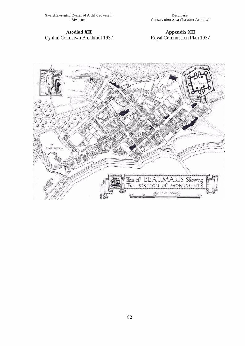
Appendix XIIRoyal Commission Plan 1937
Atodiad XIICynlun Comisiwn Brenhinol 1937
82
Beaumaris Conservation Area Character Appraisal
Gwerthfawrogiad Cymeriad Ardal Cadwraeth Biwmares

b
f
k
i
ae
c
d
h
l
j
g
ALLWEDD / KEY
Terfyn Ardal Cadwraeth / Conservation Area Boundary
Cyf. Grid / Grid Ref: 604 761
Gwerthfawrogiad Cymeriad Ardal CadwraethBiwmares
BeaumarisConservation Area Character Appraisal
Atodiad XIII Appendix XIII
Golygfeydd pwysig Significant Views
83
Golygfeydd Pwysig / Important Views
Newid Arfaethedig i Derfynau'r Ardal Cadwraeth / Proposed Change to Conservation Area Boundary

ALLWEDD / KEY
Terfyn Ardal Cadwraeth / Conservation Area Boundary
Cyf. Grid / Grid Ref: 604 761
Gwerthfawrogiad Cymeriad Ardal CadwraethBiwmares
BeaumarisConservation Area Character Appraisal
Atodiad XIV Appendix XIV
Adeiladau Rhestredig aHenebion Rhestredig
Listed Buildings &Scheduled Ancient Monuments
Adeilad Rhestredig Gradd IGrade I Listed Building
Adeilad Rhestredig Gradd II*Grade II* Listed Building
Adeilad Rhestredig Gradd IIGrade II Listed Building
Henebion RhestredigSchedule Ancient Monuments
84
Nodyn : Mae'r cofrestr i adeiladau rhestredig ac Henebion rhestredigyn newid yn rheolaidd - gofynnwch i'r adran gynllunio am wybodaethdiweddaraf.Note : The Listed Buildings & ScheduledAncient Monumentsregisters are continually updated - check with the Local PlanningAuthority for current listings
Newid Arfaethedig i Derfynau'r Ardal Cadwraeth / Proposed Change to Conservation Area Boundary