poulton-le-fylde conservation area appraisal and ... · poulton-le-fylde conservation area...
TRANSCRIPT
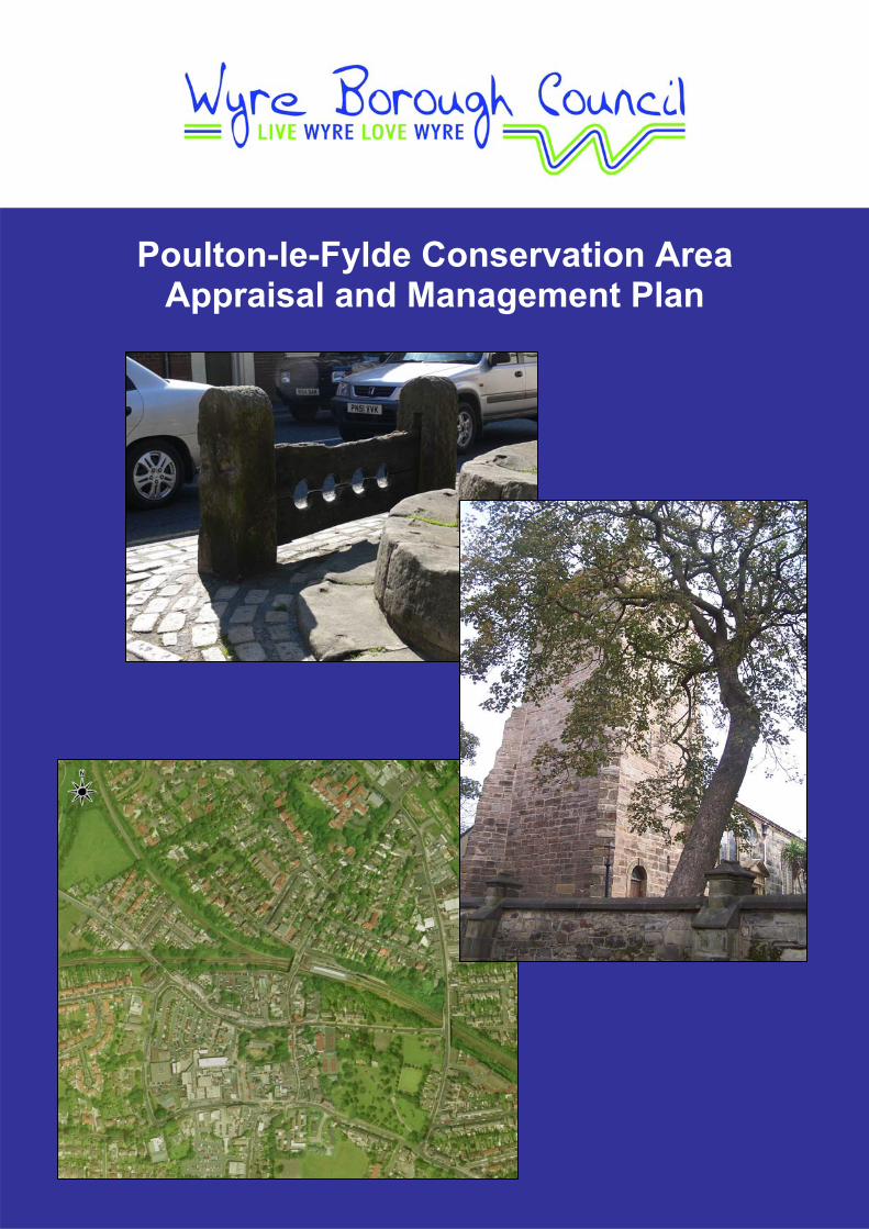
Poulton-le-Fylde Conservation Area
Appraisal and Management Plan

Poulton-le-Fylde Conservation Area Appraisal
Poulton-le-Fylde Conservation Area Appraisal
Wyre Borough Council
Adopted 28th April 2008

Wyre Borough Council
Disclaimer Copyright Notice All maps and plans in this study report are reproduced from Ordnance Survey material with the permission of Ordnance Survey on behalf of the Controller of Her Majesty's Stationery Office © Crown Copyright. Unauthorised reproduction may lead to prosecution or civil proceedings. Wyre Borough Council Licence 100018720, 2008.
Poulton-le-Fylde Conservation Area Appraisal
3.5 20th Century Poulton-le-Fylde 19
Table of contents 1 Introduction ........................................................................................................ 1
1.1 Conservation Areas 1 1.2 Purpose and Objectives of a Conservation Area Appraisal 1 1.3 Poulton-le-Fylde Conservation Area 3 1.4 General Character and Plan Form 5 1.5 Landscape Setting 7
2 Community Involvement ................................................................................... 8 2.1 Consultation Draft Comments 11
3 Historical Development ................................................................................... 14 3.1 11th – 15th Century Poulton-le-Fylde 15 3.2 16th and 17th Century Poulton-le-Fylde 15 3.3 18th Century Poulton-le-Fylde 16 3.4 19th Century Poulton-le-Fylde 17
4 Character Appraisal ......................................................................................... 21 4.1 Topography, Views and Vistas 21 4.2 Activity and Former Uses 22 4.3 Buildings 22 4.4 Boundary Walls 31 4.5 Public Realm Audit 32 4.6 Open Space 42 4.7 Trees 44 4.8 Architecture and Materials 46
5 Pressures, Issues and Threats ....................................................................... 50 5.1 Pressures 50 5.2 Issues and Threats 50
6 Opportunities, Enhancements and Improvements ....................................... 59 6.1 Opportunities 59 6.2 Recommendations for Enhancements and Improvements 60 6.3 Possible Boundary Changes 61
7 Appendices....................................................................................................... 64 7.1 Saint John’s School – Childrens’ Comments on the Conservation Area 65 7.2 Poulton-le-Fylde Conservation Area and Management Plan Questionnaire 66 7.3 Full Listed Building Descriptions and Map Showing Locations 70 7.4 Aerial Photos of the Conservation Area (2000) 74 7.5 Effects of Conservation Area Designation 76 7.6 References 78
i

Wyre Borough Council
Table of figures Figure 1. Plan of Poulton-le-Fylde illustrating the Conservation Area boundary.....................5 Figure 2. Street plan of Poulton-le-Fylde, illustrating main roads............................................6 Figure 3. Suggestions for extension of the Conservation Area boundary .............................11 Figure 4. The tree-hidden Church of St Chad .......................................................................14 Figure 5. The Church of St Chads bell tower ........................................................................14 Figure 6. The Market Cross...................................................................................................16 Figure 7. 1890s map of Poulton-le-Fylde ..............................................................................18 Figure 8. Wyre Borough Council Civic Centre.......................................................................20 Figure 9. View through Market Place ....................................................................................21 Figure 10. Tree-lined Park Road ...........................................................................................21 Figure 11. Market Place looking south ..................................................................................21 Figure 12. Victoria Road........................................................................................................21 Figure 13. Ball Street / Tithebarn Street................................................................................22 Figure 14. Church of St. Chad...............................................................................................22 Figure 15. Church of St. Chad...............................................................................................23 Figure 16. Position of building (shown in orange) .................................................................23 Figure 17. 2 Market Place .....................................................................................................24 Figure 18. Position of building (shown in orange) .................................................................24 Figure 19. 25, 27, 29 and 31 Market Place ...........................................................................25 Figure 20. Position of building (shown in orange) .................................................................25 Figure 21. Fish Stones ..........................................................................................................25 Figure 22. Position of building (shown in orange and circled)...............................................25 Figure 23. Market Cross........................................................................................................26 Figure 24. Position of building (shown in orange and circled)...............................................26 Figure 25. Stocks ..................................................................................................................26 Figure 26. Position of building (shown in orange and circled)...............................................26 Figure 27. Whipping Post ......................................................................................................27 Figure 28. Position of building (shown in orange and circled)...............................................27 Figure 29. K6 Telephone Kiosk .............................................................................................28 Figure 30. Position of building (shown in orange and circled)...............................................28 Figure 31. 4, 6 and10 Queen Square....................................................................................28 Figure 32. Position of building (shown in orange) .................................................................28 Figure 33. 1 Vicarage Road ..................................................................................................29 Figure 34. Position of building (shown in orange) .................................................................29 Figure 35. Example of boundary wall in streetscene.............................................................32 Figure 36. Example of boundary walls in situ........................................................................32 Figure 37. Example of boundary wall being removed and the surrounding streetscene.......32 Figure 38. Example of boundary wall removal for off-road parking.......................................32 Figure 39. Traditional large scale design street lighting, more modern style in background.33 Figure 40. Traditional large scale style street lighting ...........................................................33 Figure 41. Traditional small scale lantern style street lighting...............................................34 Figure 42. Traditional small scale lantern style street lighting...............................................34 Figure 43. Inconspicuous CCTV column design ...................................................................34 Figure 44. Tarmac road and concrete slab pavement...........................................................35 Figure 45. Modern sett style pavement surface, along with larger modern paving slab .......35 Figure 46. Modern sett style paving material and larger paving slab ....................................35 Figure 47. Interaction of modern setts with traditional setts ..................................................35 Figure 48. Traditional and modern setts................................................................................36 Figure 49. Traditional and modern setts around important historical features ......................36 Figure 50. Predominant bin design .......................................................................................36 Figure 51. Bin design ............................................................................................................36 Figure 52. Traditional shopfront terminology.........................................................................37 Figure 53. Traditional style shopfront ....................................................................................38 Figure 54. Highways signage ................................................................................................39
ii
Poulton-le-Fylde Conservation Area Appraisal
Figure 55. Traditional style directional signage .....................................................................39 Figure 56. Example of small information board.....................................................................39 Figure 57. Example of large information boards ...................................................................39 Figure 58. Example of historical information plaques............................................................40 Figure 59. Example of historical information plaques............................................................40 Figure 60. Example of bench design predominant within the Jean Stansfield Park..............41 Figure 61. Alternative bench design......................................................................................41 Figure 62. Bench design predominant within Market Place ..................................................41 Figure 63. Grade II Listed K6 telephone box.........................................................................42 Figure 64. Example of predominant style telephone box ......................................................42 Figure 65. Open Space within Poulton-le-Fylde Conservation Area .....................................43 Figure 66. TPOs and potential TPOs within Poulton-le-Fylde Conservation Area ................45 Figure 67. Example of two-storey semi-detached house ......................................................47 Figure 68. Example of slightly recessed doorways ...............................................................47 Figure 69. Good example of sash and casement windows...................................................47 Figure 70. Good example of sash and casement windows...................................................47 Figure 71. Decorative door features, illustrating predominant red brick................................48 Figure 72. Decorative door features......................................................................................48 Figure 73. Example of plain bargeboards .............................................................................48 Figure 74. Residential bay window with balcony detail above ..............................................48 Figure 75. Good example of predominant feature – dentil course ........................................48 Figure 76. Good example of dentil course ............................................................................48 Figure 77. Interesting architectural details ............................................................................49 Figure 78. Example of commercial property with residential accomodation above...............49 Figure 79. Good examples of traditional fascia signage .......................................................51 Figure 80. Inappropriate large scale fascia signage..............................................................51 Figure 81. Traditional appropriate and modern inappropriate blind styles ............................52 Figure 82. Good example of traditional style panes and stallrisers.......................................52 Figure 83. Heavily vehicle parked Station Road ...................................................................53 Figure 84. Station Road ........................................................................................................53 Figure 85. Victoria Road........................................................................................................53 Figure 86. Park Road ............................................................................................................53 Figure 87. Problems with parking on Ball Street ...................................................................54 Figure 88. Ball Street/Tithebarn Street..................................................................................54 Figure 89. Traditional timber sash and casement windows ..................................................56 Figure 90. Timber sash and casement window with “bullseye” style glass panes ................56 Figure 91. Example of replacement timber sash and casement window ..............................56 Figure 92. Example of inappropriate modern uPVC windows...............................................56 Figure 93. Example of satellite dish on front elevation..........................................................57 Figure 94. Example of satellite dish on front elevation..........................................................57 Figure 95. Original Welsh slates ...........................................................................................58 Figure 96. Modern shiny equivalent slates............................................................................58 Figure 97. Berkeley Court development................................................................................58 Figure 98. Berkeley Court .....................................................................................................58 Figure 99. Previous 1979 and current Conservation Area boundary ....................................61 Figure 100. Suggested alterations to Poulton-le-Fylde Conservation Area boundary ..........63 Figure 101. Map illustrating position of Listed Buildings in location within the CA boundary 73 Figure 102. Aerial photograph of Poulton-le-Fylde................................................................74 Figure 103. Aerial photo of Poulton-le-Fylde illustrating the location of the CA boundary ....75
iii

Poulton-le-Fylde Conservation Area Appraisal
1
1 Introduction
1.1
1.2
Conservation Areas Conservation Areas are defined as “areas of special architectural or historic interest
the character or appearance of which is desirable to preserve and enhance”. It is the
combination of the buildings, street patterns, open spaces, vistas, landmarks and
other features that give a Conservation Area its distinctive character. This character
should be the focus of efforts towards preservation and enhancement.
The Civic Amenities Act of 1967 introduced Conservation Areas in the UK, and
through this Wyre Borough Council has a duty to protect these designated areas
from alterations and development that would detract from the character and
appearance.
Under Planning Legislation, the Local Authority has wide powers to control
development within a Conservation Area that might damage the area’s character.
Designation of Conservation Areas provides additional controls over the demolition of
buildings and the quality of development or redevelopment in the area and gives
additional protection to trees. It is important, however, that there is a consensus on
the quality and importance of a particular Conservation Area in order to assist in its
maintenance and enhancement. To be successful, conservation policy must be a
partnership between the Council and the many interests involved in the future of the
Conservation Area.
Purpose and Objectives of a Conservation Area Appraisal The purpose of a Conservation Area Appraisal, as stated by PPG15: paragraph 4:9,
is to “clearly identify what it is about the character or appearance of the area which
should be preserved or enhanced, and set out the means by which that objective is
to be pursued”. It is also hoped that through this “clear assessment and definition of
an area's special interest and the action needed to protect it will help to generate
awareness and encourage local property owners to take the right sort of action for
themselves”.
When Conservation Areas were first designated in Wyre in the 1970s and 80s, it was
generally recognised that these areas were of special character, which warranted
preservation and enhancement. However, very little about the important features
was actually recorded. English Heritage now recommend the carrying out of
Wyre Borough Council
Appraisals which will allow a full assessment of the characteristics of existing and
proposed Conservation Areas. This will enable the Council to decide whether the
Conservation Area still has sufficient character to warrant its designation, or whether
the area needs extending in any way.
The Borough Council has an obligation under Section 69 of the Planning (Listed
Buildings and Conservation Areas) Act 1990 to periodically review its Conservation
Area designations, boundaries, and consider any new areas, and under Section 71 of
the Act to formulate and publish proposals for the preservation and enhancement of
these areas.
This Appraisal forms part of a programme of work to review all Conservation Areas
within Wyre Borough Council boundary. The Appraisals will also highlight the
implications for the future preservation and enhancement of a Conservation Area,
contained within a Management Plan.
The policies on Conservation Areas, contained within the Wyre Borough Council
Local Plan, determine planning applications for development in these areas. This
Appraisal should be read in conjunction with these policies, shown below, plus any
subsequent policies in the replacement Core Strategy, and will form a material
consideration in the judgement of planning applications and appeals.
Wyre Borough Council’s Local Plan, Chapter Three, Policy ENV9: Conservation
Areas states that there are seven criteria required to be met in order for development
in or adjoining a Conservation Area. Proposals will only be permitted where:
A. Proposals respect the existing character and setting of the area together with
views into or out of the area;
B. New buildings are sited so as to retain existing building lines and open
spaces;
C. The density, scale, proportions, height and fenestration accord with their
surroundings;
D. The use and application of building materials respect local traditional
materials, techniques and design characteristics;
E. The scale, proportion and height of advertising material and the use of
materials, including colour, is appropriate;
2

Poulton-le-Fylde Conservation Area Appraisal
F. Where acceptable the nature and degree of any illumination should have no
detrimental impact upon the visual character of the Conservation Area; and
G. Landscaping is designed as an integral part of the scheme where appropriate.
Policy ENV9 also states there are a further three criteria to ensure development
proposals are not permitted where inappropriate to surroundings:
H. The demolition of listed buildings or those buildings which make a positive
contribution to the character or appearance of the Conservation Area; or
I. The amalgamation of adjacent plots if this results in the development of larger
buildings out of scale with their surroundings; or
J. The refurbishment of adjoining buildings to create a single larger space user
where this would adversely affect the character of the Conservation Area.
The Appraisals will also provide a basis for:
• Reviewing Conservation Area boundaries;
• Guiding future Local Authority action in preparing enhancement schemes and
in guiding the actions of others; and,
• Where appropriate, increasing planning controls.
It is intended that these issues will be considered in full consultation with local
residents and landowners, local interest groups, the Local Area Forum and the
Conservation Areas Forum. The Council’s Statement of Community Involvement
(SCI) details the Consultation procedures residents should expect.
Finally this document is to raise awareness of the special qualities of the
Conservation Area so that as it continues to evolve, it does so in a sympathetic way
and the essential character of the area is maintained for future generations. A
Management Plan is also included to illustrate the changes that the Council plan to
undertake, in partnership with the community and others.
3
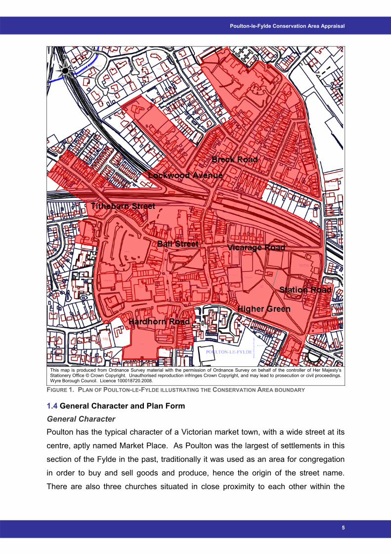
1.3 Poulton-le-Fylde Conservation Area Poulton-le-Fylde Conservation Area was first designated in 1979. In order to be able
to gauge the ‘special interest’ of an area, it is necessary to assess several aspects.
These include the location and setting; historical development and archaeology;
spatial analysis; and character analysis of the Conservation Area.

Wyre Borough Council
Location and Context Poulton-le-Fylde is a small market town situated around 8 kilometres east of the
seaside resort of Blackpool and around 27 kilometres southeast of Preston. Until the
nineteenth century the extent of development was largely limited to a few streets
surrounding the church and to the north of the railway station. In more recent times,
housing has developed on all sides of the town, now forming an almost continuous
conurbation with the neighbouring towns of Blackpool, Thornton and Cleveleys.
Agricultural land lies to the east, consisting mostly of pasture, with a limited amount
of arable and woodland use.
The Conservation Area boundary, shown in Figure 1, extends from the junction of
Station and Breck Road to the north, and reaches as far as 23 Hardhorn Road and
Berkeley Court to the south. The boundary also stretches to include 80 Tithebarn
Street and 27 Lockwood Avenue to the west, and 22 Victoria Road and 14 Hayfield
Avenue to the east.
4
Poulton-le-Fylde Conservation Area Appraisal
This map is produced from Ordnance Survey material with the permission of Ordnance Survey on behalf of the controller of Her Majesty’s Stationery Office © Crown Copyright. Unauthorised reproduction infringes Crown Copyright, and may lead to prosecution or civil proceedings. Wyre Borough Council. Licence 100018720.2008.
FIGURE 1. PLAN OF POULTON-LE-FYLDE ILLUSTRATING THE CONSERVATION AREA BOUNDARY
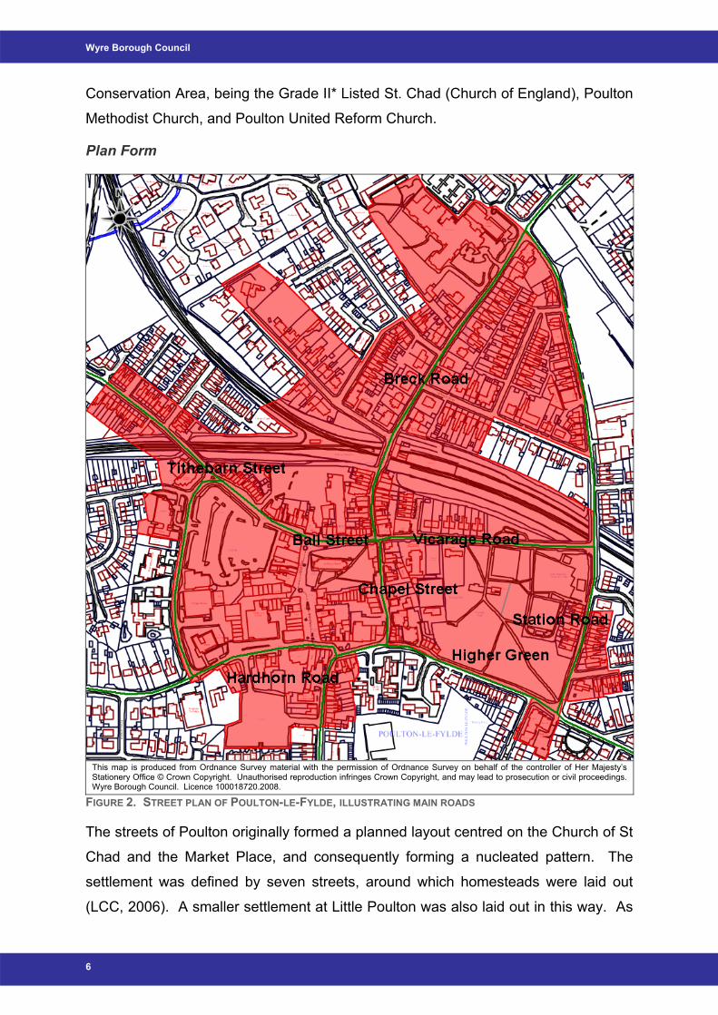
1.4 General Character and Plan Form General Character Poulton has the typical character of a Victorian market town, with a wide street at its
centre, aptly named Market Place. As Poulton was the largest of settlements in this
section of the Fylde in the past, traditionally it was used as an area for congregation
in order to buy and sell goods and produce, hence the origin of the street name.
There are also three churches situated in close proximity to each other within the
5
Wyre Borough Council
Conservation Area, being the Grade II* Listed St. Chad (Church of England), Poulton
Methodist Church, and Poulton United Reform Church.
Plan Form
FIGURE 2. STREET PLAN OF POULTON-LE-FYLDE, ILLUSTRATING MAIN ROADS
This map is produced from Ordnance Survey material with the permission of Ordnance Survey on behalf of the controller of Her Majesty’s Stationery Office © Crown Copyright. Unauthorised reproduction infringes Crown Copyright, and may lead to prosecution or civil proceedings. Wyre Borough Council. Licence 100018720.2008.
The streets of Poulton originally formed a planned layout centred on the Church of St
Chad and the Market Place, and consequently forming a nucleated pattern. The
settlement was defined by seven streets, around which homesteads were laid out
(LCC, 2006). A smaller settlement at Little Poulton was also laid out in this way. As
6

Poulton-le-Fylde Conservation Area Appraisal
Poulton developed over time, this nuclear pattern has been retained. This can be
seen in Figure 1, and is also further clarified in Figure 2, illustrating the main traffic
routes through the town.
7
1.5 Landscape Setting Poulton-le-Fylde occupies a slightly elevated site, approximately 18m above
Ordnance Datum, in the otherwise low lying, level topography of the Fylde coast and
River Wyre flood plain (LCC, 2006). The town lies on a local high point with the land
falling away gradually to the north and south. The slope towards the River Wyre, to
the north, is slightly greater than that to the south, and it is this that has more than
likely resulted in the name ‘the Breck’, a term of Anglo Scandinavian origin meaning
slope (Field, 1972).
Poulton lies on the eastern edge of the heavily urbanised Fylde coast, with rich
agricultural land to the east comprising of pasture and isolated arable lands (LCC,
2006). This pattern of agriculture, being mainly of pasture but with small areas of
arable and woodland, has remained relatively unchanged to date, and “is still
characterised by medium sized fields featuring numerous field ponds, with
hedgerows and drainage ditches” (LCC, 2006). Consequently, Poulton is situated in
an urban area that is built on agricultural foundations, though now enclosed and
heavily dominated by modern housing developments.
Summary – Poulton-le-Fylde Conservation Area - Small agricultural market town of Victorian roots - Conservation Area boundary covers the main conurbation centre - Occupies slightly elevated site, in otherwise low lying, level topography - Village initially nucleated plan, and this has continued, though now more
widespread - Historic core now surrounded by modern residential developments
Wyre Borough Council
2 Community Involvement
Community involvement has been the key to the process of undertaking a
Conservation Area Appraisal and Management Plan. It was considered essential to
engage the local community in evaluating what they consider to make the area of
‘special’ significance. The local primary school was encouraged to become involved
in the process, with the children embarking on their own project. From this project,
the following opinions / suggestions were amongst the comments received (these
comments are contained in full within Appendix 7.1):
• Article 4(2) Directions should be placed on buildings in the centre of Poulton-
le-Fylde to ensure retention of special architectural features;
• The trees within Poulton are good and if they are required to be felled then
new trees should be planted in their place;
• It would be of positive benefit to light up some of the interesting architectural
features within Poulton in evenings, namely The Market Place, e.g. to have
spotlights / floodlights / uplighters on the Stocks, Whipping Post, and Fish
Slabs to make them more prominent features;
• Improvements could be made to the station, the Teanlowe Centre and Village
Walks, for example through more appealing shop fronts i.e. proper shop signs
that are in keeping with the traditions of the town rather than having gaudy
plastic signs;
• The children think there are too many cars within the town centre;
• Improvements could be made to the street lighting as some lights do not work;
• A pelican crossing would be of benefit by the Civic Centre; and
• Attempts should be made to ensure shops are not empty as this is unsightly.
Consequently, informal consultation with the adult community then began with a walk
around the Conservation Area boundary with officers from Wyre Borough Council,
arranged for Wednesday 10th October 2007, and posters advertising this were put in
various notice boards around the Conservation Area, with the help of Poulton-le-
Fylde Historical Society. However, as there was a low turnout for this initial meeting,
it was decided that to involve a greater number of the community, the Conservation
Officer would attend Poulton Local Area Forum on Tuesday 13th November and
would give a short presentation introducing the idea of Conservation Area Appraisals
8

Poulton-le-Fylde Conservation Area Appraisal
and Management Plans. Letters were sent to each of the Ward Councillors notifying
them of this event and inviting them to attend. A questionnaire was also included
detailing issues that the public may be concerned about within the Conservation
Area, and wish to comment on, as well as giving an opportunity for the community to
add any issues they would wish to be dealt with. This questionnaire is detailed in full
in Appendix 7.2.
It was also decided prior to the Local Area Forum, that a second walk around the
Conservation Area boundary should be undertaken, and at the Forum, the public
were invited to attend the walk, arranged to take place the following Monday, on 19th
November. Eight people attended this second walk and copies of the questionnaire
were again handed out.
The questions asked within the questionnaire are detailed below. However, after all
attempts to ensure early consultation with the residents, only 2 responses were
received. The comments from these responses are detailed accordingly:
1. Do you think that an Article 4(2) Direction would be beneficial in Poulton-le-
Fylde Conservation Area?
It was thought that although this would be a good idea, financial support of property
owners was important.
2. Would you like to see any new Tree Preservation Orders (TPOs) made in
Poulton-le-Fylde? Specifically which tree(s)?
No specific trees were identified but trees are thought to be an essential asset in
terms of their aesthetic qualities and environmental benefits, and existing specimens
should be protected in any way possible. The Council’s Tree Officer has just
completed a survey of the trees in Poulton-le-Fylde, with a view to the possibility of
new TPO’s. These results are detailed in section 4.7 of this Appraisal.
3. Are there any buildings that you believe to be of importance within Poulton-le-
Fylde Conservation Area? Would you recommend any buildings to be suggested for
listing?
There are many buildings thought to be of value within the Conservation Area, such
as the Thatched House and the Old Town Hall, but unfortunately many alterations
have been made over the years to these buildings, and the Thatched House only
9
Wyre Borough Council
dates back to 1907 when it replaced the original which was pulled down. Due to this,
it is unlikely that listed status would be achieved.
4. Would you like to see planning obligations used in Poulton-le-Fylde
Conservation Area? If so, what sort of additions would you like to see?
A view has been formed that a condition of permission of new housing developments
/ estates should provide local shopping facilities, as well as including more open
space, trees in addition to improving local public transport links.
5. Are there any areas that you would wish to see improved within Poulton-le-
Fylde Conservation Area? If so, where are these areas and what enhancements
would you like to see?
The main area that is in need of improvement is thought to be Market Place. This is
due to the poor quality of some shopfronts, as well as the large planters that are
thought of as obstacles more than positive features within the area.
6. Are there any areas within the boundary that appear to suffer from negative
pressure or pose a threat to the character of the Conservation Area?
Negative issues are suggested as shops within the centre of Poulton. This is due to
the poor quality appearance and further controls are thought necessary to encourage
a higher quality of shop front design.
7. Are there any issues you would wish to see addressed in the Poulton-le-Fylde
Conservation Area Management Plan?
There were only two main suggestions made for inclusion in the Management Plan:
• An improved Market Place; and
• An up-to-date survey of the existing trees.
8. Would you like to see the Poulton-le-Fylde Conservation Area boundary
amended? If so, where should the boundary be drawn and why?
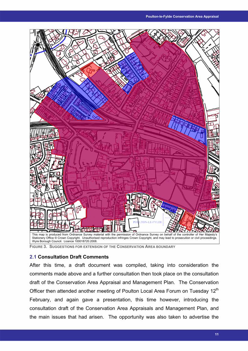
Four areas were suggested for inclusion within the Conservation Area boundary, and
two areas suggested to be omitted. These areas are illustrated in Figure 3 (the areas
in blue for inclusion and the area in red for omission), and are also detailed further in
Chapter 6 of this Appraisal.
10
Poulton-le-Fylde Conservation Area Appraisal
This map is produced from Ordnance Survey material with the permission of Ordnance Survey on behalf of the controller of Her Majesty’s Stationery Office © Crown Copyright. Unauthorised reproduction infringes Crown Copyright, and may lead to prosecution or civil proceedings. Wyre Borough Council. Licence 100018720.2008.
FIGURE 3. SUGGESTIONS FOR EXTENSION OF THE CONSERVATION AREA BOUNDARY
2.1 Consultation Draft Comments After this time, a draft document was compiled, taking into consideration the
comments made above and a further consultation then took place on the consultation
draft of the Conservation Area Appraisal and Management Plan. The Conservation
Officer then attended another meeting of Poulton Local Area Forum on Tuesday 12th
February, and again gave a presentation, this time however, introducing the
consultation draft of the Conservation Area Appraisals and Management Plan, and
the main issues that had arisen. The opportunity was also taken to advertise the
11
Wyre Borough Council
dates of the consultation period during the meeting. Around 70 people attended this
meeting. The public consultation then lasted for four weeks, from Monday 18th
February until Monday 17th March 2008, and after this time, all comments received
were compiled into this Conservation Area Appraisal and Management Plan.
Again, after extensive attempts to ensure full consultation with residents occurred,
only two written responses were received during to the consultation period. These
comments cover various issues, the majority of which are detailed below.
Comment was made regarding the possible extensions to the conservation area but
stress was put on the possibility of removing some areas. It was queried why the
Teanlowe car park and the Hardhorn car are within the Conservation Area. These
areas were thought to have no conservation merit and are not believed to be part of
the historic core of the town reflecting its development or growth over time. However,
it is thought that the Teanlowe car park does have enough significant historical value
to be included within the Conservation Area. As stated in subsection 3.5: "The
tithebarn was also replaced in 1969 by a car park. A tithebarn was a type of barn
used in England and Germany in the Middle Ages for storing the tithes - a tenth of
the farm's produce which had to be given to the church. Its original position so near
to the town centre, however, implies an ancient origin". Whilst exclusion of the
Hardhorn Road car park could benefit the character of the Conservation Area, it
might be of more advantage to keep it within the boundary in order to retain a higher
level of control regarding any further development that may be occur in the area.
Sections of this area are also thought to be included in proposals within the Poulton
Market Town Initiative, and it would consequently be more beneficial for these areas
to be kept within the boundary in order to have more control on what could possibly
be proposed in the future.
Another issue that arose was the appropriateness of guidance and advice as a
method of retaining historical features, such as sash and casement windows, which
the removal of is allowed under permitted development rights. The question was
then asked, given that a significant part of the CA is residential (more so if the
suggested extensions are supported) is not an Article 4 Direction necessary? With
regard to relying on advice and guidance and the appropriateness of applying an
Article 4 Direction, in the Management Plan at the rear of the document, Chapter 1
12
Poulton-le-Fylde Conservation Area Appraisal
states in Action 9 that further study is proposed into the appropriateness of any
Article 4 Directions within the area.
Issues relating to high levels of traffic within the town centre were also raised, mainly
regarding problems with parking and comment was also made in relation to
occasionally having to drive on the pavement in residential areas. In line with
guidance, traffic management is not considered during the compilation of a
Conservation Area Appraisal. However, as the high level of car parking is mentioned
as a negative factor within the Conservation Area Appraisal, solutions need to be
considered. However, the Poulton Market Town Initiative, in 2007, proposed
possible solutions to the traffic problems.
13
Wyre Borough Council
3 Historical Development
Poulton (-le-Fylde) first appears in the Yorkshire section of the Domesday Survey,
being one of over 60 local villages in Amounderness (as the county of Lancashire did
not exist at this time). The name ‘Poulton’ literally means “the town by the pool” and
is derived from the proximity to the River Wyre. However this is not to suggest that
no human habitation had occurred previously. Two finds, Bronze Age pottery and a
chert arrowhead, provide evidence of early human habitation in the area of Poulton
(Harris et al. 2004).
The other evidence of human existence is from the time of the Romans. Finds of
Roman coins together with other relics of that period have been found within the
Poulton area, as well as the identification of a Roman road, ‘Dane’s Pad’, in the
nineteenth century (Harris et al. 2004). Although there is no suggestion of a
settlement at Poulton-le-Fylde at this time, these discoveries suggest considerable
activity in the area during this period.
Although the place name of Poulton suggests an Anglo-Saxon origin, there is no
direct documentary or archaeological evidence to support a pre-Conquest origin for
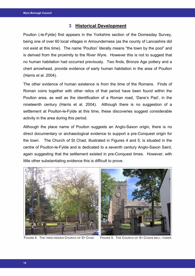
the town. The Church of St Chad, illustrated in Figures 4 and 5, is situated in the
centre of Poulton-le-Fylde and is dedicated to a seventh century Anglo-Saxon Saint,
again suggesting that the settlement existed in pre-Conquest times. However, with
little other substantiating evidence this is difficult to prove.
FIGURE 4. THE TREE-HIDDEN CHURCH OF ST CHAD FIGURE 5. THE CHURCH OF ST CHADS BELL TOWER
14
Poulton-le-Fylde Conservation Area Appraisal
15
3.1
3.2
11th – 15th Century Poulton-le-Fylde The town is mentioned in passing in the Domesday Book, being part of Earl Tostig’s
lordship of Amounderness, which was passed to Roger de Poitou (www.poulton-le-
fylde-hcs.co.uk). He then granted lands to the Abbey of St Martin in 1094 and lands
were also passed to the Abbot of Cockersand in the thirteenth century.
Although some believe the date the lands were granted also dates the church, others
argue that it is likely that the church existed before this time and was simply rebuilt or
modified at this time (www.poulton-le-fylde-hcs.co.uk). The first vicarage dates from
c.1247 and was laid out in extensive grounds to the east of the church (www.poulton-
le-fylde-hcs.co.uk). Tithes for the vicarage were collected and stored in the tithe
barn, the location of which gave the current road its name, Tithebarn Street. At this
time, these buildings would have been some of the few stone built structures in the
town, with any others being little more than temporary shelters (Harris et al. 2004).
16th and 17th Century Poulton-le-Fylde Little is known about the appearance of Poulton in the sixteenth and seventeenth
centuries. However the church was certainly in existence during the medieval period;
its tower was built in the seventeenth century and is still standing today.
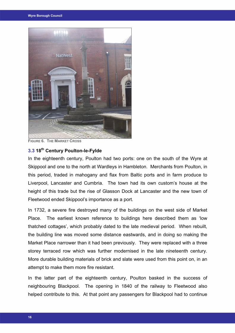
The Market Cross, shown in Figure 6 and located in the square of the Market Place,
is also thought to date from this period. A separate whipping post for public floggings
has also survived adjacent to the Market Cross from around this time. The date of
the adjacent fish slabs is uncertain but it was on them that the market prices were
agreed.
Permanent buildings would have gradually replaced the market stalls as the market
became more established (Harris et al. 2004). Despite this, the area remained poor
up to the seventeenth century and suffered a succession of famine and disease. At
this time, houses would have been of cruck construction with cob or earth walls and
thatched roofs in a style known as the ‘Fylde Longhouse’ (Harris et al. 2004).
Nothing remains of this type of development now.
Wyre Borough Council
FIGURE 6. THE MARKET CROSS
3.3 18th Century Poulton-le-Fylde In the eighteenth century, Poulton had two ports: one on the south of the Wyre at
Skippool and one to the north at Wardleys in Hambleton. Merchants from Poulton, in
this period, traded in mahogany and flax from Baltic ports and in farm produce to
Liverpool, Lancaster and Cumbria. The town had its own custom’s house at the
height of this trade but the rise of Glasson Dock at Lancaster and the new town of
Fleetwood ended Skippool’s importance as a port.
In 1732, a severe fire destroyed many of the buildings on the west side of Market
Place. The earliest known reference to buildings here described them as ‘low
thatched cottages’, which probably dated to the late medieval period. When rebuilt,
the building line was moved some distance eastwards, and in doing so making the
Market Place narrower than it had been previously. They were replaced with a three
storey terraced row which was further modernised in the late nineteenth century.
More durable building materials of brick and slate were used from this point on, in an
attempt to make them more fire resistant.
In the latter part of the eighteenth century, Poulton basked in the success of
neighbouring Blackpool. The opening in 1840 of the railway to Fleetwood also
helped contribute to this. At that point any passengers for Blackpool had to continue
16
Poulton-le-Fylde Conservation Area Appraisal
their journey by carriage from Poulton, that section of line not opening for another six
years. When it did open and Blackpool developed its own sources for suppliers of
provisions, Poulton began to decline and once more reverted to its agricultural
origins.
The main occupation for the population of Poulton tended to be in agriculture, with
few other forms of livelihood recorded. The town flourished and during the
eighteenth century the population grew from 250 to 750 (www.poulton-le-fylde-
hcs.co.uk). Further expansion, however, was limited by poor access to the town.
The increased use of the canal network plus the opening of the docks at Fleetwood
and Preston in the nineteenth century meant that Poulton-le-Fylde did not benefit
from industrial expansion.
17
3.4 19th Century Poulton-le-Fylde In 1842, when the Penny Post began, ‘-le-Fylde’ was added to the name, in order to
stop local post mistakenly being sent north to Poulton-le-Sands, which is now part of
Morecambe.
In the latter part of the nineteenth century, the success of Blackpool saw
developments of villas to the north of the railway station to cater for the successful
elite of that town who wanted to escape the hustle and bustle of a busy seaside
resort.
The population in 1801 was 769 but by the first half of the nineteenth century this had
grown by 30 percent. However, in the latter part of this century, growth began to
plateau, with an increase of only one or two percent for each decade. Numbers
increased rapidly, again from 1891 to 1901, by 36 percent to reach a figure of 2,223.
The town continued to expand, most probably due to the close proximity of
Blackpool, to which it was now a satellite.
The original railway line opened in Poulton-le-Fylde in 1840 and ran between Preston
and the newly built town of Fleetwood. The station was located at the corner of
Station Road and the Breck. In 1896, it was rebuilt in its present position at the top of
the Breck near to the town centre.
The late nineteenth century villas lining both sides of Breck Road and Victoria Road
are good examples of their type and to a large extent have been well preserved. To
the northwest and west, Victorian terraces and semi-detached houses survive in
Wyre Borough Council
some numbers. Whilst they are fairly simple in design, they have great character,
quality and represent an important aspect of Poulton’s history and economy.
On market days the streets of Poulton-le-Fylde were so crowded with farmers,
shoppers, animals and stalls that by the 1890s it became necessary to build an
auction mart behind the Golden Ball. It flourished for nearly a century until changes
in farming and marketing practices led to its demise. This land is now the car park
for Booths Supermarket.
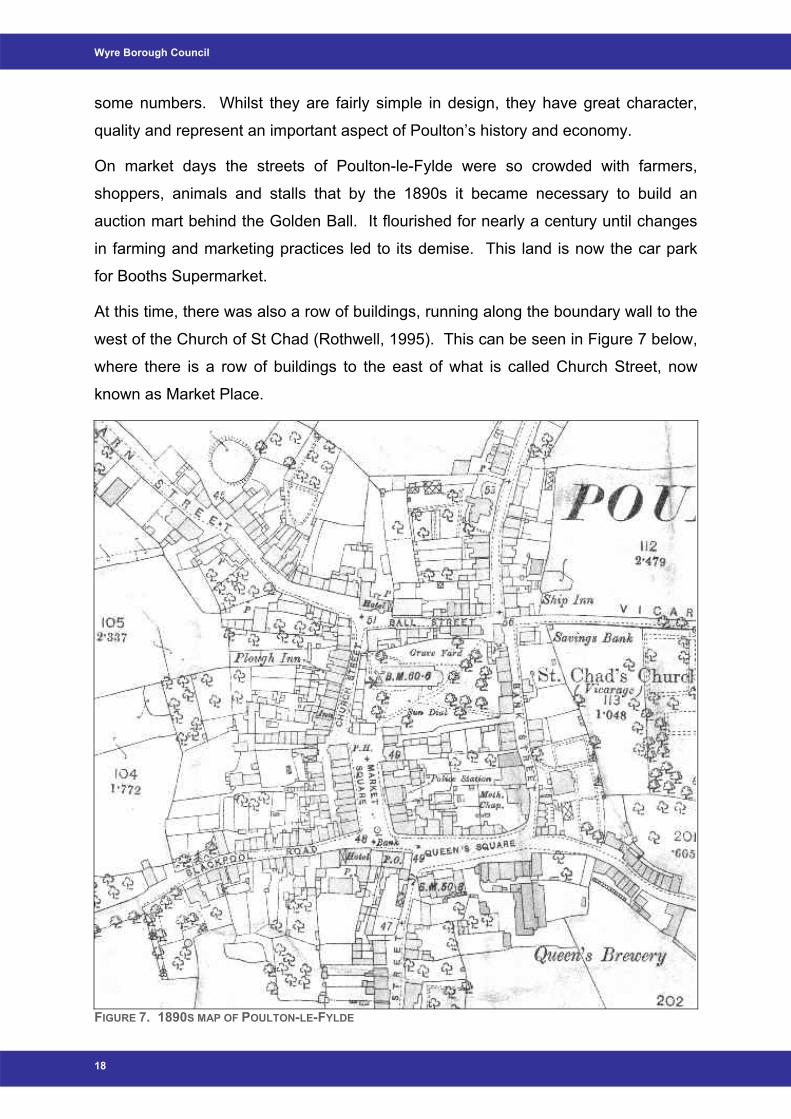
At this time, there was also a row of buildings, running along the boundary wall to the
west of the Church of St Chad (Rothwell, 1995). This can be seen in Figure 7 below,
where there is a row of buildings to the east of what is called Church Street, now
known as Market Place.
FIGURE 7. 1890S MAP OF POULTON-LE-FYLDE
18
Poulton-le-Fylde Conservation Area Appraisal
19
3.5 20th Century Poulton-le-Fylde The original Methodist chapel stood on the corner of Chapel Street and Queen's
Square until a new one replaced it on Queensway in 1968. The tithebarn was also
replaced in 1969 by a car park. A tithebarn was a type of barn used in England and
Germany in the Middle Ages for storing the tithes - a tenth of the farm's produce
which had to be given to the church. Its original position so near to the town centre,
however, implies an ancient origin.
A second storey was constructed on to the county police station, situated in Market
Place, in the 1920s (Rothwell, 1995). The original 1890s building was only a single
storey building until this time, and the more modern addition was built directly on top.
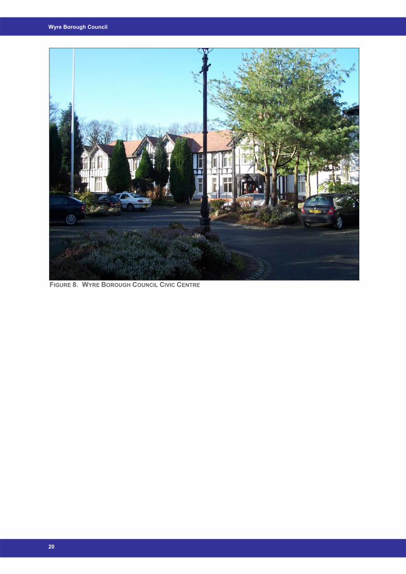
Another important building to mention is the Wyre Borough Council Civic Centre.
The building as it stands today evolved from a private home named The Woodlands,
dating from the 18th Century. The Amalgamated Weavers’ Association began
extending this existing building in 1928, following John Thornleys’ architectural
design, after acquiring around 4 acres of surrounding land. By 1929, the work was
completed, and the building opened for the purpose of providing convalescent
facilities. This use continued until the early 1960s, during which time the building
was also used as a refuge for sick babies and exhausted Service personnel during
the Second World War. The Convalescent Home continued in use until 1962 when
smaller premises less costly to run were sought and the Home then moved to
Morecambe.
In 1964, the building officially reopened as a Teacher Training College. This use
however was always designated ‘temporary’ and as such the college moved to
Preston in 1983. Since 1988, the building has continued to be of use within the
community in its current use as the main ‘home’ for Wyre Borough Council.
Wyre Borough Council
FIGURE 8. WYRE BOROUGH COUNCIL CIVIC CENTRE
20
Poulton-le-Fylde Conservation Area Appraisal
21
4 Character Appraisal
The town of Poulton-le-Fylde has developed from agricultural roots, through which a
gradual growth in population has resulted in urban sprawl. This term helps to
describe the spread of development over rural land at the fringe of an urban area.
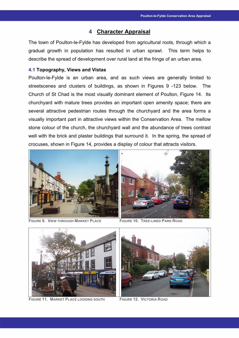
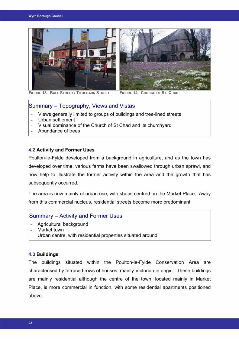
4.1 Topography, Views and Vistas Poulton-le-Fylde is an urban area, and as such views are generally limited to
streetscenes and clusters of buildings, as shown in Figures 9 -123 below. The
Church of St Chad is the most visually dominant element of Poulton, Figure 14. Its
churchyard with mature trees provides an important open amenity space; there are
several attractive pedestrian routes through the churchyard and the area forms a
visually important part in attractive views within the Conservation Area. The mellow
stone colour of the church, the churchyard wall and the abundance of trees contrast
well with the brick and plaster buildings that surround it. In the spring, the spread of
crocuses, shown in Figure 14, provides a display of colour that attracts visitors.
FIGURE 9. VIEW THROUGH MARKET PLACE FIGURE 10. TREE-LINED PARK ROAD
FIGURE 11. MARKET PLACE LOOKING SOUTH FIGURE 12. VICTORIA ROAD
Wyre Borough Council
FIGURE 13. BALL STREET / TITHEBARN STREET FIGURE 14. CHURCH OF ST. CHAD
Summary – Topography, Views and Vistas - Views generally limited to groups of buildings and tree-lined streets - Urban settlement - Visual dominance of the Church of St Chad and its churchyard - Abundance of trees
4.2 Activity and Former Uses Poulton-le-Fylde developed from a background in agriculture, and as the town has
developed over time, various farms have been swallowed through urban sprawl, and
now help to illustrate the former activity within the area and the growth that has
subsequently occurred.
The area is now mainly of urban use, with shops centred on the Market Place. Away
from this commercial nucleus, residential streets become more predominant.
Summary – Activity and Former Uses - Agricultural background - Market town - Urban centre, with residential properties situated around
4.3 Buildings The buildings situated within the Poulton-le-Fylde Conservation Area are
characterised by terraced rows of houses, mainly Victorian in origin. These buildings
are mainly residential although the centre of the town, located mainly in Market
Place, is more commercial in function, with some residential apartments positioned
above.
22
Poulton-le-Fylde Conservation Area Appraisal
The great majority of buildings in existence in Poulton-le-Fylde are late Victorian or
Edwardian (1880-1915). The coming of the railway helped to open up the
community, and the success of Fleetwood and Blackpool brought a greater degree of
prosperity to the town. Much of the Market Place was rebuilt, and new areas of the
town were developed, for example Breck Road, Park Road and Victoria Road.
Listed Buildings Within the Conservation Area of Poulton-le-Fylde, there are ten Listed Buildings.
One of these is the Grade II* Listed Church of St Chad. The remaining nine Grade II
Listed Buildings are: 2 Market Place; 25, 27, 29 and 31 Market Place; Fish Stones,
Market Place; Market Cross, Market Place; Stocks, Market Place; Whipping Post,
Market Place; K6 Telephone Kiosk outside HSBC Bank, Market Place; 4, 6 and 10
Queen Square; and 1 Vicarage Road. Full Listed Building descriptions can be found
in Appendix 7.3 (www.imagesofengland.co.uk).
• Church of St Chad
FIGURE 15. CHURCH OF ST. CHAD FIGURE 16. POSITION OF BUILDING (SHOWN IN
ORANGE)
The Church of St Chad was listed at Grade II* on 23rd September 1950. The Church
mainly originates from the mid 18th Century although the tower is though to date from
the early 17th Century (www.imagesofengland.co.uk). It is constructed of stone with
a slate roof, as illustrated in Figure 15 above. The building is substantially Georgian
(www.imagesofengland.co.uk). The west tower is castellated, of coursed roughly
dressed stone, has diagonal buttresses at the west corners, angled buttresses at the
east corners, four small corner pinnacles, paired round-headed belfry louvres on all
four sides, and is clock-faced with a circular moulded surround beneath the belfry on
the north and south sides (www.imagesofengland.co.uk).
23
Wyre Borough Council
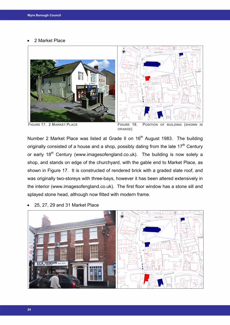
• 2 Market Place
FIGURE 17. 2 MARKET PLACE FIGURE 18. POSITION OF BUILDING (SHOWN IN ORANGE)
Number 2 Market Place was listed at Grade II on 16th August 1983. The building
originally consisted of a house and a shop, possibly dating from the late 17th Century
or early 18th Century (www.imagesofengland.co.uk). The building is now solely a
shop, and stands on edge of the churchyard, with the gable end to Market Place, as
shown in Figure 17. It is constructed of rendered brick with a graded slate roof, and
was originally two-storeys with three-bays, however it has been altered extensively in
the interior (www.imagesofengland.co.uk). The first floor window has a stone sill and
splayed stone head, although now fitted with modern frame.
• 25, 27, 29 and 31 Market Place
24
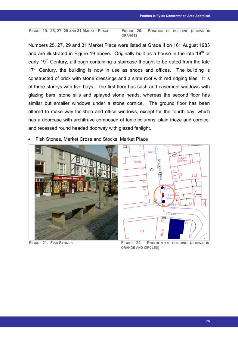
Poulton-le-Fylde Conservation Area Appraisal
FIGURE 19. 25, 27, 29 AND 31 MARKET PLACE FIGURE 20. POSITION OF BUILDING (SHOWN IN ORANGE)
Numbers 25, 27, 29 and 31 Market Place were listed at Grade II on 16th August 1983
and are illustrated in Figure 19 above. Originally built as a house in the late 18th or
early 19th Century, although containing a staircase thought to be dated from the late
17th Century, the building is now in use as shops and offices. The building is
constructed of brick with stone dressings and a slate roof with red ridging tiles. It is
of three storeys with five bays. The first floor has sash and casement windows with
glazing bars, stone sills and splayed stone heads, whereas the second floor has
similar but smaller windows under a stone cornice. The ground floor has been
altered to make way for shop and office windows, except for the fourth bay, which
has a doorcase with architrave composed of Ionic columns, plain frieze and cornice,
and recessed round headed doorway with glazed fanlight.
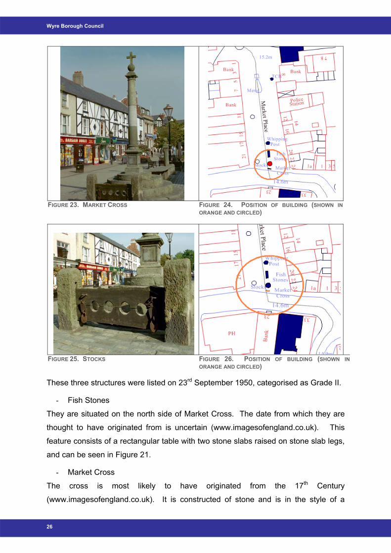
• Fish Stones, Market Cross and Stocks, Market Place
FIGURE 21. FISH STONES FIGURE 22. POSITION OF BUILDING (SHOWN IN
ORANGE AND CIRCLED)
25
Wyre Borough Council
FIGURE 23. MARKET CROSS FIGURE 24. POSITION OF BUILDING (SHOWN IN
ORANGE AND CIRCLED)
FIGURE 25. STOCKS FIGURE 26. POSITION OF BUILDING (SHOWN IN ORANGE AND CIRCLED)
These three structures were listed on 23rd September 1950, categorised as Grade II.
- Fish Stones
They are situated on the north side of Market Cross. The date from which they are
thought to have originated from is uncertain (www.imagesofengland.co.uk). This
feature consists of a rectangular table with two stone slabs raised on stone slab legs,
and can be seen in Figure 21.
- Market Cross
The cross is most likely to have originated from the 17th Century
(www.imagesofengland.co.uk). It is constructed of stone and is in the style of a
26
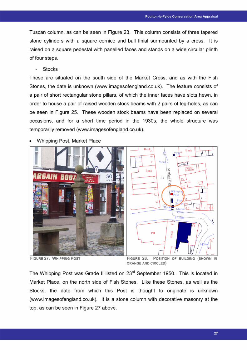
Poulton-le-Fylde Conservation Area Appraisal
Tuscan column, as can be seen in Figure 23. This column consists of three tapered
stone cylinders with a square cornice and ball finial surmounted by a cross. It is
raised on a square pedestal with panelled faces and stands on a wide circular plinth
of four steps.
- Stocks
These are situated on the south side of the Market Cross, and as with the Fish
Stones, the date is unknown (www.imagesofengland.co.uk). The feature consists of
a pair of short rectangular stone pillars, of which the inner faces have slots hewn, in
order to house a pair of raised wooden stock beams with 2 pairs of leg-holes, as can
be seen in Figure 25. These wooden stock beams have been replaced on several
occasions, and for a short time period in the 1930s, the whole structure was
temporarily removed (www.imagesofengland.co.uk).
• Whipping Post, Market Place
FIGURE 27. WHIPPING POST FIGURE 28. POSITION OF BUILDING (SHOWN IN
ORANGE AND CIRCLED)
The Whipping Post was Grade II listed on 23rd September 1950. This is located in
Market Place, on the north side of Fish Stones. Like these Stones, as well as the
Stocks, the date from which this Post is thought to originate is unknown
(www.imagesofengland.co.uk). It is a stone column with decorative masonry at the
top, as can be seen in Figure 27 above.
27
Wyre Borough Council
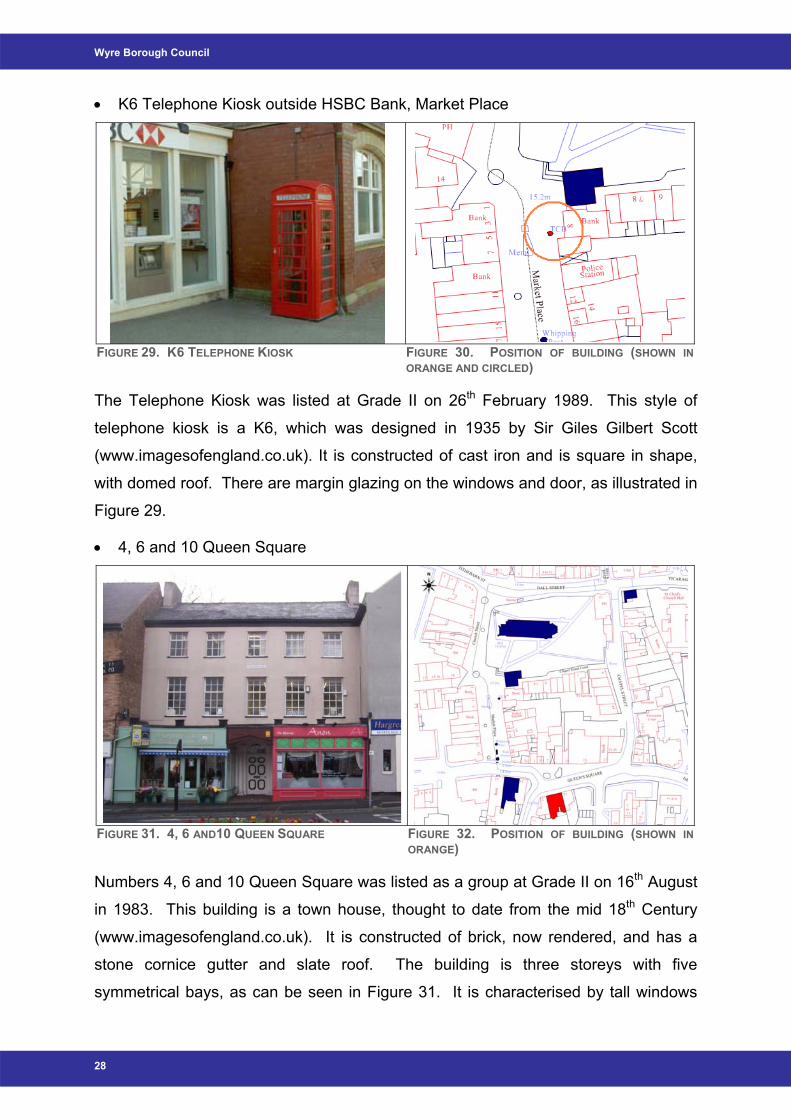
• K6 Telephone Kiosk outside HSBC Bank, Market Place
FIGURE 29. K6 TELEPHONE KIOSK FIGURE 30. POSITION OF BUILDING (SHOWN IN
ORANGE AND CIRCLED)
The Telephone Kiosk was listed at Grade II on 26th February 1989. This style of
telephone kiosk is a K6, which was designed in 1935 by Sir Giles Gilbert Scott
(www.imagesofengland.co.uk). It is constructed of cast iron and is square in shape,
with domed roof. There are margin glazing on the windows and door, as illustrated in
Figure 29.
• 4, 6 and 10 Queen Square
FIGURE 31. 4, 6 AND10 QUEEN SQUARE FIGURE 32. POSITION OF BUILDING (SHOWN IN ORANGE)
Numbers 4, 6 and 10 Queen Square was listed as a group at Grade II on 16th August
in 1983. This building is a town house, thought to date from the mid 18th Century
(www.imagesofengland.co.uk). It is constructed of brick, now rendered, and has a
stone cornice gutter and slate roof. The building is three storeys with five
symmetrical bays, as can be seen in Figure 31. It is characterised by tall windows
28
Poulton-le-Fylde Conservation Area Appraisal
with glazing bars and casements on first floor, on a six over nine arrangement, and
similar but smaller windows on 2nd floor, a three over six arrangement. These
windows are also arranged vertically. The house is set back between the adjoining
buildings on each side, and its ground floor is now incorporated in two shops
extending over the original open area to the front. However, the original entrance
survives beneath this and has a stone door surround that features columns known as
Doric pilasters (www.imagesofengland.co.uk). There is also a semi-circular fanlight
with radiating glazing bars above this.
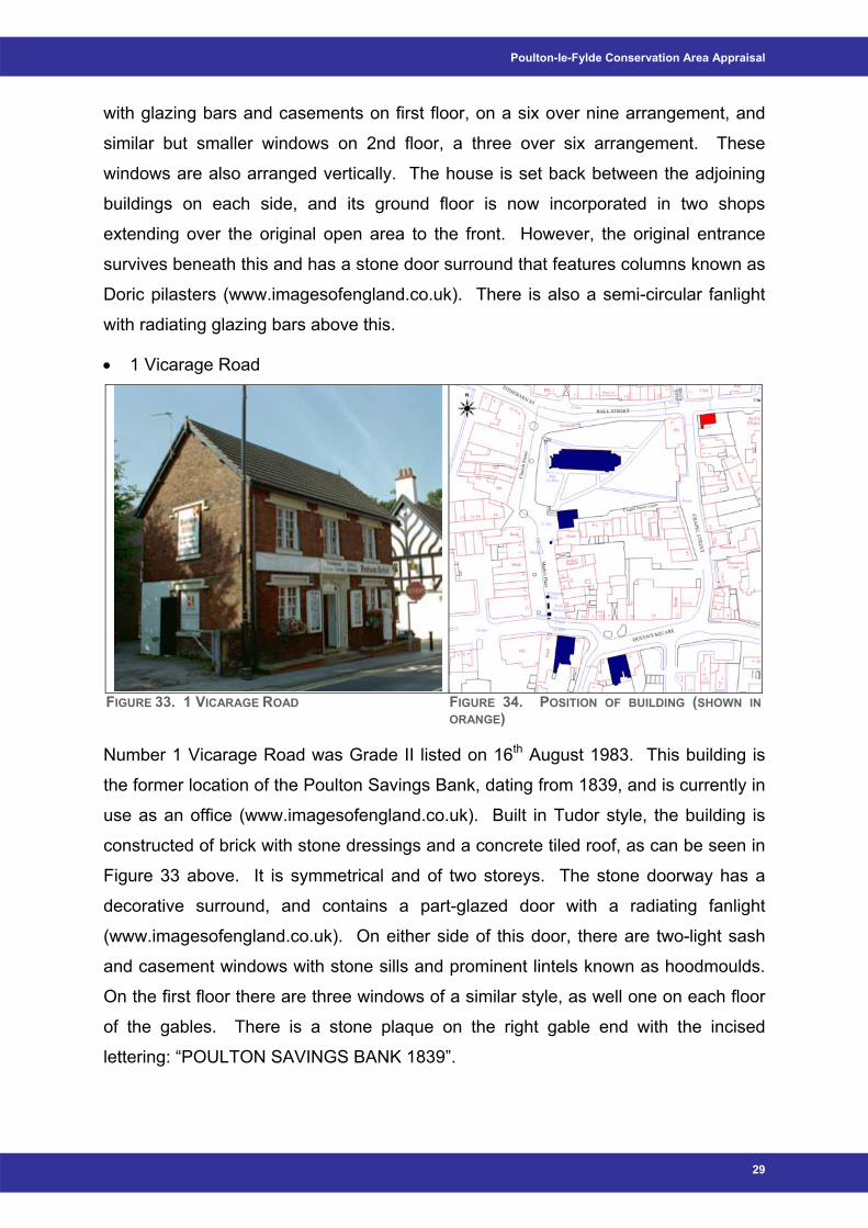
• 1 Vicarage Road
FIGURE 33. 1 VICARAGE ROAD FIGURE 34. POSITION OF BUILDING (SHOWN IN ORANGE)
Number 1 Vicarage Road was Grade II listed on 16th August 1983. This building is
the former location of the Poulton Savings Bank, dating from 1839, and is currently in
use as an office (www.imagesofengland.co.uk). Built in Tudor style, the building is
constructed of brick with stone dressings and a concrete tiled roof, as can be seen in
Figure 33 above. It is symmetrical and of two storeys. The stone doorway has a
decorative surround, and contains a part-glazed door with a radiating fanlight
(www.imagesofengland.co.uk). On either side of this door, there are two-light sash
and casement windows with stone sills and prominent lintels known as hoodmoulds.
On the first floor there are three windows of a similar style, as well one on each floor
of the gables. There is a stone plaque on the right gable end with the incised
lettering: “POULTON SAVINGS BANK 1839”.
29
Wyre Borough Council
Unlisted Buildings of Importance As well as the Statutory List of Listed Buildings, compiled by English Heritage, there
is also a Local List of buildings deemed to be of local importance within the Borough.
This list has been put together from suggestions made by Officers, Council members,
members of the public, and local societies. Poulton-le-Fylde has several ‘key’
unlisted buildings within the present Conservation Area boundary. The positive
contribution that an unlisted building can make on the character and appearance of
the Conservation Area is detailed in English Heritage’s Guidance on Conservation
Area Appraisals (2006), and also summarised by the following questions:
• Is the building the work of a particular architect of regional or local note?
• Has it qualities of age, style, and materials or any other characteristics that
reflect those of at least a substantial number of the buildings in the
Conservation Area?
• Does it relate by age, materials or any other historically significant way to
adjacent listed buildings or contribute positively to their setting?
• Does it individually, or as part of a group, serve as a reminder of the gradual
development of the settlement in which it stands, or of an earlier phase of
growth?
• Does it relate to established historic features e.g. road layout, town park, a
landscape feature, etc?
• Does the building have landmark quality, or contribute to the quality of
recognisable spaces?
• Does it reflect the traditional functional character of, or former uses within,
the Conservation Area?
• Does it have significant historic associations with local people or past
events?
• Does it contribute to the character and appearance of the Conservation
Area?
• Is it associated with a designed landscape?
In English Heritage’s view, “any one of these characteristics could indicate that a
building makes a positive contribution to the…Conservation Area provided that its
historic form and qualities have not been seriously eroded by unsympathetic
alteration”.
30
Poulton-le-Fylde Conservation Area Appraisal
A register of buildings of local historic or architectural importance has been drawn up
in order to highlight those buildings that fulfil the above criteria. There are 32
buildings within Poulton-le-Fylde Conservation Area, which are included on this Local
List, and are as follows: The Golden Ball; 3-9 (odd) Ball Street; The Thatched House
Pub; 17 Breck Road (Lloyds Chemist); The Cube; Railway Station; 32-38 (odd) Breck
Road; 37-39 (odd) Breck Road; 73 Breck Road; 63-65 Breck Road; 5 Chapel Street;
11-19 (odd) Chapel Street; Former ‘lock up’, rear of 11 Church Street; The Old Town
Hall; 14 & 16 Hardhorn Road; Former Bank of Scotland; 15 & 17 Market Place; 19 &
21 Market Place; 4-8 (even) Market Place; 14 Market Place; 33 Market Place; 23
Market Place; 2 Queen’s Square; 3 & 7 Queen’s Square; 9 Queen’s Square;
Methodist Church; 48 Tithebarn Street; United Reformed Church; Air raid shelter,
rear of 10 Tithebarn Street; the Church of St Chad Hall; 1-7 (odd) Victoria Road; and
The Queen’s Hotel.
There is also scope for inclusion of other buildings within this list, for example the
Wyre Borough Council Civic Centre. Due to the age of this building, the architectural
interest, and also the uses that it has had within the town, it is suggested that this be
suggested to English Heritage for listing.
Summary – Buildings - The character of the area relies on the visual effect of the groups of terraces as
a whole rather than a few buildings in particular - Two storey terraced rows of Victorian style buildings predominant - Three churches, - 1 Grade II* Listed Building - 9 Grade II Listed Buildings - 32 buildings included on the Local List with scope for adding the Civic Centre
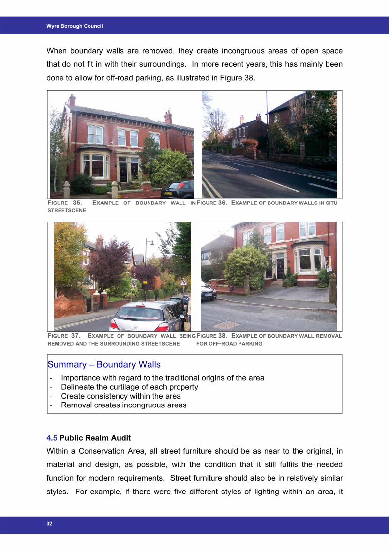
4.4 Boundary Walls Within the Conservation Area, boundary walls are an important aspect of the historic
character of the area and the lifestyles of the previous community. The low walls are
more of a guide of the curtilage of each property rather than a means to prevent
unwanted access. They also create harmony and homogeny within the area, in a
similar way to slate roofs, and timber sash and casement windows.
31
Wyre Borough Council
When boundary walls are removed, they create incongruous areas of open space
that do not fit in with their surroundings. In more recent years, this has mainly been
done to allow for off-road parking, as illustrated in Figure 38.
FIGURE 35. EXAMPLE OF BOUNDARY WALL INSTREETSCENE
FIGURE 36. EXAMPLE OF BOUNDARY WALLS IN SITU
FIGURE 37. EXAMPLE OF BOUNDARY WALL BEINGREMOVED AND THE SURROUNDING STREETSCENE
FIGURE 38. EXAMPLE OF BOUNDARY WALL REMOVAL FOR OFF-ROAD PARKING
Summary – Boundary Walls - Importance with regard to the traditional origins of the area - Delineate the curtilage of each property - Create consistency within the area - Removal creates incongruous areas
4.5 Public Realm Audit Within a Conservation Area, all street furniture should be as near to the original, in
material and design, as possible, with the condition that it still fulfils the needed
function for modern requirements. Street furniture should also be in relatively similar
styles. For example, if there were five different styles of lighting within an area, it
32

Poulton-le-Fylde Conservation Area Appraisal
would detract from the character, as it complicates the aesthetic view. This issue is
the same for all other aspects of street furniture.
Street Lighting Within Poulton-le-Fylde Conservation Area, there are three main styles of lighting.
These three styles are made up of modern street lighting, which can generally be
found in any urban area in the UK, shown in Figure 39 and more traditional style
street lighting on both small and large scale, as illustrated in Figures 39 – 42 below.
These traditional styles are very appropriate for the historical character, and as such
have a positive effect on the appearance of Poulton-le-Fylde Conservation Area.
Conversely, the more modern styled street lighting columns are inappropriate in
material and design with regard to the historic character and appearance of the
Conservation Area and should be replaced in favour of the more traditional design.
However, these modern lighting designs are relatively few in occurrence and
therefore do not noticeably detract from the character and appearance of the area.
There is general consistency and uniformity between the lighting columns and this
can be seen as a positive and / or neutral feature within the Conservation Area.
FIGURE 39. TRADITIONAL LARGE SCALE DESIGN STREET LIGHTING, MORE MODERN STYLE IN BACKGROUND
FIGURE 40. TRADITIONAL LARGE SCALE STYLE STREET LIGHTING
33

Wyre Borough Council
FIGURE 41. TRADITIONAL SMALL SCALE LANTERN STYLE STREET LIGHTING
FIGURE 42. TRADITIONAL SMALL SCALE LANTERN STYLE STREET LIGHTING
CCTV Cameras There are several CCTV camera columns located throughout the Conservation Area,
though mainly located around Market Place and the Church of St Chad, in order to
enforce public safety. They all appear to take the same fairly traditional unobtrusive
design, as illustrated in Figure 43 below, similar to that of the traditional large scale
street lighting, and as such can be seen as having a neutral effect on the character
and appearance of the Conservation Area.
FIGURE 43. INCONSPICUOUS CCTV COLUMN DESIGN
34
Poulton-le-Fylde Conservation Area Appraisal
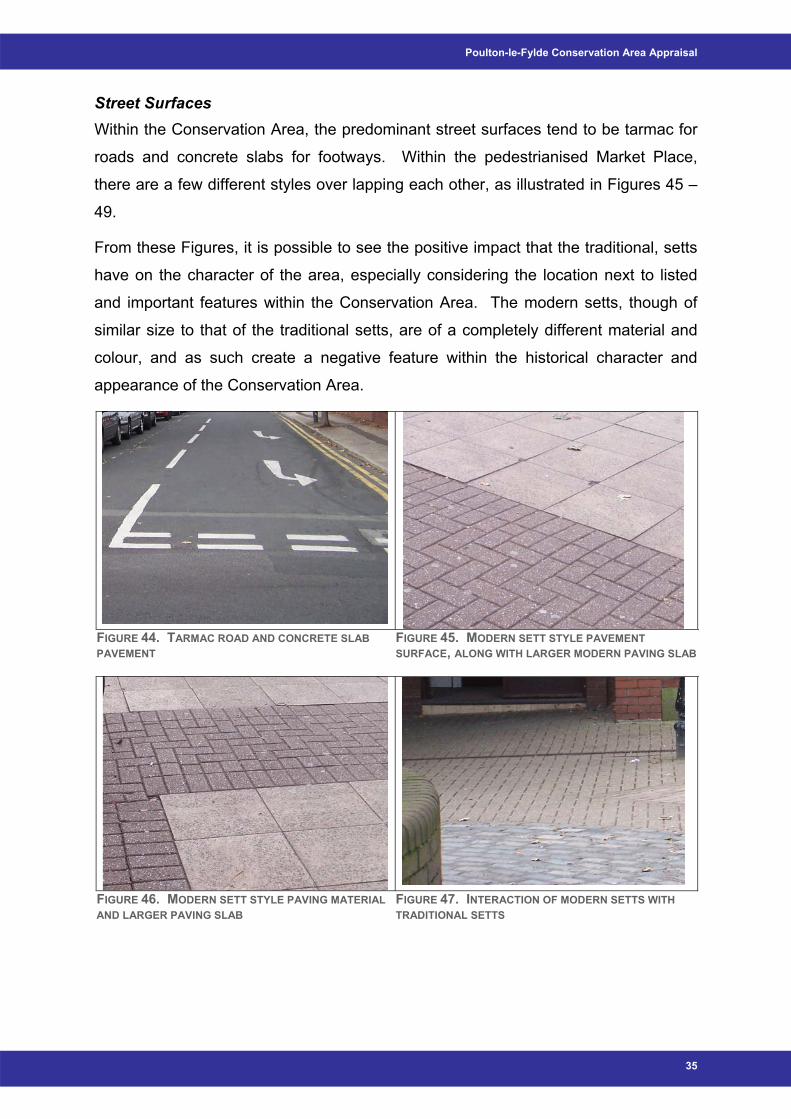
Street Surfaces Within the Conservation Area, the predominant street surfaces tend to be tarmac for
roads and concrete slabs for footways. Within the pedestrianised Market Place,
there are a few different styles over lapping each other, as illustrated in Figures 45 –
49.
From these Figures, it is possible to see the positive impact that the traditional, setts
have on the character of the area, especially considering the location next to listed
and important features within the Conservation Area. The modern setts, though of
similar size to that of the traditional setts, are of a completely different material and
colour, and as such create a negative feature within the historical character and
appearance of the Conservation Area.
FIGURE 44. TARMAC ROAD AND CONCRETE SLAB PAVEMENT
FIGURE 45. MODERN SETT STYLE PAVEMENT SURFACE, ALONG WITH LARGER MODERN PAVING SLAB
FIGURE 46. MODERN SETT STYLE PAVING MATERIAL AND LARGER PAVING SLAB
FIGURE 47. INTERACTION OF MODERN SETTS WITH TRADITIONAL SETTS
35
Wyre Borough Council
FIGURE 48. TRADITIONAL AND MODERN SETTS FIGURE 49. TRADITIONAL AND MODERN SETTS
AROUND IMPORTANT HISTORICAL FEATURES
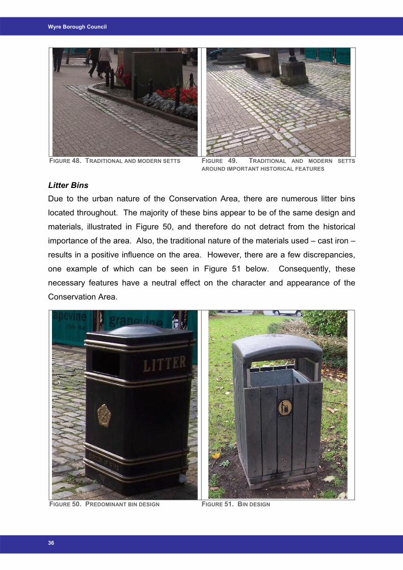
Litter Bins Due to the urban nature of the Conservation Area, there are numerous litter bins
located throughout. The majority of these bins appear to be of the same design and
materials, illustrated in Figure 50, and therefore do not detract from the historical
importance of the area. Also, the traditional nature of the materials used – cast iron –
results in a positive influence on the area. However, there are a few discrepancies,
one example of which can be seen in Figure 51 below. Consequently, these
necessary features have a neutral effect on the character and appearance of the
Conservation Area.
FIGURE 50. PREDOMINANT BIN DESIGN FIGURE 51. BIN DESIGN
36
Poulton-le-Fylde Conservation Area Appraisal
Shopfront Signage As Poulton-le-Fylde is an urban settlement, there are many examples of signage
within the Conservation Area boundary. However, due to the increasing volume of
corporate images and styles, it is essential to encourage traditional shopfronts within
this historical area. As such, a shop front design guide would be advantageous.
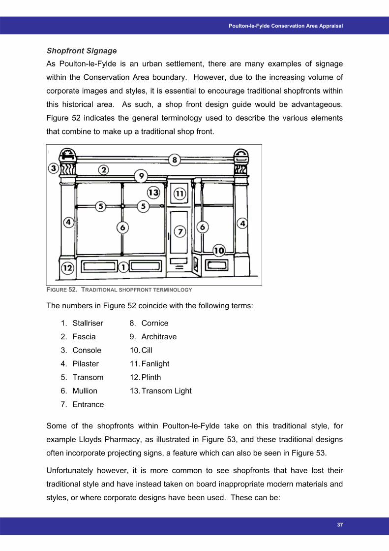
Figure 52 indicates the general terminology used to describe the various elements
that combine to make up a traditional shop front.
FIGURE 52. TRADITIONAL SHOPFRONT TERMINOLOGY
The numbers in Figure 52 coincide with the following terms:
1. Stallriser
2. Fascia
3. Console
4. Pilaster
5. Transom
6. Mullion
7. Entrance
8. Cornice
9. Architrave
10. Cill
11. Fanlight
12. Plinth
13. Transom Light
Some of the shopfronts within Poulton-le-Fylde take on this traditional style, for
example Lloyds Pharmacy, as illustrated in Figure 53, and these traditional designs
often incorporate projecting signs, a feature which can also be seen in Figure 53.
Unfortunately however, it is more common to see shopfronts that have lost their
traditional style and have instead taken on board inappropriate modern materials and
styles, or where corporate designs have been used. These can be:
37
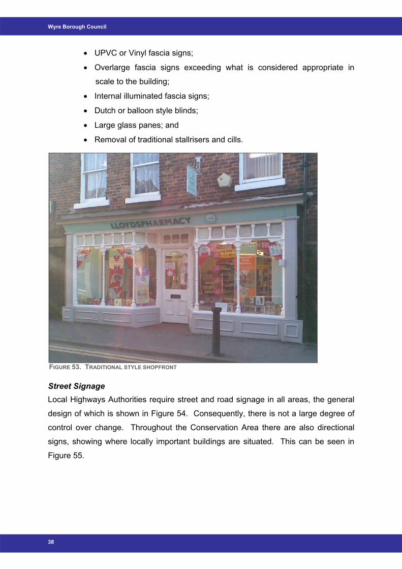
Wyre Borough Council
• UPVC or Vinyl fascia signs;
• Overlarge fascia signs exceeding what is considered appropriate in
scale to the building;
• Internal illuminated fascia signs;
• Dutch or balloon style blinds;
• Large glass panes; and
• Removal of traditional stallrisers and cills.
FIGURE 53. TRADITIONAL STYLE SHOPFRONT
Street Signage Local Highways Authorities require street and road signage in all areas, the general
design of which is shown in Figure 54. Consequently, there is not a large degree of
control over change. Throughout the Conservation Area there are also directional
signs, showing where locally important buildings are situated. This can be seen in
Figure 55.
38
Poulton-le-Fylde Conservation Area Appraisal
FIGURE 54. HIGHWAYS SIGNAGE FIGURE 55. TRADITIONAL STYLE DIRECTIONAL SIGNAGE
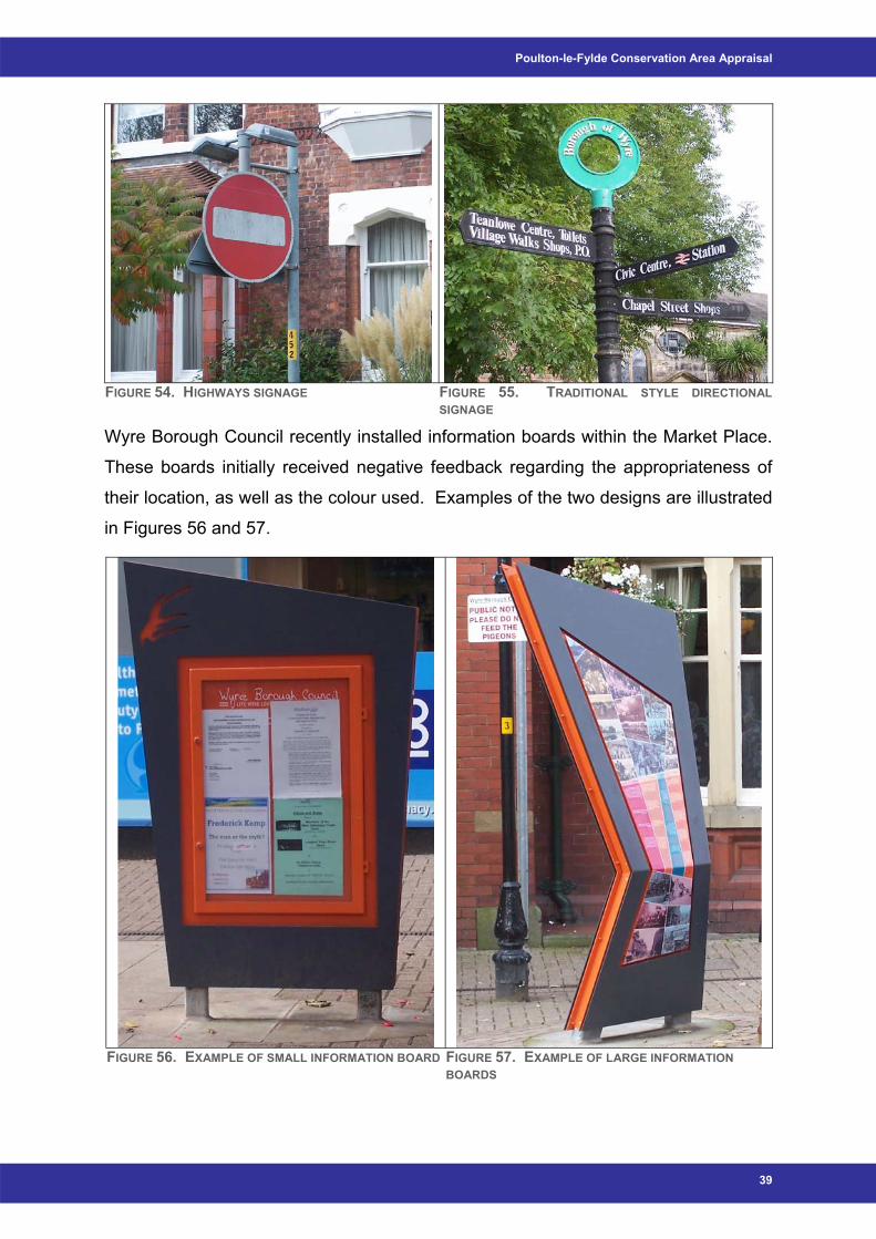
Wyre Borough Council recently installed information boards within the Market Place.
These boards initially received negative feedback regarding the appropriateness of
their location, as well as the colour used. Examples of the two designs are illustrated
in Figures 56 and 57.
FIGURE 56. EXAMPLE OF SMALL INFORMATION BOARD FIGURE 57. EXAMPLE OF LARGE INFORMATION
BOARDS
39
Wyre Borough Council
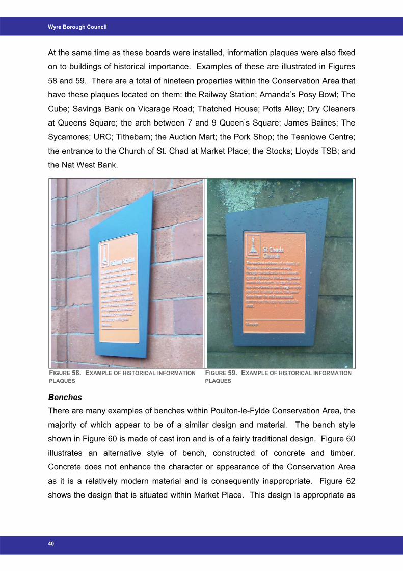
At the same time as these boards were installed, information plaques were also fixed
on to buildings of historical importance. Examples of these are illustrated in Figures
58 and 59. There are a total of nineteen properties within the Conservation Area that
have these plaques located on them: the Railway Station; Amanda’s Posy Bowl; The
Cube; Savings Bank on Vicarage Road; Thatched House; Potts Alley; Dry Cleaners
at Queens Square; the arch between 7 and 9 Queen’s Square; James Baines; The
Sycamores; URC; Tithebarn; the Auction Mart; the Pork Shop; the Teanlowe Centre;
the entrance to the Church of St. Chad at Market Place; the Stocks; Lloyds TSB; and
the Nat West Bank.
FIGURE 58. EXAMPLE OF HISTORICAL INFORMATION PLAQUES
FIGURE 59. EXAMPLE OF HISTORICAL INFORMATION PLAQUES
Benches There are many examples of benches within Poulton-le-Fylde Conservation Area, the
majority of which appear to be of a similar design and material. The bench style
shown in Figure 60 is made of cast iron and is of a fairly traditional design. Figure 60
illustrates an alternative style of bench, constructed of concrete and timber.
Concrete does not enhance the character or appearance of the Conservation Area
as it is a relatively modern material and is consequently inappropriate. Figure 62
shows the design that is situated within Market Place. This design is appropriate as
40
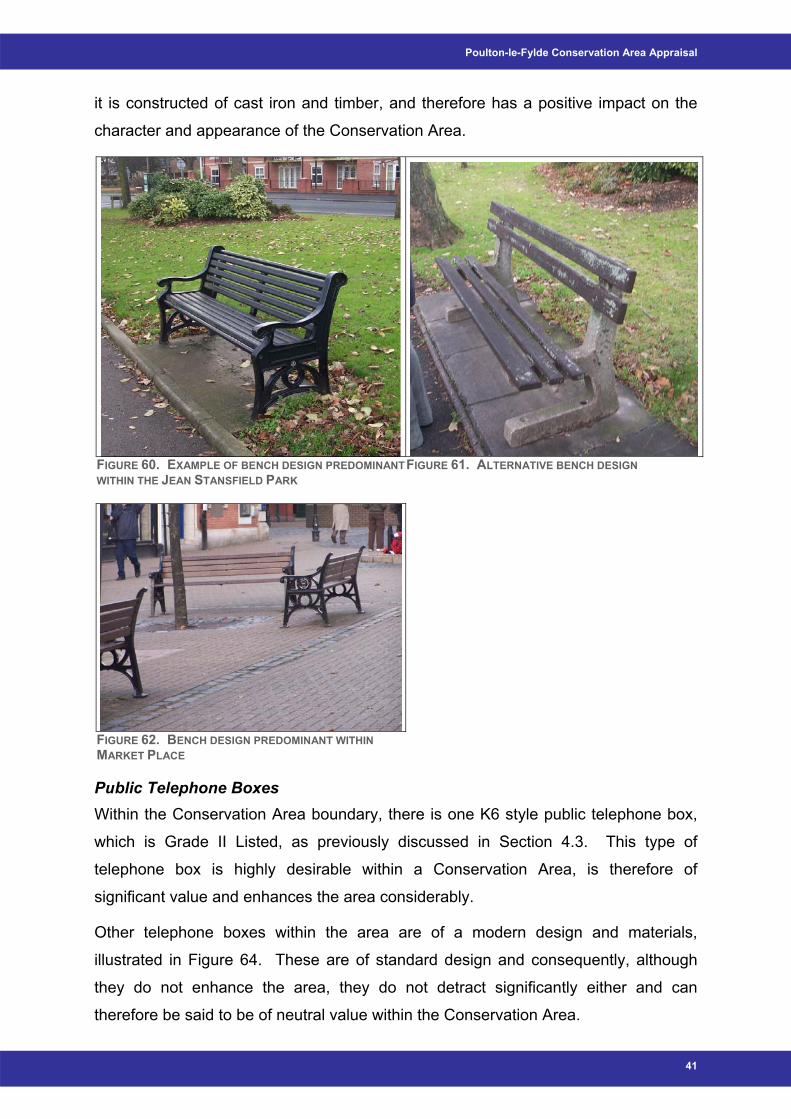
Poulton-le-Fylde Conservation Area Appraisal
it is constructed of cast iron and timber, and therefore has a positive impact on the
character and appearance of the Conservation Area.
FIGURE 60. EXAMPLE OF BENCH DESIGN PREDOMINANTWITHIN THE JEAN STANSFIELD PARK
FIGURE 61. ALTERNATIVE BENCH DESIGN
FIGURE 62. BENCH DESIGN PREDOMINANT WITHIN MARKET PLACE
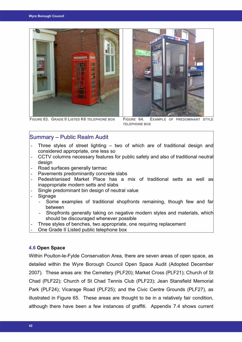
Public Telephone Boxes Within the Conservation Area boundary, there is one K6 style public telephone box,
which is Grade II Listed, as previously discussed in Section 4.3. This type of
telephone box is highly desirable within a Conservation Area, is therefore of
significant value and enhances the area considerably.
Other telephone boxes within the area are of a modern design and materials,
illustrated in Figure 64. These are of standard design and consequently, although
they do not enhance the area, they do not detract significantly either and can
therefore be said to be of neutral value within the Conservation Area.
41
Wyre Borough Council
FIGURE 63. GRADE II LISTED K6 TELEPHONE BOX FIGURE 64. EXAMPLE OF PREDOMINANT STYLE
TELEPHONE BOX
Summary – Public Realm Audit - Three styles of street lighting – two of which are of traditional design and
considered appropriate, one less so - CCTV columns necessary features for public safety and also of traditional neutral
design - Road surfaces generally tarmac - Pavements predominantly concrete slabs - Pedestrianised Market Place has a mix of traditional setts as well as
inappropriate modern setts and slabs - Single predominant bin design of neutral value - Signage
- Some examples of traditional shopfronts remaining, though few and far between
- Shopfronts generally taking on negative modern styles and materials, which should be discouraged whenever possible
- Three styles of benches, two appropriate, one requiring replacement - One Grade II Listed public telephone box
4.6 Open Space Within Poulton-le-Fylde Conservation Area, there are seven areas of open space, as
detailed within the Wyre Borough Council Open Space Audit (Adopted December
2007). These areas are: the Cemetery (PLF20); Market Cross (PLF21); Church of St
Chad (PLF22); Church of St Chad Tennis Club (PLF23); Jean Stansfield Memorial
Park (PLF24); Vicarage Road (PLF25); and the Civic Centre Grounds (PLF27), as
illustrated in Figure 65. These areas are thought to be in a relatively fair condition,
although there have been a few instances of graffiti. Appendix 7.4 shows current
42
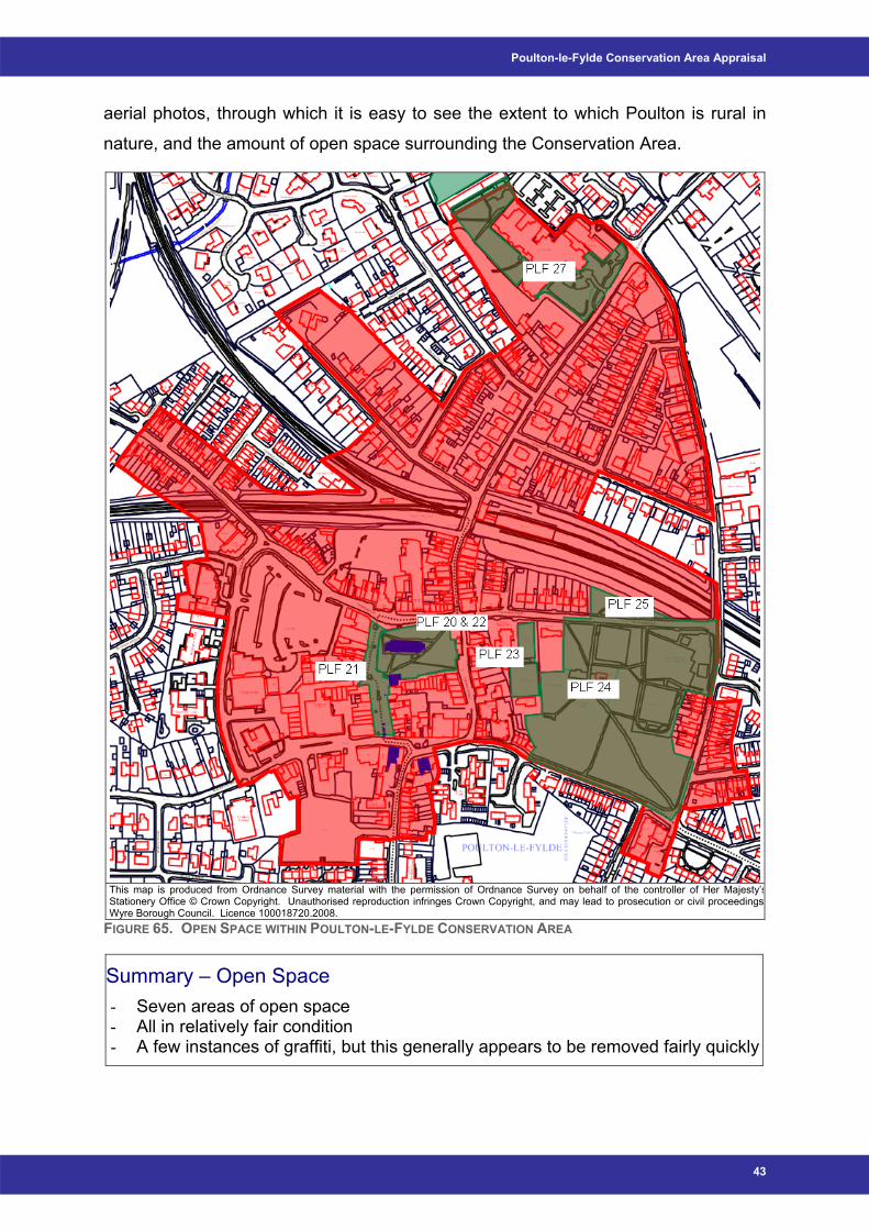
Poulton-le-Fylde Conservation Area Appraisal
aerial photos, through which it is easy to see the extent to which Poulton is rural in
nature, and the amount of open space surrounding the Conservation Area.
This map is produced from Ordnance Survey material with the permission of Ordnance Survey on behalf of the controller of Her Majesty’sStationery Office © Crown Copyright. Unauthorised reproduction infringes Crown Copyright, and may lead to prosecution or civil proceedingsWyre Borough Council. Licence 100018720.2008.
FIGURE 65. OPEN SPACE WITHIN POULTON-LE-FYLDE CONSERVATION AREA
Summary – Open Space - Seven areas of open space - All in relatively fair condition - A few instances of graffiti, but this generally appears to be removed fairly quickly
43
Wyre Borough Council
4.7 Trees Protection of trees within the Conservation Area is through:
1. Being situated within the Conservation Area boundary; and
2. Tree Preservation Orders (TPOs).
By being situated within the Conservation Area boundary, anyone intending to lop or
fell a tree greater than 100mm in diameter at 1.5 metres above ground level is
required to give the Council six-weeks written notice before starting work. This
allows the Council to assess the tree with regard to the contribution it makes towards
the character or appearance of the Conservation Area.
Through TPOs, no person is allowed to cut down, top, lop, uproot, wilfully damage or
wilfully destroy; or, cause or permit the cutting down, topping, lopping, uprooting,
wilful damage or wilful destruction of any tree specified in an Order or comprised in a
group of trees or in a woodland so specified, except with the consent of the authority
and, where such consent is given subject to conditions, in accordance with those
conditions (The Town and Country Planning (Trees) Regulations, 1999).
There are currently eight Tree Preservation Orders within the Conservation Area of
Poulton-le Fylde, as shown in Figure 66 below (dark green). This map also illustrates
a number of areas that the Tree Officer considers could have potential as TPOs (light
green).
44
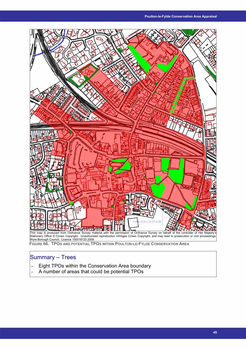
Poulton-le-Fylde Conservation Area Appraisal
This map is produced from Ordnance Survey material with the permission of Ordnance Survey on behalf of the controller of Her Majesty’sStationery Office © Crown Copyright. Unauthorised reproduction infringes Crown Copyright, and may lead to prosecution or civil proceedings.Wyre Borough Council. Licence 100018720.2008. FIGURE 66. TPOS AND POTENTIAL TPOS WITHIN POULTON-LE-FYLDE CONSERVATION AREA
Summary – Trees - Eight TPOs within the Conservation Area boundary - A number of areas that could be potential TPOs
45
Wyre Borough Council
4.8 Architecture and Materials The range of buildings illustrated within the Conservation Area presents a mix of
styles and ages ranging from the Church of St Chad, with suggestion of origin in
medieval times, to the Methodist Church built in the 1960s.
Whilst the medieval street plan around the Church of St Chad and Market Place is an
influential factor, the most represented period structurally is that of the nineteenth
and early twentieth centuries. The Victorian and Edwardian periods are particularly
dominant, an unsurprising fact as this represented prosperous times for Poulton.
Buildings built during this time tend to be semi-detached town houses, as illustrated
in Figure 67.
It is consequently unsurprising that the dominant building material within Poulton-le-
Fylde tends to be red Accrington brick, though occasionally rendered, and usually a
Welsh grey slate roof, as can be seen in Figures 67 and 70. Windows and doors
would originally have been recessed and constructed of timber in material and
painted, with the windows being of sash and casement in design as can be seen in
Figures 68 - 70. Unfortunately, due to the attraction of modern uPVC glazing, more
readily available and relatively cheap by comparison to traditional timber, many of
these traditional windows have been lost, as well as many original timber doors.
Traditional properties can be seen to have elaborate masonry around the doorways,
illustrating the wealth of the area. Examples of incorporation into door surrounds are
shown in Figures 71 and 72. With the loss of these features in more modern building
designs, the character of the Conservation Area is becoming increasingly diluted.
Bargeboards are also traditional features of many of the buildings situated within the
Conservation Area. This can be seen in Figure 73 and can be defined as boards
fixed at the gable ends of roofs to conceal and protect the ends of the roof timbers.
Bay windows also appear to be fairly traditional features, as can be seen in Figure
74. A bay window can be described as a window that internally is recessed, and
consequently projects on the outside of the building. The example shown in Figure
74 is slightly different however, being a canted bay window, defined as having a
straight front with angled sides (www.trp.dundee.ac.uk).
Figures 75 and 76 illustrate the presence of dentil courses on many buildings within
Poulton. These are decorative features that are spaced commonly in a manner
46

Poulton-le-Fylde Conservation Area Appraisal
comparable to teeth and usually placed under the cornice of the roof
(www.trp.dundee.ac.uk).
There are also many other interesting individual architectural features that are of
historical value, one of which is illustrated in Figure 77. This is decorative motif is
located on the entrance to The Cube at the top of Breck Road. This Public House
used to be the Ship Inn and as such a ship carved in stone is situated further up the
front elevation of the building.
Traditional commercial properties also tend to be built in red brick, originally with
residential properties situated on the first floor, as illustrated in Figure 78. Some
traditional examples of shopfronts remain, though many others have been greatly
altered in recent years.
FIGURE 67. EXAMPLE OF TWO-STOREY SEMI-DETACHED HOUSE
FIGURE 68. EXAMPLE OF SLIGHTLY RECESSED DOORWAYS
FIGURE 69. GOOD EXAMPLE OF SASH AND CASEMENT WINDOWS
FIGURE 70. GOOD EXAMPLE OF SASH AND CASEMENT WINDOWS
47
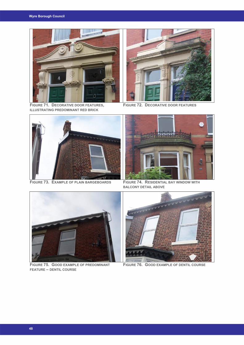
Wyre Borough Council
FIGURE 71. DECORATIVE DOOR FEATURES, ILLUSTRATING PREDOMINANT RED BRICK
FIGURE 72. DECORATIVE DOOR FEATURES
FIGURE 73. EXAMPLE OF PLAIN BARGEBOARDS FIGURE 74. RESIDENTIAL BAY WINDOW WITH BALCONY DETAIL ABOVE
FIGURE 75. GOOD EXAMPLE OF PREDOMINANT FEATURE – DENTIL COURSE
FIGURE 76. GOOD EXAMPLE OF DENTIL COURSE
48
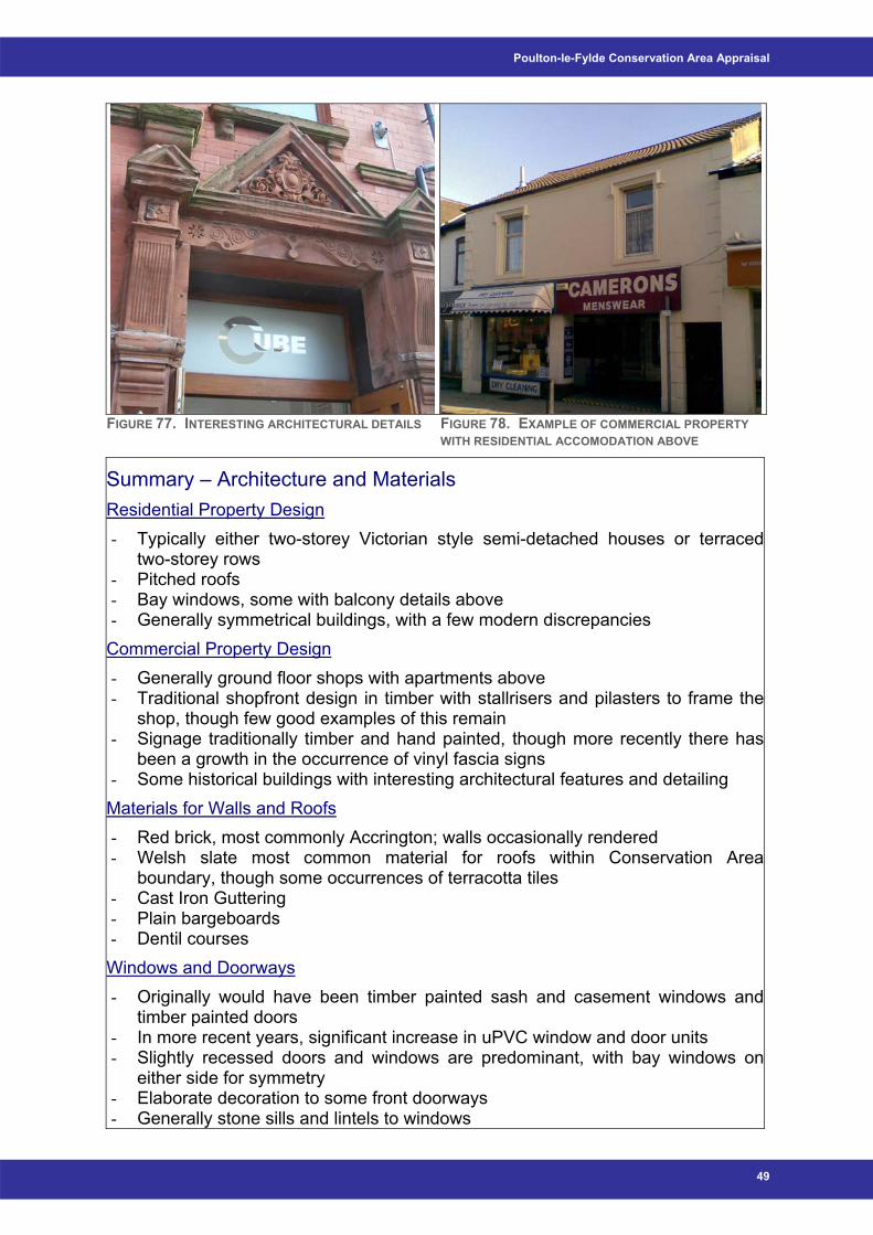
Poulton-le-Fylde Conservation Area Appraisal
FIGURE 77. INTERESTING ARCHITECTURAL DETAILS FIGURE 78. EXAMPLE OF COMMERCIAL PROPERTY WITH RESIDENTIAL ACCOMODATION ABOVE
Summary – Architecture and Materials Residential Property Design - Typically either two-storey Victorian style semi-detached houses or terraced
two-storey rows - Pitched roofs - Bay windows, some with balcony details above - Generally symmetrical buildings, with a few modern discrepancies Commercial Property Design - Generally ground floor shops with apartments above - Traditional shopfront design in timber with stallrisers and pilasters to frame the
shop, though few good examples of this remain - Signage traditionally timber and hand painted, though more recently there has
been a growth in the occurrence of vinyl fascia signs - Some historical buildings with interesting architectural features and detailing Materials for Walls and Roofs - Red brick, most commonly Accrington; walls occasionally rendered - Welsh slate most common material for roofs within Conservation Area
boundary, though some occurrences of terracotta tiles - Cast Iron Guttering - Plain bargeboards - Dentil courses Windows and Doorways - Originally would have been timber painted sash and casement windows and
timber painted doors - In more recent years, significant increase in uPVC window and door units - Slightly recessed doors and windows are predominant, with bay windows on
either side for symmetry - Elaborate decoration to some front doorways - Generally stone sills and lintels to windows
49
Wyre Borough Council
5 Pressures, Issues and Threats
5.1
5.2
Pressures The main pressures relating to the Conservation Area are:
• The increasing roll out of corporate images on shop fronts, many of which do
not sit well within the character of the Conservation Area, and consequently
the drive to increase the quality of retail provision;
• The increasing use of uPVC in doors and windows in historic buildings and
areas;
• The effect of traffic and problems with parking, possibly leading to
conversion of gardens to off street parking;
• The increase of properties with satellite dishes on the front elevation of the
building;
• Replacement of traditional Welsh slates with modern shiny slates;
• Any future redevelopment of existing buildings within the Conservation Area
boundary;
• Any future development of open space in the Conservation Area, i.e.
redevelopment of Jean Stansfield Park;
• The future redesign of street furniture within Market Place; and
• Possible further pedestrianisation of central Poulton.
Issues and Threats Shopfront Signage Fascia Signage
Traditional fascia signs should be an integrated part of the overall design and the use
of hand painted timber fascias is encouraged. Fascia boards should be angled down
towards pedestrians rather than parallel to the front face of the building and therefore
directed at the horizon. Lettering should be clear and unambiguous – often the shop
name alone is sufficient. They should be sign written or made up of individually
applied letters that are appropriate in scale, colour and typeface to the building.
Good general examples of fascia signage are shown in Figure 79, with inappropriate
styles illustrated in Figure 80.
50
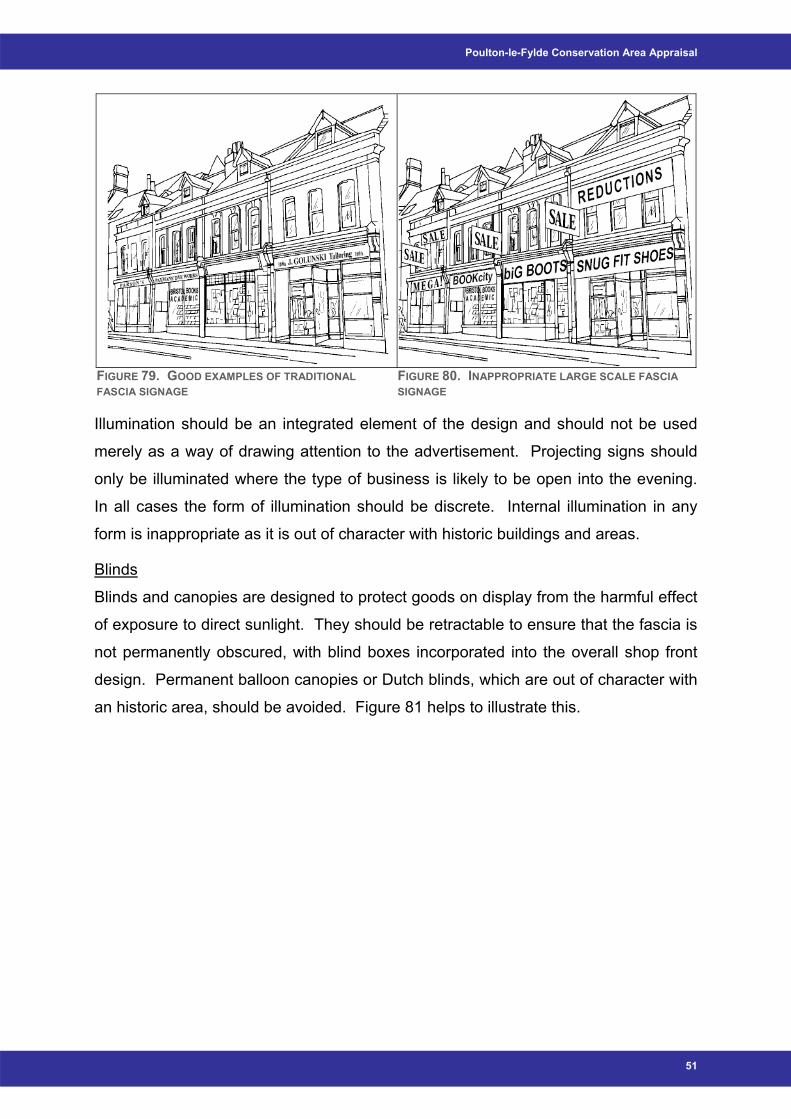
Poulton-le-Fylde Conservation Area Appraisal
FIGURE 79. GOOD EXAMPLES OF TRADITIONAL FASCIA SIGNAGE
FIGURE 80. INAPPROPRIATE LARGE SCALE FASCIA SIGNAGE
Illumination should be an integrated element of the design and should not be used
merely as a way of drawing attention to the advertisement. Projecting signs should
only be illuminated where the type of business is likely to be open into the evening.
In all cases the form of illumination should be discrete. Internal illumination in any
form is inappropriate as it is out of character with historic buildings and areas.
Blinds
Blinds and canopies are designed to protect goods on display from the harmful effect
of exposure to direct sunlight. They should be retractable to ensure that the fascia is
not permanently obscured, with blind boxes incorporated into the overall shop front
design. Permanent balloon canopies or Dutch blinds, which are out of character with
an historic area, should be avoided. Figure 81 helps to illustrate this.
51
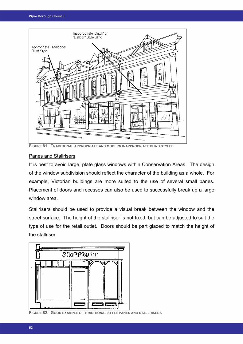
Wyre Borough Council
FIGURE 81. TRADITIONAL APPROPRIATE AND MODERN INAPPROPRIATE BLIND STYLES
Panes and Stallrisers
It is best to avoid large, plate glass windows within Conservation Areas. The design
of the window subdivision should reflect the character of the building as a whole. For
example, Victorian buildings are more suited to the use of several small panes.
Placement of doors and recesses can also be used to successfully break up a large
window area.
Stallrisers should be used to provide a visual break between the window and the
street surface. The height of the stallriser is not fixed, but can be adjusted to suit the
type of use for the retail outlet. Doors should be part glazed to match the height of
the stallriser.
FIGURE 82. GOOD EXAMPLE OF TRADITIONAL STYLE PANES AND STALLRISERS
52
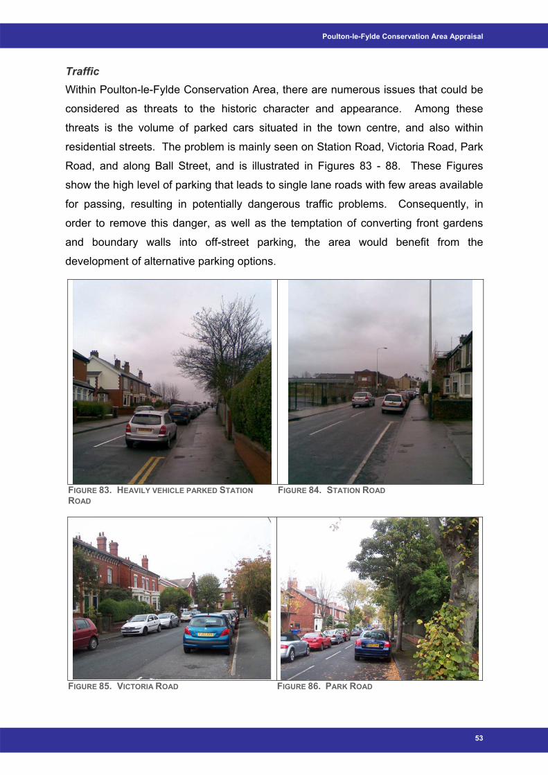
Poulton-le-Fylde Conservation Area Appraisal
Traffic Within Poulton-le-Fylde Conservation Area, there are numerous issues that could be
considered as threats to the historic character and appearance. Among these
threats is the volume of parked cars situated in the town centre, and also within
residential streets. The problem is mainly seen on Station Road, Victoria Road, Park
Road, and along Ball Street, and is illustrated in Figures 83 - 88. These Figures
show the high level of parking that leads to single lane roads with few areas available
for passing, resulting in potentially dangerous traffic problems. Consequently, in
order to remove this danger, as well as the temptation of converting front gardens
and boundary walls into off-street parking, the area would benefit from the
development of alternative parking options.
FIGURE 83. HEAVILY VEHICLE PARKED STATION ROAD
FIGURE 84. STATION ROAD
FIGURE 85. VICTORIA ROAD FIGURE 86. PARK ROAD
53
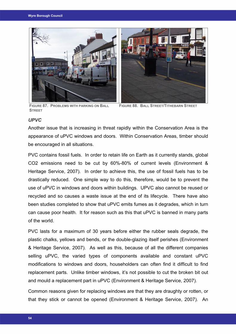
Wyre Borough Council
FIGURE 87. PROBLEMS WITH PARKING ON BALL STREET
FIGURE 88. BALL STREET/TITHEBARN STREET
UPVC Another issue that is increasing in threat rapidly within the Conservation Area is the
appearance of uPVC windows and doors. Within Conservation Areas, timber should
be encouraged in all situations.
PVC contains fossil fuels. In order to retain life on Earth as it currently stands, global
CO2 emissions need to be cut by 60%-80% of current levels (Environment &
Heritage Service, 2007). In order to achieve this, the use of fossil fuels has to be
drastically reduced. One simple way to do this, therefore, would be to prevent the
use of uPVC in windows and doors within buildings. UPVC also cannot be reused or
recycled and so causes a waste issue at the end of its lifecycle. There have also
been studies completed to show that uPVC emits fumes as it degrades, which in turn
can cause poor health. It for reason such as this that uPVC is banned in many parts
of the world.
PVC lasts for a maximum of 30 years before either the rubber seals degrade, the
plastic chalks, yellows and bends, or the double-glazing itself perishes (Environment
& Heritage Service, 2007). As well as this, because of all the different companies
selling uPVC, the varied types of components available and constant uPVC
modifications to windows and doors, householders can often find it difficult to find
replacement parts. Unlike timber windows, it’s not possible to cut the broken bit out
and mould a replacement part in uPVC (Environment & Heritage Service, 2007).
Common reasons given for replacing windows are that they are draughty or rotten, or
that they stick or cannot be opened (Environment & Heritage Service, 2007). An
54
Poulton-le-Fylde Conservation Area Appraisal
experienced joiner can rectify all of these problems, and serious consideration should
always be given to conservation of existing windows rather than complete
replacement: not only for aesthetic reasons but also economic.
The question that is most commonly asked with regard to wooden windows is in
relation to draft proofing (Environment & Heritage Service, 2007). Common
perception appears to be that wooden windows are considerably drafty. However,
what is not normally considered is that wood is a better insulator than uPVC, and
also that the same draft stripping is used in wood as in uPVC (Environment &
Heritage Service, 2007). Well-fitted wooden windows that let in a certain amount of
air, work in the same way as sealed up windows that use in-built, and obligatory, air
regulation vents to allow the room to breathe i.e. draft-proofing can be overdone
(Environment & Heritage Service, 2007). Ventilation is an important part of a
building, without it problems begin generally in the form of poor indoor air quality and
increased condensation. Issues can also arise in relation to buildings that have gas
appliances fitted.
Another factor that should also be taken into consideration is the influence that timber
windows can have on the worth of a property, in that although timber windows may
be more expensive in the short term, they generally have a positive effect on the
overall value of a property, whereas uPVC can tend to have a more negative
financial impact on a building within a traditional area.
Within Poulton-le-Fylde Conservation Area, more and more timber sash and
casement windows are being replaced with uPVC. UPVC is a modern material, and
as such should be discouraged as inappropriate and incongruous within
Conservation Areas as standard. Timber is a traditional material and consequently
should be promoted in all circumstances. Good examples where timber sash and
casement windows remain in situ are illustrated in Figures 89 and 90. Figure 91
shows an appropriate replacement timber sash and casement window, while Figure
92 illustrates inappropriate modern mock sash and casement uPVC windows.
55
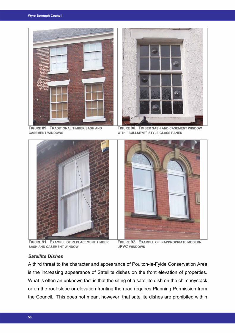
Wyre Borough Council
FIGURE 89. TRADITIONAL TIMBER SASH AND CASEMENT WINDOWS
FIGURE 90. TIMBER SASH AND CASEMENT WINDOW WITH “BULLSEYE” STYLE GLASS PANES
FIGURE 91. EXAMPLE OF REPLACEMENT TIMBER SASH AND CASEMENT WINDOW
FIGURE 92. EXAMPLE OF INAPPROPRIATE MODERN UPVC WINDOWS
Satellite Dishes A third threat to the character and appearance of Poulton-le-Fylde Conservation Area
is the increasing appearance of Satellite dishes on the front elevation of properties.
What is often an unknown fact is that the siting of a satellite dish on the chimneystack
or on the roof slope or elevation fronting the road requires Planning Permission from
the Council. This does not mean, however, that satellite dishes are prohibited within
56
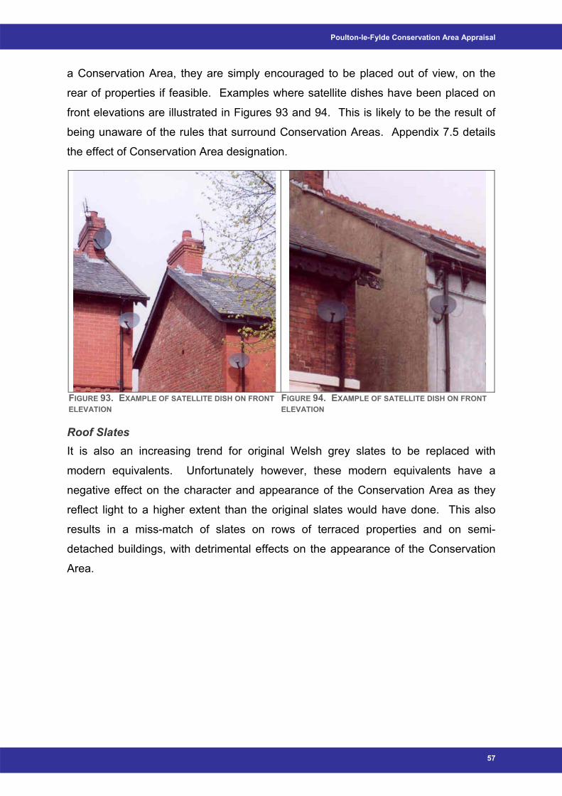
Poulton-le-Fylde Conservation Area Appraisal
a Conservation Area, they are simply encouraged to be placed out of view, on the
rear of properties if feasible. Examples where satellite dishes have been placed on
front elevations are illustrated in Figures 93 and 94. This is likely to be the result of
being unaware of the rules that surround Conservation Areas. Appendix 7.5 details
the effect of Conservation Area designation.
FIGURE 93. EXAMPLE OF SATELLITE DISH ON FRONT ELEVATION
FIGURE 94. EXAMPLE OF SATELLITE DISH ON FRONT ELEVATION
Roof Slates It is also an increasing trend for original Welsh grey slates to be replaced with
modern equivalents. Unfortunately however, these modern equivalents have a
negative effect on the character and appearance of the Conservation Area as they
reflect light to a higher extent than the original slates would have done. This also
results in a miss-match of slates on rows of terraced properties and on semi-
detached buildings, with detrimental effects on the appearance of the Conservation
Area.
57
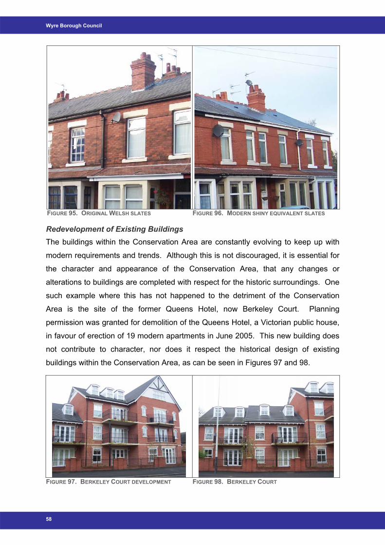
Wyre Borough Council
FIGURE 95. ORIGINAL WELSH SLATES FIGURE 96. MODERN SHINY EQUIVALENT SLATES
Redevelopment of Existing Buildings The buildings within the Conservation Area are constantly evolving to keep up with
modern requirements and trends. Although this is not discouraged, it is essential for
the character and appearance of the Conservation Area, that any changes or
alterations to buildings are completed with respect for the historic surroundings. One
such example where this has not happened to the detriment of the Conservation
Area is the site of the former Queens Hotel, now Berkeley Court. Planning
permission was granted for demolition of the Queens Hotel, a Victorian public house,
in favour of erection of 19 modern apartments in June 2005. This new building does
not contribute to character, nor does it respect the historical design of existing
buildings within the Conservation Area, as can be seen in Figures 97 and 98.
FIGURE 97. BERKELEY COURT DEVELOPMENT FIGURE 98. BERKELEY COURT
58
Poulton-le-Fylde Conservation Area Appraisal
59
6 Opportunities, Enhancements and Improvements
6.1 Opportunities There are a number of areas within Poulton-le-Fylde Conservation Area that could be
considered as opportunities for future enhancement. These are as follows:
1) The Market Place
This area exhibits the remnants of at least two regeneration schemes, and so
lacks harmony and consistency. It would benefit from a new scheme to enhance
the public realm, possibly including proposals to light up important features such
as the Market Cross or the Stocks.
The area would also benefit greatly from investment to improve both commercial
and residential properties. This could provide a valuable opportunity to emphasis
and restore the physical history of the shop frontages, as well as stimulate
businesses and consumer confidence.
The town centre area would also possibly be enhanced by a widened pedestrian
area, e.g. spread out to include Tithebarn Street and Ball Street, in order to
remove a percentage of the high volume of vehicles that travel through the
Conservation Area.
2) Vicarage Park and Jean Stansfield Park
Funding is available for the provision of new play equipment and a youth shelter.
Definitive proposals will be put forward for consultation in 2008. These proposals
will include improved public toilets.
3) Public Realm
Wyre Borough Council’s Environmental Design Team is currently compiling
proposals for the renewal of street furniture within Poulton-le-Fylde Conservation
Area. The Conservation Officer has and will continue to be involved in this project
to ensure that the proposed new street furniture is suitable for its historic
surroundings. This will include new street lighting where appropriate.
4) The Teanlowe Centre
There is significant scope for the proposed renewal / redevelopment of this
shopping centre to enhance the Conservation Area.
Wyre Borough Council
6.2 Recommendations for Enhancements and Improvements Recent and Future Development This Conservation Area Appraisal will allow stronger controls for the Development
Control section within Planning, to use against inappropriate alterations and
development. This Appraisal is also intended to be used as a guide for any future
developments within the area, to ensure appropriateness in relation to the context of
the Conservation Area. This should result in an improvement of development design.
This should also ensure that property developers would not be permitted to demolish
buildings of significant character within the Conservation Area with the purpose of
rebuilding in an inappropriate style, design or material.
Repairs and Alterations to Buildings The aim of designating a Conservation Area is to attempt to preserve and enhance
its historic value. In order to do this, the following proposals are to be implemented:
- Design Guidance and Advisory Leaflets
These will provide advice for owners and residents illustrating how the
Conservation Area affects them and their property. They will:
• Include an up-to-date map of the Conservation Area boundary,
including the location of Listed Buildings; and
• Ensure the continued preservation and enhancement of the character
and appearance of the Conservation Area by advising on appropriate
materials, repairs and alterations to buildings.
Traffic Provision of additional parking options within the Conservation Area would reduce
the risk that gardens will be converted into private driveways, and consequently
proposals to allow more parking facilities within the area should be produced. There
are also a number of areas that would benefit from pelican crossings for pedestrian
safety and this should be researched further. Possibly locations could include
outside the Civic Centre and / or the entrance to Ball Street at The Thatched House.
The Street Scene High quality traditional shopfronts add to the character of the Conservation Area, and
where these currently exist, support needs to be given to ensure their retention. A
shop front design guide would aide this process.
60
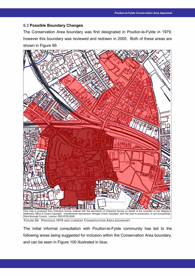
Poulton-le-Fylde Conservation Area Appraisal
61
6.3 Possible Boundary Changes The Conservation Area boundary was first designated in Poulton-le-Fylde in 1979,
however this boundary was reviewed and redrawn in 2000. Both of these areas are
shown in Figure 99.
This map is produced from Ordnance Survey material with the permission of Ordnance Survey on behalf of the controller of Her Majesty’s Stationery Office © Crown Copyright. Unauthorised reproduction infringes Crown Copyright, and may lead to prosecution or civil proceedings. Wyre Borough Council. Licence 100018720.2008.
FIGURE 99. PREVIOUS 1979 AND CURRENT CONSERVATION AREA BOUNDARY
The initial informal consultation with Poulton-le-Fylde community has led to the
following areas being suggested for inclusion within the Conservation Area boundary,
and can be seen in Figure 100 illustrated in blue.
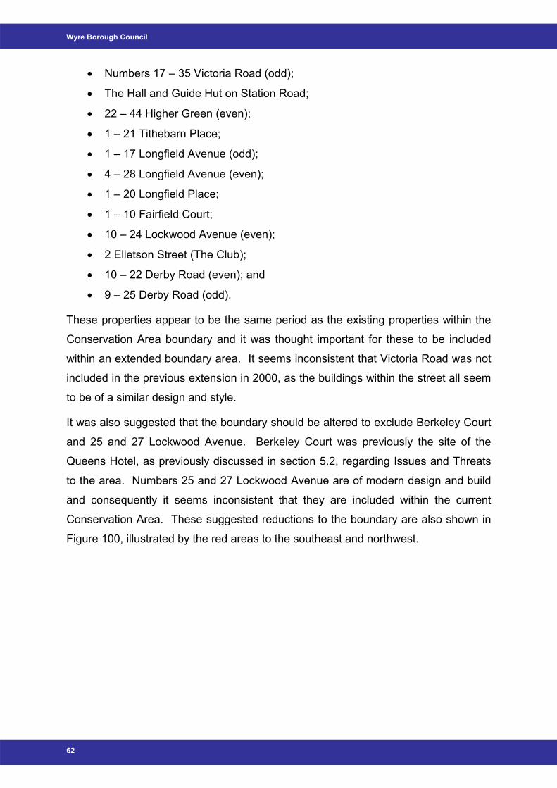
Wyre Borough Council
• Numbers 17 – 35 Victoria Road (odd);
• The Hall and Guide Hut on Station Road;
• 22 – 44 Higher Green (even);
• 1 – 21 Tithebarn Place;
• 1 – 17 Longfield Avenue (odd);
• 4 – 28 Longfield Avenue (even);
• 1 – 20 Longfield Place;
• 1 – 10 Fairfield Court;
• 10 – 24 Lockwood Avenue (even);
• 2 Elletson Street (The Club);
• 10 – 22 Derby Road (even); and
• 9 – 25 Derby Road (odd).
These properties appear to be the same period as the existing properties within the
Conservation Area boundary and it was thought important for these to be included
within an extended boundary area. It seems inconsistent that Victoria Road was not
included in the previous extension in 2000, as the buildings within the street all seem
to be of a similar design and style.
It was also suggested that the boundary should be altered to exclude Berkeley Court
and 25 and 27 Lockwood Avenue. Berkeley Court was previously the site of the
Queens Hotel, as previously discussed in section 5.2, regarding Issues and Threats
to the area. Numbers 25 and 27 Lockwood Avenue are of modern design and build
and consequently it seems inconsistent that they are included within the current
Conservation Area. These suggested reductions to the boundary are also shown in
Figure 100, illustrated by the red areas to the southeast and northwest.
62
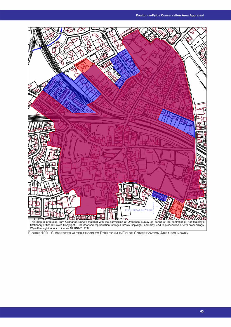
Poulton-le-Fylde Conservation Area Appraisal
This map is produced from Ordnance Survey material with the permission of Ordnance Survey on behalf of the controller of Her Majesty’s Stationery Office © Crown Copyright. Unauthorised reproduction infringes Crown Copyright, and may lead to prosecution or civil proceedings. Wyre Borough Council. Licence 100018720.2008.
FIGURE 100. SUGGESTED ALTERATIONS TO POULTON-LE-FYLDE CONSERVATION AREA BOUNDARY
63

Wyre Borough Council
7 Appendices
64
Poulton-le-Fylde Conservation Area Appraisal
65
7.1 Saint John’s School – Childrens’ Comments on the Conservation Area
The views of some of the pupils from St. John’s Catholic Primary School
• Planning Permission should be required for buildings that have special features for example the Thatched House and for buildings within the central area of Poulton;
• The trees in Poulton are good and if they have to be cut down the children would like to see new trees planted;
• It would be nice to light up some of the buildings and features in Poulton. For example have spotlights / floodlights / uplighters on the stocks, whipping post and fish slabs to make them stand out at night;
• Improve the station; the Teanlowe Centre and Village Walks – have more appealing shop fronts – proper shop signs that are in keeping with the traditions of the town rather than having gaudy plastic signs;
• Improve the toilets so that people feel comfortable using them, give them some character;
• Have a designated area for exercising dogs so that they don’t foul up the parks;
• Have dog wardens to ensure that dog owners clear up after their pets;
• Don’t allow property developers to buy houses with character and knock them down and replace them with unsuitable buildings e.g. buildings that will attract unsuitable people;
• Have netball posts in parks because most if not all the local schools play netball;
• There are too many cars in the town centre;
• Have an animal sanctuary for lost pets;
• Improve the street lighting as some lights do not work;
• Improve the sports centre and swimming pool, it is not a building to be proud of;
• Have speaking cameras to tell people to pick up their litter and stop making a nuisance of themselves (vandalising places, etc);
• Have a pelican crossing by the Civic Centre;
• Empty shops are unsightly – perhaps you could reduce the rates to encourage people to set up a business; and
• Parks with football and rugby posts.
Wyre Borough Council
7.2 Poulton-le-Fylde Conservation Area and Management Plan Questionnaire
Poulton-le-Fylde Conservation Area Appraisal and Management Plan
Poulton-le-Fylde Conservation Area was designated ‘an area of special architectural or historic interest, the character or appearance of which it is desirable to preserve or enhance’ in 1972. The special character of Conservation Areas does not come from the quality of their buildings alone, but also:
• The historic layout of roads, paths and boundaries;
• Characteristic building and paving materials;
• The particular ‘mix’ of building uses;
• Key views and vistas;
• Public and private spaces such as gardens, parks and greens;
• Trees; and
• Street furniture. The emphasis within Conservation Areas is on ensuring local character is strengthened, not diminished, by change. Sensitive management of change is essential since applications for planning permission must still be determined on their planning merits, following national guidance and policy. For the designation of Conservation Areas to be effective, it is important that their special qualities and local distinctiveness, as well as their value to the local community, are determined. A clear, comprehensive appraisal of the character of a Conservation Area provides a sound basis for development control and for developing initiatives to improve the area. Furthermore, where a formal Conservation Area Appraisal has been adopted by the Local Authority, it will be taken into account by the First Secretary of State in considering related planning appeals. The Conservation Area Appraisal should provide the basis for developing management proposals for the Conservation Area. The proposals should take the form of a mid- to long-term strategy, setting objectives for addressing the issues and recommendations for action arising from the appraisal. Government and English Heritage guidance states that a distinction should be made between the Appraisal and Management Plan, though they may form part of the same document. The sorts of objectives which we are considering for inclusion in the Management Plan are set out below. We would value your opinions on them.
66
Poulton-le-Fylde Conservation Area Appraisal
1) Do you think that an Article 4(2) Direction would be beneficial in Poulton-le-Fylde Conservation Area?
An Article 4(2) Direction is used to withdraw permitted development rights for a prescribed range of development which materially affects aspects of the external appearance of dwelling houses in Conservation Areas. This would mean that planning permission was required for the removal or alteration of particular architectural features, such as windows, doors, chimneys and boundary walls, which are important to the character or appearance of the Conservation Area. (Please give full reasons)------------------------------------------------------------------------------------------------------------------------------------------------------------------------------------------------------------------------------------------------------------------------------------------------------------------------------------------------------------------------------------------------------------------------------------------------------------------------------------------------------------------------------------------------------------------------------------------------------------------------------------------------------------------------------------------------------------------------------------------------------------------------------------------------------------------------------------------------------------------------------------------------------------------------------------------------------------------------------------------------------------------------------------------------------------------------------------------------------------------------------------------------------------------------------------------------------------------------------------------------------------------------------------------------------------------------------------------------------------------------------------------------------------------------------------------------------------------------------------------- 2) Would you like to see any new Tree Preservation Orders (TPOs) made in
Poulton-le-Fylde? Specifically which tree(s)? A major element in the character or appearance of many Conservation Areas is the trees. All trees with a trunk diameter of 75mm measured at 1.5m above ground level within a Conservation Area are protected under section 211 of the Town and Country Planning Act 1990. Any proposed works to them will require written notification to the Council six weeks prior to beginning those works. However, a TPO can provide and extra layer of protection. ------------------------------------------------------------------------------------------------------------------------------------------------------------------------------------------------------------------------------------------------------------------------------------------------------------------------------------------------------------------------------------------------------------------------------------------------------------------------------------------------------------------------------------------------------------------------------------------------------------------------------------------------------------------------------------------------------------------------------------------------------------------------------------------------------------------------------------------------------------------------------------------------------------------------------------------------------------------------------------------------------------------------------------------------------------------------------------------------------------------------------------------------------------------------------------------------------------------------------------------------------------------------------------------- 3) Are there any buildings that you believe to be of importance within Poulton-
le-Fylde Conservation Area? Would you recommend any buildings to be suggested for listing?
The word 'listing' is a short-hand term used to describe one of a number of legal procedures which help English Heritage to protect the best of our architectural heritage. When buildings are listed, they are placed on statutory lists of buildings of 'special architectural or historic interest' compiled by the Secretary of State for
67
Wyre Borough Council
Culture, Media and Sport under the Planning (Listed Buildings and Conservation Areas) Act 1990, on advice from English Heritage, consequently becoming Listed Buildings. ------------------------------------------------------------------------------------------------------------------------------------------------------------------------------------------------------------------------------------------------------------------------------------------------------------------------------------------------------------------------------------------------------------------------------------------------------------------------------------------------------------------------------------------------------------------------------------------------------------------------------------------------------------------------------------------------------------------------------------------------------------------------------------------------------------------------------------------------------------------------------------------------------------------------------------------------------------------------------------------------------------------------------------------------------------------------------------------------------------------------------------------------------------------------------------------------------------------------------------------------------------------------------------------- 4) Would you like to see planning obligations used in Poulton-le-Fylde
Conservation Area? If so, what sort of additions would you like to see? Planning obligations are negotiated legal agreements between a Local Authority and a developer. They can be used to offset the impacts of new development where these cannot be satisfactorily addressed by conditions attached to the Planning Consent. These may include the need for ‘specific mitigation’ – for example, the creation of a new wildlife area or an improved children’s play area. ------------------------------------------------------------------------------------------------------------------------------------------------------------------------------------------------------------------------------------------------------------------------------------------------------------------------------------------------------------------------------------------------------------------------------------------------------------------------------------------------------------------------------------------------------------------------------------------------------------------------------------------------------------------------------------------------------------------------------------------------------------------------------------------------------------------------------------------------------------------------------------------------------------------------------------------------------------------------------------------------------------------------------------------------------------------------------------------------------------------------------------------------------------------------------------------------------------------------------------------------------------------------------------------- 5) Are there any areas that you would wish to see improved within Poulton-le-
Fylde Conservation Area? If so, where are these areas and what enhancements would you like to see?
------------------------------------------------------------------------------------------------------------------------------------------------------------------------------------------------------------------------------------------------------------------------------------------------------------------------------------------------------------------------------------------------------------------------------------------------------------------------------------------------------------------------------------------------------------------------------------------------------------------------------------------------------------------------------------------------------------------------------------------------------------------------------------------------------------------------------------------------------------------------------------------------------------------------------------------------------------------------------------------------------------------------------------------------------------------------------------------------------------------------------------------------------------------------------------------------------------------------------------------------------------------------------------------------------------------------------------------------------------------------------------------------------------
68
Poulton-le-Fylde Conservation Area Appraisal
6) Are there any areas within the boundary that appear to suffer from negative pressure or pose a threat to the character of the Conservation Area?
------------------------------------------------------------------------------------------------------------------------------------------------------------------------------------------------------------------------------------------------------------------------------------------------------------------------------------------------------------------------------------------------------------------------------------------------------------------------------------------------------------------------------------------------------------------------------------------------------------------------------------------------------------------------------------------------------------------------------------------------------------------------------------------------------------------------------------------------------------------------------------------------------------------------------------------------------------------------------------------------------------------------------------------------------------------------------------------------------------------------------------------------------------------------------------------------------------------------------------------------------------------------------------------- 7) Are there any issues you would wish to see addressed in the Poulton-le-
Fylde Conservation Area Management Plan? -------------------------------------------------------------------------------------------------------------------------------------------------------------------------------------------------------------------------------------------------------------------------------------------------------------------------------------------------------------------------------------------------------------------------------------------------------------------------------------------------------------------------------------------------------------------------------------------------------------------------------------------------------------------------------------------------------------------------------------------------------------------------------------------------------------------------------------------------------------------------------------------------------------------------------------------------------------------------------------------------------------------------------------------------------------------------------------------------------------------------------------------------------------------------- 8) Would you like to see the Poulton-le-Fylde Conservation Area boundary
amended? If so, where should the boundary be drawn and why? Please use attached map to illustrate this, if necessary.
Please note that inclusion within a Conservation Area does not necessarily preclude development. However, it does mean that any development must be sympathetic in terms of scale, height, massing, detailed design and quality of materials. It must be demonstrated that proposals within a Conservation Area either preserve or enhance the area. -------------------------------------------------------------------------------------------------------------------------------------------------------------------------------------------------------------------------------------------------------------------------------------------------------------------------------------------------------------------------------------------------------------------------------------------------------------------------------------------------------------------------------------------------------------------------------------------------------------------------------------------------------------------------------------------------------------------------------------------------------------------------------------------------------------------------------------------------------------------------------------------------------------------------------------------------------------------------------------------------------------------------------------------------------------------------------------------------------------------------------------------------------------------------- Thank you for taking the time to provide us with your comments. Please return your comments by 21st November 2007 to Planning Policy and Conservation, Wyre Borough Council, Civic Centre, Breck Road, Poulton-le-Fylde, Lancashire FY6 7PU
69
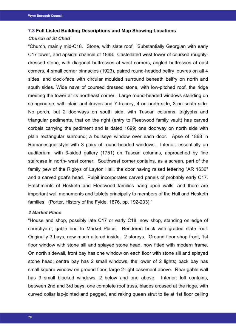
Wyre Borough Council
7.3 Full Listed Building Descriptions and Map Showing Locations Church of St Chad “Church, mainly mid-C18. Stone, with slate roof. Substantially Georgian with early
C17 tower, and apsidal chancel of 1868. Castellated west tower of coursed roughly-
dressed stone, with diagonal buttresses at west corners, angled buttresses at east
corners, 4 small corner pinnacles (1923), paired round-headed belfry louvres on all 4
sides, and clock-face with circular moulded surround beneath belfry on north and
south sides. Wide nave of coursed dressed stone, with low-pitched roof, the ridge
meeting the tower at its northeast corner. Large round-headed windows standing on
stringcourse, with plain architraves and Y-tracery, 4 on north side, 3 on south side.
No porch, but 2 doorways on south side, with Tuscan columns, triglyphs and
triangular pediments, that on the right (entry to Fleetwood family vault) has carved
corbels carrying the pediment and is dated 1699; one doorway on north side with
plain rectangular surround; a bullseye window over each door. Apse of 1868 in
Romanesque style with 3 pairs of round-headed windows. Interior: essentially an
auditorium, with 3-sided gallery (1751) on Tuscan columns, approached by fine
staircase in north- west corner. Southwest corner contains, as a screen, part of the
family pew of the Rigbys of Layton Hall, the door having raised lettering "AR 1636"
and a carved goat's head. Pulpit incorporates carved panels of probably early C17.
Hatchments of Hesketh and Fleetwood families hang upon walls; and there are
important wall monuments and tablets principally to members of the Hull and Hesketh
families. (Porter, History of the Fylde, 1876, pp. 192-203).”
2 Market Place “House and shop, possibly late C17 or early C18, now shop, standing on edge of
churchyard, gable end to Market Place. Rendered brick with graded slate roof.
Originally 3 bays, now much altered inside. 2 storeys. Ground floor shop front, 1st
floor window with stone sill and splayed stone head, now fitted with modern frame.
On north sidewall, front bay has one window on each floor with stone sill and splayed
stone head; centre bay has 2 small windows, the lower of 2 lights; back bay has
small square window on ground floor, large 2-light casement above. Rear gable wall
has 3 small blocked windows, 2 below and one above. Interior: loft contains,
between 2nd and 3rd bays, one complete roof truss, blades crossed at the ridge, with
curved collar lap-jointed and pegged, and raking queen strut to tie at 1st floor ceiling
70
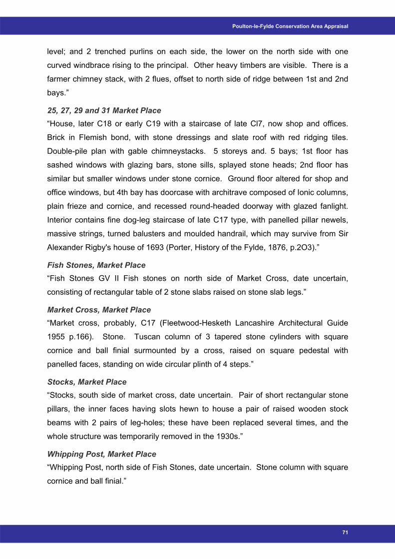
Poulton-le-Fylde Conservation Area Appraisal
level; and 2 trenched purlins on each side, the lower on the north side with one
curved windbrace rising to the principal. Other heavy timbers are visible. There is a
farmer chimney stack, with 2 flues, offset to north side of ridge between 1st and 2nd
bays.”
25, 27, 29 and 31 Market Place “House, later C18 or early C19 with a staircase of late Cl7, now shop and offices.
Brick in Flemish bond, with stone dressings and slate roof with red ridging tiles.
Double-pile plan with gable chimneystacks. 5 storeys and. 5 bays; 1st floor has
sashed windows with glazing bars, stone sills, splayed stone heads; 2nd floor has
similar but smaller windows under stone cornice. Ground floor altered for shop and
office windows, but 4th bay has doorcase with architrave composed of Ionic columns,
plain frieze and cornice, and recessed round-headed doorway with glazed fanlight.
Interior contains fine dog-leg staircase of late C17 type, with panelled pillar newels,
massive strings, turned balusters and moulded handrail, which may survive from Sir
Alexander Rigby's house of 1693 (Porter, History of the Fylde, 1876, p.2O3).”
Fish Stones, Market Place “Fish Stones GV II Fish stones on north side of Market Cross, date uncertain,
consisting of rectangular table of 2 stone slabs raised on stone slab legs.”
Market Cross, Market Place “Market cross, probably, C17 (Fleetwood-Hesketh Lancashire Architectural Guide
1955 p.166). Stone. Tuscan column of 3 tapered stone cylinders with square
cornice and ball finial surmounted by a cross, raised on square pedestal with
panelled faces, standing on wide circular plinth of 4 steps.”
Stocks, Market Place “Stocks, south side of market cross, date uncertain. Pair of short rectangular stone
pillars, the inner faces having slots hewn to house a pair of raised wooden stock
beams with 2 pairs of leg-holes; these have been replaced several times, and the
whole structure was temporarily removed in the 1930s.”
Whipping Post, Market Place “Whipping Post, north side of Fish Stones, date uncertain. Stone column with square
cornice and ball finial.”
71
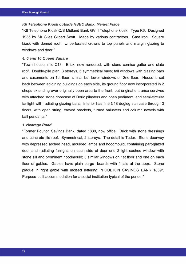
Wyre Borough Council
K6 Telephone Kiosk outside HSBC Bank, Market Place “K6 Telephone Kiosk O/S Midland Bank GV II Telephone kiosk. Type K6. Designed
1935 by Sir Giles Gilbert Scott. Made by various contractors. Cast iron. Square
kiosk with domed roof. Unperforated crowns to top panels and margin glazing to
windows and door.”
4, 6 and 10 Queen Square “Town house, mid-C18. Brick, now rendered, with stone cornice gutter and slate
roof. Double-pile plan, 3 storeys, 5 symmetrical bays; tall windows with glazing bars
and casements on 1st floor, similar but lower windows on 2nd floor. House is set
back between adjoining buildings on each side, its ground floor now incorporated in 2
shops extending over originally open area to the front, but original entrance survives
with attached stone doorcase of Doric pilasters and open pediment, and semi-circular
fanlight with radiating glazing bars. Interior has fine C18 dogleg staircase through 3
floors, with open string, carved brackets, turned balusters and column newels with
ball pendants.”
1 Vicarage Road “Former Poulton Savings Bank, dated 1839, now office. Brick with stone dressings
and concrete tile roof. Symmetrical, 2 storeys. The detail is Tudor. Stone doorway
with depressed arched head, moulded jambs and hoodmould, containing part-glazed
door and radiating fanlight; on each side of door one 2-light sashed window with
stone sill and prominent hoodmould; 3 similar windows on 1st floor and one on each
floor of gables. Gables have plain barge- boards with finials at the apex. Stone
plaque in right gable with incised lettering: "POULTON SAVINGS BANK 1839".
Purpose-built accommodation for a social institution typical of the period.”
72
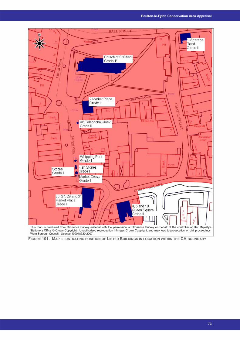
Poulton-le-Fylde Conservation Area Appraisal
This map is produced from Ordnance Survey material with the permission of Ordnance Survey on behalf of the controller of Her Majesty’s Stationery Office © Crown Copyright. Unauthorised reproduction infringes Crown Copyright, and may lead to prosecution or civil proceedings. Wyre Borough Council. Licence 100018720.2007.
FIGURE 101. MAP ILLUSTRATING POSITION OF LISTED BUILDINGS IN LOCATION WITHIN THE CA BOUNDARY
73
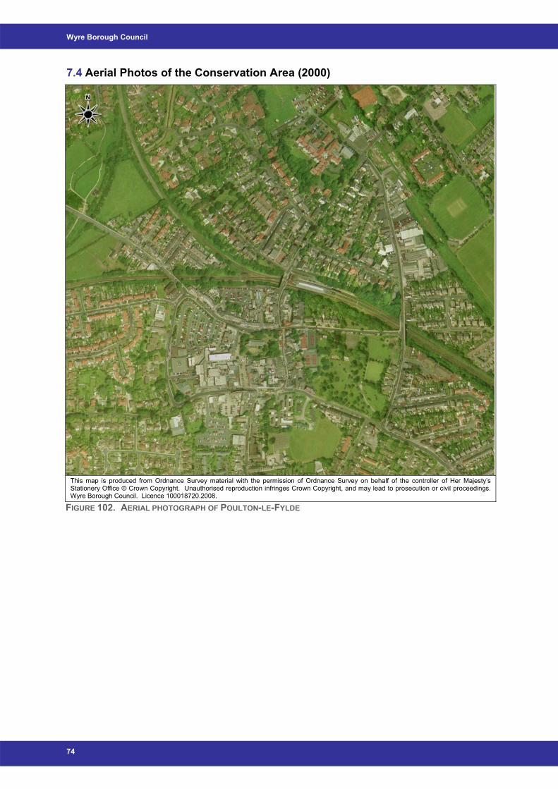
Wyre Borough Council
7.4 Aerial Photos of the Conservation Area (2000)
This map is produced from Ordnance Survey material with the permission of Ordnance Survey on behalf of the controller of Her Majesty’s Stationery Office © Crown Copyright. Unauthorised reproduction infringes Crown Copyright, and may lead to prosecution or civil proceedings. Wyre Borough Council. Licence 100018720.2008.
FIGURE 102. AERIAL PHOTOGRAPH OF POULTON-LE-FYLDE
74
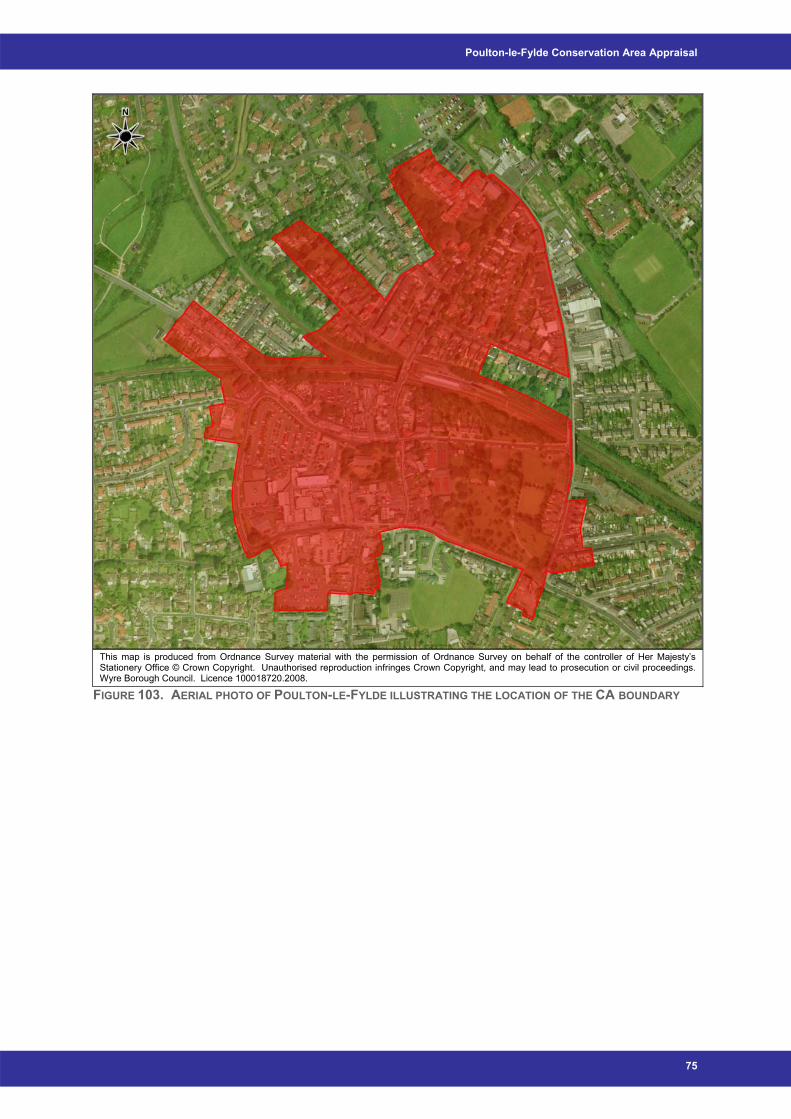
Poulton-le-Fylde Conservation Area Appraisal
This map is produced from Ordnance Survey material with the permission of Ordnance Survey on behalf of the controller of Her Majesty’s Stationery Office © Crown Copyright. Unauthorised reproduction infringes Crown Copyright, and may lead to prosecution or civil proceedings. Wyre Borough Council. Licence 100018720.2008.
FIGURE 103. AERIAL PHOTO OF POULTON-LE-FYLDE ILLUSTRATING THE LOCATION OF THE CA BOUNDARY
75
Wyre Borough Council
7.5 Effects of Conservation Area Designation Conservation Area Designation
Conservation Area designation helps to protect an area's special architectural or
historic interest by providing:
• The basis for policies designed to preserve or enhance all aspects of the
character or appearance of an area that define its special architectural or historic
interest;
• Control over the demolition of unlisted buildings and works to trees within a
Conservation Area;
• Stricter planning controls within a Conservation Area; and
• Introducing a statutory requirement for the local Planning Authority to consider the
impact of a proposed development upon the character or appearance of a
Conservation Area.
The emphasis within Conservation Areas is on ensuring local character is
strengthened, not diminished, by change. Sensitive management of change is
essential rather than no change at all, and applications for planning permission must
still be determined on their planning merits.
Conservation Area Consent is required for the total or substantial demolition (see
note 1) of any unlisted building in a conservation area, subject to exceptions
including:
a) any building with a total cubic content not exceeding 115 cubic metres, using
external measurements, or any part of such a building; and
b) any gate, wall, fence, or other such structure which is less than 1 metre high
where abutting on a highway (including a public footpath or bridleway), waterway
or open space, or less than 2 metres high in any other case; unless an Article 4(2)
direction is in place (see note 2).
Notes:
1. Examples of substantial demolition include the following:
a) Works which amount to a clearing of the site for redevelopment;
b) Works comprising demolition falling short of complete destruction of a building
such as demolition behind a retained façade;
c) Any demolition of a principal external wall or roof of the building on any elevation.
76
Poulton-le-Fylde Conservation Area Appraisal
2. Please note that some minor proposals which may involve demolition, for example
the removal of boundary walls, doors and windows, can require an application for
planning permission. This will be the case where the Council as the local planning
authority, has introduced an Article 4(2) direction. This is a special form of planning
control which the Council can introduce to remove permitted development rights in
order to prevent the loss of architectural features. If in any doubt, it is advisable to
check with the Council whether you require permission.
Fees and Penalties There is no fee for Conservation Area Consent. Failure to obtain Conservation Area Consent before demolishing a building in a
conservation area is an offence which may result in a fine or term of imprisonment, or
both, the level of fine being related particularly to the likely financial benefit of such
work.
Where works have been undertaken without Conservation Area Consent, the Council
can also serve an Enforcement Notice, specifying action intended to preserve the
character and appearance of the conservation area.
Satellite Dishes The siting of a satellite dish on the chimney stack or on the roof slope or elevation
fronting the road requires Planning Permission from the Council. This does not
mean, however, that satellite dishes are prohibited in a Conservation Area.
Roof Alterations Alterations to roofs and cladding of buildings, proposals to change the profile of a
roof, for example with the provision of a dormer window, and to clad a building with a
different material, such as imitation stone, also require Planning Permission from the
Council.
Wind Turbines Planning Permission is required for all wind turbines placed anywhere on the roof
where the house is within a Conservation Area. Listed Building Consent would be
required in all cases for the erection of a wind turbine anywhere on a Listed Building.
Note: Conservation Area Consent is not needed for:
- Painting doors or windows; or
- Replacing doors or windows.
77
Wyre Borough Council
7.6 References • Civic Trust (1967) ‘Civic Amenities Act of 1967’
• Department of the Environment and Department of National Heritage (1994)
‘Planning Policy Guidance 15: Planning and the Historic Environment’
• University of Dundee (2008) The Conservation Glossary (Online) Available
from: http://www.trp.dundee.ac.uk/research/glossary/glossary.html (Accessed
07/01/2008)
• English Heritage (2006) ‘Guidance on Conservation Area Appraisals’
• English Heritage (2006) ‘Guidance on the Management of Conservation Areas’
• Environment & Heritage Service (2007) A Guide to Repairs (Online) Available
from: http://www.ehsni.gov.uk/built/buildings/advice_repair.shtml (Accessed
28/11/2007)
• Environment & Heritage Service (2007) Wooden Windows (Online) Available
from: http://www.ehsni.gov.uk/built/advice_owners/advice_window.htm
(Accessed 28/11/2007)
• Field, J. (1972) ‘English Field Names’, Newton Abbot
• Harris, M. and Hughes, B. 5th Ed. (2006) ‘The Ancient History of the Wyre’
• Harris, M. and Hughes, B. (2007) ‘The History of the Wyre: from Harold the Elk
to Cardinal Allen’
• Lancashire County Council, Wyre Borough Council and English Heritage
(2006) ‘Lancashire Extensive Urban Survey: Poulton-le-Fylde Historic Town
Assessment Report’, Lancashire County Council
• Planning (Listed Buildings and Conservation Areas) Act 1990
• Poulton-le-Fylde Historical and Civic Society (2007) Poulton-le-Fylde Historical
and Civic Society (Online) Available from: www.poulton-le-fylde-hcs.co.uk
(Accessed 30/11/2007)
• Rothwell, C. (1995) ‘Britain in Old Photographs: Around Poulton-le-Fylde’, Alan
Sutton Publishing
• The Town and Country Planning (Trees) Regulations, 1999
• Wyre Borough Council (1999) ‘Wyre Borough Council Local Plan - Written
Statement‘, Wyre Borough Council
• Wyre Borough Council (2007) ‘Statement of Community Involvement’, Wyre
Borough Council
78


Poulton-le-Fylde Management Plan
Poulton-le-Fylde Management Plan
Wyre Borough Council
Adopted 28th April 2008


Poulton-le-Fylde Management Plan
Table of contents 1 Poulton-le-Fylde Management Plan.................................................................. 1 2 Legislative Background..................................................................................... 2 3 Statutory Controls.............................................................................................. 2 4 Erosion of Character and Additional Planning Controls ................................ 3 5 Advertisements and Signage............................................................................ 4 6 Trees ................................................................................................................... 4 7 Setting and Views .............................................................................................. 4 8 The Public Realm and Enhancement ............................................................... 5 9 Monitoring and Review...................................................................................... 5
i

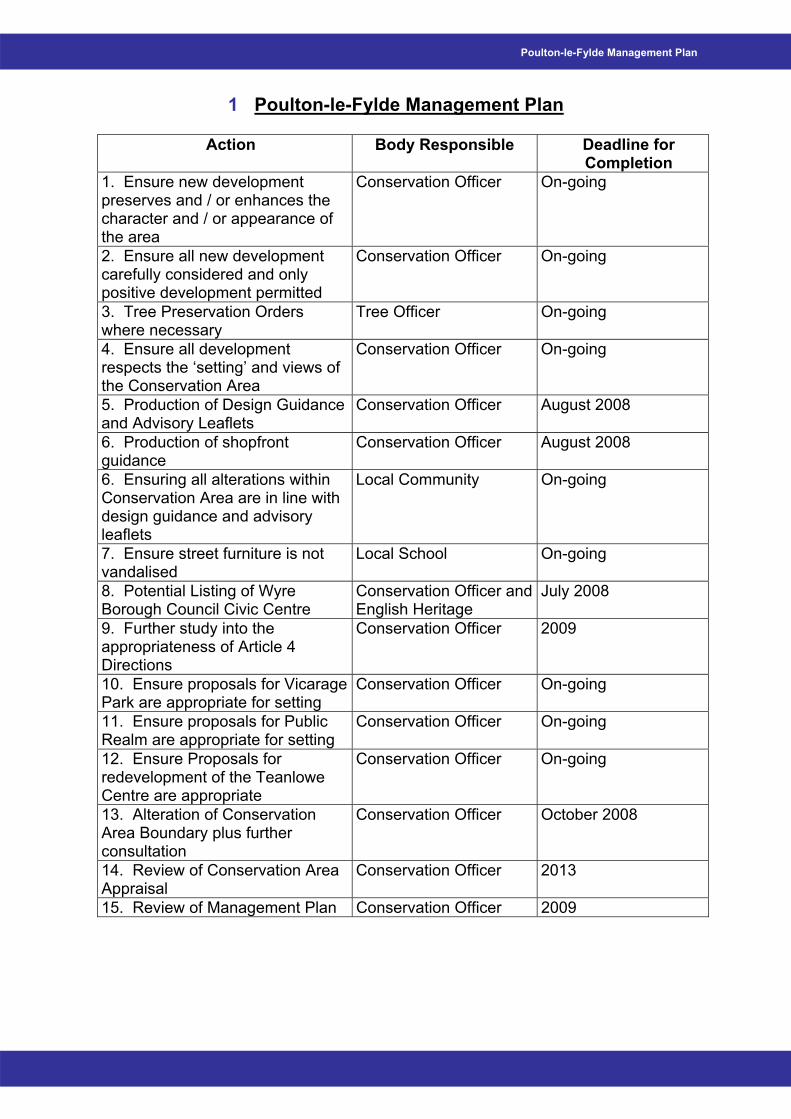
Poulton-le-Fylde Management Plan
Action Body Responsible Deadline for Completion
1. Ensure new development preserves and / or enhances the character and / or appearance of the area
Conservation Officer On-going
2. Ensure all new development carefully considered and only positive development permitted
Conservation Officer On-going
3. Tree Preservation Orders where necessary
Tree Officer On-going
4. Ensure all development respects the ‘setting’ and views of the Conservation Area
Conservation Officer On-going
5. Production of Design Guidance and Advisory Leaflets
Conservation Officer August 2008
6. Production of shopfront guidance
Conservation Officer August 2008
6. Ensuring all alterations within Conservation Area are in line with design guidance and advisory leaflets
Local Community On-going
7. Ensure street furniture is not vandalised
Local School On-going
8. Potential Listing of Wyre Borough Council Civic Centre
Conservation Officer and English Heritage
July 2008
9. Further study into the appropriateness of Article 4 Directions
Conservation Officer 2009
10. Ensure proposals for Vicarage Park are appropriate for setting
Conservation Officer On-going
11. Ensure proposals for Public Realm are appropriate for setting
Conservation Officer On-going
12. Ensure Proposals for redevelopment of the Teanlowe Centre are appropriate
Conservation Officer On-going
13. Alteration of Conservation Area Boundary plus further consultation
Conservation Officer October 2008
14. Review of Conservation Area Appraisal
Conservation Officer 2013
15. Review of Management Plan Conservation Officer 2009
1
1 Poulton-le-Fylde Management Plan
Wyre Borough Council
2 Legislative Background
The designation of a Conservation Area and production of an Appraisal document is
not an end in itself. The Appraisal provides the basis for developing management
proposals for the Conservation Area that fulfil the general duty placed on the local
authority under the Planning (Listed Buildings and Conservation Areas) Act 1990,
now formalised in BV 219c, to draw up and publish such proposals. The purpose of
this document is to present draft proposals which seek to achieve the preservation
and enhancement of the ‘special’ character of the Conservation Area, informed by
the Appraisal, for consultation. The ‘special’ qualities of the Conservation Area have
been identified as:
• Small agricultural market town of Victorian roots
• Conservation Area boundary covers the main conurbation centre
• Occupies slightly elevated site, in otherwise low lying, level topography
• Village initially nucleated plan, and this has continued, though now more
widespread
• Historic core now surrounded by modern residential developments
These qualities have been identified within the Conservation Area Appraisal process,
and both the Appraisal and this Management Plan will be subject to monitoring and
review. This guidance draws on the themes identified in the Appraisal, and satisfies
the statutory requirement of section 71(1) of the Planning (Listed Buildings and
Conservation Areas) Act 1990, namely: “It shall be the duty of the local planning
authority from time to time to formulate and publish proposals for the preservation
and enhancement of any parts of their area which are Conservation Areas”.
This document reflects Government guidance set out in Planning Policy Guidance 15
“Planning and the Historic Environment”, and English Heritage guidance set out in
“Guidance on the Management of Conservation Areas”.
3 Statutory Controls
Designation as a Conservation Area brings with it a degree of additional statutory
protection under planning legislation aimed at assisting the “preservation or
enhancement” of the area. These controls include the need for Conservation Area
consent for the demolition of any unlisted buildings, the need for planning consent for
the installation of satellite dishes visible from the street, significantly reduced
2
Poulton-le-Fylde Management Plan
“permitted development rights” for alterations and extensions to dwelling houses,
restrictions on advertising, and 6 weeks written notice of works to trees not already
protected by Tree Preservation Orders.
Action 1: The Council will ensure that new development within the Conservation
Area preserves or enhances the character or appearance of the area in accordance
with the Wyre Borough Council Local Plan (1999).
3
4 Erosion of Character and Additional Planning Controls
The Conservation Area Appraisal has identified the following as works that pose a
threat to, or detract from, the ‘special’ character of the Conservation Area:
• The increasing roll out of corporate images on shop fronts
• The increasing use of uPVC in doors and windows in historic buildings and
areas, resulting in the loss of original windows;
• The effect of traffic and problems with parking, possibly leading to conversion of
gardens to off street parking
• The increase of properties with satellite dishes on the front elevation of the
building
• Replacement of traditional Welsh slates with inappropriate substitutes;
• Any future redevelopment of existing buildings within the Conservation Area
boundary;
• Any future development of open space in the Conservation Area, i.e.
redevelopment of Jean Stansfield Park;
• The future redesign of street furniture within Market Place; and
• Possible further pedestrianisation of central Poulton.
There are numerous examples of works having been carried out, for example
alterations to doors and windows, which both individually and cumulatively detract
from the ‘special’ character or appearance of the area. If left, such works will
gradually erode the ‘special’ qualities that justified the original designation.
Action 1: The Council will ensure that all development will be considered and only
positive development, as defined in accordance with Wyre Borough Council’s Local
Development Framework, will be considered for planning permission in order to
Wyre Borough Council
further protect the ‘special’ character and historical appearance of the Conservation
Area.
Action 2: A suggestion will be made to English Heritage for the listing of the Wyre
Borough Council Civic Centre.
5 Advertisements and Signage
Signage within the Conservation Area is generally poor except for a few examples
that continue to retain a traditional style. This is due to the increasing volume of
corporate images and styles that reduce the level of local distinctiveness and
consequently erode the character of the Conservation Area.
Action 1: The Council will produce shopfront guidance to ensure all future
advertisements and signage will be appropriate for their historical location.
6 Trees
If not already protected by a Tree Preservation Order, anyone intending to lop or fell
a tree within the Conservation Area greater than 75mm in diameter at 1.5 metres
above ground level, is required to give the Council 6 weeks written notice before
starting work. This provides the Council with an opportunity of assessing the tree to
see if it makes a positive contribution to the character or appearance of the
Conservation Area, in which case a Tree Preservation Order may be served. Advice
on all tree issues, whether the pruning of existing trees or advice on suitable species
for planting, is always available from the Council Tree Officer.
Action 1: The Council will use Tree Preservation Orders wherever appropriate
where a tree of high amenity value is considered to be under threat. These will
include trees within and outside the area where they contribute to the setting of the
Conservation Area or views identified in the Appraisal.
7 Setting and Views
The setting of a Conservation Area is integral to the retention of its character. It is
often the quality and interest of areas, rather than individual buildings, which
contribute to give the area its ‘special’ quality. Consequently, development which
would not preserve or enhance the character or appearance of the area or its setting,
or which would impact detrimentally on views into and out of the area will be not be
permitted.
4
Poulton-le-Fylde Management Plan
Action 1: The Council will continue to ensure that all development respects the
‘setting’ of the Conservation Area, and important views within, into, and out of the
area, as identified in the Appraisal. These will be protected from inappropriate forms
of development.
5
8 The Public Realm and Enhancement
Due to current suggestions for redesign of the street furniture within the Conservation
Area, it will be essential that consideration will be given to the appropriateness of
designs with regard to the historical setting.
Action 1: Design guidance will be produced to encourage the use of traditional
materials and styles, such as sash and casement windows, within the Conservation
Area.
Action 2: The Conservation Officer will be highly involved in any proposals for the
redesign of street furniture.
Monitoring and Review 9
The following actions need to be taken to ensure that this appraisal and management
plan are accepted and acted upon:
• Public Consultation: The Appraisal and Management Plan will be subject to a
period of public consultation and views expressed as part of that process will be
considered when preparing the final draft for adoption. Consultation will include
placing the documents on the Council website, in libraries and council offices,
consultation with local amenity groups and residents associations where they
exist, and providing hard copies on request. A letter advising of these
arrangements will be delivered to all properties in the area by mail.
• Boundary review: The Council will extend / reduce the boundary of Poulton-le-
Fylde Conservation Area as illustrated in the Appraisal, and continue to review it
over time in accordance with Best Practice and guidance on the management of
the historic environment produced by English Heritage.
• Document review: This management plan will be monitored on an annual basis in
the light of the Local Development Framework and emerging government policy.
A review should include the following:
i. A survey of the Conservation Area and its boundaries
Wyre Borough Council
6
ii. An updated “heritage count” comprising a comprehensive photographic
record.
iii. An assessment of whether the management proposals detailed in this
document have been acted upon, including proposed enhancements.
iv. The production of a short report detailing the findings of the survey and
proposed actions and amendments.
v. Public consultation on the review findings, any proposed changes, and input
into the final review.
A Conservation Forum, made up of members of the Borough’s Civic and Historical
Societies, plus the Conservation Officer, Head of Planning and Heritage and Design
Champion, will also meet bi-annually to discuss any changes that have occurred or
should occur within the Conservation Areas.
This Management Plan will be reviewed annually.