holyhead: understanding urban character
TRANSCRIPT
Holyhead: Understanding Urban Character
CadwWelsh GovernmentPlas CarewUnit 5/7 Cefn CoedParc NantgarwCardiff CF15 7QQ
Telephone: 03000 256 000Email: [email protected]
First published by Cadw in 2019Digital ISBN 978-1-78903-534-6© Crown Copyright 2019, Cadw, Welsh Government WG36757
Cadw is the Welsh Government’s historic environment service, working for an accessible and well-protected historic environment.
Mae’r ddogfen yma hefyd ar gael yn Gymraeg. This document is also available in Welsh.
This publication is licensed under the terms of the Open Government Licence v3.0 except where otherwise stated. To view this licence, visit http://www. nationalarchives.gov.uk/doc/open-government-licence/version/3 or write to the Information Policy Team, The National Archives, Kew, London TW9 4DU, or e-mail: [email protected]
Where third party material has been identified, permission from the respective copyright holder must be sought, including Anglesey Archives, Cadw, Isle of Anglesey County Council, Llyfrgell Genedlaethol Cymru/National Library of Wales, Peter Davis Collection, Royal Commission on the Ancient and Historical Monuments of Wales and Visit Wales.
Front cover, clockwise from main picture:Holyhead from Skinner’s monument in about 1850 (Supplied by Llyrfgell Genedlaethol Cymru/National Library of Wales); Williams Street (© Crown Copyright: RCAHMW); St Cybi’s Church (© Crown Copyright: RCAHMW); Ty Cyfle (© Crown Copyright: RCAHMW).
Back cover from top: Bryn Goleu (© Crown Copyright: RCAHMW); Stanley House (© Crown Copyright: RCAHMW); Seaborne Road (© Crown Copyright: RCAHMW).

Cadw is the Welsh Government’s historic environment service, working for an accessible and well-protected historic environment.
CadwWelsh GovernmentPlas CarewUnit 5/7 Cefn CoedParc NantgarwCardiff CF15 7QQ
1
Holyhead: Understanding Urban Character

2
AcknowledgementsCadw is grateful for the help received from the Isle of Anglesey County Council conservation team, especially Nathan Blanchard, and members of the local community, in particular, local historian and President of the Maritime Museum, the late John Cave MBE. The Royal Commission on the Ancient and Historical Monuments of Wales (RCAHMW) kindly provided the photography for this study.

3
ContentsIntroduction 5
Aims of the Study 5
Historical Background 6
Origins 6
The Beginnings of Modern Holyhead 8
‘The Glory of the Principality’?: Holyhead in the Nineteenth Century 11
New Road, New Harbour: Improving
Communications 11
The Coming of the Railway 13
The Breakwater and ‘Great Harbour of Refuge’ 14
‘The Rise and Progress of Holyhead’: the Town Takes Shape 16
The Twentieth Century 23
Historical Topography 28
End of the Road, Edge of the Land 28
Land Use and Ownership 31
Transport 34
The Character of Building 35
Patterns of Development 35
Building Materials and Detail 47
Building and Engineering 54
Character Areas 55
1. Central Area: Urban Core 55
2. Central Area: Residential Development 63
3. North of the Town Centre 65
4. West and South-west Holyhead 67
5. South Holyhead and Kingsland 72
6. Porth y Felin and North Holyhead 75
7. Salt Island and the Inner Harbour 80
8. The Outer Harbour, Soldier’s Point and the North Shore 83
9. London Road 86
10. Turkey Shore and Morawelon 88
Statement of Significance 90
Selected Sources 91
Endnotes 92
1. Tithe map of Holyhead, about 1840
2. First Edition Ordnance Survey Map 1899
3. All Character Areas
4. All Character Areas with Historic Designations
5. Central Area: Urban Core (1)
6. Central Area: Residential Development (2)
7. North of the Town Centre (3)
8. West and South-west Holyhead (4)
9. South Holyhead and Kingsland (5)
10. Porth y Felin and North Holyhead (6)
11. Salt Island and the Inner Harbour (7)
12. The Outer Harbour, Soldier’s Point and the North Shore (8)
13. London Road (9)
14. Turkey Shore and Morawelon (10)
List of Maps pages 94–107

HOLYHEAD: UNDERSTANDING URBAN CHARACTER
44
HOLYHEAD: UNDERSTANDING URBAN CHARACTER
5
Aims of the Study
Historic character lies at the heart of local distinctiveness and sense of place. No two places share a history, so every place has a unique historic character which is a powerful asset in regeneration. Responding to local character is an important objective of good design; sustaining it can bring social, economic and environmental benefits.
Urban characterization is a tool that can help us use historic character to create sustainable and distinctive places for the future. It aims to describe and explain the historic character of
towns, to give a focus to local distinctiveness and to help realize the full value of the historic environment. It seeks to inform and support positive planning, regeneration and conservation programmes, help improve the quality of planning advice and contribute to local interpretation and education strategies.
Urban characterization defines the unique historic character of individual towns and identifies the variety of character within them. It looks at the history of a town and identifies its expression in patterns of space and connection, and in traditions of building, which are the fundamental ingredients of historic character.
5
Introduction
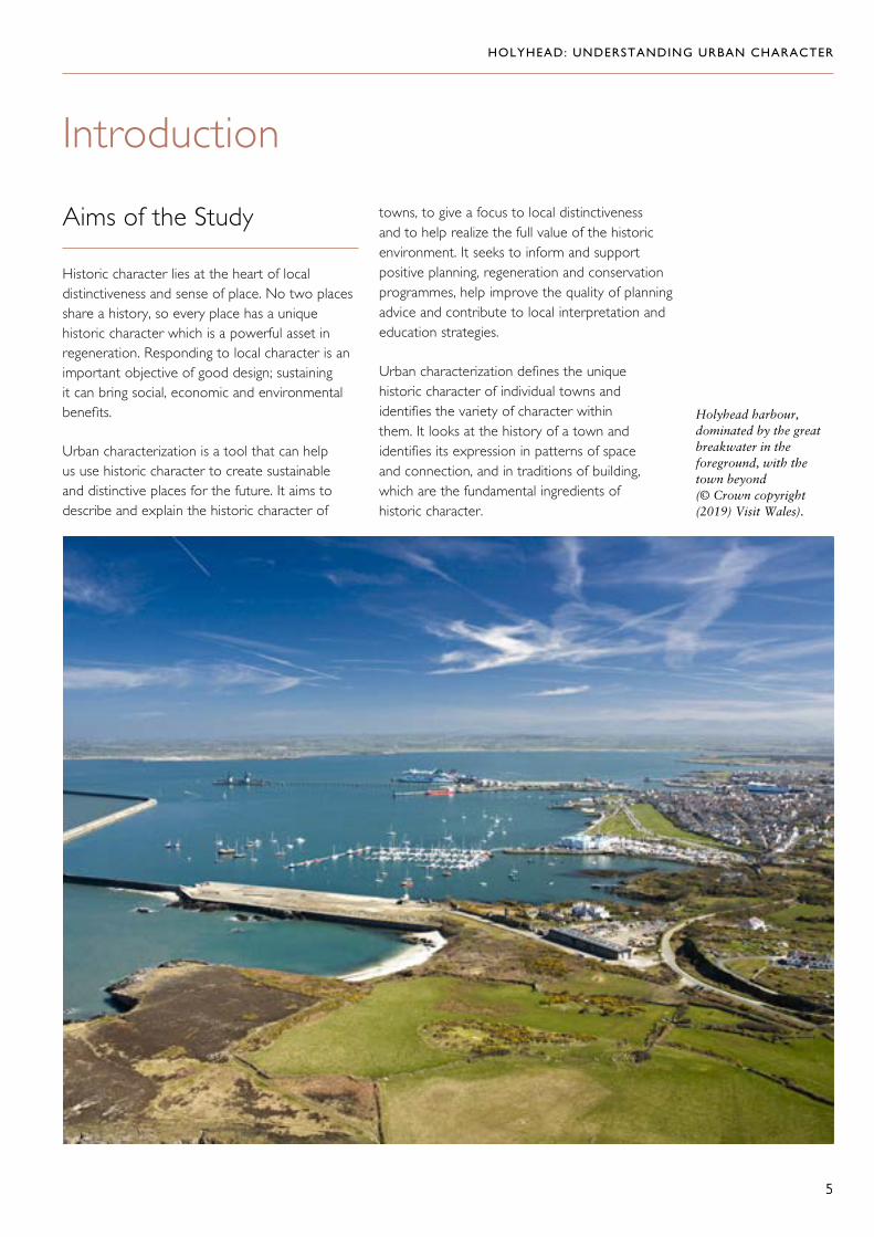
Holyhead harbour, dominated by the great breakwater in the foreground, with the town beyond (© Crown copyright (2019) Visit Wales).
6
Historical Background
Origins
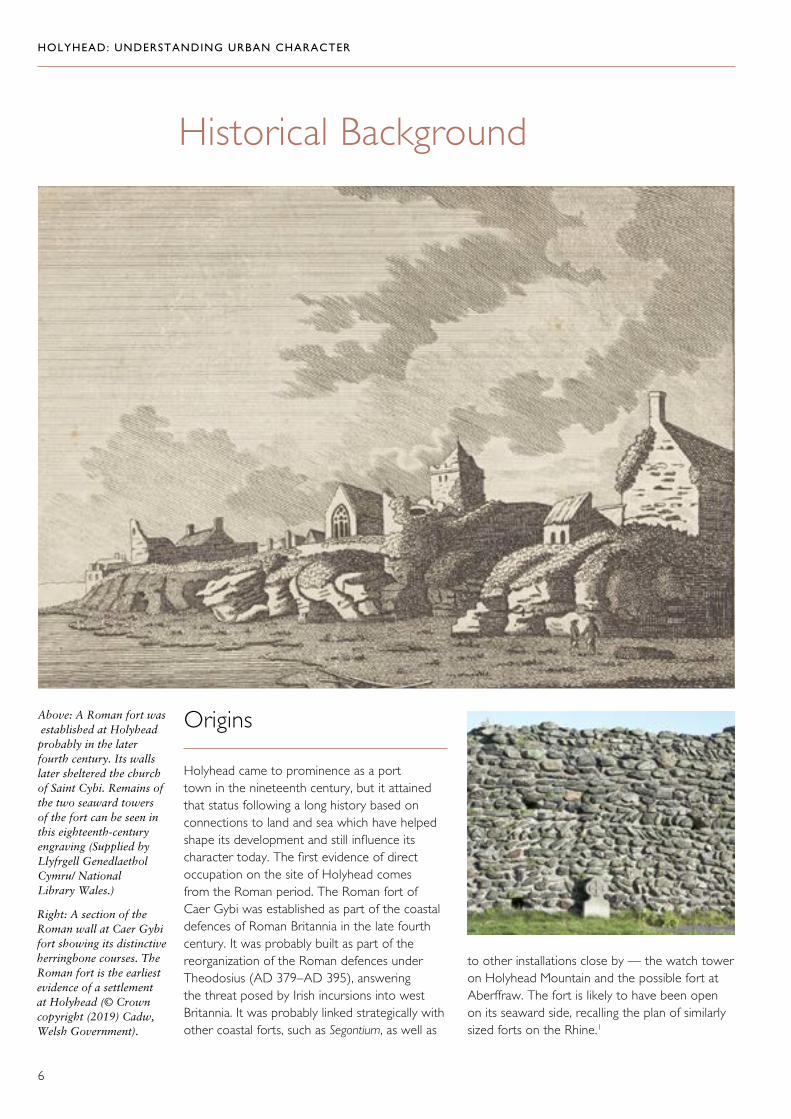
Holyhead came to prominence as a port town in the nineteenth century, but it attained that status following a long history based on connections to land and sea which have helped shape its development and still influence its character today. The first evidence of direct occupation on the site of Holyhead comes from the Roman period. The Roman fort of Caer Gybi was established as part of the coastal defences of Roman Britannia in the late fourth century. It was probably built as part of the reorganization of the Roman defences under Theodosius (AD 379–AD 395), answering the threat posed by Irish incursions into west Britannia. It was probably linked strategically with other coastal forts, such as Segontium, as well as
Above: A Roman fort was established at Holyhead probably in the later fourth century. Its walls later sheltered the church of Saint Cybi. Remains of the two seaward towers of the fort can be seen in this eighteenth-century engraving (Supplied by Llyfrgell Genedlaethol Cymru/ National Library Wales.)
HOLYHEAD: UNDERSTANDING URBAN CHARACTER
Right: A section of the Roman wall at Caer Gybi fort showing its distinctive herringbone courses. The Roman fort is the earliest evidence of a settlement at Holyhead (© Crown copyright (2019) Cadw, Welsh Government).
to other installations close by — the watch tower on Holyhead Mountain and the possible fort at Aberffraw. The fort is likely to have been open on its seaward side, recalling the plan of similarly sized forts on the Rhine.1

7
There may have been other strands in the early history of Holyhead, since there is an important prehistoric legacy in the surrounding landscape. There is a rich concentration of Neolithic, Bronze Age and Iron Age sites, including an Iron Age hillfort on Holyhead Mountain and several hut circle settlement groups around its base. However, it is the Roman fort which provides the first tangible contribution to the development of a distinctive urban settlement.
The fort probably fell out of use after the end of Roman occupation at the beginning of the fifth century and was therefore redundant by the time of Saint Cybi in the early sixth century. At this time, its walls were deemed suitable to delineate a monastic precinct which was given to Cybi by Maelgwyn, the ruler of Gwynedd. The remains of the Roman walls and the successor of Cybi’s monastery are at the heart of the modern town.
Holyhead Mountain hut circle settlement dates from the Iron Age and is one of a number of prehistoric sites around Holyhead (© Crown copyright (2019) Cadw, Welsh Government).
HOLYHEAD: UNDERSTANDING URBAN CHARACTER

HOLYHEAD: UNDERSTANDING URBAN CHARACTER
8
The Beginnings of Modern Holyhead
There is little or no tangible evidence to tell us about life in the area in the medieval period. The two churches in the fort are the earliest surviving structures. Although the presence of two churches in a single churchyard is taken as a hint of early Christian activity, the earliest dateable fabric in the church of Saint Cybi is thirteenth century and fourteenth century in
Eglwys y Bedd, both long after the time of Cybi himself. Nevertheless, the fact that the town is named after the saint suggests that he did ‘give celebrity to the place’.2 The church probably retained its monastic status until the Dissolution, and extensive fifteenth- and sixteenth-century fabric suggests that there was sufficient prosperity in the late medieval period to permit substantial investment in building. Any domestic monastic buildings that survived beyond the Dissolution were demolished piecemeal over the last two hundred years.3
The church of Saint Cybi lies on or close to the monastic settlement established by the saint in the early sixth century. Although some fabric dates from the thirteenth century, most dates from the fifteenth and sixteenth centuries (© Crown Copyright: RCAHMW).
Eglwys y Bedd, alongside Saint Cybi’s Church and inside the fort walls, dates from the fourteenth century but is reputedly on the site of the saint’s grave (© Crown copyright (2019) Cadw, Welsh Government).

HOLYHEAD: UNDERSTANDING URBAN CHARACTER
9
This 1696 picture of Holyhead by Francis Place shows a cluster of houses around the church and at Newry, which suggest it is a village rather than a town (Source: Holyhead Central: Conservation Area Character Appraisal, Isle of Anglesey County Council, 2005).
This view of Holyhead in 1737, drawn by Lewis Morris for Cambria’s Coasting Pilot, also shows a small and informal settlement (By courtesy of UK Hydrographic Office).
There are elusive documentary references which suggest that Holyhead maintained a role as a port during the Middle Ages. But the port only came to prominence in the late sixteenth century when it became the main gateway for government communication with Dublin around 1576. It thus acquired official status as a post town and port, and links with Ireland were still the mainstay of any prosperity that it had in the eighteenth century when it was described as ‘the great thoroughfare between both kingdoms.’4 In spite of its important role as the packet station for Ireland, Holyhead boasted neither a proper harbour, nor any recognizable urban form. A late seventeenth-century watercolour records several substantial houses clustered around the church and at Newry, but the scale of settlement it shows suggests a village rather than a town.5 A sketch by Lewis Morris a few decades later also depicts Holyhead as a small and informal settlement. It shows clusters of often substantial houses at the landward entrance to the town and close to the shore to the north, which are linked by an irregular line of building along the roads in between.6
In 1784 Holyhead seems to have been merely a village, consisting of ‘a straggling confused heap of thatched houses built on rocks.’7 Even in 1793, ‘Holyhead is a small town, and seems to have nothing to boast of … except the remains of some Roman walls which are seen in the church yard.’8 Nonetheless, despite its small size, Thomas Pennant had noted ten years previously that the town was ‘greatly resorted to by passengers to and from the kingdom of Ireland; and is the station of the pacquets, five of which are in constant employ; are stout vessels, and well manned.’9
By this time there were already signs of a new ambition to develop the town. In 1770, an attempt was made to establish Holyhead as a resort where visitors from Ireland might stay. Seawater baths were established in the sheltered inlet between the town and Salt Island (still commemorated by the name Front Bath Street), and houses for visitors were built nearby at Marine Square, some of which survive. Pleasure gardens were also created on Salt Island. As part of the same enterprise, an annex

HOLYHEAD: UNDERSTANDING URBAN CHARACTER
10
known as Parlyrau (now long demolished) stood on Market Hill adjacent to The Caernarfon Castle public house and served as a venue for theatrical companies and other meetings. In the same year, The Eagle and Child Hotel was built on the edge of town, conveniently situated
both for the inlet, which became the inner harbour, and for the post road (now Kingsland Road) across the island via Four Mile Bridge. The post road had been turnpiked in 1765 and a regular stagecoach service was introduced in 1785.10
Part of The Eagle and Child Hotel, built in 1770, survives in Victoria Terrace (© Crown Copyright: RCAHMW).
Marine Square, where some of the houses built in the late eighteenth century for visitors to Holyhead’s new seawater baths and pleasure gardens survive (© Crown Copyright: RCAHMW).
HOLYHEAD: UNDERSTANDING URBAN CHARACTER
11
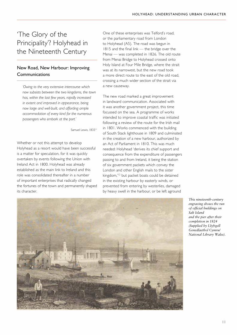
This nineteenth-century engraving shows the run of official buildings on Salt Island and the pier after their completion in 1824 (Supplied by Llyfrgell Genedlaethol Cymru/ National Library Wales).
‘The Glory of the Principality’? Holyhead in the Nineteenth Century
New Road, New Harbour: Improving Communications
‘Owing to the very extensive intercourse which now subsists between the two kingdoms, the town has, within the last few years, rapidly increased in extent and improved in appearance, being now large and well-built, and affording ample accommodation of every kind for the numerous passengers who embark at the port.’
Samuel Lewis, 183311
Whether or not this attempt to develop Holyhead as a resort would have been successful is a matter for speculation, for it was quickly overtaken by events following the Union with Ireland Act in 1800. Holyhead was already established as the main link to Ireland and this role was consolidated thereafter in a number of important enterprises that radically changed the fortunes of the town and permanently shaped its character.
One of these enterprises was Telford’s road, or the parliamentary road from London to Holyhead (A5). The road was begun in 1815 and the final link — the bridge over the Menai — was completed in 1826. The old route from Menai Bridge to Holyhead crossed onto Holy Island at Four Mile Bridge, where the strait was at its narrowest, but the new road took a more direct route to the east of the old road, crossing a much wider section of the strait via a new causeway.
The new road marked a great improvement in landward communication. Associated with it was another government project, this time focussed on the sea. A programme of works intended to improve coastal traffic was initiated following a review of the route for the Irish mail in 1801. Works commenced with the building of South Stack lighthouse in 1809 and culminated in the creation of a new harbour, authorized by an Act of Parliament in 1810. This was much needed: Holyhead ‘derives its chief support and consequence from the expenditure of passengers passing to and from Ireland, it being the station of six government packets which convey the London and other English mails to the sister kingdom,’12 but packet boats could be detained in the existing harbour by easterly winds, or prevented from entering by westerlies, damaged by heavy swell in the harbour, or be left aground

HOLYHEAD: UNDERSTANDING URBAN CHARACTER
12
Admiralty Arch, designed by Thomas Harrison and built in 1824 to commemorate the 1821 visit of George IV to Holyhead (Supplied by Llyfrgell Genedlaethol Cymru/ National Library Wales).
for eight hours out of every twelve.13 Jonathan Swift had described the problem aptly in 1727: ‘Lo here I sit at holy head/ with muddy ale and mouldy bread / I’m fastened both by wind and tide / I see the ships at anchor ride.14
John Rennie was appointed as engineer for the new harbour and he created a substantial haven through the construction of quay walls on Salt Island and the isthmus that connected it to the shore, as well as a pier (Admiralty Pier) running east from Salt Island. John Rennie died in 1821, the year in which the pier itself was completed, and Thomas Telford then assumed responsibility for the harbour project. He implemented Rennie’s designs for the impressive run of official buildings on Salt Island, which comprised the engineer’s house, the customs house, the harbour office, the depot for the Post Office stores and a lighthouse. In 1824, this line-up was completed by the Admiralty Arch, which was built to designs by Thomas Harrison to commemorate the visit to Holyhead of George IV (1820–30) in 1821 and
acted as the symbolic terminus for the new road. Behind these formal buildings were cottages, stores and workshops. By the time the harbour was completed, steam ships had been introduced on the Dublin crossing.
The continuation of the harbour project under Telford was completed by the construction of a graving dock on the south side of the harbour, protected by a second pier (the south pier) and contained by a walled compound. Transport links around the harbour were also improved: ‘a new line of road has been constructed under the walls of the town, upon the shore of the traeth, or sandy estuary which forms the harbour, extending more than a mile along a lofty artificial embankment, from the entrance to the town to the commencement of the pier.’15 This road provided direct access to the pier from Telford’s new road and also linked it with the graving dock. With subsequent improvement, it became Victoria Road and Turkey Shore Road.

HOLYHEAD: UNDERSTANDING URBAN CHARACTER
13
The Coming of the Railway
Holyhead will soon be looked upon as the principal key to the Atlantic. The vast trading interest of America, and all the countries lying westward, will without doubt, avail themselves of the facilities of this port, and its railway communication with everywhere in Great Britain’.
E. Parry, 184816
Holyhead being now joined by the railway with London, Leeds, Birmingham, Manchester and all the manufacturing districts of the kingdom, a large portion of the golden trade of commerce must naturally flow through its port. … it will become the glory of the principality’.
Thomas Jackson, 185317
Heralded as ‘an extraordinary display of enterprise and wealth,’18 the arrival of the railway marked the next major step in the fortunes of the town. It ended an interlude between 1839 and 1850 during which Liverpool took over the mail contract; Liverpool had been linked by rail to London since 1838. Holyhead recovered its position following the conclusions of a commission established in 1842 to determine the best route for the mail between London and Dublin. Its great advantage was that it was closer to Ireland and vessels that sailed out of Liverpool had to run the gauntlet of the north Wales coast, which could be treacherous to navigation. A rival claim from Porthdinllaen was eventually dismissed and Holyhead was designated as the official port for Ireland and the terminus of a new railway, the Chester to Holyhead line. The Chester
and Holyhead Railway Act was passed in 1844. Although the railway reached Holyhead in 1848, passengers had to disembark at Bangor, cross the Menai Bridge, and then board another train at Llanfair. It was not until 1850, with the opening of the Britannia Bridge, that travel direct from London was possible. From 1856, the railway was operated by the London and North Western Railway (LNWR).19 The first station was built near the foot of Kingsland Road, but by 1856 the terminus was established nearer the harbour (opposite the foot of Holborn Road, close to the famous Five Sisters public houses). An extension northwards to the pier opened in 1856. But, when the inner harbour was built twenty years later, a new station was established at its head in a greatly enlarged complex comprising long glazed platforms linked by a large hotel, which opened in 1880. By this time, Holyhead was firmly established as a major passenger port as well as the official port for the mail.
Above: The surviving red brick buildings of the 1880s station building (© Crown Copyright: RCAHMW).
The magnificent Station Hotel, built in 1880 by the London and North Western Railway, linked two long glazed platforms at the head of the inner harbour (Supplied by Llyfrgell Genedlaethol Cymru/ National Library Wales).
HOLYHEAD: UNDERSTANDING URBAN CHARACTER
14
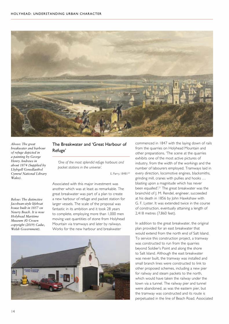
Below: The distinctive Jacobean-style lifeboat house built in 1857 on Newry Beach. It is now Holyhead Maritime Museum (© Crown copyright (2019) Cadw, Welsh Government).
Above: The great breakwater and harbour of refuge depicted in a painting by George Henry Andrews in about 1874 (Supplied by Llyfrgell Genedlaethol Cymru/ National Library Wales).
The Breakwater and ‘Great Harbour of Refuge’
‘One of the most splendid refuge harbours and packet stations in the universe’.
E. Parry, 1848120
Associated with this major investment was another which was at least as remarkable. The great breakwater was part of a plan to create a new harbour of refuge and packet station for larger vessels. The scale of the proposal was fantastic in its ambition and it took 28 years to complete, employing more than 1,000 men moving vast quantities of stone from Holyhead Mountain via tramways and later by railways. Works for the new harbour and breakwater
commenced in 1847 with the laying down of rails from the quarries on Holyhead Mountain and other preparations. ‘The scene at the quarries exhibits one of the most active pictures of industry, from the width of the workings and the number of labourers employed. Tramways laid in every direction, locomotive engines, blacksmiths, grinding mill, cranes with pullies and hooks … blasting upon a magnitude which has never been equalled’.21 The great breakwater was the brainchild of J. M. Rendel, engineer, succeeded at his death in 1856 by John Hawkshaw with G. F. Lyster. It was extended twice in the course of construction, eventually attaining a length of 2,418 metres (7,860 feet).
In addition to the great breakwater, the original plan provided for an east breakwater that would extend from the north end of Salt Island. To service this construction project, a tramway was constructed to run from the quarries beyond Soldier’s Point and along the shore to Salt Island. Although the east breakwater was never built, the tramway was installed and small branch lines were constructed to link to other proposed schemes, including a new pier for railway and steam packets to the north, which would have taken the railway under the town via a tunnel. The railway pier and tunnel were abandoned, as was the eastern pier, but the tramway was constructed and its route is perpetuated in the line of Beach Road. Associated

HOLYHEAD: UNDERSTANDING URBAN CHARACTER
15
with the great harbour of refuge were various other amenities at Newry Beach, which formed the landward face of the new harbour. Here, a lifeboat house was built in 1857 (now Holyhead Maritime Museum) and a Trinity House depot in 1870. An enclosed boat yard was added in 1890 and a landing stage alongside it in 1892 (Mackenzie landing).
Although this investment consolidated Holyhead’s position, there was plenty of scope for rivalry in the delivery of its role as official port, once the government decided to contract out the mail service from 1850. The first contract was won by the City of Dublin Steam Packet Company operating from Admiralty Pier, which, as a consequence of the arrival of the railway, was extended and linked to the new railway by a tramway. The rival Chester and Holyhead Railway (later the LNWR) quickly decided upon new investment in the railway that might strengthen its hand in obtaining the contract for the mail service in future whilst also giving it an advantage for general freight and passenger traffic. Whereas trains had originally terminated at the station, which was opposite the present entrance to Holborn Road, in 1856 the line was extended northwards to the promontory where
the tidal inlet met the harbour (opposite the foot of Boston Street). Here, the railway company established its own small marine yard on a site previously occupied by a custom house (marked as old custom house on the tithe map). This was followed by further engineering work to create a new quay on the west side of the harbour, complete with goods sheds etc.
Then, when the railway company failed again to win the mail contract in 1870, a far more ambitious scheme was proposed. This involved creating yet another new harbour (the inner harbour) by excavating the tidal inlet to the south, and reclaiming both its margins for wharves and berths, railway lines and goods sheds. At the same time, the marine yard was extended with several new buildings, and a new graving dock and pumping engine house were built on the east side of the extended harbour on the Turkey Shore Quay. As the culmination of this scheme, a grand new station and hotel were built at the head of the harbour, which opened in 1880. All this investment supported a greatly increased trade, including livestock. As a result, extensive areas adjacent to the railway were set aside for cattle sheds and lairages inland from the harbour.
Marine yard was built in two phases between about 1852 and 1880 to support the maritime activities of the Chester and Holyhead Railway and then the LNWR (© Crown Copyright: RCAHMW).
HOLYHEAD: UNDERSTANDING URBAN CHARACTER
16
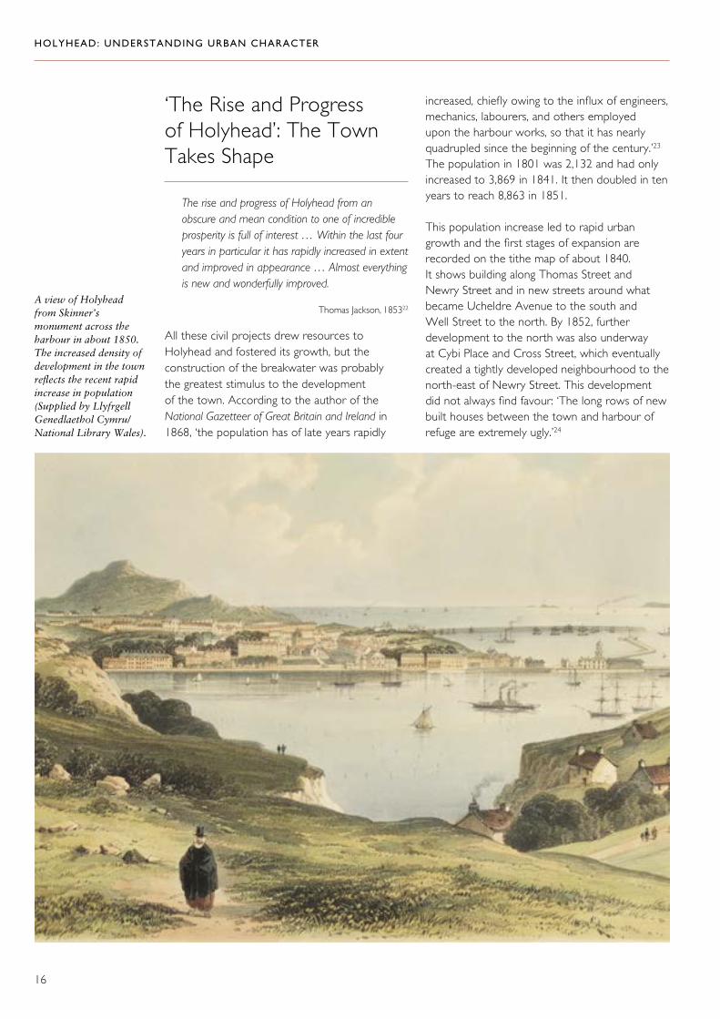
‘The Rise and Progress of Holyhead’: The Town Takes Shape
The rise and progress of Holyhead from an obscure and mean condition to one of incredible prosperity is full of interest … Within the last four years in particular it has rapidly increased in extent and improved in appearance … Almost everything is new and wonderfully improved.
Thomas Jackson, 185322
All these civil projects drew resources to Holyhead and fostered its growth, but the construction of the breakwater was probably the greatest stimulus to the development of the town. According to the author of the National Gazetteer of Great Britain and Ireland in 1868, ‘the population has of late years rapidly
increased, chiefly owing to the influx of engineers, mechanics, labourers, and others employed upon the harbour works, so that it has nearly quadrupled since the beginning of the century.’23 The population in 1801 was 2,132 and had only increased to 3,869 in 1841. It then doubled in ten years to reach 8,863 in 1851.
This population increase led to rapid urban growth and the first stages of expansion are recorded on the tithe map of about 1840. It shows building along Thomas Street and Newry Street and in new streets around what became Ucheldre Avenue to the south and Well Street to the north. By 1852, further development to the north was also underway at Cybi Place and Cross Street, which eventually created a tightly developed neighbourhood to the north-east of Newry Street. This development did not always find favour: ‘The long rows of new built houses between the town and harbour of refuge are extremely ugly.’24
A view of Holyhead from Skinner’s monument across the harbour in about 1850. The increased density of development in the town reflects the recent rapid increase in population (Supplied by Llyfrgell Genedlaethol Cymru/ National Library Wales).

HOLYHEAD: UNDERSTANDING URBAN CHARACTER
17
Early terraced housing in Newry Street (left) and Thomas Street (right) (© Crown Copyright: RCAHMW).
This detail from the tithe map of about 1840 shows the beginning of development around Newry Street and Thomas Street (Supplied by Llyfrgell Genedlaethol Cymru/ National Library Wales).

HOLYHEAD: UNDERSTANDING URBAN CHARACTER
18
House building also took place in hamlets away from the town: in 1848 Lord Stanley built Lower Mountain Row and Upper Mountain Row on the slopes of Holyhead Mountain. At the same time, there was continued expansion of the town centre which had established a concentrated
commercial role: by 1853, trading extended from Market Street into Stanley Street and Boston Street.25 By 1870–72, the town comprised ‘two good principal streets, a number of subordinate streets and considerable outskirts ... houses in the outskirts, generally, are much scattered.’26
Three-storey houses on Market Street (top), Stanley Street (below) and Boston Street (opposite), built in the early nineteenth century, were important in the revival of the town and are a distinctive element of its character today (© Crown Copyright: RCAHMW).

HOLYHEAD: UNDERSTANDING URBAN CHARACTER
19

HOLYHEAD: UNDERSTANDING URBAN CHARACTER
20
We must assume from the scattered and haphazard form of the town as it expanded that development was in many hands, but two estates in particular stand out. One was the Ucheldre estate, which was owned by the Thomas family (immortalized in Thomas Street). Development was permitted on outlying fields, but the core of land around the house was never built on. When the house was acquired by the Bon Sauveur Convent in 1907, this land was secured as a private enclave around the new convent buildings, enclosed by high walls.
The Penrhos estate of the Stanley family had acquired land in the late eighteenth century and was a major player in the growth of the town. It invested in the revival of the town,
for example, by building The Eagle and Child Hotel on the site of an older building called Plas Newydd which had been acquired in 1770. The Penrhos estate was also responsible for other development in the town centre through building leases on the main street, where two-storey and attic houses were documented by 1769 and three-storey houses on the seaward side of Market Street in 1774. The pre-eminence of this estate is commemorated in the name of Stanley Street. William Owen Stanley provided the town with a market hall in 1855. The Stanley family were also responsible for the Penrhos almshouses in Kingsland (1866), a sailors’ home and reading room on Newry Beach (1871), and the sailors’ hospital on Salt Island (1872).
This aerial view of the Bon Saveur Convent shows how development was limited to areas beyond the walled enclosure of the convent (© Crown Copyright: RCAHMW: Aerofilms Collection).

HOLYHEAD: UNDERSTANDING URBAN CHARACTER
21
The market hall was provided by the Stanley family in 1855. At the time of writing, the market hall is being restored. Note the similarity of the gables with those of the lifeboat house built in 1857 (© Crown Copyright: RCAHMW).
Below: Penrhos almhouses — sometimes known as Stanley Cottages — on the corner of Tyn Pwll Road and Cyttir Road in Kingsland were also built by the Stanley family, in 1866 (© Crown Copyright: RCAHMW).
HOLYHEAD: UNDERSTANDING URBAN CHARACTER
22
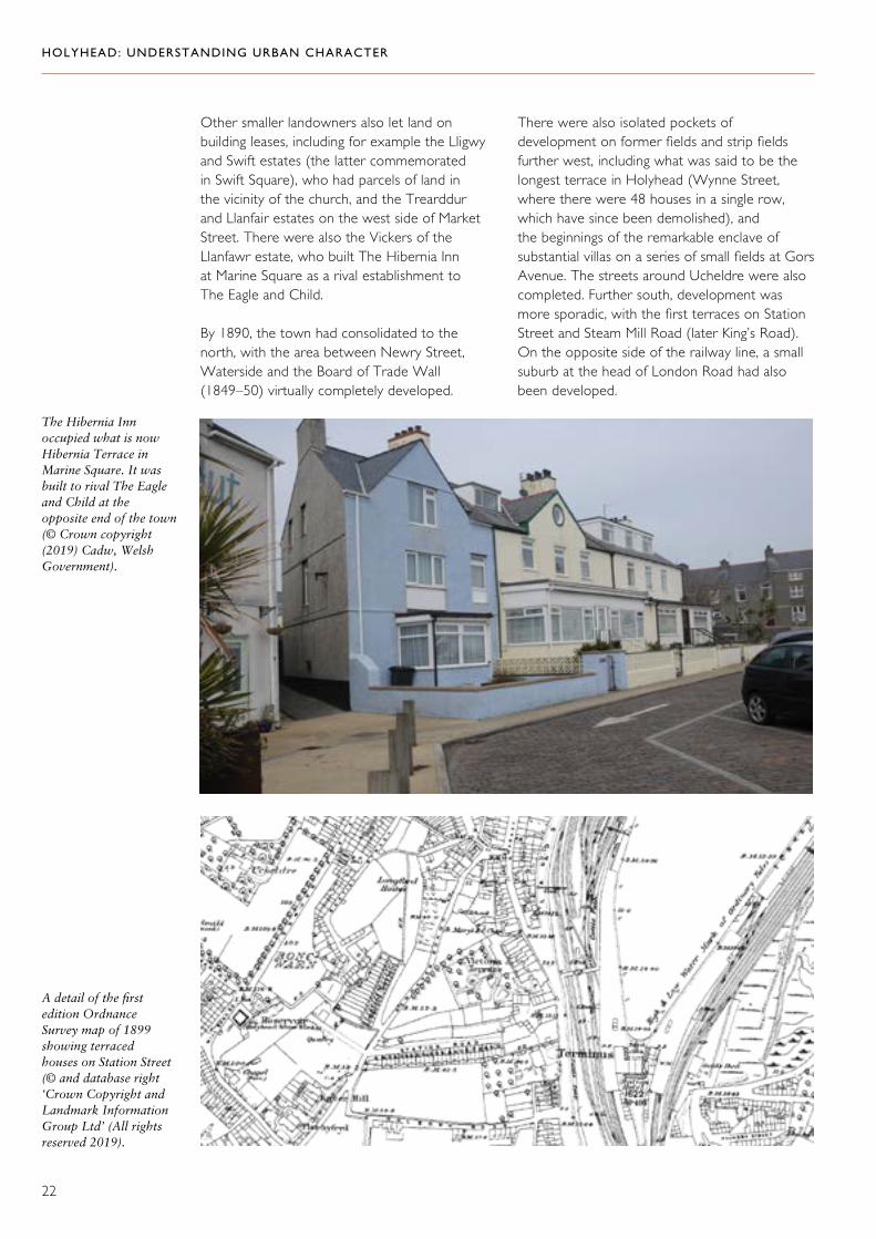
A detail of the first edition Ordnance Survey map of 1899 showing terraced houses on Station Street (© and database right ‘Crown Copyright and Landmark Information Group Ltd’ (All rights reserved 2019).
The Hibernia Inn occupied what is now Hibernia Terrace in Marine Square. It was built to rival The Eagle and Child at the opposite end of the town (© Crown copyright (2019) Cadw, Welsh Government).
Other smaller landowners also let land on building leases, including for example the Lligwy and Swift estates (the latter commemorated in Swift Square), who had parcels of land in the vicinity of the church, and the Trearddur and Llanfair estates on the west side of Market Street. There were also the Vickers of the Llanfawr estate, who built The Hibernia Inn at Marine Square as a rival establishment to The Eagle and Child.
By 1890, the town had consolidated to the north, with the area between Newry Street, Waterside and the Board of Trade Wall (1849–50) virtually completely developed.
There were also isolated pockets of development on former fields and strip fields further west, including what was said to be the longest terrace in Holyhead (Wynne Street, where there were 48 houses in a single row, which have since been demolished), and the beginnings of the remarkable enclave of substantial villas on a series of small fields at Gors Avenue. The streets around Ucheldre were also completed. Further south, development was more sporadic, with the first terraces on Station Street and Steam Mill Road (later King’s Road). On the opposite side of the railway line, a small suburb at the head of London Road had also been developed.
HOLYHEAD: UNDERSTANDING URBAN CHARACTER
23
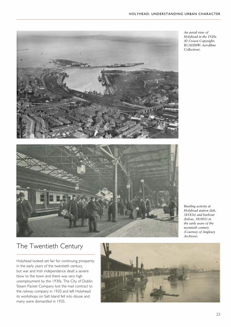
An aerial view of Holyhead in the 1920s (© Crown Copyright: RCAHMW: Aerofilms Collection).
The Twentieth Century
Holyhead looked set fair for continuing prosperity in the early years of the twentieth century, but war and Irish independence dealt a severe blow to the town and there was very high unemployment by the 1930s. The City of Dublin Steam Packet Company lost the mail contract to the railway company in 1920 and left Holyhead: its workshops on Salt Island fell into disuse and many were dismantled in 1935.
Bustling activity at Holyhead station (left, 381816) and harbour (below, 381803) in the early years of the twentieth century (Courtesy of Anglesey Archives).

HOLYHEAD: UNDERSTANDING URBAN CHARACTER
24
Modern ferry facilities in the inner harbour at Holyhead (© Crown copyright (2019) Visit Wales).
To some extent, new enterprises filled the gap, especially after the Second World War when a more diverse local economy was encouraged by the establishment of new factories at Kingsland and Turkey Shore, and by the major enterprises of Anglesey Aluminium (1969) and Wylfa (1963–71). These were largely the result of government policy and intervention and, with the nationalization of the railways in 1948, there was also state involvement in the operation of the port. The fortunes of the port were boosted by the introduction of a car ferry service in 1965, operating from Salt Island, and the establishment of a container terminal in 1970, concentrated on the
south side of the harbour. These services, initially publically owned, were privatized in the 1980s.
These ups and downs in economic activity are reflected in the building history of the town. By 1924, expansion to the south and west had continued, but the sporadic pattern of development suggests a small-scale and intermittent speculative process. Some isolated individual fields were built on as at Wynne Street (now demolished), Tara Street and Gors Avenue, and some streets remained unfinished, for example, King’s Road and Cleveland Avenue.
A detail of the first edition Ordnance Survey map of 1899 showing terraced houses on Wynne Street, built on an isolated field (© and database right ‘Crown Copyright and Landmark Information Group Ltd’ (All rights reserved 2019).

HOLYHEAD: UNDERSTANDING URBAN CHARACTER
25
Speculative development to the south of Holyhead on individual fields included Gors Avenue. Here, a substantial terrace was built alongside large, individually designed detached houses: Sunrise Terrace (top), Mount Norris (middle) and Akaroa (bottom) (© Crown Copyright: RCAHMW).
HOLYHEAD: UNDERSTANDING URBAN CHARACTER
26
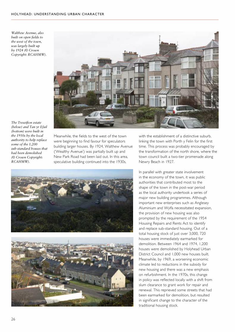
Meanwhile, the fields to the west of the town were beginning to find favour for speculators building larger houses. By 1924, Walthew Avenue (‘Wealthy Avenue’) was partially built up and New Park Road had been laid out. In this area, speculative building continued into the 1930s,
The Treseifion estate (below) and Tan yr Efail (bottom) were built in the 1950s by the local authority to help replace some of the 1,200 sub-standard houses that had been demolished (© Crown Copyright: RCAHMW).
Walthew Avenue, also built on open fields to the west of the town, was largely built up by 1924 (© Crown Copyright: RCAHMW).
with the establishment of a distinctive suburb, linking the town with Porth y Felin for the first time. This process was probably encouraged by the transformation of the north shore, where the town council built a two-tier promenade along Newry Beach in 1927.
In parallel with greater state involvement in the economy of the town, it was public authorities that contributed most to the shape of the town in the post-war period as the local authority undertook a series of major new building programmes. Although important new enterprises such as Anglesey Aluminium and Wylfa necessitated expansion, the provision of new housing was also prompted by the requirement of the 1954 Housing Repairs and Rents Act to identify and replace sub-standard housing. Out of a total housing stock of just over 3,000, 720 houses were immediately earmarked for demolition. Between 1964 and 1974, 1,200 houses were demolished by Holyhead Urban District Council and 1,000 new houses built. Meanwhile, by 1969, a worsening economic climate led to reductions in the subsidy for new housing and there was a new emphasis on refurbishment. In the 1970s, this change in policy was reflected locally with a shift from slum clearance to grant work for repair and renewal. This reprieved some streets that had been earmarked for demolition, but resulted in significant change to the character of the traditional housing stock.

HOLYHEAD: UNDERSTANDING URBAN CHARACTER
27
Large housing estates were established at Morawelon (begun in 1956) and Treseifion, but by the 1970s, redevelopment schemes were typically smaller as refurbishment rather than replacement came to the fore. Examples of these smaller developments are around Mill Bank, Waterside and St Seiriol’s Close. Typically, the new estates represented development on a larger scale than at any previous time, and the underlying pattern of fields and boundaries was lost.
Even where existing built-up areas were redeveloped, inherited street patterns were not respected, for example, around Water Street and Wynne Street (no longer extant). Much of the surviving housing stock provides evidence of different improvement regimes, including an early example on Tyn Pwll Road, where the level of change was unusually high.
After the 1970s, it was once again private development which came to the fore in large-scale building projects. The expansion of Holyhead to the west in residential suburbs and to the south in commercial development along the main transport corridor has threatened to engulf the distinctive character of the historic town.
Top: A smaller development at Rock Street replaced earlier terraced housing (© Crown Copyright: RCAHMW).
Above: An early regeneration scheme at Tyn Pwll Road, which included spar-dash render, timber cladding and enlarged windows. Note that the original boundary wall remains intact (© Crown copyright (2019) Cadw, Welsh Government).
Left: This modern aerial view shows the expansion of commercial development to the south of the town (© Crown Copyright: RCAHMW).

HOLYHEAD: UNDERSTANDING URBAN CHARACTER
28
Historical Topography
End of the Road, Edge of the Land
‘The greater part of the town is built immediately adjoining the harbour, and presents a peculiar appearance from the steepness of the streets, which run somewhat abruptly up from the water’s edge’.
The National Gazetteer of Great Britain and Ireland, 186827
Until reclamation work associated with the creation and improvement of the harbour, the town was limited to the higher ground to the west of the tidal inlet. The steeply sloping topography is an important element in the character of the town, affording views and vistas and some striking picturesque effects.
In the Roman period, the sea was immediately below the low cliffs that define the edge of the higher ground. The fort is likely to have been open to the sea on its east side; the current
An engraving of Captain Skinner’s house made from a picture painted by his friend and customs officer, James Sparrow, in 1828. The large impressive house overlooked the foreshore before Victoria Road was properly developed (Supplied by Llyfrgell Genedlaethol Cymru/ National Library Wales).
Lewis Morris’s 1737 sketch of Holyhead shows how the town is limited to the higher areas at this time (By courtesy of UK Hydrographic Office).

HOLYHEAD: UNDERSTANDING URBAN CHARACTER
29
eastern wall is modern. The arrangement depicted in Lewis Morris’s sketch of 1737 clearly indicates a shoreline immediately beneath the churchyard and the south side of Market Street, confining the built area of the town to the higher level. The two exceptions to this were at the foot of Boston Street, where a rocky promontory in the inlet created an area of solid ground, and Marine Square. In both areas, there is evidence for development that predates the creation of the harbour in the early nineteenth century and the direct access to it.
There is a tradition that the area beyond Water Street (Pwll Cam) was also reclaimed, and Lewis Morris shows a substantial break
in the settlement at this point. It is possible that the works associated with the harbour and the new road also had an impact on the ground in this area, which, together with the western shoreline (later Victoria Road), were being built on by the time of the tithe survey in about 1840. The eastern side of the harbour was also improved and partly reclaimed as part of the harbour works in the 1820s, which consolidated the shoreline at Turkey Shore Road. The second stage of harbour improvement in the 1870s extended the reclaimed area again, this time for railway lines and goods sheds on both sides of the harbour, together with a second graving dock on the new Turkey Shore Quay.
This detail from the tithe map of about 1840 shows the area around Market Street (Supplied by Llyfrgell Genedlaethol Cymru/ National Library Wales).

HOLYHEAD: UNDERSTANDING URBAN CHARACTER
30
Below right: Stanley Street was originally on the main route through the town before Victoria Road was created. Distinctive three-storey properties like these help retain the original character of the town centre (© Crown Copyright: RCAHMW).
This shoreline work was clearly enormously important to the economy of the town and contributes strongly to its character, but it never really drew vitality from the original route through the town centre. The old road went via Market Street and Stanley Street, before dropping down the line of Boston Street to the shore and Marine Square. There was no other direct access to the shore until Victoria Road was created in the 1820s, and no through route to the northern shore until the late nineteenth century when Newry Street was extended to join the new road along the north shore. This road took the line of the railway that had been built to service the proposed eastern breakwater in
the late 1840s and therefore stopped some way short of Marine Square. It was not until the mid-twentieth century that a route through the square was created, enhancing access to the north shore, but damaging the integrity of the square in the process. It is notable that the only direct access from the main street to the shore level is via the churchyard. And, with the exception of the church and Stanley House, the town is determinedly oriented onto the main street rather than onto the harbour. More recently, the increased use of the lower road has created a strong secondary orientation to the town, giving a new importance to the backs of properties on the east side of Market Street.
Right: A detail of the first edition Ordnance Survey map of 1899 showing properties oriented towards Market Street (© and database right ‘Crown Copyright and Landmark Information Group Ltd’ (All rights reserved 2019).
Below left: Victoria Road sandwiched between Market Street and the railway line has become a main thoroughfare. As a consequence, the backs of properties on Market Street are prominent in a way that was never intended (© Crown copyright (2019) Cadw, Welsh Government).

HOLYHEAD: UNDERSTANDING URBAN CHARACTER
31
Land Use and Ownership
The Market Street–Stanley Street route remained (and remains) the principal axis of the town. Until the mid-nineteenth century, development was largely confined to this axis with only haphazard expansion beyond it. Pivotal in this
layout was the enclosed churchyard, concealed from streets, but strongly influencing their orientation. Close to its entrance, the junction of the two main streets formed a small marketplace. This was adequate for the needs of the town, which was not a notable trading centre, until the mid-nineteenth century when a larger covered market was provided.
The well-preserved street pattern around the Roman fort is clear in this aerial view. The marketplace, where Market Street and Stanley Street converge, is to the left of the fort (© Crown Copyright: RCAHMW).
The marketplace, which served as the main trading centre until the market hall was built in 1855 (© Crown Copyright: RCAHMW).

HOLYHEAD: UNDERSTANDING URBAN CHARACTER
32
Beyond this line, the street pattern is characteristically irregular, despite the town’s intense development over a short period of time (between about 1850 and 1880). This reflects a much earlier pattern of land use — an irregular
This modern map shows how the irregular street pattern between Holborn Road and King’s Road preserves the earlier field boundaries (This map is based upon the Ordnance Survey material with the permission of Ordnance Survey on behalf of The Controller of Her Majesty’s Stationery Office, © Crown copyright 2016. Unauthorised reproduction infringes Crown copyright and may lead to prosecution or civil proceedings. Welsh Government. Licence Number: 100021874).
network of very small fields and enclosures, including, most notably, a series of strip fields. Ownership of these irregular plots of land must have been in many hands since they were rarely amalgamated when new streets were laid out. Instead, new streets were accommodated within this inherited pattern. Redevelopment to the north-west of the town centre has damaged this pattern now, but it survives to the south, where the streets between Holborn Road and King’s Road were fitted onto tiny fields. The sudden changes of direction and short dead-end streets are a legacy of this history.
The demarcations of ownership and land use suggested by this irregular street pattern, and the almost self-contained plots of land and strong boundaries sometimes associated with it are important elements in the historic character of Holyhead. The town appears to be structured almost as a series of enclaves, some of which are marked only by the alignments of streets, paths and plots, and others (such as the churchyard and Ucheldre) that are delineated by substantial walls.
Strong boundaries, such as these back street walls, are an important element of the historic character of Holyhead (© Crown Copyright: RCAHMW).

HOLYHEAD: UNDERSTANDING URBAN CHARACTER
33
But perhaps the most notable of these enclaves are those associated with the various government-sponsored projects that really drove the development of the town in the nineteenth century. The harbour, the railway and the breakwater projects were major programmes of building carried out with significant public investment. Their influence on the shape and structure of the town was profound and reached far beyond the installations themselves to order and contain whole areas of the topography. For example, the Board of Trade Wall that runs inland of Newry Beach contained the town to the north, differentiating land which belonged to the Crown from the rest. This boundary still presents a firm edge to the town because the only significant building work that sits outside it on Beach Road was allied to the harbour. Other strong boundary features are the walls that separate the port from the town along Victoria Road and Turkey Shore Road, or that contain the railway (parallel to London Road), all of which demarcate land uses which were effectively private.
It is a characteristic of all these separate ownerships and land usages that boundaries are often strongly marked, either by walls or by abrupt changes of character. This is an important feature of the town that deserves to be respected in the location, form and containment of new development.
Top: The Board of Trade wall along Beach Road still provides a firm edge to the town (© Crown Copyright: RCAHMW).
The wall that separates Turkey Shore Road from the quay is still a strong boundary feature (left) as is the harbour wall along Victoria Road (above) (© Crown Copyright: RCAHMW).

HOLYHEAD: UNDERSTANDING URBAN CHARACTER
34
The Stanley Embankment, between Valley and Holy Island, was the last stage of Thomas Telford’s road between London and Holyhead (A5). The A55, the North Wales Expressway, runs parallel and together these roads are a striking feature in the landscape (© Crown Copyright: RCAHMW).
The impact of the railway on land use and organization can be seen clearly in this aerial view of the harbour in 1923 (© Crown Copyright: RCAHMW: Aerofilms Collection).
Transport
Amongst the other influences on the shape and form of the town, transport has been particularly important. Telford’s new road was imposed on an earlier network of roads which had a clear hierarchy. The original route into town from Four Mile Bridge became the first
turnpike route but within decades had been supplanted in importance by London Road. There was also a network of other local lanes, some of which connected settlements (Porth y Felin Road, Llanfawr Road and Porthdafarch Road, for example), and others which were just farm lanes serving very local needs. Neither Newry Street nor Treseifion Road, for example, was any more than a local farm road until the second half of the nineteenth century. Whatever their origins, many of these roads provided the basis for development in the later nineteenth century and have been resilient features of the landscape.
The construction of the railway marked a massive intervention in the organization of land use. It occupied the low-lying land between the old post road (Kingsland Road) and Telford’s London Road, which had previously been fields, making a hard barrier that effectively separated the east and west parts of the growing town thereafter. With the roads, the railway formed an enlarged transport corridor which has since been greatly expanded by the line of the A55.

HOLYHEAD: UNDERSTANDING URBAN CHARACTER
35
This 1769 print shows the old marketplace in Holyhead surrounded by simple vernacular buildings with thatched roofs. The market cross was the centre for trading before the market hall was built in 1855 (Supplied by Llyfrgell Genedlaethol Cymru/ National Library Wales).
The Character of Building
Patterns of Development
The historic core of settlement is represented by the long axis of Market Street and Stanley Street to the north and south of the church. With the exception of the walls around the churchyard, which are Roman in origin, and the two churches, there is no evidence for any buildings surviving from before the end of the eighteenth century, though remains of medieval buildings have been recorded.28 Although accommodated within an inherited pattern of land holding, the character of the town largely reflects the status it acquired as a major port in the nineteenth century. Its buildings, whether commercial or domestic, are decidedly urban in form; there are few if any traces of the rural vernacular suggested in some early illustrations of the town.
The town centre probably acquired its present form and much of its character in the first half
of the nineteenth century. It was in this period that development in the town centre was consolidated as continuously built-up streets, which gave it a recognizably urban character. Despite the relatively large numbers of land owners, development in the town centre during the nineteenth century was unusually coherent. Notwithstanding the loss of much historical detail from the ground floor, it is characterized by long three-storeyed terraces in a vernacular Georgian idiom with considerable uniformity created by the regular rhythm of windows and chimneys. The buildings are now virtually all in commercial use and this concentration of function had probably been established by the mid-nineteenth century. Distinctive individual buildings are either civic projects, such as the market (1855), town hall (1875) and the magistrates’ court (1894), or later commercial buildings such as the banks, Ty Cyfle, and the big developments of 1906 and 1912 on Stanley Street, which are striking examples of a deliberate commercial architecture.

HOLYHEAD: UNDERSTANDING URBAN CHARACTER
36
Three-storey terraces in Market Street (top), Stanley Street (middle) and Boston Street (bottom). Note the regular rhythm of the chimneys and windows in the upper floors (© Crown Copyright: RCAHMW).

HOLYHEAD: UNDERSTANDING URBAN CHARACTER
37
Below: The new market hall, built in a distinctive Jacobean style by William Stanley in 1855. At the time of writing, the building is being restored (© Crown Copyright: RCAHMW).
The town hall, built in 1875 (left), and the magistrates court, built in 1894 (bottom left), are prominent landmarks in the town centre streetscape (© Crown Copyright: RCAHMW).
HOLYHEAD: UNDERSTANDING URBAN CHARACTER
38
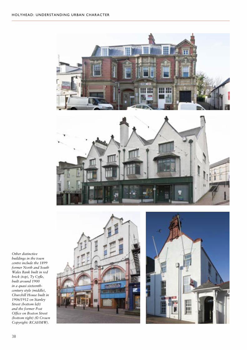
Other distinctive buildings in the town centre include the 1899 former North and South Wales Bank built in red brick (top), Ty Cyfle, built around 1900 in a quasi sixteenth-century style (middle), Churchill House built in 1906/1912 on Stanley Street (bottom left) and the former Post Office on Boston Street (bottom right) (© Crown Copyright: RCAHMW).
HOLYHEAD: UNDERSTANDING URBAN CHARACTER
39
Away from the town centre, residential development mostly dates from about 1850–80. The great influx of labour that was associated with the big civil engineering projects of the mid-nineteenth century brought with it a requirement for large numbers of relatively modest houses; these were provided almost exclusively in long terraced rows. It is hard to identify a clear chronology, but probably the earliest houses were simple single-pile, single or two unit dwellings. Very quickly, however, a more urban plan type was adopted in which houses were more often double-pile with a deep rather than a long plan.
Relatively simple plan types were capable of considerable variation. Architectural differences have become hard to read owing
to the ubiquity of pebble-dash, but the size of plot and the size of house were primary distinctions, and the sheer extent of variation suggests that Holyhead had quite a complex social hierarchy. Some rows were built directly onto the pavement; others had small front gardens, often enclosed by low walls which were given distinctive decorative treatment. Although there was often considerable uniformity within individual rows, variations between rows included the size of house (single or double-fronted, two storeys or two storeys with attics, one or two windows on the first floor) and whether or not there were bay windows or porches. Where historical features do survive, it is clear that there was quite a lively and varied play of detail in rendering, and this variety remains important.
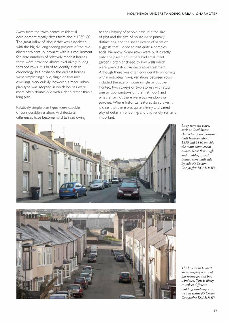
Long terraced rows, such as Cecil Street, characterize the housing built between about 1850 and 1880 outside the main commercial centre. Note that single and double-fronted houses were built side by side (© Crown Copyright: RCAHMW).
The houses in Gilbert Street display a mix offlat frontages and baywindows. This is likely to reflect different building campaigns as well as status (© Crown Copyright: RCAHMW).

HOLYHEAD: UNDERSTANDING URBAN CHARACTER
40
The boundary walls to small front gardens in Holborn Road (top), Station Street (middle) and Moreton Road (bottom) each have their own distinctive treatment. Note too the architectural variation between windows (© Crown Copyright: RCAHMW).

HOLYHEAD: UNDERSTANDING URBAN CHARACTER
41
These houses in Arthur Street retain unusual hood-mould detail around the windows; note too the regular arrangement of chimneys (© Crown Copyright: RCAHMW).
Below: Kingsland Road is dominated by long terraces of simply finished small houses (© Crown Copyright: RCAHMW).
HOLYHEAD: UNDERSTANDING URBAN CHARACTER
42
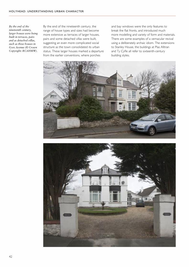
By the end of the nineteenth century, larger houses were being built in terraces, pairs and as detached villas, such as these houses in Gors Avenue (© Crown Copyright: RCAHMW).
By the end of the nineteenth century, the range of house types and sizes had become more extensive as terraces of larger houses, pairs and some detached villas were built, suggesting an even more complicated social structure as the town consolidated its urban status. These larger houses marked a departure from the earlier conventions, where porches
and bay windows were the only features to break the flat fronts, and introduced much more modelling and variety of form and materials. There are some examples of a vernacular revival using a deliberately archaic idiom. The extensions to Stanley House, the buildings at Plas Alltran and Ty Cyfle all refer to sixteenth-century building styles.

HOLYHEAD: UNDERSTANDING URBAN CHARACTER
43

HOLYHEAD: UNDERSTANDING URBAN CHARACTER
44
The rear extension to Stanley House (top), Plas Alltran (bottom left) and Ty Cyfle (bottom right) are deliberately archaic and all refer to sixteenth-century building styles (© Crown Copyright: RCAHMW).

HOLYHEAD: UNDERSTANDING URBAN CHARACTER
45
In early twentieth-century speculative developments, many of which were relatively modest semi-detached houses and bungalows, there was once again a greater conformity to design conventions of the day. Features such as bold gables advanced over bay windows and strong hipped roofs are repeated as a theme and variation. Some of these have a claim to arts and crafts inspired individuality, but even where the houses are much more conventional, their boundary walls are often robustly vernacular, using local materials when the buildings themselves rely on mass-produced and imported materials.
Early twentieth-century houses, influenced by the arts and crafts movement, in Seaborne Road (top and middle) and Walthew Avenue (bottom). Note too the robust vernacular boundary walls (© Crown Copyright: RCAHMW).

HOLYHEAD: UNDERSTANDING URBAN CHARACTER
46
Although terraced housing predominates in the town, institutional and religious buildings are also important components of its character, punctuating the uniformity of the terraces. Notable amongst these are the Roman Catholic church of 1965 which replaced an earlier one of 1855; Bethel,
Edmund Street, 1895; Ebenezer, Kingsland Road, 1850s and 1890; Hebron, Kingsland Road, 1879 and 1902; Hyfrydle, Thomas Street, 1887–88; Mount Pleasant, Thomas Street, 1883 and Tabernacl, also on Thomas Street, where a facade of 1913 was added to a building of 1823–24.
Chapels, often punctuating terraced housing, are an important part of the character of the town: Hyfrydle (top), Tabernacl (middle left) and Mount Pleasant (middle right) are on Thomas Street; Hebron (bottom left) and Ebenezer (bottom right) are on Kingsland Road (© Crown Copyright: RCAHMW).

HOLYHEAD: UNDERSTANDING URBAN CHARACTER
47
Building Materials and Detail
The main walling material was local stone, sometimes exposed in side or rear elevations. We know from George Borrow’s description of the town in 1862 that traditionally houses were limewashed or rendered: ‘The houses were tolerably large and all white. The town, with its white houses placed by the seaside, on the skirt of a mountain, beneath a blue sky and a broiling sun, put me in mind of a Moorish piratical town ...’.29 Historically, render was probably mostly smooth,
Below: Scribed render survives on this house in Cambria Street (© Crown Copyright: RCAHMW).
Roughcast render combined with rendered dressings on Kingsland Road (left) and Newry Street (bottom left) (© Crown Copyright: RCAHMW).
though sometimes finished with scribing and combined with a rusticated lower storey.
By the early twentieth century, roughcast had found favour and has some claim to be the traditional material of the town. It was generally combined with rendered dressings, usually including a plinth and architraves, and sometimes also including other banding to indicate quoins and stringcourses. Considerable creativity eventually went into the architrave detail, which provides much of the variety from one terraced row to another.
HOLYHEAD: UNDERSTANDING URBAN CHARACTER
48
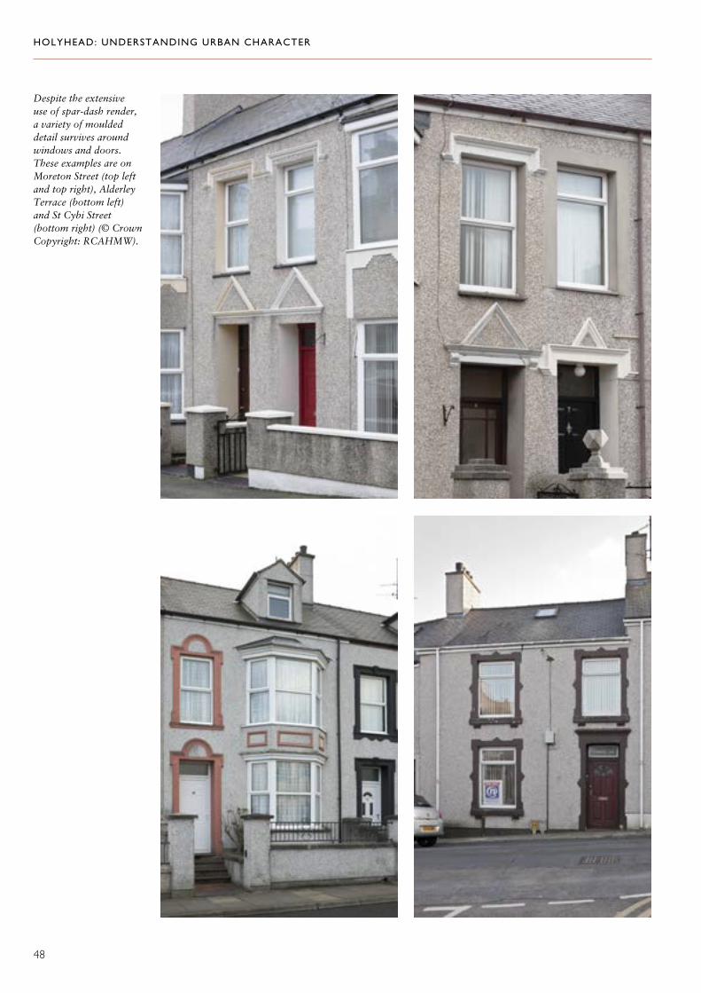
Despite the extensive use of spar-dash render, a variety of moulded detail survives around windows and doors. These examples are on Moreton Street (top left and top right), Alderley Terrace (bottom left) and St Cybi Street (bottom right) (© Crown Copyright: RCAHMW).
HOLYHEAD: UNDERSTANDING URBAN CHARACTER
49
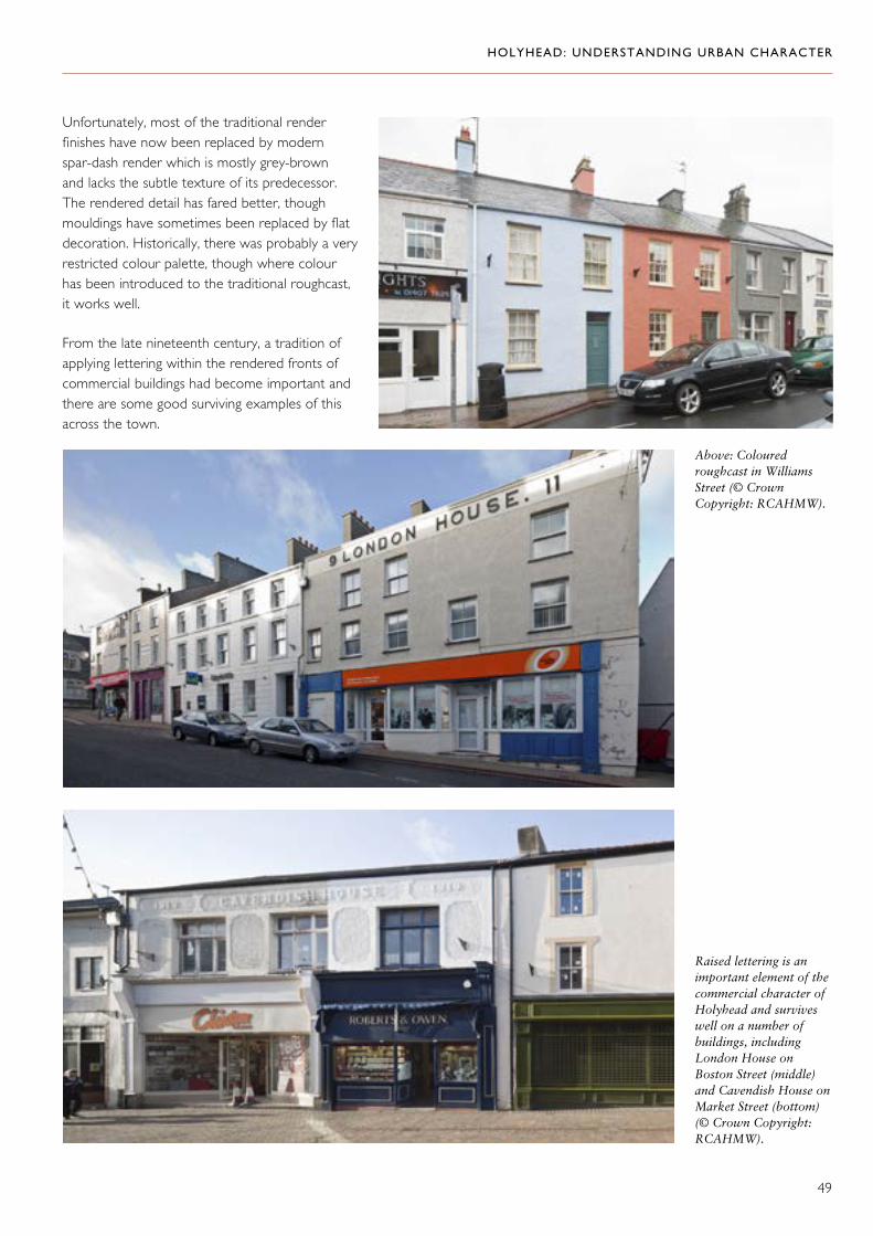
Unfortunately, most of the traditional render finishes have now been replaced by modern spar-dash render which is mostly grey-brown and lacks the subtle texture of its predecessor. The rendered detail has fared better, though mouldings have sometimes been replaced by flat decoration. Historically, there was probably a very restricted colour palette, though where colour has been introduced to the traditional roughcast, it works well.
From the late nineteenth century, a tradition of applying lettering within the rendered fronts of commercial buildings had become important and there are some good surviving examples of this across the town.
Raised lettering is an important element of the commercial character of Holyhead and survives well on a number of buildings, including London House on Boston Street (middle) and Cavendish House on Market Street (bottom) (© Crown Copyright: RCAHMW).
Above: Coloured roughcast in Williams Street (© Crown Copyright: RCAHMW).

HOLYHEAD: UNDERSTANDING URBAN CHARACTER
50
Roofing was dominated by slate, usually in uniform sizes; by the late nineteenth century, red ridge tiles were in widespread use and many have survived the wave of renewal activity that spread
through the town in the last decades of the twentieth century. These, together with chimneys which have often survived, make an important contribution to the character of the town.
Slate roofs with red ridge tiles survive in some terraces along with their chimneys. Together, they make an important contribution to the character of the town. Cambria Street (top) and Kingsland Road (bottom) are good examples (© Crown Copyright: RCAHMW).

HOLYHEAD: UNDERSTANDING URBAN CHARACTER
51
Late nineteenth- and early twentieth-century building activity introduced some new materials into the mix, including brick, imported roofing slate and building stones. These imported materials were used especially for commercial buildings — The Station Hotel may have been one of the earliest and was certainly the most spectacular example of the use of brick. These materials were also exploited to good effect in some of the higher status speculative housing developments, for example, on the upper end of Newry Street, where there are some flamboyant brick terraces, and on Walthew Avenue and Bryn Goleu, where a variety of style lent itself to a matching variety of materials. By the 1930s, variety had once again given way to greater uniformity and white render was probably the dominant material used for a while in the speculative developments around Seaborne Road and Min y Mor Road, though it too is now overshadowed by the duller palette of spar-dash.
Flamboyant brickwork on houses in Newry Street (above) and Bryn Goleu (left) (© Crown Copyright: RCAHMW).
White render was the fashionable material when these houses on Walthew Avenue were built in the 1930s (© Crown Copyright: RCAHMW).

HOLYHEAD: UNDERSTANDING URBAN CHARACTER
52
Apart from render decoration applied to door and window surrounds, very little early detail has survived renewal and modernization. Old photographs suggest that there was once a range of window types in the smaller houses though with no clear differentiation in age between the use of 4-pane or 12-pane sashes. Most windows, however, especially in the small terraced houses, have been replaced, often with UPVC. More has survived in the larger houses and commercial buildings, displaying an eccentric and welcome variety.
Middle right: 12-pane sash windows survive in this house in Williams Street (© Crown Copyright: RCAHMW).
Above and top: In general, original windows survive better in the upper storeys of commercial buildings as shown by these 4- and 12-pane examples on Market Street (© Crown Copyright: RCAHMW).
Right: 4- and 6-pane sash windows survive in houses on Greenfield Terrace on Kingsland Road (© Crown Copyright: RCAHMW).

HOLYHEAD: UNDERSTANDING URBAN CHARACTER
53
The detail applied to door and window surrounds varies from street to street. Its survival is important as it may distinguish different craftsmen. These examples are from Thomas Street (far left) and Moreton Street (left) (© Crown Copyright: RCAHMW).
Despite loss of original finishes and detail, the uniformity of development in continuous rows gives the town a coherent character, to which the survival of slate roofs and chimneys are also important contributors. Distinctions are still maintained to some
degree in the range of detail applied to door and window surrounds; these seem to vary by street or by block of building within the street, and may be signatures of the different builders and craftsmen involved in making the town.
The survival of chimneys and slate roofs — like these in Vulcan Street — helps give the town a coherent character (© Crown Copyright: RCAHMW).

HOLYHEAD: UNDERSTANDING URBAN CHARACTER
54
Building and Engineering
The town of Holyhead has its own architectural character, but it was a series of major engineering projects, which have their own architectural characteristics, that put it on the map and encouraged its growth. The harbour and especially the great breakwater were hugely challenging projects which required pioneering construction techniques and demanded resilient building materials. Both used a mix of local stone for core work and limestone from elsewhere on Anglesey for external facings. The building projects associated with them (and in particular the official buildings on Salt Island) also required high-status materials that would be commensurate with the prestige of the buildings themselves.
The quarry for the stone used to build the great breakwater (© Crown Copyright: RCAHMW).
Above: The official buildings on Salt Island, including Admiralty Arch, the harbour office and customs house, used good quality building stone to reflect their prestige (© Crown copyright (2019) Cadw, Welsh Government).

HOLYHEAD: UNDERSTANDING URBAN CHARACTER
55
Character Areas
1. Central Area: Urban Core
Historical Background
At the core of the town centre are the remains of the Roman fort, containing the two medieval churches of Saint Cybi and Eglws y Bedd. Probably no other buildings in the town
centre are earlier than the late eighteenth century and most are early to mid-nineteenth century. The town is structured around the linear axis of an old route through to a historical mooring point to the north. Away from this long street line, a pattern of small fields and plots of land survived until well into the nineteenth century, providing the framework for mid-nineteenth-century residential development.
Saint Cybi’s Church, sited within the walls of the old Roman fort, is one of the oldest buildings in the town (© Crown copyright (2019) Visit Wales).
Stanley House (centre) and Saint Cybi’s Church (centre right) overlook the original line of the foreshore, which is now Victoria Road (© Crown copyright (2019) Cadw, Welsh Government).

HOLYHEAD: UNDERSTANDING URBAN CHARACTER
56
Houses in lower Market Street (top), which lay on the principal route through the town before Victoria Road was constructed, are relatively small compared with those in the upper part of Market Street (bottom left). This difference may be related to an increase in the scale and pace of development during the nineteenth century brought about by new investment in the harbour and associated transport systems (© Crown Copyright: RCAHMW).
Bottom right: The commercial nature of the town centre was consolidated with the demolition of housing and the construction of commercial premises, including the Empire Cinema in the 1920s (© Crown Copyright (2019) Cadw,Welsh Government).
There is some evidence for the character of the town before this nineteenth-century rebuilding and growth. Eighteenth-century images of the town show a series of quite substantial detached houses in the core area, but it appears to have been substantially redeveloped from the end of the eighteenth century and especially in the early to mid-nineteenth century as new investment in transport and the harbour brought new prosperity to the town. Some indication of the scale and pace of change may be visible in a comparison between the relatively small
houses which occupy the lowest section of the east side of Market Street and the altogether more ambitious rows which characterize the upper sections and Stanley Street.
This redevelopment quickly took on a commercial character, an emphasis consolidated in the twentieth century when surviving domestic buildings in the town centre were demolished and replaced. For example, the Empire Cinema replaced a house and little pockets of housing, such as those to the north of the churchyard, were demolished.

HOLYHEAD: UNDERSTANDING URBAN CHARACTER
57
Stanley House, which retains a domestic character, is now a rare exception to the commercial emphasis of the town centre. One of the first buildings associated with the rise of commerce was the former Eagle and Child Hotel. It was built in 1770, though the original part of the building has now been demolished leaving only early- to mid-nineteenth-century additions which were altered when converted for use as housing. It was in the early to mid-nineteenth century that the characteristic form of the town was established with a series of terraced rows, comprising shops with accommodation above.
Below the main axis, Victoria Road was created as part of the harbour improvements in the 1820s, providing direct access from London Road to the new harbour. Its construction involved the reclamation of the earlier shoreline and there was further reclamation when the inner harbour was formed in the 1870s. Development on the western shoreline had previously been limited to the area around the promontory where the marine yard was later built. The former Bethel Wesleyan chapel was established in 1808 in this area.
Top: Stanley House, built in the early nineteenth century, retains its domestic character in contrast with the other buildings on Market Street and Stanley Street (© Crown Copyright: RCAHMW).
Above: Victoria Terrace occupies the site of The Eagle and Child Hotel, built in 1770. The surviving buildings date from the early to mid-nineteenth centre when the hotel was converted for use as housing (© Crown Copyright: RCAHMW).
Left: The former Bethel Wesleyan chapel on Victoria Road (© Crown copyright (2019) Cadw, Welsh Government).

HOLYHEAD: UNDERSTANDING URBAN CHARACTER
58
to the rear and in chimneys. The Stanley Arms retains a complete rendered facade, with channelled render to the ground floor and roughcast with smooth dressings above. This is probably a good indication of what had become the traditional facade treatment by the early twentieth century.
There is a good survival rate for traditional detail in the upper floors, but less so at ground-floor level, though the sash window frontage with its awning box on the fishmongers at Clifton House, Market Street, is one notable exception. Upper floors display a good range of window types, some with decorative architraves and hood moulds. Raised rendered lettering is also an important feature, for example, at Clifton House and The George Hotel on Market Street.
The Character of Building
The main axis is dominated by terraced rows of three storeys, with modest Georgian vernacular character. Virtually the whole street line through the town centre is commercial, with ground-floor shopfronts and residential accommodation above. Although of varying lengths and heights, uniformity is achieved through regular flat frontages and eaves lines which are consistent within each building block. Rooflines are punctuated by regular and often substantial chimney stacks.
Many of these urban buildings retain traditional finishes (smooth or scribed render and early roughcast combined with smooth rendered dressings), though stone is sometimes exposed
Bottom right: The Stanley Arms retains a complete rendered facade, typical of the early twentieth century, with channelled render to the ground floor and roughcast with smooth dressings above (© Crown Copyright: RCAHMW).
Below: Raised rendered lettering on The George Hotel and Clifton House. Note too the sash window and awning box on the fishmongers in Clifton House (© Crown Copyright: RCAHMW).
74–102 Market Street are typical of the three-storey Georgian buildings that line the main street through the town centre, with shops on the ground floor and accommodation above (© Crown Copyright: RCAHMW).

HOLYHEAD: UNDERSTANDING URBAN CHARACTER
59
The uniformity of these rows is interrupted by some individual building projects, the earliest of which is the market of 1855. Most of the others are late nineteenth or early twentieth century and include Ty Cyfle (around 1900), the commercial buildings that flank the market entrance (1905 and 1906), the former North and South Wales Bank of 1899, and the former National Provincial Bank of 1900. These individual commercial buildings are characterized by the use of distinctive architectural styles and, with the exception of the market hall, imported materials.
Above: The market hall, built in 1855, takes it inspiration from Jacobean styles in contrast to the earlier Georgian architecture of the town (© Crown Copyright: RCAHMW).
Left: The tiled front to The Albert Vaults adds a different finish to the repertoire of materials used for commercial buildings (© Crown Copyright: RCAHMW).
Ty Cyfle dates from around 1900 and is built in a distinctive quasi sixteenth-century style (© Crown Copyright: RCAHMW).

HOLYHEAD: UNDERSTANDING URBAN CHARACTER
60
One of the two early twentieth-century commercial buildings that flank the entrance to the market hall (© Crown Copyright: RCAHMW).
The former North and South Wales Bank of 1899, built in distinctive red brick with pale sandstone dressings, highlights the contribution of imported materials to the character of the town (© Crown Copyright: RCAHMW).
The former National Provincial Bank of 1900 uses sandstone ashlar, also a material imported to the town (© Crown Copyright: RCAHMW).
HOLYHEAD: UNDERSTANDING URBAN CHARACTER
61
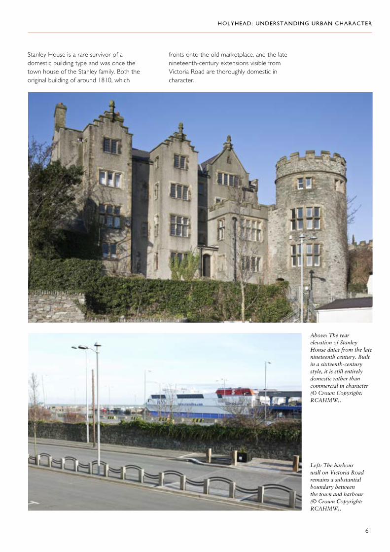
Stanley House is a rare survivor of a domestic building type and was once the town house of the Stanley family. Both the original building of around 1810, which
fronts onto the old marketplace, and the late nineteenth-century extensions visible from Victoria Road are thoroughly domestic in character.
Above: The rear elevation of Stanley House dates from the late nineteenth century. Built in a sixteenth-century style, it is still entirely domestic rather than commercial in character (© Crown Copyright: RCAHMW).
Left: The harbour wall on Victoria Road remains a substantial boundary between the town and harbour (© Crown Copyright: RCAHMW).

HOLYHEAD: UNDERSTANDING URBAN CHARACTER
62
The houses at 1 to 4 Land’s End on Victoria Road retain some original nineteenth-century features, including sash windows and traditional render finishes (© Crown Copyright: RCAHMW).
Right: The backs of properties overlooking Victoria Road detract from the historic character of the town (© Crown copyright (2019) Cadw, Welsh Government).
On Victoria Road, the boundary wall to the dockside is a distinctive feature, but the townscape is dominated either by the shabby backs of properties on Market Street (some of which retain good surviving detail), or by out of scale twentieth-century extensions. Renovation work in the vicinity of Stanley House has begun to redress
the damage done by previous neglect and acknowledges the exposure that increasing traffic on Victoria Road has given to these backs. Surviving nineteenth-century buildings on Victoria Road include terraced rows where some traditional renders and roughcast finishes survive, as well as other original detail including sash windows.

HOLYHEAD: UNDERSTANDING URBAN CHARACTER
63
2. Central Area: Residential Development
Historical Background
There is a sharp distinction between the main axis of development through the town and the area immediately to its west, which was not systematically developed until the second half of the nineteenth century. The tithe map shows an irregular pattern of plots bounded
by the lines of Thomas Street, Cambria Street and Summer Hill, and Williams Street. They contain a haphazard pattern of development in which Thomas Street was already established as a coherent axis for building, with the first terraces on its south side in place in 1840. Plot boundaries later became roads or paths, fossilizing an inherited pattern of land ownership to some extent, though now only fragments of this pattern have survived redevelopment. For example, Williams Street, Tower Gardens and the footpath from the Hill Street car park are amongst the survivors.
The irregular lines of, Cambria Street (top) and Summer Hill (bottom) reflect the haphazard plot boundaries shown on the 1840s tithe map (© Crown Copyright: RCAHMW).

HOLYHEAD: UNDERSTANDING URBAN CHARACTER
64
The Character of Building
Residential development is in rows of terraced houses, many of which open directly off the pavements, and dates mostly from between 1850
Above: The original roughcast render and small-paned sash windows that survive on this house in Williams Street have been used as the model for some sensitive renovation work (© Crown Copyright: RCAHMW).
Right: The Cambria Inn combines smooth render architraves and quoins with a roughcast finish (© Crown Copyright: RCAHMW).
Far right: The Caernarfon Castle public house retains its original smooth render finish with simple raised architraves (© Crown Copyright: RCAHMW).
Right: The British Stores (49 Thomas Street) retains original shopfront detail, including doors and windows (© Crown Copyright: RCAHMW).
and 1880. The topography of the area and the underlying structure of landholding, where roads follow boundaries, lend a distinctive character to these streets whose stepped and curving building lines punctuated by regular chimney stacks have strong picturesque qualities. Surviving traditional detail is now rare; however, a house on Williams Street, which retains traditional roughcast and small-paned sash windows, is an important survival that has already formed the model for some sensitive renovation work. Elsewhere, some of the decorative render dressings have survived the introduction of spar-dash and still lend some distinction to the terrace rows. The Cambria Inn and The Caernarfon Castle public house both retain traditional finishes. Old roughcast is combined with smooth rendered architraves and quoins in The Cambria Inn and The Caernarfon Castle has smooth render with simple raised architraves. 49 Thomas Street is a rare survivor of a traditional shop retaining not only the original shopfront, but also doors and windows.

HOLYHEAD: UNDERSTANDING URBAN CHARACTER
65
3. North of the Town Centre
Historical Background
There is no strong edge to the town centre to the north, but, beyond St Cybi’s Street, the area takes on a different character, dominated by densely built residential streets and the somewhat separate enclave of Marine Square. Early representations of the town suggest that the settlement had long continued close to the shoreline to the north-east of the town centre. Nothing, however, is left of any settlement pattern predating the construction of Marine Square, which was the product of an attempt to establish a resort at Holyhead in the 1770s. West of this, the tithe map records a pattern of small fields and plots to the north of Newry Street that provided access to several smallholdings but did not continue through to the north shore. Nor was there any access to the north shore via Marine Square — the through-road here (Prince of Wales Road) is of relatively recent date. Most of the residential development dates from the second half of the nineteenth century and survives well around Newry Street and Cybi Place, but redevelopment to the north of Water Street in the mid-twentieth century has taken its toll on a historic street pattern that strongly reflected earlier field boundaries.
Marine Square is a separate enclave and is all that remains of an attempt to establish Holyhead as a resort in the 1770s (© Crown Copyright: RCAHMW).
Houses on Newry Street (top) and North West Street (above) reflect the character of this area before Prince of Wales Road was constructed to link Marine Square with the north shore (© Crown Copyright: RCAHMW).

HOLYHEAD: UNDERSTANDING URBAN CHARACTER
66
The Character of Building
The area is dominated by tightly built terraces with houses opening directly off the street. Despite the dominance of spar-dash render, there are occasional survivals of traditional finishes (roughcast and scribed render) and a lively variety of smooth rendered dressings has been retained. Larger houses at the top of Newry Street introduce a different vocabulary with their brick dressings and ornate decoration. Although only a fragment of the original ensemble of Marine Square has survived, the buildings here have a stature that distinguishes them from the neighbouring residential streets.
Houses on Newry Street range from terraces opening onto the pavement, some of which still retain their original roughcast finish and rendered architraves (top), to larger brick-built houses with ornate dressings (right) (© Crown Copyright: RCAHMW).
The buildings on Marine Square have a stature which distinguishes them from the residential streets (© Crown Copyright: RCAHMW).

HOLYHEAD: UNDERSTANDING URBAN CHARACTER
67
4. West and South-west Holyhead
Historical Background
Away from the centre of the town, the early pattern of land use was an intensely fragmented pattern of very small fields, some of which were strips and others simply irregular parcels. This pattern provided the framework for growth of the town after about 1850, which was largely piecemeal as different plots of land became available for development. This explains something of the irregular street pattern, for example, around Upper Baptist Street and Moreton Road, but the pattern did not survive the larger scale of twentieth-century redevelopment everywhere. Running across the area were lanes serving local farms and settlements, which later helped to structure and connect settlements. These include Mill Bank, Garregllwyd Road and South Stack Road. The legacy of this early history is a distinctive pattern of discontinuous streets and occasional strong boundaries marking separate ownerships or units of development. One of the most
Top: Moreton Road — one of the streets that were developed piecemeal as plots of land became available (© Crown Copyright: RCAHMW).
Above: Houses on Mill Bank Terrace (© Crown Copyright: RCAHMW).
Left: A 1920s aerial view of Bon Sauveur Convent which shows it at the core of the Ucheldre estate (© Crown Copyright: RCAHMW: Aerofilms Collection).

HOLYHEAD: UNDERSTANDING URBAN CHARACTER
68
notable of these is at Ucheldre, which was the nucleus of a small estate, the core of which became the Bon Sauveur Convent in 1907. The early pattern of land use was highly unusual and distinctive, and the way in which development in the nineteenth century fitted into the inherited framework of fields and plots lends this part of outer Holyhead a strong character.
The spur to expansion was probably provided by the major infrastructure projects that were underway in the 1850s, including the railway and the great breakwater. The former terminus of the railway, close to the Five Sisters public houses at the foot of Holborn Road, provided the focus for a small commercial nucleus and is also commemorated in the name of Station Street.
The Character of Building
The area is strongly residential and mostly takes the form of terraced housing. There is a considerable mix of status, ranging from tightly built streets of small houses to terraces of larger houses and more substantial semi-detached houses, and some detached villas. Much of the variety comes from the distinctive pattern of development as different parcels of land were built on at different times. The often disjointed pattern of streets and paths, and the presence of
strong boundary features are as important as the detail of the buildings themselves in giving this area its character. Individual developments were often also denoted by boundary walls which have sometimes outlived the buildings themselves, for example, at the site of the National School on Rhos y Gaer Avenue.
Station Street — close to the former terminus of the railway (© Crown Copyright: RCAHMW).
The boundary walls and lane alongside the old National School remain strong features (© Crown Copyright: RCAHMW).
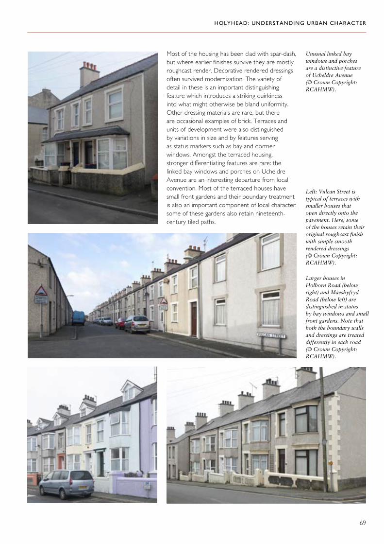
HOLYHEAD: UNDERSTANDING URBAN CHARACTER
69
Most of the housing has been clad with spar-dash, but where earlier finishes survive they are mostly roughcast render. Decorative rendered dressings often survived modernization. The variety of detail in these is an important distinguishing feature which introduces a striking quirkiness into what might otherwise be bland uniformity. Other dressing materials are rare, but there are occasional examples of brick. Terraces and units of development were also distinguished by variations in size and by features serving as status markers such as bay and dormer windows. Amongst the terraced housing, stronger differentiating features are rare: the linked bay windows and porches on Ucheldre Avenue are an interesting departure from local convention. Most of the terraced houses have small front gardens and their boundary treatment is also an important component of local character: some of these gardens also retain nineteenth-century tiled paths.
Unusual linked bay windows and porches are a distinctive feature of Ucheldre Avenue (© Crown Copyright: RCAHMW).
Left: Vulcan Street is typical of terraces with smaller houses that open directly onto the pavement. Here, some of the houses retain their original roughcast finish with simple smooth rendered dressings (© Crown Copyright: RCAHMW).
Larger houses in Holborn Road (below right) and Maeshyfryd Road (below left) are distinguished in status by bay windows and small front gardens. Note that both the boundary walls and dressings are treated differently in each road (© Crown Copyright: RCAHMW).
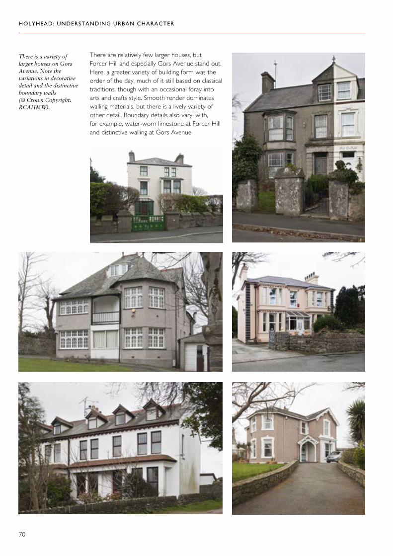
HOLYHEAD: UNDERSTANDING URBAN CHARACTER
70
There are relatively few larger houses, but Forcer Hill and especially Gors Avenue stand out. Here, a greater variety of building form was the order of the day, much of it still based on classical traditions, though with an occasional foray into arts and crafts style. Smooth render dominates walling materials, but there is a lively variety of other detail. Boundary details also vary, with, for example, water-worn limestone at Forcer Hill and distinctive walling at Gors Avenue.
There is a variety of larger houses on Gors Avenue. Note the variations in decorative detail and the distinctive boundary walls (© Crown Copyright: RCAHMW).

HOLYHEAD: UNDERSTANDING URBAN CHARACTER
71
A small commercial area at the foot of Holborn Road reflects the one-time importance of this area as the junction of London Road with the old post road, adjacent to the first railway station and so a real gateway to the town. The Five Sisters public houses and the parade
of shops to the south of Holborn Road still retain some traditional finishes (roughcast render) and distinctive detailing, such as the moulded cornices on The Dublin Packet and the high parapet to New Chester House with its raised lettering.
The Five Sisters at the bottom of Holborn Road. The Dublin Packet is the red building which now occupies two of the original five public houses located here (© Crown Copyright: RCAHMW).
New Chester House retains its raised lettering on the original roughcast render (© Crown Copyright: RCAHMW).

HOLYHEAD: UNDERSTANDING URBAN CHARACTER
72
Top: Penrhos almhouses (Stanley Cottages) on the junction between Tyn Pwll Road and Cyttir Road, both of which may have been main thoroughfares in the nineteenth century (© Crown Copyright: RCAHMW).
Above: Linear settlement along Kingsland Road (© Crown Copyright: RCAHMW).
Right: The Treseifion estate was developed in the 1950s on small fields north of Porthdafach Road (© Crown Copyright: RCAHMW).
5. South Holyhead and Kingsland
Historical Background
This area was largely rural until the end of the nineteenth century, albeit with sporadic urban fringe development, including the cemetery and the gas works. The two main axes of development that had emerged by the end of the nineteenth century were the old road to Porthdafarch and the old post road (now Kingsland Road) to Four Mile Bridge, as well as its possible predecessor, Tyn Pwll Road, where the Penrhos almshouses were built in 1866. Settlement in this area was essentially linear until the mid-twentieth century. In the 1950s, the small fields to the north of Porthdafarch Road were taken for the development of the Treseifion estate. From the 1960s, settlement continued to expand to the south, still largely structured around the principal routes. The Kingsland Road area was a general improvement area in the 1970s and recalls contrasting approaches to renewal, with relatively conservative intervention at Penrhos View and more radical alterations on Tyn Pwll Road, where entire facades were remodelled.

HOLYHEAD: UNDERSTANDING URBAN CHARACTER
73
The Character of Building
Kingsland Road (Old Post Road)The housing on Kingsland Road is dominated by long terraces of small houses, some of which open directly from the pavement, though many have small front gardens. There are occasional examples where traditional render has been retained, but little detail; these terraces were very simply finished. The terraces on Porthdafarch Road were slightly larger and embellished with decorative rendered dressings. Small houses on Arthur Street have unusual hood-mould detail. Larger Edwardian and interwar semi-detached houses occupy the top of the hill, where the windmill is an important reminder of the agricultural origins of this area. The Treseifion estate embodies many of the picturesque principals of layout which were characteristic of council house building programmes of the 1950s.
Left and above: Elsewhere on Kingsland Road, the terraces display variety in size and detailing; some houses retain their original render (© Crown Copyright: RCAHMW).

HOLYHEAD: UNDERSTANDING URBAN CHARACTER
74
Right: Houses on Arthur Street which retain their unusual hood mould detail (© Crown Copyright: RCAHMW).
Below left and right: 1950s housing in Tan yr Efail (© Crown Copyright: RCAHMW).
The houses on Greenfield Terrace on Kingsland Road are distinguished by bay windows on the ground floor and small front gardens (© Crown Copyright: RCAHMW).
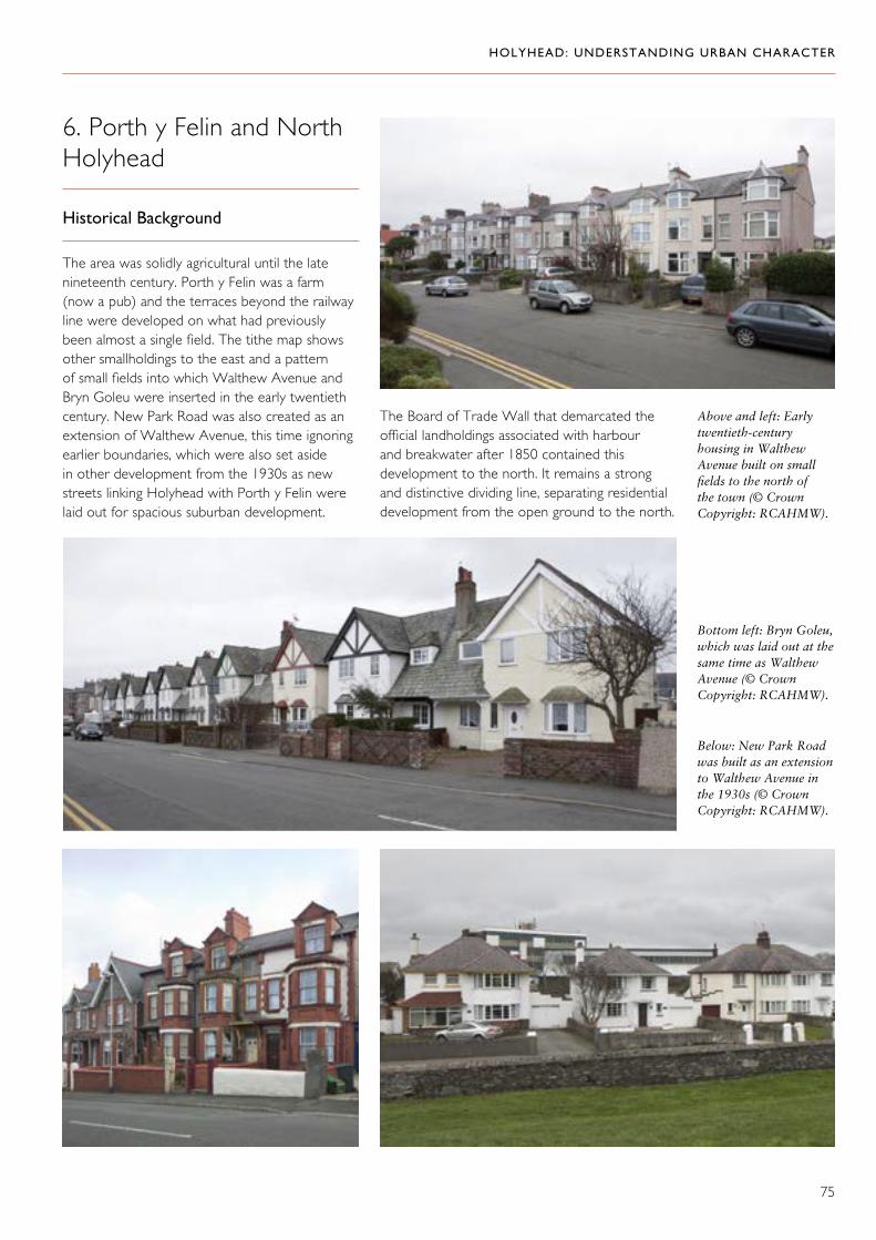
HOLYHEAD: UNDERSTANDING URBAN CHARACTER
75
6. Porth y Felin and North Holyhead
Historical Background
The area was solidly agricultural until the late nineteenth century. Porth y Felin was a farm (now a pub) and the terraces beyond the railway line were developed on what had previously been almost a single field. The tithe map shows other smallholdings to the east and a pattern of small fields into which Walthew Avenue and Bryn Goleu were inserted in the early twentieth century. New Park Road was also created as an extension of Walthew Avenue, this time ignoring earlier boundaries, which were also set aside in other development from the 1930s as new streets linking Holyhead with Porth y Felin were laid out for spacious suburban development.
Above and left: Early twentieth-century housing in Walthew Avenue built on small fields to the north of the town (© Crown Copyright: RCAHMW).
Bottom left: Bryn Goleu, which was laid out at the same time as Walthew Avenue (© Crown Copyright: RCAHMW).
Below: New Park Road was built as an extension to Walthew Avenue in the 1930s (© Crown Copyright: RCAHMW).
The Board of Trade Wall that demarcated the official landholdings associated with harbour and breakwater after 1850 contained this development to the north. It remains a strong and distinctive dividing line, separating residential development from the open ground to the north.

HOLYHEAD: UNDERSTANDING URBAN CHARACTER
76
The Character of Building
Porth y Felin appears to have developed as a distinctive maritime quarter and, although some of the houses here share characteristics with the terraced housing elsewhere in Holyhead, the terraces are typically shorter than elsewhere in the town. One row of white rendered houses with heavy cornices, hood moulds and square bay windows stands out for its maritime character which is unusual in the domestic architecture of the town. Walthew Avenue and Bryn Goleu contain a range of larger house types, including
some striking terraces. These introduce a variety of styles, including some arts and crafts work, and a matching variety of materials including brick, terracotta and imported slate. Development at New Park Road, Seaborne Road, Min y Mor Road and Tan y Bryn Road is mostly spaciously laid out semi-detached houses. Although many of the houses are conventional speculative buildings, there are some examples of individual commissions employing more imaginative styles. Most of the housing in this area sits in sizeable plots of land and boundary walls contribute a particular distinctiveness to the streets.
Right and below: Porth y Felin has a distinctly maritime character with its white rendered terraces, often much shorter than elsewhere in the town (© Crown Copyright: RCAHMW).
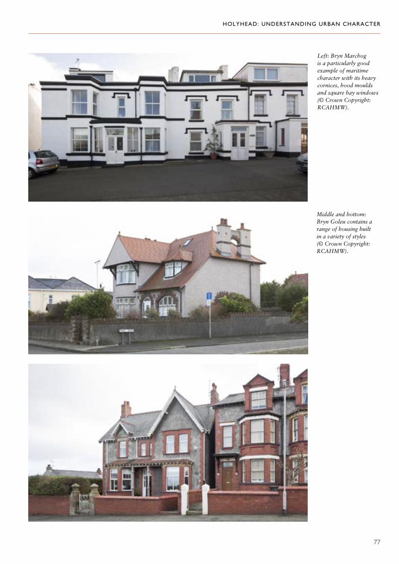
HOLYHEAD: UNDERSTANDING URBAN CHARACTER
77
Left: Bryn Marchog is a particularly good example of maritime character with its heavy cornices, hood moulds and square bay windows (© Crown Copyright: RCAHMW).
Middle and bottom: Bryn Goleu contains a range of housing built in a variety of styles (© Crown Copyright: RCAHMW).

HOLYHEAD: UNDERSTANDING URBAN CHARACTER
78
Walthew Avenue contains a range of larger houses built in a variety of styles and materials (© Crown Copyright: RCAHMW).

HOLYHEAD: UNDERSTANDING URBAN CHARACTER
79
Below: Spaciously laid out housing characterizes New Park Road (© Crown Copyright: RCAHMW).
Lef and bottom left: Houses on Seaborne Road with a strong arts and crafts character, laid out in spacious plots with boundary walls that contribute to the distinctiveness of the area (© Crown Copyright: RCAHMW).

HOLYHEAD: UNDERSTANDING URBAN CHARACTER
80
7. Salt Island and the Inner Harbour
Historical Background
Although Holyhead had an important role as a port from at least the late sixteenth century, its harbour facilities were not commensurate with its status until the early nineteenth century. Under a scheme to improve the harbour, Salt Island (hitherto the site of a salt works and later of pleasure gardens) was established as the focus for the port, and a new pier (Admiralty Pier) was built eastwards from it to provide a sheltered anchorage. The pier was initiated in 1809 and completed with the construction of the lighthouse in 1821. On the quay, the harbour office and customs house were built in 1823. The opening of Admiralty Arch in 1824 marked the completion of the first phase of work. As part of this first phase, a second pier (south pier) was built on the opposite side of the inlet in 1821, together with a graving dock and pumping engine house (1823–26) enclosed by a curtain wall. Both sides of the harbour were linked by a continuous road around the inlet
The harbour was progressively enlarged, firstly by the extension of the pier on Salt Island for the City of Dublin Steam Packet Company and, secondly, by a more ambitious scheme promoted by the LNWR implemented between 1873 and 1880. This involved excavating the tidal inlet and reclaiming its margins to create a greatly enlarged harbour, which was directly linked to a new station, together with a second graving dock and pumping engine house on the public quay to the east side of the harbour.
The modern ferry terminal on the south side of the inner harbour (© Crown Copyright: RCAHMW).
Distant view of Salt Island from the west, with Porth y Felin prominent in the foreground (© Crown Copyright: RCAHMW).

HOLYHEAD: UNDERSTANDING URBAN CHARACTER
81
A marine yard was also established on the site of an older customs house that occupied a promontory at the foot of the old harbour. The marine yard was begun by the Chester and Holyhead Railway and continued by the LNWR after it took over the former in 1856. It was developed as a service yard to support the railway companies’ maritime activities in competition with those of the City of Dublin Steam Packet Company which had established Salt Island as its headquarters. The first phase of this development was between 1852 and 1859, but it was extended in 1874 to form an extensive complex, including foundry, sawmill and erecting shop. Meanwhile, the promontory itself, on which the marine yard stood, was absorbed into reclamation work, associated with the construction of the inner harbour, for the accommodation of railway lines and goods sheds.
From the later twentieth-century, adaptation for the needs of major industrial developments (Anglesey Aluminium and Wylfa) and of major commercial imperatives to facilitate the operation of port facilities by privatized companies has led to significant physical changes. These include the creation of a car ferry berth in 1965, the establishment of a container port in 1970 and facilities for jet-propelled catamarans in 1995–98. Associated with these
developments has been extensive reclamation at Salt Island, the demolition of The Station Hotel in 1979, the construction of a new jetty for the aluminium works in 1970 and a new ferry terminal in 1995–96.
Workshops at marine yard (© Crown Copyright: RCAHMW).
Marine yard, built in two phases between about 1852 and 1880 on the promontory at the foot of the old harbour (© Crown Copyright: RCAHMW).
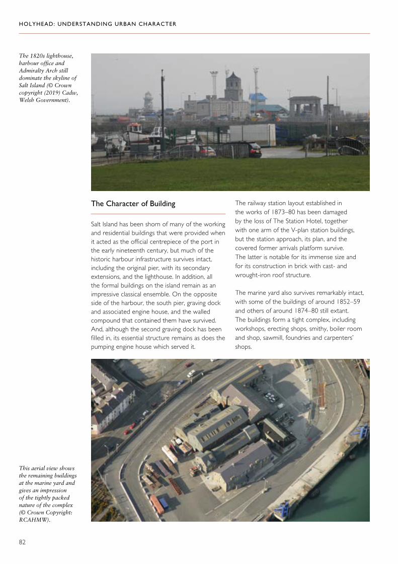
HOLYHEAD: UNDERSTANDING URBAN CHARACTER
82
The Character of Building
Salt Island has been shorn of many of the working and residential buildings that were provided when it acted as the official centrepiece of the port in the early nineteenth century, but much of the historic harbour infrastructure survives intact, including the original pier, with its secondary extensions, and the lighthouse. In addition, all the formal buildings on the island remain as an impressive classical ensemble. On the opposite side of the harbour, the south pier, graving dock and associated engine house, and the walled compound that contained them have survived. And, although the second graving dock has been filled in, its essential structure remains as does the pumping engine house which served it.
The railway station layout established in the works of 1873–80 has been damaged by the loss of The Station Hotel, together with one arm of the V-plan station buildings, but the station approach, its plan, and the covered former arrivals platform survive. The latter is notable for its immense size and for its construction in brick with cast- and wrought-iron roof structure.
The marine yard also survives remarkably intact, with some of the buildings of around 1852–59 and others of around 1874–80 still extant. The buildings form a tight complex, including workshops, erecting shops, smithy, boiler room and shop, sawmill, foundries and carpenters’ shops.
The 1820s lighthouse, harbour office and Admiralty Arch still dominate the skyline of Salt Island (© Crown copyright (2019) Cadw, Welsh Government).
This aerial view shows the remaining buildings at the marine yard and gives an impression of the tightly packed nature of the complex (© Crown Copyright: RCAHMW).

HOLYHEAD: UNDERSTANDING URBAN CHARACTER
83
8. The Outer Harbour, Soldier’s Point and the North Shore
Historical Background
The tithe map of about 1840 records the north shore area as merely a pattern of small fields and plots of land, but, with the commencement of the great breakwater project in 1847, all that changed. Initial plans for the harbour of refuge included the great breakwater and another eastern pier to run north from Salt Island. The infrastructure to support this was put in place with a railway running from the quarries on Holyhead Mountain parallel to the shore as far as the rocky shoreline to the north of Marine Square. The eastern pier was never built, but the line of the railway remained and had become a road by the 1880s. The railway between
The north shore and great breakwater are in the foreground with the Salt Island complex and inner harbour beyond (© Crown Copyright: RCAHMW).
The great breakwater was a massive undertaking that took 28 years to complete. Extended twice, it eventually reached 2,418 metres (7,860 feet) in length (© Crown Copyright: RCAHMW).
the quarries and the head of the breakwater survived for rather longer. There were various industrial infrastructure projects associated with the construction of the breakwater, including a brickworks near the quarries and an array of workshops closer to the foot of the breakwater. Here too, the construction of the grand Soldier’s Point House (built 1849 for Charles Rigby, the contractor for the breakwater) and Government House or Porth y Felin House (built 1849 for G. F. Dobson, the resident engineer) are testimony to the ambition of the project.

HOLYHEAD: UNDERSTANDING URBAN CHARACTER
84
In addition to these major building and engineering projects, the scheme had a radical impact on the organization of land on the northern foreshore, demarcating an area which lay outside the jurisdiction of the town and separated from it by the Board of Trade Wall (1849–50). North of this wall, the only significant building projects which took place were all directly associated with the operation of the port and harbour, including the coastguard station, lifeboat house (1857), the Trinity House
depot and workshops built around 1870 as the maintenance depot for the coastal lights, the Stanley sailors’ home and boatyard. The literal isolation of this area was disrupted first by the continuation of Newry Street through to the shore road and, secondly, by the establishment of Prince of Wales Road as a through route from Victoria Road via Marine Square. The area still retains a strong sense of separation from the rest of the town, which is still largely contained behind the Board of Trade Wall.
The lifeboat house, built in 1857 at Newry Beach, is reminiscent of the 1855 market hall also built in a Jacobean style. It is believed to be the oldest purpose-built lifeboat house in Wales (© Crown copyright (2019) Cadw, Welsh Government).
The Stanley sailors’ home and reading room, which was opened in 1871 and provided accommodation for shipwrecked sailors (© Crown Copyright: RCAHMW: Medywn Parry).

HOLYHEAD: UNDERSTANDING URBAN CHARACTER
85
Unlike the inner harbour, which depended on good landward communication for its successful operation and was intimately linked with first the road and then the railway, the outer harbour developed as a harbour of refuge rather than as a port and needed no such links other than those necessary for its construction. As a result, it is rather isolated from the town.
The Character of Building
The great breakwater is remarkable by virtue of its immense size and for the techniques which were pioneered during its construction. A rubble mound supported a wall faced with limestone blocks, which formed a quay and walkway protected on the seaward side by a high parapet wall with integral shelters. Moorings were defined by paired steps descending to water level, each with its own mooring post. Various transport features are associated with the breakwater as well as other structures connected with its construction all of which constitute an important group of industrial archaeological interest. The line of the railway built for the construction of the breakwater and the proposed eastern breakwater is perpetuated in the route to Holyhead Breakwater Country Park and the line of Beach Road. The abutments for the crossing
to Salt Island survive, as does the rubble bank on the island which was the start of the unfinished breakwater there.
Many of the quasi-official buildings associated with the harbour have a distinctive maritime style and are clearly demarcated as separate enclaves. The large private commissions associated with the construction of the breakwater are architecturally flamboyant. Both Porth y Felin House and Soldier’s Point are set in extensive grounds, the latter with striking castellated boundary walls.
Porth y Felin, also known as Government House, was built in 1849 for the resident engineer, G. F. Dobson (© Crown Copyright: RCAHMW).
This postcard illustrates the flamboyant Soldier’s Point house built in 1849 for Charles Rigby, the contractor for the great breakwater (Peter Davis Collection).

HOLYHEAD: UNDERSTANDING URBAN CHARACTER
86
9. London Road
Historical Background
The area to the east of the town centre, on the opposite side of the tidal creek and stream, was occupied only by a series of small farms and cottages in a patchwork of little fields until well into the nineteenth century. The farm of Cae Ty Fychan survived between London Road and the railway until after 1927, and a barn associated with this farm is still there. London
Road was the final stretch of Telford’s London–Holyhead Road of 1815–26. Cyttir Road probably represents an earlier road which is shown on the tithe map. The tithe map also shows how London Road cuts across Cyttir Road and earlier field boundaries.
Although there were some buildings at Black Bridge Road by 1840, which was an important small industrial nucleus (including the Black Bridge Foundry), development along London Road did not really get under way until later in the nineteenth century, when the arrival of the railway and its subsequent expansion for the new harbour necessitated a realignment of the original route to cross the tracks. Even then, building was desultory and the route itself was really only systematically developed in the interwar period. To the north of London Road, at its western end, quarrying may have been the precursor to the block of housing development in a series of short dead-end streets.
The Character of Building
The sole surviving terrace of mid-nineteenth century houses at the head of London Road adjacent to the railway bridge retains its historical render finish, but most other detail has been lost. The smaller terraced housing in the block of streets close to Black Bridge (‘Little Newborough’) displays a mix of flat
Wian Street (top) and Cecil Street (bottom) are two of the short dead-end streets to the north of London Road. They may have been built on the site of earlier quarrying (© Crown Copyright: RCAHMW).

HOLYHEAD: UNDERSTANDING URBAN CHARACTER
87
frontages and bay windows, but they have been stripped of virtually all their detail. Twentieth-century development includes speculatively built semi-detached houses and some local authority housing, the latter mostly in estates developed on land away from the road. Most of the housing has
been very heavily altered and little original detail survives. The speculatively built houses, however, retain strong overall form and there are some good boundary walls. To the rear of the houses on the west side of London Road, the boundary wall of the railway is also a strong feature.
The buildings in this terrace are the only surviving nineteenth-century houses on London Road. They retain their original render finish (© Crown Copyright: RCAHMW).
Middle and left: The smaller terraced houses in the short streets to the north of London Road display a mix of flat frontages and bay windows (© Crown Copyright: RCAHMW).
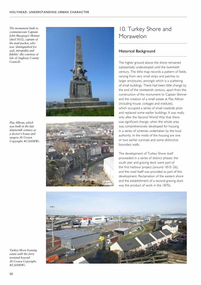
HOLYHEAD: UNDERSTANDING URBAN CHARACTER
88
The monument built to commemorate Captain John Macgregor Skinner (died 1832), captain of the mail packet, who was ‘distinguished for zeal, intrepidity and fidelity’ (By courtesy of Isle of Anglesey County Council).
Turkey Shore housing estate with the ferry terminal beyond (© Crown Copyright: RCAHMW).
Plas Alltran, which was built in the late nineteenth century as a doctor’s house and surgery (© Crown Copyright: RCAHMW).
10. Turkey Shore and Morawelon
Historical Background
The higher ground above the shore remained substantially undeveloped until the twentieth century. The tithe map records a pattern of fields, varying from very small strips and patches to larger enclosures, amongst which is a scattering of small buildings. There had been little change by the end of the nineteenth century, apart from the construction of the monument to Captain Skinner and the creation of a small estate at Plas Alltran (including house, cottages and institute), which occupied a series of small roadside plots and replaced some earlier buildings. It was really only after the Second World War that there was significant change, when the whole area was comprehensively developed for housing in a series of schemes undertaken by the local authority. In the midst of the housing are one or two earlier survivals and some distinctive boundary walls.
The development of Turkey Shore itself proceeded in a series of distinct phases: the south pier and graving dock were part of the first harbour project (around 1810–26), and the road itself was provided as part of this development. Reclamation of the eastern shore and the establishment of a second graving dock was the product of work in the 1870s.

HOLYHEAD: UNDERSTANDING URBAN CHARACTER
89
The Character of Building
The buildings associated with Plas Alltran on Llanfawr Road form a distinctive group in a strongly picturesque style. Elsewhere along this road there are some late nineteenth-century terraced houses and interwar development. However, most development in this area is
1950s and 1960s local authority housing in large self-contained estates with shops and a school, and some speculative building intermixed at the top of the hill.
The boundary wall that divides the port from the town as a near-continuous edge to Turkey Shore Road is an important feature of this area.
The wall that divides Turkey Shore Road from the port remains a prominent boundary (© Crown Copyright: RCAHMW).
Plas Alltran with its distinctive crow-stepped gables forms a focal point on the corner of Turkey Shore Road (© Crown Copyright: RCAHMW).
Left and far left: Picturesque houses adjacent to Plas Alltran (© Crown Copyright: RCAHMW).

HOLYHEAD: UNDERSTANDING URBAN CHARACTER
90
Statement of Significance
The fortunes of Holyhead as a town were made by its role as a national port, consolidated in a series of spectacular installations commensurate with its status as an official port during the nineteenth century. It is the harbour installations that above all else give Holyhead distinction. The great breakwater is the longest breakwater in Britain and a fantastic engineering achievement which is powerful testimony to the importance of maritime trade. The inner harbour also constitutes a proud group of structures of considerable engineering and architectural interest. Associated with both the inner harbour and the harbour of refuge is a whole landscape of engineering and maritime history, comprising the installations and transport systems that supported the construction and operation of both harbours over several generations. Holyhead was on the edge of the land, but it was also a hub in a network of both landward and seaward connections.
Holyhead has a history which reaches back long before it achieved renown as a port. The remains of the Roman fort and the medieval churches are evidence of its importance in earlier times, but it could hardly claim the title of town until the nineteenth century. Investment in the harbours was the spur for rapid urban growth. Holyhead’s form and layout betray the haste with which it grew: an extraordinary fieldscape is never far beneath the streets. The speed of development imparted uniformity in the pattern of building, but the complexity of the port-town society contributed variety to the types of building. Although generations of renewal have eroded much of the detail, much still remains and the seeds of a distinctiveness that once marked one street or one row from another are still in place.
The operation of Holyhead as a major port required some zoning of land use and the harbours have always been slightly detached from the town itself. Perhaps because of the inherited pattern of land use on which the town grew up, demarcation was also inherent within the urban structure, as old boundaries survived between streets or around buildings and new boundaries were created. The walls that separate one area
from another, or houses from streets, are as important an aspect of local traditions as the buildings themselves.
In the nineteenth century, Holyhead was celebrated for its confident modernity. There were some attempts to deliberately root it in the past, which have bequeathed several notable buildings that point to the antiquity of the town, sitting alongside its genuine antiquities. But what was modern then is itself historic now, and the very features that were the foundation of Holyhead’s identity as a modern town in the nineteenth century are the mainstay of its heritage today. Holyhead is a working port, but it is also a historic town: the historic infrastructure of both port and town is an asset which deserves greater recognition.

HOLYHEAD: UNDERSTANDING URBAN CHARACTER
91
Selected Sources
Anon., The Traveller’s Companion from Holyhead to London (London, 1793).
Christopher Arnold and Jeffrey L. Davies, Roman and Early Medieval Wales (Stroud, 2000).
Barry C. Burnham and Jeffrey L. Davies, ed. Roman Frontiers in Wales and the Marches (Aberystwyth, 2010).
George Borrow, Wild Wales: Its People, Language and Scenery (London, 1862).
William Cathrall, The History of North Wales, Comprising a Topographical Description of the Several Counties, Vol. II (Manchester, 1828).
Richard Haslam, Julian Orbach and Adam Voelcker, The Buildings of Wales, Gwynedd, (New Haven and London, 2009).
Isle of Anglesey County Council, Holyhead Central: Conservation Area Character Appraisal (Llangefni, 2005).
Isle of Anglesey County Council, Holyhead Beach Area Conservation Area Character Appraisal (Llangefni, 2005).
Thomas Jackson, The Visitor’s Hand-book for Holyhead (London, 1853).
Samuel Lewis, A Topographical Dictionary of Wales (London, 1833).
D. Lloyd Hughes and Dorothy M. Williams, Holyhead: the Story of a Port (Denbigh, 1967).
Angela Hennessey, ‘Holyhead 1845–1865: The Town, the People and the People’s Health’, Transactions of the Anglesey Antiquarian Society and Field Club (2000), pp. 61–75.
The National Gazetteer of Great Britain and Ireland (London,1868).
E. Parry, Parry’s Railway Companion from Chester to Holyhead (London, 1848).
Thomas Pennant, A Tour in Wales, Vol. II (first published London, 1783; this edition, Wrexham, 1991).
Slater’s Royal, National and Commercial Directory of North and South Wales (Manchester, 1858–59).
Slater’s Royal, National and Commercial Directory North and South Wales (Manchester, 1868).
Slater’s Royal, National and Commercial Directory of North and South Wales (1880).
Samuel Smiles, Lives of the Great Engineers, with an Account of their Principal Works, Vol. II (London, 1861).
Stena Line Ports, Holyhead Harbour Conservation Plan, 2003.
The Travellers Companion from London to Holyhead (London, 1793).
Lucy Williams, ‘Factors in the Culture of Pre-Railway Holyhead’, Transactions of the Anglesey Antiquarian Society and Field Club (1940), pp. 93–99.
Lucy Williams, ‘Remains of Fifteenth Century Domestic Building at Holyhead’, Transactions of the Honourable Society of Cymmrodorion (1946–47), pp. 271–72.
Lucy Williams, ‘The Development of Holyhead’, Transactions of the Anglesey Antiquarian Society and Field Club (1950), pp. 51–70.
John Marius Wilson, Imperial Gazetteer of England and Wales, embracing recent changes in counties, dioceses, parishes, and boroughs: general statistics: postal arrangements: railway systems, &c.; and forming a complete description of the country (Edinburgh, London, Glasgow, Dublin 1870–72). GB Historical GIS / University of Portsmouth, History of Holyhead in The Isle of Anglesey | Map and description, A Vision of Britain through Time. URL: http://www.visionofbritain.org.uk/place/507 Date accessed: 01 February 2018 http://www.visionofbritain.org.uk/descriptions/760090
HOLYHEAD: UNDERSTANDING URBAN CHARACTER
92
Endnotes
1. Christopher Arnold and Jeffrey L. Davies, Roman and Early Medieval Wales (Stroud, 2000); Barry C. Burnham and Jeffrey L Davies (eds), Roman Frontiers in Wales and the Marches (Aberystwyth, 2010).
2. John Marius Wilson, Imperial Gazetteer of England and Wales, embracing recent changes in counties, dioceses, parishes, and boroughs: general statistics: postal arrangements: railway systems, &c.; and forming a complete description of the country (Edinburgh, London, Glasgow, Dublin, 1870–72). GB Historical GIS / University of Portsmouth, History of Holyhead in The Isle of Anglesey | Map and description, A Vision of Britain through Time. URL: http://www.visionofbritain.org.uk/place/507 Date accessed: 01 February 2018 http://www.visionofbritain.org.uk/descriptions/760090
3. Richard Haslam, Julian Orbach and Adam Voelcker, The Buildings of Wales, Gwynedd (New Haven and London, 2009).
4. D. Lloyd Hughes and Dorothy M. Williams, Holyhead: the Story of a Port (Denbigh, 1967).
5. Francis Place, watercolour of 1699 reproduced in Holyhead Central Conservation Area Appraisal (Llangefni, 2005). http://www.anglesey.gov.uk/Journals/2011/09/28/Holyhead-Central-Appraisal2.pdf
6. Lewis Morris’s sketch appears in Cambria’s Coasting Pilot, Holy Head Bay (map 3), 1737. It is also reproduced in Holyhead Central Conservation Area Appraisal (Llangefni, 2005). http://www.anglesey.gov.uk/Journals/2011/09/28/Holyhead-Central-Appraisal2.pdf
7. In 1784, according to Mr Walpole, ‘the village consists of a straggling confused heap of thatched houses built on rocks’ in Thomas Jackson, The Visitor’s Hand-book for Holyhead (London, 1853).
8. The Travellers Companion from London to Holyhead (London, 1793).
9. Thomas Pennant, A Tour In Wales, Vol. II (London, 1783).
10. D. Lloyd Hughes and Dorothy M. Williams, Holyhead: the Story of a Port (Denbigh, 1967); Lucy Williams, ‘The Development of Holyhead’, Transactions of the Anglesey Antiquarian Society and Field Club (1950), pp. 51–70.
11 Samuel Lewis, A Topographical Dictionary of Wales (London, 1833).
12. Pigot and Co.’s National Commercial Directory for 1828-9, Comprising a Directory of the Merchants, Bankers, Professional Gentleman [&c.] in the Counties of Cheshire, Cumberland [&c.], 1828.
13. Samuel Lewis, A Topographical Dictionary of Wales (London, 1833).
14. Jonathan Swift, Holyhead Journal, 25 September 1827 reproduced in Holyhead Central Conservation Area Appraisal (Llangefni, 2005). http://www.anglesey.gov.uk/Journals/2011/09/28/Holyhead-Central-Appraisal2.pdf
15. Samuel Lewis, A Topographical Dictionary of Wales (London,1833).
16. E. Parry, Parry’s Railway Companion from Chester to Holyhead (London, 1848).
17. Thomas Jackson, The Visitor’s Handbook for Holyhead (London, 1853).

HOLYHEAD: UNDERSTANDING URBAN CHARACTER
93
18. Ibid.
19. Peter E. Baughan, The Chester & Holyhead Railway Volume 1: The Main Line up to 1880 (Newton Abbot, 1972).
20. E. Parry, Parry’s Railway Companion from Chester to Holyhead (London, 1848).
21 Thomas Jackson, The Visitor’s Handbook for Holyhead (London, 1853).
22. Ibid.
23. The National Gazetteer of Great Britain and Ireland (London,1868).
24. Ibid.
25. Angela Hennessey, ‘Holyhead 1845–1865: The Town, the People and the People’s Health’, Transactions of the Anglesey Antiquarian Society and Field Club (2000), pp. 61–75.
26. John Marius Wilson, Imperial Gazetteer of England and Wales, embracing recent changes in counties, dioceses, parishes, and boroughs: general statistics: postal arrangements: railway systems, &c.; and forming a complete description of the country (Edinburgh, London, Glasgow, Dublin, 1870–72). GB Historical GIS / University of Portsmouth, History of Holyhead in The Isle of Anglesey | Map and description, A Vision of Britain through Time. URL: http://www.visionofbritain.org.uk/place/507 Date accessed: 01 February 2018
27. The National Gazetteer of Great Britain and Ireland (London,1868).
28. Lucy Williams, ‘Remains of Fifteenth Century Domestic Building at Holyhead’, Transactions of the Honourable Society of Cymmrodorion (1946–47), pp. 271–72.
29. George Borrow, Wild Wales: Its People, Language and Scenery (London, 1862).

HOLYHEAD: UNDERSTANDING URBAN CHARACTER
94
1 Tithe map of Holyhead, about 1840
Tithe map supplied by Llyfrgell Genedlaethol Cymru/National Library of Wales.

HOLYHEAD: UNDERSTANDING URBAN CHARACTER
95
2 First Edition Ordnance Survey Map 1899
© and database right ‘Crown Copyright and Landmark Information Group Ltd’ (All rights reserved 2019.).

HOLYHEAD: UNDERSTANDING URBAN CHARACTER
96
3 All Character Areas
This map is based upon the Ordnance Survey material with the permission of Ordnance Survey on behalf of The Controller of Her Majesty’s Stationery Office, © Crown copyright 2019. Unauthorised reproduction infringes Crown copyright and may lead to prosecution or civil proceedings. Welsh Government. Licence Number: 100021874

HOLYHEAD: UNDERSTANDING URBAN CHARACTER
97
4 All Character Areas with Historic Designations
This map is based upon the Ordnance Survey material with the permission of Ordnance Survey on behalf of The Controller of Her Majesty’s Stationery Office, © Crown copyright 2019. Unauthorised reproduction infringes Crown copyright and may lead to prosecution or civil proceedings. Welsh Government. Licence Number: 100021874
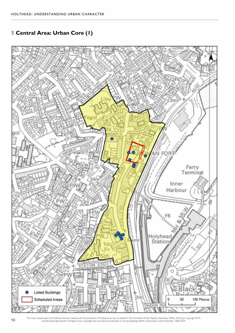
HOLYHEAD: UNDERSTANDING URBAN CHARACTER
98
5 Central Area: Urban Core (1)
This map is based upon the Ordnance Survey material with the permission of Ordnance Survey on behalf of The Controller of Her Majesty’s Stationery Office, © Crown copyright 2019. Unauthorised reproduction infringes Crown copyright and may lead to prosecution or civil proceedings. Welsh Government. Licence Number: 100021874

HOLYHEAD: UNDERSTANDING URBAN CHARACTER
99
6 Central Area: Residential Development (2)
This map is based upon the Ordnance Survey material with the permission of Ordnance Survey on behalf of The Controller of Her Majesty’s Stationery Office, © Crown copyright 2019. Unauthorised reproduction infringes Crown copyright and may lead to prosecution or civil proceedings. Welsh Government. Licence Number: 100021874

HOLYHEAD: UNDERSTANDING URBAN CHARACTER
100
7 North of the Town Centre (3)
This map is based upon the Ordnance Survey material with the permission of Ordnance Survey on behalf of The Controller of Her Majesty’s Stationery Office, © Crown copyright 2019. Unauthorised reproduction infringes Crown copyright and may lead to prosecution or civil proceedings. Welsh Government. Licence Number: 100021874

HOLYHEAD: UNDERSTANDING URBAN CHARACTER
101
8 West and South-West Holyhead (4)
This map is based upon the Ordnance Survey material with the permission of Ordnance Survey on behalf of The Controller of Her Majesty’s Stationery Office, © Crown copyright 2019. Unauthorised reproduction infringes Crown copyright and may lead to prosecution or civil proceedings. Welsh Government. Licence Number: 100021874

HOLYHEAD: UNDERSTANDING URBAN CHARACTER
102
9 South Holyhead and Kingsland (5)
This map is based upon the Ordnance Survey material with the permission of Ordnance Survey on behalf of The Controller of Her Majesty’s Stationery Office, © Crown copyright 2019. Unauthorised reproduction infringes Crown copyright and may lead to prosecution or civil proceedings. Welsh Government. Licence Number: 100021874

HOLYHEAD: UNDERSTANDING URBAN CHARACTER
103
10 Porth y Felin and North Holyhead (6)
This map is based upon the Ordnance Survey material with the permission of Ordnance Survey on behalf of The Controller of Her Majesty’s Stationery Office, © Crown copyright 2019. Unauthorised reproduction infringes Crown copyright and may lead to prosecution or civil proceedings. Welsh Government. Licence Number: 100021874

HOLYHEAD: UNDERSTANDING URBAN CHARACTER
104
11 Salt Island and the Inner Harbour (7)
This map is based upon the Ordnance Survey material with the permission of Ordnance Survey on behalf of The Controller of Her Majesty’s Stationery Office, © Crown copyright 2019. Unauthorised reproduction infringes Crown copyright and may lead to prosecution or civil proceedings. Welsh Government. Licence Number: 100021874

HOLYHEAD: UNDERSTANDING URBAN CHARACTER
105
12 The Outer Harbour, Soldier’s Point and the North Shore (8)
This map is based upon the Ordnance Survey material with the permission of Ordnance Survey on behalf of The Controller of Her Majesty’s Stationery Office, © Crown copyright 2019. Unauthorised reproduction infringes Crown copyright and may lead to prosecution or civil proceedings. Welsh Government. Licence Number: 100021874

HOLYHEAD: UNDERSTANDING URBAN CHARACTER
106
13 London Road (9)
This map is based upon the Ordnance Survey material with the permission of Ordnance Survey on behalf of The Controller of Her Majesty’s Stationery Office, © Crown copyright 2019. Unauthorised reproduction infringes Crown copyright and may lead to prosecution or civil proceedings. Welsh Government. Licence Number: 100021874

HOLYHEAD: UNDERSTANDING URBAN CHARACTER
107
14 Turkey Shore and Morawelon (10)
This map is based upon the Ordnance Survey material with the permission of Ordnance Survey on behalf of The Controller of Her Majesty’s Stationery Office, © Crown copyright 2019. Unauthorised reproduction infringes Crown copyright and may lead to prosecution or civil proceedings. Welsh Government. Licence Number: 100021874