conservation area character appraisal and management plan
TRANSCRIPT
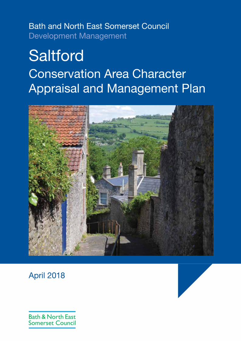
Bath and North East Somerset CouncilDevelopment Management
SaltfordConservation Area Character Appraisal and Management Plan
April 2018
Contents1 Saltford Conservation Area 3
Introduction
Context
Summary of key characteristics
Summary of recommendations
Conservation area designation
Community involvement
2 Landscape Setting 5
Valley of the River Avon
Topography and geology
Relationship with the surroundings
3 Archaeology and historic development 6
4 Spatial analysis 8
Layout and street pattern
Open space, trees and landscape
Focal points, focal buildings, views and vistas
Boundary treatments
Public realm
5 Buildings of the conservation area 12
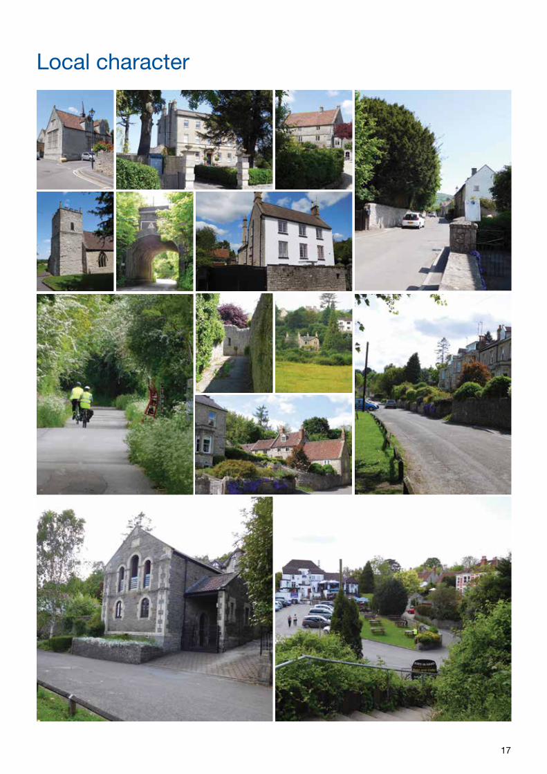
Local character
Listed buildings
Positive buildings/undesignated heritage assets
Building types
Building styles, materials and colours
6 Character Areas 15
Beech Road/upper High Street
Upper High Street
Queen Square
The Batch
Lower High Street/former railway embankment
The Shallows
The Brass Mills
7 Issues 20
Summary of issues
8 Management Proposals 21
Issues and recommendations
Landscape setting
Traffic, pedestrian movement and parking
Control of new development
Buildings
Possible enhancements
9 Monitoring and Review 23
Appendices 24
1 National and local planning policy
2 Further reading
3 Glossary
4 Contact Details
All maps are reproduced from the Ordnance Survey mapping with the permission of the Controller of Her Majesty’s Stationery Office © Crown Copyright. Unauthorised reproduction infringes Crown copyright and may lead to prosecution or civil proceedings. Licence number 100023334
3
Introduction
The historic core of Saltford was identified by the local planning authority as being of special architectural and historic interest and first designated as a conservation area in April 1977. It was redesignated in April 2018. The boundary today covers 12.11 hectares and is shown on the Conservation Area Character Appraisal Map. There are thirty seven entries on the National Heritage List for England (listed buildings) within the existing conservation area boundary. Under the Town and Country Planning legislation the Council has a duty to preserve and enhance the character and appearance of conservation areas in exercising its planning powers, and to periodically re-appraise its boundaries. This provides a consistent and sound basis on which planning and other applications are determined in the area.
As part of this process local planning authorities are encouraged to carry out character appraisals of its conservation areas. An appraisal identifies features which contribute toward the special interest and character of the area and those that detract from it. This enables local residents to participate in identifying features which are of particular value to them and to the special character of their area, and provides a base upon which to develop management proposals for preservation and enhancement.
This document therefore seeks to:
• Define the special interest of the Saltford Conservation Area and identify the issues which threaten the special qualities of the conservation area (in the form of the ‘character appraisal’)
• Provide guidelines to prevent harm and achieve enhancement
(in the form of the management proposals)
Following review, the boundary of the conservation area includes the War Memorial on High Street, land to the east of The Shallows including part of the former railway embankment and road bridge, and the complete garden of 71 High Street. No 2 Homefield Close is a modern bungalow which was removed from the conservation area.
Context
Saltford is located in the west part of Bath and North East Somerset Council, east of Bristol and west of Bath. It is in the Green Belt and its historic core is a designated conservation area, now surrounded to the south and westt by mainly C19 and C20 housing development. Bath Road (the A4) and the Great Western Railway both pass to the west. To the north and east it abuts open countryside which includes the edge of the Cotswold Area of Outstanding Natural Beauty (AONB) and the River Avon.
The conservation area covers the historic core of Saltford between Isambard Brunel’s Great Western Railway to the south and the former Midland Railway and River Avon to the north. It includes the High Street, Queen Square, The Batch and The Shallows. A series of buildings front High Street, from The Tunnel House at the south end to the former Midland Railway Bridge in the north. Buildings and open space front onto The Shallows as far as the historic Old Brass Mill to the south.
Historically the economy of the area was originally based on agriculture and many of the buildings within the conservation area were once farm buildings. These humbler buildings are interspersed by grander properties, some with large gardens enclosed by walls. From the early
C18 to early C20 Saltford was an important part of the local brass industry.
Modern Saltford owes much of its growth to the river and railways. Its population grew from just over 200 to 3000 between 1801 and 1971. Today its inhabitants still work in the village, Bath, Keynsham and also Bristol.
Summary of key characteristics
This character appraisal concludes that the key positive characteristics of the conservation area are:
• Well preserved historic village astride ancient road and river routes in the valley of the River Avon, with Saltford Manor and the Parish Church of St Mary at Queen Square as the focus of the medieval settlement, and a focal point in the conservation area
• Large proportion of historic buildings, predominantly in residential use. Also the parish church, the church hall and a public house
• The exceptionally attractive rural river valley landscape setting and topography, with long vistas out of the village to the north encompassing the river and the Cotswold hills beyond
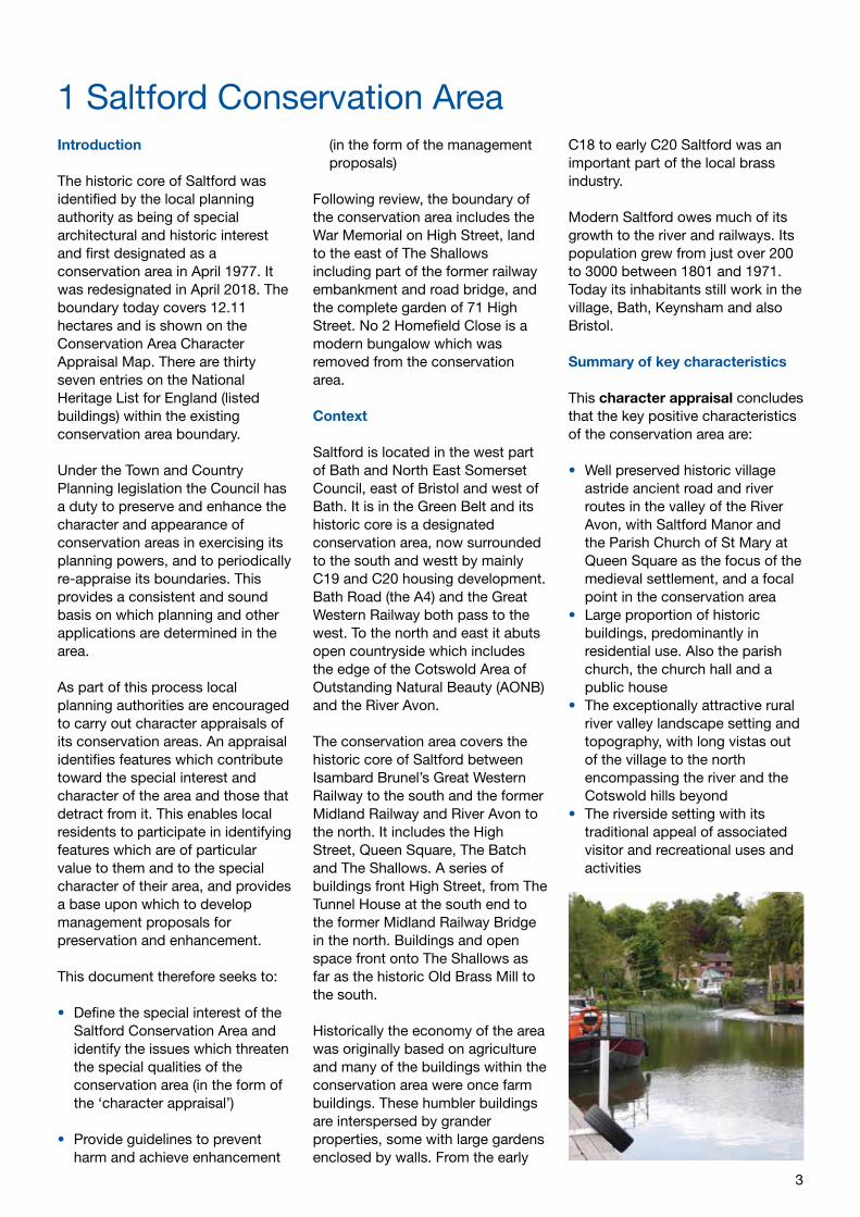
• The riverside setting with its traditional appeal of associated visitor and recreational uses and activities
1 Saltford Conservation Area
4
• Important views of the historic core from the surrounding countryside
• Survival of the early street pattern lined with distinct stone boundary walls, and vernacular and more prestigious historic buildings
• Character largely unaffected by modern street furniture or highway development
• Consistent use of local building materials, primarily clay pantiles, blue lias stone, lime based mortars and some natural slate and render
• Boundaries typically enclosed by stone walls and/or hedging and planting
• The physical and visual presence of the former Midland Railway line, now a popular cycle and pedestrian route
• Verdant mature trees and greenery
• Important green open space by the river reinforcing the rural qualities of the conservation area
Summary of recommendations
In summary the management proposals make the following recommendations:
• The setting of the conservation area should be protected
• Important key views within, from and towards the conservation area should be protected
• Potential traffic management measures on High Street should be considered
• Any new development should preserve or enhance the existing built character and appearance and recognise existing density
• Historic buildings should retain original characteristics and traditional features, and avoid introduction of artificial materials
• Buildings which make a positive contribution should be protected from demolition.
• Support for the emerging Water Space Study (Bath and North East Somerset Council 2016 – 2017)
• Surviving natural stone kerbs should be retained and whenever possible concrete kerbs should be replaced with natural stone
• Improved visitor signage and local information should be considered
• Consideration of potential future enhancement opportunities should be made as and when funding becomes available
Conservation area designation
Conservation areas are designated under the provisions of Section 69 of the Planning (Listed Buildings and Conservation Areas) Act 1990, which places a statutory duty on local planning authorities to determine which parts of their area are areas of special architectural or historic interest. A conservation area is defined as: ‘…an area of special architectural or historic interest, the character or appearance of which it is desirable to preserve or enhance’.
The quality and interest of the area as a whole, rather than individual buildings, is the main consideration when designating such areas.
Designation also provides the basis for applying national and local policies designed to preserve or enhance all aspects of character or appearance that define the special interest of a conservation area.
Section 71 of the Act requires the local planning authority to publish proposals for the preservation and enhancement of conservation areas and an appraisal provides the means for this. Section 72 requires that, in considering applications for development in a conservation area, special attention shall be paid to the desirability of preserving or enhancing the character of that area.
Conservation area appraisals are considered by Historic England to be vital to the conservation of these special areas. The content of this statement is based on the
suggested approach set out by Historic England.
Conservation area designation introduces controls over:* the way owners can alter or develop their properties. These include the requirement in legislation andnational planning policies to preserve and/or enhance and for local planning authorities to pay special attention to the desirability of preserving or enhancing the character or appearance of the area in their local planning policies. * demolition of most unlisted buildings/structures* works to trees* types of advertisements that can be displayed with ‘deemed consent’* types and size of development which can be carried out without the need for planning permission (permitted development rights)
Community involvement
Public support and involvement is essential to the successful management of conservation areas. This document was initially drafted following a meeting with representatives from Saltford Parish Council and the local Ward Councillors in May 2016, when the extent of the extent of the conservation area boundary was discussed together with some of the main problems and issues which face the local community.
After this meeting a first draft was agreed with the Parish Council for the public consultation during June and July 2017. In response to comments received from the consultation amendments were made and the final documents were formally adopted by the council for planning guidance purposes on 6th April 2018.
5
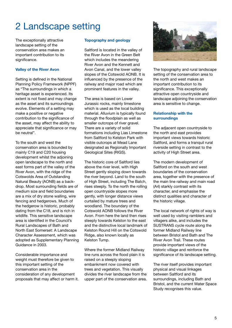
2 Landscape settingThe exceptionally attractive landscape setting of the conservation area makes an important contribution to its significance.
Valley of the River Avon
Setting is defined in the National Planning Policy Framework (NPPF) as “The surroundings in which a heritage asset is experienced. Its extent is not fixed and may change as the asset and its surroundings evolve. Elements of a setting may make a positive or negative contribution to the significance of the asset, may affect the ability to appreciate that significance or may be neutral”.
To the south and west the conservation area is bounded by mainly C19 and C20 housing development whilst the adjoining open landscape to the north and east forms part of the valley of the River Avon, with the ridge of the Cotswolds Area of Outstanding Natural Beauty (AONB) as a back-drop. Most surrounding fields are of medium size and field boundaries are a mix of dry stone walling, wire fencing and hedgerows. Much of the hedgerow is historic, probably dating from the C18, and is rich in wildlife. This sensitive landscape area is identified in the Council’s Rural Landscapes of Bath and North East Somerset: A Landscape Character Assessment, which was adopted as Supplementary Planning Guidance in 2003.
Considerable importance and weight must therefore be given to this important setting of the conservation area in the consideration of any development proposals that may affect or harm it.
Topography and geology
Saltford is located in the valley of the River Avon in the Green Belt which includes the meandering River Avon and the Kennett and Avon Canal, and the lower valley slopes of the Cotswold AONB. It is influenced by the presence of the railway and major road which are prominent features in the valley.
The area is based on Lower Jurassic rocks, mainly limestone which is used as the local building material. Alluvium is typically found through the floodplain as well as smaller outcrops of river gravel. There are a variety of solid formations including Lias Limestone from Saltford to Kelston Park with visible outcrops at Mead Lane designated as Regionally Important Geological Sites (RIGS).
The historic core of Saltford lies above the river level, with High Street gently sloping down towards the river beyond. Land to the south of High Street, including The Batch, rises steeply. To the north the rolling open countryside slopes more gently, with longer distance views curtailed by mature trees and woodland. The boundary of the Cotswold AONB follows the River Avon. From here the land then rises steeply towards Kelston to the east and the distinctive local landmark of Kelston Round Hill on the Cotswold Ridge, also known locally as Kelston Tump.
Where the former Midland Railway line runs across the flood plain it is raised on a steeply sloping embankment now covered with trees and vegetation. This visually divides the river landscape from the upper part of the conservation area.
The topography and rural landscape setting of the conservation area to the north and west makes an important contribution to its significance. This exceptionally attractive open countryside and landscape adjoining the conservation area is sensitive to change.
Relationship with the surroundings
The adjacent open countryside to the north and east provides important views towards historic Saltford, and forms a tranquil rural riverside setting in contrast to the activity of High Street area.
The modern development of Saltford on the south and west boundaries of the conservation area, together with the presence of the main line railway and main road (A4) starkly contrast with its character, and emphasise the distinct qualities and character of the historic village.
The local network of rights of way is well used by visiting ramblers and villagers alike, and includes the SUSTRANS cycle route along the former Midland Railway line between Bristol and Bath and The River Avon Trail. These routes provide important views of the historic village and reinforce the significance of its landscape setting.
The river itself provides important physical and visual linkages between Saltford and its surroundings, including Bath and Bristol, and the current Water Space Study recognises this value.
6
The Domesday Book entry for Saltford identifies the settlement as ‘Sanford.’ One theory is that the name may have come from San-ford, a sand or gravel ford. Saltford is located on ancient road and river routes in the river valley. It provided a river crossing place which attracted human settlement from earliest times. The possible presence of prehistoric roundhouses has been located nearby, and evidence has been found of an Anglo Saxon burial ground north of Avon Farm.
A Roman child’s coffin was found in 1901 in the grounds of Saltford House. The east – west Roman road from Bath to Sea Mills, a Roman port on the coast near Bristol was very close-by, and the ancient river crossing at Saltford was an important fording point which linked with the Roman road. The crossing was part of an east-west route of Roman or earlier origins, which aligned approximately with the current position of High Street.
A series of medieval fishponds and former sluices are located to the north east of the church beyond the conservation area boundary. These were probably associated with the Manor House estate. The grade II listed Parish Church of St Mary’s has C12 or possibly Saxon origins, and was partly rebuilt following Civil War damage in 1643 and extensively restored in 1832. Its west tower was possibly converted from a Norman structure in the C17. It has a notable C13 century font and Jacobean pulpit. The church groups with the Norman C12 Saltford Manor (grade II*) to the west of the church which is reputed to be one of the oldest inhabited manor houses in England. The historic building had subsequent alterations and additions from the early part of the C13 through to the C20.
South east of Saltford Manor and the church is an C18 terrace of cottages formerly known as The Rank, reputed to be associated with the local wool industry during that period. The built form of the village developed primarily during the C17 to the C19 as an agricultural community, supported by the presence of riverside mills. In the early C18 it grew as an important centre for the local brass industry. The old Brass Mill, located at the southern end of The Shallows, was probably constructed on the site of a former fulling mill. It was built in the early part of the C18 and operated until 1924. The remains are Grade II listed and are also scheduled as an Ancient Monument. They include an annealing oven and a working water wheel open to the public.
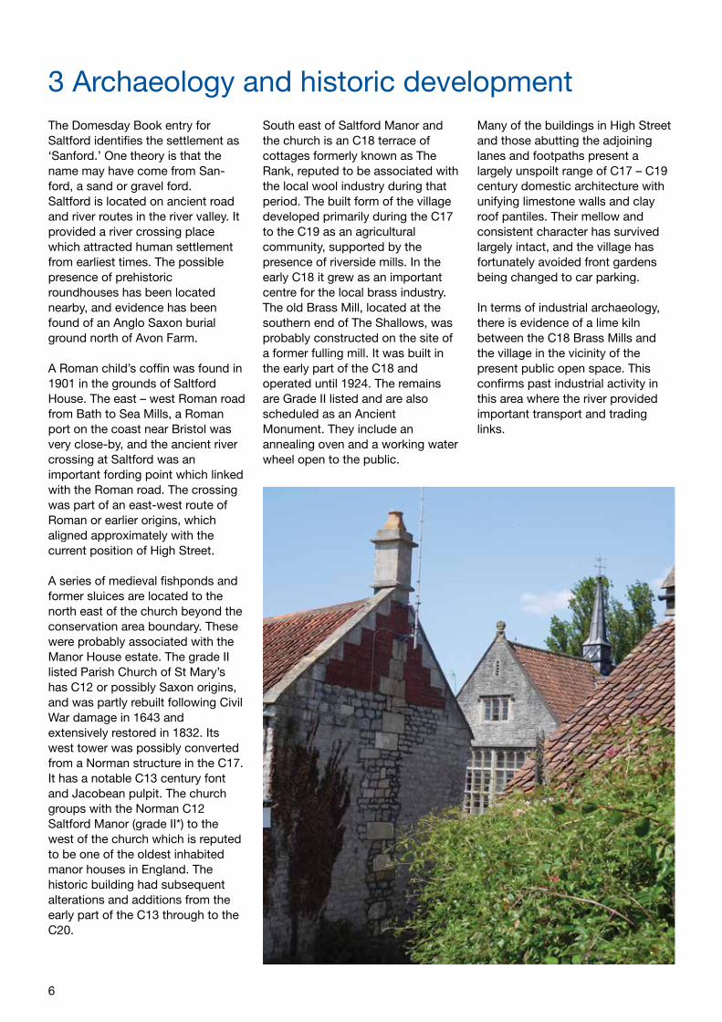
Many of the buildings in High Street and those abutting the adjoining lanes and footpaths present a largely unspoilt range of C17 – C19 century domestic architecture with unifying limestone walls and clay roof pantiles. Their mellow and consistent character has survived largely intact, and the village has fortunately avoided front gardens being changed to car parking.
In terms of industrial archaeology, there is evidence of a lime kiln between the C18 Brass Mills and the village in the vicinity of the present public open space. This confirms past industrial activity in this area where the river provided important transport and trading links.
3 Archaeology and historic development
7
The River Avon Navigation brought traffic to the area in the C19 as the Kennet and Avon Canal developed, providing a link through to the east. Before the navigation the tide swept up the river to Bath.
The opening of Brunel’s Great Western Railway in the 1840s between Bristol, Bath and London included the building of the Saltford Tunnel. Although this track survives and today carries the high speed inter-city trains, the branch of the Midland Railway between Bath and
Mangotsfield in Bristol which opened in 1869 did not escape the closure of tracks in the 1960s. Together with surviving bridges it is now used as the extremely popular cycle and walking route between the two cities.
The former chapel facing on to The Shallows was opened in 1865. In the late Victorian period the village school and hall were constructed at the entrance to Queen Square. Some of the terraced housing in the village was also built at this time.
The attractive surroundings of Saltford, together with the main road, railways, river and canal route contributed much to its expansion as a commuter village in the C20. Today this expansion is particularly evident to the south and east of the historic core.
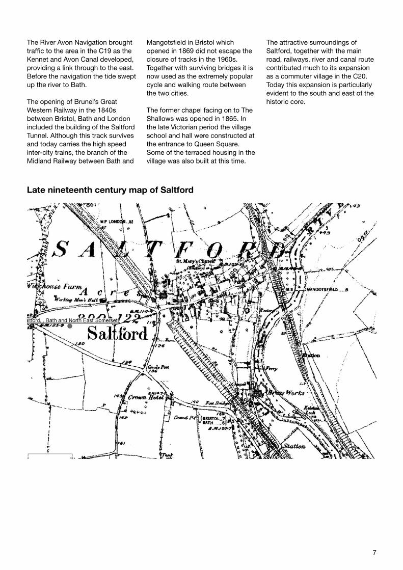
Late nineteenth century map of Saltford
8
Layout and street pattern
The principal spatial features of the conservation area result from the linear form of High Street which contrasts with the informal riverside setting of The Shallows.
Saltford’s historic linear plan form focusses on the east/west alignment of High Street, the ancient route associated with the river crossing. The south end entrance to High Street is visually dominated by The Tunnel House and Saltford House, both large detached listed buildings set within their own grounds. Beyond these and continuing north there is a fairly consistent medium density of buildings in High Street, comprising an irregular pattern of terraced cottages and individual houses, many of C17 to C19 origins.
This linear plan form is punctuated by Queen Square about half way along High Street on its west side, with the medieval church and manor house to the west side of the square. The public footpath leading from the square to the church provides access and links to the open countryside beyond.
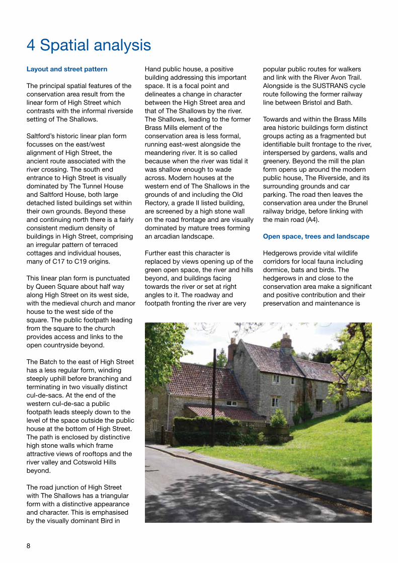
The Batch to the east of High Street has a less regular form, winding steeply uphill before branching and terminating in two visually distinct cul-de-sacs. At the end of the western cul-de-sac a public footpath leads steeply down to the level of the space outside the public house at the bottom of High Street. The path is enclosed by distinctive high stone walls which frame attractive views of rooftops and the river valley and Cotswold Hills beyond.
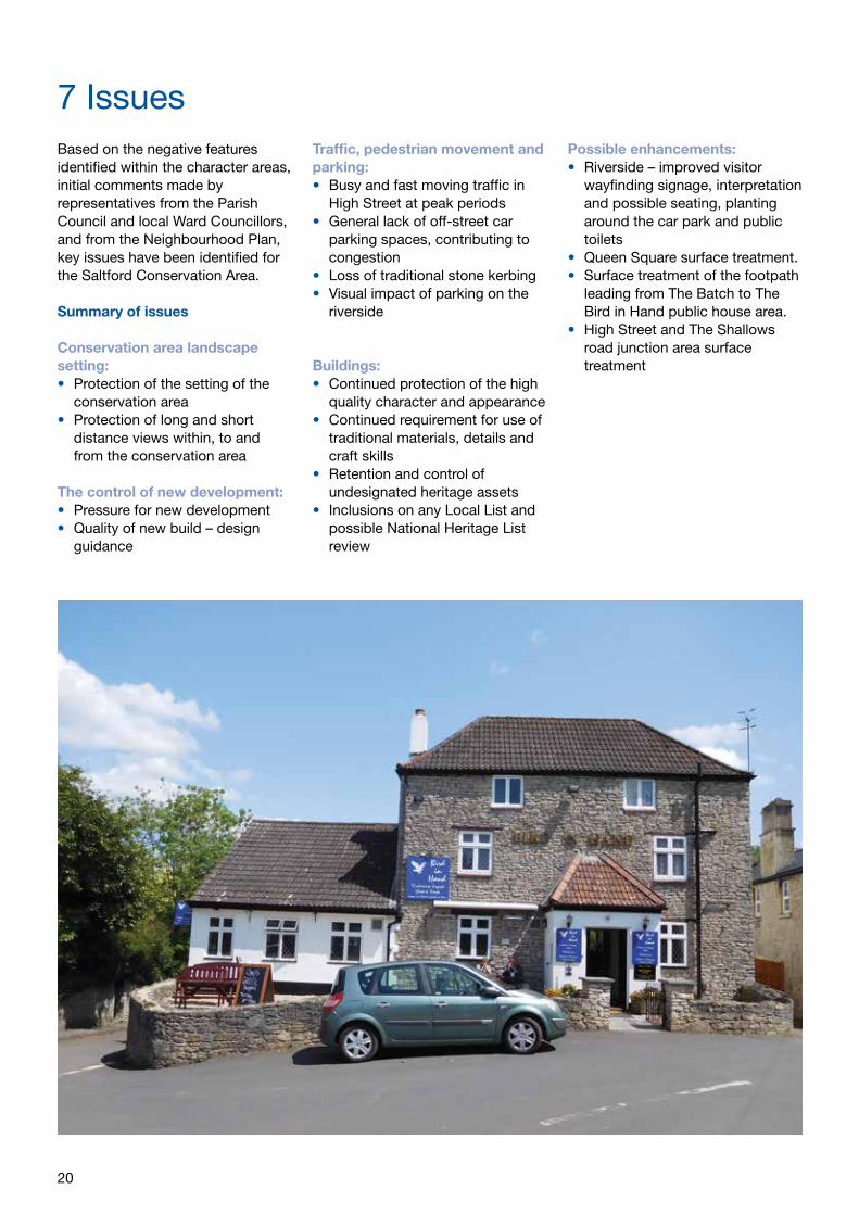
The road junction of High Street with The Shallows has a triangular form with a distinctive appearance and character. This is emphasised by the visually dominant Bird in
Hand public house, a positive building addressing this important space. It is a focal point and delineates a change in character between the High Street area and that of The Shallows by the river.The Shallows, leading to the former Brass Mills element of the conservation area is less formal, running east-west alongside the meandering river. It is so called because when the river was tidal it was shallow enough to wade across. Modern houses at the western end of The Shallows in the grounds of and including the Old Rectory, a grade II listed building, are screened by a high stone wall on the road frontage and are visually dominated by mature trees forming an arcadian landscape.
Further east this character is replaced by views opening up of the green open space, the river and hills beyond, and buildings facing towards the river or set at right angles to it. The roadway and footpath fronting the river are very
popular public routes for walkers and link with the River Avon Trail. Alongside is the SUSTRANS cycle route following the former railway line between Bristol and Bath.
Towards and within the Brass Mills area historic buildings form distinct groups acting as a fragmented but identifiable built frontage to the river, interspersed by gardens, walls and greenery. Beyond the mill the plan form opens up around the modern public house, The Riverside, and its surrounding grounds and car parking. The road then leaves the conservation area under the Brunel railway bridge, before linking with the main road (A4).
Open space, trees and landscape
Hedgerows provide vital wildlife corridors for local fauna including dormice, bats and birds. The hedgerows in and close to the conservation area make a significant and positive contribution and their preservation and maintenance is
4 Spatial analysis
9
important for the character of the area as well as biodiversity.
Gardens within the village provide visually important spaces which contribute to the setting of buildings and that of the conservation area. Where historic terraces are substantially set back from High Street frontage their long narrow gardens provide visual ‘green’ breaks in the street scene, with low stone boundary walls fronting the footpaths, supplemented by verdant hedging and trees. A good example is the front gardens of the terrace at No’s 31-39 High Street, immediately to the north of Queen Square.
Many of the gardens fronting the streets also contain large mature trees which project into the street scene and make a significant visual contribution to character and appearance. For example the trees set behind the high garden walls of No’s 23 and 25 High Street.
Elsewhere, there are important mature tree groups in the churchyard, and along the river landscape at The Shallows, positively contributing to the character and appearance of these parts of the conservation area. The large mature oak tree in the churchyard is protected by a Tree Preservation Order.
The disused railway embankment, now used as a cycle and pedestrian route is lined with mature trees and vegetation which are visible in and contribute to both long and short distance views. It also acts as an important wildlife corridor.
The most significant open space in the conservation area is the large gently sloping grassed public area at The Shallows known locally as ‘The Outlook’. This name derived from the expansive views of the river and Cotswold Hills, including Kelston Tump. Together with the greensward adjoining the river this is a popular visitor attraction.
The River Avon makes an essential physical, historic and visual contribution to local character and appearance, and plays a significant role in the setting of the conservation area. It is a Site of Nature Conservation Importance (SNCI), and its value is added to by the recreational role it plays with river activities both passive and active.
Less recognised is the tranquil churchyard space which overlooks the adjoining countryside and contributes to the important setting for the church. The churchyard is still in use.
Queen Square forms a hard surfaced open space dominated by road surfacing and parking. The road junction of High Street with The Shallows outside the public house forms a recognisable triangular shaped space, which although hard surfaced has a distinct nodal character normally associated with small village greens. This is added to by the outdoor seating at the public house where users can sit and enjoy the space with its surrounding historic buildings and garden greenery.
Some areas of private space also contribute significantly to local character. These include the large front gardens at Saltford Manor and Saltford House, the former orchard at The Batch (now a garden), and scrubland between The Shallows and the river.
Focal points, focal buildings, views and vistas
Focal pointsThe road junction of High Street with Beech Road at the top end of High Street, contains the two imposing detached Georgian houses and the war memorial and is a recognisable focal point and visual point of entry to the conservation area.
Due to the historic rural character of the conservation area which has incrementally developed over the centuries, there are no ‘planned’ focal points, particularly in High Street which is simply lined with historic buildings. Away from High Street, Queen Square together with the former school, the Manor House and the church combine to create a focal point or node in the village.
The area outside the public house provides a further focus in the village as described in paragraph 4.2 above.
Much of the character of the conservation area focusses on The Shallows and the riverside area. The visual and physical importance of this area to residents and visitors alike is highlighted elsewhere in this appraisal.
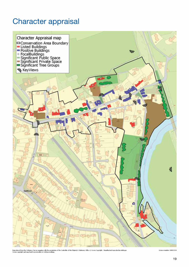
Focal buildingsKey focal buildings in the conservation area, both listed and undesignated heritage assets include:
• The Tunnel House/Saltford House• Saltford Manor/St Mary’s Church/
former school and hall• Norman House• The Bird in Hand public house• The former chapel on The
Shallows• The Brass Mills
Key views and vistas from within the conservation area:Generally, the attractive glimpses and views of the Avon Valley and the Cotswold hillsides beyond, framed by blue lias limestone cottages, boundary walls and trees are an important element of the village character. The most important views are described below and identified with numbers on the Character Appraisal Map. The omission of a view does not mean it has no significance.
10
Key viewpoint 1: approaching High Street from Beech Road.
The view at the road junction is terminated and enclosed by the imposing grouping of Saltford House and The Tunnel House together with their front gardens, stone walls and mature trees. This forms a sense of arrival at the entrance to the conservation area. The c1920 War Memorial and its garden on the south west corner of the junction contribute to this view and sense of place.
Key viewpoint 2: looking east along High Street.
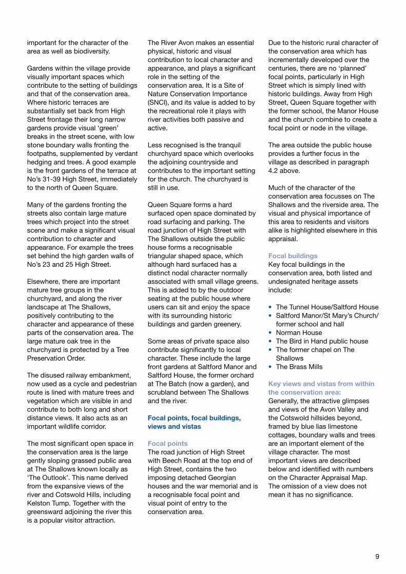
This is a long uninterrupted view of the street gently sloping in an easterly direction down towards the river, with buildings, walls and greenery providing a sense of enclosure which contributes to the local character. The Cotswold hills form a backdrop to the view. The view looking in the opposite direction, west along High Street, has equal value. Key viewpoint 3: sequence of views leading from High Street through Queen Square to the parish church and the countryside beyond.
The wider space of Queen Square, visually dominated by the former Victorian school and hall is complimented by the narrowing of
the footpath and greenery leading from it towards the point of arrival at the churchyard gate. From the church the view progression continues with open views across the attractive undulating countryside to the north, terminated by belts of mature trees.
Key viewpoint 4: looking east at the junction of High Street and The Shallows.
This triangular shaped space is framed by the landmark Bird in Hand public house and adjoining historic buildings. It includes the steep contours of the road which dramatically drop down from the junction towards the railway bridge and river valley. This topography significantly contributes to the view.
Key viewpoint 5: looking north east from the footpath
Views of the rooftops and river valley along the narrow steeply sloping pedestrian passage link between the end of The Batch and the road outside the Bird in Hand public house.
Key viewpoint 6: looking south along The Shallows from High Street
Framed by stone walls, verdant trees and foliage with glimpses of the river beyond.
Key viewpoint 7: encompassing the river and the Cotswold Hills beyond
Looking north east from The Outlook, together with the large expanse of public open space, its hillside backdrop and skyline of buildings and trees looking south east. An equally important view of this river valley area in reverse is obtained from the east end of The Shallows.
Key views and vistas from outside the conservation area: Key viewpoint 8: looking west from vantage points in the Cotswolds AONB below Kelston.
Part of the historic village core, including the church and manor house is visible in the long distance elevated views from public footpaths.
Key viewpoint 9: looking west across the river
Glimpsed views between the trees and vegetation, looking west across the river from the former railway embankment pedestrian and cycle route.
Key viewpoint(s) 10: looking along the river
Views open up of the river and open space on The Shallows approaching from both north and south directions.
Key viewpoint 11: looking south along The Shallows
Approaching the Old Brass Mill area along The Shallows from the north with its distinct group of historic buildings
Key viewpoint 12: looking south from the public footpath which runs across fields to the north of the conservation area.
Views are seen of the church and manor house in the gaps between mature trees in this attractive open countryside setting.
11
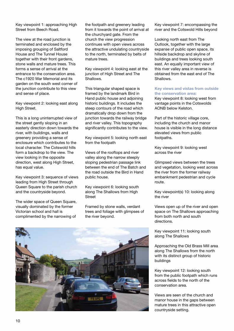
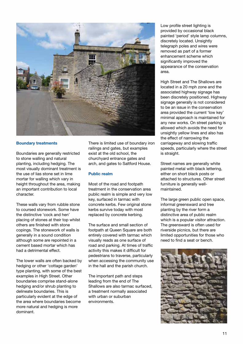
Boundary treatments
Boundaries are generally restricted to stone walling and natural planting, including hedging. The most visually dominant treatment is the use of lias stone set in lime mortar for walling which vary in height throughout the area, making an important contribution to local character.
These walls vary from rubble stone to coursed stonework. Some have the distinctive ‘cock and hen’ placing of stones at their top whilst others are finished with stone copings. The stonework of walls is generally in a sound condition although some are repointed in a cement based mortar which has had a detrimental effect.
The lower walls are often backed by hedging or other ‘cottage garden’ type planting, with some of the best examples in High Street. Other boundaries comprise stand-alone hedging and/or shrub planting to delineate boundaries. This is particularly evident at the edge of the area where boundaries become more natural and hedging is more dominant.
There is limited use of boundary iron railings and gates, but examples exist at the old school, the churchyard entrance gates and arch, and gates to Saltford House.
Public realm
Most of the road and footpath treatment in the conservation area public realm is simple and very low key, surfaced in tarmac with concrete kerbs. Few original stone kerbs survive today with most replaced by concrete kerbing.
The surface and small section of footpath at Queen Square are both entirely covered with tarmac which visually reads as one surface of road and parking. At times of traffic activity this makes it difficult for pedestrians to traverse, particularly when accessing the community use in the hall and the parish church.
The important path and steps leading from the end of The Shallows are also tarmac surfaced, a treatment normally associated with urban or suburban environments.
Low profile street lighting is provided by occasional black painted ‘period’ style lamp columns, discretely located. Unsightly telegraph poles and wires were removed as part of a former enhancement scheme which significantly improved the appearance of the conservation area.
High Street and The Shallows are located in a 20 mph zone and the associated highway signage has been discretely positioned. Highway signage generally is not considered to be an issue in the conservation area provided the current ‘low key’ minimal approach is maintained for any new works. On street parking is allowed which avoids the need for unsightly yellow lines and also has the effect of narrowing the carriageway and slowing traffic speeds, particularly where the street is straight.
Street names are generally white painted metal with black lettering, either on short black posts or attached to structures. Other street furniture is generally well-maintained.
The large green public open space, informal greensward and tree planting by the river form a distinctive area of public realm which is a popular visitor attraction. The greensward is often used for riverside picnics, but there are limited opportunities for those who need to find a seat or bench.
12
Local Character
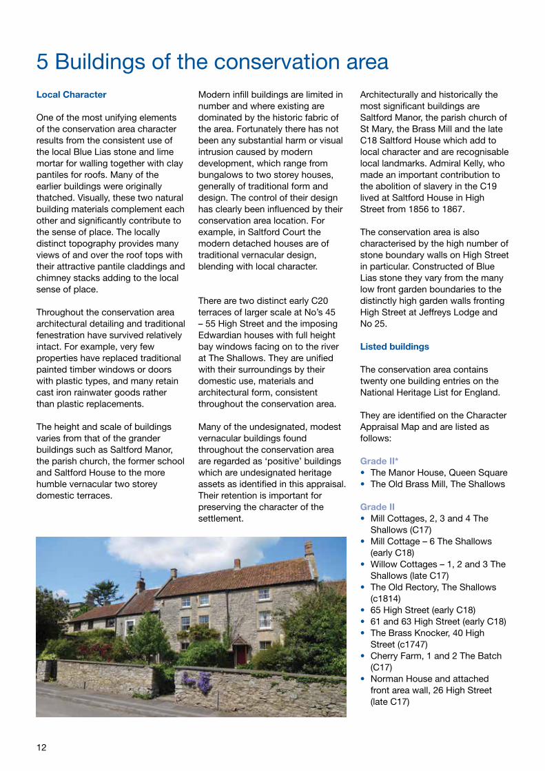
One of the most unifying elements of the conservation area character results from the consistent use of the local Blue Lias stone and lime mortar for walling together with clay pantiles for roofs. Many of the earlier buildings were originally thatched. Visually, these two natural building materials complement each other and significantly contribute to the sense of place. The locally distinct topography provides many views of and over the roof tops with their attractive pantile claddings and chimney stacks adding to the local sense of place.
Throughout the conservation area architectural detailing and traditional fenestration have survived relatively intact. For example, very few properties have replaced traditional painted timber windows or doors with plastic types, and many retain cast iron rainwater goods rather than plastic replacements.
The height and scale of buildings varies from that of the grander buildings such as Saltford Manor, the parish church, the former school and Saltford House to the more humble vernacular two storey domestic terraces.
Modern infill buildings are limited in number and where existing are dominated by the historic fabric of the area. Fortunately there has not been any substantial harm or visual intrusion caused by modern development, which range from bungalows to two storey houses, generally of traditional form and design. The control of their design has clearly been influenced by their conservation area location. For example, in Saltford Court the modern detached houses are of traditional vernacular design, blending with local character.
There are two distinct early C20 terraces of larger scale at No’s 45 – 55 High Street and the imposing Edwardian houses with full height bay windows facing on to the river at The Shallows. They are unified with their surroundings by their domestic use, materials and architectural form, consistent throughout the conservation area. Many of the undesignated, modest vernacular buildings found throughout the conservation area are regarded as ‘positive’ buildings which are undesignated heritage assets as identified in this appraisal. Their retention is important for preserving the character of the settlement.
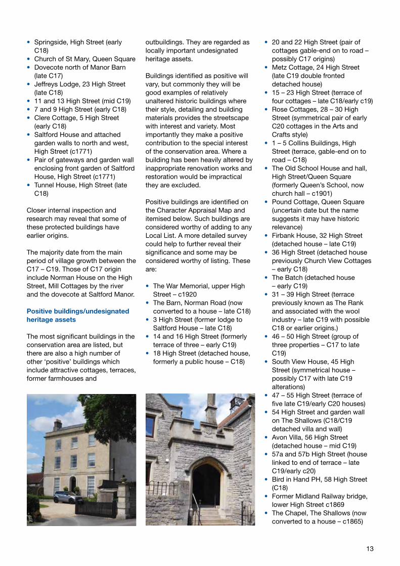
Architecturally and historically the most significant buildings are Saltford Manor, the parish church of St Mary, the Brass Mill and the late C18 Saltford House which add to local character and are recognisable local landmarks. Admiral Kelly, who made an important contribution to the abolition of slavery in the C19 lived at Saltford House in High Street from 1856 to 1867.
The conservation area is also characterised by the high number of stone boundary walls on High Street in particular. Constructed of Blue Lias stone they vary from the many low front garden boundaries to the distinctly high garden walls fronting High Street at Jeffreys Lodge and No 25.
Listed buildings
The conservation area contains twenty one building entries on the National Heritage List for England.
They are identified on the Character Appraisal Map and are listed as follows:
Grade II*• The Manor House, Queen Square• The Old Brass Mill, The Shallows
Grade II• Mill Cottages, 2, 3 and 4 The
Shallows (C17) • Mill Cottage – 6 The Shallows
(early C18)• Willow Cottages – 1, 2 and 3 The
Shallows (late C17)• The Old Rectory, The Shallows
(c1814)• 65 High Street (early C18)• 61 and 63 High Street (early C18)• The Brass Knocker, 40 High
Street (c1747)• Cherry Farm, 1 and 2 The Batch
(C17)• Norman House and attached
front area wall, 26 High Street (late C17)
5 Buildings of the conservation area
13
• Springside, High Street (early C18)
• Church of St Mary, Queen Square • Dovecote north of Manor Barn
(late C17)• Jeffreys Lodge, 23 High Street
(late C18)• 11 and 13 High Street (mid C19)• 7 and 9 High Street (early C18)• Clere Cottage, 5 High Street
(early C18)• Saltford House and attached
garden walls to north and west, High Street (c1771)
• Pair of gateways and garden wall enclosing front garden of Saltford House, High Street (c1771)
• Tunnel House, High Street (late C18)
Closer internal inspection and research may reveal that some of these protected buildings have earlier origins.
The majority date from the main period of village growth between the C17 – C19. Those of C17 origin include Norman House on the High Street, Mill Cottages by the river and the dovecote at Saltford Manor. Positive buildings/undesignated heritage assets
The most significant buildings in the conservation area are listed, but there are also a high number of other ‘positive’ buildings which include attractive cottages, terraces, former farmhouses and
outbuildings. They are regarded as locally important undesignated heritage assets.
Buildings identified as positive will vary, but commonly they will be good examples of relatively unaltered historic buildings where their style, detailing and building materials provides the streetscape with interest and variety. Most importantly they make a positive contribution to the special interest of the conservation area. Where a building has been heavily altered by inappropriate renovation works and restoration would be impractical they are excluded.
Positive buildings are identified on the Character Appraisal Map and itemised below. Such buildings are considered worthy of adding to any Local List. A more detailed survey could help to further reveal their significance and some may be considered worthy of listing. These are:
• The War Memorial, upper High Street – c1920
• The Barn, Norman Road (now converted to a house – late C18)
• 3 High Street (former lodge to Saltford House – late C18)
• 14 and 16 High Street (formerly terrace of three – early C19)
• 18 High Street (detached house, formerly a public house – C18)
• 20 and 22 High Street (pair of cottages gable-end on to road – possibly C17 origins)
• Metz Cottage, 24 High Street (late C19 double fronted detached house)
• 15 – 23 High Street (terrace of four cottages – late C18/early c19)
• Rose Cottages, 28 – 30 High Street (symmetrical pair of early C20 cottages in the Arts and Crafts style)
• 1 – 5 Collins Buildings, High Street (terrace, gable-end on to road – C18)
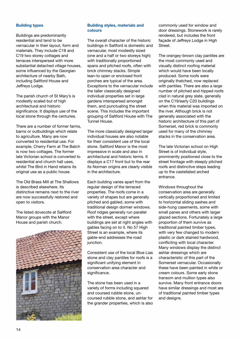
• The Old School House and hall, High Street/Queen Square (formerly Queen’s School, now church hall – c1901)
• Pound Cottage, Queen Square (uncertain date but the name suggests it may have historic relevance)
• Firbank House, 32 High Street (detached house – late C19)
• 36 High Street (detached house previously Church View Cottages – early C18)
• The Batch (detached house – early C19)
• 31 – 39 High Street (terrace previously known as The Rank and associated with the wool industry – late C19 with possible C18 or earlier origins.)
• 46 – 50 High Street (group of three properties – C17 to late C19)
• South View House, 45 High Street (symmetrical house – possibly C17 with late C19 alterations)
• 47 – 55 High Street (terrace of five late C19/early C20 houses)
• 54 High Street and garden wall on The Shallows (C18/C19 detached villa and wall)
• Avon Villa, 56 High Street (detached house – mid C19)
• 57a and 57b High Street (house linked to end of terrace – late C19/early c20)
• Bird in Hand PH, 58 High Street (C18)
• Former Midland Railway bridge, lower High Street c1869
• The Chapel, The Shallows (now converted to a house – c1865)
14
Building types
Buildings are predominantly residential and tend to be vernacular in their layout, form and materials. They include C18 and C19 two storey cottages and terraces interspersed with more substantial detached village houses, some influenced by the Georgian architecture of nearby Bath, including Saltford House and Jeffreys Lodge.
The parish church of St Mary’s is modestly scaled but of high architectural and historic significance. It displays use of the local stone through the centuries.
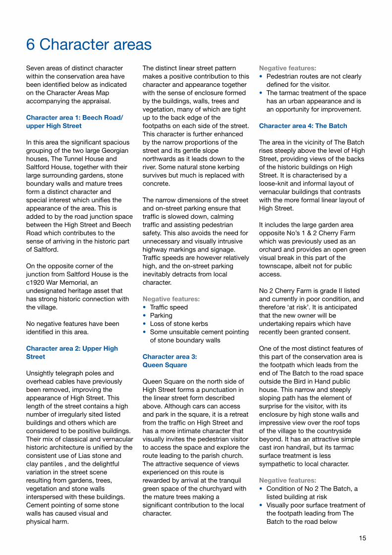
There are a number of former farms, barns or outbuildings which relate to agriculture. Many are now converted to residential use. For example, Cherry Farm at The Batch is now two cottages. The former late Victorian school is converted to residential and church hall uses, whilst The Bird in Hand retains its original use as a public house.
The Old Brass Mill at The Shallows is described elsewhere. Its distinctive remains next to the river are now successfully restored and open to visitors.
The listed dovecote at Saltford Manor groups with the Manor House and parish church.
Building styles, materials and colours
The overall character of the historic buildings in Saltford is domestic and vernacular, most modestly sized (one and a half or two storeys high) with traditionally proportioned spans and pitched roofs, often with brick chimney stacks. Simple lean-to open or enclosed front porches are typical of the area. Exceptions to the vernacular include the taller classically designed individual properties set in large gardens interspersed amongst them, and punctuating the street scene. This includes the important grouping of Saltford House with The Tunnel House.
The more classically designed larger individual houses are also notable for their consistent use of the local stone. Saltford Manor is the most impressive in scale and also in architectural and historic terms. It displays a C17 front but to the rear its Norman origins are clearly visible in the architecture.
Each building varies apart from the regular design of the terraced properties. The roofs come in a variety of shapes but are generally pitched and gabled, some with traditional design dormer windows. Roof ridges generally run parallel with the street, except where buildings are set at right angles with gables facing on to it. No 57 High Street is an example, where its gable-end addresses the road junction.
Consistent use of the local Blue Lias stone and clay pantiles for roofs is a significant unifying element in conservation area character and significance.
The stone has been used in a variety of forms including squared and coursed rubble stone, un-coursed rubble stone, and ashlar for the grander properties, which is also
commonly used for window and door dressings. Stonework is rarely rendered, but includes the front façade of Jeffreys Lodge in High Street.
The orangey-brown clay pantiles are the most commonly used and visually distinct roofing material which would have been locally produced. Some roofs were originally thatched, now replaced with pantiles. There are also a large number of pitched and hipped roofs clad in natural grey slate, generally on the C19/early C20 buildings when this material was imported on the river. Although brick is not generally associated with the historic architecture of this part of Somerset, red brick is commonly used for many of the chimney stacks in the conservation area.
The late Victorian school on High Street is of individual style, prominently positioned close to the street frontage with steeply pitched roofs and distinctive steps leading up to the castellated arched entrance.
Windows throughout the conservation area are generally vertically proportioned and limited to horizontal sliding sashes and side-hung casements, some with small panes and others with larger glazed sections. Fortunately a large proportion of them survive as traditional painted timber types, with very few changed to modern plastic or dark stained hardwood, conflicting with local character. Many windows display the distinct ashlar dressings which are characteristic of this part of the Somerset vernacular. Occasionally these have been painted in white or cream colours. Some early stone transom and mullion types also survive. Many front entrance doors have similar dressings and most are of traditional painted timber types and designs.
15
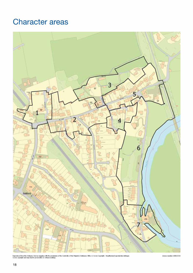
Seven areas of distinct character within the conservation area have been identified below as indicated on the Character Areas Map accompanying the appraisal.
Character area 1: Beech Road/upper High Street
In this area the significant spacious grouping of the two large Georgian houses, The Tunnel House and Saltford House, together with their large surrounding gardens, stone boundary walls and mature trees form a distinct character and special interest which unifies the appearance of the area. This is added to by the road junction space between the High Street and Beech Road which contributes to the sense of arriving in the historic part of Saltford.
On the opposite corner of the junction from Saltford House is the c1920 War Memorial, an undesignated heritage asset that has strong historic connection with the village.
No negative features have been identified in this area.
Character area 2: Upper High Street
Unsightly telegraph poles and overhead cables have previously been removed, improving the appearance of High Street. This length of the street contains a high number of irregularly sited listed buildings and others which are considered to be positive buildings. Their mix of classical and vernacular historic architecture is unified by the consistent use of Lias stone and clay pantiles , and the delightful variation in the street scene resulting from gardens, trees, vegetation and stone walls interspersed with these buildings. Cement pointing of some stone walls has caused visual and physical harm.
The distinct linear street pattern makes a positive contribution to this character and appearance together with the sense of enclosure formed by the buildings, walls, trees and vegetation, many of which are tight up to the back edge of the footpaths on each side of the street. This character is further enhanced by the narrow proportions of the street and its gentle slope northwards as it leads down to the river. Some natural stone kerbing survives but much is replaced with concrete.
The narrow dimensions of the street and on-street parking ensure that traffic is slowed down, calming traffic and assisting pedestrian safety. This also avoids the need for unnecessary and visually intrusive highway markings and signage. Traffic speeds are however relatively high, and the on-street parking inevitably detracts from local character.
Negative features:• Traffic speed• Parking• Loss of stone kerbs• Some unsuitable cement pointing
of stone boundary walls
Character area 3: Queen Square
Queen Square on the north side of High Street forms a punctuation in the linear street form described above. Although cars can access and park in the square, it is a retreat from the traffic on High Street and has a more intimate character that visually invites the pedestrian visitor to access the space and explore the route leading to the parish church. The attractive sequence of views experienced on this route is rewarded by arrival at the tranquil green space of the churchyard with the mature trees making a significant contribution to the local character.
Negative features:• Pedestrian routes are not clearly
defined for the visitor.• The tarmac treatment of the space
has an urban appearance and is an opportunity for improvement.
Character area 4: The Batch
The area in the vicinity of The Batch rises steeply above the level of High Street, providing views of the backs of the historic buildings on High Street. It is characterised by a loose-knit and informal layout of vernacular buildings that contrasts with the more formal linear layout of High Street.
It includes the large garden area opposite No’s 1 & 2 Cherry Farm which was previously used as an orchard and provides an open green visual break in this part of the townscape, albeit not for public access.
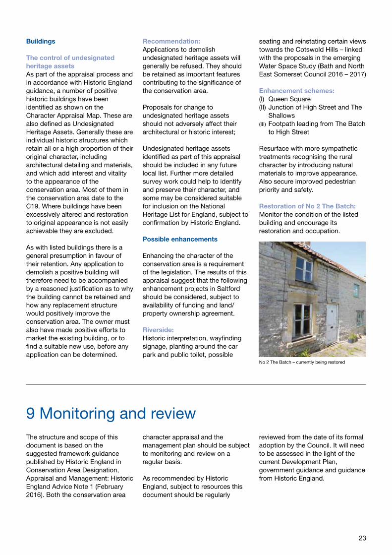
No 2 Cherry Farm is grade II listed and currently in poor condition, and therefore ‘at risk’. It is anticipated that the new owner will be undertaking repairs which have recently been granted consent.
One of the most distinct features of this part of the conservation area is the footpath which leads from the end of The Batch to the road space outside the Bird in Hand public house. This narrow and steeply sloping path has the element of surprise for the visitor, with its enclosure by high stone walls and impressive view over the roof tops of the village to the countryside beyond. It has an attractive simple cast iron handrail, but its tarmac surface treatment is less sympathetic to local character.
Negative features:• Condition of No 2 The Batch, a
listed building at risk• Visually poor surface treatment of
the footpath leading from The Batch to the road below
6 Character areas
16
Character area 5: Lower High Street/ former railway embankment
The distinct triangular space resulting from the road layout acts as a central focal point in the conservation area, a function often provided elsewhere by village greens. This character is compounded by the presence of the Bird in hand Public House which faces on to the space and enclosure provided by adjoining historic buildings. The space is surfaced with tarmac on the highway and footpaths which detracts from its appearance.
This plateau area is the springing point for the meeting of the two roads which then lead steeply down to the railway embankment and under the railway bridge and to The Shallows, emphasising the distinct local topography. The bridge and embankment act as an entry point to the historic area, both visually and physically. Visitor steps lead down from the SUSTRANS cycle route on the embankment to the level of the car park at the rear of the public house.
Negative features:• Visually unrelieved tarmac
surface treatment of the highway and footpath at the junction of the High Street and The Shallows which lacks visual definition and has an urbanising effect on the street scene.
• Lack of visitor (pedestrian and cyclist) wayfinding information from the SUSTRANS cycle route to the histroic area and river edge.
Character area 6: The Shallows
The Shallows has a distinct local rural character mainly due to the strong visual and physical presence of the River Avon. The large green open space on the south side of the road combined with the green sward and groups of large mature trees running along the river bank and former railway embankment
create the attractive open and verdant appearance of this area.
The dense tree belt and vegetation on the west side of The Shallows screens the modern housing set behind in the grounds of the former rectory.
Other planting and shrubs on the east side of the road conceal previously established views of the river valley and beyond. The railway embankment forms a visual and physical edge to the north east corner of the conservation area. Further south the open space is replaced by a variety of small scale vernacular historic buildings and a handsome early C20 terrace of large houses with bay windows facing east across the river. The tree-lined greensward continues along this part of The Shallows, unifying the area. To the north it visually links with an area of undeveloped land, crossed by an informal footpath which leads up to the cycle track on the railway embankment and then beyond to the towpath.
An area of car parking and a public toilet block is provided on the west side of the road which although necessary are visually intrusive in the riverside scene. The road segregates the open space from the river corridor and has an urbanising influence due to the surface treatment.
This part of the conservation area by the river is a visitor attraction and also an area of high recreational water activity which positively contributes to local vitality and character.
Negative features:• The visual intrusion on the rural
character by the tarmac surface treatment of the road, footways and car park
• Visual intrusion by the public toilets block
• Some vegetation restricting views of the river and valley
• Lack of wayfinding signage and
historic interpretation for the visitor, including awareness of the Brass Mill as a local tourist attraction
Character area 7: The Brass Mills
Set by the river, the surviving historic Brass Mills buildings (grade II* listed and a Scheduled Ancient Monument) provide the visual and physical focus for this area and a link with the industrial past of Saltford. This is added to by the historic buildings in close proximity on the west side of the road which attractively group with the Brass Mill structures. Some of these historic buildings are prone to flood risk.
Parts of the conservation area and some of the historic buildings adjoining the river are highly prone to flooding, a risk which is increasing with climate change. A strategy for protecting historic buildings from flooding should be considered.
Entrance to this area from the north is identified by the converted chapel with its distinct gable end and arched windows facing the road. This is now converted to residential use. On the west side of the road it also acts as a local landmark.
Entering this riverside area from the south, the Brass Mills and other historic buildings denote arrival Their distinct grouping, common use of building materials and the generally lower scale of built forms contribute to the local character of this part of the conservation area.
Negative features:• Visual impact of the large
unscreened public house car park
• Lack of visitor interpretation • A lack of definition of public
footpath routes – it is unclear where it is possible to walk and there is a lack of signage identifying links with the historic core and the rest of the river
• Flood risk to historic buildings
17
Local character
18
Character areas
19
Character appraisal
20
Based on the negative features identified within the character areas, initial comments made by representatives from the Parish Council and local Ward Councillors, and from the Neighbourhood Plan, key issues have been identified for the Saltford Conservation Area.
Summary of issues
Conservation area landscape setting:• Protection of the setting of the
conservation area• Protection of long and short
distance views within, to and from the conservation area
The control of new development:• Pressure for new development• Quality of new build – design
guidance
Traffic, pedestrian movement and parking:• Busy and fast moving traffic in
High Street at peak periods• General lack of off-street car
parking spaces, contributing to congestion
• Loss of traditional stone kerbing• Visual impact of parking on the
riverside
Buildings:• Continued protection of the high
quality character and appearance • Continued requirement for use of
traditional materials, details and craft skills
• Retention and control of undesignated heritage assets
• Inclusions on any Local List and possible National Heritage List review
Possible enhancements:• Riverside – improved visitor
wayfinding signage, interpretation and possible seating, planting around the car park and public toilets
• Queen Square surface treatment.• Surface treatment of the footpath
leading from The Batch to The Bird in Hand public house area.
• High Street and The Shallows road junction area surface treatment
7 Issues
21
Issues and recommendations
The character appraisal has identified the special positive qualities of the Saltford Conservation Area which make it unique. The following management proposals build upon the negative features which have also been identified, to provide a series of issues and recommendations for improvement and/or change, subject to availability of funding and owner agreement.
Landscape setting
The protection of the setting of Saltford Conservation AreaThe landscape to the north and east of the conservation area is noted for its attractive fields, woodland, and the valley of the River Avon within the immediate proximity of the Cotswold Area of Outstanding Natural Beauty. The countryside beyond the conservation area is already protected by relevant Development Plan policies, and the land within its boundary has similar policy protection. Constraints are also imposed on the historic environment by guidance contained in the National Planning Policy Framework (NPPF) and advice published by Historic England.
There may be potential threats from new development within or on the edges of the conservation area, or from changes to buildings or sites which lie within it, for example from the redevelopment of an existing building.
Recommendation:Any new development beyond the conservation area boundary should not harm its setting. This setting will continue to be protected through the strict enforcement of policies contained within the Development Plan. Applications for change which would have a detrimental effect on
land within or on the edges of the conservation area and its setting will be resisted.
Views within and from the landscape setting outside the conservation areaThere are several important views within the conservation area looking to the north and east across the surrounding countryside. There are also views from the surrounding landscape setting. These important views need to be protected by the careful control of proposed development which must seek to preserve the special character and setting of the conservation area.
Recommendation:Views within and around the conservation area, particularly to and from the adjoining open landscape to the north and east, will continue to be protected. Proposals for new development which would impinge on these views will be resisted.
Care of the riverside open spaceThe significance and value of the open space adjoining the river is highly regarded by the local community and visitors alike. Management, maintenance and improvement of this space are the responsibility of the Council.
Recommendation:A proposal to enhance The Shallows as a riverside space with a focus on recreation and leisure, together with public realm enhancements and improved management of vegetation should be sought in the current work on the Water Space Study (Bath and North East Somerset Council 2016 – 2017) and a site management plan introduced.
Traffic, pedestrian movement and parking
Busy and fast moving traffic in High Street at peak periodsHigh Street serves both local residents and other road users who are using it to access the area and beyond. Some traffic moves at high speeds despite the 20 mph limit. On street parking results in narrowing of the highway space available and bottle-necks. In some stretches of High Street there are no footpaths for pedestrians, and elsewhere pedestrians need to negotiate between parked vehicles to cross the road.
Recommendation:In liaison with the highway authority seek opportunities for reducing the visual and physical impact of traffic and enhancing pedestrian and cyclist access in the conservation area as and when opportunities and funding arise.
General lack of car parking spaces leading to congestionFew properties in High Street have their own private off-street parking, and there appears to be no opportunity to remedy this situation. Converting front gardens for parking would be unacceptable as it causes visual and physical harm.
Recommendation:No feasible action identified at this time.
Visitor riverside parkingThe off-road parking provided on the river side of The Shallows is informal and dominated by trees. Parking on the opposite side of the green open space is visually prominent and detracts from the riverside character of this part of the conservation area.
8 Management proposals
22
Recommendation:Through the current Water Space Study (Bath and North East Somerset Council 2016 – 2017) seek new planting around the parking area and public toilet block to reduce their visual impact and improve views
Need for improved visitor signage and informationIt is difficult for visitors to the area to find their way around and to discover the ‘hidden’ treasures of the river and historic settlement.
Recommendation:Sensitive visitor way-marking information should be installed, together with mixed media historical and other local information (digital information can help to reduce visual clutter)
Retention of stone kerbingThe surviving stretches of natural stone kerbing in the conservation area make an important contribution to local distinctiveness. Replacement concrete kerbing detracts from the special appearance and character of the area.
Recommendation:Where highway proposals in the conservation area involve works to surviving natural stone kerbs, these should be retained where practical or replaced in natural stone to match. Wherever possible, concrete kerbs should be replaced with natural stone kerbing.
Control of new development
Pressure for new developmentThere is pressure for new development, and particularly new housing sites within and around the exiting settlements in Bath and North East Somerset, including the Keynsham area which is close to Saltford. This demand for new housing land needs to be balanced against the equal requirement to preserve or enhance the conservation area and its setting.
There are already policies in the Development Plan to protect all conservation areas and other heritage assets in the District. Constant vigilance is needed to ensure that new development does not occur, whether major or minor, that would adversely affect the special interest of the conservation area and/or its setting.
Recommendation:Only development of the highest quality should take place in the conservation area. Open spaces including private gardens should be protected from inappropriate new development, and development resisted on open areas with important views, short or long distance, that contribute to the special character and setting of the area.
Quality of new build – design guidanceGeneral design guidance is included in the Bath and North east Somerset Development Plan and in the NPPF. The summary below provides some guidance on ‘good practice’ for new development in or on the edges of the conservation area:
Recommendations:New development in or on the edges of the conservation area should respect existing plot boundaries and patterns, plot ratios and historic forms of development;
Where backland or infill sites are being developed the existing open character of private gardens should be maintained and the density and scale of new development should reflect that of the surrounding historic environment;New development should preserve or enhance the historic grain of development established by plot boundaries and existing historic buildings;
New development should not impinge on important views within the conservation area or views of it
from outside and should be carefully sited to minimise visual impact;
Existing open green space should be protected from unsympathetic development where this would have an adverse impact on the spacious character of the existing site and area; Innovative modern design may be appropriate in certain cases subject to its reflecting local built character and form and being of the highest possible design quality. Any new development is encouraged to engage with the traditional existing built form, reference detailing and use of local materials to enhance the conservation area;
The use of traditional building materials is prevalent but unsympathetic changes to some details such as windows, doors and the use of modern render and cement have negatively affected the appearance of traditional buildings. Restoring and reinstating traditional and appropriately detailed windows and doors would enhance the character of the buildings. The use of traditional building materials such as timber, lime mortars and renders as opposed to plastic and cement based materials is important in preserving the traditional character and maintaining traditionally constructed buildings;
Boundaries without stone walling can be made more secure by the use of defensive planting which will contribute to the special qualities of the conservation area, rather than by the construction of high or low fences. Where fencing is constructed it should be kept simple and of ‘rural’ appearance, such as wicker panels. Standard lap-boarded fence panels lack this characteristic and detracts.
Applications to demolish existing buildings will be carefully considered and only replacement buildings of the highest quality allowed, which preserve or enhance the character and appearance of the conservation area.
23
Buildings
The control of undesignated heritage assetsAs part of the appraisal process and in accordance with Historic England guidance, a number of positive historic buildings have been identified as shown on the Character Appraisal Map. These are also defined as Undesignated Heritage Assets. Generally these are individual historic structures which retain all or a high proportion of their original character, including architectural detailing and materials, and which add interest and vitality to the appearance of the conservation area. Most of them in the conservation area date to the C19. Where buildings have been excessively altered and restoration to original appearance is not easily achievable they are excluded.
As with listed buildings there is a general presumption in favour of their retention. Any application to demolish a positive building will therefore need to be accompanied by a reasoned justification as to why the building cannot be retained and how any replacement structure would positively improve the conservation area. The owner must also have made positive efforts to market the existing building, or to find a suitable new use, before any application can be determined.
Recommendation:Applications to demolish undesignated heritage assets will generally be refused. They should be retained as important features contributing to the significance of the conservation area.
Proposals for change to undesignated heritage assets should not adversely affect their architectural or historic interest;
Undesignated heritage assets identified as part of this appraisal should be included in any future local list. Further more detailed survey work could help to identify and preserve their character, and some may be considered suitable for inclusion on the National Heritage List for England, subject to confirmation by Historic England.
Possible enhancements
Enhancing the character of the conservation area is a requirement of the legislation. The results of this appraisal suggest that the following enhancement projects in Saltford should be considered, subject to availability of funding and land/property ownership agreement.
Riverside:Historic interpretation, wayfinding signage, planting around the car park and public toilet, possible
seating and reinstating certain views towards the Cotswold Hills – linked with the proposals in the emerging Water Space Study (Bath and North East Somerset Council 2016 – 2017)
Enhancement schemes:(I) Queen Square(II) Junction of High Street and The
Shallows (III) Footpath leading from The Batch
to High Street
Resurface with more sympathetic treatments recognising the rural character by introducing natural materials to improve appearance. Also secure improved pedestrian priority and safety.
Restoration of No 2 The Batch: Monitor the condition of the listed building and encourage its restoration and occupation.
The structure and scope of this document is based on the suggested framework guidance published by Historic England in Conservation Area Designation, Appraisal and Management: Historic England Advice Note 1 (February 2016). Both the conservation area
character appraisal and the management plan should be subject to monitoring and review on a regular basis.
As recommended by Historic England, subject to resources this document should be regularly
reviewed from the date of its formal adoption by the Council. It will need to be assessed in the light of the current Development Plan, government guidance and guidance from Historic England.
9 Monitoring and review
No 2 The Batch – currently being restored
24
1 National and local planning policy
The National Planning Policy Framework (NPPF) sets out the Government’s policies for sustainable development, which includes the conservation of the historic environment. When developments are proposed, the Framework requires the significance of heritage assets, including archaeology, listed buildings and conservation areas to be defined and it stresses that ‘as heritage assets are irreplaceable, any harm or loss should require clear and convincing justification.’
The NPPF is further explained in the National Planning Practice Guidance.
The statutory development plan for B&NES comprises the Core Strategy (July 2014), Placemaking Plan (July 2017), saved Local Plan policy GDS1 sites K2, NR2, V3 and V8 (2007), Joint Waste Core Strategy (March 2011) and made Neighbourhood Plans.
Further information on the current Development Plan for Bath & North East Somerset can be viewed on the Council’s website by following the link to the Planning Policy homepage.
2 Further reading
Saltford Parish Plan – Saltford Parish Council (2010)
Saltford Placemaking Plan – Saltford Parish Council (2013)
The National Heritage List for England (available on-line on the Historic England web site)
Pevsner, N (2011) The Buildings of England: Somerset North and Bristol
Simms, P (1976) A History of Saltford Village
White, E (1990) Keynsham and Saltford : Life and Work in Times Past
Saltford Environment Group: The History of Saltford (available on-line on the Saltford Parish Council web site)
Field Boundaries Project: Bath and North East Somerset Council (2006)
Streetscape Manual: Bath & North East Somerset Council (2005)
Policy and General GuidanceThe Bath and North East Somerset Development Plan
The National Planning Policy Framework – Chapter 12 ‘Conserving and Enhancing the Historic Environment’, (2012)
The National Planning Practice Guidance, (2014)
Bath & North East Somerset, Living in a Conservation Area (2003)
Bath & North East Somerset Streetscape Manual (2005)
Archaeology in Bath and North East Somerset: Supplementary Planning Guidance (2004)
Rural Landscapes of Bath and North East Somerset: A Landscape Character Assessment, Supplementary Planning Guidance (2003)
Avon Historic Landscape Characterisation Methodology, Chapman (1997)
Avon Historic Landscape Characterisation (1995)
Historic England : Advice Note 1 – Conservation Area Designation, Appraisal and Management (2016)
Historic England : The Setting of Heritage Assets (2015)
Historic England : Understanding Historic Buildings (2016)
Historic England : Local Heritage Listing (2016)
3 Glossary
Conservation Area: Defined by legislation as ‘areas of special architectural or historic interest, the character of which it is desirable to preserve or enhance’. Some permitted development rights are removed for owners of buildings in a Conservation Area and special planning controls may apply.
Listed buildings: Buildings included on the National Heritage List for England, compiled by the Secretary of State for Culture, Media and Sport under the Planning (Listed Buildings and Conservation Areas) Act 1990
Heritage asset: A designated or undesignated building, monument, archaeological site, place, area or landscape identified as possessing local or national significance and heritage and cultural value meriting special consideration in planning decisions and the planning process.
4 Contact details
Bath & North East Somerset CouncilDevelopment ManagementLewis HouseManvers StreetBath BA1 1JGTelephone (01225) 394041
Further contact details can be found on B&NES Council’s website:www.bathnes.gov.uk
This document can be made available in a range of community languages, large print, Braille, on tape, electronic and accessible formats from Planning Services on 01225 394041
Appendices
Prepared by Bath & North East Somerset Council Development Management