conservation area character appraisal - ripon · ripon conservation area character appraisal -...
TRANSCRIPT
p. 67Ripon Conservation Area Character Appraisal - Approved 24 June 2009
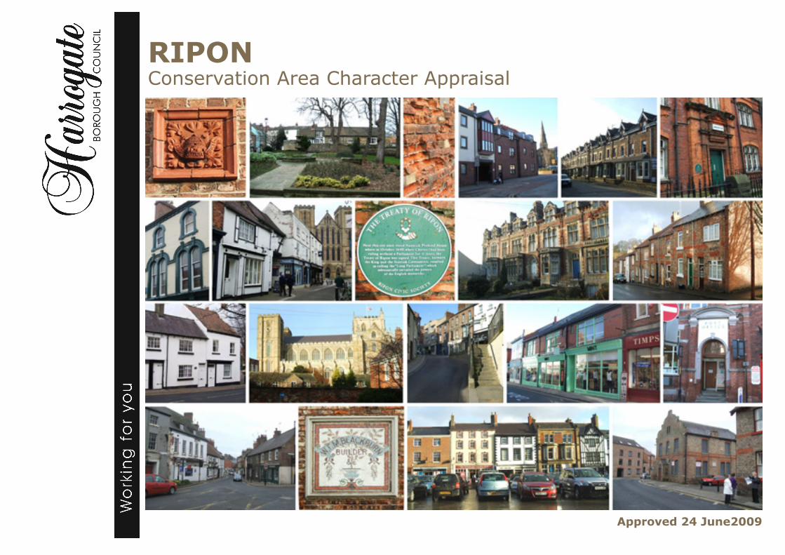
RIPONConservation Area Character Appraisal
Approved 24 June2009

p. 68 Ripon Conservation Area Character Appraisal - Approved 24 June 2009
Contents Page
1. Introduction.................................................................................................................... 1
Objectives ........................................................................................................................ 2
2. Planning policy framework ............................................................................................ 2
3 Historic development & archaeology............................................................................. 3
4 Location & landscape setting ........................................................................................ 5
5. The form & character of buildings ................................................................................. 7
6. Character area analysis ............................................................................................. 10
Map 1: Historic development ........................................................................................... 40
Map 2: Conservation Area boundary .............................................................................. 41
Maps 3a-3f: Analysis & concepts ................................................................................ 42-47
Maps 4a-4f: Landscape analysis ................................................................................ 48-53
Appendix A:
1 Management strategy.................................................................................................. 54
2 Monitoring & review..................................................................................................... 54
3 Maintaining quality ...................................................................................................... 54
4 Conservation Area boundary review ........................................................................... 54
5 The management of change ....................................................................................... 55
6 Opportunities for enhancement .................................................................................. 55
Checklist to manage change ........................................................................................ 60
Appendix B: Public consultation ..................................................................................... 61
Appendix C: Listed buildings within Ripon Conservation Area ...................................... 62
Appendix D: Further reading .......................................................................................... 64
This and other Planning documents are or will be made available in large copy print, audiocassette, Braille or languages other than English.If you require the document in one of these formats, please contact us (tel. 01423 556586 or email [email protected] )
p. 1Ripon Conservation Area Character Appraisal - Approved 24 June 2009
1 Introduction
1.1 Conservation Area Appraisals aim to define and analyse the special interest which con-stitutes the character and appearance of a place. It is these qualities which warrant the designation of a Conservation Area. This Appraisal has been approved by Harrogate Borough Council and forms an “evidence base” for the Local Development Framework (LDF). Consequently, it will be a material consideration when determining applications for development, considering planning appeals or proposing works for the preservation or enhancement of the area. It can also form the basis for a subsequent Management Strategy, which will contain proposals and policies for the conservation and enhancement of the area.
1.2 The Appraisal provides information and guidance to those wishing to carry out works in the Conservation Area whether or not they require planning approval.So, it is a useful source of information for property owners, agents, applicants and members of the public who live or work in the City of Ripon.
1.3 The main function of the Conservation Area Appraisal is to ensure that any works in the Conservation Area have regard to the special qualities of the area and to devise a strategy to protect these qualities. The Appraisal will help us understand the impact that development proposals would have on the Conservation Area and whether these are acceptable or appropriate.
1.4 The assessment of the area’s special architectural or historic interest is based on a careful and objective analysis of the area - as recommended by English Heritage in their “Guidance on Conservation Area Appraisals”.
1.5 Various qualities are looked at including: historical development, building materials, and relationships between built and open spaces. Although this Appraisal aims to be comprehensive the omission of any particular building, feature or space should not be taken to imply that it is of no interest.
1.6 Ripon Conservation Area was originally designated on 13 March 1969, andextended on 17 March 1976, 22 March 1990 and 1 September 1994. Following public consultation on the Draft Conser-vation Area Appraisal, the boundary was amended further (with effect from the date of approval of this document). This Appraisal aims to describe Ripon as it is today and identify the special character and distinctiveness of its setting, buildings and open spaces. Having identified those special qualities, the Appraisal will examine whether opportunities exist to protect and enhance its character.
1.7 By identifying what makes Ripon special or distinctive it is suggested that any future change, whether to individual buildings, building groups or the City as a whole, will be based on this understanding of the past and present character of the place.In this way we can manage future change to ensure it makes a positive contribution towards preserving or enhancing its special character.

p. 2 Ripon Conservation Area Character Appraisal - Approved 24 June 2009
The principal objectives of the Appraisal are:
to define and record the special character and interest of Ripon;
to raise public awareness of the aims and objectives of the conservation area designation and stimulate their involvement in the protection of its character;
to identify what is worthy of preservation to aid understanding;
to assess the action that may be necessary to safeguard this special interest
to identify opportunities for enhancement.
Objectives2 Planning policy framework
2.1 Local authorities have a duty to designate ‘areas of special architectural or historic interest, the character or appearance of which it is desirable to preserve or enhance’ as conservation areas under Section 69 of the Planning (Listed Buildings and Conservation Areas) Act 1990. The same Act also requires local planning authorities to review conservation areas periodically.
2.2 Government guidance on all development affecting conservation areas is set out in Planning Policy Guidance Note 15: Planning and the Historic Environment (PPG15). This advises local authorities to define the elements that make the special character or appearance of conservation areas in order to provide a sound basis on which to develop local planning policies, preservation or enhancement strategies and to make development control decisions.
2.3 In determining planning applications for development within conservation areas and applications for conservation area consent, the Council will give considerable weight to the content of conservation area character appraisals. The consideration
of proposals in accordance with these appraisals will be an important factor in deciding whether a proposal has an adverse impact on the character and appearance of the Conservation Area and, therefore, whether it is contrary to saved Local Plan Policy HD3, which is the key policy for the control of development in conservation areas. The scope of Policy HD3 also covers development proposals outside conservation areas which would affect their setting or views into or out of the area.
2.4 Involving the community and raising public awareness is an integral part of the Appraisal process and needs to be approached in a pro-active and innovative way. Community involvement helps to bring valuable public understanding and ‘ownership’ to proposals for the area. A report included in the appendix details how the local community has been involved and the contribution it has made to this Appraisal.

p. 3Ripon Conservation Area Character Appraisal - Approved 24 June 2009
3 Historic development & archaeology
3.1 There is fragmentary evidence of early settlement in the Ripon area, as shown by the discovery of an Iron Age sword in 1994, and a Roman sculpted plaque.
3.2 The name “Ripon” derives from the Old English “Hrype”, the Anglian tribe who first settled in the area. It has been known at various times as “Hrypis, Hripis, Inhrypum, Hrypsaetna, Onhripum, Rypurn, Ripun and Rippon.
3.3 The Hrype probably reached the Ripon area sometime in the sixth century AD, advancing up the River Ure and founding a settlement near its junction with the Skell. The early history of Ripon is almost entirely ecclesiastical and little is known about its secular origins.
3.4 The seventh century chroniclers describe how a Celtic monastery built around AD 660, (at one time housing St Cuthbert) was soon replaced by Abbot Wilfrid’s Bene-dictine Monastery, just north or north west of the present Cathedral. Wilfrid established a school and built a prestig-ious stone church which was dedicated in AD 672. Wilfrid’s career put Ripon on the map, and he was buried in Ripon in AD 709.
3.5 In AD 926, King Athelstan established the Liberty of St Wilfrid (a Liberty is an area free from Royal jurisdiction, and often under the control of an archbishop), as a place of refuge for fugitives. Around AD 950, Wilfrid’s church and monastery were destroyed following a Danish rebellion, the church being restored or rebuilt by AD 995, when it briefly housed the much travelled remains of St Cuthbert.
3.6 By the mid eleventh century, the monastery had gone, replaced by a collegiate church of canons controlled by the archbishops of York who periodically rebuilt the great minster church over the next 500 years as the centrepiece of their Liberty of Ripon.
3.7 The earliest focus of settlement in Ripon appears to lie within an ecclesiastical precinct extending east from the Cathedral to Priest Lane and south to Ailcy Hill and the River Skell. This precinct was reduced in size, and encompassed within a new street layout of the late twelfth and early thirteenth centuries.
3.8 By 1129, a market and a four day fair were established by Bishop Thurstan, the Market Place being believed to be located at the present Old Market Place. The Old Market Place may have extended to Allhallowsgate and was later infilled by buildings.
3.9 The first reference to the present day Market Place is in 1281, as “Le Merket-stede”. It appears to have been laid out obliquely across an earlier route from Kirkgate to Horsefair (the present North Street), following a curving ridge of high ground to the River Ure.
3.10 Market Place, St Marygate, Stonebridge-gate and perhaps The Stone Bridge may all have been laid out as a twelfth or early thirteenth century reorganisation of the City’s layout.
3.11 The town developed rapidly in the early fourteenth century, with burgages ( a unit of land tenure in a borough) being first recorded in Westgate in 1307, and properties being recorded in Blossomgate
Ripon Cathedral
The Market Place

p. 4 Ripon Conservation Area Character Appraisal - Approved 24 June 2009
©C
row
n C
opyr
ight
. All
Rig
hts
Res
erve
d H
arro
gate
Bor
ough
Cou
ncil
1000
196
28 2
009.
in 1315. By 1320, the City extended beyond Skellgate across the Skell into Barefoot Street, while Bondgate, lying outside of the Borough appears in the medieval period as a settlement of bonded labourers, the Archbishop of York’s agricultural tenants.
3.12 The Archbishop’s Borough flourished with a substantial income from markets, fairs, burgage rents and tolls. The City profited from cloth making, using wool from Fountains Abbey (founded 1132), and by the early fourteenth century, this was the main trade of Ripon. However, by the 1530s, John Leland noted of the cloth trade that “Idleness is sore increased in the town and cloth making almost decayed”.
3.13 Signs of a revival of the City came in 1604 with the two charters of James I, one re-endowing the collegiate church, and one
uniting the office of Wakeman with that of Mayor. The beneficial links between Ripon and Fountains Abbey, severed by the Reformation, were renewed in the eighteenth century with the Abbey’s successor, Studley Royal.
3.14 In 1702, John Aislabie of Studley Royal commissioned Nicholas Hawksmoor to build in the Market Place what is now the oldest monumental obelisk in Great Britain. Aislabie’s grand-daughter, Mrs Elizabeth Allanson, built to the designs of James Wyatt, the Town Hall to serve both as a meeting place for the Corporation and also as an assembly room. A theatre was also built on the corner of Park Street, and Ripon became a social focus for the surrounding gentry.
3.15 The Ripon Canal (opened in 1773) linked the City to the navigable River Ure/Ouse and contributed to its prosperity, as did the arrival of the Leeds and Thirsk Railway in 1848. Industry clustered at or near the canal basin, including sawmills, breweries and the varnish works. Other industries included tanning and fell mongering, bobbin making, wood turning and flax and corn milling.
3.16 During the nineteenth century, the popul-ation of Ripon increased from about 3000 to about 8000. Crowded courts of houses filled out the former burgage lands of the medieval City centre, while imposing villas and terraces spread north and south of the centre. A separate suburb developed at Ure Bank near the railway station.
3.17 The centre of the City was changed radic-ally by various street widenings which improved traffic flow but also removed
much of Ripon’s late medieval appearance. Efforts were made in the early 1800s to improve Bedern Bank. However, it was the improvements to Middle Street in 1870 which heralded a major programme of street widening from 1878 to 1880 when North Street, Kirkgate and Bedern Bank were widened. Minster Road was formed in 1884, and around 1900 Fishergate was widened and Middle Street and Queen Street merged into one wide street with the demolition of the intervening properties.
3.18 The closure of the railway in the 1960s was accompanied by a great increase in road traffic with which the narrow and tortuous medieval road network of Ripon was ill-equipped to cope. The City was fortunate to escape the comprehensive redevelopment which befell many towns in the 1960s. However, traffic noise, dirt and vibration led to a deterioration of many properties in the City centre and it was only following the removal of much through traffic with the opening of the bypass in 1996 that sustained environmental improvements and building repairs were tackled.
The obelisk in the Market Place was designed by Nicholas Hawksmoor

p. 5Ripon Conservation Area Character Appraisal - Approved 24 June 2009
4 Location & landscape setting
4.1 The City of Ripon lies 10 miles north of Harrogate and 4 miles west of the A1. It stands on an outcrop of Permian rocks running north-south from the Darlington area towards Wetherby. These rocks dip eastwards and comprise a succession of Magnesian limestones, marls, gypsum and sandstones. A deposit of Sherwood sandstone underlies the flatter vale to the east. Overlying this solid geology is a series of glacially-deposited sands and gravels forming a number of mounds and ridges which characterise the rolling landscape fringing the City. Surface pits and hollows evident on the City fringes are the result of gypsum dissolution underground and land instability is a development constraint here.
4.2 The historic core of the City containing the Cathedral, stands on one of these ridges above the Rivers Skell and Ure which meet just east of the City. The modern City has spilled out beyond its historic limits, especially to the north, north west and south west, the River Ure and the bypass providing a barrier to eastwards expansion.
4.3 East of the City, the landscape is open and slightly undulating with large scale arable fields with few hedges and little woodland cover. However, the landscape becomes more rolling around the villages of Sharow, Copt Hewick and Bridge Hewick, with smaller fields, the remnants of medieval enclosure. These villages are heavily wooded and enclosed but distant views of the Cathedral can still be had.
4.4 West of Ripon, the countryside becomes more rolling and undulating, with more grassland often in small hedged fields, the relic of early enclosure. Field amalgam-ation has lead to the loss of hedges and a more open landscape.
4.5 From the west, views of Ripon Cathedral can be had, most notably from the park at Studley Royal, where the main avenue to the Church of St Mary is aligned on the Cathedral some miles to the east. Studley Royal is a notable designed landscape of the eighteenth century which overlies the older monastic site of Fountains Abbey.
4.7 Within the City are a variety of landscapes and cityscapes of differing character. The Cathedral stands in what was part of a larger ecclesiastical precinct extending as far east as Priest Lane and south to High St Agnesgate. This area is characterised by large houses in extensive grounds with mature trees, and bounded by high walls.Open gardens and paddocks to the north of the Old Deanery have been displaced by modern car parks, fringed by tree planting to soften the impact.
The Cathedral, prominent in the roofscape, seen from Spa Gardens.
4.6 The rivers which skirt historic Ripon and run through the modern City are an important element in the landscape setting of the City. The River Ure cuts a shallow valley east of the City, through a well wooded landscape with views to the Cathedral. The River Skell runs just south of the historic centre of the City, parallel to the Ripon Canal, before joining the Ure to the east. West of Ripon, the Skell is joined by the River Laver, and these two shallow river valleys shrouded in woodland define the limits of the City to the southwest.
4.8 The planted medieval Market Place with its accompanying rear burgage plots form a distinctive cityscape, with little in the way of tree planting and landscaping. Much, but not all of this burgage pattern, defined by brick walls, has now been lost to redev-elopment. The streets of the medieval City descend down High Skellgate and Duck Hill towards the river, where smaller houses and cottages were concentrated, and across the river into Bondgate, a medieval suburb that has been mostly redeveloped.
High St Agnesgate

p. 6 Ripon Conservation Area Character Appraisal - Approved 24 June 2009
4.9 Mid to late nineteenth century terraces of houses are scattered around the fringes of the historic core. These “Bylaw” houses are usually built on the pavement edge, with small rear yards and no gardens.By contrast, the superior Victorian housing of larger terraced houses with small front gardens enclosed by walls and railings and larger rear gardens is found to the north of the historic core at Princess Road, Magdalens Road and Ure Bank
4.10 The largest Victorian villas are found at The Crescent, and face onto a well-treed open space enclosed by a wall and gateway. The nearby Princess Terrace and North Parade are almost as impressive, with their trees and front gardens, giving way to a more open pattern of villas and houses set in well-landscaped gardens.
Allhallowgate
4.11 During the twentieth century, the City expanded out into new suburbs of mostly semi detached two storey housing, with front gardens and small back gardens, enclosed by fences or hedges. Fewer gardens have trees, but roadside tree planting and the planting of trees on
High Skellgate
Crescent Parade
Palace Road
odd corners of open space compensates for this.
4.12 Ripon’s medieval industries, such as mill-ing and tanning, clustered near the Skell in Water Skellgate and Skellgate and across the river in Bondgate. With the opening of the Canal in 1773, a further industrial area developed around the canal basin with coal and timber yards and warehouses.This industrial area has spread southwards beyond Dallamires Lane and to the bypass, creating an anonymous twentieth century landscape of large sheds, storage areas and yards with little in the way of effective tree planting or landscaping.
p. 7Ripon Conservation Area Character Appraisal - Approved 24 June 2009
5. The form & character of buildings
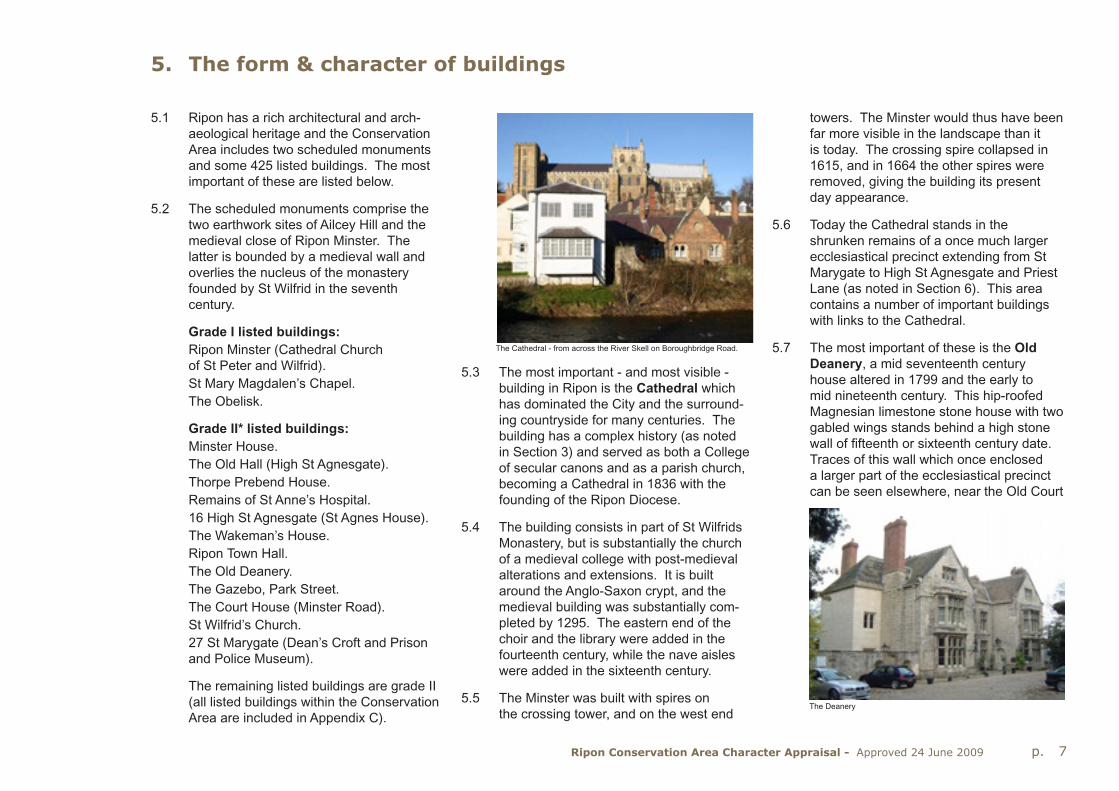
5.1 Ripon has a rich architectural and arch-aeological heritage and the Conservation Area includes two scheduled monuments and some 425 listed buildings. The most important of these are listed below.
5.2 The scheduled monuments comprise the two earthwork sites of Ailcey Hill and the medieval close of Ripon Minster. The latter is bounded by a medieval wall and overlies the nucleus of the monastery founded by St Wilfrid in the seventh century.
Grade I listed buildings:Ripon Minster (Cathedral Church of St Peter and Wilfrid).St Mary Magdalen’s Chapel.The Obelisk.
Grade II* listed buildings:Minster House.The Old Hall (High St Agnesgate).Thorpe Prebend House.Remains of St Anne’s Hospital.16 High St Agnesgate (St Agnes House).The Wakeman’s House.Ripon Town Hall.The Old Deanery.The Gazebo, Park Street.The Court House (Minster Road).St Wilfrid’s Church.27 St Marygate (Dean’s Croft and Prison and Police Museum).
The remaining listed buildings are grade II (all listed buildings within the Conservation Area are included in Appendix C).
5.3 The most important - and most visible - building in Ripon is the Cathedral which has dominated the City and the surround-ing countryside for many centuries. The building has a complex history (as noted in Section 3) and served as both a College of secular canons and as a parish church, becoming a Cathedral in 1836 with the founding of the Ripon Diocese.
5.4 The building consists in part of St Wilfrids Monastery, but is substantially the church of a medieval college with post-medieval alterations and extensions. It is built around the Anglo-Saxon crypt, and the medieval building was substantially com-pleted by 1295. The eastern end of the choir and the library were added in the fourteenth century, while the nave aisles were added in the sixteenth century.
5.5 The Minster was built with spires on the crossing tower, and on the west end
towers. The Minster would thus have been far more visible in the landscape than it is today. The crossing spire collapsed in 1615, and in 1664 the other spires were removed, giving the building its present day appearance.
5.6 Today the Cathedral stands in the shrunken remains of a once much larger ecclesiastical precinct extending from St Marygate to High St Agnesgate and Priest Lane (as noted in Section 6). This area contains a number of important buildings with links to the Cathedral.
5.7 The most important of these is the OldDeanery, a mid seventeenth century house altered in 1799 and the early to mid nineteenth century. This hip-roofed Magnesian limestone stone house with two gabled wings stands behind a high stone wall of fifteenth or sixteenth century date. Traces of this wall which once enclosed a larger part of the ecclesiastical precinct can be seen elsewhere, near the Old Court
The Cathedral - from across the River Skell on Boroughbridge Road.
The Deanery

p. 8 Ripon Conservation Area Character Appraisal - Approved 24 June 2009
House and in St Marygate (Abbot Huby’s Wall), forming a significant feature in the Conservation Area.
5.8 South of the Cathedral stands MinsterHouse, a substantial early eighteenth century brick house on or near the site of the Bedern, the domestic accommodation of the college of vicars. The south front onto the garden has a hipped roof behind a brick parapet, with stone quoins and a sill band, with stone architraves to all windows. The north elevation facing Bedern Bank is much plainer. The entrance to Minster House is defined by two sandstone gate piers with moulded cornices, ball finials and a cast iron overthrow.
5.9 The last of this group of ecclesiastical buildings near the Cathedral is The Old Court House. This low stone building with a timber-framed first floor extension is probably medieval, but of uncertain date. It is aligned gable end onto the road and lies behind a high stone wall.The Old Courthouse was probably built as the Court House of the Archbishop of York’s Liberty of Ripon. In the eighteenth century, it became the Liberty Gaol and may have become the Debtors’ Prison in the nineteenth century. It is now a private house.
5.10 Opposite stands the Court House built in 1830, and noteworthy as retaining its original courtroom fittings.
5.11 Three buildings stand out in the Market Place, the oldest being The Wakeman’s House at the southwest corner. This sixteenth or seventeenth century timber-
framed building with a steeply pitched stone slate roof was the home of Hugh Ripley, the first Mayor of Ripon. It is one of very few visibly timber-framed buildings in the Market Place.
5.12 Visible from many points around the City, the 25 metre Obelisk at the centre of the Market Place was designed by Nicholas Hawksmoor in 1702. The obelisk is topped by a wrought iron weathervane in the form of the Wakeman’s Horn, the symbol of Ripon. Opposite, on the south side of the Market Place, stands the stuccoed Town Hall, designed by James Wyatt in 1799, and presenting a classical front of ionic columns and pediment to the Market Place.
5.13 There are a number of other listed buildings worthy of note, and these are described in the Character Area Analysis in Section 6.
5.14 There are also unlisted historic buildings, which make a positive contribution to the character and appearance of the Conserv-ation Area and are of particular interest
locally. These buildings were identified during the public consultation and are recorded on the Concept Map. There is a general presumption that buildings of local interest within the Conservation Area will be protected from demolition and the Borough Council will be especially vigilant when considering applications for alteration or extension.
General form of buildings5.15 The City centre is characterised by mostly
two and three storey buildings, mainly of brick, built from the seventeenth to the twentieth centuries along the medieval street frontages. Many buildings in the historic core were refronted in the eight-
The Court House
eenth or nineteenth century, and in some cases realigned with former gable end onto the street buildings rebuilt parallel to the street.
5.16 The pattern of narrow burgage plots in the centre can still be read with brick outbuildings aligned along them, although much of this plotland pattern has become fragmented or lost in recent decades.
Westgate

p. 9Ripon Conservation Area Character Appraisal - Approved 24 June 2009
5.17 Georgian houses tend to be scattered within the historic core, about the Market Place, and in scattered short terraces around the fringes of the historic core.There are clusters of mid to late eight-eenth century buildings in Bondgate Green and Canal Road, including the canal warehouse of 1770-3, and a group of late eighteenth to early nineteenth century houses in Park Street, but there is no clearly defined Georgian quarter in Ripon.
5.18 Nineteenth century housing, of high and low status, is predominantly in terraced form with large terraces and close spaced houses to the north of the historic centre, at Palace Road, North Road and The Crescent. These elaborately detailed houses are set back from the road behind walled and railed front gardens.
5.19 By contrast, the more modest terraces such as Victoria Grove, Rayner Street and Brewster Terrace are more closely packed, and lacking any front gardens. These groups of houses are mostly found on the fringes of the Conservation Area, beyond the boundaries of which lie the varied residential developments of the twentieth century, mainly in the form of two storey brick houses.
Materials5.20 Historically, Ripon would have been a
city of timber-framed buildings. About two dozen surviving timber-framed buildings are known to exist in the City centre and there are probably others hidden behind later facades. Many of these timber-framed buildings, dating from the fifteenth to the seventeenth centuries, have been rebuilt and altered and often have eighteenth or nineteenth century brick fronts and shopfronts.
5.21 Brick buildings of pre-seventeenth century date appear to be absent, the earliest dated brick building being No. 16 High Saint Agnesgate of 1693. Other important early brick buildings are Thorpe Prebend House (mid seventeenth century), Nos. 17-18 Market Place (late seventeenth century), and Minster House of 1733.Brick became the dominant local building material from the seventeenth century, and is used to good effect on many of the nineteenth century terraces, which display the use of contrasting brick colours for banding and window heads, often with decorative terra cotta panels or keystones.
5.22 Clay pantiles or their modern concrete successors are the normal roofing material, with some buildings roofed in stone slates. Most of the nineteenth century buildings are roofed in Welsh slate, although Boroughbridge (Roman) tiles are used in places.
5.23 Stone tends to be reserved for higher status buildings and, in Ripon, the local stone is mainly Magnesian limestone.The Cathedral is the largest and most significant stone building with its boundary
Westbourne Grove
walls also of Magnesian limestone.Other important early stone buildings include the ruined Chapel of St Anne’s Hospital and the more complete Hospital of St Mary Magdalene, also built of Magnesian limestone and dating from the twelfth century. The largest stone house is the Old Deanery, dating to the mid seventeenth century, and built of limestone ashlar with ashlared boundary walls.
5.24 Cobbles are used for rear garden walls and for smaller buildings, cottages and outbuildings. A few cottages are rendered and painted. These are usually built of cobble or poor quality brick and problems with damp internal walls have resulted in them being rendered and painted.
Thorpe Prebend House
Cobble, stone and brick at High St Agnesgate

p. 10 Ripon Conservation Area Character Appraisal - Approved 24 June 2009
6. Character area analysis
6.1 This chapter looks at the Conservation Area in more detail by defining a number of distinct sub-areas. Each of these has its own character and together they provide the unique “sense of place” of Ripon:
A: The Cathedral precinct & the early settlement
B: The medieval City around the Mar-ket Place with High St Agnesgate
C: River Skell west; Riverside; Bondgate; Waterside; The Canal
D: Victorian Suburbs: The Crescent and Villas; Princess Road; Ure Bank; RC Church and terraces; South Crescent.
E: The Spa
A: The Cathedral precinct & the early settlement
6.2 The Cathedral of St Peter and St Wilfrid occupies a prominent, elevated position in the centre of Ripon and stands within a precinct partly enclosed by high limestone and brick walls on its south and west sides. These walls skirt Bedern Bank which drops sharply to the river, and is bounded on its east side by a tall stone wall behind which stands Minster House (1733), glimpsed between elaborate gate piers.
6.3 High walls continue along High St Agnes-gate before turning north along Minster Close, enclosing large private gardens and restricting views of the Cathedral; however, a good view of the south aspect can be had from Thorpe Prebend House.
6.4 Views along Minster Close are contained by walls and buildings to each side, but a doorway through the wall leads up steps (below) to reveal the south elevation of the Cathedral in all its Gothic splendour.
6.5 High St Agnesgate joins Low St Agnesgate which climbs north before curving between high brick and stone walls to Minster Road. Views of the Cathedral’s east end can be had from the south east, through the trees.
6.6 Minster Road was formed in 1884, replac-ing a narrow footpath. Until then, a wall and buildings restricted access from Kirk-gate to the Cathedral. The west towers of the Cathedral loom over the brick buildings at the end of Kirkgate in a dramatic manner.
6.7 North of Minster Road, fragmentary stone walls enclose the important scheduled archaeological site containing the buried remains of St Wilfrid’s Monastery and the Lady Kirk. The high stone boundary wall
©C
row
n C
opyr
ight
. All
Rig
hts
Res
erve
d H
arro
gate
Bor
ough
Cou
ncil
1000
196
28 2
009.

p. 11Ripon Conservation Area Character Appraisal - Approved 24 June 2009
continues along St Marygate to end at a group of seventeenth or eighteenth century cottages, the start of the medieval City.
6.8 High brick walls define the east side of St Marygate, and brick and cobble walls define the curving Residence Lane with its many trees. Trees also cover the enig-matic Ailcey Hill from which burials of the sixth and seventh centuries have been excavated. Ailcey Hill is a natural glacial feature from which views of the Cathedral can be had, and one which may have been modified in the modern period to provide a viewpoint or belvedere.
(a) Form & character of buildings General form6.9 This character area is defined by open
spaces containing prestigious buildings, most notably the Cathedral which dominates the City. All buildings are detached, often in extensive well-wooded gardens contained by high stone or brick walls. There are too few buildings of different style and materials to ascribe any general form to, other than to note that hipped roofs are used for the larger listed buildings. The modern houses fringing this character area, and mostly concealed behind high walls, are gabled detached properties.
Materials6.10 The oldest, highest status buildings in this
character area tend to be of Magnesian limestone or sandstone, with brick used for Minster House and the Old Hall, and for the modern houses at Old Deanery Close and Cathedral Close. No single roofing material dominates, with Welsh slate, stone slate and pantiles all used.The Old Court House has visible timber-framing at its south end.
Roof Details6.11 The larger, higher status houses of this
area tend to have hipped roofs. The hipped roof at Minster House is partly hidden by a brick parapet. Other houses are gabled, with plain verges.
Windows6.12 Vertical sliding sash windows are
generally used for the larger houses in this area, with casement windows, often in PVCu, on the modern houses. Old Deanery Cottage has modern timber casement windows.
(b) Listed Buildings6.13 There are seven listed buildings in the
Cathedral precinct character area. The first four, the major buildings of the area, have already been described and all have functional links with the Cathedral.They are:
Ripon Minster (Cathedral Church of Saint Peter and Wilfrid) Grade I
The Old Deanery, Minster Road Grade II*
The Old Courthouse, Minster Road Grade II
Minster House, Bedern Bank Grade II*
6.14 The other listed buildings are:
Old Hall, High St Agnesgate (Grade II*)This brick built gabled house dated 1738 is notable for its high quality internal plasterwork and staircase. It stands gable end onto the street, forming a narrow pinchpoint between itself and Thorpe Prebend House. The Old Hall is largely hidden behind high brick walls, but makes some contribution to the character and appearance of the Conservation Area.
The Court House (Grade II*) This single storey building of dressed limestone with ashlar dressings stands set back from the road behind a small well-treed park.It is notable because it retains its original interior of 1830, including the courtroom and all its contemporary fittings. The building, with its hipped slate roof, resembles a non conformist chapel.
Coach House to Minster House (Grade II) This late eighteenth century building comprises a single storey coach house flanked at each side by two storey pavilions topped with pyramidal slate roofs. The garden side of the building is lit by lunette windows, but the side abutting Bedern Bank presents a tall, windowless elevation to the street.
Coach House to Minster House

p. 12 Ripon Conservation Area Character Appraisal - Approved 24 June 2009
The walls in Bedern Bank, Low St Agnes-gate, Minster Road and St Marygate are listed features.
Long stretches of the high stone, cobble and brick walls surrounding the Cathedral are listed. The oldest and most substant-ial section of wall is Abbot Huby’s wall in St Marygate, built around 1505. This wall is built of coursed rubble and ashlar, and is pierced by an arched gateway to the modern red brick bungalows in Old Deanery Close. The wall is high enough to screen these from public view, but not so high as to obscure views of the Cathedral.
A stretch of wall of similar detail fronts the Old Deanery in Minster Road.
The high wall of coursed limestone blocks along Bedern Bank changes to a well-weathered brick wall in High St Agnesgate. These walls date from around 1720-30, and pre-date the coach house at Minster House which sits on top of them.
A further stretch of coursed limestone wall of eighteenth century date defines the eastern edge of the Cathedral precint along Minster Road and Low Saint Agnes-gate, while a final length of listed wall bounds The Old Court House garden. This is reputedly nineteenth century, but is possibly older, and it incorporates various medieval fragments including a fine pointed doorway (below).
(c) Important unlisted buildings6.15 There are unlisted buildings which make a
positive contribution to the character of the Conservation Area in this character area.
6.16 Unusually, most of the older buildings in this sub- area are listed. There are only three unlisted buildings which are of particular interest locally and which are shown on the map:
Cathedral Hall, Minster Close.This single storey rendered building with stone window surrounds and a plain tiled roof was built in 1923 to replace the fire damaged former school buildings. Behind is an attached single storey brick and slate roofed building. These buildings stand on the site of the medieval school, which became the Grammar School in 1555 and was transferred to Bishopton in 1874.
Boiler House, Minster Close.Between these buildings and the Cathedral precinct wall is the orange brick boiler house with a swept gable end facing Minster Court and with a brick chimney at the rear, capped off with a pyramidal pantiled roof. (These buildings and the Cathedral Hall frame the main southern approach to the Cathedral.)
Old Deanery Cottage and outbuildings, St Marygate.This orange brick cottage and detached outbuildings with pantiled roofs peep over the high boundary wall of the Old Deanery, with the Cathedral in the background. The cottage has been extended and altered with modern casement windows, but provides a vernacular counterpoint to the larger higher status buildings of the area.
(d) Landmark buildings6.17 The Cathedral forms the centrepiece
of this character area, and provides a prominent landmark, visible from many parts of the City and surrounding countryside. The other buildings within this character area are largely concealed behind high walls, and do not appear as landmarks.
(e) Buildings in need of significant repair or enhancement
6.18 Old Deanery Cottage and outbuildings are in need of some repair and enhancement.The outbuildings require work to the upper parts of the walls around wallplate level, while the altered cottage windows could be reinstated to traditional Yorkshire sliding sash windows.
Bedern Bank

p. 13Ripon Conservation Area Character Appraisal - Approved 24 June 2009
6.19 Abbot Huby’s wall and the brick wall along the east side of St Marygate are both in need of repointing. The walls to the north west of the Old Court House near the rear of Sainsbury’s need repair and repointing.
6.20 The high brick wall bounding Old Hall along High St Agnesgate contains a large number of badly weathered bricks that are in need of replacement.
(f) Landscape character & features6.21 The Cathedral stands on an elevated spur
of land which drops steeply to the east and south. A large number of mature trees clothe the slopes to the south of the Cathedral and are a feature of the large gardens of this area.
6.22 Two hundred metres to the east is the tree covered glacial mound of Ailcey Hill. There is documentary evidence that this hill was landscaped around 1825-50, with a path-way spiralling to a seat on the summit whence a prospect of the Cathedral and the City could be enjoyed. Few, if any, traces of this landscaping survive and the hill is now covered with trees and undergrowth.
(g) Hard spaces in need of repair or enhancement
6.23 The car park at the Old Deanery is in need of sensitive resurfacing.
6.24 The car park to the rear of Cathedral Hall off High St Agnesgate is a visible intrusion in the landscaped setting of the Cathedral, and ideally should be relocated perhaps along the north side of High St Agnesgate.
(h) Green spaces in need of repair or enhancement
6.25 The nineteenth century graveyard to the east of the Cathedral is a neglected area, with tumbled gravestones overgrown with brambles. This area is in clear need of enhancement, as in its present condition, it detracts from the Cathedral’s setting.
6.26 The small landscaped area between the Court House and the Cathedral is crossed by several asphalt paths, and some informal trodden muddy tracks which need to be properly surfaced.
(i) Spaces and materials between & around buildings.
6.27 High stone and brick boundary walls define the large gardens and the Cathedral pre-cinct, and are a notable feature of this sub-area. Buildings mostly stand in extensive grounds, well separated from each other, and are generally only partially visible from public viewpoints.
6.28 The open space at the west end of the Cathedral was repaved some years ago, and Minster Road narrowed to restrain vehicle movements. However, through traffic still uses Minster Close, and it is felt that the setting of the grade I Cathedral, would be greatly improved if Minster Close could be closed to this traffic.
6.29 Minster Close is laid with York stone paving with cobbles to each side, and forms an attractive approach to the Cathedral from the south. The paving and cobbles are continued up towards the south door of the Cathedral, but other footpaths through its precinct are laid in asphalt.
B: The medieval City around the Market Place
6.30 The medieval City lay to the west of the Cathedral and is centred around the Market Place, a large rectangular open space laid out on the bluff above the river, and surrounded by buildings of seventeenth to twentieth century date. It covers an area of about 700 x 700 metres north of the River Skell with the Cathedral and its associated buildings forming a more open enclave at the south east corner.
6.31 The original market, the Old Market, established by Bishop Thurstan by 1129 lay to the north of the present Market Place, which was first recorded in 1281. The present Market Place appears to be part of a deliberate piece of medieval town planning, and is laid out obliquely across an earlier route from Kirkgate to Horsefair (North Street).
6.32 The medieval street pattern still remains, radiating from the Market Place with North Street, Fishergate and Finkle Street entering from the north, Kirkgate to the east and Westgate leading to Bloss-omgate and Park Street to the west.
6.33 High Skellgate and Duck Hill descend steeply to Water Skellgate and the River Skell. This was the main industrial area of medieval Ripon, containing the important mill leat which served three mills in this area as well as tanneries for the leather trade.
6.34 While the medieval street pattern still exists, the late nineteenth century street widenings removed much of the medieval

p. 14 Ripon Conservation Area Character Appraisal - Approved 24 June 2009
Market Place6.36 Continuous frontages of mostly two and
three storey buildings frame the rectang-ular Market Place. Many of these buildings are listed, but the effect of nineteenth century re-frontings and later rebuilding has reduced the immediate architectural interest of the Market Place.
6.37 The west side presents a mixture of early twentieth century rebuildings in red pressed brick, a retail redevelopment in orange brick of 1977 in neo-vernacular style and some seventeenth century timber-framed buildings behind nineteenth century timbered facades. The long rear plotlands shown on earlier maps now survive only in a very truncated form.
6.38 On the north side No. 20 (listed building) presents a pressed brick gable elevation onto Fishergate, a result of late nineteenth century road widening. The most interest-ing building on this north side of Market Place is the hip roofed No. 17, a late seventeenth century brick building. This block of buildings fills the space north to
6.39 Most of the east side of Market Place is of three storey listed buildings, notably the Unicorn Hotel and the early twentieth century classical stone bank at the corner with Kirkgate.
6.40 The plotland pattern to the rear has been largely eroded by late twentieth century retail expansion, and the construction of Moss Arcade and the recent bus station.
6.41 The car parks are laid out over former fields, bounded to the south by the ancient stone walls of the ecclesiastical precinct which survive as a visible feature.
6.42 The south side of the Market Place contains the most significant buildings in the whole square - The Town Hall and the Wakeman’s House.
6.43 Next to the Town Hall stands one of the few overtly modern buildings in the Market Place, Nos. 39-40 (NatWest Bank). This is a three storey steel framed building with stone clad frame and infill panels of green slate or marble, arranged in nine bays with three shop windows framed with stone pilasters and fascias on the ground floor. This building has an uneasy relationship with its neighbours, sandwiched between the bold classicism of the Town Hall and the more restrained classicism of the Dragon Inn (No. 41), brick built, gable to the square, with an attic Diocletian window. The rear gardens and yards fall sharply to Water Skellgate, where gaps in the street frontage allow views of this chaotic jumble of yards and brick buildings.
Fishergate & North Street6.44 Following the widening of Fishergate in
the late nineteenth century, the whole east side between the Market Place and Old
character of the City centre, causing older buildings to be replaced with pressed red brick modern work. Westgate and High and Low Skellgate, where older pre-twentieth century two and three storey buildings crowd in along these narrow streets, give the best impression of how the widened streets must have looked previously.
6.35 In order to understand the character of the medieval City, it is necessary to look at the individual streets in some detail, beginning with the Market Place, then describing streets in a clockwise manner starting from North Street.
Fishergate towards the start of North Street, off the Market Place
Market Place, west side
Old Market Place; the entire frontage of this block to Fishergate was rebuilt after 1900 in red pressed brick.
The Town Hall, Market Place

p. 15Ripon Conservation Area Character Appraisal - Approved 24 June 2009
Market Place was rebuilt on a new setback alignment on a plot by plot basis soon after 1900. There are variations in height and detailing, with some buildings gable end to the street.
6.45 No. 11 Fishergate is noteworthy, being a two storey iron-framed building which is almost fully glazed on both floors. The neighbouring property to the north is built gable end onto the street, and is dated 1902. It retains its original well-detailed shopfront.
6.46 This group of early twentieth century buildings is terminated by the Abbey building (No. 15), which has an elaborately decorated, deep cornice and frieze topped by terracotta parapet urns (below).
6.47 Market Place, Fishergate and North Street form an almost continuous frontage, with North Street curving away north west then curving north before descending to North Road and the northern limit of the medieval City.
6.48 The west side of North Street contains a mixture of two and three storey eighteenth and nineteenth century buildings, with little evidence of twentieth century rebuilding or re-fronting, until Nos. 73-4 are reached. This whole block was rebuilt around 1900 in two and three storey ranges of pressed brick buildings with slate roofs.
6.49 The whole frontage between Fishergate and Coltsgate Hill is virtually unbroken, apart from No. 82, a late eighteenth century hip-roofed building which is set back behind later single storey buildings which infil the former front garden. To the rear of this frontage are some of the eighteenth century cottage yards; Ireland’s Yard which is very derelict and Smithson’s Court which has been renovated with an attractive flagged and cobbled yard.
6.50 North of Coltsgate Hill, the varied frontage of one to three storey buildings continues
with single storey buildings at Nos. 69 and 58 at each end of the group. Both of these buildings are badly mutilated, but the group includes the eighteenth century White Horse PH, a notable building with curved bay windows on two floors. The street now descends past a row of mainly altered brick and pantiled cottages set back from the road behind a raised footway, until the end of the medieval City is reached where the large hip roofed pair of houses at Nos. 41 and 42 stand.
Fishergate, off the Market Place, No. 11 (Scope) in the centre
6.51 The east side of North Street saw much more late nineteenth and early twentieth century rebuilding. The corner of Allhall-owgate is marked by a three storey row with dormer gables and canted first floor bay windows, dated 1881. The most notable building in this frontage is the listed No.15, a late nineteenth century polychrome Gothic three storey brick building gable end on to the road, with crow-stepped gable and reinstated pointed arches to the ground floor. Next door is an early twentieth century building in pressed brick with its original shopfront.
North Street
Smithson’s Court

p. 16 Ripon Conservation Area Character Appraisal - Approved 24 June 2009
6.52 Closing the view from Coltsgate Hill is Nos. 26-7 North Street, a mid eighteenth century building with a pedimented front.Beyond, and set back from the road. No. 28 is an early nineteenth century villa with a hipped slate roof and prominent porch.Just down the hill No. 29 is a smaller, early nineteenth century villa set end-on to the road. The medieval City ended around here, but the buildings have been demolished and replaced by modern garages, car showrooms and car parks.
Old Market Place & Queen Street6.53 This small triangular space to the north
of the Market Place is framed by two and three storey buildings mostly of mid nineteenth century and early twentieth century date. The earliest building is the Black Bull PH on the north side, the left wing of which is a seventeenth century timber framed building. The building abutting the Black Bull appears to be early, and may be timber-framed as well.
Street and Finkle Street to the east may have once formed part of a much larger Old Market Place.
The Workhouse Lodge of 1854 is also set back from the street frontage behind a small front garden. Behind the telephone exchange the former burial ground of the now demolished Calvinist Chapel forms a green oasis of open space.
6.58 The Workhouse, its entrance lodge with an arched entrance and shaped Flemish style gables set back from the road, is a significant mid nineteenth century redevelopment on this medieval street, and one of the main disruptions to the near continuously built-up frontage along the north side of Allhallowgate. To the rear is the main workhouse building, now in office use, with the former garden behind.
6.54 Opposite the Black Bull (above), fronting Finkle Street, is the early twentieth century Post Office, a well-modelled brick building with stone details, including a segmental pediment over the arched entrance. The block of buildings contained by North
6.55 This block is bounded by mainly nineteenth century buildings on both the North Street and Allhallowgate frontages.
Allhallowgate & St Marygate6.56 Allhallowgate curves gently south east
from North Street, widening as it descends the hill, to narrow tightly at the junction with Stonebridgegate. The north side is mainly a continuous built-up frontage of two storey cottages of eighteenth - nineteenth century date.
6.57 The 1960s telephone exchange, set back from the street at the western end is an anomaly in terms of its siting and design.
The Post Office, Finkle Street
Allhallowgate
6.59 The eastern end at the junction with Stonebridgegate has been completely
Stonebridgegate
Old Market Place

p. 17Ripon Conservation Area Character Appraisal - Approved 24 June 2009
redeveloped in the past decade with twoand three storey brick and rendered neo-vernacular terraces, with varied roof pitches and slate or pantile roofs.
6.60 The east side of Stonebridgegate was once lined with cottages, but many of these have been demolished and replaced by the modern fire and ambulance stations which lie just outside the Conservation Area. The gasworks site on the west side of Stonebridgegate forms an infill area between the medieval City and the Victorian suburbs to the north and is important to the setting of the Conservation Area.
6.61 Most of the south side of Allhallowgate has been redeveloped. By the mid nineteenth century, this side of the street was almost fully built-up east of Finkle Street. At its west end, the curving block of 1960s flats with balconies onto
the street forms a distinctive feature, contrasting with the adjacent Methodist Church of 1881 with its ornate gable end facing onto the street.
6.62 Victoria Grove cuts through to the main City centre car park, and is lined with a row of late nineteenth or early twentieth century houses, notable for their details, with varied decorated keystones over doors, variegated brick banding, coloured glass toplights and carved canopy valances.
6.63 The south side of Allhallowgate now rises onto a substantial bank giving good views of the cottages opposite and views east into Priest Lane, before descending via steps and ramps past the recently comp-leted Fleece Court. This is a group of six rendered and stone-faced houses built onto the back of the pavement in a neo-vernacular modernist style.
At its northern end around the crossroads groups of eighteenth and nineteenth century buildings face each other.
6.66 The west side of the street is fragmented, with a three storey block of 1960s flats set back from the street frontage, next to the entrance into the main car park.
6.67 Beyond is a group of eighteenth and nineteenth century cottages which butt up to the Cathedral precinct wall. These cottages are mainly slate roofed, with nineteenth century vertical sash or York-shire sliding windows. Some of the houses have paired doorways or combined doors and windows under a continuous lintel.
6.68 Worthy of note on the east side of the street is the late nineteenth century No. 33 with its decorative mosaic panel lettered ‘W.F.M. Blackburn, Builder‘ (see photo on front cover). The most important building in St Marygate is No. 27 (Deans Croft) built in the seventeenth century, with an early nineteenth century cell block added. Deans Croft is one of very few buildings in the City with stone mullioned windows. It shows a blank gabled end to the street, while the attached cell block with its small windows and high brick boundary wall presents a forbidding appearance.
High & Low St Agnesgate6.69 High St Agnesgate runs east to west
immediately south of the Cathedral precinct. The western end onto the foot of Bedern Bank runs between closely spaced buildings and high walls, giving something of a medieval appearance. The houses at this end of the street are larger and grander than those at the east end.
6.64 From Allhallowgate, the road follows a sinuous course into Priest Lane. The late nineteenth century houses here and on Lickley Street are outside the Conservation Area, but can be seen from Allhallowgate.
6.65 St Marygate runs south of Allhallowgate towards the Cathedral, mainly contained by high walls of stone and brick, above which views of the Cathedral can be had.
The bottom of Allhallowgate looking across onto Priest Lane
Former Methodist Church, Allhallowgate

p. 18 Ripon Conservation Area Character Appraisal - Approved 24 June 2009
6.70 Largest and grandest is No. 16, St Agnes House, dated 1693 with its unusual pattern of circular windows, occupying a prominent position mid way along the street. The adjacent No. 17 is a distinctive nineteenth century house with an oriel window and curved glazing bars to some windows.
6.71 Most of the buildings at the west end of the street are built up to the road edge.The exceptions are the ruined fourteenth century chapel of St Anne’s Hospital and the ornate almshouses of 1869 built in the former hospital garden. Most of these buildings are listed, while the Chapel is also a scheduled monument. The un-listed exception at the west end of the street is the white rendered building with a pyramidal slate roof standing next to the site of the Chain Bridge to the rear of Thorpe Prebend House.
6.72 Thorpe Prebend House dates from the mid seventeenth century, but probably incorporates timber framing and other parts of the earlier prebend house. The street frontage, with its large external chimney stack, has a picturesque, irregular appearance, whereas the front elevation
onto New Bridge, presents a more regular appearance with gabled wings flanking a central range.
6.73 The eastern end of High Saint Agnesgate is more fragmented, with groups of lock-up garages disrupting the frontage at Ostcliffes Court. This was the site of a tannery in the nineteenth century, and one of the former tannery buildings - of cobble and pantile, survives in the builders yard to the rear.
6.74 At the east end of High St Agnesgate is a group of brick houses (above) dated 1863 with steeply pitched slate roofs, overhang-ing eaves, bargeboards and dormers, with stone dressings to pointed windows.
The National School building
The Almshouses, High St Agnesgate
29-32 High St Agnesgate
St Anges House, 16 High St Agnesgate
17 High St Agnesgate

p. 19Ripon Conservation Area Character Appraisal - Approved 24 June 2009
6.75 Opposite, in Low St Agnesgate, are the surviving buildings of the National School dating from 1853 and recently converted to residential use. Immediately adjacent is a row of red brick and rendered “English revival” houses with timbered gables, dated 1898.
6.76 Further east along Low Mill Road, the remaining brick and stone buildings of the former Low Mill Brewery have recently been converted to other business uses as The Phoenix Business Park.
6.77 Skellfield Terrace overlooks the river at the end of Low Saint Agnesgate. It was built in two phases in 1902 and 1905, with elaborate timber canopies and terra cotta decoration and ridge cresting.
6.79 Duck Hill descends sharply from Kirkgate, and a flight of stone steps enclosed by iron railings links these two streets. The former cell block of the Borough Police Station, built 1836, stands at the foot of these steps, with barred windows on the first floor. Some interesting views of the rooftops along Duck Hill can be had from Kirkgate, and of the gabled front of the Temperance Hall of 1859, a significant building in the street scene.
6.82 Most of the buildings are listed, of two and three storeys, dating from the seventeenth to nineteenth centuries. A couple, Nos. 8-9 and 14-15, are timber framed.
6.83 The south side of Westgate begins with the HSBC bank building which turns the corner into High Skellgate. This is an early
Kirkgate6.78 Kirkgate runs eastwards from the Market
Place curving towards the Cathedral. It is lined each side with unbroken frontages of two and three storey brick buildings, many of which are listed. Some of these buildings have particularly fine nineteenth century shopfronts, and unlisted buildings worthy of note include Nos. 28 and 29 which have tiled window heads and decorative second floor banding.
6.80 Beyond Duck Hill, the architectural quality of the south side of Kirkgate declines; two early twentieth century buildings face each other across the street in an incongruous manner - No. 2, with large steel windows across the first floor elevation, and the former cinema, in “moderne” style opposite, with curved concrete window canopies.
Westgate6.81 Westgate curves gently downhill west
from the Market Place. Unfortunately, the corner with Market Place is occupied by a bland early twentieth century pressed brick building with little detail to relieve a rather dull elevation facing down High Skellgate.
No. 2 Kirkgate’s unimpressive facade.
Skellfield Terrace
Duck Hill
HSBC Bank, Westgate
p. 20 Ripon Conservation Area Character Appraisal - Approved 24 June 2009
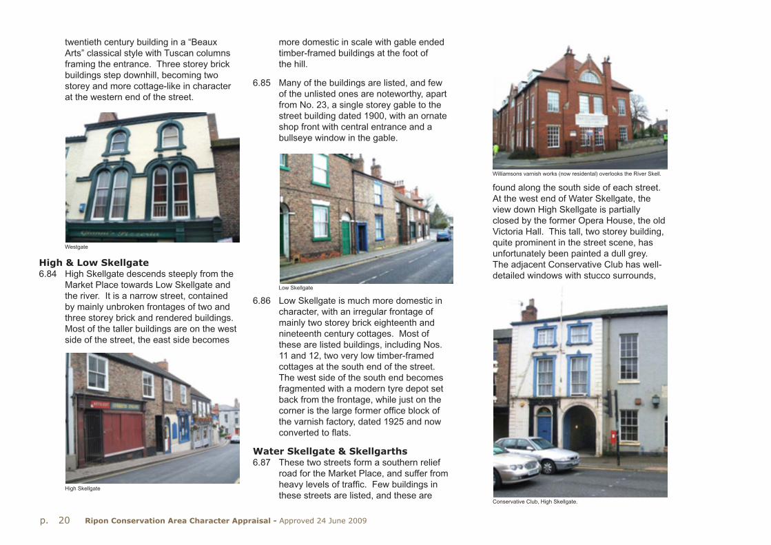
twentieth century building in a “Beaux Arts” classical style with Tuscan columns framing the entrance. Three storey brick buildings step downhill, becoming two storey and more cottage-like in character at the western end of the street.
more domestic in scale with gable ended timber-framed buildings at the foot of the hill.
6.85 Many of the buildings are listed, and few of the unlisted ones are noteworthy, apart from No. 23, a single storey gable to the street building dated 1900, with an ornate shop front with central entrance and a bullseye window in the gable.
found along the south side of each street.At the west end of Water Skellgate, the view down High Skellgate is partially closed by the former Opera House, the old Victoria Hall. This tall, two storey building, quite prominent in the street scene, has unfortunately been painted a dull grey. The adjacent Conservative Club has well-detailed windows with stucco surrounds,
High & Low Skellgate6.84 High Skellgate descends steeply from the
Market Place towards Low Skellgate and the river. It is a narrow street, contained by mainly unbroken frontages of two and three storey brick and rendered buildings.Most of the taller buildings are on the west side of the street, the east side becomes
Westgate
High Skellgate
6.86 Low Skellgate is much more domestic in character, with an irregular frontage of mainly two storey brick eighteenth and nineteenth century cottages. Most of these are listed buildings, including Nos. 11 and 12, two very low timber-framed cottages at the south end of the street.The west side of the south end becomes fragmented with a modern tyre depot set back from the frontage, while just on the corner is the large former office block of the varnish factory, dated 1925 and now converted to flats.
Water Skellgate & Skellgarths6.87 These two streets form a southern relief
road for the Market Place, and suffer from heavy levels of traffic. Few buildings in these streets are listed, and these are
Williamsons varnish works (now residental) overlooks the River Skell.
Low Skellgate
Conservative Club, High Skellgate.

p. 21Ripon Conservation Area Character Appraisal - Approved 24 June 2009
but has lost its first floor cast iron balcony. Nearby, but set back from the street front-age is the Ripon City Club, a red brick building of 1879 which stands on the site of the Bluecoat School. It is built from two sorts of brick, with a soft orange brick used for the ornate pedimented doorway, and the window surrounds. Unfortunately, this brick has weathered very badly, and the front elevation is in need of extensive repair.
slate roof which also fronts High Skellgate, but which fails to enliven this prominent junction. The adjacent Church, which was enlarged in 1896, is a much more lively building with pointed windows framed by orange and white brickwork, with blue and orange brick banding elsewhere.
6.90 A little further along the street Nos. 22-25 is a short two storey terrace with distinctive shaped stone lintels.
6.91 The north side of Skellgarths has been completely rebuilt with two and three
6.88 Much of Water Skellgate is fairly wide, as the mill race once ran along it, and many of the two storey buildings look a little out of scale. The former garage site which made a sizeable breach in the frontage has now been redeveloped with two storey housing. To the east, the former Library, an uninspiring single storey inter-war building is awaiting redevelopment. Next door is No. 18, another building of local interest which has a Flemish-style shaped gable onto the street.
6.89 The western end of Water Skellgate is marked by the early twentieth century pressed red brick Masonic Hall, a two storey building with a shallow pitched
No. 18 Water Skellgate.
Bank. The Skellgarths frontage, however, is much less lively, and something of a “canyon effect” has been created by the new buildings.
6.93 The south side of Skellgarths contains a couple of groups of listed early nineteenth century brick houses, and a scatter of later nineteenth century houses. However, where Skellgarths turn into King Street at the approach to Bondgate, the area is dominated by a large gyratory road junction which greatly reduces the impact of the listed early nineteenth century buildings fronting King Street
storey houses and flats since the 1980s, and these brick buildings form an almost unbroken frontage along the pavement edge, broken only by the access into Bedern Court and Peacock’s Passage. This narrow path, bounded by high brick and cobble walls, leads up to Kirkgate.
6.92 Bedern Court, with its two and three storey blocks and a mixture of gables and ridges, oriel windows, porches, balconies and steps provides a lively frontage to Bedern
Ripon City Club
22-25 Water Skellgate.
Bedern Court

p. 22 Ripon Conservation Area Character Appraisal - Approved 24 June 2009
(a) Form & character of buildingsGeneral form6.94 Within this area is a diverse range of build-
ing types, styles and materials. However, there are some unifying elements.
show, but these areas have been largely lost under the expansion of retail and commercial uses in the last century.
6.97 The medieval plot pattern is still visible along part of the north side of Allhallowgate, but it has been lost along North Street and Stonebridgegate. It is important that the surviving traces of this medieval plot pattern is retained as a main element of the character of the Conservation Area.
6.98 South of Westgate and Kirkgate to Water Skellgate and Skellgarths, the rear yards and gardens became infilled in the nine-teenth century with a dense pattern of cottages, workshops, stores and other buildings.
6.99 Stylistically, buildings range from vernacular to full blown classical, with neo-classical and neo-vernacular, a rich mixture of styles and periods.
Materials6.100 Brick is the dominant building material
in the historic centre of the City, although rendered buildings are found throughout the character area, especially in the Market Place. Some render conceals timber-framing, and most of the timber-framing on view in the Market Place is nineteenth century or later reproduction. Even the sixteenth-seventeeth century Wakeman’s House has a later timber front.
6.95 Most buildings are or brick or render, two or three storeys tall with pantiled or slate roofs, built up to the pavement edge and mostly aligned parallel to the street front-age. This parallel alignment is sometimes the result of eighteenth or nineteenth century rebuilding or refronting, as the backs often show a pattern of gable ended buildings. Some of this rendering or refronting hides timber-framing. Build-ings are arranged in largely unbroken frontages, with occasional ginnels into yards or connecting neighbouring streets.Plain board doors often indicate a private access into a rear yard.
6.96 Behind the buildings lie narrow walled gardens and yards. These were a part-icular feature east and west of the Market Place, as nineteenth century maps
Re-fronting and rebuilding on King Street.
6.101 Ashlared stone is used for some of the principal commercial buildings in and around the Market Place, while Magnesian limestone is used for some buildings, but more particularly for garden walls, often in conjunction with cobbles.
6.102 Brickwork varies from orange and creamy brown on eighteenth and nineteenth
Black Swan Yard
The Wakemans House, Market Place.

p. 23Ripon Conservation Area Character Appraisal - Approved 24 June 2009
century buildings to fiery red and orange pressed brick for early twentieth century buildings
6.103 Welsh slate tends to be used on visible roof pitches, with pantiles used on the smaller cottages and rear yard buildings.Stone slates are used infrequently, some-times as the lower eaves courses on a pantile roof, and Westmorland slate can also be found.
6.106 Other early brick details are the tumbled brickwork gables at the former coach house at The Old Hall in Minster Court but, in general, this type of early brickwork detail is largely absent from the area.
6.107 However, the late nineteenth century rebuildings saw some spectacular brick detail in harsh red and orange brick, especially along Fishergate, in North Street and at the Ripon City Club (see p.21) in Water Skellgate.
6.108 During the late nineteenth century, there was a great deal of refronting and rebuilding, and many shopfronts from this period survive in the streets off the Market Place, in Kirkgate, Westgate, High and Low Skellgate and North Street.
Window details6.109 Stone mullioned windows are almost
wholly absent, apart from at No. 27 Mary-gate and on some nineteenth century revivalist buildings such as the Workhouse.
6.110 Horizontally sliding Yorkshire windows arranged six by six pane are often found on older eighteenth and nineteenth century cottages, in Allhallowgate for instance, but are also found on higher status buildings such as No. 15 High St Agnesgate which has a three section Yorkshire sliding window with eight panes per section.
6.111 Multipaned vertical sliding sashes are found on the upper floors of eighteenth and early nineteenth century buildings in the central area. These windows are usually set back in brick reveals, under flat brick heads. Some early to mid eighteenth century buildings have plain or scribed stucco heads with projecting keystones, as at No. 24 North Street.
6.112 A small number of buildings have windows with stone or stucco surrounds (archi-traves). Early ones, of eighteenth century
6.104 Worthy of note are the wooden shingles used to cover the roof at No. 13 Low Skellgate, a modern timber-framed rebuilding.
Architectural detailing6.105 Most of the brick buildings of eighteenth
and nineteenth century date in the historic core are plain, with little detailing, apart from occasional eaves dentils or a brick band at first floor level. However, No. 16 High St Agnesgate of 1693 has a number of “Artisan Mannerist” details, including a shaped gable topped by a small triangular pediment, and with setbacks in the large chimney stack marked by triangular and segmental pediments in moulded brick.
No. 16 High St Agnesgate
Shopfronts in Kirkgate
13 Low Skellgate

p. 24 Ripon Conservation Area Character Appraisal - Approved 24 June 2009
date are usually flush with the wall, sometimes with a projecting keystone.Later nineteenth century surrounds are often moulded , as at the Conservative Club in Water Skellgate, or at No. 29 North Street.
6.113Most late nineteenth windows are four or two pane sliding sashes, set nearly flush in the reveals, while many of the early twentieth century buildings have casement windows.
6.114 Many buildings have full width shopfronts with doors and window under a common entablature. No. 8 Queen Street has shop windows on two floors, with very thin window framing, while round the corner, No. 11 Fishergate is of framed cast iron construction, with thin frames and large glazed areas to both floors.
(b) Listed Buildings6.116 There are 122 listed items in Area 2: The
medieval City around the Market Place.The most important are the Town Hall, The Wakeman’s House and the Obelisk.
6.117 Apart from these three, the most notable are as follows:
No. 1 Market Place: Skipton Building Society (Grade II) This three storey ashlar stone bank forms a visual stop to Kirkgate where it enters Market Place. It is a finely detailed early twentieth century building with triple keystones to the ground floor windows and triangular pediments to the first floor windows.
The Unicorn Hotel (Grade II) This four storey former coaching inn occupies a prominent site at the south east corner of the Market Place. In its present form, it has been rebuilt and extended in phases since the mid eighteenth century.
No. 15 Market Place (Grade II) This is a seventeenth century or earlier timber framed building with a later front, with a passage entry to Greaves Court, from where a timber post can be seen.
Nos. 17, 17a and 18 Market Place (North side of square)(Grade II) This hip roofed brick building , built in the late seventeenth
century has some fine seventeenth century features including two staircases and a decorated plaster ceiling, with a diamond framing a relief of a pelican.
Nos. 21 and 22 Market Place (Grade II)These are seventeenth century or earlier timber framed buildings to which false timber fronts were applied in the nineteenth century. They form a distinctive feature on the west side of the Market Place.
Nos. 23 and 24 Market Place (Grade II)Another early timber framed building which was refronted in the nineteenth century, which also forms a distinctive feature on the west side of the Market Place.
No. 41 Market Place (The Dragon Inn)(Grade II) An early nineteenth century three storey brick building with a finely detailed shopfront built gable end onto the Market Place. It has a large semi-circular (Diocletian) window in the gable.
No. 11 Fishergate (Grade II) Of late nineteenth century framed construction, presumably cast iron. The building is almost fully glazed on two floors, and was built as part of the widening of Fishergate.
Nos. 60-1 North Street “The White Horse” public house (Grade II) An early nineteenth century rendered building with curved two storey bay windows.
No. 14 North Street (Grade II) A late nineteenth century redbrick three storey building with crow stepped gable onto the street. The front is enlivened with multicoloured brick detail and stone dressings. The pointed windows to the ground floor are a recent reinstatement.
No. 80 North Street
6.115 Large numbers of well detailed eighteenth and nineteenth century shopfronts survive, particularly in Kirkgate, Westgate and the other streets off the Market Place. Elaborate examples are found at Nos. 7-9 Kirkgate, a good early twentieth century shopfront is at No. 13 Fishergate, and an inter-war bronze and vitrolite glass shopfront at No. 80 North Street.
11 Fishergate

p. 25Ripon Conservation Area Character Appraisal - Approved 24 June 2009
No. 23 North Street (Grade II) A lively early twentieth century ashlar and red brick building with a moulded stone band above the ground floor with large sculpted bosses. The windows have tall double keystones.
Nos. 26-7 North Street (Grade II) Mid eighteenth century rendered, with a pedimented central section. Prominently located opposite Coltsgate Hill.
The Black Bull PH, Old Market Place (Grade II) Part is seventeenth century, timber-framed. The building occupies much of the north side of the Old Market Place.
No. 8 Queen Street (Grade II) Has a rebuilt ground and first floor with fully glazed shopfronts on two floors.
The Workhouse, No. 75 Allhallowgate and Sharow View (Grade II) The lodge is two storey, dated 1854 with a central coach arch under a shaped gable. Sharow View
to the rear is the former workhouse block of two storeys with two shaped gables at the front. It stands on the site of the Old Hall which was used by the poor until replaced by the present building.
Abbot Huby’s Wall, west side of St. Mary-gate (Grade II) Built c1505 on a rubble plinth with cobbled upper part, with a three centred archway into Old Deanery Close.
No. 27 St Marygate (Grade II) “Deans Croft” is a seventeenth century rendered building with a rear cell block extension of 1816. The earlier building is gable end onto the road, and has two light mullioned windows.
14 North Street
Thorpe Prebend House (Grade II*) A seventeenth century brick house containing some remnants of a timber frame which probably formed part of an earlier house, of ‘U’-shaped plan around a courtyard.
St Anne’s Hospital, High St Agnesgate (Grade II*) A fourteenth century roofless ruin, which formed part of the now demol-ished medieval hospital. It has a two light Decorated window at the east end.
No. 16 High St Agnesgate (Grade II*) An early brick house dated 1693, and built in an “Artisan Mannerist “ style, with a pedi-mented shaped gable to the rear, and an external chimney stack with moulded brick details. The street elevation has circular windows with four keystones to each window.
No. 27 Kirkgate (Grade II) A mid fifteenth century timber framed building, built as a gatehouse, presumably to the Palace of the Archbishops of York.
41 Market Place
27 St Marygate

p. 26 Ripon Conservation Area Character Appraisal - Approved 24 June 2009
No. 5 Westgate (Grade II) An early nine-teenth century brick three storey house with steps up to a Tuscan columned entrance. The building is set back from the street behind iron railings.
Former Office building at Williamson’s Varnish Works, Low Skellgate (Grade II) This red brick building with terra cotta dressings occupies a prominent position overlooking the river. The front has two terra cotta panels inscribed “Varnish and enamel works:established 1775” and “T & R Williamson Ltd1775-1925 “.
Ripon City Club, Water SkellgateA late nineteenth century two storey brick building with an elaborate front elevation.The entrance breaks forward and the doorway is framed by fluted pilasters carrying a small pediment supported by scrolls, all in soft orange brickwork.
No. 18 Water SkellgateLate nineteenth century building with a shaped Flemish gable which is prominent in the street scene.
Nos. 2-13 Skellfield TerraceTerrace, built in two phases in 1902-5 which is noteworthy for its extensive use of carved joinery to porches and canopies and coloured glazing.
Allhallowgate Methodist ChurchA late nineteenth century Methodist Chapel in a debased classical style, with contrasting brick banding to upper floor and windows.
(c) Important unlisted buildings6.118 There are a few unlisted buildings which
make a positive contribution to the char-acter and appearance of the Conservation Area and are of particular local interest. Of these, the following stand out:
Post Office, Old Market PlaceBuilt around 1900, in pressed brick with stone details, an Edwardian Baroque building with a segmental pediment carried on scrolled brackets over the door.
Nos. 10-13 North StreetProminently located on the corner of Allhallowgate, this is a three storey brick terrace of shops with flats, with steep dormers and bargeboards and with canted first floor bay windows. Dated 1881.
King William IV (PH) Blossomgate Ornate early twentieth century public house, with green tiled front elevation and stained glass windows. Entrance framed by projecting quoins and keystone, dentilled gable on the main elevation.
5 Westgate
Williamsons Varnish woks, Low Skellgate. King William IV public house, Blossomgate.

p. 27Ripon Conservation Area Character Appraisal - Approved 24 June 2009
(d) Landmark buildings6.119 The major landmarks in the centre of
the historic City are the Town Hall and the Obelisk, which can be seen above the rooftops from many viewpoints. The following buildings are also considered to be landmark buildings owing to their prominence in the Cityscape:
Methodist Church, AllhallowgateThis large late nineteenth century chapel is prominent in the street scene, presenting an ornate front elevation onto Allhallowgate, and a fairly plain side and rear to the car park.
The Workhouse, AllhallowgateThe lodge with its central arch is set back from the street frontage, and with its prom-inent date plaque (“Erected AD 1854”) is a local landmark.
(e) Buildings in need of significant repair or enhancement
6.120 No survey of building condition has been carried out as part of this Appraisal, and the following list identifies only those at particular risk:
Ireland’s Court, rear of No. 62 North StreetA group of long abandoned and partly ruinous cottages and workshops ranged down a yard behind No. 62 North Street.There may be scope for the repair and reuse of some of these buildings.
Outbuildings and yard rear of No. 16 North StreetDerelict outbuildings, former storage or workshops in poor condition. Yard which runs from Allhallowgate to North Street through an arch is in poor condition.
(Other buildings which are vacant and in need of repair include W. Wells’ shop (below), No. 85 North Street, Nos. 29-31 Westgate, No. 20 Westgate and No. 18 Water Skellgate.)
Rear of No. 40 Kirkgate (outbuildings to the south of Sainsburys supermarket) This area contains a number of outbuild-ings which are either vacant or in poor condition and in need of repair. The unadopted lanes and yards linking Kirk-gate to the main car park are in poor condition and in need of repair.
Black Swan yard, Westgate. Long range of derelict and disused build-ings of one to three floors, some or all of which might convert to other uses.
Ripon City Club, Water SkellgateUnlisted brick building with elaborately detailed orange brick front elevation.Many of these details are damaged and in need of repair. Substantial range of plain brick buildings to the rear. The building is vacant and in need of a new use.
(f) Landscape character & features
6.121 The historic City centre stands on a bluff overlooking the River Skell, and roads from the Market Place descend steeply to the river crossings. The Market Place is the largest open space in the historic core area, although dominated by parked vehicles and through traffic much of the time. The parking areas, circulation and street furniture were redesigned and the whole area repaved some years ago. The space is enclosed by continuous frontages of buildings, beyond which are the frag-mented plots and garths, bounded by brick and cobble walls, which are an important element in the character of the City centre. By the nineteenth century, the central area was heavily built up with cottages and workshops crammed into the yards and courts of the area.
Rear of No. 16 North Street.
W. Wells’s neglected shopfront.
Rear of No. 40 Kirkgate

p. 28 Ripon Conservation Area Character Appraisal - Approved 24 June 2009
6.122 As a consequence, the extent of soft land-scaping in the central area is limited and fragmented and only in the outer fringes of the Conservation Area does the landscape make a significant contribution.
6.123 The main car park off St Marygate is broken up by tree and shrub planting, and the changes of level further assist in the screening of vehicles. However, the adjacent car park off Moss Arcade is much bleaker and the fringing belts of trees and shrubs, including some distinctive Scots Pines, do little to mitigate the openness of this area. The car park opposite Victoria Grove and the remodelled bus station reinforce the rather fragmented cityscape of what is probably the main entry point for visitors to the City.
6.124 Public landscaped spaces are very few and very small; the largest is the grassed area between Bondgate Bridge and New Bridge and the foot of Bedern Bank, which is marred by a large electricity sub-station.
6.125 Off Allhallowgate, hidden by the charmless BT telephone exchange, is a small garden created from a former chapel burial ground (below). At the junction of North Street and Coltsgate Hill was an even smaller open space now lost in the recently constructed road link from Blossomgate to North Street.
(g) Hard spaces in need of repair or enhancement
6.126 A number of paths and yards connect Market Place to the main car park and to the west, where recent redevelopment is largely complete. This redevelopment provides an opportunity to repair existing footpaths with traditional stone surfaces, and provide new links into the Market Place and North Street.
(i) Space between and around buildings, surface treatment & materials
6.129 Most buildings in the historic City centre are built up to the pavement edge, and consequently there is little or no space around the publicly visible street frontages. At the rear of these frontages, space around buildings is limited, and comprises densely built-up yards with outbuildings, bounded by brick and cobble walls.
6.130 This dense pattern has been disrupted to some extent where new infill housing schemes on backland sites are built around shared access and parking space, usually finished with block paviors. However, a number of cobbled yards with York stone setts or flags survive along North Street, Westgate and High Skellgate.
6.131 Most kerbs are modern pre-cast concrete, although conservation kerbs were used in the Market Place Scheme. Few examples of natural stone kerbing survive; the Old Market Place contains wide sandstone kerbs, while pink granite kerbs can be seen in Westgate.
6.132 York stone flags have been introduced into the Market Place and Kirkgate, whilst small reconstituted blocks have been used in Westgate and High Skellgate.
6.133 The carriageway in Duck Hill has been relaid in Tegula blocks, while stone setts have been used in Kirkgate.
6.127 The paths and yards linking Kirkgate to the rear of Sainsburys - the Lands Court area -are in poor condition and in great need of improvement (above). Appropriately designed street lighting should be used and the opportunity taken to reuse vacant buildings.
(h) Green spaces in need of repair or enhancement
6.128 The former workhouse garden, abandoned and overgrown for many years, is to be reclaimed and replanted for public benefit.

p. 29Ripon Conservation Area Character Appraisal - Approved 24 June 2009
C: The River Skell Corridor6.134 This area includes the River Skell, and
areas adjoining, including Borrage Lane, Williamson Drive, Riverside, Bondgate and the Canal Basin, extending about 1.3km across the southern edge of the City centre.
6.135 The riverbanks provide a well-wooded corridor, with a public footpath along much of its length giving access to open countryside beyond the City.
6.136 The western end, along Borrage Lane is quite rural in character, the narrow lane bounded by high cobble walls with many trees behind.
taller blocks of flats along the river front, built in a fairly idiosyncratic style.
6.138 On the south side of the river at Waterside, the site of the former Bondgate Brewery has been redeveloped with housing in the form of waterside blocks of two and three storeys with hipped and gabled pantiled roofs.
6.139 The main part of the brewery to survive is the former Bricklayer’s Arms PH, an attractively detailed brick building of 1758.
6.140 Clustered near Bondgate Bridge are the mid nineteenth century Chapel of St John and the adjacent Almshouses, forming a quiet enclave enclosed by walls and trees. The almshouses have timbered gables, and blue and orange brick details to windows, and date from the mid nineteenth century. At that time, Bondgate was an industrial suburb of Ripon, with sawmills and timber yards intermingled with rows of cottages. However, since the 1960s,
most of the area has been redeveloped as a residential area, and little of its former historic character remains.
6.141 The Ripon Canal enters the fringes of the City from the south east, and the terminal basin is situated a few hundred metres south of the Minster, close to the River Skell. The Canal was opened in 1767, with a warehouse and manager’s house and wharves. By the 1850s, the canal
6.137 East of Borrage Bridge the north bank of the river was occupied mainly by the scattered buildings of Williamson’s paint and varnish works. Most of these buildings were demolished in the 1990s apart from the former office block of 1925 which has been converted to flats and which forms a notable landmark at Borrage Bridge. The site has been developed around a tight grid of streets with two and three storey terraces of houses and with
basin was lined with coal and timber yards, these providing the nucleus of later commercial and industrial development in this area and later to the south at Dallamires Lane.
6.142 The Canal Basin is well contained by buildings, with a mixture of late eighteenth and nineteenth century houses with more recent infill along Canal Road, with recent terraced housing along the north side.
(a) Form & character of buildingsGeneral Form 6.143 The River Skell corridor is of varied
architectural character, with buildings of different dates and scale set within a well wooded river valley. At the western
Ford and footbridge cross the Rive Skell at Woodbridge.

p. 30 Ripon Conservation Area Character Appraisal - Approved 24 June 2009
end, Borrage Lane is characterised by mainly modern detached houses set back behind high cobble and rubble walls. At the west end of the lane some clusters of eighteenth and nineteenth century brick buildings are found and these roadside buildings and the high cobble walls create a quiet rural atmosphere. The north side of the east end of Borrage Lane has been redeveloped with a three storey crescent and adjacent terraces, giving a much denser urban character to this area.
6.144 Between Borrage Bridge and Bondgate Bridge, the north bank of the river has been completely redeveloped, with tall riverside blocks of flats, and lower rise high-density brick terraces to the rear.
Riverside House is a four storey block with dormers and gabled quoined end blocks.The projecting bays have timber-framing, emphasizing the height of the building, while the block is terminated by slender circular turrets capped with pointed lead roofs.
6.145 To the east, the two storey development at Wellington Gardens looks away from the river, and fails to take full advantage of the waterside setting.
6.146 Alongside Bondgate Bridge, the former Bondgate Brewery site has been redevel-oped as Waterside with three storey blocks of flats fronting the river. St Johns Chapel and the adjacent Almshouses form a nine-teenth century enclave in an area that has been redeveloped in recent years.
6.147 East of New Bridge, the riverbank has a more rural air, with rear gardens and trees providing the setting. Bondgate Green is a mixed area of late nineteenth century former warehouses and stores,
now in other business uses and an early twentieth century terrace with elaborate glazed timber porches and roof dormers at Nos. 17a-23. Opposite, the canal basin is bounded by a varied group of modern three storey brick, render and timber-clad houses built in the 1990s.
6.148 Canal Road forms an enclave of late eighteenth and nineteenth century two storey brick buildings, with some recent residential infill. The repaired but, at the time of publication, unused stone warehouse stands at the end of the canal basin, with the attached manager’s house and smaller storage buildings behind. This irregular group of buildings provides a picturesque approach to the canal. The canal basin and yard is bounded by a high stone wall with large gate piers and iron gates facing New Bridge.
The Canal Basin recently reopened to navigation and redeveloped mainly for residential use.
Borrage Lane
Materials6.149 Most buildings in this character area are
of brick, varying from soft orange clamp fired bricks as at No. 1 Bondgate to later
Skell Bridge, Ripon bypass.

p. 31Ripon Conservation Area Character Appraisal - Approved 24 June 2009
nineteenth century brown brick and more recent red pressed brick as at Williamson House. The main stone building is the canal warehouse, the front part (now rend-ered) being built of red sandstone, and the rear of coursed Magnesian limestone.
6.150 Borrage Bridge and New Bridge are stone built, the former being built of limestone ashlar (east) and rock faced millstone grit (west), while New Bridge is built of sandstone ashlar.
6.151 Welsh slate tends to be used for roofing of the later buildings, with pantiles for the cottages and smaller buildings.
Architectural detailing6.152 The buildings of this area comprise
a mixture of dates, styles and former uses, exhibiting a variety of architectural treatments.
6.153 Borrage Lane is characterised by modern brick houses and bungalows with hipped or gabled roofs, with a small number of nineteenth century houses and cottages, some retaining sliding sash windows.
6.154 New development at the east end of Borrage Lane close to the bridge com-prises three storey blocks, notably The Crescent (just outside the Conservation Area). This is a semi-circular crescent, with the ground floor rendered and lined out to look like ashlar stone, with a continuous balcony railing at first floor level, and stone details to windows.
6.157 Bishops Court, to the east, rises to four storeys with the top storey within the slate mansard roof. Stone balustrades are used at the top floor balcony level, and this combined with the prominent lead covered dormers and mansard roof gives a lumpen appearance to this block.
6.155 Williamson House (above), the converted office block of the former varnish works, provides the context for the redevelopment to the east. The former office block has a gabled bay framed by tiled pilasters with inscribed tiled bands between the upper floors. Full height canted bays with swept dormers above flank the central bay.
6.156 The adjacent Riverside House has a projecting straight bay window rising through four storeys, with applied vertical timbering. Quoins define the main gabled block, whilst the attached three storey range is terminated by slender turrets capped by conical roofs.
6.158 Wellington Gardens to the east is more traditional in scale and design, comprising terraces of two storey dark brick houses with slate and pantiled roofs of varying heights.
6.159 The nineteenth century enclave at Bondgate Bridge comprising St John’s Chapel and Almshouses are in a restrained gothic style, the houses having applied timbering to the gables and pointed windows framed with orange and purple brickwork.
6.160 Bondgate Green and Canal Street are characterised by mainly two storey housing of brick, render and cobble, with Welsh slate or pantile roofs. Chimney stacks are at the ridge or gable end, and buildings are simply detailed and lacking in ornament.The Crescent
Wellington Gardens

p. 32 Ripon Conservation Area Character Appraisal - Approved 24 June 2009
Window details6.161 Multi-paned sash or Yorkshire sliding
windows survive on the few eighteenth and early nineteenth century buildings of this area.
6.162 Later nineteenth century buildings have two or four paned sash windows, while the early twentieth century terrace at Nos. 18-23 Bondgate Green has some unusual sash windows with five panes over a single pane.
(b) Listed buildings6.163 There are 18 list entries in this character
area the main ones being the river bridges, Williamson House, St John’s Chapel and almshouses, No. 1 Bondgate and the canal warehouse:
Borrage Bridge (Grade II) A three arched bridge of eighteenth or nineteenth century date, which was widened in the late nine-teenth century. Consequently, the west side is of rock faced millstone grit, the east side of limestone ashlar.
Bondgate Bridge (Grade II) A single span iron lattice girder bridge built in 1892, with ashlar piers with crenellated tops. This is the only remaining iron bridge in the City.
New Bridge (Grade II) Built in 1811, with three segmental arches, and a sweeping parapet terminated by cylindrical piers.
Canal warehouse (Grade II) Built around 1770-3, this stone warehouse with attached manager’s house and stores buildings, all enclosed by a high wall, form an interesting group of eighteenth century canal buildings.
(c) Important unlisted buildings6.164 Few unlisted buildings contribute to the
character of this part of the Conservation area:
Nos. 27 and 33 Borrage Lane unspoiled mid to late nineteenth century houses with outbuildings which form attractive groups in this rural enclave.
(The cottages opposite are greatly altered, although No. 24 is notable for its brief occupancy by Wilfrid Owen, the World War 1 poet.)
Riverside House and the adjacent blocks of flats built along the river bank in recent years these have introduced a new scale of building to this corner of
Williamson House (Grade II) (above) Built in 1925, this former office block is embellished with tiled plaques which read “T & R WILLIAMSON LTD” “VARNISH & ENAMEL WORKS ESTABLISHED 1775”. It forms a notable landmark when approaching the City from the south.
Chapel of St John the Baptist (Grade II)A small limestone chapel built in the mid ninetenth century in perpendicular style, on the site of the medieval Hospital ofSt.John. The chapel and the adjacent almshouses of 1878 form an attractiveVictorian enclave in an area that has been largely redeveloped in the post war period.
No. 1 Bondgate (Grade II) Built in 1758, this brick house with a prominent timber eaves cornice abuts Bondgate Bridge and the site of the former Bondgate Brewery (redeveloped as Waterside).
Bondgate Bridge
The Canal warehouse

p. 33Ripon Conservation Area Character Appraisal - Approved 24 June 2009
the Conservation Area, and represent a dramatic change in character to this former industrial site.
Nos. 17a-23 Bondgate Green (below) is an early 20th century three-storey brick terrace with terra cotta details, dormers with barge-boards and elaborate carved wooden porches. It is one of several highly detailed terraces built around 1900 and which are a feature of the Conservation Area.
(f) Landscape character & features6.167 The River Skell (below) runs through a
shallow valley just south of the historic centre of the City before joining the Ure.It provides a well-wooded landscape feature with continuous footpaths along
the older historic core of the City. Until the early nineteenth century, the City kept within its medieval boundaries. From the early to mid nineteenth century, urban expansion on the fringes occurred, and a number of distinctive suburbs arose.
6.171 These include those areas immediately north and west of the historic core off Coltsgate Hill, North Road and College Road, as well as outlying areas at Ure Bank near the former railway station, and at South Crescent.
(d) Landmark buildings6.165 Williamson House is perhaps the outstand-
ing landmark building in this sub-area.It is prominently located next to Borrage Bridge, the main entrance to the City from the south, and is emblazoned with inscribed tiled plaques spelling out details of the former business.
(e) Buildings in need of significant repair or enhancement
6.166 Few buildings in the area are in need of repair or enhancement, the main exception being the canal warehouse. Although this building has been repaired, and the front rendered, it is in need of an appropriate new use.
its length. A major enhancement scheme was undertaken in 1999-2000 to improve landscaping, access and footpaths. The canal provides another access route into the countryside to the east.
(g) Hard spaces in need of repair or enhancement
6.168 There are no hard spaces in urgent need of enhancement.
(h) Green spaces in need of repair or enhancement
6.169 There are no green spaces in urgent need of enhancement.
D: The Victorian Suburbs6.170 Victorian developments in the form
of groups of houses and commercial buildings are found scattered throughout
6.172 Early nineteenth century development was in the form of scattered villas to the west and north of the City centre along North Road, Kirkby Road, Palace Road and Studley Road. A cluster of churches and schools developed around Trinity Lane from the late 1820s, with terraced housing following to the south of St Wilfrid’s RC Church (built 1862).
6.173 The laying out of the higher status suburbs began in the 1850s, with The Crescent, Crescent Parade and the terraces fronting Palace Road and the end of Princess Road following later. The Clock Tower of 1897 completes the Victorian development of this area.
Residential properties on North Road.17a - 23 Bondgate Green

p. 34 Ripon Conservation Area Character Appraisal - Approved 24 June 2009
6.174 Princess Road round into Magdalen’s Road was developed in the late nineteenth century with two and three storey terraces in a variety of heights and styles.
6.175 The building of Ripon College in 1858-9 was followed by the construction in the late nineteenth century of a group of large well ornamented three storey houses in pairs and short terraces along College Road.
6.176 An isolated mid to late nineteenth century development grew up around the railway station at Ure Bank with maltings in the mid century being followed by long rows of housing, including the pedimented Ure Bank Terrace.
and status, and can be seen at its most extreme along North Road and College Road.
6.179 The smallest houses are built up to the pavement edge flat-fronted with little decorative detail and rear yards, as at Brewster Terrace and Rayner Street. Larger terraces, such as Westbourne Grove have more decoration and bay windows behind small front gardens, but still with rear yards.
6.180 Dormer windows are a characteristic feature of the larger terraced houses, especially along College Road, Crescent Parade, Ure Bank Terrace, Westbourne Grove and the terraces around Palace Road and North Road junction.
6.181 The houses at Princess Road are more spacious, with front and rear gardens, while the largest terraced houses along North Road, Crescent Parade and College Road are richly ornamented, with gardens front and rear and are served by back lanes.
6.177 A further detached Victorian development began to be laid out south of Borrage Bridge at South Crescent. However, this villa scheme was only partially completed, and was infilled with later development.
(a) Form & character of buildingsGeneral form6.178 The Victorian suburbs are characterised
by either terraces of houses or detached or semi detached villas, brick built with Welsh slate roofs. The degree of decor-ative embellishment increases with size
Ure Bank Terrace
6.182 The largest Victorian houses, at The Crescent, are sited within a private enclave of grass and trees, bounded by walls and railings and with rear coach houses onto a back lane.
6.183 A similar private enclave behind large stone gate piers was begun at South Crescent. Some large nineteenth century villas survive here, but most of the site has been infilled with post-war detached houses.
Materials6.184 Machine made brick is the dominant
walling material, with Welsh slate for roofing.
6.185 Brick colours vary from white or cream through orange to fiery red and creamy brown. Bright orange or red pressed brick is used on late nineteenth and early
Crescent Parade
Brewster Terrace
Terraces along College Road

p. 35Ripon Conservation Area Character Appraisal - Approved 24 June 2009
twentieth century houses, as at College Road. Contrasting brick banding is often used, in orange or blue brick, at eaves or sill level or around window openings.
nineteenth century, detailing had become more elaborate, while by the late nine-teenth century, a domestic revival style was favoured, using pressed brick and applied timber detailing (below).
6.189 The design of terraced housing reflects these changes, and the higher status terraced housing becomes more ornate as the century progresses. The terrace at Nos. 31-35 North Road (Freemantle Terrace) represents the high point of ornamentation.
carved canopies and standardised doors and windows. External joinery is used to good effect on the terraces in Magdalen Road, Princess Road and Westbourne Terrace.
6.193 Around the 1900s, pressed brick or terra cotta details were used to decorate eaves courses or string courses, often using floral devices.
Window details6.194 The use of multi paned sash windows
gradually declined after the 1840s, as glazing technology improved. Some early to mid nineteenth century terraces, such as Nos. 25-28 Ure Bank Terrace retain 12 pane sashes, as do some of the earlier villas in Palace Road.6.186 Stone dressings are used around windows
and doors on the larger terraces in North Road, and in a more restrained manner at The Crescent. Stone houses are rare, “Highfield” (below) and its lodge on Palace Road being exceptions.
Architectural detailing6.187 As a general rule,the simple details of
the early nineteenth century give way to increasingly complex styles and details until the early twentieth century, when there is a reversion to simpler treatments.
6.188 The earlier nineteenth century detached villas on Palace Road were hip-roofed with multi-paned sash windows. By the mid
6.190 There is a great variety of detailing within what appear at first sight to be uniform terraces. For example, St.Wilfrid’s Road has five distinct patterns of two storey house with different window and brickwork details, including terra cotta keystones with foliate decoration, or swept stone lintels.
6.191 The larger houses in Westbourne Grove have continuous pent roofs with carved wooden valences carried over canted bay windows, and five panel doors. Third floor attic rooms have pitched dormers with finials and fretted bargeboards.
6.192 The development of mass produced join-ery led to the adoption of timber porches,
6.195 Four pane and later, two pane sashes became the norm, along with canted bay windows to the ground floor. These features are widespread amongst the Victorian housing of the City. By the early twentieth century there was a move back towards multi-paned windows with the upper parts of each window having small panes, or coloured glass, as at Skellfield Terrace (built 1902-5).
Princess Road
Ure Bank Terrace
Highfield, Hemsworth Walk.
Freemantle Terrace (detail.)

p. 36 Ripon Conservation Area Character Appraisal - Approved 24 June 2009
(b) Listed Buildings6.196 About thirty buildings in the Victorian
suburbs are listed, mainly churches, schools and some of the larger houses.The most important listed buildings are as follows:
Church of St Wilfrid, Coltsgate Hill (Grade II*) Built 1858-62, this French Gothic-style church with a raised chancel roof towers over the adjacent terraced houses. The Church is visible from many viewpoints in the City.
Chapel of the Hospital of St Mary Magdalen, Stonebridgegate (Grade I)Founded in the twelfth century, this chapel is mostly fifteenth century and is the most complete survival of any of Ripon’s medieval hospitals.
(c) Important unlisted buildings6.197 There are a few unlisted buildings which
make a positive contribution to the char-acter and appearance of the Conservation Area and which are of particular interest locally. Of these, the following stand out.
6-64 College Road Late nineteenth century pairs of houses and short terraces with a wealth of timber detailing, including applied timber framing, three and seven panel doors, fretted eaves valances and swept lead sheet canopies.
1-18 Crescent Parade A mid nineteenth century development in three terraces with prominent steep dormers and much detail
Church of the Holy Trinity, Kirkby Road (Grade II) Built 1826-7. This Church with its three stage tower and spire forms a visble landmark over much of the City.
Main block to Holy Trinity School, Trinity Lane (Grade II) An early nineteenth century single storey building, with a central bay breaking forward and surmounted by a pediment.
The Crescent (Grade II) A mid nineteenth century development of single and paired two and three storey houses with elaborate decoration, standing in private grounds.
College Road
Church of St Wilfrid
1-5 North Parade and 2-18 Palace RoadThese two terraces are less ornate than the listed Princess Terrace, but they complete the late nineteenth century ensemble of terraces focused around the 1897 Clock Tower.
(d) Landmark buildings6.198 The major landmarks in the Victorian
Suburbs are identified below:Church of the Holy Trinity, Kirkby Road
Church of St Wilfrid, Coltsgate Hill
Former College of Ripon and York St John (main building);
Victorian Clock Tower, North Road
Princess Terrace
Crescent Parade
Palace Road

p. 37Ripon Conservation Area Character Appraisal - Approved 24 June 2009
for the main college building of 1858. By contrast, the northern part of the former College grounds is heavily wooded, with areas of Scots pine and deciduous trees.The larger gardens along Palace Road contain many trees, behind high stone and brick walls.
(h) Green spaces in need of repair or enhancement
6.206 The garden area at South Crescent is neglected and overgown with scrub and secondary woodland. It would benefit from some thinning.
(i) Space between & around buildings, surface treatment & materials
6.207 The Victorian suburbs are of two distinct types. The western fringes of the City have large detached houses set in large gardens, often with many mature trees, behind high brick and stone walls which line, for example, Kirkby Road, College Road and Palace Road.
6.208 In contrast, most of the other Victorian housing is in terraces with modest front gardens and either rear yards or gardens served by unadopted back lanes, which are often unpaved.
E: The Spa 6.209 This sub-area is centred upon Park Street,
and contains the main parks and sports grounds in the City. Park Street also contains the best group of Georgian.or Regency houses in the City. In 1900, land was purchased from Lord Ripon to form the Spa Gardens, and in 1905, the Spa Baths were opened. This was an attempt to develop Ripon’s medicinal springs into a Spa, and in 1909 the Spa Hotel was opened to cater for visitors. However, World War I and changes in taste meant
(e) Buildings in need of signific-ant repair or enhancement
6.199 Many of the Victorian houses at the east end of Princess Road are suffering from settlement damage, with visible failure to window and door heads and bay windows. The coach house at No. 36a Princess Road is in very poor condition.
6.200 However, most of the houses of the Victorian suburbs are in good condition, and many of them retain their original glazing, doors and timber details, although ill-advised alterations have affected a number of Victorian properties.
(f) Landscape character & features
6.201 The Victorian suburbs are characterised by landscapes of varying character.
6.202 The largest area of landscaping extends across the former grounds of the College of Ripon and York St John between College Road and Palace Road. The open parkland with tree planting along the College Road frontage provides a setting
6.203 The open grazing land on each bank of the River Ure provides the setting for Ure Bank Terrace, a detached Victorian suburb. Further into the City, open fields and paddocks along North Road interrupt the pattern of nineteenth century frontage development.
6.204 Both The Crescent and South Crescent were developed as private enclaves of high status housing around shared open spaces. The garden at The Crescent has scattered trees planted within a mown lawn, whereas the garden at South Cres-cent is covered with secondary tree growth and bushes, giving a more rustic character.
(g) Hard spaces in need of enhancement
6.205 Private back lanes to some of the terraces are in need of repair or enhancement, such as at Crescent Parade.
Coach house at No. 36a Princess Road.
Former grounds of the College of Ripon & York St John.

p. 38 Ripon Conservation Area Character Appraisal - Approved 24 June 2009
that the hopes for Ripon Spa were not realised, although the City was left with a legacy of parks, open spaces and the Spa Baths.
6.212 The garden has two eighteenth century gazebos, linked by a two storey gallery. These buildings were repaired in the late 1980s.
6.213 Further west along Park Street and Cloth-erholme Road are two early nineteenth century villas with hipped slate roofs.
bricks for eighteenth century buildings, with brown and red brick for later buildings. The Spa Baths are built of red pressed brick, decorated with liberal amounts of terracotta detail.
6.218 Several of the houses along Park Street are rendered in smooth stucco. Roofs are generally of Welsh slate, although stone slate and pantiles are also used.
6.219 Boundary walls along Park Street and Clotherholme Road are mostly of brick, and there is a long section of wall capped with terracotta coping along the south side of Park Street and Studley Road.
Architectural detailing6.220 Although this sub-area contains few
buildings, there is a great variety of detailing used. The late Georgian and Regency houses at the east end of Park Street are a varied group, showing imaginative use of Venetian windows, scribed stucco window heads, door cases and Tuscan columns.
6.221 The Spa Baths is a riotous display of terra cotta, and contains some fine internal glazed panels depicting the Ripon Wakeman and the visit of King James in 1617.
(a) Form & character of buildingsGeneral form6.210 The eastern end of Park Street contains
a group of mostly three storey late eighteenth to mid nineteenth century houses of varied design and detail. Nos. 4 to 6 are rendered and No. 6 has an elaborate façade with Tuscan columns and windows flanked by blind openings.
6.214 Park Street contains the Spa Baths notable for its exceptionally inventive moulded terracotta ornament covering the whole front, mainly Arts and Crafts in character but in places Art Nouveau. The terra cotta detailing extends to the adjacent park walls and gate piers, and to the boiler house at the rear of the baths.
6.215 South of the Spa Baths is the former Dispensary of 1850, now greatly extended as the Hospital. This large two storey redbrick building occupies a long frontage on Firby Lane, and has a well detailed front elevation with stone details.
6.216 Finally, the north side of Skellbank con-tains a group of mid nineteenth century houses set well back from the road behind long front gardens.
Materials6.217 Most buildings in this area are built of
brick, either orange or red clamp fired
6.211 Nos. 7 and 8 is a three storey limestone house, with a central bay topped by a pediment.
7 & 8 Park Street
Detail of the facade of Spa Baths on Park Street.

p. 39Ripon Conservation Area Character Appraisal - Approved 24 June 2009
6.222 In Firby Lane, the main elevation of the Hospital faces east towards the City. This elevation is enlivened with stone dressings including quoins, stone bands and moulded architraves. The entrance is surmounted by a broken pediment.
(b) Listed buildings6.223 This character area contains only 17 listed
buildings including some minor features in Spa Park. The most significant listed buildings are the group of houses (Nos. 3 to 11) in Park Street, the Spa Baths and the Hospital, all discussed earlier.
(c) Important unlisted buildings6.224 Few of the small number of unlisted
buildings in this area make a significant contribution to its character. The terrace of houses at Nos. 7-11 Skellbank should be noted because of its unusual four pane over eight pane sash windows with small margin panes.
(d) Landmark buildings6.225 None of the buildings in this area could be
regarded as landmarks, that is, buildings which can generally be seen from various
viewpoints and from a distance, although the Spa Baths are extremely visible in the street scene.
(e) Buildings in need of significant repair or enhancement
6.226 None of the buildings in this area appear to be in need of significant repair or enhancement.
(f) Landscape character & features
6.227 The area divides into two parts each of different character. To the east are the formal public parks, Spa Park and Spa Gardens with their enclosing belts of trees and specimen planting. The adjacent Spa Hotel garden is enclosed by tree belts along its eastern and southern boundaries. To the west are the open areas of sports pitches, bounded by trees. From here, views of the Cathedral to the east can be had.
(g) Hard spaces in need of enhancement
6.228 There are no hard spaces in need of enhancement in this character area.
(h) Green spaces in need of enhancement
6.229 The terra cotta coped walls along the north side of Spa Gardens are in need or repair and the reinstatement of the missing railings would be an improvement.

p. 40 Ripon Conservation Area Character Appraisal - Approved 24 June 2009
Map 1: Historical development of Ripon
Rep
rodu
ced
from
the
Ord
nanc
e S
urve
y M
appi
ng w
ith th
e pe
rmis
sion
of t
he C
ontro
ller o
f Her
Maj
esty
’s S
tatio
nery
Offi
ce.
©C
row
n co
pyrig
ht.
Un
auth
oris
ed re
prod
uctio
n m
ay le
ad
to p
rose
cutio
n or
civ
il pr
ocee
ding
s.
Har
roga
te B
orou
gh C
ounc
il 1
000
1962
8 20
09
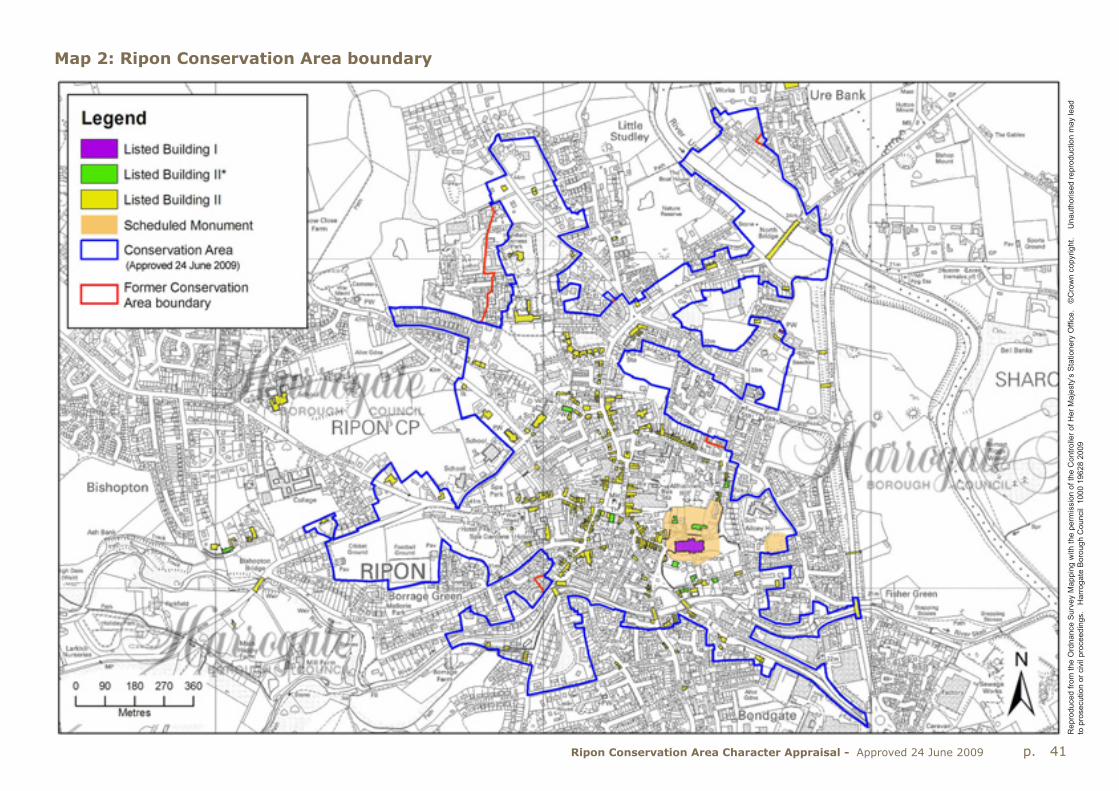
p. 41Ripon Conservation Area Character Appraisal - Approved 24 June 2009
Rep
rodu
ced
from
the
Ord
nanc
e S
urve
y M
appi
ng w
ith th
e pe
rmis
sion
of t
he C
ontro
ller o
f Her
Maj
esty
’s S
tatio
nery
Offi
ce.
©C
row
n co
pyrig
ht.
Una
utho
rised
repr
oduc
tion
may
lead
to
pro
secu
tion
or c
ivil
proc
eedi
ngs.
H
arro
gate
Bor
ough
Cou
ncil
100
0 19
628
2009
Map 2: Ripon Conservation Area boundary

p. 42 Ripon Conservation Area Character Appraisal - Approved 24 June 2009
Map 3A: Analysis & concepts: Area A, Cathedral Precinct & the early settlement
Rep
rodu
ced
from
the
Ord
nanc
e S
urve
y M
appi
ng w
ith th
e pe
rmis
sion
of t
he C
ontro
ller o
f Her
Maj
esty
’s S
tatio
nery
Offi
ce.
©C
row
n co
pyrig
ht.
Una
utho
rised
repr
oduc
tion
may
lead
to
pro
secu
tion
or c
ivil
proc
eedi
ngs.
H
arro
gate
Bor
ough
Cou
ncil
100
0 19
628
2009
NOTE: This map is not conclusive. Buildings which are not identified on the map as local landmark buildings or buildings of local interest may contribute positively to the character and appearance of the Conservation Area.

p. 43Ripon Conservation Area Character Appraisal - Approved 24 June 2009
Map 3B: Analysis & concepts: Area B, Medieval City around Market Place with High St Agnesgate
Rep
rodu
ced
from
the
Ord
nanc
e S
urve
y M
appi
ng w
ith th
e pe
rmis
sion
of t
he C
ontro
ller o
f Her
Maj
esty
’s S
tatio
nery
Offi
ce.
©C
row
n co
pyrig
ht.
Una
utho
rised
repr
oduc
tion
may
lead
to
pro
secu
tion
or c
ivil
proc
eedi
ngs.
H
arro
gate
Bor
ough
Cou
ncil
100
0 19
628
2009
NOTE: This map is not conclusive. Buildings which are not identified on the map as local landmark buildings or buildings of local interest may contribute positively to the character and appearance of the Conservation Area.

p. 44 Ripon Conservation Area Character Appraisal - Approved 24 June 2009
Map 3C: Analysis & concepts: Area C, River Skell west, Riverside, Bondgate, Waterside & the Canal
Rep
rodu
ced
from
the
Ord
nanc
e S
urve
y M
appi
ng w
ith th
e pe
rmis
sion
of t
he C
ontro
ller o
f Her
Maj
esty
’s S
tatio
nery
Offi
ce.
©C
row
n co
pyrig
ht.
Una
utho
rised
repr
oduc
tion
may
lead
to
pro
secu
tion
or c
ivil
proc
eedi
ngs.
H
arro
gate
Bor
ough
Cou
ncil
100
0 19
628
2009
NOTE: This map is not conclusive. Buildings which are not identified on the map as local landmark buildings or buildings of local interest may contribute positively to the character and appearance of the Conservation Area.

p. 45Ripon Conservation Area Character Appraisal - Approved 24 June 2009
Map 3Dn: Analysis & concepts: Area D north, Victorian Suburbs
Rep
rodu
ced
from
the
Ord
nanc
e S
urve
y M
appi
ng w
ith th
e pe
rmis
sion
of t
he C
ontro
ller o
f Her
Maj
esty
’s S
tatio
nery
Offi
ce.
©C
row
n co
pyrig
ht.
Una
utho
rised
repr
oduc
tion
may
lead
to
pro
secu
tion
or c
ivil
proc
eedi
ngs.
H
arro
gate
Bor
ough
Cou
ncil
100
0 19
628
2009
NOTE: This map is not conclusive. Buildings which are not identified on the map as local landmark buildings or buildings of local interest may contribute positively to the character and appearance of the Conservation Area.

p. 46 Ripon Conservation Area Character Appraisal - Approved 24 June 2009
Map 3Ds: Analysis & concepts: Area D south, Victorian Suburbs
Rep
rodu
ced
from
the
Ord
nanc
e S
urve
y M
appi
ng w
ith th
e pe
rmis
sion
of t
he C
ontro
ller o
f Her
Maj
esty
’s S
tatio
nery
Offi
ce.
©C
row
n co
pyrig
ht.
Una
utho
rised
repr
oduc
tion
may
lead
to
pro
secu
tion
or c
ivil
proc
eedi
ngs.
H
arro
gate
Bor
ough
Cou
ncil
100
0 19
628
2009
NOTE: This map is not conclusive. Buildings which are not identified on the map as local landmark buildings or buildings of local interest may contribute positively to the character and appearance of the Conservation Area.

p. 47Ripon Conservation Area Character Appraisal - Approved 24 June 2009
Map 3E: Analysis & concepts: Area E, The Spa
Rep
rodu
ced
from
the
Ord
nanc
e S
urve
y M
appi
ng w
ith th
e pe
rmis
sion
of t
he C
ontro
ller o
f Her
Maj
esty
’s S
tatio
nery
Offi
ce.
©C
row
n co
pyrig
ht.
Una
utho
rised
repr
oduc
tion
may
lead
to
pro
secu
tion
or c
ivil
proc
eedi
ngs.
H
arro
gate
Bor
ough
Cou
ncil
100
0 19
628
2009
NOTE: This map is not conclusive. Buildings which are not identified on the map as local landmark buildings or buildings of local interest may contribute positively to the character and appearance of the Conservation Area.
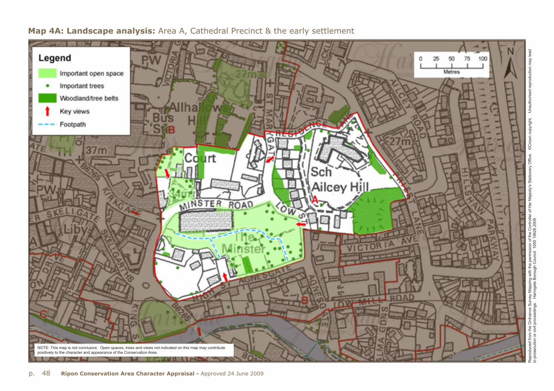
p. 48 Ripon Conservation Area Character Appraisal - Approved 24 June 2009
Map 4A: Landscape analysis: Area A, Cathedral Precinct & the early settlement
Rep
rodu
ced
from
the
Ord
nanc
e S
urve
y M
appi
ng w
ith th
e pe
rmis
sion
of t
he C
ontro
ller o
f Her
Maj
esty
’s S
tatio
nery
Offi
ce.
©C
row
n co
pyrig
ht.
Una
utho
rised
repr
oduc
tion
may
lead
to
pro
secu
tion
or c
ivil
proc
eedi
ngs.
H
arro
gate
Bor
ough
Cou
ncil
100
0 19
628
2009
NOTE: This map is not conclusive. Open spaces, trees and views not indicated on this map may contribute positively to the character and appearance of the Conservation Area.

p. 49Ripon Conservation Area Character Appraisal - Approved 24 June 2009
Map 4B: Landscape analysis: Area B, Medieval City around Market Place with High St Agnesgate
Rep
rodu
ced
from
the
Ord
nanc
e S
urve
y M
appi
ng w
ith th
e pe
rmis
sion
of t
he C
ontro
ller o
f Her
Maj
esty
’s S
tatio
nery
Offi
ce.
©C
row
n co
pyrig
ht.
Una
utho
rised
repr
oduc
tion
may
lead
to
pro
secu
tion
or c
ivil
proc
eedi
ngs.
H
arro
gate
Bor
ough
Cou
ncil
100
0 19
628
2009
NOTE: This map is not conclusive. Open spaces, trees and views not indicated on this map may contribute positively to the character and appearance of the Conservation Area.

p. 50 Ripon Conservation Area Character Appraisal - Approved 24 June 2009
Map 4C: Landscape analysis: Area C, River Skell west, Riverside, Bondgate, Waterside & the Canal
Rep
rodu
ced
from
the
Ord
nanc
e S
urve
y M
appi
ng w
ith th
e pe
rmis
sion
of t
he C
ontro
ller o
f Her
Maj
esty
’s S
tatio
nery
Offi
ce.
©C
row
n co
pyrig
ht.
Una
utho
rised
repr
oduc
tion
may
lead
to
pro
secu
tion
or c
ivil
proc
eedi
ngs.
H
arro
gate
Bor
ough
Cou
ncil
100
0 19
628
2009
NOTE: This map is not conclusive. Open spaces, trees and views not indicated on this map may contribute positively to the character and appearance of the Conservation Area.

p. 51Ripon Conservation Area Character Appraisal - Approved 24 June 2009
Map 4Dn: Landscape analysis: Area D north, Victorian Suburbs
Rep
rodu
ced
from
the
Ord
nanc
e S
urve
y M
appi
ng w
ith th
e pe
rmis
sion
of t
he C
ontro
ller o
f Her
Maj
esty
’s S
tatio
nery
Offi
ce.
©C
row
n co
pyrig
ht.
Una
utho
rised
repr
oduc
tion
may
lead
to
pro
secu
tion
or c
ivil
proc
eedi
ngs.
H
arro
gate
Bor
ough
Cou
ncil
100
0 19
628
2009
NOTE: This map is not conclusive. Open spaces, trees and views not indicated on this map may contribute positively to the character and appearance of the Conservation Area.

p. 52 Ripon Conservation Area Character Appraisal - Approved 24 June 2009
Map 4Ds: Landscape analysis: Area D south, Victorian Suburbs
Rep
rodu
ced
from
the
Ord
nanc
e S
urve
y M
appi
ng w
ith th
e pe
rmis
sion
of t
he C
ontro
ller o
f Her
Maj
esty
’s S
tatio
nery
Offi
ce.
©C
row
n co
pyrig
ht.
Una
utho
rised
repr
oduc
tion
may
lead
to
pro
secu
tion
or c
ivil
proc
eedi
ngs.
H
arro
gate
Bor
ough
Cou
ncil
100
0 19
628
2009
NOTE: This map is not conclusive. Open spaces, trees and views not indicated on this map may contribute positively to the character and appearance of the Conservation Area.
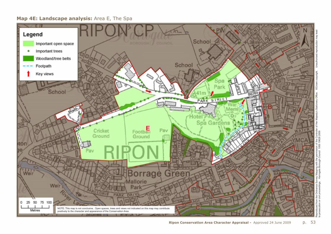
p. 53Ripon Conservation Area Character Appraisal - Approved 24 June 2009
Rep
rodu
ced
from
the
Ord
nanc
e S
urve
y M
appi
ng w
ith th
e pe
rmis
sion
of t
he C
ontro
ller o
f Her
Maj
esty
’s S
tatio
nery
Offi
ce.
©C
row
n co
pyrig
ht.
Una
utho
rised
repr
oduc
tion
may
lead
to
pro
secu
tion
or c
ivil
proc
eedi
ngs.
H
arro
gate
Bor
ough
Cou
ncil
100
0 19
628
2009
Map 4E: Landscape analysis: Area E, The Spa
NOTE: This map is not conclusive. Open spaces, trees and views not indicated on this map may contribute positively to the character and appearance of the Conservation Area.

p. 54 Ripon Conservation Area Character Appraisal - Approved 24 June 2009
Appendix A
1. Management StrategyThe purpose of the Conservation Area Appraisal and Management Strategy is to provide a clear and structured approach to development and alterations which impact on the Ripon Conservation Area. The special qualities, which “it is desirable to preserve or enhance”, have been identified in the Appraisal.
Although Ripon is an attractive City, it does not follow that all buildings and spaces within the Conservation Area necessarily contribute to that attractiveness. Ultimately, the aim is to (a) explore whether there are any buildings or areas which are at odds with or spoil the character of the Conservation Area, and (b) to consider how the special character or distinctiveness, as defined in earlier sections of this document, might best be preserved or enhanced.
Clearly, some of the ideas or suggestions will relate to buildings or land in private ownership. It is important to note that individual owners and/or the local community will not be under any obligation to make the changes or improvements suggested. However, they may be encouraged to think about suggestions made, and once the Appraisal has been adopted, the findings and recommendations will be considered by the Borough Council in response to any applications for planning permission, listed building consent, conservation area consent or requests for grant aid.
2. Monitoring & reviewThe Borough Council is required to review its conservation areas on a regular basis, this may involve the designation of new conservation areas, the de-designation of areas that have lost their special character, or the extension of existing conservation areas. The special character of Ripon has been re-evaluated as part of the process of preparing the character Appraisal and this contributes to the overall review.
Part of the review process involves the maintenance of a comprehensive and up to date photographic record to establish a visual survey of buildings of local interest in the Conservation Area. This record was compiled with involvement of the community at the public consultation event.
3. Maintaining qualityTo maintain the recognisable quality of the Ripon Conservation Area and to ensure the highest quality of design, the Council will:
from time to time review the character Appraisal and Management Strategy, which will act as a basis for development control decisions and the preparation of design briefs;
require all applications to include appropriate written information and legible, accurate and up to date, fully annotated scale drawings;
keep under review a list of buildings of local interest, that positively contribute to the character and appearance of the Conservation Area;
where appropriate prepare supplementary planning documents including design guidance and development briefs;
expect the historic elements which are essential part of the special architectural character of the Conservation Area to be preserved, repaired and reinstated where appropriate.
4. Conservation Area boundary reviewAs part of the process of producing the Appraisal the existing Conservation Area boundary was reviewed. The outcome of the public consultation event identified adjoining areas as being of positive interest in ways which directly related to the special character of the existing Conservation Area. The future inclusion of the these areas will be determined on the basis of whether they have special architectural or historic interest the character or appearance of which it is desirable to preserve and enhance.
It was suggested by residents and members of the Ripon Civic Society that a small number of amendments to the boundary were required as follows:
Include late nineteenth century terraces at Ure Bank Top
Include Nos. 20-22 Palace Road
Include field to rear of BP garage, North Road
Amend boundary at Kearsley Road and Darnborough Gate by excluding the recent development here.

p. 55Ripon Conservation Area Character Appraisal - Approved 24 June 2009
Terraces at Ure Bank TopThese terraces comprise three separate groups of two-storey terraced houses, numbered 1-21, 24-27 and 28-31. The long row of twenty one houses is of at least four separate builds, and one block is dated 1886. These are all simply detailed flat fronted houses, with swept window heads and little in the way of detail. They are much plainer than the ornate houses round the corner in Ure Bank Terrace, and have also been altered with the loss of original windows and doors and the use of external render in some cases. These factors mitigate against their inclusion in the Conservation Area and it is deemed inappropriate to include them.
On re-examination it was found that the Conservation Area boundary bisected the rear gardens of 12-15 Ure Bank Terrace. So, it has been amended to follow the gaden walls and include the whole of the gardens of these properties.
Nos. 20-22 Palace RoadThis is a largely unaltered pair of late nineteenth century houses with four pane sash windows and plain door cases and, as such, it merits inclusion in the Conservation Area.
Field behind BP garage, North StreetThis unkempt piece of grassland is bounded by groups of trees to all four boundaries, the trees along the eastern boundary being protected by a Tree Preservation Order. The field does not have any great merits which would add to the character or appearance of the Conservation Area and its inclusion within the Conservation Area is not supported.
Boundary between Kearsley Road and Darnborough Gate.Here, recent development of residential area and a new business park arbitrarily cuts across the Conservation Area boundary. Accordingly, the Conservation Area has been moved eastwards by around one hundred metres to exclude this new development but retain the trees and clumps of woodland at Highfield.
Two other small boundary changes have been made to the Conservation Area boundary to remove anomalies created by recent development.These are at Stammergate Court near the junction of Allhallowgate and Stonebridgegate, and at The Crescent in Borrage Lane. These minor adjustments have been made to ensure the Conservation Area boundary follows property boundaries and is readable on the ground.
5. The management of changeThe special character and appearance of Ripon Conservation Area is vulnerable to erosion and significant harm through often well-intentioned, but misguided alterations and inappropriate change.
There is scope for enhancement of some of the yards and backlands in the City centre, for instance at the rear of Sainsburys extending to the rear of Kirkgate. The completion of the new retail development west of Market Place may provide an opportunity for the reuse of derelict buildings at the rear of North Street at Irelands Court and adjacent areas.
20-22 Palace Road

p. 56 Ripon Conservation Area Character Appraisal - Approved 24 June 2009
6. Opportunities for enhancementWhilst most of the buildings in Ripon are in good condition, those which have been unoccupied for some time look unkempt and this is detrimental to the appearance of the City centre:
Repair roofs and external walling (including render repairs, repointing and the replacement of eroding masonry).
Repair and enhancement of traditional shopfronts .
Replacement of all or part of those shopfronts that are inappropriate for the building of which they are a part, and which are detrimental to the street scene.
Reinstate windows to their former pattern and detail where use of standardised factory made joinery and PVCu windows has undermined the character of historic areas.
There are opportunities to enhance spaces between and about buildings as follows:
Resurfacing areas in traditional paving materials;
Rationalisation of street furniture and where the appearance of street furniture is at odds with the character of the area, replace with street furniture of more appropriate design;
Trees which make a particular contribution to the Conservation Area should be protected by Tree Preservation Orders (trees in conservation areas have a degree of protection).
Management of existing trees and additional native tree planting to enhance areas or to screen unattractive elements.
Deterring casual parking that causes erosion of grass.
Reinstatement of missing railings.
Existing buildingsThe survey of the existing buildings within the Conservation Area clearly identified that a distinctive character exists, although to some extent this has been eroded by subsequent alterations, which have not always recognised that distinctiveness. Over the past 30 years, public aware-ness and expectation of the planning system to protect the ‘familiar and cherished scene’ has increased substantially. Additionally, there now exists a greater understanding of the impact which incremental change can have upon the distinctive character of historic areas. Options to safeguard and enhance the architectural character of Ripon could include some or all of the following:
Design GuidanceAdditional design guidance, which is more specific to the Conservation Area for future alterations to direct change towards materials and design detailing which complements the defined local architectural character. Such design guidance would be in the form of non-statutory planning guidance.If adopted, this guidance would act as a yardstick against which proposals could be assessed and could assist both existing and future residents in understanding what is desirable
Article 4 DirectionsFormal control over future alterations of buildings could be introduced through what is known as an Article 4 Direction, which removes permitted development rights. These are the rights granted by Statute to alter dwellings without the need for planning permission within strict limitations.Article 4 Directions can be designed to be specific to particular types of development, relating, for example, only to roof covering or front elevations. It cannot place an embargo on change, but rather brings certain types of development within the within the scope of planning control, so the impact of any proposed change can be properly assessed.
An Article 4 Direction, which would be drawn up by the local planning Authority (namely the Borough Council), is the only means of applying equal control to all buildings within the Conservation Area. Without such a Direction, alterations will only be subject to control where planning permission or listed building consent is required. Equally, any non-statutory
Iron railings at Highfield

p. 57Ripon Conservation Area Character Appraisal - Approved 24 June 2009
planning guidance will only be capable of being applied in those cases where applications are necessary. Article 4 Directions could be introduced throughout the Conservation Area or just to individual buildings whose special interest is considered to be at risk from incremental change.
Reinstatement of architectural detailsPromotion of schemes that seek to restore the architectural character of altered buildings. Some buildings have been altered, which has changed their architectural form in a way which conflicts with the distinctive character of Ripon - some, to such an extent that the original form and character is no longer recognisable. The introduction of standardised contemporary door patterns and PVCu windows and porches is well established, but much original fabric remains. Non-sympathetic alterations should be resisted.
Grant SchemesFrom time to time the Borough Council (occasionally with other partners such as English Heritage or Yorkshire Forward) operates grant schemes to help maintain and enhance the character and appearance of the Conservation Area.
Quality erosion & loss of architectural detailThe character and appearance of buildings in the Conservation Area is harmed by the removal or loss of original architectural features and the use of inappropriate materials. For example, the loss of original joinery, sash windows and front doors can have considerable negative impact on the appearance of an historic building and the area. Insensitive re-pointing, painting or inappropriate render will harm the long-term durability of brick and stonework.
In all cases, the Borough Council will expect original historic features and detailing to be retained, preserved and refurbished in the appropriate manner, and only replaced where it can be demonstrated that it is beyond repair.
Roof alterations & extensionsThe Conservation Area contains many historic rooflines, which it is important to preserve. Fundamental changes to the roofline, insensitive
alterations, poor materials, intrusive dormers, or inappropriate roof windows can all harm the character of the historic roofscape and will not be acceptable.
Shopfronts, outdoor advertisements & street furnitureShopfronts represent an important element in the City’s built environment and as such should be to a high standard of design. High quality traditional shopfronts should be retained and new shopfronts should be well related to the building of which it forms part, being of good proportions, appropriate detailing and traditional materials. Existing shopfronts with over deep fascias, plate glass windows and unsympathetic materials, or indeed, poorly detailed contemporary shopfronts should be redesigned. The design and appearance of street furniture and advertisements in the City adds to street clutter and needs improvement in order to visually enhance the character and appearance of the area without damaging the vitality of shops.
The size, design and number of any advertisements should respect the scale, character, design and location of the building and/or shopfront on which it is displayed, as well as the overall street scene.
Gardens & front boundary treatmentsFront and rear gardens and especially boundary walls make an important contribution to the streetscape and character of certain parts of the Conservation Area. The Borough Council will resist the loss of soft landscaping and original boundary walls and railings. For example the construction of new openings and the consequent breaking up of the continuous walls flanking the main roads from the west would be detrimental to the character and appearance of the Conservation Area.
Telecommunications equipment, satellite & cable dishesExternal telecommunications apparatus including cable runs can harm the appearance of historic buildings. The Borough Council can provide

p. 58 Ripon Conservation Area Character Appraisal - Approved 24 June 2009
guidance on the installation of telecommunication equipment including satellite dishes.
Overhead wires are intrusive in parts of the Conservation Area, and under-grounding of cables would considerably enhance the character of the area. This should be a long-term aim in the interests of the character and appearance of the Conservation Area.
Important trees The existing mature trees throughout the Conservation Area, add to its charm and character. In accordance with the Council’s Landscape Design Guide, the existing pattern of trees and woodland should be preserved and repaired through managed planting and maintenance. In considering both of these areas, guidance should be geared towards tree/shrub planting and management methods that improve wildlife habitats.
New developmentA key consideration is the impact that future development proposals (whether in the form of new build-ings or through the extension of existing buildings) might have on the distinctive form and character of the Conservation Area.
New buildings will only be per-mitted where they respect, rather than compete with the historic skyline, respect landform and landscape pattern and are accompanied by a comprehensive landscape scheme that is integral to the design.It is especially important to retain key views of the Cathedral, the Obelisk and the spire of Holy Trinity Church. New development must be of a suitable quality of design and execution and should relate to its context and respect the established values identified in the Appraisal. The Council will encourage new development that complements the establish grain or settlement pattern, whilst representing the time in which it is built and the culture it accommodates. New development should respect and not impact on the existing spaces between buildings.
A further key consideration for new development is the appropriateness of the overall mass or volume of the building and its scale. A new building should be in harmony with, or complementary to, its neighbours. It is important that the materials generally match or complement those that are historically dominant in the area.
Within the above criteria, new development should aim to achieve creative design solution, whether contemporary or traditional in style.
Employment & commercial activityRipon is a small, historic Cathedral City that faces many of the issues common to market towns across the country: There has been some investment in the centre in recent years, with the new bus station and retailing east of the Market Place, and with new retailing provision and housing currently under way west of the Market Place. The waterfront areas to the south of the historic City have undergone radical redevelop-ment as residential areas in recent years.
The main employment area, outside of the City centre, is well to the south of the historic City centre between Bondgate Green, the Ripon Bypass and Dallamires Lane. Concentrating employment development in this area has relieved the City centre of much heavy goods traffic, and has helped the City centre to retain much of its historic character.
The City centre provides a local service centre for the surrounding rural area and a focus for retailing and tourism. Therefore efforts should be made to encourage and support businesses and to protect and enhance existing commercial activity and the City’s role in this respect. Such efforts will benefit visitors by making the City more attractive (and improving the quality of their stay) as well as improving businesses competitiveness and arresting the decline of physical fabric in the City.
Neutral buildings & spacesNeutral elements or buildings may have no special historic or architectural quality in their own right, but nonetheless provide a setting for listed buildings and unlisted building of special character or interest. This backcloth is important and needs careful management as a setting for the special elements.
New housing, Blossomgate.

p. 59Ripon Conservation Area Character Appraisal - Approved 24 June 2009
Scheduled monumentsThe main scheduled area is centred on the Cathedral and contains the presumed site of the early monastery, with a separate scheduled area at Ailcey Hill. These areas are protected under the Ancient Monuments and Archaeological Areas Act 1979. Any works to these monuments will require consent from the Secretary of State, who would be advised by English Heritage.
Urban edgesNew development on the edge of Ripon should be of appropriate scale and take account of the existing landscape pattern and setting on the edge of the City. Harsh edges to new development should be avoided, and development at the urban edge should be designed to maintain the distinctiveness of place.
New developments in the fringes of the City should be carefully aligned to maintain historic viewpoints of the Cathedral.
The Bypass provides an effective urban edge to the eastwards expansion of the City, and although the northern and southern ends are well planted with trees, the central section has a stark appearance.
Tree plantingThere is a lack of new planting to succeed existing mature planting.New planting at the edges of the City will help to integrate new development, improve the setting of the City and help to diversify the age structure of trees. Care should be taken not to isolate the City from its surroundings, and any strategic tree planting in the fringes should take account of the characteristic patterns of tree and woodland cover.
FloodplainBuilt development should be avoided in these areas. Any flood defences should respect landscape and built environment character and should avoid earthworks and major engineering works. Opportunities to enhance the wildlife value of floodplains should be exploited, allowing for seasonal flooding and the introduction of appropriate management.
FootpathsExamine ways of improving the footpath network around the City and improving linkages into the countryside. The redevelopment west of the Market Place provides an opportunity to improve and enhance the footpaths leading from this area into the Market Place.
Wildlife & nature conservationA local nature reserve exists on the northern edge of the Conservation Area at Little Studley Meadows. There may be possibilities for the creation of wildlife corridors along river corridors and the old railway, and in areas with gypsum hollows.

p. 60 Ripon Conservation Area Character Appraisal - Approved 24 June 2009
Checklist to manage changeIn managing change in the Conservation Area, regard should be paid to the following:
Development should not impinge on the form and character of Ripon
The repair and reuse of older buildings should be encouraged in the first instance rather than redevelopment, except where the existing building detracts from the character of the Conservation Area.
The proper maintenance of older buildings is encouraged, together with the restoration of original features
Rationalisation of intrusive shop signage;
New development should avoid further sprawl into the countryside and should respect the character of settlement beyond the urban edge;
Buildings should be constructed of materials which match or complement local traditional materials.
Design should reflect the distinctive local architectural style both in terms of overall form and detailed design as appropriate to the context.
In general new buildings should follow the established building line.
New development should not adversely impact on the historic skyline, in particular on views of the Cathedral and the spire of Holy Trinity Church. There is a variety of eaves levels which is important to the street scene, and any new development should maintain this diversity.
Where buildings are set back from the street, front boundaries (walls, railings or hedges) should reflect the existing boundaries of the immediate locality.
Development should not impact upon tree cover;
The positive management of the ageing stock of mature trees should be undertaken;
Boundary walls of stone or brick are an important feature of many parts of the Conservation Area, as are iron railings, and should be repaired and retained;
Minimise clutter of signage and street furniture.
Existing historic paving should be kept in good repair and the use of traditional materials should be extended to the most sensitive locations.

p. 61Ripon Conservation Area Character Appraisal - Approved 24 June 2009
Appendix B
Public ConsultationThe Borough Council’s Statement of Community Involvement (SCI) sets out the requirements for public consultation. To meet these requirements, and to inform a review of the Conservation Area, two public consultation events were held on the evening of Monday 24 September and the morning of Saturday 29 September 2007.
These consultations took the format of public meetings and included a walkabout and a workshop session. Prior to the events residents were notified via a leaflet. In addition, a press release appeared in the local newspaper informing residents and consultees that a review of the Conservation Area was taking place and that workshops had been arranged.
The format of the workshops included a short presentation on why the Conservation Area is being reviewed, the purpose of the Appraisal and management plans and a brief resumé on the changes that have happened since the original designation.
The main activity was a walkabout, which involved dividing into groups walking around part of the Conservation Area. The groups were encour-aged to make notes and take photographs to identify what makes Ripon special to them. On return to the venues, the workshop session enabled the groups to share the information gathered on the walkabout by anno-tating large maps of the City with text, symbols and photographs. The maps then facilitated a feedback session, mainly focusing on identifying potential areas within the Conservation Area in need of enhancement.
The outcome of the consultation events and the information gathered directly contributed to producing this Appraisal. Key issues raised at the event included:
the preservation of important views;
identifying buildings of local interest;
suggestions for changes to the extent of the Conservation Area;
the retention of important boundary walls;
the retention and management of trees.
traffic through the City and particularly on Coltsgate Hill redevelopment to the west of Market Place and North Street
(n.b. the latter 2 points have been addressed to a large degree through the construction of the inner link road from Blossomgate to North Road and attendant redevelopment in the west of the Market Place.)
Whilst every effort has been made to take into account and give due consideration to the views of the local residents (and to represent those views in this Appraisal document) it has not been possible to be comprehensive.
Local involvement is an essential aspect of the consultation process and local residents were encouraged to comment on the draft documents during the consultation period from 30 June to 15 August 2008. Further, minimal amendments to the text were made following this consultation, and the Conservation Area Assessment adopted by the Council and published on its website.

p. 62 Ripon Conservation Area Character Appraisal - Approved 24 June 2009
Appendix C
Listed Buildings within Ripon Conservation AreaGrade IObelisk, Market Place
Ripon Minster
Chapel of the Hospital of St Mary Magdalene, Magdalens Road
Grade II*Church of St Wilfred, Coltsgate Hill
Ripon Town Hall, Market Place
The Court House, Minster Road
The Old Deanery, Minster Road
St Anne’s Hospital (mediaeval ruins), High St Agnesgate
Minster House, Bedern Bank
The Old Hall, High St Agnesgate
16 St Agnes House, High St Agnesgate
27 St. Marygate (Deans Croft)
Gazebos in gardens of 7 & 8 Park Street
Thorpe Prebend House, High St Agnesgate
The Wakeman’s House, Market Place
Grade IIAllhallowgate: 44 & 45, 42, 75 The Lodge, 76 77 & 78, 57 to 74, 50 to 51, 53 to 56, Sharow View;
Bedern Bank: Garden walls of Minster House, Walls to Coach House yard, Coach House to Minster House;
Blossomgate: 30 & 31, 47 48 49 & 50;
Bondgate: 1. Chapel of St John The Baptist, 94 to 99 (Hospital of St John The Baptist), Bondgate Bridge;
Bondgate Green: New Bridge, Brewers Arms, 3 4 5 & 6, Gate Piers, 28 & 29;
Borrage Green Lane: 4 (Ivy House), 5 (Skell Cottage), Wall, Wall (Borrage Green Lane/Harrogate Rd);
Borrage Terrace: 2 to 8 (even);
Canal Road: Ex-canal warehouse & wharfe manager’s house, 3, 10 (Danby House), 11 (Field House), Gate Piers to Danby & Field House;
Clotherholme Road: Clova, Gate Piers to Clova;
Coltsgate Hill: 5 to 8, 9,10 to 13, 15, 16 & 17,18, 19, 20,21, The Old Chapel, College of Ripon & York St John;
Court Terrace: 1, 2, 3 & 4 ;
(The) Crescent: 1, 2, 3, 4 & 5, 6 & 7, 8, 9,10, 11 & 12, Post - cast iron;
Duck Hill: 1, 2, Hornblower Restaurant (Ex cell block);
Firby Lane: Ripon & District Hospital;
Fishergate: 2, 4, 11, 18, 20;
Fishergreen: Skell Railway Bridge;
Fishers Court: 1, 2 & 3;
Harrogate Road: Richardson’s Drinking Fountain, Borrage Bridge;
High St Agnesgate: 14 St Michael’s House, 15, 29,30.31 & 32, Garden Walls to St Anne’s Hospital, St Anne’s Almshouses;
High Skellgate: 3, 4 & 5, 6, 7 & 8, 9 (Lamb and Flag PH), 13, 14 & 15, 17 & 17a; 19, 20, 21, 22, 24;
King Street: 2 to 6, 7 & 8;
Kirkby Road: 2 & 4 (Trinity Cottages), Church of the Holy Trinity; 7 (West Grange), 3 (Coney Garth);
Kirkgate: 5a, 5 & 6, 7, 8 & 9, 10, 11 & 11a, 12 & 13, 14 & 15, 16 & 17, 19, 23, 24 & 25, 26, 27 (The Black Friar Cafe?), 33 & 34, 35, 36 Kirkgate (The Royal Oak PH), 38 & 38a, 39, 41 & 42;

p. 63Ripon Conservation Area Character Appraisal - Approved 24 June 2009
Low Mill Road: Warehouse (at H B C Depot);
Low Skellgate: 1 & 2 (Skellgate Curios), 3, 5, 6, 9 & 10, 11 & 12, 25, 26 to 30, 34, Turks Head Public House, Williamson’s Varnish Works former offices, 36;
Low St Agnesgate: Wall (west side of road bounding Cathedral grounds);
Magdalens Road: 20 & 22 & 24 (Albion Terrace), Chapel of St. Mary Magdalene, 29 to 35 (Almshouses);
Market Place: 1, 2 (The Unicorn Hotel), 3 (annex to Unicorn Hotel), 5, K6 telephone Kiosks (row of 4 ), Cabman’s Shelter, 10 Market Place (ex Studley Royal Hotel), 8 & 9, 13, 14, 15, 17, 17a & 18 20, 23 & 24, House attached to north of 23 & 24, 25 & 26, 30 & 30a, 34, 37, 41, 42;
Minster Road: The Old Courthouse, Wall to The Old Courthouse, Wall in front of The Old Deanery;
North Road: 1, 2, 3 & 4 (Princess Terrace), 31 to 35 (Freemantle Terrace), 46, Victoria Clock Tower;
North Street: 14, 17, 18 (& ex Saracen’s Head PH), 20, 21 & 22, 23, 24 & 25, 26 & 27, 28, 42 & 42a (Crescent Lodge), 43, 49 & 50, 53, 54 & 55, 60 & 61 (The White Horse PH), 62, 63 & 64, 65, 66 & 67, 71 & 72, 73, 76, 77, Rear part of 82 & 83, 85, North Bridge;
Old Market Place: 3 (The Wakeman PH), 2, 9, 10 & 11, The Black Bull Public House;
Palace Road: 33 & 35, 54, Highfield, Lodge to Highfield, Gate piers to Highfield;
Park Street: 4 & 5, 6, 7 & 8, 9, 10, 11 (Old Park House), 12 (Burnham Close), Spa Baths, Gate piers to west of Spa Baths, Bandstand (Spa Gardens), Statue of the first Marquess of Ripon (Spa Gardens), War Memorial (Spa Gardens);
Queen Street: 7, 8, 9, 10, 11, 12;
Princess Road: 1 (Princess Terrace);
Smithson’s Court: 3 & 4;
St Marygate: 1, 2 & 2a (The Fleece PH), 21, 22, 23 & 24, 25 & 26, 28 & 29, 30, 31 & 32, Abbot Huby’s Wall;
Skellbank: 5 & 6, St. Wilfred’s Well & flanking gates;
Skellgarths: 2, 3, 4 & 5, 11, 12 & 13;
Studley Road: Green Royd;
Trinity Lane: Main block to Holy Trinity School, Presbetery to St Wilfred’s Church;
Trinity Park: West Lodge & Crowners Close, Former Coach House west of Crowners Close;
Victoria Grove: Sewer Gas Lamp;
Water Skellgate: 4, 5, 6, 6a, Ripon Conservative Club, Sigma Antiques (Former Opera House);
Westgate: 5, E part of 6 Westgate, W part of 6 & 7, 8 & 9, 10, 11 & 11a, 14, 15 & 16 (The Cosy Cafe), 17, 18 & 19, 20, 21 (The Black Swan PH), 22, 23, 25 & 26, Midland Bank;

p. 64 Ripon Conservation Area Character Appraisal - Approved 24 June 2009
Appendix D
Deadman, J. (2006) Historic Building Survey: The Beeches, Magdalen’s Road, Ripon.
(2007) Historic Building Survey : 81-2 Bondgate, Ripon.
Department of the Environment (1994) Planning Policy Guidance Note 15: Planning & the Historic Environment.
English Heritage (2006) Guidance on Conservation Area Appraisals.
Hatcher, J. (1985) The Industrial Architecture of Yorkshire (Philimore, Chichester).
MacKay, W. (1982) The Development of Medieval Ripon.Yorkshire Archaeological Journal Vol 54, pp73-80.
Pevsner, N. (1967) Buildings of England: Yorkshire, West Riding (Penguin, Harmondsworth).
Raistrick, A. (1970) The Making of the English Landscape : West Riding of Yorkshire ( Hodder & Stoughton, London).
Ripon Civic Society (1972) Ripon, Some Aspects of its History (Dalesman Books, Clapham)
Sheeran, G (1998) Medieval Yorkshire Towns (Youngson, Edinburgh).
Whyman, M (1997) Excavations in the Deanery Gardens and Low St Agnesgate, Ripon. Yorkshire Archaeological Journal Vol.69 pp119-163.
York Archaeological Trust (2003) Archaeological Evaluation 2003/31: Former Cathedral School, Low St Agnesgate, Ripon.
Younge, M.(2004) Ripon. In Butlin R.A. (ed) Historical Atlas of North Yorkshire.
Manuscript Sources
Jones, G (1986) The Ripon Estate: Landscape into Townscape (University of Leeds).
North Yorkshire County Record Office (NYCRO)
John Humphries’ Map of Ripon 1800 MIC 1540/517
Map of Ripon and Bondgate 1822 MIC 2236/115-116
Borough of Ripon Map 1857 MIC 2707/26
Plan of an Estate in Four Lots (The Crescent) 1857 MIC 2236/207
Plan of Building Land (Crescent Parade) 1860 MIC 2236/217.
Whitehead, J (1999) Architectural and Historical Notes on St Agnesgate, Ripon.
Yorkshire Vernacular Buildings Study Group: Reports on the following Ripon Buildings in the Conservation Area:
53-4 and 62 Allhallowgate;
St Michaels House, Thorpe Prebend House, High St Agnes House and Old Hall, all in High St.Agnesgate;
17-17a High Skellgate;
4 Kirkby Road;
Rear of 4 Kirkgate and 7,8,9 11, 19, 27 and 32 Kirkgate;
11-12 Low Skellgate;
Unicorn Hotel , 17-18 and 34 Market Place;
The Black Bull, Old Market Place;
27 St Marygate (Deans Croft).
18, 20 Westgate.
Further Reading

p. 65Ripon Conservation Area Character Appraisal - Approved 24 June 2009

p. 66 Ripon Conservation Area Character Appraisal - Approved 24 June 2009