conservation area appraisal and management plan
TRANSCRIPT

LDF Evidence
Base
Rochford District Council October
RochfordD i s t r i c t C o u n c i l
2007
Local Development Framework
Evidence Base
Canewdon High Street
Conservation Area Appraisal and
Management Plan


Cantonese 如果你 需要 放大,盲
文資訊或者不同語言的
版本請聯絡 01702 546 366
Gujarati Spanish Si desea esta información impresa en letra grande, Braille o en otro idioma, por favor llame al teléfono 01702 546 366
Urdu
Portugese Caso necessite desta informação em impressão maior, em Braille ou noutra língua, por favor contacte 01702 546 366
Shona Kana uchida ruzivo, kana tsananguro iyi yakanyorwa nemavara makuru, kana kuthi yakanyorwa nerurimi rwemapofu, kana nerumwe rurimi, kana umwe mufauro sununguka kuti taurira parunare ronoti 01702 546 366
If you would like this information in
large print, Braille or another language please contact 01702 546 366
This document was produced by Essex County Council for Rochford District Council. Contributions to this document were made by the following officers in the Essex County Council Historic Buildings Section: Karen Fielder MA, PgDip With document production by Cathryn Thaiss
© Rochford District Council and Essex County Council 2006

Contents 1. Introduction 1 2. Character statement 2 3. Statutory Protection 5 4. Planning Policies 5 5. Origins and development
Location and landscape setting 6 Historical development 7
6. Character Appraisal Spatial analysis 13 Character analysis 20
Problems and pressures 27 7. Management Proposals 29 Bibliography 33 Appendix Listed buildings in the conservation area 34

This page is intentionally blank.

1
1. INTRODUCTION 1.1 Canewdon is a large rural parish, which extends for several miles along the
southern side of the Crouch estuary. The area has important historical associations, with old entrenchments that once existed between the village and the river believed to mark the site of Canute’s camp before his victorious battle with Edmund Ironside in 10161. Canewdon village is located on a hill, and the massive tower of the parish church is a conspicuous local landmark that is widely thought to be the site of Canute’s Minster.
1.2 There are two conservation areas in Canewdon village, one taking in most of the
High Street centred on The Anchor public house, the other centred on the church (Fig. 1). Canewdon High Street conservation area encompasses the linear village settlement between West Cottages and Rest Cottages along the High Street and Lambourne Hall Road, including the junction with Canute Close and a short length of Gays Lane.
1.3 Conservation areas are ‘Areas of Special Architectural or Historic Interest, the
character or appearance of which it is desirable to preserve or enhance’ (Planning (Listed Buildings and Conservation Areas) Act 1990). Government Planning Policy Guidance 15, Planning and the Historic Environment, emphasises that the character of conservation areas derives not simply from the quality of individual buildings, but also depends on ‘the historic layout of property boundaries and thoroughfares; on a particular “mix” of uses; on characteristic materials; on appropriate scaling and detailing of contemporary buildings; on the quality of advertisements, shop fronts, street furniture and hard and soft surfaces; on vistas along streets and between buildings; and on the extent to which traffic intrudes and limits pedestrian use of space between buildings’ (para. 4.2).
1.4 Designation of a conservation area extends planning controls over certain types
of development, including extensions, boundary treatments, the demolition of unlisted buildings and works to trees. However it does not prevent any change and the area may be subject to pressures (good and bad) that will affect its character and appearance. Although Canewdon is a relatively remote village, it still faces pressure for change, most notably housing development, and there is a large element of modern infill along the High Street. The demand for modernisation and improvement of existing properties is a further threat to the character of the village, including extensions and works carried out as permitted development within the provisions of the General Development Order.
1.5 Rochford District Council commissioned Essex County Council to prepare this
conservation area appraisal and the research and fieldwork was carried out in July and August 2006.
1.6 The appraisal provides a brief development history of the current settlement,
followed by a description and assessment of character. The contribution of its
1 The Victoria County History (Vol. 1 1903) records a large oblong enclosure to the north of the church at Canewdon which is identified on early OS maps as the supposed site of Canute’s Camp. No above ground evidence of this survives today.

different elements to the character is identified. Any issues which may affect the protection of character will be highlighted and opportunities for enhancement identified.
2. CHARACTER STATEMENT 2.1 Canewdon is a small semi-rural village with a historic core following a medieval
or earlier linear settlement pattern along the High Street. The informality of the streetscape is enhanced by the gentle curve of the street, architectural variety and irregular building and eaves lines. The exception to this is the High Street between the two pubs, which is visually narrow and tightly enclosed, and built up to the street edge. Here the street retains its historic form and grain creating a sense of cohesion. The rural quality of the village is enhanced by trees, hedges, grass verges and private gardens. In the centre of the conservation area, The Algiers and its adjoining village stores creates a memorable impression, with its picturesque white weatherboard and ample clay tile roof. There has been significant modern infill to the historic settlement that does not always make a positive contribution to the special character due to inappropriate scale, massing and use of materials, and this undermines the overall cohesion of the conservation area. Some aspects of the public realm are also poor. Overall the appearance of the High Street reflects a continuous process of evolution and modernisation. It continues to function as the hub of village life with a range of amenities and a strong sense of community.
2

3
3
Reproduced by permission of Ordnance Survey® on behalf of the Controller of Her majesty’s Stationery Office. ©Crown Copyright. Licence number LA100019602 Fig. 1 Canewdon showing the Church and the High Street conservation areas.

Reproduced by permission of Ordnance Survey® on behalf of the Controller of Her majesty’s Stationery Office. ©Crown Copyright. Licence number LA100019602 Fig. 2 Canewdon High Street conservation area showing statutory designations.
4

5
3. STATUTORY PROTECTION WITHIN THE CONSERVATION AREA
(Fig. 2) 3.1 Canewdon High Street conservation area was designated in March 1986. 3.2 There are five listed buildings or groups of buildings in the conservation area.
These are the Old Post Office, Whinfell and Russell House (listed as one), The Anchor Public House, Canute House, and The Algiers and The Village Stores (also listed as one). These are all Grade II listed.
3.3 There are no scheduled ancient monuments within the conservation area. 3.4 There is one public footpath in the conservation area marked on the Definitive
Map of footpaths in Essex. This path runs north from the High Street along Gays Lane.
3.5 There are no trees protected by Tree Preservation Orders in the conservation
area. However trees within the conservation area enjoy protection in as much as anyone within a conservation area carrying out works to a tree must give written notification to the local planning department at least six weeks beforehand.
4. PLANNING POLICIES 4.1 Rochford District Replacement Local Plan was adopted in June 2006. Its
objectives include promoting a green and sustainable environment, improving the quality of life for people in the District, and the maintenance and enhancement of local heritage.
4.2 The Replacement Local Plan includes specific planning objectives to protect and
enhance the historic character of settlements, particularly within conservation areas, and to formulate and publish a detailed assessment of each conservation area, indicating townscape features, buildings and spaces that distinguish the character of each conservation area, to be taken into consideration when new development is being proposed.
4.3 The Replacement Local Plan contains policies (BC1-2) formulated to ensure the
preservation of the special character of the conservation areas and to promote good design within them. Further guidance for the assessment of proposals for development in conservation areas is provided in Local Plan Supplementary Planning Document 6.
4.4 Canewdon village is surrounded by Metropolitan Green Belt. The Replacement
Local Plan also includes a range of policies dealing with development in Green Belt (policies R1-R10), and there is a general presumption against inappropriate development. The preservation of the character of historic towns and villages including Canewdon is included in the Council’s objectives in applying Green Belt policies.
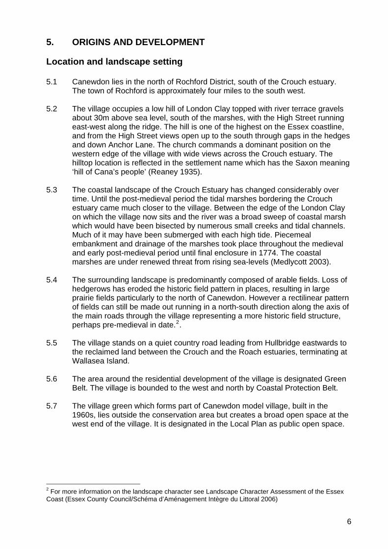
5. ORIGINS AND DEVELOPMENT Location and landscape setting 5.1 Canewdon lies in the north of Rochford District, south of the Crouch estuary.
The town of Rochford is approximately four miles to the south west. 5.2 The village occupies a low hill of London Clay topped with river terrace gravels
about 30m above sea level, south of the marshes, with the High Street running east-west along the ridge. The hill is one of the highest on the Essex coastline, and from the High Street views open up to the south through gaps in the hedges and down Anchor Lane. The church commands a dominant position on the western edge of the village with wide views across the Crouch estuary. The hilltop location is reflected in the settlement name which has the Saxon meaning ‘hill of Cana’s people’ (Reaney 1935).
5.3 The coastal landscape of the Crouch Estuary has changed considerably over
time. Until the post-medieval period the tidal marshes bordering the Crouch estuary came much closer to the village. Between the edge of the London Clay on which the village now sits and the river was a broad sweep of coastal marsh which would have been bisected by numerous small creeks and tidal channels. Much of it may have been submerged with each high tide. Piecemeal embankment and drainage of the marshes took place throughout the medieval and early post-medieval period until final enclosure in 1774. The coastal marshes are under renewed threat from rising sea-levels (Medlycott 2003).
5.4 The surrounding landscape is predominantly composed of arable fields. Loss of
hedgerows has eroded the historic field pattern in places, resulting in large prairie fields particularly to the north of Canewdon. However a rectilinear pattern of fields can still be made out running in a north-south direction along the axis of the main roads through the village representing a more historic field structure, perhaps pre-medieval in date.2.
5.5 The village stands on a quiet country road leading from Hullbridge eastwards to
the reclaimed land between the Crouch and the Roach estuaries, terminating at Wallasea Island.
5.6 The area around the residential development of the village is designated Green
Belt. The village is bounded to the west and north by Coastal Protection Belt. 5.7 The village green which forms part of Canewdon model village, built in the
1960s, lies outside the conservation area but creates a broad open space at the west end of the village. It is designated in the Local Plan as public open space.
2 For more information on the landscape character see Landscape Character Assessment of the Essex Coast (Essex County Council/Schéma d’Aménagement Intègre du Littoral 2006)
6

Historical development 3 5.8 Despite a lack of formal archaeological excavations a range of sites and
deposits are known at Canewdon reflecting multi-period occupation from at least the Neolithic (4,000-2,000 BC). The elevated position of the site made it an attractive choice for early settlers, and its proximity to the coast was valuable for sea trading and salt production. Prehistoric and Roman settlement in the area comprised farmsteads and cemeteries on the higher ground, and salterns and other coastal sites fringing the edges of the marshes. Gravel extraction in the early 18th century to the north of the church revealed a cremation cemetery of unknown date. In the first half of the 20th century gravel extraction revealed an important range of prehistoric remains including a Neolithic axe hoard and Iron Age burials. One of the most significant finds from the area is the Bronze Age Canewdon paddle, now in the National Maritime Museum, Greenwich, which demonstrates the close links with the coastal environment. The area to the north of the present settlement is characterised by a line of Iron Age or Roman Red Hills (salt production sites) marking the edge of the coastal marsh at that date.
5.9 The earliest documentary reference to Canewdon is in the Domesday Book of
1086, although the place name itself indicates earlier Saxon origins (Reaney, 1935). The area between Canewdon and Ashingdon is widely believed to have been the site of the important battle of Assandune between the Saxons under Edmund Ironside and the armies of the Danish King Canute. Canewdon is identified in local folklore as the site of King Canute’s camp, and Canewdon church is a possible candidate for the site of the minster built by Canute in 1020 to commemorate the war-dead. However the location of both the battle site and the minster are matters of academic dispute.
5.10 The Domesday Book records Canewdon at the very end of the Saxon period in
1066 and 1986. The lands belonged to Swein of Essex, the principal land-holder of the Rochford area, who would have had a hall there. Although the location of the hall is not proven, Canewdon Hall which lay to the north of the church in the area now occupied by Canewdon Hall Close is the most logical site. The parish church of St Nicholas is known to have been in existence in 1100 and it is probable that a church existed on the site prior to the Norman Conquest. The location of the late Saxon settlement is unproven, but comparison with other sites would suggest that a number of households would have been clustered close to the church and hall. The remainder would have been scattered throughout the parish in individual farms and cottages.
5.11 By the beginning of the medieval period the area was divided into five manorial
holdings, Canewdon Hall, Pudsey Hall, Apton Hall, Scotts Hall and Lambourne Hall. The principal manor of Canewdon comprised 26 households in 1086, whilst the four smaller manors had 19 households between them.
5.12 A degree of nucleation took place in the later medieval and post-medieval period
with the development of the village along the High Street to the east of the 3 For the history of Canewdon from an archaeological perspective, see Medlycott 2003, and for
Canewdon and the wider historic environment of Rochford District see the Rochford District Historic Environment Characterisation Project report of 2005. General village history can be found in publications by Ken Smith.
7

church and hall, as well as more dispersed settlement around the four smaller manorial halls and scattered isolated farms and cottages. The extent and location of the later medieval village settlement can be assessed from the 1777 Essex map of Chapman and André, which shows the church/hall complex and a line of dwellings along the southern edge of the High Street (Fig. 3). The settlement pattern now encompassed by the two Canewdon conservation areas reflects this arrangement.
Fig.3 Chapman and André map, 1777. The windmill stood until the late 19th century on the site now occupied by the Model Village.
Fig.4 Tithe map of Canewdon, 1840, showing further development mainly on the south side of the High Street and the rectilinear arrangement of fields in the surrounding landscape.
8

5.13 In the late 18th century the village saw a number of new developments that reflected the growing organisation of community life. In 1785 Pond House (no longer extant) adjacent to the village pond was identified for conversion into a parish workhouse. The workhouse closed about 50 years later when the Rochford Union workhouse was constructed. The buildings now known as Rest Cottages were erected as a children’s workhouse also in 1785. The village lock-up was erected around 1775 near the pond for the imprisonment of felons by the parish constable. This small weatherboarded building is now located at the east gate of the churchyard. A school and schoolmaster’s house was built at the west end of the High Street in 1799 on Poors’ Land. This is now a private residence known as Vicarage Cottage. As the population grew the school became inadequate and a new school was built in the High Street in 1863, a red brick building with a slate roof. This building still stands as part of the now much expanded school complex. In 1803/4 a well was dug on the orders of the Parish Vestry, housed in a small timber-shed on the south side of the High Street. This had disappeared by 1970 and now lies beneath the driveway by Richland House. In 1833 a congregational chapel was built to the east of the village, but was demolished during the Second World War and later re-sited on the High Street as it stood in the line of fire of guns protecting the radar site.
Fig. 5 Canewdon High Street in the early 20th century. The distinctive roofline of The Algiers is visible in the left background, with the gable of Canute House just visible slightly set back from this. The Anchor pub is in the right foreground. The buildings beyond this on the right have now gone, and the area is occupied by Costcutters, the school car park and late 20th century houses.
9

5.14 In 1801 the population was 569, rising to 723 in 1841, and declining once more to 495 in 1901. By the late 19th century the High Street was developed on both the north and south sides, but the south side remained the most densely built up with closely packed small plots built up to the street edge, whilst the north side remained more open. The Post Office Directory of 1871 lists commercial premises within the parish, including a shoemaker, a cooper, a carpenter, two bakers, a miller, a harness-maker and a blacksmith, and most of these are likely to have had premises in the village itself. Writing in 1867, the local historian Philip Benton recorded that the area had, over the preceding century, witnessed a degree of neglect with some houses unfit for human habitation, and ‘few recreations … except those enjoyments afforded by the public houses’.
Fig.6 Canewdon High Street from the 1st edition OS map, 1873, with tightly packed narrow plots built up to the street edge on the south side.
Fig. 7 Canewdon from the 2nd Edition OS map, 1897.
10

11
Fig. 8 Canewdon from the 3rd OS map, 1924. 5.15 Canewdon played an important role in national defence during the Second
World War when a radar site (Air Ministry Experimental Station Type 1) was located on the east edge of the village, one of the first to be built in Britain. The site comprised both a Receiving and Transmission site with four masts on each, which would once have dominated the skyline. They were used to plot the positions of British and enemy aircraft. Little remains of these important installations today, although the buildings that used to house the transmitting equipment still survive along with a number of pillboxes.
Fig.9 The High Street c.1981, with the Old Post Office on the right and Russell Row on the left
5.16 In the post-war period Canewdon expanded with new housing developments
around the settlement fringes to the north and south of the High Street, notably the Model Village built in the 1960s to the south west of the village around a large green. Along the High Street modern infill and replacement of older properties occurred, particularly on the south side of the street and around the school, with substantial semi-detached and detached properties reflecting a degree of affluence in the area. Canewdon today offers a wide range of housing and local services including village stores, pubs and a school, and it is a close knit village community. The 2001 census revealed the population of the parish to be 1477 with 558 households.

Reproduced by permission of Ordnance Survey® on behalf of the Controller of Her majesty’s Stationery Office. ©Crown Copyright. Licence number LA100019602 Fig.10 Date of construction of buildings in the conservation area.
12

13
6. CHARACTER APPRAISAL 6.1 The character of an area lies in the particular mix of local architectural details
and materials, and the relationships between buildings and spaces which form a distinctive whole. Overall the conservation area has an open, informal and varied appearance which is given structure and coherence by the gentle curve of the High Street. The north side of the High Street has retained a more open and green character, whilst the south side is more developed, although some of the small, closely packed historic plots have been merged to accommodate larger properties. The exception to the informal and open arrangement is the historic core of the High Street where there is tighter enclosure and building up to the street edge, but with variety in eaves line, roofscape and facades.
Spatial Analysis 6.2 The Canewdon High Street conservation area is linear in form, encompassing
the High Street from West Cottages in the west to Rest Cottages in Lambourne Hall Road in the east. It takes in properties on the south side of the street between West Cottages and the Anchor Public House, then runs along the street edge excluding the school complex and adjacent properties, as far as the village pond. This historic feature is included within the conservation area along with two large modern properties, Finches and Colmore, and Rest Cottages. To the north, the conservation area broadly follows the street edge opposite West Cottages, taking in the junction with Canute Close and properties from the Old Post Office to Rose Cottage, including a footpath running along the side of the gardens of Canute House and the southern end of Gays Lane. The boundary then follows the street edge ending opposite Rest Cottages.
6.3 The High Street and Lambourne Hall Road run continuously along the top of a
hill, curving gently along its length to offer unfolding views of facades of varying periods, scale and materials as the street emerges with forward movement.
6.4 The east end of the conservation area has an informal arrangement of
residential properties set back from the street edge with front gardens and green verges (Fig. 12). The wide junction with Althorne Way emphasises the feeling of openness, as does the village pond with its open green setting. West of the village pond a picket fence forms a boundary between the street and parking for the village school, which is at odds with the historic grain of the settlement. Gays Lane leads north from the High Street between the Village Stores and Rose Cottage, and is a rough gravel lane with level tarmac footway that heads off between properties and closes in to form a hedgerow-lined path following an old route north to the marshes (Fig.13).

©UK Perspectives Fig 11. Aerial photograph of conservation area
14
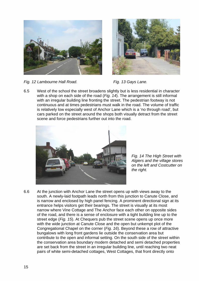
Fig. 12 Lambourne Hall Road. Fig. 13 Gays Lane. 6.5 West of the school the street broadens slightly but is less residential in character
with a shop on each side of the road (Fig. 14). The arrangement is still informal with an irregular building line fronting the street. The pedestrian footway is not continuous and at times pedestrians must walk in the road. The volume of traffic is relatively low especially west of Anchor Lane which is a ‘no through road’, but cars parked on the street around the shops both visually detract from the street scene and force pedestrians further out into the road.
Fig. 14 The High Street with Algiers and the village stores on the left and Costcutter on the right.
6.6 At the junction with Anchor Lane the street opens up with views away to the
south. A newly-laid footpath leads north from this junction to Canute Close, and is narrow and enclosed by high panel fencing. A prominent directional sign at its entrance helps visitors get their bearings. The street is visually at its most narrow where Vine Cottage and The Anchor face each other on opposite sides of the road, and there is a sense of enclosure with a tight building line up to the street edge (Fig. 15). At Chequers pub the street scene opens up once more with the wide junction at Canute Close and the open but unkempt plot of the Congregational Chapel on the corner (Fig. 16). Beyond these a row of attractive bungalows with long front gardens lie outside the conservation area but contribute to the open and informal setting. On the south side of the street within the conservation area boundary modern detached and semi detached properties are set back from the street in an irregular building line, until reaching two neat pairs of white semi-detached cottages, West Cottages, that front directly onto
15

the street and mark the west end of the conservation area. Looking further west to the end of the High Street the church is invisible behind mature trees that close the view.
Fig. 15 The High Street looking west with The Anchor pub on the left and Vine Cottage on the right.
Fig. 16 High Street looking west, Canute Close in the right foreground.
Open space 6.7 Wide open road junctions such as that with Althorne Way, broad green verges,
green space and large plots contribute to the open and informal quality of much of the conservation area (Fig. 18). The exception to this is the historic core between the two village pubs where properties are built up to the street. The village pond with its surrounding green landscaping is particularly important as public open space with amenity value that connects with the agricultural landscape beyond (Fig. 17).
16

Fig. 17 Green space around the Fig. 18 Wide verge and trees at the village pond with views beyond. junction with Althorne Way. Views 6.8 The elevated position of the village becomes evident when occasional views out
across the surrounding agricultural landscape are revealed, notably beyond the hedge at the east end of Rest Cottages, through a gap in the hedge surrounding the village pond, and looking south down Anchor Lane as it falls away down the slope of the hill (Fig. 19). This view is marred by the hard rectangular form of Anchor Parade, which is currently the subject of a planning application that would include revision of the roofline (Fig. 20). With careful design this is an opportunity both to enhance the setting of the listed Anchor pub and the view from the conservation area.
Fig. 19 View down Anchor Lane Fig. 20 Anchor Parade. looking south.
17

18
Reproduced by permission of Ordnance Survey® on behalf of the Controller of Her majesty’s Stationery Office. ©Crown Copyright. Licence number LA100019602 Fig.21. High Street conservation area townscape map.
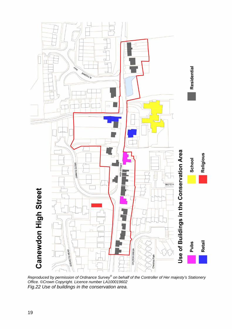
Reproduced by permission of Ordnance Survey® on behalf of the Controller of Her majesty’s Stationery Office. ©Crown Copyright. Licence number LA100019602 Fig.22 Use of buildings in the conservation area.
19

20
Character Analysis 6.9 Canewdon High Street has developed since at least the medieval period,
providing housing and a range of services and amenities for the local community. It retains its mixed use character today albeit with greater emphasis on residential properties. Evidence of former use is limited, although the village stores adjacent to Algiers demonstrate continuity of use over a long period. Canute House, now a residential property, has a vestigial shop window, and the name ‘Old Post Office’ is also indicative of former use. Architectural variety today reflects the evolution of the High Street, and includes modest terraced cottages, semi-detached and detached residences, retail premises and pubs (Fig. 22). The late 20th century and 21st centuries have seen an increase in the number of substantial residential properties with gardens, with the loss of some of the smaller cottages and workshops that fronted the street particularly on the south side. However the area between the two village pubs has retained its historic form and grain with a uniform building line and strong cohesion.
6.10 The conservation area exhibits a variety of architectural styles and forms that
contribute to its informal character and reflect its historical development. Traditional buildings contribute to the texture and interest of the streetscape. They exhibit a variety of rooflines and roof pitches that create a lively roofscape, including characteristic steep gambrel roofs, pitched roofs flanking the street with gabled and half-hipped side elevations and occasional gables facing on to the street. Roofs are frequently enlivened with brick or rendered chimneys and dormers with catslide, hipped or gabled roofs. The eaves line also varies, and the majority of properties are modest in height with one and a half or two storeys.
Materials and detailing 6.11 The older, traditional buildings share a palette of materials, principally render,
weatherboard and red brick laid in Flemish bond (possibly disguising timber framing), with plain clay tiles and later slate used for roofing. Rendered facades are generally painted white with only occasional use of a pale colour. Brick is mainly warm, soft red local brick, as seen on Canute House and The Old Post Office, laid in Flemish bond. In the past exposed brick was more common on elevations than it is today. The extensive use of non-local brick including hard brown brick on modern developments has undermined the contribution made by locally produced brick in the streetscape. Weatherboard was also once much more prevalent on street elevations than it is now, although it is still seen on side elevations as at The Old Post Office and Vine Cottage, and it is generally painted black when used in this way. The notable exception to this is the striking use of white weatherboarding on Algiers and the adjacent Village Stores. The 20th and 21st century buildings in the village feature a range of modern materials including painted render, bricks of varying colour and texture, and concrete.

Fig. 23 Algiers. Fig. 24 Old Post Office.
6.12 Window joinery is generally painted white sometimes with black architraves and sills, and small-paned casements and vertically sliding sashes are common on older properties. 20th and 21st century windows tend to be plain casements with night vents. Traditional doors are generally painted and boarded, panelled or part glazed with small panes. Entrances are occasionally embellished with simple catslide or gabled hoods, pediments and flat canopies, but few porches.
6.13 Generally, individual buildings are not heavily ornamented, but some examples
of decorative detailing used on traditional buildings include hood moulds (Canute House) and dentilled eaves cornices (The Anchor pub, Whinfell and Russell House).
Fig. 25 Whinfell House.
6.14 Front boundary treatments contribute to the character of the area. These are generally marked by low brick walls or hedges which suit the open and semi-rural character of the High Street. However the use of modern non-local brick for front walls can feel too suburban in the village setting. Less attractive frontages occur where hardstanding and driveways front directly onto the street. Historic photos show that timber post and rail and picket fences were used more widely in the past, as well as simple iron railings, all allowing the greenery of gardens and open spaces to impinge on the High Street and enhance its rural character.
21

Individual contributions to character 6.15 The most striking and memorable group of buildings is The Algiers and the
attached village stores, which provides a focus for the village and dominate the High Street at that point (Fig. 26). These buildings are of 18th century origin with later alterations and additions. The Algiers is a white weatherboarded house with a clay tiled roof over ranges that mark various builds. It is one storey but with two levels of catslide dormers in a half hipped gambrel roof on the main range. The windows are white painted small paned two and three light casements. There is a small hipped clay tiled canopy over the door, half hidden behind a tree and a neat front hedge. The shop to the right consists of two gabled ranges, the one to the left of white weatherboard and to the right of white render. The building is Grade II listed. Adjacent to Algiers is another Grade II listed building, Canute House, which is constructed of soft red brick (Fig. 27). This provides architectural contrast with the white weatherboard of The Algiers, and together they create a picturesque grouping. The house is early 19th century and of two storeys with a clay tile roof, and is unusual in the village for its more self conscious and high quality detailing. It has a lively roofline with a two storey gable to the right and a smaller feature gable to the left, the gables being moulded and dentilled, and red brick chimneys with diagonal shafts. The windows are white painted small paned casements with gauged brick arches and hood moulds, and there is a small paned bay shop window on the left. The house is set in mature gardens with a yellow stock brick wall to the front.
Fig. 26 The Algiers.
Fig. 27 Canute House.
22
6.16 The Anchor is another key building in the village, also Grade II listed, and although it is architecturally understated it occupies a prominent position at the junction with Anchor Lane. It is one of the oldest surviving buildings in the High Street, of 16th century or earlier date, with many later alterations and additions. It is of two storeys and timber framed, faced in white painted brick, with a varied roof line of clay tiles on three levels facing the road, hipped to the right and with the gable of a rear range rising above the ridge. The windows are small paned vertically sliding sashes with fine glazing bars, painted white with black frames. The doors have simple surrounds with flat canopies on brackets. Although the rear elevation of the pub viewed from Anchor Lane is appealing with its varied roofline and ranges, it is let down by an unattractive car park which is outside the conservation area but would benefit from some landscaping.
6.17 West of The Anchor as far as Chequers pub the historic character of the High
Street is at its most obvious, with several buildings of different periods making important contributions. On the south side there are a pair of single storey Grade II listed cottages, Whinfell and Russell House, of 17th century or earlier date and fronting directly onto the street (Figs 28, 29). They are timber framed and faced in brick, the cottage to the right now painted pink, with weatherboarded returns and clay tiled roofs. Each cottage has a pair of hipped dormers with small paned casements, with small paned sashes to the ground floor. On the other side of the street the elegant façade of the red brick Old Post Office emphasises the visual enclosure of the High Street (Fig. 30). Formerly known as Mayfair, and now Grade II listed, this two storey house is timber framed but with a neat symmetrical red brick principal elevation, weatherboarded on the side returns, with small paned vertical sliding sashes and a dentilled pediment over the door.
Fig. 28 Whinfell House.
Fig. 29 Russell House.
23

Fig. 30 The Old Post Office on Fig. 31 Chequers pub. the left, with Russell Row right. 6.18 A number of unlisted buildings make significant contributions to the conservation
area. Vine Cottage marks the visual narrowing of the High Street opposite the Anchor (Fig. 32). Its distinctive gambrel roof, slated with black weatherboard to the side returns, is given prominence in the roofscape by the curve of the street. It is a single storey white rendered cottage with catslide dormers and a single storey side extension. Gardens between Vine Cottage and The Old Post Office create a gap in the roofscape, but high panel fencing along the street edge maintain the sense of enclosure. Russell Row is a terrace of four well cared for white rendered cottages opposite the Old Post Office, with characteristically deep recessed sash windows and slate roofs (Fig. 30). With their strong building line they emphasise the tight enclosure of the High Street in this area. Adjacent to Russell House is Chequers pub, an off-white rendered two storey building with a slate roof, tall rendered chimneys at each gable end and a single storey side extension with a clay tiled gambrel roof and catslide dormer (Fig. 31). This much altered building is, along with the Anchor, one of the oldest buildings in the village, and marks the end of the narrow enclosed section of the High Street. Vine Cottage, Russell Row, and Chequers were all previously on the Rochford District Local List of buildings of architectural, historic and townscape which formed part of the Local Plan, but this list has unfortunately been dropped from the Replacement Local Plan.
Fig. 32 Vine Cottage.
24

6.19 Another group of unlisted buildings adding interest to the streetscape is West
Cottages (Fig. 33). These visually resonate with Russell Row, with their neat white rendered facades and deeply recessed sliding sash windows. These cottages provide a distinctive feature at the west end of the conservation area, marking the end of the historic nucleated village settlement as distinct from the church/hall complex at the west end of the village. They are well maintained and have retained their original windows and some doors, but the original roof has been replaced with concrete pantiles. They are echoed at the east end of the conservation area by another row of white rendered cottages, Rest Cottages, although they are architecturally dissimilar (Figs. 35-7). Rest Cottages have particular historic significance for the village having been constructed in 1785 as the parish workhouse for children. They have suffered from unsympathetic alteration, particularly replacement of original windows with plastic ones, and hard landscaping of front gardens to provide car parking. However they have retained their integrity as a terrace, all rendered in white with a continuous clay tiled roof, gabled dormers and catslide tiled canopies over the doors. West Cottages, Russell Row and Rest Cottages all provide punctuation in the street scene of the High Street. Finally a distinctive creamy rendered single storey cottage, Rose Cottage, with a tall rendered chimney at its gable end, adds interest at the entrance to Gays Lane, and is a prominent feature in the view west out of the village (Fig. 34).
Fig. 33 West Cottages. Fig. 34 Rose Cottage.
Fig. 35 Rest Cottages. Fig. 36 Rest Cottages.
25
Fig. 37 Rest Cottages, c. 1900.
6.20 The High Street generally has a green and semi-rural character which is derived
from green verges, open green spaces and planting and trees in gardens. Domestic gardens, including planted front gardens visible over low front boundaries of brick walls or hedges, make a significant contribution. A significant group of trees in the garden of Beecroft, which currently lies outside the conservation area, makes an important contribution to views looking both west into the High Street and east looking towards Lambourne Hall Road (Fig. 38). Where gardens have been converted to hard standing for parking, as at Rest Cottages, the greening effect is diminished. Broad green verges and trees at the junction between Althorne Way and the High Street, and wide verges bordering the pedestrian footpath outside Crouch View Villas contribute to the open rural character at the east end of the High Street although outside the conservation area boundary. The village pond with its healthy population of ducks and its green setting make a special contribution to the rural character of the conservation area. It once had an open setting with gently sloping banks to allow horses and cattle down to drink, and a simple post and rail fence along the street edge, but it now has utilitarian guard railings that detract from its special character and significance (Fig. 39). Access to the pond and surrounding green is via a path leading between hedges, but this is unsigned and overgrown, and there is a missing sign on the far side of the pond which spoils the attractive setting.
Fig. 38 Trees in grounds of Beecroft. Fig. 39 Barrier around village pond.
.
26

Problems and pressures Public realm 6.21 The poor quality of some aspects of the public realm within the conservation
area detracts from its special qualities. These aspects include the following:
• street lighting is provided by concrete lamp pillars which do not fit well in a semi-rural village context.
• railings outside the school and around the village pond (on private land) are too utilitarian in appearance and do not enhance the appearance of the conservation area.
• the sign by the village pond is missing, and a road sign at the junction of Althorne Way has been vandalised and detracts from the street scene (although it is outside the conservation area boundary).
• a new street sign and barriers placed at the footpath opposite Anchor Lane are of unsuitable design for a conservation area (Fig. 40). These form part of an unattractive and untidy group of street furniture that is prominent at the road junction especially when approaching the conservation area from Anchor Lane. A traditional white painted finger post would be more appropriate here. This new footpath is on private land and has recently been moved as part of a new housing development to the north of the High Street. The new path is bounded by fence panels between concrete posts, with a white concrete surface treatment which is of a hard urban character (Fig. 41) A brick wall or hedge would be more suitable, reflecting the treatment of the old route of the path, with a bound gravel or pea shingle path as a more fitting surface treatment.
Fig. 40 Street furniture opposite Fig. 41 New footpath. Anchor Lane junction. Modern development 6.22 There has been significant modern development in the High Street conservation
area, particularly over the last 30 years, representing infill and replacement of older properties. Generally these properties are fair examples of architecture of their time, well maintained with varied elevational design and use of modern
27
materials including brick and render that contributes to the overall architectural variety of the streetscape. Costcutters is an example of a 20th century building on the High Street, albeit excluded from the conservation area but opposite Algiers, that has clearly attempted to refer to its surroundings, echoing Algiers in its scale and with its white rendered façade and small paned windows. However late 20th and 21st century properties within the conservation area boundary generally do not allude to the traditional architecture of the village, and in this sense cannot be said to make a positive contribution to the special character even where they have architectural merit in their own right. The extensive introduction of modern materials into the conservation area at the expense of traditional vernacular materials such as local brick, weatherboard and clay tiles undermines the contribution of these materials to the distinctive local character of the village. Also modern developments have tended to be of a scale and massing which is out of step with the relatively small scale of the historic settlement. Some of the roofs are of slack pitch, and gable ends too wide, creating an ill-proportioned result that is out of keeping with the traditional buildings. Dormer windows are a feature of the traditional architecture that contribute to the lively roofscape but are largely absent from more contemporary buildings. Local fenestration patterns of small-paned sash or casement windows are also absent, with windows on modern developments principally undivided casements with night vents. Overall, modern development has been at odds with the traditional architecture of the historic settlement and is in danger of overwhelming its special architectural qualities. The effect has been to create a suburban feel to the village at the expense of the more rural aspects of its character.
6.23 Tregudda and Grido House are examples of late 20th century properties that
make good use of modern materials with varied front elevations, but they are large properties that are out of scale with the more traditional building forms of the village (Fig 42). Finches and Colmore adjacent to the village pond are also large detached properties built in a mock-tudor style that does not reflect the historic architecture and materials of the village (Fig. 43). A pair of semi-detached properties opposite the Anchor Lane junction, although of more modest scale have rather blank exteriors of inappropriate materials including pale stretcher bond brick, plastic windows and doors.
Fig. 42 Tregudda and Grido House. Fig.43 Colmore House.
28

Front garden parking
of front garden parking in both old and new development as
oss of original features rchitectural features and details as a result of
threatens the
ions of
y
. MANAGEMENT PROPOSALS
ublic realm improvements would benefit from a street improvement scheme to
nt,
its
imple, well designed street lamps that
ing more
e Costcutter should be replaced. It is outside
otpath to Canute Close should be improved if the
6.24 The introductionthreatens to undermine the contribution of planted domestic gardens to thecharacter of the conservation area. The large size of many new properties hbeen accompanied by an increase in the number of driveways, and the growingnumber of multi-car families is likely to mean greater pressure for car parking space in the future.
L6.25 The loss of original a
modernisation of older properties as part of permitted development character and appearance of older properties and the contribution that they make to the special architectural qualities of the conservation area. This includes replacement of original fenestration with UPVC windows. Alteratthis kind are a particular threat to unlisted groups of buildings that can lose their architectural integrity if creeping alteration occurs, as can be seen in the case of Rest Cottages. Russell Row and West Cottages are examples of older properties that retain sash windows but these features will be particularlvulnerable to changes in the future.
7 P7.1 The conservation area
replace old and inappropriate street furniture and enhance the public realm. There is evidence that past management of the public realm has not always respected the special character of the area, with the introduction of features more suited to an urban setting. As well as visually enhancing the environmean improvement scheme would help to provide some cohesion to the conservation area where modern intervention threatens to undermine integrity. Improvements could include:
• replacement of the street lights with sreflect the semi-rural character of the village. Given the extent of modern development, pastiche ‘heritage’ lamps would not be appropriate.
• the railings around the village pond should be replaced with somethappropriate to the rural setting, such as traditional white post and rail fencing, and access to the green open space around it improved and signed. A bench could also be provided here.
• the concrete bus shelter outsidthe conservation area boundary but appears to be of the same suite of streetfurniture as the existing street lamps and should be replaced as part of the general street improvements. It is currently defaced by graffiti adding to its unattractive appearance.
• the treatment of the new foopportunity arises. The replacement of the sign with a traditionally designed white finger post and general tidying of the area would make a big difference,but ideally a bound gravel surface treatment and brick wall or hedge boundary would be more suitable.
29
• the southern end of Gays Lane could be improved by general tidying, a new footpath sign and resurfacing in bound gravel, whilst generally retaining an un-made quality.
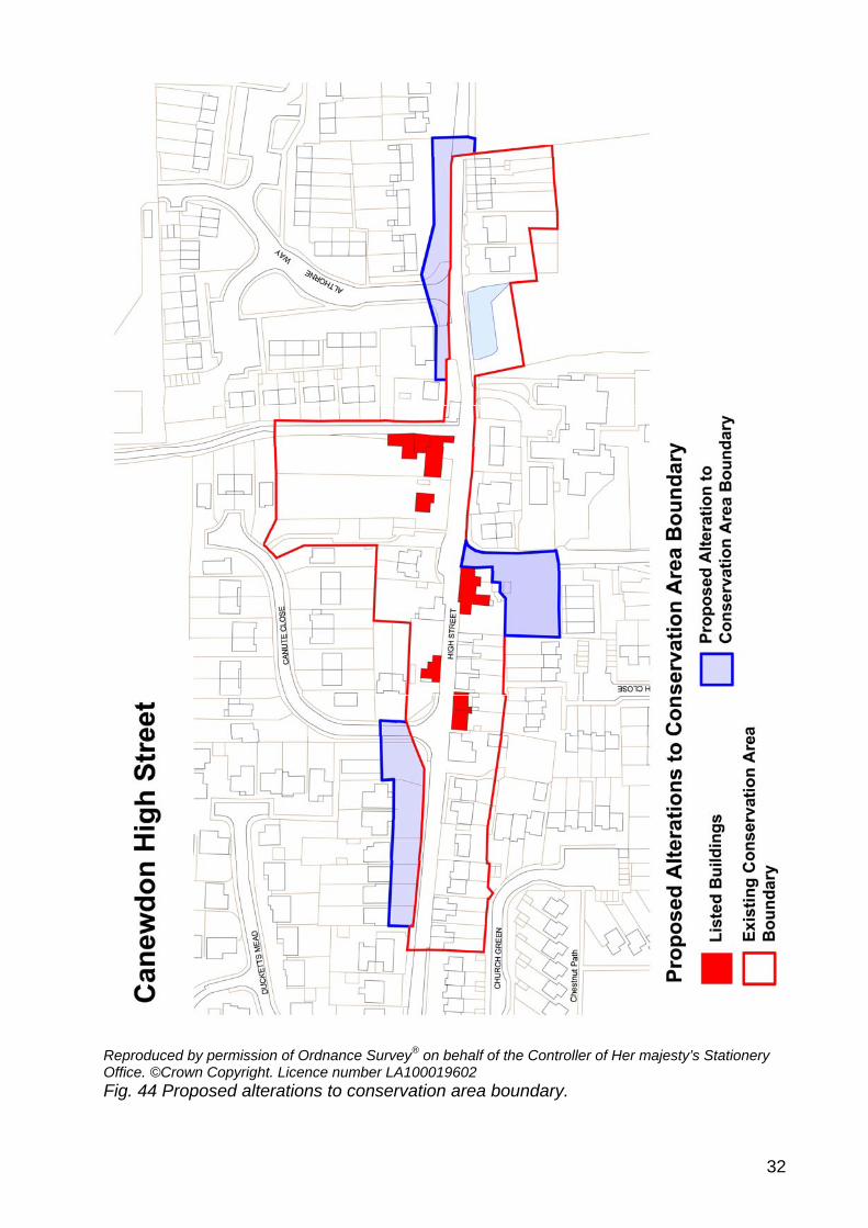
• the junction of Althorne Way could be improved by replacing the street lights and the road signs. The main road and footpaths are generally tarmac, but use of a different surface treatments, for example at the Althorne Way junction where the footway has been built out, would add interest to the streetscape.
Boundary changes 7.2 The conservation area broadly follows the historic settlement pattern as shown
in the First Edition OS map, taking in older development principally along the south side of the street and large plots of older properties to the north. It rightly excludes the school complex and surrounding modern development including Costcutters, where the historic form and grain comprising small cottages and workshops built up to the street edge has been lost. However it is recommended that some small changes are made to the boundary of the conservation area. At the east end the boundary should take in the front garden of Beecroft with its important group of trees. It should also encompass the southern end of Althorne Way to include the wide verges and trees, and the verges outside Crouch View Villas up to their boundary hedges in order to protect the green open spaces within the public realm. Similarly on the north side of the High Street at the west end of the conservation area it is suggested that the long front gardens of the bungalows at Penty-Bryn, Kamari, Lucknow and Rachel, as well as the front gardens of Jose and The Robins be included, and also the corner plot of the Congregational Chapel in as far as it impacts on the conservation area at that point. The proposed changes would protect the more green and open character of the High Street on its north side up to the street edge.
7.3 An additional boundary change is proposed to take in the car park to the rear of
the Anchor pub. This area impacts on the conservation area both in terms of the views down Anchor Lane and in its affect on the setting of the listed pub, and it would benefit greatly from improved landscaping. Backland areas such as this are vulnerable to development, and inclusion within the conservation area would strengthen control over inappropriate development.
Additional planning controls 7.4 In order to preserve and enhance the traditional features and appearance of
conservation areas, local planning authorities are empowered to introduce directions under Article 4 of the Planning Act to remove permitted development rights in respect of such things as windows, doors, fences, walls and frontage areas. Generally, the older properties have so far survived surprisingly well without excessive alteration, although there has been some erosion of character, for example with replacement of timber windows with UPVC, loss of original doors, the rendering of exposed brick and the use of concrete roof tiles. Boundary treatments have been identified as a significant element in protecting the rural quality of the village and alteration or loss to these can undermine the special character. It is important to try to prevent further erosion of character and to actively promote the restoration of original features such as windows, doors and front boundary treatments. Despite the number of modern properties within the Canewdon High Street conservation area, consideration should be given to
30

the introduction of Article 4 (2) directions to strengthen the ability of the District Council to preserve its character by protecting alterations to important unlisted buildings such as Russell Row, Rest Cottages and Vine Cottage. Measures that would be relevant include: • protection against alterations to a property affecting windows, doors and
other openings to front elevations, including the insertion of new windows and doors.
• painting of the exterior of any wall of a dwelling house in a different colour, or the application of render of cladding to external wall.
• erection of any fences, walls, gates and other forms of enclosure if they adjoin the highway, and construction within the curtilage of a dwelling house of a vehicle hard standing.
Redevelopment 7.5 The extent of modern development in Canewdon is indicative of the demand for
housing in the area and the relative affluence of the population. Late 20th century and 21st century developments have not taken due account of their surroundings particularly in terms of scale and use of appropriate materials, and have tended not to respect the historic grain or building line. Future development must take into account the importance of sympathetic design, in accordance with policies BC1-2 of the Rochford District Replacement Local Plan. There are no significant empty plots at present, and there is little scope for enhancing the area through redevelopment in the short term. Gardens are an important part of the character of the area particularly on the north side of the High Street and infill in these areas would normally be unacceptable. A small plot has been created by the relocation of the footpath at the junction with Anchor Lane although it is unlikely to be developed due to its small size. However as opportunities arise it will be vital to consider developments in terms of scale, massing, materials and detailing to ensure that new development reinforces the special qualities of the area.
31
32
Reproduced by permission of Ordnance Survey® on behalf of the Controller of Her majesty’s Stationery Office. ©Crown Copyright. Licence number LA100019602 Fig. 44 Proposed alterations to conservation area boundary.
BIBLIOGRAPHY Benton, Philip 1968 The History of Rochford Hundred: Canewdon, Rochford Hundred Historical Society Essex County Council/Schéma d’Aménagement Intègre du Littoral 2006 Landscape Character Assessment of the Essex Coast, 2nd draft Essex County Council/Rochford District Council 2006 Rochford District Historic Environment Characterisation Project Kelly, E.R. (ed) 1874 Post Office Directory of Essex, Kelly and Co. Medlycott, M. 2003 Canewdon Historic Settlement Assessment, Essex County Council Morant, P. 1768 The History and Antiquities of the County of Essex Reaney, P.H. 1935 Place-names of Essex, Cambridge Smith, Ken 1987 Canewdon: a pattern of life through the ages, Ian Henry Publications Victoria County History 1903 History of Essex Vol. 1
33

Appendix Listed Buildings in the Conservation Area
34

35