saints conservation area appraisal
TRANSCRIPT
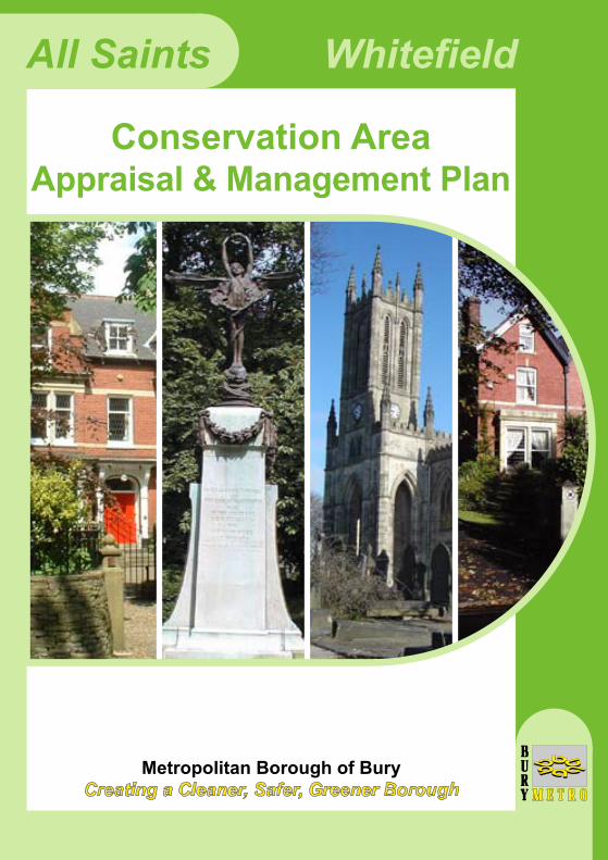
All Saints Whitefield
Metropolitan Borough of BuryCreating a Cleaner, Safer, Greener Borough
Conservation AreaAppraisal & Management Plan

page 01
PREFACE
1: Purpose: Implementing Good Practice
2: Introduction: Context within North Manchester 3: Conservation Area Boundary 4: Origins and Growth of the Area 4.1 The Early History 4.2 The 19th and 20th Centuries
5: Architecture and Environment
5.1 General Character 5.2 Character Areas 5.3 Architecture and Significant Buildings 5.4 Building Materials and Details 5.5 Spaces, Views and Landscape 5.6 Negative Factors 6: Management Plan 6.1 Introduction 6.2 Policies for the Control of Development 6.3 Policies and Actions for Enhancement 6.4 Site Specific Proposals
7: Appendices Contacts Acknowledgements
CONTENTS
Page
2
3
4
5
6
67
10
101215202327
32
32344347
52
ALL SAINTS CONSERVATION AREA

Fig. 1: Stand Cricket Ground & All Saints Church Tower
page 02
PREFACE
All Saints Conservation Area was originally designated in March 2004. A draft Conservation Area Appraisal document was presented to the local community in June 2005 to seek its views on the issues to be considered when developing a strategy for the area. These were taken into account when Planning Control Committee approved a range of actions in December 2005. This document contains the original appraisal and the subsequent management plan, which will be used to seek the protection and enhancement of the conservation area. The current management strategy does not deal with every issue. It is the start of a process, which will, through regular reviews, develop further policies and actions for the area.
This booklet should be read in conjunction with the Council's booklet, the Conservation Areas of Bury, which outlines the full implications of conservation area status. Additional information is on the Council's website www.bury.gov.uk.
Some of the statements made in the appraisal part of this document represent the discussion of issues by the Council's consultant.

page 03
1: Purpose: Implementing Good Practice
1.0 Purpose: Implementing Good Practice
The preparation of conservation area appraisals and management strategies is recommended by central government and is encouraged as good practice by English Heritage, the Government's principal advisory body on the conservation areas.
The purpose of this document is to first describe and review the elements that contribute to the special character and historic interest of the All Saints Conservation Area, including its history, architecture and environment. It will also discuss the challenges to the area's protection and enhancement and consider how best to secure the area's character and distinctiveness. The second part of the document will put forward a management plan covering issues of development and enhancement. The documents are expected to be reviewed every five years.
The appraisal is not intended to be comprehensive, and omission of any particular building, feature or space should not be taken to imply that it is of no merit.

page 04
2: INTRODUCTION: Context within N. Manchester
2.0 Introduction: Context within North Manchester
The All Saints Conservation Area lies close by the district centre of Whitefield, which is located approximately 3km south of Bury Town Centre. Situated on the A56 (Bury New Road), Whitefield is ideally placed for commuting into Bury town centre and Manchester city centre. The Metro-link station is within the conservation area boundary.
Whitefield falls within the Borough's Pilkington Park Ward and in 2001 the population was 10,004. Within the All Saints Conservation Area the population is estimated to be between 300 - 500 people.
The majority of the Conservation Area is situated to the west of Bury New Road. The leafy residential suburb of Stand surrounds the area to the north, west and south, and there are commercial and industrial areas to the east. The main streets within the conservation area are Bury New Road, Hamilton Road, Church Lane, Higher Lane, Pinfold Lane and Knowsley Road. The area's origins are as open farming land, being part of the Pilkington estate. It was the building of All Saints Church in 1822 and the coming of the railway in 1879 that had the greatest influence on the area's growth into an elegant 19th and early 20th century residential suburb.
Fig. 2: Location Plan

Conservation Area Boundary
Buildings
K E Y
Produced from the Ordnance Survey mapping with the permission of the controller of Her Majesty's Stationery Office. © Crown Copyright. Unauthorised reproduction infringes Crown Copyright and may lead to Civil proceedings. Bury MBC/100023063/2006
METROLINK
METROLINK
STANDCRICKETGROUND
TENNISCOURT
TENNISCOURT
UPLANDSHEALTHCENTRE
HAMILTONROAD PARK
ALL SAINTSCHURCH
WARMEMORIAL
BOWLINGGREEN
WHITEFIELDBUS STATION
POLICESTATION
166
2327
Library
WhitefieldHouse
110
121
133
1431
2
50
40
26
8
15
14
24
4
16
11260
217
211
212
228
32
26
47
15
1
18
12
14
2
HIGHER LANE
RINGLEY ROAD
BURNSALL AVENUE
HAMILTON ROAD
PINFOLD LANE
BURY NEW RO
AD
BURY NEW RO
AD
ASHBOUNRNE G
ROVE
DALE LAN
E
CHURCH LANE
STANLEY ROAD
GROSVENOR ROAD
GROSVENOR AV
BURY NEW ROAD
PARKLANDS
page 05
3: CONSERVATION AREA BOUNDARY
3.0 Conservation Area Boundary
The 2005 appraisal of the area considered the accuracy of the conservation area boundary. The draft report re-assessed the area's architectural and historic value and proposed an extension of the area to the east and south. This included additional properties abutting Bury New Road together with additional buildings on Pinfold Lane and Knowsley Road. The community comments were taken into account when the conservation area boundary was adjusted by Planning Control Committee in December 2005. The proposed extension was partially accepted and the current boundary is shown in Fig. 3 below.
Fig. 3: Conservation Area Map

page 06
4: ORIGINS AND GROWTH OF THE AREA
4.1 The Early History
Prestwich and Whitefield feature strongly in the early history of north Manchester and the Borough. Early settlements were linked to the line of the Roman road to Ribchester as it ran north through the Borough from Manchester. They were part of the Parish of Prestwich-cum-Oldham first recorded in c1189 and associated with the Prestwich family first known from c1193 onwards and the Pilkington family from c1185. It is probable that the parish and the great families had already been established during the Anglo-Saxon period in advance of the Norman Conquest.
Whilst early history and the development of the area through the medieval and industrial periods provides a background, it is the 19th and early 20th centuries that provide the basis for the conservation area. The key to the 19th and 20th century development was growing prosperity during the second half of the 19th century linked to improvements in transport, primarily the railways, but also the road system following the early 19th century turnpike improvements.
Until 1894 Whitefield was an area of Pilkington, a large estate of 5,500 acres which contained the medieval deer park. The conservation area covers areas previously known as the Croft, Nearer and Further Coney, Ditch Ash Park Gate, Sunny Brow, Four Lane Ends and Pinfold (the place where straying beasts were penned until claimed by their owners). These were names from the post medieval period. Prior to that the whole area was dominated first by the Pilkington and later by the Stanley families. The area is elevated above surrounding land and was part of Stand, or 'Ye Stand', which means to build on high in order to survey the deer park from the hunting lodge, Stand Hall (Fig. 4), which was built in the 16th century, or possibly earlier.
By the fifteenth century a small community of weavers and farmers was established and it is believed that this was the origin of Whitefield. There are two theories regarding the name, one of which is that the Flemish weavers spread their fabrics in the surrounding fields to bleach the cloth in the sun (see example Fig. 5). The other theory relates to the historic agricultural use of the area, with many acres of wheatfields.

Fig. 7: Original Station
Fig. 6: Uplands
Fig. 5: Lily Hill Laundry
Fig. 4: Stand Hall
page 07
4.2 The 19th and 20th Centuries
Development of modern Whitefield began in 1755, following the construction of Bury Old Road between Bury and Manchester. A small hamlet developed named Besses O'th'Barn, at the junction of Higher Lane and what is today Bury New Road. In 1780 the first cotton mill was built on Peel Street.
The crucial period of history for the proposed conservation area begins in the early 19th century. At the beginning of that century, the area was largely open land containing a few large houses in grounds. The old Mason's Arms on the new turnpike road had existed for some time and the main settlements were around the junctions with Pinfold Lane/Moss Lane and Radcliffe New Road/Green Lane.
In 1805 Edward Barlow built Green Hill in large formal gardens on Pinfold Lane. It was remodelled in 1857 by Alfred Grundy and renamed 'Underley'. It became Whitefield Town Hall in 1894 but is now sadly empty. Around the time of this remodelling the adjacent Uplands (Fig. 6) was built by John Wild, a paper maker from Radcliffe.
However, much changed with the building of All Saints Church, rectory and school on Church Lane.
© B
UR
Y A
RC
HIV
ES
SE
RV
ICE
© B
UR
Y A
RC
HIV
ES
SE
RV
ICE
© B
UR
Y A
RC
HIV
ES
SE
RV
ICE
© B
UR
Y A
RC
HIV
ES
SE
RV
ICE

Fig. 8: 1848 Fig. 9: 1893
page 08
In 1820 the ancient parish of Prestwich was considered to be too large and it was proposed that a subsidiary chapel be built in the rural area of Stand, located on a large commanding site given by the Earl of Derby in 1822. The project was eventually taken into the Million Pound Fund, a result of the national thankfulness for victory at Waterloo in 1815, and established in 1818. Sir John Sloane was originally approached with the commission but it passed to the young Charles Barry (later the architect of the Houses of Parliament) who produced a bold design in the 15th century Gothic style. It remained as designed until the 1890s when it underwent significant internal alteration. The regency style rectory to the west, also thought to be designed by Charles Barry, was built (or altered) in 1830 and the nearby Sunday School (now largely demolished) was opened in 1836.
The growing suburbs of Cheetham Hill and Heaton Hill were served by the construction of a new railway line in 1879, connecting to the old Bury to Manchester line. This established Whitefield station (Fig. 7) and its goods yard which stimulated further development in the area, including the construction of Stanley Road and industrial buildings such as Stanley Mills. The arrival of the steam tramway in the late nineteenth century encouraged the construction of further buildings along Bury New Road but development remained concentrated at the two major road junctions until the 1890s.

Fig. 10: Stand Cricket Ground
page 09
The central section of the Conservation Area has remained open, with buildings concentrated around its edges. Development occurred along the majority of Bury New Road during the late nineteenth century but a section on the west side remained undeveloped. By 1893 the Cricket Ground (Fig. 10) had been laid out and the Hamilton Road Park boundaries were established. Major development along Church Lane, Knowsley Road, Ringley Road and Pinfold Lane occurred during the 1890s and into the early years of the twentieth century, with the construction of large detached and semi-detached villas. Also, Hamilton Road and Grosvenor Street (now Grosvenor Road) were laid out, although only the former was fully developed. These new roads introduced the grid-like street pattern that is a feature of the Conservation Area. Development in the late 1930s introduced smaller semi-detached housing along Grosvenor Road and Grosvenor Avenue.
In the late twentieth century sporadic redevelopment of single plots occurred, for example the creation of Pinfold Court on the north side of Pinfold Lane. The most significant development was the construction of Parklands on the east side of Higher Lane. This is a cul-de-sac style of development of large detached bungalows.
The substantial change during the 19th century gave this area of Whitefield a new prominence; with the ecclesiastical site dominating its surroundings and the church tower a landmark from many miles away. The building of many large and fine houses along Church Lane, Pinfold Lane and Bury New Road followed fairly quickly. The arrival of the railway and the station at Whitefield in 1879 encouraged further development and by 1910 the majority of the properties we see today along Church Lane, Pinfold Lane and Hamilton Road had been built. The cricket ground and park had been in existence prior to 1893, the cricket and tennis club being founded in 1853.
The whole area was the ecclesiastical, cultural and civic heart of Whitefield fornearly two centuries.
© B
UR
Y A
RC
HIV
ES
SE
RV
ICE

page 10
5: ARCHITECTURE AND ENVIRONMENT
5.1 General Character
All Saints is a mixed but primarily residential area with All Saints Church as its centre piece. It contains Regency, Victorian and Edwardian brick villas that span the period from the beginning of the 19th to the early 20th century. Church Lane, Hamilton Road and Pinfold Lane contain many fine two and three storey detached, semi detached and terraced properties which have a host of impressive and well preserved traditional elements and details, together with their original boundary walls, gateposts and mature gardens. The buildings sit around an open setting due to the wide streets, spacious gardens and the substantial areas of large grounds, large stands of trees, public gardens and All Saints churchyard, all at the area's core.
The character of the area is in a number of linked parts. One such area is dominated by the grade I listed All Saints Church, the listed war memorial and its churchyard. This includes the substantial and well preserved houses on Church Lane and the later and more modest early 20th century properties set at a lower level along Hamilton Road. Further to the south is the more altered area around Pinfold Lane. Parts of this area are more densely developed and contain fine late 19th century buildings. Two large former houses, Underlay and Uplands, stand in their original grounds, with the former, although empty and boarded-up, retaining much of its 1805 and 1857 construction and character. These two areas are linked by the cricket ground, tennis courts and park which contribute to the green and village feel to parts of the area. The final area is the A56, Bury New Road. In the vicinity of the Metro Station there are the ornate 19th century Barclays Bank and residential and commercial late Georgian (facing the end of Hamilton Road), Victorian and Edwardian properties, some elevated above road level. Further south there is the dominant former Masons Arms (now Slattery's chocolate emporium) and close by on the road frontage, mid 19th century brick buildings, originally houses, and early Victorian villas on Knowsley Road.

A B C
D E F
G H I
page 11
Although some new development has taken place adjacent to Higher Lane, the conservation area is an excellent and well preserved example of largely 19th century high quality residential and civic development, reflecting the new prosperity of the period. The area is important to the built heritage and history of Whitefield.
A) Church Lane. B) All Saints Church. C) Hamilton Road.D) Pinfold Lane. E) Bury New Road. F) Knowsley Road.G) Pinfold Lane. H) Bury New Road. I) Church Lane.

page 12
5.2 Character Areas
The character of the Conservation Area is essentially that of a late nineteenth century, leafy, residential suburb, with large properties in generous gardens. However, amongst the residential areas there are two striking non-residential features.
All Saints Church, with its surrounding grounds and attached churchyard, covers a substantial part of the Conservation Area. The openness of the church grounds complements the surrounding residential area.
The other non-residential area covers Stand Cricket Ground, the adjacent Hamilton Road Park, together with the substantial grounds around Uplands and Whitefield House. The cricket ground and the park are relatively open in character with few trees and provide recreational facilities for the local residents and the surrounding area. The grounds of Uplands and Whitefield House are heavily wooded and contribute to the sense of space and greenery in the heart of the urban area.
In addition, Bury New Road provides a mixture of commercial activity on the eastern fringe of the area. The type of commercial activity varies along the length of the road. Concentrated around the Church Lane junction are the Barclays and Natwest Banks, immediately adjacent to Whitefield station. Further south, are local shops and services. Bury New Road is lined with a variety of buildings and is a major traffic route. It has a busy and, in part, lively commercial character.
Although generally similar, the residential roads each have their own specific character. The south side of Church Lane is dominated by the church and the open space of the churchyard. Strong features are the mature trees, which line the road, and the stone boundary walls to the various properties. The houses on the north side are very large, detached, two-storey properties set back within generous mature gardens. The houses on the south side are large semi-detached properties in smaller plots. The majority of these houses have external walls of red brick. The houses along the north side of Ringley Road are similar in character to those on the north side of Church Lane but the boundary walls are less

A B C
D E F
G H I
page 13
prominent. This road has a different character because of the mixed appearance of the housing on the south side (which is outside the designated area). Both Church Lane and Ringley Road carry a reasonable quantity of traffic.
Grosvenor Road and Grosvenor Avenue are quiet residential streets of small mid-twentieth century semi-detached houses. The buildings are of brick and render, and the boundary walls are predominantly of brick.
A) Church Lane. B) All Saints Church. C) Stand Cricket Ground.D) Hamilton Road. E) Bury New Road. F) Woodland, Uplands. G) Higher Lane. H) Pinfold Lane. I) Bury New Road.

page 14
However, many of the properties have been extensively altered so that there is limited consistency of appearance. Front gardens are small and planting generally makes little impact on the streetscene. There are some trees within the pavements along Grosvenor Road but a number of these have recently been removed. Overall, these two roads do not have a strong character and appearance.
Hamilton Road is a quiet residential street with houses along its north side on either side of the churchyard. It is lined with trees and there are open views across the cricket ground and park to the south. The houses are substantial terraced or semi-detached, two-storey properties with small front gardens. The dominant materials are red brick and slate. The former is used for both the houses and the boundary walls in the western section. The boundary wall to the graveyard and to the houses to the east is of coursed stone.
Higher Lane has a very mixed appearance. It is a wide road. There are a limited number of buildings along its east side because of the graveyard and the cricket club and these are varied in appearance. The housing along the west side is of little historic interest and is outside the designated conservation area. Parklands has a very different character, being a cul-de-sac bungalow development dating from the second half of the twentieth century. The buildings appear to be single-storey in height, although in some cases on the north side the slope of the land allows for a lower level, and there is no hard definition of the plots. There are some mature trees within the gardens.
Pinfold Lane is dominated by the trees within the gardens of various properties, particularly those in the extensive grounds of Whitefield House on the north side of the road. The trees and the boundary walls are the dominant features. The houses on the north side are very large, semi-detached, two-storey properties set back within generous mature gardens. The houses on the south side are generally smaller and are largely outside the designated area. The majority of the houses have external walls of red brick and stone. The carriageway is narrow in parts and this presents problems when on-street parking takes place.

Listed Buildings
Buildings of Significance
Buildingsthat make a positive contribution
ConservationArea boundary
Fig. 11: Heritage buildings
page 15
5.3 Architecture and Significant Buildings The majority of the buildings within the conservation area were originally constructed as large houses during the late nineteenth or early twentieth centuries. This establishes a distinctive architectural character to the area. In addition, there are a limited number of earlier buildings, such as Whitefield House and the smaller properties along Bury New Road, possibly including number 177. There are also a number of substantial public and semi-public buildings, such as the church and the banks and public houses along Bury New Road, which have different architectural qualities, together with a small number of more recent buildings.
The early buildings tend to be relatively simple in form, with shallow pitched roofs and limited architectural detailing. Apart from Whitefield House, which was a very large house in its own substantial grounds, the majority of these early buildings are located close to the roads and have no front gardens.
A B C
D E F
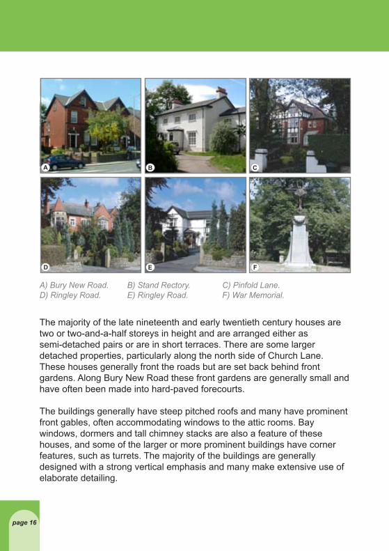
A) Bury New Road. B) Stand Rectory. C) Pinfold Lane.D) Ringley Road. E) Ringley Road. F) War Memorial.
page 16
The majority of the late nineteenth and early twentieth century houses are two or two-and-a-half storeys in height and are arranged either as semi-detached pairs or are in short terraces. There are some larger detached properties, particularly along the north side of Church Lane. These houses generally front the roads but are set back behind front gardens. Along Bury New Road these front gardens are generally small and have often been made into hard-paved forecourts.
The buildings generally have steep pitched roofs and many have prominent front gables, often accommodating windows to the attic rooms. Bay windows, dormers and tall chimney stacks are also a feature of these houses, and some of the larger or more prominent buildings have corner features, such as turrets. The majority of the buildings are generally designed with a strong vertical emphasis and many make extensive use of elaborate detailing.

A B C
D E F
page 17
The more recent buildings also have varied architectural qualities but, as a result of their small number, they generally make little impact on the overall character or appearance of the Conservation Area.
There are seven buildings and structures within the Conservation Area included on the List of Buildings of Special Architectural or Historic Interest (see Fig. 11). All Saints Church is a grade I listed building.
Within the churchyard there are five other listed structures, all of which are listed Grade II. The west gateway and piers were probably constructed in 1826. The double gates are of decorative cast iron and the stone piers are surmounted by cast iron standard lamps. The lamp post adjacent to the church entrance is also of cast iron and the upper section matches the lamps on the gate piers. The War Memorial at the eastern end of the churchyard was constructed circa 1920. It is a tapered Portland stone cruciform column surmounted by a bronze figure of Winged Victory, standing on a globe encoiled by a serpent. Two other monuments within the churchyard are also listed.
A) All Saints Churchyard. B) Whitefield House. C) Hamilton Road.D) Church Lane. E) Church Lane. F) Bury New Road.

A B C
A) All Saints Church. B) Church Lane. C) Bank, Bury New Road.
page 18
Number 32 Church Lane, may have been originally built as a farmhouse, and remodelled by Charles Barry as the Rectory. It is also listed Grade II.
In addition to the listed buildings there are a number of unlisted buildings of significance, which represent the major developments of the area or are landmark structures. They are shown on Fig. 11 and described in the following.
On the east side of Bury New Road, number 260, which is a 1930s single-storey bank building constructed of limestone with a domed corner roof, is an important landmark building. Immediately to the south there is a nineteenth century terrace (numbers 250-258), with half-timber details, which is typical of that period of development within the area. Number 228 Bury New Road, on the corner with Salisbury Road, is a tall, end of terrace, red-brick building, with an interesting chamfered corner entrance feature, which provides a minor landmark along the street.
On the west side of Bury New Road, number 231 is a late nineteenth century, red-brick Barclays Bank building with an elaborate crow-stepped gable. The whole building is significant but the gable is particularly important to views along Bury New Road from the south. To the south of Church Street, numbers 211-229 Bury New Road, is an important group of terraced and detached houses. The Uplands, Bury New Road, is set back within its own grounds and is a large two-storey detached property with single storey outbuildings. It is one of the few surviving examples in the area of a mid-late nineteenth century house standing in substantial grounds.

page 19
On the north side of Church Lane, numbers 14-20 form an important group of large semi-detached and detached, late nineteenth century villas; number 16 has an octagonal corner turret. Further west, numbers 26-30 consist of three very large detached villas, also of the late nineteenth century.
On the south side of Church Lane there is a group of large semi-detached late nineteenth century villas, which are important as they are one of groups of buildings that establish the predominant architectural character of the Conservation Area.
Numbers 50-54 Higher Lane, are two pairs of large two-storey, semi detached, red-brick houses, which are also important in establishing the predominant character of the Conservation Area.
Whitefield House, the former Council Offices on the north side of Pinfold Lane, is a two-storey brown-brick house of early nineteenth century origin. It was subsequently remodelled and extended on a number of occasions but this has not seriously eroded its basic architectural qualities. It is the earliest example within the Conservation Area of a substantial house, set in its own wooded grounds.
Numbers 4-16 Pinfold Lane are large detached and semi-detached houses of the late nineteenth century and are typical of the buildings that establish the architectural character of the Conservation Area; No. 16 has an octagonal corner turret.
Number 2 Ringley Road, is a large detached two- storey, red-brick house on the corner with Ashbourne Grove, and is typical of the houses that establish the overall architectural character of the Conservation Area. In addition to the buildings of significance described above, there are many other buildings that also make a positive contribution to the character or appearance of the conservation area.

A B C
D E F
G H I
A) Stone bay window. B) Terracotta decoration. C) Decorated stone lintel.D) Churchyard monument. E) Tall chimneys. F) Turrett feature. G) Brick decoration. H) Turrett and dormer. I) Bay windows.
page 20
5.4 Building Materials and Details
The majority of the buildings within the Conservation Area are generally constructed with a smooth red brick for external walls, some stone detailing and decoration, and Welsh blue/grey slates for roofs. As a result these are the predominant building materials within the conservation area, but a variety of other building materials also exist.

page 21
The early nineteenth century buildings are constructed of softer red or brown bricks, and a number of the buildings were originally rendered or have had render added subsequently. There is also some use of black and white, half-timbering, often in decorative patterns. All Saints Church is constructed of ashlar (large square cut blocks) stonework, as is the bank building on Bury New Road next to the station.
There is also some variety in the roofing materials. Small clay tiles are used on a number of the nineteenth century houses and later buildings make use of concrete tiles, which have also been used as replacements on some of the earlier buildings.
Boundary walls and gate piers are either of stone or smooth red brick. The stone boundary walls use many different forms of finish, including ashlar, coursed rubble and, along the north side of Ringley Road, narrow courses of rubble with an angled profile. Some of the brick boundaries have copings and plinths of stone, while others have terracotta copings.
There are no early vernacular buildings within the Conservation Area, which survive with their original appearance, though number 177 Bury New Road may have origins in the pre 19th century development period. The early nineteenth century buildings generally have the typical simple detailing of the period. Sash windows and panelled doors provided the main points of interest but many of these have been lost. A number of these buildings have semi-circular arches above the front doors and upper floor windows.
The main details of interest relate to the late nineteenth and early twentieth century buildings, particularly along Church Street and Knowsley Street. Such details are typical of the period and include the use of tall, decorative chimney stacks and pots, elaborate bargeboards, stepped brickwork, and contrasting stone details. A number of these houses make use of a similar decorative detail, which consists of a recessed panel of patterned terracotta or brickwork contained within a circular arch. This is the only detail that appears to be specifically local to the area. There are also examples of moulded stone banding; stone corbelling; stone and terracotta crests and panels; stone bays and door canopies, and decorated lintels and keystones.

A B C
D E F
G H I
A) Church Lane. B) Church Lane. C) Grosvenor Road. D) Church Lane. E) Church Lane. F) Church Lane. G) Higher Lane. H) Pinfold Lane. I) Granite Sett footpath.
page 22
The majority of the houses have boundary walls and pedestrian gates along the main frontage. These walls are constructed of a variety of materials and are generally simple in form and detailing. Elaboration is generally reserved for the gate piers, which employ a variety of decorative elements. It is clear that some of these boundary walls did support railings but these have been lost.

page 23
5.5 Spaces, Views and Landscape
Although the main roads through the Conservation Area are generally lined with buildings, a high percentage of the designated area is open space. These spaces include the churchyard around All Saints Church, Hamilton Road Park, the cricket ground, and the grounds of Uplands and Whitefield House. Also, a number of the larger houses have very large gardens.
The churchyard includes two areas with differing characters. Close to the church, particularly on its south side, horizontal stone gravestones and occasional monuments cover the ground, providing a hard surface. Further away from the church, rows of vertical gravestones are set out in grass. This section of the churchyard also includes many mature trees, which help to provide a softer character. The contrast in the hard and soft landscape within a short distance is a dramatic feature of the spaces surrounding the church.
Hamilton Road Park and Stand Cricket Ground provide the leisure space within the area but they are used quite differently. The cricket ground is a private sports club with organised use and restricted access, while the park provides an informal public recreation area with un-restricted access. Activity between the two varies, as the cricket ground is not used during the winter months, whilst the park is utilised throughout the year. Also, activity on the cricket ground during the summer months is restricted to evening practice sessions and junior games Monday to Friday, whilst at the weekends the area comes to life with senior all day matches attracting spectators to the ground. Also within this area is the tennis club which has four courts also with restricted access.
The wooded area around the Uplands and Whitefield House, to the north-west of Four Lane Ends, provides a very different type of space. The area has the feel of an old country estate with its earthy appearance and network of paths. In the summer, the extensive tree cover creates shaded ground. Some limited wildlife exists within this woodland area, for example birds and squirrels, and there is also a small pond.

A B C
D E F
G H I
A) Stand Churchyard. B) Church Lane. C) Cricket Ground. D) Pinfold Lane. E) Higher Lane. F) Ringley Road. G) The Uplands. H) Hamilton Road. I) Whitefield Park.
page 24
Views within the Conservation Area are predominantly along the linear street alignment. Medium distance views are possible along Church Road, Hamilton Road and Bury New Road. Shorter distance views are available along Pinfold Lane and Grosvenor Road. Views along most of the roads are framed by the mature trees, which provide a pleasant enclosure to the spaces.

page 25
Within the Conservation Area there are also glimpsed views through the trees on Hamilton Road across the cricket ground to Parklands. Views are also possible into the Uplands area from Hamilton Road, particularly in winter when the trees are not in leaf.
The Conservation Area includes a large number of trees and other soft landscaping, particularly in the areas around the church, the cricket ground, the park and around The Uplands and Whitefield House (see Fig. 12). There are a wide variety of different tree and shrub species. However, the majority of the trees are deciduous, which means that their summer and winter appearances are very different. There are a few evergreen trees, mainly holly, but extensive areas of evergreen shrubs, such as laurels and rhododendrons.
The grounds to the Church have areas of maintained grass around the gravestones and also mature trees defining its edges and the internal footpaths.
The cricket ground has a heavily maintained grass playing surface with a distinctive scorched brown square where the wickets are located. Surrounding the ground are mature trees, which provide a screening effect particularly on its northern side. A hedge also exists on the southern boundary.
The park has areas of maintained grass with smaller trees forming the landscaping along the footpaths.
Many of the residential properties also have substantial tree and shrub planting within their grounds. This is particularly the case along Church Lane where many of the trees screen the properties when in leaf. Also, many have hedges or shrubs along the front of the plot boundary, located behind a low stone or brick wall, for example along Church Lane, Pinfold Lane and Ringley Road.

Tree lined streetsHeavily wooded
Open spaceKey views Fig. 12: Spaces and Views
page 26

page 27
Negative Factor Neutral FactorConservation Area Boundry
5.6 Negative Factors
There are a number of negative factors within the Conservation Area, some of which are area based, whilst others are individual elements.
Fig. 13: Negative and Neutral Factors

page 28
The change from the Park to the grounds surrounding The Uplands at the bottom of the slope is confusing and it is not clear if the area is for public or private use. Also, it receives little maintenance and attracts litter and elements of fly tipping.
There has been a great deal of concern over the current condition of the former town hall and its immediate site, together with the unkempt state of the park and the pond. This longstanding problem has also led to the area being an attractor for anti-social behaviour. Other comments made during consultation were about the unattractive appearance of the Metrolink Station and some private car parks.
There are several design issues for buildings within the area. The five-storey, late twentieth century apartment block on Pinfold Lane is of a height, mass and architectural style that is different from the general character and appearance of the Conservation Area. The extension to the bank building at 260 Bury New Road is constructed from block work with a similar colour to that of the stone of the original building but its bland detailing and poorly proportioned fenestration have a detrimental impact. Similarly the appearance of Barclays Bank has suffered through the addition of unsympathetic window frames. The modern outbuilding on the west side of The Uplands is situated extremely close to the western façade, blocking views of this primary elevation and adversely affecting the setting of the building. Also, the use of modern materials, including a corrugated steel roof, is unsympathetic to the surrounding buildings.
The back lanes to the houses/offices on Bury New Road, Church Lane, Hamilton Road and Grovesnor Road are unadopted highways and therefore are not maintained by the local highway authority. As a result the surfaces are maintained by the property owners. Unfortunately, they have a poor visual appearance and bring debris onto the surrounding highways. The lane to the rear of Bury New Road is in particulary poor condition due to the scale of use in connection with the commercial frontage properties.
The garages situated along the unadopted highways are of different sizes, form and varying levels of maintenance. They create a poor visual appearance to the backland areas of the residential streets.

A B C
D E F
G H I
page 29
The conflict between parking for area residents and for commuters, the school run, office users, car boot events, cricket, and local facilities, is one of the main concerns in the area. Residents on Hamiliton Road, Pinfold Lane, and Parklands were particularly concerned about this and the poor parking provision for facilities such as the library and the over-spilling of parking from commercial activities on Bury New Road. There were a number of requests for a residents’ car parking scheme. There were additional concerns on Pinfold Lane about highway safety and access due to the speed of traffic along the highway and street parking affecting visibility.
A) Whitefield House. B) Hamilton Road. C) Pinfold Lane. D) Bury New Road. E) Bury New Road. F) Off Church Lane. G) Pinfold Lane. H) Church Lane. I) Whitefield Park.

page 30
The new car park serving Metrolink may reduce the conflict and this issue requires continued monitoring.
Commercial signage is a particular problem along Bury New Road. There are some inappropriate fascia boards on the east side of the road. Also inappropriate for the area is the large wall mounted advertisement hoarding on the south elevation of number 199 on the west side of the road.
The loss of the gates and iron fencing that would have topped the brick boundary wall to the boundary of Whitefield House on Bury New Road and Pinfold Lane has resulted in a loss of the sense of enclosure and also results in a poor visual appearance.
The car park to the former Mason’s Arms public house is a vital source of off-street parking but it creates a poor visual impression. The lack of a boundary feature to define the edge of the car park results in poor enclosure of the streetscene.
In the north-east corner of the grounds of All Saints Church, just off Church Lane, there is a small structure, which may have been a hearse house. This important structure appears to be under used and is poorly maintained. However, the main negative impact is provided by the very poor visual quality of the access. This has an adverse impact on the setting of the Grade I listed All Saints Church.
The recent removal of trees from the pavement on the east side of Grovesnor Road has had a negative impact on the streetscene.
In front of some properties, sections of original boundary walls have been removed to allow vehicle access to the garden area. This not only disrupts the historic enclosure but also replaces garden area with hardstanding. In some instances, particularly along Church Lane, the detail of the work is poor, with replacement stonework failing to match the historic stonework.

page 31
The road surface for the goods yard ramp on the western side of Whitefield station remains in place. However, areas of the historic fabric are damaged and some of the setts are missing. The area also suffers from a lack of parking control, the area is often cluttered with vehicles and manouvrebility is difficult.
Number 2 Ashbourne Grove, which is situated on the northern edge of the Conservation Area, was originally an attractive lodge building but subsequently has suffered from various unsympathetic extensions and other alterations. As a result, the original form of the building has been lost.
A wide variety of materials are used for the pavements and other surfaces within the Conservation Area. Along some roads, such as Church Lane, some stone flags remain but elsewhere tarmac has replaced the traditional materials. The loss of original paving materials reduces the special interest of the area and the lack of consistency creates a poor visual appearance.
There is also a wide variety of road signs and other street furniture, which results in visual clutter. The major problem is the lack of co-ordination of highway signage, which frequently results in many different signs in close proximity to each other. Bury New Road also suffers from the ill-considered use of street furniture. Often it is not the individual item itself but the unplanned combination of different items, which creates the problem. The pedestrian barriers located around Whitefield Station junction and the junction of Bury New Road with Pinfold Lane are particularly unattractive.

page 32
6: MANAGEMENT PLAN
6.1 Introduction
The character of All Saints Conservation Area has been described in the earlier sections of this appraisal. National conservation guidelines place a responsibility on the local planning authority to formulate and publish proposals for the preservation and enhancement of conservation areas and, in exercising their planning powers, to take into account the desirability of preserving or enhancing their character or appearance.
This conservation area appraisal and the management proposals were prepared for circulation to area residents as part of a consultation process during 2005. There is broad support from the local community for the policies and actions which form the management strategy. The All Saints Conservation Area is a generally well preserved area which has suffered relatively little large-scale change since the First World War. The changes which have taken place, however, could easily be compounded, and the result would be serious erosion of the character of the area. When alterations which seem minor in themselves become widespread, cumulatively they can have a far-reaching effect on the appearance of the area. While many residents have taken pride in the original features of their properties, alterations are beginning to have a damaging effect. Drawing attention to the special features of the place and setting this in a historic framework is seen as a way of highlighting what is best about the area to help inform individual owners so they can avoid works which might erode the special qualities.
Although not yet widespread, erosion of detail has taken place with the introduction of roof dormers and satellite dishes; the replacement of original doors and windows; changes to roofing materials; and the introduction of unsympathetic fencing and replacement garden walls.
Conservation policies recognise that change takes place and that individuals wish to improve their properties and environment. What they seek to do is to guide the way changes are made so the traditional character of the area is preserved.

page 33
Following consultation within the area, the Council has delayed consideration of stricter planning controls until the position on the ground is reviewed following a reasonable period after the 2004 designation of the conservation area. However, design guidance is to be produced as soon as is possible to guide residents in altering or extending their homes in the area. This will be prepared as general advice and will also cover the St Marys, Prestwich, and Poppythorn Conservation Areas.
Other alterations, such as replacement of street lamps and original pavement materials, introduction of signage and so-on, relate to works of maintenance and road safety measures carried out by the Council. Such works are essential for the safety and comfort of residents but there may be scope for replacing some elements with those in more sympathetic materials as routine repairs and replacements are undertaken.
As well as guarding against damaging alteration, the plan aims to consider how the area can be enhanced and to ensure that modern needs can be catered for in a sensitive way.
As indicated above, this third section sets out a possible management plan for the All Saints Conservation Area. These proposals should be read in conjunction with the appraisal of the designated area, set out in pages 4 to 31. The proposed policies and recommendations are intended to preserve the character and appearance of the Conservation Area, assist in managing change without compromising the historic environment and make proposals for its enhancement.
The plan is divided into three sections. The first sets out policies for the preservation of the special interest of the area, while the second relates to general proposals for enhancement. The final part of the plan contains proposals for the various specific sites that have been identified as opportunities for development or enhancement.
There is no time scale allotted to the actions put forward. The Council is required to prepare plans for all its conservation areas and it is not currently possible to do this and also take up all actions resulting from all of the plans.

page 34
6.2 Policies for the Control of Development
The following policies are directed at ensuring that change is in sympathy with the area’s character. These should be read in conjunction with the Council’s booklet, Conservation Areas of Bury, which gives general guidance on conservation areas and explains when planning permission is required for the alteration and extension of dwellings. They should be taken into account when consideration is being given to proposed alterations and when guidance is required.
Demolition of buildings Legislation provides for control over the demolition of buildings in conservation area (subject to various exceptions). Paragraph 4.27 of PPG 15 - Planning and the Historic Environment indicates that, “The general presumption should be in favour of retaining buildings which make a positive contribution to the character or appearance of a conservation area.” It goes on to indicate that proposals to demolish such buildings should be assessed against the samebroad criteria as proposals to demolish listed buildings (paragraphs 3.16 – 3.19 of PPG15).
Fig. 11, page 15, identifies significant buildings within the designated area. These are generally the large detached villas constructed in the nineteenth century, which establish the character of the conservation area. It also identifies buildings that make a positive contribution to the townscape. There should be a presumption against the demolition of all of these buildings.
Policy 1:The Council will only grant conservation consent for the demolition of a significant building or a building that makes a positive contribution to the townscape of the Conservation Area (as identified on Fig. 11) if it has been fully justified against the criteria laid out in PPG 15 paragraphs 3.16 – 3.19).

page 35
In addition, the Conservation Area includes a number of listed buildings, the demolition and alteration of which is also controlled by the provisions of the Planning (Listed Buildings and Conservation Areas) Act 1990.
Trees
Section 211 of the Town and Country Planning Act 1990, as amended, requires that anyone proposing to cut down, top or lop a tree in a conservation area must give six weeks notice to the local planning authority. The purpose of this requirement is to give the authority an opportunity to make a tree preservation order.
Trees make a major contribution to the character and appearance of the Conservation Area and to its setting. Many are already covered by tree preservation orders but it is recommended that the Council undertake a comprehensive tree survey of the whole of the Conservation Area, plus its setting, to determine whether additional tree preservation orders are required.
The following policy should apply:
Policy 2:The Council will generally resist proposals to cut down, top or lop trees in the Conservation Area. However, when trees are removed or die they should be replaced with new trees of appropriate species and size.

page 36
Open Spaces and Gardens
There are several areas of open spaces within the Conservation Area that are very important to its character. These include the churchyard around All Saints Church, Hamilton Road Park and the Stand Cricket Ground. All these spaces need to be protected from built development.
Policy 3:The Council will resist all proposals to develop the large open spaces within the Conservation Area with buildings.
In addition, Whitefield House and Uplands are surrounded landscaped grounds, which also need to be protected from inappropriate development. Specific proposals for these two properties are included in the final part of the plan.
The character of the area is largely established by the pattern of past development, which generally consists of substantial houses in large plots. Even Parklands, which is an area of twentieth century bungalows, has something of this character. Where proposals for re-development are acceptable under other policies, these should maintain the ratio of built-form (footprint and volume) to plot size that is typical of the area.
Policy 4:The Council will resist proposals that would result in the over-development of sites to the detriment of the traditional character of the Conservation Area.

page 37
Land Use
The character of the Conservation Area relies upon the existing pattern of land uses. Any major changes to these land uses will affect this character. At present, there are commercial uses along Bury New Road and the remainder of the area is residential. Non-residential uses should not be permitted in those parts of the Conservation Area away from Bury New Road.
Policy 5:The Council will resist proposals for the change of use or character of existing residential land or buildings within the Conservation Area.
Minor Alterations
Any work that materially affects the external appearance of a building requires planning permission, subject to permitted development rights. Under normal planning control certain works to dwellings are classified as permitted development and do not require planning permission. This includes small alterations and extensions, the erection of buildings, enclosures or pools required for a purpose incidental to the enjoyment of a dwelling house (such as a swimming pool), the provision of some hard surfaces, and the erection of and alterations to boundaries. However, within conservation areas some developments (that in other areas would be permitted development) are not classified as permitted development. This includes various types of cladding; the insertion of dormer windows; and the erection of satellite dishes on walls, roofs and chimneys fronting a highway. Also, within conservation areas the size of extensions that may be erected without specific planning permission is also more restricted.

page 38
Work that affects the external appearance of a building can include the replacement of doors and windows, particularly if it involves a change in the design or the use of a modern material, such as plastic (PVC-u). The accumulative effect of door and window replacement is beginning to damage the character and appearance of the Conservation Area. The effect of further alterations of this nature will seriously erode the special interest of the area, which is the reason for its designation.
Policy 6:Where planning permission is required, the Council will resist the replacement of doors and windows, which would adversely affect the appearance of the building, and where the proposal would be detrimental to the character of the building or to the character of the wider Conservation Area.
The traditional materials used for the external walls of the buildings establish the appearance of the Conservation Area.
Policy 7:The Council will resist all proposals to clad buildings with materials that are not appropriate to the appearance of the Conservation Area.
Traditional, small-scale dormer windows are an important feature of the Conservation Area. The introduction of large-scale or non-traditional dormer windows would damage the architectural qualities and overall appearance of the area.

page 39
Policy 8:The Council will resist all proposals that involve the construction of large non-traditional dormer windows.
The widespread erection of satellite dishes and radio equipment on buildings would have a detrimental impact on the appearance of the Conservation Area.
Policy 9:Where planning permission is required, the Council will resist all proposals that involve the erection of satellite dishes and radio equipment in prominent locations within the Conservation Area.
Extensions to buildings can be detrimental to their appearance either because of their location, size or design. Extensions (including porches and canopies) on the front or principal elevations of buildings should be avoided as these elevations have usually been carefully designed. Extensions at the side or rear are generally to be preferred, except where these elevations have also been carefully designed or are open to publicview. Extensions should be subordinate to the building to which they are attached, should use similar or complementary materials, and should reflect or complement its style and appearance.
Policy 10:The Council will resist proposed extensions that are too dominant, in a prominent location, or are otherwise detrimental to the character of the building to which they are attached, or to the character or appearance of the wider Conservation Area.

page 40
Article 4 Directions
Local planning authorities may remove (or apply for approval to remove) permitted development rights by way of an Article 4 Direction. This means that certain developments that would otherwise not require planning permission would be bought under control.
The effect of the alterations and extensions that are possible under permitted development rights, such as the erection of small porches and extensions, the creation of hard-standings, and the removal of boundary walls, have begun to damage the character and appearance of the Conservation Area. The accumulative effect of further alterations of this nature will seriously erode the special interest of the area, which is the reason for its designation.
During consultation the use of this power did not receive the full support of the local community. An interim policy has therefore been approved.
Policy 11:That the Council delay consideration of the implementation of an Article 4 direction (removing permitted development rights set out in Classes A, B, E, F and G of Part 1 of Schedule 2 of the Town and Country Planning (General Development Order) 1995) until the impact of any further changes on the ground are reviewed in due course.
Alternatively a design guide is to be prepared providing advice and guidance for residents on the subject of extensions and alterations and for use in connection with voluntary arrangements for compliance with good practice.

page 41
Hedges
Many of the properties in the Conservation Area have hedges along their boundaries and these are an important feature of the area, contributing to its character and appearance. Those along front boundaries are very important within the street scene, helping to delineate the public and private spaces.
Policy 12:As part of proposals that require planning permission, the Council will discourage the removal of hedges that contribute to the character or appearance of the Conservation Area.
Minor Alterations and Repair
The Council supports the following broad guidance:
Repair of traditional and decorative external woodwork is preferable to replacement. Window sills which require replacement should be cut out and replaced with new matching timber pieces joined in a traditional way. Where windows and doors have deteriorated beyond repair, consideration should be given to having new units made to the original design, rather than to replace them with modern standardised
alternatives. Replacement windows should be timber, which should be painted. Joinery should be painted rather than stripped or stained.
Where possible new alarm box and satellite dish fittings should be mounted below eaves level and at the rear or side of the property. Main elevations should remain uncluttered. See-through mini satellite dishes cause the least harm.

page 42
If re-roofing is required, salvageable slates should be reused where possible, the balance being made up of reclaimed material. The use of concrete tiles or synthetic ‘slates’ can be inappropriate. Where possible semi-detached houses and terraces should be re-roofed as a whole to preserve a unified appearance.
Chimney stacks should be retained although the flues may not be in use.
Where replacement of rainwater goods is necessary, off the shelf PVC-u is seldom appropriate. There are convincing copies of cast iron and timber sections in other materials that are lighter and less expensive. The installation of additional and new pipe work on the front or primary elevations should be avoided.
External brickwork should not be painted and, if it is to be cleaned, a non-abrasive method should be used. Careless repointing of brickwork can seriously affect the appearance of the property, and the work should only be entrusted to an experienced contractor using a weak mortar mix, and traditional pointing method.
Existing boundary walls and gateposts should be retained and protected from removal and relocation. In some streets, proposals to create car hardstandings by removing walls and gates should be resisted. In others, designs should take great care not to lose this part of the area’s heritage.
When trees are removed or die they should be replaced with new trees of appropriate species and size.

page 43
6.3 Policies and Actions for Enhancement
In addition to their responsibility for the preservation of conservation areas, local planning authorities are also required to propose policies and actions that will lead to enhancement. This can be achieved through both the development control process and by proposing specific actions. Where a package of action is proposed, implementation may depend, in large part, on successful bids for funding from outside the Council.
Development Opportunities
Within the Conservation Area all proposals for development are opportunities to enhance the character and appearance of the designated area. It is therefore important for full details (including detailed plans, sections, elevations and landscape proposals) to be available as part of a planning application.
Policy 13:The Council will not consider an application for planning permission for development within the Conservation Area unless it includes full details of all elements of the proposal.
Policy 14:The Council will expect any proposal for a development within the Conservation Area to include a full analysis of the surrounding area. Proposals should respond to the surrounding development in terms of scale, height, massing, alignment and materials. All proposals should protect or enhance the character and appearance of the Conservation Area.

page 44
Trees
Trees are a particular feature of the Conservation Area but they mature and die. Therefore every effort should be made to provide for new and replacement tree planting within new developments.
Policy 15:The Council will encourage the planting of new and replacement trees where appropriate as part of all developments within the Conservation Area.
Also, the Council should consider the maintenance and replacement of the trees within the pavements, particularly along Grosvenor Road, as part of a wider scheme responding to traffic and parking issues.
Boundary walls and hedges
Similarly, boundary walls and hedges are also features of the Conservation Area but they have been removed from some properties. Therefore every opportunity should be made to provide or restore walls and/or hedges to property boundaries.
Policy 16:The Council will encourage the provision and/or reinstatement of boundary walls, railings and/or hedges.

page 45
Reinstatement of features
Some of the buildings within the Conservation Area have lost their original doors, windows and other features. As a result their character has been eroded. This is particularly true of some of the buildings along Bury New Road. As proposals come forward for alterations and extensions to these buildings there may be an opportunity to encourage the reinstatement of such features.
Policy 17:The Council will encourage the reinstatement of doors, windows and other features to their original pattern.
Commercial Frontages
There are a number of commercial frontages along Bury New Road within the Conservation Area. Many of these have poorly considered shopfronts and signage, which detract from the character and appearance of the area.
Action 1:The Council produce generic advice on the design of both traditional and modern shopfronts and signage.
Unadopted Highways
The appraisal considered a range of issues associated with the appearance and use of unadopted highways. These are currently the responsibility of the adjacent landowners.
Action 2:The Council will consider a range of options for upgrading unadopted highways for discussion with the local community.

page 46
Street Parking
The appraisal has identified problems in terms of commuter parking and highway safety. These issues have a number of implications including damage to the character of the conservation area
Action 3:A survey of the scale of commuter parking and its associated problems will be carried out. In light of the survey results and the impact of the new Metrolink car park, the Council will consider alternative proposals for discussion with the local community.
Public Realm
Within the Conservation Area there is a wide variety of materials used for paving. Along some roads, such as Church Lane, some stone flags remain but elsewhere tarmac has replaced the traditional materials. Also, there are a variety of signs and other street furniture, particularly along Bury New Road, which results in visual clutter. All this is detrimental to the character and appearance of the area.
Action 4: The Council will survey and assess the area and prepare a public realm strategy that can be used to provide a consistent and appropriate approach to all works within the public realm, including work by the utility companies. Subject to external grant support, the Council will produce and implement a programme of reinstatement and enhancement to the public realm.

Fig. 14: All Saints Church
page 47
6.4 Site Specific Proposals
The previous two sections have set out a general approach for the preservation and enhancement of the Conservation Area. However, there are a number of sites within the designated area that have been identified as major opportunities for development or enhancement. These are considered below.
Churchyard Around All Saints Church
Parts of the churchyard to the south of the church building have a poor visual appearance due to lack of maintenance.
Also, the small structure to the north-east of the church (the possible hearse house) is poorly maintained and the visual quality of the access has an adverse impact on the setting of the Grade I building.
Action 5:Discussions should take place between the church authorities and the Council to consider churchyard/hearse house enhancement.

Fig. 15: Hamilton Road Park
page 48
Hamilton Road Park
The park has recently been upgraded, which has boosted the vitality of the area. Despite these improvements, the park suffers from a lack of definition around the southern boundary, and rights of access for pedestrians between the park and Uplands is unclear.
Action 6: Council departments should consider jointly addressing these issues, though this may depend in part on the future of the Uplands site.

Fig. 16: The Uplands
page 49
The Uplands
The Uplands is a large property in substantial grounds on the west side of Bury New Road. It is currently in use as an NHS clinic. The original house has suffered from a wide range of unsympathetic alterations and extensions, a number of poor quality ancillary buildings have been erected and the landscaped setting of the building has not been managed or maintained. Any future change in the use of The Uplands may represent an opportunity for substantial improvements to the main buildings and the grounds.
At present the buildings are almost entirely concealed by trees. This was not the original design intention for the site and there is the opportunity to undertake work that will restore something of the original character and appearance to the grounds. This is likely to include significant thinning of the existing trees, both to open up views of the principal elevations and to allow some of the trees to develop fully. Some new tree and shrub planting is also likely to be necessary.
Action 7: In the event that the site of the Uplands becomes available for development the Council should prepare or approve a full development brief for the site.

Fig. 17: Former Masons Arms Car Park
page 50
Former Masons Arms Car Park
The car park to the former Masons Arms public house on Bury New Road has no visual enclosure along the road boundary and therefore creates a poor visual impression. This is partly comprised by the large advert hoarding on the adjacent gable.
Action 8: The Council should initiate discussions with the owner of the property to consider a possible enhancement scheme for the car park.

Fig. 18: Whitefield House
page 51
Whitefield House
Whitefield House was formerly used as Council offices but is now empty. The present owner has undertaken some works of demolition. Both the building and its extensive grounds are key contributers to the character and appearance of the Conservation Area, with potential to either enhance or damage that character.
Consultants have advised that any works that damage the integrity or appearance of the main sections of the original house should be resisted. They also state that the key issues for the future of this site include the use of the building; the scale and design of any extensions (it is unlikely that any free-standing new building would be appropriate); the use of the grounds (which should not be sub-divided); the protection of the existing trees; new tree and shrub planting, and the boundary treatment along Bury New Road and Pinfold Lane.
Discussions are underway with the owner about the future of the site, and co-ordintaion is being undertaken via a sub-group of the Area Board.
Action 9:To ensure that any restoration, extension and use of the building and the remodelling of the park are designed together, and that they are only acceptable if they enhance the character and appearance of both the building and the conservation area.

page 52
7: APPENDICES
If you need to contact the Council in connection with the conservation area in general, or about changes to land and individual buildings, please use the Conservation Officer and Development Control telephone numbers.
Brian Daniel, Head of Planning, Engineering and Transport ServicesBury MBC, Department of Environment and Development Services, Craig House, 5 Bank Street, Bury BL9 0DN
Conservation Officer (address as above) 0161 253 5317Or email: [email protected] Control (address as above) 0161 253 5432Or email: [email protected]
USEFUL CONTACTSBury Archives ServiceBury Art Gallery, Museum and Archive, Moss Street, Bury, BL9 0DR0161 253 6782 email: [email protected]
English Heritage North West Region, Suites 3.3 & 3.4, Canada House, 3 Chepstow Street, Manchester, M1 5FW.0161 242 1400 email: [email protected]
ACKNOWLEDGEMENTSFigs 4,5,6,7,10 – Bury ArchivesAll other figures – Woodhall, Planning and Conservation – Bury MBC

Craig House, 5 Bank Street, Bury, BL9 0DN(August 2006)
Environment & Development ServicesBury Prestwich Radcliffe Ramsbottom Tottington Whitefield
Metropolitan Borough of Bury