case studies in river management - home - walter scott, jr...
TRANSCRIPT
Case Studies in River Management
Pierre Y. JulienColorado State University
1) Case Studies of River Management in the US
2) Interesting River Management Issues in South Korea
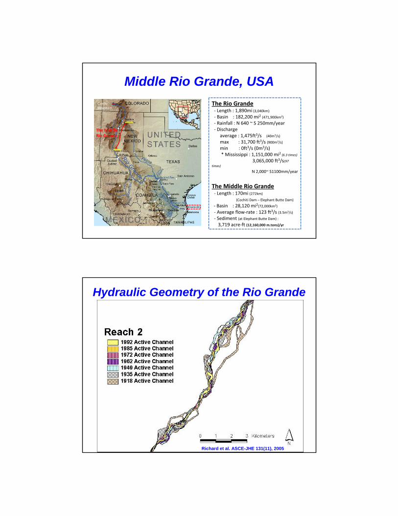
Middle Rio Grande, USA
The Rio Grande‐ Length : 1,890mi (3,040km)
‐ Basin : 182,200 mi2 (471,900km2)
‐ Rainfall : N 640 ~ S 250mm/year ‐ Discharge
average : 1,475ft3/s (40m3/s)
max : 31,700 ft3/s (900m3/s)
min : 0ft3/s (0m3/s)* Mississippi : 1,151,000 mi2 (6.3 times)
3,065,000 ft3/s(97 times)
N 2,000~ S1100mm/year
The Middle Rio Grande‐ Length : 170mi (272km)
(Cochiti Dam – Elephant Butte Dam)
‐ Basin : 28,120 mi2(72,000km2)
‐ Average flow‐rate : 123 ft3/s (3.5m3/s)
‐ Sediment (at Elephant Butte Dam) :
3,719 acre‐ft (12,160,000 m.tons)/yr
The Middle Rio Grande
Camby Mountain
Hydraulic Geometry of the Rio Grande
Richard et al. ASCE-JHE 131(11), 2005

River Dynamics Rio Grande below Cochiti Dam, NM
Braiding Transition Meandering
1935 1972 1992
Richard et al. ASCE-JHE 131(11), 2005
Site Description and Background
--History of the Middle Rio Grande
--Discharge Analysis--Reservoir Level Analysis
Site Description and Background
--History of the Middle Rio Grande
--Discharge Analysis--Reservoir Level Analysis
Aggradation/Degradation--Rangeline Analysis
Aggradation/Degradation--Rangeline Analysis
Channel Classification
--Slope Discharge Methods--Channel Morphology Methods
--Stream Power Methods
Channel Classification
--Slope Discharge Methods--Channel Morphology Methods
--Stream Power Methods
Equilibrium State Predictors
--Hydraulic Geometry Methods--Width Regression Models
Equilibrium State Predictors
--Hydraulic Geometry Methods--Width Regression Models
Subreach Definition--Channel Width Analysis--Channel Slope Analysis
Subreach Definition--Channel Width Analysis--Channel Slope Analysis
Geomorphology--Planform Analysis
--Sinuosity
Geomorphology--Planform Analysis
--Sinuosity
Sediment Parameters-- Bed Material
--Suspended Sediment Analysis
Sediment Parameters-- Bed Material
--Suspended Sediment Analysis
Hydraulic Parameters--Channel Forming Discharge
Analysis-- HEC-RAS Analysis
Hydraulic Parameters--Channel Forming Discharge
Analysis-- HEC-RAS Analysis
River Analysis Flow Chart
6Rio Grande Example from Julien et al. (2011)

Hydraulic Analysis
7Owen et al. (2011)
River Sedimentation Rio Grande near the Bosque del Apache, NM
From Baird, USBR
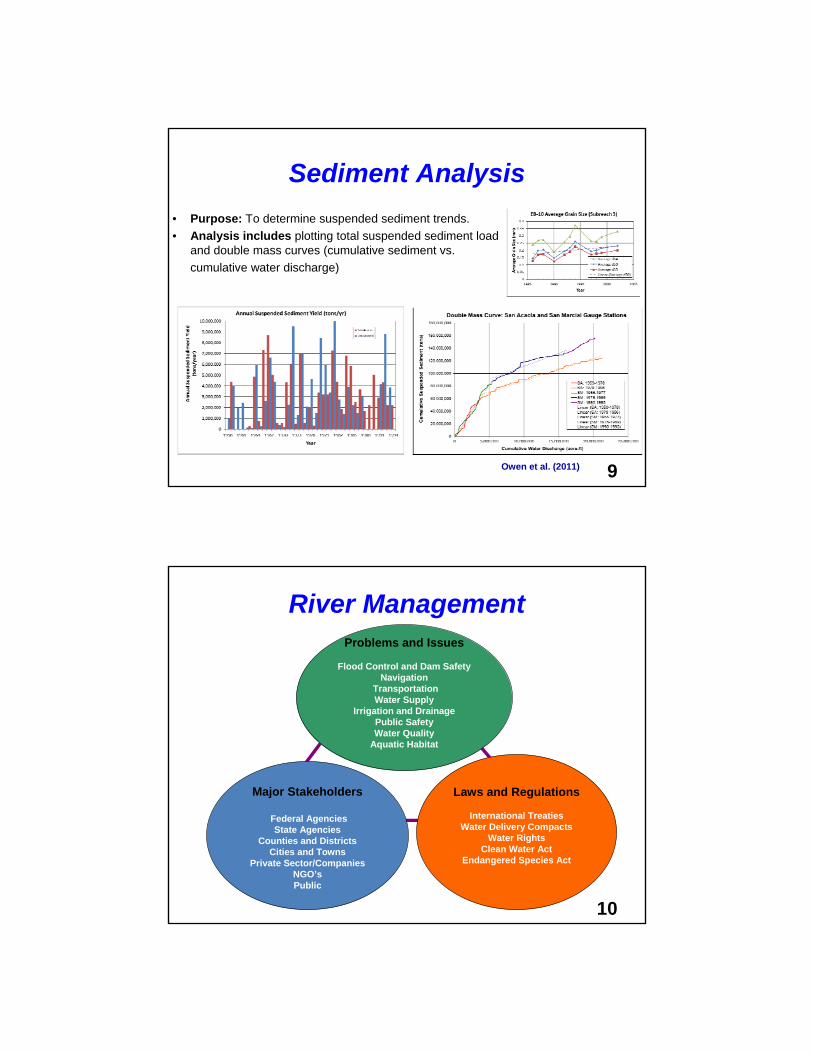
Sediment Analysis
• Purpose: To determine suspended sediment trends.
• Analysis includes plotting total suspended sediment load and double mass curves (cumulative sediment vs.
cumulative water discharge)
9Owen et al. (2011)
River Management
10
Problems and Issues
Flood Control and Dam SafetyNavigation
TransportationWater Supply
Irrigation and DrainagePublic SafetyWater Quality
Aquatic Habitat
Laws and Regulations
International TreatiesWater Delivery Compacts
Water RightsClean Water Act
Endangered Species Act
Major Stakeholders
Federal AgenciesState Agencies
Counties and DistrictsCities and Towns
Private Sector/CompaniesNGO’sPublic

1) Alluvial rivers are dynamic systems changing mostly during floods
2) River management requires monitoring of hydraulics and sedimentation
3) River management involves stakeholders and requires laws and regulations
Things remembered fromCase Studies in the US
1) Case Studies of River Management in the US
2) Interesting River Management Issues in South Korea

Restoration of Abandoned ChannelsCheongmi Stream and Mangyeong River
Cheongmi Stream
South Korea
In Collaboration with KICT – ECORIVER21 – Kim Jaehoon et al. (2011)
Changes in Active Channel WidthHwang River below Hapcheon Dam
1983 2007
Shin Youngho and Julien, ASCE- JHE, 137(1), 2011
0
100
200
300
400
500
600
700
051015202530354045
Distance from the confluence with the Nakdong River (km )
Active channel width (m)
1982199320041982_avg.1993_avg.2004 avg.
Hapcheon Main Dam
1982
200737
39
41
43
45
47
49
0 100 200 300 400 500 600
Width (m)
Bed
ele
vati
on
(m
)
1983
2003
1983
2003

Kim Jaehoon (2011)
Soil Erosion Modeling using RUSLE and GISSoil Erosion Modeling using RUSLE and GIS
Kim Hyeon Sik and Julien, (2006)
Imha Watershed
Duksan Stream
Typhoon Maemi, 2003
Water Quality IssuesImha Dam, South Korea
An, Sangdo, CSU and K-Water, 2011

Inlet point0 km 4 km
Unit : kg/m3
Water Quality ModelingInterflow turbidity currents at Imha Dam, SK
An Sangdo, CSU & K-Water, 2011
Retrofitting Bridge Piers after Riverbank Shifting
Park Sang-Kil et al. ASCE-JHE, 134(11), 2008
Before
After

Nakdong River Estuary Barrage
Ji Un et al. ASCE-JHE, 137(11), 2011
Nakdong River Estuary BarrageSediment Flushing Curves
Things remembered from Interesting Issues in South Korea
1) Impact of typhoon on upland erosion
2) Changes in river geometry and river restoration
3) Reservoir sedimentation, density currents and water quality modeling

Thank [email protected]
• Woo, Hyoseop, KICT • Park, Sang-Kil PNU• Ji, Un, Myongji U• An Sangdo, CSU and K-Water• Kim, Hyeonsik, K-Water• Shin, Youngho, K-Water• Park, Kiyoung, CSU and K-Water• Kim, Jaehoon, CSU• Choi, Gye Woon, Incheon U.• M. Velleux, Hydroqual• J. England, USBR• D.C. Baird, USBR• So many others…
Acknowledgments