brookfield garden village scoping...brookfield garden village - environmental impact assessment,...
TRANSCRIPT

Brookfield Garden Village
Hertfordshire County Council
Environmental Impact Assessment
Scoping Report
May 2017
Executive Park, Avalon Way, Anstey, Leicester, LE7 7GR
Tel: 0116 234 8000

www.wyg.com creative minds safe hands
Document Control
Project: Brookfield Garden Village
Client: Hertfordshire County Council
Report Title: Environmental Impact Assessment Scoping Report
File Origin: E:\Projects\A090000 - A09999\A090070-171\reports\Baldock South\Scoping
Consultant Information: WYG
Executive Park,
Avalon Way
Leicestershire
LE7 7GR
0116 234 8000
Document Checking:
Author: Ross Phillips Signed:
Checked by: Matt McNeice Signed:
Verified by: Adrian Rous Signed:
Issue Date Status
1 May 2017 FINAL

www.wyg.com creative minds safe hands
Contents Page
1.0 INTRODUCTION .................................................................................................................. 1
2.0 ENVIRONMENTAL IMPACT ASSESSMENT APPROACH ........................................................ 7
3.0 CUMULATIVE SCHEMES ..................................................................................................... 11
4.0 IN COMBINATION EFFECTS .............................................................................................. 12
5.0 PROPOSED IMPACT ASSESSMENT CRITERIA ................................................................... 13
6.0 TRAFFIC AND TRANSPORT ................................................................................................ 17
7.0 NOISE AND VIBRATION .................................................................................................... 19
8.0 AIR QUALITY ..................................................................................................................... 22
9.0 LANDSCAPE AND VISUAL IMPACT .................................................................................... 25
10.0 ARCHAEOLOGY AND CULTURAL HERITAGE ...................................................................... 30
11.0 HYDROLOGY AND FLOODING ........................................................................................... 41
12.0 ECOLOGY ........................................................................................................................... 44
13.0 GROUND CONDITIONS ..................................................................................................... 49
14.0 SOCIO-ECONOMICS .......................................................................................................... 52
15.0 WASTE ............................................................................................................................... 55
16.0 LIGHTING .......................................................................................................................... 58
17.0 CLIMATE CHANGE ............................................................................................................. 61
18.0 HUMAN HEALTH ................................................................................................................ 64
19.0 MAJOR ACCIDENTS, FIRE AND NATURAL DISASTERS ...................................................... 68
20.0 CONCLUSION .................................................................................................................... 70

www.wyg.com creative minds safe hands
Appendices
Appendix 1 Assessment Methodologies

Brookfield Garden Village - Environmental Impact Assessment, Scoping Report
1
A090070-136 May 2017
1.0 Introduction
1.1.1 This Environmental Impact Assessment (EIA) Scoping Report has been prepared by WYG on
behalf of Hertfordshire County Council (HCC), to request a formal scoping opinion from
Broxbourne Borough Council (BBC) in support of an application for the Brookfield Garden Village
mixed use development.
1.1.2 This Scoping Report sets out the framework within which the Environmental Statement (ES) will
be produced, including topic areas and information that will be contained within the ES.
1.1.3 The formal Scoping Request is pursuant to Part 4, Regulation 13 (1) of The Town and Country
Planning (EIA) Regulations 2011 (as amended 2015).
1.1.4 This report has assessed the baseline site conditions which have been collated through survey
work and desk studies to determine whether the proposed development is likely to result in
potentially significant environmental effects.
1.1.5 This report contains sufficient information to allow Broxbourne Borough Council to consult with
relevant stakeholders on the proposed scope of the EIA, including the Environment Agency (EA),
Natural England (NE) and Historic England so that their comments can be taken into consideration
on the provisional scope set out in this report.
1.2 Site Location
1.2.1 The site consulted upon ‘Brookfield Garden Village’ is located to the north west of Cheshunt in
Hertfordshire as shown on Figure 1. The total land take for the scheme is approximately 126.92
ha including access roads.
1.2.2 The Site is dominated by a mixture of agricultural fields, unmanaged grassland and blocks of
woodland with scattered areas of scrub, trees and mature hedgerows. The existing uses on site
are limited to use of the fields for agricultural purposes and allotments to the south east corner.
1.2.3 To the north the site is bounded by a large block of mature woodland, beyond which is
Wormleybury Manor House and its associated grounds and lake. To the east lies the A10 main
road with Wormley village located beyond this.
1.2.4 To the south the site is Cheshunt Park Gold Club and the New River. To the West open
countryside with several large woodlands.

Brookfield Garden Village - Environmental Impact Assessment, Scoping Report
2
A090070-136 May 2017
1.3 Site Context
1.3.1 The proposed allocation at Brookfield is derived from the Council’s Local Plan framework
document, issued in October 2015, that sets out how the Council proposes to deliver the
objectives established in the draft ‘vision and objectives’ for the local plan. The document
recognised that the strategic release of Green Belt land would be required if housing needs were
to be met and identified Brookfield as the principal proposed release.
1.3.2 The Broxbourne Borough Council Local plan identified several strategic development sites across
the district which includes the Brookfield Garden Village covered by this scoping report. In regards
to these sites The Local Plan states;
‘The Council plans to develop the Brookfield area as a comprehensively planned garden suburb
that will encompass a retail, civic and leisure centre for the borough of Broxbourne, a business
campus and Brookfield Garden Village. Brookfield will be home to around 5000 people.
The Local plan advocates the re-modelling of Brookfield as a new place for 21st century living,
working and leisure in the heart of the Borough. The development is being planned to meet all of
the objectives of the Local Plan.
Development at Brookfield will encompass the following principles:
1. Creation of a sustainable and integrated mixed use garden suburb that will accommodate
retail, civic, housing, jobs and social facilities;
2. The creation of an identify and sense of place for Brookfield and the borough of
Broxbourne;
3. To create a strengthened and cohesive retail centre and a new leisure and civic hub for
the borough of Broxbourne;
4. To achieve a step change in the economy of Broxbourne and increase the attractiveness
of Broxbourne as a place to live in, invest in and visit;
5. To address traffic congestion and to create sustainable patterns of movement within
Brookfield and with the remainder of the Borough;
6. To achieve exceptional standards of design and sustainability;
7. To retain and enhance the landscape and ecology of the Brookfield area.

Brookfield Garden Village - Environmental Impact Assessment, Scoping Report
3
A090070-136 May 2017
Brookfield will consist of two separate but integrated new neighbourhoods - Brookfield Riverside,
which will incorporate the existing Brookfield Centre and Brookfield Retail Park and Brookfield
Garden Village.’
1.4 Overview of the Proposed Development
1.4.1 Brookfield Garden Village presents an opportunity for Broxbourne to comprehensively address its
future residential requirements as well as the identified lack of retail and leisure facilities within
the Borough.
1.4.2 The proposals are for a residential development comprising the following:
• Up to 2000 new homes;
• New local centre;
• New primary school;
• Employment opportunities; and,
• Provision of sites for relocated uses including a Household Waste Recycling Centre,
Council Depot and Travellers site.

Brookfield Garden Village - Environmental Impact Assessment, Scoping Report
4
A090070-136 May 2017
Figure 1 – Red Line Plan

Brookfield Garden Village - Environmental Impact Assessment, Scoping Report
5
A090070-136 May 2017
1.5 Identified Key Potential Receptors
1.5.1 Residential Receptors – There are several properties in relatively close proximity to the
proposed development site, the majority of these are separated from the site by significant
buffers such as mature woodland, the A10, the New River and the Cheshunt Golf Course.
Residential receptors include Wormleybury Manor and other private residences to the north of the
site; the main urban conurbations of Wormley and Turnford to the East of the A10, the Halfhide
Lane Caravan Park adjacent to the southern most extent of the site and several farms and private
homes along Park Lane Paradise to the west of the site.
1.5.2 Local facilities: There are several educational facilities within close proximity to the site
including Flamstead End School and St Paul’s Catholic School in Flamstead End, Wormley Primary
School, Longlands Primary School, Hertford Regional College and Churchfield C of E Primary
School in Wormley and Turnford to the East.
1.5.3 The are three GP surgeries in close proximity to the site in Wormley, Turnford and Flamstead End
and a retail centre including supermarket and petrol station to the immediate south of the site
with further retail facilities in Broxbourne to the north and Cheshunt to the south.
1.5.4 A footpath (Public Right of Way (PROW) in close to the southern boundary of the site and follows
the course of the New River.
1.5.5 Heritage Features / Conservation areas: There are two Schedule Monuments within the site
which include Hell’s Wood moated site and enclosure and Perrior’s Manor moated site and
fishpond. To the north of the site there are several listed buildings and Wormleybury registered
park and garden.
1.5.6 Ecology/Biodiversity: Through the centre of the site there is Spring Wood, a large block of
ancient and semi natural woodland and to the south of the site lies Cheshunt Park Local Nature
Reserve. Approximately 1km to the east lies the Lee Valley Special Protection Area (SPA) and
RAMSAR site and the Turnford and Cheshunt Pits Site of Special Scientific Interest (SSSI). This
area comprises a series of wetlands and reservoirs which support a range of wintering wildfowl.
1.5.7 Surface, Groundwater and Water Resources: There are several recognised water courses
both in and adjacent to the site. The New River lies close to the southern boundary of the site,
the Turnford Brook crosses the site running broadly in a north west to south east direction. The
Wormley Brook lies adjacent to the north of the site and there are several large ponds on the
northern portion of the site.

Brookfield Garden Village - Environmental Impact Assessment, Scoping Report
6
A090070-136 May 2017
1.5.8 The majority of the site is located wholly within Flood Zone 1 and therefore not at risk of flooding;
this is within the exception of areas immediately adjacent to the Turnford Brook and Wormley
Brook where smaller areas lie within both Flood Zones 2 and 3 which are at medium and higher
risk of flooding.
1.5.9 Ground Conditions: There are two pits on the site which comprise Cheshunt Park Farm Quarry
and were historically used as landfill sites and received waste in the 1990’s; the waste was
considered inert and comprised glass, concrete, bricks, tiles, soil and stone.
1.6 The Environmental Impact Assessment Consultant – WYG
1.6.1 WYG is a Corporate Associate Assessor Member of the Institute of Environmental Management
and Assessment (IEMA), and has considerable experience of undertaking both statutory EIA and
non-statutory EIA (where the planning authority does not consider that a formal EIA is required
under the regulations).
1.6.2 IEMA is the UK’s leading body for environmental professionals and is an expert body in the EIA
field. IEMA has developed the prestigious EIA Quality Mark to identify organisations that are
capable of producing high quality EIA on a consistent basis. WYG is an approved Associate
Assessor member under the EIA Quality Mark which means that the quality of our EIA service is
approved and regularly reviewed by IEMA. As a result we are allowed to use the EIA Quality mark
logo on our EIA reports (as shown on the front cover). For further information on the EIA Quality
Mark please visit: http://www.iema.net/qmark.

Brookfield Garden Village - Environmental Impact Assessment, Scoping Report
7
A090070-136 May 2017
2.0 Environmental Impact Assessment Approach
2.1 EIA Screening
2.1.1 The Town and Country Planning (Environmental Impact Assessment) Regulations 2011 (as
amended 2015) (hereafter termed the ‘EIA Regulations’), require that, before consent is granted
for certain types of development an EIA must be undertaken. The EIA Regulations set out the
types of development which must always be subject to an EIA (Schedule 1 development) and
other developments, which will only require assessment if they give rise to significant
environmental effects (Schedule 2 developments).Guidance and thresholds are available to help to
decide whether EIA is required for a Schedule 2 development.
2.1.2 The development, as described in Section 1, does not fall within any of the descriptions contained
within Schedule 1 of the EIA Regulations for which EIA is mandatory. However, the development
does fall under the description in Schedule 2, 10 (b) Urban Development Projects. In April 2015
thresholds for urban development projects were raised such that a project proposal needs to be
screened if:
• The development includes more than 1 hectare of development which is not dwelling house
development; or,
• The development includes more than 150 dwelling houses; or,
• The area of the development exceeds 5 hectares.
2.1.3 In this case, the development has an area of approximately 126.92 hectares and therefore
exceeds indicative thresholds set out in the Regulations and is therefore deemed to be Schedule 2
development. Given the size of the site and the key receptors which have the potential to be
affected by the proposed development, we consider that the proposals constitute EIA
development and the remainder of this document is dedicated to setting out our proposed scope
for the ES.
2.2 EIA Scoping
2.2.1 Part 4, Regulation 13 (1) of the EIA Regulations (HMSO, 20111) provides for the Applicant to ask
the Local Planning Authority (LPA), in this case BBC, to state in writing the information that should
be provided within the ES, a process known as scoping.
1 Her Majesty’s Stationery Office (HMSO), 2011. The Town and Country Planning (Environmental Impact Assessment) Regulations 2011 (as amended 2015) (SI 1824).

Brookfield Garden Village - Environmental Impact Assessment, Scoping Report
8
A090070-136 May 2017
2.2.2 The Applicant is required under Part 4, Regulation 13 (2) to provide:
• A plan sufficient to identify the land (as shown in Site Plan Figure 1);
• A brief description of the nature and purpose of the development and of its possible effects
on the environment, and;
• Such other information or representations as the person making the request may wish to
provide or make.
2.2.3 It is the aim of this EIA Scoping Report to provide sufficient information for BBC to consider and
consult on the proposals and to provide a formal scoping opinion.
2.3 Scope of Work
Geographic Scope
2.3.1 The EIA covers the physical extent of the site as shown in the Site Plan Figure 1. It is defined by
the area of land to be used, the nature of the current environmental conditions and the manner in
which impacts are likely to be generated. It is important to note however that the influence of
many predicted impacts can extend beyond the immediate site boundary, for example, the effects
on some species that are primarily located off-site but which may use the site for foraging. Where
identified and relevant, these impacts have also been assessed as part of the EIA.
Temporal Scope
2.3.2 As this development is proposed to be operational in excess of 100 years and thereafter is likely
to comprise developed land in perpetuity this assessment will not address decommissioning.
2.3.3 Any significant changes expected in future baselines due to environmental trends will also be
described qualitatively, or in certain cases calculated as quantitative future baseline to allow
meaningful future year assessment. These future year baselines take account of cumulative
developments not yet built but in the planning system so cumulative effects are taken into
consideration as required by the EIA Regulations.
Technical Scope
2.3.4 In order to ascertain the likely scope of the EIA, the process has involved the following steps:
• Identification of the site boundary;
• Identification of the key characteristics of the development site and the establishment of the
environmental baseline through a series of desk and field studies;

Brookfield Garden Village - Environmental Impact Assessment, Scoping Report
9
A090070-136 May 2017
• Identification of gaps in the baseline and the further survey work required to address these;
• Initial consideration of the potential sources and nature of environmental impacts through
assessment against the environmental baseline; and,
• Definition of impact assessment methodologies to be utilised.
2.4 Technical Assumptions
Construction and Operational Legislative Requirements
2.4.1 The ES will assume that all legislative requirements and statutory design guidelines will be met.
Therefore, any standard guidance which is provided to ensure minimum legal compliance is not
considered to constitute ‘additional mitigation’ in this EIA and will not be taken into account as
such.
Construction Environmental Management Plan (CEMP)
2.4.2 The potential environmental effects of the construction phase will be controlled through a
Construction Environmental Management Plan (CEMP). The CEMP would be prepared prior to
commencement of construction and would contain all the design and additional mitigation as
identified and reported within the ES and any subsequently agreed requirements, expected to be
enforced by planning conditions. The details of these documents would be agreed with BBC prior
to construction commencing.
2.5 Alternatives
2.5.1 Alternatives will be covered in chapter 4 of the ES.
Alternative Sites
2.5.2 In line with the requirements of the EIA Regulations, alternatives will need to be considered as
part of the EIA and will be covered in detail within Chapter 4 of the subsequent Environmental
Statement.
2.5.3 In preparing the Local Plan Broxbourne Borough Council considered a large number of alternative
options for development which are presented in the Emerging Local Plan: Borough-Wide Options
and Scenarios.
2.5.4 The site was identified within the draft local plan as part of a wider 180 hectare ‘Brookfield’ area
which included the Brookfield Riverside and the Brookfield Garden Suburb sites.
Brookfield Garden Village - Environmental Impact Assessment, Scoping Report
10
A090070-136 May 2017
2.5.5 Discussion on why sites have been included or excluded is contained in the Sustainability
Appraisal (SA) of Broxbourne Emerging Local Plan. All of the sites included in the Proposed
Submission Local Plan were tested against the sustainability objective and a summary showing
the reasons for selecting each preferred site was included in Appendix B to the SA report.
2.5.6 The sites have been included in the draft submission of the BBC Local plan 2016-2031 which was
subject to public consultation between 18th July 2016 and 16th September 2016. Now consultation
has closed the Council is considering the overall responses before submitting to government for
examination.
Alternative Development Scenarios
2.5.7 Alternatives will be considered at all stages of the development. This might include considering
alternative processes as part of the construction phase and in terms of final design and layout of
the overall scheme.
2.5.8 The development has been, and continues to be, subject to a process of design development.
This process involves incorporating the outcomes of baseline surveys and data that is collected
and the outcomes of consultation both with statutory and non-statutory consultees and with the
public to result in the optimal solution for development at the site.

Brookfield Garden Village - Environmental Impact Assessment, Scoping Report
11
A090070-136 May 2017
3.0 Cumulative Schemes
3.1.1 The potential cumulative effects of the development in association with other developments both
during construction and on completion will be included where relevant as required by Schedule 4,
Part 1, Paragraph 4 of the EIA Regulations (HMSO, 2011). WYG has undertaken a planning history
check to initially screen for other projects within the planning system or those which are allocated
in housing or employment allocations that could give rise to significant cumulative effects in our
professional judgement. As part of the scoping opinion we would request that BBC confirm
agreement with the inclusion of the sites set out below, and provide additional details of any
developments not included which they consider should be included within the cumulative
assessment.
Table 3.1 List of Other Developments
Site Policy No. /
application ref Description/status
Brookfield Riverside Allocation in Draft
Local Plan
A proposed leisure and retail
facilities immediately to the southern edge of the site
boundary
Former St Marys High School Site
07/14/0076/F Up to 79 residential dwellings
Former Everest Sports
Ground 07/13/0649/RM Up to 96 residential dwellings
Britannia Nurseries,
Bryanstone Road 07/16/1354/RM Up to 90 dwellings
Cheshunt Sports Village 07/16/1369/F
New Stadium, up to 186 dwellings, new commercial
and leisure facilities.
High Leigh Garden Village 07/13/0899/O Up to 523 residential dwellings

Brookfield Garden Village - Environmental Impact Assessment, Scoping Report
12
A090070-136 May 2017
4.0 In combination effects
4.1.1 A review of the residual impacts within the ES will be undertaken, along with an exercise which
tabulates the impacts against receptors to identify the potential for impact interactions. Only
residual impacts classified as being of minor, moderate or major significance will be considered in
relation to the potential for the in combination (or inter-relationship) effects of individual impacts.
Residual impacts of negligible significance will be excluded as by virtue of their definition, they are
considered to be imperceptible impacts.
4.1.2 Where there is more than one impact on a particular receptor, the potential for impact
interactions will be assessed.

Brookfield Garden Village - Environmental Impact Assessment, Scoping Report
13
A090070-136 May 2017
5.0 Proposed Impact Assessment Criteria
5.1 Impact Assessment Guidance
5.1.1 The assessments presented in the subsequent ES will consider the potential for significant
environmental effects to impact the baseline conditions as a direct/indirect result of the Proposed
Development. The baseline conditions are defined as the existing state of the environment and
how it may develop in the future in the absence of the proposals. This is a requirement of the EIA
Regulations which in Schedule 4, Part 1, Paragraph 3 require a description of the aspects of the
environment likely to be significantly affected by the development (HMSO, 2011).
5.1.2 Predictions are necessary when forecasting future impacts. The EIA Regulations in Schedule 4,
Part 1, Paragraph 4 require a description by the Applicant of the forecasting methods used to
assess the effects on the environment (HMSO, 2011). Assessments will be undertaken in
accordance with best practice guidelines published by the relevant professional bodies. Industry
standard approaches, for example, the Chartered Institute of Ecology and Environmental (CIEEM)
Guidelines for Ecological Impact Assessment (EcIA) in the United Kingdom and Ireland – 2nd
Edition (CIEEM, 2016), the Landscape Institute / Institute of Environmental Management and the
Countryside Agency’s Guidelines for Landscape and Visual Impact Assessment (GLVIA) Third
Edition (LI/IEMA et al, 2013), CIRIA C552 etc., will be used in undertaking the impact
assessments, unless specifically stated otherwise. Detailed descriptions of the methodologies to
be used are attached in Appendix 1.
5.1.3 The subsequent ES will provide full details of the assessment criteria and terminology used in the
context of that technical discipline.
Proposed Consultation
5.1.4 The Applicant and its consultants propose to undertake extensive discussions with statutory and
non-statutory consultees, the local community and the landowner(s). The accumulated findings
will have an influence over the evolution of the design and layout, and will be detailed in Chapter
4 of the ES and within the specific technical chapters as appropriate.
5.2 ES Chapters and Headings
5.2.1 It is proposed that that the ES will be based around the following chapter/topic headings.
1.0 Introduction
1.1 Introduction to the Site

Brookfield Garden Village - Environmental Impact Assessment, Scoping Report
14
A090070-136 May 2017
1.2 Overview of the Proposed Development
1.3 The Applicant
1.4 Legal Framework for the Environmental Statement
1.5 Structure of the Environmental Statement
1.6 The Project Team
1.7 References
2.0 Environmental Impact Assessment Approach
2.1 Objectives
2.2 Scope of Work
2.3 Assessment Criteria
2.4 References
3.0 Description of Proposed Development
3.1 Introduction
3.2 The Site and Local Context
3.3 Existing Utilities
3.4 Development Proposals
3.5 Construction Proposals
3.6 Securing Environmental Management - The Environmental Management Plan
3.7 References
4.0 Scheme Development and Alternatives Considered
4.1 Site Feasibility and Identification
4.2 Consideration of Alternatives
4.3 Approach to Public Consultation
4.4 References
5.0 Planning Policy
5.1 National Planning Policy

Brookfield Garden Village - Environmental Impact Assessment, Scoping Report
15
A090070-136 May 2017
5.2 Regional and Local Planning Policy
5.3 References
5.2.2 Specific topic chapters will follow the same format as that proposed below. The topic chapters will
be finalised as part of the scoping exercise.
6.1 Introduction
6.2 Methodology and Scope
6.3 Baseline Environment
6.4 Mitigation within the Submitted Design
6.5 Potential Environmental Effects of the Scheme
6.6 Additional Mitigation, Compensation and Enhancement Measures
6.7 Assessment Summary and Residual Environmental Effects
6.8 References
5.2.3 In addition, in accordance with the EIA Regulations the ES will be accompanied by a Non-
Technical Summary.

Brookfield Garden Village - Environmental Impact Assessment, Scoping Report
16
A090070-136 May 2017
Environmental Topics to be
Addressed within the EIA

Brookfield Garden Village - Environmental Impact Assessment, Scoping Report
17
A090070-136 May 2017
6.0 Traffic and Transport
6.1 Introduction
6.1.1 This chapter provides the transport and access scoping assessment and provides a summary of
the potential effects and how this will be addressed in the EIA and presented in any subsequent
ES chapter.
6.2 Baseline Conditions
6.2.1 The existing highway network on or within the boundary of the site consists of:
• A10;
• B198;
• Halfhide Lane – B156; and,
• A1170.
6.3 Further Assessment/ Consultation
6.3.1 Ongoing consultation with the Local Highway Authority and Highways England will be undertaken
throughout the design process to address the transport requirements of the scheme and to
consider the potential implication on the wider highway network.
6.3.2 WYG will also produce a Transport Assessment and Travel Plan to inform the EIA and support the
planning application.
6.4 Mitigation within the Submitted Design
6.4.1 The scheme design is at an early iterative stage and therefore a mitigation strategy has yet to be
finalised. However as part of the design process WYG will provide both construction and
operational design mitigation into the Proposed Development.
6.5 Receptors to be Considered as part of EIA
6.5.1 The following sections identify the receptors we consider could potentially be significantly
impacted, as a result of the Proposed Development and will thus be assessed within the ES.
Additional receptors may be included if identified by further technical study.
6.5.2 As part of this scoping opinion we would also request that BBC provide details of any additional
receptors they consider should be included.

Brookfield Garden Village - Environmental Impact Assessment, Scoping Report
18
A090070-136 May 2017
Construction Phase
6.5.3 Construction traffic is characterised by heavy goods vehicles and construction staff movements.
6.5.4 An assessment of potential construction effects on the following receptors will be undertaken
within the ES:
• Local Road Network;
• Identified junctions;
• Vehicle delay; and
• Public Transport.
Operational Phase
6.5.5 Given the scale of the development, the proposals will generate increased traffic movements, both
within the site and externally.
6.5.6 An assessment of potential operational effects on the following receptors will be undertaken
within the ES:
• Local Road Network;
• Identified junctions;
• Vehicle delay;
• Public Transport;
• Walking, cycling, Public Rights of Way; and
• Cumulative Impacts and Effects.
6.6 Scoping Assessment Summary
6.6.1 Whilst the development is only at a very early stage in it’s design, it is considered that given the
number of residential units proposed and the size of the adjacent employment area, that the
development has the potential to have significant effects as a result of the increases in traffic.
Therefore it is proposed that a Transport and Access ES chapter will be produced within the ES.
This assessment will be undertaken in accordance with the methodology provided in Appendix 1.

Brookfield Garden Village - Environmental Impact Assessment, Scoping Report
19
A090070-136 May 2017
7.0 Noise and Vibration
7.1 Introduction
7.1.1 This chapter considers the potentially significant effects of noise and vibration during site
preparation, construction and operation of the Proposed Development to determine if an ES
chapter assessing the potential significant effects of noise and vibration is required. Particular
attention has been paid to potential changes in the acoustic environment at nearby sensitive
dwellings due to the introduction of new noise sources.
7.2 Baseline Conditions
7.2.1 The baseline position for the existing noise environment in/around the site will be established by a
noise assessment covering both weekday and weekend periods.
7.2.2 Currently the A10 to the east of the site is anticipated to be the greatest sources of noise, with
contributions from the B156, Halfhide Lane and A1170 to a lesser extent. Additional contributions
from local residential roads and small-scale commercial and industrial units have also been
identified.
7.3 Further Assessment/ Consultation
7.3.1 WYG will produce a noise and vibration assessment to determine the baseline noise level. The
Environmental Health Officer (EHO) will be consulted as part of the assessment.
7.4 Mitigation within the Submitted Design
7.4.1 The scheme design is at an early iterative stage and therefore a mitigation strategy has yet to be
finalised. However as part of the design process WYG will provide both construction and
operational design mitigation into the Proposed Development.
7.4.2 The layout of the development will take consideration of noise contours from the modelling to
avoid locating residential properties adjacent to significant noise sources, and where relevant
noise mitigation in the form of building standards and bunds or buffers will be specified as
required.
7.5 Receptors to be Considered as part of EIA
7.5.1 The following sections identify the receptors we consider could potentially be significantly
impacted, as a result of the Proposed Development and will thus be assessed within the ES.
Additional receptors may be included if identified by further technical study.

Brookfield Garden Village - Environmental Impact Assessment, Scoping Report
20
A090070-136 May 2017
7.5.2 As part of the scoping opinion we would request that BBC provide details of any additional
receptors they consider should be included.
Construction Phase
7.5.3 An assessment of potential construction effects on the following receptors will be undertaken
within the ES. These receptors will include:
• Residential properties adjacent to the eastern side of the site on the opposite side of the
A10;
• Residential properties off Halfhide Lane;
• Residential properties off Park Lane Paradise; and,
• Residential properties off Church Lane to the north.
7.5.4 Given the presence of the two landfill sites within the site boundary and the size of the
development area which they cover, it is considered likely that piling would be required to ensure
stabilisation for any of the building works. Additionally, it is also considered that piling would be
required for the bridge required to cross the New River. As such it is considered that there is the
potential for significant environmental effects in relation to vibration and therefore vibration will
be considered within the assessment.
Operational Phase
7.5.5 An assessment of potential operational effects on the following receptors will be undertaken
within the ES. These receptors will include:
• Residential properties adjacent to the eastern side of the site on the opposite side of the
A10;
• Residential properties off Halfhide Lane;
• Residential properties off Park Lane Paradise; and,
• Residential properties off Church Lane to the north.
• Increased traffic along the B156, A1170 and A10.
7.6 Scoping Assessment Summary
7.6.1 Given the potential for the development to result in increases in noise and vibration at both
construction and operational phases it is proposed that an ES chapter will be produced within the

Brookfield Garden Village - Environmental Impact Assessment, Scoping Report
21
A090070-136 May 2017
ES. This assessment will be undertaken in accordance with the methodology provided in Appendix
1.

Brookfield Garden Village - Environmental Impact Assessment, Scoping Report
22
A090070-136 May 2017
8.0 Air Quality
8.1 Introduction
8.1.1 The Chapter will assess the potential effects of the development with respect to air quality during
the construction and operational phases. Poor air quality can cause damage to the natural and
built environments and human health. The Proposed Development has the potential to deteriorate
local air quality, predominantly through increased traffic movement.
8.2 Baseline Conditions
Air Quality Management Areas
8.2.1 The closest Air Quality Management Areas (AQMA) to the site are situated on the B176 High
Street, Waltham Cross approximately 3.5km to the south; Monarch’s Way A121 Waltham Cross
approximately 4km to the south.
8.2.2 Due to the distance between the Proposed Development site and the AQMAs, it is considered
unlikely that traffic generated from the Proposed Development will influence existing traffic flows
within the AQMAs, however, given the proposed number of additional residential units and the
potential for increase in traffic this cannot be confirmed at this stage. Further liaison with the
traffic consultants will be undertaken to determine if there are likely to be increases in these areas
and whether the AQMA’s will be scoped in or out of the assessment.
Air Quality Monitoring
8.2.3 The existing air quality monitoring network comprises 28 sites across the district and also
maintains two air quality monitoring stations, one located at College Road/A10 Cheshunt
approximately 2.2km to the south and the other near the bus depot at Waltham Cross
approximately 3.7km to the south. Both sites continuously measure levels of NO2, PM10 and PM2.5.
8.2.4 The last air quality assessment report for Broxbourne was produced in April 2015 which stated
that;
‘Diffusion tube monitoring data has indicated that there were 10 exceedences of the annual
mean objective value for nitrogen dioxide in 2010, 2012, 2013 & 2014, and 9 exceedences in
2011.
In 2015, the council will declare the two further Air Quality Management Areas identified in the
2011 Detailed Assessment, and extend an already existing one. The council will work to produce

Brookfield Garden Village - Environmental Impact Assessment, Scoping Report
23
A090070-136 May 2017
and consult on, an updated Air Quality Action Plan to incorporate the new AQMAs within 12
months, and will continue to monitor air quality within the district.
The Planning process has identified a new junction (A10 / College Road), and a road (High Road,
Wormley) which could exceed the objective for nitrogen dioxide, which will require Detailed
Assessment. A further 10 diffusion tubes will be used from 4th April 2015 onwards to further
assess this, and other identified locations within the Borough.’
8.3 Further Assessment/ Consultation
8.3.1 WYG will produce an Air Quality Assessment to determine an up to date baseline. The baseline air
quality in the vicinity of the proposed development site will be defined from existing monitoring as
described above. It is determined that no additional monitoring will be required as part of the
assessment. The Environmental Health Officers (EHO) will be consulted in detail prior to and
throughout preparation of the assessment.
8.4 Mitigation within the Submitted Design
8.4.1 The scheme design is at an early iterative stage and therefore a mitigation strategy has yet to be
finalised. However as part of the design process WYG will provide both construction and
operational design mitigation for the Proposed Development.
8.5 Receptors to be Considered as part of EIA
8.5.1 The following sections identify the receptors we consider could potentially be significantly
affected, as a result of the Proposed Development and will thus be assessed within the ES.
Additional receptors may be included if identified by further technical study.
8.5.2 As part of the scoping opinion we would request that BBC provide details of any additional
receptors they consider should be included.
Construction Phase
8.5.3 An assessment of air quality effects associated with exhaust emissions from construction plant on
site; and, exhaust emissions from construction phase road traffic will be undertaken. This will
include the impact on the following receptors:
• Sensitive receptors including building façades of residential properties, schools and care
homes.
• Ecological receptors including the ancient and semi-natural woodland on site and the
Cheshunt Park Local Nature Reserve to the south west.

Brookfield Garden Village - Environmental Impact Assessment, Scoping Report
24
A090070-136 May 2017
Operational Phase
8.5.4 An assessment of air quality effects associated with road vehicle exhaust emissions associated
with vehicles travelling to and from the proposed development will be undertaken. This will
include the impact on the following receptors:
• Sensitive receptors including building façades of residential properties, schools and care
homes.
• Ecological receptors including the ancient and semi-natural woodland on site and the
Cheshunt Park Local Nature Reserve to the south west.
• Effects on AQMA’s (if deemed necessary following liaison with transport consultants).
8.6 Scoping Assessment Summary
8.6.1 It is recognised that with the size of the development and the potential increases in traffic there is
potential for significant effects to occur. It is therefore proposed that Air Quality is included within
the ES.
8.6.2 This assessment will be undertaken in accordance with methodology provided in Appendix 1.

Brookfield Garden Village - Environmental Impact Assessment, Scoping Report
25
A090070-136 May 2017
9.0 Landscape and Visual Impact
9.1 Introduction
9.1.1 This chapter provides the landscape and visual impact scoping assessment. The chapter provides
a summary of the potential receptors and how these will be addressed in the EIA and presented
in the subsequent ES.
9.2 Baseline Conditions
9.2.1 The site is predominantly undeveloped greenfield land within the green belt on the north western
urban fringe of the town of Cheshunt. It contains a central woodland belt, mature trees, and
woodland blocks around the boundaries, within a parkland setting. Turnford Brook and a large
pond lie within the Site. The woodland along Turnford Brook within the site is subject to a tree
preservation order (TPO) and is designated as ancient and semi-natural woodland. A number of
blocks of woodland around the site boundary are also subject to TPOs. The site contains a
number of large mature trees along field and former field boundaries.
9.2.2 The site lies within the national landscape character area of the Northern Thames Basin (NCA)
111 which is an area rich in geodiversity, archaeology and history and diverse landscapes ranging
from the wooded Hertfordshire plateaux and river valleys, to the open landscape and
predominantly arable area of the Essex heathlands, with areas of urbanisation mixed in
throughout. The London Basin Chalk aquifer, which underlies much of the western section of the
Northern Thames Basin NCA, is the principal aquifer supplying water to Inner London. The Chalk
is confined in the basin by the overlying Tertiary formations of London Clay, which means
recharge largely occurs in the extensive Chalk outcrop of the Northern Thames Basin.
9.2.3 The site falls within the local landscape character area of Wormleybury and Cheshunt Park, as
defined in the Broxbourne Landscape Character Assessment. This is described as an area with
modified remains of ancient oak/hornbeam woodlands in parkland settings with 18th century and
19th century mixed plantations added. A complex mixture of land uses almost masks this area’s
history, but clear traces of a medieval deer park and later parklands are evident. These are now
covered by arable farmland, pasture with parkland and recreational uses.
9.2.4 There are no Public Rights of Way (PRoW) within the Site. A number of PRoW’s lie within the
study area including a restricted byway to the immediate west of the Site, and routes within both
the urban area and surrounding countryside.

Brookfield Garden Village - Environmental Impact Assessment, Scoping Report
26
A090070-136 May 2017
9.2.5 To the immediate south of the Site lies an area designated as Open Space in the local plan. This
covers Cheshunt Park, a council run park containing a play area, parking and access trails; and
Cheshunt Park Golf Centre. To the north east of the Site, approximately 500m from the Site
boundary, lies another designated open space at Cozen Grove, which is also a wildlife site.
Smaller areas of designated open space are present throughout the study area.
9.2.6 Within the local plan consultation draft, a corridor within the Site, along part of the length of
Turnford Brook, is designated as Local Green Space.
9.2.7 The historic and cultural designations within the site and surrounding area are an indication of the
landscape value of the area. To the immediate north of the Site lies Wormleybury Registered Park
and Garden. This is described on the register as ‘a country house surrounded by a landscape
park, developed in the 1770s from an earlier formal scheme, together with remnants of early C19
gardens famed for their plant collection’. The gardens are not public access, however, Church
Lane runs through the designated area, which has residential properties along its length.
9.2.8 The site is relatively well enclosed with visibility from public areas into the site restricted by
landform and the mature vegetation within and around the site. Views of the site are generally
restricted to within 1km of the site boundary, with longer panoramic views available over
Cheshunt and the site, from over 3km to the east. Visual receptors include users of Cheshunt
Park, the local PRoW and road network, and residents within the surrounding area.
9.3 Further Assessment/ Consultation
9.3.1 WYG will produce a Landscape and Visual Impact Assessment (LVIA) which will be undertaken in
accordance with the Guidelines for Landscape and Visual Impact Assessment (published by the
Landscape Institute and Institute of Environmental Management & Assessment, Third Edition
dated 2013). Viewpoints will be agreed through consultation with the Landscape Officer for BBC.
9.3.2 A site visit has been carried out for the purpose of the scoping study and a number of locations
were visited for to identify viewpoint locations for assessment within the LVIA. The visibility
surrounding the site is limited from publicly accessible locations and the following are considered
representative of the views available from the surrounding area:
• Viewpoint 1: Cheshunt Park from Candlestick Lane;
• Viewpoint 2: Cheshunt Park from western part of the park;
• Viewpoint 3: Appleby Street Open Space to the west of the site (views from the adjacent
residential area are restricted by vegetation);

Brookfield Garden Village - Environmental Impact Assessment, Scoping Report
27
A090070-136 May 2017
• Viewpoint 4: Holy Cross Hill road and footpath junction (PRoW Cheshunt 030)to the north
west of the site;
• Viewpoint 5: From the restricted byway (PRoW Hoddesdon 067) to the west of White Stubbs
Farm, approximately 1km to the north of the site;
• Viewpoint 6: Church Lane (near Wormley Sports Club) to the north of the site; and
• Viewpoint 7: Footpath approximately 3km to the east of the site off Coleman’s Lane (PRoW
Nazeing 10).
9.3.3 Other views towards the site are severely restricted or inaccessible to the general public.
9.4 Mitigation within the Submitted Design
9.4.1 The scheme design is at an early iterative stage and therefore a mitigation strategy has yet to be
finalised. However as part of the design process WYG will provide both construction and
operational design mitigation into the Proposed Development.
9.4.2 The mitigation measures necessary to reduce the impacts of development will be defined by the
assessment process. However ‘Primary’ or 'Built- in' mitigation may include:
• The general arrangement of Landscaping and Open Space areas and new Residential
Development parcels across the site.
• The set back/relationship of development with neighbouring properties and existing
landscape features (such as mature woodland).
• Consideration of key views/visual structure within the development.
• The retention of mature trees, hedges and other landscape features within the Landscaping
and Open Space areas.
• New Woodland and Tree Planting within Landscaping and Open Space.
• Other measures such as construction, operational management practices and phasing of
development will also be considered as a means to mitigate impacts.
9.4.3 Secondary or ‘not built in’ measures will be considered if through the iterative design process
significant adverse landscape and visual impacts still arise.

Brookfield Garden Village - Environmental Impact Assessment, Scoping Report
28
A090070-136 May 2017
9.5 Receptors to be Considered as part of EIA
9.5.1 The following sections identify the receptors we consider could potentially be significantly affected
as a result of the Proposed Development and will therefore be assessed within the LVIA.
Additional receptors may be included if identified by further technical study.
9.5.2 As part of the scoping opinion we request that BBC provide details of any additional receptors
they consider should be included.
Construction Phase
9.5.3 An assessment of potential construction effects on the following receptors will be undertaken
within the ES.
9.5.4 Landscape Receptors:
• National, County and District Landscape Character Areas;
• Landscape policy;
• Landscape Features within the application Site boundary including Turnford Brook; and,
• Hedgerows, trees and woodland.
9.5.5 Visual Receptors:
• Local residents;
• Individual and /or defined groups including users of Public Rights of Way residents (including
settlements);
• Motorists/cyclists;
• Workers; and
• Visitors engaged in recreational/cultural pursuits.
Operational Phase
9.5.6 An assessment of potential operational effects on the receptors listed above will be undertaken
within the LVIA.
9.6 Scoping Assessment Summary
9.6.1 It is considered that there is potential for significant effects on the landscape of the site and the
area surrounding the Proposed Development and it is considered necessary for an assessment of

Brookfield Garden Village - Environmental Impact Assessment, Scoping Report
29
A090070-136 May 2017
the impacts and effects on the landscape and visual receptors to be conducted as part of this ES.
This assessment will be undertaken in accordance with the methodology provided in Appendix 1.
Brookfield Garden Village - Environmental Impact Assessment, Scoping Report
30
A090070-136 May 2017
10.0 Archaeology and Cultural Heritage
10.1 Introduction
10.1.1 The assessment of archaeology and cultural heritage within this context includes all buried and
above ground archaeological remains, built heritage, historic landscapes and any other features
that contribute to the archaeological and historic interest of the area. Cultural heritage includes
both designated and non-designated heritage assets.
10.1.2 This scoping assessment considers the potential consequences relating to the construction and
operation of the Proposed Development.
10.2 Baseline Conditions
10.2.1 Within the site boundary there are two Scheduled Monuments, which are Perrior’s Manor moated
site and fishpond (NHLE: 1010747) and Hell Wood moated site and enclosure (NHLE: 1010746)
which are within the block of mature woodland in the centre of the site. Both of these moated
sites include earthwork and buried remains, and would have probably served as prestigious
residences during the 13th or 14th centuries. There are no further Scheduled Monuments within a
1.5km buffer if the application site boundary.
10.2.2 There are approximately 51 listed buildings within a 1.5 km radius of the site, including one grade
I building and four grade II* buildings; of primary interest is a group of eight listed buildings
situated within 400m of the northern boundary of the application site at Wormleybury Manor,
which are located in and around the extent of the grade II registered park and garden (NHLE:
1000252) associated with the Manor, which includes the remnants of a landscaped park and well
planted gardens.
10.2.3 The central designated asset of the group of listed buildings at Wormleybury Manor is the grade I
listed 18th century Wormleybury House (NHLE: 1100541), which is accompanied by separately
listed garden features (Wormleybury Garden screen, gate, gate piers and adjoining walls grade II
NHLE: 1296201; Wormleybury Garden Vases near portico grade II NHLE: 1100542; a Garden Wall
at Garden Cottage grade II NHLE: 1100543; and Wormleybury Monument on south side of lake
grade II* NHLE: 1296166). The Parish Church of St Lawrence (grade II* LB 1173566) as well as
the associated Wormley Rectory and Old Rectory Wall (grade II NHLE: 1100544 and NHLE:
1348383) are located a little way to the west of the manor, and are enveloped by the registered
park and garden.

Brookfield Garden Village - Environmental Impact Assessment, Scoping Report
31
A090070-136 May 2017
10.2.4 The Wormley Conservation Area is located approximately 500m to the east of the site and a
further two conservation areas to the north east known as the Wentworth Cottages and New
River Conservation Areas, which are approximately 1km and 1.2km away respectively.
10.2.5 The Hertfordshire Historic Environment Record indicates a number of areas of archaeological
interest in and within close proximity to the site, as well as four archaeology alert areas. The alert
areas include:
• Alert Area 1 - a large polygon within the western portion of the site, which includes Evidence of
Roman buildings at Cheshunt Park Farm and numerous Roman finds. The alert area
encompasses evidence for Romano-British settlement (MHT2293 and MHT1353) within the
west portion of the site, and Roman Brick and Tile artefact scatter potentially including a rubble
layer (MHT1354), as well as the course of Ermine Street Roman Road (MHT9271) which
crosses the application site on an N-S axis;
• Alert Area 2 – centred on the Moated manorial site of Perrior’s Manor and Fishpond (Scheduled
Monument 1010747 and MHT1123), and incorporates the site of Factory Farm (MHT30818),
which was reputedly built as a rope factory in the late 18th century;
• Alert Area 16 – centred on two potential ring ditches within the north of the site, which may
present the ploughed remains of round barrows (MHT7991 and MHT7992); and
• Alert Area 13 – centred on the moated enclosure at Hellwood (Scheduled Monument 1010746
and MHT2227), as well as encompassing possible prehistoric features to the south of Hell Wood
(MHT10463).
10.2.6 Much of the application site is also characterised by Cheshunt Park, Medieval Deer Park
(MHT9984), which is recorded from 1226 AD, while the southern boundary of the site is crossed
at a number of points by a World War II Anti-Tank Ditch, forming part of the Outer London Stop
Line Eastern Section which ran from Newgate Street to Wormley (MHT10232). Associated
defences punctuate the anti-tank ditch in close proximity to the site boundary, including Anti-Tank
Obstacles (MHT2281) and Pillboxes (MHT2283 and MHT2282).
10.2.7 Discoveries made around the site also include a significant Mesolithic flint working site to the
south, and further Roman material to the north. The site is considered to have a high potential for
previously unrecorded archaeological remains to be present, including Romano-British remains
along the course of the Ermine Street Roman Road and medieval remains associated with the
moated sites. However, the Historic Landscape Character assessment does indicate number of
mineral extraction areas within the site, including a large area of now disused mineral extraction

Brookfield Garden Village - Environmental Impact Assessment, Scoping Report
32
A090070-136 May 2017
to the south of Hell Wood: the archaeological potential of these parts of the site is considered to
be low due to previous truncation.
10.2.8 There are approximately six locally listed buildings located within 1.5km of the site. Two are
located to approximately 1km from the south west of the site; three are located approximately
750m to the east of the site in the Wormley Conservation Area; and the final is the located
approximately 1km to the north east of the site within the Wentworth Cottages Conservation
Area. Other non-designated built heritage assets have been identified within 1.5km of the site
from the Hertfordshire Historic Environment Record. These include aqueducts, bridges, houses
and farms. However, the majority are pillboxes associated with the World War II anti-tank trap
(MHT10232) located to the immediate south of the site and potentially partially within the site –
see paragraph 10.2.6 above. Three of these non-designated built heritage assets are located
within the application site - Factory Farm (MHT3018) and part of the World War II anti-tank trap
(MHT10232) with the associated anti-tank obstacles (MHT2281) and pillbox (MHT2283). All of
these non-designated built heritage assets may have settings and hence heritage significance
affected by the Proposed Development.
10.3 Further Assessment/ Consultation
10.3.1 WYG will produce separate baseline cultural heritage assessment that will include consideration of
buried archaeological remains as a standalone Desk-Based Assessment and the setting of
designated heritage assets as a standalone Heritage Statement; these will include consultation
with key statutory consultees to identify if further survey work is required to supplement the
assessment.
10.3.2 This assessment will be undertaken in accordance with methodology provided in Appendix 1, in
accordance with the professional standards and guidance as set out within the Chartered Institute
for Archaeologists (CIfAs) Standard and Guidance for historic environment desk-based
assessments as well as the National Planning Policy Framework (2012) and the associated
Planning Practice Guidance ‘Conserving and enhancing the historic environment’ (2014). It will
also take account of Historic England’s Good Practice Advice Note 2 ‘Managing Significance in
Decision-Taking in the Historic Environment’ and Note 3 ‘The Setting of Heritage Assets’ (2015).
10.4 Mitigation within the Submitted Design
10.4.1 The scheme design is at an early iterative stage and therefore a mitigation strategy has yet to be
finalised however it is assumed the schedule monuments will be preserved in situ. As part of the
design process WYG will provide both construction and operational design mitigation into the

Brookfield Garden Village - Environmental Impact Assessment, Scoping Report
33
A090070-136 May 2017
Proposed Development. This mitigation will take into account the findings of the archaeological
investigation.
10.5 Receptors to be Considered as part of EIA
10.5.1 The following sections identify the receptors we consider could potentially be significantly
impacted, as a result of the Proposed Development and will thus be assessed within the Desk-
Based Assessment, Heritage Statement and ES. Additional receptors may be included if identified
by further technical study.
10.5.2 As part of the scoping opinion we request that BBC provide details of any receptors that could be
scoped out of the archaeological Desk-Based Assessment and Heritage Statement as well as any
additional receptors that should be included.
10.5.3 In terms of the Heritage Statement, initial screening has been undertaken for designated and
non-designated heritage assets (excluding non-designated heritage of archaeological interest) –
see Tables 10.1-10.4 at the end of this section. This compared the location of the heritage assets
with the Zone of Theoretical Visibility (ZTV) for the Proposed Development (LA.05.03) in order to
understand whether their settings and hence heritage significance were likely to be affected by
the Proposed Development. On the basis of this initial screening, it is recommended that 13
designated heritage assets (two scheduled monuments, one registered park and garden, nine
listed buildings; and one conservation area) and 15 non-designated heritage assets (two farms
and 13 World War II pillboxes, anti-tank obstacles and the tank trap) be potentially taken forward
into the Heritage Statement. The reasons for including or excluding heritage assets can be found
in Tables 10.1-10.4.
10.5.4 During the preparation of the Heritage Statement, a combination of research, site visit and
updated ZTV will be used to ensure that only those heritage assets with settings affected by the
Proposed Development are considered in detail within the Heritage Statement. It is anticipated
that the main setting impacts will be on the Scheduled moated remains within the site boundary,
on Wormleybury Manor registered park and garden and associated designated assets, as well as
the non-designated World War II installations.
Construction Phase
10.5.5 An assessment of potential construction effects on the following receptors will be undertaken
within the ES.
• Scheduled Ancient Monuments;

Brookfield Garden Village - Environmental Impact Assessment, Scoping Report
34
A090070-136 May 2017
• Registered Parks and Gardens;
• Listed Buildings;
• Conservation Areas;
• Previously recorded and potential buried archaeological remains and deposits; and
• Other features e.g. ancient hedgerows, ancient woodland, and the historic landscape.
Operational Phase
10.5.6 An assessment of the potential operational effects on the following receptors will be undertaken
within the ES.
• Scheduled Monuments;
• Registered Parks and Gardens;
• Listed Buildings;
• Conservation Areas;
• Non-designated built heritage assets; and
• Other features e.g. ancient hedgerows, ancient woodland, and the historic landscape.
10.6 Scoping Assessment Summary
10.6.1 Given the presence of the scheduled ancient monuments, previously recorded undesignated
archaeological remains and the high potential for unrecorded archaeological remains to be
present in the wider area, which may include the site, it is considered that the proposed
development has the potential for significant effects upon the archaeological resource.
Additionally, there are numerous other designated and non-designated heritage assets in close
vicinity to the site, as well as the scheduled monuments within the site, with settings and hence
heritage significance that could be impacted negatively upon by the development of the site.
10.6.2 It is therefore proposed that an Archaeology and Cultural Heritage chapter will be included within
the ES using the methodology in Appendix 1. This will not re-assess the Proposed Development
but will re-present the findings of the baseline Archaeological Desk-Based Assessment and the
Heritage Statement.

Brookfield Garden Village - Environmental Impact Assessment, Scoping Report
35
A090070-1 May 2017
Table 10.1: Scheduled Monuments, Registered Parks and Gardens and Listed Buildings Within Study Area.
NHLE No. Name Type Grade Scoped out Reason
1000252 WORMLEYBURY Registered Park
and Garden II No Located to the immediate north of the application site
1010746 Hell Wood moated site and enclosure Scheduled Monument
N/A No Located within the application site
1010747 Perrior's Manor moated site and fishpond Scheduled Monument
N/A No Located within the application site
1100507 HOME FARM GRANARY Listed Building II Yes ZTV indicates proposed development not visible from Listed Building’s immediate setting
1100509 NUMBERS 175 AND 177 INCLUDING WALL ON SOUTH
SIDE Listed Building II Yes ZTV indicates proposed development not visible from Listed Building’s immediate setting
1100513 THE RED HOUSE AT THE BROXBOURNE SCHOOL Listed Building II Yes ZTV indicates proposed development not visible from Listed Building’s immediate setting
1100514 BRIDGE HOUSE Listed Building II Yes ZTV indicates proposed development not visible from Listed Building’s immediate setting
1100515 OUTBUILDING AT NUMBER 172 (YEW TREE COTTAGE) Listed Building II Yes ZTV indicates proposed development not visible from Listed Building’s immediate setting
1100516 GARAGE AT NUMBER 172 (YEW TREE COTTAGE) Listed Building II Yes ZTV indicates proposed development not visible from Listed Building’s immediate setting
1100517 37, HIGH ROAD WORMLEY Listed Building II Yes ZTV indicates proposed development not visible from Listed Building’s immediate setting
1100518 81, HIGH ROAD WORMLEY Listed Building II Yes ZTV indicates proposed development not visible from Listed Building’s immediate setting
1100519 THE QUEENS HEAD PUBLIC HOUSE Listed Building II Yes ZTV indicates proposed development not visible from Listed Building’s immediate setting
1100520 THE OLD MANOR HOUSE Listed Building II Yes ZTV indicates proposed development not visible from Listed Building’s immediate setting
1100521 WORMLEY HOUSE Listed Building II Yes ZTV indicates proposed development not visible from Listed Building’s immediate setting
1100537 OLD SCHOOL HALL (NORTH) OLD SCHOOL COTTAGE (SOUTH) OLD SCHOOL HOUSE (WEST)
Listed Building II Yes ZTV indicates proposed development not visible from Listed Building’s immediate setting
1100540 2, 4, 6 AND 8, CHURCH LANE Listed Building II Yes ZTV indicates proposed development not visible from Listed Building’s immediate setting
1100541 WORMLEYBURY Listed Building I No Located to the immediate north of the application site
1100542 WORMLEYBURY GARDEN VASES NEAR PORTICO Listed Building II No Located to the immediate north of the application site
1100543 GARDEN WALL AT GARDEN COTTAGE Listed Building II No Located to the immediate north of the application site
1100544 WORMLEY RECTORY Listed Building II No ZTV indicates proposed development may be visible from Listed Building’s immediate setting
1100558 THE WOODMAN STORES Listed Building II Yes ZTV indicates proposed development not visible from Listed Building’s immediate setting

Brookfield Garden Village - Environmental Impact Assessment, Scoping Report
36
A090070-1 May 2017
NHLE No. Name Type Grade Scoped out Reason
1100560 BULL'S HEAD INN Listed Building II Yes ZTV indicates proposed development not visible from Listed Building’s immediate setting
1100561 HILLVIEW Listed Building II Yes ZTV indicates proposed development not visible from Listed Building’s immediate setting
1100562 THE ORCHARDS Listed Building II Yes ZTV indicates proposed development not visible from Listed Building’s immediate setting
1100567 COAL DUTY OBELISK AT FOOT OF HILL OPPOSITE
STILE TO PUBLIC FOOTPATH Listed Building II Yes
ZTV indicates proposed development may be visible from Listed Building’s immediate setting. However, the Listed
Building is not visible on Google Earth. If still present, road-side setting unlikely to be affected by proposed development due to distance and screening by vegetation.
1100568 THE LODGE Listed Building II* Yes ZTV indicates proposed development not visible from Listed Building’s immediate setting
1100577 HATTON HOUSE Listed Building II Yes ZTV indicates proposed development not visible from Listed Building’s immediate setting
1100608 FRANCIS FARMHOUSE Listed Building II No ZTV indicates proposed development visible from Listed Building’s immediate setting
1100610 THE WHITE HOUSE Listed Building II Yes ZTV indicates proposed development not visible from Listed Building’s immediate setting
1100611 BEAUMONT MANOR Listed Building II Yes ZTV indicates proposed development not visible from Listed Building’s immediate setting
1101698 THE OLD COTTAGE Listed Building II Yes ZTV indicates proposed development not visible from Listed Building’s immediate setting
1173183 BEECHOLM Listed Building II Yes ZTV indicates proposed development not visible from Listed Building’s immediate setting
1173187 SUNNYSIDE COTTAGE Listed Building II Yes ZTV indicates proposed development not visible from Listed Building’s immediate setting
1173566 PARISH CHURCH OF ST LAWRENCE Listed Building II* No ZTV indicates proposed development may be visible from Listed Building’s immediate setting
1173573 LANTERN COTTAGE Listed Building II Yes ZTV indicates proposed development may be visible from Listed Building’s immediate setting. However, Google Earth indicates proposed development is unlikely to be visible from Listed Building’s garden setting due to
distance, topography and screening by vegetation and some existing buildings.
1173688 SMALL WELLS Listed Building II Yes ZTV indicates proposed development not visible from Listed Building’s immediate setting
1173701 POST OFFICE Listed Building II Yes ZTV indicates proposed development not visible from Listed Building’s immediate setting
1174007 BP BROOKS, BUTCHERS SHOP AND OUTHOUSE TO
REAR Listed Building II Yes ZTV indicates proposed development not visible from Listed Building’s immediate setting
1174019 BARN ON WEST SIDE OF COURTYARD AT LISAND FARM Listed Building II Yes ZTV indicates proposed development not visible from Listed Building’s immediate setting
1177242 31 AND 33, WORMLEY WEST END Listed Building II Yes
ZTV indicates proposed development may be visible from Listed Building’s immediate setting. However, Google
Earth indicates proposed development is unlikely to be visible from Listed Building’s garden setting due to distance, topography and screening by vegetation and some existing buildings.
1177252 MIMMS COTTAGE Listed Building II Yes ZTV indicates proposed development not visible from Listed Building’s immediate setting
1249478 COAL DUTY MARKER AT TL 3684 0514 SW Listed Building II Yes ZTV indicates proposed development not visible from Listed Building’s immediate setting
1296087 79, HIGH ROAD WORMLEY Listed Building II Yes ZTV indicates proposed development not visible from Listed Building’s immediate setting

Brookfield Garden Village - Environmental Impact Assessment, Scoping Report
37
A090070-1 May 2017
NHLE No. Name Type Grade Scoped out Reason
1296094 OUTBUILDINGS ON SOUTH SIDE OF NUMBER 72 (THE OLD MANOR HOUSE)
Listed Building II Yes ZTV indicates proposed development not visible from Listed Building’s immediate setting
1296166 WORMLEYBURY MONUMENT ON SOUTH SIDE OF LAKE Listed Building II* No Located to the immediate north of the application site
1296201 WORMLEYBURY GARDEN SCREEN, GATE, GATE PIERS AND ADJOINING WALLS
Listed Building II No Located to the immediate north of the application site
1296351 COAL DUTY OBELISK IN FRONT YARD OF NUMBER 137 Listed Building II Yes ZTV indicates proposed development not visible from Listed Building’s immediate setting
1347824 THE WOODMAN PUBLIC HOUSE Listed Building II Yes ZTV indicates proposed development not visible from Listed Building’s immediate setting
1348362 HOLLY LODGE Listed Building II Yes ZTV indicates proposed development not visible from Listed Building’s immediate setting
1348382 THE BAAS Listed Building II* Yes ZTV indicates proposed development not visible from Listed Building’s immediate setting
1348383 THE OLD RECTORY GARDEN WALL Listed Building II Yes ZTV indicates proposed development may be visible from Listed Building’s immediate setting. However, Google Earth indicates that proposed development would not affect this Listed Building’s primary setting relationship to
and group value with the Old (Wormley) Rectory.
1348393 CAMPS FARMHOUSE Listed Building II Yes ZTV indicates proposed development not visible from Listed Building’s immediate setting
1348395 CHESHUNT PARK GOLF CLUB HOUSE Listed Building II No ZTV indicates proposed development may be visible from Listed Building’s immediate setting
1348408 2, COZENS LANE EAST (See details for further address
information) Listed Building II Yes ZTV indicates proposed development not visible from Listed Building’s immediate setting
1348411 YEW TREE COTTAGE Listed Building II Yes ZTV indicates proposed development not visible from Listed Building’s immediate setting
Summary: A total of 12 designated heritage assets (one Registered Park and Garden; two Scheduled Monuments; nine Listed Buildings) within the Study Area are recommended to be scoped into the Heritage Statement due
to the potential visibility of the proposed development from their immediate settings. These are shaded grey.

Brookfield Garden Village - Environmental Impact Assessment, Scoping Report
38
A090070-1 May 2017
Table 10.2: Conservation Areas within Study Area.
Conservation Area Scoped out Reason
Wormley Conservation Area No ZTV indicates south-western setting potentially affected by the proposed development but no visibility from within the Conservation Area
Wentworth Cottages Conservation Area Yes ZTV indicates proposed development not visible from within or from the setting of the Conservation Area
Summary: One Conservation Area (designated heritage asset) is recommended to be scoped into the Heritage Statement due to the potential visibility of the proposed development from part of its setting. It is shaded grey.
Table 10.3: Locally Listed Buildings within Study Area.
Locally Listed Building Scoped out Reason
Halcroft House & Lodge Dig Dag Yes ZTV indicates proposed development not visible from the Locally Listed Building’s immediate setting
Burton Grange Rags Lane Yes ZTV indicates proposed development not visible from the Locally Listed Building’s immediate setting
Bushcroft Slipe Lane Turnford Yes ZTV indicates proposed development not visible from the Locally Listed Building’s immediate setting
Oaklands 80 High Road Wormley Yes ZTV indicates proposed development not visible from the Locally Listed Building’s immediate setting
Fairfields 70 High Road Wormley Yes ZTV indicates proposed development not visible from the Locally Listed Building’s immediate setting
Wentworth Cottages Yes ZTV indicates proposed development not visible from the Locally Listed Building’s immediate setting
Summary: No Locally Listed Buildings are recommended to be scoped into the Heritage Statement.

Brookfield Garden Village - Environmental Impact Assessment, Scoping Report
39
A090070-1 May 2017
Table 10.4: Other Non-Designated Built Heritage Assets (NDBHAs) within Study Area.
HER ID Name Scoped out Reason
1578 PILLBOX, BREAD AND CHEESE LANE, CHESHUNT Yes ZTV indicates proposed development not visible from NDBHA’s immediate setting
1897 PILLBOX AND ANTI-TANK OBSTACLE, BREAD AND CHEESE LANE, CHESHUNT Yes ZTV indicates proposed development not visible from NDBHA’s immediate setting
2209 PILLBOX AND ASSOCIATED ANTI-TANK OBSTACLES, GAMMON FARM, CHESHUNT No ZTV indicates proposed development may be visible from NDBHA’s immediate setting
2236 PILLBOX, APPLEBY STREET FARM, CHESHUNT No ZTV indicates proposed development may be visible from NDBHA’s immediate setting
2247 PILLBOX, APPLEBY STREET FARM, CHESHUNT No ZTV indicates proposed development may be visible from NDBHA’s immediate setting
2250 PILLBOX, PARK LANE, CHESHUNT No ZTV indicates proposed development may be visible from NDBHA’s immediate setting
2254 ANTI-TANK OBSTACLES, FRANCIS FARM, CHESHUNT No ZTV indicates proposed development may be visible from NDBHA’s immediate setting
2269 PILLBOX AND ANTI-TANK OBSTACLES, PARK LANE PARADISE, CHESHUNT No ZTV indicates proposed development may be visible from NDBHA’s immediate setting
2272 PILLBOX, CHESHUNT PARK FARM, CHESHUNT No ZTV indicates proposed development may be visible from NDBHA’s immediate setting
2279 PILLBOX, NW CORNER OF CHESHUNT PARK, CHESHUNT No ZTV indicates proposed development may be visible from NDBHA’s immediate setting
2281 ANTI-TANK OBSTACLES, CHESHUNT PARK, CHESHUNT No ZTV indicates proposed development may be visible from NDBHA’s immediate setting
2282 PILLBOX, CHESHUNT PARK, CHESHUNT No ZTV indicates proposed development may be visible from NDBHA’s immediate setting
2283 PILLBOX, CHESHUNT PARK FARM, CHESHUNT No ZTV indicates proposed development may be visible from NDBHA’s immediate setting
2532 PILLBOX AND ASSOCIATED ANTI-TANK OBSTACLES, W BANK OF NEW RIVER, WORMLEY No ZTV indicates proposed development may be visible from NDBHA’s immediate setting
5080 CHESHUNT WASH BRIDGE, CHESHUNT WASH, CHESHUNT Yes ZTV indicates proposed development not visible from NDBHA’s immediate setting
5087 ROAD BRIDGE, OVER THE NEW RIVER, BROXBOURNE Yes ZTV indicates proposed development not visible from NDBHA’s immediate setting
5273 LETTER BOX, TURNFORD HIGH ROAD, CHESHUNT Yes ZTV indicates proposed development not visible from NDBHA’s immediate setting
5309 LETTER BOX, BEAUMONTS MANOR, CHESHUNT Yes ZTV indicates proposed development not visible from NDBHA’s immediate setting
5324 LAMP BOX, WORMLEY WEST END Yes ZTV indicates proposed development not visible from NDBHA’s immediate setting
5327 PUMPING STATION, TURNFORD WELL, CANADA LANE, TURNFORD Yes ZTV indicates proposed development not visible from NDBHA’s immediate setting
5701 ROAD BRIDGE, CHURCH LANE, WORMLEY Yes ZTV indicates proposed development not visible from NDBHA’s immediate setting
5702 ROAD BRIDGE, BROOKFIELD LANE, FLAMSTEAD END, CHESHUNT Yes ZTV indicates proposed development not visible from NDBHA’s immediate setting
5999 THE NEW RIVER [AQUEDUCT]
Yes ZTV indicates proposed development may be visible from parts of NDBHA’s setting. However, the part urban, part rural setting of this NDBHA would not be affected by this partial visibility.
6673 PILLBOX AND ASSOCIATED ANTI-TANK OBSTACLES, SLIPE LANE RAILWAY CROSSING, TURNFORD Yes ZTV indicates proposed development not visible from NDBHA’s immediate setting

Brookfield Garden Village - Environmental Impact Assessment, Scoping Report
40
A090070-1 May 2017
6835 ROAD BRIDGE OVER TURNFORD BROOK, CHESHUNT Yes ZTV indicates proposed development not visible from NDBHA’s immediate setting
7058 AQUEDUCT CARRYING THE NEW RIVER OVER THE TURNFORD BROOK, CHESHUNT
Yes ZTV indicates proposed development may be visible from parts of NDBHA’s setting. However, the part urban, part rural setting of this NDBHA would not be affected by this partial visibility.
7254 CHESHUNT RESERVOIR (SOUTH), BROOKFIELD LANE, CHESHUNT Yes ZTV indicates proposed development not visible from NDBHA’s immediate setting
10232 WORLD WAR II ANTI-TANK DITCH, OUTER LONDON STOP LINE EASTERN SECTION, FROM NEWGATE STREET TO WORMLEY [TANK TRAP]
No ZTV indicates proposed development may be visible from parts of NDBHA’s setting
10630 CHESHUNT NORTH RESERVOIR, BROOKFIELD LANE, CHESHUNT Yes ZTV indicates proposed development may be visible from parts of NDBHA’s setting
13002 CROSSING KEEPER'S HOUSE, THE GATE HOUSE, SLIPE LANE, WORMLEY Yes ZTV indicates proposed development may be visible from parts of NDBHA’s setting
15701 PARK AND GARDEN AT BAAS MANOR, WHITE STUBBS LANE, BROXBOURNE Yes ZTV indicates proposed development may be visible from parts of NDBHA’s setting
17725 APPLEBY STREET FARM, 147 APPLEBY STREET, CHESHUNT No ZTV indicates proposed development may be visible from parts of NDBHA’s setting
18600 FAIRLEY HOUSE (FAIRLEY FARM), STOCKWELL LANE, CHESHUNT Yes ZTV indicates proposed development not visible from NDBHA’s immediate setting
18629 BURTON LODGE, RAGS LANE, CHESHUNT Yes ZTV indicates proposed development not visible from NDBHA’s immediate setting
30646 BEAUMONT MANOR FARM, BEAUMONT ROAD, WORMLEY Yes ZTV indicates proposed development not visible from NDBHA’s immediate setting
30647 BREAD & CHEESE BRIDGE, BREAD AND CHEESE LANE, WORMLEY Yes ZTV indicates proposed development not visible from NDBHA’s immediate setting
30818 FACTORY FARM, CHESHUNT No Located within the application site
Summary: 15 Non-designated Built Heritage Assets are recommended to be scoped into the Heritage Statement due to the potential visibility of the proposed development from their immediate settings. These are highlighted
in grey. Where HER sites duplicate designated heritage assets, they have been excluded.

Brookfield Garden Village - Environmental Impact Assessment, Scoping Report
41
A090070-1 May 2017
11.0 Hydrology and Flooding
11.1 Introduction
11.1.1 This chapter provides the hydrology and drainage scoping assessment and discusses the potential
for the development to significantly affect these aspects of the baseline environment.
11.2 Baseline Conditions
Watercourses
11.2.1 There are several recognised water courses both in and adjacent to the site. The New River lies
close to the southern portion of the site; the Turnford Brook crosses the site running broadly in a
north west to south east direction. The Wormley Brook lies adjacent to the north of the site and
there are several large ponds on the northern portion of the site.
Flood Zones and Flood Plain
11.2.2 According to the Environment Agency’s Flood Map the majority of the site is located wholly within
Flood Zone 1 and therefore not at risk of flooding; this is with the exception of areas immediately
adjacent to Turnford Brook and Wormley Brook where smaller areas lie within both Flood Zones 2
and 3 which are at medium and higher risk of flooding.
Other Flood Risks
11.2.3 An initial review of the Environment Agency’s Flood Risk from surface water mapping has been
undertaken and this has confirmed that some areas of the site are at risk of surface water
flooding. These areas are primarily located in three main areas which include along the northern
boundary of the site in close proximity to Wormleybury Brook, through the centre of the site in
areas adjacent to Turnford Brook and along the southern extent of the site in close proximity to
existing drains.
11.2.4 The site is not considered to be at risk of flooding from reservoirs.
Surface Water Drainage
11.2.5 The site currently comprises largely undeveloped greenfield land. It is considered that there are
existing surface water sewers within the site, with surface water runoff being drained to the
existing drains.

Brookfield Garden Village - Environmental Impact Assessment, Scoping Report
42
A090070-1 May 2017
Water Quality
11.2.6 The New River which runs through the south of the site is subject to Water Framework Directive
targets and currently has a ‘good’ status. The Wormleybury Broook and Turnford Brook are part
of the catchment and are considered likely to be required to adhere to the same targets and
standards. However, this will be assessed in more detail during the detailed assessment phase.
Groundwater
11.2.7 The site lies partially within a groundwater source protection inner zone 1 and partially within
outer zone 2.
11.3 Further Assessment/ Consultation
11.3.1 WYG will produce a flood risk assessment and drainage strategy to support the ES and planning
application; this will include consultation with the Lead Local Flood Authority. In addition,
consultation will take place in relation to water supply and foul drainage issues with Thames
Water.
11.3.2 The drainage strategy will be developed to utilise sustainable drainage techniques, in accordance
with the guidelines of the SuDS Manual (C753) and the DEFRA Non Statutory Technical Standards
for Sustainable Drainage.
11.4 Mitigation within the Submitted Design
11.4.1 The scheme design is at an early iterative stage and therefore a mitigation strategy has yet to be
finalised. However, as part of the design process WYG will provide both construction and
operational design mitigation into the Proposed Development. This will include management
measures at the construction phase that will be delivered through a CEMP to control runoff and
pollution related risks through the construction processes taking place on site. At the operational
phase the work undertaken as part of the assessment will feed into a comprehensive drainage
strategy for the site. This drainage strategy will incorporate SuDS and provisions for the
management of foul water drainage.
11.5 Receptors to be Considered as part of EIA
11.5.1 The following sections identify the receptors we consider could potentially be significantly
impacted, as a result of the Proposed Development and will thus be assessed within the ES.
Additional receptors may be included if identified by further technical study.

Brookfield Garden Village - Environmental Impact Assessment, Scoping Report
43
A090070-1 May 2017
11.5.2 As part of this scoping opinion we would also request that BBC please provide any additional
receptors they consider should be included.
Construction Phase
11.5.3 An assessment of potential construction effects on the following receptors will be undertaken
within the ES.
• Surface water quantity and quality;
• Impact on existing watercourses;
• Drainage (including foul);
• Water usage; and
• Groundwater.
Operational Phase
11.5.4 An assessment of potential operational effects on the following receptors will be undertaken
within the ES.
• Surface water quantity and quality;
• Impact on existing watercourses;
• Drainage (including foul);
• Water usage; and
• Groundwater.
11.6 Scoping Assessment Summary
11.6.1 Given the potential effects to water from the proposed development a Hydrology and Flooding ES
chapter will be produced. This assessment will be undertaken in accordance with methodology
provided in Appendix 1.

Brookfield Garden Village - Environmental Impact Assessment, Scoping Report
44
A090070-1 May 2017
12.0 Ecology
12.1 Introduction
12.1.1 This chapter outlines the proposed scope of works which will form the Ecological Impact
Assessment (EcIA) in the Environmental Statement (ES) for the proposed development.
12.2 Baseline Conditions
12.2.1 On the basis of a review of the habitats present and the background survey information for the
site, a suite of ecological survey work is being undertaken to inform the baseline assessment of
the site, including a desktop study, extended Phase I survey and Phase II protected species
surveys.
Desktop Study
12.2.2 A desktop study has been undertaken, contacting both the local records centre and reviewing
electronic resources (e.g. MAGIC database) to identify known ecological constraints such as
statutory or non-statutory designations, or known sites for protected species.
Phase I Habitat Survey
12.2.3 The site has been surveyed based on extended Phase 1 survey methodology (Joint Nature
Conservation Committee, 20102), whereby the habitat types present are identified and mapped,
together with an assessment of the species composition of each habitat. Attention has also been
paid to any invasive or noxious plants or weeds listed on Schedule 9 of the Wildlife and
Countryside Act 1981.
12.2.4 Although there are no statutory designated sites within the boundary, the site is located
approximately 1.5km from the Lee Valley SPA/Ramsar and the Turnford and Cheshunt SSSI; and
2km from the Wormley Hoddesdonpark Wood SAC and Wormley Hoddesdonpark Wood South
SSSI. It is within the Impact Risk Zones for these statutory designated sites and, in addition,
impacts on these (and other) designated sites will need to be considered with mitigation provided
to minimise impacts on the qualifying features of each.
12.2.5 Priority habitats are present within the site boundary including ancient and semi-natural
woodland, hedgerows and unimproved neutral grassland. The watercourses including New River,
Turnford Brook and Wormleybury Brook are present within and/or within close proxmity to the
2 Handbook for Phase I habitat survey: A technique for environment audit. JNCC, 2010.

Brookfield Garden Village - Environmental Impact Assessment, Scoping Report
45
A090070-1 May 2017
site. As well as their intrinsic value and connectivity with the wider landscape, the habitats within
the boundary have potential to support protected and notable species such as badgers, great
crested newts, reptiles and bats. In addition, farmland birds including lapwing, redshank and grey
partridge have potential to use the site with skylark confirmed by BSG to be nesting.
Phase II Survey Work
12.2.6 Based on the habitats present at the site and the identified potential for protected and notable
species, the following Phase II survey work is being undertaken in support of the application:
Survey Rationale Methodology Survey Progress
Bat Activity Survey
There are habitats and features present on site that would offer suitable foraging habitat for bats
Follow Bat Surveys for Professional Ecologists: Good Practice Guidelines (Collins 2016). Bat Activity
surveys.
7 visits out of 8 have been undertaken on the site with just the May 2017 visits left to
undertake.
Bat Roost There are a number of mature trees present on site which offer
suitable rooting potential
Follow Bat Surveys for Professional Ecologists: Good Practice Guidelines (Collins 2016). Daytime
assessment to determine potential.
An initial survey undertaken in 2016
identified 107 trees with suitable potential.
Further surveys to be undertaken once detail
plans have been created.
Great Crested Newt Surveys
There are a number of ponds present on site that are suitable for supporting GCN, in addition historic records indicate that GCN
are nearby.
Following the methods set out in the Great Crested Newt Mitigation Guidelines (2001); 4-6 survey visits
between March and mid-June
EDNA surveys undertaken in 2016
found that GCN DNA in seven waterbodies on site, currently 2017 surveys are being
undertaken to assess the population.
Badger There are areas of suitable habitat
for badgers to construct their setts
Following Harris et al. (1989); a walkover survey to identify the location and size (number of entrances) of
setts across the sites
A main sett, a secondary sett and two outlier setts have been confirmed within the
site
Wintering Bird Surveys
The sites include significant areas suitable for farmland birds, and incidental reports were obtained suggesting the lakes present on site supported a large population
of wintering water fowl.
Four visits undertaken between November-February using the standard territory (registration) mapping
techniques as detailed in Bibby et al. (2007). Registrations of birds, using standard British Trust for
Ornithology (BTO) two letter species codes and activity codes (Gilbert et al., 2002), were placed onto
an appropriate field map.
Analysis of the maps is currently being undertaken.
Breeding Bird Surveys
The sites include significant areas suitable for both farmland and ground nesting birds. Last year Barn owls successfully bred on
Four visits undertaken between March-June using the standard territory (registration) mapping techniques as detailed in Bibby et al. (2007). Registrations of birds, using standard British Trust for Ornithology
Surveys are currently underway.

Brookfield Garden Village - Environmental Impact Assessment, Scoping Report
46
A090070-1 May 2017
Survey Rationale Methodology Survey Progress
site. (BTO) two letter species codes and activity codes (Gilbert et al., 2002), were placed onto an appropriate
field map.
Reptile Surveys There are areas of suitable habitat for reptiles to bask, forage and
hibernate.
The methodology for the presence/absence reptile survey was based on the Herpetofauna Workers’ Manual (2003) and Froglife’s Reptile Survey Advice
Sheet 10 (1999).
Seven visit were undertake, only a single adult grass snake was recorded along the
verge of one of the farm tracks.
Dormouse
There is habitat present within the site to support dormice, in addition the proposed
development may result in the loss of hedgerows and other
linear features
A nest tube survey was undertaken following the methodology as described in The Dormouse Conservation Handbook (Bright et al., 2014).
Surveys are currently underway.
Watervole & Otter
The stream that runs through the site offers suitable habitat to
support these species, it is also connected to other waterbodies in the wider area, where historical
records have been found for otter, watervole and white clawed
crayfish
The otter and water vole survey methodology was based on that outlined within the Water Vole
Conservation Handbook 3rd Ed. (Strachan et al, 2011) and the Water Vole Mitigation Handbook (Dean et al, 2016) with the aim of determining whether otters and water voles are present and could be affected by the
development proposals.
To date, no evidence of either species was
recorded within the site although they have
been noted in the wider area. A second visit is scheduled for May 2017
Invertebrates The mature woodland, hedgerow ponds and streams on site, offer ideal habitat for invertebrates
Night searching by torch light was undertaken along the stream on site.
A white-clawed crayfish survey was undertaken in 2016, it did not find evidence of this species. Invertebrate surveys for
other terrestrial or aquatic species have not been undertaken as
much of the high value habitat will be retained. The masterplan has focused on creating
buffers around retained habitats and on
enhancing connectivity along green corridors.
12.3 Further Assessment/ Consultation
12.3.1 It is considered that the above Phase II surveys will enable all significant habitat and faunal issues
to be assessed and that no other surveys are required to inform the baseline assessment.

Brookfield Garden Village - Environmental Impact Assessment, Scoping Report
47
A090070-1 May 2017
12.3.2 A qualitative and quantitative ecological impact assessment will be undertaken, following the
principles set out in the CIEEM publication ‘Guidelines for Ecological Impact Assessment in the UK
and Ireland’ (2016), and will include an assessment of cumulative effects, details of appropriate
mitigation measures, and details of any residual effects (should any exist following mitigation).
12.3.3 Consultation with all interested parties, including Natural England and the local authority, would
be undertaken to check that all issues are covered within the assessment.
12.4 Mitigation within the Submitted Design
12.4.1 Mitigation measures will be determined following assessment of the likely significant effects and
review of the masterplan.
12.4.2 Such mitigation measures are likely to include the implementation of safeguard measures to
protect important habitats and protected species during construction works, such as protective
fencing and a Construction Environmental Management Plan (CEMP) to reduce effects of dust,
noise and drainage during construction works; the sensitive design of lighting; replacement
planting and habitat creation; and the design of green space to enhance green infrastructure and
recreational opportunities within the site.
12.5 Receptors to be Considered as part of EIA
12.5.1 The assessment of potential effects of the scheme on ecological receptors has been informed by
the baseline survey work and the evolving masterplan.
12.5.2 The potential for ecological features to be affected as a result of the proposed development will
be assessed, taking into consideration any direct loss of habitats and associated flora or fauna;
indirect effects on flora or fauna; effects on any sites of nature conservation importance; and
specific effects on protected species, both during the construction and operational phase of the
development.
12.5.3 The effects to be considered will include:
Construction Phase
• Land-take (construction)
• Disturbance (visual, noise)
• Hydrology and pollution (dust generation, pollution of aquatic habitats)
• Lighting (construction)

Brookfield Garden Village - Environmental Impact Assessment, Scoping Report
48
A090070-1 May 2017
• Construction site hazards
Operational Phase
• Anthropogenic / urban effects (including recreational pressure, disturbance etc)
• Air Quality / Pollution and Hydrology
• Permanent Lighting
12.6 Scoping Assessment Summary
12.6.1 The scoping assessment concludes that there is the potential for significant ecological effects to
arise as a result of the development and that further assessment will therefore be required in the
next stage of the EIA.
12.6.2 This assessment will be undertaken in accordance with the methodology provided in Appendix 1.

Brookfield Garden Village - Environmental Impact Assessment, Scoping Report
49
A090070-1 May 2017
13.0 Ground Conditions
13.1 Introduction
13.1.1 This chapter provides the geology, soils and hydrogeology scoping assessment. The chapter
provides a summary of the potential receptors and how these will be addressed in the EIA and
presented in the subsequent ES.
13.2 Baseline Conditions
13.2.1 There are two historic lanfill pits located on the site, one of which lies to the north of the main
block of woodland running through the centre of the site and one of which lies to the south. The
two pits which comprise Cheshunt Park Farm Quarry were historically used as landfill sites and
received waste in the 1990’s; the waste was considered inert and comprised glass, concrete,
bricks, tiles, soil and stone.
13.2.2 The site is underlain by bedrock compromising London Clay Formation, clay, silt and sand.
Superficial deposits include Taplow Gravel Formation - sand and gravel, Alluvium – clay, silt, sand
and gravel and Enfield Silt Member – clay and silt.
13.3 Further Assessment/ Consultation
13.3.1 Consultation will be undertaken with the Local Authority’s Contaminated Land Officer and
Environment Agency to capture additional site-specific information, aid the development of the
conceptual site model, finalise the supplementary site investigation design and discuss the site
investigation findings.
13.3.2 WYG has undertaken a gap analysis in relation to the existing baseline information and
determined that additional site investigation works are required specific to the proposed
development and to determine the ground conditions.
13.4 Mitigation within the Submitted Design
13.4.1 It is not considered that the development scheme would generate significant waste soils requiring
offsite disposal. It is considered that documents such as an earthworks strategy, Materials
Management Plan (in accordance with CL:AIRE Code of Practice for the Definition of Waste) or
alternatively environmental permits / exemptions may be necessary to control the re-use of any
site won soil arisings or the excavation of materials.

Brookfield Garden Village - Environmental Impact Assessment, Scoping Report
50
A090070-1 May 2017
13.4.2 The mitigation measures required will be described in the ES so that their effectiveness at
reducing or removing significant effects can be understood.
13.5 Receptors to be Considered as part of EIA
13.5.1 The following sections identify the receptors we consider could potentially be significantly
impacted, as a result of the Proposed Development and will thus be assessed within the ES.
Additional receptors may be included if identified by further technical study.
13.5.2 As part of this scoping opinion we request that BBC provide details of any additional receptors
they consider should be included.
Construction Phase
13.5.3 An assessment of potential construction effects on the following receptors will be undertaken
within the ES.
• Health & safety risks to site workers and the general public;
• Stability issues;
• Release of contaminants and/or creation of new preferential pathways by which existing ground
contamination may enter controlled waters;
• Changes to local groundwater regime; and,
• Loss of agricultural land or mineral resouce.
Operational Phase
13.5.4 An assessment of potential operational effects on the following receptors will be undertaken
within the ES.
• Stability issues;
• Release of contaminants and/or creation of new preferential pathways by which existing ground
contamination may enter controlled waters;
• Changes to local groundwater regime; and
• Future users of the site.

Brookfield Garden Village - Environmental Impact Assessment, Scoping Report
51
A090070-1 May 2017
13.6 Scoping Assessment Summary
13.6.1 The scoping assessment concludes that there is the potential for significant geology,
contaminated land issues, soils and hydrogeology effects to arise as a result of the development,
and further consideration will therefore be required in the subsequent stage of the EIA.
13.6.2 This assessment will be undertaken in accordance with the methodology provided in Appendix 1.

Brookfield Garden Village - Environmental Impact Assessment, Scoping Report
52
A090070-1 May 2017
14.0 Socio-economics
14.1 Introduction
14.1.1 This chapter provides the socio economic scoping assessment and discusses the potential for the
development to significantly affect this aspect of the environment.
14.2 Baseline Conditions
14.2.1 The Site is located to the north of the town of Cheshunt and west of the villages of Turnford and
Wormley, in the Borough of Broxbourne, Hertfordshire.
14.2.2 It is 12 miles (19 km) north of central London and has a population of around 52,000 according to
the United Kingdom's 2001 Census. Due to its good transport links and close proximity
to London much of the surrounding area is given over to residential development.
14.2.3 The Site is dominated by arable fields and woodland, therefore the site’s contribution to the local
economy is considered to be slight.
14.3 Further Assessment/ Consultation
14.3.1 None required.
14.4 Mitigation within the Submitted Design
14.4.1 No mitigation relevant to socio economics is specified within the design above and beyond the
provision of housing and land for employment use.
14.5 Receptors to be Considered as part of EIA
Construction Phase
14.5.1 The impacts of the construction phase of the proposed development on the following
receptors/indicators will be assessed:
• Employment opportunities during construction (direct jobs); and
• Indirect and induced jobs e.g. local construction suppliers.
Operational Phase
14.5.2 The impacts of the operational phase of the proposed development on the following
receptors/indicators will be assessed:

Brookfield Garden Village - Environmental Impact Assessment, Scoping Report
53
A090070-1 May 2017
• Employment opportunities as a result of the employment land;
• Increase in population arising from the 1500 additional residential properties;
• Potential benefits for the local labour market (increase in skilled workforce);
• Expenditure as a result of the additional residents;
• Capacity of local health services to manage the increase in residential population;
• Capacity of educational facilities to manage increase in residential population; and
• Provision of recreation facilities within the vicinity of the site.
14.6 Scoping Assessment Summary
14.6.1 The results of the scoping assessment conclude that there is potential for significant socio-
economic effects to arise as a result of the development, specifically with respect to employment
opportunities and the impact of the associated expenditure on the local economy. As such it is
proposed to include a socio economic chapter within the ES.
14.6.2 This assessment will be undertaken in accordance with the methodology provided in Appendix 1.

Brookfield Garden Village - Environmental Impact Assessment, Scoping Report
54
A090070-1 May 2017
Environmental Topics to be
‘Scoped Out’ of the EIA

Brookfield Garden Village - Environmental Impact Assessment, Scoping Report
55
A090070-136 May 2017
15.0 Waste
15.1 Introduction
15.1.1 This chapter provides the waste scoping assessment and discusses the potential for the
development to significantly affect this aspect of the environment.
15.2 Baseline Conditions
15.2.1 The site is in mainly agricultural use and is currently considered to produce negligible waste.
15.3 Mitigation within the Submitted Design
15.3.1 The construction mitigation will include the implementation of a Construction Environmental
Management Plan (CEMP). This CEMP will include the provision of a Site Waste Management Plan
(SWMP) and the use of modern methods of construction. Waste will be managed in accordance
with the Waste Hierarchy, and as such waste minimisation will be given the highest priority.
15.4 Potential Environmental Effects of the Scheme
15.4.1 The key sensitive receptors to impacts arising from the generation of waste, during both the
construction and operational phases of the Proposed Development, are;
• Waste Infrastructure Capacity
• Human Receptors; and,
• Environmental Receptors
Construction Phase
15.4.2 The proposed development will result in the production of construction and excavation waste
(primarily comprising inert soils, bricks, concrete, cladding, steel, timber, glass etc.) during the
construction phase.
15.4.3 Steps to manage this waste will be outlined in a Site Waste Management Plan. This will include
the use of best practice in waste segregation and phasing of the project to maximise reuse and
recycling opportunities during the construction phase of the proposed development, which will be
undertaken either on or off site depending on the volume of waste produced. The impact on
Waste Infrastructure Capacity is therefore deemed to be negligible.

Brookfield Garden Village - Environmental Impact Assessment, Scoping Report
56
A090070-136 May 2017
15.4.4 Based on the use of best practice waste management techniques outlined in the SWMP, the risk
of harm to human and environmental receptors is also deemed to be negligible.
Operational Phase
15.4.5 Municipal, commercial and industrial waste will be produced during the operational phase.
15.4.6 Assuming the implementation of a SWMP and considering the fact that the waste generated by
the proposed development has been accounted for strategically in the County’s waste strategy as
a result of the site being allocated for residential development.
15.4.7 In respect to operational waste a number of measures will be implemented to reduce waste
generation and encourage recycling and re-use. Assuming this, the impact on identified receptors
during the operational phase is deemed to be negligible.
15.5 Scoping Assessment Summary
15.5.1 The results of the scoping assessment conclude that there is limited potential for significant waste
effects to arise as a result of the development and as such this topic is scoped out of further
assessment within the ES. Waste will be addressed in the front end of the ES, including details of
such design features discussed in the section above. Table 15.1 shows a summary of potential
effects in response to waste.

Brookfield Garden Village - Environmental Impact Assessment, Scoping Report
57
A090070-136 May 2017
Table 15.1 – Assessment of Potential Effects - Waste
Summary
description of the identified
impact
Sensitivity of Receptor Impact Magnitude
Significance
and Nature of Effect
Additional Mitigation
Residual
Impact Magnitude
Residual
Significance and Nature of
Effect
Confidence Level
Construction Phase
Waste
Infrastructure Capacity
Very High Negligible Neutral None Required Negligible Neutral High
Human and Environmental
Receptors
Very High Negligible Neutral None Required Negligible Neutral High
Operational Phase
Waste
Infrastructure Capacity
Very High Negligible Neutral None Required Negligible Neutral High
Human and Environmental
Receptors
Very High Negligible Neutral None Required Negligible Neutral High

Brookfield Garden Village - Environmental Impact Assessment, Scoping Report
58
A090070-136 May 2017
16.0 Lighting
16.1 Introduction
16.1.1 This chapter provides the lighting scoping assessment and discusses the potential for the
development to significantly affect this aspect of the environment.
16.2 Baseline Conditions
16.2.1 The main located residential receptors are located to the east of the A10 in Wormley and Turnford
and a limited number are located to the west and north of the site albeit these receptors are
largely isolated from the site boundaries by mature blocks of woodland.
16.2.2 In addition to residential receptors, ecological receptors are present onsite including the network
of woodlands water courses and hedgerows. Such receptors are of high sensitivity.
16.2.3 The baseline environment will be established by measuring existing pre-curfew and post-curfew
lighting conditions. Both existing and proposed residential receptors as well as ecological
receptors will be considered.
16.3 Mitigation within the Submitted Design
16.3.1 The lighting of the Proposed Development will be designed in accordance with relevant standards.
16.3.2 During the construction phase, the CEMP will include good practice measures to be implemented
across the Site. The measures to be implemented include:
• specified working hours, uses of lighting, locations of floodlights;
• lighting to be switched off unless specifically needed; and
• barriers to be erected to shield adjacent receptors where appropriate.
16.3.3 An appropriate lighting scheme will be incorporated into the development design that will mitigate
light spill on to ecological receptors e.g. woodland, water courses etc.
16.4 Potential Environmental Effects of the Scheme
Construction Phase
16.4.1 The onsite temporary light fittings, construction compounds and on Site security lighting
associated with preparation and construction have the potential to result in sky glow and light
trespass or ‘spill’ impacting sensitive local and ecological receptors.

Brookfield Garden Village - Environmental Impact Assessment, Scoping Report
59
A090070-136 May 2017
16.4.2 The level of light will be dependent on the location of the construction activities on a daily basis
and the equipment being used, with light levels being attenuated as the distance between the
source and receptor increases. Any impacts would be temporary.
16.4.3 Through the implementation of a CEMP, the potential impact of construction lighting is deemed to
be negligible.
Operational Impacts and Effects
16.4.4 Lighting associated with the operational phase of the proposed development has the potential to
impact on receptors of ecological sensitivity within the vicinity of the site.
16.4.5 As there will be a requirement to meet standard guideline criteria, through good design
incorporating the use of buffers and consented conditions, significant adverse effects are
considered unlikely to occur and the impact is deemed to be negligible.
16.5 Scoping Assessment Summary
16.5.1 This assessment concludes that it is unlikely that the development will produce any significant
negative lighting effects. It is therefore concluded that it is not necessary to provide a separate
Lighting chapter within the proposed EIA and therefore it has been scoped out of further
assessment. A lighting assessment will however be completed as part of the planning application.
16.5.2 As the development will adhere to best practice guidance in respect to lighting, it is deemed that
rather than considering the effects of lighting in a standalone chapter, it is proposed to address
the issue of lighting design within the development description and design chapter. In addition
lighting will be considered and discussed within the appropriate technical chapters, most notably
ecology, where relevant. Table 16.1 shows a summary of potential effect in response to lighting.

Brookfield Garden Village - Environmental Impact Assessment, Scoping Report
60
A090070-136 May 2017
Table 16.1 – Assessment of Potential Effects – Lighting
Summary description
of the identified
impact
Sensitivity of
Receptor Impact Magnitude
Significance and
Nature of Effect
Additional
Mitigation
Residual
Impact Magnitude
Residual
Significance and Nature of Effect
Confidence
Level
Construction Phase
Impact on
local sensitive receptors
Very High Negligible Neutral None Required Negligible Neutral High
Impact on
ecological receptors
Very High Negligible Neutral None Required Negligible Neutral High
Impact on sky glow levels
Very High Negligible Neutral None Required Negligible Neutral High
Operational Phase
Impact on local sensitive
receptors
Very High Negligible Neutral None Required Negligible Neutral High
Impact on
ecological receptors
Very High Negligible Neutral None Required Negligible Neutral High
Impact on sky
glow levels Very High Negligible Neutral None Required Negligible Neutral High

Brookfield Garden Village - Environmental Impact Assessment, Scoping Report
61
A090070-136 May 2017
17.0 Climate Change
17.1 Introduction
17.1.1 This chapter provides the climate change scoping assessment and discusses the potential for the
development to significantly affect this aspect of the environment.
17.2 Baseline Conditions
17.2.1 UK Climate Projections 2009 (UKCP09) is the official source of climate projections in the UK. It is
funded by the Department for Environment, Food & Rural Affairs (DEFRA) and the Department of
Energy & Climate Change (DESS) in partnership with the Met Office, EA and Tyndall Centre,
amongst others.
17.2.2 The UKCP09 Projections show a general trend of:
• Increased summer temperatures;
• Increased winter temperatures – the UK’s winters will also be milder with the average
temperatures being 2.2oC warmer;
• Reduced summer rainfall – there may be a 16% decrease in summer rainfall making the UK’s
summers much drier; and
• Increased winter rainfall – winters will be wetter with an average of 14% more rainfall.
17.2.3 The Site is in mainly agricultural use and is considered currently to have negligible impact on
climate change.
17.3 Mitigation within the Submitted Design
17.3.1 The Proposed Development will be designed in accordance with relevant building regulations.
17.4 Potential Environmental Effects of the Scheme
Construction Phase
17.4.1 The construction phase has the potential to increase greenhouse gas emissions due to:
• Emissions from construction plant on site; and
• Exhaust emissions from construction phase road traffic.
Operational Impacts and Effects
17.4.2 Once operational the development has the potential to increase greenhouse gas emissions due to:

Brookfield Garden Village - Environmental Impact Assessment, Scoping Report
62
A090070-136 May 2017
• Road vehicle exhaust emissions associated with vehicles travelling to and from the Proposed
Development; and
• Household and non-residential emissions from operational users.
17.5 Scoping Assessment Summary
17.5.1 The assessment concludes that it is unlikely that the development will produce any significant
impact upon climate change and therefore this topic has been scoped out of further assessment.
17.5.2 It is considered that any development that is not carbon neutral, given the sensitivity of the
receptor (global climate), would result in a significant adverse effect. Therefore, rather than
considering the effects of climate change in a standalone chapter, it is proposed to address the
issue of mitigation (carbon reduction) within the development description and design chapter. In
addition climate change adaption is considered and discussed within the appropriate technical
chapters where relevant, for example through the hydrology chapter. Table 17.1 shows a
summary of potential effects in response to climate change.

Brookfield Garden Village - Environmental Impact Assessment, Scoping Report
63
A090070-136 May 2017
Table 17.1 – Assessment of Potential Effects – Climate Change
Summary description of
the identified
impact
Sensitivity of
Receptor
Impact
Magnitude
Significance and
Nature of Effect
Additional
Mitigation
Residual
Impact Magnitude
Residual Significance
and Nature of Effect
Confidence
Level
Construction Phase
GHG emissions
during construction, associated with
emissions from site plant and
construction traffic, embodied carbon of
construction
materials.
Very High Slight
Intermediate Effect
(Adverse, permanent, long-term, irreversible and
cumulative. Both direct and indirect)
None
proposed
Slight
Intermediate Effect
(Adverse, permanent, long-
term, irreversible and cumulative. Both direct and
indirect)
High
Operational Phase
GHG emissions
associated with
heating, lighting and other
equipment, embodied carbon
from increased transport.
Very High Slight
Intermediate Effect
(Adverse, permanent, long-term, irreversible and
cumulative. Both direct and indirect)
None proposed
Slight
Intermediate Effect
(Adverse, permanent, long-term, irreversible and
cumulative. Both direct and indirect)
High

Brookfield Garden Village - Environmental Impact Assessment, Scoping Report
64
A090070-136 May 2017
18.0 Human Health
18.1 Introduction
18.1.1 This chapter provides the human health scoping assessment and discusses the potential for the
development to significantly affect this aspect.
18.2 Baseline Conditions
18.2.1 The site is mainly occupied by open green space and agricultural fields.
18.3 Mitigation within the Submitted Design
18.3.1 The Proposed Development will be designed to abide by current housing safety regulations.
18.3.2 During construction, activities will be controlled through the CEMP which will ensure compliance
with the health and safety Construction (Design and Management) Regulations (2015).
18.4 Potential Environmental Effects of the Scheme
18.4.1 A number of aspects of the construction phase have the potential to affect human health, these
include:
18.4.2 With respect to air quality:
• The generation of dust during construction activities.
• Emissions from construction plant on Site; and, exhaust emissions from construction phase
road traffic.
18.4.3 With Respect to Noise:
• Increase in noise and vibration as a result of construction activities.
18.4.4 With Respect to Ground Conditions:
• Potential exposure to construction workers of existing ground contamination.
18.4.5 With respect to Traffic:
• Increase in construction traffic entering Site and on the local road network.
18.4.6 With respect to Socio Economic effects:
• Increase in direct and indirect employment opportunities associated with the construction
works.

Brookfield Garden Village - Environmental Impact Assessment, Scoping Report
65
A090070-136 May 2017
Operational Impacts and Effects
18.4.7 A number of aspects of the operational phase have the potential to affect human health, these
include:
18.4.8 With respect to air quality:
• Vehicle emissions from increases in road traffic associated with the completed development.
18.4.9 With Respect to Noise:
• Increase in noise from increases in road traffic associated with the completed development.
18.4.10 With respect to Traffic:
• Increase in congestion, driver delay, conflicts with non-motorised forms of transport etc,
associated with the completed development.
18.4.11 With respect to Socio Economic effects:
• Increase in provision of affordable housing.
• Increase in housing provision in an area of high housing demand.
• Provision of public open space.
18.5 Scoping Assessment Summary
18.5.1 It is proposed that these human health issues will be considered within specific topic chapters
namely socio economic, air quality, transport, ground, noise and vibration. Human health will
therefore not be assessed as a separate chapter within this ES. Table 18.1 shows a summary of
potential effects in relation to human health.

Brookfield Garden Village - Environmental Impact Assessment, Scoping Report
66
A090070-136 May 2017
Table 18.1 – Assessment of Potential Effects – Human Health
Summary
description of the identified
impact
Sensitivity of Receptor Impact Magnitude
Significance and Nature of
Effect
Additional Mitigation
Residual Impact
Magnitude
Residual
Significance and Nature of
Effect
Confidence Level
Construction Phase
Air Quality ( Dust and vehicle
generated pollution)
High To be assessed in relevant ES Chapter
Noise & Vibration High To be assessed in relevant ES Chapter
Traffic High To be assessed in relevant ES Chapter
Ground
Conditions High To be assessed in relevant ES Chapter
Direct Employment
Opportunities e.g. construction
Very High Medium
Moderate Beneficial, Direct,
Reversible, Short Term
None required Medium
Moderate Beneficial, Direct,
Reversible, Short Term
High
Indirect
Employment opportunities
High Slight
Low Beneficial,
Direct, Reversible, Short Term
None required Slight
Low Beneficial,
Direct, Reversible, Short Term
High
Operational Phase

Brookfield Garden Village - Environmental Impact Assessment, Scoping Report
67
A090070-136 May 2017
Air Quality ( Dust
and vehicle generated
pollution)
High To be assessed in relevant ES Chapter
Noise & Vibration High To be assessed in relevant ES Chapter
Traffic High To be assessed in relevant ES Chapter
Employment
Opportunities e.g. primary school
Very High Slight
Low Beneficial, Direct,
Permanent, Long Term
None required Slight
Low Beneficial, Direct,
Permanent, Long Term
High
Social and
Community Demands
Very High Negligible Neutral None Required Negligible Neutral High
Open spaces Very High Slight
Low Beneficial, Direct,
Permanent, Long Term
None required Slight
Low Beneficial, Direct,
Permanent, Long Term
High

Brookfield Garden Village - Environmental Impact Assessment, Scoping Report
68
A090070-136 May 2017
19.0 Major Accidents, Fire and Natural Disasters
19.1 Introduction
19.1.1 This chapter provides the major accidents, fire and natural disasters scoping assessment and
discusses the potential for the development to significantly affect this aspect of the environment.
19.2 Baseline Conditions
19.2.1 The site is in mainly agricultural use and is therefore currently considered to be at negligible risk
of Major Accidents, Fire and Natural Disasters.
19.3 Mitigation within the Submitted Design
19.3.1 The Proposed Development will be designed to current best practice, in respect of road safety,
drainage design and building regulations.
19.3.2 During construction, activities will be controlled through the CEMP which will ensure compliance
with the health and safety Construction (Design and Management) Regulations (2015).
19.4 Potential Environmental Effects of the Scheme
19.4.1 Given the proposed housing and commercial use of this development, the potential for either
large volume storage or frequent passage / delivery of fuels and chemicals during both
construction and operation is considered to be low. This is in comparison to more industrial sites
such as chemical works, storage depots, docks, major highways etc.
19.5 Scoping Assessment Summary
19.5.1 It is therefore considered that while there is always a potential risk that a major accident, fire or
natural disaster could result in a significant environmental impact, given the nature of the
Proposed Development, this risk can be appropriately mitigated though embedded design
measures and through compliance with statutory design guidelines. It is therefore proposed that
major accidents, fire and natural disasters are not assessed as a separate chapter within this ES.
Table 19.1 shows a summary of potential effect in response to major accidents, fire and natural
disasters.

Brookfield Garden Village - Environmental Impact Assessment, Scoping Report
69
A090070-136 May 2017
Table 19.1 – Assessment of Potential Effects – Major Accidents, Fire and Natural Disasters
Summary description of the identified
impact
Probability of Risk Potential
Severity
Significance and
Nature of Effect Additional Mitigation
Confidence
Level
Handling of hazardous materials
Unlikely Severe Low/Moderate
While no significant impacts have been identified during construction, activities will be controlled
through a CEMP which will ensure compliance with the health and safety Construction Regulations
High
Risks from spills, fire or
explosion Unlikely Severe Low/Moderate High
Risks of traffic accidents
(including spillages and
pollution incidents)
Unlikely Severe Low/Moderate High
Risks from spills, fire or
explosion Unlikely Severe Low/Moderate None Required High
Risks of traffic accidents (including spillages and
pollution incidents)
Unlikely Severe Low/Moderate None Required High

Brookfield Garden Village - Environmental Impact Assessment, Scoping Report
70
A090070-136 May 2017
20.0 Conclusion
20.1.1 This scoping report concludes that the topics which will need to be assessed and included as
separate ES topics in the proposed ES are as follows:
• Traffic and Transport;
• Noise and Vibration;
• Air Quality;
• Landscape & Visual Impact Assessment (including arboriculture);
• Archaeology and Cultural Heritage;
• Hydrology and flooding;
• Ecology;
• Ground conditions (including ground contamination); and
• Socio-Economics.
20.1.2 The supporting documents to be submitted alongside the ES will include:
• Planning Statement;
• Design and Access Statement;
• Arboricultural Statement;
• Lighting Assessment and,
• Topographical Survey.
20.1.3 This ES scoping assessment has identified a number of topics which it is considered are unlikely to
have significant effects as mitigation is to be implemented through sensitive design and/or the
implementation of good practice working measures during construction which will negate any
likely impacts. As such based on this detailed scoping assessment the following topics have been
scoped out of the ES:
• Lighting;
• Waste;
• Climate Change;
• Human Health; and
• Major accidents, fire and natural disasters.

Brookfield Garden Village - Environmental Impact Assessment, Scoping Report
71
A090070-136 May 2017
20.1.4 The topics detailed above will not be included in the ES as separate ES chapters. However, the
relevant technical reports relating to each topic will be summarised in the front end chapters of
the ES and these technical reports will be submitted with the application as stand-alone
documents.

Brookfield Garden Village - Environmental Impact Assessment, Scoping Report
72
A090070-136 May 2017
Appendix 1 – Assessment Methodologies

Brookfield Garden Village - Environmental Impact Assessment, Scoping Report
73
A090070-136 May 2017
Traffic and Transport methodology
The methodology we will use for the assessment is based on the Institute of Environmental Assessment
guidance document entitled ‘Guidelines for Environmental Assessment of Road Traffic’. The purpose of the
guidance is to provide a systematic framework for the appraisal of road traffic effects arising for a wide
range of developments.
The guidance identifies that the effect of road traffic is dependent on a wide range of factors, the most
common being:
• Volume of traffic, in particular the change in volume;
• Traffic speeds and operational characteristics; and
• Traffic composition e.g. percentage of Heavy Good Vehicles (HGV).
The perception of effect will also vary depending on factors such as location, existing traffic volumes, time
of day and land use adjacent to the road network. For example, an increase in daytime movements, when
general traffic volumes are lower, will be more noticeable than an increase which occurs during the
morning and evening peak hours when existing volumes are high. Similarly, an increase in HGV
movements would be less noticeable to people at work in a noisy factory adjacent to the road, compared
with a residential dwelling or park. This is especially true during the construction phases of the
development.
The assessment of the environmental effects of traffic will comprise a number of stages, including the
determination of existing and forecast traffic levels, identification of characteristics and the definition of the
spatial and temporal scope for the assessment.
Spatial Scope
The guidelines suggest that two broad rules should be applied to determine the spatial scope of the
assessment, which is based on the change in traffic volumes on the road network:
• Highway links where traffic flows increase/decrease by more than 30 percent; and
• If adjacent to a sensitive area, highway links where traffic flows increase/decrease by more than
10 percent.
Day to day variation in traffic levels is typically around 10 percent, meaning that an increase in traffic levels
of less than 10 percent is unlikely to have a discernible environmental effect and would not require
assessment.

Brookfield Garden Village - Environmental Impact Assessment, Scoping Report
74
A090070-136 May 2017
The assessment will consider the vehicle generation associated with both the construction and occupation
phases, and will primarily focus on the suitability of the highway links and the effect of any works required
at the junctions to accommodate the increase in traffic volumes during the occupation phase of the
development.
Identification of Receptors
The following transport and highway receptors have potentially to be affected by traffic generated by the
proposed development:
• Road users (vehicles and non-motorised users); and
• Road links / junctions (within the scope of the Transport Assessment).
The receptors will vary in sensitivity at various points along the highway network according to the local
circumstances. For example, the sensitivity of road users will vary according to their proximity to the
proposed access routes.
Assessment Criteria
Typically, a transport and access chapter for an ES would use criteria based on the percentage change in
traffic to determine the magnitude of change, which, combined with the sensitivity/importance of receptors,
would determine the significance of the effect.
The approach to assessment is focussed on effects during construction and occupation. Potential
significance of effects will be identified and assessed using the following qualitative criteria:
• Substantial: the proposed development will affect conditions for all receptors and will significantly
affect the highway network;
• Moderate: the proposed development will affect conditions for some receptors and will affect the
highway network in the local area;
• Slight: the proposed development will affect conditions for some receptors but will only affect a
very small area, and only slightly affect the highway network in the local area; and
• Negligible: no change in conditions for receptors, nor effects on the highway network in the area
based upon the thresholds set out in the assessment criteria as discussed under impacts.

Brookfield Garden Village - Environmental Impact Assessment, Scoping Report
75
A090070-136 May 2017
Receptors
Table 1.1 sets out the traffic and transport receptors to be included in the assessment.
Table 1.1 Traffic and Transport Receptors
Designation Development Receptors
International European Transport Network
National Road network managed by Highways England
County Strategically important junctions
Borough Major road network managed by Local Authority
Local/Neighbourhood Local Road Network managed by Local Authority; Pedestrians, Cyclists using all other rights
of way
Impacts Motorised Users
Table 1.2 sets out the impact on motorised users.
Table 1.2 Impacts: Motorised users
Designation Development Receptors
Substantial Measurable change in AADT traffic flows above baseline of 90%
Moderate Measurable change in AADT traffic flows above baseline of 60%
Slight Measurable change in AADT traffic flows above baseline of 30%
Negligible Measurable change in AADT traffic flows below baseline of 30%
Impacts Non-Motorised Users
Table 1.3 sets out the impact on non-motorised users.
Table 1.3 Impacts: Non-motorised users
Designation Development Receptors
Substantial People are likely to be deterred from making pedestrian journeys to an extent sufficient to
induce a reorganisation of their activities (i.e. journeys increased by over 500m). This includes
routes used for travel between community facilities.
Journey lengths significantly increased in a negative impact or substantially enhanced
recreational routes resulting in positive impact.

Brookfield Garden Village - Environmental Impact Assessment, Scoping Report
76
A090070-136 May 2017
Designation Development Receptors
Severance/intimidation impact ≥90% change in traffic flow (24 hour).
Moderate Some people, particularly children and old people, are likely to be dissuaded from making
journeys on foot. For others, pedestrian journeys will be longer or less attractive. This occurs on
routes used for travel between community facilities.
Journey lengths materially increased in a negative impact or improved recreational routes
resulting in positive impact.
Severance/intimidation impact ≥60% change in traffic flow (24 hour).
Slight All people wishing to make pedestrian movements will be able to do so, but there will probably
be some hindrance to movement. This occurs on routes used for travel between community
facilities.
Severance/intimidation impact ≥30% change in traffic flow (24 hour).
Negligible Little or no hindrance to pedestrian movement.
It should be noted that for the purposes of this assessment, any effect that is predicted to result in an
impact of moderate or above will be considered to represent a significant effect ( both positive and
adverse). Hence, mitigation measures will be required to reduce the effect to slight - adverse or better.

Brookfield Garden Village - Environmental Impact Assessment, Scoping Report
77
A090070-136 May 2017
Noise and Vibration methodology
Identified Receptors
Key receptors to noise generally include individual or groups of residential properties, hospitals and schools.
In accordance with the NPPF, the tranquillity of the site and surrounding area will be been considered.
Areas of tranquillity in England have been mapped by the CPRE with the findings published in 2007.
Table 2.4 Methodology for Assessing Sensitivity of Noise and Vibration
Sensitivity Example of Receptor
Very high Hospitals
High Residential properties (Permanent tenants) and Schools
Medium Transient residential receptors such as users of hotels, Non-motorised Users including pedestrians and cyclists on trails of national importance
Low Commercial premises
Determining Impact Magnitude of Effect
Guidance with regard to assessing the magnitude of noise impact is available within the Guidelines for
Environmental Noise Impact Assessment been jointly issued by the Institute of Environmental Management
and Assessment (IEMA) 2014. The guidance indicates broad parameters with respect to categorising the
basic noise change. For the purpose of this assessment, the categories outlined in Table 2.2 below form a
broad basis to present the impact magnitude. The categories are comparable to the categorisation of the
noise level change presented within the IEMA guidance document. A change in noise level of less than 1
dB(A) is considered to be imperceptible, therefore changes in noise levels of between 0.1 – 0.9 will refer to
a negligible impact.
Table 2.5 Method for Assessing the Magnitude of the Impact
Change in noise level (dB(A)) Category
0 No Impact
0.1 – 0.9 Negligible Impact
1.0 – 2.9 Slight Impact
3.0 – 4.9 Moderate Impact
5.0 Substantial Impact

Brookfield Garden Village - Environmental Impact Assessment, Scoping Report
78
A090070-136 May 2017
As human perception to noise is subjective, a flexible approach to the categories specified in Table 2.2 will
be undertaken in the context of the Proposed Development and the location of the Site. The IEMA
guidance stipulates that the noise level categories should not be used strictly to define the description of
the noise change as there is no simple formulaic approach for relating noise change to a verbal description
such as ‘slight’ or ‘moderate’. Therefore, the magnitude of noise impact should be stated as the predicted
dB(A) level and not simply as an impact category.
With regard to road traffic noise, Tables 3.1 and 3.2 of DMRB Volume 11 Section 3 Part 7 (HD 213/11)
present examples classification of the magnitude of noise impacts in the short and long term suitable for
the assessment of changes in traffic noise levels. Table 3.1 of DMRB has the same categories as those
presented in Table 2.2. Therefore, the magnitude of road traffic noise impacts in the short term is based on
the method presented in Table 2.2. For long term impacts, the impact magnitude classification is presented
in Table 2.3 below. To ensure consistency with the WYG framework terminology, the DMRB descriptors
have been translated into WYG terminology.
Table 2.6 Classification of Magnitude of Road Traffic Noise Impacts in the Long Term
Change in noise level (dB(A)) Magnitude
0 No Impact
0.1 – 2.9 Negligible
3 – 4.9 Slight Impact
5 – 9.9 Moderate Impact
10+ Substantial Impact
Determining the Significance of Potential Effects (Based on a Matrix Approach)
The level of significance of each effect is determined by combining the impact risk with the sensitivity of the
receptor. Table 2.4 shows how the interaction of magnitude and sensitivity can be combined to determine
the significance of an environmental effect.
If an impact magnitude is negative then the resulting effect is described as being adverse; if an impact
magnitude is positive the resulting effect is classed as being beneficial.

Brookfield Garden Village - Environmental Impact Assessment, Scoping Report
79
A090070-136 May 2017
Table 2.7 Significance of Effects Matrix
Sensitivity of Receptor
Magnitude of Impact
Substantial magnitude
Moderate magnitude
Slight magnitude Negligible magnitude
Very High Major Major Intermediate Neutral
High Major Intermediate Minor Neutral
Medium Intermediate Minor Minor Neutral
Low Minor Minor Neutral Neutral
Further to the matrix presented in Table 2.4 where there is no impact predicted, then the significance of
the effect will be neutral for all receptors.
For the purposes of this assessment an effect identified as being of intermediate significance or greater,
based on the descriptors presented in, is considered to be significant. This equates to an increase or
decrease in noise level of 3 dB(A) as a result of the Proposed Development at receptors of high sensitivity
(e.g. residential receptors). For the long term effects of the road traffic, this equates to an increase or
decrease in noise level of 5 dB(A) as a result of the Proposed Development at receptors of high sensitivity.

Brookfield Garden Village - Environmental Impact Assessment, Scoping Report
80
A090070-136 May 2017
Air Quality methodology
The significance of the effects during the operational phase of the development is based on the latest
guidance produced by EPUK and IAQM in May 2015.
The following rationale will be used in determining the severity of the air quality effects at individual
receptors:
• The change in concentration of air pollutants and air quality effects, will be quantified and
evaluated in the context of Air Quality Objectives (AQOs). The effects will be provided as a
percentage of the Air Quality Assessment Level (AQAL), which may be an AQO, EU limit or target
value, or an Environment Agency ‘Environmental Assessment Level (EAL)’;
• The absolute concentrations will also be considered in terms of the AQAL and are divided into
categories for long term concentration. The categories are based on the sensitivity of the
individual receptor in terms of harm potential. The degree of harm potential to change increases
as absolute concentrations are close to or above the AQAL;
• Severity of the effect will be described as qualitative descriptors; negligible, slight, moderate or
substantial, by taking into account in combination the harm potential and air quality effect. This
means that a small increase at a receptor which is already close to or above the AQAL will have
higher severity compared to a relatively large change at a receptor which is significantly below the
AQAL;
• The effects can be adverse when air quality concentration increase or beneficial when
concentration decrease as a result of development;
• The judgement of overall significance of the effects will then be based on severity of effects on
all the individual receptors considered; and,
• Where a development is not resulting in any change in emissions itself, the significance of effect is
based on the effect of surrounding sources on new residents or users of the development, i.e.,
will they be exposed to levels above the AQAL as detailed in Table 3.1

Brookfield Garden Village - Environmental Impact Assessment, Scoping Report
81
A090070-136 May 2017
Table 3.1 -Significance of Effects Matrix
Long term average
concentration at
receptor
in assessment year
% Change in concentration relative to AQAL
1 2-5 6-10 >10
≤75% of AQAL Negligible Negligible Slight Moderate
76-94% of AQAL Negligible Slight Moderate Moderate
95-102% of AQAL Slight Moderate Moderate Substantial
103-109 of AQAL Moderate Moderate Substantial Substantial
≥110 of AQAL Moderate Substantial Substantial Substantial

Brookfield Garden Village - Environmental Impact Assessment, Scoping Report
82
A090070-136 May 2017
Landscape and Visual Impact
The methodology used for assessing the landscape and visual effects will based on the recommendations in
Guidelines for Landscape and Visual Impact Assessment 3rd Edition published by the Landscape Institute
and the Institute of Environmental Management & Assessment in 2013 (GLVIA3).
The assessment process will comprise a combination of desk studies and field surveys, with subsequent
analysis, and involves:
• A review of landscape designations and planning policies for the landscape, and of other landscape
studies relevant to the area, as indicators of landscape value, including national and local landscape
character assessments;
• A survey of the Site and landscape context study areas and inspection of views of the Site from
publicly accessible viewpoints, including a photographic survey. The proposed viewpoints will be
discussed with the local planning authority;
• Evaluation of the features and elements of the landscape and their contribution to the landscape
character, context and setting, based on these studies;
• Analysis of the development proposals and consideration of potential landscape and visual effects
of the proposed development;
• Assessment of the susceptibility, value and sensitivity of the landscape to the changes likely to arise
from the development;
• Identification of the extent of theoretic visibility of the development and potentially sensitive
receptors, supported by a viewpoint analysis;
• Consideration of proposals for mitigation measures to avoid, reduce or offset adverse effects;
• Assessment of magnitude of change and the degree and nature of effects on the landscape and on
visual amenity, with the mitigation proposals in place; and
• Assessment of the significance of these affects in EIA terms

Brookfield Garden Village - Environmental Impact Assessment, Scoping Report
83
A090070-136 May 2017
Photography
Photographs have a special role in describing landscape character and illustrating key views. In order for
photographs to be representative and to create an image that is as similar as possible to that which is seen
with the human eye, accepted practice is to use a lens with a focal length equivalent to 50 mm for a 35 mm
Single Lens Reflex (SLR) camera, and a horizontal field of view of a little under 40 degrees. The camera
used for the appraisal and assessment photography will be a Canon EOS 5D MKIII digital SLR camera on a
tripod with levelled panoramic head. Photographs will be taken with a fixed lens of focal length 50mm.
Landscape photography includes wide angle or panoramic views requiring a sequence of photographs to be
taken across the view. Where this approach is taken, a series of overlapping photographs are digitally
spliced together in Adobe Photoshop CS to provide a panorama approximating to the normal field of view in
a landscape context. Where necessary, the contrast and brightness of individual photographs will be slightly
manipulated in order to create a consistent panorama without noticeable joins. The viewpoints will be
located using a camera mounted GPS device and verified against Ordnance Survey grid reference and
height above Ordnance Datum. The photographs representing the viewpoints within this assessment will be
90 degree views.
Zone of Theoretical Visibility
ZTV’s will be based upon a digital terrain model generated from a 5m grid interval dataset: Ordnance
Survey OS Terrain 5® dataset. The ZTVs are based upon topographic data only; minor undulations in the
terrain may not be reflected in the 5m grid interval of the dataset. Similarly, the screening effects of surface
features such as buildings are not taken into consideration during the preparation of the ZTV.
A second ZTV will be produced based upon the same dataset as set out above but the screening effect of
woodland and buildings will be taken into consideration using Ordnance Survey Open Map Local ESRI®
Shapefile data. Woodland will be given a mean average height of 10m and buildings a mean average height
of 7m. The screening effects of other features such as individual trees and hedgerows will not be taken into
consideration during the preparation of the ZTV.
Landscape Methodology
The sensitivity of landscape receptors is dependent on their value and susceptibility to, or ability to
accommodate, the changes that would be brought about by the proposed development. The sensitivity of
landscape receptors combines professional judgments of their susceptibility to the type of change arising
from the development proposal and the value attached to the landscape or its components. The following

Brookfield Garden Village - Environmental Impact Assessment, Scoping Report
84
A090070-136 May 2017
indicative categories of landscape sensitivity, or nature of the landscape receptor, will be considered in
order to arrive at judgements on sensitivity.
Table 4.1 Indicative Criteria for assessing Landscape Sensitivity
Category Indicative criteria
High sensitivity A highly valued landscape e.g. of national or international importance, whose
character or key characteristics are susceptible to change;
Aspects of the landscape character are highly valued as “key characteristics”
and susceptible to change in National or local character assessments;
The landscape character is highly valued as intact and in good condition and
particularly vulnerable to disturbance;
A highly valued landscape with no or limited potential for substitution or
replacement.
Moderate sensitivity A landscape of local importance or value, whose character or key
characteristics are susceptible to change;
Other characteristics of the landscape character also noted in National or local
character assessments and susceptible to change;
The landscape character is valued for moderate condition and not particularly
vulnerable to disturbance;
A moderately valued landscape with some potential for substitution or
replacement.
Lesser sensitivity No or little evidence of value or importance attached to the landscape area, its
features or characteristics;
Few features, characteristics or qualities susceptible to disturbance or
particularly susceptible to improvement or upgrading
Good potential for substitution or replacement
These are the criteria against which receptors will be considered in order to arrive at a judgement as to
their sensitivity, but it is not necessary for all the criteria set out for a category to apply.
Assessment criteria
The degree of the likely landscape effects of the Project is determined by relating the sensitivity of the
receptors to the changes arising from the development proposals, and the degree and nature of the
changes in the landscape arising from the proposals.
The scale of magnitude of the changes is related to considerations of the size or scale of the change, the
geographical extent of the area influenced, and the duration and reversibility of the change. The scale of
magnitude of the changes is graded, as follows:

Brookfield Garden Village - Environmental Impact Assessment, Scoping Report
85
A090070-136 May 2017
Table 4.2 Indicative criteria for assessing Magnitude of Landscape Change
Magnitude of
Change
Landscape Change
Great change Major size or scale of change, affecting the landscape type or character of the
area within which the proposal lies or extending over the wider area;
continuing into the longer term or permanently, with low prospect of
reversibility
Medium change Intermediate size or scale of change, affecting part of the landscape type or
character of the area within which the proposal lies, or larger scale of change
at the level of the site or immediate context; continuing into the medium term,
with good prospect of reversibility
Small change A minor proportion of the extent of the character type or area is affected or
smaller scale of change over a larger extent; the changes occur at the level of
the site or immediate context, are short term and reversible.
Negligible/None No change to landscape characteristics
The degree of effect, whether adverse or beneficial, is assessed by relating the sensitivity of the receptor
and the magnitude of change, by considering the following indicative criteria:
Table 4.3 Indicative criteria for assessing Landscape Effects
Landscape effect Indicative criteria
Major
Highly sensitive landscape completely degraded or greatly changed, with little
or no scope for mitigation;
Great improvement, sufficient to upgrade overall landscape character.
Moderate Medium change to moderately sensitive landscape; lesser change to higher
sensitivity landscape or greater change to less sensitive landscape.
Minor Localised or limited adverse change to the existing landscape character;
greater change to less sensitive landscape;
Considerable scope for mitigation;
Localised improvement to the existing landscape.
Negligible Little or no perceived change to the existing landscape character;
The change is difficult to discern.
Intermediate conditions may be described, such as Moderate-Major, where the criteria for Moderate may be
exceeded but not qualify as Major. Where there is no magnitude of change, the effect would be none.
Major effects are likely to be considered “significant”, especially if adverse and long term or not reversible,
and Minor or Negligible effects as “not significant”. The relative significance of intermediate or moderate
effects will also be assessed. These are effects that are not significant, but may be important
considerations in decision making about the proposed development.

Brookfield Garden Village - Environmental Impact Assessment, Scoping Report
86
A090070-136 May 2017
In addition, in some instances the effect may be offset by other considerations, for example, through the
mitigation proposals, and the resulting effect is neither beneficial nor adverse.
Visual Methodology
The sensitivity of viewers is affected by the susceptibility of the viewer to changes in views and visual
amenity and the value attached to particular view locations and views. The context of the location
contributes to susceptibility, for example, people viewing from residential properties or from a valued
landscape are likely to be more susceptible to change than people viewing from an industrial context.
Particular views may have importance and be valued, for example, as “classic” views depicted in art or
reported in literature, or as part of the experience of a landscape of importance or promoted recreation
facility or route.
The following criteria for visual sensitivity, combining susceptibility and value considerations, are used:
Table 4.4 Indicative criteria for assessing Visual Sensitivity
Category Indicative criteria
High sensitivity Viewers in residential or community properties with open views of the site
Views experienced by many viewers
Daily, prolonged or sustained views available over a long period, or where the
view of the landscape is an important attractant
A view from a landscape, recreation facility or route valued nationally or
internationally for its visual amenity
Moderate sensitivity Viewers in residential or community properties with partial or largely screened
views of the site
Frequent open views available of the site
Viewers are pursuing activities such as sports or outdoor work, where the
landscape is not the principal reason for being there or the focus of attention is
only partly on the view
A view of the site from other valued landscapes, or a regionally important
recreation facility or route
Lesser sensitivity A view of low importance or value, or where the viewer’s attention is not focused
their surroundings
A view of the site from a landscape of moderate or less importance
Occasional open views or glimpsed views available of the site passing views
available to travellers in vehicles
A view available to few viewers
Assessment Criteria
The degree of the likely visual effects of the Project will be determined by relating the sensitivity of the
receptors and the changes in the landscape or view of the landscape to which they will be subjected. The

Brookfield Garden Village - Environmental Impact Assessment, Scoping Report
87
A090070-136 May 2017
scale of magnitude of the changes in visual amenity is evaluated in terms of size or scale, the geographical
extent of the area influenced, duration and reversibility, as follows:
Table 4.5 Indicative criteria for assessing Magnitude of Visual Change
Magnitude of
Change
Visual Change
Great change Major size or scale of change, affecting a large proportion of the
angle of the view or affecting views from a wide area; continuing
into the longer term or permanently, with low prospect of
reversibility
Medium change Intermediate size or scale of change, affecting angle of the view
or affecting views from the wider context, or larger scale of
change in views from within the site or immediate context;
continuing into the medium term, with good prospect of
reversibility
Small change A minor proportion of the angle of view is affected or the
contribution of the changed elements or characteristics to the
composition of the view is not important; the changes are viewed
from longer distances, are short term and reversible
Negligible/no
change
Barely perceptible change
The degree of effect, whether adverse or beneficial, will be assessed by relating the sensitivity of the
receptor and the magnitude of change, using the following indicative criteria:
Table 4.6 Indicative criteria for assessing Visual Effect
Visual effect Indicative criteria
Major Large or very large change or visual intrusion experienced by highly sensitive
viewers or from highly sensitive public viewpoints
The proposal would cause a great deterioration in the existing view
Large or very large improvement in the view, sufficient to upgrade overall visual
amenity
Moderate Medium change or visual intrusion experienced by moderately sensitive viewers;
lesser change to higher sensitivity viewers or greater change to less sensitive
viewers
Minor Small or localised visual intrusion in the existing view, especially for less sensitive
viewers
Localised reduction in visual intrusion, or improvement in the view
Negligible The change in the view is imperceptible or difficult to discern

Brookfield Garden Village - Environmental Impact Assessment, Scoping Report
88
A090070-136 May 2017
Major effects are likely to be considered “significant”, especially if long term or permanent, and minor or
negligible effects as “not significant”. The relative significance of moderate effects will also be assessed.
These are effects that are not significant, but may be important considerations in decision making about the
proposed development.
In addition to these criteria, in some instances the effect may be discernible or greater, but offset by other
considerations, for example, through the mitigation or restoration proposals, and the resulting effect is
neither beneficial nor adverse.

Brookfield Garden Village - Environmental Impact Assessment, Scoping Report
89
A090070-136 May 2017
Archaeology and Cultural Heritage
Archaeology
Introduction
The study area will be agreed with the Local Planning Authority HER for the archaeology baseline. A 2km
study area has been used for the setting assessment (designated heritage assets only). These study areas
have been chosen to encompass the development proposals and assess the nature of the surrounding
cultural heritage assets and place the recorded sites within their context. The sources consulted will
include:
• Historic England and Local Planning Authority for designated sites;
• Historic mapping;
• National Mapping Programme;
• Local Planning Authority Archaeology for Historic Environment Record (HER) data;
• National Record of the Historic Environment (NRHE) (formerly the National Monuments Record
(NMR); and
• Appropriate documentary sources and archaeological journals.
Methodology for Assessing Impacts and Effects
Assessment of effects will be carried out through the consideration of baseline conditions in relation to the
elements of the scheme that could cause cultural heritage effects. Baseline conditions are defined as the
existing environmental conditions and in applicable cases, the conditions that would develop in the future
without the scheme.
No standard method of evaluation and assessment is provided for the assessment of significance of effects
upon cultural heritage, therefore a set of evaluation and assessment criteria have been developed using a
combination of the Secretary of State’s criteria for Scheduling Monuments (Scheduled Monument
Statement), Design Manual for Roads and Bridges (DMRB), Volume 11, Part 3, Section 2, HA 208/07 and
Transport Analysis Guidance (TAG Unit 3.3.9, Heritage of Historic Resources Sub-Objective).
Professional judgement will be used in conjunction with these criteria to undertake the assessment of
effects. The criteria for assessing value and magnitude of change are outlined below.
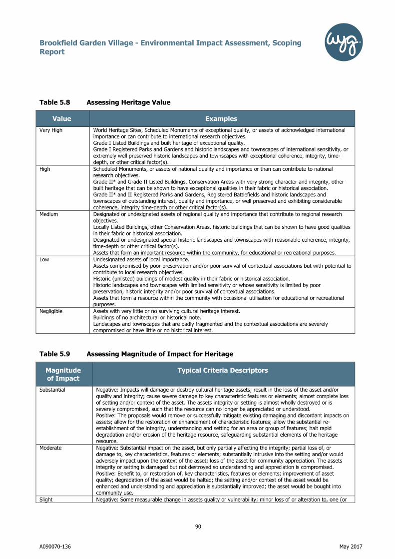
Brookfield Garden Village - Environmental Impact Assessment, Scoping Report
90
A090070-136 May 2017
Table 5.8 Assessing Heritage Value
Value Examples
Very High World Heritage Sites, Scheduled Monuments of exceptional quality, or assets of acknowledged international importance or can contribute to international research objectives. Grade I Listed Buildings and built heritage of exceptional quality. Grade I Registered Parks and Gardens and historic landscapes and townscapes of international sensitivity, or extremely well preserved historic landscapes and townscapes with exceptional coherence, integrity, time-depth, or other critical factor(s).
High Scheduled Monuments, or assets of national quality and importance or than can contribute to national research objectives. Grade II* and Grade II Listed Buildings, Conservation Areas with very strong character and integrity, other built heritage that can be shown to have exceptional qualities in their fabric or historical association. Grade II* and II Registered Parks and Gardens, Registered Battlefields and historic landscapes and townscapes of outstanding interest, quality and importance, or well preserved and exhibiting considerable coherence, integrity time-depth or other critical factor(s).
Medium Designated or undesignated assets of regional quality and importance that contribute to regional research objectives. Locally Listed Buildings, other Conservation Areas, historic buildings that can be shown to have good qualities in their fabric or historical association. Designated or undesignated special historic landscapes and townscapes with reasonable coherence, integrity, time-depth or other critical factor(s). Assets that form an important resource within the community, for educational or recreational purposes.
Low Undesignated assets of local importance. Assets compromised by poor preservation and/or poor survival of contextual associations but with potential to contribute to local research objectives. Historic (unlisted) buildings of modest quality in their fabric or historical association. Historic landscapes and townscapes with limited sensitivity or whose sensitivity is limited by poor preservation, historic integrity and/or poor survival of contextual associations. Assets that form a resource within the community with occasional utilisation for educational or recreational purposes.
Negligible Assets with very little or no surviving cultural heritage interest. Buildings of no architectural or historical note. Landscapes and townscapes that are badly fragmented and the contextual associations are severely compromised or have little or no historical interest.
Table 5.9 Assessing Magnitude of Impact for Heritage
Magnitude
of Impact
Typical Criteria Descriptors
Substantial Negative: Impacts will damage or destroy cultural heritage assets; result in the loss of the asset and/or quality and integrity; cause severe damage to key characteristic features or elements; almost complete loss of setting and/or context of the asset. The assets integrity or setting is almost wholly destroyed or is severely compromised, such that the resource can no longer be appreciated or understood. Positive: The proposals would remove or successfully mitigate existing damaging and discordant impacts on assets; allow for the restoration or enhancement of characteristic features; allow the substantial re-establishment of the integrity, understanding and setting for an area or group of features; halt rapid degradation and/or erosion of the heritage resource, safeguarding substantial elements of the heritage resource.
Moderate Negative: Substantial impact on the asset, but only partially affecting the integrity; partial loss of, or damage to, key characteristics, features or elements; substantially intrusive into the setting and/or would adversely impact upon the context of the asset; loss of the asset for community appreciation. The assets integrity or setting is damaged but not destroyed so understanding and appreciation is compromised. Positive: Benefit to, or restoration of, key characteristics, features or elements; improvement of asset quality; degradation of the asset would be halted; the setting and/or context of the asset would be enhanced and understanding and appreciation is substantially improved; the asset would be bought into community use.
Slight Negative: Some measurable change in assets quality or vulnerability; minor loss of or alteration to, one (or

Brookfield Garden Village - Environmental Impact Assessment, Scoping Report
91
A090070-136 May 2017
Magnitude of Impact
Typical Criteria Descriptors
maybe more) key characteristics, features or elements; change to the setting would not be overly intrusive or overly diminish the context; community use or understanding would be reduced. The assets integrity or setting is damaged but understanding and appreciation would only be diminished not compromised. Positive: Minor benefit to, or partial restoration of, one (maybe more) key characteristics, features or elements; some beneficial impact on asset or a stabilisation of negative impacts; slight improvements to the context or setting of the site; community use or understanding and appreciation would be enhanced.
Negligible / No Change
Negative: Very minor loss or detrimental alteration to one or more characteristics, features or elements. Minor changes to the setting or context of the site. No discernible change in baseline conditions. Positive: Very minor benefit to or positive addition of one or more characteristics, features or elements. Minor changes to the setting or context of the site No discernible change in baseline conditions.
The level of significance of the environmental effect will be determined by combining the impact risk with
the sensitivity of the receptors which is commensurate with the standard WYG assessment. Any effect of
intermediate adverse/beneficial and greater is defined as being significant.
Heritage Impact Assessment Methodology
No standard method of evaluation and assessment is provided for the assessment of significance of effects
upon cultural heritage, therefore a set of evaluation and assessment criteria have been developed using a
combination of the Secretary of State’s criteria for Scheduling Monuments (Scheduled Monument
Statement, Annex 1), Design Manual for Roads and Bridges, Volume 11, Part 3, Section 2, HA 208/07,
Transport Analysis Guidance (TAG Unit 3.3.9, Heritage of Historic Resources Sub-Objective) and English
Heritage Good Practice Advice in Planning Note 3: The Setting of Heritage Assets. Professional judgement is
used in conjunction with these criteria to undertake the impact assessment.
Value
The table below provides guidance on the assessment of cultural heritage value on all archaeological sites
and monuments, historic buildings, historic landscapes and other types of historical site such as battlefields,
parks and gardens, not just those that are statutorily designated.
Value Examples
Very High World Heritage Sites, Scheduled Monuments of exceptional quality, or assets of
acknowledged international importance or can contribute to international research
objectives.
Grade I Listed Buildings and built heritage of exceptional quality.
Grade I Registered Parks and Gardens and historic landscapes and townscapes of
international sensitivity, or extremely well preserved historic landscapes and
townscapes with exceptional coherence, integrity, time-depth, or other critical

Brookfield Garden Village - Environmental Impact Assessment, Scoping Report
92
A090070-136 May 2017
Value Examples
factor(s).
High Scheduled Monuments, or assets of national quality and importance or that can
contribute to national research objectives.
Grade II* and Grade II Listed Buildings, Conservation Areas with very strong
character and integrity, other built heritage that can be shown to have exceptional
qualities in their fabric or historical association.
Grade II* and II Registered Parks and Gardens, Registered Battlefields and
historic landscapes and townscapes of outstanding interest, quality and
importance, or well preserved and exhibiting considerable coherence, integrity
time-depth or other critical factor(s).
Medium Designated or undesignated assets of regional quality and importance that
contribute to regional research objectives.
Locally Listed Buildings, other Conservation Areas, historic buildings that can be
shown to have good qualities in their fabric or historical association.
Designated or undesignated special historic landscapes and townscapes with
reasonable coherence, integrity, time-depth or other critical factor(s).
Assets that form an important resource within the community, for educational or
recreational purposes.
Low Undesignated assets of local importance.
Assets compromised by poor preservation and/or poor survival of contextual
associations but with potential to contribute to local research objectives.
Historic (unlisted) buildings of modest quality in their fabric or historical
association.
Historic landscapes and townscapes with limited sensitivity or whose sensitivity is
limited by poor preservation, historic integrity and/or poor survival of contextual
associations.
Assets that form a resource within the community with occasional utilisation for
educational or recreational purposes.
Negligible Assets with very little or no surviving cultural heritage interest.
Buildings of no architectural or historical note.
Landscapes and townscapes that are badly fragmented and the contextual
associations are severely compromised or have little or no historical interest.
Magnitude
The magnitude of the potential impact is assessed for each site or feature independently of its
archaeological or historical value. Magnitude is determined by considering the predicted deviation from
baseline conditions. The magnitude of impact categories are adapted from the Transport Assessment

Brookfield Garden Village - Environmental Impact Assessment, Scoping Report
93
A090070-136 May 2017
Guidance (TAG Unit 3.3.9) and Design Manual for Roads and Bridges, Volume 11, Part 3, Section 2, HA
208/07.
Magnitude of
Impact
Typical Criteria Descriptors
Substantial Impacts will damage or destroy cultural heritage assets; result in the loss of the
asset and/or quality and integrity; cause severe damage to key characteristic
features or elements; almost complete loss of setting and/or context of the asset.
The assets integrity or setting is almost wholly destroyed or is severely
compromised, such that the resource can no longer be appreciated or understood.
(Negative).
The proposals would remove or successfully mitigate existing damaging and
discordant impacts on assets; allow for the restoration or enhancement of
characteristic features; allow the substantial re-establishment of the integrity,
understanding and setting for an area or group of features; halt rapid degradation
and/or erosion of the heritage resource, safeguarding substantial elements of the
heritage resource. (Positive).
Moderate Substantial impact on the asset, but only partially affecting the integrity; partial loss
of, or damage to, key characteristics, features or elements; substantially intrusive
into the setting and/or would adversely impact upon the context of the asset; loss
of the asset for community appreciation. The assets integrity or setting is damaged
but not destroyed so understanding and appreciation is compromised. (Negative).
Benefit to, or restoration of, key characteristics, features or elements; improvement
of asset quality; degradation of the asset would be halted; the setting and/or
context of the asset would be enhanced and understanding and appreciation is
substantially improved; the asset would be bought into community use. (Positive).
Slight Some measurable change in assets quality or vulnerability; minor loss of or
alteration to, one (or maybe more) key characteristics, features or elements;
change to the setting would not be overly intrusive or overly diminish the context;
community use or understanding would be reduced. The assets integrity or setting
is damaged but understanding and appreciation would only be diminished not
compromised. (Negative).
Minor benefit to, or partial restoration of, one (maybe more) key characteristics,
features or elements; some beneficial impact on asset or a stabilisation of negative
impacts; slight improvements to the context or setting of the site; community use
or understanding and appreciation would be enhanced. (Positive).
Negligible / No
Change
Very minor loss or detrimental alteration to one or more characteristics, features or
elements. Minor changes to the setting or context of the site. No discernible change
in baseline conditions (Negative).
Very minor benefit to or positive addition of one or more characteristics, features or

Brookfield Garden Village - Environmental Impact Assessment, Scoping Report
94
A090070-136 May 2017
Magnitude of
Impact
Typical Criteria Descriptors
elements. Minor changes to the setting or context of the site No discernible change
in baseline conditions. (Positive).
Magnitude (scale of change) is determined by considering the predicted deviation from baseline conditions.
Quantifiable assessment of magnitude has been undertaken where possible. In cases where only
qualitative assessment is possible, magnitude has been defined as fully as possible.
During the assessment any embedded mitigation has been considered in the impact assessment and this is
clearly described in this section (cross referring the development description). Therefore, the magnitude of
the impacts described herein will be stated before and after additional mitigation has been taken into
consideration.
Impacts may be of the following nature and will be identified as such where relevant:
• Negative or Positive.
• Direct or indirect.
• Temporary or permanent.
• Short, medium or long term.
• Reversible or irreversible.
• Cumulative.

Brookfield Garden Village - Environmental Impact Assessment, Scoping Report
95
A090070-136 May 2017
Significance
By combining the value of the cultural heritage resource with the predicted magnitude of impact, the
significance of the effect can be determined. This is undertaken following the table below. The significance
of effects can be beneficial or adverse.
Significance of
Effects
Magnitude of Impact
Cultural
Heritage Value
Substantial Moderate Slight Negligible / no
Change
Very High Major Major –
Intermediate
Intermediate Minor
High Major –
Intermediate
Intermediate Intermediate –
Minor
Neutral
Medium Intermediate Intermediate -
Minor
Minor Neutral
Low Intermediate –
Minor
Minor Minor – Neutral Neutral
Negligible Minor-Neutral Minor-Neutral Neutral Neutral
Significance should always be qualified as in certain cases an effect of minor significance could be
considered to be of great importance by local residents and deserves further consideration. The significance
of effect is considered both before and after additional mitigation measures proposed have been taken into
account.
For the purposes of this Heritage Statement, substantial negative impacts and major adverse effects are
considered to amount to ‘substantial harm’ in National Planning Policy Framework (NPPF) terms. Moderate
negative impacts and intermediate adverse effects are considered to amount to ‘less than substantial harm’
in NPPF terms. Slight negative impacts and minor adverse effects are considered to amount to minimal
harm, while negligible negative impacts/no change and neutral effects are not considered to amount to any
harm at all.
For the purposes of this Heritage Statement, negative impacts that are moderate in magnitude or greater
and adverse effects that are intermediate in scale or greater indicate that the special architectural or
historic interest of listed buildings or their settings and/or the character or appearance of conservation

Brookfield Garden Village - Environmental Impact Assessment, Scoping Report
96
A090070-136 May 2017
areas would not be preserved in terms of section 16, 66 and 72 of the Planning (Listed Building and
Conservation Areas) Act 1990.
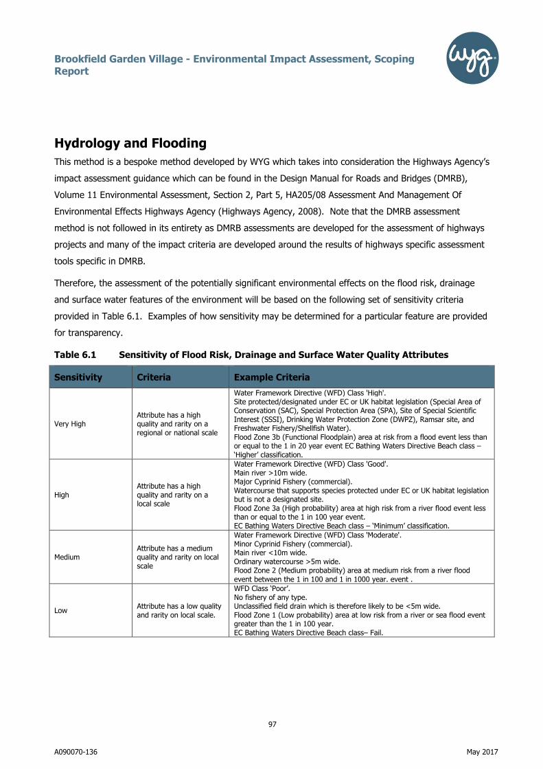
Brookfield Garden Village - Environmental Impact Assessment, Scoping Report
97
A090070-136 May 2017
Hydrology and Flooding
This method is a bespoke method developed by WYG which takes into consideration the Highways Agency’s
impact assessment guidance which can be found in the Design Manual for Roads and Bridges (DMRB),
Volume 11 Environmental Assessment, Section 2, Part 5, HA205/08 Assessment And Management Of
Environmental Effects Highways Agency (Highways Agency, 2008). Note that the DMRB assessment
method is not followed in its entirety as DMRB assessments are developed for the assessment of highways
projects and many of the impact criteria are developed around the results of highways specific assessment
tools specific in DMRB.
Therefore, the assessment of the potentially significant environmental effects on the flood risk, drainage
and surface water features of the environment will be based on the following set of sensitivity criteria
provided in Table 6.1. Examples of how sensitivity may be determined for a particular feature are provided
for transparency.
Table 6.1 Sensitivity of Flood Risk, Drainage and Surface Water Quality Attributes
Sensitivity Criteria Example Criteria
Very High Attribute has a high quality and rarity on a regional or national scale
Water Framework Directive (WFD) Class 'High'. Site protected/designated under EC or UK habitat legislation (Special Area of Conservation (SAC), Special Protection Area (SPA), Site of Special Scientific Interest (SSSI), Drinking Water Protection Zone (DWPZ), Ramsar site, and Freshwater Fishery/Shellfish Water). Flood Zone 3b (Functional Floodplain) area at risk from a flood event less than or equal to the 1 in 20 year event EC Bathing Waters Directive Beach class – ‘Higher’ classification.
High Attribute has a high quality and rarity on a local scale
Water Framework Directive (WFD) Class 'Good'. Main river >10m wide. Major Cyprinid Fishery (commercial). Watercourse that supports species protected under EC or UK habitat legislation but is not a designated site. Flood Zone 3a (High probability) area at high risk from a river flood event less than or equal to the 1 in 100 year event. EC Bathing Waters Directive Beach class – ‘Minimum’ classification.
Medium Attribute has a medium quality and rarity on local scale
Water Framework Directive (WFD) Class 'Moderate'. Minor Cyprinid Fishery (commercial). Main river <10m wide. Ordinary watercourse >5m wide. Flood Zone 2 (Medium probability) area at medium risk from a river flood event between the 1 in 100 and 1 in 1000 year. event .
Low Attribute has a low quality and rarity on local scale.
WFD Class ‘Poor’. No fishery of any type. Unclassified field drain which is therefore likely to be <5m wide. Flood Zone 1 (Low probability) area at low risk from a river or sea flood event greater than the 1 in 100 year. EC Bathing Waters Directive Beach class– Fail.

Brookfield Garden Village - Environmental Impact Assessment, Scoping Report
98
A090070-136 May 2017
Determination of the Magnitude of Flood Risk and Drainage Effects and their Significance
The magnitude of potential impacts during both construction and operation of the proposed development
will be assessed using the criteria presented in Table 6.2. The magnitude (scale of change) is determined
by considering the degree of deviation from the baseline conditions and whether this is likely to result in
any changes in the use of the receptor concerned.
Table 6.2 Assessing the Impact Magnitude on Flood Risk and Drainage, Surface Water Quality and Water Demand
Impact magnitude
Example Criteria
Substantial negative
A pollution incident or release during construction or operation of a development likely to result in a major pollution incident. Substantial change (reduction) in the water body’s existing failing physico chemical elements and the addition of new failing chemical elements resulting in a substantial change in current WFD physico chemical status. Therefore substantially increased pressure in meeting target status. A substantial adverse change in hydromorphological characteristics of the water feature which would affect the water body’s existing WFD ecological status. Project conflicts with the delivery of more than one RBMP mitigation measures on a WFD water body. Loss or extensive change to a fishery. Building ‘vulnerable development’ in Flood Zone 3b on the site. Direct loss of Flood Zone 3b on site and indirect increase in flood risk elsewhere. Exceeds minimum current Building Regulations Standards for water use (legally non compliant).
Moderate negative
A pollution incident or release during construction or operation of a development likely to result in a moderate or minor pollution incident. Moderate change (reduction) in the water body’s physico chemical elements resulting in a moderate change in current WFD physico chemical status. Therefore moderately increased pressure in meeting target status. A moderate change in hydromorphological characteristics of the water feature which would affect the water body’s existing WFD ecological status. Project conflicts with the delivery of one RBMP mitigation measure on a WFD water body. Partial loss in productivity of a fishery. Building ‘vulnerable development’ in Flood Zone 3a on the site. Direct loss of Flood Zone 3a on site and indirect increase in flood risk elsewhere. Water demand during construction on most large construction projects is expected to be moderate negative. Meets minimum current Building Regulations Standards for water use.
Slight negative
Small reduction in water quality. Reduction in the water body’s chemical elements but insufficient to change the current WFD chemical status. Therefore only slight increased pressure in meeting target WFD chemical status. A slight change in the hydromorphological characteristics but insufficient to change the current WFD ecological status. Building ‘vulnerable development’ in Flood Zone 2 on the site. Direct loss of Flood Zone 2 on site and indirect increase in flood risk elsewhere. Meets Code for Sustainable Homes Level 3 for water use. Water demand for non-residential buildings (BREEAM standard for non-residential buildings requirement) – water efficiency measures would help to achieve a Very Good rating (assuming 1 credit achieved for a water use between 4.5 and 5.5 m3/per person/year). Water demand during construction on most small construction projects is expected to be slight negative.
Negligible
Very low levels of pollution from discharges insufficient to significantly affect water quality. Very low risk of pollution from accidental spillages. No discernible change in the water body’s chemical elements. Therefore, no discernible change to WFD chemical status of waterbody. No discernible movement towards or away from the target WFD chemical status. No discernible cause and effect between the project and RBMP mitigation measures. No discernible loss of flood zone Meets Code for Sustainable Homes Level 4-6 for water use or similar (note: water neutrality results in no impact). Water demand for non-residential buildings (BREEAM standard for non-residential buildings requirement) –

Brookfield Garden Village - Environmental Impact Assessment, Scoping Report
99
A090070-136 May 2017
Impact magnitude
Example Criteria
water efficiency measures would help to achieve an Excellent rating (assuming 2 credits achieved for a water use between 1.5 and 4.4 m3/per person/year).
Slight positive Improvement in the water body’s physico chemical elements but insufficient to change the current WFD chemical status. Therefore a slight improvement towards meeting target WFD chemical status. Direct net gain of Flood Zone 2 on site and indirect decrease in flood risk elsewhere.
Moderate positive
Moderate change (improvement) in the water body’s physico chemical elements resulting in a moderate positive change in current WFD chemical statusA moderate positive change in hydromorphological characteristics of the water feature which would affect the water body’s existing WFD ecological status. Therefore substantially decreased pressure in meeting WFD ecological target status as a result of the proposal (but this might not result in the water body’s designation being removed from the Heavily Modified Waterbody category). Direct net gain of Flood Zone 3a on site and indirect decrease in flood risk elsewhere.
Substantial positive
Substantial change (improvement) in the water body’s existing failing physico chemical elements. A substantial beneficial change in hydromorphological characteristics of the water feature which would affect the water body’s existing WFD ecological status. Therefore substantially decreased pressure in meeting WFD ecological target status as a result of the proposal(s) (possibly resulting in the waterbody losing its ‘Heavily Modified Waterbody’ designation). Direct net gain of Flood Zone 3b on site and indirect decrease in flood risk elsewhere.
Determination of the Magnitude of Drainage Infrastructure Impacts and their Significance
Drainage infrastructure impact magnitude will be determined by applying a qualitative approach. This will
follow the following steps:
• Reviewing the drainage proposals to ascertain if there will be any impact from the proposed
design on existing drainage infrastructure and capacity during construction and operation.
For drainage infrastructure impacts the magnitude of the impact is described in descriptive words (not on a
scale of magnitude) by stating whether the impact is either negative or positive or no impact. It is assumed
that all negative and positive impacts result in significant effects.
Determining the Significance of Potential Effects and Significant Effects
Magnitude and sensitivity for flooding and drainage and surface water quality attributes is combined as
shown in Table9.3 to determine the significance of the effects. This is similar to the significant effects table
as provided specifically within Volume 11 Environmental Assessment, Section 3, Part 10, HD45/09
(Highways Agency, 2009), but terminology has been modified to maximise consistency of terminology used
within this ES.
A level of significance of intermediate significance or greater is considered as being significant within the
terms of reference of the EIA Regulations.

Brookfield Garden Village - Environmental Impact Assessment, Scoping Report
100
A090070-136 May 2017
Table 6.3 Estimating the Significance of Potential Effects on Flood Risk and Drainage,
Surface Water Quality and Water Demand
Magnitude of Impact
Substantial magnitude
Moderate magnitude
Slight magnitude
Negligible magnitude
Sensitivity of Receptor
Very High Major Major Intermediate Neutral
High Major Intermediate Minor Neutral
Medium Major Intermediate Minor Neutral
Low Minor Minor Neutral Neutral

Brookfield Garden Village - Environmental Impact Assessment, Scoping Report
101
A090070-136 May 2017
Ecology
Once all of the updated surveys have been completed, an EcIA will be undertaken in accordance with the
Chartered Institute of Ecology & Environmental Management’s (CIEEM) Guidelines for EcIA in the UK (2nd
ed, 2016).
This will involve the identification of the sensitive ecological receptors on site and an assessment of their
nature conservation value. We will then determine the likely significant effects of the proposed scheme
upon those receptors. Firstly we will assess the likely impacts of the scheme taking into account any design
mitigation. This will then allow us to determine what mitigation and/or enhancement measures we consider
are necessary to off-set any predicted significant impacts. The remaining residual impacts will then be
presented (i.e. those arising after the implementation of mitigation) and it is these against which the
scheme should be determined.

Brookfield Garden Village - Environmental Impact Assessment, Scoping Report
102
A090070-136 May 2017
Ground Conditions
Environmental receptors can demonstrate different sensitivities to changes in their environment. It is also
recognised that environmental impacts can operate over a range of geographical areas and therefore a
geographical scale should be taken into account in the scale/magnitude of the impact, as well as the
receptor. The sensitivity of the receptor also takes into account the long or short term exposure of the
receptor.
For the purpose of this assessment sensitivity is determined as Very High, High, Medium and Low as
detailed in Table 8.1 below.
Table 8.1 Methodology for Assessing Sensitivity of a Receptor
Sensitivity Criteria Example Criteria
Very High
Attribute has a high quality and/or rarity
on a regional or national scale
Sites of Special Scientific Interest (SSSIs) with geological/geomorphological qualifying interest.
Groundwater aquifers currently used, or likely to be suitable for use as, public potable supplies (e.g. Principal Aquifers, Source Protection Zone for a potable
groundwater supplies).
Groundwater that is providing baseflow to ‘very good’ WFD status quality surface waters.
Soils with a very high likelihood of readily transmitting contaminants to nearby sensitive receptors or over a large distance (e.g. granular deposits in saturated
zone or in continuity with river systems etc.). H1 soils as defined by the Environment Agency groundwater vulnerability classification system.
Agricultural land use / soil quality (based on ALC Grades 1, 2 and 3a) (the ‘best and most versatile’).
Human population (e.g. local residents and site construction workers etc.).
High Attribute has a high quality and/or rarity
on local scale
Regionally Important Geological Sites (RIGS).
Groundwater aquifers currently used for, or likely to be suitable for, providing non-potable supplies or limited domestic supplies (e.g. Secondary Aquifers for
domestic supplies or industrial abstractions).
Groundwater that is providing baseflow to ‘good’ WFD quality status surface waters.
Soil sensitivity to pollution: soils with a moderately high potential to transmit contaminants to other receptors or over a significant distance (e.g. mixed
cohesive and granular deposits of alluvium). H2/H3 soils as defined by the Environment Agency groundwater vulnerability classification system.
Agricultural land use / soil quality of ALC Grade 3b (moderate).
Medium
Attribute has a
medium quality and / or rarity on local
scale
Groundwater that is unlikely to be suitable for providing abstractions (e.g.
aquifers in areas of saline intrusion).
Soils with an intermediate potential to transmit contaminants (e.g. Glacial Clays
with occasional sand bands). Soils of intermediate (I1 or I2) leaching potential
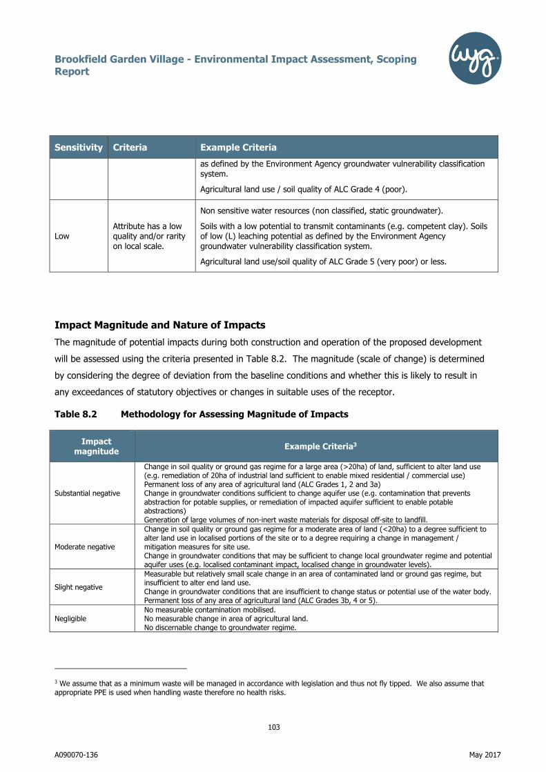
Brookfield Garden Village - Environmental Impact Assessment, Scoping Report
103
A090070-136 May 2017
Sensitivity Criteria Example Criteria
as defined by the Environment Agency groundwater vulnerability classification
system.
Agricultural land use / soil quality of ALC Grade 4 (poor).
Low Attribute has a low quality and/or rarity
on local scale.
Non sensitive water resources (non classified, static groundwater).
Soils with a low potential to transmit contaminants (e.g. competent clay). Soils of low (L) leaching potential as defined by the Environment Agency
groundwater vulnerability classification system.
Agricultural land use/soil quality of ALC Grade 5 (very poor) or less.
Impact Magnitude and Nature of Impacts
The magnitude of potential impacts during both construction and operation of the proposed development
will be assessed using the criteria presented in Table 8.2. The magnitude (scale of change) is determined
by considering the degree of deviation from the baseline conditions and whether this is likely to result in
any exceedances of statutory objectives or changes in suitable uses of the receptor.
Table 8.2 Methodology for Assessing Magnitude of Impacts
Impact magnitude
Example Criteria3
Substantial negative
Change in soil quality or ground gas regime for a large area (>20ha) of land, sufficient to alter land use (e.g. remediation of 20ha of industrial land sufficient to enable mixed residential / commercial use) Permanent loss of any area of agricultural land (ALC Grades 1, 2 and 3a) Change in groundwater conditions sufficient to change aquifer use (e.g. contamination that prevents abstraction for potable supplies, or remediation of impacted aquifer sufficient to enable potable abstractions) Generation of large volumes of non-inert waste materials for disposal off-site to landfill.
Moderate negative
Change in soil quality or ground gas regime for a moderate area of land (<20ha) to a degree sufficient to alter land use in localised portions of the site or to a degree requiring a change in management / mitigation measures for site use. Change in groundwater conditions that may be sufficient to change local groundwater regime and potential aquifer uses (e.g. localised contaminant impact, localised change in groundwater levels).
Slight negative
Measurable but relatively small scale change in an area of contaminated land or ground gas regime, but insufficient to alter end land use. Change in groundwater conditions that are insufficient to change status or potential use of the water body. Permanent loss of any area of agricultural land (ALC Grades 3b, 4 or 5).
Negligible No measurable contamination mobilised. No measurable change in area of agricultural land. No discernable change to groundwater regime.
3 We assume that as a minimum waste will be managed in accordance with legislation and thus not fly tipped. We also assume that appropriate PPE is used when handling waste therefore no health risks.

Brookfield Garden Village - Environmental Impact Assessment, Scoping Report
104
A090070-136 May 2017
Table 8.3 Methodology for Assessing the Significance of Impacts
Magnitude of Impact
Substantial
magnitude
Moderate
magnitude
Slight
magnitude
Negligible
magnitude
Sensitivity of Receptor
Very
High Major Major Intermediate Neutral
High Major Intermediate Minor Neutral
Medium Major Intermediate Minor Neutral
Low Minor Minor Neutral Neutral
Any impacts of minor significance or lower are not considered to be significant and as such it will not be
necessary to always propose mitigation methods. Impacts of intermediate - minor or higher significance will
be deemed to be potentially significant and will require, where possible, mitigation methods to be adopted.
Contaminated Land Risks Assessment Methodology
By considering the sources, pathways and receptors, an assessment of the environmental risks is made
with reference to the significance and degree of the risk. This assessment is based on the consideration of
whether the source of contamination is likely to reach a receptor and hence whether it may cause an
adverse impact.
The qualitative risk assessment has been undertaken in accordance with BS10175 and CIRIA Document
C552: Contaminated Land Risk Assessment, A Guide to Good Practice. The source – pathway – receptor
linkages are developed around the information presented above. Potential risks from on-site and off-site
sources are considered in relation to the proposed redevelopment of the site to a residential with plant
uptake end-use.
The risk assessment has been carried out by assessing the severity of the potential consequence, taking
into account both the potential severity of the hazard, sensitivity of the target and probability of the hazard
occurring, based on the categories detailed in Table 8.4.

Brookfield Garden Village - Environmental Impact Assessment, Scoping Report
105
A090070-136 May 2017
Table 8.4 Categorisation of Risk
Category Definition
Severe Acute risks to human health, catastrophic damage to buildings/property, major pollution of controlled waters
Medium Chronic risk to human health, pollution of sensitive controlled waters, significant effects on sensitive ecosystems or species, significant damage to buildings or structures
Mild Pollution of non sensitive waters, minor damage to buildings or structures
Minor Requirement for protective equipment during site works to mitigate health effects, damage to non sensitive ecosystems or species
The likelihood of an event (probability) takes into account both the presence of the hazard and target and
the integrity of the pathway and has been assessed based on the categories given below.
Table 8.5 Categorisation of Probability
Category Definition
High Likelihood Pollutant linkage may be present, and risk is almost certain to occur in long term, or there is evidence of harm to the receptor
Likely Pollutant linkage may be present, and it is probable that the risk will occur over the long term
Low Likelihood Pollutant linkage may be present, and there is a possibility of the risk occurring, although there is no certainty that it will do so
Unlikely Pollutant linkage may be present, but the circumstances under which harm would occur are improbable
The potential severity of the risk and the probability of the risk occurring have been combined in
accordance with the following matrix in order to give a level of risk for each potential hazard.
Table 8.6 Risk Matrix Categories
Potential Severity
Severe Medium Mild Minor
Probability of Risk
High Likelihood Very High High Moderate Low
Likely High Moderate Low Low
Low Likelihood Moderate Low Low Very Low
Unlikely Low Low Very Low Very Low

Brookfield Garden Village - Environmental Impact Assessment, Scoping Report
106
A090070-136 May 2017
Socio-economics methodology
Assessment Methodology
The assessment first establishes the baseline position in terms of local economic conditions and the current
provision of education, health, leisure and community facilities, before examining the potential impacts of
the proposed residential development and their significance. Opportunities for mitigation of any adverse
effects and the enhancement of positive effects are then examined, including any built-in mitigation
elements of the scheme, such as open space and social infrastructure facilities.
This assessment draws upon published Government and local authority statistics. In particular, data from
the 2011 Census and other published national statistics have been used. At the local level, relevant data
published by Broxbourne Borough Council has also been considered.
Sensitivity Receptors
Different socio-economic landscapes are affected in different ways depending upon the political and
economic profile of the locality. This can be explored in differing ways and used to extrapolate the impact
of any proposal. Impacts are defined by their degree of influence on certain receptors. Receptors include,
but are not limited to, the overall population (including the total number of residents), working population,
non-working population (those in education, retired or unemployed), skills of residents, indices of
deprivation and the overall health of the economy.
The sensitivity of a receptor explores the challenges relating to the particular issue and are attributed
weight according to their severity and relationship with national, regional and local norms. As an example a
receptor relating to deprivation levels in an area of high unemployment and poor education compared to
the national average would be considered to have very high sensitivity. A receptor with average levels of
employment and education but poor ethnic diversity may be considered to have medium or low level
sensitivity. Evidence and indicators of socio-economic sensitivity can be broken down as:
• Very high: Substantial evidence of direct socio-economic challenges relative to national and
regional comparators and afforded high priority at national or regional level.
• High: Evidence of challenges linked to receptor which may be indirect. Regional disparity with
national or local priority and policy level.
• Medium: Some evidence of socio-economic challenges. Disparity at local or regional level.
• Low: Little or no evidence of socio-economic challenges.

Brookfield Garden Village - Environmental Impact Assessment, Scoping Report
107
A090070-136 May 2017
• Negligible: No evidence of challenges and/or no relation to the receptor.
Effect Magnitude
The magnitude of effects are those that will be caused or influenced by the development and are assessed
in relation to the established baseline conditions. The impacts are assessed in relation to their magnitude
and are additionally assessed after mitigation if necessary or relevant. The magnitude of effects may be
positive (beneficial) or negative (adverse).
• Substantial: Large absolute and/or percentage change in socio economic indicators.
• Moderate: Noteworthy change.
• Slight: Measureable but not significantly influential change.
• Negligible: No determinable change.
Significance Criteria
The significance of effects combines the magnitude of change against the sensitivity of the receptor. Thus,
as a simple example, the introduction of a large employment generating development in any area of high
unemployment should have a substantial impact in area of high sensitivity and thus the significance of the
effect would be major and beneficial.
The significance of effects is broken down into the matrix as indicated below:
Table 9: Significance of effects matrix
Magnitude
of change
Sensitivity of receptor
Very
High High Medium Low Negligible
Substantial Major Moderate Moderate Minor Negligible
Moderate Moderate Moderate Minor Minor Negligible
Slight Minor Minor Minor Negligible Negligible
Negligible Negligible Negligible Negligible Negligible Negligible

Brookfield Garden Village - Environmental Impact Assessment, Scoping Report
108
A090070-136 May 2017
It should be noted that the significance of effects criteria does not imply a value judgement on change per
se. Thus, an increase in population may not be regarded as a negative socio-economic effect but could be
subject to caveats relating to mitigation.
For the purposes of this assessment any impact moderate or above is considered to be significant.