acreage estimation of isabgol ( plantago ovata forsk
TRANSCRIPT

88IJMFM&AP, Vol. 6 No. 2, 2020
Acreage estimation of Isabgol (Plantago ovata Forsk)using remote sensing and geographic information system
Sujay Dutta1*, Mukesh Kumar1, R. Nagaraja Reddy2*, Nirav Pampaniya2,Rakesh Ganvit2, Manivel P2, B.B. Basak2, Satyajit Roy2 and B.K. Bhattacharya1
1Space Applications Centre, ISRO, Ahmedabad - 380 015, Gujarat, India*Email: [email protected]
2ICAR-Directorate of Medicinal and Aromatic Plants Research, Anand - 387310 Gujarat, India*Email: [email protected]
Received : 25.08.20 ; Revised : 16.10.20 Accepted: 24.10.20
ABSTRACT
A feasibility study for assessing acreage of Isabgol using remote sensing data was carried out. Traditionally, cropacreage estimated based on land records is cumbersome, costly and time consuming. No remote sensing-basedmethods available for acreage estimation of Isabgol. Unsupervised classification with ISODATA clusteringtechnique was applied to multi date LISS-III data to generate different classes which were segregated using SoilAdjusted Vegetation Index (SAVI) spectral profile of crops grown along with Isabgol. Six date SAVI data was usedto generate spectral signature of candidate crop and other crops. SAVI ranged from 0.09 to 0.19 for Isabgol. Theestimated Isabgol acreage was around 1675 ha, 5753 ha and 4120 ha for Bhachau, Rapar and Santalpur blocks,respectively with a classification accuracy of 80% and Kappa coefficient of 0.72. Accurate estimation of area willhelp planning and export management of Isabgol in the country.
Keywords: Crop acreage, Isabgol, ISODATA clustering, Medicinal crop, Multi date LISS-III, Soil AdjustedVegetation Index (SAVI)
INTRODUCTION
Remote sensing techniques have demonstratedpotentiality in providing information of thecharacteristics and spatial distribution of naturalresources including agricultural resources becauseof their unique advantages of providing multi-spectral, multi-temporal and multi-spatial resolutions.Use of satellite remote sensing data has also provedto be more cost effective, reliable, timely and fasterthan the conventional ground-based surveys ofagricultural resources. Spectral reflectance dataobtained from remote sensing is a manifestation ofintegrated effect of weather, soil, cultural practicesand crop characteristics that can be used inidentifying and monitoring crop growth and forestimating crop yield (Yedage et al., 2013).
Medicinal plants form the important raw drugsfor various traditional systems of medicines (Manivelet al., 2019). Medicinal plants are obtained eitherfrom wild (80%) or cultivated (20%). Medicinalplants cultivation ensures purity, authenticity andavailability of raw drugs to industries. The demandfor medicinal plants across the globe is increasing.Acreage estimation of medicinal plants facilitates
micro level planning and demand analysis. Eventhough space technology was used in manyagriculture crops, there are very few studies werecarried out for medicinal plants. The integrated useof geographic information systems (GIS) and groundsurveys to map medicinal and herbal (MH) plantsin a semi-arid and arid Mediterranean area in thenorth-west of Jordan was carried out by Al-Bakriet al. (2011). Salem (2003) applied GIS-basedapproach to the spatial analysis of endangeredarboreal species in Egypt. GIS method for assessingchemodiversity in medicinal plants (Moraes et al.,2005) was reported. Wu et al. (2019) developedglobal medicinal plant geographic informationsystem (GMPGIS) to analyze environmentalinformation of ecologically suitable regions in China.
Isabgol (Plantago ovata Forsk) is a high valuemedicinal plant cultivated in India. Isabgol husk isthe economic part, has medicinal value, used asnatural fiber as well as laxative. Isabgol husk tradedas Psyllium husk has many industrial applicationstoo (Patel et al., 2020). India is the largest exporterof Isabgol in the world, mainly produced in arid zoneof Gujarat, Madhya Pradesh, Haryana, UttarPradesh and Rajasthan (Janakiram et al., 2019).
International Journal of Minor Fruits, Medicinal and Aromatic Plants. Vol. 6 (2) : 88-95, December 2020

89IJMFM&AP, Vol. 6 No. 2, 2020
Although Isabgol largely cultivated in India, non-availability of precise information on area andproduction is a major impediment to the developmentof Isabgol based industry. At present, Isabgolacreage is obtained from conventional datacollection techniques such as field visits on groundand from reports. These reports are often subjective,involve more time and money. Often prone to largeerrors due to inadequate ground observations, leadsto poor crop yield production estimates. Theaccurate estimation of Isabgol acreage is essentialfor various planning purposes, including pricing,export/import and contingency measures.Numerous researches have been carried out foracreage estimation by different researcher fordifferent crops. Singh et al. (2005) appliedmaximum likelihood classification approach withIRS LISS-III data for village level crop areaestimation. The soyabean acreage estimation andcrop production was estimated with help of MODIS(TERRA) satellite data and GIS database for somedistrict of Madhya Pradesh (Maurya, 2011). Husaket al. (2008) used hybrid high-medium resolutiontechnique for estimation of cropped area for centralEthiopia. Yedage et al. (2013) used IRS P6 LISS-III data for finding out minimum and maximumconcentration of sugarcane using Bhatiaconcentration index (yr) for all tehsils of Solapur
district in Maharashtra state. An unsupervisedclassification was applied to multidate IRS LISS-III data to estimate the rice acreage (Naidu andGiridhar, 2016). Rajak et al. (2016) estimated earlycrop area using multidate MODIS data and twodate AWiFS data for Gujarat. The study aims atdetermining the optimum method for preciseestimates of acreage of Isabgol using remotesensing and geographic information system. Isabgolacreage was estimated in three block of Gujaratduring Rabi 2018-19. Accurate estimates of isabgolacreage will help plan production, pricing and exportof Isabgol in the country.
METHODOLOGYStudy area and season
The study was conducted on three blocks namelyBhachau, Rapar and Santalpur block of Gujarat state(Fig.1) during Rabi season of 2018-19. An idealsowing time of Isabgol was in fortnight ofNovember and harvest during March-April.
Satellite data usedA multi-date LISS-III data (Table 1) of Rabi
season of 2018-19 was used in this study. Six cloudfree data of isabgol growing season available fromstart of December to mid of February was usedfor analysis.
Fig. 1: Geographical location of the study area
Dutta et al.

90IJMFM&AP, Vol. 6 No. 2, 2020
Field dataPrimary level survey was carried out in the study
area for collection of ground truth at 193 locationsusing hand held GPS for the available crops andfarmers were interviewed for the farming systemsand management techniques for the Isabgol crops.
Preprocessing of satellite data
Co-registrationSpatial characteristics of any object including
crop derive from different time need to havecommon geo-referencing so that they can beintegrated. An auto image co-registration techniquecalled Auto Image Registration Software (AIRS)developed by Space Applications Center (SAC),Ahmedabad was used for co-registering the satelliteimages in batch mode keeping all dates of aparticular path and row at a time and a referenceimage.
DN to Radiance conversionSatellite provides raw data in Digital Number
(DN) which was converted into radiance and theninto the TOA reflectance using the equation.
... (1)
Where, L is radiance, DN is Digital Number fora particular pixel, Lmax maximum radiance for thegiven band and DNmax depends on sensor. LISS-III provides 10-bit data therefore 1023 is taken asDNmax.
Radiance to TOA Reflectance
... (2)
Table 1: Characteristics of LISS-III imageriesCharacteristic Value Path Date of PassSpectral band: Green (B2) 0.52 – 0.59 m 91/55 05-12-2018Spectral band: Red (B3) 0.62 – 0.68 m 29-12-2018Spectral band: NIR (B4) 0.77 – 0.86 m 10-01-2019Spectral band: MIR (B5) 1.55 – 1.70 m 22-01-2019Spatial Resolution 23 m 03-02-2019Swath 142 km 15-02-2019Revisit time 24 daysQuantisation 10 Bit
Where U = 1/R, Here U is the Sun Earthdistance
And R = 1.00011 + 0.034221cos() +0.00128sin() + 0.000719 *cos(2) +
0.000077sin (2)Where,
... (3)
Where, J.D is Julian Day or Day of year.E0 is Extra-terrestrial irradiance in mW/cm-2/
µm [Pandya et al., 2002]
Soil Adjusted Vegetation Index (SAVI)A distance-based vegetation index soil adjusted
vegetation index (SAVI) was used. Distance-basedvegetation indices cancel or diminish the effect ofsoil brightness in cases where vegetation is sparse.i.e., the pixels in the image are a combination ofvegetation and soil information. SAVI tends tominimize soil brightness, a phenomenon that hasbeen demonstrated (Miura et al., 2000, Cao et al.,2014; Pop et al., 2019). Huete (1988) introduced asoil calibration factor in the NDVI equation toaccount for the first order soil-vegetation opticalinteractions. The calibration factor of 0.5 was used.SAVI is defined as
Where,NIR is the reflectance in the near infraredRED is the reflectance for redL is a constant that is a surrogate for LAI, Huete
(1988)
Acreage estimation of isabgol using remote sensing and GIS
91IJMFM&AP, Vol. 6 No. 2, 2020
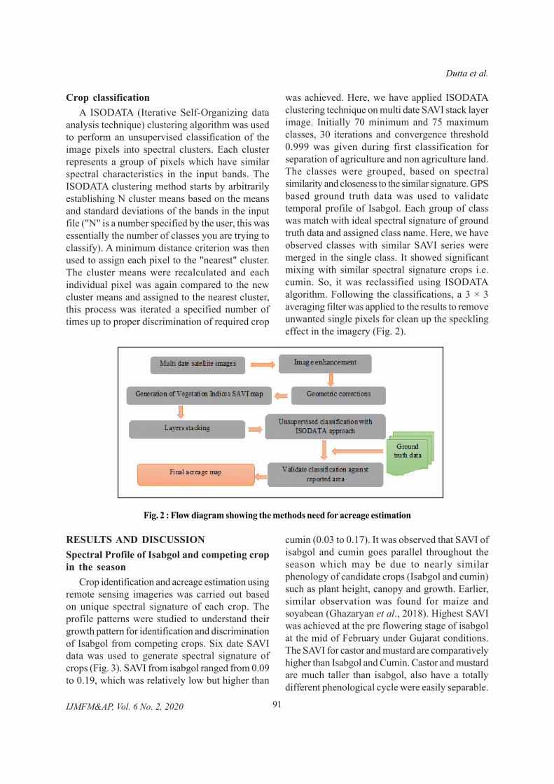
Crop classificationA ISODATA (Iterative Self-Organizing data
analysis technique) clustering algorithm was usedto perform an unsupervised classification of theimage pixels into spectral clusters. Each clusterrepresents a group of pixels which have similarspectral characteristics in the input bands. TheISODATA clustering method starts by arbitrarilyestablishing N cluster means based on the meansand standard deviations of the bands in the inputfile ("N" is a number specified by the user, this wasessentially the number of classes you are trying toclassify). A minimum distance criterion was thenused to assign each pixel to the "nearest" cluster.The cluster means were recalculated and eachindividual pixel was again compared to the newcluster means and assigned to the nearest cluster,this process was iterated a specified number oftimes up to proper discrimination of required crop
was achieved. Here, we have applied ISODATAclustering technique on multi date SAVI stack layerimage. Initially 70 minimum and 75 maximumclasses, 30 iterations and convergence threshold0.999 was given during first classification forseparation of agriculture and non agriculture land.The classes were grouped, based on spectralsimilarity and closeness to the similar signature. GPSbased ground truth data was used to validatetemporal profile of Isabgol. Each group of classwas match with ideal spectral signature of groundtruth data and assigned class name. Here, we haveobserved classes with similar SAVI series weremerged in the single class. It showed significantmixing with similar spectral signature crops i.e.cumin. So, it was reclassified using ISODATAalgorithm. Following the classifications, a 3 × 3averaging filter was applied to the results to removeunwanted single pixels for clean up the specklingeffect in the imagery (Fig. 2).
RESULTS AND DISCUSSIONSpectral Profile of Isabgol and competing cropin the season
Crop identification and acreage estimation usingremote sensing imageries was carried out basedon unique spectral signature of each crop. Theprofile patterns were studied to understand theirgrowth pattern for identification and discriminationof Isabgol from competing crops. Six date SAVIdata was used to generate spectral signature ofcrops (Fig. 3). SAVI from isabgol ranged from 0.09to 0.19, which was relatively low but higher than
cumin (0.03 to 0.17). It was observed that SAVI ofisabgol and cumin goes parallel throughout theseason which may be due to nearly similarphenology of candidate crops (Isabgol and cumin)such as plant height, canopy and growth. Earlier,similar observation was found for maize andsoyabean (Ghazaryan et al., 2018). Highest SAVIwas achieved at the pre flowering stage of isabgolat the mid of February under Gujarat conditions.The SAVI for castor and mustard are comparativelyhigher than Isabgol and Cumin. Castor and mustardare much taller than isabgol, also have a totallydifferent phenological cycle were easily separable.
Dutta et al.
Fig. 2 : Flow diagram showing the methods need for acreage estimation

92IJMFM&AP, Vol. 6 No. 2, 2020
AcreageThe identified Isabgol and mixing crop area were
recoded and second stage classification was carriedout with 30 clusters to estimate the acreage. Thenthe last recode was applied to generate Isabgol areaalone. The final acreage map (Fig.4) along withtheir false colour composition (FCC) image weregenerated for each block. Acreage was estimatedthrough complete enumeration technique ofclassified pixels. The final estimated area ofBhachau, Rapar and Santalpur block was around1675 ha, 5762 ha and 4120 ha respectively. Theestimated area needs to be compared with the areaavailable on land records for method validation, suchinformation was not available for the selected blocksat time of study.
Accuracy assessmentThe accuracy is concerned with the
correspondence between class label and 'true' class.A 'true' class is defined as what is observed on theground during field surveys. Accuracy assessmentdetermines the quality of information derived from
remotely sensed data. The confusion matrix (Foody,2002) was generated for the blocks (Table 2) forassessing the classification accuracy. The overallclassification accuracy achieved was about 80%with Kappa coefficient of 0.72. Higher producer'saccuracy of about 92% and user's accuracy of 82%was achieved for Isabgol. It showed some confusionwith cumin crop for which users and producer'saccuracy were 85% and 70% respectively. Earlier,similar observation was reported as maize classconfused with soyabean and double crop (Azar etal., 2018).
CONCLUSIONA pilot study to estimate the acreage of Isabgol
was undertaken in three blocks (Bhachau, Raparand Santalpur) of Gujarat, India for the first time. Asimple and high accurate method developed foracreage estimation of Isabgol will help in earlyforecast of supply and demand. Two stageISODATA clustering classification technique wasused to discriminate different classes. The estimatedarea was 1675 ha, 5762 ha and 4120 ha respectively
Fig. 3: Spectral profile of different crops
Table 2: Confusion matrix and kappa coefficient for Bhachau, Rapar, Santalpur blocks
Crops Isabgol Cumin Mustard Castor User's Producer'saccuracy accuracy
(%) (%)Isabgol 24 5 0 0 82 92Cumin 2 12 0 0 85 70Mustard 0 0 22 8 73 84Castor 0 0 4 18 81.8 69
Overall Accuracy = 80%, Kappa coefficient =0.72
Acreage estimation of isabgol using remote sensing and GIS

93IJMFM&AP, Vol. 6 No. 2, 2020
(A)
(B)
(C)
Fig. 4: False color composite (FCC) and classified map of block under study (A) Bhachau(B) Rapar and (C) Santalpur
for Bhachau, Rapar and Santalpur block. Integrateduse of remote sensing, GIS and Ground truth datafor accurate, timely and cost-effective acreageestimation of crop plants will help in early estimationof acreage. Accurate estimation of isabgol area andexpansion of existing area will help planning andexport management of isabgol in the country.
ACKNOWLEDGEMENTAuthors are grateful to the Director, Space
Applications Centre (SAC), Ahmedabad, Gujarat,
India and the Deputy Director, Earth, Ocean,Atmosphere, Planetary Sciences and ApplicationsArea, SAC, Ahmedabad for their encouragementand support to carrying out the study. Authors arethankful to the Director, ICAR-Directorate ofMedicinal and Aromatic Plants Research, Anand,Gujarat for guidance and provide facility for carryout this work. This work was carried out in projectentitled "Workplan for inventory of medicinal plants"under Space Technology Utilization for Food
Dutta et al.

94IJMFM&AP, Vol. 6 No. 2, 2020
Acreage estimation of isabgol using remote sensing and GIS
Security, Agricultural Assessment and Monitoring(SUFALAM) program of SAC, Ahmedabad,Gujarat.
REFERENCES :
Al-Bakri, J. T., Al-Eisawi, D., Damhoureyeh, S.and Oran, S. 2011. GIS-based analysis ofspatial distribution of medicinal and herbalplants in arid and semiarid zones in theNorthwest of Jordan. Annals of Arid Zone,50(2), 99-115.
Azar, R., Villa, P., Stroppiana, D., Crema, A.,Boschetti, M., and Brivio, P. A. 2016.Assessing in-season crop classificationperformance using satellite data: a test casein Northern Italy. European Journal ofRemote Sensing, 49(1), 361-380.
Cao, L., Liu, T., and Wei, L. 2014. A comparison ofmulti-resource remote sensing data forvegetation indices. In IOP Conference Series:Earth and Environmental Science, 17(1):012067. 1-7. doi:10.1088/1755-1315/17/1/012067.
Foody, G.M. 2002. Status of land coverclassification accuracy assessment. RemoteSensing of Environment, 80:185-201.
Ghazaryan, G., Dubovyk, O., Löw, F., Lavreniuk,M., Kolotii, A., Schellberg, J. and Kussul, N.2018. A rule-based approach for cropidentification using multi-temporal and multi-sensor phenological metrics. EuropeanJournal of Remote Sensing, 51(1), 511-524.
Huete, A.R. 1988. A soil-adjusted vegetation index(SAVI). Remote sensing of environment,25(3), 295-309.
Husak, G.J., Marshall, M.T., Michaelsen, J.,Pedreros, D., Funk, C. and Galu, G. 2008.Crop area estimation using high and mediumresolution satellite imagery in areas withcomplex topography. Journal ofGeophysical Research: Atmospheres,113(D14112),1-8, doi:10.1029/2007JD009175.
Janakiram, T., R. Nagaraja Reddy, Manivel P. andSatyajit Roy. 2019. Road Map for Isabgolpromotion in India, ICAR-Directorate ofMedicinal and Aromatic Plants Research,Anand, Gujarat.
Manivel, P., Nagaraja Reddy, R., Saravanan Raju,Thondaiman V. and Rakesh, G. 2019.Exploration and collection of geneticresources of salparni (Desmodiumgangeticum L.) in India. InternationalJournal of Minor Fruits, Medicinal andAromatic Plants, 5 (1):21-28.
Maurya, A.K. 2011. Estimation of Acreage & CropProduction through Remote Sensing & GIS.Geospatial World Forum, 18-21, January 2011,Hyderabad, India.
Miura, T., Huete, A.R. and Yoshioka, H. 2000.Evaluation of sensor calibration uncertaintieson vegetation indices for MODIS. IEEETransactions on Geoscience and RemoteSensing, 38(3), 1399-1409.
Moraes, R. M., Momm, H. G., Silva, B., Maddox,V., Easson, G. L., Lata, H. and Ferreira, D.2005. Geographic information system methodfor assessing chemo-diversity in medicinalplants. Planta Medica, 71(12), 1157-1164.
Naidu, C.R., and Giridhar, M.V.S.S. 2016. Un-Supervised Classification of Rice Crop usingIRS LISS III Satellite Images for WazirabadCommand Area. International Journal ofEngineering Development and Research,4(2): 1568-1571
Pandya, M. R., Singh, R. P., Murali, K. R., Babu,P. N., Kirankumar, A. S. and Dadhwal, V. K.2002. Bandpass solar exoatmosphericirradiance and Rayleigh optical thickness ofsensors on board Indian remote sensingsatellites-1B,-1C,-1D, and P4. IEEETransactions on Geoscience and RemoteSensing, 40(3): 714-718.
Patel, S., Pachhigar, K., Ganvit, R., Panchal, R.R.,Manivel, P, Kumar, J. and Reddy, R.R.N.2020. Exploring flowering genes in isabgol(Plantago ovata Forsk.) through transcriptomeanalysis. Plant Molecular Biology Reporter,https://doi.org/10.1007/s11105-020-01237-8
Pop, S., Cristea, L., Luculescu, M. C., Zamfira, S.C., and Boer, A. L. 2019. Vegetation IndexEstimation in Precision Farming Using CustomMultispectral Camera Mounted on UnmannedAerial Vehicle. In: International Conferenceon Remote Engineering and Virtual

95IJMFM&AP, Vol. 6 No. 2, 2020
Instrumentation (pp. 674-685) Springer,Cham.
Rajak, D.R., Jain, R.K., and Ray, S.S. 2016. Earlyestimation of crop sown area by integratingmulti-source data. Journal of Geomatics,10(1), 80-88.
Salem, B. B. 2003. Application of GIS to biodiversitymonitoring. Journal of Arid Environments,54(1), 91-114.
Singh, R.P., Sridhar, V.N., Dadhwal, V.K.,Jaishankar, R., Neelkanthan, M., Srivastava,A.K., and Yadav, M. 2005.Village level crop
inventory using remote sensing and fieldsurvey data. Journal of the Indian Societyof Remote Sensing, 33(1), 93-98.
Wu, J., Li, X., Huang, L., Meng, X., Hu, H., Luo,L., and Chen, S. 2019. A new GIS model forecologically suitable distributions of medicinalplants. Chinese Medicine, 14(1), 4.
Yedage, A.S., Gavali, R.S. and Patil, R.R. 2013.Remote sensing and GIS base crop acreageestimation of the sugarcane for Solapurdistrict, Maharashtra, Golden ResearchThoughts, 2:11.
Dutta et al.