a level geology checkpoint task - ks4 science – ks5 geology€¦ · web viewcheckpoint task....
TRANSCRIPT

Checkpoint Task
KS4 Science – KS5 Geology
Instructions and answers for teachers
These instructions cover the learner activity section which can be found on page 7. This Checkpoint task should be used in conjunction with the KS4 Science – KS5 Geology Transition Guide, which supports OCR A Level Geology.
When distributing the activity section to the learners either as a printed copy or as a Word file you will need to remove the teacher instructions section.
IntroductionThe geological setting of the Checkpoint task is a cross section through an imaginary rock outcrop exposed in the side of a valley. The sequence includes igneous features and a sedimentary sequence. A number of fossils have been identified in the area. Firstly learners use the fossils present to discuss how fossils can be used in dating a sequence of rocks. The second part of the task involves linking the geothermal gradient to different plate tectonic settings. The final part of the task involves interpreting a phase diagram in terms of both crystallisation of a magma and formation of magma.
The Checkpoint task requires learners to apply their knowledge of each of these topics to unfamiliar settings; they must consider the incomplete nature of the fossil record and compare and contrast a fossil’s suitability as a zone fossil. Learners must interpret a wide range of data, they must account for patterns they see and suggest why these patterns arise.
Using a phase diagram to consider both melting and crystallisation offers stretch and challenge to learners. At KS4 they learnt that at a change of state the temperature remained constant while bonds were being broken/formed. Using a phase diagram they are being asked to consider more complex systems where mixtures evolve.
Version 1 1 © OCR 2016
Teacher PreparationThe Checkpoint task is intended to be used with Year 11 or Year 12 Science learners in the summer term to give them a flavour of geology. It serves to show them that they are not starting geology from scratch but already have relevant scientific knowledge and understanding which they can apply. While it will allow teachers of geology to assess learners’ existing understanding, it is not intended to be a test but is an exploration of existing knowledge and understanding in a new context.
It is assumed that learners will have had some exposure to phase diagrams and the “Does salt make ice melt?” activity is provided as an analogous example of the behaviour of a binary mixture under different concentrations (many igneous rocks may be modelled as simple binary mixtures of two minerals). Alternatively learners could investigate: zone fossils (sometimes called index fossils), phase diagrams (i.e. H2O + NaCl) and partial melting (the Geological Society’s Plate Tectonics is an excellent resource) through flipped learning prior to the lesson; they will need some guidance to research material at an appropriate level.
The resource sheet presents the geological section using the standard set of rock stipples (regular black and white patterns) and information for each fossil is summarised in the style of geology top trumps. Appropriate background is provided in the stem of each activity within the Checkpoint task and supplementary detail is given in the glossary. However, learners are not expected to have detailed knowledge of individual fossils or rocks (beyond the fact that some are sedimentary and other igneous).
Supporting/further information Palaeocast is an outreach project run by a group of young early-career postgraduate palaeontologists who produce monthly podcasts and support resources on current issues and application of fossils. http://www.palaeocast.com
The Rock Cycle animated web resource from the Geological Society of London is good straightforward introduction to geology and the igneous rocks of Britain. Although aimed at KS3, it serves to allow older learners to rapidly assimilate an introductory level of geological knowledge and vocabulary.
Version 1 2 © OCR 2016
Task answersA geology student has studied the geology of an area and sketched their observations on the cross-section shown on the resource sheet. The student had to work like a detective to produce the cross-section, as a lot of the rock was covered by vegetation. The layers of sedimentary rock have been intruded by igneous rocks. The geology student discovered fossils in three different beds of rock and has summarised some information about these fossils.
1. Igneous rocks can be dated by comparing the ratio of radioactive elements in minerals to their daughter products. Which igneous rock should the student use to date the deposition of the sedimentary rocks?
2. Why are the fossils more useful to the geology student in drawing up the cross-section than the date from the igneous rock?
3. What other information, besides dating, would the fossils give the student to help their geological investigation?
4. While they were still working in the valley the student was able to use the fossils to work out that the rock layers were in the correct order and that the upper limestone was millions of years old. Explain how the student was able to do this before researching the fossils.
5. Explain which of the three fossils the student found would be most suitable as a zone fossil.
Version 1 3 © OCR 2016
The volcanic ash as it was erupted on top of the sandstone and then the upper limestone was deposited on top of it. The dyke is possibly the feeder for the magma. The granite is younger than the lower limestone but it relationship to the sandstone is unknown.
Fossils allow geologists to match layers of rock from more than one location. Fossils track the evolutionary record, which is like a one directional reference tape, to compare to in order to work out the age of a rock formation
Energy of environment, environmental indicator, some give way up of original deposition, palaeocurrent direction.
Discussion of three fossil types, as you move up the sequence the three sites reflect the evolution to more complex species over time, these species are all now extinct.
Best zone fossil Graptolite: rapid evolution, abundance, planktonic way of life – global distribution, occupied many environmental niches. Archaeopteryx shows rapid evolution but rare (low preservation potential) and limited distribution. Spiriferida less diverse environments, slower evolution and patchy distribution.

6. The student thinks that the granite intrusion and the volcanic ash could have been formed at a convergent (destructive) plate boundary. The four graphs below show the geothermal gradient and partial melting curves.
Match each graph to a plate tectonic setting and explain how you came to your decision.
Plate tectonic setting Graph Explanation
Convergent (destructive) plate boundary
D solidus reduced and geothermal gradient increased, due to cool subducting slab and presence of wet rock/hydrous minerals; results in partial melting.
Divergent (constructive) plate boundary
B rising mantle material (convection current) results in decompression and partial melting occurs when the geotherm intersects the solidus.
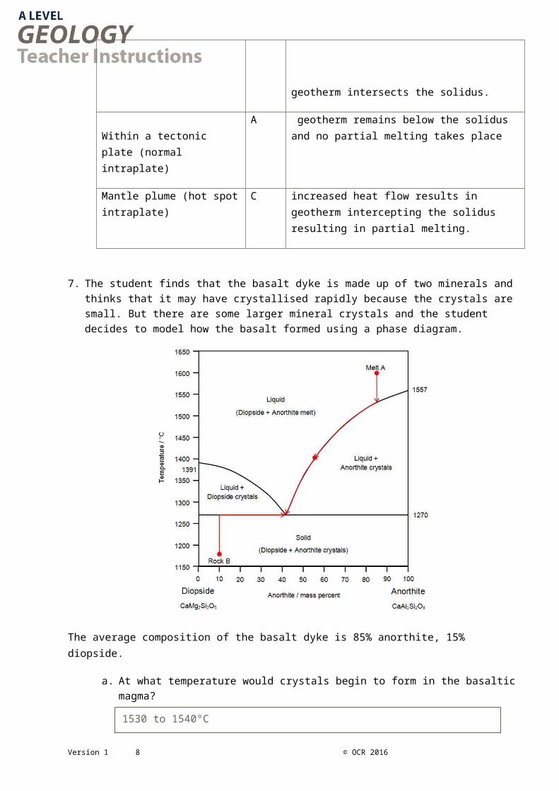
Within a tectonic plate (normal intraplate)
A geotherm remains below the solidus and no partial melting takes place
Mantle plume (hot spot intraplate)
C increased heat flow results in geotherm intercepting the solidus resulting in partial melting.
Version 1 4 © OCR 2016
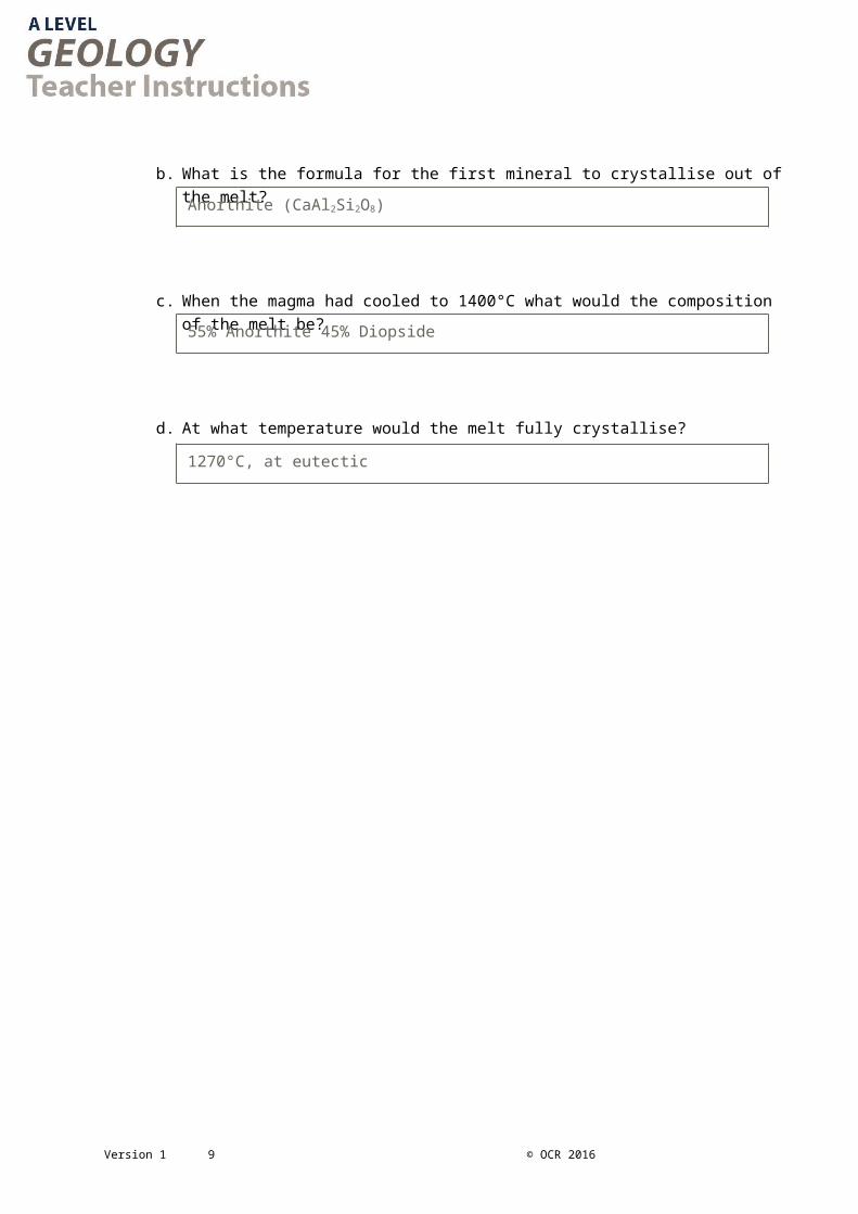
7. The student finds that the basalt dyke is made up of two minerals and thinks that it may have crystallised rapidly because the crystals are small. But there are some larger mineral crystals and the student decides to model how the basalt formed using a phase diagram.
The average composition of the basalt dyke is 85% anorthite, 15% diopside.
a. At what temperature would crystals begin to form in the basaltic magma?
b. What is the formula for the first mineral to crystallise out of the melt?
c. When the magma had cooled to 1400°C what would the composition of the melt be?
d. At what temperature would the melt fully crystallise?
Version 1 5 © OCR 2016
1530 to 1540°C
Anorthite (CaAl2Si2O8)
55% Anorthite 45% Diopside
1270°C, at eutectic
The student compared the basalt to Rock B which had a composition of 10% anorthite, 90% diopside.
e. At what temperature would Rock B begin to melt?
f. What would the composition of the first melt produced be?
g. What would happen if Rock B continued to be heated?
Version 1 6 © OCR 2016
We’d like to know your view on the resources we produce. By clicking on ‘Like’ or ‘Dislike’ you can help us to ensure that our resources work for you. When the email template pops up please add additional comments if you wish and then just click ‘Send’. Thank you.
Whether you already offer OCR qualifications, are new to OCR, or are considering switching from your current provider/awarding organisation, you can request more information by completing the Expression of Interest form which can be found here: www.ocr.org.uk/expression-of-interest
Looking for a resource? There is now a quick and easy search tool to help find free resources for your qualification: www.ocr.org.uk/i-want-to/find-resources/
OCR Resources: the small print
OCR’s resources are provided to support the delivery of OCR qualifications, but in no way constitute an endorsed teaching method that is required by the Board, and the
decision to use them lies with the individual teacher. Whilst every effort is made to ensure the accuracy of the content, OCR cannot be held responsible for any errors or omissions
within these resources.
© OCR 2016 - This resource may be freely copied and distributed, as long as the OCR logo and this message remain intact and OCR is acknowledged as the originator of this work.
OCR acknowledges the use of the following content: n/aPlease get in touch if you want to discuss the accessibility of resources we offer to support delivery of our qualifications: [email protected]
1270°C, at eutectic
90% Diopside 10% Anorthite
Temperature remains at 1270°C till the eutectic composition is reached.

Checkpoint TaskKS4 Science – KS5 Geology Learner ActivityA geology student has studied the geology of an area and sketched their observations on the cross-section shown on the resource sheet. The student had to work like a detective to produce the cross-section, as a lot of the rock was covered by vegetation. The layers of sedimentary rock have been intruded by igneous rocks. The geology student discovered fossils in three different beds of rock and has summarised some information about these fossils.
1. Igneous rocks can be dated by comparing the ratio of radioactive elements in minerals to their daughter products. Which igneous rock should the student use to date the deposition of the sedimentary rocks?
2. Why are the fossils more useful to the geology student in drawing up the cross-section than the date from the igneous rock?
3. What other information, besides dating, would the fossils give the student to help their geological investigation?
4. While they were still working in the valley the student was able to use the fossils to work out that the rock layers were in the correct order and that the upper limestone was millions of years old. Explain how the student was able to do this before researching the fossils.
5. Explain which of the three fossils the student found would be most suitable as a zone fossil.
Version 1 7 © OCR 2016
6. The student thinks that the granite intrusion and the volcanic ash could have been formed at a convergent (destructive) plate boundary. The four graphs below show the geothermal gradient and partial melting curves.
Match each graph to a plate tectonic setting and explain how you came to your decision.
Plate tectonic setting Graph Explanation
Convergent (destructive) plate boundary
Divergent (constructive) plate boundary
Within a tectonic plate (normal intraplate)
Mantle plume (hot spot intraplate)
Version 1 8 © OCR 2016
7. The student finds that the basalt dyke is made up of two minerals and thinks that it may have crystallised rapidly because the crystals are small. But there are some larger mineral crystals and the student decides to model how the basalt formed using a phase diagram.
The average composition of the basalt dyke is 85% anorthite, 15% diopside.
a. At what temperature would crystals begin to form in the basaltic magma?
b. What is the formula for the first mineral to crystallise out of the melt?
c. When the magma had cooled to 1400°C what would the composition of the melt be?
d. At what temperature would the melt fully crystallise?
Version 1 9 © OCR 2016

The student compared the basalt to Rock B which had a composition of 10% anorthite, 90% diopside.
e. At what temperature would Rock B begin to melt?
f. What would the composition of the first melt produced be?
g. What would happen if Rock B continued to be heated?
Version 1 10 © OCR 2016
The cross-section and sketches below summarise the geology of a large rock outcrop exposed in the side of a valley including three fossil sites.
Version 1 11 © OCR 2016
Name: Brachiopod SpiriferidaAge range: Upper Ordovician to JurassicNumerical age: 461-176 MaMode of life: muddy seabed filter feederDistribution: global, particularly Laurasian continentEnvironments: shallow muddy marine
Name: Dinosaur/Bird ArchaeopteryxAge range: Upper JurassicNumerical age: 151-125 MaMode of life: generalist predator of insects and small fishDistribution: offshore subtropicalEnvironments: deltaic, coastal lagoons
Name: Graptolite DidymograptusAge range: Lower to Middle OrdovicianNumerical age: 478-444 MaMode of life: mobile planktonic filter feederDistribution: globalEnvironments: deep marine, tidal shelf, carbonate shelf, coastal
GlossaryAnorthite— a variety of the mineral feldspar which contains a lot of Ca. It forms light coloured thin rectangular prism shaped crystals
Basalt — a dark fine crystalline igneous rock formed from the partial melting and crystallisation of mantle material.
Biostratigraphy — the science of correlating and working out the relative ages of rocks using the fossils found in the rocks
Brachipods — a group of formerly abundant shelled marine animals that attached themselves to the seabed with a fleshy foot
Conglomerate — a sedimentary rock formed from the products of physical erosion and containing a very wide range of particle sizes
Deposition — the processes by which sedimentary rocks are laid down by particles physically settling out from suspension or being chemically precipitated from solution
Dinosaurs — the dominant land vertebrates in the Mesozoic Era
Diopside — a variety of the mineral pyroxene. It forms dull green coloured, compact multisided crystals
Dyke— a sheet of igneous rock that has been intruded cutting across the layers in the surrounding rock
Fossil — the mineralised remains of a dead plant or animal.
Geotherm—the specific shape of the geothermal gradient below a specific point on the Earth
Granite — a light coloured coarse crystalline igneous rock formed from the partial melting and crystallisation of other crustal rocks
Graptolites — an extinct group of colonial marine animals that could move vertically in the water column and were once very abundant
Intrusion — the processes by which magma forces its way into the surrounding rocks where it crystallises as igneous rock
Limestone—a sedimentary rock formed on the seabed from the remains of marine organisms
Liquidus— a line or surface on a phase diagram above which there is complete melting and below which there are both crystals and melt present
Melt (noun) — liquid rock produced by the partial melting of solid rock because of changes in temperature and/or pressure within the Earth
Mineral — chemical compounds (typically SiO2 polymers) with a crystalline structure. Most rocks are formed of mixture of minerals
Sandstone — a sedimentary rock formed from the products of physical erosion and containing particle sizes between 2mm and 0.063mm
Solidus— a line or surface on a phase diagram below which the rock is all solid and above which there is partial melting
Shale — a sedimentary rock formed from the products of chemical and physical erosion and containing very fine particle sizes
Trace fossils — structure in sedimentary rocks which show how the animal that made them lived (e.g. foot prints and burrows)
Volcanic Ash — an igneous rock formed from fine to medium crystals that have been deposited by a volcanic eruption
Zone Fossil — a fossil which allows the enclosing rock to be assigned to a specific biostratigraphic zone; they can be used to ‘date’ the rock
Version 1 12 © OCR 2016