2.7 hazards and hazardous materials - … · 2.7 hazards and hazardous materials san diego county...
TRANSCRIPT

2.7 Hazards and Hazardous Materials
San Diego County General Plan Update Draft EIR Page 2.7-1 July 1, 2009
2.7 Hazards and Hazardous Materials This section of the EIR describes the existing hazardous materials, airport, wildland fire, vector, and emergency response and evacuation plan conditions in San Diego County. This section also analyzes the proposed County General Plan Update and its potential to have a significant impact on public safety, health or the environment. Information contained in the following section has been incorporated from County of San Diego Guidelines for Determining Significance, Hazardous Materials and Existing Contamination (DPLU 2007m), County of San Diego Guidelines for Determining Significance, Airport Hazards (DPLU 2007h), County of San Diego Guidelines for Determining Significance, Emergency Response Plans (DPLU 2007j), County of San Diego Guidelines for Determining Significance, Wildland Fire and Fire Protection (DPLU 2008e), County of San Diego Guidelines for Determining Significance, Vectors (DPLU 2009e), County of San Diego General Plan Safety Element Background Report (DPLU 2007e), County of San Diego General Plan Land Use Element Background Report (DPLU 2007c) and additional resources as cited throughout the section. A summary of the hazards and hazardous materials impacts identified in Section 2.7.3 is provided below.
Hazards and Hazardous Materials Summary of Impacts
Issue Number Issue Topic Project Direct Impact
Project Cumulative Impact
Impact After Mitigation
1 Transport, Use and Disposal of Hazardous Materials Less Than Significant Less Than Significant Less Than Significant
2 Accidental Release of Hazardous Materials Less Than Significant Less Than Significant Less Than Significant
3 Hazards to Schools Less Than Significant Less Than Significant Less Than Significant
4 Existing Hazardous Materials Sites Less Than Significant Less Than Significant Less Than Significant
5 Public Airports Potentially Significant Less Than Significant Less Than Significant 6 Private Airports Potentially Significant Less Than Significant Less Than Significant
7 Emergency Response and Evacuation Plans Potentially Significant Less Than Significant Less Than Significant
8 Wildland Fires Potentially Significant Potentially Significant Significant and Unavoidable
9 Vectors Less Than Significant Less Than Significant Less Than Significant 2.7.1 Existing Conditions This section of the EIR is divided into five discussions of potential hazards to public safety and the environment: hazardous materials, airports, wildland fires, vectors and emergency response and evacuation plans. The discussion on hazardous materials describes sites with known hazardous materials issues, sites with potential hazardous materials issues, hazardous materials transportation, hazardous materials disposal and hazardous materials release threats. The discussion on airports examines existing airport facilities and potential operational hazards within the County. The wildland fires discussion examines fire threat hazards, wildland/urban
2.7 Hazards and Hazardous Materials
San Diego County General Plan Update Draft EIR Page 2.7-2 July 1, 2009
interface areas, and the history of wildland fires in the County. The vectors discussion identifies vector sources, populations and associated diseases. Finally, the discussion on emergency response and evacuation plans identifies operations and plans that exist to protect lives and property in the event of a disaster within the County. 2.7.1.1 Hazardous Materials Hazardous materials are commonly stored and used by a variety of businesses and are commonly encountered during construction activities. Hazardous materials typically require special handling, reuse, and disposal because of their potential to harm human health and the environment. The California Health and Safety Code defines a hazardous material as:
“Any material that, because of its quantity, concentration, or physical or chemical characteristics, poses a significant present or potential hazard to human health and safety or to the environment if released into the workplace or the environment. “Hazardous materials” include, but are not limited to, hazardous substances, hazardous waste, and any material that a handler or the administering agency has a reasonable basis for believing that it would be injurious to the health and safety of persons or harmful to the environment if released into the workplace or the environment.” (H&SC Section 25501)
The following discussion outlines the existing hazardous materials conditions in the County. Sites with Known Hazardous Materials Issues A variety of government data sources are available to identify sites that may have been subject to a release of hazardous substances or that may have supported a use that could have resulted in a hazardous condition on site. Listed below are some key sources of data that identify potential environmental conditions and historical uses that may represent a hazardous condition on specific properties.
1. Hazardous Waste and Substances sites from California EPA Department of Toxic Substances Control (DTSC) EnviroStor database;
2. Leaking Underground Storage Tank Sites by County and Fiscal Year from the State Water Resources Control Board (SWRCB) GeoTracker database;
3. Solid waste disposal sites identified by SWRCB with waste constituents above hazardous waste levels outside the waste management unit;
4. Active Cease and Desist Orders (CDO) and Cleanup and Abatement Orders (CAO) from the SWRCB;
5. Hazardous waste facilities subject to corrective action pursuant to Section 25187.5 of the Health and Safety Code (H&SC), identified by DTSC;
6. Active and closed solid waste sites (Solid Waste Inventory System-SWIS database) maintained by the California Integrated Waste Management Board;
7. Hazardous Materials Establishment Listing maintained by the County of San Diego;
2.7 Hazards and Hazardous Materials
San Diego County General Plan Update Draft EIR Page 2.7-3 July 1, 2009
8. The County of San Diego maintains the Site Assessment and Mitigation (SAM) Case Listing of contaminated sites that have previously or are currently undergoing environmental investigations and/or remedial actions;
9. Resource Conservation and Recovery Information System (RCRIS): A database of RCRA facilities that is maintained by EPA;
10. The U.S. Army Corps of Engineers (ACOE), 911 Wilshire Boulevard, Los Angeles, California, 90017, (213) 452-3908, maintains a list of Formerly Used Defense Sites (FUDS); and
11. The DTSC School Property Evaluation and Cleanup Division is responsible for assessing, investigating and cleaning up proposed school sites. A list is maintained by DTSC of school properties with environmental assessments and the findings.
As of January 2007, all databases listed above (with the exception of database 3 - list of solid waste disposal sites identified by SWRCB, database 5 - list of hazardous waste facilities subject to corrective action by H&SC, and database 11 - DTSC school property list) have identified sites located in unincorporated areas of San Diego County. Databases with sites located in the unincorporated County are discussed below. Sites listed in the RCRIS and the Hazardous Materials Establishment databases are not included in this discussion because information contained in these databases is repetitive of other databases. DTSC EnviroStor Database This list includes the following site types: Federal Superfund Sites (National Priorities List); State Response, including Military Facilities and State Superfund; Voluntary Cleanup; and School sites. Information includes site name, site type, status, address, any restricted use (recorded deed restrictions), past use(s) that caused contamination, potential contaminants of concern, potential environmental media affected, site history, planned and completed activities. In the entire County of San Diego there are over 150 sites listed on the EnviroStor database. Approximately 22 of these are located in the unincorporated communities of Ramona, Borrego Springs, Fallbrook, Campo, Jacumba, Cuyamaca, Tecate, Boulevard, Rancho Santa Fe, Warner Springs, Pine Valley, Mount Laguna, and Lakeside (DTSC 2008b). GeoTracker Database The GeoTracker database is a geographic information system that provides online access to environmental data including underground fuel tanks, fuel pipelines and public drinking water supplies. GeoTracker contains information about leaking underground fuel tanks (LUFT) and can identify and display LUFT sites within various distances of wells. This provides users with the ability to assess potential threats to their drinking water sources. GeoTracker also has information and data on non-LUFT cleanup programs, including Spills-Leaks-Investigations-Cleanups sites, Department of Defense Sites, and Land Disposal programs. In the entire County of San Diego there are almost 8,000 sites listed in the GeoTracker Database. Of these 8,000, 66 are listed as “Open” and of these, 19 are located in the unincorporated communities of Camp Pendleton, Descanso, Ramona, Campo, Mt. Laguna, and Lakeside. All 19 sites are classified as LUFT (GeoTracker 2008).

2.7 Hazards and Hazardous Materials
San Diego County General Plan Update Draft EIR Page 2.7-4 July 1, 2009
Active CDO and CAO List The list of active CDO and CAO from the SWRCB is a compilation of “all cease and desist orders issued after January 1, 1986, pursuant to Section 13301 of the Water Code, and all cleanup or abatement orders issued after January 1, 1986, pursuant to Section 13004 of the Water Code, that concern the discharge of wastes that are hazardous materials.” The orders that are “active,” meaning the necessary actions have not yet been completed, are on this list. The SWRCB updates this list by deleting sites when there is no longer any discharge of wastes and/or where the necessary cleanup or abatement actions were taken. In the entire County of San Diego there are over 150 “active” CDO and/or CAO sites listed. Approximately 42 of these are located in the unincorporated communities of Borrego Springs, Camp Pendleton, Lakeside, Ramona, Rancho Santa Fe, and Valley Center (CalEPA 2008). SWIS Database The SWIS database contains information on solid waste facilities, operations, and disposal sites throughout the State of California. The types of facilities found in this database include landfills, closed disposal sites, transfer stations, materials recovery facilities, composting sites, transformation facilities, waste tire sites, and construction, demolition and inert debris facilities and operations. For each facility, the database contains information about location, owner, operator, facility type, regulatory and operational status, authorized waste types, local enforcement agency and inspection and enforcement records. There are 95 facility/site listings within both the incorporated and unincorporated areas of San Diego County which are under the jurisdiction of the County of San Diego Local Enforcement Agency (SWIS 2008). County of San Diego Site Assessment and Mitigation (SAM) Program Case Listing The San Diego County SAM Program, within the Land and Water Quality Division of the DEH, has a primary purpose to protect human health, water resources, and the environment within San Diego County by providing oversight of assessments and cleanups in accordance with the California H&SC and the CCR. The SAM’s Voluntary Assistance Program also provides staff consultation, project oversight, and technical or environmental report evaluation and concurrence (when appropriate) on projects pertaining to properties contaminated with hazardous substances. The DEH SAM Program maintains the SAM list of contaminated sites that have previously or are currently undergoing environmental investigations and/or remedial actions. The SAM Program covers all of San Diego County and includes remediation sites of all sizes. The SAM case listing is revised and updated regularly and the number of sites on the list is continually changing, but may contain upwards of 5,000 cases at one time. There is some overlap with the information in other regulatory databases, however the list also contains sites that often are not covered by some of the larger regulatory databases. If a project is submitted to the County for discretionary review and is located on a site found on the SAM list, the project’s status must be determined and any ongoing remediation requirements coordinated with the DEH SAM project manager.

2.7 Hazards and Hazardous Materials
San Diego County General Plan Update Draft EIR Page 2.7-5 July 1, 2009
Formerly Used Defense Sites (FUDS) Listing The ACOE maintains a list of FUDS within the unincorporated County. FUDS are real properties that were under the jurisdiction of the Secretary of Defense and owned by, leased by, or otherwise possessed by the U.S. FUDS are located throughout the U.S. and in many cases the ownership of these properties have been transferred to private individuals, corporations, State and local governments, federal agencies, and tribal governments. FUDS include, but are not limited to: hazardous, toxic and radioactive waste; military munitions including munitions constituents; containerized hazardous, toxic and radioactive waste; building demolition and debris removal; and potentially responsible party sites (government shares burden with private entity). There are approximately 146 FUDS in San Diego County, including FUDS within incorporated cities. Many FUDS have potential hazardous waste contamination problems such as disposal areas and LUFTs. Other FUDS utilized practice rounds for training, and some FUDS used live munitions and explosives, known collectively as ordnance and explosives. The live munitions that were fired but did not detonate are known as unexploded ordnance, or UXO. The UXO that remain on FUDS properties today pose the greatest safety hazard to the public, if they are disturbed. Figure 2.7-1 identifies the approximate location of UXO/FUDS within the County and their associated risk assessment code, which is a cumulative score of both the hazard probability and the hazard severity of the site. Sites are ranked on a one to four scale, one being at the most risk for and increased hazard to the public and environment. Many FUDS sites in San Diego County are under investigation by the ACOE to identify and remediate potential hazards. High risk FUDS sites, with scores of one or two, are located in the communities of Lakeside, Otay and Campo/Lake Morena. FUDS sites with lower risk are located with the communities of Borrego Springs and Ramona. Sites with Potential Hazardous Materials Issues A variety of historical land uses and conditions could potentially result in site contamination, representing potential hazards to humans and the environment when new land uses are proposed on those lands. Examples of historic land uses that have the potential to result in current site contamination include burnsites, landfills, formerly used defense sites, agriculture, and petroleum storage. Burn Dump Sites Burn ash refers to the debris, refuse, ash, and ash-contaminated soil that result from the open burning of municipal solid waste. Burn dump sites refer to locations where the open burning of solid waste occurred. From the late 1800s to the early 1970s, the open burning of solid waste was a common practice. After the waste was burned soil was placed over the debris, which typically consisted of unburned metal and ash. Ash from the open burning of municipal solid waste is the most common, but not the only source of burn ash. Historically, some open burning and low temperature incineration did occur with specific commercial waste streams, often disposed of on site. Burn ash can be commingled with other solid wastes, including incompletely burned refuse. There are many environmental issues and concerns regarding the management of former burn dump sites. Burn ash may contain concentrations of heavy metals, such as lead, that may be a

2.7 Hazards and Hazardous Materials
San Diego County General Plan Update Draft EIR Page 2.7-6 July 1, 2009
potential risk to human health and, if excavated, may need to be disposed as either a California or RCRA hazardous waste. When properly managed, burn dump sites pose little to no potential risk to the environment or public health. During development activities, soil containing burn ash must be properly managed. This includes minimizing dust migration and using appropriate BMPs to prevent surface erosion and the transportation of the burn ash. If the soil is to be exported from the site, care must be taken to ensure that it is disposed at an appropriate disposal facility The County Department of Public Works Landfill Management Unit manages six former burn dump sites within the County. Additional burn dump sites throughout the County are managed either by private property owners or other jurisdictions. Figure 2.7-2 identifies the location of burn dump sites within the County. Landfills Active, abandoned, and closed landfills present potential issues related to the exposure of humans to hazards, such as landfill gas migration, when a project is proposed on or near a landfill site. Active landfills located within the County are shown in Figure 2.7-2. Landfill capacity is discussed in Section 2.16, Utilities and Service Systems. Active Landfills There are seven active landfills in the San Diego region that serve the residents, businesses, and military operations of both incorporated and unincorporated areas. The Sycamore, Otay, Ramona, and Borrego landfills are owned and operated by the private waste service company, Allied Waste Industries. Las Pulgas and San Onofre landfills are owned and operated by the USMC, and the Miramar Landfill is owned and operated by the City of San Diego. The USMC-operated landfills are not available for public disposal. Table 2.7-1 identifies existing land uses that surround active landfills. Transfer Stations Solid waste not placed directly in the landfills is deposited temporarily in several privately operated transfer stations or rural bin sites located throughout the County. In Section 2.16, Utilities of this EIR, Table 2.16-6 identifies the location of these transfer stations and the amount of solid waste that is transferred there annually. The region’s transfer stations and bin sites play a vital role in accommodating throughput to landfills, serving as collection and separation points of solid waste and recyclables. Inactive Landfills The Landfill Management Unit of the County Public Works Department manages and maintains 11 closed landfills throughout the county and San Diego metro area, and maintains the gas collection system at the Bell Jr. High Landfill located in the City of San Diego. At least five other closed landfills are maintained by other parties. Although closed landfill sites no longer accept solid waste, there is a great deal of maintenance required to keep them environmentally safe. At inactive landfills, the County and others monitor landfill gas and maintain active landfill gas control systems, maintain the soil cover system, monitor groundwater quality and surface water, and maintain storm water BMPs to ensure that closed landfills do not pollute surface or ground water, or pose an explosion or health hazard.

2.7 Hazards and Hazardous Materials
San Diego County General Plan Update Draft EIR Page 2.7-7 July 1, 2009
Historic Agriculture Agricultural activities include the application of fertilizers, herbicides, and pesticides that have the potential to contaminate soil and groundwater. Soils contaminated by past agricultural activities are a growing concern, generally because of land use changes involving proposed housing developments on former agricultural lands. Pesticides from historic or nearby land use have the potential to leach into groundwater resources and cause contamination in public or private drinking water wells. Investigation of suspected pesticide contamination on properties proposed for development typically includes soil and groundwater sampling in areas where materials were stored, handled, and mixed in addition to identifying the historical crops grown, pesticides applied, and the methods of application. The investigation and any remedial actions related to pesticide contamination focuses on the elimination of human or environmental exposure. Constituents of concern at former agricultural sites include organochlorine pesticides and metals, which may pose a human health risk. Figure 2.2-3 in Section 2.2, Agriculture, identifies the location of agricultural resources within the County. Agricultural resources are defined as any land with an active agricultural operation or any site with a history of agricultural production, including land used for the raising of livestock, fur bearing animals, fish or poultry and dairying. Much of the agricultural land within the County and shown on Figure 2.2-3 is used for grazing or dry land farming activities that typically do not require significant pesticide use. The evaluation and any remedial actions as a result of contaminated soils on agricultural lands should be focused on the potential for human health exposure. Petroleum Petroleum hydrocarbons are the most commonly used group of chemicals in society today. Petroleum hydrocarbons encompass a wide range of compounds including, but not limited to: fuels, oils, paints, dry cleaning solvents, and non-chlorinated solvents. These compounds are used in all facets of modern life and can cause soil and groundwater contamination if not properly handled. Underground storage tanks (USTs) and aboveground storage tanks (ASTs) that store petroleum are common sources of contamination into soils and groundwater in the County. The presence of such contamination is typically identified during removal of these tanks. Property owners with USTs and ASTs on their land often include marketers who sell gasoline to the public, such as service stations and convenience stores, or non-marketers who use tanks solely for their own needs, such as fleet service operators or agricultural users. Leaking USTs can result in vapor intrusion from volatile organic compounds (VOC) and benzene into homes when chemicals seep down into the soil and groundwater and travel through soil as vapor. These vapors may then move up through the soil and into nearby buildings, through cracks in the foundation, causing contamination of indoor air. While vapor intrusion is uncommon, it should be considered when there is a known source of soil or groundwater contamination nearby. Hazardous Waste Transportation In California, unless specifically exempted, it is unlawful for any person to transport hazardous wastes unless the person holds a valid registration issued by the DTSC. The DTSC maintains a list of active registered hazardous waste transporters throughout the State. There are five registered hazardous waste transporters within the unincorporated areas of San Diego County. The name, location and company services of these transporters are listed in Table 2.7-2

2.7 Hazards and Hazardous Materials
San Diego County General Plan Update Draft EIR Page 2.7-8 July 1, 2009
The process of transporting hazardous waste often involves transfer facilities. A transfer facility
is any facility that is not an on-site facility that is related to the transportation of waste. These facilities include but are not limited to, loading docks, parking areas, storage areas, and other similar areas. Although not all transfer facilities hold hazardous waste, any operator of a facility that accepts hazardous waste for storage, repackaging or bulking must obtain formal authorization for those activities through the hazardous waste permit process. Hazardous waste transporters are exempt from storage facility permit requirements so long as they observe the limits on storage time and handling. Hazardous Waste Transfer facilities fall into three main categories:
1. An exempt transfer facility operated by a registered transporter, 2. A transfer facility operating under the authority of a RCRA permit, and 3. A transfer facility operating under the authority of a Standardized Permit.
Table 2.7-3 provides general characteristics of each hazardous waste transfer facilities category. A transfer facility may be either permitted or exempt. The permit authorizes the activities and establishes the conditions that must be followed by the operator of a permitted transfer facility. Exempt facilities are owned and operated by the transporter of the waste. Hazardous Materials Disposal Through the Resource Conservation and Recovery Act (RCRA), Congress directed the EPA to create regulations that manage hazardous waste from “the cradle to the grave.” Under this mandate, the EPA has developed strict requirements for all aspects of hazardous waste management including the recycling, treatment, storage, and disposal of hazardous waste. Facilities that provide recycling, treatment, storage, and disposal of hazardous waste are referred to as Treatment, Storage and Disposal Facilities (TSDF). Regulations pertaining to TSDFs are designed to prevent the release of hazardous materials into the environment and are more stringent than those that apply to generators or transporters. Within the unincorporated County, multiple TSDF sites exist, such as those owned and operated by the U.S. Military and the San Diego Gas and Electric Company. Hazardous Materials Release Threats When unexpectedly released into the environment, hazardous materials may create a significant hazard to the public or environment. Hazardous materials are commonly stored and used by a variety of businesses within the County and could be released into the environment through improper handling or accident conditions. The following business plans and response systems are in place to help prevent hazardous material release threats. Hazardous Materials Business Plans Any business that handles, stores, or disposes of a hazardous substance at a given threshold quantity must prepare a Hazardous Materials Business Plan (HMBP). HMBPs intend to minimize hazards to human health and the environment from fires, explosions, or an unplanned release of hazardous substances into air, soil, or surface water. The HMBP must be carried out immediately whenever a fire, explosion, or unplanned chemical release occurs. A HMBP includes three sections: 1) an inventory of hazardous materials, including a site map, which

2.7 Hazards and Hazardous Materials
San Diego County General Plan Update Draft EIR Page 2.7-9 July 1, 2009
details their location; 2) an emergency response plan; and 3) an employee-training program. HMBPs serve as an aid to employers and employees in managing emergencies at a given facility. They also help better prepare emergency response personnel for handling a wide range of emergencies that might occur at the facility. The Hazardous Materials Division (HMD) of the DEH conducts routine inspections at businesses required to submit Business Plans. The purpose of these inspections is to: 1) ensure compliance with existing laws and regulations concerning HMBP requirements; 2) identify existing safety hazards that could cause or contribute to an accidental spill or release; and 3) suggest preventative measures designed to minimize the risk of a spill or release of hazardous materials. After initial submission of an HMBP, the business must review and recertify the HMBP every year. Risk Management Plans Article 2 of Chapter 6.95 (H&SC Sections 25531- 25543.3) requires the owner or operator of a stationary source with more than a threshold quantity of a regulated substance to prepare a Risk Management Plan (RMP). The State statutes and regulations combine federal and State program requirements for the prevention of accidental releases of listed substances into the atmosphere. The incorporation of the federal and State requirements has been designated the California Accidental Release Prevention (CalARP) Program. CalARP requires that a RMP include a hazard assessment program, an accidental release prevention program, and an emergency response plan. The RMP must be revised every five years or as necessary. The majority of facilities or businesses in San Diego County that have prepared RMPs are ammonia refrigeration facilities and water treatment and wastewater treatment plants that handle chlorine gas. Hazardous Materials Emergency Response The County of San Diego Department of Environmental Health, Hazardous Incident Response Team (DEH-HIRT) consists of ten California State Certified Hazardous Materials Specialists. The team was founded in 1981 by the Unified Disaster Council and is funded by a Joint Powers Agreement. This team services all unincorporated San Diego County areas, 18 municipalities, two military bases, and five Indian reservations. There are over 400 responses a year in the DEH-HIRT operational area. DEH-HIRT responds jointly with the San Diego Fire-Rescue Department Hazardous Incident Response Team to investigate and mitigate chemically related emergencies or complaints. Emergency response activities include mitigation, containment, control actions, hazard identification, and threat evaluation to the local population and the environment. DEH-HIRT is also responsible for handling all after normal business hours complaints for the DEH. Recent DEH-HIRT incidents include responses to the 2007 firestorm, responses to fires at factories that store and use hazardous materials, and responses to accidents involving vehicles transporting fuel, liquid oxygen, pesticides and other hazardous materials (DEH 2008a). 2.7.1.2 Airport Hazards The areas of concern when addressing airport hazards are over-flight safety, airspace protection, flight patterns and land use compatibility. Dealing with these concerns contributes to the overall safety of passengers, pilots and crews on flights, in addition to the safety of people

2.7 Hazards and Hazardous Materials
San Diego County General Plan Update Draft EIR Page 2.7-10 July 1, 2009
on the ground. Hazards associated with airports can have serious human safety and quality of life impacts. The following section describes the airport types and locations within the County and the programs these facilities implement to prevent hazards. Airport Transportation There are eight County owned public airports located in San Diego County. Of these, six are located within the unincorporated area. These airports include Agua Caliente Airstrip, Borrego Valley Airport, Fallbrook Community Airpark, Jacumba Airport, Ocotillo Airstrip, and Ramona Airport. The Gillespie Field and McClellan-Palomar Airports are also owned by the County but are located within incorporated areas. Residents in the unincorporated area are also served by a number of airports located within incorporated cities, including San Diego International Airport (Lindberg Field), Montgomery Field, Brown Field Municipal Airport, and Oceanside Municipal Airport. Aviation facilities provide a variety of aviation services to local residents, including civil aviation, government use, business flights, charter flights, flight schools, and helicopter operations. All of the airports in the County are discussed below in terms of general characteristics and operation. Agua Caliente Airstrip The Agua Caliente Airstrip serves residents of rural east San Diego County and visitors to Agua Caliente Hot Springs County Park. In addition, military helicopters from Naval Air Station North Island (Coronado) perform evening/nighttime flight training missions at this airstrip. The Agua Caliente Airstrip had a total of 650 annual operations in 2006. The facility is located in the Desert Subregion on County Highway S-2 north of I-8, approximately 95 miles east of downtown San Diego. Vehicle parking is available, but the facility is not served by transit. The facility consists of a single 2,500 foot cement treated runway surface and a cement treated tie-down area. The airstrip is within an easy walk to the Agua Caliente Hot Springs County Park and a small store adjacent to the Park. Borrego Valley Airport The Borrego Valley Airport serves the general aviation needs of the community of Borrego Springs and visitors to the Anza-Borrego Desert State Park. The airport is located three miles east of Borrego Springs and 100 miles northeast of downtown San Diego. Several local resorts provide shuttle service from the airport. The facility consists of a single 5,011 foot paved lighted runway on 198 acres. Borrego Valley Airport serves single- and twin-engine piston aircraft, corporate jets, and helicopters. Associated facilities include a taxiway, aircraft parking, fueling areas, aircraft hangars, and a restaurant. Fallbrook Community Airpark The Fallbrook Community Airpark is a general aviation airport and does not receive any commercial air service. As a community airport, the facility primarily serves recreational flying, training, and local emergencies. The Fallbrook Community Airpark is located 60 miles north of downtown San Diego on South Mission Road adjacent to the eastern boundary of the Fallbrook Naval Weapons Station. The Airpark is two miles south of the Fallbrook Town Center area and approximately five miles west of I-15 and four miles north of SR-76. Access to the site is served by private vehicles and there is no public transportation available. The airpark consists of 290 acres, of which 118 acres are used for aviation facilities. The remaining areas are subleased for

2.7 Hazards and Hazardous Materials
San Diego County General Plan Update Draft EIR Page 2.7-11 July 1, 2009
agricultural production and recreational activities. The 2,160-foot airpark runway is limited to accommodating small airplanes less than 12,500 pounds. Other airpark facilities include hangars, fueling areas, and tie-down areas for transient aircraft. Unlike all of the other airports located west of the mountains, the Fallbrook Airpark runway is oriented approximately north-south (instead of east-west), presenting a 12-mph crosswind from the west. All flight patterns must stay east of the runway to avoid restricted airspace to the west over the Fallbrook Naval Weapons Depot and USMC Camp Pendleton. Jacumba Airport Jacumba Airport serves the Mountain Empire communities of Jacumba, Boulevard, Tierra del Sol, and Live Oak Springs. The airport is mainly used as a glider facility by single-engine aircraft and sailplanes, with activity predominately occurring during weekends in non-summer months. The facility is located on Old Highway 80, one mile east of Jacumba, 75 miles east of San Diego and 100 yards north of the Mexican border. This 131-acre facility is unattended and has an unpaved (gravel) and unlighted 2,510 foot runway. Only 395 operations occurred at this airport in 2006. Ocotillo Airstrip The Ocotillo Airstrip is a low-activity facility, used primarily by small, single-engine, piston airplanes and military helicopters from Naval Air Station North Island performing evening/nighttime training missions. The airstrip is situated on a dry lakebed in rural East County, approximately 100 miles east of downtown San Diego. The facility is located directly north of SR-78 and the small town of Ocotillo Wells. The Anza Borrego Desert State Park surrounds the airstrip to the north, west, and east. The 353-acre facility consists of two packed-silt runways and a graded area for aircraft tie-down. Ultra-light aircraft use an adjacent graded airstrip, which is not under County supervision. Ramona Airport The Ramona Airport is the busiest airport located within the unincorporated County. Ramona is equipped with a single east-west runway capable of handling corporate jet aircraft. It also has a public practice helipad located south of the runway. During wildfire season, usually May through November, the California Department of Forestry and Fire Protection (CAL FIRE) and the U.S. Forest Service (USFS) operate one of the busiest aerial fire attack bases in the nation (air tankers and helicopters) at this airport. They stage much of their Southern California fire protection operations from this location. The airport is located approximately two miles west of the Ramona Town Center area, about 27 miles northeast of downtown San Diego in the Santa Maria Valley. The 342-acre facility has a single 5,000-foot paved runway. CAL FIRE and USFS helicopters have exclusive use of two helipads at this facility. Gillespie Field Gillespie Field, the oldest and largest County owned airport, is classified as a Regional-Business/Corporate airport in the California Aviation System Plan (CASP). This classification describes an airport located in an area with a large population base that serves a number of jurisdictions with a high concentration of business or corporate flying. The airport is located within the limits of the City of El Cajon, except for a small portion located in the City of Santee. The airport is easily accessible from I-8 and SR-67. A transit stop for the San Diego Trolley is
2.7 Hazards and Hazardous Materials
San Diego County General Plan Update Draft EIR Page 2.7-12 July 1, 2009
located less that one-half mile from the control tower, on the opposite side of the runway from the terminal building. This general aviation airport has two east/west runways, one north/south runway, multiple lighted taxiways, two concrete-paved helipads, and navigational landing aids. Gillespie Field also has many fixed-based operators (private non-county operators), which offer services such as aircraft rental, flight training, maintenance, charter flights, fuel sales, restaurants, hangars, and tie-down facilities. A general aviation terminal is available, but primarily used by County administrative personnel. In addition to the airport itself, Gillespie Field includes two business parks, which provide more than 2,000 jobs in the City of El Cajon and help to boost the local economy. In addition to general aviation operations, Gillespie Field is a center for aviation museums, the County of San Diego Sheriff’s Aerial Support to Regional Enforcement Agencies (ASTREA) Helo Program, and the Civil Air Patrol’s Search and Rescue Operations. McClellan-Palomar Airport McClellan-Palomar Airport primarily serves general aviation users, but also serves corporate aircraft, and two regularly scheduled airlines (America West and United Express), which provide non-stop service to Phoenix and Los Angeles. There is also intense helicopter activity south of the runway. The airport is located within the limits of the City of Carlsbad. The site is three miles southeast of downtown Carlsbad at the corner of Palomar Airport Road and El Camino Real, approximately 30 miles north of downtown San Diego. The airport has both short and long term parking, with a shuttle bus running between the lots and terminals. The airport has a newly completed airport terminal which provides passenger airline services, rental cars, and restaurant services as well as US Custom Services. Airport Types The types of airports within the unincorporated County include general aviation airports, military airports, and heliports. These airport types are discussed further below. Figure 2.7-3 identifies the location of the airport facilities located within the County. General Aviation Airports A general aviation airport can be either public or private use. Anyone may use a public airport, but for a private airport, a user would need the owner’s permission prior to use. General aviation public airports provide a variety of aviation services to local residents, including civil aviation, government use, business flights, charter flights, and flight schools. These uses also include helicopter operations. General aviation airports are known for their large diversification of aviation uses. Public use airports located within unincorporated San Diego County are listed in Table 2.7-4. Table 2.7-5 lists private airports located within the unincorporated County. Military Airports There are four military airports in San Diego County. These include USMC Camp Pendleton, Navel Outlying Field Imperial Beach, MCAS Miramar, and Navel Air Station North Island. Only USMC Camp Pendleton is located fully within the unincorporated area of the County. A portion of the MCAS Miramar influence area is located within the unincorporated area near I-15 and Pomerado Road. The location of military airports within the County is shown in Figure 2.7-3.
2.7 Hazards and Hazardous Materials
San Diego County General Plan Update Draft EIR Page 2.7-13 July 1, 2009
Heliports Currently, the unincorporated County possesses heliport/helipad areas at Ramona Airport and Fallbrook Airpark. The Ramona heliport is on an elongated practice pad on the south side of the runway. The Fallbrook Airpark heliport is operated solely by the Sherriff’s Department and Fire Rescue personnel, unlike the Ramona Airport which is operated by its own airport. It is located on the southeast portion of the airport. Public Airport Hazard Prevention Airport Land Use Compatibility Plans (ALUCPs) are plans that guide property owners and local jurisdictions in determining what types of proposed new land uses are appropriate around airports. They are intended to protect the safety of people, property and aircraft on the ground and in the air in the vicinity of the airport. They also protect airports from encroachment by new incompatible land uses that could restrict their operations. ALUCPs are based on a defined area around an airport known as the Airport Influence Area (AIA). Airport Influence Areas (AIAs) are established by factors including airport size, operations, configuration, as well as the safety, airspace protection, noise, and overflight impacts on the land surrounding an airport. It is important to note that ALUCPs do not affect existing land uses. Structure replacement and infill development are generally permitted under ALUCPs, in accordance with policies established by the San Diego County Regional Airport Authority (SDCRAA). In December 2006, the SDCRAA adopted new ALUCPs for six rural airports operated by the County (Agua Caliente, Borrego Valley, Fallbrook, Jacumba, Ocotillo, and Ramona). Airport safety zones are established for all public airports as part of the ALUCP and land use restrictions within safety zones are established to protect people and property on the ground and in the air. Safety zones were created to address the following three safety concerns:
1. Protecting people and property on the ground. Land use restrictions are implemented that include limiting the intensity of use, residential uses, and sensitive uses such as occupants with mobility issues and hazardous materials;
2. Minimizing injury to aircraft occupants. Land use controls are implemented to preserve useful open land in the vicinity of the airport for an off-airport emergency landing; and
3. Preventing creation of hazards to flight. Restrictions on building heights and objects in the approach and take-off flight paths are implemented, along with the limitation of land uses that would interfere with aircraft communication and navigation equipment or attract wildlife that pose a hazard to aircraft (such as large birds).
Figure 2.7-4 presents an example of a runway that has been divided into six safety zones. Safety compatibility zones vary for each airport and a number of factors are considered when developing these zones. Table 2.7-6 describes the characteristics of the different Aircraft Safety Zones and Table 2.7-7 generally describes compatibility requirements for public airports. Military Airports Hazard Prevention Guidelines set forth by the Department of Defense (DOD) as part of its Air Installation Compatible Use Zone (AICUZ) Program address land use compatibility and safety policies for military airport runways. The AICUZ was initiated in the 1970s to recommend land uses that

2.7 Hazards and Hazardous Materials
San Diego County General Plan Update Draft EIR Page 2.7-14 July 1, 2009
may be compatible with noise levels, accident potential and flight clearance requirements associated with military airfield operations. DOD prepared individual AICUZ plans for all major military airports. The objective of this program is to encourage compatible uses of public and private lands in the vicinity of military airfields through the local communities’ comprehensive planning process. The Accident Potential Zone (APZ) is unique to military airfields, and is generally applied to all U.S. Navy and Marine Corps airfields within the U.S. Designation of APZs is a component of the AICUZ. These zones describe the probable impact area if an accident were to occur, based on historical accident data. Clear Zones, which are similar to a civilian airport RPZ, typically extend 3,000-feet beyond the end of the runway, measuring 1,500-feet wide at the runway and 2,284-feet wide at its outer edge. In addition, military airports designate two APZs (APZ-1 and APZ-2), which extend beyond the Clear Zone. Land Use Compatibility for these APZs is listed in Table 2.7-8. Because military installations often lack land use authority over the extent of an AICUZ, it is the responsibility of the local jurisdiction to ensure incompatible uses are not permitted or, if allowed, that they are properly regulated in these zones. Private Airport Hazard Prevention Safety-related hazards at private and special-use airports affect less land because of lower activity levels compared to public-use airports. In addition, the general public has very limited access to or ability to utilize these facilities due to their ownership by private citizens or public agencies (such as the Bureau of Land Management or the U.S. Forest Service). Land use controls differ substantially between public airports and private airports. First, there are no AIA identified around these airports and land use restrictions are much less defined than with public airports. Second, Caltrans’ Division of Aeronautics controls private and special-use airports through a permitting process, and is also responsible for regulating operational activities at these airports. 2.7.1.3 Wildland Fire Hazards A vast amount of the County’s undeveloped lands support natural habitats such as grasslands, sage scrub, chaparral, and some coniferous forest. In the context of fire ecology, these areas are known as wildlands. Fire ecology research has shown that the natural fire regime for the shrublands and forests in San Diego County was one of frequent small fires and occasional large fires. Modern society has interrupted and fractured the natural fire process by initiating fire suppression policies, introducing invasive plant species that burn readily such as eucalyptus trees, and building houses within or adjacent to wildland areas (known as wildland-urban interface (WUI) areas) such as San Diego’s backcountry. Although fires can occur anywhere in the County, fires that begin in wildland areas pose a serious threat to personal safety and structures due to rapid spread and the extreme heat that these fires often generate. Past wildfires have taken lives, destroyed homes and devastated hundreds of thousands of acres of the County’s natural resources. The following section discusses the fire hazard potential in the County, current wildland-urban interface conditions, and the history of wildland fires in the County. Fire Protection Districts, including non-serviced areas, County Service Areas and State Responsible Areas, are discussed in Section 2.13, Public Services.

2.7 Hazards and Hazardous Materials
San Diego County General Plan Update Draft EIR Page 2.7-15 July 1, 2009
Fire Hazard Potential in the County of San Diego CAL FIRE has mapped areas of significant fire hazards in the County through their Fire and Resource Assessment Program (FRAP). These maps place areas of the County into different Fire Hazard Severity Zones (FHSZ) based upon fuels, terrain, weather, and other relevant factors. Figure 2.7-5 identifies Federal Responsibility Areas (FRA), which are areas where the USFS is responsible for wildfire protection; State Responsibility Areas (SRA), which are areas where CAL FIRE is responsible for wildfire protection; and Local Responsibility Areas (LRA) where local fire protection agencies are responsible for wildfire protection. The majority of the unincorporated area of the County is SRA lands (see Figure 2.7-5). The FHSZ are divided into three levels of fire hazard severity: Moderate, High and Very High. The majority of the County is in the High and Very High FHSZ, except for the Desert and eastern Mountain Empire Sub-regions which are in the Moderate FHRZ. There are also areas of Moderate FHSZ and un-zoned areas in the more densely populated communities around the County. Wildland Urban Interface As identified above, a WUI is an area where development is located in close proximity to open space or lands with native vegetation and habitat that are prone to brush fires. The WUI creates an environment in which fire can move readily between structural and vegetation fuels. Once homes are built within (or adjacent to) natural habitat settings, it increases the complexity of fighting wildland fires because the goal of extinguishing the wildland fire is often superseded by protecting human life and private property. The WUI is composed of communities that border wildlands or are intermixed with wildlands and where the minimum density exceeds one structure per 40 acres. WUI communities are created when the following conditions occur: 1) structures are built at densities greater than one unit per 40 acres; 2) the percentage of native vegetation is less than 50 percent; 3) the area is more than 75 percent vegetated; and 4) the area is within 1.5 miles of an area greater than a census block (1,325 acres). The 1.5 mile buffer distance was adopted according to the 2001 California Fire Alliance definition of vicinity, which is roughly the distance that pieces of burning wood can be carried from wildland fire to the roof of a structure (UW 2008). Figure 2.7-6 shows areas in San Diego County mapped as WUI by CAL FIRE. Existing acres of WUI per community planning area are shown in Table 2.7-9. Wildland Fire History in San Diego County San Diego County has a long history of wildland fires. As identified in an annual report produced by CAL FIRE called “Wildfire Activity Statistics,” San Diego County is consistently listed among the top five counties in the State for both number of acres burned and dollar value of fire damage. In San Diego County, fire season is typically defined from May through November, depending on variations in weather conditions. However, the threat of a wildland fire is always present and is influenced by weather conditions throughout the year. The 2007 San Diego County firestorms were the second largest in County history, superseded only by the devastating firestorms of October 2003. The firestorms started on October 21, 2007 near the U.S./Mexico international border and burned throughout San Diego County until the

2.7 Hazards and Hazardous Materials
San Diego County General Plan Update Draft EIR Page 2.7-16 July 1, 2009
last fire was fully contained on November 9, 2007. At the height of the firestorms, there were seven separate fires burning in San Diego County. The fires resulted in seven civilian deaths, 23 civilian injuries, and 89 firefighter injuries. More than 6,200 fire personnel fought to control the wildland fires but the fires consumed approximately 369,000 acres, or about 13 percent of the County’s total land mass. Additionally, the fires destroyed an estimated 1,600 homes, 800 outbuildings, 253 structures, 239 vehicles, and two commercial properties. The total projected damage costs of the 2007 San Diego County firestorms are estimated to exceed $1.5 billion (EG&G 2007). Table 2.7-10 identifies the damage inflicted by major wildfires in San Diego County since 1996. Figure 2.7-7 shows areas that have suffered from wildland fires in the past. 2.7.1.4 Vectors A vector is any insect, arthropod, rodent or other animal of public health significance that can cause human discomfort, injury or is capable of harboring or transmitting the causative agents of human disease. Typical adverse effects related to vectors are two-fold. First, vectors can cause significant public health risks due to the transmission of disease to human and animal populations. Second, vectors can create a nuisance for the residents of the County. In the County of San Diego, the most significant vector populations include mosquitoes, rodents, flies, and fleas. Vector sources, populations, and transmittable diseases are discussed below. Vector Sources Vector sources occur where site conditions provide habitat suitable for breeding. The vector sources listed below focus specifically on those sources most commonly associated with proposed land development projects that could represent a potential hazard to public health. Standing Water Any source of standing water, including but not limited to ponds, reservoirs, natural and constructed wetlands, irrigation ponds, detention basins, percolation and infiltration basins, and other stormwater conveyance and treatment systems that hold standing water can be breeding grounds for mosquitoes and other vectors resulting in adverse public health effects related to disease transmission. Backyard residential sources of standing water are common vector breeding sources. These sources include unmaintained swimming pools and buckets, toys, and other common items that can hold even small amounts of water. Ponds, Stormwater BMPs, wetlands and reservoirs are another major source of vectors. The condition of the water body dictates its potential to generate vectors. For example, flowing and aerated water does not support mosquito breeding, while stagnant water does support mosquito breeding. Stormwater Management A standard requirement for new development is the incorporation of measures, or Best Management Practices (BMPs), to reduce stormwater flow rates, allow stormwater to infiltrate back into the ground, and to reduce constituent concentrations in runoff. Unfortunately, BMPs for managing runoff often provide aquatic habitats suitable for mosquitoes and other vector species as an unintended consequence of their implementation within residential neighborhoods. Examples of post-construction conditions that may increase the probability of
2.7 Hazards and Hazardous Materials
San Diego County General Plan Update Draft EIR Page 2.7-17 July 1, 2009
mosquito production in stormwater BMPs include clogging (e.g., effluent pipes, media filters, infiltration basins), establishment of invasive or exotic vegetation, groundwater fluctuations, non-stormwater runoff (e.g., increases in runoff frequency, residence time, and/or volume), scouring and erosion, structural damage (e.g., shifting or settling, roots), trash and sediment accumulation (e.g., formation of pools, clogging, redirected water flows), vandalism, and vegetation overgrowth. Other conditions favorable to mosquito production may become apparent as structures age. An often overlooked aspect of treatment BMP implementation is the long-term commitment of funds necessary for proper maintenance of structures. Routine and timely maintenance is critical for suppressing mosquito breeding as well as for meeting local water quality goals. If maintenance is neglected or inappropriate for a given site, even structures designed to be the least “mosquito friendly” may become significant breeding sites. Once these BMPs are degraded, they may be considered habitat and cannot easily be rehabilitated. Composting and Manure Management The presence of large quantities of manure can significantly increase problems related to vectors, particularly from the breeding of flies. Equine operations, kennels, and animal agricultural uses such as poultry ranches or other animal breeding operations can increase vector populations, if not properly managed. Vector Populations and Diseases Mosquitoes Almost all mosquitoes need standing water to complete their life cycle. For this reason, mosquitoes are found in areas of standing water including wetlands, irrigation ponds, detention basins, percolation and infiltration basins, and other stormwater conveyance systems. Some mosquito species are vectors of diseases. There are approximately 24 different species of mosquitoes that are found in San Diego County and of these there are at least four that are known to carry diseases that can be passed to humans. The recent spread of West Nile Virus (WNV) has increased the health risk of mosquito contact and increased the importance of preventing mosquito breeding. Another virus of concern from mosquitoes includes arboviruses (arthropod-borne viruses), a large group of viruses that are spread mainly by bloodsucking insects. In the U.S., arboviruses are most commonly spread by mosquitoes. Arboviruses that have been found or may occur in San Diego County include Western Equine encephalitis, Saint Louis encephalitis, and most recently WNV. Birds are often the source of infection for mosquitoes, which can then spread the infection to horses, other animals, and people. Most people infected with arboviruses have few or no symptoms, but arboviruses can cause serious and potentially fatal inflammation of the brain (encephalitis) as well as other complications. Emerging diseases are also a concern for San Diego County. Dengue, Chikungunya virus and Malaria are examples of emerging diseases that could come to us from foreign countries. Due to the ease of international travel, the threat of new diseases in our own backyard is very real. Up until a few years ago, West Nile Virus was an emerging disease as well.

2.7 Hazards and Hazardous Materials
San Diego County General Plan Update Draft EIR Page 2.7-18 July 1, 2009
Rodents Rodents, such as mice, rats or squirrels, are very destructive pests that can spread disease, contaminate foods and food preparation areas, and cause costly structural damage. Diseases spread by rodents that can harm humans include plague and hantavirus. Plague is a bacterial disease carried by rodents that is spread through the bite of an infected flea. Rodents, usually ground squirrels, can carry plague. Humans and their pets can also be infected with plague if bitten by infected fleas at campgrounds or rural areas, typically at the higher elevations. The County conducts plague surveillance, mostly at higher elevation localities. Surveillance and testing often yields one or more positive blood tests in ground squirrels each year. In response, plague-warning signs are posted at campgrounds to inform visitors of the appropriate precautions. Hantavirus is a potentially fatal rodent-borne disease. Both hemorrhagic and respiratory strains of hantavirus occur in wild rodents (deer and harvest mice) in San Diego County. Humans typically become infected with hantavirus by breathing air-borne particles of wild rodent droppings and urine contaminated with the virus. Symptoms of the virus include fever, headache, nausea, vomiting, and respiratory failure. Flies Flies are vectors of disease. When flies forage on feces and spoiled food they come into contact with pathogens and can spread them to other animals and humans. In two weeks, one female fly may lay more than 1,000 eggs in sources including, but not limited to, animal wastes, household garbage, and piled lawn clippings. The most common fly diseases are dysentery, salmonella, e-coli infection, and cholera. Fleas Fleas are usually brought into the home by dogs, cats or other furry pets. In order to live and reproduce, they feed off the blood of humans and animals, such as dogs and cats. Diseases spread by fleas include plague, tapeworm, and typhus. 2.7.1.5 Emergency Response and Evacuation Plans Overview Emergency response plans include elements to maintain continuity of government, emergency functions of governmental agencies, mobilization and application of resources, mutual aid, and public information. Emergency response plans are maintained at the federal, State and local level for all types of disasters, including human-made and natural. It is the responsibility of government to undertake an ongoing comprehensive approach to emergency management in order to avoid or minimize the effects of hazardous events. Local governments have the primary responsibility for preparedness and response activities. To address disasters and emergency situations at the local level, the Unified Disaster Council (UDC) is the governing body of the Unified San Diego County Emergency Services Organization. The UDC is chaired by a member of the San Diego County Board of Supervisors and comprised of representatives from the 18 incorporated cities. The County of San Diego Office of Emergency Services (OES) serves as staff to the UDC.

2.7 Hazards and Hazardous Materials
San Diego County General Plan Update Draft EIR Page 2.7-19 July 1, 2009
Potential hazards or events that may trigger an emergency response action in the County include earthquakes, tsunamis, floods, wildland fires, landslides, droughts, hurricanes, tropical storms and freezes. Emergency response actions could also be triggered from a hazardous material incident, water or air pollution, a major transportation accident, water, gas, or energy shortage, an epidemic, a nuclear accident, or terrorism. Operational Area Emergency Plan In San Diego County, there is a comprehensive emergency plan known as the Operational Area Emergency Plan (OAEP). Stand-alone emergency plans for the Operational Area include:
• San Diego County Nuclear Power Plant Emergency Response Plan; • San Diego County Operational Area Oil Spill Contingency Element of the Area
Hazardous Materials Plan; • San Diego County Operational Area Emergency Water Contingencies Plan; • Unified San Diego County Emergency Services Organization Operational Area Energy
Shortage Response Plan; • Unified San Diego County Emergency Services Organization Recovery Plan; • San Diego County Multi-Jurisdictional Hazard Mitigation Plan; • San Diego Urban Area Tactical Interoperable Communications Plan; and • San Diego County Draft Terrorist Incident Emergency Response Protocol.
In addition to the above plans, the OES maintains Dam Evacuation Plans for the Operational Area. Emergency plans for dam evacuation are necessary to plan for the loss of life, damage to property, displacement of people, and other ensuing hazards that can occur from dam failure. In the event of dam failure, damage control and disaster relief would be required and mass evacuation of the inundation areas would be essential to save lives. Dam inundation is further discussed in Section 2.8, Hydrology and Water Quality. Dam evacuation plans contain information concerning the physical situation, affected jurisdictions, evacuation routes, unique institutions and event responses. In addition, the plans include inundation maps showing direction of flow; inundation area boundaries; hospitals, schools, multipurpose staging areas; command posts/sites; and mass care and shelter facilities/sites. Unique institutions, as defined by the OES, include the following types of facilities: hospitals, schools, skilled nursing facilities, retirement homes, mental health care facilities, care facilities with patients that have disabilities, adult and childcare facilities, jails/detention facilities, stadiums, arenas and amphitheaters. San Diego County Multi-Jurisdictional Hazard Mitigation Plan The Multi-Jurisdictional Hazard Mitigation Plan was developed with the participation of all jurisdictions in the County of San Diego including every incorporated city and the unincorporated County. The plan includes an overview of the risk assessment process, identifies hazards present in the jurisdiction, hazard profiles, and vulnerability assessments. The plan also identifies goals, objectives and actions for each jurisdiction in the County. Hazards profiled in the plan include wildfire, structure fire, flood, coastal storms, erosion, tsunami, earthquakes, liquefaction, rain-induced landslide, dam failure, hazardous materials

2.7 Hazards and Hazardous Materials
San Diego County General Plan Update Draft EIR Page 2.7-20 July 1, 2009
incidents, nuclear materials release, and terrorism. The plan sets forth a variety of objectives and actions based on a set of broad goals including: 1) promoting disaster-resistant future development; 2) increased public understanding and support for effective hazard mitigation; 3) building support of local capacity and commitment to become less vulnerable to hazards; 4) enhancement of hazard mitigation coordination and communication with federal, State, local and tribal governments; and 5) reducing the possibility of damage and losses to existing assets, particularly people, critical facilities or infrastructure, and County owned facilities, due to dam failure, earthquake, coastal storm, erosion, tsunami, landslides, floods, structural fire/wildfire, and manmade hazards. Emergency Air Support Helicopters and small planes are used in a variety of emergency response actions such as search and rescue operations and retrieving water to extinguish wildfires. During an emergency response, aircraft tend to fly low to the ground thus increasing the potential hazards to aircraft from towers and other objects within airspace. CAL FIRE and the County of San Diego Sheriff’s Department Aerial Support Detail, Air Support to Regional Enforcement Agencies (ASTREA) base carry out emergency response actions. CAL FIRE is the largest fire department in California and the third largest fire department in the U.S. Firefighters working for CAL FIRE are responsible for fulfilling their mission to provide comprehensive fire protection and other related emergency services, including protection of life and property. The San Diego County Sheriff’s ASTREA operates aircraft throughout San Diego County on a daily basis. These aircraft are involved in law enforcement, search and rescue, and fire-related missions. 2.7.2 Regulatory Framework 2.7.2.1 Federal Center for Disease Control; National Center for Infectious Diseases; Division of Vector-Borne Infectious Diseases The Division of Vector-Borne Infectious Diseases, within the Center for Disease Control, serves as a national and international reference center for vector-borne diseases. The mission of the Division is to: 1) develop and maintain effective surveillance for vector-borne viral and bacterial agents and their arthropod vectors; 2) conduct field and laboratory research and epidemic aid investigations; 3) define disease etiology, ecology, and pathogenesis in order to develop improved methods and strategies for disease diagnosis, surveillance, prevention and control; 4) provide diagnostic reference and epidemiologic consultation, on request, to State and local health departments, other components of CDC, other federal agencies, and national and international health organizations; and 5) provide intramural and extramural technical expertise and assistance in professional training activities. Resource Conservation and Recovery Act (RCRA) of 1976, as amended by the Hazardous and Solid Waste Amendments of 1984 Federal hazardous waste laws are generally promulgated under RCRA. These laws provide for the “cradle to grave” regulation of hazardous wastes. Any business, institution, or other entity that generates hazardous waste is required to identify and track its hazardous waste from the point of generation until it is recycled, reused, or disposed. DTSC is responsible for

2.7 Hazards and Hazardous Materials
San Diego County General Plan Update Draft EIR Page 2.7-21 July 1, 2009
implementing the RCRA program as well as California’s own hazardous waste laws, which are collectively known as the Hazardous Waste Control Law. Under the Certified Unified Program Agency (CUPA) program, Cal EPA has in turn delegated enforcement authority to the County of San Diego for State law regulating hazardous waste producers or generators. Comprehensive Environmental Response, Compensation, and Liability Act (CERCLA) and the Superfund Amendments and Reauthorization Act (SARA) of 1986 Congress enacted CERCLA, commonly known as Superfund, on December 11, 1980. CERCLA established prohibitions and requirements concerning closed and abandoned hazardous waste sites; provided for liability of persons responsible for releases of hazardous waste at these sites; and established a trust fund to provide for cleanup when no responsible party could be identified. SARA amended the CERCLA on October 17, 1986. SARA stressed the importance of permanent remedies and innovative treatment technologies in cleaning up hazardous waste sites; required Superfund actions to consider the standards and requirements found in other State and federal environmental laws and regulations; provided new enforcement authorities and settlement tools; increased State involvement in every phase of the Superfund program; increased the focus on human health problems posed by hazardous waste sites; encouraged greater citizen participation in making decisions on how sites should be cleaned up; and increased the size of the trust fund to $8.5 billion. Chemical Accident Prevention Provisions When Congress passed the Clean Air Act Amendments of 1990, it required EPA to publish regulations and guidance for chemical accident prevention at facilities using extremely hazardous substances. These rules, which built upon existing industry codes and standards, require companies of all sizes that use certain flammable and toxic substances to develop a Risk Management Program. Emergency Planning Community Right-to-Know Act (EPCRA) The EPCRA, also known as SARA Title III, was enacted in October 1986. This law requires any infrastructure at the State and local levels to plan for chemical emergencies. Reported information is then made publicly available so that interested parties may become informed about potentially dangerous chemicals in their community. EPCRA Sections 301 through 312 are administered by EPA’s Office of Emergency Management. EPA’s Office of Information Analysis and Access implements the EPCRA Section 313 program. In California, SARA Title III is implemented through CalARP. Hazardous Materials Transportation Act The U.S. Department of Transportation regulates hazardous materials transportation under Title 49 CFR. State agencies with primary responsibility for enforcing federal and State regulations and responding to hazardous materials transportation emergencies are the California Highway Patrol and the California Department of Transportation. These agencies also govern permitting for hazardous materials transportation. Title 49 CFR reflects laws passed by Congress as of January 2, 2006.

2.7 Hazards and Hazardous Materials
San Diego County General Plan Update Draft EIR Page 2.7-22 July 1, 2009
EPA Region 9, Preliminary Remediation Goals (PRGs) Region 9 is the Pacific Southwest Division of the EPA, which includes Arizona, California, Hawaii, Nevada, Pacific Islands, and over 140 Tribal Nations. PRGs are tools for evaluating and cleaning up contaminated sites. PRGs for the Superfund/RCRA programs are risk-based concentrations, derived from standardized equations combining exposure information assumptions with EPA toxicity data. They are considered to be protective for humans (including sensitive groups) over a lifetime. However, PRGs are not always applicable to a particular site and do not address non-human health issues such as ecological impacts. Region 9’s PRGs are viewed as agency guidelines, not legally enforceable standards. International Fire Code (IFC) The IFC, created by the International Code Council, is the primary means for authorizing and enforcing procedures and mechanisms to ensure the safe handling and storage of any substance that may pose a threat to public health and safety. The IFC regulates the use, handling, and storage requirements for hazardous materials at fixed facilities. The IFC and the International Building Code (IBC) use a hazard classification system to determine what protective measures are required to protect fire and life safety. These measures may include construction standards, separations from property lines, and specialized equipment. To ensure that these safety measures are met, the IFC employs a permit system based on hazard classification. The IFC is updated every three years. Federal Aviation Administration (FAA) Functions The FAA has primary responsibility for the safety of civil aviation. The FAA’s major functions regarding hazards include the following: 1) Developing and operating a common system of air traffic control and navigation for both civil and military aircraft; 2) Developing and implementing programs to control aircraft noise and other environmental effects of civil aviation; 3) Regulating U.S. commercial space transportation; and 4) Conducting reviews to determine that the safety of persons and property on the ground are protected. U.S. Department of Defense (DOD) Air Installations Compatible Use Zone (AICUZ) Program Safety compatibility criteria for military air bases are set forth through the AICUZ Program administered by the DOD. This Program applies to military air installations located within the U.S., its territories, trusts, and possessions. The AICUZ Program has the following four purposes: 1) to set forth DOD policy on achieving compatible use of public and private lands in the vicinity of military airfields; 2) to define height and land use compatibility restrictions; 3) to define procedures by which AICUZ may be defined; and 4) to provide policy on the extent of Government interest in real property within these zones that may be retained or acquired to protect the operational capability of active military airfields. The Robert T. Stafford Disaster Relief and Emergency Assistance Act (P.L. 93-288), as amended, (42 U.S.C. Sections 5121-5206), and Related Authorities CFR Sections 206.31-206.48, provide the statutory framework for a Presidential declaration of an emergency or a declaration of a major disaster. Such declarations open the way for a wide range of federal resources to be made available to assist in dealing with an emergency or major

2.7 Hazards and Hazardous Materials
San Diego County General Plan Update Draft EIR Page 2.7-23 July 1, 2009
disaster. The Stafford Act structure for the declaration process reflects the fact that federal resources under this act supplement State and local resources for disaster relief and recovery. Except in the case of an emergency involving a subject area that is exclusively or preeminently in the federal purview, the Governor of an affected State, or Acting Governor if the Governor is not available, must request such a declaration by the President. Federal Response Plan The Federal Response Plan of 1999 is a signed agreement among 27 federal departments and agencies, including the American Red Cross, that: 1) provides the mechanism for coordinating delivery of federal assistance and resources to augment efforts of State and local governments overwhelmed by a major disaster or emergency; 2) supports implementation of the Robert T. Stafford Disaster Relief and Emergency Act, as well as individual agency statutory authorities; and 3) supplements other federal emergency operations plans developed to address specific hazards. The Federal Response Plan is implemented in anticipation of a significant event likely to result in a need for federal assistance or in response to an actual event requiring federal assistance under a Presidential declaration of a major disaster or emergency. 2.7.2.2 State Government Code Section 65962.5 (a), Cortese List The Hazardous Waste and Substance Sites Cortese List is a planning document used by the State, local agencies and developers to comply with the California Environmental Quality Act (CEQA) requirements in providing information about the location of hazardous materials release sites. Government Code Section 65962.5 requires the California Environmental Protection Agency (Cal/EPA) to develop at least annually an updated Cortese List. DTSC is responsible for a portion of the information contained in the Cortese List. Other State and local government agencies are required to provide additional hazardous material release information for the Cortese List. California Health & Safety Code (H&SC), Hazardous Materials Release Response Plans and Inventory Two programs found in the California H&SC Chapter 6.95 are directly applicable to the CEQA issue of risk due to hazardous substance release. In San Diego County, these two programs are referred to as the HMBP Program and the CalARP program. DEH is responsible for the implementation of the HMBP program and the CalARP program in San Diego County. The HMBP and CalARP Program provide threshold quantities for regulated hazardous substances. When the indicated quantities are exceeded, a HMBP or RMP is required pursuant to the regulation. Congress requires the EPA Region 9 to make RMP information available to the public through the EPA’s Envirofacts Data Warehouse. The Envirofacts Data Warehouse is considered the single point of access to select EPA environmental data. California Health & Safety Code (H&SC), Vector Control Sections 116110 through 116112 of the California H&SC establishes mosquito abatement and vector control districts which are charged to protect Californians and their communities against the threats of vector borne diseases. These districts are responsible for: developing and

2.7 Hazards and Hazardous Materials
San Diego County General Plan Update Draft EIR Page 2.7-24 July 1, 2009
conducting programs for the prevention and control of vectors; Surveillance of vectors and vector-borne diseases; Coordinating and conducting emergency vector control, as required; Training and certifying government agency vector control technicians; and Disseminating information to the public regarding protection from vectors and vector-borne diseases. Title 14 Division 1.5 of the California Code of Regulations CCR Title 14 Division 1.5 establishes the regulations for CAL FIRE and is applicable in all State Responsibility Areas (SRA)—areas where CAL FIRE is responsible for wildfire protection. Most of the unincorporated area of the County is SRA and any development in these areas must comply with these regulations. Among other things, Title 14 establishes minimum standards for emergency access, fuel modification, setback to property line, signage, and water supply. Title 22 of the California Code of Regulations & Hazardous Waste Control Law, Chapter 6.5 The DTSC regulates the generation, transportation, treatment, storage and disposal of hazardous waste under RCRA and the California Hazardous Waste Control Law. Both laws impose “cradle to grave” regulatory systems for handling hazardous waste in a manner that protects human health and the environment. Cal/EPA has delegated some of its authority under the Hazardous Waste Control Law to county health departments and other CUPAs, including the San Diego County DEH. Title 23 of the California Code of Regulations (CCR), Underground Storage Tank (UST) Act The UST monitoring and response program is required under Chapter 6.7 of the California Health and Safety Code and Title 23 of the CCR. The program was developed to ensure that the facilities meet regulatory requirements for design, monitoring, maintenance, and emergency response in operating or owning USTs. The County DEH is the local administering agency for this program. Title 27 of the CCR, Solid Waste Title 27 of the CCR contains a waste classification system that applies to solid wastes that cannot be discharged directly or indirectly to waters of the State and which therefore must be discharged to waste management sites for treatment, storage, or disposal. The California Integrated Waste Management Board (CIWMB) and its certified Local Enforcement Agency (LEA) regulate the operation, inspection, permitting and oversight of maintenance activities at active and closed solid waste management sites and operations. California Health and Safety Code §25270 etc., Aboveground Petroleum Storage Act The Aboveground Petroleum Storage Act requires registration and spill prevention programs for AST that store petroleum. In some cases, ASTs for petroleum may be subject to groundwater monitoring programs that are implemented by the Regional Water Quality Control Boards and the SWRCB. The County DEH is the local administering agency for this program.

2.7 Hazards and Hazardous Materials
San Diego County General Plan Update Draft EIR Page 2.7-25 July 1, 2009
California Human Health Screening Levels (CHHSLs) The CHHSLs or “Chisels” are concentrations of 54 hazardous chemicals in soil or soil gas that Cal/EPA considers to be below thresholds of concern for risks to human health. The CHHSLs were developed by the Office of Environmental Health Hazard Assessment on behalf of Cal/EPA. The CHHSLs were developed using standard exposure assumptions and chemical toxicity values published by the EPA and Cal/EPA. The CHHSLs can be used to screen sites for potential human health concerns where releases of hazardous chemicals to soils have occurred. Under most circumstances, the presence of a chemical in soil, soil gas, or indoor air at concentrations below the corresponding CHHSL can be assumed to not pose a significant health risk to people who may live or work at the site. There are separate CHHSLs for residential and commercial/industrial sites. SB 1889, Accidental Release Prevention Law/California Accidental Release Prevention Program (CalARP) SB 1889 required California to implement a new federally mandated program governing the accidental airborne release of chemicals promulgated under Section 112 of the Clean Air Act. Effective January 1, 1997, CalARP replaced the previous California Risk Management and Prevention Program and incorporated the mandatory federal requirements. CalARP addresses facilities that contain specified hazardous materials, known as “regulated substances” that, if involved in an accidental release, could result in adverse off-site consequences. CalARP defines regulated substances as chemicals that pose a threat to public health and safety or the environment because they are highly toxic, flammable, or explosive. Emergency Response to Hazardous Materials Incidents California has developed an Emergency Response Plan to coordinate emergency services provided by federal, State, and local government, and private agencies. The plan is administered by the California Emergency Management Agency (Cal EMA) and includes response to hazardous materials incidents. Cal EMA coordinates the response of other agencies, including Cal/EPA, California Highway Patrol, California Department of Fish and Game, Regional Water Quality Control Board, San Diego Air Pollution Control District, the City of San Diego Fire Department, and DEH-HIRT. California Fire Code (CFC) The CFC is Chapter 9 of Title 24 of the California Code of Regulations. It is created by the California Building Standards Commission and it is based on the International Fire Code created by the International Code Council. It is the primary means for authorizing and enforcing procedures and mechanisms to ensure the safe handling and storage of any substance that may pose a threat to public health and safety. The CFC regulates the use, handling, and storage requirements for hazardous materials at fixed facilities. The CFC and the California Building Code (CBC) use a hazard classification system to determine what protective measures are required to protect fire and life safety. These measures may include construction standards, separations from property lines, and specialized equipment. To ensure that these safety measures are met, the CFC employs a permit system based on hazard classification. The CFC is updated every three years.
2.7 Hazards and Hazardous Materials
San Diego County General Plan Update Draft EIR Page 2.7-26 July 1, 2009
California Education Code (CEC) The CEC establishes the law for California public education. CEC requires that the DTSC be involved in the environmental review process for the proposed acquisition and/or construction of school properties that will use State funding. The CEC requires a Phase I Environmental Site Assessment be completed prior to acquiring a school site or engaging in a construction project. Depending on the outcome of the Phase 1 Environmental Site Assessment, a Preliminary Environmental Assessment and remediation may be required. The CEC also requires potential, future school sites that are proposed within two miles of an airport to be reviewed by Caltrans Division of Aeronautics. If Caltrans does not support the proposed site, no State or local funds can be used to acquire the site or construct the school. California State Aeronautics Act The State Aeronautics Act is implemented by Caltrans Division of Aeronautics. The purpose of this Act is to: 1) foster and promote safety in aeronautics; 2) ensure State provide laws and regulations relating to aeronautics are consistent with federal aeronautics laws and regulations; 3) assure that persons residing in the vicinity of airports are protected against intrusions by unreasonable levels of aircraft noise; and 4) develop informational programs to increase the understanding of current air transportation issues. Caltrans Division of Aeronautics issues permits for and annually inspects hospital heliports and public-use airports, makes recommendations regarding proposed school sites within two miles of an airport runway, and authorizes helicopter landing sites at/near schools. State Fire Regulations State fire regulations are set forth in Sections 13000 et seq. of the California H&SC, which include regulations concerning building standards (as also set forth in the California Building Code), fire protection and notification systems, fire protection devices such as extinguishers and smoke alarms, high-rise building and childcare facility standards, and fire suppression training. The State Fire Marshal enforces these regulations and building standards in all State-owned buildings, State-occupied buildings, and State institutions throughout California. California Emergency Services Act This Act was adopted to establish the State’s roles and responsibilities during human-made or natural emergencies that result in conditions of disaster and/or extreme peril to life, property, or the resources of the State. This Act is intended to protect health and safety by preserving the lives and property of the people of the State. California Natural Disaster Assistance Act (NDAA) The NDAA provides financial aid to local agencies to assist in the permanent restoration of public real property, other than facilities used solely for recreational purposes, when such real property has been damaged or destroyed by a natural disaster. The NDAA is activated after the following occurs: 1) a local declaration of emergency; or 2) Cal EMA gives concurrence with the local declaration, or the Governor issues a Proclamation of a State Emergency. Once the NDAA is activated, local government is eligible for certain types of assistance, depending upon the specific declaration or proclamation issued.

2.7 Hazards and Hazardous Materials
San Diego County General Plan Update Draft EIR Page 2.7-27 July 1, 2009
2.7.2.3 Local San Diego County, Site Assessment and Mitigation (SAM) Program The County of San Diego DEH maintains the Site Assessment and Mitigation (SAM) list of contaminated sites that have previously or are currently undergoing environmental investigations and/or remedial actions. San Diego County SAM Program, within the Land and Water Quality Division of the DEH, has a primary purpose to protect human health, water resources, and the environment within San Diego County by providing oversight of assessments and cleanups in accordance with the California H&SC and the CCR. The SAM’s Voluntary Assistance Program (VAP) also provides staff consultation, project oversight, and technical or environmental report evaluation and concurrence (when appropriate) on projects pertaining to properties contaminated with hazardous substances. San Diego County Board Policy I-132, Valley Center Mitigation Policy This policy was developed to ensure that the mitigation outlined in the Environmental Impact Report (EIR) for the Valley Center Septic Moratorium/Board of Supervisors Policy I-78 Amendment is enforced. One aspect of this Board Policy includes a requirement to investigate for the existence of contaminated soils or hazardous operations in the area covered by the EIR. Specifically, the policy states, “A hazardous materials assessment shall be conducted by a certified entity for any parcel proposed for development with the potential for the existence of contaminated soils or hazardous materials such as parcels historically utilized for agricultural operations. The purpose of the hazardous materials assessment would be to identify the presence/absence of hazardous materials and identify remediation measures that shall be implemented prior to development of the project site.” County of San Diego Code of Regulatory Ordinances Sections 68.401-68.406, Combustible Vegetation and Other Flammable Materials Ordinance This ordinance addresses the accumulation of weeds, rubbish, and other materials on a private property found to create a fire hazard and be injurious to the health, safety, and general welfare of the public. The ordinance constitutes the presence of such weeds, rubbish, and other materials as a public nuisance, which must be abated in accordance with the provisions of this section. This ordinance is enforced all County Service Areas (CSAs), and in the unincorporated areas of the County outside of a fire protection district. All fire protection districts have a combustible vegetation abatement program, and many fire protection districts have adopted and enforce the County’s ordinance. County of San Diego Code of Regulatory Ordinances Sections 96.1.005 and 96.1.202, Removal of Fire Hazards The San Diego County Fire Authority, in partnership with CAL FIRE, the Bureau of Land Management, and the US Forest Service, is responsible for the enforcement of defensible space inspections. Inspectors from CAL FIRE are responsible for the initial inspection of properties to ensure an adequate defensible space has been created around structures. If violations of the program requirements are noted, inspectors provide a list of required corrective measures and provide a reasonable timeframe to complete the task. If the violations still exist

2.7 Hazards and Hazardous Materials
San Diego County General Plan Update Draft EIR Page 2.7-28 July 1, 2009
upon re-inspection, the local fire inspector will forward a complaint to the County for further enforcement action. County of San Diego Consolidated Fire Code The County of San Diego, in collaboration with the local fire protection districts, created the first Consolidated Fire Code in 2001. The Consolidated Fire Code contains the County and fire protection districts amendments to the California Fire Code. The purpose of consolidation of the County and local fire districts adoptive ordinances is to promote consistency in the interpretation and enforcement of the Fire Code for the protection of the public health and safety, which includes permit requirements for the installation, alteration, or repair of new and existing fire protection systems, and penalties for violations of the code. The Code provides the minimum requirements for access, water supply and distribution, construction type, fire protection systems, and vegetation management. Additionally, the fire code regulates hazardous materials and associated measures to ensure that public health and safety are protected from incidents relating to hazardous substance releases. County DPLU Fire Prevention in Project Design Standards Following the October 2003 Wildfires, the County’s DPLU incorporated a number of fire prevention strategies into the discretionary project review process for CEQA projects. One of the more significant changes is the requirement that the majority of discretionary permits (e.g., subdivision and use permits) in WUI areas prepare a Fire Protection Plan (FPP) for review and approval. An FPP is a technical report that considers the topography, geology, combustible vegetation (fuel types), climatic conditions and fire history of the proposed project location. The plan addresses the following in terms of compliance with applicable codes and regulations including but not limited to: water supply, primary and secondary access, travel time to the nearest fire station, structure setback from property lines, ignition-resistant building features, fire protection systems and equipment, impacts to existing emergency services, defensible space and vegetation management. 2.7.3 Analysis of Project Impacts and Determination of
Significance 2.7.3.1 Issue 1: Transport, Use, and Disposal of Hazardous
Materials Guidelines for Determination of Significance Based on Appendix G of the CEQA Guidelines, the proposed General Plan Update would have a significant impact if it would create a significant hazard to the public or the environment through the routine transport, use, or disposal of hazardous materials. A significant impact would occur if the project proposed businesses, operations, or facilities that handle hazardous substances in excess of the threshold quantities listed in Chapter 6.95 of the H&SC, generate hazardous waste regulated under Chapter 6.5 of the H&SC, and/or store hazardous substances in underground storage tanks regulated under Chapter 6.7 of the H&SC, and would not be able to comply with applicable hazardous substance regulations.

2.7 Hazards and Hazardous Materials
San Diego County General Plan Update Draft EIR Page 2.7-29 July 1, 2009
Impact Analysis Implementation of the proposed General Plan Update would result in land uses in the unincorporated County that typically involve the use, storage, disposal and transportation of hazardous materials. Chemicals that are considered hazardous materials are found everywhere. They purify drinking water, increase crop production, and simplify household chores. Hazards can occur during production, storage, transportation, use, or disposal. Hazardous materials in various forms can cause death, serious injury, long-lasting health effects, and damage to buildings, homes, and other property. Many products containing hazardous chemicals are also used and stored in homes routinely. These products are also shipped daily on the nation’s highways, railroads, waterways, and pipelines. Chemical manufacturers are one source of hazardous materials, but there are many others, including service stations, hospitals, and hazardous materials waste sites. Varying quantities of hazardous materials are manufactured, used, or stored at facilities in the unincorporated County, from major industrial plants to local dry cleaning establishments or gardening supply stores. Hazardous materials come in the form of explosives, corrosives, flammable and combustible substances, poisons, and radioactive materials (FEMA 2008). Implementation of the proposed General Plan Update would result in increased development in the County, which would include land uses that involve the use, disposal or transport of hazardous materials. Additionally, the General Plan Update creates new land use designations, such as limited, medium and high impact industrial, which would allow businesses that handle large quantities of hazardous materials. Although hazardous materials can be found in all land use designations, those that are more likely to regularly use hazardous materials include limited impact industrial, medium impact industrial, high impact industrial, general commercial and rural commercial. The high impact industrial land use would be considered the proposed land use with the highest potential to transport, store and dispose of hazardous materials in quantities that could pose a significant risk to humans or the environment. New development occurring under the General Plan Update would result in an increase in land uses that use hazardous materials. Additionally, the transportation of hazardous materials may increase as a direct result of increased hazardous materials usage within the County. As shown in Table 2.7-2, there are five registered active hazardous waste transporters that service the unincorporated County. There are no permitted TSDF facilities within the unincorporated County, therefore registered active hazardous waste transporters would transport hazardous waste generated in the County from its source to TSDF facilities in adjacent counties or incorporated cities. Hazardous waste sources may be located in any CPA or Subregion in San Diego County. The transportation of hazardous waste occurs mostly along major roadways in the County; however, because hazardous waste sources could occur anywhere in the County, any County roadway could be used to transport hazardous waste. Therefore, it is likely that the transportation of hazardous wastes would cross through or pass by all land use types in the County, including residential and other sensitive land uses. An increase in hazardous materials usage and transport could result in adverse environmental effects. Federal, State and Local Regulations and Existing Regulatory Processes Numerous federal, State and local regulations exist that require strict adherence to specific guidelines regarding the use, transportation, and disposal of hazardous materials. Regulations that would be required of those transporting, using or disposing of hazardous materials include
2.7 Hazards and Hazardous Materials
San Diego County General Plan Update Draft EIR Page 2.7-30 July 1, 2009
RCRA, which provides the ‘cradle to grave’ regulation of hazardous wastes; CERCLA, which regulates closed and abandoned hazardous waste sites; the Hazardous Materials Transportation Act, which governs hazardous materials transportation on U.S. roadways; IFC, which creates procedures and mechanisms to ensure the safe handling and storage of hazardous materials; Title 22, which regulates the generation, transportation, treatment, storage and disposal of hazardous waste; CCR Title 27, which regulates the treatment, storage and disposal of solid wastes; and the County Consolidated Fire Code, which regulates hazardous materials and hazardous substance releases. For development within the State of California, Government Code Section 65850.2 requires that no final certificate of occupancy or its substantial equivalent be issued unless there is verification that the owner or authorized agent has met, or is meeting, the applicable requirements of the Health and Safety Code, Division 20, Chapter 6.95, Article 2, Sections 25500 through 25520. The County of San Diego DEH-HMD is the Certified Unified Program Agency (CUPA) for San Diego County responsible for enforcing Chapter 6.95 of the Health and Safety Code. As the CUPA, the DEH-HMD is required to regulate hazardous materials business plans and chemical inventory, hazardous waste and tiered permitting, underground storage tanks, and risk management plans. The Hazardous Materials Business Plan is required to contain basic information on the location, type, quantity and health risks of hazardous materials stored, used, or disposed of on development sites. The plan also contains an emergency response plan which describes the procedures for mitigating a hazardous release, procedures and equipment for minimizing the potential damage of a hazardous materials release, and provisions for immediate notification of the HMD, the Office of Emergency Services, and other emergency response personnel such as the local Fire Agency having jurisdiction. Implementation of the emergency response plan facilitates rapid response in the event of an accidental spill or release, thereby reducing potential adverse impacts. Furthermore, the DEH-HMD is required to conduct ongoing routine inspections to ensure compliance with existing laws and regulations; to identify safety hazards that could cause or contribute to an accidental spill or release; and to suggest preventative measures to minimize the risk of a spill or release of hazardous substances. Proposed General Plan Update Goals and Policies The proposed General Plan Update includes goals and policies within the Safety Element that would reduce the exposure of people and the environment to hazards involved with the routine transport, use or disposal of hazardous materials. Goal S-1 is to enhance public safety and the protection of public and private property within the unincorporated County. Policy S-1.1 supports this goal by minimizing the population exposed to hazards through the assignment of land use designations that reflect site specific constraints and hazards. Policy S-1.2 would locate future public facilities away from the County’s most hazardous areas where feasible. Goal S-11 intends to limit human and environmental exposure to hazardous materials that pose a threat to human lives or environmental resources. Policy S-11.1 supports this goal by appropriately locating land uses that involve the storage, transfer, or processing of hazardous materials in quantities that could pose a significant risk to humans or the environment to minimize risk and comply with all applicable hazardous materials regulations. Policy S-11.2 would restrict industrial uses that store, process or transport significant amounts of hazardous material to areas designated as high impact industrial, which should not permit incompatible uses.
2.7 Hazards and Hazardous Materials
San Diego County General Plan Update Draft EIR Page 2.7-31 July 1, 2009
Summary Implementation of the proposed General Plan Update would involve an increase in the transport, use, and disposal of hazardous materials. However, any future development and use of land uses, as designated under the proposed General Plan Update, would be required to comply with applicable federal, State and local regulations related to hazardous materials. Required compliance with these regulations would ensure impacts related to transport, use and disposal of hazardous materials would be less than significant. 2.7.3.2 Issue 2: Accidental Release of Hazardous Materials Guidelines for Determination of Significance Based on Appendix G of the CEQA Guidelines and the County of San Diego Guidelines for Determining Significance for Hazardous Materials and Existing Contamination, the proposed General Plan Update would have a significant impact if it would create a significant hazard to the public or the environment through reasonably foreseeable upset and accident conditions involving the release of hazardous materials into the environment. Impact Analysis As described in Section 2.7.1, Existing Conditions, hazardous materials are regularly used and transported in San Diego County. Although such activities involve strict regulations regarding monitoring and handling, accidental release of hazardous materials due to natural disasters, human error or misuse is possible. The designation of land uses such as limited impact industrial, medium impact industrial, high impact industrial, general commercial and rural commercial would result in the development of facilities that typically involve the use and storage of hazardous materials. Additionally, because growth would be accommodated in the unincorporated County, the demand for goods and services would also be expected to increase, such as industrial manufacturing or drycleaners, both of which involve the use of hazardous materials and have the potential for the accidental release of these materials. Therefore, the number of facilities that use and store hazardous materials, which may have the potential to result in a reasonably foreseeable upset or accident condition involving the release of hazardous materials into the environment, would increase under the proposed General Plan Update. Implementation of the proposed General Plan Update would have the potential to result in adverse impacts to the public and environment from an unplanned accidental release of hazardous materials. Within the unincorporated County, there are multiple FUDS that have potential hazardous waste contamination problems such as disposal areas and LUFTS. Many of these FUDS contain UXOs, which pose high hazard risks in the event of an accidental release or detonation. Additionally, the public or environment could also be exposed to hazardous materials through improper construction activities which involve material removal such as asbestos, lead or USTs; during construction on properties with existing contamination; during transportation from facilities within the County to TSDF facilities outside the County; or in areas where established populations are located near facilities that use, store or dispose of hazardous materials.

2.7 Hazards and Hazardous Materials
San Diego County General Plan Update Draft EIR Page 2.7-32 July 1, 2009
Federal, State and Local Regulations and Existing Regulatory Processes Numerous federal, State, and local regulations exist that reduce the potential for humans or the environment to be affected by an accidental release of hazardous materials. These include, but are not limited to, the following: 1) Chemical Accident Prevention Provision, which requires companies that use certain hazardous materials to develop a Risk Management Program; 2) RCRA, which requires infrastructure at the State and local levels to plan for chemical emergencies; 3) Robert T. Stafford Disaster Relief and Emergency Assistance Act, which provides the statutory framework for a Presidential declaration of an emergency or major disaster; 4) California H&SC, which provides threshold quantities for regulated hazardous substances and the establishment of Hazardous Materials Release Response Plans; 5) CCR Title 23, which ensures that facilities meet regulatory requirements for underground storage tanks ; 6) Aboveground Petroleum Storage Act, which requires registration and spill prevention programs for ASTs; 7) CalARP, which governs the accidental airborne release of chemicals; 8) Emergency Response to Hazardous Materials Incidents; which provides coordination between federal, State, local government, and private agencies in the event of an emergency; 9) California Emergency Services Act, which establishes the State’s role during natural or man-made emergencies; and 10) County Consolidated Fire Code, which regulates hazardous materials and hazardous substance releases. As mentioned above in Issue 1, the DEH-HMD is also required to conduct ongoing routine inspections to ensure compliance with existing laws and regulations; to identify safety hazards that could cause or contribute to an accidental spill or release; and to suggest preventative measures to minimize the risk of a spill or release of hazardous substances. Proposed General Plan Update Goals and Policies The proposed General Plan Update includes goals and policies within the Land Use Element and Safety Element that would reduce the exposure of people and the environment to hazardous materials in the case of an accidental release. Goal LU-11 is to appropriately site and design commercial, office, and industrial development to enhance the unique character of each unincorporated community and to minimize vehicle trip lengths. Policy LU-11.9 would locate transitions of medium intensity land uses or provide buffers between lower intensity uses, such as low-density residential districts, and higher intensity development, such as commercial or industrial uses. Buffering that would be required by this policy may be accomplished through increased setbacks or other techniques such as grade differentials, walls and landscaping. Policy LU-11.11 would require industrial land uses with outdoor activities or storage to provide a buffer from adjacent incompatible land uses, such as residential areas. Goal S-1 is to enhance public safety and the protection of public and private property within the unincorporated County. Policy S-1.1 supports this goal by minimizing the population exposed to hazards through the assignment of land use designations that reflect site specific constraints and hazards. Policy S-1.2 would locate future public facilities away from the County’s most hazardous areas where feasible. Goal S-11 intends to limit human and environmental exposure to hazardous materials that pose a threat to human lives or environmental resources. Policy S-11.1 supports this goal by appropriately locating land uses that involve the storage, transfer, or processing of hazardous materials in quantities that could pose a significant risk to humans or the environment to minimize risk and comply with all applicable hazardous materials regulations. Policy S-11.2 would restrict industrial uses that store, process or transport significant amounts of hazardous materials to areas designated as high impact industrial, to avoid conflicts with incompatible uses.

2.7 Hazards and Hazardous Materials
San Diego County General Plan Update Draft EIR Page 2.7-33 July 1, 2009
Summary Implementation of the proposed General Plan Update would result in an increase in land uses that commonly store, use, and dispose of hazardous materials, such as limited impact industrial, medium impact industrial, and high impact industrial development. Additionally, existing industries and businesses that use hazardous materials may expand or increase to accommodate the projected growth under the General Plan Update. However, all future development, allowable under the proposed land use designations identified in the General Plan Update, would be required to comply with applicable federal, State and local regulations related to the transportation, use, storage, and disposal of hazardous materials. Compliance with such regulations would minimize the potential for a release to occur and provide planning mechanisms for prompt and effective cleanup if an accidental release did occur. Therefore, required compliance with existing regulations would ensure impacts related to an accidental hazardous materials release would be less than significant. 2.7.3.3 Issue 3: Hazards to Schools Guidelines for Determination of Significance Based on Appendix G of the CEQA Guidelines and the County of San Diego Guidelines for Determining Significance for Hazardous Materials and Existing Contamination, the proposed General Plan Update would have a significant impact if it would emit hazardous emissions or handle hazardous or acutely hazardous materials, substances, or waste within one-quarter mile of an existing or proposed school. Impact Analysis As discussed above, almost all land uses under the proposed General Plan Update have the potential to use, store, transport and dispose of hazardous materials. Even schools and day care operations may use and dispose of hazardous materials, such as cleaning products or laboratory chemicals, that potentially pose a risk to the public. Therefore, it is possible that implementation of the proposed General Plan Update would result in the use, storage, or transport of hazardous materials within one-quarter mile of a school. Table 2.7-11 identifies the proposed land uses that would be one-quarter mile from schools under implementation of the General Plan Update. Although hazardous materials can be found in all land uses, those that are more likely to regularly use high quantities of hazardous materials include limited impact industrial, medium impact industrial, high impact industrial, general commercial, and rural commercial. The high impact industrial land use would be considered the proposed land use with the highest potential to transport, store and dispose of hazardous materials in significant quantities. As shown in Table 2.7-11, a total of approximately 1,060 acres of limited impact industrial, medium impact industrial, high impact industrial, general commercial, and rural commercial land uses would occur within the one-quarter mile of schools. Daycares may occur under many different land use categories in the County, which could similarly be within one-quarter mile of a use that handles hazardous materials. Therefore, under the proposed project, land uses that have a high potential for hazardous materials usage would potentially be located within one-quarter mile of schools or daycares.

2.7 Hazards and Hazardous Materials
San Diego County General Plan Update Draft EIR Page 2.7-34 July 1, 2009
The use, storage, or transportation of hazardous materials within one-quarter mile of a school or daycare could also increase under the proposed General Plan Update from the transportation of hazardous materials on roadways within the vicinity of schools. The expansion of existing commercial or industrial uses to accommodate population growth in the region may affect an existing or future school or day care, if it is located in the vicinity of a land use or development that currently uses, stores or disposes of hazardous materials. Federal, State and Local Regulations and Existing Regulatory Processes Federal and State regulations exist that reduce hazardous emissions and hazardous materials handling within one-quarter mile of an existing or proposed school. These include, but are not limited to, CHHSLs, which evaluates sites with potential human health concerns, and the CEC, which requires the preparation of environmental assessments prior to school siting. In the County, development projects are reviewed for potential hazardous emissions or substances under CEQA using the County’s Guidelines for Determination of Significance. Section 15186 of the State CEQA Guidelines establishes requirements for school projects, as well as projects near schools, to ensure that potential health impacts resulting from exposure to hazardous materials, wastes, and substances are examined and disclosed in an environmental document. Section 15186 also states that hazardous materials that must be considered a risk are those which may impose a health or safety hazard to persons who would attend or would be employed at the school. Specifically, when a project located within one-quarter mile of a school involves the construction or alteration of a facility that might emit hazardous or acutely hazardous air emissions or handle acutely hazardous materials or a mixture containing acutely hazardous materials in a quantity equal to or greater than that specified in Section 25536(a) of the Health and Safety Code, the Lead Agency must, 1) consult with the affected school district regarding the potential impact of the project when circulating the environmental document, and 2) notify the affected school district in writing prior to approval and certification of the environmental document. Moreover, all County permits that include storage, handling, transport, emission and disposal of hazardous substances will be in full compliance with local, State, and federal regulations. California Government Code Section 65850.2 requires that no final certificate of occupancy or its substantial equivalent be issued unless there is verification that the owner or authorized agent has met, or is meeting, the applicable requirements of the Health and Safety Code, Division 20, Chapter 6.95, Article 2, Sections 25500 through 25520. As discussed in Issue 1 above, the County’s DEH-HMD is required to regulate hazardous materials business plans and chemical inventory, hazardous waste and tiered permitting, underground storage tanks, and risk management plans. If proposed development projects will handle regulated substances subject to California Accidental Release Prevention (CalARP) Requirements within one-quarter mile of an existing or proposed school, then the County requires completion of an Off-Site Consequence Analysis to determine whether, in the event of an accidental release, a potentially significant hazard could occur. When school districts propose new school projects, they must undergo similar reviews and regulatory processes prior to being sited near uses that would potentially handle or emit hazardous materials.

2.7 Hazards and Hazardous Materials
San Diego County General Plan Update Draft EIR Page 2.7-35 July 1, 2009
Proposed General Plan Update Goals and Policies The proposed General Plan Update includes several goals and policies within the Land Use Element and Safety Element that would reduce the exposure of school and day care populations to hazardous materials. Goal S-11 is to limit human and environmental exposure to hazardous materials that pose a threat to human lives or environmental resources. Policy S-11.3 supports this goal by locating land uses that use hazardous materials away from sensitive uses such as schools, hospitals, day care centers and residential neighborhoods to ensure that they are protected. This policy would avoid locating sensitive uses near established hazardous materials users or high impact industrial areas where incompatibilities would result. The intent of Goal LU-11 is to appropriately site and design commercial, office, and industrial development to enhance the unique character of each unincorporated community and to minimize vehicle trip lengths. Policy LU-11.10 supports this goal by protecting designated medium and high impact industrial areas from encroachment by incompatible land uses, such as residences, schools, or other sensitive uses. The intent of this policy is to retain the ability to use industrially designated locations by reducing future development conflicts. Summary The General Plan Update proposes land uses that have a high potential for hazardous materials usage to be located within one-quarter mile of an existing or proposed school or daycare. However, compliance with federal and State regulations pertaining to hazardous wastes, including the CEQA Guidelines specified above, would ensure that risks associated with hazardous emissions and schools would remain below a level of significance. 2.7.3.4 Issue 4: Existing Hazardous Materials Sites Guidelines for Determination of Significance Based on Appendix G of the CEQA Guidelines and the County of San Diego Guidelines for Determining Significance for Hazardous Materials and Existing Contamination, the proposed General Plan Update would have a significant impact if it proposed development to be located on a site which is included on a list of hazardous materials sites compiled pursuant to Government Code Section 65962.5 and, as a result, would create a significant hazard to the public or the environment. A significant impact could also occur if the project includes structure(s) for human occupancy and/or significant linear excavation within 1,000 feet of an open, abandoned, or closed landfill; if development is proposed on or within 250 feet of the boundary of a parcel identified as containing burn ash (from the historic burning of trash); if the project is located on or within 1,000 feet of a FUDS; if human or environmental exposure to soils or groundwater in exceedance of EPA Region 9 PRGs, Cal/EPA CHHSLs, or Primary State or Federal Maximum Contaminant Levels (MCLs) for applicable contaminants would occur; or if the project would involve the demolition of commercial, industrial or residential structures that contain ACM, LBP and/or other hazardous materials.

2.7 Hazards and Hazardous Materials
San Diego County General Plan Update Draft EIR Page 2.7-36 July 1, 2009
Impact Analysis Typical adverse effects related to existing contamination from hazardous substances relate to the potential for site conditions or site contamination to result in adverse human or environmental effects. Potential pathways of exposure to contaminants from existing contamination includes direct ingestion of contaminated soils and/or ground water, inhalation of volatiles and fugitive dusts, potential explosion hazards associated with landfill gas, ingestion of contaminated ground water caused by migration of chemicals through soil to an underlying potable aquifer, dermal absorption, ingestion of homegrown produce that has been contaminated via plant uptake, and migration of volatiles into basements and slabs. Potential exposure to contaminants could also occur to construction workers during site development and to the residents or workers that occupy the ultimate land use approved on the site. Some land uses designated under the proposed General Plan Update would be more likely to disturb existing hazardous material sites and increase potential pathways of exposure than others. For example, residential designations would have the potential to introduce human populations into areas that could have a history of contamination from historic burnsites, nearby landfills, historic agricultural use, or other existing hazards. Construction activities could uncover buried underground storage tanks or other buried hazards. Areas designated open space recreation or open space conservation land use designations, which generally do not allow land uses that involve excavation, grading, or the permanent construction of dwelling units, would be unlikely to disturb existing hazardous material sites, and would not result in hazardous materials exposure to the public. As discussed in Section 2.7.1, Existing Conditions, the unincorporated County of San Diego has 22 sites listed on the EnviroStor database, 19 sites listed as open on the Geotracker database, approximately 42 sites listed on the Active CDO and/or CAO list, and 95 sites listed on the SWIS database. In addition to the sites listed on these databases, many areas within the County also contain potential hazards from former activities involving burn dump sites, landfills, FUDS, agriculture, or petroleum contamination. A summary of the potential impacts associated with each of these hazardous materials categories is provided below. Sites Listed Pursuant to Government Code Section 65962.5 Implementation of the proposed General Plan Update would likely result in future development on or within one-quarter mile from a site identified in one of the regulatory databases, compiled pursuant to Government Code Section 65962.5. The DTSC EnviroStor Database has approximately 22 sites located in the unincorporated communities or areas of Ramona, Borrego Springs, Fallbrook, Campo, Jacumba, Cuyamaca, Tecate, Tierra Del Sol, Rancho Santa Fe, Warner Springs, Pine Valley, Mount Laguna, and Lakeside (EnviroStor Database 2008). The GeoTracker Database lists over 8,000 sites within the entire County of San Diego, of which 19 are listed active and located in the unincorporated communities of Camp Pendleton, Descanso, Ramona, Campo, Mount Laguna, and Lakeside. The list of active CDO and CAO from the SWRCB contains approximately 42 sites located in the unincorporated communities or areas of Borrego Springs, Camp Pendleton, Lakeside, Ramona, Rancho Santa Fe, and Valley Center (CAEPA 2008). The SWIS database lists 95 sites within the County of San Diego, seven of which are active landfills identified on Table 2.7-1. Additionally, Table 2.7-12 identifies sensitive receptors within one-quarter mile of sites listed on the Cortese list. There are 2,113 residential parcels, 10 schools, one long-term resident care facility, and five licensed day care facilities located within one-quarter mile of an existing hazardous materials site in the County. Due to the

2.7 Hazards and Hazardous Materials
San Diego County General Plan Update Draft EIR Page 2.7-37 July 1, 2009
large number of sites located throughout the County that have existing contamination, implementation of the General Plan Update would have the potential to result in a potentially significant hazard to the public or environment by locating projects on or near sites listed pursuant to Government Code Section 65962.5. Burn Dump Sites Implementation of the proposed General Plan Update may result in land uses that would be located on or within 250 feet of the boundary of a parcel identified as containing burn ash (from the historic burning of trash). As shown in Figure 2.7-2, County burnsites are located in the unincorporated communities or areas of Fallbrook, Ramona, Lakeside, Alpine, Jamul, Campo, Descanso, Julian, Lake Henshaw, Palomar Mountain, Oak Grove/Sunshine Summit, Warner Springs Ranch, Mount Laguna, Pine Valley, and Jacumba. Many of these communities would experience development under the General Plan Update. Therefore, implementation of the proposed General Plan Update could have the potential to create a hazard to the public or the environment through exposure of new development to burn dump sites. Active, Abandoned, or Closed Landfills Implementation of the proposed General Plan Update would have the potential to allow structures proposed for human occupancy and/or significant linear excavation to occur within 1,000 feet of an active, abandoned, or closed landfill. As shown on Figure 2.7-2, active landfills within the unincorporated County are located in the communities or areas of Ramona, Las Pulgas, San Onofre, and Borrego Springs. Closed landfills are located in the unincorporated communities of Pendleton/De Luz, Bonsall, Valley Center, and Valle De Oro. Implementation of the proposed General Plan Update may result in land uses that expose the public or environment to hazards associated with active, abandoned or closed landfills. FUDS Implementation of the proposed General Plan Update would have the potential to result in development and land uses that would be located on or within 1,000 feet of a FUDS. As shown on Figure 2.7-1, FUDS are located in the unincorporated communities of Bonsall, Otay, Campo/Lake Moreno, Lakeside, and Ramona. FUDS have potential hazardous waste contamination problems such as disposal areas and LUFTs. Additionally, some FUDS have UXOs that pose a potentially significant risk to the public if disturbed. Therefore, implementation of the proposed General Plan Update would have the potential to result in hazards to the public or the environment from exposure to FUDS. Historic Agriculture Implementation of the proposed General Plan Update could result in land uses and development on or near areas that have elevated pesticide levels due to past agricultural operations. Agriculture, historically and currently, is a strong component to the economy of San Diego County. Figure 2.2-2, in Section 2.2 Agriculture, identifies the numerous agricultural resources that exist throughout the County, some of which may have elevated levels of agricultural pesticides. Implementation of the proposed General Plan would create land uses on sites previously used for agricultural operations, which could expose humans to soils or groundwater previously contaminated with agricultural pesticides.
2.7 Hazards and Hazardous Materials
San Diego County General Plan Update Draft EIR Page 2.7-38 July 1, 2009
Petroleum Contamination Implementation of the proposed General Plan Update could result in land uses and development on areas with elevated concentrations of petroleum in soil, surface or groundwater. Accidents, spills, leaks, and past improper disposal of petroleum products have resulted in multiple sites across the unincorporated County that have contaminated land, groundwater and surface water. For example, the GeoTracker database, which identifies LUFT sites, has over 8,000 sites listed in both incorporated and unincorporated San Diego County. Many of these sites do not pose a hazard to the County because they lie outside of the County’s jurisdiction, are classified as closed, or pertain to other environmental issues. The majority of LUFT sites identified in the GeoTracker Database are listed as completed/case closed, indicating contamination has been remediated. However, LUFT sites classified as open, are located within the unincorporated communities of Camp Pendleton, Descanso, Ramona, Campo, Mount Laguna, and Lakeside. The County SAM listing also identifies multiple LUFT sites in the communities of Borrego Springs, Spring Valley, and Valle de Oro. These contaminated sites have the potential to threaten human health as well as the environment by contaminating soil, groundwater and drinking water supplies. Implementation of the General Plan Update would allow development to occur on areas within the County that have been exposed to petroleum contamination, thereby potentially creating a hazard to the public or the environment. Federal, State and Local Regulations and Existing Regulatory Processes Federal and State regulations exist that prevent or reduce hazards to the public and environment from existing hazardous materials sites. These include, but are not limited to, the following: 1) CERCLA, which regulates closed and abandoned hazardous waste sites; 2) PRGs, which establishes tools for evaluating and cleaning up contaminated sites; 3) Cortese List, which provides information about the location of hazardous materials release sites; and 4) CHHSLs, which evaluates sites with potential human health concerns. The San Diego County Site Assessment and Mitigation (SAM) Program, within the Land and Water Quality Division of the DEH, maintains the Site Assessment and Mitigation (SAM) list of contaminated sites that have previously or are currently undergoing environmental investigations and/or remedial actions. If a project is submitted to the County for Discretionary Review and is located on a site found on the SAM list, the project’s status must be determined and any ongoing remediation requirements coordinated with the DEH SAM project manager. For ministerial reviews, such as building permits, sites are screened during Building Permit Per-submittal Review. If the property is on any of the lists as a potential hazardous materials site, then DEH review and approval is required. Proposed General Plan Update Goals and Policies The General Plan Update includes two goals and several policies within the Safety Element that would reduce the potential for the public and the environment to be exposed to hazardous materials from existing site contamination. The intent of Goal S-1 is to enhance public safety and the protection of public and private property within the unincorporated County. Policy S-1.1 would minimize the population exposed to hazards by assigning land use designations that reflect site specific constraints and hazards. Policy S-1.2 would locate future public facilities away from the County’s most hazardous areas where feasible. The intent of Goal S-11 is to limit
2.7 Hazards and Hazardous Materials
San Diego County General Plan Update Draft EIR Page 2.7-39 July 1, 2009
human and environmental exposure to hazardous materials that pose a threat to human lives or environmental resources. Policy S-11.4 would require areas of known or suspected contamination to be assessed prior to reuse and to be reused in a manner that is compatible with the nature of the contamination and subsequent remediation efforts. Policy S-11.5 would require new development adjacent to existing agricultural operations in semi-rural and rural lands to adequately buffer agricultural areas and ensure compliance with relevant safety codes where pesticides or other hazardous materials are used. Summary Under implementation of the proposed General Plan Update, land uses and development may be located on a site such as those pursuant to Government Code 65962.5, burn dump sites, active, abandoned or closed landfills, FUDS, areas with historic or current agriculture or areas with petroleum contamination. However, compliance with applicable existing regulations and processes would ensure that the General Plan Update would not result in a significant hazard to the public or the environment from future development on existing hazardous materials sites. Therefore, the proposed General Plan Update would have a less than significant impact associated with existing hazardous materials sites. 2.7.3.5 Issue 5: Public Airports Guidelines for Determination of Significance Based on Appendix G of the CEQA Guidelines and the County of San Diego Guidelines for Determining Significance, Airport Hazards, the proposed General Plan Update would have a significant impact if it would locate development within an airport land use plan or, where such a plan has not been adopted, within two miles of a public airport or public use airport, and would result in a safety hazard for people residing or working in the project area. Impact Analysis Implementation of the proposed General Plan Update would accommodate increased population within the unincorporated County, thereby increasing the demand for airport travel and operations. An increase in airport travel would increase the potential for safety risks associated with airports to occur. Airport hazards involve uncertain events that may occur with occasional aircraft operations. This is quite different than predictable events (such as noise) that occur with every aircraft operation. On the ground, aircraft hazards are generally produced by aircraft mishaps, either incident or accidents, which are associated with the operation of an aircraft. Ground-related incidents or accidents generally occur during take-off or landing. The most common type of take-off or landing accident is a runway incursion. A runway incursion is defined as an occurrence along the airport runway that creates a collision hazard or prevents an aircraft from taking off or landing. It can involve an aircraft, vehicle, person, or any other object that impacts an aircrafts’ ability to land or take-off. Hazards in the air jeopardize the safety of an airborne aircraft and expose passengers, pilots, and crews to danger. Examples of hazards that interfere with air safety include tall structures, birds, glare-producing objects, or radio waves from communication centers. Essentially, there are two types of aviation-related safety concerns that affect land use near airports. The first is minimizing the severity of an aircraft accident by limiting the number of people and amount of property within airport hazard zones. The second is
2.7 Hazards and Hazardous Materials
San Diego County General Plan Update Draft EIR Page 2.7-40 July 1, 2009
minimizing hazards in the air through restrictions on building heights and on uses that produce electronic or visual impairments to navigation or attract large numbers of birds. Within the unincorporated County of San Diego, there are six public airports, including Fallbrook Community Airport, Borrego Valley Airport, Ocotillo Airport, Ramona Airport, Agua Caliente Airstrip, and Jacumba Airport. Figure 2.7-4 identifies the location of airports throughout the County. Each of these airports have adopted ALUCPs that guide nearby property owners and local jurisdictions in determining what types of proposed new land uses are appropriate around airports. These ALUCPs are largely based on requirements provided by the California Airport Land Use Planning Handbook, which was developed using FAA regulations that establish compatible land use and density criteria from recorded crash patterns. However, each ALUCP is unique to the airport it serves. Table 2.7-7 provides an example of public airport safety zone compatibility requirements. Some land uses designated under the proposed General Plan Update would be more likely to result in public airport safety hazards than others. For example, areas designated as residential and commercial would be likely to continually contain high concentrations of persons. If land uses containing high concentrations of persons are located in areas adjacent to public airport operations, public airport hazards would be considered potentially significant. In contrast, open space recreation or open space conservation land use designations would generally not accommodate high density populations. Therefore, impacts from public airport hazards in areas with open space land use designations would generally not occur. The majority of land uses proposed under the General Plan Update within the vicinity of public airports are rural lands, open space, semi-rural lands, and federal or State-owned park land. Federal, State and Local Regulations and Existing Regulatory Processes Federal and State regulations exist that prevent hazards to the public and environment near public airports. These include FAA regulations, which establish safety standards for civil aviation, and the State Aeronautics Act, which establishes air safety standards. In addition, the County requires that development projects near public airports comply with any applicable ALUCP. Proposed General Plan Update Goals and Policies The General Plan Update includes two goals and multiple policies within the Safety Element and Mobility Element that would reduce safety hazards associated with public airports. Goal S-15 requires development within safety (airport hazard) zones to minimize the risk of personal injury to both flight occupants and people and property damage on the ground as well as protect airport operations from incompatible land uses. Policy S-15.1 would require land uses surrounding airports to be compatible with the operation of each airport. Policy S-15.2 would require operational plans for new public/private airports and heliports, as well as future operational changes to existing airports, to be compatible with existing and planned land uses that surround the airport facility. Policy S-15.3 would restrict potentially hazardous obstructions or other hazards to flight located within airport approach and departure areas and discourages uses that may impact airport operations or do not meet federal or State aviation standards. This policy includes specific concerns such as heights of structures near airports and activities which can cause electronic or visual impairments to air navigation or which attract large numbers of birds (such as landfills, wetlands, water features, and cereal grain fields).

2.7 Hazards and Hazardous Materials
San Diego County General Plan Update Draft EIR Page 2.7-41 July 1, 2009
Goal M-7 is to maintain viable and accessible airport facilities whose continuing operations effectively serve the evolving needs of the region while minimizing any adverse impacts of airport operations. Policy M-7.1 would adequately consider and minimize impacts to environmental resources and surrounding communities when operating and, when necessary to meet changing needs, expanding public aviation facilities. Summary Generally, land uses proposed under the General Plan Update within the vicinity of public airports include rural lands, open space, semi-rural lands, and federal or State land. However, under implementation of the General Plan Update, some public airports, such as Fallbrook Community Airport, may have adjacent land uses such as village residential, which would maintain higher density populations. Although it would be required to comply with the ALUCP, development within the Airport Influence Area (AIA) of a public airport may increase the risk of people living or working in these areas to hazards associated with airport operations. While existing County policies and regulations and proposed General Plan Update goals and policies are intended to reduce impacts associated with public airport hazards, specific measures that implement these policies and regulations are proposed to ensure that the intended environmental protections are achieved. Therefore, the proposed project is concluded to result in a potentially significant impact associated with public airports and specific implementation programs are identified as mitigation. 2.7.3.6 Issue 6: Private Airports Guidelines for Determination of Significance Based on Appendix G of the CEQA Guidelines and the San Diego County Guidelines for Determining Significance, Airport Hazards, the proposed General Plan Update would have a significant impact if it would locate development within the vicinity of a private airstrip and would result in a safety hazard for people residing or working in the project area. Impact Analysis Military Airports, included under this discussion of private airports, have APZ safety guidelines set forth by the Department of Defense. There are four military airports in San Diego County. These include USMC Camp Pendleton, Navel Outlying Field Imperial Beach, MCAS Miramar, and Navel Air Station North Island. Only USMC Camp Pendleton is located completely within the unincorporated area of the County, although a portion of the MCAS Miramar influence area is located within the unincorporated County area near I-15 and Pomerado Road. Land Use Compatibility of Military APZ zones are shown in Table 2.7-8. Under implementation of the General Plan Update, land uses in the vicinity of the USMC Camp Pendleton military airport would be designated as Military Installations and the DOD would continue to be the regulatory agency charged with ensuring ground and air safety within the vicinity of the airport. Additionally, the MCAS Miramar APZ does not cover areas in the unincorporated County. Therefore, impacts to Military Airports from implementation of the General Plan would be less than significant. Implementation of the proposed General Plan Update would accommodate an increase the population within the unincorporated County, thereby increasing the demand for private airport

2.7 Hazards and Hazardous Materials
San Diego County General Plan Update Draft EIR Page 2.7-42 July 1, 2009
travel and operations. An increase in private airport operations would increase the potential for safety risks associated with private airports to occur. Private and special-use airports are controlled by Caltrans Division of Aeronautics through a permitting process and the regulation of operational activities at these airports. Within the unincorporated County, private airports are located in the communities of Alpine, Bonsall, Central Mountain, Desert, Jamul/Dulzura, Julian, Mountain Empire, North County Metro, North Mountain, Otay, Pala/Pauma, Pendleton/De Luz, Ramona, and Valley Center. Generally, under the proposed General Plan Update, land use designations within two miles of a private airport would include rural lands and semi-rural lands. However, a few private airports, such as Blackington Airpark in Valley Center, would have adjacent land use designations such as village residential, which would maintain higher density populations. Airport hazards involve uncertain events that may occur with occasional aircraft operations. This is quite different than predictable events (such as noise) that occur with every aircraft operation. On the ground, aircraft hazards are generally produced by aircraft mishaps, either incident or accidents, which are associated with the operation of an aircraft. Ground-related incidents or accidents generally occur during take-off or landing. The most common type of take-off or landing accident is a runway incursion. A runway incursion is defined as an occurrence along the airport runway that creates a collision hazard or prevents an aircraft from taking off or landing. It can involve an aircraft, vehicle, person, or any other object that impacts an aircrafts’ ability to land or take-off. Hazards in the air jeopardize the safety of an airborne aircraft and expose passengers, pilots, and crews to danger. Examples of hazards that interfere with air safety include tall structures, birds, glare-producing objects, or radio waves from communication centers. Essentially, there are two types of aviation-related safety concerns that affect land uses near airports. The first is minimizing the severity of an aircraft accident by limiting the number of people and amount of property within airport hazard zones. The second is minimizing hazards in the air through restrictions on building heights and on uses that produce electronic or visual impairments to navigation or attract large numbers of birds. Some land uses designated under the proposed General Plan Update would be more likely to result in private airport safety hazards than others. For example, areas designated as residential and commercial would be likely to relatively contain higher concentrations of persons. If land uses containing high concentrations of persons are located in areas adjacent to private airport operations, private airport hazards would be considered potentially significant. In contrast, open space recreation or open space conservation land use designations would generally not accommodate high density populations. Therefore, impacts from private airport hazards in areas with open space land use designations would generally not occur. Federal, State and Local Regulations and Existing Regulatory Processes Federal and State regulations exist that help to prevent hazards to the public and the environment from land uses within two miles of private airstrips. These include, but are not limited to, the following: 1) FAA regulations, which establish safety standards for civil aviation; 2) DOD AICUZ, which establish safety compatibility criteria for military air bases; and 3) State Aeronautics Act, which establishes air safety standards. Projects proposing private airstrips fall under the category of Major Impact Utilities and Services and require a MUP in all zones except where the use is entirely prohibited. As part of the discretionary review process for these MUP applications, potential impacts to people residing or

2.7 Hazards and Hazardous Materials
San Diego County General Plan Update Draft EIR Page 2.7-43 July 1, 2009
working in the area are carefully evaluated during environmental reviews and hearing processes. Proposed General Plan Update Goals and Policies The proposed General Plan Update includes one goal and several policies within the Safety Element that would reduce safety hazards associated with private airports within the vicinity of higher density populations. Goal S-15 would require development within safety (airport hazard) zones to minimize the risk of personal injury to both flight occupants and people and property damage on the ground as well as protect airport operations from incompatible land uses. Policy S-15.4 would locate private airstrips and heliports outside of safety zones and flight paths for existing airports and in a manner to avoid impacting public roadways and facilities compatible with surrounding established and planned land uses. Summary Implementation of the proposed General Plan Update may result in land use designations that allow development within two miles of a private airport. Therefore, the proposed project may result in safety hazards for people residing or working in the project area. While existing County policies and regulations and proposed General Plan Update goals and policies are intended to reduce impacts associated with private airport hazards, specific measures that implement these policies and regulations are proposed to ensure that the intended environmental protections are achieved. Therefore, the proposed project is concluded to result in a potentially significant impact associated with private airports and specific implementation programs are identified as mitigation. 2.7.3.7 Issue 7: Emergency Response and Evacuation Plans Guidelines for Determination of Significance Based on Appendix G of the CEQA Guidelines and the County of San Diego Guidelines for Determining Significance, Emergency Response Plans, the proposed General Plan Update would have a significant impact if it would impair implementation of or physically interfere with an adopted emergency response plan or emergency evacuation plan. Impact Analysis Interference with an adopted emergency response or evacuation plan would result in an adverse physical effect to people or the environment by potentially increasing the loss of life and property in the event of a disaster. Development that proposes large concentrations of people or special needs individuals, such as stadiums or hospitals, in an area with increased hazards, such as a dam inundation area, could cause adverse effects related to the implementation of the Multi-Jurisdictional Hazard Mitigation Plan or a Dam Evacuation Plan (additional information on dam inundation and flooding is provided in Section 2.8, Hydrology and Water Quality). Failure to provide reasonable access for emergency equipment and evacuation of civilians can also result in the major loss of life, property, and natural resources. Additionally, certain tall structures can physically interfere with the implementation of an emergency response if the height of the structure or tower interferes with the ability of emergency air support services to carry out missions associated with an emergency response.
2.7 Hazards and Hazardous Materials
San Diego County General Plan Update Draft EIR Page 2.7-44 July 1, 2009
The San Diego County Multi-Jurisdictional Hazard Mitigation Plan evaluates risks associated with coastal storms, erosion, and tsunami, dam failure, earthquakes, floods, rain-induced landslides, liquefaction, structure/wildfire fires and manmade hazards and provides goals, objectives and actions to reduce impacts from these hazards. The Dam Evacuation Plan contains information concerning the physical situation, affected jurisdictions, evacuation routes, unique institutions, and event responses. The goal of the Dam Evacuation Plan is to prevent the loss of life, damage to property, displacement of people, and other ensuing hazards in the event of a dam failure. Implementation of the proposed General Plan Update does not propose to change the plans or policies of the Multi-Jurisdictional Hazard Mitigation Plan, Dam Evacuation Plan or any other emergency plan, although it is possible that land uses and development implemented under the General Plan Update may require the updating of these emergency plans. Construction activities associated with development occurring under the General Plan Update would have the potential to interfere with emergency plans and procedures if authorities are not properly notified, or multiple projects are constructed during the same time and multiple roadways used for emergency routes are concurrently blocked. Additionally, the proposed General Plan Update would reallocate 80 percent of the projected population growth within the unincorporated County to the western portion of the County, generally in areas where infrastructure currently exists. There is a potential that the existing emergency response and evacuation plans that serve the County in the event of an emergency do not account for this relocation of growth. This could cause an inadvertent impairment to the existing emergency response plans and policies, which could increase the risk to loss of life and property in the event of an emergency. Therefore, implementation of the General Plan Update has the potential to create a significant impact to emergency response and evacuation plans, and would result in a potentially significant impact. Federal, State and Local Regulations and Existing Regulatory Processes The County of San Diego reviews development proposals for consistency with the following plans/regulations: 1) the Statewide Standardized Emergency Management System; 2) the San Diego County Nuclear Power Station Emergency Response Plan; 3) the Oil Spill Contingency Element; 4) the Emergency Water Contingencies Annex and Energy Shortage Response Plan; 5) and the Dam Evacuation Plan. Proposed General Plan Update Goals and Policies The General Plan Update includes several goals and policies within the Safety Element, Mobility Element, and Land Use Element that would reduce the potential for proposed land uses and development to interfere with adopted emergency response or evacuation plans. In the Safety Element, Goal S-1 aims to enhance public safety and the protection of public and private property. Policy S-1.3 supports efforts and programs that address reducing the risk of natural and man-made hazards and the appropriate disaster response. Goal S-3 aims to minimize injury, loss of life, and damage to property produced by structural or wildland fire hazards. In the Mobility Element, Goal M-1 would create a safe and efficient public and private road network that balances regional travel needs with the travel requirements and preferences of local communities. Policy M-1.2 would provide an interconnected public road network with multiple connections that improve efficiency by incorporating shorter routes between trip origin and destination, disperse traffic, reduce traffic congestion in specific areas, and provide both primary and secondary access/egress routes that support emergency services during fire and other emergencies. Goal M-3 would create new or expanded transportation facilities that are
2.7 Hazards and Hazardous Materials
San Diego County General Plan Update Draft EIR Page 2.7-45 July 1, 2009
phased with and equitably funded by the new development that necessitates their construction. Policy M-3.3 would require new development to provide multiple access/egress routes. If multiple safe routes are not achievable, require the new development projects to incorporate design, construction, and fuel management considerations that achieve the same practical affect. “Same practical effect” means to provide: 1) access for emergency wildland fire equipment; 2) safe civilian evacuation; 3) signage that avoids delays in emergency equipment responses; 4) available and accessible water to effectively attack wildfire or defend a structure from wildfire, and; 5) fuel modification sufficient for civilian and firefighter safety. Goal M-4 would design roads to be safe for all users and compatible with their context. Policy M-4.4 would design and construct public and private roads to allow for necessary access for fire apparatus and emergency vehicles accommodating outgoing vehicles from evacuating residents. Summary Implementation of the General Plan Update would increase land uses and development in areas that may not have accounted for this growth in their existing Emergency Response and Evacuation plans. Therefore, the proposed project would have the potential to impair these Emergency Response and Evacuation Plans. While existing County policies and regulations and proposed General Plan Update goals and policies are intended to reduce impacts associated with emergency response and evacuation plans, specific measures that implement these policies and regulations are proposed to ensure that the intended environmental protections are achieved. Therefore, the proposed project is concluded to result in a potentially significant impact associated with emergency response and evacuation plans and specific implementation programs are identified as mitigation. 2.7.3.8 Issue 8: Wildland Fires Guidelines for Determination of Significance Based on Appendix G of the CEQA Guidelines and the County of San Diego Guidelines for Determining Significance, Wildland Fire and Fire Protection, the proposed General Plan Update would have a significant impact if it would expose people or structures to a significant risk of loss, injury, or death involving wildland fires, including where wildlands are adjacent to urbanized areas or where residences are intermixed with wildlands. Impact Analysis Generally, two types of adverse effects are associated with wildland fires; the immediate effects that occur during a wildland fire event and the effects that occur in the aftermath. In addition to the potential loss of life and property, wildfires may result in the loss or permanent change of natural resources. Although wildfires are considered a natural process necessary to the functioning of many ecosystems, a wildfire’s aftermath typically leaves land scorched and exposed. Until the land rehabilitates, the exposed soils may contribute to adverse environmental impacts including air and water pollution and unstable soils conditions such as mudslides and erosion. The end result of uncontrolled wildfire also includes debris from burned homes, some of which can be highly toxic, and can adversely impact the environment by polluting local waterways such as streams and rivers. Although natural conditions make wildfires common in

2.7 Hazards and Hazardous Materials
San Diego County General Plan Update Draft EIR Page 2.7-46 July 1, 2009
San Diego County, locating high density land uses adjacent to or within a WUI can result in increased fire related risk to people and structures. The vast majority of unincorporated San Diego County is ranked through FRAP as having High or Very High fire hazard severity. Figure 2.7-5 depicts these areas for San Diego County. Additionally, approximately 575,434 acres of the unincorporated County are considered to be within WUI areas, which are at higher risk of adverse effects from wildfire events. Figure 2.7-6 depicts WUI areas within the unincorporated County while Table 2.7-13 identifies the proposed acreage of WUI areas by community under the General Plan Update. In addition to being located within areas that are at high risk of wildland fires, economic and environmental barriers exist within the County that may prevent adequate response to wildland fire events. For example, in the event of a major wildland fire event, adequate fire response staff may not be available within the County, requiring the need to recruit fire fighters from across or outside the State. To compound the issue, funding for adequate fire protection services and personnel is often inadequate. Additionally, response times for a wildland event may be inadequate due to insufficient access. Fire response and access is further discussed in Section 2.13, Public Services. Infrastructure constraints, such as an insufficient supply of water to fight large wildland fires, may also contribute to an increased risk of wildland fire hazards. This issue is further discussed in Section 2.16, Utilities and Service Systems. Federal, State and Local Regulations and Existing Regulatory Processes Federal, State and county regulations exist that reduce hazards to the public and environment from wildland fires. These include, but are not limited to, the following: 1) NDAA, which provides assistance in the event of an emergency; 2) County Vegetation and Other Flammable Materials Ordinance, which addresses the accumulation of weeds, rubbish, and other materials that can create fire hazards; 3) County Removal of Fire Hazards Regulatory Ordinance, which ensures adequate defensible space to prevent wildland fires; 4) FPPs, which require the review and analysis of fire hazards in projects under discretionary review; and 5) County Consolidated Fire Code, which has requirements more stringent than State requirements with regards to access roadways, building ignition-resistant construction, vegetation clearance, water supply, and locations of structures on property. In the County of San Diego, proposed development projects go through a review process in which County staff evaluates potential fire hazards using the County’s Guidelines for Determination of Significance and the Consolidated Fire Code. The applicable Fire Authority Having Jurisdiction (FAHJ) is consulted on new projects along with the San Diego County Fire Authority. In all cases, a Fire Service Availability form must be approved for fire services before a development project can be approved. Proposed General Plan Update Goals and Policies The proposed General Plan Update includes several goals and policies within the Land Use Element, Conservation and Open Space Element and Safety Element that would reduce the exposure of people and the environment to wildland fire risks. Goal LU-6 aims to create a built environment in San Diego County that is in balance with the natural environment, scarce resources, natural hazards, and the unique local character of individual communities. Policy LU-6.10 would direct development away from hazardous wildfire areas or other unavoidable hazardous areas by designating these areas for lower density land uses. Goal LU-10 utilizes

2.7 Hazards and Hazardous Materials
San Diego County General Plan Update Draft EIR Page 2.7-47 July 1, 2009
semi-rural and rural lands to buffer communities, protect natural resources, foster agriculture, and accommodate unique rural communities. Policy LU-10.2 would require development in semi-rural and rural areas to respect and conserve the unique natural features and rural character, while preserving sensitive environmental resources and hazard areas. Goal S-3 aims to minimize injury, loss of life, and damage to property produced by structural or wildland fire hazards. Policy S-3.1 would require new development to be located, sited, designed and constructed to enhance defensibility and to minimize the risk of structural loss and life safety resulting from wildland fires. Policy S-3.2 would require new development located on ridgelines, top of slopes, saddles or other topographic areas to be sited and designed to account for topography in wildland areas that pose a greater fire risk. Policy S-3.3 would site and design new development to minimize the likelihood of a wildfire spreading to structures by limiting pockets, peninsulas, or islands of fire-prone vegetation within a development. Policy S-3.4 would locate new development where fire and emergency services are or will be available. Policy S-3.6 would ensure that new development located within hazard severity areas adequately implements mitigation measures that reduce the risk of structural loss and life safety due to wildfire. Additionally Policy S-3.7 requires fire safe construction for all new development, remodels, and rebuilds to meet current ignition resistance construction codes. Goal S-4 aims to create managed vegetation fuel loads, including ornamental and wildland vegetation, particularly in areas of wildland-urban interface. Policy S-3.1 supports programs consistent with State law that require fuel management/modification within established defensible space boundaries. Policy S-4.1 supports fuel management programs that balance fuel management needs with the preservation of native vegetation to reduce the probability of a large, catastrophic fire event. Summary Implementation of the proposed General Plan Update would result in land uses that allow residential, commercial and industrial development in areas that are prone to wildland fires. This is due to the fact that the majority of the unincorporated County is located in High or Very High fire threat hazard areas. Implementation of the General Plan Update would result in a potentially significant impact from the exposure of people or structures to a significant risk of loss, injury, or death involving wildland fires, including where wildlands are adjacent to urbanized areas or where residents are intermixed with wildlands. While existing County policies and regulations and proposed General Plan Update goals and policies are intended to reduce impacts associated with wildland fires, specific measures that implement these policies and regulations are proposed to ensure that the intended environmental protections are achieved. Therefore, the proposed project is concluded to result in a potentially significant impact involving wildland fires and specific implementation programs are identified as mitigation. 2.7.3.9 Issue 9: Vectors Guidelines for Determination of Significance Based on the County of San Diego Guidelines for Determining Significance, Vectors, the proposed General Plan Update would have a significant impact if it would substantially increase human exposure to vectors capable of spreading disease by:

2.7 Hazards and Hazardous Materials
San Diego County General Plan Update Draft EIR Page 2.7-48 July 1, 2009
a. Proposing a vector breeding source including, but not limited to, sources of standing water for more than 72 hours (e.g., ponds, stormwater management facilities, constructed wetlands); or
b. Proposing a vector breeding source including, but not limited to, composting or manure
management facilities, confined animal facilities, or animal boarding/breeding/training operations.
Impact Analysis Typical adverse effects related to vectors are two-fold. First, vectors can cause potentially significant public health risks due to the transmission of disease to human and animal populations. Second, vectors can create a nuisance for the residents of the County. A project that proposes a source of vector breeding habitat could result in an unnecessary increase in vector populations. When the vector breeding source is located near a substantial human population, a potentially adverse environmental effect could occur. Similarly, placing a substantial number of people near an existing off-site vector breeding source could significantly increase the potential exposure of people to vectors. Implementation of the proposed General Plan Update would allow for the creation of sources of standing water that would persist for more than 72 hours. As a result, this could substantially increase human exposure to vectors, such as mosquitoes, that are capable of transmitting potentially significant public health diseases or creating nuisances. Additionally, implementation of the proposed project would encourage agricultural operations that involve the production, use and/or storage of manure or a composting operation. Federal, State and Local Regulations and Existing Regulatory Processes On the federal level, the Center for Disease Control oversees the Division of Vector-Borne Infectious Diseases and implements programs to prevent hazards from vectors. On the State level, Sections 116110 through 116112 of the California H&SC establishes mosquito abatement and vector control districts. And on the local level, the County Department of Environmental Health implements the Vector Surveillance Program provides the public with early detection of public health threats, mosquito control, property inspection, on-site advice, public education, and information on controlling vectors. When new development projects in the County have particular vector sources associated with them, the plans are forwarded to DEH for additional review. In most such cases, a vector control plan will be prepared and implemented as part of that project. Proposed General Plan Update Goals and Policies General Plan Update Policy COS-6.2 would require adequate buffers around agricultural operations that could decrease the potential for vectors. However, other proposed General Plan Update goals and policies intended to protect environmental resources could actually increase potential vector breeding sources. Goals and policies identified in the Conservation Open Space Element that would increase potential human exposure to vectors are summarized below. Goal COS-3 would implement measures that protect wetlands from adverse impacts and encourage the restoration and enhancement of degraded wetlands. Policy COS-3.1 would require new development to avoid wetland areas so that existing wetlands and associated upland buffers are

2.7 Hazards and Hazardous Materials
San Diego County General Plan Update Draft EIR Page 2.7-49 July 1, 2009
protected and opportunities for enhancement are retained. This policy would also minimize any disturbances to wetland areas when total avoidance is not feasible. Goal COS-4 aims to create a balanced and regionally integrated water management approach to achieve the long-term viability of San Diego County’s water quality and supply. Policy COS-4.3 would maximize stormwater filtration and/or infiltration in areas that are not subject to high groundwater by maximizing the natural drainage patterns and the retention of natural vegetation and other pervious surfaces and by providing on-site detention of stormwater. Goal COS-5 would implement the protection and maintenance of local reservoirs, watersheds, aquifer-recharge areas, and natural drainage systems to maintain high quality water resources. Policy COS-5.2 would encourage new development in groundwater-dependant areas to minimize the use of directly connected impervious surfaces and to retain stormwater run-off caused from the development footprint at or near the site of generation for percolation into the groundwater. Goal COS-6 encourages a viable and long-term agricultural industry and the sustainability of agricultural land uses in San Diego County that serve as a beneficial resource and contributor to the County’s rural character and open space network. Policy COS-6.3 encourages that when planning for new development adjacent to agricultural land uses, site compatible recreational and open space uses and multi-use trails adjacent to the agricultural lands, where these uses are mutually beneficial and would minimize conflicts with non-agricultural land uses. Summary The proposed project would be required to comply with existing regulations and processes associated with vector control. Therefore, the General Plan Update would not create a significant hazard to the public or the environment by substantially increasing human exposure to vectors. Impacts would be less than significant. 2.7.4 Cumulative Impacts Typically, the geographic scope of cumulative impact analysis for hazardous materials includes the area immediately surrounding the affected hazardous materials location. However, the proposed project includes the entire unincorporated County. Therefore, for the purposes of this analysis, the geographic scope of cumulative impact analysis is the unincorporated County and immediately surrounding areas. 2.7.4.1 Issue 1: Transportation, Use, and Disposal of Hazardous
Materials Cumulative projects within the region are likely to result in new development which would include facilities that involve the use, storage, disposal or transport hazardous materials, and potentially increase hazards to the public or the environment. For example, the general plans of surrounding jurisdictions would contain industrial land use designations which would allow businesses to handle large quantities of hazardous materials, thereby increasing the use, storage and disposal of hazardous materials. Additionally, the transportation of hazardous materials would increase in the region as a result of an expanded and improved highway system, as proposed in the SCAG RTP and SANDAG RTP. However, similar to the proposed

2.7 Hazards and Hazardous Materials
San Diego County General Plan Update Draft EIR Page 2.7-50 July 1, 2009
project, cumulative projects would be required to comply with regulations applicable to the use, disposal and transportation of hazardous materials, including: RCRA, CERCLA, the Hazardous Materials Transportation Act, IFC, and CCRs Title 22 and Title 27. Cumulative projects in Mexico would not be subject to these regulations; however, any transportation of hazardous materials from Mexico into the U.S. would be required to comply with the above mentioned regulations. Therefore, any potential significant impacts would be reduced to below a level of significance through compliance with applicable regulations. Therefore, the identified cumulative projects would not result in a significant cumulative impact. Implementation of the proposed General Plan Update would involve the increased transport, use, and disposal of hazardous materials. However, potential direct impacts would be considered less than significant because of required compliance with existing federal, State and local regulations. As described above, a potentially significant cumulative impact associated with this issue is would not occur. Therefore, implementation of the General Plan Update would not contribute to a cumulative impact. 2.7.4.2 Issue 2: Accidental Release of Hazardous Materials The implementation of various cumulative projects, such as private projects not included in the General Plan Update (see Chapter 1.0, Project Description Table 1-11), would increase the likelihood of hazards to the public or the environment through the reasonably foreseeable upset and accident conditions involving the release of hazardous materials into the environment. Generally, as the population increases, services and industries, such as dry cleaners and industrial manufacturing, which commonly store, use and dispose of hazardous materials, would increase to service the expanding population. As the services and industries that use hazardous materials increase, the risk of accidental release associated with these services and industries would also increase. Cumulative projects would be subject to regulations regarding the handling of hazardous materials, such as: Chemical Accident Prevention Provision, RCRA, Robert T. Stafford Disaster Relief and Emergency Assistance Act, California H&SC, CCR Title 23, Aboveground Petroleum Storage Act, CalARP, Emergency Response to Hazardous Materials Incidents, and the California Emergency Services Act. Cumulative projects in Mexico would not be subject to these regulations; however, an accidental release of a hazardous material in Mexico would be unlikely to contribute to a cumulative impact because the area of exposure would be limited to the immediate surrounding area. These regulations would reduce the risks associated with an accidental release of hazardous materials from cumulative projects. Therefore, a potentially significant cumulative impact would not occur. Implementation of the General Plan Update would result in land uses, such as limited impact industrial, medium impact industrial, and high impact industrial, that commonly store, use, and dispose of hazardous materials. In some cases, even commercial and residential uses can involve storage or handling of hazardous substances. Industries and businesses using hazardous materials are anticipated to expand or increase to accommodate the needs of the projected population growth under the General Plan Update. However, all future development as allowed under the land-use designations proposed by the General Plan Update would be required to comply with applicable federal, State and local regulations related to the transportation, storage and use of hazardous materials. Compliance with such regulations would minimize the potential for an accidental hazardous materials release to occur and provide planning for prompt and effective cleanup in the event of an accidental release. As described above, a potentially significant cumulative impact associated with this issue would not occur.
2.7 Hazards and Hazardous Materials
San Diego County General Plan Update Draft EIR Page 2.7-51 July 1, 2009
Therefore, implementation of the General Plan Update would not result in a cumulatively considerable contribution to hazardous materials releases. 2.7.4.3 Issue 3: Hazards to Schools Cumulative projects in the region, such as the SCAG RTP and SANDAG RTP and various energy projects, would increase infrastructure, services and the quality of life in the area, to accommodate regional population growth. As population increases in the region, public services, such as schools, and industries and services that use hazardous materials, such a manufacturing and dry cleaners, would concurrently increase. Proposed schools could potentially be located in the vicinity of facilities that emit hazardous emissions or handle hazardous or acutely hazardous materials, while existing schools could be affected by new or expanded facilities that use hazardous waste. However, cumulative projects would be subject to CEQA/NEPA review and CEC requirements. These requirements, such as mandated hazard investigations for potential school sites and analyses of proposed projects or existing land uses, would reduce the risk of cumulative projects to emit hazardous materials within one-quarter mile of schools. Cumulative projects in Mexico would not be subject to these regulations; however, the cumulative projects would be unlikely to contribute to a cumulative impact because the area of exposure would be limited to the immediate surrounding area. Therefore, a significant cumulative impact would not occur. The proposed General Plan Update would result in land uses that have a high potential for hazardous materials usage to be located within one-quarter mile of an existing or proposed school or daycare. However, compliance with federal and State regulations pertaining to hazardous wastes, as discussed in Section 2.7.3.3, would ensure that risks associated with hazardous emissions and schools would remain at a less than significant level. As described above, a potentially significant cumulative impact associated with this issue would not occur. Therefore, the proposed project would not contribute to a potentially significant cumulative impact. 2.7.4.4 Issue 4: Existing Hazardous Materials Site It is reasonable to assume that surrounding jurisdictions have multiple existing hazardous materials sites, pursuant to Government Code Section 65962.5, similar to San Diego County. Therefore, implementation of cumulative projects, such as development consistent with surrounding jurisdictions general plans, energy projects, or private projects not included in the General Plan Update, would result in the location of a project on a site with existing hazardous materials issues, which would result in a potentially significant impact to the public or environment. However, most cumulative projects would be required to undergo CEQA/NEPA review, in addition to abiding by applicable regulations that prevent risks associated with existing hazardous materials sites, such as CERCLA, PRGs, Cortese List, and CHHSLs. Cumulative projects in Mexico would not be subject to these regulations; however, the development of hazardous sites in Mexico would be unlikely to contribute to a cumulative impact because the area of exposure would be limited to the immediate surrounding area. Therefore, cumulative projects would not result in a significant cumulative impact associated with existing hazardous materials sites. Implementation of the proposed General Plan Update would result in facilities being located on a site that would create potentially significant hazards to the public or environment, such as

2.7 Hazards and Hazardous Materials
San Diego County General Plan Update Draft EIR Page 2.7-52 July 1, 2009
those pursuant to Government Code 65962.5, burn dump sites, active, abandoned or closed landfills, FUDS, areas with historic agriculture, or areas with petroleum contamination. However, any future development of the land uses proposed under the General Plan Update would be required to comply with federal, State, and local regulations and County policies related to existing on-site hazardous materials contamination. Therefore, the proposed General Plan Update would have a less than significant direct impact. As described above, a potentially significant cumulative impact associated with this issue would not occur. Therefore, the proposed project, in combination with other cumulative projects, would not contribute to a potentially significant cumulative impact. 2.7.4.5 Issue 5: Public Airports Cumulative projects, such as general plans in surrounding jurisdictions or developments on tribal lands or within Mexico, would potentially result in incompatible land uses within the vicinity of a public airport. This could result in a potentially significant safety hazard for people residing or working in these project areas. However, cumulative projects would be subject to safety regulations, such as ALUCPs, FAA standards and the State Aeronautics Act, which would reduce the potential for safety hazards to below a level of significance. Therefore, cumulative projects would not result in a potentially significant cumulative impact. Implementation of the General Plan Update would result in a potentially significant impact for people residing or working in the project area and within two miles of a public airport. However, as discussed above, a potentially significant cumulative impact would not occur from the combined effects of other cumulative projects. Therefore, the proposed General Plan Update would not contribute to a potentially significant cumulative impact. 2.7.4.6 Issue 6: Private Airports Cumulative projects, such as general plans in surrounding jurisdictions or developments on tribal lands or within Mexico, would potentially result in incompatible land uses within the vicinity of a private airport. This could potentially result in a significant safety hazard for people residing or working in these project areas. However, cumulative projects would be subject to safety regulations, such as FAA standards, DOD standards and the State Aeronautics Act, which would reduce the potential for safety hazards to below a level of significance. Therefore, cumulative projects would not result in a potentially significant cumulative impact. Implementation of the General Plan Update would result in a potentially significant impact for people residing or working in the project area and within two miles of a private airport. As discussed above, a potentially significant cumulative impact would not occur from the combined effects of other cumulative projects. Therefore, the proposed General Plan Update would not contribute to a potentially significant cumulative impact. 2.7.4.7 Issue 7: Emergency Response and Evacuation Plans Cumulative projects, such as development consistent with surrounding jurisdictions general plans, energy projects, or private projects not included in the General Plan Update, would have the potential to impair existing emergency and evacuation plans. This could occur from any of the following: 1) an increase in population that is induced from cumulative projects which are unaccounted for in emergency plans; 2) an increase in population that emergency response
2.7 Hazards and Hazardous Materials
San Diego County General Plan Update Draft EIR Page 2.7-53 July 1, 2009
teams are unable to service adequately in the event of a disaster; or 3) evacuation route impairment if multiple development projects concurrently block multiple evacuation or access roads. However, cumulative projects would be required to comply with applicable emergency response and evacuation policies outlined in regulations such as the Federal Response Plan, the California Emergency Services Act, and local fire codes. Therefore, due to existing regulations, cumulative projects would not result in a significant cumulative impact. Land uses and subsequent development implemented under the proposed General Plan Update have the potential to interfere with adopted emergency response and evacuation plans. However, implementation of the proposed General Plan policies, implementation programs and existing regulations would reduce this impact to a level below significance. As discussed above, a potentially significant cumulative impact would not occur. Therefore, the proposed General Plan Update, in combination with other cumulative projects, would not contribute to a significant cumulative impact. 2.7.4.8 Issue 8: Wildland Fires Southern California has a history of experiencing frequent and intensive wildland fires, which have exposed people and structures to a potentially significant loss of life and property. Some cumulative projects would occur in areas that are considered high or very high fire hazard severity zones. Growth occurring in the San Diego region, implemented under various cumulative projects, would likely place people and/or property within danger of wildland fires, due the widespread risk across the region. Although regulations exist to reduce hazards associated with wildland fires, they would not reduce the risk to below a level of significance. Therefore, the cumulative impact associated with wildland fires would be significant. Implementation of the proposed General Plan Update would result in land uses that allow residential, commercial and industrial development in areas that are prone to wildland fires. Implementation of the General Plan Update would result in a potentially significant impact from the exposure of people or structures to a significant risk or loss, injury or death involving wildland fires, including where wildlands are adjacent to urbanized areas or where residents are intermixed with wildlands. Therefore, the proposed project’s contribution to this significant cumulative impact would be cumulatively considerable. 2.7.4.9 Issue 9: Vectors Cumulative projects, such as surrounding jurisdictions general plans, would potentially contribute to vector breeding sources in a similar manner to those of the proposed County General Plan Update. Cumulative projects that incorporate environmental measures such as conserving wetlands or encouraging agricultural operations would inadvertently increase vector breeding sources. However, cumulative projects would be required to follow CDC Division of Vector-Borne Infectious Diseases and California HS&C requirements regarding vector transmission. Cumulative projects in Mexico would not be subject to these regulations; however, cumulative projects in Mexico would be unlikely to contribute to a cumulative impact related to vectors because the area of exposure would be limited to the immediate surrounding area. Therefore, cumulative project compliance with these requirements would reduce potential cumulative impacts to below a level of significance. A significant cumulative impact with respect to vectors would not occur.

2.7 Hazards and Hazardous Materials
San Diego County General Plan Update Draft EIR Page 2.7-54 July 1, 2009
The proposed project would not result in a significant impact related to an increase in vectors within the unincorporated County. As discussed above, cumulative projects would not result in a significant cumulative impact. Therefore, the project would not contribute to a significant cumulative impact. 2.7.5 Significance of Impact Prior to Mitigation Prior to mitigation, the proposed General Plan Update would result in a less than significant impact regarding potential increases in hazards to the public and environment from: the transportation, use and disposal of hazardous materials; an accidental release of hazardous materials; existing hazardous materials sites; and vectors. However, the proposed General Plan Update would result in potentially significant direct impacts regarding public airports, private airports, emergency response, and wildland fire hazards. The proposed project would not result in any significant cumulative impacts to the above mentioned issues, with the exception of wildland fire hazards. 2.7.6 Mitigation 2.7.6.1 Issue 1: Transport, Use, and Disposal of Hazardous
Materials Impacts related to the transportation, use and disposal of hazardous materials are less than significant given the existing regulations, policies, plans and guidelines discussed above. Therefore, mitigation is not necessary.
2.7.6.2 Issue 2: Accidental Release of Hazardous Materials Impacts related to the related to the accidental release of hazardous materials are less than significant given the existing regulations, policies, plans and guidelines discussed above. Therefore, mitigation is not necessary. 2.7.6.3 Issue 3: Hazards to Schools Impacts related to the related to hazardous materials and schools were found to be less than significant given the existing regulations, policies, plans and guidelines discussed above. Therefore, mitigation is not necessary. 2.7.6.4 Issue 4: Existing Hazardous Materials Sites Impacts related to the related to existing hazardous materials sites were found to be less than significant given the existing regulations, policies, plans and guidelines discussed above. Therefore, mitigation is not necessary.
2.7 Hazards and Hazardous Materials
San Diego County General Plan Update Draft EIR Page 2.7-55 July 1, 2009
2.7.6.5 Issue 5: Public Airports The following General Plan Update policies and mitigation measures would mitigate proposed project impacts related to hazards associated with public airports to below a level of significance. General Plan Update Policies Policy S-15.1: Land Use Compatibility. Require land uses surrounding airports to be compatible with the operation of each airport. Policy S-15.2: Airport Operational Plans. Require operational plans for new public/private airports and heliports, as well as future operational changes to existing airports, to be compatible with existing and planned land uses that surround the airport facility. Policy S-15.3: Hazardous Obstructions within Airport Approach and Departure. Restrict potentially hazardous obstructions or other hazards to flight located within airport approach and departure areas or known flight patterns and discourage uses that may impact airport operations or do not meet Federal or State aviation standards. Specific concerns include heights of structures near airports and activities which can cause electronic or visual impairments to air navigation or which attract large numbers of birds (such as landfills, wetlands, water features, and cereal grain fields). Mitigation Measures Haz-1.1 Implement the Guidelines for Determining Significance, Airport Hazards, when
reviewing new development projects to ensure compatibility with surrounding airports and land uses and apply appropriate mitigation when impacts are significant.
Haz-1.2 Participate in the development of ALUCPs and future revisions to the ALUCPs to
ensure the compatibility of land uses and airport operations. Haz-1.3 Review the AICUZ when reviewing new development projects within the
influence area. Ensure that such development projects are consistent with the land use compatibility and safety policies therein.
Haz-1.4 Facilitate coordination between DPW and DPLU staff when planning new airports
or operational changes to existing airports when those changes would produce new or modified airport hazard zones.
Haz-1.5 Coordinate with the San Diego County Regional Airport Authority (SDCRAA) and
County Airports for issues related to airport planning and operations. 2.7.6.6 Issue 6: Private Airports The General Plan Update policies and mitigation measures listed under Issue 5: Public Airports are applicable to this issue and incorporated here by reference. In addition, the following policy and mitigation measure would also contribute to reducing impacts associated with people

2.7 Hazards and Hazardous Materials
San Diego County General Plan Update Draft EIR Page 2.7-56 July 1, 2009
residing or working within two miles of a private airstrip. With implementation of all applicable policies and mitigation measures, impacts would be reduced to below a level of significance. General Plan Update Policies Policy S-15.4: Private Airstrip and Heliport Location. Locate private airstrips and heliports outside of safety zones and flight paths for existing airports where they are compatible with surrounding established and planned land uses, and in a manner to avoid impacting public roadways and facilities. Mitigation Measures Haz-2.1 Implement and revise as necessary the Zoning Ordinance requiring MUPs for
private airports and heliports. 2.7.6.7 Issue 7: Emergency Response and Evacuation Plans The following General Plan Update policies and mitigation measures would mitigate proposed project impacts related to the impairment of emergency response and evacuation plans to below a level of significance. General Plan Update Policies Policy S-1.3: Risk Reduction Programs. Support efforts and programs that reduce the risk of natural and man-made hazards and that reduce the time for responding to these hazards. Policy M-1.2: Interconnected Road Network. Provide an interconnected public road network with multiple connections that improve efficiency by incorporating shorter routes between trip origin and destination, disperse traffic, reduce traffic congestion in specific areas, and provide both primary and secondary access/egress routes that support emergency services during fire and other emergencies. Policy M-3.3: Multiple Ingress and Egress. Require development to provide multiple ingress/egress routes in conformance with State law and local regulations. Policy M-4.3: Rural Roads Compatible with Rural Character. Design and construct public roads to meet travel demands in Semi-Rural and Rural Lands that are consistent with rural character while safely accommodating transit stops when deemed necessary, along with bicyclists, pedestrians, and equestrians. Where feasible, utilize rural road design features (e.g., no curb and gutter improvements) to maintain community character consistent with Community Plans. Mitigation Measures Haz-3.1 Facilitate coordination between DPLU and the Office of Emergency services to
implement and periodically update the Hazard Mitigation Plan.

2.7 Hazards and Hazardous Materials
San Diego County General Plan Update Draft EIR Page 2.7-57 July 1, 2009
Haz-3.2 Implement the CEQA Guidelines for Determining Significance to ensure that discretionary projects do not adversely impact emergency response or evacuation plans. Also implement the County Public Road Standards and County Private Road Standards during these reviews and ensure that road improvements are consistent with Emergency Response and Evacuation Plans. Apply appropriate mitigation when impacts are significant.
Haz-3.3 Prepare Fire Access Road network plans and include in Community Plans or
other document as appropriate. Also implement the County Fire Code and require fire apparatus access roads and secondary access for projects.
2.7.6.8 Issue 8: Wildland Fires The General Plan Update policies and mitigation measures provided under the respective subheadings below would minimize the proposed project’s potentially significant impact associated with the wildland fire risk. However, even with mitigation measures in place, continued development and growth under the General Plan Update would occur in areas that are known to be at high risk for wildland fires. This is due to the fact that the majority of the unincorporated County is classified as High or Very High fire risk (see Figure 2.7-5). The General Plan Update policies and feasible mitigation measures described below would be implemented to reduce impacts associated with wildland fires; however, not to below a significant level. Additional mitigation measures have been identified that would fully reduce impacts to below a level of significance; however, the County has determined that their implementation would be infeasible. A discussion of infeasible mitigation measures, as well as General Plan policies and feasible mitigation measures is provided below. Infeasible Mitigation Measures The following measures were considered in attempting to reduce impacts associated with wildland fires to below a level of significance. However, the County has determined that these measures would be infeasible as described below; therefore, these mitigation measures would not be implemented.
• Require development guidelines to be prepared and incorporated into all community plans that would limit the amount of future development in order to reduce hazards associated with wildland fires. Restrictions on the type or amount of development within a community would conflict with areas identified for increased growth under the General Plan Update. Therefore, this measure would be infeasible because community plans are required to be consistent with the adopted General Plan. The measure would also conflict with goals of the Housing Element to provide sufficient housing stock and would not achieve one of the primary objectives of the proposed project which is to accommodate a reasonable amount of growth.
• Substantially reduce planned densities in areas of concern. This measure would be
considered infeasible because the majority of the unincorporated County is located in areas of concern for wildland fires. Implementation of this mitigation measure would result in significant growth restrictions in areas identified for increased growth in the General Plan Update. As such, this measure would conflict with goals of the Housing Element to provide sufficient housing stock and would not achieve one of the primary
2.7 Hazards and Hazardous Materials
San Diego County General Plan Update Draft EIR Page 2.7-58 July 1, 2009
objectives of the proposed project which is to accommodate a reasonable amount of growth.
• Approve only development that is located in LRA or SRA areas that are considered to
have a moderate fire hazard. This measure would be considered infeasible because, the majority of the unincorporated County is classified as having a higher than moderate risk for wildland fires under LRA and SRA areas (see Figure 2.7-5). Implementation of this mitigation measure would result in significant growth restrictions in areas identified for increased growth in the General Plan Update. As such, this measure would conflict with goals of the Housing Element to provide sufficient housing stock and would not achieve one of the primary objectives of the proposed project which is to accommodate a reasonable amount of growth.
• Require extensive fuel modification around existing and future development in wildland
areas. This measure would be infeasible because it would substantially impact the environment by damaging biological resources, altering drainage patterns, causing erosion, and modifying the visual landscape. This would conflict with the objective to protect natural resources and habitat that uniquely define the County’s character and ecological importance.
Because the measures listed above have been found to be infeasible by the County and would not be implemented, impacts would remain significant and unavoidable. Chapter 4.0, Project Alternatives, provides a discussion of several land use alternatives to the proposed project that would result in reduced impacts to wildland fire hazards as compared to the proposed project. General Plan Update Policies Implementation of the General Plan Update policies listed below would reduce the proposed project’s impacts to wildland fire hazards, however, not to below a level of significance. Policy LU-6.10: Protection from Wildfires and Unmitigable Hazards. Assign land uses and densities in a manner that minimizes development in Very High and High hazard fire areas or other unmitigable hazardous areas. Policy LU-11.2: Compatibility with Community Character. Require that commercial, office, and industrial development be located, scaled, and designed to respect and enhance the unique character of the community. Policy S-3.1: Defensible Development. Require development to be located, designed, and constructed to provide adequate defensibility and minimize the risk of structural loss and life safety resulting from wildland fires. Policy S-3.2: Development in Hillsides and Canyons. Require development located near ridgelines, top of slopes, saddles, or other areas where the terrain or topography affect its susceptibility to wildfires to be located and designed to account for topography and reduce the increased risk from fires. Policy S-3.3: Minimize Flammable Vegetation. Site and design development to minimize the likelihood of a wildfire spreading to structures by minimizing pockets, peninsulas, or islands of flammable vegetation within a development.

2.7 Hazards and Hazardous Materials
San Diego County General Plan Update Draft EIR Page 2.7-59 July 1, 2009
Policy S-3.4: Service Availability. Plan for development where fire and emergency services are available or planned. Policy S-3.6: Fire Protection Measures. Ensure that development located within fire threat areas implement measures that reduce the risk of structural and human loss due to wildfire. Policy S-4.1: Fuel Management Programs. Support programs consistent with State law that require fuel management/modification within established defensible space boundaries and when strategic fuel modification is necessary outside of defensible space, balance fuel management needs with the preservation of native vegetation. Mitigation Measures Implementation of the General Plan Update mitigation measures listed below would reduce the proposed project’s impacts to wildland fire hazards, however, not to below a level of significance. Haz-4.1 Identify and minimize potential fire hazards for future development by using and
maintaining a database that identifies fire prone areas, locating development away from Fire Hazard areas whenever practicable, and adhering to the County Guidelines for Determining Significance for Wildland Fires & Fire Protection and applying appropriate mitigation when impacts are significant.
Haz-4.2 Conduct effective and environmentally sensitive brush management measures
such as: addressing habitat-specific fire controls within Resource Management Plans; implementation of the Weed Abatement Ordinance and enforcing proper techniques for maintaining defensible space around structures; coordination with the local FAHJ to ensure that district goals for fuel management and fire protection are being met; and recognizing the Memorandum of Understanding between the wildlife agencies and fire authorities that guides the abatement of flammable vegetation without violating environmental regulations for habitat protection.
Haz-4.3 Enforce and comply with Building and Fire Code to ensure there are adequate
fire service levels; and require site and/or building designs that incorporate features that reduce fire hazards. Also implement the General Plan Regional Category map and Land Use Maps, which typically show lower densities in wildland areas.
Haz-4.4 Create a Conservation Subdivision Program that facilitates conservation-
oriented, fire-safe, project design through changes to the Subdivision Ordinance, Resource Protection Ordinance, Zoning Ordinance, Groundwater Ordinance, and other regulations as necessary.

2.7 Hazards and Hazardous Materials
San Diego County General Plan Update Draft EIR Page 2.7-60 July 1, 2009
2.7.6.9 Issue 9: Vectors Impacts related to the exposure of the public to vectors were found to be less than significant due to the existing regulations, policies, plans and guidelines that are in place to regulate vectors, as discussed above. Therefore, mitigation is not necessary. 2.7.7 Conclusion The discussion below provides a synopsis of the conclusion reached in each of the above impact analyses, and the level of impact that would occur after mitigation measures are implemented. 2.7.7.1 Issue 1: Transport, Use, and Disposal of Hazardous
Materials Implementation of the proposed General Plan Update would result in an increase in the transportation, use and disposal of hazardous materials from an increase in land uses that commonly store, use, and dispose of hazardous materials, such as limited impact industrial, medium impact industrial, and high impact industrial development. However, the project would be required to comply with federal, State and local regulatory requirements, including RCRA, CERCLA, Hazardous Materials Transportation Act, CFC, Title 22, CCR Title 27, and the County Consolidated Fire Code, which strictly regulate the transportation, use and disposal of hazardous materials. Additionally, the proposed General Plan Update includes multiple goals and policies related to the responsible transportation, use and disposal of hazardous materials. Therefore, impacts would be less than significant. Additionally, the project would not contribute to a significant cumulative impact. 2.7.7.2 Issue 2: Accidental Release of Hazardous Materials Implementation of the General Plan Update would result in land uses, such as limited impact industrial, medium impact industrial, and high impact industrial, that commonly store, use, and dispose of hazardous materials. Additionally, industries and businesses using hazardous materials would expand or increase to accommodate the projected population growth under the General Plan Update. However, all future development allowable under the proposed land uses of the General Plan Update, would be required to comply with applicable federal, State and local regulations related to the accidental release of hazardous materials. Compliance with such regulations would minimize the potential for a release to occur and provide planning mechanisms for prompt and effective cleanup if an accidental release did occur. These regulations include, but are not limited to: Chemical Accident Prevention Provision, RCRA, the Robert T. Stafford Disaster Relief and Emergency Assistance Act, the California H&SC, CCR Title 23, the Aboveground Petroleum Storage Act, CalARP, Emergency Response to Hazardous Materials Incidents; the California Emergency Services Act, and the County Consolidated Fire Code. Therefore, required compliance with existing regulations would reduce project impacts related to an accidental hazardous materials release to below a level of significance. Additionally, the project would not contribute to a significant cumulative impact.

2.7 Hazards and Hazardous Materials
San Diego County General Plan Update Draft EIR Page 2.7-61 July 1, 2009
2.7.7.3 Issue 3: Hazards to Schools The proposed General Plan Update would result in land uses that have a high potential for hazardous materials to be located within one-quarter mile of an existing or proposed school or daycare. However, compliance with General Plan Update policies and federal and State regulations pertaining to hazardous wastes, including the CEQA Guidelines, would ensure that risks associated with hazardous emissions and schools would be below a level of significance. Additionally, the project would not contribute to a significant cumulative impact. 2.7.7.4 Issue 4: Existing Hazardous Materials Sites Under implementation of the proposed General Plan Update, land uses and development would be located on a site that would create potentially significant hazards to the public or environment, such as those pursuant to Government Code 65962.5, burn dump sites, active, abandoned or closed landfills, FUDS, areas with historic or current agriculture, or areas with petroleum contamination. However, future development of land uses proposed under the General Plan Update would be required to comply with applicable General Plan Update policies and existing federal, State, and local regulations related to existing on-site hazardous materials contamination. Therefore, the proposed General Plan Update would have a less than significant impact. Additionally, the project would not contribute to a significant cumulative impact. 2.7.7.5 Issue 5: Public Airports Generally, land uses proposed under the General Plan Update and within the vicinity of public airports include rural lands, open space, semi-rural lands, and federal and State lands. However, under the General Plan Update, some public airports, such as Fallbrook Community Airport, would be located adjacent to land uses such as village residential, which would maintain higher density populations and have the potential to result in significant hazards to the public. Although the proposed project would be required to comply with the ALUCP, development within an AIA of a public airport would have the potential to increase the risk of people living or working in these areas to hazards associated with airport operations. Therefore, project impacts would be potentially significant. However, the proposed General Plan Update policies and mitigation measures, in addition to compliance with applicable regulations such as ALUCPs, FAA regulations and the State Aeronautics Act, would mitigate proposed project impacts related to hazards associated with public airports to below a level of significance. Additionally, the project would not contribute to a significant cumulative impact. 2.7.7.6 Issue 6: Private Airports Implementation of the proposed General Plan Update would result in land use designations that allow development within the two miles of a private airport. Therefore, the proposed project would result in a safety hazards for people residing or working in the project area and would result in a potentially significant impact. However, the proposed General Plan Update policies and mitigation measures, in addition to compliance with applicable regulations such as FAA regulations, DOD AICUZ, and the State Aeronautics Act, would mitigate proposed project impacts related to hazards associated with private airports to below a level of significance. Additionally, the project would not contribute to a significant cumulative impact.

2.7 Hazards and Hazardous Materials
San Diego County General Plan Update Draft EIR Page 2.7-62 July 1, 2009
2.7.7.7 Issue 7: Emergency Response and Evacuation Plans Implementation of the General Plan Update would increase land uses and development in areas of the County that would not have accounted for this growth in their existing emergency response and evacuation plans. Therefore, the proposed project would have the potential to impair emergency response and evacuation plans. This is considered to be a potentially significant impact. However, the proposed General Plan Update policies and mitigation measures, in addition to compliance with applicable regulations such as the Multi-Jurisdictional Hazard Mitigation Plan and the Dam Evacuation Plan, would mitigate proposed project impacts to below a level of significance. Additionally, the project would not contribute to a significant cumulative impact. 2.7.7.8 Issue 8: Wildland Fires Implementation of the proposed General Plan Update would result in land uses that allow residential, commercial and industrial development in areas that are prone to wildland fires. This is due to the fact that the majority of the unincorporated County is located in high or very high fire hazard severity zones. Implementation of the General Plan Update would have the potential to expose people or structures to a potentially significant risk of loss, injury, or death involving wildland fires. Therefore, impacts are considered significant. The proposed General Plan Update policies and mitigation measures, in addition to compliance with applicable regulations, would reduce proposed project impacts related to wildland fires. However, impacts would not be reduced to below a significant level and therefore would remain significant and unavoidable. In addition, implementation of the proposed General Plan Update would result in a cumulatively considerable contribution to a significant cumulative impact associated with wildland fires. 2.7.7.9 Issue 9: Vectors Future development of land uses consistent with the General Plan Update would have the potential to increase human exposure to vectors. However, project compliance with existing regulations, policies, plans and guidelines associated with vector control would ensure that significant impacts do not occur. Therefore, the proposed project would not result in a significant impact associated with vectors. Additionally, implementation of the General Plan Update would not contribute to a significant cumulative impact related to exposure to vectors.

2.7 Hazards and Hazardous Materials
San Diego County General Plan Update Draft EIR Page 2.7-63 July 1, 2009
Table 2.7-1. Land Uses Surrounding Active Landfills
Landfill Name Surrounding Land Use Type Acres Affected Community Planning
Area Facilities 40 Agriculture 48 Circulation 89 Parks 191
Borrego Springs
Undeveloped 7,688
Desert, Borrego Springs
Water 6 Circulation 119
Las Pulgas
Military 7,912
Pendleton-De Luz
Military 1 Water 4 Agriculture 68 Facilities 275 Commercial 615 Industrial 915 Residential 1,042 Parks 1,084
Miramar
Undeveloped 1,552
City of San Diego
Agriculture 10 Commercial 161 Industrial 228 Parks 328 Circulation 603 Facilities 775 Residential 864
Otay
Undeveloped 5,068
Otay, City of San Diego, City of Chula Vista
Commercial 24 Facilities 59 Parks 166 Circulation 262 Residential 1,266 Agriculture 1,652 Undeveloped 4,599
Ramona
Undesignated 10
Ramona, North Mountain, North County Metro
Facilities 4 Agriculture 65 Residential 161 Circulation 445
San Onofre
Military 7,362
Pendleton/De Luz
Water 97 Commercial 323 Facilities 362 Circulation 554 Military 614 Residential 823 Parks 1,894
Sycamore
Undeveloped 3,371
City of San Diego, City of Santee
Note: Data has been rounded to nearest whole number. Source: DPLU 2007c

2.7 Hazards and Hazardous Materials
San Diego County General Plan Update Draft EIR Page 2.7-64 July 1, 2009
Table 2.7-2. Registered “Active” Hazardous Waste Transporters in Unincorporated Areas of San Diego County
Transporter(1) Name Location(1) Company Services(2)
EFR Environmental Services Lakeside Waste Removal, Waste Solids and Liquid Removal, RCRA, NON-RCRA, Transportation Services
Erreca’s Inc. Lakeside Heavy engineering highway contractor and site development specialist, concentrating in highway/heavy construction
Burns & Sons Trucking, Inc. Spring Valley Construction Trucking Company Heavy Metal Environmental Services, Inc.
Spring Valley Sampling, Testing, Remediation, Monitoring, Clearance and Hazardous Transport
Casper Company Spring Valley Hazardous Materials Abatement (1) Information adapted from DTSC list of hazardous waste transporters (DTSC 2008c) (2) Information adapted from respective companies public domain websites
Table 2.7-3. Hazardous Waste Transfer Facility Characteristics
Permitted Exempt Transfer Facility RCRA Permit Facility Standardized Permit Facility Exempt Transfer Facility
Operated by….
Owner/operator of facility Owner/operator of facility Operated by the transporter
Is authorized to….
Receive wastes as designated on the permit, (must sign all manifests). Open containers in an authorized unit to sample, transfer or bulk package containerized wastes to a tank or another container. Store wastes as specified in permit. Handle wastes as specified in permit.
Transfer and store Non-RCRA wastes (common examples are used oil, anti-freeze, wastes containing copper and other metals). Open containers in an authorized unit to sample, transfer or bulk package containerized wastes to a tank or another container.
Transfer wastes in containers from one vehicle to another. Move waste containers from truck onto ground, into a storage building or another truck, and move a trailer from one tractor to another. Hold wastes in containers on site of a transportation related facility for: 1) 6 days or less at facilities located in commercial, or mixed zoned areas; or 2) 10 days or less at facilities located in industrial or agricultural zoned areas.
Restrictions…. n/a n/a Waste must remain in the container it was in when offered by the generator.May only park in areas that DOT and other hazardous materials laws, regulations and ordinances allow (areas zoned for residential land uses are prohibited).
Is NOT authorized to…
Act as a transfer facility for wastes specifically prohibited in permit conditions, or Act as an exempt transfer facility for wastes that are designated to the facility
Store waste oil for longer than 35 days
Open Containers Pump from one container to tank, tank to tank, or tank to container. Bulk of consolidate at Exempt Transfer facility Repackage wastes in any way (except for emergencies).
Source: DTSC 2006
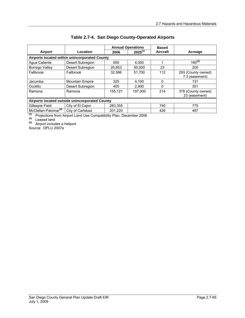
2.7 Hazards and Hazardous Materials
San Diego County General Plan Update Draft EIR Page 2.7-65 July 1, 2009
Table 2.7-4. San Diego County-Operated Airports
Annual Operations Airport Location 2006 2025(1)
Based Aircraft Acreage
Airports located within unincorporated County Agua Caliente Desert Subregion 650 4,000 1 160(2) Borrego Valley Desert Subregion 20,853 50,000 23 200 Fallbrook Fallbrook 32,586 51,700 112 293 (County owned)
7.3 (easement) Jacumba Mountain Empire 325 4,100 0 131 Ocotillo Desert Subregion 405 2,900 0 351 Ramona Ramona 155,121 197,000 214 378 (County owned)
23 (easement) Airports located outside unincorporated County Gillespie Field City of El Cajon 283,355 740 775 McClellan-Palomar(3) City of Carlsbad 201,220 426 487 (1) Projections from Airport Land Use Compatibility Plan, December 2006 (2) Leased land (3) Airport includes a heliport Source: DPLU 2007e

2.7 Hazards and Hazardous Materials
San Diego County General Plan Update Draft EIR Page 2.7-66 July 1, 2009
Table 2.7-5. Private Airports Located in Unincorporated San Diego County Community Planning Area Airstrip Name (If Any) Acreage Ownership
On the Rocks 6 Private Alpine 2 U.S. Forest Service (USFS)
Bonsall 7 Private Central Mountain 7 Private
4 Federal Bureau of Land Management
10 Private 16 Private 14 Private 4 Private
Desert
Borrego Air Ranch 11 Private Jamul/Dulzura Klein Airport 4 Private Julian Hunt’s Sky Ranch 4 Private
4 Private 2 Private Mountain Empire
7 Private Lake Wohlford 4 City of San Diego Lake Wohlford 4 Private North County Metro
5 Private 22 Private 5 Private 13 Private 8 Private 5 Private Warner Springs Airport 99 Private
North Mountain
Ward Airport 1 Private 15 City of San Diego Otay 41 City of San Diego Pauma Air Park 45 Private Pauma Air Park 7 Private Pala/Pauma
Lyall-Roberts Airport 3 Private 3 Private Pendleton/De Luz 9 USFS
Ramona Flying T Ranch 4 Private Valley Center Blackinton Airpark 7 Private Note: Data has been rounded to nearest whole number. Source: DPLU 2007e

2.7 Hazards and Hazardous Materials
San Diego County General Plan Update Draft EIR Page 2.7-67 July 1, 2009
Table 2.7-6. Safety Zone Aircraft Accident Risk Characteristics
Zone Description
Nominal Dimensions (California Airport Land
Use Planning Handbook) Relative
Risk Level Nature of Accident Risk
Percent of Accidents in Zone
(Handbook database)
1 Runway Protection Zone (RPZ) primarily located on airport property and airport ownership is encouraged)
May depend upon approach visibility minimums 1,200 feet minimum and 2,700 feet maximum beyond runway ends; 125 to 500 feet from centerline adjacent to runway Acreage (one runway end): 8 to 79 (RPZ only)
Very High Landing undershoots and overshoots Overruns on aborted takeoffs Loss of control on takeoff
Arrivals: 28%–56% Departures: 23%–29% Total: 33%–39%
2 Inner Safety Zone Along extended runway centerline2,000 feet minimum and 6,000 feet maximum zone area beyond runway ends Acreage (one runway end): 44 to 114.
High Aircraft at low altitude with limited directional options in emergencies Typically under 400 feet on landing On takeoff, engine at maximum stress
Arrivals: 9%–15% Departures: 3%–28% Total: 8%–22%
3 Inner Turning Zone Fan-shaped area adjacent to Zone 2 2,000 feet minimum, 4,000 feet maximum zone area from runway ends Acreage (one runway end): 50 to 151
Moderate Turns at low altitude on arrival for aircraft flying Tight base leg present, stall-spin potential Likely touchdown area if an emergency at low altitude occurs during takeoff, especially to the left of the centerline
Arrivals: 2%–6% Departures: 5%–9% Total: 4%–7%
4 Outer Safety Zone Along extended runway centerline3,500 feet minimum, 10,000 feet maximum beyond runway ends Acreage (one runway end): 35 to 92
Low to Moderate
Low altitude overflight for aircraft on straight-in approaches, especially instrument approaches On departure, aircraft normally completes transition from takeoff power and flap settings to climb mode, and begins turns to en-route heading
Arrivals: 3%–8% Departures: 2%–4% Total: 2%–6%
5 Sideline Zone (Primarily located on airport property)
Adjacent to runway 500 feet minimum, 1,000 feet maximum from centerline Acreage: varies with runway length
Low to Moderate
Low risk on landing Moderate risk from loss of directional control on takeoff, especially with twin-engine aircraft
Arrivals: 1%–3% Departures: 5%–8% Total: 3%–5%
6 Traffic Pattern Zone
Oval area around other zones 5,000 feet minimum, and 10,000 feet maximum beyond runway ends 4,500 feet minimum and 6,000 feet maximum from runway centerline Acreage: varies with runway length
Low Significant percentage of accidents, but spread over wide area Widely varied causes
Arrivals: 10%–21% Departures: 24%–39% Total: 18%–29%
Source: Caltrans 2002b

2.7 Hazards and Hazardous Materials
San Diego County General Plan Update Draft EIR Page 2.7-68 July 1, 2009
Table 2.7-7. Public Airport Safety Zone Compatibility Requirements
Density / Intensity Standards(1) Zone Description Urban Suburban Rural Military
1 Runway Protection Zone (RPZ) (Military: Clear Zone)
No new structures of any kind
Residential: No new dwelling units (du) allowed
Residential: Average lot ≥ 20 acres (ac)
Residential: No new DUs allowed
2 Inner Safety Zone (Military: Accident Potential Zone 1)
Other Uses: Max. 80 people (ppl) per ac (ppl/acre)
Other Uses: Max. 60 ppl/acre
Other Uses: Max. 40 ppl/acre
Other Uses: Max. 25 ppl/acre
Residential: No new single family; Multi-family ≤50 du/ac
Residential: Average lot ≥ 10 ac
Residential: No new DUs allowed
3 Inner Turning Zone (Military: Primary Approach / Departure Zone) Other Uses:
Max. 80 ppl/acre Other Uses: Max. 120 ppl/acre
Other Uses: Max. 100 ppl/acre
Other Uses: Max. 120 ppl/acre
Residential: Aver. 30 du/ac
Residential: Aver. 8 du/ac
Residential: Aver. lot ≥ 5 ac
4 Outer Safety Zone (Military: High Noise Flight Corridor) Other Uses:
Max. 120 ppl/acre Other Uses: Max. 100 ppl/acre
Other Uses: Max. 80 ppl/acre
Not applicable
Residential: No restriction
Residential: No restriction
Residential: Aver. lot ≥ 5 ac
5 Sideline Zone (Military: Flight Corridor Buffer)
Other Uses: No restriction
Other Uses: Max. 200 ppl/acre
Other Uses: Max. 150 ppl/acre
No restriction
6 Traffic Pattern Zone No restriction No restriction No restriction No restriction (1) Density/Intensity Standards are unique to each airport due to site specific compatibility requirements. Source: DPLU 2007e
Table 2.7-8. Land Use Compatibility in Accident Potential Zones Land Use Type APZ 1(1) APZ 2(1) Residential Apartments(2) and Transient Lodging Incompatible Incompatible Assembly Areas: Schools, Churches, Libraries, Auditoriums, Sports Arenas, etc., Preschools, Nurseries, and Restaurants
Incompatible Incompatible
Hospitals, Sanitariums, and Nursing Homes Incompatible Incompatible Offices, Retail Stores(3) 50 or fewer
Persons/Acre Compatible
Wholesale Stores, Manufacturing(3) 50 or fewer Persons/Acre
Compatible
Outdoor Uses: Playgrounds, Neighborhood Parks, Golf Courses, Riding Stables, Public Right of Way
50 or fewer Persons/Acre
Compatible
(1) It is suggested that lot coverage in APZ-1 should be less than 25%; and less than 40% in the APZ-2. (2) Residential land uses include single-family, duplex, mobile homes, and multi-family and retired homes (3) Hazardous materials Source: SANDAG 1990

2.7 Hazards and Hazardous Materials
San Diego County General Plan Update Draft EIR Page 2.7-69 July 1, 2009
Table 2.7-9. Existing Wildland Urban Interface (WUI) Fire Threat in Acreage (Time period: 1/1/2004 to 12/31/2004)
North County WUI acres Backcountry WUI acres
Bonsall 21,036 Central Mountain 14,160 Fallbrook 35,818 Cuyamaca 21,712 North County Metro 29,680 Descanso 20,034 Hidden Meadows 10,130 Pine Valley 49,625 Twin Oaks 8,188 Desert 66,324 Pala/Pauma 58,695 Borrego Springs 30,139 Pendleton/De Luz 151,756 Julian 27,636 Rainbow 9,663 Mountain Empire 24,110 San Dieguito 29,864 Boulevard 39,006 Valley Center 54,362 Jacumba 18,448 Campo/Lake Morena 49,162
East County WUI acres Potrero 18,276
Alpine 60,069 Tecate 3,061 County Islands 323 North Mountain 117,047 Crest/Dehesa 20,193 Palomar Mountain 18,176 Jamul/Dulzura 77,808 Lakeside 41,968 Otay 8,688 Ramona 76,950 Spring Valley 5,035 Sweetwater 7,465 Valle de Oro 9,644 Note: Data has been rounded to nearest whole number. Source: DPLU GIS 2008

2.7 Hazards and Hazardous Materials
San Diego County General Plan Update Draft EIR Page 2.7-70 July 1, 2009
Table 2.7-10. History of Major Wildfires in San Diego County (1996-2007)
Date Name Acres Burned Structures Destroyed Deaths
Poomacha Fire 49,410 217 0 Marine Corps Base Camp Pendleton Fires (Ammo, Wilcox & Horno Fires)
21,004 0 0
Rice Fire 9,472 248 0 Witch Fire 197,990 1,634 2
October 2007
Harris Fire 90,440 548 5 July 2006 Horse Fire 16,700 0 0 July 2004 Mataguay Fire 8,867 4 0
Paradise Fire 57,000 415 2 Cedar Fire 280,278 5,171 14 Otay Fire 46,291 6 0
October 2003
Roblar Fire 8,592 0 0 July 2003 Coyote Fire 18,704 3 0 July 2002 Pines Fire 61,690 45 0 February 2002 Gavilan Fire 6,000 43 0 January 2001 Viejas Fire 10,353 23 0 July 2000 Pechanga Fire 11,733 5 0 September 1999 La Jolla Fire 7,800 2 1 October 1996 Harmony Grove Fire 9,438 54 0 ( - ) indicates information is not available Source: CAL FIRE 2008

2.7 Hazards and Hazardous Materials
San Diego County General Plan Update Draft EIR Page 2.7-71 July 1, 2009
Table 2.7-11. Land Uses within One-Quarter Mile of School Facilities
Land Use Designations(1) Acres Within ¼ mile of a School General Commercial 656 Limited Impact Industrial 34 Medium Impact Industrial 105 Military Installations 577 National Forest and State Parks 221 Neighborhood Commercial 7 Office Professional 77 Open Space (Recreation) 812 Public/Semi-Public Facilities 3,315 Rural Commercial 266 Rural Lands (RL-80) 1,446 Semi-rural Residential (SR-4) 5,594 Specific Plan Area 1,551 Tribal Lands 356 Village Core Mixed Use 230 Village Residential (VR-7.3) 7,947 (1) Land use designations not listed have zero acreage located within ¼ mile of
a school facility Note: Data has been rounded to nearest whole number. Source: DPLU GIS 2008

2.7 Hazards and Hazardous Materials
San Diego County General Plan Update Draft EIR Page 2.7-72 July 1, 2009
Table 2.7-12. Sensitive Receptors within One-Quarter Mile of Sites Pursuant to Government Code 65962.5
Hospitals Residential Parcels(1) Schools
Long-term Residential
Care Facilities Licensed Day Care Facilities
Community Planning Areas Alpine 0 43 0 0 0 County Island 0 104 0 0 0 Desert 0 6 0 0 0 Fallbrook 0 319 1 1 1 Lakeside 0 359 2 0 3 North County Metro 0 318 1 0 0 Ramona 0 23 0 0 0 San Dieguito 0 524 4 0 1 Spring Valley 0 129 0 0 0 Sweetwater 0 42 0 0 0 Valle De Oro 0 102 1 0 0 Valley Center 0 7 0 0 0 Bonsall 0 95 1 0 0 Boulevard 0 4 0 0 0 Campo/Lake Morena 0 6 0 0 0 Jacumba 0 2 0 0 0 Hidden Meadow 0 19 0 0 0 Twin Oaks 0 11 0 0 0 Total 0 2,113 10 1 5 (1) Residential Parcels have been identified as those with an Assessed Improvement Value >=$10,000. While this is
not necessarily indicative of a residential structure on the parcel, this methodology has shown that these parcels do contain something of value and therefore are included in this analysis.
Source: DPLU GIS 2008

2.7 Hazards and Hazardous Materials
San Diego County General Plan Update Draft EIR Page 2.7-73 July 1, 2009
Table 2.7-13. Acreages Proposed Within Wildland Urban Interface (WUI) Areas under the Proposed General Plan Update
North County WUI acres Backcountry WUI acres
Bonsall 17,008 Central Mountain 2,197 Fallbrook 29,178 Cuyamaca 5875 North County Metro 24,028 Descanso 7,148 Hidden Meadows 7,076 Pine Valley 8,290 Twin Oaks 7,871 Desert 12,893 Pala/Pauma 31,997 Borrego Springs 23,787 Pendleton/De Luz 12,264 Julian 20,840 Rainbow 8,772 Mountain Empire 1,101 San Dieguito 15,788 Boulevard 23,608 Valley Center 44,545 Jacumba 8,950 Campo/Lake Morena 23,454
East County WUI acres Potrero 13,243
Alpine 24,466 Tecate 2,325 County Islands 116 North Mountain 45,911 Crest/Dehesa 13,309 Palomar Mountain 6,191 Jamul/Dulzura 43,601 Lakeside 21,993 Otay 128 Ramona 56,483 Spring Valley 2,802 Sweetwater 2,795 Valle de Oro 5,078 Note: Data has been rounded to nearest whole number. Source: DPLU GIS 2008
2.7 Hazards and Hazardous Materials
San Diego County General Plan Update Draft EIR Page 2.7-74 July 1, 2009
This page is intentionally left blank.

UXO/FUDS LOCATIONS FIGURE 2.7-1
Pine Valley
Boulevard
Borrego Springs
Cuyamaca
Palomar Mountain
Potrero
Lake Morena / Campo
Jacumba
Descanso
Tecate
TwinOaks
HiddenMeadows
Desert
North Mountain
Mountain Empire
Central Mountain
Alpine
Ramona
Pendleton/De Luz
Jamul/Dulzura
Pala/Pauma
Otay
Julian
Lakeside
Valley Center
Fallbrook
Bonsall
San Dieguito
Crest/Dehesa
Rainbow
Valle De Oro
NorthCountyMetro
Sweetwater
SpringValley
OR
AN
GE C O U N
TY
PA
CI
FI
C
OC
EA
N
R I V E R S I D E C O U N T Y
IM
PE
RI
AL
CO
UN
TY
ME
XI
CO
C O U N T YS A N D I E G O
SA
ND
IE
GO
CO
UN
TY
56
76
78
94
7879
78
79
76
67
78
52 67
94
125
163
125
905
5
8
5
8
15
15
805
805
0 2 4 6 8 10
Miles
Source: Department of Defense, 2008; County of San Diego, 2008
Legend
Risk Assessment Code (RAC)
1
2
3
4
Military Facilities
Tribal Lands
Community/SubregionalPlanning Areas
Subareas
Incorporated Areas
Freeways
Major Highways
San Diego County WaterAuthority Service Boundary
Rivers
Lakes/Reservoirs
Risk Assessment Code: The cumulative scoreof both the Hazard Probability and the HazardSeverity scores. Sites are ranked on a one tofour scale, one being the most at risk.

LOCATION OF ACTIVE LANDFILLS, INACTIVE LANDFILLS AND BURNSITES WITHIN THE COUNTY FIGURE 2.7-2
Pine Valley
Boulevard
Borrego Springs
Cuyamaca
Palomar Mountain
Potrero
Lake Morena / Campo
Jacumba
Descanso
Tecate
TwinOaks
HiddenMeadows
Desert
North Mountain
Mountain Empire
Central Mountain
Alpine
Ramona
Pendleton/De Luz
Jamul/Dulzura
Pala/Pauma
Otay
Julian
Lakeside
Valley Center
Fallbrook
Bonsall
San Dieguito
Crest/Dehesa
Rainbow
Valle De Oro
NorthCountyMetro
Sweetwater
SpringValley
OR
AN
GE C O U N
TY
PA
CI
FI
C
OC
EA
N
R I V E R S I D E C O U N T Y
IM
PE
RI
AL
CO
UN
TY
ME
XI
CO
C O U N T YS A N D I E G O
SA
ND
IE
GO
CO
UN
TY
56
76
78
94
7879
78
79
76
67
52
78
67
94
125
163
125
905
5
8
5
8
15
15
805
805
Otay
Ramona
Miramar
Borrego
Sycamore
Las Pulgus
San Onofre
Vista
Jamul
Campo
La Mesa
N Street
Lakeside
Julian I
Descanso
Bayscene
Alpine I
Julian II
Jacumba I
Encinitas
Alpine II
Shinohara I
Pine Valley
Solana Beach
Shinohara II
Mount Laguna
Lake Henshaw
Fallbrook 1CFallbrook 1B
Fallbrook 1A
Jacumba Street
Palomar Mountain
Butterfield Ranch
San Pasqual Academy
Warner Springs Ranch
Escondido I (mayhew)
Escondido II (Benton)
Carlsbad I (Andrews Ct)
Ramona Dump and burn site
Oak Grove/Sunshine Summit
Carlsbad II (Waterbury /Elm)
Vulcan Carroll Canyon Inert Landfill
Risk Assessment Code: The cumulative scoreof both the Hazard Probability and the HazardSeverity scores. Sites are ranked on a one tofour scale, one being the most at risk.
0 2 4 6 8 10
Miles
Source: County of San Diego DEH, 2008; County of San Diego DPLU, 2008
Legend
Active Landfill
Closed Landfill
Burnsites
Community/SubregionalPlanning Areas
Subareas
Incorporated Areas
Freeways
Major Highways
San Diego County WaterAuthority Service Boundary
Rivers
Lakes/Reservoirs
Historic burnsites information is fromDepartment ofEnvironmental HealthLocal Enforcement Agency (LEA)

Pine Valley
Boulevard
Borrego Springs
Cuyamaca
Palomar Mountain
Potrero
Lake Morena / Campo
Jacumba
Descanso
Tecate
TwinOaks
HiddenMeadows
Desert
North Mountain
Mountain Empire
Central Mountain
Alpine
Ramona
Pendleton/De Luz
Jamul/Dulzura
Pala/Pauma
Otay
Julian
Lakeside
Valley Center
Fallbrook
Bonsall
San Dieguito
Crest/Dehesa
Rainbow
Valle De Oro
NorthCountyMetro
Sweetwater
SpringValley
OR
AN
GE C O U N
TY
PA
CI
FI
C
OC
EA
N
R I V E R S I D E C O U N T Y
IM
PE
RI
AL
CO
UN
TY
ME
XI
CO
C O U N T YS A N D I E G O
SA
ND
IE
GO
CO
UN
TY
Pauma Valley Air Park
56
76
78
94
7879
78
79
76
67
78
52 67
94
125
163
125
905
5
8
5
8
15
15
805
805
Ramona
HoffmanOcotillo
Ward Ranch
Blackinton
Brown Field
MCAS Miramar
Reider Ranch
Lyall-Roberts
Lake Wohlford
Flying T Ranch
Borrego Valley
Special Use BLM
Special Use BLM
Lindbergh Field
Jacumba Airport
Gillespie Field
Montgomery Field
Hunt's Sky Ranch
McClellan-Palomar
Loma Madera RanchBorrego Air Ranch
MCAS Camp Penelton
Oceanside Municipal
John Nichol's Field
Warner Springs Airport
Agua Caliente Airstrip
Torrey Pines Glider Port
Barona Indian Reservation
Fallbrook Community Airpark
Rancho Vallecito - State Parks
On the Rocks - U.S. Forest Service
MILITARY, PUBLIC AND PRIVATE AIRPORTS FIGURE 2.7-3
0 2 4 6 8 10
Miles
Legend
Public Airports
San Diego County Owned
Other
Military
Military Airport
Independent
Personnal Use
Special Use (No FAA Number)
Heliport
Community/SubregionalPlanning Areas
Subareas
Incorporated Areas
Freeways
Major Highways
San Diego County WaterAuthority Service Boundary
Rivers
Lakes/Reservoirs
Source: County of San Diego DPLU, 2008

TYPICAL LAYOUT OF AIRPORT SAFETY ZONES FIGURE 2.7-4
SOURCE: San Diego County Airport Land Use Commission, 2006
LEGEND
1
2
3
4
5
6
Runway Protection Zone
Inner Safety Zone
Inner Turning Zone
Outer Safety Zone
Sideline Zone
Traffic Pattern Zone
No Scale
Runway
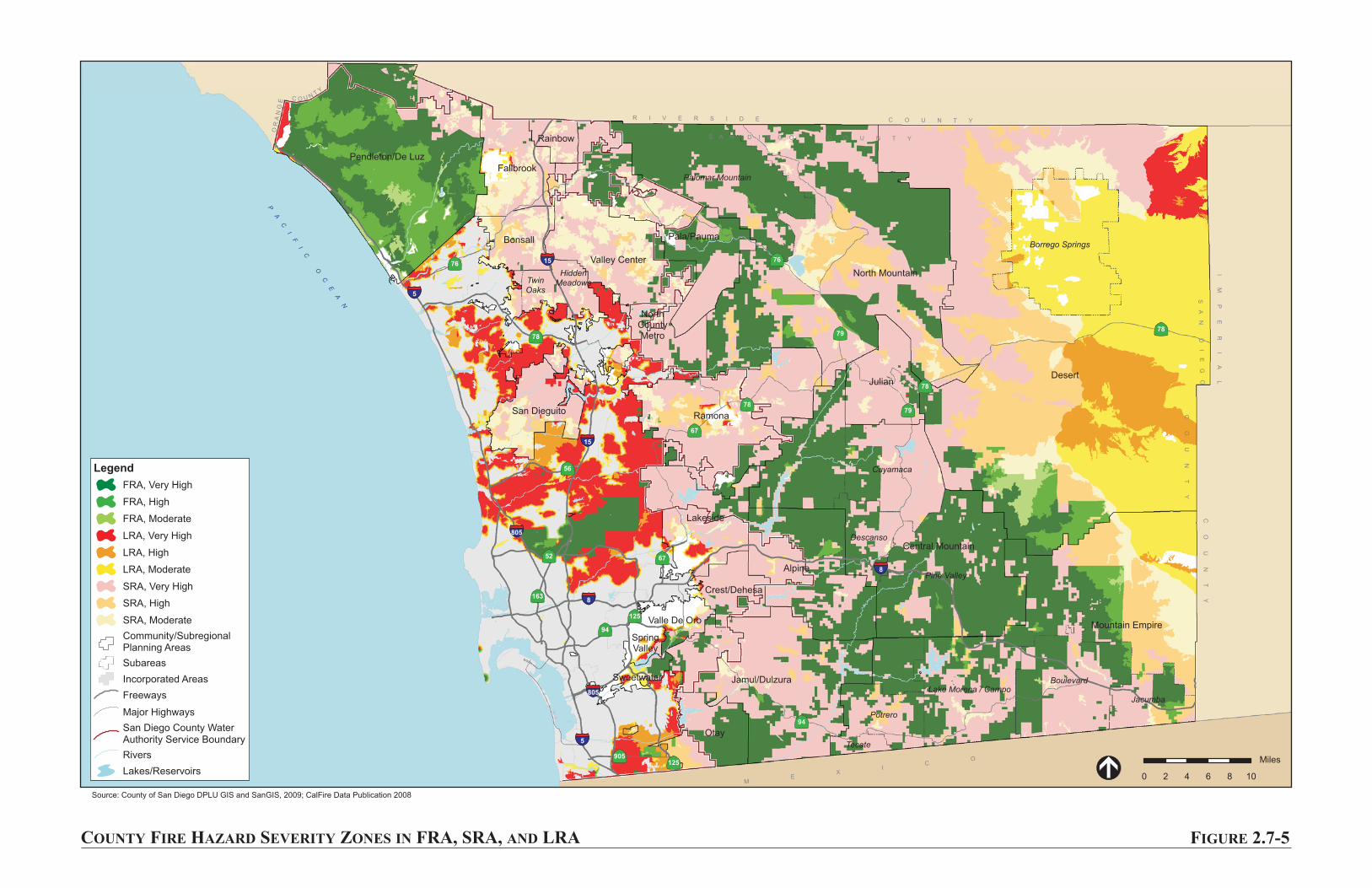
COUNTY FIRE HAZARD SEVERITY ZONES IN FRA, SRA, AND LRA FIGURE 2.7-5
Pine Valley
Boulevard
Borrego Springs
Cuyamaca
Palomar Mountain
Potrero
Lake Morena / Campo
Jacumba
Descanso
Tecate
TwinOaks
HiddenMeadows
Desert
North Mountain
Mountain Empire
Central Mountain
Alpine
Ramona
Pendleton/De Luz
Jamul/Dulzura
Pala/Pauma
Otay
Julian
Lakeside
Valley Center
Fallbrook
Bonsall
San Dieguito
Crest/Dehesa
Rainbow
Valle De Oro
NorthCountyMetro
Sweetwater
SpringValley
OR
AN
GE C O U N
TY
PA
CI
FI
C
OC
EA
N
R I V E R S I D E C O U N T Y
IM
PE
RI
AL
CO
UN
TY
ME
XI
CO
C O U N T YS A N D I E G O
SA
ND
IE
GO
CO
UN
TY
56
76
78
94
7879
78
79
76
67
78
52 67
94
125
163
125
905
5
8
5
8
15
15
805
805
0 2 4 6 8 10
Miles
Source: County of San Diego DPLU GIS and SanGIS, 2009; CalFire Data Publication 2008
Legend
FRA, Very High
FRA, High
FRA, Moderate
LRA, Very High
LRA, High
LRA, Moderate
SRA, Very High
SRA, High
SRA, Moderate
Community/SubregionalPlanning Areas
Subareas
Incorporated Areas
Freeways
Major Highways
San Diego County WaterAuthority Service Boundary
Rivers
Lakes/Reservoirs

WILDLAND / URBAN INTERFACE AREAS FIGURE 2.7-6
Pine Valley
Boulevard
Borrego Springs
Cuyamaca
Palomar Mountain
Potrero
Lake Morena / Campo
Jacumba
Descanso
Tecate
TwinOaks
HiddenMeadows
Desert
North Mountain
Mountain Empire
Central Mountain
Alpine
Ramona
Pendleton/De Luz
Jamul/Dulzura
Pala/Pauma
Otay
Julian
Lakeside
Valley Center
Fallbrook
Bonsall
San Dieguito
Crest/Dehesa
Rainbow
Valle De Oro
NorthCountyMetro
Sweetwater
SpringValley
OR
AN
GE C O U N
TY
PA
CI
FI
C
OC
EA
N
R I V E R S I D E C O U N T Y
IM
PE
RI
AL
CO
UN
TY
ME
XI
CO
C O U N T YS A N D I E G O
SA
ND
IE
GO
CO
UN
TY
56
76
78
94
7879
78
79
76
67
78
52 67
94
125
163
125
905
5
8
5
8
15
15
805
805
0 2 4 6 8 10
Miles
Source: County of San Diego DPLU GIS and SanGIS, 2008; CalFire Data Publication 2003
Legend
Wildland Urban Interface
Community/SubregionalPlanning Areas
Subareas
Incorporated Areas
Freeways
Major Highways
San Diego County WaterAuthority Service Boundary
Rivers
Lakes/Reservoirs
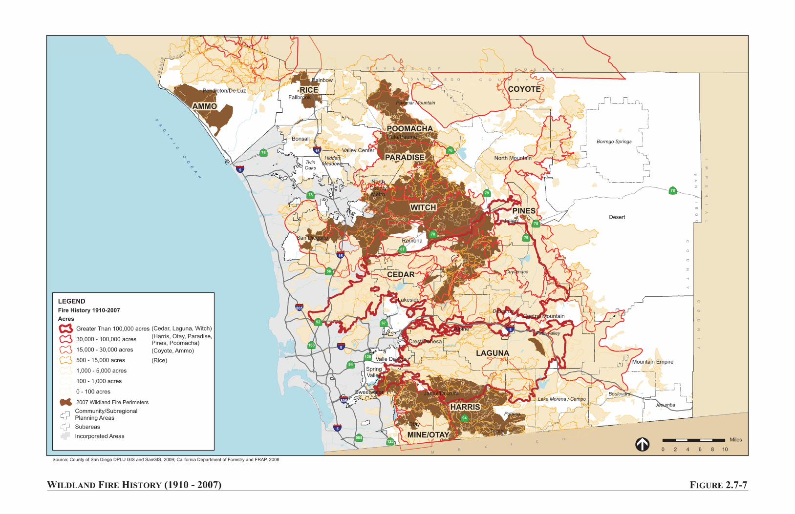
WILDLAND FIRE HISTORY (1910 - 2007) FIGURE 2.7-7
Pine Valley
Boulevard
Borrego Springs
Cuyamaca
Palomar Mountain
Potrero
Lake Morena / Campo
Jacumba
Descanso
Tecate
TwinOaks
HiddenMeadows
Desert
North Mountain
Mountain Empire
Central Mountain
Alpine
Ramona
Pendleton/De Luz
Jamul/Dulzura
Pala/Pauma
Otay
Julian
Lakeside
Valley Center
Fallbrook
Bonsall
San Dieguito
Crest/Dehesa
Rainbow
Valle De Oro
NorthCountyMetro
Sweetwater
SpringValley
OR
AN
GE C O U N
TY
PA
CI
FI
C
OC
EA
N
R I V E R S I D E C O U N T Y
IM
PE
RI
AL
CO
UN
TY
ME
XI
CO
C O U N T YS A N D I E G O
SA
ND
IE
GO
CO
UN
TY
COYOTE
CEDAR
WITCH
POOMACHA
AMMO
RICE
PARADISE
PINES
HARRIS
LAGUNA
MINE/OTAY
56
76
78
94
7879
78
79
76
67
78
52 67
94
125
163
125
905
5
8
5
8
15
15
805
805
0 2 4 6 8 10
Miles
Source: County of San Diego DPLU GIS and SanGIS, 2009; California Department of Forestry and FRAP, 2008
Community/SubregionalPlanning Areas
Subareas
Incorporated Areas
LEGEND
Fire History 1910-2007
Acres
Greater Than 100,000 acres
30,000 - 100,000 acres
15,000 - 30,000 acres
500 - 15,000 acres
1,000 - 5,000 acres
100 - 1,000 acres
0 - 100 acres
2007 Wildland Fire Perimeters
(Cedar, Laguna, Witch)
(Harris, Otay, Paradise,Pines, Poomacha)
(Coyote, Ammo)
(Rice)