5.8 hazards and hazardous materials - co.shasta.ca.us · to hazards and hazardous materials is...
TRANSCRIPT

TIERRA ROBLES PLANNED DEVELOPMENT ZONE AMENDMENT 10-002
TRACT MAP 1996 SCH NO. 2012102051
DRAFT ▪ OCTOBER 2017 5.8-1 HAZARDS AND HAZARDOUS MATERIALS
5.8 HAZARDS AND HAZARDOUS MATERIALS The purpose of this section is to identify, to the extent feasible, the potential for hazards associated with historic and current site uses, surrounding sites, and recognized environmental conditions in connection with the proposed project site and to identify potential risks to human health, including uses of the proposed project site, workers, and construction workers. Information in this section focuses on the potential for the proposed projects to create a significant hazard to the public or the environment through the use, transport, disposal or accidental release of hazardous materials. This section also addresses hazards associated with wildfires. The following analysis of the potential environmental impacts related to hazards and hazardous materials is primarily derived from the following sources:
• California Department of Forestry and Fire Protection. State Responsibility Areas. November 2007.
• Shasta County. Shasta County General Plan. September 2004.
• Shasta County. Shasta County and City of Anderson Multi-Jurisdictional Hazard Mitigation Plan. September 2011.
• Wildlands Resource Managers. Tierra Robles Wildland Fuel/Vegetation Management Plan. July 2015.
5.8.1 ENVIRONMENTAL SETTING The proposed project encompasses approximately 715.4 acres and is currently undeveloped vacant land. A single wood and wire corral, some interior fences, and a network of dirt ranch roads crisscross the proposed project site. Onsite topography is characterized as level to rolling terrain in the western portion of the proposed project site, and steeper slopes and ridges are located in the eastern portion of the property, with elevations ranging from approximately 600 feet above mean sea level (msl) to 650 feet above msl. Soils at the project site are typically described as gravelly loams with low productivity. Soils series for individual soil types within the project boundaries are typically related to slope (Red Bluff gravelly loams on gentle slopes, Newton gravelly loams on intermediate slopes, Inks-Petz complex on steeper slopes). These soils are typically associated with low permeability due to the presence of pedogenic clay accumulation in the shallow subsurface. These soil types are not noted for significant erosion potential.
The proposed project site is dissected by three major drainage systems including Clough Creek, which flows southwest across the northwest corner of the property, an unnamed stream that flows south across the east central portion of the project site, and a major unnamed drainage that flows from north to southeast across the eastern side of the project site. In addition, there are two small streams with attached tributaries which drain the central portion of the project site. The upland areas of the site have a vegetative composition that is dominated by blue oaks with scattered gray pine over an annual grassland understory. Tree canopy cover ranges from 10 percent to 50 percent with the majority of the trees being greater that six-inch diameter at breast height (dbh). Annual grasses and forbs comprise the understory with patches of manzanita, coffee berry, and poison oak being the predominant shrubs. Some occurrences of live oak are also found within the steeper draws of the drainage in the northeast corner of the property. Currently, the project site is vacant, but has been used for ranching and grazing cattle activities in the past.

TIERRA ROBLES PLANNED DEVELOPMENT ZONE AMENDMENT 10-002
TRACT MAP 1996 SCH NO. 2012102051
DRAFT ▪ OCTOBER 2017 5.8-2 HAZARDS AND HAZARDOUS MATERIALS
WILDFIRE HAZARD SEVERITY ZONES California law requires CAL FIRE to identify areas based on the severity of fire hazard that is expected to prevail in the site location. These areas, or "zones," are based on factors such as fuel (material that can burn), slope and fire weather. There are three zones, based on increasing fire hazard...medium, high and very high. Classification of a zone as moderate, high or very high fire hazard is based on a combination of how a fire will behave and the probability of flames and embers threatening buildings. Each area of the Fire Hazard Severity Zones Map gets a score for flame length, embers, and the likelihood of the area burning. Scores are then averaged over the zone areas. Final zone class (moderate, high and very high) is based on the average scores for the zone. Fire Hazard Severity Zones are found in areas where the state has financial responsibility for fire protection, called State Responsibility Areas. More than 31 million acres are in the project area. Very High Fire Hazard Severity Zones are found throughout Shasta County and neighboring counties as well. The zones serve several purposes. For instance, they are used to designate areas where exterior wildfire exposure protection building codes apply to new buildings. Local governments must also consider fire hazard severity in the safety element of their general plans. As shown in Figure 5.8-1, VERY HIGH FIRE SEVERITY ZONE, the project site is located within a State Responsibility Area and the entire site is located within the Very High Fire Hazard Severity Zone. Fire protection services for the project area are provided by CAL FIRE, based in the Redding area. The Shasta County Fire Department (SCFD) contracts with the California Department of Forestry and Fire Protection (CAL FIRE) to manage and oversee the operation of SCFD. The SCFD/CAL FIRE maintains automatic and mutual aid agreements with adjacent fire districts, including the City of Redding Fire Department.
ONSITE WILDFRE HAZARDS A wildfire is an uncontrolled fire spreading through vegetative fuels, exposing and possibly consuming structures‖ and may originate from a variety of ignition sources.1 Three different types of wildfires exist. A “surface fire” is the most common type and burns along the floor of a forest, moving slowly and killing or damaging trees. A “ground fire” is usually started by lightning and burns on or below the forest floor in the organic layer down to the mineral soil. “Crown fires” spread rapidly by wind and move quickly by jumping along the tops of trees.
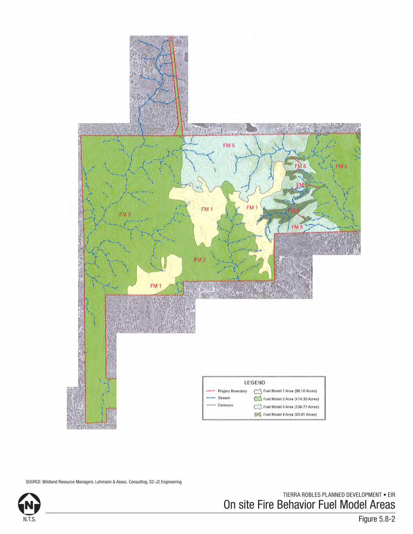
There are four principal vegetative communities on the proposed project site: 1) annual grassland, 2) blue oak woodlands, 3) blue oak/interior live oak/gray pine and 4) interior live oak/shrub. To understand the threat of fire in various vegetative communities the United States Department of Agriculture (USDA) has developed fire behavior models based on fire danger ratings for each vegetative type. These vegetation communities and the applicable fire behavior model are shown on Figure 5.8-2, ONSITE FIRE BEHAVIOR FUEL MODEL AREAS, and are described below.
• Annual Grasslands – Fire Behavior Fuel Model 1. Fire spread is governed by the fine, very
porous, and continuous herbaceous fuels that have cured or are nearly cured. Fires are surface fires that move rapidly through the cured grass and associated material. Very little shrub or timber is present, generally less than one‐third of the area.
1 Shasta County Multi-Jurisdictional Hazard Mitigation Plan, Section 4.3.2, page 4-28. 2011.

N.T.S.
TIERRA ROBLES PLANNED DEVELOPMENT • EIR
Figure 5.8-1
Very High Fire Severity Zone
PROJECT SITE
TIERRA ROBLES PLANNED DEVELOPMENT • EIR
N.T.S. Figure 5.8-2
On site Fire Behavior Fuel Model Areas
SOURCE: Wildland Resource Managers, Lehmann & Assoc. Consulting, S2-J2 Engineering
TIERRA ROBLES PLANNED DEVELOPMENT ZONE AMENDMENT 10-002
TRACT MAP 1996 SCH NO. 2012102051
DRAFT ▪ OCTOBER 2017 5.8-5 HAZARDS AND HAZARDOUS MATERIALS
• Blue Oak Woodlands – Fire Behavior Fuel Model 2. Fire spread is primarily through the fine herbaceous fuels, either curing or dead. These are surface fires where the herbaceous material, in addition to litter and dead‐down stem wood from the open shrub or timber overstory, contribute to the fire intensity. Open shrub lands and oak/pine stands that cover one‐third to two‐thirds of the area may generally fit this model. Such stands may include clumps of fuels that generate higher intensities and that may produce firebrands.
• Blue Oak/Interior Live Oak/Gray Pine – Fire Behavior Fuel Model 5. Fire is generally carried in the surface fuels that are made up of litter cast by the shrubs and the grasses or forbs in the understory. The fires are generally not very intense because surface fuels loads are light, the shrubs are young with little dead material, and the foliage contains little volatile material.
• Interior Live Oak ~ Fire Behavior Fuel Model 6. Fires carry through the shrub layer where the foliage is more flammable than fuel model 5, but this requires moderate winds, greater than 8 mi/h at mid‐flame height. Fire will drop to the ground at low wind speeds or at openings in the stand. The shrubs are older but not as tall as shrub types of model 4, nor do they contain as much fuel as model 4.
Late spring through mid‐fall are known as the “fire season” in the north state due to the lack of moisture and dry fuel conditions. These factors coupled with the vegetation found on the project site contribute to a high risk of fire.
5.8.3 REGULATORY SETTING A hazardous material is a substance or combination of substances which, because of its quantity, concentration, or physical, chemical, or infectious characteristics, may either (1) cause or significantly contribute to an increase in mortality or an increase in serious, irreversible, or incapacitating irreversible illness; or (2) pose a substantial present or potential hazard to human health and safety, or the environment when improperly treated, stored, transported, or disposed of. (22 CCR 5 662.60.10.)
Hazardous waste is the subset of hazardous materials that has been abandoned, discarded, or recycled and is not properly contained, including contaminated soil or groundwater with concentrations of chemicals, infectious agents, or toxic elements sufficiently high to increase human mortality or to destroy the ecological environment. If a hazardous material is spilled and cannot be effectively picked up and used as a product, it is considered to be hazardous waste. If a hazardous material site is unused, and it is obvious there is no realistic intent to use the material, it is also considered to be a hazardous waste. Examples of hazardous materials include flammable and combustible materials, corrosives, explosives, oxidizers, poisons, materials that react violently with water, radioactive materials, and chemicals. Various federal and state agencies exercise regulatory authority over the use, generation, transport, and disposal of hazardous substances. The primary federal agencies that are responsible for overseeing regulations and policies regarding hazardous materials are the Environmental Protection Agency (USEPA), Department of Labor Occupational Safety and Health Administration (OSHA), and the Department of Transportation (DOT). The primary California state agency with similar authority and responsibility is the California Environmental Protection Agency (Cal-EPA), which may delegate enforcement authority to other local agencies with which it has agreements.

TIERRA ROBLES PLANNED DEVELOPMENT ZONE AMENDMENT 10-002
TRACT MAP 1996 SCH NO. 2012102051
DRAFT ▪ OCTOBER 2017 5.8-6 HAZARDS AND HAZARDOUS MATERIALS
Several laws governing the transport, storage, and use of hazardous materials are governed by these agencies as well as oversight for contaminated sites cleanup. Federal laws and regulations, as well as specific legislation and policies, related to hazards and hazardous materials are summarized below.
FEDERAL Code of Federal Regulations
Federal regulations applicable to hazardous substances are contained primarily in the Code of Federal Regulations (CFR) Titles 29 (Labor), 40 (Protection of Environment), and 49 (Transportation). The applicable CFR titles include standards and provisions for the protection of workers, the natural and environment, and the general public from the effects associated with the use, storage, and transport of hazardous materials.
Resource Conservation and Recovery Act
The 1976 Federal Resource Conservation and Recovery Act (RCRA) and the 1984 RCRA Amendments regulate the treatment, storage, and disposal of hazardous and non-hazardous wastes. The legislation mandated that hazardous wastes be tracked from the point of generation to their ultimate fate in the environment. This includes detailed tracking of hazardous materials during transport and permitting of hazardous material handling facilities. The 1984 RCRA amendments provided the framework for a regulatory program designed to prevent releases from underground storage tanks (USTs). The program establishes tank and leak detection standards, including spill and overflow protection devices for new tanks. The tanks must also meet performance standards to ensure that the stored material will not corrode the tanks. Owners and operators of USTs had until December 1998 to meet the new tank standards. As of 2001, an estimated 85 percent of USTs were in compliance with the required standards.
Comprehensive Environmental Response, Compensation, and Liability Act
The Comprehensive Environmental Response, Compensation, and Liability Act of 1980 (CERCLA) introduced active federal involvement to emergency response, site remediation, and spill prevention, most notably the Superfund program. CERCLA was intended to be comprehensive in encompassing both the prevention of, and response to, uncontrolled hazardous substances releases. CERCLA deals with environmental response, providing mechanisms for reacting to emergencies and to chronic hazardous material releases. In addition to establishing procedures to prevent and remedy problems, it establishes a system for compensating appropriate individuals and assigning appropriate liability. It is designed to plan for and respond to failure in other regulatory programs and to remedy problems resulting from action taken before the era of comprehensive regulatory protection.
STATE The primary state agencies that are responsible for overseeing regulations and policies regarding hazardous materials are the California Office of Emergency Services (OES), California Environmental Protection Agency (Cal-EPA), CalRecycle (formerly the California Integrated Waste Management Board (IWMB), Department of Toxic Substances Control (DTSC), California Department of Transportation (Caltrans), California Highway Patrol (CHP), California Regional Water Quality Control Boards (RWQCB), and the California Air Resources Board (CARB). Several laws governing the generation, transport, and

TIERRA ROBLES PLANNED DEVELOPMENT ZONE AMENDMENT 10-002
TRACT MAP 1996 SCH NO. 2012102051
DRAFT ▪ OCTOBER 2017 5.8-7 HAZARDS AND HAZARDOUS MATERIALS
disposal of hazardous materials are administered by these agencies. State laws and regulations that are applicable to hazards and hazardous materials are presented below.
Hazardous Materials Management
The California Environmental Protection Agency (Cal-EPA) has established regulations governing the use of hazardous materials in the state. Within Cal-EPA, the Department of Toxic Substance Control (DTSC) has primary hazardous materials regulatory responsibility, but can delegate enforcement responsibilities to local jurisdictions that enter into agreements with DTSC, for the generation, transport, and disposal of hazardous materials under the authority of the Hazardous Waste Control Law (HWCL). State regulations applicable to hazardous materials are contained primarily in Title 22 of the CCR. Title 26 of the CCR is a compilation of those chapters or titles of the CCR that are applicable to hazardous materials management. Also within the "umbrella" of Cal-EPA, CalRecycle (formerly the California Integrated Waste Management Board (IWMB)) is responsible for protecting the public's health and safety and the environment through management of the solid waste generated in California. Solid waste regulations are generally enforced through local enforcement agencies (usually county agencies). CalRecycle works in partnership with local government, industry, and the public to reduce waste disposal and ensure environmentally safe landfills. Solid waste management provisions are outlined in the Public Resources Code (PRC), Division 30.
The California Highway Patrol (CHP) and the California Department of Transportation (Caltrans) are the enforcement agencies for hazardous materials transportation regulations. The California Department of Industrial Relations, Division of Occupational Safety and Health Administration (Cal/OSHA) standards are more stringent than federal OSHA regulations. Cal/OSHA assumes primary responsibility for developing and enforcing workplace safety regulations in Title 8 of the CCR. The California Office of Emergency Services (Cal/OES) is the state office responsible for establishing emergency response and spill notification plans related to hazardous materials accidents. In addition, Cal/OES regulates businesses by requiring specific businesses to prepare an inventory of hazardous materials, and to prepare risk management plans through the California Accidental Release Prevention Program (Title 19 of the CCR). The Regional Water Quality Control Boards (RWQCB) regulate surface and groundwater quality according to the provisions of the California Porter-Cologne Water Quality Act, the Toxic Pits Cleanup Act, Underground Tank Law, and federal Clean Water Act. Generally, all petroleum-related sites are handled by the RWQCBs and all underground tank sites are managed by County environmental management agencies. The project site is located within the jurisdiction of the Central Valley RWQCB (Region 5). The RWQCB can delegate responsibilities, such as underground tank permitting and monitoring, to local jurisdictions, such as Shasta County.
Unified Hazardous Waste and Hazardous Materials Management Regulatory Program
In January 1996, Cal-EPA adopted regulations implementing a "Unified Hazardous Waste and Hazardous Materials Management Regulatory Program" (Unified Program). The six elements of the Unified Program are as follows: 1) hazardous waste generators and hazardous waste on-site treatment; 2) underground storage tanks; 3) above-ground storage tanks; 4) hazardous material release response plans and inventories 5) risk management and prevention programs; and 6) Unified Fire Code hazardous materials management plans and inventories. The Unified Program is implemented at the local level by a local agency — the Certified Unified Program Agency (CUPA). The CUPA is responsible for consolidating the

TIERRA ROBLES PLANNED DEVELOPMENT ZONE AMENDMENT 10-002
TRACT MAP 1996 SCH NO. 2012102051
DRAFT ▪ OCTOBER 2017 5.8-8 HAZARDS AND HAZARDOUS MATERIALS
administration of the six program elements within its jurisdiction. The Shasta County Environmental Health Division (SCEHD) is the designated CUPA in the County.
Emergency Response to Hazardous Materials Incidents
To coordinate emergency services provided by local, state, and federal agencies, California has developed an Emergency Response Plan pursuant to the Emergency Services Act. The Plan is administered by the state Office of Emergency Services. Local agencies are required to develop area plans for an organized response to releases of hazardous materials that are dependent on Business Plans submitted by handlers of hazardous materials and waste within that agency's area. Pursuant to California Health and Safety Code, Section 25503(a) and CCR Section 2729, any business handling hazardous material must establish and implement a Hazardous Materials Business Plan. These Business Plans are then submitted to the local administering agency. In the County, the administering agency is SCEHD.
California Health and Safety Code
Cal-EPA has established rules governing the use of hazardous materials and the management of hazardous wastes. Many of these regulations are embodied in the California Health and Safety Code. The code includes regulations that govern safe drinking water, substances control, land reuse and revitalization, remediation, restoration, and methamphetamine contaminated cleanups.
California Code of Regulations Title 22 and Title 26
The California Code of Regulations (CCR) Title 22 provides state regulations for hazardous materials, and CCR Title 26 provides regulation of hazardous materials management. In 1996, Cal/EPA established the "Unified Hazardous Waste and Hazardous Materials Management Regulatory Program" (Unified Program) which consolidated the six administrative components of hazardous waste and materials into one program.
California Building Code
The 2016 California Building Standards Code (known as the California Building Code or CBC) includes requirements of the Office of the State Fire Marshal for the promotion of fire and life safety. The CBC is currently undergoing changes as part of the 2018 Triennial Code Adoption Cycle, but this review and subsequent updated codes are not expected until 2020. The 2016 building codes and standards reduce the risk of burning embers igniting buildings. Codes already in effect place standards on roofing construction and attic venting. The new building codes require siding, exterior doors, decking, windows, eaves wall vents, and enclosed overhanging decks to meet new test standards. The new ignition resistant codes apply to all fire hazard zones in the State Responsibility Area and in Very High Fire Hazard Severity Zones in Local Responsibility Areas. In addition, new building rules require rural homeowners to clear brush and trees 100 feet around their homes and 10 feet on each side of driveways, rather than 30 feet, which was the previous standard. The updated fire hazard severity zones will be used by building officials to determine appropriate construction materials for new buildings in the wildland urban interface. The update zones will also be used by property owners to comply with natural hazards disclosure requirements at time of property sale. It is likely that the fire hazard severity zones will be used by local governments as they update the safety elements of their general plans.

TIERRA ROBLES PLANNED DEVELOPMENT ZONE AMENDMENT 10-002
TRACT MAP 1996 SCH NO. 2012102051
DRAFT ▪ OCTOBER 2017 5.8-9 HAZARDS AND HAZARDOUS MATERIALS
LOCAL
Shasta County Multi-Jurisdictional Hazard Mitigation Plan
The Shasta County Multi-Jurisdictional Hazard Mitigation Plan (SCHMP) includes resources and information to assist in planning for hazards. The plan provides a list of actions that may assist Shasta County and the City of Anderson in reducing risk and preventing loss from future hazard events. The emphasis of the SCHMP is on the assessment and avoidance of identified risks, implementing loss reduction measures for existing exposures, and insuring critical services and facilities survive a disaster. Hazard mitigation strategies and measures avoid losses by limiting new exposures identified in hazard areas, alter the hazard by eliminating or reducing the frequency of occurrence, avert the hazard by redirecting the impact by means of a structure or adapt to the hazard by modifying structures or standards.
Shasta County General Plan
The Public Safety Group, Fire Safety and Sheriff Protection subsection, of the Shasta County General Plan contains policies regarding fire protection and development practices within an identified high risk fire hazard area. These policies are intended to protect persons and structures from fires and ensure that development minimizes the risk of creating fire hazards or defending against those hazards. The following General Plan objectives and policies are applicable to the proposed project:
Section 5.4 – Fire Safety and Sheriff Protection
• Objective FS-I. Protect development from wildland and non-wildland fires by requiring new development projects to incorporate effective site and building design measures commensurate with level of potential risk presented by such a hazard and by discouraging and/or preventing development from locating in high risk fire hazard areas.
• Objective FS-2. Protection of life and property from crime by encouraging new development projects to incorporate effective defensible space design techniques.
o Policy FS-a. Alt new land use projects shall conform to the County Fire Safety Standards.
o Policy FS-b. Known fire hazard information should be reported as part of every General Plan amendment, zone change, use permit, variance, building site approval, and all other land development applications subject to the requirements of the California Environmental Quality Act (CEQA).
o Policy FS-e. Development in areas requiring expanded levels of police and fire services shall participate in adopted County programs designed to offset the added costs for providing the expanded level of services.
The Public Safety Group, Hazardous Materials subsection, of the General Plan contains policies regarding contact and release of hazardous materials. These policies are intended protect persons and property from accidental release of hazardous materials. The following General Plan objectives and policies are applicable to the proposed project:

TIERRA ROBLES PLANNED DEVELOPMENT ZONE AMENDMENT 10-002
TRACT MAP 1996 SCH NO. 2012102051
DRAFT ▪ OCTOBER 2017 5.8-10 HAZARDS AND HAZARDOUS MATERIALS
Section 5.6 – Hazardous Materials
• Objective HM-I. Protection of life and property from contact with hazardous materials through site design and land use regulations and storage and transportation standards.
• Objective HM-2. Protection of life and property in the event of the accidental release of hazardous materials through emergency preparedness planning.
o Policy HM-a. The County shall make every effort to inform applicants for discretionary and
nondiscretionary projects which are located within potential border zone property of known hazardous waste facilities that they must comply with State requirements regarding hazardous waste facilities. A map shall be prepared and maintained which identifies these areas.
5.8.4 STANDARDS OF SIGNIFICANCE
SIGNIFICANCE CRITERIA In accordance with State CEQA Guidelines, the effects of a project are evaluated to determine whether they would result in a significant adverse impact on the environment. An EIR is required to focus on these effects and offer mitigation measures to reduce or avoid any significant impacts that are identified. The criteria used to determine the significance of impacts may vary depending on the nature of the project. According to Appendix G of the State CEQA Guidelines, the proposed project would have a significant impact related to population and housing, if it would:
• Create a significant hazard to the public or the environment through the routine transport, use, or disposal of hazardous materials. Refer to Impact 5.8-1, below.
• Create a significant hazard to the public or the environment through reasonably foreseeable upset and accident conditions involving the release of hazardous materials into the environment. Refer to Impact 5.8-1, below.
• Emit hazardous emissions or handle hazardous or acutely hazardous materials, substances, or waste within one-quarter mile of an existing or proposed school. Refer to AREAS OF NO PROJECT IMPACT, below.
• Be located on a site which is included on a list of hazardous materials sites compiled pursuant to Government Code Section 6596.5 and, as a result, would create a significant hazard to the public or the environment. Refer to AREAS OF NO PROJECT IMPACT, below.
• For a project located within an airport land use plan, or, where such a plan has not been adopted, within two miles of a public airport or public use airport, the project would result in a safety hazard for people residing or working in the project area. Refer to AREAS OF NO PROJECT IMPACT, below.
• For a project within the vicinity of a private airstrip, the project would result in a safety hazard for people residing or working in the project area. Refer to AREAS OF NO PROJECT IMPACT, below.
TIERRA ROBLES PLANNED DEVELOPMENT ZONE AMENDMENT 10-002
TRACT MAP 1996 SCH NO. 2012102051
DRAFT ▪ OCTOBER 2017 5.8-11 HAZARDS AND HAZARDOUS MATERIALS
• Impair implementation of or physically interfere with an adopted emergency response plan or emergency evacuation plan. Refer to Impact 5.8-2, below.
• Expose people or structures to a significant risk of loss, injury, or death involving wildland fires, including where wildlands are adjacent to urbanized areas, or where residences are intermixed with wildlands. Refer to Impact 5.8-3, below.
Based on these standards, the effects of the proposed project have been categorized as either a “less than significant” impact or a “potentially significant” impact. Mitigation measures are recommended for potentially significant impacts. If a potentially significant impact cannot be reduced to a less than significant level through the application of mitigation, it is categorized as a “significant and unavoidable” impact.
AREAS OF NO PROJECT IMPACT In October 2012 and February 2016, the County conducted an Initial Study to determine significant effects of the proposed project. In the course of this evaluation, certain impacts of the proposed project were found to not to be significant because of the inability of a project of this scope to create such impacts or the absence of project characteristics producing effects of this type. The effects determined not to be significant are not required to be included in primary analysis sections of the Draft EIR. As such, the following impacts either are not applicable to the proposed project or are not reasonably foreseeable and are not addressed further within this section (refer to Section 10.0, EFFECTS FOUND NOT TO BE SIGNIFICANT):
• Emit hazardous emissions or handle hazardous or acutely hazardous materials, substances, or waste within one-quarter mile of an existing or proposed school.
• Be located on a site which is included on a list of hazardous materials sites compiled pursuant to Government Code Section 6596.5 and, as a result, would create a significant hazard to the public or the environment.
• For a project located within an airport land use plan, or, where such a plan has not been adopted, within two miles of a public airport or public use airport, the project would result in a safety hazard for people residing or working in the project area.
• For a project within the vicinity of a private airstrip, the project would result in a safety hazard for people residing or working in the project area.
5.8.5 POTENTIAL IMPACTS AND MITIGATION MEASURES
METHODOLOGY Project related information provided by the applicant, as well as Fire Hazard Severity Zones and State Responsibility Areas maps and information available from Shasta County were reviewed. Evaluation of the potential impacts are based on information obtained from CAL FIRE, Shasta County, applicable General Plan objectives and policies, County Codes, and the California Building Code. In accordance with CEQA, the effects of a project are evaluated to determine if they would result in a significant adverse impact on the environment. Hazards and hazardous material impacts are analyzed below according to topic. Mitigation measures directly correspond with an identified impact.
TIERRA ROBLES PLANNED DEVELOPMENT ZONE AMENDMENT 10-002
TRACT MAP 1996 SCH NO. 2012102051
DRAFT ▪ OCTOBER 2017 5.8-12 HAZARDS AND HAZARDOUS MATERIALS
IMPACT 5.8-1
Project construction activities could create a significant hazard to the public through foreseeable upset and accidental conditions or the environment through reasonably foreseeable upset and accident conditions involving the release of hazardous materials into the environment.
Significance: Less Than Significant Impact. Impact Analysis: The following discussion provides an assessment of both short-term (construction) and long-term (operation) impacts related to the potential for hazardous materials to be released into the environment. Short-Term Construction During project construction, there is a possibility of accidental release of hazardous substances, such as spilling petroleum-based fuels used for construction equipment. The level of risk associated with the accidental release of hazardous substances is not considered significant because of the small volume and low concentration of hazardous materials utilized during the construction phases. The project contractor would be required to use standard construction controls and safety procedures that would avoid and minimize the potential for accidental release of such substances into the environment. Standard construction practices would be observed such that any materials released would be appropriately contained and remediated as required by local, State, and federal law. Adherence with federal, State, and local regulations as part of the project development would protect site worker safety and would reduce potential impacts to these workers, and the public in general to a less than significant level. Long-Term Operation Operation of the project would not include the use or transportation of significant amounts of potentially hazardous materials, including fuels or other hazardous liquids. The project would therefore not result in a significant hazard to workers, the public, or the environment through the routine transport, use, or disposal of hazardous materials. Compliance with applicable regulations and hazardous materials plans sufficiently minimizes potential exposure and risk. This is considered a less than significant impact. No mitigation is required. The nature of the proposed project does not present a significant risk related to hazardous materials or emissions. Future onsite uses would include 166 single-family residential units. Therefore, the onsite use and storage of hazardous materials may include typical household substances including cleaning solvents, fuel for lawn equipment, fertilizers, commercial pesticides, and other materials used in the regular operation and maintenance of residential properties. In addition, the onsite waste water treatment plant will use and store chlorine disinfectant and other chemicals to de-chlorinate waste generated waste water. With proper use and disposal, these chemicals will not result in hazardous or unhealthy conditions impacting nearby residents. Future onsite uses would be required to comply with all applicable local, State, and federal regulations and policies regarding hazardous materials. Less than significant impacts are anticipated in this regard. Mitigation Measures: No mitigation measures are required.
TIERRA ROBLES PLANNED DEVELOPMENT ZONE AMENDMENT 10-002
TRACT MAP 1996 SCH NO. 2012102051
DRAFT ▪ OCTOBER 2017 5.8-13 HAZARDS AND HAZARDOUS MATERIALS
Level of Significance After Mitigation: No mitigation measures are required. Impacts would be less than significant.
IMPACT 5.8-2
The proposed project would not impair implementation of or physically interfere with an adopted emergency response plan or emergency evacuation plan.
Significance: Less Than Significant Impact. Impact Analysis: Potential short-term and long-term impacts to emergency response and evacuation routes are discussed below. Refer to Section 5.16, TRAFFIC AND CIRCULATION, for a detailed discussion of traffic operations and mitigation. Short-Term Construction Some traffic delays can be expected during proposed project construction; however, the traffic impacts during construction are temporary in nature and will cease upon completion of construction activities. The proposed project is located in an accessible area with primary access proposed off of Old Alturas Road. Minimum access requirement for emergency vehicles would be maintained at the project site and on surrounding roadways at all times during construction and ongoing operation. Construction activities associated with the proposed project would occur along Old Alturas Road at the future connection with Chatham Ranch Drive. Any construction activities associated with the proposed project would not impede or block emergency access on Old Alturas Road. Impacts would be less than significant. Long-Term Operation The proposed onsite road network consists of 34,545 linear feet (53.73 acres) of paved roadways that vary in widths of 50 feet, 60 feet, and 84 feet in width. Access will be provided by a proposed connection to Old Alturas Road via Chatham Ranch Drive that is consistent with Shasta County Fire Safety Standards, Section 6.11, General Road Design Requirements. As a result, the proposed project would not impair implementation of any emergency response plan or emergency evacuation plan as it would not alter existing roadways, physically interfere with existing roadway patterns, and be constructed in accordance with County Fire Safety Standards. Impacts would be less than significant. Mitigation Measures: No mitigation measures are required. Level of Significance After Mitigation: No mitigation measures are required. Impacts would be less than significant.
IMPACT 5.8-3
Implementation of the proposed project could expose people or structures to a significant risk of loss, injury or death involving wildland fires, including where wildlands are adjacent to urbanized areas or where residences are intermixed with wildlands.
Significance: Potentially Significant Impact.
TIERRA ROBLES PLANNED DEVELOPMENT ZONE AMENDMENT 10-002
TRACT MAP 1996 SCH NO. 2012102051
DRAFT ▪ OCTOBER 2017 5.8-14 HAZARDS AND HAZARDOUS MATERIALS
Impact Analysis: Fire protection services for the project area are provided by CAL FIRE, based in the Redding area. The Shasta County Fire Department (SCFD) contracts with CAL FIRE to manage and oversee the operation of SCFD. The SCFD/CAL FIRE maintains automatic and mutual aid agreements with adjacent fire districts, including the City of Redding Fire Department. Additional information regarding fire protection services is provided in Section 5.13, PUBLIC SERVICES AND FISCAL IMPACTS. Many locations throughout Shasta County, including the proposed project site, are identified as having a very high wildland-fire hazard potential due to an intermixture of urban/rural uses and natural areas with high fuel loads and varied terrain. The presence of urban development adjacent to wildlands increases the likelihood of wildland fires, and the presence of wildlands adjacent to urban development allows fire to spread rapidly to and through developed areas. The Shasta County Multi-Jurisdictional Local Hazard Mitigation Plan (SCHMP) and the Fire Hazard Severity Zones in State Responsibility Areas Map (CAL FIRE, 2007) identifies the proposed project site as being located in a Very High Fire Hazard Severity Zone (VHFHSZ). As a result, development of the proposed project would expose people and structures to a potential risk of loss, injury, or death involving wildland fires. The VHFHSZ includes not only the project site, but the adjacent properties as well. These properties are generally undeveloped with limited residential development, and where residential development does occur the structures are generally surrounded by continuous vegetation and fuels that allow wildland fires to spread rapidly. As mentioned above under Section 5.8.3, REGULATORY SETTING, the Public Safety Group, Fire Safety and Sheriff Protection subsection, of the Shasta County General Plan contains policies regarding fire protection and development practices within an identified high risk fire hazard area. These policies are intended to protect persons and structures from fires and ensure that development minimizes the risk of creating fire hazards or defending against those hazards. The proposed project complies with all applicable goals and policies in the Shasta County General Plan related to urban and wildland fires. The proposed project includes a number of measures to reduce fire hazards. As noted above under Impact 5.8-2, all proposed roadways, driveways, and buildings would be constructed in accordance with the Shasta County Fire Safety Standards. These standards also require the clearing of combustible vegetation around all structures for a distance of not less than 30 feet on each side, or to the property line. The California Public Resources Code 4291 includes a “Defensible Space” requirement of clearing 100 feet around all buildings, or to the property line, whichever is less. Water to the project area will be supplied by Bella Vista Water district and fire hydrants will be placed as specified by California’s State Fire Code. In addition, the applicant has prepared a Wildland-Fuel Vegetation Management Plan (herein referenced as the Tierra Robles Wildland Fuel/Vegetation Management Plan) to address onsite vegetation management in both areas within 100 feet of structures and 10 feet on either side of driveways for clear access for emergency vehicles, and in designated onsite management and open space areas (refer to Resource Management Areas, below). Shasta County Multi-Jurisdictional Local Hazard Mitigation Plan The SCHMP evaluates hazards for a wide array of potential issues within the County. One specific issue identified in the SCHMP is wildland fire. The LHMP states that the area of the proposed project area “is typically grassy woodland with blue oak, valley oak, gray pine, and annual grasses. Significant fires have occurred on the valley floor, especially during north wind events, because the primary fuel is annual
TIERRA ROBLES PLANNED DEVELOPMENT ZONE AMENDMENT 10-002
TRACT MAP 1996 SCH NO. 2012102051
DRAFT ▪ OCTOBER 2017 5.8-15 HAZARDS AND HAZARDOUS MATERIALS
grasses. Each year the fire danger is recurring.”2 As noted in the County’s SCHMP, the proposed project site is located within a VHFHSZ and within the Cow Creek Fuel Reduction Planning Area. The SCHMP identifies several mitigation strategies that the County should implement to reduce losses from future hazard events, including wildland fires. In order to implement the mitigation strategies, a series of hazard mitigation goals were developed for the Cow Creek Watershed. Goal WDF-1 addresses wildland fires and specifically states that it is the County’s desire to promote disaster resistant future development.3 Later in the SCHMP this goal is further defined as a Very High priority action item supported by several implementation strategies, including the following key strategy: “provide a network of fuel breaks and large fuel treatment areas at strategic locations in the watershed, helping to reduce or eliminate the spread of wildlife in the watershed.”4 The provisions of the SCHMP are consistent with the Shasta County General Plan related to mitigation of wildfire hazards and the proposed project is consistent with the Shasta County General Plan objectives and policies noted above. Resource Management Areas In order to comply with the requirements of the CAL FIRE/SCFD, the property was subdivided into five Resource Management Areas (RMA’s). These areas, while not geographically contiguous, represent five distinct and identifiable habitat types where appropriate fire fuel management prescriptions can be implemented based on specific environmental concerns and unique fire hazard conditions within each RMA. The descriptions of each of the five RMA’s and specific vegetation management prescriptions are summarized below. Detailed fuel management prescriptions for each RMA are provided in the Tierra Robles Wildland Fuel/Vegetation Management Plan (refer to Appendix 15.2). In addition, refer to Figure 5.8-3, RESOURCE MANAGEMENT AREAS.
• RMA 1. Primarily located on the high terrace area of the central portion of the project area, RMA 1 is characterized by annual grasses with scattered larger blue oaks with well‐developed crowns. The guidelines state that grasses should be maintained at four inches of height or less and trees should be limbed up to eight feet about ground height. Piled grass cuttings and limbs are permitted to be burned onsite on burn days approved by the Shasta County Fire Department.
• RMA 2. This RMA consists of blue oak woodland with an annual grass understory and occasional grey pines. Tree size varies widely in this area. The management guidelines require standing and declining trees to be retained unless they pose a hazard to the land users. Smaller trees shall be thinned out in accordance with the Tierra Robles Wildland Fuel/Vegetation Management Plan and oaks should be limbed up to eight feet above ground height. Piled grass cuttings and limbs are permitted to be burned onsite on burn days approved by the Shasta County Fire Department. Additionally, shrubs planted on sloped ground shall be planted at spaces no less than twice the height of the shrubs being planted.
• RMA 3. This RMA is characterized by blue oaks with interior live oaks and scattered grey pines. The guidelines for RMA 3 are substantially similar to those of RMA 2 with the addition of the need to retain live oak clumps, the need to remove mid-story brush to a spacing of twice the height of the brush, and the need to remove dead and down brush and limbs.
2 Shasta County Multi-Jurisdictional Hazard Mitigation Plan, page 4-30. 2011. 3 Shasta County Multi-Jurisdictional Hazard Mitigation Plan, page 5-21. 2011. 4 Shasta County Multi-Jurisdictional Hazard Mitigation Plan, page 5-47. 2011.

TIERRA ROBLES PLANNED DEVELOPMENT • EIR
N.T.S. Figure 5.8-3
Resource Management Areas
SOURCE: Wildland Resource Managers, Lehmann & Assoc. Consulting, S2-J2 Engineering

TIERRA ROBLES PLANNED DEVELOPMENT ZONE AMENDMENT 10-002
TRACT MAP 1996 SCH NO. 2012102051
DRAFT ▪ OCTOBER 2017 5.8-17 HAZARDS AND HAZARDOUS MATERIALS
• RMA 4. This RMA is unique among the four RMA’s with building lots in that it has large regions of continuous fuel ladder from the understory to the canopy. The guidelines for RMA 4 incorporate many aspects noted for other RMA’s above, but adjust those guidelines to account for the addition of sloped terrain and increased need to manage the fuel in those areas.
• RMA 5. This RMA has no building envelopes and consists of large tracts of open space land. RMA 5 is not contiguous and exists primarily in two tracts. The first being found in the eastern portion of the property and contains an unnamed drainage that is referred to in these materials as “East Creek”. This section is specifically designated RMA 5-1. The second tract of RMA 5, which is designated RMA 5-2, runs along Clough Creek along the northwestern portion of the property. Together RMA 5-1 and RMA 5-2 constitute over 26% of the total project area. The specific guidelines for the management of this area can be found in the Tierra Robles Wildland Fuel/Vegetation Management Plan (refer to Appendix 15.2). The fuel load in RMA 5-1 will be managed through the use of livestock grazing from January to May of each year. RMA 5-2 will be managed by the TRCSD as per the Tierra Robles Wildland Fuel/Vegetation Management Plan.
• General Management Requirements for All RMA’s. In an effort to comply with California Public Resources Code, Section 4291-4299, the following prescriptions will be required for all RMAs:
o Structures. 30 feet out from every structure remove all dead plants, grass, and weeds.
Remove dead or dry leaves and pine needles from yard, roof and rain gutters. Keep tree branches 10 feet away from chimney and other trees.
o Structures. 30 to 100 feet from every structure cut or mow annual grass sown to a maximum height of 4 inches. Create horizontal spacing between shrubs and trees. Create vertical spacing between grass, shrubs, and trees.
o Vegetation. On flat to mild slopes (0-20%) planted shrubs should be spaced apart 2 times
the height of the shrub (two 2-feet high shrubs planed a minimum of 4-feet apart). The specific methods to ensure compliance with the Tierra Robles Wildland Fuel/Vegetation Management Plan and other fire safety requirements, including applicable Shasta County Fire Standards and California Public Resources Code, Section 4291-4299, will be implemented through MM 5.8-1, below. Annual monitoring and reporting will be the responsibility of the Tierra Robles Community Services District (TRCSD) in a manner approved by the County. Development of the proposed project, in compliance with applicable Shasta County General Plan, reduces the potential for the proposed project to impact adjacent residences from wildfire events, as well as reducing the potential that the proposed project would be significantly damaged from offsite wildfires burning onto the project site. Implementation of MM 5.8-1, including fire fuel prescriptions as contained within the Tierra Robles Wildland Fuel/Vegetation Management Plan, Shasta County Fire Standards, and defensible space requirements pursuant to California Public Resources Code 4291, would reduce impacts associated with wildfire hazards to less than significant levels.
TIERRA ROBLES PLANNED DEVELOPMENT ZONE AMENDMENT 10-002
TRACT MAP 1996 SCH NO. 2012102051
DRAFT ▪ OCTOBER 2017 5.8-18 HAZARDS AND HAZARDOUS MATERIALS
Mitigation Measures: MM 5.8-1: Prior to the issuance of a building permit, all required fuel-reduction work associated with
construction of the onsite roadway network, the wastewater treatment plant and associated infrastructure facilities shall be completed by the project applicant to the satisfaction of the Shasta County Fire Department. Monitoring of fire prescription activities within Resource Management Areas 1 through 4 shall be the sole responsibility of the Tierra Robles Community Services District (TRCSD) and shall occur as each private residential lot is developed and monitored to ensure substantial compliance with fire fuel management prescriptions and site development guidelines as identified in the Tierra Robles Wildland Fuel/Vegetation Management Plan, Shasta County Fire Safety Standards, and California Public Resources Code Section 4291, Defensible Space. Ongoing maintenance activities within Resource Management Area 5 shall be the sole responsibility of the TRCSD. The TRCSD shall provide annual fire fuel monitoring and compliance reports to the Shasta County Fire Department documenting conformity with fire fuel prescription activities and methods, including reporting of any enforcement actions taken to fulfill the requirements of the above referenced guidelines and standards. The specific reporting methods to be used to ensure compliance shall be determined by the TRCSD and approved by the Shasta County Fire prior to issuance of a building permit that would allow construction of the first onsite residence.
Level of Significance After Mitigation: Impacts would be less than significant with mitigation incorporated.
5.8.6 CUMULATIVE SETTING, IMPACTS, AND MITIGATION MEASURES
IMPACT 5.8-4
The proposed project, combined with other cumulative projects, would not increase hazardous material or wildfire exposure to the public.
Significance: Less Than Significant Impact. Cumulative Setting: The geographic scope for cumulative impacts to hazards and hazardous materials includes past, present, and reasonably foreseeable projects is identified in Section 4.0, BASIS OF CUMULATIVE ANALYSIS. This geographic scope of analysis is appropriate because of influence of the area with wildfires, as well as the localized nature of hazardous materials impacts and other hazards discussed in this section. Impacts of the proposed project would be cumulatively considerable if they have the potential to combine with similar impacts of the identified cumulative projects. Impact Analysis: Development throughout unincorporated Shasta County, in accordance with the Shasta County General Plan, would be required to comply with the regulations, standards, and guidelines for storage, use, and disposal of hazardous materials established by the EPA, and Shasta County. Any transportation of hazardous materials is required to comply with the regulations of the California Department of Transportation and the California Highway Patrol. New development would be reviewed by federal, State, and local agencies and would be required to comply with hazardous materials handling regulations. As each project is required to undergo environmental review and comply with applicable regulations, overall cumulative impacts would be less than significant. Compliance with the applicable federal, State, and local regulations, which includes safety standards, would minimize the potential
TIERRA ROBLES PLANNED DEVELOPMENT ZONE AMENDMENT 10-002
TRACT MAP 1996 SCH NO. 2012102051
DRAFT ▪ OCTOBER 2017 5.8-19 HAZARDS AND HAZARDOUS MATERIALS
cumulatively considerable impacts on the proposed project site. Therefore, the proposed project, in conjunction with future projects, would not result in cumulatively considerable impacts from hazards and hazardous materials.
Development within Shasta County would increase the County’s population and would increase the amount of hazardous materials used in the County. The proposed project does not involve a use or activity that would interfere with emergency-response or emergency-evacuation plans for the area. Adherence to Shasta County General Plan policies pertaining to hazards and hazardous materials would reduce these impacts to less than significant levels. Therefore, the project does not have the capacity to contribute to cumulative hazardous materials impacts. Future development within areas of Shasta County identified as a VHFHSZ would be required to undergo environmental analysis pursuant to CEQA. As needed, project specific mitigation measures would be required on a project-by-project basis to minimize impacts of wildland fires on future urbanized areas. Policies contained within the County’s General Plan and SCHMP address fire prevention measures on open space lands to reduce the risk of wildland fires. Shasta County General Plan Objective FS-1 and FS-2, and Policy FS-a promotes the use of techniques to reduce fire damage in areas of high wildland fire potential and requires all new development to meet State and local standards for fire protection. With implementation of applicable Shasta County General Plan policies, Shasta County Fire Standards, and defensible space requirements pursuant to California Public Resources Code 4291, the proposed project would not significantly contribute to cumulative impacts related to wildland fires. Cumulative impacts would be less than significant. Mitigation Measures: No mitigation measures are required. Level of Significance After Mitigation: No mitigation measures are required. Cumulative impacts related to hazards and hazardous materials would be less than significant.