5.8 hazards and hazardous materials - fresno · 2017-01-13 · 5.8 ‐ hazards and hazardous...
TRANSCRIPT
City of Fresno General Plan and Development Code Update Master Environmental Impact Report Hazards and Hazardous Materials
FirstCarbon Solutions 5.8‐1 M:\DriveT@VOL1\shared\31680016 ‐ Fresno General Plan MEIR\Fresno GP MEIR_FINAL 7.22.14\31680016 Sec 05‐08 HazMat Fresno MEIR 7.22.14.doc
5.8 ‐ Hazards and Hazardous Materials
5.8.1 ‐ Introduction
This chapter provides information on safety hazards within the City of Fresno Planning Area,
including environmental effects associated with hazardous materials, emergency response, and the
potential for aircraft crash hazards. Information used to prepare this section is based on the City of
Fresno 2025 General Plan, City of Fresno General Plan Update, applicable Airport Land Use
Compatibility Plans (ALUCPs), and data from federal, state, and local agencies containing information
regarding hazardous materials use, wastes, and environmental contamination. The County of
Madera suggested that their updated emergency plans are evaluated; however, the City of Fresno
General Plan and Development Code Update would not affect the County of Madera emergency
response plans.
5.8.2 ‐ Environmental Setting
Study Area for Project Impacts
The study area for project impacts regarding hazards and hazardous materials is the Planning Area
because potential development under the General Plan and Development Code Update is limited to
areas within the Planning Area.
Study Area for Cumulative Impacts
The study area for the analysis of cumulative hazardous materials impacts is the City of Fresno
Planning Area and the immediate surrounding County of Fresno County of Madera, and City of
Clovis areas because the cumulative context for analysis of potential hazards and hazardous
materials impacts is, in general, site‐specific. However, there could be contamination in some areas
that is conveyed through soil or the groundwater that could cumulatively affect areas within the City
of Fresno Planning Area. This analysis will be based on a summary of projections approach as
provided in Section 15130(b)(1)(B) of the CEQA Guidelines. The applicable projections include
growth identified in Fresno County 2000 General Plan, County of Madera General Plan, and the City
of Clovis General Plan.
The study area for the analysis of cumulative airport hazards impacts is the area within the Airport
Land Use Compatibility Plan for each of the airports including the Fresno‐Yosemite International
Airport, Chandler Executive Airport, and Sierra Skypark. This analysis will be based on a summary of
projections approach as provided in Section 15130(b)(1)(B) of the CEQA Guidelines. The applicable
projections include growth identified in Fresno County 2000 General Plan.
Hazardous Materials
Hazardous Materials Definitions
Hazardous materials, as defined by the California Code of Regulations, are substances with certain
physical properties that could pose a substantial present or future hazard to human health or the

City of Fresno General Plan and Development Code Update Hazards and Hazardous Materials Master Environmental Impact Report
5.8‐2 FirstCarbon Solutions M:\DriveT@VOL1\shared\31680016 ‐ Fresno General Plan MEIR\Fresno GP MEIR_FINAL 7.22.14\31680016 Sec 05‐08 HazMat Fresno MEIR 7.22.14.doc
environment when improperly handled, disposed, or otherwise managed. Hazardous materials are
grouped into the following four categories, based on their properties:
Toxic ‐ causes human health effects
Ignitable ‐ has the ability to burn Corrosive ‐ causes severe burns or damage to materials
Reactive ‐ causes explosions or generates toxic gases
A hazardous waste is any hazardous material that is discarded, abandoned, or slated to be recycled.
The criteria that define a material as hazardous also define a waste as hazardous. If improperly
handled, hazardous materials and hazardous waste can result in public health hazards if released into
the soil or groundwater or through airborne releases in vapors, fumes, or dust. Soil and
groundwater having concentrations of hazardous constituents higher than specific regulatory levels
must be handled and disposed of as hazardous waste when excavated or pumped from an aquifer.
The California Code of Regulations, Title 22, Sections 66261.20‐24 contains technical descriptions of
toxic characteristics that could cause soil or groundwater to be classified as hazardous waste.
Hazardous Materials Use
Hazardous materials are routinely used, stored, and transported in the Planning Area and are
associated with industrial and commercial/retail businesses, as well as in educational facilities,
hospitals, and households. Hazardous waste generators in the Planning Area include industries,
businesses, public and private institutions, and households. Federal, state, and local agencies
maintain comprehensive databases that identify the location of facilities using large quantities of
hazardous materials, as well as facilities generating hazardous waste. Some of these facilities use
certain classes of hazardous materials that require risk management plans to protect surrounding
land uses.
The Fresno County Health Department’s Certified Unified Program Agency (CUPA) is responsible for
implementing a unified hazardous materials and hazardous waste management regulatory program.
The agency provides oversight of businesses that:
Require Hazardous Materials Business Plans;
Require California Accidental Release Prevention plans or Federal Risk Management Plans;
Operate Underground Storage Tanks; Operate Aboveground Storage Tanks; Generate Hazardous Waste(s);
Have Onsite Treatment of Hazardous Waste(s)/Tiered Permits.
Compliance is achieved through routine inspections of all regulated facilities, and investigation of
citizen‐based complaints and inquiries regarding improper handling and/or disposal of hazardous
materials and/or hazardous wastes. Hazardous waste source reduction is a primary goal of the
CUPA. Additionally, the agency provides oversight for the remediation of contaminated sites.
City of Fresno General Plan and Development Code Update Master Environmental Impact Report Hazards and Hazardous Materials
FirstCarbon Solutions 5.8‐3 M:\DriveT@VOL1\shared\31680016 ‐ Fresno General Plan MEIR\Fresno GP MEIR_FINAL 7.22.14\31680016 Sec 05‐08 HazMat Fresno MEIR 7.22.14.doc
Hazardous Waste Storage and Leaking Sites
State laws relating to the storage of hazardous materials in underground storage tanks include
permitting, monitoring, closure, and cleanup requirements. Regulations set forth construction and
monitoring standards, monitoring standards for existing tanks, release reporting requirements, and
closure requirements. A Permit to Operate from Fresno County Environmental Health Department is
required in order to operate an underground storage tank system within the Planning Area.
Environmental Health staff inspects UST facilities on an annual basis to assure compliance with
applicable laws and regulations. The purpose of this program is to assure that hazardous materials
stored in underground tanks are not released into the groundwater and/or the environment. The
Permit to Operate incorporates a set of conditions for operation and continuous monitoring of the
underground storage tank system.
Sites within the Planning Area that have been previously contaminated by hazardous materials are
required to be identified and cleaned up. These contaminated sites are mainly associated with
leaking underground storage tanks and are predominately clustered south of downtown, Fresno
Yosemite International Airport, Palm Bluffs Corporate Center (located in northwest Fresno) and along
the Union Pacific Railroad Tracks. Releases, leaks, or disposal of chemical compounds, such as
petroleum, on or below ground surface can cause contamination in underlying soil and groundwater.
Disturbance of previously contaminated areas may expose the public to hazards from physical or
airborne contact. Due to these threats from hazardous materials, the City of Fresno coordinates with
local, state and federal agencies to ensure potential threats are minimized. Below is a brief
description of six of the databases that provide information about hazardous materials sites within
the Planning Area.
1. Comprehensive Environmental Response, Compensation and Liability Information System
(CERCLIS): CERCLIS contains data on potentially hazardous waste sites that have been
reported to the United States Environmental Protection Agency (US EPA) by states,
municipalities, private companies and private persons, pursuant to Section 103 of the
Comprehensive Environmental Response, Compensation, and Liability Act (CERCLA).
CERCLIS contains sites, which are either proposed to or on the National Priorities List (NPL)
and sites, which are in the screening and assessment phased for possible inclusion on the
NPL. The CERCLIS database lists five Federal Superfund sites within the Planning Area.
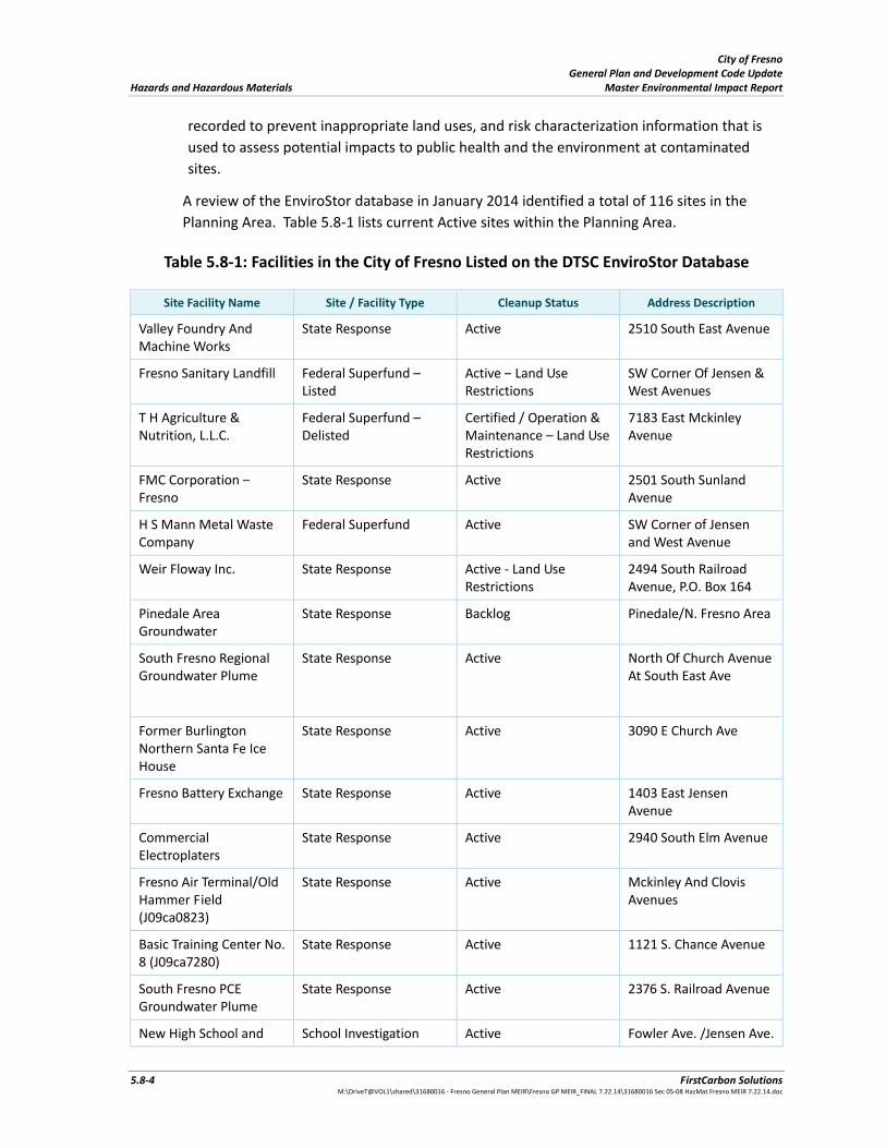
2. Department of Toxic Substances Control EnviroStor Database: The Department of Toxic
Substances Control’s (DTSC’s) Site Mitigation and Brownfields Reuse Program’s (SMBRP’s)
EnviroStor database identifies sites that have known contamination or sites for which there
may be reasons to investigate further. This is one of a number of lists that comprise the
“Cortese List” (a list of all hazardous materials sites compiled pursuant to Government Code
Section 65962.5). The database includes the following site types: Federal Superfund sites
(National Priorities List (NPL)); State Response, including Military Facilities and State
Superfund; Voluntary Cleanup; and School sites. EnviroStor provides similar information to
the information that was available in CalSites, and provides additional site information,
including, but not limited to, identification of formerly‐contaminated properties that have
been released for reuse, properties where environmental deed restrictions have been
City of Fresno General Plan and Development Code Update Hazards and Hazardous Materials Master Environmental Impact Report
5.8‐4 FirstCarbon Solutions M:\DriveT@VOL1\shared\31680016 ‐ Fresno General Plan MEIR\Fresno GP MEIR_FINAL 7.22.14\31680016 Sec 05‐08 HazMat Fresno MEIR 7.22.14.doc
recorded to prevent inappropriate land uses, and risk characterization information that is
used to assess potential impacts to public health and the environment at contaminated
sites.
A review of the EnviroStor database in January 2014 identified a total of 116 sites in the
Planning Area. Table 5.8‐1 lists current Active sites within the Planning Area.
Table 5.8‐1: Facilities in the City of Fresno Listed on the DTSC EnviroStor Database
Site Facility Name Site / Facility Type Cleanup Status Address Description
Valley Foundry And Machine Works
State Response Active 2510 South East Avenue
Fresno Sanitary Landfill Federal Superfund –Listed
Active – Land Use Restrictions
SW Corner Of Jensen & West Avenues
T H Agriculture & Nutrition, L.L.C.
Federal Superfund –Delisted
Certified / Operation & Maintenance – Land Use Restrictions
7183 East Mckinley Avenue
FMC Corporation – Fresno
State Response Active 2501 South Sunland Avenue
H S Mann Metal Waste Company
Federal Superfund Active SW Corner of Jensen and West Avenue
Weir Floway Inc. State Response Active ‐ Land Use Restrictions
2494 South Railroad Avenue, P.O. Box 164
Pinedale Area Groundwater
State Response Backlog Pinedale/N. Fresno Area
South Fresno Regional Groundwater Plume
State Response Active North Of Church Avenue At South East Ave
Former Burlington Northern Santa Fe Ice House
State Response Active 3090 E Church Ave
Fresno Battery Exchange State Response Active 1403 East Jensen Avenue
Commercial Electroplaters
State Response Active 2940 South Elm Avenue
Fresno Air Terminal/Old Hammer Field (J09ca0823)
State Response Active Mckinley And Clovis Avenues
Basic Training Center No. 8 (J09ca7280)
State Response Active 1121 S. Chance Avenue
South Fresno PCE Groundwater Plume
State Response Active 2376 S. Railroad Avenue
New High School and School Investigation Active Fowler Ave. /Jensen Ave.
City of Fresno General Plan and Development Code Update Master Environmental Impact Report Hazards and Hazardous Materials
FirstCarbon Solutions 5.8‐5 M:\DriveT@VOL1\shared\31680016 ‐ Fresno General Plan MEIR\Fresno GP MEIR_FINAL 7.22.14\31680016 Sec 05‐08 HazMat Fresno MEIR 7.22.14.doc
Site Facility Name Site / Facility Type Cleanup Status Address Description
Middle School
Source: Department of Toxic Substances Control‐ Envirostor Database 2014
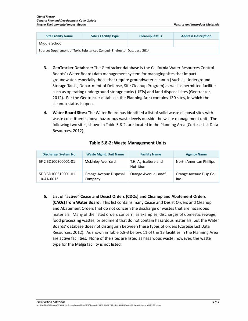
3. GeoTracker Database: The Geotracker database is the California Water Resources Control
Boards’ (Water Board) data management system for managing sites that impact
groundwater, especially those that require groundwater cleanup ( such as Underground
Storage Tanks, Department of Defense, Site Cleanup Program) as well as permitted facilities
such as operating underground storage tanks (USTs) and land disposal sites (Geotracker,
2012). Per the Geotracker database, the Planning Area contains 130 sites, in which the
cleanup status is open.
4. Water Board Sites: The Water Board has identified a list of solid waste disposal sites with
waste constituents above hazardous waste levels outside the waste management unit. The
following two sites, shown in Table 5.8‐2, are located in the Planning Area (Cortese List Data
Resources, 2012):
Table 5.8‐2: Waste Management Units
Discharger System No. Waste Mgmt. Unit Name Facility Name Agency Name
5F 2 5D100300001‐01 Mckinley Ave. Yard T.H. Agriculture and Nutrition
North American Phillips
5F 3 5D100319001‐01 10‐AA‐0013
Orange Avenue Disposal Company
Orange Avenue Landfill Orange Avenue Disp Co. Inc.
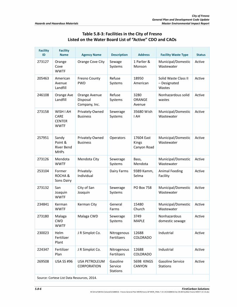
5. List of “active” Cease and Desist Orders (CDOs) and Cleanup and Abatement Orders
(CAOs) from Water Board: This list contains many Cease and Desist Orders and Cleanup
and Abatement Orders that do not concern the discharge of wastes that are hazardous
materials. Many of the listed orders concern, as examples, discharges of domestic sewage,
food processing wastes, or sediment that do not contain hazardous materials, but the Water
Boards’ database does not distinguish between these types of orders (Cortese List Data
Resources, 2012). As shown in Table 5.8‐3 below, 11 of the 13 facilities in the Planning Area
are active facilities. None of the sites are listed as hazardous waste; however, the waste
type for the Malga facility is not listed.
City of Fresno General Plan and Development Code Update Hazards and Hazardous Materials Master Environmental Impact Report
5.8‐6 FirstCarbon Solutions M:\DriveT@VOL1\shared\31680016 ‐ Fresno General Plan MEIR\Fresno GP MEIR_FINAL 7.22.14\31680016 Sec 05‐08 HazMat Fresno MEIR 7.22.14.doc
Table 5.8‐3: Facilities in the City of Fresno Listed on the Water Board List of “Active” CDO and CAOs
Facility ID
Facility Name Agency Name Description Address Facility Waste Type Status
273127 Orange Cove WWTF
Orange Cove City Sewage Systems
1 Parlier & Monson
Municipal/Domestic Wastewater
Active
205463 American Avenue Landfill
Fresno County PWD
Refuse Systems
18950 American
Solid Waste Class II – Designated Wastes
Active
246108
Orange Ave Landfill
Orange Avenue Disposal Company, Inc.
Refuse Systems
3280 ORANGE Avenue
Nonhazardous solid wastes
Active
273158
WISH I AH CARE CENTER WWTF
Privately‐Owned Business
Sewerage Systems
35680 Wish I AH
Municipal/Domestic Wastewater
Active
257951 Sandy Point & River Bend MHPs
Privately‐Owned Business
Operators 17604 East Kings Canyon Road
Municipal/Domestic Wastewater
Active
273126
Mendota WWTF
Mendota City Sewerage Systems
Bass, Mendota
Municipal/Domestic Wastewater
Active
253104 Former ROCHA & Sons Dairy
Privately‐ Individual
Dairy Farms 9389 Kamm, Selma
Animal Feeding Facility
Active
273132 San Joaquin WWTF
City of San Joaquin
Sewerage Systems
PO Box 758 Municipal/Domestic Wastewater
Active
234841
Kerman WWTF
Kerman City General Farms
15480 Church
Municipal/Domestic Wastewater
Active
273180 Malaga CWD WWTF
Malaga CWD Sewerage Systems
3749 MAPLE
Nonhazardous domestic sewage
Active
230023 Helm Fertilizer Plant
J R Simplot Co. Nitrogenous Fertilizers
12688 COLORADO
Industrial Active
224347 Fertilizer Plan
J R Simplot Co. Nitrogenous Fertilizers
12688 COLORADO
Industrial Active
269508 USA SS #96 USA PETROLEUM CORPORATION
Gasoline Service Stations
5698 KINGS CANYON
Gasoline Service Stations
Active
Source: Cortese List Data Resources, 2014.
City of Fresno General Plan and Development Code Update Master Environmental Impact Report Hazards and Hazardous Materials
FirstCarbon Solutions 5.8‐7 M:\DriveT@VOL1\shared\31680016 ‐ Fresno General Plan MEIR\Fresno GP MEIR_FINAL 7.22.14\31680016 Sec 05‐08 HazMat Fresno MEIR 7.22.14.doc
6. Department of Toxic Substances Control: Section 65962.5(a)(1) requires that DTSC “shall
compile and update as appropriate, but at least annually, and shall submit to the Secretary
for Environmental Protection, a list of all the following: (1) [a]ll hazardous waste facilities
subject to corrective action pursuant to Section 25187.5 of the Health and Safety Code
(Cortese List Data Resources, 2012).
The hazardous waste facilities identified in HSC § 25187.5 are those where DTSC has taken or
contracted for corrective action because a facility owner/operator has failed to comply with a date
for taking corrective action in an order issued under HSC § 25187, or because DTSC determined that
immediate corrective action was necessary to abate an imminent or substantial endangerment. This
is a very small and specific subgroup of facilities, and they are not separately posted on the DTSC or
Cal/EPA’s website. (Cortese List Data Resources, 2012). There are no facilities listed in the Planning
Area.
Hazardous Materials Incidents Emergency Response
The unauthorized releases of hazardous materials into the environment could create many
environmental impacts including impacts to properties, natural environment and human health. The
significance of these impacts could vary according to the location and quantity of the substance
released. Hazardous releases can occur in area that treats, stores, transports and uses hazardous
materials; however, certain areas within the State and Planning Area are at higher risk for releases.
In the event of an unauthorized release of hazardous materials/substances, emergency response
measures must be implemented to ensure the protection of human and natural environmental
health from risk.
The Planning Area includes a developed urban area with industrial uses concentrated in the southern
portion of the Planning Area. Agriculture is one of the City’s major industries. The potential for
hazardous materials incidents are heightened. Accidental releases of pesticides, fertilizers, and other
agricultural chemical may be harmful to the public’s health, safety, and the environment. In addition,
the Planning Area contains major transportation routes, such as State Highways 99, 180, 41, and 168.
Varieties of chemicals are transported utilizing one of the two railroad lines. The Fresno Yosemite
International Airport, Fresno Chandler Executive Airport, and the Sierra Sky Park are located within
the Planning Area. These facilities, along with the transportation routes and industrial uses listed
above, transport hundreds of thousands of tons of hazardous materials through and into the
Planning Area each year. Due to the urban nature of the Planning Area and its location among
several routes that regularly transport hazardous materials through and around the Planning Area,
the area faces risks associated with the potential for hazardous materials emergencies. The City of
Fresno Fire Department recognizes the potential for a large chemical release to occur which could
expose thousands of people to hazardous or toxic vapors.
The City of Fresno Fire Department Hazardous Materials Response Team (HMRT) has embraced an
all‐hazards approach to emergency response to ensure that the Planning Area receives effective
protection from the risk of hazardous materials releases.
City of Fresno General Plan and Development Code Update Hazards and Hazardous Materials Master Environmental Impact Report
5.8‐8 FirstCarbon Solutions M:\DriveT@VOL1\shared\31680016 ‐ Fresno General Plan MEIR\Fresno GP MEIR_FINAL 7.22.14\31680016 Sec 05‐08 HazMat Fresno MEIR 7.22.14.doc
The Fire Department HMRT is comprised of sixty personnel trained to the Hazardous Materials
Technician and/or Specialist requirements. Fourteen personnel are on duty each day with a
minimum of nine of those persons, trained to the Technician/Specialist level. The HMRT utilizes two
State Office of Emergency Services (OES) Type 1 Hazmat response rigs, and a Mass Decontamination
trailer. The HMRT is deployed from two strategically located fire stations. The HMRT OES Type 1
response rig is assigned to a fire station with a fire engine and a fire truck. The second Type 1
response rig is assigned to a station staffed with HMRT personnel assigned to a fire engine. The
second station is also the location of the Mass Decontamination trailer. The deployment plan
requires the dispatch of the closest response company in conjunction with the HMRT to hazardous
materials emergencies.
The Fresno City Hazardous Materials Response Teams have partnered with the OES to deploy
regionally or statewide to support any jurisdiction through the State Master Mutual Aid System
(www.fresno.gov).
Emergency Response
In addition to emergency response to hazardous materials incidents, both the City of Fresno and the
County of Fresno implement programs to facilitate emergency preparedness for other types of
incidents within the Planning Area. Specifically, the City of Fresno has an Emergency Operations Plan
that describes what the City’s actions will be during a response to an emergency. This plan also
describes the role of the Emergency Operations Center (EOC) and the coordination that occurs
between the EOC, City Departments, and other response agencies. The plan establishes a
requirement for the emergency management organization to mitigate any significant emergency
disaster affecting the City of Fresno. The plan also identifies the policies, responsibilities, and
procedures required to protect the health and safety of City communities, public and private
property, and the environmental effects of natural or technological disasters. In addition, the plan
establishes the operation concepts and procedures associated within initial response operations
(field response) to emergencies, the extended response operations (City of Fresno Emergency
Operations Center Activities), and the recovery process. Furthermore, the plan complies with the
State of California Emergency Operations Plan “Cross Walk” checklist for determining whether an
emergency plan has addressed critical elements of California’s Standardized Emergency
Management System (SEMS) and the National Incident Management System (NIMS).
The County of Fresno has a Multi‐Hazard Mitigation Plan, which is a multi‐jurisdictional plan that
aims to reduce or eliminate long‐term risk to people or property from natural disasters and their
effects that is applicable to the city and areas outside of the City but within the Planning Area.
Standardized Emergency Management System
In addition to the City Emergency Operations Plan and the County Multi‐Hazard Mitigation Plan, the
SEMS is the system required by Government Code Section 8607 (a) for managing response to multi‐
agency and multi‐jurisdiction emergencies in California. SEMS consists of five organizational levels,
which are activated as necessary: field response, local government, operational area, OES Mutual Aid
Regions, and State OES.
City of Fresno General Plan and Development Code Update Master Environmental Impact Report Hazards and Hazardous Materials
FirstCarbon Solutions 5.8‐9 M:\DriveT@VOL1\shared\31680016 ‐ Fresno General Plan MEIR\Fresno GP MEIR_FINAL 7.22.14\31680016 Sec 05‐08 HazMat Fresno MEIR 7.22.14.doc
Emergency Operations Center
The primary City of Fresno EOC is a borrowed meeting area located at the Municipal Services
Building, 2101 G Street, Building A. During a disaster/emergency, the City of Fresno EOC will support
field response operations in mitigating incidents within the incorporated areas of the City of Fresno.
The primary emphasis will be placed on saving lives, protecting property, and preserving the
environment. The City of Fresno EOC will operate using the SEMS/National Incident functions,
principles, and components. It will implement the action planning process, identifying and
implementing specific objectives for each operational period.
The City of Fresno EOC will serve as the coordination and communications between the City of
Fresno and Fresno County Operational Area EOC. The Operational Area EOC will be activated
whenever an emergency or disaster impacts the City, cities, or special district(s). The Fresno
Operational Area EOC will utilize the discipline‐specific mutual aid coordinators to coordinate fire,
law enforcement, public works, and medical specific resources. Other resource requests that do not
fall into these four disciplines will be coordinated by the requesting branch/section/unit within the
Appropriate SEMS EOC Section.
Emergency Response Routes
The City does not maintain formal evacuation routes, as the most appropriate routes away from an
area that may have been affected by a major disaster would be determined by the location and type
of incident. Plans for such incidents would also be heavily subject to change.
Airport Hazards
Three airports occur within the City of Fresno, with Fresno Yosemite International Airport being the
largest. Each of the three airports is described below.
Fresno Yosemite International Airport
Fresno Yosemite International Airport (FYI) occurs in the eastern portion of the City along East
Clinton Way. FYI is a joint use civilian/military airport. It is used by commercial air carriers, air cargo
operators, charter operators, the State of California, general aviation, and the United States military.
The California Air National Guard (CANG) occupies a 58‐acre area adjacent to McKinley Avenue in
the southeast portion of FYI. A helicopter repair and maintenance unit of the Army National Guard,
the California Division of Forestry, and a number of corporate aviation businesses occupy facilities
north of the runways. About 250 general aviation aircraft are based at FYI and two Fixed Base
Operators (FBOs) offer a wide range of aeronautical services. According the FYI Safety Compatibility
Zones Map, existing residential structures are located within Safety Zone 1‐Runway Protection Zone
(RPZ).
Fresno Chandler Executive Airport
Fresno Chandler Executive Airport occurs in the southwestern portion of the City at the intersection
of Kearny Boulevard and Thorne Avenue. The airport is designated as a general aviation reliever
airport for FYI. One small cargo carrier operates out of the facility, and nine general aviation

City of Fresno General Plan and Development Code Update Hazards and Hazardous Materials Master Environmental Impact Report
5.8‐10 FirstCarbon Solutions M:\DriveT@VOL1\shared\31680016 ‐ Fresno General Plan MEIR\Fresno GP MEIR_FINAL 7.22.14\31680016 Sec 05‐08 HazMat Fresno MEIR 7.22.14.doc
businesses operate out of the airport. Approximately 180 general aviation aircraft are based at
Fresno Chandler Executive Airport. There are currently no plans to expand the airport.
Sierra Sky Park
Sierra Sky Park airport occurs in the northern portion of the City adjacent to the San Joaquin River
along Herndon Avenue. The facility is a privately owned public use general aviation airport. Sierra
Sky Park functions as a reliever airport for small general aviation aircraft, and includes a hangar and
office complex. There are currently no plans to expand the facility.
Fire Hazards
The Planning Area is located within the Central Valley, and is relatively flat. The majority of the
Planning Area occurs as developed properties or agricultural lands. Similar uses surround the
Planning Area with the City of Clovis to the east, and mostly agricultural properties to the north,
west, and south. The Sierra Nevada foothills to the north and east of the Planning Area and the City
of Clovis provide the nearest areas where large expanses of undeveloped properties occur. Because
of the topography and the distance between the developed portions of the Planning Area and
undeveloped areas, the primary fire hazard concern within the Planning Area consists of the
potential for structure fires in developed areas.
5.8.3 ‐ Regulatory Setting
Potential hazards and the use and transportation of hazardous substances are regulated by an
overlapping set of adopted City, County, State, and federal plans, policies and regulations. In general,
federal and State legislation empowers regulation by local agencies; however, both State and federal
agencies such as the Federal Aviation Administration (FAA) (airports) and Regional Water Quality
Control Board (RWQCB) (ground and surface water contamination) retain a substantial direct
regulatory role. The City addresses these issues primarily in its Municipal Code and to a lesser extent
in its 2025 General Plan. Hazardous materials are also regulated by the City of Fresno Fire
Department and the San Joaquin Valley Air Pollution Control District (SJVAPCD). The Fresno Council
of Governments maintains the Airport Land Use Plan (ALUP), and the City Municipal Code contains
the Airport Zoning Ordinance that addresses land use and safety regulations in the airport zone.
Federal
Toxic Substances Control Act
Established in 1976 and amended on December 31, 2002, the Toxic Substances Control Act (TSCA)
(15 United States Code [USC] Section 2601‐2692) grants the EPA power to require proper reporting,
record‐keeping, and testing requirements related to chemical substances and/or mixtures.
Specifically, the TSCA addresses the production, importation, use, and disposal of specific chemicals,
including polychlorinated biphenyls (PCBs), asbestos, radon, and lead‐based paints (LBP). The TSCA
establishes the EPA’s authority to require the notification of the use of chemicals, require testing,
maintain a TSCA inventory, and require those importing chemicals under Sections 12(b) and 13 to
comply with certification and/or other reporting requirements. This federal legislation also phased
out the use of asbestos‐containing materials in new building materials and sets requirements for the
City of Fresno General Plan and Development Code Update Master Environmental Impact Report Hazards and Hazardous Materials
FirstCarbon Solutions 5.8‐11 M:\DriveT@VOL1\shared\31680016 ‐ Fresno General Plan MEIR\Fresno GP MEIR_FINAL 7.22.14\31680016 Sec 05‐08 HazMat Fresno MEIR 7.22.14.doc
use, handling, and disposal of asbestos‐containing materials. Disposal standards for lead‐based paint
wastes are also detailed in the TSCA.
The Emergency Planning and Community Right‐To‐Know Act
The Emergency Planning and Community Right‐To‐Know Act (also known as Title III of the Federal
Superfund Amendments and Reauthorization Act, or “SARA III”) (42 United States Code 11001 et
seq.), was established by the EPA to allow for emergency planning at the State and local level
regarding chemical emergencies, to provide notification of emergency release of chemicals, and to
address community right‐to‐know regarding hazardous and toxic chemicals. SARA III was designed to
increase community access and knowledge about chemical hazards as well as facilitate the creation
and implementation of State/Native American tribe emergency response commissions, responsible
for coordinating certain emergency response activities and for appointing local emergency planning
committees (LEPCs). Section 1910.1200(c) Title 29 of the CFR defines “chemicals or hazardous
materials” for the purposes of SARA III.
Federal Air Regulations, Part 77.
The Federal Aviation Administration (FAA) is charged with the review of construction activities that
occur in the vicinity of airports. Its role in reviewing these activities is to ensure that new structures
do not result in a hazard to navigation. The regulations in the Federal Air Regulations (14 CFR, Part
77) are designed to ensure that no obstructions in navigable air space are allowed to exist that would
endanger the public. Proposed structures are also evaluated against Terminal En Route Procedures,
which ensure that a structure does not adversely impact flight procedures. Tall structures, including
buildings, construction cranes, and cell towers in the vicinity of an airport can be hazardous to the
navigation of airplanes. Federal Air Regulations Part 77 identifies the maximum height at which a
structure would be considered an obstacle at any given point around an airport. The extent of the
off‐airport coverage that needs to be evaluated for tall structure impacts can extend miles from an
airport facility. In addition, Federal Air Regulations Part 77 establishes standards for determining
whether objects constructed near airports will be considered obstructions in navigable airspace, sets
forth notice requirements of certain types of proposed construction or alterations, and provides for
aeronautical studies to determine the potential impacts of a structure on the flight of aircraft
through navigable airspace.
Federal Insecticide, Fungicide, and Rodenticide Act.
The Federal Insecticide, Fungicide, and Rodenticide Act (FIFRA) (7 United States Code 136 et seq.)
was originally passed in 1947. It has been amended several times, most extensively in 1972, and
most recently by the Food Quality Protection Act of 1996. The purpose of FIFRA is to establish
federal jurisdiction over the distribution, sale, and use of pesticides. It also gives EPA the authority to
study the effects of pesticide use. Other key provisions of FIFRA require pesticide applicators to pass
a licensing examination for status as “qualified applicators,” create a review and registration process
for new pesticide products, and ensure thorough and understandable labeling that includes
instructions for use.
City of Fresno General Plan and Development Code Update Hazards and Hazardous Materials Master Environmental Impact Report
5.8‐12 FirstCarbon Solutions M:\DriveT@VOL1\shared\31680016 ‐ Fresno General Plan MEIR\Fresno GP MEIR_FINAL 7.22.14\31680016 Sec 05‐08 HazMat Fresno MEIR 7.22.14.doc
Hazardous Materials Transportation Act (HMTA) – safe transport of hazardous materials.
The U.S. Department of Transportation regulates hazardous materials transportation between states
under Title 49, Chapter 1, Part 100‐185 of the Code of Federal Regulations. Within California,
Caltrans and the CHP enforce federal law. Together, these agencies determine driver training
requirements, load labeling procedures, and specifications for container types to be used.
Federal Emergency Management Agency (FEMA)
With respect to emergency planning, FEMA is responsible for ensuring the establishment and
development of policies and programs for emergency management at the federal, State, and local
levels. Enforcement of these laws and regulations is delegated to State and local environmental
regulatory agencies.
Resource Conservation and Recovery Act
The 1976 Federal Resource Conservation and Recovery Act (RCRA) and the 1984 RCRA Amendments
regulate the treatment, storage, and disposal of hazardous and non‐hazardous wastes. The
legislation mandated that hazardous wastes be tracked from the point of generation to their ultimate
fate in the environment. This includes detailed tracking of hazardous materials during transport and
permitting of hazardous material handling facilities.
The 1984 RCRA amendments provide the framework for a regulatory program designed to prevent
releases from USTs. The program establishes tank and leak detection standards, including spill and
overflow protection devices for new tanks. The tanks must also meet performance standards to
ensure that the stored material will not corrode the tanks. Owners and operators of USTs had until
December 1998 to meet the new tank standards. As of 2001, an estimated 85 percent of USTs
complied with the required standard.
Comprehensive Environmental Response, Compensation and Liability Act
The Comprehensive Environmental Response, Compensation, and Liability Act of 1980 introduced
active federal involvement to emergency response, site remediation, and spill prevention, most
notably the Superfund program. The act was intended to be comprehensive in encompassing both
the prevention of, and response to uncontrolled hazardous substances releases. The act deals with
environmental response, providing mechanisms for reacting to emergencies and chronic hazardous
material releases. In addition to establishing procedures to prevent and remedy problems, it
establishes a system for compensating appropriate individuals and assigning appropriate liability. It
is designed to plan for, and respond to, failure in other regulatory programs and to remedy problems
resulting from action taken before the era of comprehensive regulatory protection.
State
California Health and Safety Code
The California Environmental Protection Agency has established rules governing the use of hazardous
materials and the management of hazardous wastes. California Health and Safety Code Sections
25531, et seq., incorporate the requirement of Superfund Amendments and Reauthorization Act and
the Clean Air Act as they pertain to hazardous materials. Health and Safety Code Section 25534
City of Fresno General Plan and Development Code Update Master Environmental Impact Report Hazards and Hazardous Materials
FirstCarbon Solutions 5.8‐13 M:\DriveT@VOL1\shared\31680016 ‐ Fresno General Plan MEIR\Fresno GP MEIR_FINAL 7.22.14\31680016 Sec 05‐08 HazMat Fresno MEIR 7.22.14.doc
directs facility owners storing or handling acutely hazardous materials in reportable quantities to
develop a Risk Management Plan (RMP). The RMP must be submitted to the appropriate local
authorities, the designated local administering agency, and the EPA for review and approval.
San Joaquin Valley Air Pollution Control District (SJVAPCD)
The San Joaquin Valley Unified Air Pollution Control District has regulations that require compliance
with the asbestos demolition and renovation requirements developed by the United States
Environmental Protection Agency in the National Emission Standards for Hazardous Air Pollutants
(NESHAP) regulation, 40 CFR, Part 61, Subpart M. (San Joaquin Valley Pollution Control District
Asbestos Bulletin, 2012).
Local
City of Fresno Municipal Code
Chapter 10, Article 14 of the City of Fresno Municipal Code pertains to the recovery of expenses
associated with hazardous spills. Specifically, this section states that “Any person causing a release or
threatened release which results in an emergency action shall be liable to the City of Fresno for the
recoverable costs resulting from the emergency action.”
Fresno County Environmental Health Department ‐ Hazardous Materials Business Plans
Facilities that store, use or handle hazardous materials above reportable amounts are required to
prepare and file a Hazardous Materials Business Plan for the safe storage and use of chemicals. In
the event of an emergency, firefighters, health officials, planners, public safety officers, health care
providers and others rely on the Business Plan. Implementation of the Business Plan should prevent
or reduce damage to the health and safety of people and the environment when a hazardous
material is released (Fresno County Department of Environmental Health, 2012).
A Business Plan must be submitted by businesses that handle a hazardous material, or a mixture
containing a hazardous material, in quantities equal to or greater than:
1. 500 pounds of a solid.
2. 55 gallons of a liquid.
3. 200 cubic feet of a compressed gas at standard temperature and pressure.
4. The federal Threshold Planning Quantity (TPQ) for Extremely Hazardous Substances.
5. Radioactive materials in quantities for which an Emergency Plan is required as per Parts 30,
40, or 70, Chapter 1 of Title 10 of Code of Federal Regulations.
The Business Plan must include: 1) the type and quantity of hazardous materials; 2) site map; 3) risks
of using these materials; 4) spill prevention; 5) emergency response; 6) employee training and 7)
emergency contacts (Fresno County Department of Environmental Health, 2012).
City of Fresno General Plan and Development Code Update Hazards and Hazardous Materials Master Environmental Impact Report
5.8‐14 FirstCarbon Solutions M:\DriveT@VOL1\shared\31680016 ‐ Fresno General Plan MEIR\Fresno GP MEIR_FINAL 7.22.14\31680016 Sec 05‐08 HazMat Fresno MEIR 7.22.14.doc
Airport Land Use Commission Airport Land Use Plans
The specific safety regulations for the Fresno‐Yosemite International Airport, Fresno Chandler
Downtown Airport, and Sierra Sky Park Airport are identified in Impact HAZ‐5 and Impact HAZ‐6,
below.
2025 Fresno General Plan
Below are the objectives and policies that relate to hazards and hazardous materials from the Safety
Element of the currently adopted Fresno 2025 General Plan.
Fire Hazards
1‐1. OBJECTIVE: Maintain a high level of fire protection for large and tall structures constructed in
the City of Fresno.
I‐1‐a. Policy: Adopt appropriate standards, as necessary, for fire protection and fire suppression
within high‐rise buildings.
The City of Fresno shall enforce the latest adopted version of the California Code of Regulations Title 24 standards regarding high‐rise buildings, to ensure the highest level of fire
protection for new and existing construction.
The City of Fresno shall pursue to the fullest extent possible the existing city ordinance and Uniform Fire Code (UFC) and National Fire Protection Association (NFP A) standards for the
installation of automatic fire sprinkler systems for all new construction and for existing
construction where trade‐offs are allowed by local ordinance.
Maintain and enforce the provisions of Fresno Municipal Code that relate to fire protection
requirements (public service delivery plan and fire access lanes/areas) for mid‐rise and high‐
rise buildings.
The City of Fresno shall maintain adequate personnel and equipment, based at appropriate
locations, to expeditiously meet the fire prevention, life safety, and emergency mitigation
needs for large and tall structures.
1‐2. OBJECTIVE: Ensure the public's health, safety, and welfare by implementing appropriate
controls and emergency response capability to deal with those materials that, because of their
quantity, concentration, physical or chemical characteristics, pose a significant present or potential
hazard to human health, safety, or the environment.
I‐2‐a. Policy: Maintain and enforce the latest adopted California Building Code and Uniform Fire
Code standards to ensure safe processing and storage of hazardous materials.
1‐2‐b. Policy: Maintain a close liaison with the Fresno County Environmental Health Department,
Cal‐EPA Division of Toxics, and the State Office of Emergency Services to assist in developing and
maintaining hazardous material business plans, inventory statements, risk management prevention
plans, and contingency/emergency response action plans.
City of Fresno General Plan and Development Code Update Master Environmental Impact Report Hazards and Hazardous Materials
FirstCarbon Solutions 5.8‐15 M:\DriveT@VOL1\shared\31680016 ‐ Fresno General Plan MEIR\Fresno GP MEIR_FINAL 7.22.14\31680016 Sec 05‐08 HazMat Fresno MEIR 7.22.14.doc
Hazardous Materials
I‐6. OBJECTIVE: Reduce and control the adverse effects of hazardous materials on the public's
health, safety, and welfare to promote the public health and welfare of local residents and the
productive capacity of industry.
1‐6‐a. Policy: Hazardous materials will be defined as those that, because of their quantity,
concentration, physical or chemical characteristics, pose significant potential hazards to human
health, safety, or the environment. Specific federal, state, and local definitions and listings of
hazardous materials will be used by the City of Fresno.
I‐6‐b. Policy: The city will coordinate and cooperate with other local, state, and federal agencies
with expertise and responsibility for hazardous materials.
1‐6‐c. Policy: Approval of annexations and development projects (including issuance of building
permits) will be subject to state and federal requirements for adequate assessment and mitigation
measures on listed hazardous material sites and for business activities that involve more than
threshold amounts of hazardous materials.
1‐6‐d. Policy: As may be appropriate, the city shall require and evaluate the results of "Level I" and
further site investigations before approving development entitlements on, or annexation of,
property.
1‐6‐e. Policy: Through the environmental review process for land use plans and other development
projects, the city will continue to identify and assess the health‐ and safety‐related implications of
storage, use, and disposal of hazardous materials.
1‐6‐f. Policy: All commercial and industrial special permits will be conditioned upon proper
containment, use, safeguarding, and disposal of hazardous materials.
I‐6‐g. Policy: The city will continue to prevent, assess, and seek remediation for, any hazardous
material contamination within, and affecting, its planning area.
1‐6‐h. Policy: The city will continue to aid in the identification and mapping of waste disposal sites
(including abandoned wastes), and to assist in the survey of the kinds, amounts, locations, etc., of
hazardous wastes.
1‐6‐i. Policy: The city will utilize conditions for development. projects, will adopt and enforce
ordinances, and will use its police powers for land use regulation, code enforcement and nuisance
abatement in order to prohibit the inappropriate use of, and/or discharge of, toxic and hazardous
materials to the atmosphere, to wastewater collection and storm drainage systems, to groundwater,
and to surface bodies of water, when such use or discharge threatens public health, safety, or
general welfare.
1‐6‐j. Policy: Disaster and emergency response preparedness and planning for the city will include
procedures and policies appropriate to hazardous materials.
City of Fresno General Plan and Development Code Update Hazards and Hazardous Materials Master Environmental Impact Report
5.8‐16 FirstCarbon Solutions M:\DriveT@VOL1\shared\31680016 ‐ Fresno General Plan MEIR\Fresno GP MEIR_FINAL 7.22.14\31680016 Sec 05‐08 HazMat Fresno MEIR 7.22.14.doc
I‐6‐k. Policy: The city will continue to support and assist with special household hazardous waste
collection activities, to reduce the amount of this material ∙being improperly discarded.
1‐6‐1. Policy: The city will continue to assist in providing information to the public on hazardous
materials.
5.8.4 ‐ Thresholds of Significance
CEQA Thresholds
In accordance with CEQA, the effects of a project are evaluated to determine if they will result in
significant adverse impact on the environment. The criteria used to determine the significance of an
impact to hazards and hazardous materials are based on the Environmental Checklist in Appendix G
of the State CEQA Guidelines and identified below. Accordingly, hazards and hazardous materials
impacts resulting from the proposed project are considered significant if the project would:
a) Create a significant hazard to the public or the environment through the routine transport,
use, or disposal of hazardous materials? (See Routine Use, Impact HAZ‐1)
b) Create a significant hazard to the public or the environment through reasonably foreseeable
upset and accident conditions involving the hazardous materials into the environment? (See
Accident Conditions, Impact HAZ‐2)
c) Emit hazardous emissions or handle hazardous or acutely hazardous materials, substances,
or waste within one‐quarter mile of an existing or proposed school? (See Schools, Impact
HAZ‐3)
d) Be located on a site which is included on a list of hazardous materials sites compiled
pursuant to Government Code Section 65962.5 and, as a result, would it create a significant
hazard to the public or the environment? (See Hazardous Materials Site Listing, Impact HAZ‐
4)
e) For a project located within an airport land use plan or, where such a plan has not been
adopted, within two miles of a public airport or public use airport, would the project result
in a safety hazard for people residing or working in the project area? (See Airports, Impact
HAZ‐5)
f) For a project within the vicinity of a private airstrip, would the project result in a safety
hazard for people residing or working in the project area? (See Private Airstrip, Impact HAZ‐
6)
g) Impair implementation of or physically interfere with an adopted emergency response plan
or emergency evacuation plan? (See Emergency Plans, Impact HAZ‐7)
h) Expose people or structures to a significant risk of loss, injury or death involving wildland
fires, including where wildlands are adjacent to urbanized areas or where residences are
intermixed with wildlands? (See Wildland Fires, Impact HAZ‐8)
City of Fresno General Plan and Development Code Update Master Environmental Impact Report Hazards and Hazardous Materials
FirstCarbon Solutions 5.8‐17 M:\DriveT@VOL1\shared\31680016 ‐ Fresno General Plan MEIR\Fresno GP MEIR_FINAL 7.22.14\31680016 Sec 05‐08 HazMat Fresno MEIR 7.22.14.doc
5.8.5 ‐ Impact Analysis, Mitigation Measures, and Level of Significance After Mitigation
The impact assessment below identifies potential project‐related impacts associated with
implementation of the proposed General Plan and Development Code Update.
Routine Use
Impact HAZ‐1 The project would not create a significant hazard to the public or the environment through the routine transport, use, or disposal of hazardous materials.
Project Specific Impact Analysis
It is anticipated that implementation of the proposed General Plan and Development Code update
could result in the exposure of persons to hazards and/or hazardous materials during construction as
well as during the life of the General Plan. Thus, potential construction‐related and long‐term (i.e.
operational) hazards impacts are discussed below.
Potential Short‐Term Construction Impacts
The proposed General Plan udpate includes infill development and intensification of land uses within
the City of Fresno Planning Area. Therefore, existing structures within the Planning Area may need
to be demolished and new buildings will be constructed. Demolition of existing buildings in the
Planning Area could expose persons working or living in the Planning Area to potentially hazardous
materials including but not limited to asbestos and lead from lead‐based paints. Various regulations
and guidelines pertaining to abatement of, and protection from, exposure to asbestos and lead have
been adopted for demolition activities. These requirements include: San Joaquin Valley Air Pollution
Control District requirements for demolitions and renovations; Construction Safety Orders 1529
(pertaining to asbestos) and 1532.1 (pertaining to lead) from Title 8 of the CCR, Part 61, Subpart M
of the Code of Federal Regulations (CFR) (pertaining to asbestos); and lead exposure guidelines
provided by the Department of Housing and Urban Development (HUD). In California, asbestos and
lead abatement must be performed and monitored by contractors with appropriate certifications
from the State Department of Health Services. In addition, the California Occupational Safety and
Health Administration (Cal/OSHA) has regulations concerning the use of hazardous materials,
including requirements for safety training, availability of safety equipment, hazardous materials
exposure warnings, and emergency action and fire prevention plan preparation. Cal/OSHA enforces
the hazard communication program regulations, which include provisions for identifying and labeling
hazardous materials, describing the hazards of chemicals, and documenting employee‐training
programs. All demolition that could result in the release of lead and/or asbestos must be conducted
according to Cal/OSHA standards.
Grading and excavation of sites for new development may expose construction workers and the
public to known or potentially unknown hazardous substances present in the soil or groundwater.
There are sites containing hazardous materials located throughout the City (City of Fresno. Map Atlas
Existing Conditions Report, 2011), which pose as potential health hazards. However, new
development on contaminated areas that would occur as a result of implementation of the General
Plan and Development Code Update would be required to be remediated (i.e., cleaned up), prior to
City of Fresno General Plan and Development Code Update Hazards and Hazardous Materials Master Environmental Impact Report
5.8‐18 FirstCarbon Solutions M:\DriveT@VOL1\shared\31680016 ‐ Fresno General Plan MEIR\Fresno GP MEIR_FINAL 7.22.14\31680016 Sec 05‐08 HazMat Fresno MEIR 7.22.14.doc
the commencement of construction activities. These activities would be under the supervision of
the Department of Toxic Substances Control (DTSC), Fresno County Division of Environmental Health,
and/or Regional Water Quality Control Board (RWQCB), depending on the site characteristics.
Potential soil contamination in these areas must be properly identified and cleaned up prior to any
development activities on any of these sites to prevent exposure of people and the environment to
these hazards. Additionally, it is also possible that old underground storage tanks (USTs) that were in
use prior to permitting and record keeping requirements may be present throughout the Planning
Area. If an unidentified underground storage tank were uncovered or disturbed during construction
activities, it would need to be sealed and abandoned in place or removed. Removal activities could
pose both health and safety risks, such as the exposure of workers, tank handling personnel, and the public to tank contents or vapors. Potential risks, if any, posed by underground storage tanks would
be minimized by managing the tank according to Fresno County standards as enforced and
monitored by the Department of Environmental Health. The extent to which groundwater may have
been affected, if at all, depends on the type of contaminant, the amount released, and depth to
groundwater at the time of the release, if any, occurred. If groundwater contamination has been
identified, remediation activities would be required by the RWQCB, DTSC, or other appropriate
regulatory agency prior to the start of any new construction activities.
To reduce potential project‐specific impacts regarding routine transport, use, or disposal of
hazardous materials in the City of Fresno, the General Plan Update includes the following objective
and policies:
Objective NS‐4: Minimize the risk of loss of life, injury, serious illness, and damage to property
resulting from the use, transport, treatment, and disposal of hazardous materials and hazardous
wastes.
Policy NS‐4‐a: Processing and Storage. Require safe processing and storage of hazardous materials,
consistent with the California Building Code and the Uniform Fire Code, as adopted by the City.
Policy NS‐4‐b: Coordination. Maintain a close liaison with the Fresno County Environmental Health
Department, Cal‐EPA Division of Toxics, and the State Office of Emergency Services to assist in
developing and maintaining hazardous material business plans, inventory statements, risk
management prevention plans, and contingency/emergency response action plans.
Policy NS‐4‐c: Soil and Groundwater Contamination Reports. Require an investigation of potential
soil or groundwater contamination whenever justified by past site uses. Require appropriate
mitigation as a condition of project approval in the event soil or groundwater contamination is
identified or could be encountered during site development.
Policy NS‐4‐d: Site Identification. Continue to aid federal, State, and County agencies in the
identification and mapping of waste disposal sites (including abandoned waste sites), and to assist in
the survey of the kinds, amounts, and locations of hazardous wastes.
Policy NS‐4‐e: Compliance with County Program. Require that the production, use, storage,
disposal, and transport of hazardous materials conform to the standards and procedures established
City of Fresno General Plan and Development Code Update Master Environmental Impact Report Hazards and Hazardous Materials
FirstCarbon Solutions 5.8‐19 M:\DriveT@VOL1\shared\31680016 ‐ Fresno General Plan MEIR\Fresno GP MEIR_FINAL 7.22.14\31680016 Sec 05‐08 HazMat Fresno MEIR 7.22.14.doc
by the County Division of Environmental Health. Require compliance with the County’s Hazardous
Waste Generator Program, including the submittal and implementation of a Hazardous Materials
Business Plan, when applicable.
Policy NS‐4‐f: Hazardous Materials Facilities. Require facilities that handle hazardous materials or
hazardous wastes be designed, constructed, and operated in accordance with applicable hazardous
materials and waste management laws and regulations.
Policy NS‐4‐g: Hazmat Response. Include policies and procedures appropriate to hazardous
materials in the City’s disaster and emergency response preparedness and planning, coordinating
with implementation of Fresno County’s Hazardous Materials Incident Response Plan.
Policy NS‐4‐i: Public Information. Continue to assist in providing information to the public on
hazardous materials.
Potential Long‐Term Operational Impacts
New development associated with the proposed General Plan and Development Code Update would
result in the addition of new buildings and infrastructure as well as population to the Planning Area.
Development under the proposed General Plan would result in the addition of land uses, which
could generate hazardous materials, as well as added population, which could be exposed to future
hazardous materials releases. Additionally, new development that would be constructed under the
proposed General Plan that involves routine transport, use, or disposal of hazardous materials will
be required to conform to City of Fresno ordinances and regulations regarding the transport, use and
disposal of hazardous materials. New businesses that handle a hazardous material, or a mixture
containing a hazardous material, in quantities equal or greater than 500 pounds of a solid, 55 gallons
of a liquid, 200 cubic feet of a compressed gas at a standard room temperature and pressure, the
federal Threshold Planning Quantity (TPQ) for Extremely Hazardous Substances, and radioactive
materials in quantities for which an Emergency Plan is required as per Parts 30, 40, or 70, Chapter 1
of Title 10 of Code of Federal Regulation (CFR) will be required to conform to the City of Fresno
approved Hazardous Materials Business Plan. The Hazardous Materials Business Plan includes
business owner/operator identification form, business activities form, hazardous materials inventory,
site map and building diagram(s), written emergency response plans, and written employee training
programs. Less than significant project‐specific impacts are anticipated because all generation,
transport, and treatment of hazardous materials are required to comply with applicable federal,
State and local requirements. Additionally, as described below, the proposed General Plan update
contains objectives and policies that are specific to hazards and hazardous materials.
To reduce potential project‐specific impacts regarding routine transport, use, or disposal of
hazardous materials in the City of Fresno, the General Plan Update includes Objective NS‐4 and
Policies NS‐4‐a through NS‐4‐I as discussed above and the following policy.
Policy NS‐4‐h: Household Collection. Continue to support and assist with the County’s special
household hazardous waste collection activities, to reduce the amount of this material being
improperly discarded.
City of Fresno General Plan and Development Code Update Hazards and Hazardous Materials Master Environmental Impact Report
5.8‐20 FirstCarbon Solutions M:\DriveT@VOL1\shared\31680016 ‐ Fresno General Plan MEIR\Fresno GP MEIR_FINAL 7.22.14\31680016 Sec 05‐08 HazMat Fresno MEIR 7.22.14.doc
With the implementation of the above objective and policies, project impacts regarding the
exposure of hazards to the public or the environment through the routine transport, use, or disposal
of hazardous materials will remain less than significant.
Cumulative Impact Analysis
Cumulative effects are anticipated regarding the routine transport, use, or disposal of hazardous
materials related to agricultural use and industrial uses within and beyond the Planning Area.
Agricultural uses are located within and adjacent to the areas surrounding the Planning Area.
Agricultural and industrial uses include the routine transportation, use and disposal of hazardous
materials including pesticides, insecticides, petroleum, and other hazardous substances. The
implementation of the General Plan and Development Code Update could contribute to cumulative
effects. However, those effects would be reduced with the implementation of the objective and
policies identified above. The project’s contribution to potential cumulative effects from routine
transport, use, and disposal of hazardous materials would not be considerable with the
implementation of Objective NS‐4 and Policies NS‐4‐a through NS‐4‐h. Therefore, the proposed
project would result in less than significant cumulative impacts.
Mitigation Measures
Project Specific
No mitigation measures are required.
Cumulative
No mitigation measures are required.
Level of Significance After Mitigation
Project Specific
Less than significant impact.
Cumulative
Less than significant impact.
Accident Conditions
Impact HAZ‐2 The project would not create a significant hazard to the public or the environment through reasonably foreseeable upset and accident conditions involving the release of hazardous materials into the environment.
Project Specific Impact Analysis
The City of Fresno Fire Department recognizes the potential for a large chemical release to occur
which could expose thousands of people to hazardous/toxic vapors. A variety of chemicals are
transported via the two railroad lines or the four freeways, which transect the City. The City of
Fresno Fire Department Hazardous Materials Response Team has embraced an all‐hazards approach
to emergency response to ensure that the community receives a robust, competent level of service
to all hazardous materials events (City of Fresno Hazardous Materials Team, 2012). Implementation
of the General Plan and Development Code Update could result in significant impacts with regard to
City of Fresno General Plan and Development Code Update Master Environmental Impact Report Hazards and Hazardous Materials
FirstCarbon Solutions 5.8‐21 M:\DriveT@VOL1\shared\31680016 ‐ Fresno General Plan MEIR\Fresno GP MEIR_FINAL 7.22.14\31680016 Sec 05‐08 HazMat Fresno MEIR 7.22.14.doc
the creation of a hazard to the public or environment through reasonably foreseeable upset and
accident conditions involving the release of hazardous materials into the environment. To reduce
potential impacts from the accidental release of hazardous materials into the environment within
the Planning Area, the General Plan Update includes Objective NS‐4 and Policies NS‐4‐e‐NS‐4‐g
(identified in Impact HAZ‐1, above) within the Noise and Safety Element. Implementation of the
Objective and Policies would result in less than significant impacts related to upset and accident
conditions involving the release of hazardous materials into the environment.
Cumulative Impact Analysis
The implementation of cumulative development that is located outside of the Planning Area, such as
development that would occur within the Counties of Fresno and Madera and the City of Clovis,
could result in potential impacts regarding significant hazard to the public or the environment
through reasonably foreseeable upset and accident conditions involving the release of hazardous
materials into the environment. Any accidental release of hazardous materials into the environment
would be responded to by the City of Fresno Fire Department Hazardous Materials Response Team.
The Fresno County Emergency Response Team would provide assistance to the public and other
agencies by responding to hazardous materials spills and accidents. The County of Madera
Emergency Response Team would respond to hazardous materials spills and accidents within their
jurisdiction. Overall, cumulative development could contribute to accidental releases of hazardous
materials into the environment. The following implementing objective and policies from the
proposed General Plan would reduce potential impacts regarding the creation of a significant hazard
to the public or the environment through reasonably foreseeable upset and accident conditions
involving release of hazardous materials into the environment: Objective NS‐4 and Policies NS‐4‐e
NS‐4‐f, and NS‐4‐g within the Noise and Safety Element. With the implementation of the objective
and policies, the project’s contribution to potential cumulative upset or accident conditions would
not be considerable. Therefore, the implementation of the project would result in less than
significant cumulative impacts.
Mitigation Measures
Project Specific
No mitigation measures are required.
Cumulative
No mitigation measures are required.
Level of Significance After Mitigation
Project Specific
Less than significant impact.
Cumulative
Less than significant impact.
City of Fresno General Plan and Development Code Update Hazards and Hazardous Materials Master Environmental Impact Report
5.8‐22 FirstCarbon Solutions M:\DriveT@VOL1\shared\31680016 ‐ Fresno General Plan MEIR\Fresno GP MEIR_FINAL 7.22.14\31680016 Sec 05‐08 HazMat Fresno MEIR 7.22.14.doc
Schools
Impact HAZ‐3 The project would not emit hazardous emissions or handle hazardous or acutely hazardous materials, substances, or waste within one‐quarter mile of an existing or proposed school.
Project Specific Impact Analysis
As detailed in the Fire Stations and Hazardous Materials Map in the City of Fresno, 2011 Map Atlas
Existing Conditions Report, existing EPA Environmental sites, including underground storage tanks,
hazardous materials sites and environmentally regulated sites, are scattered across the Planning
Area. As detailed in the Existing Conditions Report, contaminated sites in the Planning Area are
largely associated with leaking underground storage tanks and are predominantly clustered south of
downtown, Fresno‐Yosemite International Airport, Palm Bluffs Corporate Center (located in
northwest Fresno) and along the Union Pacific Railroad Tracks. It is anticipated that future
development under the General Plan and Development Code could occur within one‐quarter mile of
an existing or proposed school. However, all generation, transport, and treatment of hazardous
materials are required to comply with applicable federal, State and local requirements. Therefore,
impacts in this regard are anticipated to be less than significant.
To reduce potential impacts from hazardous emissions or handling of hazardous or acutely
hazardous materials, substances, or waste within one‐quarter mile of an existing or proposed school,
the General Plan Update includes the following objectives and policies within the Noise and Safety
Element: Objective NS‐4 and Policies NS‐4‐b, NS‐4‐e NS‐4‐f, NS‐4‐g, and NS‐4‐i. In addition, the
following policy would further reduce potential hazardous impacts.
Healthy Communities Element
Policy HC‐3a: Restrict new residential development, schools, and parks within 500 feet of a limited
access freeway, in order to reduce exposure to concentrations of toxic air pollutants and noise.”
With the implementation of the objective and policies identified above, the project’s potential for
hazardous materials impacts to schools would be less than significant.
Cumulative Impact Analysis
Schools that are proposed along the edge of the Planning Area could be exposed to hazardous
releases outside of the Planning Area. Adherence to existing federal, state, and local regulations
regarding the use and disposal of hazardous materials and wastes would reduce potential impacts on
human health and safety. Additionally, hazardous materials impacts within one‐quarter mile of a
school could be reduce because the nearby City of Clovis and the County of Fresno have their own
regulations, hazardous materials business plans, and emergency response teams for the use,
treatment, storage and accidental release of a hazardous material. Therefore, cumulative
development in the vicinity of the Planning Area would result in less than significant impacts on
schools. Since the proposed project would also result in less than significant hazardous materials
impacts to schools and the potential impacts would be further reduced by the objective and policies
identified above, the project’s contribution to cumulative hazardous materials impacts to schools
would not be considerable, and thus a less than significant cumulative impact would occur.
City of Fresno General Plan and Development Code Update Master Environmental Impact Report Hazards and Hazardous Materials
FirstCarbon Solutions 5.8‐23 M:\DriveT@VOL1\shared\31680016 ‐ Fresno General Plan MEIR\Fresno GP MEIR_FINAL 7.22.14\31680016 Sec 05‐08 HazMat Fresno MEIR 7.22.14.doc
Mitigation Measures
Project Specific
No mitigation measures are required.
Cumulative
No mitigation measures are required.
Level of Significance After Mitigation
Project Specific
Less than significant impact.
Cumulative
Less than significant impact.
Hazardous Materials Site Listing
Impact HAZ‐4 The project would be located on a site, which is included on a list of hazardous materials sites compiled pursuant to Government Code Section 65962.5, but would not create a significant hazard to the public or the environment.
Project Specific Impact Analysis
Contaminated sites are mainly associated with leaking underground storage tanks and are
predominately clustered south of downtown, Fresno Yosemite International Airport, Palm Bluffs
Corporate Center (northwest Fresno) and along the Union Pacific Railroad Tracks. These sites may
include Superfund, Environmental Protection Agency, Storage and Disposal Facilities, Toxic Release
Inventory System, National Discharge Elimination System Majors, Large Quantity Generators, Major
Discharge of Air Pollutants, Corrective Actions, Risk Management Plan, Section Seven Tracking
System (pesticides) and Brownfield Properties, as defined by the Environmental Protection Agency
(City of Fresno Map Atlas 2011).
Cortese list data resources were searched to determine the extent of any sites within the City of
Fresno Planning Area, which are included on a list of hazardous materials sites complied pursuant to
Government Code Section 65962.5. The provisions in Government Code Section 65962.5 are
commonly referred to as the "Cortese List.” Information on the California Environmental Protection
Agency’s website includes five data resources that provide information regarding the facilities or
sites identified as meeting the "Cortese List" requirements (Cortese List Data Resources 2012).
1) List of Hazardous Waste and Substances sites from Department of Toxic Substances Control
(DTSC) EnviroStor database.
2) List of Leaking Underground Storage Tank Sites by County and Fiscal Year from Water Board
GeoTracker database.
3) List of solid waste disposal sites identified by Water Board with waste constituents above
hazardous waste levels outside the waste management unit.
City of Fresno General Plan and Development Code Update Hazards and Hazardous Materials Master Environmental Impact Report
5.8‐24 FirstCarbon Solutions M:\DriveT@VOL1\shared\31680016 ‐ Fresno General Plan MEIR\Fresno GP MEIR_FINAL 7.22.14\31680016 Sec 05‐08 HazMat Fresno MEIR 7.22.14.doc
4) List of “active” CDO and CAO from Water Board.
5) List of hazardous waste facilities subject to corrective action pursuant to Section 25187.5 of
the Health and Safety Code, identified by the Department of Toxic Substances Control.
Each of the above sources was reviewed for the City of Fresno to ascertain the extent of hazardous
waste in the City with regard to the Cortese List Data Resources provided on the California
Environmental Protection Agency’s website.
It is anticipated that with development in accordance with the General Plan Update that projects
could be located on a site, which is included on a list of hazardous materials sites compiled pursuant
to Government Code Section 65962.5. However, before a development would be permitted to occur
on such a site, the site would be required to be remediated and mitigated for on‐site hazardous
materials to a level that would permit development onsite. Thus, impacts in this regard are
anticipated to be less than significant.
To reduce potential impacts from development on a site, which is included on a list of hazardous
materials sites compiled pursuant to Government Code Section 65962.5, the General Plan Update
includes the following objectives and policies within the Noise and Safety Element: Objective NS‐4
and Policies NS‐4‐a through NS‐4‐g and NS‐4‐i.
Cumulative Impact Analysis
The contribution of the project’s impact regarding development located on a site, which is included
on a list of hazardous materials sites compiled pursuant to Government Code Section 65962.5, could
be significant and cumulatively considerable. Hazardous Materials sites located within and outside of
the Planning Area could potentially cause significant environmental effects due to onsite and offsite
migration of contaminants affecting other properties. Redevelopment or development would be
required to comply with all applicable regulations for remediation of hazards, such as compliance
with appropriate guidelines of the Underground Storage Tank Program. Any development that
would handle, transport or store hazardous materials within the vicinity of the Planning Area, such
as the City of Clovis, County of Madera, and the County of Fresno, would also be required to comply
with applicable federal, State and local requirements. Therefore, potential cumulative hazardous
materials impacts would be less than significant. Since, the proposed project would also result in
less than significant hazardous materials impacts and these impacts would be further reduced with
Objective NS‐4, Policies NS‐4‐a through NS‐4‐g, the project’s contribution to cumulative hazardous
materials impacts would not be considerable and would be less than significant.
Mitigation Measures
Project Specific
No mitigation measures are required.
Cumulative
No mitigation measures are required.
City of Fresno General Plan and Development Code Update Master Environmental Impact Report Hazards and Hazardous Materials
FirstCarbon Solutions 5.8‐25 M:\DriveT@VOL1\shared\31680016 ‐ Fresno General Plan MEIR\Fresno GP MEIR_FINAL 7.22.14\31680016 Sec 05‐08 HazMat Fresno MEIR 7.22.14.doc
Level of Significance After Mitigation
Project Specific
Less than significant impact.
Cumulative
Less than significant impact.
Airports
Impact HAZ‐5 The project is located within an airport land use plan and within two miles of a public airport or public use airport, and the project could result in a safety hazard for people residing or working in the project area.
Project Specific Impact Analysis
As detailed in the Safety Element of the 2025 General Plan for the City of Fresno, there are two
public airports in the City of Fresno: (1) Fresno‐Yosemite International Airport and (2) Fresno
Chandler Downtown Airport. The 2025 General Plan also states that in conjunction with the Fresno‐
Yosemite International Airport, the Air National Guard maintains an airbase for military flight and
training operations. Per the Noise Element of the City’s 2025 General Plan, the Air National Guard is
stationed at the Fresno Yosemite International Airport. Implementation of the proposed General
Plan and Development Code Update would increase the population within the Planning Area and as
such may expose those working or living in the area to potential safety hazards associated with
airport operations. As detailed in the Safety Element of the current 2025 City of Fresno General Plan,
each airport has its own specific plan and airport land use plan designed to provide for public safety.
Information about each airport’s land use plan is provided below.
1) Fresno‐Yosemite International Airport: The Fresno‐Yosemite International Airport (FYI)
Compatibility Land Use Plan states that the FYI airport was formerly known as the Fresno Air
Terminal (FAT). The FYI Airport is the largest and busiest commercial service airport in California’s
Central Valley and is owned and operated by the City of Fresno. FYI is a joint use civilian/military
airport and is used by commercial air carriers, air cargo operators, charter operators, the State of
California, general aviation, and the United States military (Fresno Yosemite International Airport
Compatibility Land Use Policy Plan, 2012).
The intent of land use safety compatibility is to minimize the risks associated with an off‐airport
aircraft accident or emergency landing. Risks to both people and property on the ground in the
vicinity of the airport and to people on board aircraft are considered. The safety zone
boundaries are based upon general aviation aircraft accident location data contained in the
California Airport Land Use Planning Handbook (“Caltrans Handbook”) along with data regarding
the runway configuration and aircraft operation procedures at FYI.
1) Land Uses or land use characteristics, which may affect safe air navigation or because of
their nature and proximity to an airport, may be incompatible with the airport and shall be
avoided in the vicinity of FYI.
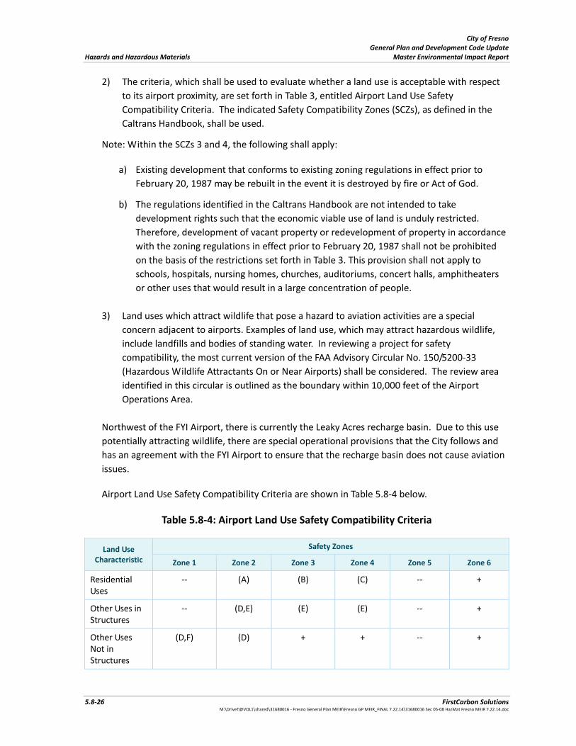
City of Fresno General Plan and Development Code Update Hazards and Hazardous Materials Master Environmental Impact Report
5.8‐26 FirstCarbon Solutions M:\DriveT@VOL1\shared\31680016 ‐ Fresno General Plan MEIR\Fresno GP MEIR_FINAL 7.22.14\31680016 Sec 05‐08 HazMat Fresno MEIR 7.22.14.doc
2) The criteria, which shall be used to evaluate whether a land use is acceptable with respect
to its airport proximity, are set forth in Table 3, entitled Airport Land Use Safety
Compatibility Criteria. The indicated Safety Compatibility Zones (SCZs), as defined in the
Caltrans Handbook, shall be used.
Note: Within the SCZs 3 and 4, the following shall apply:
a) Existing development that conforms to existing zoning regulations in effect prior to
February 20, 1987 may be rebuilt in the event it is destroyed by fire or Act of God.
b) The regulations identified in the Caltrans Handbook are not intended to take
development rights such that the economic viable use of land is unduly restricted.
Therefore, development of vacant property or redevelopment of property in accordance
with the zoning regulations in effect prior to February 20, 1987 shall not be prohibited
on the basis of the restrictions set forth in Table 3. This provision shall not apply to
schools, hospitals, nursing homes, churches, auditoriums, concert halls, amphitheaters
or other uses that would result in a large concentration of people.
3) Land uses which attract wildlife that pose a hazard to aviation activities are a special
concern adjacent to airports. Examples of land use, which may attract hazardous wildlife,
include landfills and bodies of standing water. In reviewing a project for safety
compatibility, the most current version of the FAA Advisory Circular No. 150/5200‐33
(Hazardous Wildlife Attractants On or Near Airports) shall be considered. The review area
identified in this circular is outlined as the boundary within 10,000 feet of the Airport
Operations Area.
Northwest of the FYI Airport, there is currently the Leaky Acres recharge basin. Due to this use
potentially attracting wildlife, there are special operational provisions that the City follows and
has an agreement with the FYI Airport to ensure that the recharge basin does not cause aviation
issues.
Airport Land Use Safety Compatibility Criteria are shown in Table 5.8‐4 below.
Table 5.8‐4: Airport Land Use Safety Compatibility Criteria
Land Use Characteristic
Safety Zones
Zone 1 Zone 2 Zone 3 Zone 4 Zone 5 Zone 6
Residential Uses
‐‐ (A) (B) (C) ‐‐ +
Other Uses in Structures
‐‐ (D,E) (E) (E) ‐‐ +
Other Uses Not in Structures
(D,F) (D) + + ‐‐ +
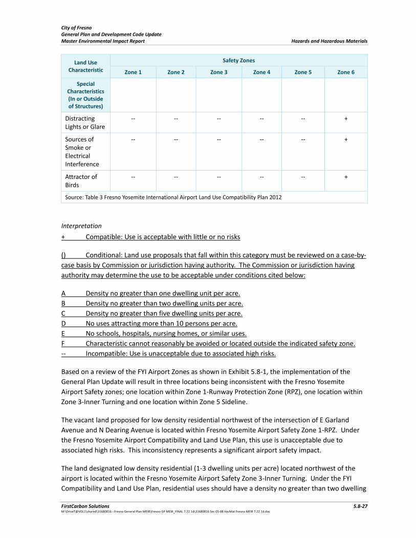
City of Fresno General Plan and Development Code Update Master Environmental Impact Report Hazards and Hazardous Materials
FirstCarbon Solutions 5.8‐27 M:\DriveT@VOL1\shared\31680016 ‐ Fresno General Plan MEIR\Fresno GP MEIR_FINAL 7.22.14\31680016 Sec 05‐08 HazMat Fresno MEIR 7.22.14.doc
Land Use Characteristic
Safety Zones
Zone 1 Zone 2 Zone 3 Zone 4 Zone 5 Zone 6
Special Characteristics (In or Outside of Structures)
Distracting Lights or Glare
‐‐ ‐‐ ‐‐ ‐‐ ‐‐ +
Sources of Smoke or Electrical Interference
‐‐ ‐‐ ‐‐ ‐‐ ‐‐ +
Attractor of Birds
‐‐ ‐‐ ‐‐ ‐‐ ‐‐ +
Source: Table 3 Fresno Yosemite International Airport Land Use Compatibility Plan 2012
Interpretation
+ Compatible: Use is acceptable with little or no risks
() Conditional: Land use proposals that fall within this category must be reviewed on a case‐by‐
case basis by Commission or jurisdiction having authority. The Commission or jurisdiction having
authority may determine the use to be acceptable under conditions cited below:
A Density no greater than one dwelling unit per acre.
B Density no greater than two dwelling units per acre.
C Density no greater than five dwelling units per acre.
D No uses attracting more than 10 persons per acre.
E No schools, hospitals, nursing homes, or similar uses.
F Characteristic cannot reasonably be avoided or located outside the indicated safety zone.
‐‐ Incompatible: Use is unacceptable due to associated high risks.
Based on a review of the FYI Airport Zones as shown in Exhibit 5.8‐1, the implementation of the
General Plan Update will result in three locations being inconsistent with the Fresno Yosemite
Airport Safety zones; one location within Zone 1‐Runway Protection Zone (RPZ), one location within
Zone 3‐Inner Turning and one location within Zone 5 Sideline.
The vacant land proposed for low density residential northwest of the intersection of E Garland
Avenue and N Dearing Avenue is located within Fresno Yosemite Airport Safety Zone 1‐RPZ. Under
the Fresno Yosemite Airport Compatibility and Land Use Plan, this use is unacceptable due to
associated high risks. This inconsistency represents a significant airport safety impact.
The land designated low density residential (1‐3 dwelling units per acre) located northwest of the
airport is located within the Fresno Yosemite Airport Safety Zone 3‐Inner Turning. Under the FYI
Compatibility and Land Use Plan, residential uses should have a density no greater than two dwelling
City of Fresno General Plan and Development Code Update Hazards and Hazardous Materials Master Environmental Impact Report
5.8‐28 FirstCarbon Solutions M:\DriveT@VOL1\shared\31680016 ‐ Fresno General Plan MEIR\Fresno GP MEIR_FINAL 7.22.14\31680016 Sec 05‐08 HazMat Fresno MEIR 7.22.14.doc
units per acre. Since the land use designation allows up to three dwelling units per acre, this land
use designation could be inconsistent with the compatibility zone that allows no greater than two
dwelling units per acre. Therefore, this inconsistency represents a potentially significant airport
safety impact.
The vacant land proposed for light industrial uses northeast of the airport is located within the
Fresno Yosemite Airport Safety Zone 5‐Sideline. Under the FYI Compatibility and Land Use Plan,
residential uses, other uses in structures, and other uses not in structures are considered
incompatible and unacceptable due to associated high safety risks. Therefore, this inconsistency
represents a potentially significant airport safety impact.
2) Fresno Chandler Downtown Airport: The land use policy plan for this airport sets forth the
criteria which the Airport Land Use Commission (ALUC) will use in evaluating amendments of
general, community and specific plans, airport master plans, rezoning applications, zoning
ordinance text amendments, and building code amendments proposed in the vicinity of the
Fresno Chandler Downtown Airport (FCH). Additionally, as stated in the airport’s land use plan:
The following projects, if located within the Airport Review Area, shall be referred to the ALUC
for a determination of consistency with the airport’s land use policy plan: the adoption or
amendment of general, community and specific plans, airport master plans, rezoning
applications, zoning ordinance text amendments, and building code amendments. ALUC
determination of consistency does not apply to conditional use permits, variances, subdivision or
parcel maps, although the ALUC may be requested to review these projects and make a
recommendation (Fresno‐Chandler Downtown Airport Land Use Policy Plan, 2000).
The Fresno‐Chandler Downtown Airport Land Use Policy Plan contains restrictions of land uses or
land use characteristics which may affect safe air navigation or which, because of their nature and
proximity to an airport, may be incompatible with the airport shall be avoided in the vicinity of FCH.
The criteria, which shall be used to evaluate whether a land use is acceptable with respect to its
airport proximity, are set forth in Table C‐2, entitled “Safety Compatibility Criteria” in the Fresno
Chandler Downtown Airport Land Use Policy Plan. The indicated Safety Compatibility Zones shall be
used in conjunction with the Environs Plan Map (Figure D‐1 of the Land Use Policy Plan). Land uses
which attract concentrations of birds, are a special concern within the traffic pattern zone of
airports. In reviewing a project for safety compatibility, this possibility should be considered.
Sanitary landfills can attract birds and generate airborne debris, posing a threat to aircraft
operations, which cannot be satisfactorily mitigated by conventional operating procedures. Landfills
should, therefore, not be permitted in proximity to FCH.
As detailed in the airspace protection section of the Airport Land Use Policy Plan, no structure, tree
or other object shall be permitted to exceed the height limits established in accordance with Part 77,
Subpart C, of the Federal Aviation Regulations (FAR), with certain exceptions, depending on existing
conditions (Fresno‐Chandler Downtown Airport Land Use Policy Plan, 2000).
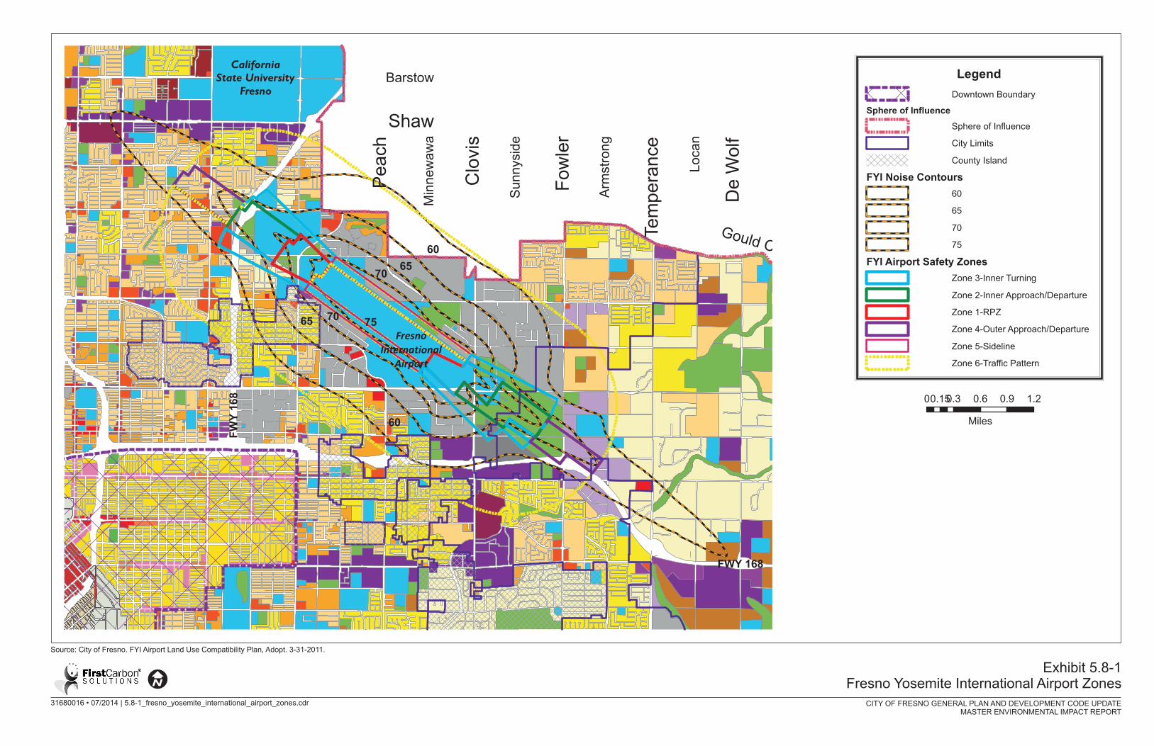

City of Fresno General Plan and Development Code Update Master Environmental Impact Report Hazards and Hazardous Materials
FirstCarbon Solutions 5.8‐31 M:\DriveT@VOL1\shared\31680016 ‐ Fresno General Plan MEIR\Fresno GP MEIR_FINAL 7.22.14\31680016 Sec 05‐08 HazMat Fresno MEIR 7.22.14.doc
Based on a review of the FCH Airport Zones as shown on Exhibit 5.8‐2, the General Plan Update
includes residential uses that are proposed within Runway Protection Zone 1, Inner Safety Zone 2,
Inner Training Zone 3 that are located southeast of the airport runways. In addition to land use
designations that could accommodate future residential uses within these safety zones, there are
existing residences located within these areas. According to the Fresno Chandler Downtown Airport
Land Use Policy Plan, no residential uses are allowed in Safety Zone 1 and single‐family residential
uses are allowed in safety zones 2 and 3. Following is a discussion for Safety Zones 1, 2, and 3.
Safety Zone 1 – The General Plan Update includes a Neighborhood designation within Safety Zone 1
on two vacant lots northeast of the Kearney Boulevard and Thorne Avenue intersection. The
planned land uses for these two lots are not consistent with the Fresno Chandler Downtown Airport
Land Use Policy Plan.
In addition, the General Plan Update includes a Medium Density designation (single family) along
portions of four lots generally northwest of the W. Hawes Avenue and Thorne Avenue intersection.
Currently, these four lots encompass approximately 0.5 acre. The Medium Density designation
allows from 5 to 12 units per acre; however, the Fresno Chandler Downtown Airport Land Use Policy
Plan prohibits residential within the backyards of these four lots.
Safety Zone 2 – Medium Density and Neighborhood designations are identified southeast of the
runways. These land use designations provide for single family residential which is permitted in the
Fresno Chandler Downtown Airport Land Use Policy Plan for Safety Zone 2.
Safety Zone 3 – For this safety zone, Medium Density and Neighborhood designations are also
identified southeast of the runways. These land use designations provide for single family residential
which is permitted in the Fresno Chandler Downtown Airport Land Use Policy Plan for Safety Zone 3.
As discussed above, the proposed General Plan includes an inconsistency with the regulations
identified for Safety Zone 1 in the Fresno Chandler Downtown Airport Land Use Policy Plan.
Therefore, these inconsistencies represent a potentially significant airport safety impact.
The following objective and policies from the proposed General Plan Update would reduce potential
airport safety impact associated with the Fresno Yosemite International Airport:
Objective NS‐5: Protect the safety, health, and welfare of persons and property on the ground and
in aircraft by minimizing exposure to airport‐related hazards.
Policy NS‐5‐a: Land Use and Height. Incorporate and enforce all applicable Airport Land Use
Compatibility Plans (ALUCPs) through land use designations, zoning, and development standards to
support the continued viability and flight operations of Fresno’s airports and to protect public safety,
health, and general welfare.
Limit land uses in airport safety zones to those uses listed in the applicable ALUCPs as
compatible uses, and regulate compatibility in terms of location, height, and noise.
City of Fresno General Plan and Development Code Update Hazards and Hazardous Materials Master Environmental Impact Report
5.8‐32 FirstCarbon Solutions M:\DriveT@VOL1\shared\31680016 ‐ Fresno General Plan MEIR\Fresno GP MEIR_FINAL 7.22.14\31680016 Sec 05‐08 HazMat Fresno MEIR 7.22.14.doc
Ensure that development, including public infrastructure projects, within the airport approach
and departure zones complies with Part 77 of the Federal Aviation Administration Regulations
(Objects Affecting Navigable Airspace), particularly in terms of height.
Policy NS‐5‐b: Airport Safety Hazards. Ensure that new development, including public infrastructure
projects, does not create safety hazards such as glare from direct or reflective sources, smoke,
electrical interference, hazardous chemicals, fuel storage, or from wildlife, in violation of adopted
safety standards.
Policy NS‐5‐c: Aviation Easements. Employ avigation easements in order to secure and protect
airspace required for unimpeded operation of publicly owned airports.
Commentary: Avigation easements are established in the form of land use covenants and are binding
upon present and subsequent property owners.
Policy NS‐5‐d: Disclosure. As a condition of approval for residential development projects, require
sellers to prepare and provide State Department of Real Estate Disclosure statements to property
buyers notifying of noise and safety issues related to airport operations.
Policy NS‐5‐e: Planned Expansion. Allow for the orderly expansion and improvement of publicly‐
owned airports, while minimizing adverse environmental impacts associated with these facilities.
Periodically update airport facility master plans in accordance with FAA regulations.
Require land use within the boundaries of the Fresno‐Yosemite International Airport and
Chandler Downtown Airport to conform to designations and policies specified in adopted City
of Fresno compatible land use plans.
Provide local jurisdictions surrounding the City's publicly owned airports with specific guidelines for effectively dealing with the presence and operation of these airports.
With the implementation of the objective and policies identified above, the potential airport hazard
impacts associated with the proposed project would remain significant.
Cumulative Impact Analysis
The implementation of cumulative development along with the General Plan Update will result in
three locations being inconsistent with the Fresno Yosemite Airport Safety Zones and one location
being inconsistent with the Fresno Chandler Downtown Airport Land Use Policy Plan. Since these
inconsistencies would occur under the proposed project, the project’s contribution to cumulative
airport hazard impacts would be considerable and would be considered significant.
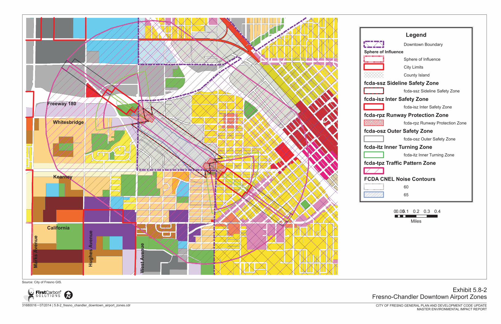

City of Fresno General Plan and Development Code Update Master Environmental Impact Report Hazards and Hazardous Materials
FirstCarbon Solutions 5.8‐35 M:\DriveT@VOL1\shared\31680016 ‐ Fresno General Plan MEIR\Fresno GP MEIR_FINAL 7.22.14\31680016 Sec 05‐08 HazMat Fresno MEIR 7.22.14.doc
One inconsistency for 1 –RPZ, Airport Safety Zone 3‐Inner Turning, and Zone 5‐Sideline. This
inconsistency represents a significant cumulative airport safety impact. The implementation of the
General Plan Update will contribute substantially to this potential significant airport safety impact.
Mitigation measures MM HAZ‐1 through MM HAZ‐5 should be implemented to reduce significant
cumulative impacts to a less than significant cumulative effect.
Mitigation Measures
Project Specific
MM HAZ‐1 Re‐designate the existing vacant land proposed for low density residential northwest
of the intersection of E Garland Avenue and N Dearing Avenue and located within
Fresno Yosemite International Airport Zone 1‐ RPZ to Open Space.
MM HAZ‐2 Limit the proposed low density residential at 1‐3 dwelling units per acre located
northwest of the airport and located within Fresno Yosemite International Airport
Zone 3‐Inner Turning to 2 dwelling units per acre or less.
MM HAZ‐3 Re‐designate the current area within Fresno Yosemite International Airport Zone 5‐
Sideline located northeast of the airport to Public Facilities‐Airport or Open Space.
MM HAZ‐4 Redesignate the current vacant lots at the northeast corner of Kearney Boulevard
and Thorne Avenue to Public Facilities‐Airport or Open Space.
MM HAZ‐5 Prohibit residential uses within Safety Zone 1 northwest of the W. Hawes Avenue
and Thorne Avenue intersection
Cumulative
Implementation of Mitigation Measures HAZ‐1 through HAZ‐5 shall be implemented.
Level of Significance After Mitigation
Project Specific
Less than significant impact.
Cumulative
Less than significant impact.
Private Airstrip
Impact HAZ‐6 The project is within the vicinity of a private airstrip, and the project would not result in a safety hazard for people residing or working in the project area
Project Specific Impact Analysis
Sierra Sky Park is a privately owned, public use general aviation airport located approximately ten
miles northwest of the Fresno Downtown Area. The Land Use Policy Plan for this airport sets forth
the criteria, which the City of Fresno will use in evaluating development proposals proposed for
adoption of plan amendments in the vicinity of the Sierra Sky Park Airport. Plan amendments and re‐
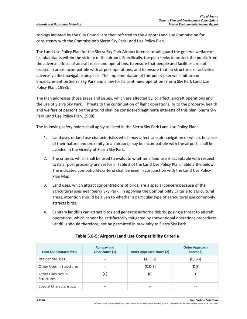
City of Fresno General Plan and Development Code Update Hazards and Hazardous Materials Master Environmental Impact Report
5.8‐36 FirstCarbon Solutions M:\DriveT@VOL1\shared\31680016 ‐ Fresno General Plan MEIR\Fresno GP MEIR_FINAL 7.22.14\31680016 Sec 05‐08 HazMat Fresno MEIR 7.22.14.doc
zonings initiated by the City Council are then referred to the Airport Land Use Commission for
consistency with the Commission’s Sierra Sky Park Land Use Policy Plan.
The Land Use Policy Plan for the Sierra Sky Park Airport intends to safeguard the general welfare of
its inhabitants within the vicinity of the airport. Specifically, the plan seeks to protect the public from
the adverse effects of aircraft noise and operations, to ensure that people and facilities are not
located in areas incompatible with airport operations, and to ensure that no structures or activities
adversely affect navigable airspace. The implementation of this policy plan will limit urban
encroachment on Sierra Sky Park and allow for its continued operation (Sierra Sky Park Land Use
Policy Plan, 1998).
The Plan addresses those areas and issues, which are affected by, or affect, aircraft operations and
the use of Sierra Sky Park. Threats to the continuation of flight operations, or to the property, health
and welfare of persons on the ground shall be considered legitimate interests of this plan (Sierra Sky
Park Land Use Policy Plan, 1998).
The following safety points shall apply as listed in the Sierra Sky Park Land Use Policy Plan:
1. Land uses or land use characteristics which may affect safe air navigation or which, because
of their nature and proximity to an airport, may be incompatible with the airport, shall be
avoided in the vicinity of Sierra Sky Park.
2. The criteria, which shall be used to evaluate whether a land use is acceptable with respect
to its airport proximity are set for in Table 2 of the Land Use Policy Plan, Table 5.8‐6 below.
The indicated compatibility criteria shall be used in conjunction with the Land Use Policy
Plan Map.
3. Land uses, which attract concentrations of birds, are a special concern because of the
agricultural uses near Sierra Sky Park. In applying the Compatibility Criteria to agricultural
areas, attention should be given to whether a particular type of agricultural use commonly
attracts birds.
4. Sanitary landfills can attract birds and generate airborne debris, posing a threat to aircraft
operations, which cannot be satisfactorily mitigated by conventional operations procedures.
Landfills should therefore, not be permitted in proximity to Sierra Sky Park.
Table 5.8‐5: Airport/Land Use Compatibility Criteria
Land Use Characteristic Runway and
Clear Zones (1) Inner Approach Zones (2) Outer Approach
Zones (3)
Residential Uses ‐‐ (A, E,G) (B,E,G)
Other Uses in Structures ‐‐ (C,D,E) (D,E)
Other Uses Not in Structures
(C) (C) +
Special Characteristics: ‐‐ ‐‐ ‐‐

City of Fresno General Plan and Development Code Update Master Environmental Impact Report Hazards and Hazardous Materials
FirstCarbon Solutions 5.8‐37 M:\DriveT@VOL1\shared\31680016 ‐ Fresno General Plan MEIR\Fresno GP MEIR_FINAL 7.22.14\31680016 Sec 05‐08 HazMat Fresno MEIR 7.22.14.doc
Land Use Characteristic Runway and
Clear Zones (1) Inner Approach Zones (2) Outer Approach
Zones (3)
Distracting Light or Glare
Sources of Smoke or electronic Interference
‐‐ ‐‐ ‐‐
Attractor of Birds ‐‐ ‐‐ ‐‐
Notes: 1. See Policy Plan Map for location of zones. 2. The inner approach zone extends to the point below where the approach surface intersects the horizontal surface. 3. The outer approach zone extends to the point of the junction of the horizontal and conical zones. Source: Sierra Sky Park Airport Land Use Policy Plan, 1998
Interpretation
+ Acceptable: Use is acceptable
() Conditionally Acceptable: Use is acceptable under conditions cited below:
A Density no greater than three dwelling units per acre.
B Outer Approach Zone: Density no greater than two‐five dwelling units per acre.
C No uses attracting more than 10 persons per acre
D No schools, hospitals, nursing homes, churches, or similar uses or structures for large
assemblages of persons.
E. At least 20% of area to be landscaped open space in a clustered configuration.
F Allowed only if cannot reasonably be avoided or located outside the indicated zone.
G Density Transfer Provision – a conditional use permit shall be required of any property owner
who seeks the privilege of “transferring” the number of dwelling units which such property owner
could have constructed in the Inner and Outer Approach Zone onto the remainder of the impacted
parcel which lies outside said zone and which is under the same ownership, using the underlying
land use designation of the 1984 Fresno General Plan.
‐‐ Unacceptable: Use is unacceptable.
As detailed in the airspace protection section of the Land Use Policy Plan, no structure, tree or other
object shall be permitted to exceed the height limits established in accordance with Part 77, Subpart
C, of the Federal Aviation Regulations (FAR), with certain exceptions, depending on existing
conditions (Sierra Sky Park Land Use Policy Plan, 1998).
Based on a review of the Sierra Sky Park Airport Zones as shown in Exhibit 5.8‐3, the proposed land
uses in the General Plan Update includes an office use at the southwest corner of Herndon Avenue
and N. Brawley Avenue. Currently, this land contains some agriculture and some undeveloped areas.
According to the Airport/Land Use Compatibility Criteria for Sierra Sky Park, land uses are allowed
with this area; however, there is a restriction on the use intensification. The Compatibility Criteria
prohibits uses attracting more than 10 persons per acre. The future implementation of an office use
at this location would be required to comply with the intensification requirement as well as the

City of Fresno General Plan and Development Code Update Hazards and Hazardous Materials Master Environmental Impact Report
5.8‐38 FirstCarbon Solutions M:\DriveT@VOL1\shared\31680016 ‐ Fresno General Plan MEIR\Fresno GP MEIR_FINAL 7.22.14\31680016 Sec 05‐08 HazMat Fresno MEIR 7.22.14.doc
height limit. Compliance with these existing regulations would result in a less than significant impact
on airport safety.
Cumulative Impact Analysis
The implementation of cumulative development along with the General Plan Update would not
result in inconsistencies with the Sierra Sky Park Land Use Policy Plan. Since the project would result
in less than significant impacts on airport safety, the project’s contribution to cumulative airport
hazard impacts would not be considerable, and therefore, the project would result in a less than
significant cumulative airport hazard impact.
Mitigation Measures
Project Specific
No mitigation measures are required.
Cumulative
No mitigation measures are required.
Level of Significance After Mitigation
Project Specific
Less than significant impact.
Cumulative
Less than significant impact.
Emergency Plans
Impact HAZ‐7 The project would not impair implementation of or physically interfere with an adopted emergency response plan or emergency evacuation plan.
Project Specific Impact Analysis
The City's Police and Fire Departments are the lead agencies for all local emergency response efforts.
The City's full‐time Emergency Preparedness Officer (EPO) is responsible for ensuring that Fresno's
emergency response plans are up‐to‐date and implemented properly. The EPO also facilitates
cooperation between City departments and other local, state and federal agencies that would be
involved in emergency response operations (City of Fresno Emergency Response Plan Overview.
2012). The City of Fresno EOC will serve as the coordination and communication between the City of
Fresno and Fresno County Operational Area EOC. A potentially significant impact could occur if the
EOC is under redevelopment or construction during an emergency.
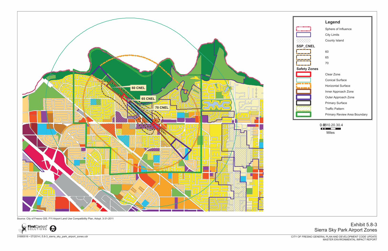


City of Fresno General Plan and Development Code Update Master Environmental Impact Report Hazards and Hazardous Materials
FirstCarbon Solutions 5.8‐41 M:\DriveT@VOL1\shared\31680016 ‐ Fresno General Plan MEIR\Fresno GP MEIR_FINAL 7.22.14\31680016 Sec 05‐08 HazMat Fresno MEIR 7.22.14.doc
The following objective and policies in the General Plan Update would reduce potential impacts to
emergency response and evacuation.
Noise and Safety Element
Objective NS‐6: Foster an efficient and coordinated response to emergencies and natural disasters.
Policy NS‐6‐a: County Multi‐Jurisdiction Hazard Mitigation Plan. Adopt and implement the Fresno
County Multi‐Jurisdiction Hazard Mitigation Plan and City of Fresno Local Hazard Mitigation Plan
Annex.
Commentary: The federal Disaster Mitigation Act of 2000 requires that cities, counties, and special
districts have a Local Hazard Mitigation Plan to be eligible to receive FEMA hazard mitigation funds.
Cities and counties can adopt and use all or part of a regional multi‐jurisdictional plan, such as the
one prepared by Fresno County, in lieu of preparing all or part of a Local Hazard Mitigation Plan.
Policy NS‐6‐b: Disaster Response Coordination. Maintain coordination with other local, State, and
Federal agencies to provide coordinated disaster response.
Policy NS‐6‐c: Emergency Operations Plan. Update the City’s Emergency Operations Plan
periodically, using a whole community approach, which integrates considerations for People with
access and functional needs in all aspects of planning.
Policy NS‐6‐d: Evacuation Planning. Maintain an emergency evacuation plan in consultation with
the Police and Fire Departments and other emergency service providers, which shows potential
evacuation routes and a list of emergency shelters to be used in case of catastrophic emergencies.
Policy Guidance: The evacuation plan can be flexible in order to consider many scenarios and
multiple modes of transportation beyond private automobiles. It should provide special provisions
for disadvantaged populations, such as those with physical handicaps or those with low or very low
incomes, and for areas with fewer resources through neighborhood emergency preparedness
programs.
Policy NS‐6‐e: Critical Use Facilities. Ensure critical use facilities (e.g. City Hall, police and fire
stations, schools, hospitals, public assembly facilities, transportation services) and other structures
that are important to protecting health and safety in the community remain operational during an
emergency.
Site and design these facilities to minimize their exposure and susceptibility to flooding,
seismic and geological effects, fire, and explosions.
Work with the owners and operators of critical use facilities to ensure they can provide
alternate sources of electricity, water, and sewerage in the event that regular utilities are
interrupted in a disaster.
City of Fresno General Plan and Development Code Update Hazards and Hazardous Materials Master Environmental Impact Report
5.8‐42 FirstCarbon Solutions M:\DriveT@VOL1\shared\31680016 ‐ Fresno General Plan MEIR\Fresno GP MEIR_FINAL 7.22.14\31680016 Sec 05‐08 HazMat Fresno MEIR 7.22.14.doc
Policy NS‐6‐f: Emergency Vehicle Access. Require adequate access for emergency vehicles in all new
development, including adequate widths, turning radii, hard standing areas, and vertical clearance.
Policy NS‐6‐g: Emergency Preparedness Public Awareness Programs. Continue to conduct programs
to inform the general public, including people with access and functional needs, of the City’s
emergency preparedness and disaster response procedures.
With the implementation of the above objective and policies, potential interference with an adopted
emergency response plan or emergency evacuation plan would be reduced; however, the impact
could remain significant.
Cumulative Impact Analysis
Development outside of the Planning Area could affect emergency response and evacuation;
however, this potential effect would not be a cumulative effect on the City’s Emergency Operation
Center. Since the proposed project could result in a significant impact on the Emergency Operations
Center if the Center is under redevelopment during an emergency, the proposed project’s
contribution to a cumulative emergency or evacuation impact is considered considerable and
therefore, a significant cumulative impact.
Mitigation Measures
Project‐Specific
MM HAZ‐6 Establish an alternative Emergency Operations Center in the event the current
Emergency Operations Center is under redevelopment or blocked.
Cumulative
Implementation of Mitigation Measure HAZ‐6 is required.
Level of Significance After Mitigation
Project Specific
Less than significant impact.
Cumulative
Less than significant impact.
Wildland Fires
Impact HAZ‐8 The project would not expose people or structures to a significant risk of loss, injury or death involving wildland fires, including where wildlands are adjacent to urbanized areas or where residences are intermixed with wildlands.
Project Specific Impact Analysis
As detailed in the City of Fresno Map Atlas Existing Conditions Report, dated August 2011, although
the City of Fresno is proximate to high and very high fire hazard designated areas, the city is largely
categorized as little or no threat or moderate fire hazard, which is largely attributed to paved areas.
Some small areas along the San Joaquin River Bluff area in northern Fresno are prone to wildfires
City of Fresno General Plan and Development Code Update Master Environmental Impact Report Hazards and Hazardous Materials
FirstCarbon Solutions 5.8‐43 M:\DriveT@VOL1\shared\31680016 ‐ Fresno General Plan MEIR\Fresno GP MEIR_FINAL 7.22.14\31680016 Sec 05‐08 HazMat Fresno MEIR 7.22.14.doc
due to relatively steep terrain/vegetation, and these areas are classified as high fire hazard areas.
Land, which is currently vacant, is designated as multi‐use on the City’s Proposed General Plan (Map
Atlas Existing Conditions Report, 2011). Thus, development under the proposed General Plan Update
adjacent to the San Joaquin River Bluff would be subject to dangers from wildland fires. As such, the
proposed project is anticipated to have a potentially significant impact in this regard.
The following implementing objectives and policies within the General Plan Update would reduce
potential impacts from wildfires.
Objective PU‐2: Ensure that the Fire Department’s staffing and equipment resources are sufficient
to meet all fire and emergency service level objectives and are provided in an efficient and cost
effective manner.
Policy PU‐2‐a: Unify Fire Protection. Pursue long‐range transfer of fire protection service
agreements with adjacent fire districts that, in concert with existing automatic aid agreements, will
lead to the eventual unification of fire protection services in the greater Fresno area.
Policy PU‐2‐b: Maintain Ability. Strive to continually maintain the Fire Department’s ability to
provide staffing and equipment resources to effectively prevent and mitigate emergencies in existing
and new high‐rise buildings and in other high‐density residential and commercial development
throughout the city.
Policy PU‐2‐c: Rescue Standards. Develop appropriate standards, as necessary, for rescue
operations, including, but not limited to, confined space, high angle, aswift water rescues, and the
unique challenges of a high speed rail corridor.
Objective PU‐3: Enhance the level of fire protection to meet the increasing demand for services
from an increasing population.
Policy PU‐2‐d: Station Siting. Use the General Plan, community plans, Specific Plans, neighborhood
plans, and Concept Plans, the City’s Geographic Information Systems (GIS) database, and a fire
station location program to achieve optimum siting of future fire stations.
Policy PU‐2‐e: Service Standards. Strive to achieve a community wide risk management plan that
include the following service level objectives 90 percent of the time:
First Unit on Scene – First fire unit arriving with minimum of three firefighters and ability to
apply suppressing agent within 6 minutes and 20 seconds from emergency call (7 minutes and
30 seconds with 9‐11 processing time).
Effective Response Force – Provide sufficient number of firefighters on scene of an emergency
(17 for low risk, 23 for high risk) within nine minutes and 20 seconds from time of alert to
arrival.
City of Fresno General Plan and Development Code Update Hazards and Hazardous Materials Master Environmental Impact Report
5.8‐44 FirstCarbon Solutions M:\DriveT@VOL1\shared\31680016 ‐ Fresno General Plan MEIR\Fresno GP MEIR_FINAL 7.22.14\31680016 Sec 05‐08 HazMat Fresno MEIR 7.22.14.doc
Policy PU‐3‐a: Fire Prevention Inspections. Develop strategies to enable the performance of annual
fire and life safety inspection of all industrial, commercial, institutional, and multi‐family residential
buildings, in accordance with nationally recognized standards for the level of service necessary for a
large Metropolitan Area, including self‐certification program.
Policy PU‐3‐b: Reduction Strategies. Develop community risk reduction strategies that target high
service demand areas, vulnerable populations (e.g. young children, older adults, non‐English
speaking residents, persons with disabilities, etc.) and high life hazards occupancies.
Policy PU‐3‐d: Review All Development Applications. Continue Fire Department review of all
development applications, provide comments and recommend conditions of approval that will
ensure adequate on‐site and off‐site fire protection systems and features are provided.
Policy PU‐3‐e: Building Codes. Adopt and enforce amendments to construction and fire codes, as
determined appropriate, to systematically reduce the level of risk to life and property from fire,
commensurate with the City’s fire suppression capabilities.
Policy PU‐3‐f: Adequate Infrastructure. Continue to pursue the provision of adequate water
supplies, hydrants, and appropriate property access to allow for adequate fire suppression
throughout the City.
Policy PU‐3‐g: Cost Recovery. Continue to evaluate appropriate codes, policies, and methods to
generate fees or other sources of revenue to offset the ongoing personnel and maintenance costs of
providing fire prevention and response services.
It is anticipated that implementation of the above objectives and policies from the proposed General
Plan Update will reduce project impacts to wildland fires to a less than significant level.
Cumulative Impact Analysis
Implementation of the proposed project along with cumulative development could create a
potentially significant cumulative impact associated with the risk of loss, injury or death involving
wildland fires. However, implementation of the General Plan Update objectives and policies would
reduce project specific impacts related to wildfires. Therefore, the Project’s contribution to
potentially significant wildfire hazards would not be cumulatively considerable and would be less
than cumulatively significant.
Mitigation Measures
Project Specific
No mitigation measures are required.
Cumulative
No mitigation measures are required.
City of Fresno General Plan and Development Code Update Master Environmental Impact Report Hazards and Hazardous Materials
FirstCarbon Solutions 5.8‐45 M:\DriveT@VOL1\shared\31680016 ‐ Fresno General Plan MEIR\Fresno GP MEIR_FINAL 7.22.14\31680016 Sec 05‐08 HazMat Fresno MEIR 7.22.14.doc
Level of Significance After Mitigation
Project Specific
Less than significant impact.
Cumulative
Less than significant impact.
