wind energy feasibility study - gw · wind energy feasibility study ... it is expected these will...
TRANSCRIPT

Attachment 2 to Report 05.128 Page 1 of 28
255036 1
Wind Energy Feasibility Study - Greater Wellington Regional Council land at Mt Climie and Puketiro
Executive Summary
As part of Greater Wellington Regional Council’s vision to create a sustainable region, it has identified 10 key elements. One of these is energy. In 2003, the Council approved investigating renewable energy (wind energy) developments on Council land. An update was provided in 2004. Investigations into the feasibility of wind energy developments at the Mt Climie ridge to the east of Upper Hutt and at Puketiro adjacent to the Battle Hill Farm Forest Park have been completed. Specific legislation that will allow developments by third parties on Council land set aside for water supply or forestry purposes was passed by Parliament in March 2005. Investigations at the Belmont site are well advanced and are expected to be completed later this calendar year. The Puketiro site is partly in Porirua City and partly in Upper Hutt City while the Mt Climie ridge is entirely within Upper Hutt City. Wind energy generation is a discretionary activity under the District Plans of both cities. Wind energy recording and analysis shows there is adequate wind at Puketiro to possibly make a wind farm viable. At the Mt Climie ridge though, the wind resource is outstanding. Several other studies have been completed as part of the investigation. At Puketiro, the key issue will be the visual aspects. While at the Mt Climie ridge, the main issues are ecology and visual. Noise from the turbines is very unlikely to be an issue at either site as far as residential properties are concerned. Any Puketiro development will be smaller than the potential at Mt Climie, unless some adjacent landowners join with the Council. Because of the fixed development costs, such as access roading, a Puketiro development only on Council land is probably marginal. A development at the Mt Climie ridge will be economic, but the ecology impact is much greater than at Puketiro. The issue of possible Council investment is any project was not resolved when the project was first considered. It is apparent that there are a number of energy companies who would provide the Council with development proposals. With the pressure on Council funds for transport and other issues, the Council may like to take only the landowner interest in any development.
The decision of whether or not to proceed with none, one or both sites has to be based on a trade-off between the benefits of having renewable energy on Council land at Mt Climie and/or Puketiro against the adverse effects.

Attachment 2 to Report 05.128 Page 2 of 28
1. 1. Purpose
To update Councillors about possible wind energy developments on Council land prior to making a decision about two of the three sites being investigated.
2. Introduction
In March 2003, the Council approved investigating wind energy development at the Belmont Regional Park (report 03.11). This was subsequently expanded to allow investigations at other Council sites, namely Puketiro, adjacent to the Battle Hill Farm Forest Park and the Mt Climie ridgeline to the east of Upper Hutt. Both of these latter sites are part of the land held for future water supply purposes.
An update was provided in May 2004 (report 04.174).
Investigation work for Puketiro and the Mt Climie ridgeline has reached a point where the Council can now decide to either proceed further with the proposals, or suspend further wind data gathering for these two sites.
The Belmont Regional Park site is larger than either of the other sites and investigations are taking longer. It is expected these will be completed by the end of 2005.
Because wind generated electrical energy in New Zealand is not subsidised, unlike some other countries, high quality sites are required in order for a development to be economic. Generally, these are sites that have an average wind speed above about 9.5 metres/second (35 km/h).
3. Why renewable energy?
This issue was covered in the earlier reports. But to recap, the reality of climate change has strengthened since the first renewable energy report to Council two years ago.
New Zealand requires about 150 MW of new electricity generation each year. The Maui gas field is nearly exhausted and as a consequence the Huntly power station is now largely fired by coal. Two years ago, Meridian Energy’s project Aqua of over 500MW showed promise, this has now been cancelled.
The default position for new power generation in New Zealand is to use fossil fuels and without further natural gas discoveries or importing liquid natural gas, coal will provide the energy source.
Wind energy developments in NZ though are gathering pace. In the last two years, Tararua Stage II and the nearby Te Apiti wind farm have been completed. Hau Nui, near Martinborough, has been expanded. Consents for more wind farms have been granted or applied for. One proposal though has been declined and is now before the Environment Court.
The New Zealand Wind Energy Association believes 1000 MW of wind energy generation should be possible by 2010. The 1000 MW includes constructed, in progress and consented developments. Obtaining suitable wind energy sites remains a major impediment to development of this form of renewable energy.
Attachment 2 to Report 05.128 Page 3 of 28
255036 3
With the Kyoto Protocol now ratified, New Zealand is committed to reducing its greenhouse gas emissions in the period 2008-2012 to 1990 levels. Renewable energy, such as wind generation, can support this objective.
Some opponents of wind energy may argue that because of New Zealand’s small size, what happens here has minimal impact globally. New Zealanders’ attitude to the climate change issues and those in developed countries can impact on the attitude of people in emerging nations. China, for example, may pass its first renewable energy legislation in 2005. The draft legislation calls for a doubling of renewable energy to 120,000 MW by 2020. Of this, 20,000 MW would be in the form of wind energy. By way of comparison, New Zealand’s total generating capacity is about 8500 MW.
4. Can wind energy on GWRC land make a difference?
With the clean, green image portrayal of New Zealand overseas and the amount of wind here, it surprises some visitors, particularly those from Europe, that there are so few wind turbines. While the emphasis in the past has been on hydro developments, the last major new hydro power station was completed over 10 years ago.
It has previously been indicated that a wind farm on the Mt Climie ridgeline could produce electrical energy equivalent to that used annually by 35,000 homes or one third of the houses in the Wellington metropolitan area. Although the Belmont and Puketiro sites are not as windy as the Mt Climie ridgeline, a total of 100 MW installed on these two sites could power the equivalent of another 47,000 homes (400 GWh a year). The potential therefore exists from these three sites to provide the equivalent of 70% of the domestic electrical energy used in the Wellington area.
From a CO2 abatement perspective, under the Kyoto Protocol, the annual emission of 420,000 tonnes of CO2 can be avoided by these three possible wind farms. On the New Zealand Climate Change office website, it states:
“The cost of doing nothing about climate change could be severe and the impacts on our environment, economy and society are likely to get steadily worse if greenhouse gas emissions are not reduced significantly over the coming decades.”
In October 2002, the Government announced an objective of achieving an additional 30 PJ (8340 GWh) a year from renewable sources by 2012. The 700 GWh a year that could be available from the three GWRC sites is 8% of this.
There are electrical losses in the transmission lines in the order of 5 to 10% to provide power to the Wellington area. This is because the power is mainly sourced from the centre of the North Island or the South Island. Producing power locally can reduce the average transmission losses. Consequently, the spot price of wholesale electricity will also reduce.
Undoubtedly, wind energy developments on GWRC land can make a difference.

Attachment 2 to Report 05.128 Page 4 of 28
5. Planning framework
5.1 Suitable development and a sustainable region
As part of the Long Term Community Council Plan (LTCCP), the Council consulted on a sustainable region concept in 2003.
What a sustainable region is was not defined in the various documents, rather the focus is on outcomes. In 1987, the World Commission on Environment and Development (the Brundtland Commission) agreed on a definition of sustainable development that has been adopted by many organisations.
Sustainable development is development that meets the needs of the present without compromising the ability of future generations to meet their own needs.
This definition does not imply conservation or doing nothing.
There are 10 elements that make up the Council’s vision of a sustainable region. One of the elements is Energy and Council’s wind energy investigations are mandated under this element which can result in an increase in renewable energy in the region. The projects though will have both positive and negative outcomes when considered alongside the other elements.
As part of the Council’s LTCCP process, 40 submitters indicated they were in favour of wind energy developments in the Wellington Region. This was a high number of responses relative to the number of responses to other issues.
In 2004, the Energy Efficiency and Conservation Authority (EECA) carried out an acceptance survey for support of various forms of energy. Eighty-two percent approved of wind power, next was hydro generation with 79%. When people were asked would they support a wind farm in their local area, 60% said yes and 18% were opposed.
A high degree of community acceptance is assured for the principle of wind energy – in line with Council’s sustainable region vision. Specific acceptance though will depend on the detail and this can be partly determined through public consultation.
5.2 Regional Policy Statement
The Regional Policy Statement for the Wellington Region (RPS) has a chapter on sustainable energy management. The objectives in this chapter aim to moderate energy demand, improve energy efficiency, move to greater use of renewable energy sources and deal with the adverse effects of energy production, transmission and end use. Policies address each of these 4 areas, and of particular note is Policy 6 that aims to "promote efficient energy production from the Region's renewable energy assets, where the effects of the development are environmentally acceptable". The RPS also has energy-related objectives and policies in the Air and Built Environment and Transportation chapters e.g. policies that promote use of renewable energy (and improvements in energy efficiency) for benefits to air quality, human (and ecosystem) health and by way of public transport, easing congestion and enhancing the quality of urban environments. The benefits for

Attachment 2 to Report 05.128 Page 5 of 28
255036 5
climate change arising from greater use of renewables are also recognised in various parts of the RPS.
Whilst there is support for renewable energy in the RPS, there is also a concern that the effects of any energy production (and transmission) should also be seriously considered. At a broad scale, this includes landscape, biodiversity and soil/water/air quality issues. Policies and Methods in the Energy chapter, and other parts of the RPS too (particularly the policies in the “Ecosystems” and “Landscape and Heritage” chapters of the RPS), therefore reflect the need to strike a balance between the benefits of renewable energy production but also the effects of that production.
6. Feasibility studies for wind energy developments on GWRC land
6.1 Legislation
It was noted in 2003 that it was not possible for a third party to construct wind turbines on GWRC land purchased for water supply purposes, without a change in legislation. The Wellington Regional Council (Water Board Functions) Act was passed in March 2005. This Act allows renewable energy developments provided the prime function of water collection is not compromised. The Select Committee hearing the Bill was given an assurance that the GWRC would consult the public about any development.
A requirement of the Bill is that water catchment land has to be protected for its prime purpose. This is practical for both the Puketiro and Mt Climie ridgeline sites and appropriate wording can be written into any development agreement.
6.2 Consultation
There have been preliminary discussions with various interested parties as part of the feasibility studies. Most groups are reserving their positions until more definitive information is available, such as actual wind turbine locations.
There have been brief discussions with local iwi and they are supportive of the principal of wind generation. Positions have been reserved pending detailed information which is not yet available.
6.3 Wind turbine sizes and wind farm layouts
In the 2003 report on renewable energy (03.11), it was indicated that a possible size for wind turbines at Belmont was 850 to 1000kW. A turbine of 1.5MW was noted as a possibility depending on logistics and economics. In the last two years, the logistics and economics of larger turbines have been proven in NZ. The likely turbine size for Belmont and Puketiro is now in the 1.5 to 3MW range. For the Mt Climie ridgeline, turbines of less than 1000kW would be best because of the extreme winds.
A wind turbine consists of a tower, tubular for any development on GWRC land. Towers are in the order of 3.5 to 4.5m diameter at the base tapering to the top. On top of the tower sits a unit (nacelle) that contains various machinery items – about 50 to 70m above ground level. The turbine blades are fixed at the front of the nacelle. Blade lengths vary but could range from about 35 to 45 metres. The total height of the turbines would be 85 to 125m.
Power from the turbines is usually taken to a central point by underground cables. From there, overhead cables take the power to the site boundary.
Attachment 2 to Report 05.128 Page 6 of 28
An initial access track 7 to 10m wide is needed for the large construction crane but the track can be reduced to 3-4 metres in width once construction is finished.
Each wind farm usually has a central building for amenity/power switching and control purposes.
Each turbine site may require an initial construction site of up to 50m x 50m, with a base/ foundation of up to 20m x 20m. As the foundations can be grassed over following construction, the final footprint is equal to the diameter of each turbine tower – about 4 metres.
Site and track construction would require trees and vegetation removed from site, as well as spoil to be removed and stored, if future need arose.
During construction, site buildings for staff, equipment, storage, vehicle parking, and a concrete batching plant may be required.
6.4 Puketiro
6.4.1 Wind speed
Wind speed data has been collected at the site since October 2003, with a short gap due to some technical problems. Average wind speed where the anemometer is located is predicted as 9.8m/sec, measured 50m above ground level. This is probably sufficient for a wind farm. Some variation in average wind speed is expected over the site. Further details of the wind resource are included on pages 18-22.
6.4.2 Other landowners
There are two adjoining landowners who use their land for exotic forestry. While both are supportive of wind energy developments, they are not yet ready to make a decision as to whether or not to commit to a wind farm development on their land. A decision will probably not be made until an energy developer is able to present a detailed proposal. A third landowner with a farming property is very keen on a wind energy development but access to the property is via the property of one of the uncommitted parties.
6.4.3 Road access
Two access routes are currently being investigated, both are through private property. There is a reasonable probability that one of these will be available. If not, consideration could be given to utilising a yet to be constructed logging road through Council land at Battle Hill.
6.4.4 Recreation
The proposed wind farm site is situated at the eastern boundary of Battle Hill Farm Forest Park and the Akatarawa Forest in an area dominated by plantation forest, although there are also open grassed hilltops. Mountain bikers and walkers from Battle Hill gain access into the Akatarawa Forest via the Puketiro forestry roads.
In terms of recreational preferences, people in 4WD vehicles tend to prefer a sense of isolation, views, scenery, heritage, while the social aspects of the sport are also important. Technical difficulty and skill development are also important considerations. Motorcycling preferences are dependant on the skill levels of riders, with less developed tracks more popular with highly skilled riders. Access
Attachment 2 to Report 05.128 Page 7 of 28
255036 7
onto the current forestry roads at Puketiro is controlled by the issuing of permits. Mountain bikers/walkers from the park have access to an area in which motorised access is currently limited but with well graded accessible areas reasonably remote from urban development.
In the short-term, construction is likely to make the area unavailable for recreational use for health and safety reasons. In the long-term, the key change will be the character of the area as a result of adding turbine structures in the landscape. Effects on the ecology, visual quality and noise will also influence how people’s recreational experiences will be affected. Conversely an access track to the turbines may make this area more accessible for people.
Assessing the significance of any effect on a recreational experience is difficult as any assessment is based on understanding people’s perceptions and preferences. Additional tracks to construct the wind farm, as well as provide for ongoing maintenance requirements, are likely to favour less experienced motorised vehicle recreationalists as the skill levels required to negotiate the tracks will not be high. It is expected that vehicle access will still be managed through a permit system. These new tracks will give mountain bikers and walkers more ready access to the ridgeline and vantage points at the site, although the nature of the walkers or bikers experience is likely to be affected by noise emitted as a result of the turbines operating. In addition, people that visit the site are likely to appreciate or have no preference in terms of wind development, while those wishing a more remote experience may well forego visiting the area. There is nothing “unique” about the exotic forestry at Puketiro.
Battle Hill Farm Forest Park may also be further affected, should access be required through the park, by disrupting current recreational opportunities within the park and potentially by increasing pressure for motorised access through the park itself to the Akatarawa Forest area.
6.4.5 Landscape
The types of visual impact that a wind farm may have are dependent on the viewer’s perception (in terms of subjective judgements and relative location), as well as the degree of sensitivity that an area may have. As these effects are based on perception they can be difficult to assess. Landscape values are generally considered to be a combination of landform, land cover and land use.
The current landscape is rural in nature, reflecting the site’s location, as well as the current plantation forestry and past pastoral uses. Transpower pylons also traverse the area and there is an existing forestry road that roughly follows the wind farm development’s proposed course.
Many landscape assessments rely on large scale assessments aided by photomontages to assess effects on visual values. Recently an exercise was undertaken by landscape students to evaluate potential effects from a wind development in this area. The key points are that the development would be visible for the Porirua community, including from around the Pauatahanui inlet, while the largest effect would be observed at Battle Hill Farm Forest Park. The potential for minor blade flicker, issues arising from the siting or route of the construction road and the ability of design to minimise effects was also discussed. Comment was made of the potential for change in the character of the coastal environment of the Pauatahanui area. Students believed that the effects were minimal to moderate on the surrounding area. However, students did not discuss the significance of changes in the landscape at the site level, including the addition of the turbines into an area predominately rural in character and this needs further investigation.

Attachment 2 to Report 05.128 Page 8 of 28
6.4.6 Puketiro Photomontages
Three photomontages have been prepared based on photos taken from Seaview Road in Paremata, a park in Whitby and the road on the north side of the Pauatahanui inlet. The first two sites are the closest urban areas where the wind turbines will be visible from. Montages are based on turbines of a notional 1.75 MW size placed only on GWRC land. If turbines of 3 MW were constructed, they would be slightly larger but there would be less of them than a series of 1.75 MW turbines. While the tentative proposal is for 15 No. 1.75 MW turbines, there is the possibility of another 7 turbines on the GWRC boundary with an adjacent landowner. The montages are based on 22 turbines, not 15, to give a better representation of what may be possible.
6.4.7 Ecology
The site is predominately located along plantation forestry and grassed open top ridges away from any areas with indigenous values. No wetlands or significant indigenous plants have been reported in the area. The area is adjacent to the ‘Akatarawa Forest’ ecological area that has been identified as significant by the Department of Conservation. All of the region’s surviving indigenous bird species are found in the Akatarawa Forest including kereru, tui, New Zealand falcon and shining cuckoo. Common introduced species are also likely to be resident within the area. Kereru and tui are also found at Battle Hill Farm Forest Park. No vegetation studies or fauna studies have been completed within the project area. The status of invertebrate, gecko, lizard or bat populations in the area is also unknown.
In the short-term, vegetation is likely to be disturbed during the construction phase. However as the plant species are either introduced grasses or exotic forestry species, recovery should be relatively quick, with little impact expected on indigenous biodiversity values. Construction may affect streams draining the ridgeline. In the long term, the effect of removing exotic trees is likely to be minimal. As no bird surveys have been undertaken in the area it is difficult to assess the impact of the wind farm development on any resident bird populations. While they may not be applicable in New Zealand, studies in the United States have indicated that an average of two bird deaths per turbine per year can be expected. The significance depends on the species type. Obviously, the deaths of two native species would be of more concern than say magpies. In the United States, for every one bird death by a wind turbine, there are in excess of 1000 deaths from cats and 5500 from birds hitting windows or buildings.
6.4.8 Forest Land Plan
The Council is currently finalising the Regional Forests Land Plan: Future Water Collection Areas. This covers the Puketiro and Mt Climie areas.
The Forest Lands Plan seeks to ensure that the land remains fit for the purpose of future water supply by managing the land’s environmental values.
Possible wind farms are mentioned under the Network Utilities section of the plan as a restricted activity and can be considered according to the plan’s objectives and policies. The possible wind farm area is entirely within the Puketiro plantation forestry area. A number of exotic trees of varying ages will need to be removed to either allow for construction or reduce wind shielding effects. Tree values would be determined and a payment made to the Council’s plantation forestry accounts.
Attachment 2 to Report 05.128 Page 9 of 28
255036 9
6.4.9 Porirua City Council District Plan
About one quarter of the turbines are positioned on GWRC land within Porirua City with the remainder on GWRC land in Upper Hutt City. While any development will have to comply with the Plans of both Councils, the visibility issues have a greater impact within the Porirua City area.
Porirua City
The Puketiro site is in the Rural Zone. There is not a Landscape Protection Area overlay on this part of the Rural Zone, so the provisions are those that apply in the Rural Zone.
There are no supportive objectives and policies – the introductory text recognises that some rural land is difficult to farm economically, and the maintenance of the rural area as a “scenic” resource must be balanced with the landowner’s need to provide for their well-being.
Policies are very general – for example, one policy is “to ensure that activities within the Rural Zone do not detract from the character or quality of the rural environment” and another policy is about ensuring “that non-primary production activities do not make it necessary to upgrade rural roads beyond the level needed to service rural and recreational activities”. This latter policy simply means that if you want to build a road, you have to pay for it.
There are a couple of ecosystem-related objectives/policies but since the site is grassland or exotic forestry, their impact is minor. One is to “avoid or reduce the adverse effects of activities on ecosystems and the character of the rural zone”, and another is “to encourage the maintenance and enhancement of the ecological integrity and natural character of the Rural Zone.”
It is difficult to tell if a wind turbine or wind farm would be Discretionary or Non-complying. The Plan has a loop in logic that is hard to interpret. It says that all activities that are not permitted, controlled, limited discretionary or prohibited, and are not specified in the relevant parts of the non-complying activities list, D4.1.5 (ii), (iii) or (v) are discretionary. But then under the non-complying activity section, it says that any activity which is not permitted, controlled, limited discretionary, discretionary or prohibited, is non-complying.
And there are no discretionary activity standards.
It is concluded wind farms are probably discretionary, maybe non-complying and would probably expect to require a notified application, with an effects assessment that addresses the issues raised in the policies/objectives mentioned.
Upper Hutt City
The planning issues for the Upper Hutt City District Plan are outlined in section 6.6.9.
6.4.10 Consultation
Some general consultation about all the Council’s possible wind energy sites was mentioned in section 6.2.
As noted earlier, there has been discussion with neighbouring landowners about the project. Officers of Porirua and Upper Hutt Cities have been advised of the projects.

Attachment 2 to Report 05.128 Page 10 of 28
Land adjacent to the Council’s land is either exotic forestry or farm land.
There has been no consultation with residents of the various rural properties other than those who own properties adjoining the site. To the west of the site, the nearest houses are about 2km away. Houses to the north are many kilometres away. To the east, there are a few properties on Bulls Run Road, about 1.5km from the nearest turbine. Houses to the south in the Judgeford area are 4km or more from the site. All these houses are beyond the range where noise may be a potential issue. Consultation will take place as part of the overall process if the project proceeds.
6.4.11 Economics
Infratil Limited is a shareholder in TrustPower that owns one wind farm. Infratil Limited issued an Investment Statement as part of a loan bond raising issue. In it, Infratil stated TrustPower built the 36 MW Stage 2 Tararua wind farm for $61M or $1.7M a megawatt.
Whether the Puketiro wind farm is economic or not depends on the capital cost and the developer’s expectations of future power prices. However, given other wind industry activity in New Zealand, it is expected Puketiro is likely to be economic or nearly economic.
Assuming a 26 MW wind farm at Puketiro costs say $45-50M, then about 30% of this will be spent in New Zealand.
It is expected one or two staff would be employed full time on operations and maintenance.
6.4.12 Transmission lines
If the development only involves GWRC land, then the power will probably be taken to Transpower’s Pauatahanui substation, about 7km from the site. For a larger development involving adjacent landowners, there is the possibility of a new Transpower substation being built next to the 110kW power line that crosses the Battle Hill Farm Forest Park.
6.4.13 Construction
Onsite construction could take less than one year. Some disruption to the community is inevitable, for example, transporting the over-dimension turbine blades. However, nothing has been identified that would prevent a development from proceeding. Specific conditions relating to construction are usually included in the resource consent.
6.5 Mt Climie ridgeline
6.5.1 Wind speed
The Mt Climie ridgeline has an average wind speed of 13.3m/sec, and the potential size of a development is about 63 MW. From an electrical generation perspective, it is one of the world’s best sites. The only other known similar wind speed site where wind turbines are operating is the Caribbean. Additional information on the wind resource is included on pages 18-22.
6.5.2 Consultation
Some general consultation about all the Council’s sites was mentioned in section 6.5.10.

Attachment 2 to Report 05.128 Page 11 of 28
255036 11
There are a number of communication towers between the two Mt Climie trigs. Owners and selected users of these towers have been consulted. In some cases, an actual site layout for the wind turbines is required to determine whether or not there is likely to be any interference. Resolving such issues is largely through private technical discussions. There are similar communications structures at the Tararua wind farm and technical issues were successfully resolved.
Airways New Zealand has indicated there are no aircraft issues.
Mt Climie is a site for launching hang gliders and paragliding. Discussions were held with local club members and provided they can continue their activities, they are not opposed to a wind farm. In fact, the club may benefit from better road access and rationalising the existing power lines at the site.
A meeting was held with a small focus group of residents from the Mangaroa and Whiteman’s Valleys. Key issues are visual, power lines and possible impact from construction traffic.
6.5.3 Access
An existing unsealed track runs from the Council’s Tunnel Gully recreation area to the Mt Climie ridgeline. Its principal purpose is to allow access for servicing the various communications structures. Upgrading this road is possible, but the public road to Tunnel Gully passes through a residential area and would also need some upgrading. Recreational use within Tunnel Gully is not compatible with construction traffic. On this basis, the route is not favoured.
Council has an arrangement whereby it can access its plantation forest on the west side of Mt Climie from the Mangaroa Valley through private land. A vertical clearance restriction under a rail overbridge at Upper Hutt and the number of rural lifestyle properties in the Mangaroa Valley means there would be some disruption to the residents and a limitation on turbine component sizes. This route is a possibility for a limited number of construction vehicles in the first few weeks of construction.
Two parcels of Council land adjoin State Highway 2 at, or near the top of the Kaitoke Hill. This part of State Highway 2 is being realigned at present and a slip road will remain providing access to local properties, including the Council’s land. This is an ideal arrangement for providing access to a wind farm site. State Highway 2 at this point carries 5000-6000 vehicles a day so the impact of the additional traffic will be relatively minor. The first part of the access track would be based on upgrading an existing forestry track. Then a new track would be developed up to the ridgeline to near the Mt Climie No. 1 trig. The initial part of the track is quite steep and may have to be sealed. Access to wind turbine sites on the ridge would be from a new track constructed to largely follow the contour of the ridge. The track is not expected to be visible from residential areas in Upper Hutt, City, but will be visible from State Highway 2.
6.5.4 Recreation
The Pakuratahi Forest offers a uniquely accessible yet still remote wilderness experience, unique in the region, if not nationally. The forest is easily accessible by car from within an hour of the region’s metropolitan centres via SH2. The impact on recreational activities within the forest is in part dependent on the change in area’s character, access tracks required for construction, as well as the effects on current tracks and/or facilities. At the forest’s northern area there are go-kart, rifle range, and airfield facilities and there may be effects on these during the construction phase. Similarly,
Attachment 2 to Report 05.128 Page 12 of 28
walkers, bikers, campers and hunters may be affected by the extra noise, dust, traffic, and the presence of construction workers, meaning that recreationalists would avoid the area during construction.
In the long-term, a key change in recreational experience will be on the area’s character changing from a remote wilderness experience to an area with development. Along the ridgeline itself the quality of current recreational users would change from a remote more natural setting to a more open, industrial like setting. Effects on the ecology, visual quality and noise discussed in the other sections will also affect people’s experience.
Any large change in the environs and type of experience may change the people seeking to enter the area. Activities such as tramping, hunting or fishing in the upper catchment area may become less attractive as the remote wilderness experience is lessened by the appearance of large structures. The annual trip to Mt Climie looking at the area’s ecological/altitudinal sequences may also be affected with changes in the area’s nature. Conversely an access track may make this area more accessible for people with mobility problems or on mountain bikes, which in turn will alter the remote experience for trampers and walkers.
6.5.5 Landscape
In terms of landscape values, the main change will be the introduction of man-made structures into an environment that is natural in form and in appearance, particularly at a distance. Change in the area’s vegetation will be reflected in a change in the area’s landscape values. The area has a high degree of natural character that is appreciable from a wide area due to its elevation. The ridgeline area has been identified as being a visually sensitive area to change, as it forms the backdrop to the Hutt valley and can be seen from Wellington City. Although the upper catchment area has been identified as less sensitive to change, anybody within the catchment will see a significant change in what is otherwise a more remote wilderness type area.
The landscape values at the site will also change as the access track is constructed and the presence of turbines alters the nature of the observable landform and environment. Vegetation will be removed, the natural character modified and a more regular surface created along the ridge. Windswept vegetation currently provides a distinctive element to the area, as do the rock outcrops, open tussock land, seep/bog/wetland associations, beech forest associations and the cloud forest areas. The removal of these different elements will result in a more uniform experience for people visiting the area, while the distinctive elements will become the turbine structures themselves. This will result in a quite different experience of scale for the observer within the landscape. For some people this may result in a reduction in the quality of the experience for those people that currently take the time and effort to see it.
The commonly identified visual effects from the presence of turbines include the structure itself, blade glint, flickering and shadow. Design can help ameliorate these effects, however, modelling would be required to assess the significance of those effects, both onsite and offsite.
The layout of wind turbines in the wind farms built so far in New Zealand has been irregular and largely governed by the land forms. This tends to give a more compact layout to a farm. At Mt Climie, the ridge is long and narrow, this limits turbines to being placed in a single row, apart from a few turbines on a couple of side spurs to the east.

Attachment 2 to Report 05.128 Page 13 of 28
255036 13
Communications towers in the centre of the site create some restrictions so essentially the turbines can be placed in two strings with a gap in the centre of about 2km.
Mt Climie ridgeline, at about 800m above sea level, stands above many of the surrounding hills. This means it is quite visible from many parts of the Wellington area. From the ridge itself, parts of Porirua City, the Wairarapa and the Inland Kaikoura mountains can be seen on a clear day. There are many days though when the ridge is covered in cloud.
6.5.6 Mt Climie Ridgeline Photomontages
Photomontages have been prepared for four sites with views from; SH2 about 1km from the top of the Kaitoke Hill, the Mangaroa Valley, the Totara Park bridge in Upper Hutt and the Riverstone residential area in Upper Hutt City.
Mt Climie ridgeline is not visible from the business area of Upper Hutt City.
The montages have been based on a nominal 1.0 MW wind turbine. With such a high wind speed, it is likely a developer will opt for a well proven design which suggests a machine of about this size or smaller. A combination of larger turbines and less of them cannot be precluded however.
6.5.7 Ecology
The Mt Climie ridgeline is located in an area that has been long recognised as having high ecological values. The Protected Areas Scientific Advisory Committee survey completed in the 1980s recommended that the area be set aside for protection. The area’s values have been reconfirmed as high in a recent ecological survey and advice from the Department of Conservation. The key types of effects are vegetation loss/damage, effects on fauna, the loss/displacement of native birds, fragmentation of habitat as well as permanent effects on alpine wetlands and bogs, and water quality.
Impacts on the area’s ecology and biodiversity values are likely to be high, if a wind farm is developed on this site. Indigenous trees up to 25m in height, mature bush, cloud forest, tussock grasslands, wetlands and seeps will be affected. Regionally threatened species are found at the site and it is also the only location of snow tussock in the Rimutaka Ranges. The harsh climatic conditions and poor thin soils make any site remediation or restoration difficult. The most significant effect is likely to be on threatened bird species, particularly NZ falcon, kereru and kaka. The proposed site has high ecological values and at times is shrouded in low cloud, these two factors combine to make bird species particularly vulnerable to this type of development. It is likely that the area would lose the variety of ecotypes currently present to be replaced by an environment more similar to the more simplified ecotype found at Climie 1. On the eastern side of the upper Pakuratahi catchment, the ecological sequences and processes extend from the river and valley floor and up to the ridgeline in an increasingly rare and unmodified way. The combination of the above impacts means that the significance of effects are likely to high on the area’s ecological and biodiversity values. To date, wind developments in New Zealand have avoided areas of high ecological values, particularly for bird species.
Additional ecological information is included on pages 23-28.

Attachment 2 to Report 05.128 Page 14 of 28
6.5.8 Forest Land Plans
The plan covers both the Mt Climie and Puketiro areas. Hence, the comments section 6.5.8 also apply to Mt Climie.
6.5.9 Upper Hutt City Council District Plan
Mt Climie ridgeline is entirely within the Upper Hutt City boundary.
On the District Plan maps, the site has 3 relevant map notations: 1. It is in the Rural Zone. 2. There is a "Protected Ridgeline" feature. 3. There are a number of designations shown (mainly Greater Wellington Regional Council's
designation, WRC4, but also included are designations for Telecom, Broadcast Communications Limited, and the Minister for State Owned Enterprises [the rail tunnel]).
The presence of the Rimutaka Rail Trail is also noted as a single symbol on the Planning Maps, but is not shown on the maps "due to its physical extent". The Rural Zone Policies refer to landscape values and amenity values. One policy refers to minimising adverse effects on "areas of significant indigenous flora or fauna, and amenity values". A separate policy identifies the need to minimise adverse effects on "significant natural, ecological, scenic, visual, landscape....values". The concern in policy 5.4.5 is about activities that affect the contours of the land and their effect on "amenity values, particularly where the land is visible from roads and public places". Policy 5.4.11 is a more general concern about maintaining rural amenity values whilst recognising that rural related activities can take place. Policy 5.4.12 deals with the design, location and scale of buildings that "complement the character of the surrounding areas", but is essentially looking at good design and the contribution good design makes to amenity. The Utilities Policies are also relevant. A general policy seeks to ensure that developments avoid, remedy or mitigate any adverse environmental effects, but Policy 16.4.2 is more pertinent in that it requires "an assessment of alternative methods and sites for proposed utility developments which have significant implications for resource use, or which may cause significant adverse environmental effects". In the Rural Zone rules, there is no direct mention of wind farms or energy related infrastructure as "activities", but reference is made to the Utilities chapter and the associated Utilities Rules. Construction of new roads is a Discretionary activity, as is any activity not specifically identified in the Rules table, which would mean that wind turbines are a Discretionary activity too. Masts, transformers and lines are all permitted activities, but the height limits would move turbines into Discretionary status. Also, among the Matters for Consideration for Utilities, the Plan refers to harmony with the natural features of the area, visibility and damage/destruction of habitats or ecosystems or significant vegetation. Rules for Protected Ridgelines are brief and simple. Any building or structure, otherwise permitted, located on a protected ridgeline, needs to comply with the Permitted Activity standard that it is not located or designed so as it can be seen from any point on State Highway 2. Wind
Attachment 2 to Report 05.128 Page 15 of 28
255036 15
turbines would therefore fail to be permitted. They would therefore become a Discretionary Activity on both counts - height under Utilities rules and visibility under the Protected Ridgelines rules. The designations referred to earlier may be an issue - not simply because a piece of land is designated for a Telecom or BCL purpose, but there may be technical issues of interference etc. These aspects will need to be addressed. 6.5.10 Economics
Some initial information is included in section 6.5.11. Assuming a 60 MW wind farm is developed on the Mt Climie ridgeline, then the cost is likely to be in the range of $100-120M. With such a high average wind speed, the wind farm will be economic provided wind turbine manufacturers are prepared to warrant their machines.
6.5.11 Transmission lines
An 11 kV power line supplies the existing communications equipment on Mt Climie and traverses GWRC land from the Mangaroa Valley. This line could be replaced with twin 33kV circuits. From the Mangaroa Valley, the transmission line could initially either be overhead or buried in the road, which is more expensive, en route to Transpower’s substation in the urban area of Upper Hutt City. Mangaroa residents who attended the focus group meeting would prefer a buried cable.
A second option investigated is to take the power to the north end of the site and then overhead to the 110kV line that passes at the back of the Te Marua water treatment plant, where a new substation could be built. Vector, the local network owner, have costed both options. The option of taking the power to Upper Hutt is cheaper than a new substation.
Wind turbines, within the wind farm, are connected by underground cables.
6.5.12 Noise
Wind at the site is mainly from the northwest. Houses in the Mangaroa and Whiteman’s Valleys are to the west of the site, at a lower elevation and several kilometres away. No difficulties are expected in complying with the District Plan with regard to noise limits.
At the north end of the site, the turbines would be at a lower elevation than on the main ridge but still some distance from the nearest farm houses.
6.5.13 Construction
Initial construction work would be to build a new access track from SH2. It may progress from both ends but the heavy construction vehicles are more likely to operate from the bottom end. Until the track is built, light construction vehicles could use the existing track to Mt Climie in a controlled way.
A construction period of about one year is envisaged. This depends though on weather conditions and the construction logistics.
There will be some impact in the Mangaroa Valley when the power cables are placed.
Attachment 2 to Report 05.128 Page 16 of 28
For safety reasons, public access to the site would have to be restricted during construction.
6.6 Alternative sites
Sometimes with development, it is a case of comparing a number of sites and selecting the best following an evaluation. An example is the new Karori Pump Station that is being designed at present.
With the energy sector, the issue is different, there is the need for about 150 MW of new generation each year. Hence a number of sites could be considered as opposed to selecting a best site. It is not a case of either Puketiro or the Mt Climie ridgeline. It is a case of considering all feasible sites to meet the continuous requirement for new generation.
7. Key issues and discussion
7.1 Puketiro
The impact of building a wind farm at Puketiro is relatively low. Currently, the Puketiro area is planted in pine trees or grass pasture remains from when the area was farmed.
While a full ecological study has not been carried out, there is a reasonable expectation that there will be no significant ecological issues.
The nearest urban area is Whitby in Porirua City, about six kilometres from the site in a direct line. Only some of the turbines will be visible from Whitby as the photomontages show. The land has been modified from its original state through plantation forestry and the three power transmission lines that cross the site.
Turbine noise at the nearest houses will be well below the requirements of the District Plan.
Road access is subject to ongoing discussions with two adjoining property owners. In both cases, there are existing forestry tracks that could be enhanced to take wind farm construction traffic. The fall back position is to construct a road across Regional Council land.
Power from the site will go to Transpower’s substation at Pauatahanui.
Wind recordings from a single anemometer site suggest the average wind speed is adequate and similar to several other operating wind farms in New Zealand.
7.2 Mt Climie ridgeline
Wind speed data shows that this site offers a very high quality wind energy resource.
Because of the height of the site above the urban areas of Upper Hutt City, many of the wind turbines will be visible from these areas. For example, most of the turbines will be visible from the Riverstone area in Upper Hutt, however, this is 10km from the site.
From an ecological point of view, there will be effects and these vary over the site. At the north end pine trees would need to be removed to form the access track. Then, over a distance of about five kilometres, the track and turbines would be placed in an area of native bush. Once the track reached the summit, it would continue along the ridge for about 11 kilometres through an area that varies

Attachment 2 to Report 05.128 Page 17 of 28
255036 17
between being open or through regenerating vegetation following earlier fires. While the affected area would be less than 1% of the Pakuratahi forest, there would be significant effects on the vegetation and bird life in the event of the development a renewable energy resource at this site.
Constructing a new access track directly from SH2 near the top of the Kaitoke Hill means there is no impact on residential areas during construction, apart from a possible short term effect in the Mangaroa Valley.
Some technical objections may be received from the owners of the communications structures at Mt Climie. Work to date with them suggests resolution should be straightforward.
M D Kennedy Project Manager Renewable Energy March 2005

Attachment 2 to Report 05.128 Page 18 of 28

Attachment 2 to Report 05.128 Page 19 of 28
255036 19

Attachment 2 to Report 05.128 Page 20 of 28
Attachment 2 to Report 05.128 Page 21 of 28
255036 21
Attachment 2 to Report 05.128 Page 22 of 28
Attachment 2 to Report 05.128 Page 23 of 28
255036 23
TO Murray Kennedy
COPIES Rob Forlong
FROM Trecia Smith
DATE 16 March 2005
FILE NUMBER PK/03/03/01
FOR YOUR INFORMATION
Climie Ridgeline: Potential effects on ecological values
This summary provides an overview of the potential effects from wind farm development and is based on a scoping report prepared by the Parks & Forests Department. Cumulative effects have not been addressed. The management framework for considering use and development on Council land is contained within the draft Regional Forests Lands Plan: Future Water Collection Areas, section 5, which identifies the decision making framework for wind farms as a ‘restricted activity’.
Summary
The potential adverse effects of a wind farm development along the Climie ridge are likely to be of high significance. Species identified on the Department of Conservation’s threatened species lists are present at the site. The most significant effects are likely to be on the area’s ecological values and threatened species such as kaka, NZ falcon and kereru. Sub-alpine wetlands and associations will be lost, and threatened plants will also be affected. These have direct effects on the region’s biodiversity. The quality of many of the area’s other values are also reliant on the area’s ecological values. This includes the visual and scenic qualities of the area, as well as the quality of people’s recreational experience.
Ecological Values & Potential Effects
The area has important ecological values and provides excellent undisturbed examples of ecological/altitudinal sequences from aquatic, wetland, tall forest, to montane shrub and grasslands and sub-alpine/ alpine associations. In conjunction with the adjoining Wainuiomata and Rimutaka forests and nearby Hutt catchments the Pakuratahi forest acts as an ecological corridor, adding to the wider area’s ecological integrity and resilience. The biodiversity values of the Rimutaka ranges in general are maintained by the presence of the large tract of the undeveloped areas, like the upper Pakuratahi catchment, acting as a refuge for native species. This is particularly important for those species that require large areas of forest to forage, for example, kakariki, kaka and NZ falcon. A recent ecological survey showed that the area’s values are still significant.
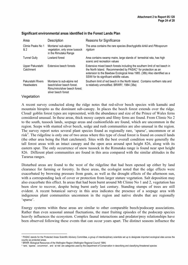
The following table has been adapted from the draft Forest Lands Plan and represents the areas identified as significant in that plan.
Attachment 2 to Report 05.128 Page 24 of 28
Significant environmental areas identified in the Forest Lands Plan
Area Description Reasons for Significance Climie Peaks No 1 & 2
Montane/ sub-alpine vegetation, only snow tussock in the Rimutaka Range
The area contains the rare species Brachyglottis kirkiii and Pittosporum rigidum
Tunnel Gully Lowland forest Area contains swamp maire, large stands of terrestrial rata, has high scenic and recreation values
Upper Pakuratahi Catchment
Extensive beech forests Extensive mixed beech forests including the southern limit of red beech in the North Island. Recommended by PASAC1 for protection as an extension to the Bawbaw Ecological Area 1985. (38b) Also identified as a SSWI for its significant wildlife values.
Pakuratahi Rivers Headwaters
Montane to sub-alpine red beech/silver beech forest. Rimu/miro/silver beech forest; silver beech forest
Southern limit of red beech in the North Island. Contains northern rata and is relatively unmodified. BRWR2, 1984 (38a)
Vegetation
A recent survey conducted along the ridge notes that red-silver beech species with kamahi and mountain hiropito as the dominant sub-canopy. In places the beech forest extends over the ridge. Cloud/ goblin forest types are represented, with the abundance and size of the Prince of Wales ferns considered unusual. In these areas, thick mossy carpets and filmy ferns are found. From Climie No 2 to the south, tussock lands, seepage areas and cushionfields are found, which are uncommon in the region. Seeps with stunted silver beech, sedge and rush communities are also unusual in the region. The survey report notes several plant species found as regionally rare, ‘sparse’, uncommon or at risk3. The ridgeline is only one of two areas where this type of cloud forest is found on council lands (the other area being the Hutt catchment). Sites with the best overall condition were generally the tall forest areas with an intact canopy and the open area around spot height 826, along with its eastern spur. The only occurrence of snow tussock in the Rimutaka range is found near spot height 826. Different plant communities are found in this area compared with the similar altitudes in the Tararua ranges.
Disturbed areas are found to the west of the ridgeline that had been opened up either by land clearance for farming or forestry. In these areas, the ecologist noted that the edge effects were exacerbated by browsing pressure from goats, as well as the drought effects of the afternoon sun, with a corresponding lack of cover or protection from larger stature vegetation. Salt deposition may also exacerbate this effect. In areas that had been burnt around Mt Climie No 1 and 2, vegetation has been slow to recover, despite being burnt early last century. Standing stumps of trees are still evident. A recent botanical survey in this area indicates the presence of a seepage area with indigenous plant communities uncommon in the region and native shrubs that are regionally ‘sparse’.
Energy systems within these areas are similar to other comparable beech/podocarp associations. Rather than even seasonal annual fluctuations, the mast fruiting episodes of the podocarp species heavily influences the ecosystem. Complex faunal interactions and predator/prey relationships have been observed following these events that can occur years apart. The distinct seasons influence the
1 PASAC stands for the Protected Areas Scientific Advisory Committee, a group of interdisciplinary scientists set up to designate important ecological sites across the country as protected areas. 2 BRWR: Biological Resources of the Wellington Region (Wellington Regional Council 1984) 3 ‘rare’, ‘sparse’, ‘uncommon’, and ‘at risk’ are categories used by the Department of Conservation in describing and classifying threatened species
Attachment 2 to Report 05.128 Page 25 of 28
255036 25
feeding behaviour of birds, including kereru, tui, bellbird, and silvereyes, as birds travel between these catchments from available food source to food source.
Potential effects: vegetation damage/loss To construct an access road, vegetation will have to be removed along the ridgeline. At the northern end of the site, beech forest has extended over the ridge, with canopies extending to 25m in height. Further along the ridge, road construction will require the removal of mature kamahi bush and in the higher areas, tussock and astelia associations will be damaged or destroyed. Stunted cloud forest and cushion bogs found on the ridge will be removed. Braccyglottis kirkii, identified the Department of Conservation as regionally critical is also found along the ridgeline environment and may be affected.
The effects of vegetation removal can be seen around the Climie No 1 and 2 peaks, as well along the western flanks of the ridge where tall stature vegetation has failed to re-establish effectively. Sub-alpine/ alpine communities have slow rates of growth, reflecting the harsh environmental conditions. The thin nature of the soils and daily temperature extremes will make any site remediation or planting difficult.
Edge effects are likely to extend into habitat on either side of the access track. This means that the effect on the surrounding habitat will extend further than the initial construction work. Some effects will be due to losing the buffering effects from wind and temperature within these micro-environments. Windthrow around the edges of clearings is an example of this type of effect, which has been observed on the western flanks, of beech trees up to 15m in height. Removal of taller vegetation is likely to result in the open tops around Climie 1 & 2 extending along most of the access track’s extent ridgeline. The evidence suggests that it would take a long time (centuries) to restore to the pre-existing habitat types.
Fauna
Bird species, representative of all the region’s bird species are found here, including kaka. Birds recorded recently (end of 2004) in the area include bellbird, fantail, grey warbler, kereru, kingfisher, morepork, rifleman, silvereye, tomtit, tui, kakariki and NZ falcon. Whitehead, Bellbirds, kaka shining and long-tail cuckoos have also been recorded within the forest. NZ Falcon has breeding and nesting requirements similar to those found along the ridgeline. Nothing is known of migratory bird flight paths within the catchment, such as shining or long-tailed cuckoos, although the birds have been heard. Kaka, kereru and NZ Falcon have relatively large flight ranges, distances comparable to travelling from Karori to Mt Bruce. Kereru, bellbird and tui are opportunistic feeders that move as fruiting and flowering become available in different habitats and catchments.
Little is known of the invertebrate fauna. Similarly, no research has been undertaken or recordings made of skink or gecko populations. Bats have been found in the Tararua Forest Park and the Hutt catchment, although none have been recorded in the Pakuratahi or Wainuiomata catchments.
Potential effects on fauna The loss of vegetation will affect the faunal communities resident in the area by removing available habitat and causing species to vacate the area. Existing predator/ prey relationships may change in response to the changed environmental conditions. There is no information available on invertebrate fauna but as the main pollinators and therefore dispersal agents of plants, habitat recovery following

Attachment 2 to Report 05.128 Page 26 of 28
disturbance will be slower than for natural events like wind throw. Similarly there is a lack of information on lizards, geckos and bats present in the area, making any assessment difficult.
Potential effects: loss, displacement of birds Around the world, one of the more controversial aspects of wind farm development is the effect on bird species. In the United States, studies have found that not only raptor species but also passerine or perching species are at risk from wind turbines. Fatalities are caused by collisions with turbine blades as well as from habitat destruction. Collisions are caused by ‘blade blindness’, increased prey abundance due to the change in the immediate environment4, reduced visibility in low cloud conditions, lighting, and the spatial arrangement of turbines. Data in the US estimates an average of 2.19 fatalities per turbine per year, although in some developments there have been no fatalities, while in other sites the average has increased to 4.45 p.a.
Raptors have generally been the focus of much concern in the US as they have relatively small populations, low breeding rates, have suffered a high proportion of turbine related deaths as well as being high profile birds. As might be expected, the collision rate of raptor species increases in environments that the birds spend more time in. In Australia, increasing attention has been paid to parrot species that have a threatened status that may be affected by turbines. New Zealand raptors include the NZ falcon, morepork and harrier, while parrots include kea and kaka.
Birds within the Pakuratahi Forest likely to be affected include NZ falcon, morepork, kaka, bellbird, whitehead, shining and long-tail cuckoos, fantail, grey warbler, kereru, rifleman, silvereye, tomtit, and tui either directly in collision or by loss of habitat. The low cloud and fog experienced in the area is likely to exacerbate these effects, as well as the ridgelines position between the Akatarawa, Hutt and Wainuiomata catchments. Of these, the following three species are identified as threatened by DoC: Kaka is classified as nationally endangered; the NZ falcon is nationally vulnerable, while the kereru is in gradual decline5. The ridgeline provides suitable habitat for NZ falcon nesting sites, whether this species has ever nested there is unknown. Migration patterns through the area by species such as shining cuckoo are similarly unknown.
Fragmentation of habitat and the effective separation of indigenous ecosystem processes in the Rimutaka and Tararua ranges may also occur. Birds travel from the Hutt, Akatarawa, Wainuiomata catchments to the Pakuratahi catchment for the different foraging opportunities presented throughout the year. Studies in the US have shown that bird densities do not tend to recover within a 180m radius of each turbine. Unlike a road (or SH2), a row of turbines may effectively present a barrier extending 80m high and 15 kms long for bird species to navigate over the ridgeline.
Aquatic ecosystems
Limited fish surveys have been undertaken in the Pakuratahi catchment with 10 native species present including dwarf galaxiads and five bully species. Modelling suggests that shortjawed kokopu should also be present. No sampling has been undertaken of freshwater invertebrates in the upper catchment.
No detailed sampling or assessment has been undertaken of the ridgeline seeps and wetlands. 4 This includes increases in species, including pests, that are attractive to raptors, as well as bird carcasses that may attract foragers and an increase in insects that area attractive to birds 5 Refer Molloy 2002, DoC - briefly; nationally endangered: total national population 250-1000 mature individuals, < 5 sub populations with < 300 largest sub population or < 10ha habitat, with a decline trend of 30%. Nationally vulnerable: total population 1,000-5,000 mature individuals, <15 sub populations, decline trend 30-60%. National decline; population <5,000 mature individuals, > 15 sub populations, decline 5-30%, however a serious imbalanced age structure has been identified within kereru populations that may result in a population collapse.

Attachment 2 to Report 05.128 Page 27 of 28
255036 27
Given the remoteness of the eastern upper forest catchment and lack of development; it would be expected that the quality of the aquatic ecosystems are excellent. Further information is required and sampling and studies undertaken to determine the freshwater species present.
Potential effects: aquatic systems and loss of wetlands Road construction activities, including the road and turbine foundations, will alter the drainage patterns of the area, affecting the small catchments originating from the ridgeline. The steepness of the area suggests that fill will be required to stabilise areas, meaning that the impact of the track will extend down off the ridgeline. Seeps and bogs along the ridgeline will be lost, as the drainage patterns will change with the presence of the access track, as well as being difficult to avoid.
Small first order streams draining these areas will also be affected as the removal of vegetation will make sediment freely available in the sites’ drainage and runoff discharges. Flow rates and volumes may also change with the changed drainage patterns. The extent to which small tributaries will be affected requires investigation. The significance of the impact on aquatic ecosystems downstream will depend on the volumes of sediment released and flow changes in the catchments.
Pests
Many of the region’s animal pests have been found in the catchment area, including deer, goats and pigs. Rabbits and hares have also been reported at Climie Nos 1 & 2. In the past these pests have been identified as the main risk to the area’s values. The recent ecological survey noted that goat damage was the largest problem, however this seemed more confined to the more open sunny west facing slopes leading to the ridgeline. Possum sign was minimal and deer do not appear to be in great numbers. The last pest animal operation (1080) was completed in 2002.
Pest plants are controlled in the western and northern parts of the forest include buddleia, holly, ivy and pampas. Himilayan honeysuckle is found and appears to be spreading along roads from seeds carried inadvertently by vehicles. Although plant pests are found in the western and northern parts of the forest, they are contained to areas along the old rail formation and the tunnel gully area. Lotus has been recorded at the Climie No 2 tower site. Few pest plants of concern have been recorded in the southern and eastern parts of the forest and the area is presently considered to be at relatively low risk due to the intactness of the original vegetation.
Potential effects: pest species Within the area, rabbits, hares, goats, possums, pigs and deer are found. Browsing pressure seemed at its most acute in the open cleared areas. Given the likelihood of an access track opening the ridge area, there is a possibility that the impact of browse will be increased, as deer, rabbits, and goats favour more open habitats. The road may also act as a corridor allowing pest animal species to move more easily from one end of the catchment to the other. There is also potential for pest plant species to be transported on vehicles, further spreading of the weeds and costs of management control. This was identified as a significant risk in the Wainuiomata catchment and led to the installation of a vehicle washing facility.
Significance
The ecological values of the Climie ridgeline are significant, with nationally threatened species present at the proposed site. In the 1980s, the PASAC survey recommended that this area be set

Attachment 2 to Report 05.128 Page 28 of 28
aside for protection. The area’s values have been reconfirmed as high both in the recent ecological survey and advice from the Department of Conservation.
Given the significant values of the area’s ecological values, it is likely that effects to these values will also be significant. These types of sub-alpine/montane environments are not well represented on council lands. The goblin/cloud forest is one of two areas managed by council, although the Climie site is at a much lower altitudinal level with a more diverse plant community. As the areas disturbed by fire last century show, they are slow to recover, vulnerable to pest species and edge effects. It is likely that these ecotypes will be removed from the ridgeline, as the available space for the development is not large. As the Pakuratahi forest is part of a larger ecological complex, ecological processes are dependent in part on the movement of birds meaning that wider area is likely to be affected by this type of proposal. The Wetland Action Plan acknowledges that wetland associations are increasingly threatened in the region and states that Council will protect wetlands on council land.