wind energy development in northern ireland ireland's landscapes
TRANSCRIPT
Environment & Heritage Service
WIND ENERGY DEVELOPMENT IN NORTHERN IRELAND’S LANDSCAPES Draft Supplementary Planning Guidance to accompany
Planning Policy Statement 18 ‘Renewable Energy’ February 2008

How to give your views
All responses should be made in writing and emailed to [email protected] or sent by post to:
Stephen Hamilton Wind Sensitivity Analysis Consultation DOE Planning & Environmental Policy Group 12th Floor River House 48 High Street Belfast BT1 2AW.
The consultation period will end on the Thursday 5 June 2008.
Electronic copies are available on the Planning Service website: www.planningni.gov.uk or can be obtained by telephoning (028) 9054 7713, textphone at (028) 9054 0642 or by writing to the above address. Should you require a copy of this document in an alternative format, it can be made available upon request in large print, disc, Braille, or audiocassette. It may also be made available in minority languages for those who are not proficient in English.
In keeping with our policy on openness, the Department may make responses to this consultation document publicly available upon request.
At the end of the consultation period the Department will consider all comments received, following which the draft documents will be amended if necessary and, subject to Ministerial approval, published in final form.


___________________________________________________________________________________
_____________________________________________________________________
2 Julie Martin Associates
Acknowledgements
This guidance has been produced by Julie Martin Associates in association with Alison Farmer Associates, Minogue Associates and ERA-Maptec Ltd.
Its preparation was supervised by officers from the Environment and Heritage Service, the Planning and Environmental Policy Group and the Planning Service of the Department of the Environment for Northern Ireland.
The study team and the Department wish to thank all those who helped in the preparation of the guidance by providing background information, mapping and informal comment.

___________________________________________________________________________________
_____________________________________________________________________
Julie Martin Associates
Contents
1 Wind Energy Development in the Landscape.................................5 1.1 Purpose and Scope of the Guidance......................................................................... 5 1.2 Policy Context and Relationship of the Guidance to PPS 18................................... 8 1.3 Wind Energy Development in Northern Ireland ...................................................... 9 1.4 Northern Ireland’s Landscapes .............................................................................. 14
2 Approach and Methodology............................................................17 2.1 Introduction............................................................................................................ 17 2.2 Key Terms and Definitions .................................................................................... 19 2.3 Sensitivity Assessment........................................................................................... 20 2.4 Capacity Assessment.............................................................................................. 23 2.5 Principles Affecting Sensitivity and Capacity ....................................................... 25
3 Landscape Sensitivity and Capacity Assessment..........................35 3.1 Sensitivity and Capacity of the LCAs.................................................................... 35 3.2 Cumulative Landscape Sensitivity and Capacity ................................................... 39
3.2.1 The Antrim Plateau ....................................................................................... 40 3.2.2 The North West ............................................................................................. 41 3.2.3 Fermanagh ..................................................................................................... 43 3.2.4 Overview ....................................................................................................... 45
4 Guidance on Preparing Wind Energy Proposals..........................47 4.1 Introduction............................................................................................................ 47 4.2 Using the Sensitivity and Capacity Assessment Sheets ......................................... 47
4.2.1 Key Landscape and Visual Characteristics and Values................................. 47 4.2.2 Overall Sensitivity......................................................................................... 48 4.2.3 Capacity Assessment ..................................................................................... 48
4.3 Initial Scheme Planning ......................................................................................... 49 4.4 Siting, Layout and Design...................................................................................... 50 4.5 Assessment of Landscape and Visual Impacts....................................................... 54 4.6 Reviewing Applications and Making Judgements ................................................. 58
Annex 1: Landscape Sensitivity and Capacity Assessment Sheets ....61
Annex 2: Sources of Further Technical Advice .................................323
___________________________________________________________________________________
_____________________________________________________________________
4 Julie Martin Associates
Figures
Figure 1: Northern Ireland’s Landscape Character Areas Figure 2: Mean Wind Speeds at 75m Above Ground Level Figure 3: Existing and Proposed Wind Farms in Northern Ireland Figure 4: Northern Ireland’s Special Landscapes
Tables
Table 1: Landscape Values Information Table 2: Additional Terms and Definitions Table 3: Criteria for Assessing Landscape Sensitivity to Wind Energy Development Table 4: Wind Energy Development Typology Table 5: Sensitivity and Capacity: General Principles Table 6: Sensitivity and Capacity in Different Types of Landscape Table 7: Summary of Landscape Sensitivity and Capacity by LCA Table 8: Key Principles of Good Siting, Layout and Design Table 9: Good Practice Requirements for Landscape and Visual Impact Assessment Table 10: Checklist of Illustrations That Should be Provided Table 11: Checklist of Questions That the Department Will Consider
___________________________________________________________________________________
_____________________________________________________________________
Julie Martin Associates 5
1 Wind Energy Development in the Landscape
1.1 Purpose and Scope of the Guidance
This supplementary planning guidance on wind energy development in Northern Ireland’s landscapes accompanies the Department of the Environment’s Draft Planning Policy Statement 18: Renewable Energy (PPS 18)1, which was issued as a consultation paper in November 2007 and sets out the Department’s planning policy for development that generates energy from renewable resources.
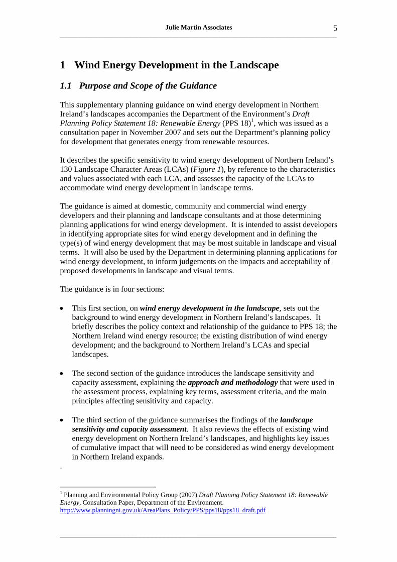
It describes the specific sensitivity to wind energy development of Northern Ireland’s 130 Landscape Character Areas (LCAs) (Figure 1), by reference to the characteristics and values associated with each LCA, and assesses the capacity of the LCAs to accommodate wind energy development in landscape terms.
The guidance is aimed at domestic, community and commercial wind energy developers and their planning and landscape consultants and at those determining planning applications for wind energy development. It is intended to assist developers in identifying appropriate sites for wind energy development and in defining the type(s) of wind energy development that may be most suitable in landscape and visual terms. It will also be used by the Department in determining planning applications for wind energy development, to inform judgements on the impacts and acceptability of proposed developments in landscape and visual terms.
The guidance is in four sections:
• This first section, on wind energy development in the landscape, sets out the background to wind energy development in Northern Ireland’s landscapes. It briefly describes the policy context and relationship of the guidance to PPS 18; the Northern Ireland wind energy resource; the existing distribution of wind energy development; and the background to Northern Ireland’s LCAs and special landscapes.
• The second section of the guidance introduces the landscape sensitivity and capacity assessment, explaining the approach and methodology that were used in the assessment process, explaining key terms, assessment criteria, and the main principles affecting sensitivity and capacity.
• The third section of the guidance summarises the findings of the landscape sensitivity and capacity assessment. It also reviews the effects of existing wind energy development on Northern Ireland’s landscapes, and highlights key issues of cumulative impact that will need to be considered as wind energy development in Northern Ireland expands.
.
1 Planning and Environmental Policy Group (2007) Draft Planning Policy Statement 18: Renewable Energy, Consultation Paper, Department of the Environment. http://www.planningni.gov.uk/AreaPlans_Policy/PPS/pps18/pps18_draft.pdf

Key
to th
e La
ndsc
ape
Cha
ract
er A
reas
1.
The
Gar
rison
Low
land
s 2.
Low
er L
ough
Ern
e 3.
Cro
agh
and
Gar
vary
Riv
er
4.
Loug
h N
avar
and
Bal
linte
mpo
U
plan
ds
5.
The
Loug
h M
acne
an V
alle
y 6.
Th
e K
nock
mor
e Sc
arpl
and
7.
Th
e Si
llees
Val
ley
8.
Th
e A
rney
Low
land
s 9.
C
uilc
agh
and
Mar
lban
k 10
. Slie
ve R
usse
l, D
erry
lin a
nd
Kin
awle
y 11
. Upp
er L
ough
Ern
e 12
. New
tow
nbut
ler a
nd R
ossl
ea
Low
land
s 13
. Enn
iski
llen
14. L
ough
Bra
dan
15. I
rvin
esto
wn
Farm
land
16
. Bro
ughe
r Mou
ntai
n 17
. Clo
gher
Val
ley
Low
land
s 18
. Slie
ve B
eagh
19
. Kill
eter
Upl
ands
20
. Der
g V
alle
y 21
. Fai
ry W
ater
Val
ley
22. O
mag
h Fa
rmla
nd
23. C
amow
en V
alle
y 24
. Sou
th S
perr
in
25. B
eagh
mor
e M
oors
and
Mar
sh
26. B
essy
Bel
l and
Gor
tin
27. F
oyle
Val
ley
28. G
lene
lly V
alle
y 29
. Spe
rrin
Mou
ntai
ns
30. S
perr
in F
ooth
ills
31. B
urng
ibba
gh a
nd D
rum
ahoe
32. D
erry
Slo
pes
33. L
ough
Foy
le A
lluvi
al P
lain
34
. Lou
gher
mor
e H
ills
35. M
agill
igan
Low
land
s 36
. Bin
even
agh
37. R
oe B
asin
38
. Eas
tern
Bin
even
agh
Slop
es
39. G
lens
hane
Slo
pes
40. U
pper
Moy
ola
Val
ley
41. S
lieve
Gal
lion
42. C
ooks
tow
n Fa
rmla
nds
43. C
arric
kmor
e H
ills
44. S
lieve
mor
e 45
. Dun
gann
on D
rum
lins a
nd H
ills
46. B
lack
wat
erV
alle
y 47
. Lou
ghga
ll O
rcha
rd B
elt
48. W
est L
ough
Nea
gh S
hore
s 49
. Mag
hera
felt
Farm
land
50
. Moy
ola
Floo
dpla
in
51. G
arva
gh F
arm
land
52
. Low
er B
ann
Val
ley
53. L
ower
Ban
n Fl
oodp
lain
54
. Col
erai
ne F
arm
land
55
. Gar
ry B
og
56. D
ervo
ck F
arm
land
s 57
. Cau
sew
ay C
oast
and
Rat
hlin
Isla
nd
58. L
ong
Mou
ntai
n R
idge
59
. Cul
lyba
ckey
and
Clo
gh M
ills
Dru
mlin
s 60
. Riv
er M
ain
Val
ley
61. N
orth
Lou
gh N
eagh
Sho
res
62. E
ast L
ough
Nea
gh P
oint
s 63
. Por
tmor
e Lo
ugh
Frin
ge
64. L
ough
Nea
gh P
eatla
nds
65. U
pper
Ban
n Fl
oodp
lain
66
. Arm
agh
Dru
mlin
s 67
. Arm
agh/
Ban
brid
ge H
ills
68. C
arrig
atuk
e H
ills
69. N
ewry
Bas
in
70. C
ross
mag
len
Dru
mlin
s and
Lou
ghs
71. R
ing
of G
ullio
n 72
. Slie
ve R
oosl
ey
73. K
ilkee
l Coa
st
74. K
ingd
om o
f Mou
rne
75. M
ourn
e M
ount
ains
76
. Bal
lyro
ney
Bas
in
77. I
veag
h Sl
opes
78
. Nor
th B
anbr
idge
Hill
s 79
. Cra
igav
on P
late
au
80. D
onag
hclo
ney
Val
ley
81. K
ilwar
lin P
late
au
82. D
rom
ore
Low
land
s 83
. Low
er S
lieve
Cro
ob F
ooth
ills
84. M
ourn
e Fo
othi
lls
85. N
ewca
stle
Val
leys
86
. Tyr
ella
Coa
stal
Dun
es
87. S
lieve
Cro
ob S
umm
its
88. C
ragg
y D
rom
ara
Upl
ands
89
. Hill
sbor
ough
Slo
pes
90. R
avar
net V
alle
y 91
. Quo
ile V
alle
y Lo
wla
nds
92. B
ally
quin
tin a
nd L
ecal
e C
oast
93
. Por
tafe
rry
and
Nor
th L
ecal
e 94
. Stra
ngfo
rd D
rum
lins a
nd Is
land
s 95
. Bal
lygo
wan
Dru
mlin
s 96
. Cas
tlere
agh
Plat
eau
97. B
elfa
st/L
isbu
rn
98. C
arric
kfer
gus U
plan
d Pa
stur
es
99.
Out
er A
rds C
oast
l0
0. A
rds F
arm
land
s and
Est
ates
10
1. S
crab
o 10
2. H
olyw
ood
Hill
s 10
3. B
ango
r Coa
stlin
e 10
4. C
raig
antle
t Esc
arpm
ent
105.
Cas
tlere
agh
Slop
es
106.
Lag
an P
arkl
and
107.
Hum
moc
ky L
agan
Low
land
s 10
8. B
road
Lag
an V
alle
y 10
9. U
pper
Bal
linde
rry
Plat
eau
110.
Der
ryki
llulta
gh
111.
Div
is S
umm
its
112.
Bel
fast
Bas
alt E
scar
pmen
t 11
3. E
xpan
sive
Cru
mlin
Far
mla
nd
114.
Thr
ee a
nd S
ix M
ile W
ater
Val
leys
11
5. T
ardr
ee a
nd S
ix M
ile W
ater
Slo
pes
116.
Bal
lym
ena
Farm
land
11
7. C
entra
l Bal
lym
ena
Gle
ns
118.
Moy
le M
oorla
nds a
nd F
ores
t 11
9. B
ally
cast
le G
lens
12
0. F
air H
ead
121.
Moy
le G
lens
12
2. G
arro
n Pl
atea
u 12
3. L
ame
Gle
ns
124.
Lam
e B
asal
t Moo
rland
12
5. T
ardr
ee U
plan
d Pa
stur
es
126.
Lam
e C
oast
12
7. L
ame
Rid
gela
nd
128.
Isla
nd M
agee
12
9. C
arric
kfer
gus S
hore
line
130.
Car
rickf
ergu
s Far
med
Esc
arpm
ent
___________________________________________________________________________________
_____________________________________________________________________
8 Julie Martin Associates
The fourth and final section of the guidance explains how to use the landscape sensitivity and capacity assessment in preparing wind energy proposals. It provides good practice guidance on site selection; detailed issues of siting, layout and design; and assessment of landscape, visual and cumulative impacts. It also describes how the Department will use the guidance in reviewing and making judgements on applications.
The main text of the guidance is accompanied, in Annex 1, by detailed landscape sensitivity and capacity assessment sheets for each of the 130 LCAs.
1.2 Policy Context and Relationship of the Guidance to PPS 18
Like other planning policy statements, PPS 18 applies to the whole of Northern Ireland2. Its contents will be taken into account in preparing development plans and are also material to decisions on individual planning applications and appeals.
Reference is made in PPS 18 to supplementary planning guidance on the sensitivity of the Region’s landscapes to wind energy development3, which will also be taken into account in assessing proposals. This document is the consultation draft of that guidance. It should be read in conjunction with PPS 18, along with the relevant contents of existing development plans, other planning policy publications including the Regional Development Strategy, and other supplementary planning guidance documents.
The primary aim of PPS 184 is “to encourage and facilitate the provision of renewable energy… in appropriate locations within the built and natural environment” as part of the Government’s response to climate change, which has set a Regional target for energy generation from renewable sources of 12% by 20125. The detailed policy objectives of PPS 186 (mainly aimed at promoting renewable energy development) include the following objectives in relation to landscape issues:
• “to ensure that the environmental, landscape, visual and amenity impacts associated with renewable energy development are adequately addressed;
• to ensure appropriate protection of the Region’s built, natural and cultural heritage features;
• to promote knowledge of and greater acceptance by the public of prospective renewable energy developments that are appropriately located…”
Within PPS18, Planning Policy RE1 Renewable Energy Development sets out the main considerations that the Department will take into account in assessing proposals for renewable energy, and the tests that will need to be met in relation to wind energy development specifically. Applications for wind energy development will be required to demonstrate, inter alia, that they will not have an unacceptable adverse impact on
2 However the policies of PPS 18 do not apply to offshore renewable energy developments as these are not subject to control under the land use planning system. 3 PPS 18, Policy RE1. 4 PPS 18, para 1.8. 5 PPS 18, para 2.10. 6 PPS18, para 3.1.

___________________________________________________________________________________
_____________________________________________________________________
Julie Martin Associates 9
visual amenity or landscape character and that the cumulative impact of existing or approved wind turbine development has been taken into consideration.
The thrust of Planning Policy RE1 is that the Department will support renewable energy proposals unless they would have adverse effects which are not outweighed by the local and wider environmental and social benefits of the development. In the case of natural and built heritage sites of international importance7 the integrity of the site should not be adversely affected; while for national/regional designations8 the objectives of designation should not be compromised.
At the same time, it is recognised that the significance of environmental effects may depend on the type and scale of the renewable energy development and the sensitivity of the location (which can vary between and within designated areas)9 and also that renewable energy resources can usually only be developed where they occur and are greatest in upland areas10.
In relation to the landscape and visual effects of renewable energy development, PPS 18 notes that “the impact of turbines on the landscape will vary according to the size and number of turbines and the type of landscape involved”11. It places a new emphasis on identifying those characteristics that may make a landscape sensitive to wind energy development and on assessing the capacity of all of Northern Ireland’s landscapes, including the Areas of Outstanding Natural Beauty and other designated landscapes, to accommodate wind energy development, while noting that because the LCAs are broad in extent there will inevitably be areas of varying sensitivity with different implications for development.
This guidance, which presents the findings of the wind energy landscape sensitivity and capacity assessment of Northern Ireland’s 130 LCAs that was undertaken for the Department’s Environment and Heritage Service, is expected to inform the landscape assessment of wind energy developments in future.
1.3 Wind Energy Development in Northern Ireland
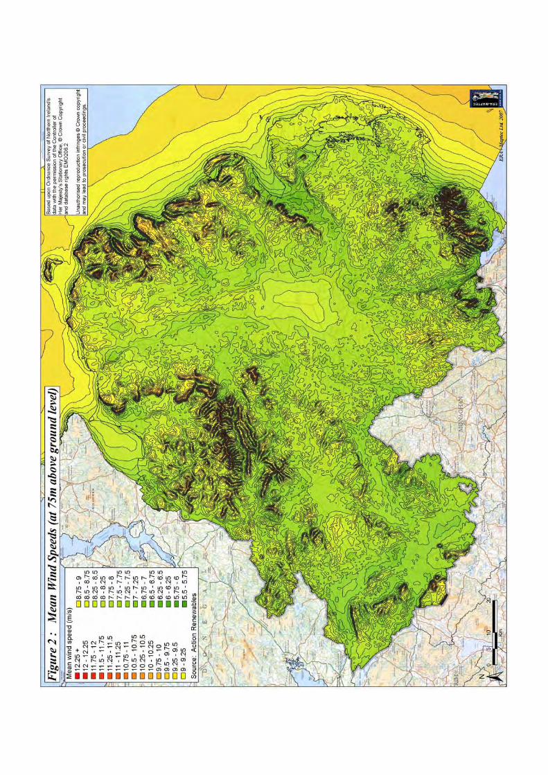
Figure 2 shows Northern Ireland’s wind energy resource in terms of mean wind speeds at 75m above ground level, the typical hub height of a commercial wind turbine. Further information on the Region’s wind resource can be found on the website of the Department of Enterprise, Trade and Investment (DETI)12. This information, while not directly used in the preparation of this guidance, nonetheless indicates the broad distribution of the Region’s wind resources and the areas that are most likely to be subject to commercial wind energy development in the short to medium term at least.
7 Special Protection Areas, Special Areas of Conservation, Ramsar sites and World Heritage Sites. 8 Areas of Special Scientific Interest, Areas of Scientific Interest, National Nature Reserves, National Parks, Areas of Outstanding Natural Beauty, Monuments in State Care and Scheduled Monuments, Listed Buildings, and Historic Parks, Gardens and Demesnes. 9 PPS 18 para 4.10. 10 PPS 18 para 4.15. 11 PPS 18 para 4.19. 12 http://www.detini.gov.uk/cgi-bin/get_builder_page?page=691&site=5&parent=21&prevpage=53
___________________________________________________________________________________
_____________________________________________________________________
Julie Martin Associates 11
It can be seen that the areas of highest wind speed, with the best commercial wind energy resource, are located mainly in upland areas and hence in a relatively small number of LCAs. However recent technological advances and changes to renewable energy markets have resulted in wind speed being less pivotal in the site selection process for wind energy development, and this trend is expected to continue in future.
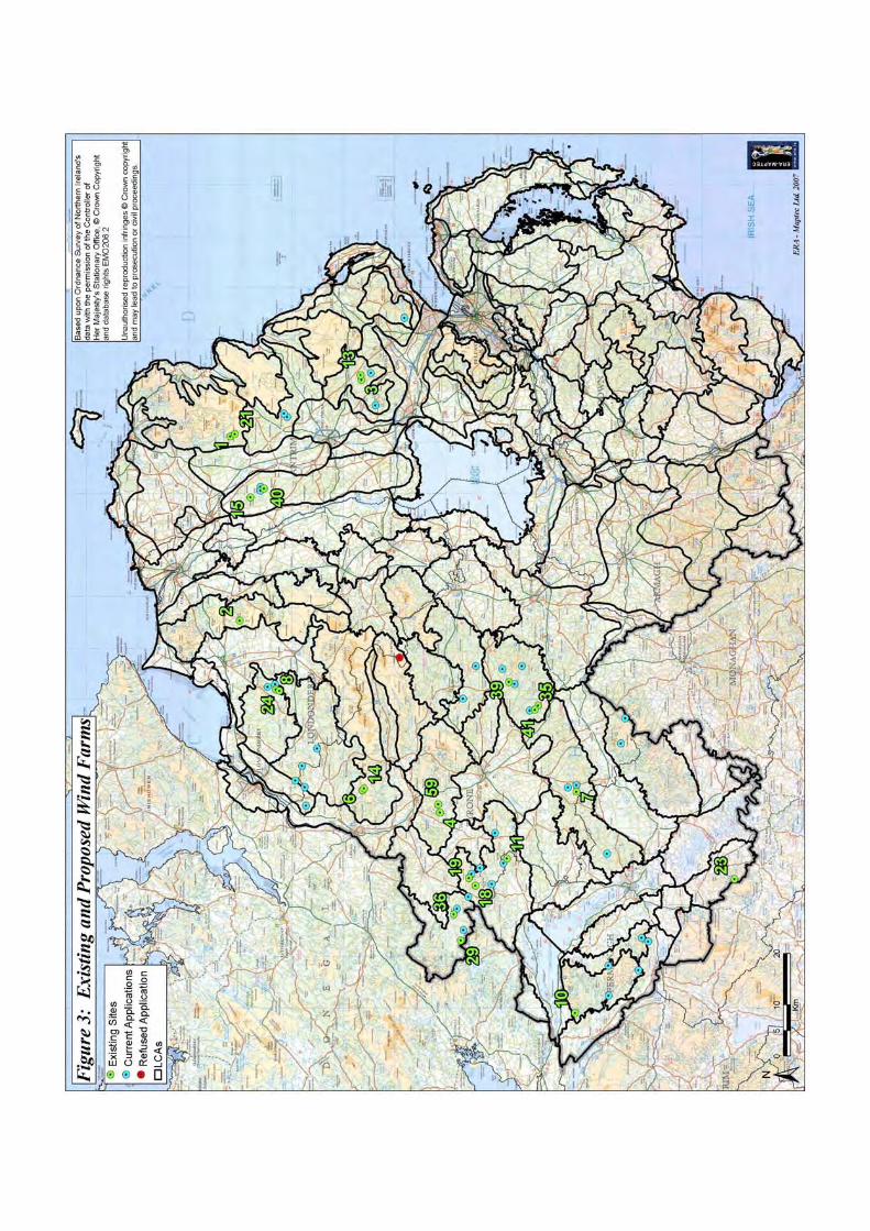
Figure 3 shows the location of operational and consented wind farms and application sites for development of more than one turbine as at October 200713. A strong concentration of sites, again in a few mainly upland LCAs, can be seen from this map, indicating that parts of Northern Ireland are already experiencing strong pressures for wind energy development. The assessment of landscape sensitivity to wind energy development has taken account of these existing and consented wind energy developments, further details of which are given in the table alongside Figure 3.
In contrast, single, stand-alone turbine developments (principally domestic or community turbines in the 15-25m height range) are much more evenly and widely spread across Northern Ireland, occurring in nearly all areas except the higher ground within the uplands. There are now around 300 such developments with planning approval and many further applications pending14.
Hence it is possible that wind resources in any part of Northern Ireland may be sufficient to support wind energy development of some scale, and for this reason the guidance covers all of Northern Ireland. It provides guidance on all types and scales of wind energy development except for microgeneration from small turbines associated with dwellings, which may soon have permitted development rights15.
Wind energy development outside Northern Ireland’s land area may also affect Northern Ireland’s landscapes. Such development is already taking place or is proposed in all the border counties of the Republic of Ireland (Donegal, Leitrim, Cavan, Monaghan and Louth). Information on operational, consented and proposed wind energy developments in these counties was compiled in the course of the study and informed the assessment of landscape sensitivity and capacity, particularly in relation to existing and potential cumulative impacts in transboundary areas.
Finally, Ireland’s coastal waters have considerable potential for offshore wind energy development. Two specific areas are under exploration at present that, if developed, could affect the landscapes and seascapes of Northern Ireland. These are the Tunes Plateau area, near the mouth of Lough Foyle between Inishowen Head in County Donegal and Portrush in County Antrim; and a larger area close to the mouth of Carlingford Lough, off the coast of Counties Down and Louth. There is also the possibility of offshore wind energy development off the north-east Antrim coast, the Ards peninsula and the south Down coast in future, these areas of coast having been
13 Further details and updates of this information can be found on the Planning Service website, at http://www.planningni.gov.uk/Devel_Control/Planning_System/Permission/resources/Windfarm_map. pdf14 Based on unpublished information supplied by Planning Service. 15 See http://80.4.156.254/news_consultations_energy_250107 Although this guidance does not specifically apply to microgeneration from small domestic turbines, some of the same principles may still be relevant.

Key
to E
xist
ing
(Ope
ratio
nal o
r Con
sent
ed) W
ind
Far
ms a
s at O
ctob
er 2
007
Plan
ning
Se
rvic
e R
ef N
o N
ame
Dis
tric
t N
o of
Tur
bine
s T
urbi
ne H
eigh
t to
Bla
de T
ip
Stat
us
1 C
orke
y A
ntrim
10
60
m
Ope
ratio
nal
2 R
igge
d H
ill
Ant
rim
10
60m
O
pera
tiona
l 3
Ellio
ts H
ill
Ant
rim
10
65m
O
pera
tiona
l 4
Bes
sy B
ell
Tyro
ne
10
60m
O
pera
tiona
l 6
Ow
enre
agh
D
erry
10
60
m
Ope
ratio
nal
7 Le
ndru
m's
Brid
ge
Tyro
ne
20
65m
O
pera
tiona
l 8
Alta
hulli
on
Der
ry
15
82m
O
pera
tiona
l 10
C
alla
ghee
n Fe
rman
agh
13
83m
O
pera
tiona
l 11
Ta
ppag
han
Fe
rman
agh
13
88m
O
pera
tiona
l 13
W
olf B
og
Bal
lym
ena
5
100m
C
onse
nted
and
und
er c
onst
ruct
ion
14
Ow
enre
agh
2 St
raba
ne
6 66
m
Con
sent
ed
15
Gar
ves M
ount
ain
Farm
B
ally
mon
ey
6 12
5m
Con
sent
ed
18
Bin
Mou
ntai
n St
raba
ne
6 92
m
Ope
ratio
nal
19
Loug
h H
ill
Om
agh
6 83
m
Ope
ratio
nal
21
Gru
ig
Bal
lym
oney
10
10
0m
Con
sent
ed
23
Slie
ve R
ushe
n Fe
rman
agh
18
125m
C
onse
nted
and
und
er c
onst
ruct
ion
24
Alta
hulli
on 2
Li
mav
ady
9 (4
of w
hich
new
) 83
m
Con
sent
ed
29
Crig
hsha
ne
Stra
bane
14
10
0m
Con
sent
ed
35
Slie
vedi
vena
O
mag
h
12
101m
C
onse
nted
and
und
er c
onst
ruct
ion
36
Chu
rchi
ll
Stra
bane
8
100m
C
onse
nted
39
C
rock
agar
ron
Om
agh
6
125m
C
onse
nted
40
G
lenb
uck
B
ally
mon
ey
1 12
0m
Con
sent
ed
41
Slie
vedi
vena
2
Om
agh
8 10
1m
Con
sent
ed
59
Bes
sy B
ell 2
O
mag
h
6 10
0m
Con
sent
ed
Not
e: S
ites a
nd c
onse
nts t
hat h
ave
been
repl
aced
or s
uper
sede
d ar
e no
t sho
wn.
___________________________________________________________________________________
_____________________________________________________________________
14 Julie Martin Associates
identified in a report published by DETI16 as having significant wind energy resources that might be available for exploitation in future subject to environmental, technical and economic considerations.
Although the location and extent of offshore wind energy development is still uncertain and is not subject to control under Northern Ireland’s land use planning system, the possibility of such development is referred to within the sensitivity and capacity assessments where it could have an impact on the landscape character, amenity or seaward setting of the LCA concerned, or where it could affect the landscape capacity for wind energy development of onshore areas.
1.4 Northern Ireland’s Landscapes
Northern Ireland has a great variety of landscapes, as identified in the Northern Ireland Landscape Character Assessment 200017 and as shown in Figure 1. All told, 130 different landscape character areas or LCAs have been defined and this stunning range of landscapes gives Northern Ireland its distinctive and special identity. It is a region of dramatic landscape contrasts and subtle transitions. The inherent diversity of the underlying rocks, landforms and soils has been augmented by centuries of settlement and land management, resulting in an amazing variety of landscape patterns and features within a relatively small area.
The 130 LCAs highlight the variations in landscape character across Northern Ireland. Detailed descriptions and maps of these landscapes are provided in the Environment and Heritage Service’s series of Landscape Character Assessment Reports, which cover all of Northern Ireland’s Districts18; the descriptions are also available on the Environment and Heritage Service website19. The main report provides a more general overview of the Region’s landscapes, outlining the special qualities and features which make each part of Northern Ireland’s landscape memorable.
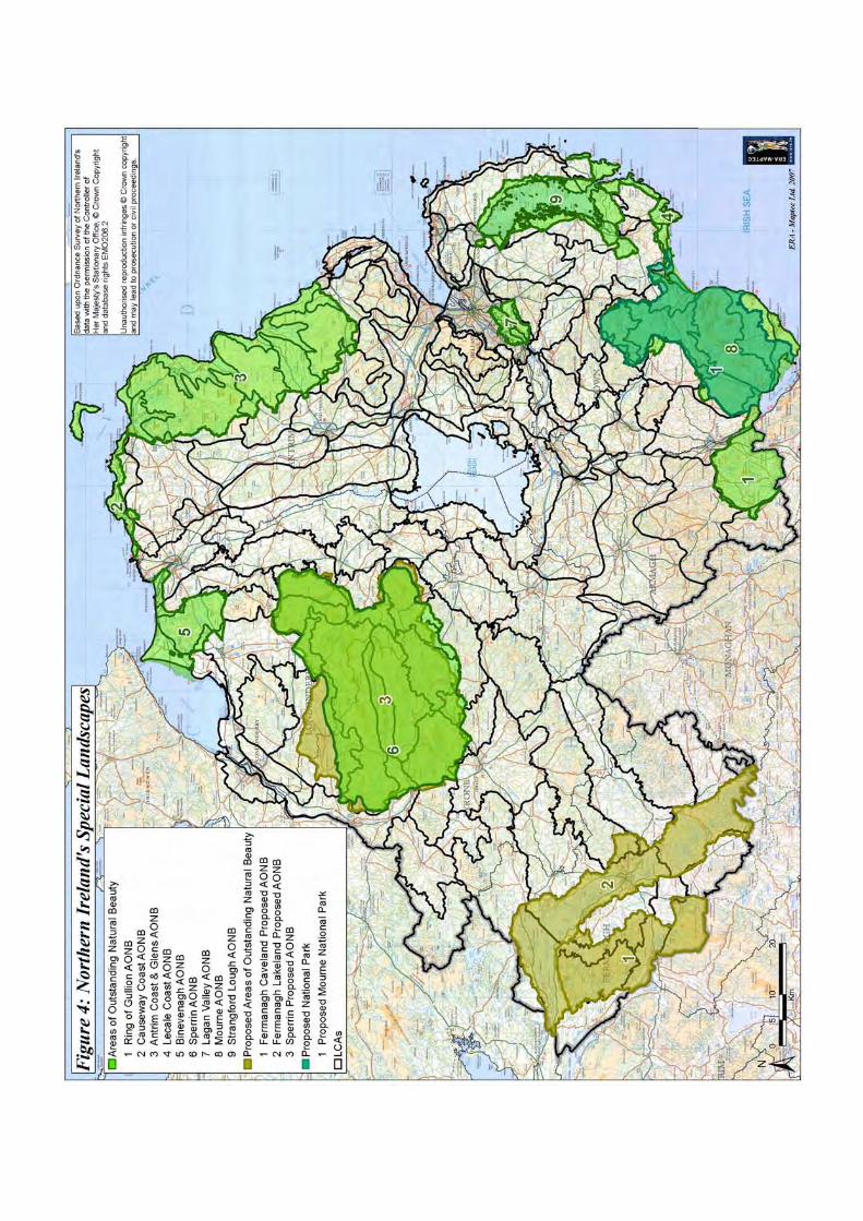
Northern Ireland’s most spectacular landscapes, the Areas of Outstanding Natural Beauty (AONBs), are well known and highly valued. They are recognised as being of national importance, and are Category V Protected Landscapes as defined by the World Conservation (IUCN). The Mournes and the Giant’s Causeway and Causeway Coast, already identified as AONBs, also form a proposed National Park and part of a World Heritage Site respectively. The location of all these special landscapes is shown on Figure 4, and again further details can be found on the Environment and Heritage Service website20. In addition, the Northern Ireland Landscape Character Assessment 2000 identified a further tier in the hierarchy of special landscapes, Areas of Scenic Quality. The location of these areas is shown in that report and their
16 Action Renewables (2004) A Study into the Renewable Energy Resource of the Six Counties of Northern Ireland, DETI. http://www.detini.gov.uk/cgi-bin/downutildoc?id=586 17 Environmental Resources Management (2000) Northern Ireland Landscape Character Assessment 2000, Corporate Document Services. 18 Environmental Resources Management (1999) Northern Ireland Landscape Character Assessment, Environment and Heritage Service Research and Development Series No. 99/1-26. 19 http://www.ehsni.gov.uk/landscape/country_landscape.htm 20 http://www.ehsni.gov.uk/landscape/designated-areas-2.htm
___________________________________________________________________________________
_____________________________________________________________________
16 Julie Martin Associates
boundaries are indicated on Area Plans21. All these landscapes are recognised not only for their special scenic qualities but also for their natural and cultural heritage value.
Landscape sensitivity to wind energy development, as explained in the next section, depends on many factors. Each landscape has it own specific sensitivities, depending on its specific landform and landcover as well as on a range of other characteristics and values including, for example, enclosure, visibility, condition, scenic and perceptual qualities, natural and cultural heritage features and cultural associations.
Importantly, sensitivity depends on landscape character as well as on landscape values. A landscape that is highly valued and designated as such may nonetheless be able to accommodate wind energy development in the right location, if there is a good fit with character and if the landscape’s special qualities can be conserved. Conversely, a landscape that has not been designated may still be highly sensitive to wind energy development, for example where it occupies a highly visible and prominent location within the landscape or forms the part of the distinctive landscape setting to a settlement.
This guidance describes the main sensitivities associated with each of Northern Ireland’s 130 LCAs and indicates what capacity they may have to accommodate wind energy development.
21 http://www.planningni.gov.uk/AreaPlans_Policy/APP.htm
___________________________________________________________________________________
_____________________________________________________________________
Julie Martin Associates 17
2 Approach and Methodology
2.1 Introduction
This section explains the approach and methodology that were used for assessing wind energy landscape sensitivity and capacity in Northern Ireland. It covers key terms and definitions; provides details of how the sensitivity assessment and capacity assessment were undertaken; and outlines the main principles affecting sensitivity and capacity.
The aims of the assessment were to:
• Assess the relative sensitivity of landscapes across Northern Ireland to wind energy development;
• Indicate the types and scales of wind energy development that may be appropriate in each of the LCAs.
It is important to note that the landscape sensitivity and capacity assessment is intended to provide broad, strategic guidance on appropriate locations for wind energy development. However every development proposal is unique, and there remains a need for detailed consideration of the landscape and visual impacts of individual applications on a case by case basis, as well as for consideration of other issues referred to in Planning Policy RE1.
The approach that has been used is consistent with good practice guidance in landscape character assessment and landscape and visual impact assessment22, notably:
• Countryside Agency and Scottish Natural Heritage (2002) Landscape Character Assessment Guidance for England and Scotland, Countryside Agency and Scottish Natural Heritage.
• Countryside Agency and Scottish Natural Heritage (2004), Landscape Character Assessment Guidance Topic Paper 6: Techniques and Criteria for Judging Sensitivity and Capacity, Countryside Agency and Scottish Natural Heritage.
• Landscape Institute and Institute of Environmental Management and Assessment (2002) Guidelines for Landscape and Visual Impact Assessment, 2nd edition, Spon.
The approach is also based on emerging good practice in assessing wind energy landscape sensitivity and capacity in other parts of the UK and the Republic of Ireland, but has been tailored specifically to the Northern Ireland situation. Undertaken initially as a desk exercise, the landscape sensitivity and capacity assessment was checked and verified in the field prior to completion.
22 Although prepared mainly for use in England and Scotland, the guidance listed is equally applicable in Northern Ireland, where there is no equivalent existing guidance.
___________________________________________________________________________________
_____________________________________________________________________
18 Julie Martin Associates
A key source of information was the Northern Ireland Landscape Character Assessment 200023, the 130 LCAs defined in this report forming the working units for the assessment. The assessment also drew upon the District Landscape Character Assessment Reports24, particularly the landscape analysis mapping that is contained in these reports.
In addition, maps and descriptions of the principal landscape, natural and cultural heritage designations and recreational features across Northern Ireland (see table below) were consulted, together with other published information on landscape values where available. Most of this information is available either from the Environment and Heritage Service website25 or from Area Plans26. Where possible, equivalent information was also compiled for areas of the Republic of Ireland within 30km of the border, to inform understanding of the wider landscape context27.
Table 1: Landscape Values Information
World Heritage Site (WHS) European Geopark (existing and proposed Geopark areas) Existing and proposed Areas of Outstanding Natural Beauty (AONBs)28
Proposed National Park29
Areas of Scenic Quality (ASQs) Special Areas of Conservation (SACs) and candidate SACs Special Protection Areas (SPAs) and potential SPAs Ramsar Sites Areas of Special Scientific Interest (ASSI) Areas of Scientific Interest (ASI) National Nature Reserves (NNRs) Nature Reserves (NRs) Marine Nature Reserve (MNR) State Care Monuments Scheduled Monuments Areas of Significant Archaeological Interest (ASAIs) Register of Historic Parks, Gardens and Demesnes (Registered Parks) Conservation Areas Ulster Way Walks promoted on the Walk Northern Ireland website30
23 Environmental Resources Management (2000) Northern Ireland Landscape Character Assessment 2000, Corporate Document Services. 24 Environmental Resources Management (1999) Northern Ireland Landscape Character Assessment, Environment and Heritage Service Research and Development Series No. 99/1-26. 25 http://www.ehsni.gov.uk/ 26 http://www.planningni.gov.uk/AreaPlans_Policy/APP.htm 27 However landscape values information for these transboundary areas was not reviewed in detail. 28 Proposed AONBs are the Fermanagh Caveland and Erne Lakeland AONBs; and the Sperrin AONB. The latter is already designated under the Amenity Lands (NI) Act 1965 and is also proposed for designation (with an amended boundary) under the Nature Conservation and Amenity Lands (NI) Order 1985. 29 A National Park has been proposed for Mourne and work is underway to define a boundary. For the purposes of this report the proposed National Park boundary is that indicated the report prepared for the Environment and Heritage Service in 2005 by Alison Farmer Associates and Julie Martin Associates, entitled Mourne National Park Boundary Recommendations. 30 http://www.walkni.com/
___________________________________________________________________________________
_____________________________________________________________________
Julie Martin Associates 19
2.2 Key Terms and Definitions
Landscape sensitivity to wind energy development is the extent to which the inherent character and visual amenity of a landscape are vulnerable to change due to wind energy development. It is primarily a function of landscape character sensitivity (ie the degree to which a landscape character area is vulnerable to change which will affect its character); and visual sensitivity (ie the degree to which a particular view or visual landscape experience is vulnerable to change which will affect its character).
Landscape value is also relevant in assessing landscape sensitivity and capacity for wind energy development. This term refers to the intrinsic value attached to a landscape, often reflected in designation or recognition, and expressing national or local consensus as to the degree of importance of a landscape.
Landscape capacity is the extent to which a landscape can accommodate wind energy development without significant adverse impacts on its landscape character, visual amenity or landscape value.
Additional definitions for terms commonly used in landscape character assessment and landscape and visual impact assessment can be found in the box below. In each case the definition is taken from (or closely based upon) the most recent relevant guidance from the sources listed in Section 2.1 above.
Table 2: Additional Terms And Definitions
General terms relating to landscape and visual resources
Landscape fabric – Physical landscape elements and features, such as landform, landcover, boundary features, trees and woodland, that make up the landscape we see, and that may be affected for example by recontouring, land use changes, or damage to vegetation in the course of development.
Landscape character – The distinct and recognisable pattern of elements that occurs consistently in a particular type of landscape and how this is perceived by people. It reflects particular combinations of geology, landform, soils, vegetation, land use and human settlement. It creates the particular sense of place of different areas of the landscape.
Landscape quality (or condition) – A term based on judgements about the physical state of the landscape, and about its intactness, from visual, functional and ecological perspectives. It also reflects the state of repair of individual features and elements which make up the character in any one place.
Landscape value – The intrinsic value that is attached to a landscape, often reflected in designation or recognition. It expresses national or local consensus as to the (degree of) importance of a landscape, for reasons including landscape quality, scenic (or visual) quality, wildness and tranquillity, natural and cultural heritage interests, cultural associations and recreational opportunities.
Amenity – The benefits afforded to people by a particular area in terms of what is seen and experienced. Amenity includes not just visual amenity and views but also the experience of landscape in its widest sense. Different groups of people such as walkers, residents and motorists may have different amenity expectations.
___________________________________________________________________________________
_____________________________________________________________________
20 Julie Martin Associates
Terms used in landscape and visual impact assessment
Landscape impacts – Changes in the physical landscape which give rise to changes in its character and how it is experienced, and may in turn affect the value attached to a landscape. Landscape impacts may be beneficial (for example where a characteristic feature is restored) or adverse (for example where a characteristic feature is damaged or lost).
Visual impacts – Changes in the appearance or perceptions of a particular area or view as a result of development or other change. Visual impacts can be beneficial (for example where a new view is opened up) or adverse (for example where an existing view is affected by the addition of an intrusive feature).
Landscape sensitivity – A term based on the inherent sensitivity to change of a landscape in both landscape character and visual terms (as a result of its type of character, visibility etc). In Environmental Impact Assessment the term sensitivity may also be used to encompass the value placed upon the landscape.
Visual sensitivity – The sensitivity of visual receptors (viewers and views) to changes in the appearance of the landscape. Sensitivity depends on the location and context of the viewpoint, the expectations and occupation or activity of the viewer, and the importance or value of the view.
Landscape capacity – A term used to indicate – generally for the purposes of planning policy or guidance – the extent to which a landscape can accommodate specific types of change or development. Capacity assessment should identify key aspects of the specific change or development that are likely to have an impact on the landscape.
Magnitude – A combination of the scale, extent and duration of an effect. The nature and degree of change to the landscape resource, the scale of the change in view resulting from the loss or addition of features, the degree of contrast or integration of new features in the landscape, the angle and distance of view, the extent of the area over which the changes would be visible, and the duration of the effects are all relevant considerations.
Impact significance – A term that is not absolute and can only be defined in relation to each development and its location. The two principal criteria determining significance are the sensitivity of the landscape or viewer and the magnitude of the effect.
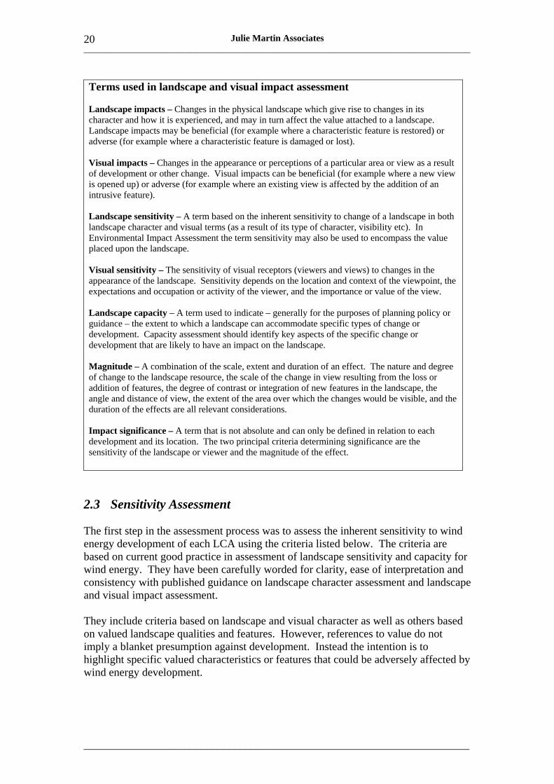
2.3 Sensitivity Assessment
The first step in the assessment process was to assess the inherent sensitivity to wind energy development of each LCA using the criteria listed below. The criteria are based on current good practice in assessment of landscape sensitivity and capacity for wind energy. They have been carefully worded for clarity, ease of interpretation and consistency with published guidance on landscape character assessment and landscape and visual impact assessment.
They include criteria based on landscape and visual character as well as others based on valued landscape qualities and features. However, references to value do not imply a blanket presumption against development. Instead the intention is to highlight specific valued characteristics or features that could be adversely affected by wind energy development.
___________________________________________________________________________________
_____________________________________________________________________
21 Julie Martin Associates
Table 3: Criteria for Assessing Landscape Sensitivity to Wind Energy Development
Criterion Comments
Scale A large scale landscape, where the turbines may be in proportion with the landscape, is likely to be of lower sensitivity to wind energy development than a small scale landscape, where the turbines may appear to dominate the landscape and features such as field patterns, individual trees and buildings may be compared with and highlight the size of the turbines.
Landform Landform that is smooth, regular and convex, or flat and uniform, is likely to be less sensitive to wind energy development than dramatic or rugged landform. This is because the former types of landform tend to be less prominent and less distinctive in character. Convex landform may in addition provide partial screening for turbine structures.
Enclosure A sense of enclosure provided by topography or vegetation – especially in areas with large scale topography or woodlands – may increase the ability of the landscape to provide screening for the lower parts of turbine structures and for associated access and infrastructure and hence indicate lower landscape sensitivity. However note that woodlands and forestry should be a long term feature if their screening effects are to be relied upon.
Complexity of Simple, uncluttered landscapes with sweeping lines and extensive areas landcover and of consistent ground cover are likely to offer greater potential for wind features energy development than areas with more complex, irregular or intimate
landscape patterns (for example ancient, irregular field systems) which tend to be more sensitive.
Man-made influence A high degree of man-made influence on the landscape may mean that it is less sensitive to change due to wind energy development. Turbines are likely to be less conspicuous in brownfield or industrial landscapes already affected by built structures such as masts, pylons or chimneys, provided there are no visual conflicts where the structures are seen in close proximity. Commercial forestry may also introduce a man-made influence to upland landscapes that would otherwise seem natural and wild.
Skylines and Landscapes that do not form a distinctive backdrop or context tend to be settings less sensitive to wind energy development than those with strong visual
features and focal points such as hilltop monuments, church spires or designed landscape features, which may form important skylines, landmarks or settings for settlements.
Visibility and views Landscapes that are visually contained or have limited inward and outward views may be less sensitive to wind energy development than areas with extensive inward and outward views. Extensive close or middle range views from scenic routes, well-known vistas or tourist viewpoints may increase a landscape’s sensitivity to wind energy development, as may close proximity to settlement.
Landscape quality Areas where the condition and integrity of landscape patterns, elements (condition) and features are relatively good may be more sensitive to wind energy
development than areas where condition is poor. In areas where landscape condition is good the fabric and character of the landscape are likely to be more highly valued and also more vulnerable to change.
___________________________________________________________________________________
_____________________________________________________________________
22 Julie Martin Associates
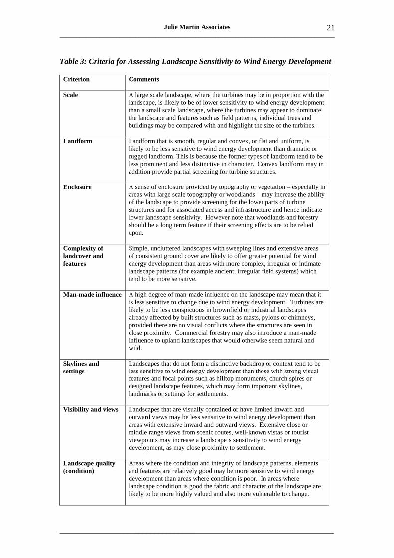
Scenic quality Scenic quality, that is visual appeal due to important views, visual interest and variety, contrasting landscape patterns, or dramatic topography, may increase landscape sensitivity to wind energy development. Land of high scenic quality occurs within designated landscapes (World Heritage Site, proposed National Park, AONBs) but also elsewhere; the approaches to and settings of areas of high scenic quality may also be sensitive.
Wildness and The presence of a relatively wild and/or tranquil character (due to tranquillity remoteness, freedom from disturbance and factors such as openness and
perceived naturalness) tends to make the landscape more sensitive to wind farm development. The introduction of wind turbines may alter perceptions of wildness and tranquillity, introducing movement, sound and light effects and possibly bringing a more industrial character to the affected landscapes.
Natural and The presence of natural and cultural heritage features such as interesting cultural heritage and valued habitats, wildlife, archaeological, historical or built features features that enhance the landscape experience may increase sensitivity to wind
farms, particularly where these features may directly affected by construction works and/or access tracks; or where or enjoyment of these features may be diminished.
Cultural Specific cultural (ie historical, folklore, literary or artistic) associations associations relating to the landscape may result in increased sensitivity to wind
energy development if the character or perceptions of the landscape concerned are likely to be significantly altered.
Amenity and Areas offering access to high quality landscapes, memorable places, recreation special experiences and to a range of opportunities for open-air recreation
may be more sensitive to wind energy development due to potential effects on accessibility and/or on the quality of the recreational experience that will be obtained.
For each LCA a description of sensitivity against each of the criteria was prepared. The LCA was then given an overall sensitivity level using a five point scale as outlined below:
High sensitivity Landscape is very vulnerable to change and would be adversely affected by wind energy development, which would result in a significant change in landscape and visual characteristics and values.
High to medium sensitivity
Medium sensitivity
Medium to low sensitivity
Low sensitivity Landscape is not vulnerable to change and would not be adversely affected by wind energy development, which would not result in significant change in landscape and visual characteristics and values.
___________________________________________________________________________________
_____________________________________________________________________
Julie Martin Associates 23
The sensitivity level for each LCA was assessed by considering the combined weight of evidence on landscape sensitivity (rather than by scoring the LCA against each criterion and averaging the scores). This is because landscape and visual characteristics and values do not readily lend themselves to scoring and criteria may carry different weights in different types of landscape and with different types and scales of development.
It should be noted that within many LCAs there is considerable variation in sensitivity level across the area, reflecting the fact that the LCAs are broad character or identity areas rather than generic landscape types that share particular landform and landcover characteristics. The overall sensitivity level is therefore the level that prevails over most of the LCA’s geographic area. Localised areas of higher or lower sensitivity may also exist and these are identified in the sensitivity descriptions31.
The sensitivity assessment is intended as broad guidance only. It provides the background information that is needed to inform the subsequent capacity assessment, which explores each LCA’s specific ability to accommodate different turbine heights and groupings.
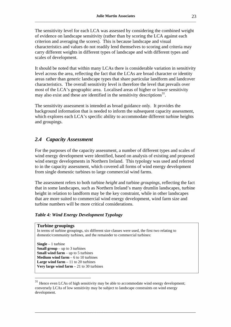
2.4 Capacity Assessment
For the purposes of the capacity assessment, a number of different types and scales of wind energy development were identified, based on analysis of existing and proposed wind energy developments in Northern Ireland. This typology was used and referred to in the capacity assessment, which covered all forms of wind energy development from single domestic turbines to large commercial wind farms.
The assessment refers to both turbine height and turbine groupings, reflecting the fact that in some landscapes, such as Northern Ireland’s many drumlin landscapes, turbine height in relation to landform may be the key constraint, while in other landscapes that are more suited to commercial wind energy development, wind farm size and turbine numbers will be more critical considerations.
Table 4: Wind Energy Development Typology
Turbine groupings In terms of turbine groupings, six different size classes were used, the first two relating to domestic/community turbines, and the remainder to commercial turbines:
Single – 1 turbine Small group – up to 3 turbines Small wind farm – up to 5 turbines Medium wind farm – 6 to 10 turbines Large wind farm – 11 to 20 turbines Very large wind farm – 21 to 30 turbines
31 Hence even LCAs of high sensitivity may be able to accommodate wind energy development; conversely LCAs of low sensitivity may be subject to landscape constraints on wind energy development.
___________________________________________________________________________________
_____________________________________________________________________
24 Julie Martin Associates
Turbine height In terms of turbine height, four different height classes were defined:
Domestic/community – 25m or less to blade tip Small commercial – 25-40m to blade tip Medium commercial – 40-80m to blade tip Large commercial – 80-125m to blade tip
Using this typology, a written capacity assessment was prepared for each LCA, based on the sensitivity assessment and on professional judgement as to what kind of wind energy development could best be accommodated, and where, in the landscapes of the LCA concerned. Each capacity assessment considered:
• The size of turbine grouping(s) that could be accommodated in the landscape; • Issues of turbine height in relation to the landscape, including reference to
appropriate turbine height classes; • Specific geographic opportunities and constraints relative to landform, skylines,
settings, wild land, natural and cultural heritage features etc; • Any special landscape considerations relating to domestic or community wind
energy development within the LCA; • Issues and potential issues relating to the cumulative, transboundary and
seaward impacts of commercial wind energy development; • In LCAs with commercial wind energy development capacity, indicative
development thresholds that should not be exceeded (in terms of numbers of wind farms and preferred separation).
The latter parts of the capacity assessment were informed by a desk- and field-based review of the levels of landscape and visual impact associated with existing (ie operational and consented) wind energy development. This indicated which LCAs are already affected by issues of cumulative impact and informed the identification of limits or ‘thresholds’ of wind energy development.
While there are no firm rules, some previous work suggests that to achieve effective landscape and visual separation of wind farms, separation distances ranging from 6km (for smaller sites in landscapes with some enclosure) to 12km (for larger sites in open exposed landscapes) are desirable to prevent the landscape becoming dominated by wind farms and to reduce intervisibility. Conversely, if small and medium size wind farms are located less than 3-5km apart (to the outermost turbines of each site), they may be seen as ‘clusters’ and, in areas of appropriate landscape character, may be accommodated as such within the landscape provided that the turbines in the cluster read as a single coherent group.
Ultimately, definitive judgements on cumulative impacts can only be made on a case-by-case basis taking account of the specific character of the landscape and the siting, layout and intervisibility of the proposed wind farm with other wind farms in the same LCA and in neighbouring LCAs. However it is also important to bear in mind the broader, strategic impacts of wind energy development on Northern Ireland’s landscapes. These are considered in Section 3.2, which highlights the issues of cumulative landscape sensitivity and capacity that will need to be considered as wind energy development in Northern Ireland expands.
___________________________________________________________________________________
_____________________________________________________________________
25 Julie Martin Associates
2.5 Principles Affecting Sensitivity and Capacity
When the approach and methodology outlined above were applied to Northern Ireland’s 130 LCAs, a number of key principles or factors affecting sensitivity and capacity emerged very clearly. These principles are summarised in the tables below and illustrated in the accompanying photographs.
Some of the principles (Table 5) are general ones, relating to spacing between wind farms, turbine groupings, turbine height, and turbine layout and design in relation to the landscape.
Others relate to particular types of landscape (Table 6), reflecting the fact that different types of landscape may have fundamentally different abilities to accommodate wind energy due to their different characteristics, features and values.
For example, broad upland landscapes, by virtue of their large scale, may be able to accommodate large wind farms; whereas intricate rolling, small scale drumlin landscapes are generally better suited to small groups of turbines; and in coastal areas the size of turbine grouping that can be accommodated will depend heavily on the coastal configuration and landform.
Further, more detailed advice on the siting, layout and design of wind energy development in relation to the landscape can also be found in Section 4.
___________________________________________________________________________________
_____________________________________________________________________
26 Julie Martin Associates
Table 5: Sensitivity and Capacity: General Principles
Spacing between wind farms • Satisfactory spacing depends both on landscape character and on the degree of intervisibility. • Where several wind farms are visible together or sequentially they may affect landscape character
and visual amenity at a strategic level. • Retention of areas of undeveloped landscape is important. For example, where a small lowland
wind farm connects larger upland sites visually, wind farm influence on landscape character may become much more significant and dominant.
• Appropriate spacing depends at least partly on landscape patterns and rhythms. Hence on an undulating upland ridge, wind farm spacing may reflect the pattern and frequency of undulations, whereas on a simple rounded upland ridge a cluster of wind farms may give a better landform fit.
• As a rule of thumb, separation distances ranging from 6km (for smaller sites in landscapes with some enclosure) to 12 km (for larger sites in open exposed landscapes) are desirable to prevent the landscape becoming dominated by wind farms and to reduce intervisibility.
• If small and medium sized wind farms are located less than 3-5km apart (to the outermost turbines) they may be seen as clusters and in areas of appropriate character may be accommodated as such within the landscape.
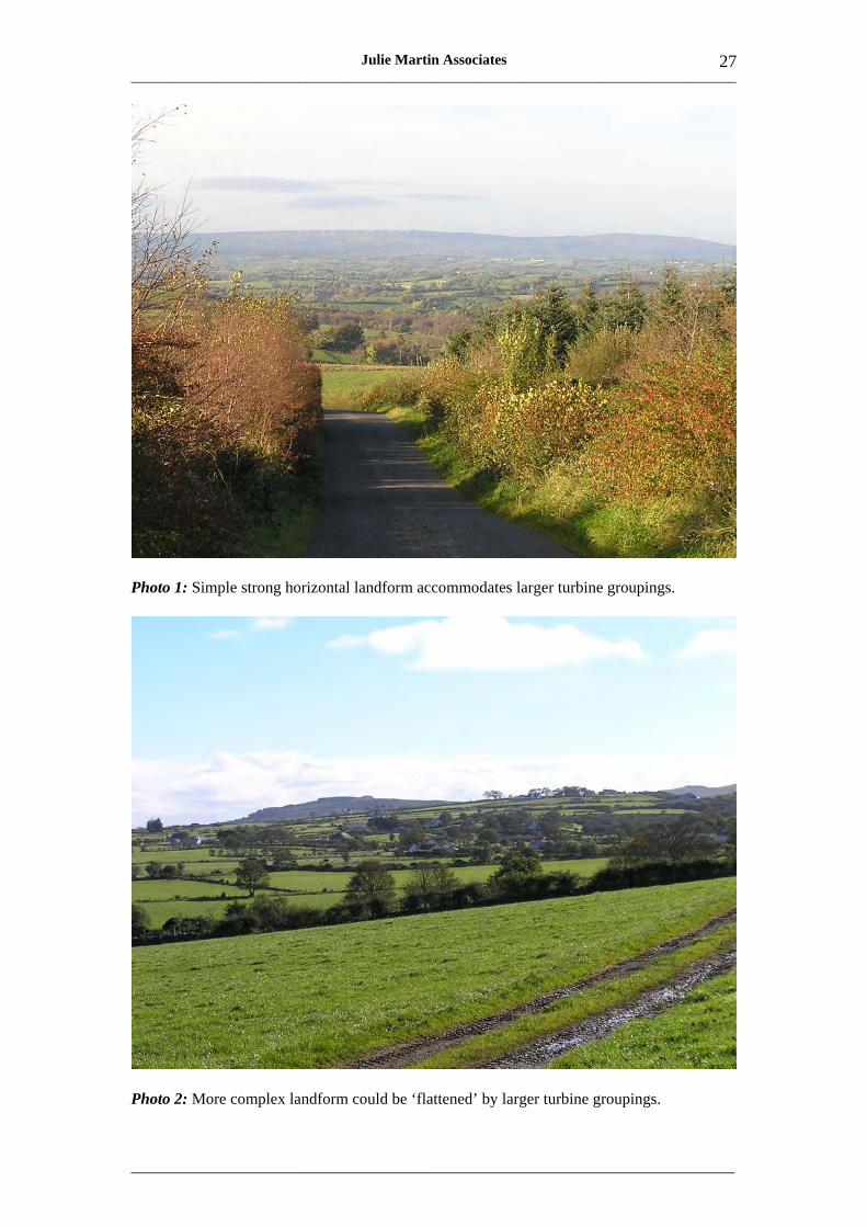
Turbine groupings • Landscapes with a simple, strong and mainly horizontal form are more likely to be able to
accommodate large turbine groupings successfully (Photo 1). • In landscapes with more complex and varied landform, large turbine groupings may have an
undesirable ‘flattening’ effect on landscape character (Photo 2). • Smaller turbine groupings are likely to fit best in small scale and more intricate landscapes. • Compact clusters of turbines may sometimes be used to create or highlight a focal point within
the landscape, adding or reinforcing a vertical emphasis in the landscape, but such an approach needs to be used very selectively. It is only likely to be successful on small hilltops; on larger hilltops it could be overwhelming.
Turbine height • In general, turbine height should be proportionate to landform height. This will help to retain
topographic distinctions and contrasts between upland and lowland landscapes. • Hence elevated upland landscapes can often accommodate taller turbines than lowland
landscapes, especially where the lowland landscapes have a rolling, varied topography whose subtle variations could be overwhelmed by tall turbines.
• However, extensive, flat, uniform lowland landscapes may also be able to accommodate tall turbines because of the lack of topographic distinctions and because the larger horizontal extent of such landscapes tends to diminish perceived turbine height.
Turbine siting, layout and design • The settings of distinctive or valued landscape features may be especially sensitive to wind
turbines. Such features may include dramatic landform features such as cliffs, natural features such as loughs or wetlands, and cultural features such as settlements and historic parks.
• Inconsistencies in turbine layout, height or design between adjacent wind farms can draw the eye and may cause increased landscape and visual impact.
• Proximity of turbines to existing intrusive structures such as electricity transmission lines may create a sense of visual clutter (Photo 3) where the turbines and other structures are seen together.
• Turbine layouts can and should be influenced by landscape patterns, for example by drumlin patterns or field patterns.
• Functional relationships between domestic, community and industrial turbines and their landscape settings should be reflected in turbine siting, turbines being closely associated with, and in scale with, the farms, settlements or industrial plant that they serve.
• In the case of domestic and community turbines the relationship to existing buildings and settlements and tree cover is especially important (Photo 4). Siting in open, exposed landscapes should generally be avoided because it may gradually and cumulatively give the surrounding countryside a more industrial character, as well as giving rise to visual intrusion.
___________________________________________________________________________________
_____________________________________________________________________
27 Julie Martin Associates
Photo 1: Simple strong horizontal landform accommodates larger turbine groupings.
Photo 2: More complex landform could be ‘flattened’ by larger turbine groupings.

___________________________________________________________________________________
_____________________________________________________________________
28 Julie Martin Associates
Photo 3: Turbines seen with electricity pylons may create visual clutter.
Photo 4: Relationship between turbine and farm buildings and trees reduces impact.
___________________________________________________________________________________
_____________________________________________________________________
29 Julie Martin Associates
Table 6: Sensitivity and Capacity in Different Types of Landscape
Upland landscapes • The broader the upland, the greater its capacity for wind energy development is likely to be. • Uplands with a simple, rounded and generally horizontal form are able to accommodate larger
turbine groupings than more dramatic or convoluted upland landforms. • In areas of more complex upland landform, smaller turbine groupings will generally fit better
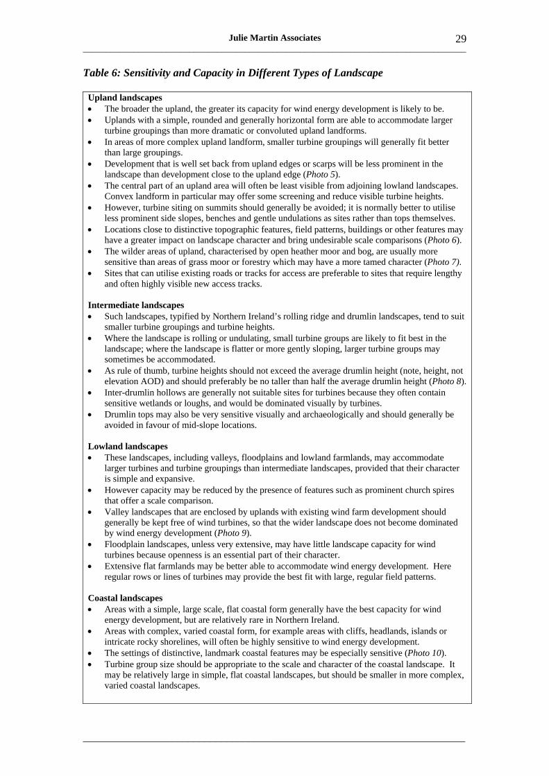
than large groupings. • Development that is well set back from upland edges or scarps will be less prominent in the
landscape than development close to the upland edge (Photo 5). • The central part of an upland area will often be least visible from adjoining lowland landscapes.
Convex landform in particular may offer some screening and reduce visible turbine heights. • However, turbine siting on summits should generally be avoided; it is normally better to utilise
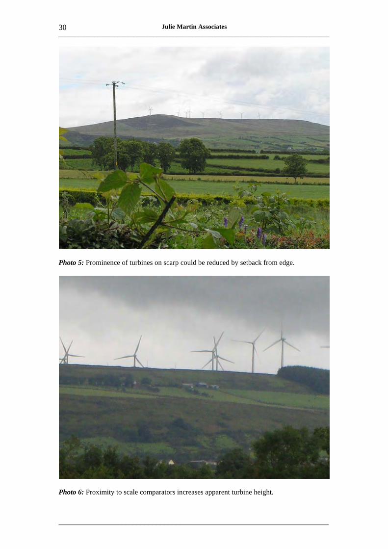
less prominent side slopes, benches and gentle undulations as sites rather than tops themselves. • Locations close to distinctive topographic features, field patterns, buildings or other features may
have a greater impact on landscape character and bring undesirable scale comparisons (Photo 6). • The wilder areas of upland, characterised by open heather moor and bog, are usually more
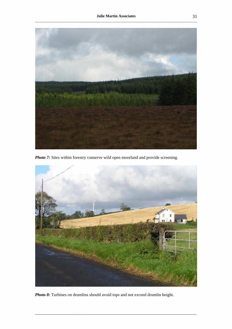
sensitive than areas of grass moor or forestry which may have a more tamed character (Photo 7). • Sites that can utilise existing roads or tracks for access are preferable to sites that require lengthy
and often highly visible new access tracks.
Intermediate landscapes • Such landscapes, typified by Northern Ireland’s rolling ridge and drumlin landscapes, tend to suit
smaller turbine groupings and turbine heights. • Where the landscape is rolling or undulating, small turbine groups are likely to fit best in the
landscape; where the landscape is flatter or more gently sloping, larger turbine groups may sometimes be accommodated.
• As rule of thumb, turbine heights should not exceed the average drumlin height (note, height, not elevation AOD) and should preferably be no taller than half the average drumlin height (Photo 8).
• Inter-drumlin hollows are generally not suitable sites for turbines because they often contain sensitive wetlands or loughs, and would be dominated visually by turbines.
• Drumlin tops may also be very sensitive visually and archaeologically and should generally be avoided in favour of mid-slope locations.
Lowland landscapes • These landscapes, including valleys, floodplains and lowland farmlands, may accommodate
larger turbines and turbine groupings than intermediate landscapes, provided that their character is simple and expansive.
• However capacity may be reduced by the presence of features such as prominent church spires that offer a scale comparison.
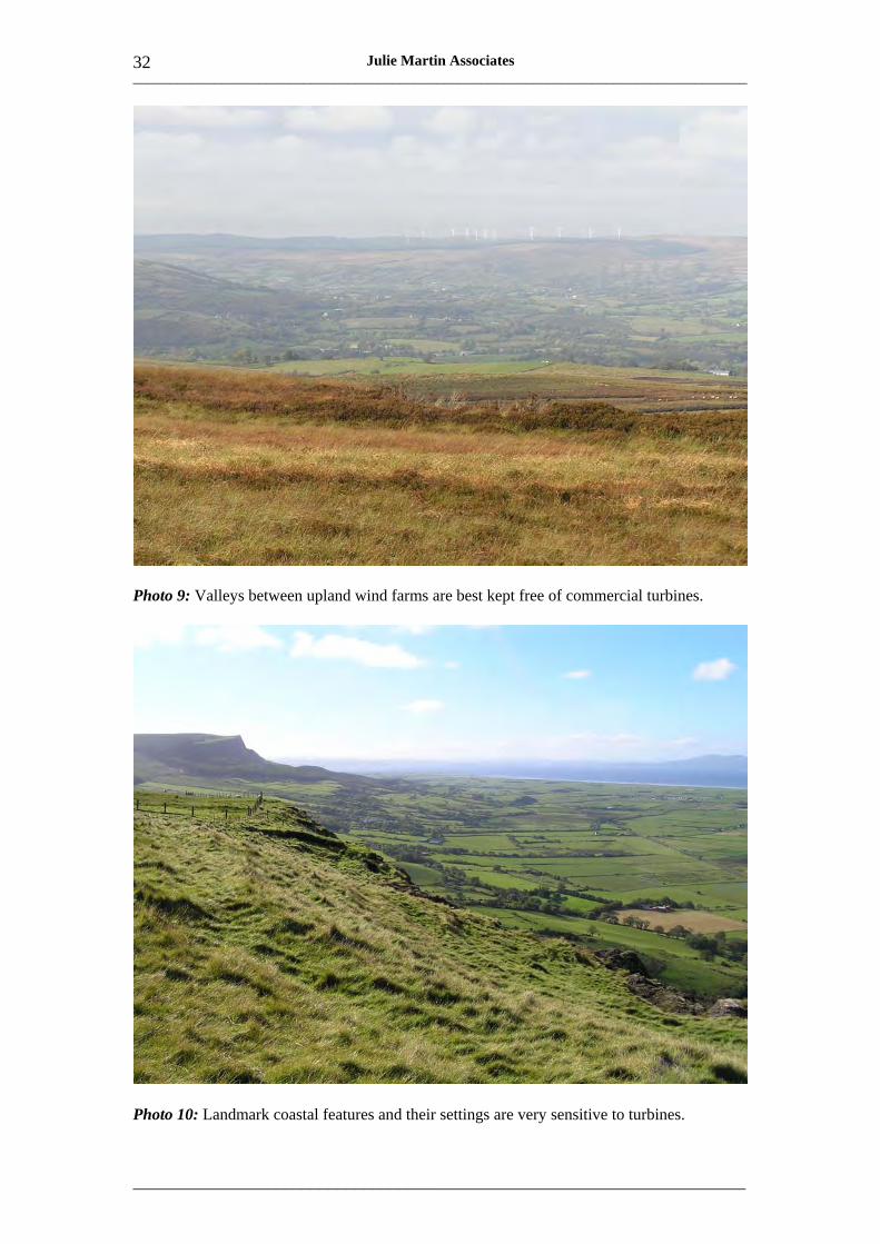
• Valley landscapes that are enclosed by uplands with existing wind farm development should generally be kept free of wind turbines, so that the wider landscape does not become dominated by wind energy development (Photo 9).
• Floodplain landscapes, unless very extensive, may have little landscape capacity for wind turbines because openness is an essential part of their character.
• Extensive flat farmlands may be better able to accommodate wind energy development. Here regular rows or lines of turbines may provide the best fit with large, regular field patterns.
Coastal landscapes • Areas with a simple, large scale, flat coastal form generally have the best capacity for wind
energy development, but are relatively rare in Northern Ireland. • Areas with complex, varied coastal form, for example areas with cliffs, headlands, islands or
intricate rocky shorelines, will often be highly sensitive to wind energy development. • The settings of distinctive, landmark coastal features may be especially sensitive (Photo 10). • Turbine group size should be appropriate to the scale and character of the coastal landscape. It
may be relatively large in simple, flat coastal landscapes, but should be smaller in more complex, varied coastal landscapes.
___________________________________________________________________________________
_____________________________________________________________________
30 Julie Martin Associates
Photo 5: Prominence of turbines on scarp could be reduced by setback from edge.
Photo 6: Proximity to scale comparators increases apparent turbine height.
___________________________________________________________________________________
_____________________________________________________________________
31 Julie Martin Associates
Photo 7: Sites within forestry conserve wild open moorland and provide screening.
Photo 8: Turbines on drumlins should avoid tops and not exceed drumlin height.
___________________________________________________________________________________
_____________________________________________________________________
32 Julie Martin Associates
Photo 9: Valleys between upland wind farms are best kept free of commercial turbines.
Photo 10: Landmark coastal features and their settings are very sensitive to turbines.

___________________________________________________________________________________
_____________________________________________________________________
33 Julie Martin Associates
Urban and industrial landscapes • These landscapes may have some capacity for wind energy development due to the presence of
existing man-made influences. • For example sites close to power stations, factories, large institutions such as hospitals, business
parks and major transport corridors may have capacity for wind turbines in landscape terms. • Wind turbines should be carefully sited and designed relative to existing structures. Particular
attention should be paid to relative heights and proportions. • Close visual relationships may help to reinforce functional relationships. • In some cases turbines may be used to create a new focal point or landmark, drawing the eye
upwards and away from existing intrusive features. • However care should be taken to avoid creating visual clutter by placing turbines too close to
other complex structures such as pylons or telecommunications masts.

___________________________________________________________________________________
_____________________________________________________________________
34 Julie Martin Associates
___________________________________________________________________________________
_____________________________________________________________________
Julie Martin Associates 35
3 Landscape Sensitivity and Capacity Assessment
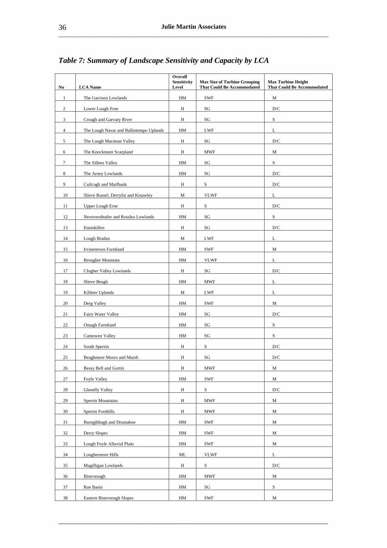
3.1 Sensitivity and Capacity of the LCAs
Table 7 below summarises the findings of the landscape sensitivity and capacity assessment of Northern Ireland’s 130 LCAs. As it is only a summary it should always be read in conjunction with the full assessments, which are presented as a series of assessment sheets in Annex 1. Section 4 explains in detail what each section of the assessment sheet means and how the assessments should be used.
The first two columns of Table 7 give the number and name of the LCA (see Figure 1 for LCA locations).
The third column indicates the overall sensitivity level as follows (see Section 2.3 for full definitions of sensitivity levels):
H = High sensitivity HM = High to medium sensitivity M = Medium sensitivity ML = Medium to low sensitivity L = Low sensitivity.
As noted earlier, there are variations in sensitivity within each LCA. The overall sensitivity level is the level that prevails over most of the LCA’s geographic extent, but localised areas of higher or lower sensitivity may also exist and are identified in the sensitivity descriptions within the assessment sheets.
The fourth column shows the maximum size of turbine grouping that could be accommodated in the LCA as follows:
S = Single – 1 turbine SG = Small Group – up to 3 turbines SWF = Small Wind Farm – up to 5 turbines MWF = Medium Wind Farm – 6 to10 turbines LWF = Large Wind Farm – 11 to 20 turbines VLWF = Very Large Wind Farm – 20 to 30 turbines
The fifth column shows the maximum turbine height that could be accommodated in the LCA as follows:
D/C = Domestic/community – 25m or less to blade tip S = Small commercial – 25-40m to blade tip M = Medium commercial – 40-80m to blade tip L = Large commercial – 80-125m to blade tip
It is important to note that the capacities indicated are maxima and may apply to part of the LCA only. Other parts of the LCA may have lower capacity or no capacity at all. Again, the sensitivity and capacity assessment sheets give further details.
___________________________________________________________________________________
_____________________________________________________________________
36 Julie Martin Associates
Table 7: Summary of Landscape Sensitivity and Capacity by LCA
No LCA Name
Overall Sensitivity Level
Max Size of Turbine Grouping That Could Be Accommodated
Max Turbine Height That Could Be Accommodated
1 The Garrison Lowlands HM SWF M
2 Lower Lough Erne H SG D/C
3 Croagh and Garvary River H SG S
4 The Lough Navar and Ballintempo Uplands HM LWF L
5 The Lough Macnean Valley H SG D/C
6 The Knockmore Scarpland H MWF M
7 The Sillees Valley HM SG S
8 The Arney Lowlands HM SG D/C
9 Cuilcagh and Marlbank H S D/C
10 Slieve Russel, Derrylin and Kinawley M VLWF L
11 Upper Lough Erne H S D/C
12 Newtownbutler and Rosslea Lowlands HM SG S
13 Enniskillen H SG D/C
14 Lough Bradan M LWF L
15 Irvinestown Farmland HM SWF M
16 Brougher Mountain HM VLWF L
17 Clogher Valley Lowlands H SG D/C
18 Slieve Beagh HM MWF L
19 Killeter Uplands M LWF L
20 Derg Valley HM SWF M
21 Fairy Water Valley HM SG D/C
22 Omagh Farmland HM SG S
23 Camowen Valley HM SG S
24 South Sperrin H S D/C
25 Beaghmore Moors and Marsh H SG D/C
26 Bessy Bell and Gortin H MWF M
27 Foyle Valley HM SWF M
28 Glenelly Valley H S D/C
29 Sperrin Mountains H MWF M
30 Sperrin Foothills H MWF M
31 Burngibbagh and Drumahoe HM SWF M
32 Derry Slopes HM SWF M
33 Lough Foyle Alluvial Plain HM SWF M
34 Loughermore Hills ML VLWF L
35 Magilligan Lowlands H S D/C
36 Binevenagh HM MWF M
37 Roe Basin HM SG S
38 Eastern Binevenagh Slopes HM SWF M
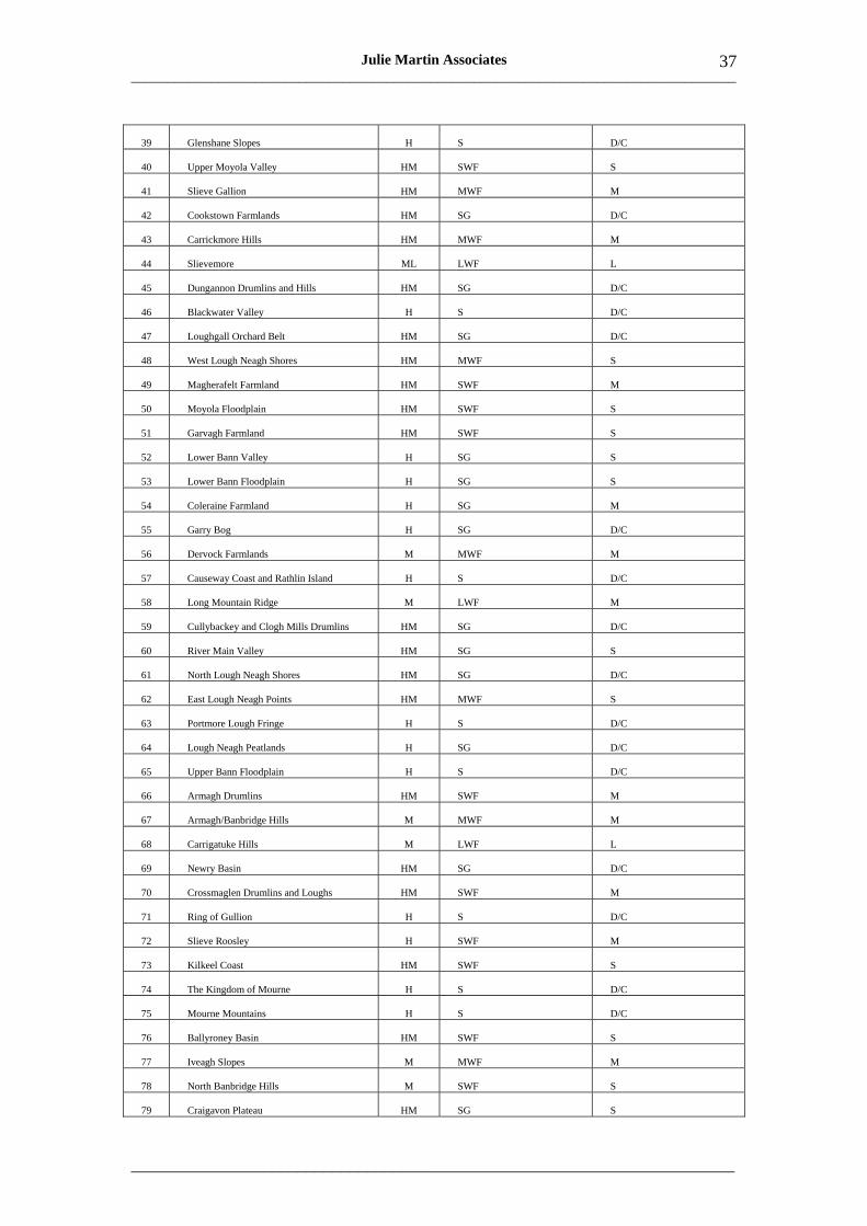
___________________________________________________________________________________
_____________________________________________________________________
37 Julie Martin Associates
39 Glenshane Slopes H S D/C
40 Upper Moyola Valley HM SWF S
41 Slieve Gallion HM MWF M
42 Cookstown Farmlands HM SG D/C
43 Carrickmore Hills HM MWF M
44 Slievemore ML LWF L
45 Dungannon Drumlins and Hills HM SG D/C
46 Blackwater Valley H S D/C
47 Loughgall Orchard Belt HM SG D/C
48 West Lough Neagh Shores HM MWF S
49 Magherafelt Farmland HM SWF M
50 Moyola Floodplain HM SWF S
51 Garvagh Farmland HM SWF S
52 Lower Bann Valley H SG S
53 Lower Bann Floodplain H SG S
54 Coleraine Farmland H SG M
55 Garry Bog H SG D/C
56 Dervock Farmlands M MWF M
57 Causeway Coast and Rathlin Island H S D/C
58 Long Mountain Ridge M LWF M
59 Cullybackey and Clogh Mills Drumlins HM SG D/C
60 River Main Valley HM SG S
61 North Lough Neagh Shores HM SG D/C
62 East Lough Neagh Points HM MWF S
63 Portmore Lough Fringe H S D/C
64 Lough Neagh Peatlands H SG D/C
65 Upper Bann Floodplain H S D/C
66 Armagh Drumlins HM SWF M
67 Armagh/Banbridge Hills M MWF M
68 Carrigatuke Hills M LWF L
69 Newry Basin HM SG D/C
70 Crossmaglen Drumlins and Loughs HM SWF M
71 Ring of Gullion H S D/C
72 Slieve Roosley H SWF M
73 Kilkeel Coast HM SWF S
74 The Kingdom of Mourne H S D/C
75 Mourne Mountains H S D/C
76 Ballyroney Basin HM SWF S
77 Iveagh Slopes M MWF M
78 North Banbridge Hills M SWF S
79 Craigavon Plateau HM SG S
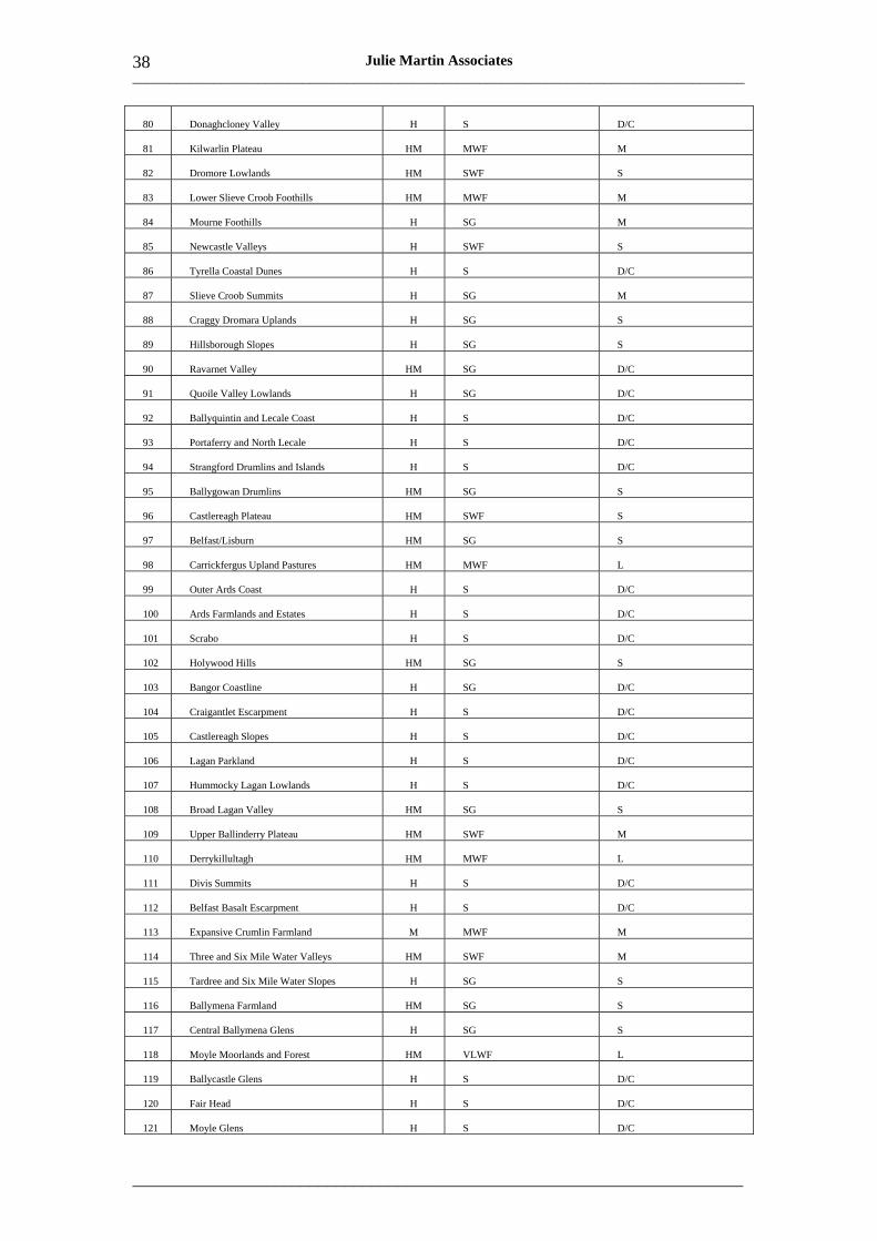
___________________________________________________________________________________
_____________________________________________________________________
38 Julie Martin Associates
80 Donaghcloney Valley H S D/C
81 Kilwarlin Plateau HM MWF M
82 Dromore Lowlands HM SWF S
83 Lower Slieve Croob Foothills HM MWF M
84 Mourne Foothills H SG M
85 Newcastle Valleys H SWF S
86 Tyrella Coastal Dunes H S D/C
87 Slieve Croob Summits H SG M
88 Craggy Dromara Uplands H SG S
89 Hillsborough Slopes H SG S
90 Ravarnet Valley HM SG D/C
91 Quoile Valley Lowlands H SG D/C
92 Ballyquintin and Lecale Coast H S D/C
93 Portaferry and North Lecale H S D/C
94 Strangford Drumlins and Islands H S D/C
95 Ballygowan Drumlins HM SG S
96 Castlereagh Plateau HM SWF S
97 Belfast/Lisburn HM SG S
98 Carrickfergus Upland Pastures HM MWF L
99 Outer Ards Coast H S D/C
100 Ards Farmlands and Estates H S D/C
101 Scrabo H S D/C
102 Holywood Hills HM SG S
103 Bangor Coastline H SG D/C
104 Craigantlet Escarpment H S D/C
105 Castlereagh Slopes H S D/C
106 Lagan Parkland H S D/C
107 Hummocky Lagan Lowlands H S D/C
108 Broad Lagan Valley HM SG S
109 Upper Ballinderry Plateau HM SWF M
110 Derrykillultagh HM MWF L
111 Divis Summits H S D/C
112 Belfast Basalt Escarpment H S D/C
113 Expansive Crumlin Farmland M MWF M
114 Three and Six Mile Water Valleys HM SWF M
115 Tardree and Six Mile Water Slopes H SG S
116 Ballymena Farmland HM SG S
117 Central Ballymena Glens H SG S
118 Moyle Moorlands and Forest HM VLWF L
119 Ballycastle Glens H S D/C
120 Fair Head H S D/C
121 Moyle Glens H S D/C
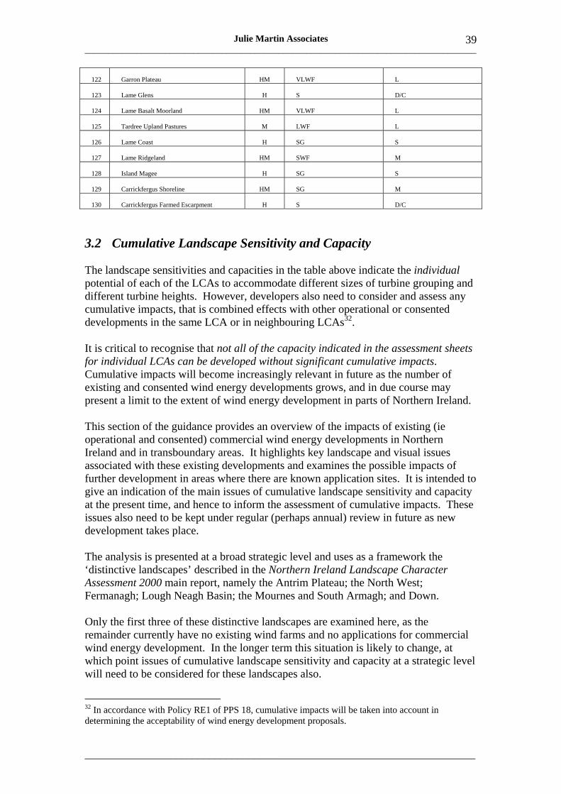
___________________________________________________________________________________
_____________________________________________________________________
39 Julie Martin Associates
122 Garron Plateau HM VLWF L
123 Lame Glens H S D/C
124 Lame Basalt Moorland HM VLWF L
125 Tardree Upland Pastures M LWF L
126 Lame Coast H SG S
127 Lame Ridgeland HM SWF M
128 Island Magee H SG S
129 Carrickfergus Shoreline HM SG M
130 Carrickfergus Farmed Escarpment H S D/C
3.2 Cumulative Landscape Sensitivity and Capacity
The landscape sensitivities and capacities in the table above indicate the individual potential of each of the LCAs to accommodate different sizes of turbine grouping and different turbine heights. However, developers also need to consider and assess any cumulative impacts, that is combined effects with other operational or consented developments in the same LCA or in neighbouring LCAs32.
It is critical to recognise that not all of the capacity indicated in the assessment sheets for individual LCAs can be developed without significant cumulative impacts. Cumulative impacts will become increasingly relevant in future as the number of existing and consented wind energy developments grows, and in due course may present a limit to the extent of wind energy development in parts of Northern Ireland.
This section of the guidance provides an overview of the impacts of existing (ie operational and consented) commercial wind energy developments in Northern Ireland and in transboundary areas. It highlights key landscape and visual issues associated with these existing developments and examines the possible impacts of further development in areas where there are known application sites. It is intended to give an indication of the main issues of cumulative landscape sensitivity and capacity at the present time, and hence to inform the assessment of cumulative impacts. These issues also need to be kept under regular (perhaps annual) review in future as new development takes place.
The analysis is presented at a broad strategic level and uses as a framework the ‘distinctive landscapes’ described in the Northern Ireland Landscape Character Assessment 2000 main report, namely the Antrim Plateau; the North West; Fermanagh; Lough Neagh Basin; the Mournes and South Armagh; and Down.
Only the first three of these distinctive landscapes are examined here, as the remainder currently have no existing wind farms and no applications for commercial wind energy development. In the longer term this situation is likely to change, at which point issues of cumulative landscape sensitivity and capacity at a strategic level will need to be considered for these landscapes also.
32 In accordance with Policy RE1 of PPS 18, cumulative impacts will be taken into account in determining the acceptability of wind energy development proposals.
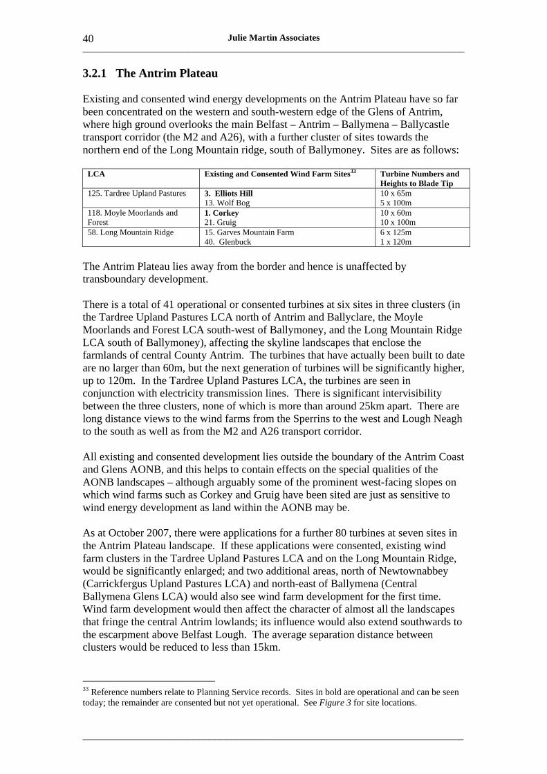
___________________________________________________________________________________
_____________________________________________________________________
40 Julie Martin Associates
3.2.1 The Antrim Plateau
Existing and consented wind energy developments on the Antrim Plateau have so far been concentrated on the western and south-western edge of the Glens of Antrim, where high ground overlooks the main Belfast – Antrim – Ballymena – Ballycastle transport corridor (the M2 and A26), with a further cluster of sites towards the northern end of the Long Mountain ridge, south of Ballymoney. Sites are as follows:
LCA Existing and Consented Wind Farm Sites33 Turbine Numbers and Heights to Blade Tip
125. Tardree Upland Pastures 3. Elliots Hill 13. Wolf Bog
10 x 65m 5 x 100m
118. Moyle Moorlands and Forest
1. Corkey 21. Gruig
10 x 60m 10 x 100m
58. Long Mountain Ridge 15. Garves Mountain Farm 40. Glenbuck
6 x 125m 1 x 120m
The Antrim Plateau lies away from the border and hence is unaffected by transboundary development.
There is a total of 41 operational or consented turbines at six sites in three clusters (in the Tardree Upland Pastures LCA north of Antrim and Ballyclare, the Moyle Moorlands and Forest LCA south-west of Ballymoney, and the Long Mountain Ridge LCA south of Ballymoney), affecting the skyline landscapes that enclose the farmlands of central County Antrim. The turbines that have actually been built to date are no larger than 60m, but the next generation of turbines will be significantly higher, up to 120m. In the Tardree Upland Pastures LCA, the turbines are seen in conjunction with electricity transmission lines. There is significant intervisibility between the three clusters, none of which is more than around 25km apart. There are long distance views to the wind farms from the Sperrins to the west and Lough Neagh to the south as well as from the M2 and A26 transport corridor.
All existing and consented development lies outside the boundary of the Antrim Coast and Glens AONB, and this helps to contain effects on the special qualities of the AONB landscapes – although arguably some of the prominent west-facing slopes on which wind farms such as Corkey and Gruig have been sited are just as sensitive to wind energy development as land within the AONB may be.
As at October 2007, there were applications for a further 80 turbines at seven sites in the Antrim Plateau landscape. If these applications were consented, existing wind farm clusters in the Tardree Upland Pastures LCA and on the Long Mountain Ridge, would be significantly enlarged; and two additional areas, north of Newtownabbey (Carrickfergus Upland Pastures LCA) and north-east of Ballymena (Central Ballymena Glens LCA) would also see wind farm development for the first time. Wind farm development would then affect the character of almost all the landscapes that fringe the central Antrim lowlands; its influence would also extend southwards to the escarpment above Belfast Lough. The average separation distance between clusters would be reduced to less than 15km.
33 Reference numbers relate to Planning Service records. Sites in bold are operational and can be seen today; the remainder are consented but not yet operational. See Figure 3 for site locations.
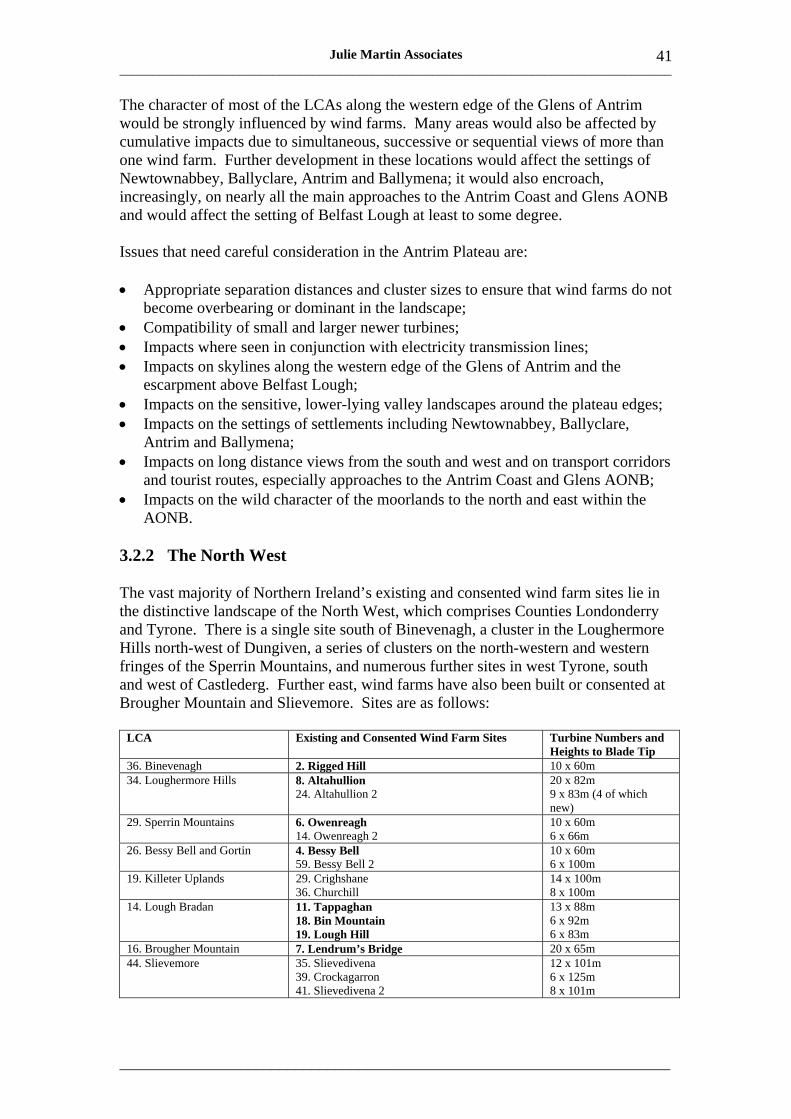
___________________________________________________________________________________
_____________________________________________________________________
Julie Martin Associates 41
The character of most of the LCAs along the western edge of the Glens of Antrim would be strongly influenced by wind farms. Many areas would also be affected by cumulative impacts due to simultaneous, successive or sequential views of more than one wind farm. Further development in these locations would affect the settings of Newtownabbey, Ballyclare, Antrim and Ballymena; it would also encroach, increasingly, on nearly all the main approaches to the Antrim Coast and Glens AONB and would affect the setting of Belfast Lough at least to some degree.
Issues that need careful consideration in the Antrim Plateau are:
• Appropriate separation distances and cluster sizes to ensure that wind farms do not become overbearing or dominant in the landscape;
• Compatibility of small and larger newer turbines; • Impacts where seen in conjunction with electricity transmission lines; • Impacts on skylines along the western edge of the Glens of Antrim and the
escarpment above Belfast Lough; • Impacts on the sensitive, lower-lying valley landscapes around the plateau edges; • Impacts on the settings of settlements including Newtownabbey, Ballyclare,
Antrim and Ballymena; • Impacts on long distance views from the south and west and on transport corridors
and tourist routes, especially approaches to the Antrim Coast and Glens AONB; • Impacts on the wild character of the moorlands to the north and east within the
AONB.
3.2.2 The North West
The vast majority of Northern Ireland’s existing and consented wind farm sites lie in the distinctive landscape of the North West, which comprises Counties Londonderry and Tyrone. There is a single site south of Binevenagh, a cluster in the Loughermore Hills north-west of Dungiven, a series of clusters on the north-western and western fringes of the Sperrin Mountains, and numerous further sites in west Tyrone, south and west of Castlederg. Further east, wind farms have also been built or consented at Brougher Mountain and Slievemore. Sites are as follows:
LCA Existing and Consented Wind Farm Sites Turbine Numbers and Heights to Blade Tip
36. Binevenagh 2. Rigged Hill 10 x 60m 34. Loughermore Hills 8. Altahullion
24. Altahullion 2 20 x 82m 9 x 83m (4 of which new)
29. Sperrin Mountains 6. Owenreagh 14. Owenreagh 2
10 x 60m 6 x 66m
26. Bessy Bell and Gortin 4. Bessy Bell 59. Bessy Bell 2
10 x 60m 6 x 100m
19. Killeter Uplands 29. Crighshane 36. Churchill
14 x 100m 8 x 100m
14. Lough Bradan 11. Tappaghan 18. Bin Mountain 19. Lough Hill
13 x 88m 6 x 92m 6 x 83m
16. Brougher Mountain 7. Lendrum’s Bridge 20 x 65m 44. Slievemore 35. Slievedivena
39. Crockagarron 41. Slievedivena 2
12 x 101m 6 x 125m 8 x 101m
___________________________________________________________________________________
_____________________________________________________________________
42 Julie Martin Associates
There is transboundary development in several nearby parts of County Donegal, notably a few km to the west of the Killeter Uplands; around Cark Mountain southwest of Letterkenny, around 20km from the border; and around 10km north of Derry on the Inishowen peninsula. Offshore, the area outside the mouth of Lough Foyle, known as Tunes Plateau, has been under exploration for development of an offshore wind farm.
A total of 159 turbines at 16 sites have been built or are consented, in five clusters each of two sites and six other separate locations. Affected LCAs are Binevenagh and the Loughermore Hills in County Londonderry; and Sperrin Mountains, Bessy Bell and Gortin, Killeter Uplands, Lough Bradan, Brougher Mountain and Slievemore, all in County Tyrone.
The sites south of Binevenagh and in the Loughermore Hills, which are around 15km apart, are both in relatively isolated locations, well separated and generally in scale with their landscape settings. Nonetheless, they have some impact on the residents of Dungiven and Limavady and on views from east-west routes such as the A6 from Belfast to Derry and the A2 from Coleraine to Derry. They also affect the settings of the Binevenagh AONB and, to a lesser extent, the Sperrin AONB.
To the west, the sites in the Sperrin Mountains, Bessy Bell and Gortin, the Killeter Uplands and Lough Bradan all lie within around 10km of the border with County Donegal. The settings of the Foyle and Strule valleys, the A5 Strabane-Omagh road (which is an important tourist route) and the western edges of the Sperrin AONB are affected by wind farms at Owenreagh (within the AONB itself) and Bessy Bell. Further west, wind farm sites are generally remote from centres of population, but are very widely intervisible, particularly in the Killeter Uplands and Lough Bradan, where relatively short separation distances of 5-7km between wind farms tend to increase the dominance of wind energy in the landscape. This effect is increased by views to transboundary wind farm sites in Donegal. The southernmost sites in the Killeter Uplands and Lough Bradan LCAs lie on the skyline above Lower Lough Erne and are seen at a distance of 5-10km from the proposed Erne Lakeland AONB.
Further east, in mid-Tyrone, the group of low hills that trends south-west to northeast, overlooking the A4 Belfast to Enniskillen road and the Clogher valley, has seen wind farm development at Brougher Mountain and Slievemore, where there is a line of three sites over a distance of around 20km. These sites, set on rolling, rounded and isolated hills, generally have modest landscape and visual impacts. The southernmost site, Lendrum’s Bridge, is seen in some views from Enniskillen and the proposed Erne Lakeland AONB 15-20km away, as well as from the A4; while other sites affect more minor settlements and routes.
As at October 2007, there were applications for a further 278 onshore turbines at 25 new sites in the North West. If all these applications were consented, the wind farm cluster in the Loughermore Hills LCA would be extended and a very large, loose new cluster, spread over around 10km, would be created in the Sperrin Foothills LCA, potentially dominating and adversely affecting the intimate valley landscapes and complex, dramatic topography of the foothills landscape, which fringes the existing AONB and is proposed for inclusion in a new Sperrin AONB (to be designated under the Nature Conservation and Amenity Lands (NI) Order 1985). The A6 Belfast to
___________________________________________________________________________________
_____________________________________________________________________
Julie Martin Associates 43
Derry road would have close range, simultaneous, successive or sequential views of a series of wind farm sites from Limavady onwards.
Development at Bessy Bell would also expand; and in the Killeter Uplands and Lough Bradan LCAs the number of wind farms would more than double, with up to 12 sites spread out over an east-west upland ridge less than 20km in length, potentially forming a massive and almost unbroken line. This would almost certainly dominate the landscape character of these LCAs and also exert a wider landscape and visual influence, particularly over Lower Lough Erne and parts of the proposed Erne Lakeland AONB.
A cluster of wind farms would be created in Brougher Mountain LCA; and Slievemore LCA would see the development of a wind farm cluster plus several further individual wind farms, together forming a line around 10km long along the ridge top and frequently visible when looking north from the A4 and the Clogher valley. To the south of the A4, on the parallel Slieve Beagh ridge, two wind farms would be visible, again affecting views from the A4 tourist route and the Clogher valley. Further north, additional wind farms would be found in the Carrickmore Hills LCA, very close to the Sperrin AONB and visible from the A505 Cookstown to Omagh road.
Issues that need careful consideration in the North West are:
• Separation distances and thresholds of wind farm development on specific ridge lines such as those in the Killeter Uplands, Lough Bradan and Slievemore LCAs;
• Impacts on skylines along the Foyle, Strule and Clogher valleys and north of Lough Erne;
• Impacts on the wild character of some landscapes, eg the Killeter Uplands LCA; • Impacts on transport corridors and important tourist routes, especially the A6, A5
and A4; • Impacts on the landscape character and value of the existing and proposed Sperrin
AONB of any wind farm development in the Sperrin Foothills LCA; • Impacts on the Sperrin AONB and its setting of any wind farm development in the
Carrickmore Hills LCA; • Visual impacts on the proposed Erne Lakeland AONB to the south; • Cumulative impacts with transboundary development in County Donegal (and
potentially also County Monaghan).
3.2.3 Fermanagh
Existing and consented wind energy development is located in the west and south of Fermanagh. There will shortly be a total of 31 turbines at two sites, one in the Lough Navar and Ballintempo Uplands LCA and one in the Slieve Russel, Derrylin and Kinawley LCA.
LCA Existing and Consented Wind Farm Sites Turbine Numbers and Heights to Blade Tip
4. Lough Navar and Ballintempo Uplands
10. Callagheen 13 x 93m
10. Slieve Russel, Derrylin and Kinawley
23. Slieve Rushen 18 x 125m
___________________________________________________________________________________
_____________________________________________________________________
44 Julie Martin Associates
There is transboundary development in nearby parts of Counties Donegal, Leitrim and Cavan, notably around 10-15km to the north near Lough Derg in County Donegal; 25km away to the south-west at Corry Mountain in County Leitrim; and at Slieve Russel (or Rushen) just south of the border in County Cavan.
Callagheen wind farm site in the Lough Navar and Ballintempo Uplands LCA lies at the north-western end of Lower Lough Erne. It falls within the setting of the Cliffs of Magho, a prominent and distinctive landscape feature on the south side of the lough. It is widely visible from the north from within the proposed Erne Lakeland AONB and also from parts of the proposed Fermanagh Caveland AONB to the south, affecting the views of tourists and visitors as well as local residents.
Slieve Rushen wind farm, a replacement for an earlier, smaller wind farm, is currently under construction, including creation of extensive, tarmaced access roads. It is the largest existing or consented wind farm with 125m high turbines in Northern Ireland at present, occupying a prominent site on the northern and eastern flanks of the domed top of Slieve Russel. When complete, it is likely to dominate the landscape of this relatively small LCA and be visible from Enniskillen and from much of Upper Lough Erne (proposed Erne Lakeland AONB) at distances of 10-15km, as well as from the A4 from Belfast to Enniskillen. It will also affect the character and setting of upland areas to the north, all of which lie within the proposed Fermanagh Caveland AONB and are an important tourism resource for the county.
As at October 2007 there were applications for an additional 52 turbines at six sites in Fermanagh. Most of these sites would be on high ground west of Lower Lough Erne, affecting the Lough Navar and Ballintempo Uplands, Lough Macnean Valley and Knockmore Scarpland LCAs, generally lie around the edges of the upland area and roughly 5-8km apart. If all these applications were consented they would affect the character and skylines of several key adjoining landscape (and recreational) features, notably the scarp face just south of Knockmore Cliff; Lough Macnean Upper and Lough Macnean Lower, and Cuilcagh (including Marble Arch Caves). The landscape character and values associated with the proposed Fermanagh Caveland AONB would be adversely affected; and development could also affect several important tourism gateways from the Republic of Ireland.
Issues that need careful consideration in Fermanagh are:
• Impacts on landscape character and skylines along the south and west of Lower and Upper Lough Erne;
• Impacts on specific landscape and recreational features including the Cliffs of Magho, Loughs Macnean Upper and Lower, Cuilcagh and Knockmore Cliff, the Fermanagh waterways, scenic and walking routes, and tourism gateways from the Republic of Ireland;
• Impacts on the wild character of Fermanagh’s upland landscapes; • Acceptability of wind farm development that may affect the landscape and visual
character and values associated with the proposed AONBs; • Cumulative impacts associated with transboundary development in Counties
Donegal, Leitrim and Cavan.

___________________________________________________________________________________
_____________________________________________________________________
Julie Martin Associates 45
3.2.4 Overview
This review of cumulative landscape sensitivity and capacity highlights the fact that the landscape and visual impacts of existing wind farm development may represent only a fraction of the impacts that will be experienced in future. In very broad terms, the number of turbines that we see in the landscape today will almost double when all consented developments have been built. If all the current applications were to be consented the level of development would almost double again.
Most wind farms and wind farm applications to date have been concentrated in inland areas of Antrim, north and west Londonderry, west and mid Tyrone, and west and south Fermanagh. While there has not, as yet, been any commercial wind energy development (or even any applications) in the Lough Neagh Basin, the Mournes and South Armagh, or Down, this does not mean that there are no significant wind resources in these areas. Indeed a report by Action Renewables34 indicates that County Down in particular has a considerable resource, similar in size to that of Counties Antrim and Fermanagh. Hence it is likely to be only a matter of time before development proposals come forward in these landscapes also, which are in any case already affected to some extent by wind farm development in adjoining areas.
Wind farm development and applications for development have so far affected a small number of LCAs. While this is beneficial in some respects, concentrating the impacts in localised areas, it also means that issues of cumulative impact will increasingly come to the fore in these areas. In future, therefore, there will be a growing need to apply limits or thresholds of acceptable wind energy development in areas where it seems likely that wind energy development would otherwise come to dominate the landscape completely.
This applies particularly along the western edge of the Glens of Antrim, south of Castlederg (Killeter Uplands and Lough Bradan), and along the upland ridge of Brougher Mountain and Slievemore. All these areas are already significantly affected by existing wind farm development, and particular care is needed in siting any further development in these areas if the impacts on landscape and visual character and values are to be kept to acceptable levels. Conversely, there may be other landscapes such as parts of the plateaux of County Antrim which – by virtue of their particular combination of landscape and visual characteristics – have a greater capacity to accommodate wind energy development than those areas targeted so far.
General issues that particularly merit consideration at a strategic level are whether there are significant cumulative impacts on particular settings, skylines or views, areas of high landscape or scenic quality, areas of wildness or tranquillity, natural and cultural heritage features, cultural associations, and recreational interests such as tourist, scenic or walking routes. These issues should receive further consideration in future when assessing the cumulative impacts of specific schemes.
34 Action Renewables (2004) A Study into the Renewable Energy Resource of the Six Counties of Northern Ireland, DETI. http://www.detini.gov.uk/cgi-bin/downutildoc?id=586

___________________________________________________________________________________
_____________________________________________________________________
46 Julie Martin Associates
___________________________________________________________________________________
_____________________________________________________________________
Julie Martin Associates 47
4 Guidance on Preparing Wind Energy Proposals
4.1 Introduction
This section explains how to use the landscape sensitivity and capacity assessments in preparing wind energy proposals. It provides good practice guidance on taking landscape issues into account in initial scheme planning; siting, layout and design; and assessment of landscape, visual and cumulative impacts. It also briefly describes how the Department itself will use this Supplementary Planning Guidance. Suggested sources of further technical advice can be found in Annex 2.
Although aimed primarily at commercial wind energy development, much of the guidance is also relevant for smaller scale domestic and community wind energy schemes. Any special considerations that apply to such schemes are noted.
4.2 Using the Sensitivity and Capacity Assessment Sheets
The landscape sensitivity and capacity assessment sheets, presented in Annex 1, are divided into three sections. The text below explains the content of each section and how it is intended to be used.
4.2.1 Key Landscape and Visual Characteristics and Values
The first section of the assessment sheet provides information on the key landscape and visual characteristics and values of the LCA, expressed in terms of the criteria for assessing landscape sensitivity to wind energy development (see Table 3 for a full explanation of each of these criteria). Readers should refer to Table 1 for a key to the acronyms used in relation to landscape values.
This section presents the background information that informed the sensitivity and capacity assessment. It also highlights issues that need to be considered in site selection, design and assessment of landscape and visual impacts.
It provides details of:
• landscape scale and form, including the height of key landform features, which may influence the choice of turbine groupings and turbine heights;
• potential screening by landform or vegetation, which may assist in integrating wind turbines into the landscape;
• location of areas of man-made influence that may suggest some capacity for wind energy development;
• key skylines and settings that are important to landscape character and distinctiveness and may require protection;
• views that should be taken into account in siting and may also need to be covered in a landscape and visual impact assessment;
___________________________________________________________________________________
_____________________________________________________________________
48 Julie Martin Associates
• areas of high landscape quality, scenic quality, wildness or tranquillity that may be especially sensitive to wind energy development, which could damage these special qualities;
• natural and cultural heritage features that contribute to the character and value of this LCA and may need to be protected and/or receive special attention during the assessment of impacts;
• any known cultural associations (such as paintings or writings about this landscape), which may increase its sensitivity;
• key amenity and recreational features, such as long distance walking routes, that could be affected by the landscape and visual impacts of wind energy development.
4.2.2 Overall Sensitivity
The second section gives an assessment of the LCA’s overall level of sensitivity to wind energy development, as defined in Section 2.3. It summarises the main factors that influence the sensitivity of the landscape and describes any significant spatial variations in sensitivity across the LCA. It also highlights key constraints to wind energy development.
This section provides the underlying rationale for the capacity assessment and is relevant to the assessment of landscape and visual impacts, which takes landscape and visual sensitivity into account.
4.2.3 Capacity Assessment
This section comprises a written capacity assessment and advice on the types and scales of wind energy development (as defined in Table 4) that could be accommodated in this LCA and where. It should be read in conjunction with the two previous sections of the assessment sheet and not in isolation.
This section is intended to assist developers in identifying appropriate locations and sites for wind energy development and in defining the type(s) of wind energy development that may be most suitable in landscape and visual terms. Importantly, it also will be used by the Department in determining planning applications for wind energy development.
It indicates:
• the size of turbine grouping(s) that could be accommodated in the landscape; • the turbine height class(es) that would be appropriate in this landscape; • specific geographic opportunities and constraints, by reference to the key
landscape and visual characteristics and values and the overall sensitivity assessment;
• any special landscape considerations relating to domestic or community wind energy development within the LCA;
• issues and potential issues of cumulative, transboundary and seaward impact; • in LCAs with commercial wind energy development capacity, indicative
development thresholds that should not be exceeded, expressed by reference to
___________________________________________________________________________________
_____________________________________________________________________
Julie Martin Associates 49
numbers of wind farms and preferred separation (see the last two paragraphs of Section 2.42 for general guidance on separation).
4.3 Initial Scheme Planning
At the initial feasibility and scheme planning stage, the focus of developers’ effort is on site selection and identifying an appropriate type and scale of a wind energy development. Ideally this should include consideration and rigorous assessment of a number of different scheme alternatives. Good site selection and scheme definition are the most effective way of addressing issues of potential landscape and visual impact and ultimately ensuring that a proposal will gain planning permission.
Developers are strongly encouraged to involve a suitably qualified and experienced landscape architect from the outset. Initial scheme planning and siting, layout and design should be informed and influenced by an ongoing process of landscape and visual impact assessment (see Section 4.5) if proposals are to be acceptable in landscape and visual terms.
For each possible development area or site, the relevant sensitivity and capacity assessment sheet(s) (Annex 1) should be consulted as a first step, with a view to understanding the broad pattern of landscape sensitivities, opportunities and constraints within the affected LCA(s). This should help identify the general locations where there may be some capacity for wind energy development, and the type(s) of wind turbine grouping and turbine height might be accommodated. It should also indicate those areas where wind energy development is not likely to be acceptable in landscape and visual terms.
This may usefully be followed by more detailed work for specific potential development sites, including:
• analysis of landscape and visual characteristics and values for the area concerned, drawing on the Northern Ireland Landscape Character Assessment, the landscape values information as detailed in Section 2.1, and information on relevant local and development plan designations;
• review of the assessment sheets for any neighbouring LCAs that may also be affected by the wind energy development;
• identification of other sites within a radius of at least 30km (including transboundary sites in the Republic of Ireland) that may give rise to cumulative impacts35;
• consideration of any relevant issues of cumulative landscape sensitivity and capacity (see Section 3.2);
• preliminary field survey of landscape and visual character and context; • preliminary visibility mapping (see Section 4.5) and appraisal of potential impacts
on key views.
35 These should include operational, consented and application sites. See the Planning Service website http://www.planningni.gov.uk/Devel_Control/Planning_System/Permission/resources/Windfarm_map. pdf In the case of transboundary development see the Irish Wind Energy Association website http://www.iwea.com/index.cfm/page/windfarmsinireland and contact the county council(s) concerned.
___________________________________________________________________________________
_____________________________________________________________________
50 Julie Martin Associates
Specific site analysis is necessary because each potential development site is unique and local variations in landscape character or value may be very significant.
By the end of this process, developers should have a clear understanding of which site(s) offer the best prospect in landscape terms of obtaining planning consent, the type(s) of development that are most likely to be acceptable, and any notable landscape and visual issues that will need to be addressed. The choice of site and development type should respect the specific sensitivity and capacity of the landscapes concerned and should accord with the landscape sensitivity and capacity principles set out in Tables 5 and 6.
4.4 Siting, Layout and Design
Having selected a preferred development site, careful and thorough work on detailed siting, layout and design should be undertaken. This process ideally should be an iterative one and offers significant further opportunities to prevent or mitigate adverse landscape and visual impacts. The key principles of good siting, layout and design are summarised in Table 8 below.
Table 8: Key Principles of Good Siting, Layout and Design
Siting • Sites should relate well to the broad grain of the topography and should not distract from or
obscure important character distinctions such as upland-lowland transitions. • Siting should respect landscape settings and skylines, particularly settings to distinctive landform
features, settlements, historic landmarks and areas designated for their scenic quality. (Photo 11) • Prominent and highly visible skylines, for example at the edge of upland areas, should generally
be avoided; but when setting turbines back from the upland edge, try to avoid creating views of blade tips only, as these can be highly distracting (Photo 12).
• Significant impacts on key views from important viewpoints and popular tourist and scenic routes are also undesirable.
• Optimise separation of commercial wind farm sites from settlements to reduce impacts on the amenity of residents. At distances less than around 2km, wind turbines are likely to be prominent in the landscape and turbine movement will be clearly visible.
• Identify and avoid impacts on areas of wild character and on features of natural or cultural heritage interest that contribute to landscape character and landscape value, including important earth science features and habitats; vulnerable bird species; areas of significant archaeological interest; and historic monuments, designed landscapes, conservation areas and their settings.
Layout • Investigate alternative layouts from an early stage to find the optimum response to character as
seen from key viewpoints. This is especially important where there are several wind farm sites in the same area.
• Through careful layout and arrangement of turbines, ensure that turbines read as a coherent group (Photo 13) in all the main views.
• Avoid significant turbine overlaps, which may catch the eye. • Layouts that reflect existing landscape patterns, such as regular field patterns or linear transport
corridors, may allow the positive sculptural qualities of turbines to be seen to good effect. • Maximise the benefits of existing screening by topography or woodland through careful
placement of turbines and adjustment of turbine base heights. However do not rely on woodland or forestry screening if felling is likely during the lifespan of the project.
• Adequate separation from walking, riding and other recreational routes is important to prevent adverse impacts on the landscape experience, amenity and safety of recreational landscape users. 500m is generally regarded as a sensible minimum.
___________________________________________________________________________________
_____________________________________________________________________
51 Julie Martin Associates
Design • The scale of development, in terms of lateral extent and height, should be in proportion with, and
not overwhelm, key landscape elements such as valleys, ridges, hills and woodlands. • Aim to create a simple image that respects the hierarchy of elements in the landscape and does
not compete with, or create clutter when seen together with, other man-made landscape elements. • In urban or industrial contexts, developments should respond to the scale of the built form and sit
comfortably alongside large buildings or structures, providing a balanced composition that enhances any existing focal point.
• Consistent turbine height, layout and design are critical for sites that lie close to one another, particularly those within a cluster (ie within 3-5km to the outermost turbines).
• Investigate a range of colour options for turbines, considering the background against which the turbines will usually be seen. Pale colours suit most sites in elevated locations where turbines will mainly be seen against the sky. Darker colours may be appropriate where turbines will be seen against a landscape background (more common for domestic and community turbines).
• All turbines on a site should rotate in the same direction and the maximum speed of blade rotations should be kept as low as possible to reduce visual impact.
Infrastructure • Road access for long loads (eg blades up to 45m long) may necessitate road widening, creation of
wide bell-mouth entrances and removal of features such as stone bridges, walls, gateposts, hedges and trees, affecting the fabric and character of the landscape.
• Minimise such impacts by good design and appropriate mitigation eg replacement planting. Avoid measures that would urbanise the character of rural lanes eg kerbing and fencing.
• Impacts of on-site access tracks (typically 5-6m wide) may be reduced by use of existing farm or forestry tracks. The length of new on-site access track should be minimised through efficient track layout, and tracks should be surfaced in a way that blends in with the surroundings. Where possible tracks should be re-vegetated (in full or in part) following construction.
• Access track impacts will be heightened on steep slopes (Photo 14), where they may require zigzag routes, cut and fill and drainage channels, and on wet marshy ground where they may require extensive foundations. Use of highly engineered solutions should be minimised as it may scar the landscape, and tracks should follow the contours (provided this does entail excessive length).
• Where possible, transformers should be housed within the turbine tower to reduce their visual impacts, and on-site cables should be buried underground.
• Substation and control buildings should be carefully sited and should generally avoid high, exposed locations where they may be incongruous and provide a scale comparison with turbines.
• Use of local building materials and styles will help integrate such structures into the landscape. Hard surfacing, fencing and lighting around substations should be minimised.
Siting, layout and design also need to take into account a range of specific ecological, ornithological, archaeological, built heritage and other interests, each of which will require specific assessment. The approach that should be adopted in dealing with these and other issues is described in more detail in PPS 18 Annex 1. The principal conservation sites and features that need to be considered in each LCA during work on detailed siting, design and layout are identified in the landscape sensitivity and capacity assessment sheets36.
Key conservation issues that may affect siting and layout are the presence of designated nature conservation sites, sensitive peatland habitats, and archaeological sites and monuments. Another issue that may be a particular constraint is the presence of vulnerable bird species37. Where such species are present in an LCA this
36 However these should not be regarded as providing a comprehensive list of conservation interests. 37 Wintering whooper swans, pale-bellied brent geese and Greenland white-fronted geese; breeding and roosting hen harriers; breeding golden plover and arctic terns; and peregrine falcons are currently considered by the Royal Society for the Protection of Birds as potentially vulnerable to the presence of wind turbines within 1km.
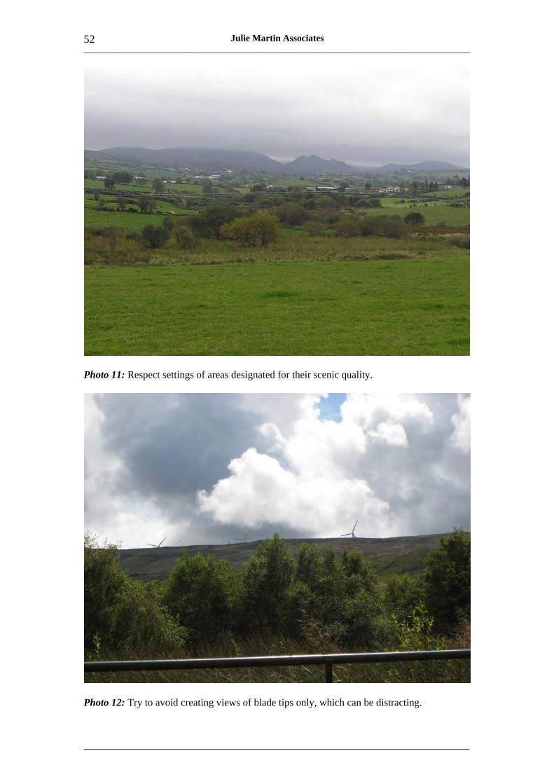
___________________________________________________________________________________
_____________________________________________________________________
52 Julie Martin Associates
Photo 11: Respect settings of areas designated for their scenic quality.
Photo 12: Try to avoid creating views of blade tips only, which can be distracting.
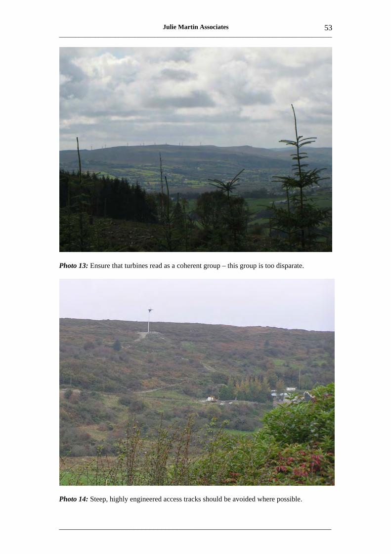
___________________________________________________________________________________
_____________________________________________________________________
53 Julie Martin Associates
Photo 13: Ensure that turbines read as a coherent group – this group is too disparate.
Photo 14: Steep, highly engineered access tracks should be avoided where possible.
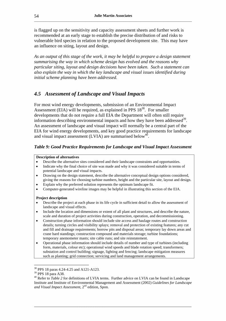
___________________________________________________________________________________
_____________________________________________________________________
54 Julie Martin Associates
is flagged up on the sensitivity and capacity assessment sheets and further work is recommended at an early stage to establish the precise distribution of and risks to vulnerable bird species in relation to the proposed development site. This may have an influence on siting, layout and design.
As an output of this stage of the work, it may be helpful to prepare a design statement summarising the way in which scheme design has evolved and the reasons why particular siting, layout and design decisions have been taken. Such a statement can also explain the way in which the key landscape and visual issues identified during initial scheme planning have been addressed.
4.5 Assessment of Landscape and Visual Impacts
For most wind energy developments, submission of an Environmental Impact Assessment (EIA) will be required, as explained in PPS 1838. For smaller developments that do not require a full EIA the Department will often still require information describing environmental impacts and how they have been addressed39. An assessment of landscape and visual impact will normally be a central part of the EIA for wind energy developments, and key good practice requirements for landscape and visual impact assessment (LVIA) are summarised below40.
Table 9: Good Practice Requirements for Landscape and Visual Impact Assessment
Description of alternatives • Describe the alternative sites considered and their landscape constraints and opportunities. • Indicate why the final choice of site was made and why it was considered suitable in terms of
potential landscape and visual impacts. • Drawing on the design statement, describe the alternative conceptual design options considered,
giving the reasons for choosing turbine numbers, height and the particular site, layout and design. • Explain why the preferred solution represents the optimum landscape fit. • Computer-generated wireline images may be helpful in illustrating this section of the EIA.
Project description • Describe the project at each phase in its life cycle in sufficient detail to allow the assessment of
landscape and visual effects. • Include the location and dimensions or extent of all plant and structures, and describe the nature,
scale and duration of project activities during construction, operation, and decommissioning. • Construction phase information should include site access and haulage routes and construction
details; turning circles and visibility splays; removal and protection of existing features; any cut and fill and drainage requirements; borrow pits and disposal areas; temporary lay down areas and crane hard standings; construction compound and materials storage; turbine foundations; temporary anemometer masts; site cable runs; and site reinstatement.
• Operational phase information should include details of number and type of turbines (including form, materials, colour etc); operational wind speeds and blade rotation speed; transformers; substation and control building; signage, lighting and fencing; landscape mitigation measures such as planting; grid connection; servicing and land management arrangements.
38 PPS 18 paras 4.24-4.25 and A121-A123. 39 PPS 18 para A38. 40 Refer to Table 2 for definitions of LVIA terms. Further advice on LVIA can be found in Landscape Institute and Institute of Environmental Management and Assessment (2002) Guidelines for Landscape and Visual Impact Assessment, 2nd edition, Spon.

___________________________________________________________________________________
_____________________________________________________________________
55 Julie Martin Associates
• Decommissioning phase information should include arrangements for removal of turbines and ancillary structures; proposals for restoration; and future land management.
Baseline assessment – landscape resources • Agree with the Department the size of the study area. For turbines of medium or large
commercial height this should generally extend to a 30km radius around the site; for small turbines a 20km radius may be acceptable.
• Compile mapping and descriptions of the existing landscape within the study area, examining the broad landscape context (15-30km), landscape setting (5-15km), local landscape setting (2-5km) and immediate landscape setting (up to 2km). Use the LCAs as a framework for writeup.
• Cover landscape character, landscape values and landscape sensitivity throughout the study area (including transboundary areas), drawing on the relevant landscape character assessment reports, information on special landscape values (such as descriptions of landscape, natural and cultural heritage designations); and the landscape sensitivity and capacity assessment sheets.
• Describe how landscape character affects the sensitivity to wind energy development of the landscapes within the study area and define their level of sensitivity.
• In relation to valued landscape characteristics and features, explain the reasons why the characteristic or feature is important and its level of importance (ie national, regional, local).
• Describe the landscape of the site itself, including landform, landcover, features of natural and cultural heritage interest and access. Include details of the landscape fabric ie vegetation, trees, hedges and other boundary features and their condition.
• Confirm and expand this information through field survey.
Baseline assessment – visual resources • Prepare mapping to show the area over which wind turbines may be seen (commonly referred to
as the zone of theoretical visibility (ZTV). • Review the ZTV and consider the site’s contribution to visual amenity within the distance bands
indicated above. Consider in the field the degree to which trees and vegetation may reduce or contain visibility.
• Use the ZTV and field work to help identify viewpoints to be covered in the assessment through the preparation of wireline images and photomontages. These viewpoints should be discussed and agreed with the Department and other stakeholders at the scoping stage.
• The number of viewpoints required will vary but 15-25 viewpoints are likely to be necessary for most commercial wind farms, particularly in areas of high landscape sensitivity.
• Include views referred to in the sensitivity and capacity assessment, eg views from settlements; transport corridors; tourist and walking routes; specific receptors such as historic parks; and also locations where cumulative impacts will occur with other wind energy developments.
• Give priority to views from distances of less than 5km but also include some middle and longer range views.
• Include a range of receptors (viewer groups) and classify these in terms of their sensitivity. In general, those engaged in tourism and recreation eg walkers have higher amenity expectations and are more sensitive, while groups such as passing motorists and local workers have lower amenity expectations and are less sensitive.
Description of impacts • This section should systematically identify and describe the likely effects of the proposal;
indicate the mitigation measures developed; estimate the magnitude of the changes that will occur; and consider whether they will be beneficial or adverse. It should cover impacts at construction, operational and decommissioning phases. Transboundary impacts on areas of the Republic of Ireland within 30km of the site should be included.
• Impacts should be separately assessed under headings of landscape fabric, landscape character, landscape values and visual amenity and for each of the distance bands described above..
• For landscape fabric, the scale of impacts such as physical damage or loss and proposed mitigation should be given wherever possible, eg length of hedge lost, length of replacement hedging proposed.
• For landscape character, the assessment should briefly describe the changes that will occur to the character of each of the LCAs where wind turbines are visible, considering how the wind farm will affect perceptions of character (eg landscape scale, patterns, focal points, skylines and settings etc) and how widespread and prominent the changes will be.

___________________________________________________________________________________
_____________________________________________________________________
56 Julie Martin Associates
• For landscape values, the assessment should describe any changes in landscape quality, scenic quality, wildness, tranquillity, natural and cultural heritage features, cultural associations and amenity and recreation that will occur due to the development (given its distance and visibility).
• For visual amenity, the extent of visibility should be described by reference to ZTV mapping. Changes in views from the selected viewpoints should be assessed by reference to the wireline images and photomontages. Commentary and assessment should also be provided on impacts on residential properties within 2km; impacts on views from Registered Parks and Conservation Areas within 5km; and impacts on views from the principal routes in the area (including the main road routes, tourist routes and walking routes where appropriate).
Cumulative impacts • Where there are any other operational, consented or application stage sites within a 30km radius
of the site, cumulative impacts should also be assessed (recognising that there are varying degrees of certainty associated with these different types of site).
• Prepare cumulative ZTV(s) for a radius of at least 30km around the proposed development (the Department may request that this be extended in some cases, for example where a highly sensitive landscape lies midway between two wind farm sites).
• Analyse the pattern of combined effects and identify key viewpoints within areas of overlap between the ZTVs of different developments, including some short and middle range views. Again, these viewpoints should be selected in consultation with the Department and other stakeholders. Prepare cumulative wireline images for each of these viewpoints.
• Assess cumulative impacts under the same headings as site-specific impacts. Pay particular attention to issues such as: � the combined effect of different site accesses on the landscape fabric of a single hillside
or valley; � how developments relate to one other and to the underlying landscape in terms of scale
and capacity; � the extent to which the setting of valued landscapes or features may be eroded by
cumulative impacts; � the combined visual effects of more than one wind farm on particular tourist routes or
long distance walks when seen together or sequentially. • In assessing the magnitude of cumulative impacts it may be helpful to consider the extent of
overlap between the ZTVs of different developments, and extent to which the proposed development extends the horizontal field of view occupied by wind turbines.
Assessment of impact significance • Finally the significance of impacts should be assessed by reference to the sensitivity of the
landscape or viewer and the magnitude of the change that is expected to occur. Significance should be classified, for example on five or seven levels from negligible to major. Good practice is to do this by means of a matrix that sets out the combinations of sensitivity and magnitude that give rise to specific significance levels.
• The assessment of significance should be informed by the sensitivity and capacity assessment for the LCAs concerned, and should focus on the potentially significant impacts of the project, that is those that will affect decision-making.
In addition to text covering all the topics listed above, appropriate, high quality illustrations will greatly assist the assessment process and help people to understand the assessment findings. The preparation of appropriate maps, ZTVs, wireline images and photomontages is a complex and specialist process and expert input will be required. The project landscape architect should be able to advise on the selection of a suitable specialist and supervise the preparation of the illustrations.
The Department will expect LVIAs for commercial wind energy developments to meet the good practice requirements that are summarised in Table 9. Developers should also submit presentation material (including maps and other illustrations) as set out in Table 10 below.
___________________________________________________________________________________
_____________________________________________________________________
57 Julie Martin Associates
Table 10: Checklist of Presentation Material That Should be Provided
Conceptual design options Computer-generated wireline images to show conceptual design options that were considered. Images accompanied by map(s) to show the turbine layouts that are illustrated and the viewpoint location, viewing direction, included field of view and appropriate viewing distance for the wirelines.
Site layout Site layout plan showing position of turbines, access and internal tracks, compounds, substation and all ancillary elements in the context of the physical landscape fabric, including contours, type and condition of landcover, boundaries and trees, existing access points, utilities and important environmental features. Scale 1:25,000 or greater.
Turbines and other elements Scaled elevations showing technical detail of turbines, transformers, substation and ancillary elements, with key dimensions. Typical photographs of turbines proposed.
Landscape character Map showing site location and LCAs within the study area on a colour 1:50,000 OS base (this may be reduced as long as it is legible). LCAs and landscape types in the Republic of Ireland should also be shown where these lie within the study area. Map should indicate concentric distance bands from the outer turbines of the site including those distance bands used in writeup (ie 2, 5, 15 and 30km). Viewpoint locations should also be shown.
Landscape designations and values Map showing site location and location of valued landscape features within the study area on a 1: 50,000 OS base (as before), including all the designations and features listed in Table 1 of this guidance (and equivalents in the Republic of Ireland). Concentric distance bands as above. Viewpoint locations.
Zones of theoretical visibility Maps of theoretical visibility to hub height and to blade tip height on a 1:50,000 OS base (as before), with transparent colouring to indicate the number of hubs or blade tips that may be visible at a given point. Maps should cover the whole study area with enlargements at 1:25,000 or 1:50,000 to show visibility up to 5km in more detail. Concentric distance bands as above. Viewpoint locations.
Visualisations Computer-generated wireline images and (where possible) colour photomontages for the selected viewpoint locations. These should be based on photographs taken with a 50mm lens on a 35mm film format (or digital equivalent), reproduced at a size that, when seen at a normal reading distance of around 50cm, will appear similar to what would be seen in the field. The horizontal field of view should be similar to that of the human eye (around 50 degrees). Each visualisation should be accompanied by a photograph of the view as existing and by details of distance to nearest turbine, viewpoint grid reference and height AOD, viewing direction, included field of view and appropriate viewing distance.
Cumulative impacts Location map (with individual turbine locations) for all operational, consented and application sites for commercial wind energy development within 30km (or wider area if required by the Department) in Northern Ireland and the Republic of Ireland. Presented on a 1:50,000 OS base (as before) with concentric distance bands. Overlain by transparent ZTVs of different sites in different colours, so that areas of cumulative visibility can be seen. Location of cumulative viewpoints. 180 or 360 degree computer-generated wireline images for these viewpoints, annotated with site name, status (operational, consented, application), and distance to nearest turbine.
___________________________________________________________________________________
_____________________________________________________________________
58 Julie Martin Associates
4.6 Reviewing Applications and Making Judgements
As indicated earlier, this Supplementary Planning Guidance on wind energy development in Northern Ireland’s landscapes will be used by the Department in determining planning applications for wind energy development. It will inform judgements on the impacts and acceptability of proposed developments in landscape and visual terms and on the adequacy of the LVIA provided.
In reviewing applications for wind energy development (and in considering potential applications at the scoping stage) the landscape sensitivity and capacity assessment sheets for the LCA(s) affected by the development will be the Department’s key point of reference. Reference will also be made to the guidance on cumulative landscape sensitivity and capacity in Section 3.2.
Table 11: Checklist of Questions That the Department Will Consider
Initial appraisal The following questions will be central to the Department’s initial appraisal: � Is the development sited in an LCA where the sensitivity and capacity assessment indicates that
there may be some capacity for wind energy development? � If so, are the proposed size of turbine grouping and the proposed turbine height within the range
indicated in the capacity assessment as potentially being acceptable? � Is the specific proposed location in a part of the LCA where the capacity assessment indicates
that there may be opportunities for wind energy development of this kind? � Is the proposed development consistent with any thresholds or separation requirements indicated
in the capacity assessment? � Does the LVIA provided accord with the good practice requirements in Table 9 and has adequate
presentation material as indicated in Table 10 been supplied? If any of these tests is not met, the Department will use the landscape sensitivity and capacity assessment in framing its response to the application. Depending on the circumstances this may mean a refusal, a request that the application be modified and resubmitted, or a request for further information.
Review of the application If these four tests are met, the Department will consider, by reference to the sensitivity and capacity assessment, the information provided in the LVIA, and its own desk study, field work and consultations on the site concerned: � Does the application accord with the landscape sensitivity and capacity principles set out in
Tables 5 and 6? � Does it demonstrate understanding of and respect for landscape character (not only in the LCA
that is most directly affected, but also in the wider area)? � Does it respect the visual amenity of the LCA and the wider surrounding landscape? � Has proper account been taken, in siting, layout and design, of the key landscape characteristics
and values and the specific sensitivities of the landscapes concerned? � Have all significant impacts been identified or are there omissions? If so, is further information
required on these potential impacts? � Are there any significant residual impacts on landscape fabric, landscape character, landscape
values or visual amenity that may mean the proposal is unacceptable? � If so, could these be reduced to an acceptable level by design changes such as a reduction in the
number or height of turbines, changes to turbine layout, alternative site access arrangements or off-site screening?
� Are there significant cumulative impacts on landscape fabric, landscape character, landscape values or visual amenity that may mean the proposal is unacceptable? If so, could these be reduced to an acceptable level by siting, layout or design changes?

___________________________________________________________________________________
_____________________________________________________________________
59 Julie Martin Associates
Response to the application Taking all these factors into account – as well as a wide range of other environmental and technical considerations – the Department will formulate its response to the application. This may take the form of a request for further information, an offer of planning permission (usually with particular conditions attached), a request that the application be modified and resubmitted, or an outright refusal.
This Supplementary Planning Guidance will inform and underpin the Department’s judgements on the acceptability of landscape and visual impacts. In particular, the landscape sensitivities described in the sensitivity and capacity assessment sheets will be used to explain and justify decisions and recommendations that may be made in relation to landscape and visual issues.

___________________________________________________________________________________
_____________________________________________________________________
60 Julie Martin Associates

___________________________________________________________________________________
_____________________________________________________________________
61 Julie Martin Associates
Annex 1: Landscape Sensitivity and Capacity Assessment Sheets

___________________________________________________________________________________
_____________________________________________________________________
62 Julie Martin Associates
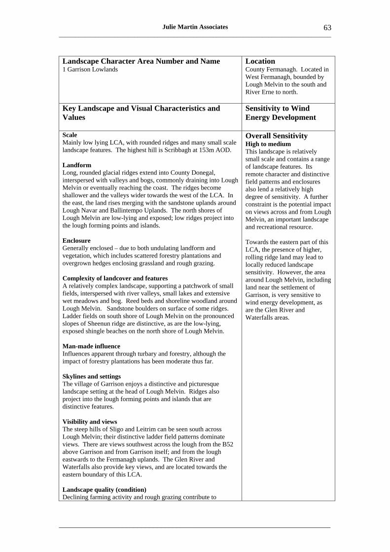
___________________________________________________________________________________
_____________________________________________________________________
63 Julie Martin Associates
Landscape Character Area Number and Name 1 Garrison Lowlands
Location County Fermanagh. Located in West Fermanagh, bounded by Lough Melvin to the south and River Erne to north.
Key Landscape and Visual Characteristics and Values
Sensitivity to Wind Energy Development
Scale Mainly low lying LCA, with rounded ridges and many small scale landscape features. The highest hill is Scribbagh at 153m AOD.
Landform Long, rounded glacial ridges extend into County Donegal, interspersed with valleys and bogs, commonly draining into Lough Melvin or eventually reaching the coast. The ridges become shallower and the valleys wider towards the west of the LCA. In the east, the land rises merging with the sandstone uplands around Lough Navar and Ballintempo Uplands. The north shores of Lough Melvin are low-lying and exposed; low ridges project into the lough forming points and islands.
Enclosure Generally enclosed – due to both undulating landform and vegetation, which includes scattered forestry plantations and overgrown hedges enclosing grassland and rough grazing.
Complexity of landcover and features A relatively complex landscape, supporting a patchwork of small fields, interspersed with river valleys, small lakes and extensive wet meadows and bog. Reed beds and shoreline woodland around Lough Melvin. Sandstone boulders on surface of some ridges. Ladder fields on south shore of Lough Melvin on the pronounced slopes of Sheenun ridge are distinctive, as are the low-lying, exposed shingle beaches on the north shore of Lough Melvin.
Man-made influence Influences apparent through turbary and forestry, although the impact of forestry plantations has been moderate thus far.
Skylines and settings The village of Garrison enjoys a distinctive and picturesque landscape setting at the head of Lough Melvin. Ridges also project into the lough forming points and islands that are distinctive features.
Visibility and views The steep hills of Sligo and Leitrim can be seen south across Lough Melvin; their distinctive ladder field patterns dominate views. There are views southwest across the lough from the B52 above Garrison and from Garrison itself; and from the lough eastwards to the Fermanagh uplands. The Glen River and Waterfalls also provide key views, and are located towards the eastern boundary of this LCA.
Landscape quality (condition) Declining farming activity and rough grazing contribute to
Overall Sensitivity High to medium This landscape is relatively small scale and contains a range of landscape features. Its remote character and distinctive field patterns and enclosures also lend a relatively high degree of sensitivity. A further constraint is the potential impact on views across and from Lough Melvin, an important landscape and recreational resource.
Towards the eastern part of this LCA, the presence of higher, rolling ridge land may lead to locally reduced landscape sensitivity. However, the area around Lough Melvin, including land near the settlement of Garrison, is very sensitive to wind energy development, as are the Glen River and Waterfalls areas.
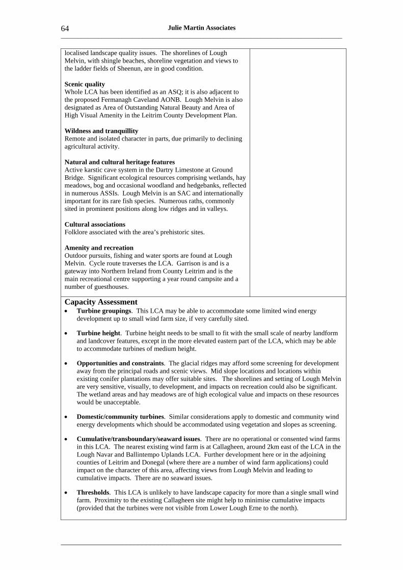
___________________________________________________________________________________
_____________________________________________________________________
64 Julie Martin Associates
localised landscape quality issues. The shorelines of Lough Melvin, with shingle beaches, shoreline vegetation and views to the ladder fields of Sheenun, are in good condition.
Scenic quality Whole LCA has been identified as an ASQ; it is also adjacent to the proposed Fermanagh Caveland AONB. Lough Melvin is also designated as Area of Outstanding Natural Beauty and Area of High Visual Amenity in the Leitrim County Development Plan.
Wildness and tranquillity Remote and isolated character in parts, due primarily to declining agricultural activity.
Natural and cultural heritage features Active karstic cave system in the Dartry Limestone at Ground Bridge. Significant ecological resources comprising wetlands, hay meadows, bog and occasional woodland and hedgebanks, reflected in numerous ASSIs. Lough Melvin is an SAC and internationally important for its rare fish species. Numerous raths, commonly sited in prominent positions along low ridges and in valleys.
Cultural associations Folklore associated with the area’s prehistoric sites.
Amenity and recreation Outdoor pursuits, fishing and water sports are found at Lough Melvin. Cycle route traverses the LCA. Garrison is and is a gateway into Northern Ireland from County Leitrim and is the main recreational centre supporting a year round campsite and a number of guesthouses.
Capacity Assessment • Turbine groupings. This LCA may be able to accommodate some limited wind energy
development up to small wind farm size, if very carefully sited.
• Turbine height. Turbine height needs to be small to fit with the small scale of nearby landform and landcover features, except in the more elevated eastern part of the LCA, which may be able to accommodate turbines of medium height.
• Opportunities and constraints. The glacial ridges may afford some screening for development away from the principal roads and scenic views. Mid slope locations and locations within existing conifer plantations may offer suitable sites. The shorelines and setting of Lough Melvin are very sensitive, visually, to development, and impacts on recreation could also be significant. The wetland areas and hay meadows are of high ecological value and impacts on these resources would be unacceptable.
• Domestic/community turbines. Similar considerations apply to domestic and community wind energy developments which should be accommodated using vegetation and slopes as screening.
• Cumulative/transboundary/seaward issues. There are no operational or consented wind farms in this LCA. The nearest existing wind farm is at Callagheen, around 2km east of the LCA in the Lough Navar and Ballintempo Uplands LCA. Further development here or in the adjoining counties of Leitrim and Donegal (where there are a number of wind farm applications) could impact on the character of this area, affecting views from Lough Melvin and leading to cumulative impacts. There are no seaward issues.
• Thresholds. This LCA is unlikely to have landscape capacity for more than a single small wind farm. Proximity to the existing Callagheen site might help to minimise cumulative impacts (provided that the turbines were not visible from Lower Lough Erne to the north).
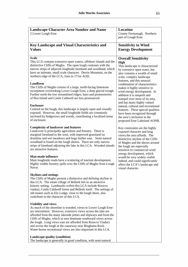
___________________________________________________________________________________
_____________________________________________________________________
65 Julie Martin Associates
Landscape Character Area Number and Name 2 Lower Lough Erne
Location County Fermanagh. Northern part of Lough Erne.
Key Landscape and Visual Characteristics and Values
Sensitivity to Wind Energy Development
Scale This LCA contains extensive open waters, offshore islands and the distinctive Cliffs of Magho. The open lough contrasts with the narrow strips of adjacent loughside farmland and woodland, which have an intimate, small scale character. Derrin Mountain, on the northern edge of the LCA, rises to 171m AOD.
Landform The Cliffs of Magho consist of a large, north-facing limestone escarpment overlooking Lower Lough Erne, a deep glacial trough. Further north the low streamlined ridges, bays and promontories of Boa Island and Castle Caldwell are less pronounced.
Enclosure Centred on the lough, this landscape is largely open and visually exposed. However, the small loughside fields are commonly enclosed by hedgerows and woods, contributing a localised sense of enclosure.
Complexity of landcover and features Landcover is principally agriculture and forestry. There is marginal farmland to the west, with improved grassland on drumlins and wet meadows and bogs further east. Semi-natural woodland is found on the lough shores. There are only narrow strips of farmland adjoining the lake in this LCA. Wooded islands are attractive features.
Man-made influence Main loughside roads have a scattering of tourism development. Highly visible forestry spills over the Cliffs of Magho from Lough Navar.
Skylines and settings The Cliffs of Magho present a distinctive and defining skyline in this LCA. The estate village of Belleek lies in an attractive historic setting. Landmarks within this LCA include Rosscor viaduct, Castle Caldwell forest and Belleek itself. The settings of old estates such as Ely Lodge, close to the lough shore, also contribute to the character of this LCA.
Overall Sensitivity High This landscape is characterised by extensive open water, but also contains a wealth of small scale, complex landscape features, and this unusual combination of characteristics makes it highly sensitive to wind energy development. In addition it is unspoilt and tranquil over most of its area, and has many highly valued natural, cultural and recreational features. These special qualities have been recognised through the area’s inclusion in the proposed Erne Lakeland AONB.
Key constraints are the highly exposed character and long views the area affords. The distinctive skyline of the Cliffs of Magho and the shores around the lough are especially sensitive to commercial wind energy development, which would be very widely visible indeed, and could significantly affect the LCA’s landscape and visual character.
Visibility and views As much of the shoreline is wooded, views to Lower Lough Erne are intermittent. However, extensive views across the lake are afforded from the many lakeside jetties and slipways and from the Cliffs of Magho, which in turn dominate southward views across the lough. Long views east are afforded from Rosscor Viaduct and across the lough at the causeway near Binghams Rock. Water-borne recreational views are also important in this LCA.
Landscape quality (condition) The landscape is generally in good condition, with semi-natural
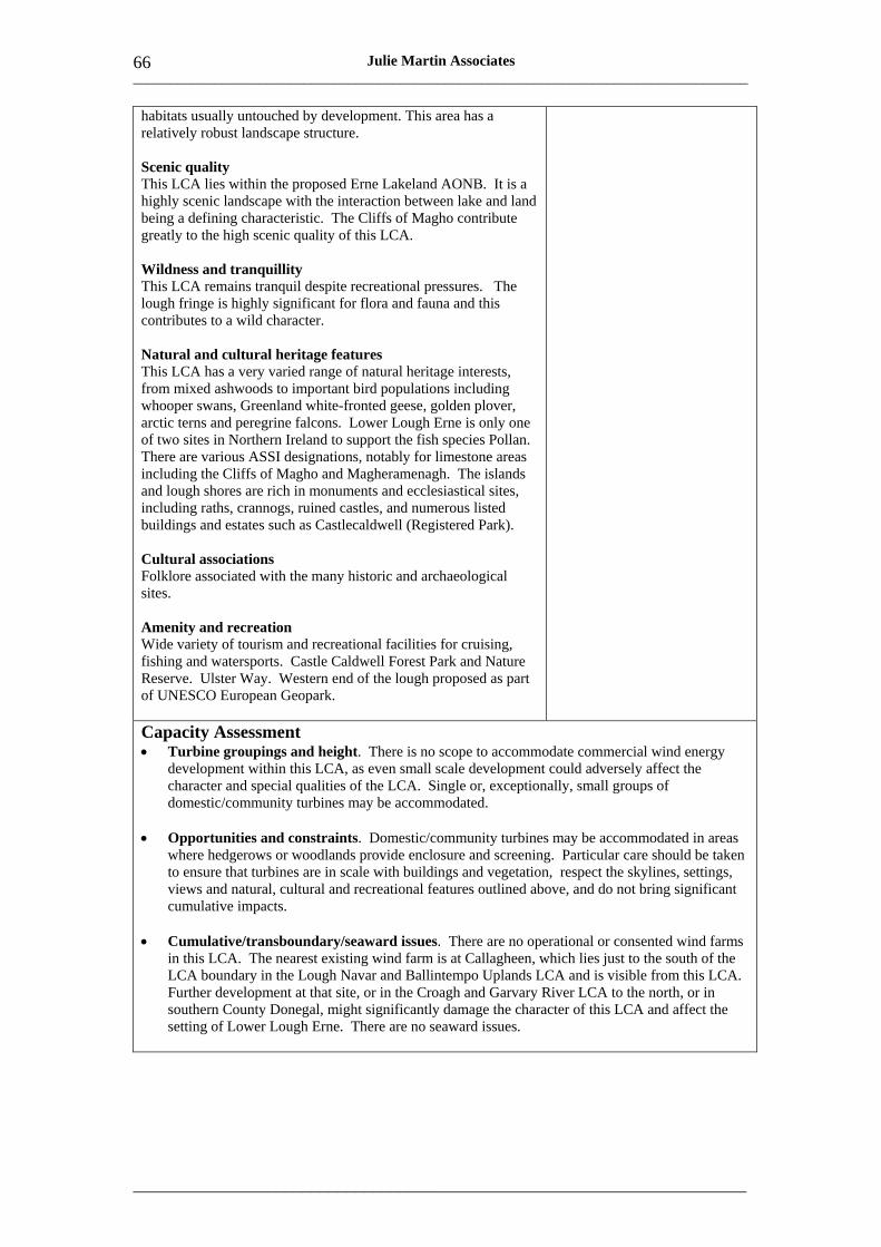
___________________________________________________________________________________
_____________________________________________________________________
66 Julie Martin Associates
habitats usually untouched by development. This area has a relatively robust landscape structure.
Scenic quality This LCA lies within the proposed Erne Lakeland AONB. It is a highly scenic landscape with the interaction between lake and land being a defining characteristic. The Cliffs of Magho contribute greatly to the high scenic quality of this LCA.
Wildness and tranquillity This LCA remains tranquil despite recreational pressures. The lough fringe is highly significant for flora and fauna and this contributes to a wild character.
Natural and cultural heritage features This LCA has a very varied range of natural heritage interests, from mixed ashwoods to important bird populations including whooper swans, Greenland white-fronted geese, golden plover, arctic terns and peregrine falcons. Lower Lough Erne is only one of two sites in Northern Ireland to support the fish species Pollan. There are various ASSI designations, notably for limestone areas including the Cliffs of Magho and Magheramenagh. The islands and lough shores are rich in monuments and ecclesiastical sites, including raths, crannogs, ruined castles, and numerous listed buildings and estates such as Castlecaldwell (Registered Park).
Cultural associations Folklore associated with the many historic and archaeological sites.
Amenity and recreation Wide variety of tourism and recreational facilities for cruising, fishing and watersports. Castle Caldwell Forest Park and Nature Reserve. Ulster Way. Western end of the lough proposed as part of UNESCO European Geopark.
Capacity Assessment • Turbine groupings and height. There is no scope to accommodate commercial wind energy
development within this LCA, as even small scale development could adversely affect the character and special qualities of the LCA. Single or, exceptionally, small groups of domestic/community turbines may be accommodated.
• Opportunities and constraints. Domestic/community turbines may be accommodated in areas where hedgerows or woodlands provide enclosure and screening. Particular care should be taken to ensure that turbines are in scale with buildings and vegetation, respect the skylines, settings, views and natural, cultural and recreational features outlined above, and do not bring significant cumulative impacts.
• Cumulative/transboundary/seaward issues. There are no operational or consented wind farms in this LCA. The nearest existing wind farm is at Callagheen, which lies just to the south of the LCA boundary in the Lough Navar and Ballintempo Uplands LCA and is visible from this LCA. Further development at that site, or in the Croagh and Garvary River LCA to the north, or in southern County Donegal, might significantly damage the character of this LCA and affect the setting of Lower Lough Erne. There are no seaward issues.
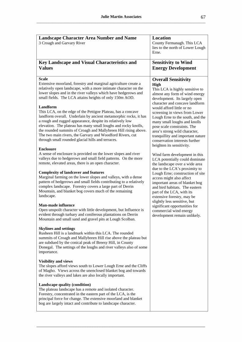
___________________________________________________________________________________
_____________________________________________________________________
67 Julie Martin Associates
Landscape Character Area Number and Name Location 3 Croagh and Garvary River County Fermanagh. This LCA
lies to the north of Lower Lough Erne.
Key Landscape and Visual Characteristics and Values
Sensitivity to Wind Energy Development
Scale Extensive moorland, forestry and marginal agriculture create a relatively open landscape, with a more intimate character on the lower slopes and in the river valleys which have hedgerows and small fields. The LCA attains heights of only 150m AOD.
Landform This LCA, on the edge of the Pettigoe Plateau, has a concave landform overall. Underlain by ancient metamorphic rocks, it has a rough and rugged appearance, despite its relatively low elevation. The plateau has many small loughs and rocky knolls, the rounded summits of Croagh and Mallybreen Hill rising above. The two main rivers, the Garvary and Woodford Rivers, cut through small rounded glacial hills and terraces.
Enclosure A sense of enclosure is provided on the lower slopes and river valleys due to hedgerows and small field patterns. On the more remote, elevated areas, there is an open character.
Complexity of landcover and features Marginal farming on the lower slopes and valleys, with a dense pattern of hedgerows and small fields contributing to a relatively complex landscape. Forestry covers a large part of Derrin Mountain, and blanket bog covers much of the remaining landscape.
Man-made influence Open unspoilt character with little development, but Influence is evident through turbary and coniferous plantations on Derrin Mountain and small sand and gravel pits at Lough Scolban.
Overall Sensitivity High This LCA is highly sensitive to almost any form of wind energy development. Its largely open character and concave landform would afford little or no screening in views from Lower Lough Erne to the south, and the many small loughs and knolls pose scale constraints. The area’s strong wild character, tranquillity and important nature conservation interests further heighten its sensitivity.
Wind farm development in this LCA potentially could dominate the landscape over a wide area due to the LCA’s proximity to Lough Erne; construction of site access might also affect important areas of blanket bog and bird habitats. The eastern part of the LCA, with its extensive forestry, may be slightly less sensitive, but significant opportunities for commercial wind energy development remain unlikely.
Skylines and settings Rusheen Hill is a landmark within this LCA. The rounded summits of Croagh and Mallybreen Hill rise above the plateau but are subdued by the conical peak of Breesy Hill, in County Donegal. The settings of the loughs and river valleys also of some importance.
Visibility and views The slopes afford views south to Lower Lough Erne and the Cliffs of Magho. Views across the unenclosed blanket bog and towards the river valleys and lakes are also locally important.
Landscape quality (condition) The plateau landscape has a remote and isolated character. Forestry, concentrated in the eastern part of the LCA, is the principal force for change. The extensive moorland and blanket bog are largely intact and contribute to landscape character.

___________________________________________________________________________________
_____________________________________________________________________
68 Julie Martin Associates
Scenic quality This LCA is of high scenic quality. It abuts the Fermanagh Lakeland proposed AONB, which includes the area around Lough Scolban. The remainder of the LCA forms part of the Derrin Mountain ASQ.
Wildness and tranquillity The remote areas of this LCA have a wild, remote and isolated character. The lower slopes support more agricultural activity but retain an isolated and tranquil character.
Natural and cultural heritage features International earth science interest associated with extensive subterranean drainage systems as well as a variety of surface karst phenomena. Pettigoe Plateau is the only extensive area of lowland western blanket bog in Northern Ireland and supports ASSI, SAC and Ramsar nature conservation designations. Whooper swans, Greenland white-fronted geese, golden plover and arctic terns. With the exception of crannogs, few other known archaeological sites.
Cultural associations The area is sparsely settled and there may be folklore associations with the extant crannogs.
Amenity and recreation The Ulster Way traverses this LCA, climbing between Black Hill and Meenatully Hill. Fishing at Lough Scolban and cycling. Eastern part of the LCA is proposed as part of UNESCO European Geopark.
Capacity Assessment • Turbine groupings. This LCA has very limited capacity for commercial wind energy
development due to its visual exposure, wild character and conservation interests. Exceptionally it might accommodate a small group of turbines in part of the LCA.
• Turbine height. Turbine height should be small reflecting the visual exposure and wild character of this LCA.
• Opportunities and constraints. The forested landscapes of the eastern part of the LCA are the only area that may offer some very limited capacity for small scale commercial wind energy development. Care should be taken to ensure that turbines respect the skylines, settings, views and natural, cultural and recreational features outlined above. In particular, any significant impact on views from Lower Lough Erne or the Cliffs of Magho beyond would be unacceptable.
• Domestic/community turbines. Single or small groups of turbines of domestic/community height could be accommodated in the enclosed landscapes of the lower slopes but would not be acceptable in the remote and open upper plateau areas where they would be highly prominent.
• Cumulative/transboundary/seaward issues. There are no operational or consented wind farms in this LCA. The nearest existing wind farm is at Callagheen, visible around 5km to the south. Any further development that was visible close to that site might significantly damage the character of the LCA and affect the setting of Lower Lough Erne. Transboundary issues might arise if there were any wind farm development in adjoining areas of County Donegal such as around Bressy Hill or Bradlieve Mountain to the west. There are no seaward issues.
• Thresholds. This LCA is unlikely to be able to accommodate more than one small group of turbines.
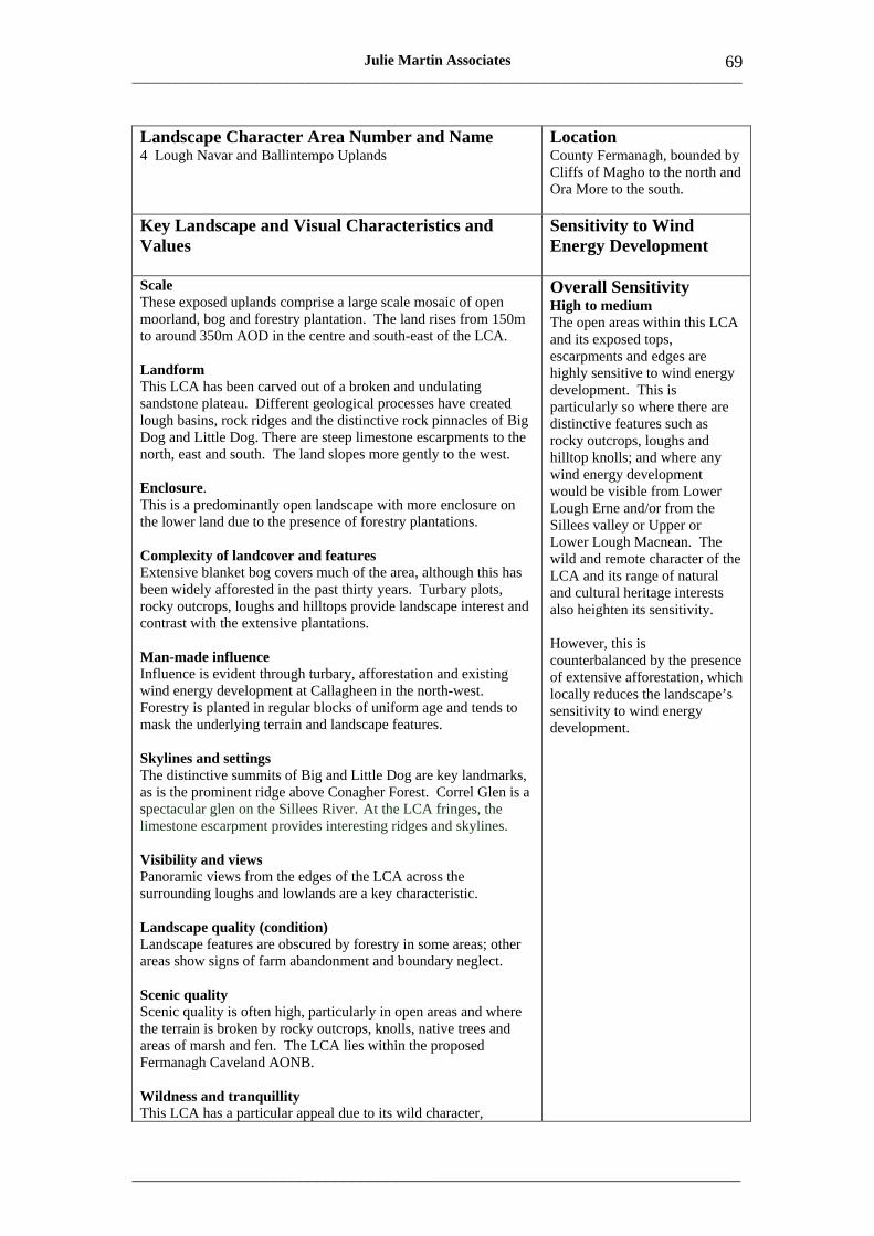
___________________________________________________________________________________
_____________________________________________________________________
69 Julie Martin Associates
Landscape Character Area Number and Name 4 Lough Navar and Ballintempo Uplands
Location County Fermanagh, bounded by Cliffs of Magho to the north and Ora More to the south.
Key Landscape and Visual Characteristics and Values
Sensitivity to Wind Energy Development
Scale These exposed uplands comprise a large scale mosaic of open moorland, bog and forestry plantation. The land rises from 150m to around 350m AOD in the centre and south-east of the LCA.
Landform This LCA has been carved out of a broken and undulating sandstone plateau. Different geological processes have created lough basins, rock ridges and the distinctive rock pinnacles of Big Dog and Little Dog. There are steep limestone escarpments to the north, east and south. The land slopes more gently to the west.
Enclosure. This is a predominantly open landscape with more enclosure on the lower land due to the presence of forestry plantations.
Complexity of landcover and features Extensive blanket bog covers much of the area, although this has been widely afforested in the past thirty years. Turbary plots, rocky outcrops, loughs and hilltops provide landscape interest and contrast with the extensive plantations.
Man-made influence Influence is evident through turbary, afforestation and existing wind energy development at Callagheen in the north-west. Forestry is planted in regular blocks of uniform age and tends to mask the underlying terrain and landscape features.
Skylines and settings The distinctive summits of Big and Little Dog are key landmarks, as is the prominent ridge above Conagher Forest. Correl Glen is a spectacular glen on the Sillees River. At the LCA fringes, the limestone escarpment provides interesting ridges and skylines.
Visibility and views Panoramic views from the edges of the LCA across the surrounding loughs and lowlands are a key characteristic.
Landscape quality (condition) Landscape features are obscured by forestry in some areas; other areas show signs of farm abandonment and boundary neglect.
Scenic quality Scenic quality is often high, particularly in open areas and where the terrain is broken by rocky outcrops, knolls, native trees and areas of marsh and fen. The LCA lies within the proposed Fermanagh Caveland AONB.
Wildness and tranquillity This LCA has a particular appeal due to its wild character,
Overall Sensitivity High to medium The open areas within this LCA and its exposed tops, escarpments and edges are highly sensitive to wind energy development. This is particularly so where there are distinctive features such as rocky outcrops, loughs and hilltop knolls; and where any wind energy development would be visible from Lower Lough Erne and/or from the Sillees valley or Upper or Lower Lough Macnean. The wild and remote character of the LCA and its range of natural and cultural heritage interests also heighten its sensitivity.
However, this is counterbalanced by the presence of extensive afforestation, which locally reduces the landscape’s sensitivity to wind energy development.
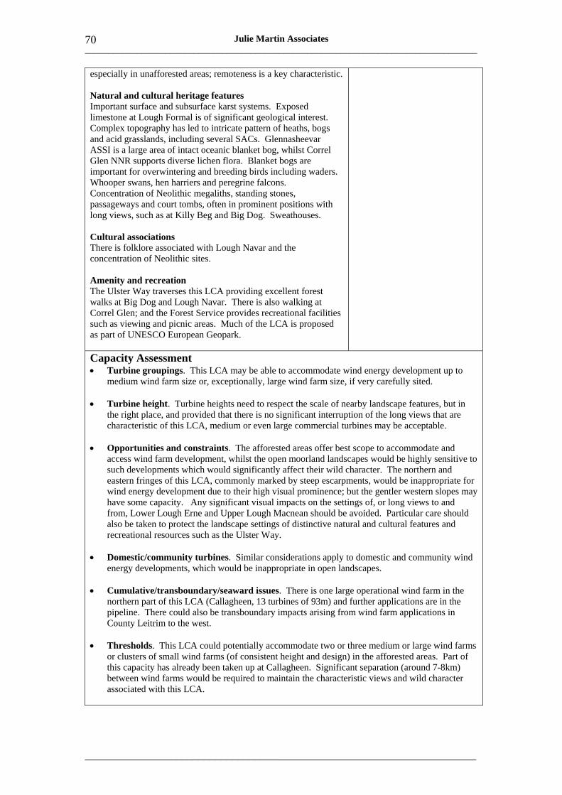
___________________________________________________________________________________
_____________________________________________________________________
70 Julie Martin Associates
especially in unafforested areas; remoteness is a key characteristic.
Natural and cultural heritage features Important surface and subsurface karst systems. Exposed limestone at Lough Formal is of significant geological interest. Complex topography has led to intricate pattern of heaths, bogs and acid grasslands, including several SACs. Glennasheevar ASSI is a large area of intact oceanic blanket bog, whilst Correl Glen NNR supports diverse lichen flora. Blanket bogs are important for overwintering and breeding birds including waders. Whooper swans, hen harriers and peregrine falcons. Concentration of Neolithic megaliths, standing stones, passageways and court tombs, often in prominent positions with long views, such as at Killy Beg and Big Dog. Sweathouses.
Cultural associations There is folklore associated with Lough Navar and the concentration of Neolithic sites.
Amenity and recreation The Ulster Way traverses this LCA providing excellent forest walks at Big Dog and Lough Navar. There is also walking at Correl Glen; and the Forest Service provides recreational facilities such as viewing and picnic areas. Much of the LCA is proposed as part of UNESCO European Geopark.
Capacity Assessment • Turbine groupings. This LCA may be able to accommodate wind energy development up to
medium wind farm size or, exceptionally, large wind farm size, if very carefully sited.
• Turbine height. Turbine heights need to respect the scale of nearby landscape features, but in the right place, and provided that there is no significant interruption of the long views that are characteristic of this LCA, medium or even large commercial turbines may be acceptable.
• Opportunities and constraints. The afforested areas offer best scope to accommodate and access wind farm development, whilst the open moorland landscapes would be highly sensitive to such developments which would significantly affect their wild character. The northern and eastern fringes of this LCA, commonly marked by steep escarpments, would be inappropriate for wind energy development due to their high visual prominence; but the gentler western slopes may have some capacity. Any significant visual impacts on the settings of, or long views to and from, Lower Lough Erne and Upper Lough Macnean should be avoided. Particular care should also be taken to protect the landscape settings of distinctive natural and cultural features and recreational resources such as the Ulster Way.
• Domestic/community turbines. Similar considerations apply to domestic and community wind energy developments, which would be inappropriate in open landscapes.
• Cumulative/transboundary/seaward issues. There is one large operational wind farm in the northern part of this LCA (Callagheen, 13 turbines of 93m) and further applications are in the pipeline. There could also be transboundary impacts arising from wind farm applications in County Leitrim to the west.
• Thresholds. This LCA could potentially accommodate two or three medium or large wind farms or clusters of small wind farms (of consistent height and design) in the afforested areas. Part of this capacity has already been taken up at Callagheen. Significant separation (around 7-8km) between wind farms would be required to maintain the characteristic views and wild character associated with this LCA.
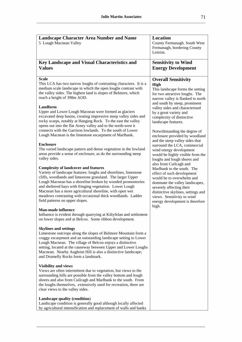
___________________________________________________________________________________
_____________________________________________________________________
71 Julie Martin Associates
Landscape Character Area Number and Name 5 Lough Macnean Valley
Location County Fermanagh. South West Fermanagh, bordering County Leitrim.
Key Landscape and Visual Characteristics and Values
Sensitivity to Wind Energy Development
Scale This LCA has two narrow loughs of contrasting characters. It is a medium scale landscape in which the open loughs contrast with the valley sides. The highest land is slopes of Belmore, which reach a height of 398m AOD.
Landform Upper and Lower Lough Macnean were formed as glaciers excavated deep basins, creating impressive steep valley sides and rocky scarps, notably at Hanging Rock. To the east the valley opens out into the flat Arney valley and to the north-west it connects with the Garrison lowlands. To the south of Lower Lough Macnean is the limestone escarpment of Marlbank.
Enclosure The varied landscape pattern and dense vegetation in the lowland areas provide a sense of enclosure, as do the surrounding steep valley sides.
Complexity of landcover and features Variety of landscape features: loughs and shorelines, limestone cliffs, woodlands and limestone grassland. The larger Upper Lough Macnean has a shoreline broken by wooded promontories and sheltered bays with fringing vegetation. Lower Lough Macnean has a more agricultural shoreline, with open wet meadows contrasting with occasional thick woodlands. Ladder field patterns on upper slopes.
Man-made influence Influence is evident through quarrying at Kiltyfelan and settlement on lower slopes and at Belcoo. Some ribbon development.
Overall Sensitivity High This landscape forms the setting for two attractive loughs. The narrow valley is flanked to north and south by steep, prominent valley sides and characterised by a great variety and complexity of distinctive landscape features.
Notwithstanding the degree of enclosure provided by woodland and the steep valley sides that surround the LCA, commercial wind energy development would be highly visible from the loughs and lough shores and also from Cuilcagh and Marlbank to the south. The effect of such development would be to overwhelm and dominate the valley landscapes, severely affecting their distinctive skylines, settings and views. Sensitivity to wind energy development is therefore high.
Skylines and settings Limestone outcrops along the slopes of Belmore Mountain form a craggy escarpment and an outstanding landscape setting to Lower Lough Macnean. The village of Belcoo enjoys a distinctive setting, located at the causeway between Upper and Lower Loughs Macnean. Nearby Aughrim Hill is also a distinctive landscape; and Drumelly Rocks form a landmark.
Visibility and views Views are often intermittent due to vegetation, but views to the surrounding hills are possible from the valley bottom and lough shores and also from Cuilcagh and Marlbank to the south. From the loughs themselves, extensively used for recreation, there are clear views to the valley sides.
Landscape quality (condition) Landscape condition is generally good although locally affected by agricultural intensification and replacement of walls and banks
___________________________________________________________________________________
_____________________________________________________________________
72 Julie Martin Associates
by wire fencing.
Scenic quality The steep valley sides adjoining the loughs create a highly scenic landscape. The LCA lies within the proposed Fermanagh Caveland AONB.
Wildness and tranquillity The upper slopes of the valley have a stronger wild character than the more active and modified valley floors and loughside agricultural areas.
Natural and cultural heritage features Significant limestone and karst landscape features around Belmore. White-clawed crayfish in Upper Lough Macnean. Islands in the loughs are also important for breeding waders, including lapwing, snipe and curlew. Whooper swans and Greenland white-fronted geese. Habitats include upland mixed ashwood, upland oakwood and wet woodland around the lough shores. Lurgan River Wood ASSI supports hazel and ash woodland; also many NRs. Some significant archaeological sites, with evidence of Mesolithic settlement at Cushrush Island. Gardenhill Estate has small scale parkland.
Cultural associations Reflecting the long settlement history, there are numerous folk stories associated with the archaeological sites. The LCA lies within the ancient kingdom of Breifne.
Amenity and recreation LCA is a key gateway into Northern Ireland from Counties Cavan and Leitrim, giving access to tourist attractions such as Marble Arch Caves and Florencecourt as well as to Enniskillen and other parts of Fermanagh. Part of the area is proposed as UNESCO European Geopark. Ulster Way traverses the LCA; Gortahole Outdoor Pursuits area; swimming, boating and fishing on the lakes; cycling opportunities.
Capacity Assessment • Turbine groupings and height. This LCA has no capacity to accommodate commercial wind
energy development due to the narrowness of the valley and the prominent and visually exposed character of the valley sides, with their dramatic limestone crags and wide views from and across the loughs. Single or small groups of turbines of domestic/community height may be acceptable.
• Opportunities and constraints. Single or small groups of turbines of domestic/community height could be accommodated in the enclosed landscapes of the lower slopes but would not be acceptable on the lough shores or the more remote and valley sides and escarpments where they would be highly prominent. Particular care should be taken to ensure that turbines are in scale with buildings and vegetation and to respect the skylines, settings, views and natural, cultural and recreational features outlined above.
• Cumulative/transboundary/seaward issues. There are no operational or consented wind farms in this LCA although there are several applications in this general locality, within or close to the LCA. The nearest operational or consented wind farms, at Callagheen to the north-west and Slieve Rushen to the south-east, are both more than 10km away and have little or no effect within this LCA. Transboundary issues might arise, however, if there were any wind farm development in adjoining areas of Counties Leitrim or Cavan. There are no seaward issues.
.
___________________________________________________________________________________
_____________________________________________________________________
73 Julie Martin Associates
Landscape Character Area Number and Name 6 The Knockmore Scarpland
Location County Fermanagh. West of Enniskillen and Sillees valley.
Key Landscape and Visual Characteristics and Values
Sensitivity to Wind Energy Development
Scale A dramatic landscape dominated by the escarpment. Large scale uplands contrast with more intimate enclosed lowland agricultural areas. Highest point is summit of Belmore at 398m AOD.
Landform A karst landscape of scarps, extensive cliff faces, gorges, caves, limestone pavements, woodlands and loughs. The rugged karst relief has been emphasised by glacial action and includes limestone pavements, cliffs, potholes, sink holes and gorges. Larger rivers cut through the rock to form waterfalls, spectacular gorges and caves. A number of loughs lie along the scarp edge.
Enclosure Enclosure is provided on lower slopes by woodland, hedgerows and earthbanks. Coniferous plantations around Belmore lend some screening, whilst escarpments are open and dominate skylines
Complexity of landcover and features At Knockmore 100m cliffs descend into scarp woodland, whilst Belmore has a broader landscape pattern with coniferous plantations on its middle slopes. The glen landscapes include a variety of small loughs, fields, scrub woodland and scattered houses. On lower slopes, there are wet meadows.
Man-made influence Overt man-made influences are generally limited, except for the extensive conifer plantations at the south end of the escarpment.
Skylines and settings The Knockmore Scarpland limestone escarpment dominates the skylines in west Fermanagh. The northern and eastern edges of Belmore, the main east-facing escarpment of the LCA, and two smaller scarps above Kilgarrow are all prominent ridgelines. Belmore is a key feature in views from Cuilcagh and Marlbank to the south.
Visibility and views There are panoramic views over the adjoining lowlands from all the open scarp slopes and key views eastwards from the tertiary road that runs north-south beneath the escarpment, providing access to the area’s wealth of landscape features.
Landscape quality (condition) The landscape is generally in good condition and is characterised by attractive pristine natural features. Grazing pressure affects woodland regeneration in parts. Some areas are affected by farm abandonment and field boundary neglect.
Scenic quality This is a highly scenic landscape within the proposed Fermanagh
Overall Sensitivity High. The prominence of the escarpment skyline across much of Fermanagh makes this LCA extremely sensitive in both landscape and visual terms. Its rugged and highly varied landform, wealth of scenic, natural and cultural heritage interest, and generally unspoilt, pristine landscape quality further heighten its sensitivity.
Locally, in the simpler and larger scale forested landscapes north-west of Belmore Mountain, the landscape may be somewhat less sensitive, particularly where visibility is contained by landform and/or forestry plantation.
___________________________________________________________________________________
_____________________________________________________________________
74 Julie Martin Associates
Caveland AONB. It has a particular wealth and diversity of landscape features.
Wildness and tranquillity The cliffs and escarpments create a dramatic and wild character, in contrast with the more settled lower agricultural areas.
Natural and cultural heritage features Significant geological interest, including limestone formations and limestone pavement and the only example of a joint controlled maze cave in Northern Ireland. Rough grazing, small improved fields and hay meadows contribute rich ecological interest. Important limestone woodlands (West Fermanagh Scarplands ASSI and SAC); oak woodland over sandstone in the northern part of the LCA; further designations at Largalinny ASSI and SAC. Blanket bog around Belmore has overwintering and breeding birds including waders. Hen harriers and peregrine falcons. Significant concentration of Bronze Age and Neolithic archaeological monuments and sites representing most of Fermanagh’s past, including subsistence farming from the nineteenth century.
Cultural associations Long settlement history and dramatic scenery contribute to a strong sense of history, tradition and folklore.
Amenity and recreation The Ulster Way traverses the south west part of this LCA. Caving and potholing are becoming increasingly important. Southern part of the LCA is proposed as part of UNESCO European Geopark.
Capacity Assessment • Turbine groupings. There is very limited capacity for commercial wind energy within this
visually prominent LCA. Only one localised area may have some capacity for development up to small or medium wind farm size.
• Turbine height. Turbines up to medium height may be accommodated in one area only.
• Opportunities and constraints. Most of the escarpment is wholly unsuited to wind farm development. The scarp landscapes are particularly sensitive and inappropriate for wind energy developments, as are the lower slopes which are clothed in semi-natural woodland. The only area that may have some capacity for a small or medium wind farm is the area north-west of Belmore Mountain, which is more rounded and partially enclosed by landform and forestry, with forest tracks providing access. Sites close to any distinctive landform features that would lend a sense of scale should be avoided, and any significant impacts on skylines, settings and key views described above or on notable features of natural, cultural or recreational interest would be unacceptable. Special care should be taken to avoid impacts on views from Cuilcagh and Marlbank to the south.
• Domestic/community turbines. Any such turbines should be sited on lower settled ground where vegetation provides screening.
• Cumulative/transboundary/seaward issues. There are currently no operational or consented wind farm developments within or near this LCA although there are several applications in this general locality, within or close to the LCA. Transboundary impacts are unlikely and there are no seaward issues.
• Thresholds. In the area indicated, this LCA could accommodate at most one medium wind farm, subject to careful siting and layout. Significant separation from any wind farms in adjoining LCAs would be important.
___________________________________________________________________________________
_____________________________________________________________________
75 Julie Martin Associates
Landscape Character Area Number and Name 7 The Sillees Valley
Location County Fermanagh. South of Lower Lough Erne.
Key Landscape and Visual Characteristics and Values
Sensitivity to Wind Energy Development
Scale A distinct and well defined lowland area with drumlins. Cullen Hill at 194m AOD is the highest point in this LCA, but the height of individual drumlins is much less than this.
Landform The lowland contains steep-sided drumlins which rise higher towards the north-west of the LCA. A limestone ridge separates this LCA from Lough Erne, rising to nearly 200m at Cullen Hill. The dramatic cliffs and foothills of the Knockmore Scarpland bound the western part of the LCA.
Enclosure A strong sense of enclosure is provided by the drumlin hills, reinforced by small fields, hedgerows and trees and by the enclosing skylines to east and west.
Complexity of landcover and features There is a complex pattern of small fields, hedges, loughs, woods and forestry plantations. The Sillees river winds between the hills through Carran and Ross Loughs to Upper Lough Erne, and the drainage pattern is intricate. These loughs, situated below the limestone escarpment, are significant landscape features. Contrasts occur between improved farming with larger drained fields, and low intensity farming with rough grazing and hay meadows.
Man-made influence Intrusive man-made influences are generally limited but include new roadside development, turbary and forestry plantations, the latter generally well-integrated with the landscape.
Skylines and settings The Knockmore Scarpland (including Belmore Mountain) provides distinctive skylines in this LCA; as does the limestone ridge that encloses the valley to the east.
Visibility and views Gaps between drumlins afford occasional views to lowlands. Ross Lough and Monea Castle are landmarks within this LCA. Key views from Thompsons Bridge west to the Knockmore escarpment; and from the escarpment east across most of the LCA.
Landscape quality (condition) The landscape is generally in good condition. The rolling patchwork of bushy hedgerows and hedgerow trees provides a robust framework.
Scenic quality Proximity to the Knockmore escarpment contributes to the scenic quality and sense of place of this LCA. The far northern part of
Overall Sensitivity High to medium Although most of this LCA’s landscape is relatively broad, open and exposed to view, the undulating landform and overgrown hedgerows provide a sense of enclosure and potential screening for wind energy development, at least in parts.
Significant constraints, however, are the drumlin landform, which could easily be overwhelmed and ‘flattened’ by tall wind energy development; the relatively settled character of the landscape, which allows little space for wind farms; and proximity to the outstanding and distinctive landscapes of the Knockmore Scarpland, which directly overlooks this LCA.
___________________________________________________________________________________
_____________________________________________________________________
76 Julie Martin Associates
this LCA around Derrygonnelly lies within the proposed Fermanagh Caveland AONB.
Wildness and tranquillity This low-lying river valley does not have particular wild qualities, but is highly tranquil. . Natural and cultural heritage features In the south of the LCA, important glaciofluvial deposits associated with subglacial and proglacial processes during the final deglaciation have been identified. Improved grassland predominates, but some unimproved alkaline grasslands support diversity of herbs and grasses, and fens occur near some loughs, notably at Ross Lough NR. Bullfinch and curlew are found within this LCA. Early Christian settlements are well represented. Plantation castle at Monea, under state care. Castletown Manor is a Registered Park. Many vernacular buildings.
Cultural associations Long settlement contributes to a strong sense of history and folklore.
Amenity and recreation Visitor facilities at Monea Castle. Fishing at Arney River, local services and accommodation.
Capacity Assessment • Turbine groupings. Wind energy development up to the size of a small group of turbines may
be acceptable if very carefully sited in relation to topography and vegetation.
• Turbine height. As this is a relatively small scale landscape, with drumlins and associated field patterns, turbine heights should generally be small; domestic/community height turbines could also be accommodated.
• Opportunities and constraints. The most appropriate areas for wind energy development would be within the drumlin belt or forests, although the forests are generally limited in size. Turbines should not be set on drumlin tops but on drumlin slopes. It is unlikely that a single drumlin will be able to accommodate more than one to three turbines, whatever their height. The limestone ridge on the east of the LCA would be inappropriate for development as it would impact significantly on a characteristic skyline. The same applies to the western edge of the area, which forms the setting to Knockmore Scarpland.
• Cumulative/transboundary/seaward issues. There are no operational or consented wind farms within or near this LCA, although there are several applications on land to the west. If consented, these would affect the landscape of the Sillees Valley LCA and cumulative impacts could become an issue. There are no transboundary or seaward issues.
• Thresholds. Due to the robust landscape pattern with topography and vegetation providing some screening, this LCA may be able to accommodate several small turbines or turbine groups, provided that there is adequate separation and limited intervisibility.
___________________________________________________________________________________
_____________________________________________________________________
77 Julie Martin Associates
Landscape Character Area Number and Name 8 The Arney Lowlands
Location County Fermanagh. South Fermanagh, bordering Cuilcagh and Marlbank LCA.
Key Landscape and Visual Characteristics and Values
Sensitivity to Wind Energy Development
Scale A broad river valley floor distinguished by wide flat spaces between low hills, generally around 50-60m AOD.
Landform The valley is characterised by wide flat lowlands enclosed by low hills. The wide valley floor is actually a broad glacial trough through which the River Arney meanders. The drumlins of the Sillees Valley lie to the north, the wetlands of Lough Erne to the east and the Lough Macnean Valley to the west and north.
Enclosure This is predominantly an open landscape, though overgrown hedgerows create the impression of a wooded countryside
Complexity of landcover and features Much of this lowland has damp peaty soils and is farmed or covered with scrub woodland and raised bogs. The shallow hills form islands of small rushy fields and hay meadows surrounded by thick overgrown hedgerows. Each hill accommodates a dispersed group of small farmhouses linked by straight roads which are often raised above the level of the surrounding wetland. Much of this lowland has damp peaty soils and is farmed or covered with scrub woodland and raised bogs.
Man-made influence Scattered roadside development and turbary are the principal influences.
Skylines and settings Skylines of adjacent areas are most distinctive, particularly those associated with the Cuilcagh and Marlbank LCA to the southwest. The Florencecourt Estate (National Trust) also adjoins the LCA to the south.
Visibility and views Long views are afforded across this lowlying LCA, particularly from surrounding elevated areas and the low hills of this LCA. The adjoining LCA of Cuilcagh and Marlbank has views across this LCA, as does Belmore Mountain to the north-west.
Landscape quality (condition) Overall, the landscape is in reasonable condition.
Scenic quality The scenic quality of this LCA is not particularly high; the exceptions to this are the views to the adjoining LCAs.
Wildness and tranquillity This low-lying river valley does not have particular wildness,
Overall Sensitivity High to medium This is a broad landscape, interrupted by low hills, hedgerows, scrub woodland and raised bogs that provide a degree of variety, enclosure and screening.
Its sensitivities relate primarily to the landform of low hills, which could easily be overwhelmed and ‘flattened’ by tall wind energy development; the relatively settled character of the landscape, which allows little space for wind farms; and proximity to the outstanding and distinctive landscapes of Cuilcagh and Marlbank, which directly overlook this LCA..
___________________________________________________________________________________
_____________________________________________________________________
78 Julie Martin Associates
although it is generally tranquil.
Natural and cultural heritage features This landscape contains gravel and sand eskers such as at Killykeeghan. Tattenamona ASSI is among the best remaining examples of a lowland raised bog within the drumlin belt of Northern Ireland; other raised bog areas support snipe and curlew. The agricultural mosaic of hay meadows, grassland and rushy grass provides an important habitat for the corncrake. Greenland white-fronted geese. Archaeological sites are confined to raths on elevated land.
Cultural associations Historically, this LCA has fulfilled an important role as a communications route between the wetlands and the uplands.
Amenity and recreation Limited access for fishing, local services in villages. Florencecourt and Marble Arch Caves, just outside the LCA, are important recreational attractions.
Capacity Assessment • Turbine groupings and height. This LCA has little or no capacity for commercial wind energy
development reflecting the need to respect the subtle variations in landform, the presence of small scale landscape features, and the LCA’s role as a setting for Cuilcagh, Marlbank and Belmore. Development should be limited to single or small groups of turbines of domestic/community height.
• Opportunities and constraints. The most appropriate areas for wind energy development would be within the low undulating hills and drumlins rather than the flatter open bogs and wetlands. Turbines should be very carefully sited relative to topography, buildings and tree groups and should not be set on hill tops but on slopes. Particular care should be taken to avoid significant impacts on key views to and from Florencecourt, Cuilcagh and Marlbank to the south and west. Views from Belmore to the north-west are also sensitive. Impacts on raised bogs and other wetlands should also be avoided.
• Cumulative/transboundary/seaward issues. There are no operational or consented wind farms within or near this LCA, although there are several applications on land to the north-west. If consented, these would affect the landscape of the Arney Lowlands LCA and cumulative impacts could become an issue. There are no transboundary or seaward issues.
___________________________________________________________________________________
_____________________________________________________________________
79 Julie Martin Associates
Landscape Character Area Number and Name Location 9 Cuilcagh and Marlbank County Fermanagh. South
Fermanagh adjoining Counties Leitrim and Cavan.
Key Landscape and Visual Characteristics and Values
Sensitivity to Wind Energy Development
Scale A largely open karst landscape, rising to 665m at Cuilcagh Mountain.
Landform This LCA contains the only true mountain in the area, Cuilcagh Mountain. There are also cliffs, escarpments, dry valleys, limestone pavements and gorges, with prominent rounded hills known as 'reef knolls' rising above the land surface. Impermeable flagstones and shales form the long broken slopes of Cuilcagh Mountain.
Enclosure Generally open landscape but hedgerows on lower slopes and stone walls in limestone areas provide some enclosure around small and ancient fields.
Complexity of landcover and features There is a rich variety of vegetation, with montane grassland and blanket bog on the grits and fine species-rich dry grassland on the limestone. Hazel scrub grows in irregular patches on steeper limestone slopes but there is a more luxuriant woodland cover at sink-holes. The peat uplands and extensive areas of blanket bog have been cut mechanically.
Overall Sensitivity High Although the large scale and relatively simple, rounded landform of Cuilcagh Mountain summit is in theory well-suited to wind energy development, the dramatic scenery and natural and cultural heritage features associated with this landscape are of outstanding national and international importance. Their unspoilt character is highly sensitive to wind energy development. In addition, the position of the upland is such that any such development, particularly near the upland edges, would be very widely visible from the valleys and lowlands to the north, east and south. The landscape character and value of a wide area of west Fermanagh would be adversely affected.
Man-made influence Generally very limited apart from agricultural activity, mechanical extraction of peat, conifer plantations and tourist activities.
Furthermore, as most of the upland has no vehicular access, its important upland landscapes
Skylines and settings Distinctive ridgelines associated with limestone escarpments, above Marble Arch in the north around Cloghany and
and habitats are highly vulnerable to the impacts of new access track creation.
Gortalughany in the east. Florencecourt Estate (National Trust) is an important part of the setting of the LCA.
Visibility and views Key views are south from close to Marble Arch caves towards Cuilcagh summit; north from Benaughlin; and east from Gortalughany. There are impressive views from most of the elevated land.
Landscape quality (condition) This predominantly natural landscape is in good condition.
Scenic quality This LCA has outstanding scenic quality and is situated within the proposed Fermanagh Caveland AONB.
Wildness and tranquillity There is a wild and tranquil character particularly within the
___________________________________________________________________________________
_____________________________________________________________________
80 Julie Martin Associates
upland and summit area around Cuilcagh Mountain.
Natural and cultural heritage features Huge number of earth science, ecological and cultural heritage features, including Cuilcagh Mountain ASSI and Ramsar site; mature ashwoods at Marble Arch and Hanging Rock (Hanging Rock and Rossaa Forest NNR, Marble Arch NNR); diverse herbs and grasses on limestone soils at Killykeeghan and Crossmurrin NNR; golden plover and peregrine falcons; prehistoric field boundaries; Neolithic and Bronze Age burial sites including cairns; farm sites from Early Christian period; Florencecourt House and Estate (Registered Park).
Cultural associations Numerous associations owing to long human activity within this area.
Amenity and recreation Ulster Way traverses this LCA and there is a wide range of mountain walks and scenic drives. An established tourism and recreational area with facilities at Marble Arch and Florencecourt Estate and Forest park. Marble Arch and Cuilcagh Mountain Park jointly awarded UNESCO European Geopark status.
Capacity Assessment • Turbine groupings and height. This landscape has no capacity for commercial wind energy
development due to its open, natural character, wide visibility, outstanding scenic, natural and cultural heritage value and its role as an important area for tourism and recreation. Single domestic/community wind energy development may be accommodated with care.
• Opportunities and constraints. Domestic/community turbines are likely to be acceptable on the margins of the LCA where there is significant woodland cover. However the distinctive upland ridges and exposed lower slopes could not accommodate even such small scale development.
• Cumulative/transboundary/seaward issues. There are no operational or consented wind farms within this LCA. The closest lies around 8km south-east at Slieve Rushen (replacement wind farm, 18 turbines). Potential wind farm developments around Belmore to the north might also be visible from this LCA; and there could be transboundary issues if development took place in County Cavan to the south. There are no seaward issues. These existing and potential impacts from development in adjoining areas further underline the inherent sensitivity of this LCA to commercial wind energy development, which would be wholly unacceptable in this landscape.

___________________________________________________________________________________
_____________________________________________________________________
81 Julie Martin Associates
Landscape Character Area Number and Name 10 Slieve Russel, Derrylin and Kinawley
Location County Fermanagh. South Fermanagh adjoining County Cavan.
Key Landscape and Visual Characteristics and Values
Sensitivity to Wind Energy Development
Scale This LCA has contrasting characters between the open upland areas with small glens, and the more enclosed lowlands with drumlins. The highest point is Eden More at 325m AOD but the summit of Slieve Russel in adjacent County Cavan dominates, at 403m AOD.
Landform The area is dominated by Slieve Russel, a flat-topped, isolated block of limestone, sandstone and shales. Small glens dissect the mountain and run down to complex glacial deposits on the lower slopes. The Owengarr River separates the principal summits of Eden More and Molly Mountain. The area also includes the drumlin lowlands and lowland bog to the east and the glacial trough occupied by the Cladagh River
Enclosure The upland landscapes are generally open apart from gappy hedgerows, while the lower drumlin areas are more enclosed by topography and hedgerows.
Complexity of landcover and features The summit has blanket bog, affected by turbary and erosion. The lower slopes have a more complex landscape dominated by rough grazing, with ladder farms a striking feature of hillsides. Lower slopes and lowlands to east and north support a mosaic of small fields, with varying degrees of agricultural intensity from improved pasture to hay meadows, with bogs in between.
Man-made influence Extensive quarrying of limestone and sand and gravel pits. Existing wind energy development. Telecommunications masts. Turbary.
Skylines and settings Prominent ridges are located around the summits of Slieve Russel and Molly Mountain, which are also important, but relatively distant, landmarks when seen from land around Upper Lough Erne.
Visibility and views Long views are afforded across lowlands and loughlands from uplands. Key views from Molly Mountain north-east across lowlands.
Landscape quality (condition) Quite poor condition owing to discordant land uses within a visually prominent area. Limestone quarries, gravel pits and processing give parts of the area an industrial, degraded character.
Overall Sensitivity Medium The relatively simple, open upland areas of this LCA are well-suited in scale and landform to wind energy development. Extensive man-made influences also lend a degraded, industrial character in parts and have damaged the LCA’s landscape and scenic quality and wildness. These factors, coupled with the relatively limited extent of natural and cultural heritage interests, and the fact that Slieve Russel is relatively distant in views from the Fermanagh Lakeland landscapes, mean that most of the LCA is of medium sensitivity.
Locally landscape sensitivity is raised by the presence of particular landmark features or views, notably around Molly Mountain and along the Ulster Way in the northern part of the LCA.
___________________________________________________________________________________
_____________________________________________________________________
82 Julie Martin Associates
Scenic quality This LCA does not have a high scenic quality and carried no scenic designations.
Wildness and tranquillity Any previous sense of wildness or tranquillity within this LCA has been eroded by existing development and industrial activity.
Natural and cultural heritage features The Derrylin sediments form the most extensive and thickest glaciofluvial complex in south-west Northern Ireland. Moninea Bog ASSI and SAC is of international significance with its intact dome, structural features and flora; Cladagh River ASSI is significant for rare priority species of aquatic flora and fauna. Hen harriers and golden plover. Neolithic stone monuments are the oldest archaeological sites. There are also a number of raths on drumlins and sweathouses occur in Sheetrim townland.
Cultural associations Folklore associated with archaeological sites.
Amenity and recreation Ulster Way traverses this LCA and there is a scenic route with viewpoints on Molly Mountain. Local services at Derrylin.
Capacity Assessment • Turbine groupings. Upland areas within this LCA have some capacity for large or even very
large wind farm development due to their large scale and simple form.
• Turbine height. Large commercial turbines size may be accommodated in appropriate locations as indicated below.
• Opportunities and constraints. Degraded areas such as land affected by mineral extraction, where intrusive influences that already detract from landscape character, quality and value, offer the best opportunities for commercial wind farm development within this LCA, although the principal development area, the summit of Slieve Russel, has already been developed. Development on or near the summit of the adjacent top, Molly Mountain, a key landmark and viewpoint on the route of the Ulster Way, is unlikely to be acceptable.
• Domestic/community turbines. The lower landscapes of the surrounding foothills and drumlins and glens have better landscape capacity for domestic/community wind turbines than the generally open summits.
• Cumulative/transboundary/seaward issues. One new (replacement) wind farm, Slieve Rushen, is under construction close to the top of Slieve Russel. This large wind farm of 18 turbines 125m high and its associated tarmac access roads will have moderate impacts on surrounding areas, including proposed AONBs; further applications are also expected in this LCA. There are no other operational or consented wind farms within 30km in Northern Ireland at present, the nearest applications being near Belmore more than 20km north-west. However, there are existing cumulative and transboundary issues associated with a wind farm on the south side of Slieve Russel in County Cavan. There are no seaward issues.
• Thresholds. This upland area has capacity for a single large or very large wind farm. Once the new wind farm is complete, this LCA is likely to have little further wind energy capacity, although some further enlargement of the existing site may be accommodated, subject to detailed appraisal of landscape, visual and other environmental issues.
___________________________________________________________________________________
_____________________________________________________________________
83 Julie Martin Associates
Landscape Character Area Number and Name 11 Upper Lough Erne
Location County Fermanagh. South Fermanagh, adjoining County Cavan.
Key Landscape and Visual Characteristics and Values
Sensitivity to Wind Energy Development
Scale A small scale landscape of land and water. The highest point is Knockninny Hill at 194m AOD but the drumlin tops surrounding the lough generally rise to only around 50-60m AOD.
Landform Rolling low drumlins and flooded hollows linked by streams and the River Erne. The landscape is dominated by water as the River Erne widens and narrows around varying sized islands.
Enclosure Drumlins, wooded shorelines and hedgerows enclosing small fields create an enclosed character.
Complexity of landcover and features A mosaic of small pastures on drumlins, with woodland and wetland areas around the Upper Lough Erne. Wooded estates are a landscape features. A complex and intimate landscape. Small settlements are scattered throughout the area along disorientating narrow twisting roads and on the higher ground of drumlin tops and sides. There are traditional small farms and cottages throughout.
Man-made influence There are few intrusive man-made influences apart from a limestone quarry near Knockninny Hill.
Skylines and settings The village of Lisnaskea enjoys a distinctive landscape setting enclosed by steep slopes. The only prominent landmark in this vast and intricate network of wetlands is the hill of Knockninny.
Visibility and views Views vary from enclosed inlets to wider reaches of open water which are scattered with islands. From the roads, there are occasional views across open water to wooded islands. Key views are from Crom Castle and Trasna Island. The top of Knockninny affords good views across the lough.
Landscape quality (condition) The landscape elements and features of this LCA are generally in good condition. . Scenic quality This LCA has a high scenic quality and is part of the proposed Erne Lakeland AONB.
Wildness and tranquillity The wooded loughshore vegetation enhances the wildness character of this LCA and the lough itself contributes to a sense of
Overall Sensitivity High Although enclosure is provided by woodland and drumlin topography, this is a small scale, complex, intimate landscape that is highly sensitive to wind energy development. All but the smallest of turbines would be out of scale with the drumlin and island landform and sensitivity is further heightened by the strong wild, natural character within which turbines would seem out of place.
In addition, this LCA is a highly valued landscape and recreational resource and makes an important contribution to tourism in Fermanagh. Its habitats, bird life and wealth of archaeology are also very vulnerable to change.
___________________________________________________________________________________
_____________________________________________________________________
84 Julie Martin Associates
tranquillity. A quiet, rural LCA.
Natural and cultural heritage features Most of the lough is designated as ASSI, SPA and Ramsar. Woodland is significant in this LCA, with the ancient woodland at Crom Castle (Crom ASSI) is of particular importance. Whooper swans, Greenland white-fronted geese, hen harriers and peregrine falcons. Early Christian monuments and sites are notable, and the grand buildings of large wooded and parkland estates such as Crom Castle contribute to landscape character. Registered Parks at Crom Castle (National Trust) and Belle Isle. Conservation Area at Lisnaskea.
Cultural associations Folklore associated with lough and long settlement history
Amenity and Recreation The Ulster Way and a number of cycle routes traverse this LCA. The lough is popular for boating and angling, connecting to the Erne-Shannon Canal at its southern end. Crom Castle Estate is open to the public.
Capacity Assessment • Turbine groupings and height. This LCA has no capacity for commercial wind energy
development. The rural and intimate character of this valued landscape would be dominated by such developments. Single domestic or, exceptionally, community scale turbines may be accommodated with care.
• Opportunities and constraints. Domestic and community scale turbines should be sited in areas where hedgerows or woodlands provide screening and help integrate the turbines with the surrounding landscape. Sites on the lough edge, islands and drumlin tops should be avoided, as should impacts on views to and from the landmark hill of Knockninny and impacts on the natural and cultural heritage interests outlined above.
• Cumulative/transboundary/seaward issues. There are currently no wind farm developments or applications within this LCA. The nearest operational or consented site is the large Slieve Rushen wind farm under construction 6km south-west of this LCA, affecting its wider setting; any significant wind energy development at Slieve Beagh to the north-east could also affect the setting. Transboundary impacts from wind energy development in County Cavan to the south are also possible. There are no seaward issues.
___________________________________________________________________________________
_____________________________________________________________________
85 Julie Martin Associates
Landscape Character Area Number and Name 12 Newtownbutler and Rosslea Lowlands
Location County Fermanagh, south of Slieve Beagh.
Key Landscape and Visual Characteristics and Values
Sensitivity to Wind Energy Development
Scale Landscape scale varies across this LCA, reflecting variations in land management and drainage. Although this is broad lowland, of relatively widely spaced drumlins, the vegetation and field patterns lend a small scale to the landscape in parts. Most of the area is low lying at around 60m AOD but on the fringes of Slieve Beagh there is higher ground, up to around 120m AOD.
Landform Widely spaced drumlins with occasional small loughs bounded by rivers. The drumlins become higher and more closely spaced north of the B36. At the foot of the Carnrock Hills, there is a pronounced valley and chain of small loughs. Drumlins determine drainage and settlement, and the River Finn has an extensive flood plain.
Enclosure Open views in all directions are bounded by low drumlin hills, giving a strong sense of enclosure and unity to the landscape. Individual trees, parkland and tall unmanaged hedges give a well wooded character.
Complexity of landcover and features Mix of intensive pasture and rushy fields showing declining agricultural activity. Unmodified rivers such as the River Finn and small loughs with fringing reed swamps and wet meadows are key landscape features. A wooded character due to trees, parkland and unmanaged hedges with small semi-natural woodlands on some drumlin slopes.
Man-made influence Intrusive man-made influences are generally limited, except for some quarrying and commercial forestry.
Skylines and settings The church spire of Newtownbutler forms a landmark within this LCA, whilst in the east the village of Rosslea and the nearby estate of Rosslea Manor enjoy a distinctive landscape setting creating a degree of enclosure unusual in a Fermanagh village. The ridgeline of the southern slopes of Slieve Beagh is prominent from the lowland when not concealed by drumlins.
Visibility and views Open views in all directions, except when visibility is contained by drumlins. Views into the area from Carnrock (Slieve Beagh LCA) to the north.
Landscape quality (condition) This is a unified and rural landscape in good condition although there is evidence of declining farming activity. .
Overall Sensitivity High to medium Much of this landscape is small scale with drumlins, strong field patterns, and individual trees and parkland, although there are also areas of simpler and broader scale landscape, particularly on the northern fringes of the LCA, near Slieve Beagh.
The relatively small size of the drumlins and settled character of the landscape are the key constraints to wind energy development; in addition, the area is overlooked from the hills to the north. Hence the landscape would be highly sensitive to wind farms and to tall turbines, both of which would tend to dominate and detract from its intricate patterns. However it may be less sensitive in parts to well-sited and smaller scale wind energy development.
___________________________________________________________________________________
_____________________________________________________________________
86 Julie Martin Associates
Scenic quality The scenic quality of this undulating landscape is quite good.
Wildness and tranquillity This LCA has a strongly tranquil rural character with pasture and wet meadows. It does not have a strong wildness character.
Natural and cultural heritage features Good examples of Carboniferous geological sites. There is a nature reserve at Cornagague Wood and many of the isolated loughs are designated ASSIs. Whooper swans, Greenland white-fronted geese, golden plover. Early Christian settlements, raths and crannogs are concentrated in the north of this LCA. Many nineteenth century farmhouses and remnants of plantation estates are a feature. Registered Park at Rosslea Manor.
Cultural associations Folklore associated with archaeology and a long history as a communications route between upland and lakeland areas.
Amenity and Recreation The Ulster Way traverses the western part of this LCA. Cycling routes. Public access to Rosslea Manor.
Capacity Assessment • Turbine groupings. This landscape has some capacity to accommodate wind energy
development up to the size of a small group of turbines, if carefully sited.
• Turbine height. The scale of the landscape is such that turbine heights should generally be small, to avoid overwhelming the underlying drumlin topography. Turbines of domestic/community height may also be accommodated.
• Opportunities and constraints. The higher ground in the north of the LCA is most likely to be able to accommodate small scale commercial wind energy development as described above. Turbines should be sited on drumlin sides, not tops, and siting within open inter-drumlin hollows and wetlands should also generally be avoided. Lough shores and parklands would be inappropriate sites for wind energy development, as would the distinctive landscape settings around Newtownbutler and Rosslea.
• Cumulative/transboundary/seaward issues. There are currently no wind farm developments or applications within this LCA, although there are several applications around Slieve Beagh some 10km to the north, in both Counties Fermanagh and Monaghan, that could present issues of cumulative impact in future. There are no seaward issues.
• Thresholds. This LCA may be able to accommodate one or two small groups of turbines, provided that these are well-spaced, with little intervisibility.
___________________________________________________________________________________
_____________________________________________________________________
87 Julie Martin Associates
Landscape Character Area Number and Name 13 Enniskillen
Location County Fermanagh. The southern part of Lower Lough Erne.
Key Landscape and Visual Characteristics and Values
Sensitivity to Wind Energy Development
Scale The open nature of the lake contrasts with the enclosure afforded by drumlins and vegetation. Away from the lake this is predominantly a small scale landscape. The highest areas in this LCA are the drumlin hills around Enniskillen such as White Hill (105m AOD).
Landform This LCA includes the southern end of Lower Lough Erne, the town of Enniskillen and the winding rivers and wetlands in the northern part of Upper Lough Erne. High drumlins and wet inter-drumlin hollows dominate this landscape, enclosing the southern part of Lower Lough Erne.
Enclosure Occasional views across the lough are afforded by gaps in vegetation. Otherwise generally an enclosed landscape due to drumlin topography and vegetation.
Complexity of landcover and features A complex landscape of open water, wooded islands, vegetated shorelines and grassy drumlins enclosed by hedgerows. Large wooded estate landscapes are another feature in this LCA as are the turloughs of Fardrum and Roosky.
Man-made influence Some unsympathetic ribbon development close to the lough shore is to the landscape. New ridge-top development in the town is also prominent and there are pockets of degraded landscapes, for instance at the airport.
Overall Sensitivity High This scenic landscape supports a complex range of small scale features including estates, associated woodlands, hedgerows and many archaeological sites. The lough shore and adjacent lands would be very sensitive to wind energy development whilst several of the drumlins form important settings to settlements, most notably around Enniskillen. The landscape scale is unsuited to wind energy development and although enclosed at low level, the area is overlooked from higher ground.
In addition, this LCA serves as a crucial link between Lower and Upper Lough Erne and fulfils important recreational and amenity functions. Overall it is therefore of high sensitivity to wind energy development.
Skylines and settings Enniskillen has an exceptional landscape setting at the main crossing point along the Erne River Corridor. The Erne splits and winds around the steep drumlins which provide defensible hill-top sites for the historic town. Enniskillen has many prominent landmarks, including castles and churches. Estates such as Castle Coole and Ely Lodge also enjoy distinctive landscape settings.
Visibility and views Occasional open views across expanses of water and along reed beds and carr woodland on lough fringes such as at White Island. Views into the LCA from higher ground to east and west.
Landscape quality (condition) This landscape is in good condition and the small scale pattern creates a robust landscape. Hedgerows, hedgerow trees and the woodlands and parklands of estate landscapes are sometimes not well managed and may be overgrown and gappy.
___________________________________________________________________________________
_____________________________________________________________________
88 Julie Martin Associates
Scenic quality Scenic quality is generally quite high and this LCA lies within the proposed Fermanagh Lakeland AONB. The interaction between the lough, shoreline and drumlins contributes to the scenic quality.
Wildness and tranquillity The area around the lough enjoys a wild and tranquil character in parts though recreational activities can also contribute to a more active character. Away from the lough there is no strong sense of wildness or tranquillity.
Natural and cultural heritage features Fardrum and Roosky are rare examples of turloughs. Castle Archdale Islands NNR comprises undisturbed mixed deciduous woodland on glacial drift in the Lower Lough Erne basin. Whooper swans, Greenland white-fronted geese, arctic terns, peregrine falcons. High proportion of archaeological features and sites with particularly high number of Early Christian sites such as Devenish Island (ASAI). Registered Parks at Castle Archdale, Fort Hill, Castle Coole and Lisgoole Abbey. Conservation Area at Enniskillen.
Cultural associations Folklore associated with the area’s prehistoric sites. Artistic associations.
Amenity and recreation Enniskillen and Kesh provide recreational and amenity services. Scenic waterways in this LCA are important for cruisers and rowing. There are walks around Ely Lodge and in other Forest Parks and estates. Country Park at Castle Archdale, which is also proposed as part of UNESCO European Geopark.
Capacity Assessment • Turbine groupings and height. Commercial wind energy development is unlikely to be
acceptable in this LCA due to the small scale of its landscape. Only single turbines or small groups could be accommodated and these should not exceed domestic/community height, given the small scale of the drumlin landform.
• Opportunities and constraints. The lough shore and distinctive drumlin landscapes around settlements such as Enniskillen would be particularly sensitive to development, as would the estate woodlands. Any domestic or community turbines should be sited well back from the lough edge, should respect the character of these settings and features and where possible should be screened by hedgerows and topography; cumulative impacts may also be a consideration.
• Cumulative/transboundary/seaward issues. There are no existing or consented wind farms within this LCA, the closest being Tappaghan, Lendrum’s Bridge and Slieve Rushen, all more than 20km away to the north, north-east and south respectively. However, there are applications for wind energy development much closer to the LCA, within the uplands to both east and west, and these could give rise to issues of cumulative impact if consented. Transboundary issues are unlikely and there are no seaward issues.
___________________________________________________________________________________
_____________________________________________________________________
89 Julie Martin Associates
Landscape Character Area Number and Name 14 Lough Bradan
Location Counties Fermanagh and Tyrone.
Key Landscape and Visual Characteristics and Values
Sensitivity to Wind Energy Development
Scale The large scale upland areas contrast with smaller scale drumlins and valleys in low-lying areas. North-east, the land rises to the massive rounded summits of Bolaght Mountain (345m AOD), Tappaghan Mountain (333m AOD) and Pollnalaght (268m AOD).
Landform This LCA is characterised by valleys and steep drumlins on the lowlands, with a transition to an undulating sandstone plateau. The plateau is slightly elevated and fingers of this more resistant rock extend out into the drumlin lowlands. The uplands present their steepest face to the north, where they ring the Fairy Water valley presenting a broken ridgeline that is craggy in parts.
Enclosure Hedgerows and undulating topography create an enclosed character on the lower areas; the uplands are more open in character and mainly comprise grass moorland. However there is also extensive afforestation in parts of the LCA, notably in the west and north.
Complexity of landcover and features A sparsely settled landscape with a mixture of moorland, rough grazing, coniferous forestry, cutover bog, improved pastures, wet rushy land in between drumlins, and small estates. Upland areas, with extensive grass moor or forestry present simpler landscape patterns than lowland areas.
Man-made influence Influence apparent through forestry, peat extraction, agriculture, masts, existing wind farms, quarrying activities and settlements.
Overall Sensitivity Medium The broad, convex, rounded summits of the upland areas within this LCA are relatively well-suited to wind energy development. Sensitivity is further reduced, over wide areas, by the presence of extensive commercial forestry and other man-made influences.
The undulating topography of the surrounding drumlins – while more sensitive in itself to wind energy development – tends to contain views to the upland areas where larger scale wind energy development is more likely to occur; although the northern edge of the plateau tends to be more open to long distance views. There are relatively few areas designated for their natural and cultural heritage interest. Overall, therefore, landscape sensitivity to wind energy development is medium.
Skylines and settings The western and southern slopes of Tappaghan and Pollnalaght form distinctive skylines within this LCA. To the north, where the hills ring the Fairy Water valley, they present a series of steep, prominent ridges and skylines. The village of Ederney enjoys an attractive drumlin setting.
Visibility and views Key views are principally from the upland areas and include panoramic views east and north-east towards Bessy Bell and the Sperrins and west to Sligo and Donegal. Long views are also afforded across the upland areas, although afforestation masks some landscape features. The lower areas are more enclosed.
Landscape quality (condition) This landscape is in varied condition. Afforestation and peat cutting have affected large areas, and quarry scars also detract from landscape quality. However, the open moorland, enclosed drumlins and river valleys are quite robust and in good condition.
___________________________________________________________________________________
_____________________________________________________________________
90 Julie Martin Associates
Scenic quality Scenic quality varies within this LCA but the open upland areas are attractive and the lower, farmed drumlin areas contribute to scenic quality. There are no scenic designations.
Wildness and tranquillity Where not affected by extensive afforestation or extraction of peat, the uplands of this LCA may retain a wild, remote character that contributes to a sense of tranquillity.
Natural and cultural heritage features Quarrying at Straduff exposed Upper Carboniferous rocks of the Drumlish Formation and this formation is unique in the British Isles (Straduff ASSI). Meenadoan NR, blanket bog. Other extensive bog areas in this LCA, although damaged, support waders and grouse. Hen harriers, golden plover, peregrine falcons. The area retains its historic townland boundary patterns and numerous archaeological features including a well-preserved stone circle at Drumskinny.
Cultural associations Folklore associated with archaeology.
Amenity and recreation The Ulster Way traverses the north-western edge of this LCA. In addition, there is access to Lough Bradan Forest (Forest Service).
Capacity Assessment • Turbine groupings. This LCA can accommodate commercial wind energy development up to
large wind farm size, given careful siting to avoid overwhelming the landscape.
• Turbine height. Medium or large turbines may be accommodated in open, upland areas away from distinctive features such as crags that might highlight turbine size.
• Opportunities and constraints. The best locations for commercial turbines are towards the tops of the broader, convex summits, where the rounded landform and – in the north and west – forestry provide partial screening. Locations on the northern edge of the plateau should generally be avoided, as this edge is prominent and widely visible from the Derg valley. The slopes and scarp north of Lough Bradan Forest are particularly sensitive in this respect. Areas of heather moorland and bog would be highly sensitive to wind farm development, especially to the impacts of access track construction, as would river valleys such as the Glendurragh and Kesh valleys. Where possible existing forest access tracks should be utilised for wind farm development.
• Domestic/community turbines. These would be best sited on lower ground close to groups of buildings and trees.
• Cumulative/transboundary/seaward issues. There are three operational wind farms in this LCA (Tappaghan, 13 turbines 88m high; Lough Hill, 6 turbines 83m high; and Bin Mountain, 6 turbines 92m high) and a further five application sites; hence there are significant issues of cumulative impact already, affecting the setting of Lower Lough Erne to the south and the Derg valley to the north. There are also potential transboundary impacts in the west where the LCA borders County Donegal. There are no seaward issues.
• Thresholds. This LCA could accommodate up to two large wind farms or two clusters of smaller wind farms (with consistent site layouts and turbines heights and designs). Hence it is already close to capacity. The strategy should be to seek to create distinct areas of wind energy development, clearly separated by areas of undeveloped landscape. Separation distances of around 7-8km between clusters are necessary to prevent the main, broken ridgeline becoming dominated by turbines. Similar or greater separation from wind farms in the Killeter Uplands LCA to the west is also desirable.
___________________________________________________________________________________
_____________________________________________________________________
91 Julie Martin Associates
Landscape Character Area Number and Name 15 Irvinestown Farmland
Location County Fermanagh. North-east of the county. Lower Lough Erne lies to the west.
Key Landscape and Visual Characteristics and Values
Sensitivity to Wind Energy Development
Scale This LCA is a broad area of lowland farmland. The highest areas are in the north of the LCA but generally heights do not exceed around 140m AOD.
Landform These are rolling drumlin lowlands with deep hollows and linear valleys. The landform is generally aligned along a NW-SE axis. To the north of Irvinestown, ice movement has exposed harder limestone crags and eroded small lough basins, for example at Parkhill and Maghera. The Ballinamallard River and tributaries drain through inter-drumlin hollows in a complex pattern and form a local landscape feature.
Enclosure The combination of landform, trees and hedgerows provides a relatively high degree of enclosure.
Complexity of landcover and features Most agricultural land is under pasture and/or silage production. On higher ground, rushy grass is enclosed in small fields. Prominent hilltop farms. A wooded character is created by extensive hedgerows and the mature woodland of estates. Birch and willow scrub on cut-over bogs contrast with the managed grassland.
Man-made influence Several small disused quarries on limestone rocks in the north. Transmission line along the south-eastern edge of the LCA.
Skylines and settings Ridge-tops and rounded summits form local skylines such as Crockraver; the settings of Irvinestown close to Necarne Estate is distinctive; Ballinamallard also enjoys a distinctive landscape setting. Outside the LCA the top of Tappaghan is visible to the north and Brougher Mountain to the south.
Overall Sensitivity High to medium This broad LCA is sensitive to wind energy development in respect of its generally small scale, complex, landform and landscape features; its relatively high landscape and scenic quality; and its deeply rural, unspoilt character. The river corridors and their associated wetlands and loughs are especially vulnerable to the impact of wind energy development.
However, the LCA also offers a high degree of enclosure and potential screening and has relatively few distinctive skylines, settings, views, or major natural or cultural heritage interests. Its sensitivity is classed as high to medium, reflecting its vulnerability to extensive or tall wind energy development. It is less sensitive to small scale wind energy development, particularly on the higher ground in the north of the LCA.
Visibility and views There are long views across the lowland area from higher ground but within the drumlins views are shorter and intermittent, enclosed by drumlin skylines.
Landscape quality (condition) Landscape condition is generally reasonable, with a strong landscape structure. Some landscape elements such as hedgerows are in poorer condition locally, especially in the less prosperous farming areas..
Scenic quality This LCA is moderately scenic and has a strongly rural character
___________________________________________________________________________________
_____________________________________________________________________
92 Julie Martin Associates
over most of its area.
Wildness and tranquillity The LCA is highly tranquil but not wild.
Natural and cultural heritage features Tonaghbeg ASSI is a large intact lowland raised bog. Breeding lapwing, snipe and curlew have been recorded in the cutover and raised bog areas. Hen harriers, golden plover. This LCA also supports rare lake types. Evidence of the early seventeenth century plantation can be seen around Irvinestown which is laid out formally around a square, and there are several attractive large houses within small estates which are of historical interest. Earlier sites include a Neolithic passage grave at Kiltierney. Necarne Castle Registered Park.
Cultural associations Folklore associated with archaeology.
Amenity and recreation Necarne Castle and Forest. Otherwise limited formal facilities but fishing on Ballinamallard River.
Capacity Assessment • Turbine groupings. This landscape could accommodate development up to small wind farm
size in part of the LCA only.
• Turbine height. Turbine heights should not exceed small or, exceptionally medium, if the scale of the LCA’s landform and landscape features is to be respected.
• Opportunities and constraints. The ridge along the northern edge of the LCA is the only area that may be able to accommodate small wind farm development. The drumlin lowlands that cover most of the LCA should be kept free of commercial wind energy development to maintain separation between wind farms in adjoining upland LCAs. Any wind energy development, including domestic/community turbines, should be sited away from key skylines and settings (including drumlin skylines) as described above. Mid-slope locations would be the most appropriate.
• Cumulative/transboundary/seaward issues. There are no operational or consented wind farms within this LCA although there are wind farms in adjoining LCAs – Tappaghan around 3km to the north in Lough Bradan LCA and Lendrum’s Bridge around 4km to the south in Brougher Mountain LCA. Any new wind farm development that would visually link these developments would be undesirable. There are no transboundary or seaward issues.
• Thresholds. This LCA could accommodate at most one or two small wind farms, which should be well-separated (at least 6km apart). Adequate separation from wind farms in adjacent LCAs is also important.
___________________________________________________________________________________
_____________________________________________________________________
93 Julie Martin Associates
Landscape Character Area Number and Name 16 Brougher Mountain
Location Counties Fermanagh and Tyrone, on north side of Clogher Valley Lowlands
Key Landscape and Visual Characteristics and Values
Sensitivity to Wind Energy Development
Scale Upland area rising to 250-300m AOD. Extensive blanket bog and wide horizons on higher ground but also smaller scale landscapes of enclosed pasture on middle and lower slopes.
Landform Sandstone ridge trending south-west to north-east, dissected by short, steep glens. Prominent escarpment on south-east, overlooking Clogher valley. Distinctive rounded summits rising from plateau at its southern end and along escarpment crest; stepped profile at Brougher Mountain. Lower slopes and valleys have convoluted landform with drumlins and glacial moraines.
Enclosure Generally open and exposed on upper slopes around Brougher Mountain and Lendrum’s Bridge, but with some extensive blocks of conifers. Stands of mixed woodland on the steep escarpment. Lower slopes enclosed by sandstone walls, earth banks and hedges, with scattered trees and woodland on steeper valley sides.
Complexity of landcover and features Blanket peat covers hill tops with extensive turf cuttings in some areas. Plateau surface, particularly in the south, is pitted with small loughs. On the slopes there is a sharp contrast between the fields of improved grassland in the glens and the rough grassland, heath and bog of the hills.
Man-made influence There are a number of small sand and gravel pits. Radio masts are prominent on some skylines. Wind farm at Lendrum’s Bridge.
Overall Sensitivity High to medium The sensitivity of this broad upland area is higher than might be expected due to the presence of complex and distinctive landform features, particularly at the southern end of the ridge and along the escarpment above the Clogher valley. The many notable ridge and skyline features also form part of the setting of settlements and are visible from the A4.
The LCA is classed as being of high to medium sensitivity, reflecting the many distinctive, small scale landscape features and the proximity of the Clogher Valley ASQ and the proposed Erne Lakeland AONB which are highly sensitive to skyline impacts. The landscape may be less sensitive away from distinctive hill tops, escarpment edges and skylines, particularly where there are large forestry plantations.
Skylines and settings Numerous prominent and distinctive ridge and skyline features, including escarpments to south-east and north-west and individual tops of Cloghtogle Mountain, Topped Mountain, Largy, Ballyreagh, Killyculla, Derrin, Brougher Mountain, Screggagh and Crocknatummogue.
Visibility and views Hill tops are visible from the A4 Belfast to Enniskillen road over a wide area of east Fermanagh and the Clogher valley and from land around Irvinestown and Omagh to the west and north. They form part of the wider settings of settlements including Enniskillen, Lisbellaw, Tempo, Fintona and Ballinamallard in adjoining LCAs. Fine outward views from Topped Mountain, Brougher Mountain and area south of Fintona towards Clogher Valley Lowlands LCA.
Landscape quality (condition) Character of the area has been eroded in parts by neglect of traditional stone buildings and walls, boundary removal and
___________________________________________________________________________________
_____________________________________________________________________
94 Julie Martin Associates
piecemeal new housing. Peat cutting and drainage for agriculture or forestry have damaged blanket bog. Some land reclamation and agricultural intensification.
Scenic quality The south-west of the LCA lies within the proposed Erne Lakeland AONB, and the escarpment north of Augher and Clogher is part of the Clogher Valley Area of Scenic Quality. Elsewhere there are localised areas of high scenic quality where the distinctive hill tops give rise to a strong sense of place and long outward views.
Wildness and tranquillity Higher ground around Brougher Mountain and Lendrum’s Bridge is relatively wild and LCA as a whole is remote and tranquil.
Natural and cultural heritage features Remnant wood pasture and intact blanket bog as well as small loughs of some nature conservation interest. Golden plover and hen harrier sites. Megalithic sites around Topped Mountain (ASAI) and on the slopes of Ballyreagh and Brougher Mountain. Concentrations of raths at lower altitudes eg above Tempo. Registered Park at Aughentaine.
Cultural associations Not known.
Amenity and recreation Access to summit cairn on Topped Mountain. Part of Knockmany Forest and the Carleton Trail north of Clogher lie within the LCA.
Capacity Assessment • Turbine groupings. This LCA may be able to accommodate development up to large or very
large wind farm size, but only in a very limited part of the LCA . • Turbine height. Turbines up to medium or large height may be acceptable away from the
plateau edges and any distinctive landform features.
• Opportunities and constraints. The central plateau is the only part of the ridge likely to be able to accommodate significant wind farm development, which should preferably take the form of a single, compact, coherent cluster. Smaller and more dispersed wind energy development could detract from the strong horizontal form of this upland area and is unlikely to be acceptable. Particular care should be taken to avoid impacts on: the distinctive ridge and skyline features (listed above); the settings of nearby settlements Enniskillen, Lisbellaw, Tempo, Fintona and Ballinamallard; and the Erne Lakeland AONB and Clogher Valley Area of Scenic Quality. Adverse effects on natural and cultural heritage features and recreational resources (see above) and the creation of intrusive new access tracks would also be unacceptable.
• Domestic/community turbines. Such wind energy development would be inappropriate if it affected any of the distinctive ridge and skyline features of this LCA.
• Cumulative/transboundary/seaward issues. There is one operational wind farm in this LCA at present, at Lendrum’s Bridge (20 turbines of 65m), with further applications close by that may give rise to cumulative impacts. There are no seaward or transboundary issues.
• Thresholds. This LCA is unlikely to be able to accommodate more than a single compact cluster comprising the equivalent of one large or very large wind farm on the central part of the ridge. This means that the LCA is already at or near its wind energy development capacity. Consistent site layouts and turbines sizes and designs are desirable within the cluster.
___________________________________________________________________________________
_____________________________________________________________________
95 Julie Martin Associates
Landscape Character Area Number and Name 17 Clogher Valley Lowlands
Location Counties Fermanagh and Tyrone, between Maguiresbridge and Ballygawley
Key Landscape and Visual Characteristics and Values
Sensitivity to Wind Energy Development
Scale Lowland corridor with small rounded hills and long ridges. Enclosed to the north-west by Brougher Mountain and to the south-east by Slieve Beagh. Intimate, small scale, undulating and well-wooded landscapes. Land rarely rises above 100m AOD.
Landform Small rounded hills and long ridges, comprising boulder clay drumlins of varying sizes and long winding eskers of sand and gravel, with occasional solid rock outcrops. Flatter land between hills and ridges.
Enclosure Fairly dense vegetation cover, with hedgerows, woods and tree belts providing a strong sense of enclosure. Fields are relatively large and are bounded by hedges which are often overgrown with tall, mature trees.
Complexity of landcover and features A highly complex and varied landscape with many intimate, small scale features including streams, rivers, meadows, mills, bridges, pockets of bog, small loughs, birch and willow scrub, traditional buildings, small country houses, parkland and numerous raths and crannogs. Landscape especially complex in the area around Clogher and Augher.
Overall Sensitivity High The LCA has a strong sense of place. Its rich historic landscape heritage and intricate landscape patterns are very sensitive to change. The relatively small scale of the drumlin and esker landform and the fact that the area is overlooked in views from the adjacent uplands further heighten its sensitivity. The height of turbines in relation to landform is the key constraint.
However strong enclosure by trees and hedgerows may reduce its sensitivity to small wind energy developments, particularly those of domestic or community scale, provided these are very carefully sited.
Man-made influence Few intrusive man-made influences except for localised ribbon development and sand and gravel and limestone quarrying.
Skylines and settings The adjacent uplands of Brougher Mountain and Slieve Beagh, although outside the LCA, contribute to its character; conversely views of the LCA provide an important setting for the upland landscapes. At a local level the drumlins create many small scale skyline features, often framing small loughs or wetlands below. Settlements of Brookeborough, Tempo, Fivemiletown, Clogher, Augher and Ballygawley also have distinctive landscape settings, typically comprising parkland or other historic features such as hilltop raths.
Visibility and views There are a number of key views and landmarks such as church towers, often associated with areas of higher ground and designed landscapes. Older houses and farms tend to be sited on top or sides of drumlins and ridges, commanding views.
Landscape quality (condition) The landscape is in good condition, with intact field boundaries
___________________________________________________________________________________
_____________________________________________________________________
96 Julie Martin Associates
and a high degree of unity and enclosure.
Scenic quality Small area around Lisbellaw in the south-west lies in the proposed Erne Lakeland AONB. Two ASQs: a small one at Colebrooke Estate and a much larger one covering the whole area around Clogher and Augher (Clogher Valley ASQ).
Wildness and tranquillity Not a wild landscape but one with a very strong sense of tranquillity and time-depth.
Natural and cultural heritage features Fine example of an undisturbed fluvio-glacial landscape. Important estate woodlands eg at Colebrooke and Tempo Manor, some ancient in origin. Lowland bog, fen, river and rare lake habitats, often ASSIs. Peregrine falcons. Numerous raths, tree rings, crannogs, listed buildings, and small country houses. Marked concentration of Registered Parks, especially in the eastern part of the LCA.
Cultural associations Rich history and traditions associated with historic and designed landscapes.
Amenity and recreation Part of Knockmany Forest and almost all of the Carleton Trail north of Clogher lie within the LCA.
Capacity Assessment • Turbine groupings and height. This LCA is unlikely to be able to accommodate commercial
wind energy development as the landscape is small scale and has many highly valued features. Any wind energy development should generally be limited to single or small groups of domestic/ community size turbines.
• Opportunities and constraints. Care should be taken to integrate domestic and community scale turbines into the existing pattern of small hills, ridges and mature vegetation. The drumlin skylines and characteristically flat open bog areas would not be suitable sites for turbines. Impacts on the settings of settlements, loughs, historic features such as raths and estate landscapes should be avoided.
• Cumulative/transboundary/seaward issues. There are no operational or consented wind farms in this LCA at present. The nearest existing wind farm is at Lendrum’s Bridge in LCA 16 Brougher Mountain, around 7km to the north of Fivemiletown. There are no transboundary or seaward issues.
___________________________________________________________________________________
_____________________________________________________________________
97 Julie Martin Associates
Landscape Character Area Number and Name 18 Slieve Beagh
Location Counties Fermanagh and Tyrone, on south side of Clogher Valley Lowlands
Key Landscape and Visual Characteristics and Values
Sensitivity to Wind Energy Development
Scale Extensive area of rolling sandstone uplands, rising to massive rounded summit of Slieve Beagh (380m AOD) in the north. A large scale landscape with some smaller features.
Landform Generally rounded. Northern edge of the uplands has a broken surface, with flat-topped hills and rounded ridges separated by deep valleys and punctuated by small rounded loughs. Southern edge forms a prominent escarpment with a long line of hills and summits, steep slopes and incised glens.
Enclosure Mainly open and exposed on the summits but middle slopes are widely afforested, with forestry covering around 40% of the LCA and lending shelter and enclosure over a substantial area.
Complexity of landcover and features Hill farms, often abandoned, on lower slopes. Ladder field patterns in some areas, notably southern escarpment slopes. Widespread afforestation on middle slopes, often in broken, fragmented patterns. Blanket bog on upper slopes, subject to peat cutting in some areas.
Man-made influence A legacy of forestry and/or peat cutting has had a strong influence on many of the LCA’s landscapes, detracting from their natural character. Localised impacts from limestone quarrying and radio masts.
Skylines and settings Prominent ridges to north and west of Slieve Beagh summit, widely visible from the Clogher and Colebrooke valleys; also all along the south side of the uplands. The LCA forms part of the immediate landscape backdrop and setting to the settlements of Brookeborough and Lisnaskea which lie just outside the LCA.
Overall Sensitivity High to medium The strong structural form of Slieve Beagh is in theory well-suited to wind energy development. The generally large scale, rounded landform of the hill tops provides some screening in areas away from the edges and scarps, as does the presence of forestry plantations. The man-made influence of forestry also tends to reduce sensitivity; and most inward views are relatively distant.
However, this is tempered by the LCA’s wide visibility and by the presence of important, intact blanket bog habitats which must be protected. The wildness and integrity of these habitats are vulnerable to access and infrastructure impacts (less so in areas already affected by forestry). Impacts of a wind farm at Slieve Beagh summit on the Clogher Valley ASQ could also be significant. Some of the lower slopes and the western part of the ridge may be somewhat less sensitive.
Visibility and views Panoramic views over adjacent lowlands to both north and south, for example at Carnrock. Views to Slieve Beagh from the A4 Enniskillen to Belfast road, and from the Clogher Valley ASQ near Augher and Clogher. Views to and from Upper Lough Erne in the south of the LCA.
Landscape quality (condition) The abandonment of farming, piecemeal afforestation and peat cutting have affected landscape quality eg due to rush encroachment, dereliction of buildings and field boundaries and loss or fragmentation of moorland and blanket bog.
___________________________________________________________________________________
_____________________________________________________________________
98 Julie Martin Associates
Scenic quality The scenic quality of the area itself is not particularly high, given the issues of landscape condition outlined above. Clogher Valley ASQ immediately to the north of Slieve Beagh.
Wildness and tranquillity Sense of wildness in summit area of Slieve Beagh, reduced in some areas by nearby afforestation and peat cutting.
Natural and cultural heritage features LCA contains one of the largest areas of intact upland blanket bog in Northern Ireland and is of international significance because of its size, intact nature and wetland features (Slieve Beagh ASSI, SAC, SPA and Ramsar site). There are populations of golden plover, hen harriers (breeding in forestry areas) and peregrine falcons. Prehistoric monuments occur around the edges of the LCA, with raths on prominent sites.
Cultural associations Not known.
Amenity and recreation Slieve Beagh is crossed by both the Ulster Way and the Sliabh Beagh Way (connecting to the Carleton Trail). Viewpoint at Carnrock. Loughs important for fishing.
Capacity Assessment • Turbine groupings. This landscape could accommodate small or medium wind farm
development, if carefully sited, subject to careful consideration of nature conservation interests and potential impacts. Nature conservation constraints could be significant, and should be addressed at the outset.
• Turbine height. The scale of the landscape is such that medium or large commercial turbines could be accommodated 1n appropriate locations.
• Opportunities and constraints. The western part of the LCA may have greater landscape capacity for wind energy than the area around Slieve Beagh summit. Here consideration could be given to siting wind farms within or close to areas of forestry plantation, taking advantage of existing forestry access tracks. However, great care needs to be taken to avoid unacceptable impacts on distinctive landform features such as the internal upland valleys; the settings of loughs; the skylines above the Clogher and Colebrooke valleys; the settings of Brookeborough and Lisnaskea; views from the A4 and Upper Lough Erne; important natural and cultural heritage features (including ornithological interests); and the landscape experience of those using the Ulster Way and Sliabh Beagh Way.
• Domestic/community turbines. These can be accommodated away from important skylines or settings, for example adjacent to farms on the lower slopes.
• Cumulative/transboundary/seaward issues. There are no operational or consented wind farms within or near this LCA at present, although there are two application sites below Slieve Beagh summit and another just across the border in County Monaghan. Hence there is potential for both cumulative and transboundary impacts in future. There are no seaward issues.
• Thresholds. In landscape and visual terms, the LCA may be able to accommodate one or two carefully sited small or medium wind farms, ideally at least 7-8km apart.
___________________________________________________________________________________
_____________________________________________________________________
99 Julie Martin Associates
Landscape Character Area Number and Name 19 Killeter Uplands
Location County Tyrone. West Tyrone, adjoining County Donegal.
Key Landscape and Visual Characteristics and Values
Sensitivity to Wind Energy Development
Scale An open exposed upland landscape, with the highest elevation at Meenbog Hill, 271m AOD.
Landform These uplands, the westward continuation of the main ridgeline in the Lough Bradan LCA, have a broad, rounded landform, which seems diminished in scale by the extensive conifer plantations. Small ridges run north-south from the main ridge, giving it an undulating profile. The area includes the upper reaches of the Mourne Beg River and the Derg, which flow within broad, shallow valleys.
Enclosure The open uplands contrast with the more enclosed, sheltered valleys. The widespread forestry plantations also provide enclosure, especially in the western part of the LCA.
Complexity of landcover and features This LCA is characterised by a relatively homogeneous, large-scale mosaic of open moorland and conifer plantations on upland summits. The valleys support a mosaic of woodland, pasture and marsh, enclosed frequently by stone walls.
Man-made influence The most obvious human influences are from peat cutting and conifer plantations. Many of the older plantations have hard, angular edges, which can be a distracting visual influence.
Skylines and settings The ridges of these uplands form distinctive, broken skylines, often capped with forestry. They include the main east-west ridge centred on Meenrore Hill (enclosing Lough Derg to the south in County Donegal), and the more northerly top of Meenbog Hill.
Overall Sensitivity Medium The generally large scale and simple, homogenous character of this LCA, combined with the presence of rounded hills and extensive afforestation, indicate reduced landscape sensitivity to wind energy development. In visual terms sensitivity is also relatively low, as much of the area is isolated, inaccessible and not visible from public roads or settlements. In addition, there are relatively few scenic, natural or cultural heritage interests.
The south-western part of the LCA contains craggier landform of somewhat higher sensitivity as the rugged hill profiles in this area lend a sense of scale and form part of the scenic setting of Lough Derg in County Donegal. Open upland areas are also more sensitive than forested areas, as they retain the strongest sense of wildness.
Visibility and views Large areas of the Killeter Uplands and many of the valleys are not visible from public roads or settlements. On the uplands there are quite long views across the open landscape despite the forestry. The main route along the Derg valley has views to all the surrounding uplands.
Landscape quality (condition) On the higher land to the west, field boundaries are in poor condition, with broken stone walls, earthbanks and gappy, remnant hedgerows, and many farm buildings are derelict.
Scenic quality The scenic quality is quite high, largely due to the remote and open character of this LCA, although coniferous plantations detract from this quality. There are no scenic designations.
___________________________________________________________________________________
_____________________________________________________________________
100 Julie Martin Associates
Wildness and tranquillity A remote and often wild landscape with little settlement.
Natural and cultural heritage features Essan Burn and Mullyfamore ASSI is a large area of blanket bog in the Essan Valley. Killeter NR, also blanket bog. The River Derg system is an SAC and is important for salmon. Whooper swans. Limited archaeology but a cashel is present at Rabble Hill.
Cultural associations This LCA adjoins (and forms part of the setting of) the important pilgrimage site of Lough Derg in County Donegal to the south, which has links with monastic sites and early travel in the wider region, including Upper and Lower Lough Erne.
Amenity and recreation Walking within Killeter Forest. The nearby Lough Derg historic and pilgrimage site is much visited by tourists.
Capacity Assessment • Turbine groupings. This LCA has the ability to accommodate commercial wind energy
development up to medium or large wind farm size, subject to careful siting, design and spacing. However, the broken, undulating character of the main ridgeline suggests that a very large wind farm could not be accommodated because it would tend to dominate and flatten the landscape.
• Turbine height. Medium or large turbines may be accommodated in upland areas.
• Opportunities and constraints. The more rounded, broader hills in the north and west may be better able to accommodate wind farm development, and minor ridgelines may afford some topographic screening. The south-western part of the LCA contains rockier and craggier tops that are more sensitive, although the lower ridges may have some capacity. Impacts on important skylines at the head of the Derg valley and to the south above Lough Derg itself should be minimised. Siting within forestry plantations may be beneficial, reducing impacts on the area’s wild character. Where possible existing forest access tracks should be utilised for wind farm development. River valleys and intact moorland and bog habitats would be unsuited to wind farm development.
• Domestic/community turbines. These may also be accommodated on lower ground where associated with groups of buildings and trees.
. • Cumulative/transboundary/seaward issues. There are two consented wind farm sites within
this LCA (Crighshane, 14 turbines 100m high; and Churchill, 8 turbines 100m high) as well as a further three application sites; hence there are significant issues of cumulative impact already, affecting the setting of Lower Lough Erne to the south and the Derg valley to the north. There are also potential transboundary impacts in the west where the LCA borders County Donegal near Lough Derg and there are three existing wind farms (and further applications) within a distance of around 10km of this LCA. There are no seaward issues.
• Thresholds. This LCA could accommodate two or three medium or large wind farms or discrete clusters of smaller wind farms of equivalent size (with consistent site layouts and turbines heights and designs). Hence, when existing development consents are taken into account, around half of the LCA’s capacity is already committed. The strategy should be to seek to create distinct areas of wind energy development, clearly separated by areas of undeveloped landscape. Separation distances of at least 5-7km between wind farms or clusters are recommended to prevent the area becoming dominated by wind farms and to help conserve its wild character. Similar or greater separation from wind farms in the Lough Bradan LCA to the east is also desirable.
___________________________________________________________________________________
_____________________________________________________________________
101 Julie Martin Associates
Landscape Character Area Number and Name 20 Derg Valley
Location County Tyrone. West Tyrone, adjoining County Donegal.
Key Landscape and Visual Characteristics and Values
Sensitivity to Wind Energy Development
Scale A broad valley enclosed by rounded hills. The highest areas are to the north of Castlederg but rarely exceed 150m as at Whisker Hill.
Landform The broad valley is enclosed by an undulating landscape of rounded hills, many of which are capped with open moorland. The summits to the north of Castlederg have a particularly exposed character and are separated by extensive areas of blanket bog and marginal farmland. The River Derg has carved a relatively broad vale. There are many shallow tributary valleys and the landform is gently undulating, although the river floodplain is almost flat.
Enclosure Generally broad and open due to intensive farming on sand and gravel soils; the summits to the north of the LCA also have an open, exposed character. Locally hedgerows and undulating topography create a sense of enclosure.
Complexity of landcover and features The broad valley floor contains large fields, frequently with drainage ditches and hedgerows. Smaller fields exist on the upper land. The Derg River is not embanked so peaty marshes and wet woodlands occur. North of Castlederg there are extensive areas of blanket bog and more marginal farmland. Stone bridges and exposed northern summits provide local landscape features.
Man-made influence There are relatively few overt influences within the LCA itself although there are views to existing wind farms to south and east.
Overall Sensitivity High to medium This LCA is generally broad in form and enclosed by rounded hills. There are relatively few important views or natural, cultural or recreational interests. These factors suggest reduced sensitivity to wind energy. However the relatively low elevation of the hills and the fact that some of them have a distinctive form and provide local landmarks, as well as the unspoilt, tranquil character of the area as a whole, tend to increase sensitivity.
The areas that are least sensitive to wind energy development are likely to be the flatter summits on the edges of the LCA; the more prominent outlier hills would be highly sensitive. The height of the hills is likely to be a key constraint on turbine size, as many commercial turbines would be out of scale with these low hills.
Skylines and settings The hills provide important skylines, particularly the exposed hills north of Castlederg. Castlederg itself enjoys an attractive and distinctive setting, surrounded by hills and sited at the crossing point at the centre of the Derg Valley. There are a number of distinctive outlier hills within the valley such as Muckle Hill and Mullanabreen Hill..
Visibility and views The broad valley affords long views but the undulating hills enclosing the valley create much shorter, occasional views.
Landscape quality (condition) This landscape is in moderate condition, though stone walls and hedgerows are frequently not maintained which affects landscape quality and pattern.
Scenic quality Parts of this LCA enjoy good scenic quality, such as the river
___________________________________________________________________________________
_____________________________________________________________________
102 Julie Martin Associates
valleys, and the northern hills.
Wildness and tranquillity Due to the long settlement history of the LCA there is no strong wildness character. The exception to this is the exposed northern hills that retain a remote character. However most of the area is highly tranquil.
Natural and cultural heritage features The northern side of Derg River contains a linear belt of kettled topography and hummocks. Moneygal Bog ASSI (also NR and SAC) is the only extensive intact lowland raised bog in this LCA. The diverse land uses including arable land that provides habitats for skylarks and linnets. Standing stones and raths are evidence of long settlement history. The stone mill buildings at Ardstraw are distinctive riverside features.
Cultural associations Castlederg has associations with Davy Crockett
Amenity and recreation Few formal opportunities although Castlederg provides local services, and contains a tourist office.
Capacity Assessment • Turbine groupings. This LCA could accommodate wind energy development up to small wind
farm size.
• Turbine height. Turbine heights should be small or medium at most, given the relatively low elevation of the hills in this LCA and the presence of small scale landscape features.
• Opportunities and constraints. The river valleys and distinctive outlier hills are the most sensitive parts of this LCA for wind energy development. The flatter, undulating hills north and south of Castlederg may have better capacity but nonetheless care will be needed to avoid impacts on locally important skylines, especially to the north. Mid slope locations would be the most appropriate.
• Domestic/community turbines. These could also be accommodated, although exposed locations on skylines or open valley floors should be avoided.
• Cumulative/transboundary/seaward issues. There are no operational or consented wind farm developments within this LCA. However the three adjacent LCAs all contain operational and/or consented wind farms as well as further application sites. Hence cumulative impacts on this largely low-lying LCA are likely to become an issue in the future. Potentially there could also be transboundary issues as the LCA adjoins County Donegal north of Castlederg. There are no seaward issues.
• Thresholds. It is unlikely that this LCA could accommodate more than one or two small, well-separated wind farms. Particular care should be taken to ensure that the broad, open character of the central section of the valley is retained, as development here could visually link the wind energy sites in the adjoining LCAs, creating a landscape dominated by wind farms.

___________________________________________________________________________________
_____________________________________________________________________
103 Julie Martin Associates
Landscape Character Area Number and Name 21 Fairy Water Valley
Location County Tyrone. West Tyrone, west of Omagh.
Key Landscape and Visual Characteristics and Values
Sensitivity to Wind Energy Development
Scale Generally low-lying and small scale, rising to around 160m AOD on the edges of the surrounding uplands.
Landform The Fairy Water flows eastwards from the foot of Bolaght Mountain in West Tyrone to meet the Strule near Omagh. The Fairy Water Valley includes the broad, marshy valley of the Fairy Water and the undulating branching valley of the Drumquin River to the south. The landform is generally hummocky and irregular.
Enclosure Hedgerows provide some sense of enclosure, as do the more undulating upland landscapes to the south, but there is limited screening. Valley and upland margins support hedgerow trees, copses and more extensive woodlands.
Complexity of landcover and features Mosaic of poorly drained areas of peaty marsh and woodland. To the south, there is a small irregular patchwork of pastures, enclosed by hedgerows and stone walls. Wetlands contain small loughs, raised bog and marsh. Small coniferous plantations are located in the south-west.
Man-made influence Existing wind farms to the west and south, outside the LCA, have a strong influence on the character of this area in parts.
Skylines and settings Drumquin is located in an attractive river valley setting, with drumlins. The surrounding hills of Pollnalaght and Dunnaree Hill also provides distinctive ridgelines for this LCA.
Visibility and views There are views from Drumquin across to the adjacent uplands such as Dunnaree Hill. Long views are afforded across the flat river valley, though the drumlin landscape at the south is more enclosed visually.
Landscape quality (condition) The Fairy Water Valley, an inaccessible waterlogged landscape showing signs of farm abandonment and lack of management. The Drumquin Valley is an attractive and deeply rural landscape.
Scenic quality The scenic quality in this LCA is not especially high, the exception being the Drumquin Valley. There are no scenic designations.
Wildness and tranquillity This is a remote and often inaccessible landscape. The Drumquin
Overall Sensitivity High to medium This LCA, with its open character, its many small scale landscape features, and its sense of remoteness, is relatively sensitive to wind energy development, notwithstanding the sometimes degraded landscape quality and relatively few recreational interests. It provides a strong sense of contrast with surrounding upland areas, and is vulnerable to the introduction of tall structures.
There may be limited areas of lower sensitivity in the undulating foothills to the south and south-west where small coniferous plantations also provide enclosure, but open floodplain areas would be very sensitive to all forms of wind energy development, which would be widely visible.
___________________________________________________________________________________
_____________________________________________________________________
104 Julie Martin Associates
valley in particular is remote and hidden due to enclosure by surrounding summits.
Natural and cultural heritage features Earth science interest associated with hummocky moraine and outwash. This wet floodplain is important for marshes and bogs such as the complex called Fairy Water Bogs comprising several intact raised bogs (Fairy Water Bogs ASSI, SAC and Ramsar site). Peregrine falcons. Occasional archaeological sites such as the rath at Bridge Hill.
Cultural associations None known.
Amenity and recreation The Ulster Way traverses this LCA, otherwise few amenity or recreational sites.
Capacity Assessment • Turbine groupings and height. This LCA is unlikely to be able to accommodate commercial
wind energy development, which could easily overwhelm the small scale intimate landscape. Any wind energy development should generally be limited to single or small groups of domestic/ community size turbines, which should be carefully integrated with landform and vegetation.
• Opportunities and constraints. The more undulating foothills of the south and south-west of this LCA are least sensitive to community scale wind energy development, particularly where woodland plantations offer screening. Sites on the broad low river floodplain, the settings of the many small loughs, and the attractive setting of Drumquin and the Drumquin river valley would be inappropriate.
• Cumulative/transboundary/seaward issues. There are no operational or consented wind farm developments within this LCA. However the Lough Bradan and Bessy Bell LCAs adjoin Fairy Water Valley and there are in total five existing or consented wind farms and a similar number of application sites within around 1-5km of this LCA. Hence cumulative impacts are an issue of growing importance and are a key constraint on wind energy development in this LCA. There are no transboundary issues or seaward issues.
___________________________________________________________________________________
_____________________________________________________________________
105 Julie Martin Associates
Landscape Character Area Number and Name 22 Omagh Farmland
Location County Tyrone, south of Bessy Bell.
Key Landscape and Visual Characteristics and Values
Sensitivity to Wind Energy Development
Scale Lowland, small scale landscape dominated by drumlins and a complex drainage system. The southern drumlins rarely rise above 120m AOD for example at Feenan, and are commonly much lower. To the north, the foothills of the Sperrins rise to approximately 150m AOD within the LCA.
Landform The landform in the north, close to the Sperrins and Pollnalaght, is relatively broad, whilst the south is dominated by densely packed drumlins, creating a deeply undulating terrain. There is a complex drainage system of small streams and loughs with floodplains and marsh. The Camowen River drains the north, whilst the Drumragh, Ballynahatt and Quiggery rivers drain the south. South of Omagh, the drumlins become the dominant landform influence.
Enclosure The extensive drumlins, complex drainage and vegetation create a dynamic and secretive landscape with a strong sense of enclosure.
Complexity of landcover and features Landcover is principally pasture with a complex, small-scale field pattern, forming an even, geometric patchwork that often travels right over the drumlins; becoming irregular in shape on the flatter land in between; this gives each drumlin an individual identity, particularly if associated with a distinctive feature such as copse. There are dense hedgerows and small deciduous woodlands, with wet inter-drumlin hollows supporting marsh and peat.
Man-made influence Electricity transmission line runs north-south west of Omagh. Omagh is a major settlement whose influence also affects the surrounding countryside, particularly along the main transport corridors.
Overall Sensitivity High to medium The sensitivity of this LCA is locally reduced by the high degree of enclosure afforded by landform and vegetation, particularly within the drumlin areas to the south. However this is offset by high landscape complexity, a strongly settled character, and the strong sense of place and distinctive skylines provided by many drumlins. Turbine height is a key constraint in these areas, where the intimate landscape features could easily be overwhelmed by tall structures.
The river corridors and their associated wetlands are highly sensitive to wind energy development which would interrupt their more open character and potentially affect bog and fenland habitats. The southern slopes of the Sperrins are also highly sensitive due to their widespread visibility and role as the southern setting of the AONB.
Skylines and settings Local skylines and ridges are often prominent. The river corridor and parkland outside Omagh provide an attractive setting, as does the drumlin setting of Seskinore Forest and Fintona in the south. There are prominent mountain slopes to the north on the edge of Mullaghcarn in the Sperrins. The sandstone ridges to the east of Fintona and the uplands of West Tyrone form distant backdrops.
Visibility and views There are few long views and the consistent size and shape of the drumlins can be disorientating.
Landscape quality (condition) This LCA is in good condition, although wet inter-drumlin gley soils show signs of rush infestation.
___________________________________________________________________________________
_____________________________________________________________________
106 Julie Martin Associates
Scenic quality The scenic quality is quite high owing to the distinctive drumlins and river valleys although there are no formal designations. The Sperrin AONB adjoins the LCA to the north-east.
Wildness and tranquillity Although an active agricultural landscape, the river corridors retain a tranquil character.
Natural and cultural heritage features Sites of earth science interest include the Ballygawley delta complex, of importance in understanding the glacial history of Northern Ireland. Tully Bog and Cranny Bogs (both of which are ASSI and SAC) are among the best examples of inter-drumlin raised bogs in Northern Ireland. Bird species recorded here include song thrush, yellowhammer and skylark. There are a number of raths, early Christian settlement at Cappagh, and occasional estates such as Mountjoy and Edenfel (Registered Park). Conservation Area at Omagh.
Cultural associations Omagh town has links with O’Neill and plantation.
Amenity and recreation Historic trail around Omagh town; fishing at Lough Muck and cycling routes. Access to walking in Sperrins AONB.
Capacity Assessment • Turbine groupings. This landscape could accommodate single or small groups of wind turbines,
provided these are carefully sited in order to avoid visual clutter in the local skylines formed by the drumlins.
• Turbine height. Turbine heights should generally be domestic/community, although exceptionally small commercial turbines may be acceptable. The key issue is to ensure that turbines are of a height appropriate to landform and landscape features such as small scale field patterns.
• Opportunities and constraints. The undulating terrain of the southern part of this LCA, close to the foothills of Brougher Mountain and Slievemore, may have better capacity than other areas. River valleys, loughs and locally important skylines and ridges associated with the drumlins would not be appropriate. Mid slope locations would generally be best. Domestic and community wind energy development should be closely associated with farmsteads and shelterbelts and should avoid open, exposed slopes; their cumulative impacts may also be a consideration.
• Cumulative/transboundary/seaward issues. There are no operational or consented wind farm developments within this LCA; the closest is at Bessy Bell around 3km north of the LCA and at Lendrum’s Bridge and Slievedivena, both around 5km south of the LCA. There are no transboundary or seaward issues.
• Thresholds. The LCA is unlikely to be able to support more than one or two small groups of community or small commercial turbines and these would have to be very carefully sited and designed.
___________________________________________________________________________________
_____________________________________________________________________
107 Julie Martin Associates
Landscape Character Area Number and Name 23 Camowen Valley
Location County Tyrone, south of the Sperrins.
Key Landscape and Visual Characteristics and Values
Sensitivity to Wind Energy Development
Scale Lowland, small scale landscape with glacial moraines and complex drainage system. The uplands to the north and east frame this area and the land gently rises on these margins of the LCA, reaching around 150m AOD on the lower foothills of the Sperrins.
Landform A broad, shallow valley composed of deposited glacial moraine that has produced an undulating landform. Whilst much of the valley is underlain by sandstone, there are small outcrops of granite and rounded glacial moraine forming minor ridges. Winding rivers and streams produce a complex drainage system.
Enclosure The landscape resembles a complex maze, and has a disorientating, enclosed character. A sense of containment is further provided by the higher land to the north and east.
Complexity of landcover and features The landscape pattern varies but generally comprises a patchy large-scale mosaic of peaty marsh, conifer plantations and pasture. Shallow slopes on the ridges of moraine contain extensive conifer plantations. Birch and willow scrub, marsh and bog occur in low-lying areas; and small pastures with scrubby hedgerows on more elevated land
Man-made influence Small scale forestry, cutover bog, mineral extraction and scattered settlement. Conifer plantations have straight, angular shapes on shallow slopes.
Overall Sensitivity High to medium The undulating topography provided by the glacial moraines and widespread man-made influences in this LCA suggest lower sensitivity to wind energy development, but this is counterbalanced by the presence of complex and often small scale field patterns and drainage systems. In addition, certain ridges and rocky outcrops such as those at Crocknashinnagh would be highly sensitive to development, particularly where they contribute to the setting of the AONB to the north.
The elevated, afforested eastern margins of this LCA may offer somewhat lower sensitivity to relatively small scale wind energy development but would still be highly sensitive to any larger scale development.
Skylines and settings The crinkly silhouettes of the granite outcrops of Crocknashinnagh are a local landmark. The Sperrin top of Mullaghcarn encloses the LCA to the north.
Visibility and views This undulating landscape generally does not afford long views although there are southerly views from Crocknashinnagh and other areas of higher ground in the north and east.
Landscape quality (condition) Large parts of marshy areas are neglected unfarmed, and combined with unmanaged hedgerows this creates a scruffy character. The margins of this LCA tend to be better drained and in better landscape condition.
Scenic quality Scenic quality of this LCA is not particularly high but it adjoins and forms part of the setting of the Sperrin AONB to the north.
___________________________________________________________________________________
_____________________________________________________________________
108 Julie Martin Associates
Wildness and tranquillity This LCA has a relatively wild character, linked to the extensive areas of wetland, marsh and abandoned farmland..
Natural and cultural heritage features Seefin Esker in the south of this LCA is of earth science interest. Deroran Bog ASSI and SAC is one of the largest remaining lowland raised bogs in Northern Ireland. Curlew and skylark have been recorded from this LCA. The Camowen River has river water crowfoot and is also a salmon river. Cultural heritage features include a concentration of raths close to the Camowen river.
Cultural associations None known.
Amenity and recreation Local services at Drumnakilly. Brown trout and salmon fishing in Camowen River.
Capacity Assessment • Turbine groupings. This LCA has little capacity for commercial wind energy development,
except possibly for single or small groups of turbines. Larger turbine groups could dominate this relatively complex landscape.
• Turbine height. Turbines should be of domestic/community or small commercial height to reduce impacts on skylines and to better fit with the existing small scale field patterns and landscape features.
• Opportunities and constraints. The east of the area, close to Slievemore, is the only area that might be able to accommodate any commercial wind energy development, subject to careful siting and layout to avoid the existing small scale landscape pattern being diminished. Mid slope locations would be the most appropriate. The locally distinctive eskers and craggy ridges and the broad river valley with associated archaeological sites should be avoided.
• Domestic/community turbines. Domestic and community wind energy development should be closely associated with farmsteads and shelterbelts and should avoid open, exposed slopes.
• Cumulative/transboundary/seaward issues. There are no operational or consented wind farm developments within this LCA. The closest are at Crockagarron and Slievedivena, 3 and 6km south-east of the LCA. The adjacent LCAs of Carrickmore Hills and Slievemore also have a number wind farm application sites. Hence cumulative impacts may become an issue in future. There are no transboundary or seaward issues.
• Thresholds. At most this LCA could support one or two small groups of commercial turbines, provided they were well separated from each other and from wind energy developments in adjoining LCAs.
___________________________________________________________________________________
_____________________________________________________________________
109 Julie Martin Associates
Landscape Character Area Number and Name 24 South Sperrin
Location Counties Tyrone and Londonderry, Sperrins south of Glenelly Valley
Key Landscape and Visual Characteristics and Values
Sensitivity to Wind Energy Development
Scale Large scale, broad, rounded ridges rising to over 550m AOD and forming a backdrop to more intimate valley landscapes of Owenkillew and Owenreagh Rivers.
Landform Simple upland landform, with deep, branching gullies. Narrow floodplains below, often subdivided by irregular mounds of glacial till.
Enclosure Open mountain skylines tightly enclosing valley landscapes.. Stone walls and hedgerows on lower slopes, following historic townland boundaries and emphasising undulating landform. Valleys in the southern and eastern part of LCA have a more open form. Upper valley reaches are characterised by conifer plantations with bold, dark shapes.
Complexity of landcover and features Marginal farmland with scrub, rushes and moorland vegetation on upper slopes. Patches of peaty marsh in low-lying areas between ridges of moraine and valley sides. River valleys have narrow lanes with stone bridges at river crossings and a diverse pattern of hedgerow trees, small copses and woodlands.
Man-made influence Few intrusive influences except for forestry in the upper valley reaches, which disrupts some skylines eg that of Carnanelly.
Skylines and settings Upland edges enclose and form prominent skylines above the river valleys, especially in the northern half of the LCA. Some of the upland edges such as Carnanelly have distinctive rocky crests that lend a sense of scale. On its south side the LCA provides the landscape setting for Beaghmore Moors and Marsh LCA, including its important archaeological landscapes.
Overall Sensitivity High While the large scale and relatively simple landform and landcover of this LCA are in theory suited to wind energy development, this LCA has an unspoilt character and many valued characteristics and features that make it highly sensitive to change over most of its area. The dramatic, enclosed lower valley reaches are especially sensitive; commercial wind energy development on the slopes or tops above would have an overwhelming landscape impact.
Further east, where the valleys have a more open form and where there is extensive forestry, the character of the landscape appears better suited to wind energy development. However this is outweighed by the very wide visibility of this part of the South Sperrins. In views from the south particularly, Mullaghturk and Carnanelly appear as a focal points, and the landscape is too sensitive for any commercial wind energy development.
Visibility and views Many views from valleys to surrounding ridgelines. Central Sperrins Way offers hillwalkers a series of outstanding views into the Owenkillew and Glenelly valleys, north to the main Sperrin ridge and east to Slieve Gallion.
Landscape quality (condition) In the lower river valleys the historic field pattern is intact and stone walls are often striking landscape features. In the upper river valleys, farm buildings are often derelict, and pastures rushy and unmanaged, with scrub, broken walls, earth banks and gappy remnant hedgerows.

___________________________________________________________________________________
_____________________________________________________________________
110 Julie Martin Associates
Scenic quality Area lies within the boundaries of the existing and proposed Sperrin AONBs and is generally of very high scenic quality.
Wildness and tranquillity Strong sense of tranquillity throughout due to the area’s remoteness and inaccessibility. Wild character on ridge tops and in upper valley reaches, although this character is affected by forestry in some areas.
Natural and cultural heritage features Many features of earth science interest, including Barnes Gap (glacial meltwater channel) and important sand and gravel complexes. Some of the finest rivers and river valley woodlands in Northern Ireland, designated as ASSIs. Golden plover and peregrine falcon sites. Prominent raths and standing stones that are important landscape features and rich archaeology. Beltrim Castle landscaped demesne (Registered Park) near Gortin.
Cultural associations Not known.
Amenity and recreation Central Sperrins Way waymarked route. Sperrin Heritage Centre in Glenelly Valley just to the north of the LCA. Local picnic sites.
Capacity Assessment • Turbine groupings and height. This LCA is unlikely to be able to accommodate commercial
wind energy development. Any wind energy development should generally be limited to single domestic/community size turbines. Even such small scale development would be inappropriate in the open, exposed and largely uninhabited landscapes of the upper slopes.
• Opportunities and constraints. Any turbines should be carefully sited away from skylines, reflecting the sensitivity of the landscape setting and the wide visibility of this LCA. Adverse effects on the character and setting of features of natural and cultural heritage interest (see above), on the area’s sense of wildness, and on views from the South Sperrins Way should also be avoided. Domestic turbines should be associated with groups of buildings and trees, while areas of forestry plantation might offer suitable sites for community turbines.
• Cumulative/transboundary/seaward issues. There are no operational or consented wind farms in or near this LCA at present. There are no issues of cumulative impact. There are no transboundary or seaward issues.
___________________________________________________________________________________
_____________________________________________________________________
111 Julie Martin Associates
Landscape Character Area Number and Name 25 Beaghmore Moors and Marsh
Location Counties Tyrone and Londonderry, south and east of South Sperrin
Key Landscape and Visual Characteristics and Values
Sensitivity to Wind Energy Development
Scale Rolling plateau of wide shallow valleys and broad, rounded ridges rising to over 250m AOD, with smaller scale landscape features.
Landform Extensive glacial deposits form irregular ridges and mounds throughout the area. Slopes typically have shallower, smooth profiles, although some quarried outcrops irregular skylines.
Enclosure Generally open, exposed character. Exposed moorland on some ridge tops; elsewhere pastures enclosed by low stone walls, stunted hedgerows or wire fences; open peaty marsh on shallow valley floors. Extensive conifer plantations on lower slopes in some parts of the LCA, notably in the south (Creggan) and east (Davagh).
Complexity of landcover and features Expansive, relatively homogeneous landscape, fragmented in some areas by conifer shelterbelts and forestry. Scattered farmsteads on higher ground, connected by generally straight, embanked roads with stone bridges across watercourses.
Man-made influence Sand and gravel quarries, particularly on the southern edge of the area. Forestry, including many newly planted areas of forest.
Skylines and settings Skylines mainly lie in the adjoining LCAs of Bessy Bell and Gortin (LCA 26) to the west, South Sperrin (LCA 24) to the north and Slieve Gallion (LCA 41) to the east. The LCA also provides the immediate setting for Beaghmore Stone Circle and its important archaeological landscapes.
Visibility and views At a broad scale the landform is concave, which means that there is generally wide visibility, over long distances, to and from all the surrounding uplands. From within the LCA there are some fine, long views to the hills, notably to Mullaghcarn to the west, Evishbrack to the east and Mullaghturk to the north.
Landscape quality (condition) Locally landscape quality is affected by sand and gravel quarrying. The effects of farm abandonment are also evident in the form of derelict buildings, neglected field boundaries and pastures and other relict farmland landscape features – although this also contributes to the area’s wild character.
Scenic quality Although this area lies mainly within the Sperrin AONB and has a
Overall Sensitivity High The large scale, relatively uniform landform, simple uncluttered character and lack of prominent skylines within this landscape tend to reduce its sensitivity to wind energy development. However it is very widely visible, particularly from adjoining upland areas, and has a great wealth of features of natural and cultural heritage interest and also a strong wild character.
There may be localised areas within this LCA where these qualities are absent and sensitivity is lower, for example in the context of sand and gravel quarrying or extensive forestry.
___________________________________________________________________________________
_____________________________________________________________________
112 Julie Martin Associates
distinctive character and many important landscape values, its scenic quality is lower than that of some other parts of the AONB. The southern edge of the LCA is excluded from the boundary of the proposed new Sperrin AONB.
Wildness and tranquillity Wide, open, windswept landscape with a strong wilderness character, reinforced by a sense that human occupation was once much more widespread than it is today (see below).
Natural and cultural heritage features Various areas of national earth science and nature conservation importance, including volcanic outcrops at Cashel Rock; Black Bog, one of the largest raised bog sites in Northern Ireland; and the upper reaches of the Owenkillew River with its rare freshwater fauna. Golden plover. Prominent and well-known historic monuments including Beaghmore stone circle, Ougham Stone, Cloghacara Standing Stone and several other outstanding concentrations of scheduled monuments, mainly dating from the Bronze Age and often revealed by peat cutting. Most of the eastern third of the LCA lies within the Beaghmore ASAI.
Cultural associations Music and folklore associated with the area’s wealth of prehistoric sites.
Amenity and recreation An Creagán visitor centre and parts of Creggandevsky Archaeological Trail. Davagh Forest picnic site. Popular cycling area.
Capacity Assessment • Turbine groupings and height. This LCA has little or no capacity for commercial wind energy
development due to its high visual sensitivity, wild character and important heritage interests. Any wind energy development should be limited to single or small groups of domestic or community turbines and even these will require very careful siting.
• Opportunities and constraints. Areas already influenced by sand and gravel quarrying or forestry, for example in the south-eastern part of the LCA, may be better able to accommodate wind energy development than other areas. Particular care should be taken to avoid impacts on views to and from the Sperrin tops that enclose the LCA on the west, east and north; and to avoid impacts on the fabric, character or setting of features of natural and cultural heritage interest (see above). It is especially important to protect the wild landscape character associated with many of these features. Turbines should be closely associated with buildings and shelterbelts and should avoid open, exposed slopes.
• Cumulative/transboundary/seaward issues. There are no operational or consented wind farms in or near this LCA at present. There are no issues of cumulative impact. There are no transboundary or seaward issues.

___________________________________________________________________________________
_____________________________________________________________________
113 Julie Martin Associates
Landscape Character Area Number and Name Location 26 Bessy Bell and Gortin Counties Tyrone and
Londonderry, south-western section of Sperrins.
Key Landscape and Visual Characteristics and Values
Sensitivity to Wind Energy Development
Scale High mountain summits and ridges rising to 542m AOD at Mullaghcarn, with lower summits and ridges to the west.
Landform Dramatic mountainous landform, with distinct, sharp ridges and rocky summits. A long ridge extends north-west from the main mountain block, providing a sequence of lower summits, including Mary Gray, whose twin peak of Bessy Bell lies west of the deeply incised Strule valley and has a more rounded form.
Overall Sensitivity High The majority of this landscape is highly sensitive to wind energy development, notwithstanding the presence of existing and consented wind farms. This is an iconic and widely visible Sperrin landscape, whose summits and steep upper slopes
Enclosure Summits are generally open and unenclosed. Central slopes of the LCA, encircling Cappagh Burn, are forested (Gortin Glen Forest Park). Lower slopes are enclosed by hedgerows and relatively dense tree cover, with numerous hedgerow trees, small copses and wooded valleys.
are particularly sensitive to the introduction of any new structures. Sensitivity is further increased by the LCA’s popularity for outdoor recreation.
Complexity of landcover and features Diverse landscape pattern, with transition from steep wooded river banks to farmland to open moor in short distances. Mountain slopes are littered with grey scree and burns flow in deep gullies. Lower slopes of Mullaghcarn have striking pattern of stone walls
There are very localised areas of somewhat lower sensitivity to wind farm development on the south- western fringes of the LCA, near Bessy Bell.
and earth banks following historic townland boundaries.
Man-made influence Existing wind farm on south-western slopes of Bessy Bell. Forestry plantations at Gortin Glen and west of Bessy Bell. Busy road corridor of A5 Omagh to Derry road. Prominent, locally intrusive industry and mineral extraction at Newtownstewart.
Skylines and settings Notable ridges and skylines around the edges of all the main upland areas and along the terrace east of the River Strule. Southern flanks of Slieveard, south of Mullaghcarn, are particularly prominent and form part of the wider setting of Omagh. Northern flanks of Bessy Bell provide landscape setting for town of Newtownstewart.
Visibility and views Many long scenic views from mountain slopes and along Strule valley. Stunning vies of the main upland area from all the surrounding land but particularly from the south and west. Bessy Bell is a key landmark in long distance views along the Strule valley and from the west.
Landscape quality (condition) Landscape as a whole is in good condition.
Scenic quality This is a highly scenic landscape that is very popular and
___________________________________________________________________________________
_____________________________________________________________________
114 Julie Martin Associates
accessible for recreation. The majority of the LCA lies within the boundaries of the existing and proposed Sperrin AONB, which extends as far west as the eastern flanks of Bessy Bell. Bessy Bell and the Baronscourt estate to the west form an ASQ.
Wildness and tranquillity The upland tops, especially on the east where they are not afforested, have a strong wild character.
Natural and cultural heritage features Important earth science features include the steep-sided lacustrine mound at Gortin Gap and the massive moraine near Newtownstewart on which Harry Avery’s Castle is sited. Relatively large areas of upland heath, for example at Boorin Wood NNR. Some notable estate woodland and remnant semi-natural woodland, including areas of ASSI. Peregrine falcons. Heritage parkland at Baronscourt, west of Bessy Bell (Registered Park).
Cultural associations Baronscourt is Ireland’s only surviving ducal seat and one of the grandest houses and demesnes in the country.
Amenity and recreation Notable series of countryside attractions, including Gortin Glen Forest Park, the Ulster History Park and the Ulster-American Folk Park, offer opportunities to understand and appreciate the area’s landscapes, habitats and history. Gortin Loop and Robber’s Table Walk. Part of the Ulster Way crosses the area south of Bessy Bell.
Capacity Assessment • Turbine groupings. This LCA has capacity for small or medium wind farm development.
• Turbine height. Commercial turbine heights should ideally be small or medium at most, and turbines should not be sited on hill tops but on hill flanks where they may be seen against a backdrop of land. Heights and layouts should be consistent between any adjacent sites, which should read as a cluster.
• Opportunities and constraints. The south-western hill shoulder of Bessy Bell is the only location in the LCA that is suited to wind farm development. Key constraints are skyline impacts, impacts on views from the Strule valley, A5, Gortin Glen Forest Park and Mullaghcarn (all within the Sperrin AONB), and impacts on the setting of the Heritage Park at Baronscourt.
• Domestic/community turbines. There is some scope for single or small groups of domestic/community size turbines, provided these are closely associated with farmsteads and sheltering woodland and avoid open, exposed slopes and ridgelines.
• Cumulative/transboundary/seaward issues. There is one existing wind farm at Bessy Bell (10 turbines of 60m on the south-western hill shoulder) and a further consented wind farm (6 turbines of 100m on the south-eastern hill shoulder). These give rise to issues of cumulative impact, both locally and over a wider area to the west, where there are two existing wind farms around 15km away in Lough Bradan LCA (LCA 14). There are no significant transboundary issues and no seaward issues.
• Thresholds. This LCA has landscape capacity for one medium wind farm development. That capacity will have been met (or indeed exceeded) when the consented site has been built. There is no further scope for commercial wind energy development in this LCA.
___________________________________________________________________________________
_____________________________________________________________________
115 Julie Martin Associates
Landscape Character Area Number and Name 27 Foyle Valley
Location Counties Tyrone and Londonderry. Foyle, Mourne, Strule and Owenkillew valleys running from Derry south and east to Newtownstewart and Plumbridge
Key Landscape and Visual Characteristics and Values
Sensitivity to Wind Energy Development
Scale Broad, rolling valley on the western slopes of the Sperrins. Generally low-lying but enclosed by hill tops of up to around 300m AOD in parts.
Landform A very diverse landform. Character of the valley changes from an open sheet of water within flat agricultural floodplain north of Ballymagorry, to an incised wooded channel enclosed by river terraces and steep, irregular mounds of moraine between Strabane and Newtownstewart.
Enclosure Generally open character in north where the river is set within arable fields and pastures; more enclosed to the south where the landscape is incised, well hedged and wooded along watercourses and tributary valleys.
Complexity of landcover and features A complex and varied landscape. Farmland has strong geometric field pattern, which continues onto the slopes of the adjacent higher land. Edges of the Sperrin foothills and Sperrin mountains to the east have scenic, steep, wooded tributary glens.
Overall Sensitivity High to medium The alluvial plain and steep valley sides on the western margins of the Sperrin Foothills and Sperrin Mountains are very sensitive to change, not only because of their complex and varied character, but because they form a backdrop to views along the valley. They are a key part of the landscape setting of the Sperrin AONB as well as the towns of Strabane and Newtownstewart.
The western edge of the valley south of Strabane (where this lies in Northern Ireland) shows less obvious landscape and visual constraints to wind energy development.
Man-made influence Major towns of Derry and Strabane and smaller settlements of Artigarvan, Sion Mills and Newtownstewart extend urban and industrial influences over parts of the area. Busy A5 Derry to Omagh with prominent bypasses at Strabane and Newtownstewart. Electricity transmission line along eastern edge of valley. Localised sand and gravel extraction.
Skylines and settings There is a sequence of distinctive skyline features and settings along the valley, including prominent enclosing slopes and ridgelines (mainly just outside the LCA) at Derry and the top of Knockavoe above Strabane. Bessy Bell and Mary Gray (outside the LCA) form part of the wider landscape setting of Newtownstewart. Also many smaller skyline features reflecting topographic variations.
Visibility and views Important views both to and from the Sperrins. Valley has a key visual role as the western setting for the Sperrin AONB and a major communications and tourist route. Stunning views northwards to the over the River Foyle from slopes of Knockavoe.
___________________________________________________________________________________
_____________________________________________________________________
116 Julie Martin Associates
Landscape quality (condition) Condition of field patterns, hedges and walls is relatively good. Mineral extraction affects landscape quality in parts.
Scenic quality Scenic quality is generally high. The LCA includes land within the existing and/or proposed Sperrin AONB east of Newtownstewart and north-east of Strabane as well as parts of ASQs at Knockavoe (Sperrin Foothills) and Bessy Bell.
Wildness and tranquillity There is no strong sense of wildness within the LCA although much of the area is tranquil countryside closely adjoining wilder areas.
Natural and cultural heritage features River Foyle is an SAC. Lower reaches have whooper swans, pale-bellied brent geese and Greenland white-fronted geese. Peregrine falcons. Owenkillew River and Owenkillew and Glenelly Woods are part of more extensive ASSIs that extend eastwards into the heart of the Sperrins. Other smaller river, moss and woodland ASSIs. Newtownstewart Castle. Conservation Area at Sion Mills and Registered Parks at Molenan House near Derry, Holy Hill House near Artigarvan and Moyle House near Newtownstewart.
Cultural associations Not known.
Amenity and recreation Key gateway to the County Donegal, Derry and the central Glenelly valley of the Sperrins.
Capacity Assessment • Turbine groupings. The relatively high sensitivity of this LCA suggests little capacity for
commercial wind energy development. The only area in which a small group of turbines or small wind farm might be acceptable is on the western edge of the valley south of Strabane.
• Turbine height. Turbine heights should be small or medium at most, reflecting the complexity and sensitivity of the landscape setting and the relatively small landform scale.
• Opportunities and constraints. Unacceptable impacts on the settings of Derry, Strabane and Newtownstewart should be avoided, as should visual impacts on the Sperrin AONB and the A5 tourist route. Important natural and cultural heritage features and their settings (eg Sion Mills Conservation Area which is close to the area indicated above) should be conserved.
• Domestic/community turbines. These can be accommodated but require great care to protect the many important skylines and settings within the valley.
• Cumulative/transboundary/seaward issues. There are no operational or consented wind farms within this LCA. However one operational and one consented site (total 16 turbines) can be found at Owenreagh in the Sperrin Mountains (LCA 29) around 8km east of Strabane. Other operational and consented sites (total 16 turbines) are at Bessy Bell, around 16km south of Strabane. In addition, there are three consented wind farms 10 to 18km west of Strabane in County Donegal. Hence there are growing cumulative and transboundary impacts. These further constrain the development potential of this LCA. There are no seaward issues.
• Thresholds. The LCA is likely to be able to accommodate, at most, one very carefully sited small group of turbines or small wind farm.
___________________________________________________________________________________
_____________________________________________________________________
117 Julie Martin Associates
Landscape Character Area Number and Name 28 Glenelly Valley
Location County Tyrone. East-west valley in central north Sperrin, east of Plumbridge.
Key Landscape and Visual Characteristics and Values
Sensitivity to Wind Energy Development
Scale Long linear glen to the south of Sawel Mountain, following one of the principal fault lines in the Sperrins. Hidden, secretive, narrow mountain valley landscape that contrasts with expansive, windswept moorland above. Enclosed by steep ridges rising to around 400m AOD, with further higher summits beyond, outside the LCA.
Landform Valley sides are undulating and field boundaries emphasise the undulations. River meanders across a complex floodplain of alluvium and glacial moraine. Channel has carved deeply into these soft deposits creating steep, irregular mounds and pockets of peaty marsh on the valley floor.
Enclosure Valley is tightly enclosed topographically. At lower levels, there is also enclosure by woodlands, stone walls, hedgerows and a few, mainly small, conifer plantations.
Complexity of landcover and features The pastures, woodland and copses form a varied, diverse patchwork with small, oddly-shaped fields and larger woodlands on steeper slopes. Poor quality grassland with wet flushes, gullies, patches of rushes and scrub. Earthbanks, hedgerows and stone walls form a interconnected network, with walls increasingly common on upper slopes, often following ancient townland boundaries. Other common elements include clachans, churches, stone bridges and traditional stone farmsteads.
Overall Sensitivity High The Glenelly Valley is highly sensitive to wind energy development of all types and scales other than domestic. This is due to the inherent scale, form and complexity to the intimate valley landscapes, which are in addition very strongly influenced visually by the skylines above. Any wind energy development on the slopes or skylines would be extremely intrusive. In addition, the landscape is sensitive because it is highly valued for its scenic beauty, historic field patterns, significant archaeological sites.
There is no scope for commercial wind energy development and even domestic or community scale wind energy needs to be approached with great caution.
Man-made influence Few prominent or intrusive man-made influences except for small conifer plantations which are prominent, distracting and out of scale with the surrounding landscape pattern.
Skylines and settings Very prominent skylines (small north-south ridges and tops) dominate the valley visually to both north and south. Wealth of archaeological sites can be seen on the valley slopes.
Visibility and views Views from minor roads to north and south of the river are strongly focused on the meandering river, floodplain and valley sides. The ridge tops above, just outside the LCA, offer commanding views into the scenic valley landscapes eg from the Central Sperrins Way to the south.
Landscape quality (condition) Most of the farmland and field boundaries are in good condition, although the quality of the upper pastures is generally poorer than
___________________________________________________________________________________
_____________________________________________________________________
118 Julie Martin Associates
near the valley floor. Some abandoned farmland on the fringes of the moorland.
Scenic quality The Glenelly valley, which lies at the heart of the Sperrin AONB, is highly scenic and is often regarded as one of the most idyllic in Northern Ireland. Stunning mountain setting.
Wildness and tranquillity This is a highly tranquil, remote and ‘hidden’ landscape with a timeless character. Although not wild in itself, except towards the valley head, there is a strong sense of wildness in views to the Sperrin tops above, especially those to the north.
Natural and cultural heritage features Considerable earth science interest (Glenelly river valley deglacial complex and Barnes Gap glacial meltwater channel). Remnant blanket bog. The Glenelly River is of good water quality, with salmon and trout. Peregrine falcons. Many important and distinctive historic landscape features, including the historic townland boundaries, traditional buildings, and hillside raths and standing stones, which lend a strong historic character to the valley’s landscapes.
Cultural associations Area has a rich sense of history and culture associated with the many signs of early human habitation.
Amenity and recreation Central Sperrins Way runs along and above the valley bottom and crosses the ridge to the south. Sperrin Heritage Centre. Goles Forest to the east.
Capacity Assessment • Turbine groupings and height. This LCA has no capacity for commercial wind energy
development due to its very high landscape and visual sensitivity. Any wind energy development should generally be limited to single domestic scale turbines, as even community scale turbines could have a significant impact on the landscape.
• Opportunities and constraints. Domestic wind energy development should be closely associated with farmsteads and sheltering woodland and should avoid open, exposed slopes and ridgelines.
• Cumulative/transboundary/seaward issues. There are no operational or consented wind farms in this LCA. The nearest existing wind farms are at Owenreagh (total 16 turbines) 8km northwest of Plumbridge and visible from some areas of higher ground around Plumbridge. There are no cumulative, transboundary or seaward issues.
___________________________________________________________________________________
_____________________________________________________________________
119 Julie Martin Associates
Landscape Character Area Number and Name 29 Sperrin Mountains
Location Counties Tyrone and Londonderry. High Sperrin tops.
Key Landscape and Visual Characteristics and Values
Sensitivity to Wind Energy Development
Scale Broad, rounded ridges with rocky outcrops leading to steep summits averaging 500m in height and rising to 678m AOD at Sawel Mountain. Smaller scale, with enclosures, on lower slopes.
Landform Mountains form an east-west spine across the North West and have a dramatic appearance. The ridges have a broad, rounded profile leading to summits with a rocky, pointed profile. Glacial deposits sometimes from mounds and terraces along the lower slopes, softening and confusing the natural break of slope. Deep, branching gullies and open, fast-flowing streams.
Enclosure Generally open and exposed. Some areas of conifer plantation and some broadleaved woodland within lower valleys. Earth banks and hedgerows at lower elevations.
Complexity of landcover and features Summits have extensive areas of bog with heather and rushes, punctuated by small, rounded loughs. The steep slopes leading to the summits are carpeted with close-cropped moorland grasses. The lower valley slopes retain the historic field pattern, with hedgerows, earth banks and stone walls enclosing a diverse patchwork of fields and woodlands. Stone walls on upper slopes often follow historic townland boundaries.
Man-made influence Localised man-made influences including wind turbines at Owenreagh Hill; conifer plantations, which in some areas (notably in the east and at Banagher Forest) form dark, geometric blocks on the slopes; and a number of hard rock quarries.
Overall Sensitivity High This LCA lies at the heart of the Sperrins. The scale and landform of at least parts of the area are in theory well-suited to wind energy development. However, this is generally outweighed by the sheer visual prominence of the Sperrin Mountains over a wide area of Northern Ireland. This is an iconic landscape of immense appeal for tourism and recreation; its core landscapes are highly sensitive to any commercial wind energy development. In addition, it has a strong wild character and many natural and cultural features that are highly vulnerable to the introduction of wind turbines and associated access tracks and infrastructure.
Hence the majority of this landscape is unsuitable for wind energy development, notwithstanding the presence of existing and consented wind farms.
Skylines and settings Many prominent ridgelines. In the east the skyline is generally lower and more broken; here the main skyline features include Knockavoe and Owenreagh Hill plus other smaller individual tops. To the west the ridge broadens and increases in height. Mountains also form part of the wider setting for the towns of Strabane, Dungiven and Draperstown, which lie just outside the LCA.
Visibility and views Exceptionally fine mountain and valley views characterise the LCA and are a key attraction to tourists and walkers. The mountains are an iconic feature in views west and south from the A6 Belfast to Derry road; and are also an important element of views east from the A5 Derry to Omagh road near Strabane.
Landscape quality (condition) In some areas with poor soils, the field pattern on the lower slopes has become derelict and obscured by rushes and scrub.
___________________________________________________________________________________
_____________________________________________________________________
120 Julie Martin Associates
Scenic quality A stunning mountain landscape of very high scenic quality and forms the heart of the Sperrin AONB. Land at Knockavoe, just outside the AONB, has been identified as part of the Sperrin Foothills ASQ and for inclusion in the new Sperrin AONB.
Wildness and tranquillity Much of this landscape is extremely wild, remote and inaccessible, particularly towards the eastern end of the ridge. Wildness is more strongly represented in the Sperrin Mountains than in any other area of Northern Ireland except the Mournes.
Natural and cultural heritage features Many earth science sites, such as the glacial meltwater channel at Butterlope Glen. Extensive blanket bog, a habitat of national importance. Rare montaine plant communities on the highest slopes of Sawel Mountain. Upland oakwood at Banagher Glen forms the largest intact block of semi-natural woodland in Northern Ireland. Peregrine falcons. Concentration of prehistoric sites and monuments along Banagher Glen, an important early communication route. Registered Park at Learmount Castle.
Cultural associations Traditional farming customs, buildings and land uses have survived particularly well. Association with President Wilson, whose ancestral home lies to the east of Strabane.
Amenity and recreation Hill tops provide fantastic scope for mountain walking, yet are within easy reach of contrasting valley landscapes that have a wealth of historical and cultural interest. Learmount Castle and Banagher Glen and Forest are particular attractions.
Capacity Assessment • Turbine groupings. This LCA is able to accommodate medium wind farm development in one
specific area only, at Owenreagh in the west of the LCA. Any larger turbine groupings would tend to dominate and flatten this topographically complex landscape, adversely affecting its visual amenity and wild character.
• Turbine height. Commercial turbine heights should ideally be small or medium at most.
• Opportunities and constraints. Siting requires great care to address impacts on skylines and views; and impacts on natural and cultural heritage interests. Turbines should not be sited on hill tops but on hill flanks where they may be seen at least partly against a backdrop of land.
• Domestic/community turbines. There is some very limited scope for single or small groups of domestic/community size turbines, provided these are closely associated with farmsteads and sheltering woodland and avoid open exposed slopes and ridgelines.
• Cumulative/transboundary/seaward issues. There is one existing wind farm at Owenreagh Hill and further consented turbines (16 turbines in all, 60-66m high). Other operational and consented sites are at Bessy Bell (total 16 turbines) 15km to the south; and there are three consented wind farms within 18 to 25km to the west in County Donegal. Hence there are growing cumulative/transboundary impacts that further constrain development in this LCA. There are no seaward issues.
• Thresholds. This LCA has landscape capacity for one medium wind farm development; this capacity will be fully met (indeed exceeded) when the consented site has been built. There is no further scope for commercial wind energy development in this LCA.
___________________________________________________________________________________
_____________________________________________________________________
121 Julie Martin Associates
Landscape Character Area Number and Name 30 Sperrin Foothills
Location County Londonderry, northern flanks of Sperrin Mountains
Key Landscape and Visual Characteristics and Values
Sensitivity to Wind Energy Development
Scale Rounded foothills around 300m high along the northern edge of the Sperrin Mountains, plus the larger and more irregular upland area of Slievekirk (370m AOD) to the north, separated by small, intimate valley landscapes with small scale field patterns extending high up the hillsides.
Landform Varied landform, typically of rounded, dome-shaped hills and steep, winding, deeply dissected valley systems and waterfalls of the Burn Dennet and Faughan River. Some of the hills, such as Slievekirk, have steeper, patterned sides. Glacial moraine often forms a complex, steeply undulating landform on valley sides.
Enclosure Contrast between open hill tops and wooded, hedged valley landscapes close below. Strong geometric pattern of fields and hedgerows sweeps up over the summits of the smaller hills. Broadleaved woodland on the steepest slopes. Fairly dense tree cover with numerous hedgerow trees and copses in the valleys.
Complexity of landcover and features Diverse landscape pattern with steep, wooded valley sides, neat rolling farmland, and brown moorland summits, all closely juxtaposed. Loughs and areas of peaty marsh, such as Lough Ash, are occasionally found in poorly drained hollows. Numerous small settlements with a traditional character.
Man-made influence Sand and gravel quarrying on edges of some river valleys.
Skylines and settings Dramatic, cliffed skylines all around the edge of Slievekirk. Settings of Learmount Castle and settlements of Dunnamanagh, framed by the Burn Dennet River and Creaghan Hill, and Claudy, overlooking the Faughan valley, are especially sensitive.
Overall Sensitivity High Theoretically the simple, convex form of some of the hills in this LCA is suited to wind energy development, and the widespread tree cover could provide screening. However the relatively small size of the hills, the intimate character of the adjoining valleys, the small scale field patterns on the hill slopes, and the many sudden, short range views tend increase landscape sensitivity to wind energy development.
A further constraint is the fact that the LCA forms a foreground to some of the most important views of the Sperrins: hence any wind energy development on this northern fringe of the Sperrins is likely to have widespread and significant impacts on landscape character and visual amenity. The northeastern and north-western fringes of the LCA may be of slightly lower sensitivity.
Visibility and views Outstanding views. LCA forms the foreground to iconic views of the Sperrin Mountains (LCA 29) from the B74 at Claudy and from the A6 Belfast to Derry Road to the north. Slievekirk is also a very prominent, attractive feature, seen at close range in views from the A6 just outside Derry. Within the LCA, there are frequent close views from one side of the valley to another.
Landscape quality (condition) Localised impacts from hedgerow removal and built development.
Scenic quality Much of this LCA is of outstanding scenic quality and is proposed for inclusion in the new Sperrin AONB; central part of LCA also
___________________________________________________________________________________
_____________________________________________________________________
122 Julie Martin Associates
lies within the Sperrin Foothills ASQ. Scenic quality of valleys of Burn Dennet near Dunnamanagh, Bonds Glen below Slievekirk, and River Faughan near Claudy is particularly high.
Wildness and tranquillity Not a wild landscape but one with a very strong sense of tranquillity, linked to the hidden, intimate character of the valleys. Less tranquil on the northern edge of the LCA, which is more open and influenced by built development and busy roads.
Natural and cultural heritage features Extensive fluvio-glacial sands and gravels of scientific interest. Many sites of national conservation importance eg Silverbrook Wood, Corbylin Wood, Bonds Glen and Ervey Wood ASSIs. Rivers of international importance for Atlantic salmon. Peregrine falcons. Numerous sites of historic interest, including chambered graves, raths, churches and castles, often on river terraces eg in Faughan valley. Romantic ruined landmarks of Dunnamanagh and Altinaghree Castles; Registered Parks at Learmount Castle and at Ardmore and The Oaks north of Slievekirk.
Cultural associations Rich cultural history and associations.
Amenity and recreation Ervey Wood and Ness Wood Country Parks on northern edge of the LCA near Slievekirk. Learmount Castle and Banagher Glen, on the boundary with the Sperrin Mountains (LCA 29) are key recreational attractions and gateways to the Sperrin Mountains.
Capacity Assessment • Turbine groupings. This landscape has very little capacity for commercial wind energy
development due to its diverse, often intimate character and intrinsically high scenic quality. Groupings up to medium wind farm size might, exceptionally, be accommodated on the fringes.
• Turbine height. Heights should be small or medium at most, reflecting the fact that turbine will be seen in very close juxtaposition with small scale field patterns and landscape features.
• Opportunities and constraints. The only areas in which a small wind farm might be acceptable are on the north-eastern fringes of the LCA (north of the A6) and on outlying hills north-west of Slievekirk. Sites on prominent ridgelines such as those around Slievekirk or in views to the Sperrin Mountains (notably from the B74 and A6) should be avoided as any wind farms in these locations would dominate the landscape. Unacceptable impacts on the setting of Learmount Castle, Dunnamanagh and Claudy should be avoided, as should visual impacts on the Sperrin AONB and the A5 tourist route. Important natural and cultural heritage features and their settings (as indicated above) should be protected.
• Domestic/community turbines. These should be closely associated with farmsteads and sheltering woodland and avoid open exposed slopes and ridgelines.
• Cumulative/transboundary/seaward issues. There are no operational or consented wind farms within this LCA but several outstanding applications. The nearest operational or consented wind farms are at Owenreagh (total 16 turbines) and at Altahullion (total 24 turbines) on the south-west and north-east fringes of the LCA respectively, around 25km apart. If any further wind farms were to be consented in the area between these sites, it would raise significant issues of cumulative landscape and visual impact. No significant transboundary or seaward issues.
• Thresholds. The LCA could accommodate, at most, one or two carefully sited, small or medium wind farms, well separated from each other and from existing development in adjoining LCAs.
___________________________________________________________________________________
_____________________________________________________________________
123 Julie Martin Associates
Landscape Character Area Number and Name 31 Burngibbagh and Drumahoe
Location County Derry. West Derry close to the River Foyle
Key Landscape and Visual Characteristics and Values
Sensitivity to Wind Energy Development
Scale A relatively flat river valley enclosed by high ridges with a small scale pattern of fields and hedges. The land rises to the east adjoining the Sperrin Foothills. Gortmonly Hill, 218m AOD, is the highest point in this LCA.
Landform The valley has a strong, narrow, linear form and is aligned along north-east to south-west, following a similar geological fault line to that of the River Foyle. The valley floor is relatively flat and well-defined and the enclosing ridges have a broad, rounded landform with open summits. The Faughan River enters the Burngibbagh and Drumahoe valley system at its central point and then turns abruptly north to follow the natural fault-line
Enclosure In the north there is a more open character due to the broader valley floor and larger field systems; while the south has more hedgerows, smaller fields and has a more enclosed character. The hedgerows form a strong geometric pattern that clothes the valley sides to a considerable height.
Complexity of landcover and features Pasture is the main land use and fields are enclosed by a neat network of hedgerows, with a transition to stone walls on some upper slopes. The northern part of the valley, containing the Faughan River, has larger fields and a relatively wide, unenclosed valley floor. The southern part supports smaller field systems with hedgerows, increasing in density towards the valley floor. Estates are small, but their associated woods are locally significant.
Overall Sensitivity High to medium This LCA is generally very sensitive to wind energy development due to its strong form and field patterns, extending high up the valley sides, its wide visibility, particularly from the south and west, and its proximity to the city of Derry. Its open summits and ridges are distinctive and characteristic landscape features; development on these summits would interrupt and tend to diminish these characteristic skylines.
The northern part is more degraded with pylons and former mineral workings so is somewhat less sensitive in that respect, although also more heavily settled. The southern part retains a remote, unspoilt intact character that would be highly sensitive to any commercial wind energy development.
Man-made influence . There are a number of quarry sites, several transmission lines running the length of the valley (although these are well aligned and not unduly intrusive), and urban development associated with the outskirts of Londonderry.
Skylines and settings The ridgetops are very distinctive in this LCA, especially to the west, where they form the wider setting of Derry and the Foyle. Ridges around Curryfree Hill in the east are important skylines.
Visibility and views Longer views are afforded in the northern valley whilst the southern part is more narrow and enclosed, providing only occasional views. From higher ground there are outstanding views across the Foyle to County Donegal. The western part of the LCA is very visible from the A2 Strabane to Derry road and the A6 from Belfast to Derry crosses the centre of the LCA.
___________________________________________________________________________________
_____________________________________________________________________
124 Julie Martin Associates
Landscape quality (condition) The Faughan River valley, to the north, has a somewhat degraded landscape character, with evidence of hedgerow loss and sand and gravel extraction in the Gorticross area. The landscape of the southern part of the valley is in good condition. . Scenic quality The contrast between moor-capped summits and green pastures contributes to scenic quality. The more intact southern part of the LCA has higher scenic quality although there are no scenic designations.
Wildness and tranquillity The southern Burngibbagh section of the valley is relatively undeveloped and has a secluded, tranquil, rural character.
Natural and cultural heritage features The Faughan Valley is of high scientific interest due to the presence of extensive glaciolacustrine and glaciofluvial deposits consisting of deltas, moraines, eskers and outwash plains. The farmland has created habitats for several bird priority species, including skylark, song thrush, spotted flycatcher and yellowhammer. Peregrine falcons. The River Faughan is important for Atlantic salmon. Standing stones and raths are scattered along elevated slopes of the valley sides. Small wooded estates are also present at Ashbrook and Ardmore (Registered Parks).
Cultural associations Not known.
Amenity and recreation Area provides recreational open space for Londonderry; otherwise recreational opportunities are not well developed.
Capacity Assessment • Turbine groupings. This LCA has limited capacity for commercial wind energy development
and could not accommodate development larger than small wind farm size.
• Turbine height. Given the limited height of the hills, and the importance of this area as part of the approaches to and setting of the Foyle estuary and Derry, turbines should of small or at most medium height.
• Opportunities and constraints. The northern part of this LCA, which has more rounded landform and a more degraded character, is more likely to be able to accommodate commercial wind energy development than the more dramatic and scenic southern part. Turbines should be set well back from the steep valley sides to reduce their prominence and to help contain visibility.
• Domestic/community turbines. Turbines of this size may also be accommodated on the mid or lower slopes only, where they will not affect open skylines.
• Cumulative/transboundary/seaward issues. There is a wind farm application in this LCA, as well as others in nearby parts of the Sperrin Foothills LCA, creating potential for cumulative impacts on the intimate landscapes of the south of the LCA, especially since existing and consented wind farm sites at Owenreagh lie less than 10km away to the south. There may also be transboundary issues if wind farm development occurs west of the Foyle in County Donegal. There are no seaward issues.
• Thresholds. LCA is unlikely to be able to accommodate more than a single small wind farm.
___________________________________________________________________________________
_____________________________________________________________________
125 Julie Martin Associates
Landscape Character Area Number and Name 32 Derry Slopes
Location County Londonderry West Londonderry sharing a border with Donegal
Key Landscape and Visual Characteristics and Values
Sensitivity to Wind Energy Development
Scale A relatively open broad landscape dominated by city of Derry; Minkey Hill at 210m AOD is one of the highest areas.
Landform The landscape is composed of smooth rounded hill tops with undulating lower slopes, steep slopes down to the River Foyle and a broad, shallow vale leading to the west.
Enclosure Broad shallow valley form and urban waterfront present a mainly open character. In more rural areas there is some enclosure by hedgerows and riparian vegetation.
Complexity of landcover and features Broad geometric patchwork of fields disrupted by extensive built development; Relatively open farmland on slopes of Minkey Hill; smaller fields, with hedgerows and narrow roads to north of Skeoge valley. Bands of broadleaf woodland on the banks of the Foyle. City of Londonderry/Derry dominates the landscape; areas of managed public open space are juxtaposed with relatively neglected fields on the urban fringe.
Man-made influence Man-made influence is very strong, with LCA dominated by city of Londonderry and associated urban, industrial and port activities. Telecommunications masts at Holywell Hill and Minkey Hill.
Overall Sensitivity High to medium This LCA’s gateway role and proximity to the historic city of Derry and the Foyle increases its sensitivity to wind energy development, which could be highly visible. These western slopes frame the city and provide a scenic landscape setting. The sensitivity. The River Foyle waterside and the area’s many small historic parks and estates are also highly sensitive.
However, the undulating slopes and urban fringe areas, particularly where already affected by man-made influences, may be somewhat less sensitive to development that is carefully sited and appropriate in scale.
Skylines and settings The historic city has a dramatic, elevated site, with massive defensive walls and a strong, distinctive character. The lands adjoining the river north of the city also form an attractive wooded valley with shoreline. The ridges around Minkey Hill form important skylines and these western slopes drop fairly steeply towards the River Foyle, creating a distinctive landscape setting. The ridges of Elagh More also form important skylines.
Visibility and views The eastern slopes of Minkey Hill and the river corridor are prominent in views to the city from the east bank of the River Foyle. River views from the banks of the Foyle are important in this LCA.
Landscape quality (condition) The landscape of the urban fringe is relatively degraded, with much evidence of hedgerow removal and a general neglect of land management. The river banks and slopes of Minkey Hill are the most scenic though telecommunications on the summits detract from the quality of the views.
___________________________________________________________________________________
_____________________________________________________________________
126 Julie Martin Associates
Scenic quality The river banks are the most scenic part of this LCA, as well as the rounded summits of the hills. Otherwise this LCA is not highly scenic and has no landscape designations.
Wildness and tranquillity There is no strong sense of wildness or tranquillity
Natural and cultural heritage features Earth science interest is concentrated around Lough Foyle which demonstrates contemporary coastal processes. Estate woodlands are an important natural heritage feature, and the River Foyle is an important fishery. Whooper swans, pale-bellied brent geese, Greenland white-fronted geese. Considerable number of Registered Parks and houses such as Thornhill; Doherty’s Tower on Elagh More is a state care monument. Londonderry Conservation Area.
Cultural associations Numerous associations with the historic city of Derry.
Amenity and recreation LCA is an important gateway to Northern Ireland from County Donegal and the historic city of Derry is an important tourism centre.
Capacity Assessment • Turbine groupings. This LCA has limited capacity for commercial wind energy development
and could only accommodate small turbine group or small wind farm development. Careful siting would be required to avoid impacts on the historic setting of Derry and the River Foyle.
• Turbine heights. Turbine heights should be small or medium at most, so as not to dominate or intrude unduly on this sensitive setting and be in scale with the relatively small surrounding hills and existing built features that lend a sense of scale.
• Opportunities and constraints. The undulating lower slopes in the southern part of this LCA are least sensitive to commercial wind energy development. Here mid-slope locations may be acceptable, particularly where topography could offer some screening. Care should also be taken in relation to access roads which could be highly visible from across the river. The steep slopes surrounding the city, the river and its adjacent lands, and the estates and estate woodlands would not be appropriate for wind energy developments. Although Holywell and Minkey Hills have a number of telecommunications masts, these sites on the skyline are too prominent to accommodate wind energy development.
• Domestic/community turbines. These may be accommodated where hedgerows offer screening or in developed areas such as urban fringe industrial estates.
• Cumulative/transboundary/seaward issues. There are no operational or consented wind farms within this LCA. Transboundary issues may arise as this LCA shares a border with County Donegal. There are no seaward issues.
• Thresholds. This LCA may accommodate a single small wind farm at most.
___________________________________________________________________________________
_____________________________________________________________________
127 Julie Martin Associates
Landscape Character Area Number and Name Location 33 Lough Foyle Alluvial Plain County Derry. North west of
Londonderry, adjoining Lough Foyle.
Key Landscape and Visual Characteristics and Values
Sensitivity to Wind Energy Development
Scale Generally open, low-lying alluvial plain with highest area no more than 30 to 40m AOD.
Landform Flat, alluvial plain backed by a low bench of more resistant rocks. Parts of coastal plain are reclaimed land, drained by straight drainage channels and enclosed by coastal embankments. Inland the ground rises gently to the Loughermore Hills.
Enclosure Generally the area has an open character in landform terms, particularly when overlooked from higher ground. However the western part of the area, on the northern outskirts of Derry, is more wooded, particularly along the A2.
Complexity of landcover and features A patchwork of large arable fields on coastal reclaimed land north of Eglinton and towards mouth of River Roe. These are enclosed by straight drainage ditches with rare hedgerows and trees. Inland, there are smaller pastures enclosed by low hedgerows. Gorse is the dominant hedgerow species. Most mature trees are associated with shelterbelts around farms. A few blocks of broadleaved woodland.
Man-made influence Extensive and often intrusive urban and large scale industrial development north of Derry, including airport, power station, power line and other intrusive structures.
Skylines and settings Ridges associated with adjacent LCAs such as lower slopes of Gortnessy Hill in Loughermore Hills LCA create local skylines. Eglinton enjoys an attractive setting, bounded by the wooded Muff Glen to the south. The LCA forms a very important part of the wider setting of Lough Foyle, Magilligan Strand and Binevenagh.
Visibility and views This is quite an open landscape and long views are common, particularly north across Lough Foyle to Inishowen in County Donegal and east to Binevenagh. Most views are from the A2 Derry to Coleraine road.
Landscape quality (condition) The condition of the landscape varies, depending on the extent to which it has been developed or drained and improved as farmland. Reclaimed land is often intensively farmed and subject to hedgerow removal whilst poorer land retains amore natural character.
Overall Sensitivity High to medium This LCA is of varied sensitivity to wind energy development. In the west the strongly industrial character with many large industrial structures suggests lower than average levels of sensitivity, especially given the presence of existing screening woodland along the A2.
Further east, however, the low-lying, open farmland and coastal land is very sensitive, not least as any significant wind energy development could intrude upon iconic views to Binevenagh headland. Moreover, the ecological resources of this area are very significant with extensive mud flats and internationally important waterfowl present on Lough Foyle.
___________________________________________________________________________________
_____________________________________________________________________
128 Julie Martin Associates
Scenic quality The scenic quality of this LCA is not particularly strong and there are no designations, although the views towards and across to Lough Foyle are outstanding.
Wildness and tranquillity The area to the west of Limavady retains a relatively wild and tranquil character.
Natural and cultural heritage features The deltaic deposits associated with this alluvial plain are of earth science interest. Despite reclamation, there remain extensive mudflats and some small areas of coastal saltmarsh, notably at the Roe Estuary NNR. Lough Foyle is internationally important for birds. The Lough Foyle SPA (also the Lough Foyle Ramsar site) supports whooper swans, pale-bellied brent geese, Greenland white-fronted geese and arctic terns, often in internationally important numbers and is also internationally important for Atlantic salmon. There are relatively few archaeological sites but the church at Eglinton is a scheduled monument.
Cultural associations Not known.
Amenity and recreation Walks around Ballykeely bank and forest, outdoor education centre at Carromena.
Capacity Assessment • Turbine groupings. This LCA has some limited capacity for a small group of turbines or a
small wind farm within the industrial area north of Derry city, at the western end of the LCA. Further east, however, there is no capacity for commercial wind energy development.
• Turbine height. Turbines up to medium commercial height may be accommodated in this specific area only. In other parts of the LCA only very carefully sited domestic turbines, associated with buildings and trees, may be accommodated within the very open, exposed and low-lying coastal plain.
• Opportunities and constraints. The only part of the LCA with any commercial wind energy capacity is the industrial area north of Derry, where turbines associated with industry may be acceptable, given careful attention to siting, shape and form relative to existing structures. Any significant impacts on views to Binevenagh would be unacceptable. Proximity to Lough Foyle Ramsar and ASSI sites is a key consideration and assessment and appropriate mitigation of ornithological impacts will be essential, as there could potentially be impacts on roosting and feeding sites or on flightlines. Aviation constraints will also need to be considered.
• Cumulative/transboundary/seaward issues. There are no operational or consented wind farms in this LCA. The nearest existing or consented wind farm sites are around 9km to the south in the Loughermore Hills LCA and are unlikely to be intervisible with any wind farm development in this LCA. However, there are a number of existing and proposed wind farm sites 8-10km to the north in County Donegal and these could give rise to cumulative, transboundary impacts. Seaward impacts could result from any offshore wind farm development at Tunes Plateau (under exploration), but as this would lie outside Lough Foyle, intervisibility is likely to be limited.
• Thresholds. This LCA is unlikely to be able to accommodate more than a single small group of turbines or small wind farm in the area indicated.
___________________________________________________________________________________
_____________________________________________________________________
129 Julie Martin Associates
Landscape Character Area Number and Name 34 Loughermore Hills
Location County Londonderry. Upland area in north-west of the county.
Key Landscape and Visual Characteristics and Values
Sensitivity to Wind Energy Development
Scale Large scale upland massif averaging 280m and rising to almost 400m AOD at Loughermore. Bounded to the west and south by the Rivers Faughan, Foreglen and Roe.
Landform Broad ridges with rounded summits and wide, relatively shallow valleys and gently undulating slopes. Many ridges have extensive conifer plantations that may appear to flatten or diminish the scale of the landform. Lower in the west where smaller outlying hills such as Slieve Buck and the Highland Hills are separate and distinct from the main upland area.
Enclosure Mixture of open moor and conifer plantations on high ground, particularly in the east, creating dark, enclosed areas. Field enclosures (walls, earth banks and hedgerows) at lower levels.
Complexity of landcover and features Relatively homogenous landscape with a simple, large-scale pattern of open moorland, bog and conifer plantations at Loughermore Forest on the upper slopes and summits. In the valleys, patches of scrubby woodland and marsh in a more finely-grained landscape mosaic. A more farmed landscape in the west.
Man-made influence Several electricity transmission lines run along the north of the hills and also across the hills to the south. Widespread evidence of peat cutting and extensive afforestation, mainly in geometric blocks and form hard, angular lines across the rounded hill slopes.
Overall Sensitivity Medium to low Much of this landscape is of low sensitivity and well-suited to wind energy development, having large scale, rounded, convex summits; simple, relatively homogeneous landcover; extensive upland forestry; and other man-made influences.
The broad, central massif of the eastern part of the LCA, centred on Loughermore, is of lowest sensitivity to wind energy development. The lower margins of the upland, and some of the land further west which has a more distinctive landform, are of medium sensitivity. This is because these areas are more widely visible, and have a wider range of natural, cultural and amenity interests.
Skylines and settings Lower margins of the hills are prominent and visually sensitive.
Visibility and views This LCA is prominent in views of the LCA from the A6 to the south and Glenshane Pass to the east but views from the A2 and settlement of Eglinton to the north are largely contained by the convex landform. From the settlements of Dungiven and Limavady to the east the hills present a broad, low profile. North side of the upland overlooks, and is visible from, Lough Foyle.
Landscape quality (condition) Pastures of margins of moor may have broken stone walls and earth banks and gappy hedgerows. Widespread peat cutting.
Scenic quality Generally not high although some of the valley landscapes of the Burntollet and Muff in the west of the area are very attractive. The area around Ness Wood lies within the Sperrin Foothills ASQ.
___________________________________________________________________________________
_____________________________________________________________________
130 Julie Martin Associates
Wildness and tranquillity Remote and empty with few roads and virtually no settlements, particularly on summits. Exposed, windswept character on open moorland, although interrupted by presence of conifer plantations.
Natural and cultural heritage features Tracts of deciduous woodland in the gullies and steeper valleys on the margin of the hills, including Ness Wood ASSI. Whooper swans in part of the LCA. Rivers important for salmon and trout. Many prehistoric monuments on the hill slopes, including standing stones, chambered graves, raths and cairns, especially around Slieve Buck and Ness Wood (Ballygroll prehistoric complex). Registered Park at Templemoyle House in the north-west.
Cultural associations Not known.
Amenity and recreation Ness Wood Country Park and waterfall, Ballygroll prehistoric complex, and Muff Glen are popular with visitors. Forest walks within Loughermore Forest.
Capacity Assessment • Turbine groupings. This LCA has capacity to accommodate wind energy development. Its
large scale and horizontal form indicates scope for large or even very large wind farm development; smaller wind farm development may also be appropriate depending on landform.
• Turbine height. The scale of the landscape is such that large commercial turbines could be used in appropriate locations.
• Opportunities and constraints. The landscapes around Loughermore in the eastern part of the LCA are most suited to wind energy development. However, open views to Loughermore summit itself from the north-east should be conserved. Consideration should be given to siting wind farms within or close to areas of forestry plantation, utilising existing forest access tracks. The lower margins of the upland and land to the west, particularly the more prominent outlier hills, are less suited to wind energy and could not accommodate a large wind farm. Care needs to be taken to avoid unacceptable impacts on skylines, particularly near the A6. The north side of the upland area may also be more sensitive because of views from Lough Foyle. Turbines should not be sited where they will be seen in the context of electricity transmission lines. Unacceptable impacts on natural, cultural and recreational interests outlined above should also be avoided.
• Domestic/community turbines. Siting should avoid open, exposed locations.
• Cumulative/transboundary/seaward issues. This LCA already has operational and consented wind farm development at Altahullion (24 turbines in total, 82-83m high). There are other applications nearby and another existing wind farm at Rigged Hill (10 turbines) around 15km to the north-east. Hence there is potential for cumulative impacts. There is also some potential for transboundary and seaward impacts, due to several existing and proposed wind farms on the south-eastern edge of Inishowen in County Donegal, and from possible wind farm development at Tunes Plateau near the mouth of Lough Foyle (under exploration). Any additional wind farms in this LCA should ideally lie outside the zone of visual influence of these developments.
• Thresholds. The creation of a large compact cluster of turbines, equivalent to one very large wind farm (possibly through expansion of the existing Altahullion wind farm), is likely to be the most successful solution in landscape and visual terms for this LCA, and would help minimise cumulative impacts on surrounding areas. Consistent site layouts and turbines sizes and designs would be essential within the cluster. The LCA is unlikely to be able to accommodate more than one such very large wind farm, but given adequate separation, and provided the criteria outlined above are met, it may also have capacity for one or two smaller wind farm sites.

___________________________________________________________________________________
_____________________________________________________________________
131 Julie Martin Associates
Landscape Character Area Number and Name 35 Magilligan Lowlands
Location County Londonderry. On north coast of the county at the mouth of Lough Foyle.
Key Landscape and Visual Characteristics and Values
Sensitivity to Wind Energy Development
Scale Flat alluvial plain just above sea level, overlooked and dominated by the Binevenagh cliffs.
Landform Lowland originates from deposits of alluvium and blown sand which accumulated forming a large, flat triangle of land in the lee of the long sandspit leading to Magilligan Point. Cliffs of Binevenagh form backdrop. Rugged sand dunes south of Benone Beach are in strong contrast to the flat, smooth land to the south.
Enclosure Open, with large fields, occasional isolated hedgerows and groups of trees; some small shelterbelts near farm buildings. Smaller enclosed pastures at the foot of the basalt escarpment.
Complexity of landcover and features Homogeneous landscape of rectangular fields subdivided by a grid of drainage ditches. Predominantly white farm buildings are focal points in this rather uniform landscape. Farm tracks on low embankments connect at right angles to the main road. Long strands at Magilligan and Benone, the latter backed by dunes.
Man-made influence Geometric pattern gives landscape an artificial, engineered character. Principal settlements form linear development along main roads. Localised visual intrusion from the prison, caravan park and new housing at Bellarena, although these area relatively small features within the wider landscape.
Skylines and settings Dramatic cliffs of Binevenagh are a striking backdrop and are the dominant landscape feature. Mountains of Inishowen in County Donegal are visible as a distant horizon to the west of Lough Foyle.
Visibility and views The landscape is the focal point in views from the cliffs above, which also offer magnificent panoramas across Lough Foyle to Donegal. From the A2 to the west and from Lough Foyle (Inishowen ferry), it provides the foreground to Binevenagh. Its open character is crucial to this role.
Landscape quality (condition) Some hedgerows are unmanaged and in poor condition; some farm buildings derelict or underused.
Scenic quality Magilligan Strand is one of the longest, most inaccessible and unspoilt beaches in Europe. The area provides the setting for
Overall Sensitivity High Flat, uniform coastal landscapes may have the capacity to accommodate wind energy development but that is not the case here.
This LCA’s key role in views to and from the landmark feature of Binevenagh, its open character, and its great wealth of scenic, natural, cultural and recreational interests make it highly sensitive to any commercial wind energy development. Even smaller scale domestic and community wind energy schemes may be difficult to accommodate in this LCA.
___________________________________________________________________________________
_____________________________________________________________________
132 Julie Martin Associates
Binevenagh, one of the finest scenic features in Northern Ireland. The dune systems that back Benone are also of very high scenic interest; and the distinctive rectilinear landscapes give valuable insights into the underlying physical landscape. The whole LCA lies within the Binevenagh AONB.
Wildness and tranquillity Strong sense of wildness, particularly at Magilligan Point and Strand, with their commanding views of Lough Foyle and Inishowen Head.
Natural and cultural heritage features Magilligan Strand is one of the largest beach and dune systems and the most studied post-glaclial land form in Europe. The dune grasslands, intertidal sand and mudflats are of national (and international ) nature conservation importance, part of an outstanding coastal wetland complex. Whooper swans, pale-bellied brent geese, Greenland white-fronted geese. LCA is bounded on the south by the Roe Estuary NR and by the fine seventeenth century demesne of Bellarena (Registered Park). Historic Martello tower at Magilligan Point.
Cultural associations Important defensive landscape and special example of nineteenth century enclosures and reclamation.
Amenity and recreation Strands are outstanding recreational assets. New ferry link to Inishowen is a key visitor attraction.
Capacity Assessment • Turbine groupings and height. Any commercial wind energy development is likely to be
unacceptable in this landscape because of proximity to the cliffs of Binevenagh as well as potential for significant adverse impacts on earth science and nature conservation interests of national and international importance. Community wind energy development may also be unacceptable in this landscape due to its open, exposed character. Single domestic turbines may be acceptable in appropriate locations.
• Opportunities and constraints. Any domestic turbines should be very closely associated with farm buildings and sheltering trees; they should not be sited where they will be skylined.
• Cumulative/transboundary/seaward issues. There are no operational or consented wind farms in this LCA; the nearest ones are at Rigged Hill (10 turbines) around 12km to the south-east and at Altahullion (24 turbines in total) around 16 km to the south. Neither is widely visible from this LCA, and there are no issues of cumulative impact at present. More visible are two existing transboundary wind farms (and further proposals) across Lough Foyle in County Donegal, around 20km away. These wind farms cumulatively may subtly alter the western landscape setting of this LCA. Furthermore, a major offshore wind farm is possible at Tunes Plateau (under exploration), just outside the mouth of Lough Foyle. This could lie as close as 5km from the LCA and have 50-85 turbines. Potentially it would have an adverse effect on the seaward setting of this highly sensitive LCA (although the impact on sea level views might be somewhat less than the impact on high level views such as those from Binevenagh).
___________________________________________________________________________________
_____________________________________________________________________
133 Julie Martin Associates
Landscape Character Area Number and Name 36 Binevenagh
Location County Londonderry. Upland running north-south from Lough Foyle to near Glenshane Pass.
Key Landscape and Visual Characteristics and Values
Sensitivity to Wind Energy Development
Scale Dramatic west-facing cliff-like escarpment averaging 400m and rising to 550m AOD in the south where it meets the Sperrin Mountains. Backed by expansive moorland plateau landscape.
Landform Escarpment of Binevenagh is a dominant feature of the landscape to the east of the Roe Basin. A sequence of steep summits form striking landmarks with distinctive slope profiles including near-vertical, craggy rock faces and landslips (as at Binevenagh itself). To the east of the escarpment is a gently rolling plateau surface.
Enclosure Open, exposed upland moors with few native trees or field boundaries. Extensive conifer plantations subdivide and enclose areas of moorland, particularly in the northern part of the LCA. Eastwards there is a gradual decrease in height and a transition from moorland to farmland and enclosed fields.
Complexity of landcover and features Large scale mosaic of upland moor and extensive conifer plantations. Textured pattern of moorland grass, heather, rushes, stunted scrub and rocky outcrops. Ancient townland boundaries.
Man-made influence Wind farm at Rigged Hill. Conifer plantations with hard, geometric edges. A6 at Glenshane Pass. Prominent hard rock quarries at Donald’s Hill and near Glenshane.
Skylines and settings Prominent west-facing skylines, notably at Binevenagh, Keady Mountain, Donald’s Hill and Benbradagh. These are a key part of the wider landscape settings of Limavady and Dungiven in the Roe Basin (LCA 37). East-facing skylines tend to be less prominent. The southern end of the LCA, at Mullaghmore, is prominent above Moneyneany and Draperstown (LCA40). To the north, Binevenagh forms distinctive settings to Magilligan Strand, Mussenden Temple and the Bann estuary (outside the LCA).
Visibility and views A highly visible landscape, with clear views from settlements mentioned above, from A6 Belfast to Derry road, from A2 Derry to Coleraine road and from throughout the Roe Basin as well as from the east. Outstanding, almost aerial, panoramas from the top of Binevenagh, embracing Lough Foyle and the whole north coast.
Landscape quality (condition) Landscape is generally in good condition although there are a number of man-made influences as described above.
Overall Sensitivity High to medium Much of this landscape is of extreme sensitivity due to its iconic, landmark character and very wide visibility.
However lower and less prominent sections of the escarpment, and areas where there is extensive forestry, may be somewhat less sensitive to commercial wind energy development.
___________________________________________________________________________________
_____________________________________________________________________
134 Julie Martin Associates
Scenic quality Much of the LCA is of very high scenic quality with stunning views. The northern part of the escarpment forms the Binevenagh AONB, which includes both Magilligan and the Bann estuary (the latter also an ASQ), key parts of Binevenagh’s setting. South of Benbradagh the LCA falls within the Sperrin AONB.
Wildness and tranquillity Wild unstructured landscape character in areas of open moor. More regimented areas of dark conifer plantation tend to reduce the sense of wildness in parts.
Natural and cultural heritage features Many features of biodiversity importance including arctic-alpine communities and cliff-face woodlands at Binevenagh and extensive intact upland raised bog on plateau top, eg Altikeeragh ASSI in north and Carn/Glenshane Pass SSSI in south. Whooper swans, pale-bellied brent geese, Greenland white-fronted geese near coast and peregrine falcons. Numerous vernacular buildings and monuments (raths, crosses, standing stones).
Cultural associations Binevenagh has an important place in folklore and legend.
Amenity and recreation Ulster Way runs almost the full length of the LCA. Numerous mountain and forest walks, picnic sites and viewpoints.
Capacity Assessment • Turbine groupings. This LCA some limited capacity to accommodate wind energy
development up to medium wind farm size. However, commercial wind energy development at the northern or southern ends of the escarpment would be unacceptable.
• Turbine height. The relatively large scale and strong horizontal form of the escarpment means that medium commercial turbines may be accommodated in appropriate locations.
• Opportunities and constraints. The lower central section of the LCA may be better suited to wind farm development in landscape and visual terms than other areas. Siting within forestry here may also be beneficial. Particular care should be taken to avoid impacts on the distinctive skylines of Binevenagh, Keady Mountain, Donald’s Hill and Benbradagh as well as on features of natural and cultural heritage interest and recreational resources.
• Domestic/community turbines. These should also be avoided in areas where they would affect prominent escarpment skylines.
• Cumulative/transboundary/seaward issues. There is one operational wind farm in this LCA, at Rigged Hill (10 turbines of 60m). In addition there are operational and consented wind farms at Altahullion (total 24 turbines) around 15km south-west of Rigged Hill. Any further wind energy development is likely to give rise to issues of cumulative impact unless closely associated with existing sites. Transboundary wind farms in County Donegal are 30km or more away and unlikely to give rise to major landscape issues here. However if an offshore wind farm were to be developed at Tunes Plateau (under exploration for up to 85 turbines) just outside the mouth of Lough Foyle and only around 5km away from this LCA, there could be a major impact on the outstanding panoramic views and seaward setting of Binevenagh cliffs and AONB, especially given the elevated nature of the views.
• Thresholds. The LCA is unlikely to be able to accommodate more than a single medium wind farm. This means that it has little or no expansion capacity in terms of turbine numbers.
___________________________________________________________________________________
_____________________________________________________________________
135 Julie Martin Associates
Landscape Character Area Number and Name 37 Roe Basin
Location County Londonderry. Valley landscape around Dungiven and Limavady
Key Landscape and Visual Characteristics and Values
Sensitivity to Wind Energy Development
Scale Broad basin form, but primarily a small scale, settled and farmed landscape, with rolling landform, hedges, trees and farms. Generally low-lying but ground rises to around 150m AOD around the edges of the area.
Landform Broad, saucer-shaped basin of the River Roe to the west of the basalt escarpment and north of the Sperrins. Dominated by the striking silhouette of the basalt cliffs in particular. Alluvial floodplain of River Roe and lower slopes of the uplands are fringed with rounded ridges of glacial moraine.
Enclosure A rolling landscape that rises and becomes more visible at its eastern, southern and western edges. Regular, geometric patchwork of fields enclosed by hedgerows. Few large woodlands, although copses, small broadleaved woodlands and numerous hedgerow trees provide a sheltered character, particularly on lower ground.
Complexity of landcover and features Scale of landscape pattern varies from smaller scrubby pastures on the edges of the basin to larger arable fields on the glacial ridges alongside the river. Beech trees are important landscape features towards the centre of the basin. Heathy patches of birch, gorse and bracken throughout the valley. Villages have a clustered form and there are numerous scattered white-washed farms.
Overall Sensitivity High to medium This LCA is of a broad scale overall and a sense of enclosure is afforded by hedges, hedgerow trees and woodland. However, it has relatively small and complex landform and landcover features; and its western and southern edges are more exposed and provide the setting for the basalt escarpment landscapes of Binevenagh LCA and for the Sperrin Mountains.
Any significant wind energy development could affect views to and from adjoining upland areas and, importantly, could interrupt the broad sweep of the basin landform. Limited areas around the periphery of this character area, away from the principal views, may be of somewhat lower sensitivity to a smaller scale commercial wind energy development. Overall, sensitivity is high to medium.
Man-made influence Areas around large settlements such as Dungiven and along the A2 show pressure for built development. Locally new roads and bypasses disrupt landscape pattern. Sand and gravel quarries are associated with glacial moraine around the margins of the vale.
Skylines and settings LCA is strongly influenced by prominent west-facing skylines of basalt escarpment, notably at Binevenagh, Keady Mountain, Donald’s Hill and Benbradagh and by Sperrin Mountain tops south of Dungiven. Important internal skyline south of Limavady where land rises to over 100m. Setting of Limavady includes deep wooded section of River Roe while Dungiven is surrounded by attractive glens that also form the setting to the Sperrin AONB.
Visibility and views Basin as a whole is overlooked from all the surrounding uplands. Area around Dungiven has spectacular views of the mountains and attractive river valleys all around. Higher ground in the centre of the basin, south of Limavady, provides views northwards to Binevenagh and Lough Foyle.
___________________________________________________________________________________
_____________________________________________________________________
136 Julie Martin Associates
Landscape quality (condition) Pleasant farmed landscape that is generally in good condition with strong and intact hedgerows, parkland and demesne plantings.. Low-lying poorly drained and upland fringe landscapes may be unkempt with gappy hedgerows and derelict farm buildings.
Scenic quality Part of the Curly valley south of Binevenagh lies within the Binevenagh AONB. No areas identified as ASQs although the area around Dungiven is particularly scenic, reflecting its proximity to the Sperrin Mountains and Benbradagh.
Wildness and tranquillity Not a wild landscape but a generally tranquil, farmed landscape.
Natural and cultural heritage features Few important nature conservation sites except for River Roe (SAC). Peregrine falcons. Southern edges of the LCA are relatively rich in early settlement sites and historic features. Registered Parks at Ardnargle, Drenagh, Roe Valley Park, Pellipar and Knockan and Ash Park make an important contribution to landscape character.
Cultural associations Not known.
Amenity and recreation Roe Valley Country Park with historic incised river gorge. Banagher Glen and Forest.
Capacity Assessment • Turbine groupings. Parts of this LCA may have some limited capacity for small turbine groups
if very carefully sited.
• Turbine height. Commercial turbine heights should generally be small reflecting the low-lying landform.
• Opportunities and constraints. Fringe landscapes west of Dungiven and south-west of Limavady are the only areas in which commercial wind energy development might be acceptable. Turbines would need to be sited on lower slopes, preferably against a hillside backdrop. Any wind energy development that would significantly affect the skylines, settings or views described above is unlikely to be acceptable. Impacts on the setting of the Binevenagh and Sperrin AONBs in particular should be avoided.
• Domestic/community turbines. This type of wind energy development should be avoided in areas where it would affect prominent skylines or the settings of the AONBs.
• Cumulative/transboundary/seaward issues. There are no operational or consented wind farms in this LCA although there are wind farms close by at Rigged Hill (10 turbines) just to the east and Altahullion (total 24 turbines) to the west. These already affect the character of the central part of the LCA and any wind energy development that would visually link these sites would be very disruptive to the landscape of the Roe Basin. Transboundary wind farms in County Donegal lie around 15km away from the north-west edge of the LCA and intervisibility with these sites should be avoided. There are no significant seaward issues.
• Thresholds. The LCA is unlikely to be able to accommodate more than one or two small turbine groups at most, which should be well-separated from each other and from existing development in adjoining LCAs.
___________________________________________________________________________________
_____________________________________________________________________
137 Julie Martin Associates
Landscape Character Area Number and Name 38 Eastern Binevenagh Slopes
Location County Londonderry, eastern slopes of Binevenagh, between the north coast at Castlerock and Garvagh.
Key Landscape and Visual Characteristics and Values
Sensitivity to Wind Energy Development
Scale Medium scale landscape of low rolling plateau between around 100 and 150m AOD.
Landform Sloping basalt plateau to the east of Binevenagh, drained by numerous branching streams in narrow, well-defined valleys and steep gullies. Plateau surface is rolling with a series of broad ridges aligned north-west to south-east. These have an irregular, slightly crumpled surface.
Enclosure In general few woodlands except those associated with the historic estate of Downhill and Garvagh Forest. Hedgerow trees and small copses give a relatively well-treed character in parts and there are tracts of scrubby woodland on steeper valley slopes. Fields have geometric, angular shapes and are enclosed by a mixture of stone walls, fencing and gappy hedgerows.
Complexity of landcover and features Numerous tracks and roads form straight, angular patterns. Roads generally follow ridge tops or run directly across the contours, emphasising the alignment of the terrain. Most of the area is relatively poor farmland and rough pastures with scattered farmsteads. Small coniferous plantations. Reservoir at Ballystrone.
Overall Sensitivity High to medium This landscape is less obviously sensitive than the western slopes of Binevenagh, but nonetheless there are significant landscape and visual constraints to wind energy development. These include the AONB and coastal setting in the north, the distinctive landform of ridges and small knolls (which raises issues of scale), and the fact that the landscape is open to views from the east.
Although these impacts could be reduced to some extent by careful siting, there are likely to be few sites that might be suitable for even small commercial wind farms. The southern part of the LCA is least sensitive.
Man-made influence Few overt man-made features although development pressures are evident in some areas.
Skylines and settings Binevenagh LCA, just to the west, forms long low skyline. Skyline is not uniform but punctuated by small tops such as Sconce Hill to the north, and broken by a number of communications routes. North-south ridges form internal skylines as at Ballystrone Hill. Settings of Garvagh, Castlerock and the historic estate of Downhill nearby.
Visibility and views Area is widely visible in long distance views from the east, including A2 and other east-west communications routes. Clear views from the Bann estuary, Portstewart and high ground around Coleraine.
Landscape quality (condition) Landscape is generally in poor condition, with incomplete field boundaries and areas of derelict buildings and pastures. Small copses and hedgerow trees are sometimes poorly structured.
___________________________________________________________________________________
_____________________________________________________________________
138 Julie Martin Associates
Scenic quality Not particularly high, the exception being at the northern end of the LCA, around Downhill, which lies within the Binevenagh AONB and has a stunning coastal setting.
Wildness and tranquillity Localised sense of wildness on higher ground, especially near Binevenagh.
Natural and cultural heritage features Woodland ASSI at Errigal Glen. Whooper swans, pale-bellied brent geese, Greenland white-fronted geese near coast. Peregrine falcons. Many monuments and archaeological sites (cairns, raths and standing stones) suggestions ancient settlement. Registered Park at Downhill.
Cultural associations Downhill has associations with the Earl Bishop of Derry.
Amenity and recreation Downhill is in National Trust ownership. Walks at Downhill Forest, Garvagh Forest and Errigal Glen.
Capacity Assessment • Turbine groupings. Part of this LCA may have some limited capacity to accommodate a small
group of turbines or small wind farm if very carefully sited. However, wind farm development at the scenic northern end of the LCA would be unacceptable.
• Turbine height. Turbine height should be small or, exceptionally, medium to be in keeping with the scale of surrounding landform features, which are often relatively small and distinctive in this LCA
• Opportunities and constraints. The lower southern section of the LCA may be better suited to wind farm development in landscape and visual terms. Care should be taken to minimise skylining in key views such as those from east-west communications routes, and to ensure that site layout fits with the long, low form of the hill and does not interrupt the distinctive profiles of the hilltop knolls. Significant impacts on features of natural, cultural and recreational interest should be avoided.
• Domestic/community turbines. Domestic and community wind energy development would be inappropriate in any open or prominent location, especially at the northern end of the LCA.
• Cumulative/transboundary/seaward issues. There are no operational or consented wind farms in this LCA. The nearest wind farm, at Rigged Hill, is visible from parts of this LCA and any new wind farm should be well-separated from that site. There are also two consented wind farms at Long Mountain, around 15km to the east, hence cumulative impacts may occur in future. There are no transboundary impacts. However the possible Tunes Plateau offshore wind farm (under exploration for up to 85 turbines), just outside the mouth of Lough Foyle, could lie as close as 5km from the LCA and have a major impact on the outstanding landscapes of the northern end of the LCA, especially given the elevated nature of the views.
• Thresholds. The LCA is unlikely to be able to accommodate more than one small group of turbines or small wind farm.
___________________________________________________________________________________
_____________________________________________________________________
139 Julie Martin Associates
Landscape Character Area Number and Name 39 Glenshane Slopes
Location County Londonderry. East facing slopes north and south of Glenshane Pass.
Key Landscape and Visual Characteristics and Values
Sensitivity to Wind Energy Development
Scale High summit of Carntogher (464m AOD) which towers over the Glenshane Pass. Broad, rounded ridges with sweeping slopes and rocky outcrops, leading to steep, pointed summits.
Landform Relatively small upland area on the eastern fringes of the Sperrins. Landform similar to that of the Sperrins to the west, with knife-like ridges and pointed summits with are more sharply defined than those of the basalt plateau. Summits are surrounded by steep ridges and steep slopes. Deep branching gullies on upland edges.
Enclosure A largely open moorland landscape, carpeted with close-cropped moorland grasses and extensive bog. Prominent townland boundaries are visible as earth banks and stone walls and form a striking landscape pattern on some slopes. Extensive conifer plantation of Glenshane Forest fringes Upper Roe valley on the south-western edge of the area.
Complexity of landcover and features Simple open landscape composition on the tops. Eastern slopes have a more diverse landscape pattern, with a transition to the undulating pastures of the drumlin lowlands near Maghera. Striking ladder field patterns on south-east slopes eg at Crockor.
Man-made influence Generally limited in this open, wild landscape. No prominent buildings or infrastructure except for the A6.
Skylines and settings Area is a key element in the dramatic approach to and route through the Sperrins and North West along the A6. The upland edges are important skyline features.
Visibility and views Long distance views to this area from around Lough Neagh. Closer views from Garvagh to the north and Maghera to the west. From the tops themselves there are outstanding views to Donegal and Lough Foyle, Sawel and the high Sperrins, Slieve Gallion, the Antrim Hills and even the Mournes.
Landscape quality (condition) Generally in good condition, although the transitional landscapes of the eastern and north-eastern slopes have broken field patterns and abandoned farms and cottages that lend an air of decline.
Scenic quality Very high – dramatic moorland landscape of sweeping slopes and summits. Almost all of the LCA, except the north-east corner, lies
Overall Sensitivity High While the rounded ridges of this LCA are, in principle, suited to wind farm development, the very high prominence and visibility of the LCA at a Northern Ireland-wide level is a key constraint. In addition, this is a pristine mountain landscape to which many special landscape values – including a strong sense of wildness – are attached.
This landscape is too sensitive to accommodate commercial wind energy development. Even its north-eastern fringes, where landscape condition is in decline, are highly sensitive due to the presence of important archaeological landscapes.

___________________________________________________________________________________
_____________________________________________________________________
140 Julie Martin Associates
in the Sperrin AONB.
Wildness and tranquillity Extensive area with a strong wild character on the tops, which are inaccessible by road, with gradual transition to more settled pastoral landscapes to the east.
Natural and cultural heritage features Wealth of nature conservation interest, notably extensive areas of intact blanket bog of European importance (at Carn/Glenshane ASSI) and smaller areas of upland heath. Peregrine falcons. Strong concentrations of archaeological sites at Crockmore, east of Carntogher, and in the north-east corner of the LCA, representing ancient landscapes that have been relatively untouched by change.
Cultural associations Area is rich in mythology and archaeological heritage.
Amenity and recreation Glenshane Forest. Carntogher Way and History Trail. Drumbane Trail.
Capacity Assessment • Turbine groupings and height. This LCA has no capacity for commercial wind energy
development due to its very high landscape and visual sensitivity. Any wind energy development should generally be limited to single domestic scale turbines, as even community scale turbines could have a significant impact on this very exposed landscape.
• Opportunities and constraints. Domestic wind energy development should be closely associated with farmsteads and should avoid open, exposed slopes and ridgelines.
• Cumulative/transboundary/seaward issues. There are no operational or consented wind farms within this LCA. The nearest operational or consented sites are at Rigged Hill, around 10km to the north and Long Mountain, around 16km to the north-east. These have (or will have when built) some impact on the landscape setting of the LCA. There are no significant transboundary or seaward issues.
___________________________________________________________________________________
_____________________________________________________________________
141 Julie Martin Associates
Landscape Character Area Number and Name 40 Upper Moyola Valley
Location County Londonderry. Centred on Draperstown and enclosed by Sperrin Mountains to north and Slieve Gallion to south.
Key Landscape and Visual Characteristics and Values
Sensitivity to Wind Energy Development
Scale Broad basin of the Moyola River, containing small scale, intimate, well-settled farmland landscapes and rising to around 250-300m AOD on parts of its western and southern fringes.
Landform Valley is deeply undulating, with steep, rounded slopes dissected by numerous small branching streams, becoming steeper and smaller in scale towards the centre of the valley.
Enclosure Surrounding mountains provide a strong sense of enclosure. Upper slopes are relatively open but lower slopes have numerous hedgerow trees, small copses and some avenue features. Dense tree cover creates enclosure and tends to mask the variations in landform. The river is almost hidden from view. Some small conifer plantations such as Derrynoyd Wood.
Complexity of landcover and features Small pastures and many small broadleaved woodlands forming an irregular patchwork. Larger fields enclosed by walls around the outer margins of the valley; regular ladder fields extending up onto the hills above. Often a striking division between the farmland and the moorland above. Straight roads along the margins of the valley; narrow twisting, banked lanes elsewhere. Traditional farms, cottages, bridges and fords.
Man-made influence Little overt man-made influence. Some pressure for built development. Electricity transmission line cuts across the valley south-west of Draperstown.
Skylines and settings Most skylines lie on the edges of or outside the LCA and belong to the Sperrin Mountains and Slieve Gallion. No prominent internal skylines.
Visibility and views Glimpsed views into the valley bottom from roads around valley margins and from lanes rising up the valley sides. Many high level views into and across the area from surrounding hills.
Landscape quality (condition) Most hedgerows and farmland landscape features are in good condition. Farmland on the edges of the moors is of poorer quality, with gappy hedgerows and weed and scrub encroachment.
Scenic quality Moderately high scenic quality overall, due unspoilt character,
Overall Sensitivity High to medium This landscape is of high to medium sensitivity to wind energy development. Its strongly enclosed, treed character and limited internal views tend to reduce its sensitivity, but this is offset by the fact that the area forms an key approach to and setting for the Sperrin AONB, from which there are many high-level views into the LCA.
This landscape is not sensitive to domestic and community scale wind energy development, but is much more sensitive to commercial wind energy development. The least sensitive part of the LCA is the southern edge of the valley, on the lower slopes of Slieve Gallion.
___________________________________________________________________________________
_____________________________________________________________________
142 Julie Martin Associates
variety of landscape feature and attractive upland setting. Upper slopes are of high scenic quality and included in the existing and proposed Sperrin AONBs.
Wildness and tranquillity Strongly tranquil character away from main roads and some sense of wildness on the upland edges.
Natural and cultural heritage features Standing stones, cairns, graves and raths on the upper hillsides. Conservation Area at Draperstown.
Cultural associations Not known.
Amenity and recreation Area forms part of several important approaches to the Sperrins near Drapertown (roads leading to Banagher Forest, Glenelly and Lough Fea). Derrynoyd Forest and the Rural College.
Capacity Assessment • Turbine groupings. Part of this LCA may have some limited capacity for a small group of
turbines or small wind farm if very carefully sited.
• Turbine height. Turbine height should not exceed small, reflecting the small scale of landform features.
• Opportunities and constraints. Fringe landscapes on the southern edge of the valley are the only area with any capacity for commercial wind energy development. Turbines would need to be sited on mid slopes against a hillside backdrop. Care should be taken in this area to avoid visual conflict with electricity transmission lines. Commercial wind energy development in other parts of this landscape is unlikely to be acceptable. Any significant impacts on the setting of or approaches to the Sperrin AONB are especially undesirable.
• Domestic/community turbines. Domestic and community wind energy development should be avoided in areas where it would affect the more open, exposed landscapes of the valley edges, and where possible should be sited close to buildings or trees.
• Cumulative/transboundary/seaward issues. There are no operational or consented wind farms in this LCA. The nearest consented wind farms are at Long Mountain, more than 20km to the north-east. There are no significant cumulative and no transboundary or seaward issues.
• Thresholds. The LCA is unlikely to be able to accommodate more than one small turbine group or small wind farm. This should be well separated from any development in adjoining LCAs, notably Slieve Gallion LCA to the south.
___________________________________________________________________________________
_____________________________________________________________________
143 Julie Martin Associates
Landscape Character Area Number and Name 41 Slieve Gallion
Location Counties Londonderry and Tyrone. Eastern edge of the Sperrins between Cookstown and Draperstown.
Key Landscape and Visual Characteristics and Values
Sensitivity to Wind Energy Development
Scale Large scale upland area rising to 528m AOD. Steep, flat-topped summit of a former volcanic plug.
Landform Prominent twin tops on the eastern fringe of the Sperrins. Distinctive profile with steep-sided, flatter summit than the surrounding mountains and an uneven slope profile. Northern slopes are shallower and more undulating than those on the south. Resistant band of limestone outcrops at the foot of the hill and is dissected by steams in deep, narrow valleys. Upland plateau with blanket bog around Lough Fea; lower outlier hills to south-west.
Enclosure Slieve Gallion is largely open and untreed at high levels. Increasing hedge and tree cover on lower slopes, particularly to the south, where there are many copses and hedgerow trees, creating a secluded, soft, sheltered character. Shores around Lough Fea are wooded and further west on the outlier hills there are extensive areas of conifer forest, including part of Davagh Forest.
Complexity of landcover and features Lower slopes have a diverse landscape pattern with an irregular patchwork of fields punctuated by small blocks of woodland. Many of the narrow glens are densely wooded. Some small conifer plantations on the granite ridges south of the summit. Fields become smaller on steeper slopes and on the valley floor and are mainly enclosed by hedgerows. No large settlements but scattered farms and cottages connected by narrow, twisting lanes.
Man-made influence Single tall mast on the summit of Slieve Gallion. Extensive sand and gravel quarrying of glacial moraine on the north-western side of Slieve Gallion summit, the upland plateau fringes of Lough Fea and in the western outlier hills. Blocky form of conifer woodlands is prominent in parts.
Overall Sensitivity High to medium Slieve Gallion is an LCA of varied sensitivity, reflecting its varied character. The summits and steep southern and eastern slopes are highly sensitive to commercial wind energy development as they are exposed to long views and provide a visual focus over a very wide area. Land around Lough Fea, which links the area to South Sperrin (LCA 24) is also highly sensitive. The south-western outlier hills, although adversely affected by sand and gravel extraction and forestry, are generally too prominent visually to accommodate commercial wind turbines.
The north-western slopes of Slieve Gallion, with their more rounded topography and lower visual prominence, are somewhat less sensitive, particularly where they are already affected by commercial sand and gravel extraction.
Skylines and settings Prominent gateway feature for the Sperrins. Hill slopes, particularly those facing south and east, are extremely sensitive and part of the wider landscape setting of Cookstown and Magherafelt. Western outliers, although smaller scale, are also notable skyline features. Bright blue kettle hole lake of Lough Fea provides a visual focus.
Visibility and views Outstanding 360˚ views of most of Sperrins and Lough Neagh basin. Focal point in views towards Sperrins from south and east.
___________________________________________________________________________________
_____________________________________________________________________
144 Julie Martin Associates
Landscape quality (condition) Landscape quality is generally good, particularly on the southern and eastern slopes, but deteriorates in the western part of the LCA where quarrying and to a lesser extent forestry are intrusive and have damaged the landscape fabric.
Scenic quality Most of the LCA lies within the Sperrin AONB. The attractive and verdant slope and valley landscapes southern and eastern flanks of Slieve Gallion, an ASQ, are also proposed for inclusion in the new Sperrin AONB.
Wildness and tranquillity The summit of Slieve Gallion has a relatively strong wild character, although this has been affected by the mast and quarrying. The plateau area north of Lough Fea has a very strong wild character with extensive heather moor and bog.
Natural and cultural heritage features Numerous sites of earth science interest including Slieve Gallion and Lough Fea deglacial complex. Upland raised bog and blanket bog ASSIs at Teal Lough. Remnant semi-natural valley-side woodlands. Peregrine falcons. Wealth of archaeological sites on the plateau area (including part of Beaghmore ASAI). Registered Park at Lissan.
Cultural associations Not known.
Amenity and recreation Forest trail from Inishcarn Forest to summit. Viewpoints and picnic sites near Lough Fea. Scenic route north of Slieve Gallion.
Capacity Assessment • Turbine groupings. Part of this LCA may have some limited capacity for small or even medium
size wind farm development if very carefully sited. However most of the LCA has no capacity due to its visual prominence and role as a landmark.
• Turbine height. Turbines up to medium height may be accommodated in appropriate locations.
• Opportunities and constraints. The only area having some capacity is the north-western slopes of Slieve Gallion, where the landscape is affected by widespread sand and gravel extraction. Any development in this area should be set well back from the steeper, more prominent slopes along at the northern edge of the massif to optimise topographic screening. Commercial wind energy development in other parts of this LCA is unlikely to be acceptable. It is especially important to avoid any impact on views westwards across the plateau area around Lough Fea towards South Sperrin LCA and on views of Slieve Gallion from the south and east. Any impacts on natural and cultural heritage features should also be avoided.
• Domestic/community turbines. Similar considerations apply to domestic and community wind energy development, which should generally be confined to the lower farmed and wooded slopes.
• Cumulative/transboundary/seaward issues. There are no operational or consented wind farms in this LCA. The nearest such wind farms are at Crockagarron around 20km to the south-west and at Rigged Hill and Long Mountain, around 30km to the north and north-west respectively. There are no significant cumulative and no transboundary or seaward issues.
• Thresholds. The LCA might accommodate one small or medium wind farm, well separated from any development in adjoining LCAs, notably the Moyola Valley LCA to the south.
___________________________________________________________________________________
_____________________________________________________________________
145 Julie Martin Associates
Landscape Character Area Number and Name 42 Cookstown Farmlands
Location County Tyrone, west of Lough Neagh.
Key Landscape and Visual Characteristics and Values
Sensitivity to Wind Energy Development
Scale A relatively small scale, low-lying drumlin landscape, with land rising to just over 100m AOD towards the west near the Carrickmore Hills and Slieve Gallion.
Landform This is a drumlin landscape; relatively shallow in the Cookstown area, but becoming steeper and more pronounced on the higher land to the west and north west. Towards the east, the landform flattens towards the floodplains of the Ballymully, Ballinderry and Killymoon Rivers.
Enclosure Quite an enclosed landscape owing to small-scale topography, field size and hedgerows. The floodplains of the east are shallower and less enclosed.
Complexity of landcover and features A diverse patchwork of pasture and some arable land, with hedgerows and farm buildings. The wooded parkland landscapes and high stone boundary walls of the Killymoon, Loughry and Drum Manor estates are important local landscape features. The Killymoon River is particularly attractive, with woodlands and small-scale riverside pastures along the immediate river corridor.
Man-made influence Some intrusive development near Cookstown and along main roads and some sand and gravel extraction.
Overall Sensitivity High to medium For much of this landscape views are inward looking and short, interrupted by topography and vegetation. These factors reduce the sensitivity of the landscape to wind energy development. However the variations in topography over short distances and the small scale of the drumlins mean that this landscape could easily be overwhelmed by poorly sited wind energy development.
The drumlins and higher lands to the west and north offer the best areas for wind energy development due to their undulating topography, but turbine height in relation to the drumlins will nonetheless be a key constraint, especially since the north-west of the LCA forms part of the setting of the Sperrin AONB. The most sensitive parts of the landscape are the river corridors and their associated trees and woodlands, the historic designed landscapes and the river floodplains.
Skylines and settings The designed wooded landscapes encircling Cookstown to the south and east contribute to a distinctive setting for the town. Killymoon River is particularly attractive with riparian vegetation and woodlands. Elsewhere, adjacent uplands such as Slieve Gallion and Slievemore provide distant skylines. Local skylines are provided by drumlins.
Visibility and views This is an inward looking landscape with the drumlins permitting occasional outward views only. The floodplains are more open in character but similarly do not provide long views.
Landscape quality (condition) The landscape is in relatively good condition, although there is evidence of hedgerow removal in areas where more intensive agricultural operations are undertaken.
Scenic quality The interaction between drumlins, agricultural activity,
___________________________________________________________________________________
_____________________________________________________________________
146 Julie Martin Associates
floodplains and adjacent uplands contributes to a moderate scenic quality in this LCA. The Sperrin AONB adjoins the LCA to the north-west.
Wildness and tranquillity River corridors and estates contribute to a sense of tranquillity.
Natural and cultural heritage features The south of the LCA is part of the Moneymore deglacial complex. Priority species recorded include linnet, song thrush and curlew. Peregrine falcons. Upper Ballinderry River (ASSI and SAC) supports important aquatic species such as freshwater pearl mussel. Raths, chambered graves, holy wells and estates testify to a long settlement history. Ardboe High Cross near Cookstown is one of the best examples of ninth century high crosses in Northern Ireland. Several Registered Parks including Drum Manor and Killymoon Castle and Loughry near Cookstown.
Cultural associations Rich association with myths and legends.
Amenity and recreation Drum Manor Forest Park has a number of walks; Tullaghoge Fort; and Cookstown provides local services.
Capacity Assessment • Turbine groupings and height. This LCA is unlikely to be able to accommodate commercial
wind energy development, due mainly to the small scale of its landscapes. Any wind energy development should generally be limited to single or small groups of domestic/community size turbines.
• Opportunities and constraints. The drumlins in the south-west, towards Slievemore, offer the best opportunities for community wind energy development, although care will still be needed avoid dominating the drumlin landscape. The summits of drumlins would be inappropriate sites for turbines. Care should be taken to integrate domestic and community scale turbines into the existing pattern of drumlin hills and mature vegetation and to protect the southern setting of Slieve Gallion; cumulative impacts may also be a consideration. The drumlin skylines and characteristically flat open river floodplains would not be suitable sites for turbines. Impacts on the settings of settlements, historic features such as raths, and estate landscapes should be avoided.
• Cumulative/transboundary/seaward issues. There are no operational or consented wind farms in this LCA at present but two consented sites are located in the adjacent uplands of Slievemore LCA and there are further application sites in both Slievemore and Carrickmore Hills LCAs. Community wind farm development in the south-west of the LCA might therefore give rise to cumulative impacts future. There are no transboundary or seaward issues.
___________________________________________________________________________________
_____________________________________________________________________
147 Julie Martin Associates
Landscape Character Area Number and Name 43 Carrickmore Hills
Location County Tyrone South of Sperrins, midway between Cookstown and Omagh
Key Landscape and Visual Characteristics and Values
Sensitivity to Wind Energy Development
Scale A broad, generally open upland fringe landscape, but one that includes a range of smaller scale landscape features such as small loughs, areas of moss and carr woodland. Rises to around 300m AOD at Cregganconroe.
Landform Underlain by igneous rocks which form an elevated plateau. Steep, prominent rocky granite summits with a crinkled ridge-top profile and undulating landform in areas of glacial moraine. More rolling character on lower slopes to the south.
Enclosure Generally open and exposed, particularly on upper slopes. Sparse tree cover except for scrubby woodlands on margins of marshy ground. Some localised enclosure by landform and hedgerows.
Complexity of landcover and features Irregular rocky outcrops. Complex series of glacio-fluvial features. Varied and unpredictable pattern of loughs, marsh, rushy pastures, gorse hedgerows, granite boulders and earth banks. Raised bog and numerous rounded loughs, particularly in the area to the west known as the Murrins.
Man-made influence Extensive sand and gravel quarrying, particularly in the northern and eastern part of the LCA. Also issues of traffic, housing and industrial development around Dunnamore in the north-east.
Overall Sensitivity High to medium This landscape, although large scale overall, includes many smaller scale, complex landscape features. Its character could easily be overwhelmed by large or poorly sited wind turbines. Locally, the relatively strong man-made influence, generally convex skyline and mixed landscape quality, reduce landscape sensitivity somewhat, particularly in the north-east.
However there are also areas of very high landscape sensitivity close to the rocky summits, glacial features and concentrations of prehistoric sites, where the area has a strong wild character. The area to the west, the Murrins, is also more sensitive due to its proximity to Mullaghcarn.
Skylines and settings Area forms skyline north of villages of Carrickmore and Pomeroy and contributes to the setting of these two settlements. To the north, the granite outcrops at Cregganconroe form locally distinctive landscape features when seen from the A505, as do the western outlier hills of Slieve Gallion.
Visibility and views To the west the LCA is closely framed by summit of Mullaghcarn, providing a strong visual connection to the Sperrin high tops. There are long outward views to the south.
Landscape quality (condition) Poor marginal farmland has a rough character and is in relatively poor condition. Many field boundaries incomplete.
Scenic quality Despite the area’s location on the edge of the Sperrin AONB, scenic quality is not generally high. The exceptions are the western part of the LCA (the Murrins) with small scenic loughs and views to Mullaghcarn; and the north eastern fringe, which
___________________________________________________________________________________
_____________________________________________________________________
148 Julie Martin Associates
abuts Slieve Gallion.
Wildness and tranquillity The area has a wild and remote character in parts but this is tempered by man-made influences as outlined above and by landscape quality issues.
Natural and cultural heritage features Important glaciofluvial complexes. Lough Doo ASSI. Golden plover and peregrine falcons. An outstanding wealth and concentration of prehistoric, particularly Bronze Age, sites.
Cultural associations Music and folklore associated with the area’s wealth of prehistoric sites.
Amenity and recreation An Creagán visitor centre lies on the northern edge of the LCA. Creggandevsky Archaeological Trail is publicised as a medium distance walking route within the LCA. Drum Manor Forest Park on eastern edge of the LCA is a Registered Park and has woodland walks. Wellbrook Beetling Mill (National Trust) also lies on the east.
Capacity Assessment • Turbine groupings. This LCA has some limited capacity to accommodate development of small
wind farm size; a medium wind farm might also be acceptable if vary carefully sited.
• Turbine height. Turbine heights may need to be less than the commercial average (ie small or medium) to fit with the relatively small scale of nearby landform and landcover features.
• Opportunities and constraints. The middle or lower southern slopes of the LCA, and areas in the eastern part of the LCA (where the landscape is already affected by gravel extraction and industrial development) may be better able to accommodate wind farm development than other areas. Particular care should be taken to avoid impacts on the distinctive skyline of Cregganconroe and on views to and from the AONB at Mullaghcarn, Evishbrack, Beltonanean Mountain and Slieve Gallion. The area around the Murrins is also particularly sensitive due to its high scenic quality. Adverse effects on the character and setting of glaciofluvial features, loughs and prehistoric sites or on key recreational resources (see above) would also be unacceptable.
• Domestic/community turbines. Domestic and community wind energy development would be inappropriate in the open, exposed and largely uninhabited landscape of the upper slopes.
• Cumulative/transboundary/seaward issues. There are no operational or consented wind farms in this LCA at present. The nearest existing wind farm is at Crockagarron, around 7km to the south in Slievemore LCA. There are no issues of cumulative impact at present. There are no transboundary or seaward issues.
• Thresholds. The LCA is unlikely to be able to accommodate more than a single medium wind farm or a cluster of one or two small wind farms.
___________________________________________________________________________________
_____________________________________________________________________
149 Julie Martin Associates
Landscape Character Area Number and Name 44 Slievemore
Location County Tyrone. Upland area between Pomeroy and Garvaghy. .
Key Landscape and Visual Characteristics and Values
Sensitivity to Wind Energy Development
Scale Broad, rounded, convex sandstone ridge up to around 300m AOD.
Landform Sandstone ridge extending from Pomeroy, on the southern edge of the Creggan Plateau, south-west to Garvaghy (beyond which point the ridge becomes part of LCA 16, Brougher Mountain). Highest summits of Slievemore (314m) and Cappagh Mountain (280m) have a rounded shape, while the glens and lower slopes have a more complex, lumpy form resulting from glacial deposition.
Enclosure Broad ridge tops are a generally open, large scale mosaic of extensive heather moorland and conifer plantations. Tree cover increases on lower slopes, with numerous hedgerows and hedgerow trees.
Complexity of landcover and features The landscape has a diverse pattern, relating closely to the varied topography. There are strong contrasts in scale, colour and character between the landscape of the ridge tops and that of the undulating pastures and marshy hollows on the fringes of the moorland. Dense network of narrow lanes links scattered farms and villages, with a few straight roads across the ridge top.
Man-made influence Peat cutting has had a significant influence on many parts of the moorland. Conifers form prominent geometric blocks. Some communications masts on higher ground.
Skylines and settings Steep escarpment on the south-west of the ridge around Slievemore and Slievedivena. Clear ridge line on the south-east.
Visibility and views Long outward views from the ridgetop summits over the surrounding lowlands. Although settled, this landscape is relatively remote and empty. The larger settlements surrounding the area (Pomeroy, Ballygawley, Beragh, Sixmilecross and Carrickmore) are in general fairly distant from higher ground, which is partially screened by the convex landform, although Pomeroy has views southwards along the crest of the ridge.
Landscape quality (condition) Marginal upland landscape where farmland features such as field boundaries are often neglected. Peat cutting, forestry and sand and gravel extraction have also affected landscape quality.
Scenic quality Scenic quality is unexceptional on the whole. There is no AONB
Overall Sensitivity Medium to low Much of this landscape is of relatively low landscape and visual sensitivity and hence is well-suited to wind energy development. The broad, convex shape of the ridge; its strongly horizontal form in long views; the presence of localised enclosure by forestry and of various man-made influences; and the limited visibility and prominence of the hill tops all tend to reduce sensitivity.
Sensitivity is generally lowest way from the edges of the ridge, which tend to be more visible. It is higher in areas with distinctive small summits or ‘crocks’.
___________________________________________________________________________________
_____________________________________________________________________
150 Julie Martin Associates
or ASQ land.
Wildness and tranquillity Some sense of wildness on the summits, reduced by the presence of peat cutting, forestry and sand and gravel extraction.
Natural and cultural heritage features Extensive blanket bog, but most has been cut over. Some small broadleaved and wet woodlands of interest, notably at Pomeroy Forest and Glenmore Wood ASSI. Peregrine falcons. Archaeological sites such as raths and standing stones, mainly along the north-western edge of the ridge. Registered Park at Pomeroy House.
Cultural associations Not known.
Amenity and recreation Few formal opportunities.
Capacity Assessment • Turbine groupings. This landscape has capacity to accommodate medium or even large wind
farm development. Large groups of turbines may fit better within this large scale landscape than smaller ones, given the strongly horizontal landscape form.
• Turbine height. The scale of the landscape is such that full-size (ie large) commercial turbines can be accommodated if carefully sited in relation to specific landform features.
• Opportunities and constraints. Areas away from the edges of the ridge, where the landform is rounded rather than angular, are most likely to be suitable for wind energy development. Development should avoid areas of smaller scale topographic interest, such as the small summits or ‘crocks’ north of Altmore Forest. Siting within areas of forestry and use of existing forest access tracks would be beneficial. Care also needs to be taken to avoid significant impacts on views from surrounding settlements and from the A4 and A5 to the south of the LCA.
• Domestic/community turbines. Domestic and community wind energy should be sited in the more sheltered, settled landscapes of the upland margins rather than on the tops.
• Cumulative/transboundary/seaward issues. The nearest operational wind farm is around 15km outside the LCA at Lendrum’s Bridge in Brougher Mountain, LCA 16. There are consented wind farms in this LCA at Slievedivena (20 turbines of 101m) and Crockagarron (6 turbines of 125m); and a number of applications for other sites lie along the ridge. Hence cumulative impacts and appropriate separation distances are key issues. There are no transboundary or seaward issues.
• Thresholds. The LCA is of a scale to accommodate two or at most three substantial clusters of turbines, each equivalent to a large wind farm. These may comprise two or three smaller wind farms. The clusters should be well-separated to ensure that the landscape of the LCA is not wholly dominated by wind farms. Consistent site layouts and turbines sizes and designs will be essential within each cluster. Around half of the LCA’s overall capacity has already been consented.
___________________________________________________________________________________
_____________________________________________________________________
151 Julie Martin Associates
Landscape Character Area Number and Name 45 Dungannon Drumlins and Hills
Location County Tyrone. Area south-west of Lough Neagh.
Key Landscape and Visual Characteristics and Values
Sensitivity to Wind Energy Development
Scale This is a drumlin landscape, but with an unusually large scale landform. Certain hills such as Branny Hill in the south-west rise to 197m AOD.
Landform The drumlins form steep, rounded hills, some of which are linked together to form groups of hills with distinctive, rounded summits. The principal hill groups are in the south-west, where two small uplands and in the north of the LCA near Stewartstown.
Enclosure The landscape has an enclosed character, and the steep slopes and scenic loughs add a note of drama. Narrow winding lanes form a dense network. Farms and settlements are sited in sheltered locations on lower slopes of drumlins, often associated with avenues and parkland trees. The areas of higher ground have a somewhat more open and sometimes heathy character, although still farmed. There are small coniferous plantations and pockets of broadleaved wood throughout.
Complexity of landcover and features There are diverse landscape patterns and features. Fields are predominantly pasture and are of irregular shapes and sizes, becoming smaller and more angular on steep slopes. Rounded loughs fringed by patches of marsh and alder or willow scrub are a feature of low-lying areas between drumlins; many are overlooked by houses whose gardens may be a significant influence. In some areas arable fields are interspersed with pastures.
Man-made influence Much of the area is unspoilt by overt human influence. However there are isolated features such as masts and small quarries plus an electricity transmission line in the north of the area. Outskirts of Dungannon have been affected by intrusive industrial, commercial and housing development.
Skylines and settings Lough shores, drumlins and estates contribute to an attractive setting for several towns and villages including Ballygawley, Aughnacloy and parts of Dungannon. The higher hills such as Aghnahoe Hill, Ivy Hill, Branny Hill and Burnt Hill reach an elevation above the surrounding drumlins, providing local skylines.
Visibility and views The higher ground in the south-west offers outward views and is in turn widely visible from the A5 Armagh to Omagh
Overall Sensitivity High to medium This is a relatively intimate, enclosed landscape. Although, over much of the LCA, views are short due to enclosure by drumlins, the landscape is quite heavily settled. The loughs and areas with shallow landform are especially sensitive and often overlooked or used for recreation. The higher drumlin areas may be somewhat less sensitive but development is still constrained by the relatively small landform scale and the high degree of landscape complexity, so commercial wind energy development is unlikely to be acceptable.
The higher, more open hills in the south-west, which theoretically might be less constrained in scale terms, are particularly scenic and widely visible from popular tourist routes.
___________________________________________________________________________________
_____________________________________________________________________
152 Julie Martin Associates
road and also from the A4 Belfast to Enniskillen road.
Landscape quality (condition) This is generally a well maintained landscape in good condition. In the north there is some evidence of amalgamation of fields with removal of older boundaries.
Scenic quality The scenic quality of this area is quite high with a secretive and ancient character, the steep hills providing more dramatic scenic quality and contrasting with the loughs. Much of the southern part of the LCA lies within the Clogher Valley ASQ.
Wildness and tranquillity The largely sheltered and pastoral character of this LCA contributes a relatively high tranquillity.
Natural and cultural heritage features Several sites of earth science interest. The Ballygawley Water and the River Blackwater have white clawed crayfish. Song thrush, bullfinch, skylark, spotted flycatcher and reed bunting all common. Peregrine falcons. Many raths throughout the LCA. Registered Parks at Drumcairne House and Stewart Hall in the north and at Parkanaur, Martray House and Manor House Benburb further south. Conservation Area at Northland in Dungannon.
Cultural associations Folklore associated with archaeology. US President Grant’s ancestral home.
Amenity and recreation Parkanaur and Drumcairne both now Forest Parks. Ulster Way traverses southern part of LCA. Lakeside picnic sites. US President Grant home.
Capacity Assessment • Turbine groupings and height. This LCA is unlikely to be able to accommodate commercial
wind energy development due to the small scale intimate character of its landscapes. Any wind energy development should generally be limited to single or small groups of domestic/ community size turbines.
• Opportunities and constraints. The higher hills towards the north and south of the LCA may be better able to accommodate such development than elsewhere. Care should be taken to integrate domestic and community turbines into the existing pattern of drumlin hills and mature vegetation, avoiding key skylines and hill or drumlin summits; cumulative impacts may also be a consideration. Impacts on the Clogher Valley ASQ; on settings of the small scenic loughs, settlements, historic features such as raths, and estate landscapes; and on views from the A4 and A5, should be avoided.
• Cumulative/transboundary/seaward issues. There are no operational or consented wind farms in this LCA at present. The nearest such sites are at Slievedivena around 5km west of the LCA. Wind farm development here will have some impacts on the Dungannon Drumlins and Hills, and the need to maintain adequate landscape separation is a further reason why commercial wind energy development would be unacceptable in this LCA. In addition, there are other application sites in Slievemore LCA to the west, Slieve Beagh LCA to the south-west, and County Monaghan to the south that may affect this LCA in future. There are no seaward issues.
___________________________________________________________________________________
_____________________________________________________________________
153 Julie Martin Associates
Landscape Character Area Number and Name Location 46 Blackwater Valley Counties Tyrone and Armagh. Lies in
south Tyrone adjoining County Monaghan.
Key Landscape and Visual Characteristics and Values
Sensitivity to Wind Energy Development
Scale A flat river valley enclosed by scattered drumlins creating a small scale landscape. Generally low-lying (30-40m AOD), the highest land being around 90m AOD.
Landform The Blackwater Valley contains the flat marshy floodplain of the tortuous Blackwater River, which flows from the Clogher Valley into Lough Neagh. Scattered drumlins form islands on the floodplain.
Enclosure Drumlins, often wooded, enclose the valley and hedge-banked lanes allow limited views, creating a secluded and secret landscape.
Complexity of landcover and features The river is fringed with wet semi-improved and improved pasture and marsh. Fields are divided by overgrown hedgerows and mature trees giving the area a well wooded character Numerous small streams flow between scattered drumlins and an abandoned canal, with numerous bridges along the length of the valley. Historic wooded designed landscapes; large estate houses with parkland and lakes enjoy an attractive riverside setting.
Man-made influence There are few intrusive man-made influences in this unspoilt rural landscape.
Skylines and settings Caledon village enjoys an attractive drumlin setting to the north and the church spire is a local landmark. Middleton with its castle is also situated in attractive wooded drumlin setting.
Visibility and views Inaccessible, with few settlements; winding banked lanes offer occasional views.
Landscape quality (condition) The landscape is in good condition with excellent examples of wetland and parkland which have both ecological and historical value.
Scenic quality This is a rural, peaceful, undisturbed and unspoilt valley with outstanding scenic qualities. The LCA is designated as the Blackwater Valley ASQ.
Overall Sensitivity High Although the scattered drumlins might afford some screening, this small LCA is highly sensitive to commercial wind energy development due to its secluded, secret and unspoilt character. The small scale of the landscape, both in terms of elevation and features, and the presence of particularly fine historic estates and designed landscapes, further heighten the area’s sensitivity.
The LCA is of outstanding scenic quality (recognised through ASQ designation) and the Ulster Way passes through it. These factors further increase its sensitivity.
___________________________________________________________________________________
_____________________________________________________________________
154 Julie Martin Associates
Wildness and tranquillity Rural, peaceful and unspoilt landscape is highly tranquil.
Natural and cultural heritage features Crilly House quarry is of earth science interest containing numerous fossils. There are several small patches of fen in the LCA, usually around small lakes as at Tulllybrick Lough ASSI; estate woodland is also ecologically significant. Whooper swans, golden plover. Numerous raths and crannogs. Registered Parks at Auchnacloy, Caledon and Tynan Abbey, Caledon being the among the finest designed landscapes in Northern Ireland, with stone walls, follies and acres of mature woodland. Historic plantation village at Caledon is also a Conservation Area.
Cultural associations Caledon, home of the Earls of Caledon, has many historic associations eg with architect John Nash, picturesque landscape designer WS Gilpin, and Pheilim O'Neill.
Amenity and recreation The Ulster Way and cycling routes traverse this LCA.
Capacity Assessment • Turbine groupings and height. This LCA has no capacity for commercial wind energy
development due to its small scale and high sensitivity. Any wind energy development should generally be limited to single domestic turbines, as even community scale turbines could have a significant impact on the landscape given its low-lying character.
• Opportunities and constraints. Domestic wind energy development should be closely associated with farmsteads and sheltering woodland and should avoid drumlin tops.
• Cumulative/transboundary/seaward issues. There are no operational or consented wind farms in this LCA. The nearest such wind farms are at Slievedivena, 12km or more to the north-west. The LCA shares a long border with County Monaghan, so there may be transboundary issues in future. There are no seaward issues.
___________________________________________________________________________________
_____________________________________________________________________
155 Julie Martin Associates
Landscape Character Area Number and Name 47 Loughall Orchard Belt
Location Counties Tyrone and Armagh, south of Lough Neagh.
Key Landscape and Visual Characteristics and Values
Sensitivity to Wind Energy Development
Scale This is a varied landscape, with a mixture of landscape scales and patterns. The drumlins are generally low, rarely exceeding 80m AOD.
Landform The area is characterised by low rolling drumlins. The ground falls away gently towards Lough Neagh to the north, the Blackwater valley to the west and the Bann valley to the east. The LCA is crossed by numerous small river valleys and streams, tributaries of the Rivers Blackwater and Bann; these have flat open floodplains. The underlying geology is a mixture of sedimentary and contemporaneous igneous rocks and gives rise to rich brown earths.
Enclosure Generally enclosed by drumlin and hedgerows. Blocks of attractive, well kept orchards are located on the steeper sheltered drumlin slopes. There are many old gnarled trees as well as some newly planted orchards and nurseries. There are numerous wooded designed estates and parklands.
Complexity of landcover and features The upper slopes are a mixture of pasture and arable fields, enclosed by hedgerows and some hedgerow trees. The very shallow northern slopes near Portadown tend to be poorly drained, with extensive areas of moss. Regenerating alder, birch and willow are found on the moss; and previous peat extraction has left a typical pattern of rectangular working sites linked by access tracks. Locally, attractive loughs, hilltop copses, mature trees and neat clipped hedges are landscape features.
Overall Sensitivity High to medium The majority of the area has a rolling landform and good tree cover and in that sense is not particularly sensitive to change. However the complex, varied landscape patterns, with mixed farmland and horticulture, including extensive orchards on sheltered drumlin slopes, are unusual and heightens the LCA’s sensitivity. Orchard landscapes in particular are increasingly rare, this being the only example in Northern Ireland.
The key constraint, however, is the small landform scale. This means that commercial wind energy developments would tend to dominate and ‘flatten’ the landscape. The more open land on lower slopes adjacent to the floodplains of the Blackwater and Bann and their tributaries is very sensitive to wind energy development of all types and scales.
Man-made influence The landscape pattern over much of the area to the east is influenced by the linear corridors of the M1, the A4 and by the River Bann. Two lines of pylons run east-west across the LCA. and the urban fringe of Portadown is under pressure from residential and infrastructure developments.
Skylines and settings Loughall enjoys an attractive setting associated with the manor house estate and Lough Gill. Low hills provide local skylines. Churches with spires are common in this LCA, creating local landmarks.
Visibility and views Long views to Lough Neagh and Portadown area from hill tops. In some areas there are pleasant long views across
___________________________________________________________________________________
_____________________________________________________________________
156 Julie Martin Associates
mixed farmland to farmsteads, churches and woodlots, but elsewhere, views are more contained by narrow tree-lined roads or regenerating scrub.
Landscape quality (condition) The landscape condition is relatively good, with a well maintained hedgerow structure.
Scenic quality This is a well-maintained and diverse landscape. The characteristic orchards, parklands, wetlands and traditional buildings contribute to a relatively high scenic quality although there are no scenic designations as such.
Wildness and tranquillity There is not a strong wildness character to this LCA. The LCA is an active, agricultural landscape so does not support tranquil sense.
Natural and cultural heritage features Carganamuck Quarry is of earth science interest with exposures of limestones and shales and a number of fossils. Selshion Bog ASSI. Peregrine falcons. Demesne woodland (lowland woodland pasture and parkland) includes that at The Argory. The Argory and Ardress House (both National Trust), Manor House Loughall and Summer Island are Registered Parks. Loughgall, the largest estate, has associated historic features such as crannogs and raths. Conservation Areas at Moy and Loughall.
Cultural associations Associations with archaeology and estates.
Amenity and recreation Ulster Way and part of Newry Canal way. Public access to The Argory and Ardress House.
Capacity Assessment • Turbine groupings and height. This LCA has no capacity to accommodate commercial wind
energy development, the key constraints being the small scale but distinctive landform variations, presence of landmarks such as churches, and complexity of the area’s landscape patterns. However single or small groups of domestic/community turbines could be accommodated in appropriate locations.
• Opportunities and constraints. Appropriate locations for domestic/community turbines are sites sheltered by drumlins and/or woodland and associated with buildings or settlement. Siting in mid-slope locations is likely to provide the best landscape fit. Particular care should be taken to avoid any impacts on distinctive settings or designed landscapes (as described above); ; cumulative impacts may also be a consideration. Locations where turbines might be viewed in conjunction with overhead power lines should also be avoided in this LCA.
• Cumulative/transboundary/seaward issues. There are no operational or consented wind farms within or near this LCA. There are no cumulative issues at present and no transboundary or seaward issues.
___________________________________________________________________________________
_____________________________________________________________________
157 Julie Martin Associates
Landscape Character Area Number and Name 48 West Lough Neagh Shores
Location Counties Tyrone and Londonderry. This LCA is located on the western shores of Lough Neagh. .
Key Landscape and Visual Characteristics and Values
Sensitivity to Wind Energy Development
Scale A low-lying landscape with extensive flat pastures and drumlins rising to no more than around 50m AOD.
Landform The landscape is low-lying, particularly in its eastern half, with a transition from shallow drumlins on the edges of the floodplains, to extensive flat farmland on the fringes of Lough Neagh. Many small streams drain east to the lough.
Enclosure Enclosure varies but is generally high. There are dense hedges, numerous hedgerow trees, and the mature hedgerow oaks are a special, distinctive feature of the area. There are large wet woodlands of willow, alder and birch on more extensive low-lying land. Enclosure is also provided by embankments close to river channels.
Complexity of landcover and features Extensive flat pastures surrounded by regular patterns of drainage ditches and a well-connected network of straight hedgerows. Farms and individual houses are concentrated on shallow drumlins, which often form prominent wooded 'islands' and lend greater complexity to the landscape.
Man-made influence Disused airfield. Some intrusive industry. Intrusive housing and linear development, for example around Moortown. Derelict buildings and abandoned farms.
Skylines and settings Ballyronan, a wooded estate on the lough shore, has an attractive setting. Ardboe Cross, also on the lough shore, is a landmark in this LCA.
Visibility and views Views across the flat landscape are often contained by trees and woodland, particularly in the northern half of the LCA. Views towards the lough from the B161 for example at Tamnavalley, on somewhat higher ground inland of the lough shore. Expansive views along the shoreline in parts.
Landscape quality (condition). Most farmland is in good condition, but wetter areas are more extensively managed with evidence of rush and scrub.
Scenic quality This LCA has relatively high scenic quality in parts. The immediate lough fringe is part of the Lough Neagh Fringe ASQ.
Overall Sensitivity High to medium The extensive areas of flat topography, high degree of tree and woodland enclosure, and presence of significant man-made influences (notably the disused airfield), suggest that at least parts of this landscape may have relatively low sensitivity to wind energy development. The area is isolated and not widely visible or prominent within the wider landscape because it is so low-lying.
Set against this, the LCA is valued for its scenic, natural and cultural interests and also fulfils an important recreational role. The most sensitive parts of the landscape are the drumlin hills, the higher ground and the lough shores (the latter falling within the ASQ); the least sensitive the extensive flat pastures, former airfield site and areas around existing industrial structures.
___________________________________________________________________________________
_____________________________________________________________________
158 Julie Martin Associates
Wildness and tranquillity Close to the lough shore there may be some sense of wildness, reflecting the vast expanse of the lough.
Natural and cultural heritage features Glaciofluvial sands and gravels associated with the deglaciation of the region and the wasting of the Lough Neagh ice sheet. The whole of Lough Neagh is designated as ASSI, Ramsar and is an SPA due to bird populations. Whooper swans, pale-bellied brent geese, Greenland white-fronted geese, golden plover. Cultural heritage features include scattered raths, Ardboe Church and Salters Castle.
Cultural associations Mythology associated with Lough Neagh.
Amenity and recreation Walks around Ballyronan Wood. Gort Moss Walk. Cycle routes. Small marinas and slipways on the lough shore.
Capacity Assessment • Turbine groupings. This LCA has some limited capacity to accommodate wind farm
development if very carefully located. Small or even medium wind farm development may be appropriate given the strongly horizontal form of the landscape.
• Turbine height. Turbine sizes should be small, to be in scale with and to be effectively assimilated within this flat but relatively wooded landscape, and to limit any interruption to views to the lough from the higher ground in the western part of the LCA.
• Opportunities and constraints. The former airfield site and other areas of degraded landscape away from the lough shore but well-contained by trees and woodland may have the best capacity for wind energy development. Turbine layouts that relate well to the underlying field patterns may be most successful. Care should be taken to avoid impacts on the natural, cultural and recreational interests outlined above, including ornithological interests.
• Domestic/community turbines. These may also be accommodated where topography and hedgerows afford screening. They should be sited close to existing buildings or tree groups and away from the lough shore.
• Cumulative/transboundary/seaward issues. There are no existing or consented wind farms within or close to this LCA. The nearest such site is the consented wind farm at Crockagarron around 30km to the south-west. Hence there are no cumulative issues at present, and no transboundary or seaward issues.
• Thresholds. This landscape is unlikely to be able to accommodate more than a single small or medium wind farm.
___________________________________________________________________________________
_____________________________________________________________________
159 Julie Martin Associates
Landscape Character Area Number and Name 49 Magherafelt Farmland
Location County Londonderry. Northwest of Lough Neagh.
Key Landscape and Visual Characteristics and Values
Sensitivity to Wind Energy Development
Scale Overall Sensitivity This is a relatively elevated area adjacent to the West High to medium Lough Neagh Shores, reaching heights of 120m AOD at The diversity of landform and Gortagilly Hill. However it is a farmed landscape with enclosure in this LCA contribute to some small scale landscape features. varying sensitivity. The most sensitive
landscapes are those that are small in Landform scale such as narrow river corridors, Narrow valleys contrast with open, windswept farmland. small drumlins and local ridgetops. The drumlin landform is generally not as well-defined as in Open views to Slieve Gallion and to the surrounding lowlands, but individual small drumlins are settlements also heighten sensitivity important landscape features which are often up-standing locally. from the farmland plateau. The higher ground is separated from the Sperrins to the west by a north-south river valley. The plateau is somewhat less sensitive
and topographically is separated from Enclosure the Sperrin edge, which tends to reduce The plateau and drumlins are quite open, in contrast to the its sensitivity. However, wind energy more sheltered and enclosed valleys. Narrow river valleys development may be widely visible as have ribbons of woodland and tall riverbank trees. On there is little screening offered by higher land, stands of mature trees are present. Hedgerow either hedgerows or topography. network is quite sparse with straight roads sometimes unenclosed.
Complexity of landcover and features The large farmsteads, and their associated stands of mature trees, are prominent landscape features. Woodland is scarce, largely confined to incised streams on the western border and to the Spring Hill estate
Man-made influence Landscape is affected by recent development around Magherafelt. Electricity transmission line runs north-west to south-east across the area.
Skylines and settings The western ridges of Magherafelt create an attractive setting for the town; likewise the steep slopes of Spring Hill provide enclosure and a backdrop to views around Moneymore. Individual drumlins and ridgetops such as provide local skylines and are a feature of this LCA. Killowen Hill, south of Magherafelt, is a notable example.
Visibility and views The summits of Mullaghboy Hill, to the west of Magherafelt; and Spring Hill, overlooking Moneymore, are the highest points of a broken ridge line which provides long views over the deep river valley to the west. There are long views to and from Slieve Gallion to the west, notably from the A31 between Moneymore and Magherafelt.
Landscape quality (condition). Landscape condition is variable, with the field pattern in
___________________________________________________________________________________
_____________________________________________________________________
160 Julie Martin Associates
some areas being disrupted by loss of hedgerows.
Scenic quality The scenic quality of this LCA is not particularly high but the views west towards Slieve Gallion are important scenically.
Wildness and tranquillity This area has no special sense of wildness or tranquillity; it is crossed by several major roads.
Natural and cultural heritage features Moneymore complex is of earth science interest, recording the final ice-margins in the Lough Neagh lowlands during the deglacial period. Damp grasslands are important sites for breeding waders such as lapwing and snipe. Greenland white-fronted geese. Peregrine falcons. A small number of raths, and Springhill, a seventeenth century plantation house and Registered Park managed by the National Trust. Conservation Area at Moneymore.
Cultural associations Associations with the plantation.
Amenity and recreation Springhill has costume museum and trails. Moneymore and Maghera provide local services.
Capacity Assessment • Turbine groupings. This LCA may have some limited capacity to accommodate small
commercial wind farm development.
• Turbine height. Turbines should be of small or medium commercial height at most.
• Opportunities and constraints. Mid slope locations on eastern side of more elevated land to the west (ie away from the Sperrins) may offer the best capacity for small wind farm development. However, any significant impacts on the settings or views outlined above, notably on the setting of Slieve Gallion, would be unacceptable. The settings of Magherafelt, Moneymore and Springhill are also very sensitive and should be conserved.
• Domestic/community turbines. These may also be accommodated where topography and hedgerows afford screening, preferably close to existing buildings or tree groups and away from distinctive local skylines.
• Cumulative/transboundary/seaward issues. There are no operational or consented within or near this LCA at present, the nearest lying around 30km away. There are no significant cumulative, transboundary or seaward issues.
• Thresholds. This LCA is unlikely to accommodate more than a single small wind farm.
___________________________________________________________________________________
_____________________________________________________________________
161 Julie Martin Associates
Landscape Character Area Number and Name 50 Moyola Floodplain
Location County Londonderry. South of Maghera.
Key Landscape and Visual Characteristics and Values
Sensitivity to Wind Energy Development
Scale Flat, extensive, open and medium scale floodplain landscape with small scale low drumlins to the east which rise to approximately 60m AOD.
Landform Shallow landscape bowl comprising the flat floodplain of Moyola River extending into gently shelving and shallow valley slopes and drumlins in the east. River meanders though this landscape joined by a number of tributaries.
Enclosure Enclosure is mixed – belts of woodland, isolated trees, and drumlin topography create a strong sense of enclosure in places and there are more open views across parts of the floodplain.
Complexity of landcover and features Grassy embankments along the Moyola River, some steep, and small rectangular fen pastures drained by straight ditches on the floodplain and associated with hedgerows. Areas of dense scrubby fen carr. Stone hump-backed bridges are local features.
Man-made influence Landscape in the east is settled with dispersed farmsteads and clustered estate villages eg Gulladuff and Knockcloghrim. The valley floor has little settlement and the town of Maghera is located to the north on the margins of the floodplain. Roads are straight and often on embankments. Major roads eg A42 radiate from Maghera and there are occasional small conifer plantations.
Overall Sensitivity High to medium The open floodplain landscape in this LCA has a simple topography and strong horizontal emphasis which makes it in theory suitable for some wind energy development. However this area is highly valued for nature conservation and sensitive in this respect. Further east the rounded, gently undulating terrain and small scale of the drumlins (which are approximately 40m in height at most) along with the settled character of this landscape (including built landmarks) are key constraints to wind energy development. The role of this landscape in forming a setting to the Sperrin AONB and local settlements also increases its sensitivity in parts.
Nevertheless this area is not of high scenic value and the pattern of the landscape is in places fragmented, giving some scope for small scale wind energy development if carefully sited.
Skylines and settings Most skylines lie outside the LCA and belong to the Sperrin Mountains and Slieve Gallion. No prominent internal skylines. The open valley floor meadows form an important setting to the town of Maghera. Village church towers form local landmarks.
Visibility and views Views across the open valley floodplain and glimpsed views between drumlins from roads and lanes. High level views particularly towards the Sperrin Mountains and across the area from drumlin tops.
Landscape quality (condition) Strong contrast in landscape condition – some floodplain pastures are in good condition; others are partly derelict or undermanaged. Hedgerow and ditch condition also varies.
___________________________________________________________________________________
_____________________________________________________________________
162 Julie Martin Associates
Scenic quality Scenic quality is unremarkable and there are no landscape designations within this LCA.
Wildness and tranquillity Floodplain has a remote character as a result of its openness and lack of access. Elsewhere the landscape is deeply tranquil and rural away from the transport corridor of the A42.
Natural and cultural heritage features Wet woodlands and areas of lowland moss are of ecological value. Ballynahone Bog is a NNR, ASSI, SAC and Ramsar. Curran Bog is an ASSI, and SAC. Peregrine falcons. There are a number of scheduled archaeological sites, which are mainly in the drumlin areas.
Cultural associations Not known.
Amenity and recreation Valley floor and riverside locations are important and valued for walks and picnic sites.
Capacity Assessment • Turbine groupings. Part of this LCA may have some limited capacity for development up to
small wind farm size.
• Turbine height. Turbines heights may need to be less than the commercial average (ie small) reflecting the small scale of landform features and sensitivity of church tower landmarks.
• Opportunities and constraints. The north-eastern parts of the LCA (where the locally treed character of the area may assist in screening some views) may be better able to accommodate wind farm development than other areas. Particular care should be taken to avoid impacts on the setting of or approaches to the Sperrin AONB. Adverse effects on the natural heritage interests in this LCA would also be unacceptable.
• Domestic/community turbines. Domestic and community wind energy development should avoid prominent hilltops and locations which adversely affect the site or setting of existing built landmarks. Where possible vegetation should be used to help screen local views.
• Cumulative/transboundary/seaward issues. There are no operational or consented wind farms in this LCA. The nearest consented wind farms are at Long Mountain, more than 20km to the north-east. There are no significant cumulative and no transboundary or seaward issues.
• Thresholds. The LCA is unlikely to be able to accommodate more than one small wind farm.
___________________________________________________________________________________
_____________________________________________________________________
163 Julie Martin Associates
Landscape Character Area Number and Name Location 51 Garvagh Farmland County Londonderry. Intermediate
land lying between Sperrin Hills to the west and Lower Bann valley to the east
Key Landscape and Visual Characteristics and Values
Sensitivity to Wind Energy Development
Scale Low lying drumlin hills and small scale landscape pattern. Ground rises to 139m AOD in the south-west only.
Landform Undulating terrain comprising rounded drumlins with smooth elliptical forms and a north-west to south-east axis between which are inter-drumlin hollows. Through wider gaps in the drumlins flow the rivers Agivey and Grillagh. Most drumlins are no higher than 50-70m AOD.
Enclosure Enclosed character as a result of hedgerow pattern, drumlin topography, many small copses, numerous hedgerow trees and woodlands. Woodland blocks are most prevalent to the east of Garvagh.
Complexity of landcover and features Predominately pasture (some wet and rush infested, adding texture to the landscape) along with wetland areas in the inter-drumlin hollows, copses and trees. Pattern of field enclosure and woodlands emphasises the drumlin landform.
Man-made influence Dispersed pattern of farms linked by minor lanes. Modern bungalows and associated urbanising influences throughout the area.
Skylines and settings Rounded drumlin tops form local skylines. This landscape provides an important part of the setting to the Sperrins AONB, the hills forming a skyline to the west. This LCA also forms a setting to the towns of Maghera and Garvagh. The church at Aghadowey forms an important landmark.
Visibility and views Views are generally short and inward-looking although there are occasional elevated views from drumlin tops on local roads towards the rising land of the Sperrin Mountains to the west and Long Mountain Ridge to the east.
Landscape quality (condition) Farmland on the drumlins is in good condition, particularly where drumlins are smaller although many hedgerows are not maintained and there are occasional patches of uncultivated land. Some loss of quality due to dispersed development and loss of field boundaries particularly in the north-east.
Scenic quality
Overall Sensitivity High to medium The rounded gently undulating terrain and small scale of the drumlins (which are approximately 40m in height at most), along with the settled character of this landscape, make much of the area highly sensitive to commercial wind energy development. Areas of archaeological or historic value and the role of this landscape as a setting to the Sperrin AONB and local towns are key constraints. Nevertheless this area is not of high scenic value and the pattern of the landscape is in places fragmented.
Away from the rising land close to the Sperrin Mountains and in the more wooded areas east of Garvagh where the topography is more gently rolling, the landscape is less sensitive to wind energy development if carefully sited.
___________________________________________________________________________________
_____________________________________________________________________
164 Julie Martin Associates
This landscape is not designated but abuts the Sperrin AONB in the west and south.
Wildness and tranquillity In places away from the major roads this landscape has a deeply tranquil quality.
Natural and cultural heritage features Peregrine falcons. Occasional archaeological sites, the highest concentration occurring in the south with a number in state care. Ampertaine House is a Registered Park.
Cultural associations Not known.
Amenity and recreation Cycling is popular in this area.
Capacity Assessment • Turbine groupings. This LCA has some capacity to accommodate groupings up to small wind
farm size.
• Turbine height. Turbine heights may need to be smaller than commercial average (ie small) to fit with the scale of the drumlins and landscape and settlement features.
• Opportunities and constraints. The northern part of this LCA and particularly east of Garvagh (where the topography is less distinct, there are fewer sensitive cultural heritage sites and where blocks of woodland may assist in screening some views), may be better able to accommodate wind farm development than other areas. Special care should be taken to avoid impacts on areas with distinctive views to the Sperrin AONB and to ensure turbine layouts relate well to the pattern of field enclosures. Adverse effects on residential properties and cultural heritage sites, Registered Park land or local landmarks would also be unacceptable.
• Domestic/community turbines. Such wind energy development would be inappropriate adjacent to cultural or natural heritage sites and should avoid drumlin summits. Domestic turbines should show a close relationship with existing farmsteads and dispersed housing.
• Cumulative/transboundary/seaward issues. There are no operational or consented wind farms in this LCA at present. The nearest existing wind farm is at Rigged Hill, around 7km to the west. There are also consented wind farm sites to the east in LCA 58 (Garves Mountain Farm and Glenbuck), around 10km away. These sites may give rise to some cumulative impacts in future. There are no seaward or transboundary issues.
• Thresholds. This LCA is unlikely to be able to accommodate more than a single small wind farm. Adequate separation from any wind farms in adjacent LCAs will be important.
___________________________________________________________________________________
_____________________________________________________________________
165 Julie Martin Associates
Landscape Character Area Number and Name 52 Lower Bann Valley
Location Counties Londonderry and Antrim. Valley landscape between lowland drumlins to the west and Long Mountain Ridge to the east.
Key Landscape and Visual Characteristics and Values
Sensitivity to Wind Energy Development
Scale Broad expansive valley of large to medium scale, particularly on open floodplain. Low elevation at approximately 50m AOD.
Landform Gentle, relatively flat landform comprising floodplain of Lower Bann River with isolated drumlin hills towards the outer fringes of the valley.
Enclosure Open character particularly around Lough Beg. Elsewhere areas of wet woodland, mixed woodland belts and conifer plantations near Portglenone as well as hedgerow trees give rise to a generally enclosed character overall.
Complexity of landcover and features Diverse landscape pattern including open floodplain pastures divided by straight drainage ditches with areas of poor drainage, wet woodlands and bog. In places rivers are flanked by raised embankments. On margins of area there is a strong hedgerow network with many mature hedgerow trees.
Man-made influence Extensive ribbon development along straight roads and on lower drumlin slopes and some nucleated villages. Some industrial development, bypass and transmission lines near Toome.
Overall Sensitivity High While the relatively simple and flat topography found in this area in theory makes it suited to wind farm development, this LCA has a wealth of nature conservation interest and designed parkland landscapes as well as areas of high scenic quality associated with Lough Beg and Lough Neagh. These qualities act as key constraints to wind energy development. The river valley floodplain of the Lower Bann and tributary river valleys are also particularly sensitive to wind turbines because of their openness and small scale drumlin landscape features.
Where the topography is relatively simple, vegetation provides localised enclosure and potential screening, and there are fewer sensitive cultural or natural heritage sites, the landscape is somewhat less sensitive.
Skylines and settings Wide skylines are formed by higher land to the west and east. The churches on Church Island, Lough Beg, and in the historic towns act as local landmark features. This LCA forms an important river setting to the towns of Kilrea, Castledawson and Bellaghy and to Lough Beg and Lough Neagh.
Visibility and views Openness affords some longer range views (including views from boat traffic on the River Bann) across this landscape as well as views to higher land to the west including the Sperrin Mountains and Slieve Gallion, and to the east where Long Mountain Ridge forms the skyline.
Landscape quality (condition) Area around Toome has a degraded character as a result of loss of field boundaries.
___________________________________________________________________________________
_____________________________________________________________________
166 Julie Martin Associates
Scenic quality The Lower Bann valley floor and farmland margins to Lough Beg are an ASQ.
Wildness and tranquillity Secluded character over much of the area. The fringes of Lough Beg are particularly remote and tranquil.
Natural and cultural heritage features High concentration of earth science and nature conservation sites, many of which are designated ASSIs including Lough Neagh, Lough Beg, Tully Hill, Wolf Island Bog, Dead Island Bog, Ballymacombs More and Toome. The western slopes of Lough Beg are also a NNR. Lough Beg and environs are important for whooper swans, pale-bellied Brent geese and Greenland white fronted geese. There is a high concentration of Registered Parks in this LCA including Moyola Park, Ballyscullion House, Moore Lodge and Portglenone House. There are a few archaeological sites, some of which are in state care.
Cultural associations Eel fishery at Toome Bridge.
Amenity and recreation Portglenone Forest Park and cycling. Boating on River Bann.
Capacity Assessment • Turbine groupings. This LCA has very little capacity to accommodate commercial wind energy
development although, exceptionally, turbine numbers up to small group size might be acceptable if very carefully sited.
• Turbine height. Turbine heights may need to be smaller than commercial average (ie small) to fit with the scale of the drumlins and landscape features.
• Opportunities and constraints. The middle western part of this LCA (where the topography is relatively simple) is the only area that might able to accommodate commercial wind energy development. Wind turbines should avoid areas of sensitive, rounded small scale drumlins and small scale tributary valleys, and should relate well to field enclosure patterns. Adverse effects on residential properties, church landmarks and cultural and natural heritage sites would be unacceptable.
• Domestic/community turbines. Domestic and community wind energy development would be inappropriate adjacent to cultural or natural heritage sites and should avoid drumlin summits. Domestic turbines should show a close relationship with existing farmsteads and dispersed housing.
• Cumulative/transboundary/seaward issues. There are no operational or consented wind farms in this LCA at present. The nearest consented wind farms are at Garves Mountain Farm and Glenbuck in LCA 58 Long Mountain Ridge (around 5km away). These may give rise to some cumulative impacts in future. There are no seaward or transboundary issues.
• Thresholds. This LCA is unlikely to be able to accommodate more than a single small group of wind turbines.
___________________________________________________________________________________
_____________________________________________________________________
167 Julie Martin Associates
Landscape Character Area Number and Name 53 Lower Bann Floodplain
Location Counties Londonderry and Antrim. Between Aghadowey in west to Ballymoney in east.
Key Landscape and Visual Characteristics and Values
Sensitivity to Wind Energy Development
Scale Mixed – some areas of extensive open floodplain pastures and other areas of smaller field pattern and enclosure. Elevation rising to 50m AOD.
Landform Flat floodplain extending into undulating landform on outer margins, across which flow the wide channel of the Lower River Bann and numerous tributaries.
Enclosure Extensive blocks of wet woodland on margins of rivers and some woods (including blocks of conifers) on higher land at margins (eg Brickhill Bridge) giving rise to moderately enclosed landscape.
Complexity of landcover and features Varied sized pastures. On floodplain these are divided by straight drainage ditches.
Man-made influence Dispersed settlement pattern. Disused airfield west of Landagivey). Large farms with prominent buildings and straight roads on embankments across the floodplain.
Skylines and settings Church at Aghadowey and rath on the floodplain near Ballynacree House are local landmark features. This is a landscape of gentle topography. Prominent skylines tend to be formed by higher land beyond this LCA eg Binevenagh hills and Long Mountain Ridge.
Visibility and views There are some medium distance views from the slightly raised land overlooking the floodplain.
Landscape quality (condition) Varied – there is evidence of hedgerow removal in areas with good quality farmland. Low-lying pastures are often in poor condition (infested with rushes). Disused airfield has a degraded character.
Scenic quality Although f some scenic interest, there are no landscape designations in this LCA.
Wildness and tranquillity This landscape has a tranquil character away from main roads and the disused airfield but is not wild.
Overall Sensitivity High While the relatively simple and flat topography found in this floodplain landscape in theory makes it suited to wind farm development, the often open nature of the floodplain makes it visually sensitive. The river floodplain also contains a number of landscape features and affords a high degree of tranquillity which is sensitive to change. The small geographical extent of this LCA is also a key constraint.
In areas where the landscape condition is mixed and landscape patterns are less strong such, as around the disused airport and to the south-west of the LCA, the landscape is somewhat less sensitive.
___________________________________________________________________________________
_____________________________________________________________________
168 Julie Martin Associates
Natural and cultural heritage features Occasional raths on the valley floor form important archaeological sites (scheduled or in state care). This landscape has a high concentration of Registered Parks including Moore Fort, Lizard Manor and Bovagh House.
Cultural associations Not known.
Amenity and recreation Walks, parking and picnic locations along the River Bann and some camping sites.
Capacity Assessment • Turbine groupings. This LCA has very limited capacity to accommodate commercial wind
energy development but a small group of turbines might be acceptable if very carefully sited.
• Turbine height. Turbine heights may need to be small to medium to fit with the scale of landscape and settlement features.
• Opportunities and constraints. The south-western parts of this LCA (where the condition of the landscape is mixed, there are fewer sensitive natural and cultural heritage sites, and localised woodland blocks may provide some screening), may be better areas able to accommodate wind farm development. Particular care should be taken to avoid impacts on the river corridor, on areas of nature conservation interest, and on areas which form an important setting to settlements or Registered Parks. Care should be taken to ensure turbine layouts relate well to the pattern of ditches and woodlands. Adverse effects on residential properties and cultural heritage sites would be unacceptable.
• Domestic/community turbines. Domestic and community wind energy development would be inappropriate adjacent to cultural or natural heritage sites or on the open floodplain adjacent to the River Bann. Domestic turbines should show a close relationship with existing farmsteads and dispersed housing.
• Cumulative/transboundary/seaward issues. There are no operational or consented wind farms in this LCA at present. The nearest consented wind farms are at Garves Mountain Farm and Glenbuck in LCA 58 Long Mountain Ridge (approximately 6km away). These may give rise to some cumulative impacts in future. There are no seaward or transboundary issues.
• Thresholds. This LCA is unlikely to be able to accommodate more than a single small group of wind turbines.
___________________________________________________________________________________
_____________________________________________________________________
169 Julie Martin Associates
Landscape Character Area Number and Name 54 Coleraine Farmland
Location Counties Londonderry and Antrim. Comprises farmland along the north coast and stretching inland along the River Bann.
Key Landscape and Visual Characteristics and Values
Sensitivity to Wind Energy Development
Scale Large-medium scale on open ridgetops; sand dunes and coastal areas with areas of more intimate small scale landscape in lower lying areas and coastal farmland fringe.
Landform Series of broad ridges (rising to approximately 90m) and valleys aligned north south with occasional rocky outcrops. River Bann flows in a narrow wooded valley widening to an estuary at the coast. The coastline is dramatic and rocky with indented broken cliffs comprising distinctive peninsulas, sand dunes and expansive sandy beaches.
Enclosure Ridges are open and windswept, interspersed with areas of more secluded farmland eg south of Portrush. Enclosure is created by topography and bushy hedgerows. Somerset Forest (mixed woodland) creates localised enclosure.
Complexity of landcover and features Complex landcover. Mixture of coastal habitats, estuary, inland wooded river valley and intervening farmland.
Man-made influence Larger settlements including Coleraine, Portrush, Portstewart and Castlerock and the outskirts of Ballymoney to the south exert an influence over surrounding landscapes. Caravan parks and housing developments sometimes prominent on skylines.
Overall Sensitivity High The farmland in this LCA is vulnerable to wind energy development due to its generally open character and elevation. It forms an important setting to the Causeway Coast AONB to the east and Binevenagh AONB to the west. The wooded river valley of the Bann is also highly sensitive to commercial wind energy development as a result of the scale of the landscape features and the area’s recreational value. Similarly the complex indented form of the coastline and open character of the Bann estuary, along with their subtle characteristics and strong sense of wildness, are particularly sensitive. These characteristics are key constraints in this LCA.
Land to the south-west of the LCA away from the estuary comprises broader ridges where there are fewer cultural and natural heritage sites. Here the landscape is somewhat less sensitive.
Skylines and settings The coastal landscapes, River Bann estuary and inland ridges form important settings to the towns of Castlerock, Portstewart, Portrush and Coleraine and part of the wider landscape setting of the Giant’s Causeway WHS. Similarly the wooded Bann valley and its tributary valleys form an important setting to Coleraine. Local landmarks include churches and historic sites eg Ballyreagh Castle.
Visibility and views Long sweeping views to the Causeway Coast from the lowlands east of Coleraine and to the hills of Binevenagh to the west. Distinctive and memorable coastal views out to skerries and along coastline. Elevated views from inland ridges out to sea and over coastal towns.
Landscape quality (condition) Moderate condition – some loss of field boundaries.
___________________________________________________________________________________
_____________________________________________________________________
170 Julie Martin Associates
Scenic quality Scenic quality is high, particularly within the eastern coastal areas of this LCA which are included within the Causeway Coast AONB; and the north-western part of the LCA which lies within Binevenagh AONB.
Wildness and tranquillity Rugged coastal sand dunes have a striking wild character.
Natural and cultural heritage features Sand dune landscapes at the mouth of the Bann are designated SPA and ASSI and are of particular importance for birds eg Bann Estuary, Portrush West Strand, Rathmore Head and The Skerries. Nature Reserves also exist along the Bann Estuary (National Trust) and at Portrush. Greenland white-fronted geese; peregrine falcons. Registered Parks at Cromore, Guy Wilson Daffodil Garden, Knockarna House, Leslie Hill and O’Harabrook.
Cultural associations Not known.
Amenity and recreation Golf courses along the coast (Portrush is of international importance). Caravan parks. Waymarked walks from the coast along the estuary to Coleraine; and walks at Christie Park and Somerset Forest, along the River Bann, and through woodlands. Coastal areas are important for watersports. Horse riding on beaches and rural lanes.
Capacity Assessment • Turbine groupings. This LCA has very little capacity to accommodate commercial wind energy
development, although a small group of turbines might be acceptable if very carefully sited.
• Turbine height. Turbine heights may need to be small to medium to fit with the scale of landscape and settlement features.
• Opportunities and constraints. The southern-western parts of this LCA (where there are fewer sensitive natural and cultural heritage sites, less recreational activity and where localised woodland may provide some screening) may be better able to accommodate wind farm development than other areas. Particular care should be taken to avoid impacts on adjacent AONB landscapes, areas of nature conservation interest and areas which form an important setting to settlements, estuary, coastal landscape or River Bann valley. Care should also be taken to avoid close proximity to residential properties, cultural heritage sites and rocky outcrops.
• Domestic/community turbines. Domestic and community wind energy development would be inappropriate adjacent to cultural or natural heritage sites, along the open estuary or in coastal areas and should also avoid important skyline locations. Domestic turbines should show a close relationship with existing farmsteads and dispersed housing and should avoid rocky outcrops.
• Cumulative/transboundary/seaward issues. There are no operational or consented wind farms in this LCA at present. The nearest existing wind farm is at Rigged Hill in LCA 36, approximately 12km away. There are no transboundary issues but there may be seaward issues in relation to any offshore wind energy development at Tunes Plateau (under exploration for up to 85 turbines) 5km north of this LCA which could have considerable impact on this LCA and cumulative issues in future.
• Thresholds. This LCA is unlikely to be able to accommodate more than a single small group of wind turbines.
___________________________________________________________________________________
_____________________________________________________________________
171 Julie Martin Associates
Landscape Character Area Number and Name 55 Garry Bog
Location County Antrim. West of Bush River north of Ballymoney.
Key Landscape and Visual Characteristics and Values
Sensitivity to Wind Energy Development
Scale Open broad, large scale landscape forming a very small LCA. Low elevation at approximately 35m AOD.
Landform Flat expansive floodplain landscape.
Enclosure Open exposed character with occasional shrubs and trees and some blocks of coniferous woodland which provide localised enclosure and structure.
Complexity of landcover and features Matrix of farmland, carr, raised bog and coniferous forestry. Pastures are divided by straight wet ditches and post and wire fencing.
Man-made influence Coniferous plantations (eg Garry Wood) and geometric pattern of drainage ditches. Few houses and farms located along roadsides.
Skylines and settings Vertical structures such as telegraph poles are prominent against the skyline.
Visibility and views Open landscape with long flat views to surrounding rolling farmland and hills beyond.
Landscape quality (condition) Raised bog of Garry Carr is in good condition. However the flat surrounding farmland has a degraded feel in parts as a result of post and wire fencing which is in a poor state of repair.
Scenic quality There are no landscape designations associated with this LCA, which is not of special scenic quality.
Wildness and tranquillity Rural, remote, relatively wild character as a result of little settlement and general open pastoral characteristics.
Natural and cultural heritage features Garry Bog is a lowland raised bog and is designated as ASSI, NNR, SAC and Ramsar site.
Cultural associations Not known.
Overall Sensitivity High The open, broad and expansive character of this small LCA, and its relatively simple topography, make it in theory suited to wind energy development. However the nature conservation interest of much of the area is high; and it provides an oasis of wild, tranquil character within an area of intensive farming. In addition, wind energy development in the south of the area would be highly visible, particularly from Ballymoney.
However, the coniferous plantations found to the north-east of this LCA have a blocky character, limit views and could help accommodate small scale wind energy development. Sensitivity here may be lower, although the area concerned is very small.
___________________________________________________________________________________
_____________________________________________________________________
172 Julie Martin Associates
Amenity and recreation Garry Bog is an area of tourism and recreational value for walking and exploring.
Capacity Assessment • Turbine groupings and height. This LCA has no capacity for commercial wind energy
development. It can only accommodate single or small groups of turbines of domestic/community height, reflecting the sensitivity of the landscape setting and the relatively low elevation of surrounding farmland and hills.
• Opportunities and constraints. Areas already influenced by forestry in the north-eastern part of the LCA may be better able to accommodate community wind energy development than land elsewhere. Particular care should be taken to avoid adverse effects on the nature conservation value of Garry Bog itself and to protect the wild and tranquil landscape character associated with this area. Domestic turbines should be closely associated with farmsteads and shelterbelts and should avoid open, exposed farmland.
• Cumulative/transboundary/seaward issues. There are no operational or consented wind farms in this LCA at present or in adjacent LCAs. There are no issues of cumulative impact. There are no transboundary or seaward issues.
___________________________________________________________________________________
_____________________________________________________________________
173 Julie Martin Associates
Landscape Character Area Number and Name 56 Dervock Farmlands
Location County Antrim. Area north of Ballymoney extending towards Ballycastle and Coleraine.
Key Landscape and Visual Characteristics and Values
Sensitivity to Wind Energy Development
Scale Medium to large scale derived from gentle topography and field enclosure pattern. Land rises to approximately120m AOD.
Landform Open, rolling but often flattish farmland crossed by shallow valleys of River Bush. This landscape has a strong horizontal emphasis.
Enclosure Mature hedgerow trees coupled with areas of broadleaved and conifer woodland create moderate enclosure. Trees become progressively more windswept towards the coast and the landscape more open and exposed. More sheltered, intimate landscapes occur along the River Bush valley; pockets of fen and in woodland areas.
Complexity of landcover and features Mixed land uses dominated by pastures and some arable forming a patchwork of fields separated by clipped hedges and fences. Large area of coniferous woodland. Inland there are small flat areas of raised bog.
Man-made influence Commercial forestry. Scattered small settlements (including Bushmills) and individual properties along minor lanes with traditional farms associated with large new barns. Some prominent new farm buildings sit uncomfortably in the landscape.
Skylines and settings This landscape forms an important inland setting to the Causeway Coast and Antrim Coast and Glens AONBs and the Giant’s Causeway WHS. It is also an important setting to the historic town of Bushmills and Dervock. Occasional church towers stand out as local landmarks.
Overall Sensitivity Medium The variety of enclosure and land use in this landscape reduces its sensitivity to wind energy development. However the often open long distance rural views and presence of areas with a smaller scale intimate character, such as the river valleys and pockets of fen, make parts of this landscape sensitive to development. The northern fringes of this LCA (particularly north of the B17) are especially sensitive to commercial wind energy development as a result of their visual prominence and importance in providing a rural unspoilt backdrop to the Causeway Coast AONB and Giant’s Causeway WHS.
The more central areas where there are larger blocks of commercial forestry and where the land dips away to the south are likely to be less sensitive. The southern fringes where the land rises towards Connellys Hill may also be less sensitive, although the fact that the landscape forms part of the setting to the Antrim Coast and Glens AONB in this area is likely to be a constraint.
Visibility and views Open rolling countryside permits long views particularly from elevated ridges and routes to and from the WHS.
Landscape quality (condition) Farmland is in generally good condition. Hedges are well clipped with occasional replacement to post and wire.
Scenic quality The land surrounding and including the historic town of Bushmills forms part of the Causeway Coast AONB. The north-eastern fringes of this LCA also fall within the
___________________________________________________________________________________
_____________________________________________________________________
174 Julie Martin Associates
Antrim Coast and Glens AONB.
Wildness and tranquillity Wild character becomes progressively stronger towards the coast on more elevated ridges of farmland. Elsewhere the landscape has a strong rural tranquillity.
Natural and cultural heritage features Clontyfinnan is designated an ASI. Peregrine falcons. High concentration of Registered Parks along the River Bush and its environs including Gardenvale, Ballyhibistock House, Benvarden House, Ballylough House and Dunarave. Scattering of archaeological sites many of which are scheduled with a concentration occurring in the Ballymoney area. Conservation Areas at Bushmills and Ballymoney.
Cultural associations Bushmills is associated with important Irish whisky distillery.
Amenity and recreation Bushmills is a major tourist centre serving the Causeway Coast AONB. Waymarked walking route connecting coast road with Ballycastle. Important tourist routes (A2 and A44) pass through this landscape.
Capacity Assessment • Turbine groupings. This LCA has capacity to accommodate groupings up to medium wind
farm size away from its northern edge, which is a sensitive part of the setting of the WHS.
• Turbine height. Turbine heights may need to be smaller than commercial average (ie small to medium) to fit with the scale of the landscape features and pattern.
• Opportunities and constraints. The central and southern parts of this LCA (where the land dips away from the coast, and where there are block of coniferous forestry), may be better able to accommodate wind farm development than other areas. Particular care should be taken to avoid impacts on areas of nature conservation interest or areas which form an important setting to settlements or Registered Parks. Care should be taken to ensure turbine layouts relate well to the pattern of field enclosures and blocks of woodland. Adverse effects on prominent skylines and viewpoints or on the special qualities of the Causeway Coast AONB/WHS or that of the Antrim Coast and Glens AONB would be unacceptable.
• Domestic/community turbines. Domestic and community wind energy development would be inappropriate adjacent to cultural or natural heritage sites and should avoid prominent skylines. Domestic turbines should show a close relationship with existing farmsteads and dispersed housing.
• Cumulative/transboundary/seaward issues. There are no operational or consented wind farms in this LCA at present. The nearest existing wind farm site is at Corkey (approximately 8km away to the south-east). Other consented wind farms are at Garves Mountain Farm and Glenbuck in LCA 58 Long Mountain Ridge (approximately 6.5km away). These may give rise to some cumulative impacts in future. There are no transboundary issues but possible seaward issues relating to potential offshore wind energy development at Tunes Plateau north-west of the LCA.
• Thresholds. This LCA is unlikely to be able to accommodate more than two small or medium wind farms. Careful consideration will need to be given to separation distances between wind farm sites in this and adjoining LCAs.
___________________________________________________________________________________
_____________________________________________________________________
175 Julie Martin Associates
Landscape Character Area Number and Name 57 Causeway Coast and Rathlin Island
Location County Antrim. North coast between Portrush and Ballycastle
Key Landscape and Visual Characteristics and Values
Sensitivity to Wind Energy Development
Scale Medium scale rural landscape rising to 207m AOD.
Landform High plateau coastal landscape with rocky knolls and vertical or stepped rugged cliffs. Coastal features include stacks and needles and the island of Rathlin.
Enclosure Exposed and open windswept landscape.
Complexity of landcover and features Rough and semi-improved pastures divided by low (often gorse) hedges, stone walls and post and wire fencing. Occasional hedgerow trees are windswept. Rocky knolls are characteristic.
Man-made influence Some modern bungalows, derelict cottages and farmsteads (some of which have been developed as holiday cottages). Occasional disused quarries.
Skylines and settings Ruined castles on headlands and cliff tops form striking landmarks. This landscape forms an important setting to the coastal towns of Portrush, Portballintrae and Ballycastle.
Overall Sensitivity High The Causeway Coast and Rathlin Island LCA is highly sensitive to wind energy development. This is due to the open nature of this landscape, its elevation, and the opportunity for wide ranging views; these factors which act as key constraints. It is also because this landscape is of exceptional coastal beauty and is a key tourist destination within Northern Ireland. Its international importance has been recognised in WHS designation.
The inland parts of this landscape, although outside the AONB, in the main form an important backdrop to the designated landscape and which appear on the skyline from within the AONB. This landscape is also highly valued for its archaeological sites and range of other natural and cultural heritage landscape features.
Visibility and views Long views from elevated areas along the coast and inland. Large farms, barns and holiday cottages may be visually prominent, as are wires and poles where they occur on skylines.
Landscape quality (condition) Coastal margins have a pristine condition. Inland fringes have suffered from some development but otherwise remain in good condition overall.
Scenic quality High scenic quality derived from dramatic basalt cliffs, sandy bays, coastal scenery and rich wildlife and archaeological features. The majority of this LCA falls within the Causeway Coast AONB. Rathlin Island forms part of the Antrim Coast and Glens AONB.
Wildness and tranquillity Wild and open character as a result of its exposure to sea weathering, strong prevailing winds and lack of tree cover or topographic shelter.
___________________________________________________________________________________
_____________________________________________________________________
176 Julie Martin Associates
Natural and cultural heritage features Unique formation of the Giant’s Causeway – WHS. Particularly high concentration of natural heritage sites associated with valued habitats (including sand dunes) or exceptional geology eg Craigahulliar, White Park Bay, Carrickarade, White Rocks, Giant’s Causeway and Dunseverick, Runkerry, Sheep Island and North Antrim Coast. The latter two are also designated SPA and SAC respectively. Rathlin Island also has a wealth of ASSI, ASI, SPA and SAC designations and a NR reflecting its importance in terms of nature conservation and bird habitats. Greenland white-fronted geese, golden plover, peregrine falcons. Rich in archaeology including ruined castles eg. Dunluce Castle and Dunseverick Castle; and raths and cairns associated with Lannimore Hill, many of which are scheduled.
Cultural associations Associated with the myth and legend of Finn Macool. Area also associated with the Girona (part of the Spanish Armada) which was shipwrecked off the Causeway Coast.
Amenity and recreation Beaches are valued for outdoor recreation including horse riding. Giant’s Causeway is Northern Ireland's premier tourist attraction. There are various coastal walks (including the Causeway Coastal Way). Watersports are also popular, including surfing. The Carrickarade bridge is also a key tourist destination. The coast road is a scenic route and has a number of parking places with spectacular coastal views.
Capacity Assessment • Turbine groupings and height. This LCA has no capacity for commercial wind energy
development due to its very high landscape and visual sensitivity. Any wind energy development should generally be limited to single domestic scale turbines, as even community scale turbines could have a significant impact on the landscape.
• Opportunities and constraints. Domestic wind energy development needs to be approached with great caution. It should be closely associated with farmsteads and sheltering woodland and should avoid visually prominent and open, exposed slopes and ridgelines.
• Cumulative/transboundary/seaward issues. There are no operational or consented wind farms in this LCA or adjacent LCAs. The nearest existing wind farms are at Corkey in LCA 118 (over 22km away). There are no significant cumulative and no transboundary at present issues but there may be seaward issues in future in relation to any offshore wind energy development at Tunes Plateau north of this LCA. This could have considerable impact on this LCA, particularly from elevated coastal viewpoints.
___________________________________________________________________________________
_____________________________________________________________________
177 Julie Martin Associates
Landscape Character Area Number and Name Location 58 Long Mountain Ridge County Antrim. Ridge extending from
Ballymoney to Randalstown in the south
Key Landscape and Visual Characteristics and Values
Sensitivity to Wind Energy Development
Scale Diverse scales – medium to large scale on broad, rounded ridge rising to 210m AOD, and smaller scale on side slopes. Ridge elevation is greatest in the north and becomes progressively shallow towards the south.
Landform Distinct rounded ridge shaped by glaciation and orientated north-south with complex and undulating side slopes. Strong horizontal from when viewed from east and west.
Enclosure Open and exposed on ridge crest; more treed (hedgerow trees, avenues of beech and wooded estates) on side slopes. Woodland in the south is less common.
Complexity of landcover and features Predominately pastoral farmland (rough and improved pastures) with some arable defined by strong hedge enclosure pattern with hedgerow trees. Patches of moorland, scrub and blanket bog occur on exposed ridge top especially towards the north. Craggy outcrops occur at the heads of streams.
Man-made influence Settlements (eg Rasharkin and Dunloy) and houses are frequent and dispersed on ridge crest and side slopes and include some intrusive development. Occasional conifer plantations eg Craigs Wood. Complex network of telegraph poles. Existing telecommunications masts stand out on the skyline.
Overall Sensitivity Medium The gentle convex shape of the ridge and its relatively simplicity of character tend to reduce this landscape’s sensitivity to wind energy development; and although the area is visible over a wide area, close range views are generally filtered by existing vegetation. In addition, this LCA is not of exceptional landscape or scenic quality. This means that, overall, landscape sensitivity is medium.
However, the side slopes and southern sections of the ridge are of a lower elevation and have a more complex topography as well as smaller scale field patterns, increasing their sensitivity. The southern sections of the ridge also form a setting to Lough Neagh. In addition landscape features such as craggy outcrops at the heads of streams, archaeological sites, estate landscapes and dispersed pattern of settlement are key constraints in some areas.
Skylines and settings This landscape forms an important skyline feature when viewed from lower-lying landscapes adjacent as the main area of elevated land between the Sperrins and Antrim Coast and Glens. The southern slopes of the ridge form a northern setting to Lough Neagh. Church spires at Moneyglass and Ahoghill are key landmarks.
Visibility and views Distant elevated views into lowlands, river valleys and across to other ridges and hills eg to Antrim Coast and Glens to the east and Sperrins to the west. Views constantly change through this landscape as a result of complex valley-side topography and vegetation.
Landscape quality (condition) The moorland areas on the crest of the ridge are fragmented and undermanaged. But otherwise the condition of this

___________________________________________________________________________________
_____________________________________________________________________
178 Julie Martin Associates
landscape is fair to good.
Scenic quality There are no landscape designations in this LCA.
Wildness and tranquillity The more open crest and moorland scrub areas have a sense of relative wildness and remoteness. Elsewhere the rural and treed character of the landscape gives rise to a high degree of tranquillity.
Natural and cultural heritage features Ballymacaldragh is an ASSI. Concentration of archaeological sites and features in state care or scheduled. Small wooded estates on lower slopes overlooking the River Main valley. Glebe House is a Registered Park.
Cultural associations Not known.
Amenity and recreation Long distance walking route from Portglenone towards Lough Beg.
Capacity Assessment • Turbine groupings. This LCA has capacity to accommodate development up to medium or
even large wind farm size, reflecting its strongly horizontal form.
• Turbine height. Turbine heights should ideally be no greater than medium to fit with the relatively small scale of the landform, field patterns and landscape features.
• Opportunities and constraints. The central and northern crest of this LCA may be better able to accommodate wind farm development than other areas. However should all consented and application sites be approved it is likely that the northern part of this LCA will have reached and possibly exceeded its capacity. Particular care should be taken to ensure turbine layouts relate well to the pattern of field enclosures and blocks of woodland, and that turbines of consistent height are used on adjacent sites. Adverse effects on archaeological sites and their settings and other key landscape features as noted above would be unacceptable.
• Domestic/community turbines. Domestic and community wind energy development would be inappropriate adjacent to cultural or natural heritage sites and should avoid prominent skylines. Domestic turbines should show a close relationship with existing farmsteads and other rural settlement.
• Cumulative/transboundary/seaward issues. There are no operational wind farms in this LCA at present. However there are two consented wind farms at Garves Mountain Farm and Glenbuck (8 and 1 turbines of 125m and 120m respectively) and further application sites in close proximity to Glenbuck, where they might read as a cluster with it. Other existing and consented wind farm sites occur to the east in LCA 118 (Corkey and Gruig, approximately 9km away). Hence there are growing issues of cumulative impact. There are no transboundary or seaward issues.
• Thresholds. This LCA is unlikely to be able to accommodate more than two medium wind farms (preferably clustered and of consistent height and design) or a single large wind farm. This means that it has remaining capacity for the equivalent of an additional medium wind farm. Careful consideration will need to be given to cumulative impacts and separation distances from sites in other nearby LCAs.
___________________________________________________________________________________
_____________________________________________________________________
179 Julie Martin Associates
Landscape Character Area Number and Name 59 Cullybackey and Clogh Mills Drumlins
Location County Antrim. East of Long Mountain Ridge extending south to Ballymena.
Key Landscape and Visual Characteristics and Values
Sensitivity to Wind Energy Development
Scale Medium (in north-east) to small scale as a result of relatively low-lying topography, rising to 168m AOD, river valley and field enclosure pattern.
Landform Variety of landform including steep-sided ridges, generally trending north-south, and small hills, troughs and hollows between the distinctive rounded drumlins on River Main valley floor. River Clogh meanders through the drumlins.
Enclosure Relatively high tree cover and undulating topography give rise to a sheltered and enclosed landscape.
Complexity of landcover and features Pastures divided by hedgerows and stone walls. Wet rush infested pastures in hollows between drumlins. Areas of localised peat cutting. Historic sites such as mottes and stone bridges are characteristic features.
Man-made influence Main transport corridor for the A26. Abandoned gravel pits exist on the main esker ridge and quarrying is more prevalent around Ballymena. Ballymena area is affected by housing pressure and road improvements
Skylines and settings The River Main Valley and Glarryford esker form an important setting to the town of Cullybackey. Historic mottes located on prominent hill tops form notable landmarks eg Dundermot Motte, as does the prominent church spire of Cullybackey.
Overall Sensitivity High to medium For much of this landscape views are inward-looking and short, interrupted by topography and vegetation. This reduces the sensitivity of this landscape to wind energy development. However the variation in topography over short distances and the small scale of the drumlins (which are often just 20m height) and the complex landform mean that this landscape could easily be overwhelmed by poorly sited or tall wind energy development, especially since there is already wind energy development in adjoining LCAs to east and west. The quality of the landscape along the river valleys and the local landscape features such as cultural heritage features, wetland sites are of high sensitivity and are key constraints.
Towards the northern part of this LCA, on the more elevated ridges, the scale of the landscape is larger and there are fewer sensitive cultural and natural heritage sites. In addition the influence of development and the A26 corridor in the area north of Ballymena makes this area somewhat less sensitive.
Visibility and views This is a predominately inward-looking landscape as a result of vegetation and topography although there are some longer views to higher land adjacent eg to the Long Mountain Ridge to the west and hills of the Antrim Coast and Glens to the east.
Landscape quality (condition) Improves to the north-east away from Ballymena. Hedgerow neglect has lead to overgrown, gappy or leggy hedgerows in places.
Scenic quality The Clogh River valley is of some scenic interest, although there are no scenic designations.
___________________________________________________________________________________
_____________________________________________________________________
180 Julie Martin Associates
Wildness and tranquillity This landscape is deeply rural in areas away from Ballymena and the A26 transport corridor; it has a high degree of tranquillity. It is not remote or relatively wild.
Natural and cultural heritage features The west of the LCA includes most of the Glarryford esker outwash complex, where the ridge and mound topography adds interest to the low-lying, frequently bog-dominated, valley of the River Main. Many of the low lying wetland landscapes including Caldanagh Bog, Dunloy Bog and Prosses Bog are ASSIs. Peregrine falcons. Concentration of archaeological remains including raths and mottes which are scheduled sites. Lissanoure Castle is set within wooded historic parkland towards the northern end of the LCA and is a Registered Park, along with Craigdun and Hillmount further south.
Cultural associations Not known.
Amenity and recreation A26 is the main tourist route connecting Belfast with the North Antrim coast.
Capacity Assessment • Turbine groupings and height. This LCA has no capacity for commercial wind energy
development due to its relatively low and varied landform. However it can accommodate single or small groups of turbines of domestic/community height.
• Opportunities and constraints. The ridge towards the north of this LCA (where the landscape is a larger scale and away from the river valleys) and the area along the A26 corridor in the southern part of the LCA may be better able to accommodate community turbines than other areas. Particular care should be taken to ensure that prominent skylines are avoided and that turbine layouts relate well to north-south trend of the landform, rivers and main communication routes. Adverse effects on geomorphological sites, bog landscapes, archaeological sites and their settings, Registered Parkland and other key landscape features as noted above would be unacceptable. Domestic turbines should show a close relationship with existing buildings and tree groups and should avoid the tops of drumlins or other geomorphological features; cumulative impacts of domestic turbines may also be a consideration.
• Cumulative/transboundary/seaward issues. There are no operational wind farms in this LCA at present. However there are two consented wind farms at Garves Mountain Farm and Glenbuck in LCA 58 (about 3km the west of the LCA) and other existing and consented wind farm sites to the east in LCA 118 (Corkey and Gruig, about 3km to the east of the LCA). Any wind energy development that would link these sites visually would be unacceptable and could give rise to significant cumulative impacts. There are no transboundary or seaward issues.
___________________________________________________________________________________
_____________________________________________________________________
181 Julie Martin Associates
Landscape Character Area Number and Name Location 60 River Main Valley County Antrim. River Main Valley
between Randalstown in the south and Ballymena in the north
Key Landscape and Visual Characteristics and Values
Sensitivity to Wind Energy Development
Scale Medium to large scale and almost flat.
Landform Almost uniformly flat valley floor landscape (at approximately 40m AOD) comprising expansive floodplain of the River Main. Contrasts with more elevated ridges to the east and west.
Enclosure Well wooded, especially in the south, due to hedgerow trees, and which form an important landscape structure.
Complexity of landcover and features Pastoral farmland with a strong hedgerow pattern. Small fragmented patches of moss and wetland in the south.
Man-made influence Large farm buildings are prominent. There are occasional isolated commercial developments. Pylons cross the central part of this LCA and stand out on the skyline in this flat landscape. Extensive areas of peat cutting. Motorway and railway influence the landscape, particularly in the south.
Skylines and settings The northern part of this LCA forms an important part of the riverside setting to Ballymena.
Visibility and views Occasional open, expansive views across the floodplain and glimpsed views to higher land which frames this LCA.
Landscape quality (condition) Landscape degradation through peat cutting and development of infrastructure and commercial development along major roads.
Scenic quality Scenic quality is fair and there are no scenic designations within the LCA.
Wildness and tranquillity Areas of past peat cutting, remnant moss and areas of regenerative birch combined with pylons give this landscape a desolate feel that does not express a strong wilderness or tranquillity.
Natural and cultural heritage features In the south of the area are areas of peat, wetland and birch woodland which are of ecological value. Galgorm Castle in
Overall Sensitivity High to medium The relatively flat and uniform topography of this landscape suggest that there may be some scope for commercial wind energy development. However, the northern part of the LCA is highly sensitive for its riverside landscape, settings to Ballymena and cultural heritage sites, and recreational opportunities. In these areas the small scale of landscape is also a key constraint.
The central and southern parts of this LCA are more wooded and somewhat less sensitive to wind energy development.
___________________________________________________________________________________
_____________________________________________________________________
182 Julie Martin Associates
the north of the LCA is a Registered Park and there are a number of scheduled monuments within the area although not a high concentration. Gracehill and Randalstown are both historic towns with Conservation Areas.
Cultural associations Not known.
Amenity and recreation Riverside walks along the Braid River in the north near Ballymena.
Capacity Assessment • Turbine groupings. This LCA may have some capacity to accommodate development up to the
size of a small turbine group.
• Turbine height. Turbine heights need to be small to fit with the scale of the landscape patterns and features.
• Opportunities and constraints. The southern part of this LCA, particularly where the landscape is affected by other man-made influences and where woodlands help integrate turbines into the landscape, may be better able to accommodate wind energy development than other areas. Care should be taken to ensure that turbine layouts relate well to the pattern of field enclosures and avoid impacts on ecological sites.
• Domestic/community turbines. Domestic and community wind energy development should avoid open prominent sites. Domestic turbines should show a close relationship with existing farmsteads and tree groups.
• Cumulative/transboundary/seaward issues. There are no operational or consented wind farms in this LCA at present. The closest such sites are Elliots Hill and Wolf Bog (approximately 1011km to the east); there are further applications in that area and in the area north of Broughshane, also around 10km away, to the north-east. Care will therefore need to be taken to avoid any significant cumulative impacts with wind energy development in this LCA. There are no transboundary or seaward issues.
• Thresholds. This LCA is unlikely to be able to accommodate more than one or two small groups of turbines and careful consideration will need to be given to separation distances from sites in adjacent LCAs.
___________________________________________________________________________________
_____________________________________________________________________
183 Julie Martin Associates
Landscape Character Area Number and Name 61 North Lough Neagh Shores
Location County Antrim. Northern shores of Lough Neagh.
Key Landscape and Visual Characteristics and Values
Sensitivity to Wind Energy Development
Scale A belt of mostly flat land approximately two to three km wide, fringing the northern shores of Lough Neagh and rarely reaching heights above 40m AOD. Small scale landscape features, particularly along the lough shore.
Landform The lough banks are carved into troughs and hummocks with incised streams but landform is predominantly flat. The shoreline is composed of meandering line of bays, inlets and headlands, with numerous tiny islands particularly to the west where the area merges into the lower slopes of Long Mountain Ridge; to the east the land rises more steeply from the lough shore.
Enclosure Densely wooded shoreline to south-east where broadleaved woodland runs almost continuously over 6km from Portlee to Farrs Bay and Randalstown Forest; more open, reed fringed edge to west with expansive lough views.
Complexity of landcover and features Complex lough shore of bays and headlands. Diverse, irregular pattern of landcover, including marsh, moss, pasture, rough grassland and reed beds at lough edge, backed by extensive flat pasturelands with large open fields, gappy hedges and straight drainage ditches. A border of reed beds is quite characteristic along much of the shoreline, giving a soft and distinct edge. In other marshy areas, patchy rushes and low-growing alders create pockets of semi-natural habitat. A diverse landscape close to the shore, the farmed interior is simpler in character.
Man-made influence Few intrusive influences apart from some large farms, loughside houses, bungalows and M22 motorway south of Randalstown.
Overall Sensitivity High to medium The flat landform, large scale pastures and degree of woodland enclosure within this LCA suggest some scope for wind energy development. However this narrow band of land along the lough shores – with their complex form and many small scale landscape features, expansive views and wide range of valued natural, cultural and recreational features – is unspoilt and highly sensitive in most respects. Any commercial scale wind energy development would be out of scale with the landscape and is likely to be very intrusive.
However, the more enclosed landscapes of the eastern part of the LCA may be less sensitive, particularly to domestic or commercial scale wind energy development, because of their enclosed character and separation from the lough edge by woodland.
Skylines and settings This low-lying area does not provide many skylines except for the expansive lough skyline. The eastern fringe of Antrim town enjoys an attractive setting composed of estate, parkland and river elements.
Visibility and views Villages such as Churchtown, Knockaphort and Dostree have open aspects overlooking the expanse of the lough. Lough views are perhaps the most distinguishing characteristic of this landscape
Landscape quality (condition) Most of this landscape is grazed intensively and its flat relief has encouraged large field sizes and drainage works. Hedgerows are generally in poor condition.
___________________________________________________________________________________
_____________________________________________________________________
184 Julie Martin Associates
Scenic quality Much of this LCA has relatively high scenic quality and is included in the Lough Neagh Shores ASQ.
Wildness and tranquillity The farmed interior does not have a wild character but is strongly rural; the fringed lough shores, inlets, bays and headlands have a tranquil character.
Natural and cultural heritage features Excellent examples of wet woodland around the shore, but especially east of the River Main where the woodland belt is wider. Examples may be seen at Rea's Wood, Randalstown and Farr's Bay NRs. The whole of Lough Neagh is designated as ASSI and proposed Special Protection Area (SPA) due to bird populations. Whooper swans, pale-bellied brent geese, Greenland white-fronted geese. Shane’s Castle and Antrim Castle, on the outskirts of Antrim, are Registered Parks.
Cultural associations Folklore associated with the area’s prehistoric sites.
Amenity and recreation Randalstown Forest and forest walks; public park at Antrim Castle. Watersports, birdwatching, fishing and walking around the lough. Several small marinas.
Capacity Assessment • Turbine groupings and height. This LCA has no capacity for commercial wind energy
development due to its unspoilt character and expansive views, but may be able to accommodate single turbines or small groups of turbines of domestic/community height.
• Opportunities and constraints. Areas away from the lough shore but well-contained by trees and woodland may have the best capacity for wind energy development. Particular care should be taken to protect views to and from the lough and the settings of historic parkland. Any significant impacts on the area’s nature conservation, historic and recreational interests, especially its bird life, would be unacceptable.
• Cumulative/transboundary/seaward issues. There are no operational or consented wind farms in this LCA, the nearest being at Elliots Hill and Wolf Bog around 12km to the north-east. There are no significant issues of cumulative impact at present and no transboundary or seaward issues.

___________________________________________________________________________________
_____________________________________________________________________
185 Julie Martin Associates
Landscape Character Area Number and Name 62 East Lough Neagh Points
Location County Antrim. Eastern shores of Lough Neagh.
Key Landscape and Visual Characteristics and Values
Sensitivity to Wind Energy Development
Scale Flat farmland landscape on the fringes of Lough Neagh, rising to around 40m AOD on margins of the basalt plateau. Scale of landscape varies from relatively large scale near the lough shore to smaller scale inland.
Landform There is a strong contrast between the flat clay landscape on the fringes of Lough Neagh and the rolling margins of the basalt plateau to the east. The coastal form is relatively simple in the north; more complex in the south.
Enclosure The fringes of the lough are fairly open with long views; this contrasts with the more enclosed rolling farmland in the east.
Complexity of landcover and features Near the lough is a completely flat landscape, with prominent large farmsteads on small `islands'. Many farms are associated with stands of mature trees. Linear shelterbelts subdivide the farmland and mature hedgerow oaks and willows line the roads in this flat clay landscape. The large arable fields are drained by straight ditches and enclosed by gappy hedgerows. By contrast, the rolling farmland to the east is mostly small in scale, with overgrown hedgerows and numerous small-holdings. There is a linear pattern of settlement, with some derelict farm buildings and tiny cottages along the ridgetop roads.
Man-made influence Prominent linear development along ridgetop roads. Sand and gravel extraction on the lough shore has led to erosion of the character of narrow roads by heavy lorries. Private (RAF) airfield west of Crumlin.
Overall Sensitivity High to medium The shores of the lough are very sensitive, as are the ridge tops inland, with their smaller scale landscape patterns. Along the lough shore, the area’s considerable ecological and historic resources and its recreational role are key constraints. The southern part of the area is most sensitive due to its more complex shoreline and accessibility.
However there may be some areas of lower sensitivity, especially in the flat clay farmland landscapes in the northern part of the LCA, away from the lough’s edge. These are relatively large scale landscapes with limited access and visibility; the surrounding trees and shelterbelts may offer opportunities to integrate small scale wind energy development into the landscape.
Skylines and settings Skylines are not a feature of this LCA although the ridge tops inland form local skylines.
Visibility and views Long views from lough shore such as at Ardmore Point. However much of the lough shore is relatively inaccessible, especially in the northern half of the LCA, hence seldom viewed.
Landscape quality (condition) The condition of the landscape deteriorates in the southern half of the LCA and in some lough shore areas due to hedgerow removal. The larger scale farmland close to the lough is generally in better condition than the rolling farmland to the east. . Scenic quality Although landscape condition is variable in this LCA, shoreline
___________________________________________________________________________________
_____________________________________________________________________
186 Julie Martin Associates
areas fall within the Lough Neagh Shores ASQ.
Wildness and tranquillity The lough shore supports a relatively tranquil quality but not an especially wild character except in the area close to Portmore Lough in the south.
Natural and cultural heritage features The fringes of Lough Neagh are renowned for their wildlife and habitat value. Extensive areas are designated as ASSI for fen, marsh and moss habitats which support many rare examples of flora and fauna. The entire fringe of Lough Neagh is also designated as a SPA. Whooper swans, pale-bellied brent geese, Greenland white-fronted geese. There are numerous raths and a round tower on Ram’s Island (Registered Park).
Cultural associations Folklore associated with the area’s prehistoric sites.
Amenity and recreation Watersports, birdwatching, fishing, cycling and walking at various sites around the Lough. The southern part of the LCA, around Bartin’s Bay is most visited.
Capacity Assessment • Turbine groupings. This LCA has some limited capacity to accommodate wind farm
development if very carefully located. Small or even medium wind farm development may be appropriate given the strongly horizontal form of the landscape.
• Turbine height. Turbine heights should be small, to be in scale with and to be effectively assimilated within this flat but relatively wooded landscape, and to limit any interruption to views to the lough from the higher ground in the eastern part of the LCA.
• Opportunities and constraints. The northern half of the LCA, inland of the lough shore, where visibility is well-contained by trees and woodland, may have the best capacity for wind energy development. Turbine layouts that relate well to the underlying field patterns may be most successful. Care should be taken not to damage views to the distinctive shoreline points, bays and islands. Ornithological and aviation constraints will also need to be considered.
• Domestic/community turbines. Domestic and community turbines may also be accommodated where topography and hedgerows afford screening throughout the LCA. They should be sited close to existing buildings or tree groups and away from the lough shore.
• Cumulative/transboundary/seaward issues. There are no operational or consented wind farms in this LCA, the nearest being at Elliots Hill and Wolf Bog around 15km to the north-east. There are no significant issues of cumulative impact at present and no transboundary or seaward issues.
• Thresholds. This landscape is unlikely to be able to accommodate more than a single small or medium wind farm.
___________________________________________________________________________________
_____________________________________________________________________
187 Julie Martin Associates
Landscape Character Area Number and Name 63 Portmore Lough Fringe
Location County Antrim. Small area to east of Lough Neagh.
Key Landscape and Visual Characteristics and Values
Sensitivity to Wind Energy Development
Scale Fenland landscape, rising no higher than around 40m AOD, with many small scale landscape features.
Landform This low-lying, flat area is underlain by Lough Neagh clay and becomes increasingly waterlogged towards the margins of the lough.
Enclosure A relatively enclosed, inaccessible landscape. The larger pastures on higher land towards the edges of the Lough Neagh Shores are enclosed by overgrown hedgerows. On the margins of Portmore Lough the fields become progressively overgrown by regenerating scrub and fen carr.
Complexity of landcover and features There are geometric field patterns and numerous drainage channels; and many of the straight, narrow roads are raised on embankments and bordered by ditches. Pasture and fen become waterlogged towards lough margin, which is clothed in scrub and inaccessible. The traditional settlement pattern is of tiny houses and small farmsteads at the end of narrow, straight tracks.
Man-made influence Is evident only through drainage, pasture, scattered and sparse settlement.
Skylines and settings The ancient moated churchyard to the west of the village of Lower Ballinderry has a special, remote character; it is on an island virtually surrounded by fen carr.
Visibility and views There are few views to or from Portmore Lough, as it is screened by dense fen carr.
Landscape quality (condition) This is a relatively remote area, characterised by marginal, partially waterlogged farmland and fen. The land has always been of poor condition, but the area is important for its habitat interest.
Scenic quality The fenland landscape is of high scenic quality and fall within the Portmore Lough and Derrymore Point ASQ.
Wildness and tranquillity The landscape retains a rather wild, remote character.
Natural and cultural heritage features SAC at Montiaghs Moss. Portmore Lough ASSI is a eutrophic
Overall Sensitivity High This is a small scale, low-lying LCA encircling Lough Portmore. It has many small scale landscape features, a remote and inaccessible character, and significant ecological resources.
It would be highly sensitive to commercial wind energy development which would overwhelm the small scale landscape patterns and potentially threaten the area’s wildlife interests.

___________________________________________________________________________________
_____________________________________________________________________
188 Julie Martin Associates
lough with extensive marginal fen and reed vegetation. It is part of the Lough Neagh and Lough Beg SPA which has internationally important numbers of wintering and breeding birds. Whooper swans, pale-bellied brent geese, Greenland white-fronted geese. The south-western shore is also an RSPB Reserve; wintering wildfowl visit the damp pasture fields and in summer, curlew and lapwing breed here. Moated churchyard at Ballinderry and Registered Park (former deerpark) at Portmore.
Cultural associations Not known.
Amenity and recreation This remote area is not well developed for recreation and amenity.
Capacity Assessment • Turbine groupings and height. This LCA has no capacity for commercial wind energy
development owing to its small scale, wild character, and high ecological resources. Any development other than single domestic turbines is unlikely to be acceptable in landscape terms.
• Opportunities and constraints. Even domestic turbines will require very careful siting to avoid impacts on the wild character of this sparsely settled landscape.
• Cumulative/transboundary/seaward issues. There are no operational or consented wind farms in this LCA, the nearest being at Elliots Hill and Wolf Bog more than 25km to the north-east. There are no significant issues of cumulative impact at present and no transboundary or seaward issues.
___________________________________________________________________________________
_____________________________________________________________________
189 Julie Martin Associates
Landscape Character Area Number and Name 64 Lough Neagh Peatlands
Location Counties Tyrone and Armagh. Southern shores of Lough Neagh.
Key Landscape and Visual Characteristics and Values
Sensitivity to Wind Energy Development
Scale A low-lying marshy landscape on the southern part of Lough Neagh. Small drumlins reach heights of 20 to 30m AOD.
Landform Small protruding drumlins set within a low-lying wet and marshy landscape. Drumlins are more pronounced in south-west towards Dungannon. Lough Guillion is the largest of several small loughs and Rivers Bann and Blackwater drain this LCA, their floodplains having a flat, fenland character.
Enclosure Enclosure is more pronounced in pasture areas with hedgerows and drumlins in south-west while floodplain and peatland areas towards the lough are generally much more open.
Complexity of landcover and features Intricate shore line. Extensive varied patchwork of pasture, plantations, regenerating bog, lough shore and small settlements. Distinct changes of level marking former peat extraction. Old canal, river channels and drainage have strong visual influence as does the traditional road pattern laid out for peat working. South west has more pronounced drumlins with pastures of medium size enclosed by hedgerows. Larger pastures are found on the farmland adjacent to the River Bann. There are small orchards and areas of horticulture (mostly strawberries) on the old peat beds.
Man-made influence Prominent influences include M1 motorway, embanked roads, former peat extraction, horticulture and extensive urban, industrial and commercial development around Lurgan and Craigavon.
Skylines and settings Church spires are locally prominent in the low-lying landscape.
Visibility and views Access to and views from the water’s edge are relatively rare but important where they occur eg near Maghery and at Oxford Island. Near Charleston, there are unusually long views south-east along the River Bann. Long views are afforded from the higher land in the south. Views from the M1 particularly where it crosses river floodplains.
Overall Sensitivity High This LCA is a distinctive landscape of high sensitivity due to its generally open yet often small scale, intricate landscape character and its huge diversity of both natural and cultural landscape features. It is also highly valued in scenic terms, and includes some of the most important recreational areas around Lough Neagh. The open flat floodplain areas, lough shore, wetlands and estates would be highly sensitive to any commercial wind energy development, which would also be widely visible from the M1 and embanked roads. The more defined drumlin belt in the south-west might offer some topographic screening but great care would be needed to avoid interrupting the long views towards the River Bann from this area.
The only area of significantly lower sensitivity is on the south side of the motorway between Lurgan and Craigavon where the landscape has been significantly affected by intrusive urban, industrial and commercial development.
Landscape quality (condition) Generally good away from urban areas and transport corridors. Hedgerows are often neglected and some fields suffer from invasion by gorse and bramble, with areas of regenerating scrub.
Scenic quality This is a varied landscape with superb indented shoreline
___________________________________________________________________________________
_____________________________________________________________________
190 Julie Martin Associates
landscapes and a valuable sense of isolation and tranquillity. The wetland and shoreline landscapes on the edge of Lough Neagh are highly valued for their scenic quality and the areas close to the lough lie within the Lough Neagh Shores ASQ.
Wildness and tranquillity The shores in particular are highly valued for their isolation and tranquillity; while some of the fen areas have a strong wild character.
Natural and cultural heritage features Earth science interest at Coalisland Brick Pit which contains a fine exposure of Coal Measures of Westphalian age. Very good ecological resources evidenced by Lough Neagh’s designation as an ASSI, SAC and Ramsar site; the lough shores and wetlands are also important. Whooper swans, pale-bellied brent geese, Greenland white-fronted geese. Annagarriff Wood (Annagarriff NNR) in Peatlands Park appears to have survived as a hunting preserve for over 200 years. The main intact bog is Mullenakill NNR and Peatlands Park ASSI. Inland, the River Blackwater and a number of loughs are ASSIs. Coney Island (National Trust) and Raughlan on the lough shore and Fairview House further south are Registered Parks. Industrial heritage related to lough shore and Portadown port.
Cultural associations Mythology associated with Lough Neagh.
Amenity and recreation Wetlands Way and the Ulster Way traverse this LCA; County Park at Peatlands Park. Lough Neagh Discovery Centre, jetties, fishing on the lough; birdwatching at Oxford Island. Cycle routes.
Capacity Assessment • Turbine groupings and height. This LCA has no capacity for commercial wind energy
development, which would detract significantly from the area’s landscape character and values. However single turbines or small turbine groups of domestic/community height may be accommodated in some areas.
• Opportunities and constraints. The principal area that could accommodate community turbines is the land south of the M1 on the northern fringes of Lurgan and Craigavon. Carefully designed and sited wind energy development in this area could form a new landmark feature. However any significant impacts on views to or from the lough shore would be unacceptable. Floodplain sites and proximity to features such as church spires should be avoided. Domestic wind turbines would be inappropriate close to the lough shore but would fit more readily within areas such as the more defined drumlin belt in the south-west, given careful siting, association with existing structures, and use of hedgerow screening. Care should be taken to avoid impacts on the natural, cultural and recreational interests outlined above, including ornithological interests; and cumulative impacts should be avoided.
• Cumulative/transboundary/seaward issues. There are no operational or consented wind farms in or near this LCA at present. There are no existing cumulative, transboundary or seaward issues.

___________________________________________________________________________________
_____________________________________________________________________
191 Julie Martin Associates
Landscape Character Area Number and Name 65 Upper Bann Floodplain
Location Counties Armagh and Down. Bann floodplain south of Portadown.
Key Landscape and Visual Characteristics and Values
Sensitivity to Wind Energy Development
Scale. A small LCA defined by the immediate valley of the Upper Bann south of Portadown. Most land lies below around 40m AOD. Its unenclosed character of the area gives it a moderate scale.
Landform This LCA follows the course of the Upper Bann River and the Newry Canal and consists of well defined, broad river terraces, with floodplain areas close to Portadown.
Enclosure There LCA has an open character generally.
Complexity of landcover and features The area includes the extensive areas of moss on the river floodplain at Terryhoogan Moss, Park Bog and Brackagh Bog with well-defined, broad river terraces containing large pastures above Dynes Bridge. The river floodplain is the most attractive landscape feature and is an important focus for views and recreation. The River Bann has been contained by flood embankments (often 6m high) and many smaller banks and straight drainage ditches run laterally across adjacent pastures. There is some riparian wood and scrub present along river banks.
Man-made influence At Portadown, built development is a dominant local influence and the Belfast-Dublin railway also runs through the LCA. Many large agricultural and factory buildings on lower floodplain Electricity transmission line across the valley.
Skylines and settings The river flats, pastures and mosses south of Portadown contribute to its landscape setting; skylines are not a feature of this open LCA. Portadown port at northern end of LCA.
Visibility and views Important views of the river around Portadown; long views across the floodplain within the LCA are also a feature.
Landscape quality (condition) The condition of the River Bann floodplain landscape is good, with the exception of the area immediately to the south of Portadown.
Scenic quality The river valley itself is in good condition and has some scenic quality although it carries no designations.
Wildness and tranquillity There is no a particularly strong wild or tranquil character to this
Overall Sensitivity High The character of this LCA is defined by the River Bann and its floodplains. Its open character, river views and recreational lend a generally high sensitivity, increased by the presence of some important and sensitive habitats.
The river terraces are the key landscape element, and these do not easily lend themselves to commercial wind energy development, which would be widely visible and would dominate the floodplain landscapes.
___________________________________________________________________________________
_____________________________________________________________________
192 Julie Martin Associates
LCA although the river Bann itself with riparian woodland has a tranquil character in places.
Natural and cultural heritage features Wet woodlands cover much of the former peat bog, as for example at Terryhoogan Moss and at Brackagh Bog NR where there is dense alder and willow carr woodlands. There are scattered occasional raths and Moyallen and Woodbank on the eastern margins of this LCA are historic parks.
Cultural associations Not known.
Amenity and recreation Newry Canal Way traverses this LCA and the river is an important focus for recreation especially around Portadown. Cycling opportunities.
Capacity Assessment • Turbine groupings and height. This LCA has no capacity for commercial wind energy
development. Even single domestic turbines would be difficult to accommodate given the open character of the river valley and floodplains.
• Opportunities and constraints. Domestic turbines could only be accommodated near the edges of the LCA in association with groups of buildings and trees, and care should be taken to avoid cumulative effects.
• Cumulative/transboundary/seaward issues. There are no operational or consented wind farms in or near this LCA at present. There are no existing cumulative, transboundary or seaward issues.

___________________________________________________________________________________
_____________________________________________________________________
193 Julie Martin Associates
Landscape Character Area Number and Name 66 Armagh Drumlins
Location County Armagh. Area centred on city of Armagh.
Key Landscape and Visual Characteristics and Values
Sensitivity to Wind Energy Development
Scale. Relatively small scale landscape due to field enclosures and topography. Highest land is in the south as the land rises towards Carrigatuke Hills, reaching 222m AOD near Derrynoose in the south-west.
Landform The Armagh Drumlins is an extensive area of rolling north-south orientated drumlins, overlooked by the Carrigatuke Hills to the south. To the north the ground falls away towards the Loughgall Orchard Belt and the fringes of Lough Neagh, the drumlins becoming more pronounced in this area.
Enclosure The open character and views that occur on higher ground in the west and south contrast with the more enclosed and intimate hill and drumlin landscapes further north.
Complexity of landcover and features The area is drained by numerous small winding streams, tributaries of the Callan River. Occasional loughs and sedgy mosses occupy the hollows between drumlins. Land use is dominated by improved pastures with overgrown hedgerows and tree belts. Mature hedgerow ash trees are common. There are a number of wooded historic estates with stone walls and stands of mature trees eg at Mullaghbane. There are numerous scattered dwellings and farms, connected by a network of winding, hedged roads. Large farm barns and ruined stone cottages are common.
Overall Sensitivity High to medium This is a large LCA with a strong drumlin topography, particularly in the north, and a generally robust landscape pattern that should in theory contribute to a lower sensitivity. However, the scope for wind energy development is strongly constrained by the relatively small scale and pronounced form of most individual drumlins, and the many important skylines and settings across the LCA. Archaeological settings on drumlin skylines are especially sensitive.
Mid slope locations in the south-west, close to the Carrigatuke Hills may be somewhat less sensitive.
Man-made influence New development on ridges especially close to Armagh are highly visible and detracts somewhat from the landscape setting of the city.
Skylines and settings The most sensitive areas of this landscape are the settings of the numerous important archaeological sites. These are concentrated to the south and west of Armagh and include Navan Fort. Local skylines and drumlin summits are also relatively sensitive, for example north of Keady, particularly when they are the sites of ancient raths. Settlements such as Armagh, Keady and Richhill all enjoy distinctive settings, commonly associated with estates.
Visibility and views The city of Armagh, with its tall spires, is a focus for local roads and views, particularly from higher ground to the south.
Landscape quality (condition) Farmland landscapes throughout this LCA are generally in good condition.
___________________________________________________________________________________
_____________________________________________________________________
194 Julie Martin Associates
Scenic quality This LCA is of some scenic quality, but has no scenic designations.
Wildness and tranquillity This LCA does not have an especially strong wild character, although it is highly tranquil in parts.
Natural and cultural heritage features Rare area of dry grassland at Annacramph Meadows ASSI north of Armagh; also a number of small inter-drumlin lough ASSIs. Navan Fort (ASAI), of national significance; numerous estates with associated demesnes and houses including a number of important Registered Parks particularly in the north; churches and cathedral of Armagh; Conservation Areas at Armagh and Richhill.
Cultural associations Armagh has numerous cultural associations and is an important diocesan centre.
Amenity and recreation Gosford Park has amenity facilities; Castle Dillon has a bird sanctuary; numerous historic sites.
Capacity Assessment • Turbine groupings. This LCA has some very limited capacity to accommodate wind energy
development up to small wind farm size in part of its area. Most of the LCA is, however, unsuited to commercial wind energy development.
• Turbine height. Turbines will need to be of small or at most medium height, to ensure that they do not dominate the generally small scale, complex landscape patterns.
• Opportunities and constraints. The foothills of Carrigatuke Hills in the south-west of the LCA may offer the best capacity for small wind farms. Turbines should be carefully spaced so as not to dominate individual hills or drumlins and should generally be sited on the middle or lower slopes, not on the tops. Particular care should be taken to avoid impacts on important archaeological and historic landscapes as described above.
• Domestic/community turbines. Domestic and community turbines should be located close to buildings and trees and away from hill tops and notable landscape features; cumulative impacts may also be a consideration.
• Cumulative/transboundary/seaward issues. There are no operational or consented wind farms in this LCA at present, nor in adjacent LCAs. Transboundary impacts may become an issue in future as this LCA borders County Monaghan. There are no seaward issues.
• Thresholds. This LCA is unlikely to be able to accommodate more than one or two small, well-separated wind farms at most.
___________________________________________________________________________________
_____________________________________________________________________
195 Julie Martin Associates
Landscape Character Area Number and Name 67 Armagh/Banbridge Hills
Location Counties Down and Armagh. Hills to east and west of Banbridge.
Key Landscape and Visual Characteristics and Values
Sensitivity to Wind Energy Development
Scale. A generally broad scale landscape with some variations. Highest ground rises to around 150m AOD.
Landform The landscape is characterised by broad, rolling and generally convex hills, ridges and shallow valleys. Most slopes have a relatively smooth profile but there are rocky outcrops on the slopes leading up to the summit of Knockiveagh to the south-east.
Enclosure Relatively open landscape, with long views from local ridges. Many buildings are associated with shelter stands of mixed broadleaved trees but there are typically few hedgerow trees.
Complexity of landcover and features The shallow valleys support flat pastures with drainage ditches, bog and wet woodland. Arable land is generally concentrated on the broad, upper slopes of ridges. To the south, the fields become larger and more open in character as the landform flattens out at the base of the slopes; here there is extensive sheep grazing and stud farming. Small loughs such as Lough Shark are attractive features locally. There are many groups of residential dwellings scattered along rural roads in this LCA, often stone-built.
Man-made influence Substantial farmsteads and outbuildings are often prominent on the upper slopes. Transmission line runs north-south through the western part of the LCA. Some intrusive development around Banbridge.
Overall Sensitivity Medium The broad scale landform and landcover patterns of much of this LCA are of relatively low sensitivity to wind energy development. The landscape’s convex form and undulations could offer some topographic screening; and although there are features of natural and cultural heritage interest, these are relatively infrequent on the higher land which is intensively farmed and often sparsely settled. The settings of settlements, historic features and loughs are, however, more sensitive.
The high ground in the west of the LCA and in the area west of Banbridge is of lowest landscape sensitivity, provided care is taken to protect the settings of raths and other monuments, which occur on some hill tops.
Skylines and settings Castle grounds, river settings and local ridges to the south of Gilford create an attractive setting for the town; field patterns to the west of Loughbrickland are distinctive.
Visibility and views Long views from local ridges.
Landscape quality (condition) In general, the landscape is in good condition, particularly on the upper slopes, but there are patches of gorse and brambles in the poorly-drained areas towards the valley floor. Hedgerow loss is evident as a result of intensification and field enlargement.
Scenic quality Landscape is generally attractive but not of special scenic quality.
Wildness and tranquillity There is no a particularly strong wildness to this landscape
___________________________________________________________________________________
_____________________________________________________________________
196 Julie Martin Associates
although it is tranquil in parts.
Natural and cultural heritage features Area supports lowland woodland, pasture and parkland with Beech and oak common. Lough Shark ASI is important for wintering wildfowl and rare passage species. Many large estates and Registered Parks such as Scarva House, particularly along the Newry Canal corridor. Industrial heritage such as mills.
Cultural associations None known.
Amenity and recreation Newry Canal Way and Ulster Way. Lough Shark is popular for coarse fishing with perch, pike, rudd and bream present. Loughbrickland historic trail and woodland; Scarva visitor centre, services at Banbridge; access to several historic sites.
Capacity Assessment • Turbine groupings. This LCA has some limited capacity to accommodate small to medium wind
farm development, given the broad form of the hills.
• Turbine height. Turbine heights should generally be medium at largest, to be in scale with the relatively low hills that are found in this LCA.
• Opportunities and constraints. The higher hills in the west and centre of the LCA may have the best capacity for commercial wind energy development. Any development should be carefully sited within the hilltop undulations, avoiding the higher ground which is not only more visible but may be capped by raths or other historic features. Siting of turbines where they will be seen in close proximity to electricity transmission lines should be avoided. The landscape settings of the principal settlements, river valleys and loughs should be conserved and visual impacts on these features should be minimised.
• Domestic/community turbines. Domestic and community turbines should be located close to buildings and shelter plantings, and away from hill tops and notable landscape features.
• Cumulative/transboundary/seaward issues. There are no operational or consented wind farms in this LCA at present, nor in adjacent LCAs. There are no transboundary or seaward issues.
• Thresholds. This LCA is unlikely to be able to accommodate more than one or two well separated small or medium wind farms at most.

___________________________________________________________________________________
_____________________________________________________________________
197 Julie Martin Associates
Landscape Character Area Number and Name 68 Carrigatuke Hills
Location County Armagh. Hills lying between city of Armagh and Ring of Guillion to the southeast.
Key Landscape and Visual Characteristics and Values
Sensitivity to Wind Energy Development
Scale A large scale landscape of smooth rolling green hills and deep wooded valleys. The summit of Carrigatuke is 365m AOD.
Landform The higher hills form a broad continuous upland area with few valleys. The rounded summits are separated by a plateau. The lower hills are more rolling with streams and loughs (particularly in the west) draining the valleys in between. They have a strong north-south orientation.
Enclosure A generally open landscape, particularly on the uplands. The lower slopes are more enclosed due to hedgerows and valley landform.
Complexity of landcover and features The higher hills contain blanket bog and grass and heather moorland. Large conifer plantations create a series of straight edged blocks on the highest hills, where they stand out clearly against open moorland. On the lower rolling hills there are small woodlands, mature trees and tree belts, giving a well-treed character. Wooded streams and loughs are attractive features of the valleys which drain from the hills. These include the valleys of the Carnagh estate, Glen Anne and Ballymoye.
Man-made influence Man-made influence is evident in major quarries in the northern part of the LCA and extensive, hard-edged conifer plantations. Telecommunications mast on the top of Carrigatuke.
Skylines and settings The uplands form several skylines in this LCA, particularly defining the setting of Newtownhamilton to the south and east. Other prominent ridges are around the edges of Carrigatuke, Black Hill and Blackrock.
Visibility and views There are extensive views from the hilltops, particularly Carrigatuke, over the surrounding lowlands. However, Carrigatuke summits is distant in views from the settlements of Armagh and Keady to the north.
Overall Sensitivity Medium The large scale of the uplands within this LCA, combined with rolling slopes and the presence of coniferous forestry, tend to reduce this LCA’s sensitivity to commercial wind energy development. Conservation and recreational interests are not as extensive as in many other LCAs. Parallel north-south ridges create areas of reduced visibility within the landscape and even the upland tops are not widely visible at close range (although they are a part of many long range views over a wider area). The lower and more prominent slopes to the north and east of the area are more sensitive in this respect as they lie closer to Armagh and Newry than the central and southern sections of the hills. In addition, the south-east of the LCA is particularly sensitive because of its proximity to the Ring of Gullion AONB.
Overall, though, this is a landscape of only moderate sensitivity to wind energy development. The central section of the hills, away from the more prominent edge landscapes, is least sensitive.
Landscape quality (condition) The landscape condition is generally fair to good with a reasonable hedgerow structure. However, landscape quality and diversity have been adversely affected by afforestation in some areas.
___________________________________________________________________________________
_____________________________________________________________________
198 Julie Martin Associates
Scenic quality The scenic quality of this LCA is relatively good, the remote uplands plateau contrasting with the enclosed, intimate wooded valleys below. The southern margin of the LCA includes a small part of the Slieve Gullion AONB.
Wildness and tranquillity The higher hills have a wild exposed character where not affected by forestry.
Natural and cultural heritage features Straghans Lough, Crossbane Lough and Drumcarn ASSIs to the west are designated for their habitat diversity; in addition to fens, grasslands support waders. Peregrine falcons. Archaeological features are associated with some of the hilltops. Ballymoyer House Estate is operated by the National Trust and is a Registered Park, as is Drumbanagher to the north-east.
Cultural associations Folklore associated with archaeology.
Amenity and recreation Ballymoyer House with woodland walks, open to the public, viewing from Carrigatuke summit, Carnagh Country House.
Capacity Assessment • Turbine groupings. The large scale landscape of this LCA has some capacity to accommodate
wind farm development up to medium or large size.
• Turbine height. Medium to large commercial turbine heights may be acceptable given the relatively large scale and extent of the upland area and the fact that there are relatively few short-range views.
• Opportunities and constraints. The central section of the hills, around Carrigatuke summit, offers the best scope for wind energy development, which should be set back from the edges of the upland area. Siting within the extensive conifer plantations around the summit may be beneficial in terms of screening and access; and screening opportunities provided by the north-south ridges should be optimised. Development in the parts of the uplands that lie closest to Armagh, Keady, Newry and the Ring of Gullion AONB should be avoided to minimise visual impacts and impacts on landscape settings. Similarly the settings of the area’s small loughs, archaeological sites and Registered Parks should be affected as little as possible. Access track impacts on open moorland should be minimised.
• Domestic/community turbines. Domestic and community turbines should be located close to buildings and tree groups and away from notable landscape features; hill tops should be avoided.
• Cumulative/transboundary/seaward issues. There are no operational or consented wind farms within or near this LCA at present. Transboundary and cumulative issues could arise in future if there were wind farm development in nearby areas of County Monaghan. There are no seaward issues.
• Thresholds. This LCA could accommodate one large wind farm or two smaller wind farms either in a coherent cluster (of consistent height and design) or well separated, as long views are a feature of this LCA.
___________________________________________________________________________________
_____________________________________________________________________
199 Julie Martin Associates
Landscape Character Area Number and Name 69 Newry Basin
Location Counties Down and Armagh. Area around Newry draining into Carlingford Lough.
Key Landscape and Visual Characteristics and Values
Sensitivity to Wind Energy Development
Scale. The Newry Basin is a large scale rolling drumlin landscape situated between the Ring of Gullion and the Mourne Mountains. The ground rises gently to just over 100m AOD around the edges of the area.
Landform At a broad scale, the landform is concave. The area is drained by tributaries of the Newry River which flow in attractive river valleys. To the south-east, the drumlins are replaced by broader ridges separated by narrow, flat-bottomed valleys with ribbon loughs and bogs such as Derryleckagh Lake. South of Newry, the Newry River flows in a dramatic, steep-sided narrow valley.
Enclosure The landscape seems open and exposed on ridgetops and enclosed and sheltered within the valleys.
Complexity of landcover and features The Newry Basin is a very diverse area, with a rich heritage of historic landscapes and archaeological sites. The rolling fields have a neat and artificially green appearance, although pastures become increasingly marginal with rocky knolls, bracken and gorse hedgerows towards the foothills of the Mourne Mountains. Elsewhere, well-trimmed low hedges and tree belts separate fields, creating an intact and unified landscape pattern. Small woodlands, such as Derryleckagh Wood, are often found on valley sides.
Man-made influence Pylons, quarries, major transport corridors and insensitive development detract from the landscape in parts, especially around and south-east of Newry.
Skylines and settings The Newry River valley south and east of the city is dramatic and steep, creating a distinctive landscape setting for the city. Narrow Water Castle is an important historic landmark at the entrance to the Newry River.
Visibility and views There are occasional panoramic views of the Mourne Mountains from the tops of the drumlins. In turn the LCA is widely visible from the surrounding hills within the Ring of Gullion and the Mournes and from the A1, A26 and A27.
Overall Sensitivity High to medium This diverse landscape contains a number of elements that are sensitive to wind energy development including attractive river valleys, loughs and marshes, and many archaeological sites (raths, mottes, standing stones) around the fringes of the area. The drumlin landscapes and the narrow ridges and valleys around Derryleckagh are not of a scale to accommodate commercial wind energy development; and south of Newry the LCA is sandwiched between the two adjoining AONBs of Slieve Guillion and Mourne Mountains that that overlook the LCA. This too heightens its landscape and visual sensitivity.
The least sensitive parts of the LCA are the broad drumlin ridges to the north-east, the area around the Burren (which is already affected by large scale development); and the river’s edge and industrial landscapes just south of Newry town centre. However, turbines would need to be of less than commercial size – commercial turbines would be out of scale with the landscape and would be highly intrusive.
Landscape quality (condition) The landscape is generally in good condition, especially in the drumlin farmland landscape to the north. It becomes slightly more degraded on the fringes of Newry.
___________________________________________________________________________________
_____________________________________________________________________
200 Julie Martin Associates
Scenic quality The western edge of the LCA lies within the Ring of Gullion AONB, whereas the south-eastern margin overlaps and incorporates part of the Mourne AONB and proposed National Park. Landscapes around Newry are generally less scenic despite the town’s dramatic landscape setting.
Wildness and tranquillity The ridge tops and upper slopes retain a relatively wild character.
Natural and cultural heritage features Whooper swans, pale-belled brent geese and arctic terns are present in Carlingford Lough on the southern edge of the LCA (ASSI, Ramsar, SPA). Derryleckagh ASSI (and SAC) is a large example of wet inter-drumlin fen. Raths are scattered throughout, whilst there is a concentration of cashels and standing stones on eastern Mourne foothills. Registered Parks include Narrow Water Castle and Green Park. Conservation Areas at Bessbrook and Newry.
Cultural associations Folklore associated with Carlingford Lough and adjacent uplands of Slieve Gullion and Mourne Mountains.
Amenity and recreation Ulster Way traverses this LCA. Access to Mourne and Slieve Guillion walking areas. Newry acts as key gateway to Northern Ireland from the Republic of Ireland.
Capacity Assessment • Turbine groupings and height. This LCA has no capacity to accommodate commercial wind
energy development due to its relatively high landscape and visual sensitivity. However single or small groups of turbines of domestic/community height may be acceptable in the right locations.
• Opportunities and constraints. The north-eastern part of the LCA, with its larger scale drumlins, the area around the Burren, and the industrial area south of Newry may have the best capacity to accommodate domestic and community scale wind energy. Turbines should be sited on drumlin side-slopes not tops and should take advantage of screening afforded by low north-south ridges and tree groups. Closer to Newry, visual relationships with existing structures will be the key influence on turbine siting. In all cases, care should be taken to avoid any significant impacts on views to and from the Mourne and Ring of Gullion AONBs. The landscape settings of river valleys, estates, bogs, loughs and archaeological sites such as hilltop raths would be unsuitable for wind energy development.
• Cumulative/transboundary/seaward issues. There are no operational or consented wind farms within or near this LCA at present. Transboundary and cumulative issues could arise in future if there were wind farm development in nearby areas of County Louth. There are no seaward issues as Carlingford Lough is not widely visible from this LCA.
___________________________________________________________________________________
_____________________________________________________________________
201 Julie Martin Associates
Landscape Character Area Number and Name 70 Crossmaglen Drumlins and Loughs
Location County Armagh. South-western corner of the county.
Key Landscape and Visual Characteristics and Values
Sensitivity to Wind Energy Development
Scale This lowland landscape on the southern border of County Armagh is contained to the north and east by the uplands of the Carrigatuke Hills and the Ring of Gullion. The land rises to around 150-200m AOD around the edge of the LCA but is generally much lower.
Landform This is a structured landscape of rolling green drumlins and some elevated hills. It has a concave form overall. Rivers, including the Creggan River, pass inconspicuously between drumlins, with some areas of flat floodplain.
Enclosure Higher ground has a regular, hedged field pattern and its drumlins provide enclosure. Broad, open areas of wetland and bog in inter-drumlin hollows and floodplains.
Complexity of landcover and features A diverse well structured landscape with regular field patterns containing pasture enclosed by hedgerows; small loughs, bog and scrub occupy poorer land in between. Some lough shores are wooded and many are inaccessible as they are fringed with extensive areas of moss. Rivers and streams are crossed by attractive stone bridges. Roller-coaster roads wind across the drumlins making orientation difficult. The principal settlement is Crossmaglen, at the junction of several rural roads. Archaeological features, such as the Drumhill standing stone, are important.
Man-made influence Quarrying and electricity transmission lines are the principal man-made influences.
Overall Sensitivity High to medium The rolling topography and robust field structure may offer some screening but the role of the area as a gateway and as part of the setting of the adjacent Ring of Guillion AONB, and its strongly rural and relatively unspoilt character tend to increase its sensitivity. It has a particular wealth of archaeological sites, further raising its sensitivity. The inter-drumlin wetlands and loughs are also very sensitive and are of both ecological and scenic importance.
The higher ground in the centre of the LCA, away from the Ring of Gullion, is less sensitive than other areas. However, the small scale of both the landform and landscape features limits the height of wind energy development that could be accommodated.
Skylines and settings The Ring of Gullion creates a strong backdrop, with hilltop towers overlooking the drumlins. The stream corridor and Glen Lough house to the north, and moss and scrub to the south, create an attractive setting for the village of Crossmaglen.
Visibility and views This LCA is inward-looking with short views afforded due to topography. The Ring of Gullion forms a backdrop and there are views to and from the neighbouring uplands.
Landscape quality (condition) The hedgerow pattern remains intact on the drumlins but there are some areas of degraded farmland, with derelict and abandoned fields and stone cottages. The principal pressure for change is neglect.
___________________________________________________________________________________
_____________________________________________________________________
202 Julie Martin Associates
Scenic quality Inter-drumlin wetlands and loughs are of locally of high scenic quality. The backdrop of the Ring of Gullion AONB adds to scenic quality.
Wildness and tranquillity Isolation of the area by the uplands has given it a remote and deeply rural character.
Natural and cultural heritage features Lowland pastures managed at low intensity are relatively rare in Northern Ireland, especially in the east, but there are several examples in this LCA, including Tullyard ASSI. Archaeological features, such as the Drumhill standing stone, are important and The Dorsey is an ASAI.
Cultural associations None known.
Amenity and recreation A29 is a gateway to Northern Ireland from Dundalk. Local services and recreational facilities at Crossmaglen.
Capacity Assessment • Turbine groupings. This LCA has some limited capacity to accommodate a small group of
commercial turbines or small wind farm, provided it is very carefully sited and designed.
• Turbine height. Turbine heights should be small or medium at most, to respect the scale and complexity of the surrounding landscape.
• Opportunities and constraints. The higher ground towards the centre of the LCA may have greater capacity than other areas. Turbines should take advantage of topographic screening by avoiding hill and drumlin tops and should not overwhelm the pattern of drumlins. Sites in or near to inter-drumlin wetlands, loughs and archaeological sites would also be inappropriate. Any significant impacts on key views to and from the Ring of Gullion, which provides a dramatic backdrop to this LCA, should be avoided.
• Domestic/community turbines. Such turbines should be sited close to groups of buildings and trees.
• Cumulative/transboundary/seaward issues. There are no operational or consented wind farms within or near this LCA at present. Transboundary and cumulative issues could arise in future if there were wind farm development in nearby areas of County Monaghan or County Louth. There are no seaward issues.
• Thresholds. This LCA could accommodate one small wind farm at most.
___________________________________________________________________________________
_____________________________________________________________________
203 Julie Martin Associates
Landscape Character Area Number and Name Location 71 Ring of Gullion County Armagh. On southern boarder
of Northern Ireland south-west of Newry.
Key Landscape and Visual Characteristics and Values
Sensitivity to Wind Energy Development
Scale Open moorland with exposed expansive character on hilltops, which rise to over 500m AOD. Small scale pastures and ladder farms on lower slopes and intervening lower lying land.
Landform Ring of volcanic hills and central volcanic plug – Slieve Gullion (576m AOD) enclosing a lower-lying circular, concave basin. Hills have a ‘knobbly’, craggy and uneven skyline profile and many rocky outcrops.
Enclosure Exposed on upper slopes and hills away from coniferous plantations; more intimate and enclosed on lower slopes and basins as a result of trees and gorse hedgerows.
Complexity of landcover and features Within lower-lying basin there are river valleys and extensive areas of bog. Upland grass, heather, moorland and coniferous plantations dominate the hilltops with pasture on lower slopes divided by stone walls and gorse hedgerows. Dispersed pattern of farmsteads on lower slopes.
Man-made influence Extensive commercial forestry on hillsides and radio masts and hilltop towers on the skyline. New housing of pebbledash bungalows often some distance from roads.
Overall Sensitivity High This landscape has a very high sensitivity to commercial wind energy development primarily because of its topography but also due to its dispersed settlement pattern, small scale pastoral basin features and high concentration of cultural and natural assets.
Slieve Gullion as the central and highest hill within this LCA is highly sensitive to wind energy development and any development would dominate the entire LCA. Elsewhere, although the ring of hills is often cloaked in commercial forestry that might have some screening potential, the hills often have an uneven or ‘knobbly’ skyline profile making it difficult to place wind turbines comfortably. Moreover, development on any one top would compromise the integrity of the ‘ring’ as a whole. The concentration of heritage, nature conservation and geological interest associated with these hills only heightens their overall sensitivity.
Skylines and settings Slieve Gullion as the highest hill in this LCA forms a distinctive skyline feature from the surrounding basin and ring of hills. In addition each of the hills due to their isolated nature also has a distinctive skyline profile and encloses the LCA forming a setting to Slieve Gullion. The eastern slopes of Camlough Mountain also provide an important setting to Newry.
Visibility and views This is an inward-looking landscape, the outer hills enclosing views from lower lying areas. However from the hill tops there are views across the Carlingford River and Lough to the Mourne Mountains and north-west to the Carrigatuke Hills.
Landscape quality (condition) Mixed. Some areas remain unaffected by development while other areas have undergone change eg near Meigh. Many of the traditional stone buildings are derelict. Walls
___________________________________________________________________________________
_____________________________________________________________________
204 Julie Martin Associates
are often in poor condition and some pastures infested with scrub and rushes.
Scenic quality Special visual character resulting from its unique physical structure and the farming of the land through thousands of years of occupation, which have given rise to a distinctive enclosure and settlement pattern. LCA designated as Ring of Gullion AONB.
Wildness and tranquillity Remote, isolated and open in places. Narrow lanes and derelict farmsteads and stone walls enhance sense of remoteness and isolation. However the sense of tranquillity is undermined in places by masts or towers on hilltops and commercial forestry operations.
Natural and cultural heritage features This LCA is of outstanding geological significance and value forming one of the best ring-dyke systems in the British Isles. Slieve Gullion is designated ASSI and SAC for its geological importance. High concentration of archaeological and historic features eg cairns, castles and cashels many of which are scheduled or are in state care. Areas of nature conservation value include extensive areas of heathland (ASSI) and wetlands and basin fens many of which are designated ASSI or ASI. Pale-bellied brent geese; arctic terns; peregrine falcons. This LCA also contains three Registered Parks (Hawthorne Hill, Killevy Castle and Forkhill House).
Cultural associations Rich association with myths and legends.
Amenity and recreation LCA is a gateway feature when approaching Northern Ireland from Dundalk and Dublin. Slieve Gullion Forest Park. Viewpoints and picnic sites eg Ballymacdermot Mountain. National cycle route passes through this area between Carnlough and Sieve Gullion.
Capacity Assessment • Turbine groupings and height. The sensitive landscapes of this LCA have no capacity to
accommodate commercial wind energy development. However single domestic or, exceptionally, community scale turbines may be accommodated if very carefully sited.
• Opportunities and constraints. Domestic/community wind energy development would be inappropriate on the open, exposed hills or upper slopes. A proliferation of small domestic scale turbines could have cumulative impacts in this highly sensitive landscape with its many internal views.
• Cumulative/transboundary/seaward issues. There are no operational or consented wind farms in this LCA at present or in adjacent LCAs. The nearest existing wind farm site is near Dundalk, around 9km away. Cumulative and transboundary issues could arise if commercial wind energy development were to occur closer by in County Louth eg at Carlingford Mountain. If offshore wind farm development were to take place near the mouth of Carlingford Lough around 20km away (under exploration as an offshore site) there would be impacts on the wider landscape setting of this LCA from elevated viewpoints.
___________________________________________________________________________________
_____________________________________________________________________
205 Julie Martin Associates
Landscape Character Area Number and Name 72 Slieve Roosley
Location County Down. East of Newry and west of the Mourne Mountains.
Key Landscape and Visual Characteristics and Values
Sensitivity to Wind Energy Development
Scale A group of large scale upland ridges (to 364m AOD) dissected by generous deep valleys or glens, particularly to the south, with lower lying foot slopes and outlier hills.
Landform Elevated convex but often narrow ridges with a jagged skyline profile and steeply sloping valley sides and footslopes. Convex gently rounded outlier hills.
Enclosure Open and exposed on moorland ridges with limited areas of conifer plantation to the east. Within valleys topography provides enclosure reinforced by enclosure pattern and occasional hedgerow trees.
Complexity of landcover and features Valley sides comprise wet and improved pasture enclosures while upland areas become progressively unimproved, forming extensive areas of textured heather moorland, bracken, gorse, rush and cotton grass. Dispersed farmsteads, cottages and isolated properties within the valleys.
Man-made influence Absence of overt influences on upper ridges and slopes except for commercial forestry to the east. Some urbanising influences to the north west around Mayobridge; quarrying and landfill at Gruggandoo.
Skylines and settings Distinctive jagged profile ridges and upland areas. Important setting to Mourne Mountains and Carlingford Lough. Important setting to settlement of Mayobridge.
Visibility and views Extensive outward views from elevated areas and outer slopes. Particularly long, open panoramic views across the hilltops to the dramatic horizon of the Mourne Mountains, Carlingford Lough and Carlingford Mountain, notably from the northern and south-eastern parts of this LCA.
Landscape quality (condition) Core area is in good condition but lower footslopes have a degraded appearance – poor condition of stone walls and rush infested pastures. Some urbanising influences (modern property development) in glens and on outlier hills towards Mayobridge.
Scenic quality High scenic quality in core of area derived from visually
Overall Sensitivity High This landscape, although mainly elevated and large scale includes intimate valley and footslope landscapes – a combination which gives rise to high scenic quality. Although the vertical scale of the landscape reduces sensitivity, the narrowness of the upland ridges, their wild character, and their wide visibility (from the valleys and surrounding landscapes) make them highly sensitive to commercial wind energy development.
Lower lying foothills to the west and north which are of mixed landscape quality are somewhat less sensitive although their smaller landscape pattern, notable concentration of archaeological sites, and function as a setting to the Mourne AONB are key constraints.
___________________________________________________________________________________
_____________________________________________________________________
206 Julie Martin Associates
attractive juxtaposition of open exposed ridgetops and enclosed valleys and textured land cover and enclosure patterns. Area forms part of Mourne AONB and proposed Mourne National Park in part.
Wildness and tranquillity Exposed, remote upland ridges and sheltered valleys have a high degree of tranquillity and relative wildness derived from absence of overt man-made structures and openness of the landscape and low population density.
Natural and cultural heritage features Peregrine falcons. Area is rich in archaeological remains (scheduled monuments in the west of the area) eg raths, standing stones, graves and earthworks and historic townland boundaries. Registered Park at The Lodge (Kilbroney).
Cultural associations This area has inspired artists and writers as a result of its inherent scenic quality. The enclosure pattern is also nationally significant in relation to the Irish potato famine.
Amenity and recreation The Ulster Way passes through this LCA as does the Rostrevor Cycle Route. The area is also popular for paragliding, hang gliding (Ballywally Mountain), as well as fell running and shooting.
Capacity Assessment • Turbine groupings. This LCA has some limited capacity to accommodate development up to
small wind farm size in the western outlier hills only. Commercial wind energy development in other areas would be unacceptable.
• Turbine height. Turbine heights may need to be smaller than commercial average (ie small to medium) to fit with the relatively small-scale outlier hill landform, landscape features and settlement.
• Opportunities and constraints. The outlier hills to the west of this LCA, particularly to the south and north of Mayobridge (away from main ridgelines and cultural heritage features) may be better able to accommodate wind farm development than other areas. Particular care should be taken to avoid impacts on the distinctive skyline profile of the upland ridges and on views to and from the AONB, Carlingford Lough and Carlingford Mountain. Adverse effects on the character and setting of archaeological sites or key recreational resources (see above) would also be unacceptable.
• Domestic/community turbines. Domestic and community wind energy development would be inappropriate in the open, exposed and largely uninhabited upper slopes and ridges.
• Cumulative/transboundary/seaward issues. There are no operational or consented wind farms in this LCA at present, nor in adjacent LCAs. The nearest existing wind farm site is near Dundalk, around 18km away. Transboundary issues could arise if commercial wind energy development were to occur closer by in County Louth eg at Carlingford Mountain. If offshore wind farm development were to take place near the mouth of Carlingford Lough, less than 20km away (under exploration as an offshore site) there would be impacts on elevated viewpoints within this LCA.
• Thresholds. LCA is unlikely to be able to accommodate more than one small wind farm.
___________________________________________________________________________________
_____________________________________________________________________
207 Julie Martin Associates
Landscape Character Area Number and Name 73 Kilkeel Coast
Location County Down. South of Mourne Mountains adjacent to Carlingford Lough and the Irish Sea.
Key Landscape and Visual Characteristics and Values
Sensitivity to Wind Energy Development
Scale An open, flat landscape (less than 30m AOD) on coastal margins with small scale enclosed settled farmland, some wooded estates and incised river corridors inland.
Landform Gently undulating, coastal lowland dissected by narrow rocky burn valleys. Land flattens out towards the sandy coastline.
Enclosure Hedgerows and occasional hedgerow trees along with some wooded estates and wooded incised valleys provide some enclosure in this relatively flat landscape.
Complexity of landcover and features Mainly pastoral landscape of unimproved and semi-improved grassland divided by hedgebanks, stone walls and hedges. Extensive areas of open salt marsh at Mill Bay.
Man-made influence Housing development associated with Kilkeel and ribbon development along the A2. Caravan parks on coastal headlands particularly Cranfield and north east of Kilkeel. Areas of sand and gravel extraction along the coastal margins between Kilkeel and Cranfield.
Skylines and settings Much of this area forms an important foreground to the Mourne Mountains and Carlingford Lough.
Overall Sensitivity High to medium The influences of development and ability of vegetation and enclosure pattern to screen views locally reduce the sensitivity of this landscape. Nevertheless much of the LCA forms an important setting and foreground to views of the Mourne Mountains and Carlingford Lough and Mountain. This is particularly true of the open coastal areas around Carlingford Lough, where the scale and grandeur of these views, and the tranquil and relative wildness of these coastal landscapes, could easily be overwhelmed by poorly sited wind energy development. Further inland local landscape features such as incised burn valleys, glacial moraines and cultural heritage sites are also of very high sensitivity.
Towards the south-east coast the influence of development and limited inland views tend to reduce landscape sensitivity, although this is offset by the high concentration of settlement and recreation activities in this part of the LCA.
Visibility and views Open, extensive views across Carlingford Lough and to the Kingdom of Mourne and Mourne Mountains, particularly from the open, flat coastal areas in the south-west. Local vegetation and field enclosure may limit outward views but views are notable from locally raised land eg moraines. There are limited views inland from the coastal margins.
Landscape quality (condition) High quality landscape particularly towards Greencastle, the mud flats around Mill Bay. and in land around the incised river corridors. Elsewhere the condition of the landscape is mixed, influenced by ribbon development, caravan parks, signage and sand and gravel extraction.
Scenic quality Extensive views across open water of Carlingford Lough and surrounding mountain scenery combined with coastal mudflats and rocky skerries at the mouth of the lough gives
___________________________________________________________________________________
_____________________________________________________________________
208 Julie Martin Associates
rise to an outstanding composition of elements. Area lies within the Mourne AONB and partly within the proposed Mourne National Park.
Wildness and tranquillity Peaceful landscape of water, salty air, muddy estuary sides and at other times an exposed elemental landscape. Wooded burn valleys have a verdant and secretive quality.
Natural and cultural heritage features Significant glaciofluvial features including moraine and raised beaches along the coastline (ASIs). Internationally important habitats (mudflats and saltmarshes) at Mill Bay (Ramsar, SPA, ASSI) and bird populations. Pale-bellied brent geese and arctic terns. Cultural heritage features include Green Castle at Mill Bay (historic monument), Registered Park at Ballyedmond, and numerous archaeological sites many being scheduled monuments.
Cultural associations Scenic quality of this landscape and its immediate setting has inspired many artists.
Amenity and recreation Significant area for coastal watersports including sailing , windsurfing, waterskiing, sea angling and jet skiing. Valuable area for birdwatching and access to natural coastal habitats (walking and cycling – Cranfield to Greencastle and Mill Bay footpath and Cranfield to Greencastle Circular Cycle Route). Clay pigeon shooting (Cranfield), motocross and pitch and putt golf.
Capacity Assessment • Turbine groupings. This LCA has some limited capacity to accommodate development up to
small wind farm size if very carefully sited, but only in one part of the LCA.
• Turbine height. Turbine heights need to be small to fit with the relatively small scale landscape and settlement features and minimise intrusion in the many long views.
• Opportunities and constraints. The south-east coastal area of this LCA is the only area that may be able to accommodate such wind farm development, which should be sited away from notable landscape features and settlements and where it may be viewed as separate and distant from the Mourne Mountains. Particular care should be taken to avoid impacts on the open and unspoilt coastal mudflats and distinctive views to the surrounding mountains of the Mourne AONB and Carlingford. Adverse effects on important geological features, habitats and ornithological interests should be avoided. Similarly, impacts on the character and setting of archaeological sites, or key recreational resources (see above) would be unacceptable.
• Domestic/community turbines. These would be inappropriate in the open, exposed uninhabited coastal areas or within or near geomorphological or cultural heritage sites.
• Cumulative/transboundary/seaward issues. There are no operational or consented wind farms in this LCA at present, nor in adjacent LCAs. Transboundary issues could arise if commercial wind energy development were to occur in County Louth eg at Carlingford Mountain. If offshore wind farm development were to take place near the mouth of Carlingford Lough, less than 10km away (under exploration as an offshore site), or elsewhere along this coast, there would be adverse impacts on views from much of this LCA and on its setting.
• Thresholds. LCA is unlikely to be able to accommodate more than one small wind farm at most.
___________________________________________________________________________________
_____________________________________________________________________
209 Julie Martin Associates
Landscape Character Area Number and Name 74 Kingdom of Mourne
Location County Down. Foothill slopes of Mourne Mountains between upland areas and the Irish Sea.
Key Landscape and Visual Characteristics and Values
Sensitivity to Wind Energy Development
Scale Open but settled landscape divided by a small-medium distinctive field pattern defined by glacial boulders. Elevation less than 200m AOD.
Landform Gently shelving plain extending from the foot of the Mourne Mountains to the sea. Dissected by numerous rocky streams and glacial moraines giving rise to areas of gentle undulations. Occasional knolls of higher land.
Enclosure Generally open landscape with few trees. Some areas of greater vegetation cover, limited to valleys, coniferous plantations on higher knolls, and parkland areas.
Complexity of landcover and features Mixed farming land use with patches of gorse scrub and rushy pastures in places.
Man-made influence Scattered distribution of farms and housing development across the area and particularly along the coast. Telecommunications masts on hills.
Skylines and settings Spectacular views to the Mourne Mountains and along the sometimes dramatic rocky coastline. This landscape forms an important and unique setting to the Mourne Mountains.
Visibility and views Views to and from southern summits of Mourne Mountains and Carlingford Mountain to the south. The higher land surrounding this landscape and its general openness mean that the stone wall enclosure pattern is a defining feature of this landscape. Development is often highly visible and may draw the eye.
Landscape quality (condition) Distinctive and intact field boundary and road network pattern. Majority of stone walls are in good condition. Recent housing development across the area visually disrupts this pattern in places. Some clearance of scrub and rough ground for agriculture. Quality of the landscape reflected in inclusion within Mourne AONB.
Scenic quality Striking, unique and culturally significant pattern of small fields, combined with backdrop views to the mountains and views out to sea, gives rise to an area of high scenic quality.
Overall Sensitivity High This landscape forms an important setting to the Mourne Mountains. It is a generally open landscape with distinctive patterns of small-medium field enclosures which are visible both from within this landscape and from surrounding higher land. This pattern is highly sensitive to physical and visual disruption particularly by development which is comparatively large and out of scale.
Woodland cover in and around knolls of higher land to the west of the area reduces landscape sensitivity although a number of the knolls currently have existing telecommunication masts and these areas still form an important setting to the Mourne Mountains.
___________________________________________________________________________________
_____________________________________________________________________
210 Julie Martin Associates
This is reflected in the area’s inclusion within the Mourne AONB. More than half of the area also lies within the proposed National Park.
Wildness and tranquillity Limited sense of remoteness except on northern fringes. Tranquillity is patchy due to the dispersed nature of settlement and intensity of farming activity.
Natural and cultural heritage features Geomorphological interest along the coast (ASSI). Peregrine falcons. Archaeological sites. Registered Park at Mourne Park.
Cultural associations Attracts many artists (past and present). Enclosure pattern reflects an important phase in Irish history.
Amenity and recreation Area provides access and parking to the Mourne Mountains beyond. Important tourist sites include Silent Valley, open access forests (eg Crocknafeola Wood) and Mourne Park heritage garden. Coastal areas offer opportunities for water sports. Cycle routes exist throughout the area.
Capacity Assessment • Turbine groupings and heights. This sensitive LCA has no capacity to accommodate
commercial wind energy development. Any wind energy development should generally be limited to single domestic scale turbines, as even community scale turbines could have a significant impact on the landscape.
• Opportunities and constraints. Domestic wind energy development needs to be approached with great caution. It should be closely associated with farmsteads and sheltering woodland and should avoid visually prominent and open, exposed upper slopes. Proliferation of small domestic scale turbines may have cumulative impacts due to dispersed pattern of settlement and high visibility of this landscape.
• Cumulative/transboundary/seaward issues. There are no operational or consented wind farms in this LCA at present, nor in adjacent LCAs. Transboundary issues could arise if commercial wind energy development were to occur in nearby County Louth eg at Carlingford Mountain. If offshore wind farm development were to take place near the mouth of Carlingford Lough, less than 10km away (under exploration as an offshore site), or elsewhere along the south Down coast, there would be adverse impacts on views from much of this LCA and on the setting of the AONB and proposed National Park.
___________________________________________________________________________________
_____________________________________________________________________
211 Julie Martin Associates
Landscape Character Area Number and Name 75 Mourne Mountains
Location County Down. Mountainous area stretching between Rostrevor and Newcastle.
Key Landscape and Visual Characteristics and Values
Sensitivity to Wind Energy Development
Scale Overall Sensitivity Open and expansive upland landscape comprising a series Highof mountain peaks (rising to 853m AOD at Slieve Donard) This landscape, although large scale dissected by rocky streams and rivers in steep combs and overall, includes many areas of glens. complex features eg rocky crags and
tors or areas of nature conservation Landform value. The collection of distinctive Dramatic mountain peaks forming distinctive pyramidal mountain summits, widespread jagged peaks with sculptured tors or more gently rounded visibility and memorable skyline smooth rolling mountains. Smooth slopes occasionally give profiles make them highly sensitive to way to vertical rock outcrops and scree slopes. Steep sided wind energy development. Although hanging valleys and glens lie between mountain peaks. smooth rounded summits would be less
sensitive to wind energy development Enclosure they are often located in close Predominately this is an open exposed landscape. Upper proximity to other more sensitive slopes are unenclosed except for the Mourne Wall, while summits or notable landscape features lower slopes are enclosed by stone walls creating medium such as steep cliffs, rocky crags or scale fields. important views.
Complexity of landcover and features The intactness of this landscape and its A general uniformity to landcover including extensive areas high scenic quality mean that it is of rough grassland and heathland, areas of peatland and vulnerable to wind energy blanket bog and isolated commercial forestry and development, which would fragment broadleaved woodland. There are rock faces and scree the area and alters the unfettered slopes in places. Dispersed farmsteads occur on lower skyline. slopes.
Man-made influence Little evidence of man-made elements on high peaks with the exception of the Mourne Wall, Silent Valley Reservoir and telephone masts on Slieve Martin. Commercial forestry and reservoir development have exerted influence on some valleys but tend to add visual variety.
Skylines and settings Distinctive mountain skyline profiles seen from considerable distance give this area a strong identity. The profile of the mountains form a striking backdrop to views from the surrounding landscape throughout south-eastern Northern Ireland.
Visibility and views Spectacular, exhilarating and panoramic long distance views afforded from this LCA both inland and out to sea.
Landscape quality (condition) High quality landscape as a result of intact landcover, traditional grazing rights and an enclosure pattern which is in good condition. There are some derelict farm properties in places.
___________________________________________________________________________________
_____________________________________________________________________
212 Julie Martin Associates
Scenic quality High scenic quality derived from compactness of area, simplicity of landform and striking diversity of individual profiles of mountain peaks. Area is designation AONB and forms heart of proposed Mourne National Park.
Wildness and tranquillity Strong sense of relative wildness and remoteness away from honey pot sites and major recreation routes. High scenic quality and lack of overt man-made features strengthens these qualities.
Natural and cultural heritage features Many important habitats including Eastern Mournes SAC and many geological and physiographic features including the largest outcrop of Tertiary granites in the British Isles (ASI, ASSI and SAC designations). Ancient woodland at Rostrevor (NNR and SAC). Peregrine falcons. Mourne Wall and historic grazing rights and smuggling trade routes.
Cultural associations Mourne Wall which encloses the mountain peaks and is associated with the supply of water to Belfast. Many artists and writers have been inspired by this landscape and its dramatic scenery.
Amenity and recreation Important area for hillwalking and orienteering. Ulster Way traverses through this LCA. Other recreation activity includes horse riding in Rostrevor Forest, rockclimbing and hang gliding from crags, off road cycling, as well as water skiing, sailing, canoeing and kayaking on the River Glen.
Capacity Assessment • Turbine groupings and heights. This highly sensitive LCA has no capacity to accommodate
commercial wind energy development. Any wind energy development should generally be limited to single domestic scale turbines, as even community scale turbines could have a significant impact on the landscape.
• Opportunities and constraints. Domestic wind energy development needs to be approached with great caution. It should be closely associated with farmsteads and sheltering woodland and should avoid visually prominent and open, exposed upper slopes and ridges or rocky crags.
• Cumulative/transboundary/seaward issues. There are no operational or consented wind farms in this LCA at present, nor in adjacent LCAs. Transboundary issues could arise if commercial wind energy development were to occur in nearby County Louth eg at Carlingford Mountain. If offshore wind farm development were to take place near the mouth of Carlingford Lough less than 15km away from parts of the LCA (under exploration as an offshore site), or elsewhere along the south Down coast, there would be adverse impacts on views from the southern part of this LCA and on the setting of the AONB and proposed National Park.
___________________________________________________________________________________
_____________________________________________________________________
213 Julie Martin Associates
Landscape Character Area Number and Name 76 Ballyroney Basin
Location County Down. North of Hilltown between the Mourne Foothills to the east and Iveagh Slopes to the northwest.
Key Landscape and Visual Characteristics and Values
Sensitivity to Wind Energy Development
Scale Flat lowland basin containing repetitive pattern of small scale rounded hills or drumlins rising to 113m AOD.
Landform Lowland basin of drumlins creating a gently hummocky landscape interspersed with inter drumlin watery hollows and the course of the Rivers Bann and Drumadonnell.
Enclosure Hedgerow enclosure pattern and occasional hedgerow trees combined with topography and wet woodlands in low lying hollows give rise to an enclosed and intimate landscape.
Complexity of landcover and features Patchwork of land cover closely relating to topography: farmed improved pastoral fields enclosed by gappy hedgerows and occasional hedgerow trees on the drumlins and rushy pastures, birch woodland and moss areas and small loughs in poorly drained hollows. This is a settled landscape with a dispersed pattern of farmsteads and properties located along roads on the higher land provided by the drumlins.
Man-made influence Development along roads has an urbanising influence in places.
Skylines and settings Striking town of Rathfriland sits in a prominent location on top of a drumlin and its church spire acts as significant landmark.
Overall Sensitivity High to medium For much of this landscape views are inward looking and short, interrupted by topography and vegetation. However to the south there are regular views out of this landscape to the Mourne Mountains. The variation in topography over short distances and the small scale of the drumlins (which are often only approximately 40m in height and small in geographical extent), mean that this landscape could easily be overwhelmed by poorly sited wind energy development. The quality and condition of the landscape, its role as a setting to the Mourn Mountains (particularly south of the A25) and the small scale of the drumlins are key constrains in this LCA. Similarly local landscape features such as cultural heritage features, wetland sites and loughs and areas important for recreation eg the River Bann are of very high sensitivity.
Towards the north of this LCA there are fewer sensitive sites and the landscape is less significant in forming a setting to the Mourne Mountains which makes this area relatively less sensitive.
Visibility and views Views are typically short and inward looking – interrupted by drumlins and dense pockets of gorse and birch. However this landscape also affords some important views to the Mourne Mountains to the south and to Slieve Croob in the north and the Iveagh Slopes in the west.
Landscape quality (condition) The quality of this landscape is mixed – in some areas landscape features such as hedgerows are gappy and copses lack management.
Scenic quality Some scenic quality due to combination of ‘classic’ drumlin hills which highlight field boundary patterns and contrasting low lying wetland areas. The southern parts of
___________________________________________________________________________________
_____________________________________________________________________
214 Julie Martin Associates
this LCA are included in the Mourne AONB and proposed National Park, reflecting their association with adjacent hills.
Wildness and tranquillity The inaccessibility of this landscape and unspoilt nature of many areas eg river courses give it a high degree of tranquillity and remoteness away from road corridors.
Natural and cultural heritage features Extensive area of lowland peatland at Lacken Bog (ASSI). Whooper swans. Many archaeological sites designated as historic monuments eg raths and a couple of monuments in State Care eg Goward Dolmen. Registered Garden at Ballyward.
Cultural associations Not known.
Amenity and recreation Core recreational activities focus on the settlements and River Bann and include Cabra Towers Outdoors Centre at Rathfriland, games fishing and canoeing on the Upper River Bann.
Capacity Assessment • Turbine groupings. This LCA has some localised capacity to accommodate development up to
small wind farm size.
• Turbine height. Turbine heights need to be small to fit with the relatively small scale drumlins and landscape and settlement features.
• Opportunities and constraints. The northern part of this LCA (away from the Mourne Mountains) may be better able to accommodate wind energy development than other areas. Particular care should be taken to avoid impacts on areas with distinctive views to the surrounding mountains and foothills of the Mourne AONB. Adverse effects on the character and setting of Rathfriland, or on key natural or cultural heritage or recreational resources (see above) would also be unacceptable. Care should be taken to avoid prominent drumlin tops and prevent overcrowding turbines on individual drumlin hills and to seek balanced patterns of development where a site may extend onto a number of adjacent drumlin hills. Care should also be taken to avoid close proximity to residential properties.
• Domestic/community turbines. Domestic and community wind energy development would be inappropriate adjacent to cultural or natural heritage sites and should avoid drumlin summits.
• Cumulative/transboundary/seaward issues. There are no operational or consented wind farms in this LCA at present, nor in adjacent LCAs. There are no transboundary or seaward issues.
• Thresholds. This LCA is unlikely to be able to accommodate more than one or two small groups of turbines or small wind farms, which should be well-separated.
___________________________________________________________________________________
_____________________________________________________________________
215 Julie Martin Associates
Landscape Character Area Number and Name 77 Iveagh Slopes
Location County Down. Low hills south of Banbridge and northwest of Rathfriland.
Key Landscape and Visual Characteristics and Values
Sensitivity to Wind Energy Development
Scale Relatively open, upland, medium scale landscape of exposed hill summits around 200m AOD (with a general south-west to north-east orientation) and enclosed undulating plateau marginal pastures.
Landform Undulating upland plateau and more elevated hills rising to 230m AOD on Knockiveagh with a scattering of rocky outcrops on upper slopes.
Enclosure Distinctive hedgerow patterns radiating out from shallow depressions or running in a linear elongated pattern parallel with contours with occasional hedgerow trees. Narrow lanes are tree lined with glimpsed views out.
Complexity of landcover and features Patchwork of marginal pastures and shallow depressions of bog with areas of gorse which add texture and areas of arable cultivation. Sparsely settled with a scattered distribution of isolated properties and farms located at the end of long straight lanes and occasional villages at road intersections.
Man-made influence Generally few intrusive man-made influences.
Skylines and settings Knockiveagh is the most distinctive skyline of the collection of hills that make up this LCA and forms a prominent ridge particularly when viewed from the south as a result of its elevation above surrounding areas and its rocky outcrops. Other landmarks include standing stones near Ballynafoy.
Visibility and views Open nature of this landscape and elevation of hilltops affords long views over adjacent lower lying landscapes to the Mourne Mountains to the south, Sperrins to the northwest and short-range views to Slieve Croob to the northeast.
Landscape quality (condition) Generally high quality landscape with attractive stone buildings and unspoilt farmland. The plateau areas are often poorly drained and have a lower quality farmland than the upper slopes where the fields and hedgerows are in good order.
Overall Sensitivity Medium The elevated nature and visual prominence of this LCA relative to other surrounding low-lying landscapes, and the distinctive ridge of Knockiveagh, make this landscape sensitive to poorly sited wind energy development. Cultural heritage features and their settings are also sensitive particularly those sites that form local landmarks.
However the medium scale, open and elevated nature of the central plateau, and its clear visual separation from the landscapes of the Mournes and Slieve Croob reduce the sensitivity overall.
___________________________________________________________________________________
_____________________________________________________________________
216 Julie Martin Associates
Scenic quality This landscape is not overtly scenic and is not part of a designated landscape. Nevertheless areas of scenic quality occur where there is an attractive composition of upland slopes and low lying raised bogs associated with a distinctive pattern of hedgerows.
Wildness and tranquillity Remote and unspoilt qualities combined with upland character give this area a degree of relative wildness and tranquillity.
Natural and cultural heritage features Low in diversity of habitats and species although small remnant patches of fen are characteristic. Scattering of historic monuments particularly on hill tops comprising cairns and raths, a number of which are scheduled.
Cultural associations Not known.
Amenity and recreation Tourist viewpoint on Knockiveagh with long distant views to the Mournes and Slieve Roosley. Waymarked route on southern slopes of Imdel.
Capacity Assessment • Turbine groupings. This LCA has some capacity to accommodate development up to medium
wind farm size.
• Turbine height. Turbines up to medium height could be accommodated by this landscape if located appropriately.
• Opportunities and constraints. The slightly lower lying and less distinctive plateau areas in the centre of this LCA (which faces away from the Mourne Mountains and Slieve Croob) may be better able to accommodate wind farm development than other areas. Particular care should be taken to avoid impacts on areas with memorable long distance views to the Mourne and Sperrin AONBs eg Knockiveagh summit. Turbines should be located on mid slopes away from skyline craggy summits and ridgetops. Adverse effects on the character and setting of geological features, archaeological sites or key recreational resources (see above) would also be unacceptable.
• Domestic/community turbines. Domestic and community wind energy development would be inappropriate adjacent to cultural or natural heritage sites and should relate closely to buildings and shelterbelt plantings, avoiding visually prominent and open, exposed upper slopes.
• Cumulative/transboundary/seaward issues. There are no operational or consented wind farms in this LCA at present or in adjacent LCAs. There are no transboundary or seaward issues.
• Thresholds. This LCA is unlikely to be able to accommodate more than one medium or a cluster of two small wind farms of consistent height and design.
___________________________________________________________________________________
_____________________________________________________________________
217 Julie Martin Associates
Landscape Character Area Number and Name 78 North Banbridge Hills
Location County Down. North of Banbridge.
Key Landscape and Visual Characteristics and Values
Sensitivity to Wind Energy Development
Scale The landscape as a whole has a medium scale due to its combination of smooth, rounded hills, ridges and drumlins and medium scale field patterns. The ground rises to just over 100m AOD in the south-east.
Landform This is an area of smooth, rounded hills, and ridges, interspersed with drumlins. The hills are separated by narrow, winding valleys or wider lowlands. The steep valley of the River Bann forms the southern boundary of the area.
Enclosure Drumlins and hedgerows create a generally enclosed landscape. There are numerous hedgerow trees and small mixed woodlands scattered throughout the area and these too lend enclosure. Arable farming areas tend to be more open.
Complexity of landcover and features The landscape pattern is diverse, with a mixture of pasture and arable farming, with patches of marsh and wet meadows dissected by drainage ditches. The long grass, rushes, and scrub in these areas provide a visual contrast to the smooth pastures on the upper slopes. Most drumlins and hills are divided evenly into fields by dense hedgerows which produce a striking pattern of field boundaries.
Man-made influence Dispersed settlement along ridge top routes. A1 and town of Banbridge exert an influence on the landscape of the south-eastern part of the LCA. Agricultural service and industrial buildings along the principal routes. Quarries in the south-east. Communications masts and two transmission lines crossing the LCA from east to west.
Overall Sensitivity Medium This area is similar in sensitivity to wind energy development to the Armagh/Banbridge Hills to the south. The relatively broad, rounded form of the hills and drumlins, combined with dense hedgerow cover, tend to decrease sensitivity to commercial wind energy development, and there are few long views within this landscape, which can at times be disorientating. The landscape is already affected by intrusive development in parts; and although there are features of natural and cultural heritage interest, these are relatively infrequent on the higher land which is intensively farmed and often sparsely settled. The settings of settlements, wetlands and cultural heritage sites are, however, more sensitive, notably within the Bann valley.
The high ground in the east and south-east of the LCA, is generally least sensitive.
Skylines and settings The broad drumlins and river valley create an attractive setting for the town of Banbridge. The chimneys and buildings of historic mills provide a sequence of landmarks along the River Bann valley.
Visibility and views The viewpoints are constantly shifting in this undulating drumlin landscape, consequently longs views are occasional rather than frequent.
Landscape quality (condition) The condition of the landscape varies; most hedgerows are intact, but the majority are also under-managed and mature hedgerow trees are in decline.
___________________________________________________________________________________
_____________________________________________________________________
218 Julie Martin Associates
Scenic quality This valley is an attractive and characterful landscape feature, with clustered stone villages, historic churches and stands of mature trees but has no scenic designations.
Wildness and tranquillity There is no strong wildness or tranquillity associated with this LCA.
Natural and cultural heritage features Fen is widespread and most individual sites are small; however, in some parts, the drumlins are widely spaced and the fens more extensive, as for example at Clare Bog, which also has developing wet woodland. Whooper swans. Elmfield and Straw Hill are Registered Parks. Mills associated with the linen industry are also a feature.
Cultural associations None known.
Amenity and recreation Huntley Wood Walk along River Bann.
Capacity Assessment • Turbine groupings. This LCA has some capacity to accommodate small group or small wind
farm development.
• Turbine height. Turbine heights should generally be small, to be in scale with the relatively low hills that are found in this LCA.
• Opportunities and constraints. The higher hills in the east and south-east of the LCA may have the best capacity for commercial wind energy development, particularly in areas where the landscape is already affected by development such as quarrying.. Any development should be carefully sited within the hilltop undulations, generally avoiding hilltops and features of natural or cultural heritage interest, particularly close to the River Bann where mill buildings form landmarks. Siting of turbines where they will be seen in close proximity to electricity transmission lines should also be avoided.
• Domestic/community turbines. Domestic and community turbines should be located close to buildings and shelter plantings, and away from hill tops and notable landscape features. Open wetland areas and drumlin skylines should be avoided.
• Cumulative/transboundary/seaward issues. There are no operational or consented wind farms in this LCA at present, nor in adjacent LCAs. There are no transboundary or seaward issues.
• Thresholds. This LCA is unlikely to be able to accommodate more than one or two small groups of turbines or a small wind farm.
___________________________________________________________________________________
_____________________________________________________________________
219 Julie Martin Associates
Landscape Character Area Number and Name 79 Craigavon Plateau
Location Counties Armagh and Down. South-east of Lough Neagh.
Key Landscape and Visual Characteristics and Values
Sensitivity to Wind Energy Development
Scale. Rural parts of this landscape are characterised by a relatively small-scale pattern of fields on a low plateau generally less than 60m AOD but rising to 102m AOD at Shane’s Hill.
Landform The plateau has a gently rolling or undulating landform, with steeper slopes on the margins of the valley of the Upper Bann to the south and the of the Donaghcloney valley to the north-east. Small, winding, steep-sided valleys are attractive features on the southern edges of the plateau.
Enclosure Enclosure varies; steeper slopes and valleys offer more enclosure whilst the plateau is more open in character.
Complexity of landcover and features Land uses include pasture, horse grazing, horticulture (including some orchards) and small blocks of mixed woodland. There is a more unified agricultural landscape pattern on the slopes overlooking the Donaghcloney Valley, where land quality is relatively high. Significant pockets or rural landscape remain with stone walls, bridges, and some thatched cottages.
Man-made influence Urban areas of Lurgan, Craigavon and Waringstown strongly influence character. The continuity of the landscape pattern is broken by the A26 and B3 roads and by extensive, scattered residential and roadside development in some areas. Transmission lines run across the plateau.
Overall Sensitivity High to medium The small scale landscape patterns and densely settled character of this LCA tend to increase its sensitivity. Any significant commercial wind energy development would be both out of scale with the landscape and highly visible. The steeper slopes and more rural areas on the margins of the River Bann and the Donaghcloney valley are the most sensitive and visible parts of the landscape; but parts of the plateau are also sensitive due to visual clutter and lack of a clear structure.
Sensitivity is reduced, however, by the presence of widespread existing man-made influences; it is lowest in areas of derelict or brownfield land and along heavily developed transport corridors.
Skylines and settings Estate planting associated with Waringstown contributes to its landscape setting. River flats and pasture form the eastern landscape setting of Portadown.
Visibility and views Church spires are often local landmarks; long views are not a particular feature.
Landscape quality (condition) The quality and condition of the landscape is mixed due to urban and urban fringe pressures. There are pockets of good quality farmland on the plateau but also areas of neglect, particularly towards the River Bann valley. The character of many settlements, such as Bleary and Waringstown, is dominated by extensive new housing estates and scattered peripheral development
Scenic quality Generally low due to proximity to urban areas, existing man-made
___________________________________________________________________________________
_____________________________________________________________________
220 Julie Martin Associates
structures and relatively poor landscape condition.
Wildness and tranquillity Substantial pockets of relatively tranquil and rural lands remain outside the urban areas and their fringes.
Natural and cultural heritage features Semi-natural and less improved grassland is located mainly between Lurgan and Portadown and occurs as undeveloped land and planned open space in Craigavon, often associated with planted trees and shrubs. Occasional raths. Waringstown House, Brownlow House (Lurgan Park) and Eden Villa are Registered Parks. Conservation Area at Lurgan.
Cultural associations None known.
Amenity and recreation Millennium route 9, a cycling route around Craigavon, Lurgan Castle with woodland demesne. Recreational facilities associated with urban centres.
Capacity Assessment • Turbine groupings. This LCA has some limited capacity for development of single turbines or
small groups of turbines.
• Turbine height. Domestic/community or, exceptionally small commercial size turbines would be acceptable in parts of this LCA.
• Opportunities and constraints. Suitable sites for single or small groups of turbines of community or small commercial height may be found in areas of derelict or brownfield land, in developed areas such as industrial estates and transport corridors, and in open farmland. Any such turbines should fit well in terms of siting and design with existing built structures and should be located well away from dwellings and public open spaces to reduce their visual impact. They should also avoid other sensitive features such as river corridors, particularly in the southern part of the LCA. Domestic turbines should be located near farm buildings and shelter plantings.
• Cumulative/transboundary/seaward issues. There are no operational or consented wind farms within this LCA or in neighbouring LCAs and no transboundary or seaward issues.
• Thresholds. This LCA is unlikely to be able to accommodate more than one or two small groups of turbines of community or commercial height.
___________________________________________________________________________________
_____________________________________________________________________
221 Julie Martin Associates
Landscape Character Area Number and Name 80 Donaghcloney Valley
Location County Down. East of Lurgan.
Key Landscape and Visual Characteristics and Values
Sensitivity to Wind Energy Development
Scale A subtle lowland valley with a small scale field patterns on the margins, and larger open scale meadows on the valley floor. Highest land is around 40m AOD.
Landform This is a small, shallow, flat-bottomed valley which lies between the Upper Ballinderry Plateau to the north and the Kilwarlin Plateau to the south. The River Lagan drains this LCA.
Enclosure The outer margins are more enclosed by trees and hedges than the floodplain meadows.
Complexity of landcover and features The River Lagan occupies a small channel but its visual presence is emphasised by stream-side willows and the historic remnants of water mills near the head of the valley. The principal settlement of Magheralin has a clustered form. It is surrounded by open arable farmland, with some prominent lines of mature trees.
Man-made influence The roads are generally straight and ribbon development, which is often associated with conifer shelterbelts, is particularly evident along the B9. There are a number of large agri-industrial buildings within the valley and many are built from prominent, reflective materials.
Skylines and settings The centre of the valley is most prominent and the village of Magheralin has attractive parkland setting to the south. The valley also forms part of the setting for Moira at its northern end.
Visibility and views The River Lagan meanders tightly at the entrance to the broader Lagan valley to the north east and is a prominent focus in views. There are also views across open meadows within the river valley.
Landscape quality (condition) The field pattern towards the head of the valley is beginning to break down and the general condition of the hedgerows is 'gappy'.
Scenic quality The river channel and associated riparian vegetation, combined with former mills lend some localised scenic quality but there are no designations.
Wildness and tranquillity There is not a particularly wild or tranquil LCA.
Natural and cultural heritage features Much landcover is improved grassland with little associated
Overall Sensitivity High This very small LCA has little space for commercial wind energy development which would be out of scale and out of place in the open floodplain landscape. The area is also closely overlooked by the settlements of Magheralin and Moira. It is highly sensitive overall.
The centre of the valley is most prominent and therefore particularly sensitive to any wind energy development, including domestic and community scale turbines.

___________________________________________________________________________________
_____________________________________________________________________
222 Julie Martin Associates
biodiversity. Hedgerows are probably most important habitat in this LCA. Limited cultural heritage features apart from Pretty Mary’s Fort near Moira.
Cultural associations Historic association with battle in 637 between King of Ulster and High King of Ireland.
Amenity and recreation Very limited, local services at Moira.
Capacity Assessment • Turbine groupings and height. This small scale lowland valley LCA has no capacity to
accommodate commercial wind energy development. Single domestic turbines are the only form of wind energy development that is likely to be acceptable.
• Opportunities and constraints. Domestic turbines would not be appropriate on the open flat valley floor; they may be accommodated on the margins of the LCA which is more enclosed in character.
• Cumulative/transboundary/seaward issues. There are no operational or consented wind farms within this LCA or in neighbouring LCAs. There are no transboundary or seaward issues.
___________________________________________________________________________________
_____________________________________________________________________
223 Julie Martin Associates
Landscape Character Area Number and Name 81 Kilwarlin Plateau
Location County Down. North of Dromore.
Key Landscape and Visual Characteristics and Values
Sensitivity to Wind Energy Development
Scale. Broad plateau between 100 and 150m AOD with medium scale field patterns.
Landform The escarpment slopes of the Kilwarlin Plateau overlook the Lagan Valley and extend from Hillsborough to Moira. The plateau is an extension of the Hillsborough ridge and dips gradually to the west from 146m at Fort Hill to 122m AOD at Red Hill. It has a broad, undulating surface, with rounded summits echoing the drumlin form. It has a relatively flat as opposed to convex form overall.
Enclosure This is a relatively open landscape apart from some enclosure by mature hedgerows and hedgerow trees. The farmland is subdivided into medium-sized fields by neat hedgerows. There are numerous mature hedgerow trees – principally oak, ash and sycamore – scattered throughout the landscape.
Complexity of landcover and features The hedgerows on more elevated land contain gorse and have a clumpy character, but in general, the landscape pattern is very consistent, with few irregularities. Traditional farms are often sited on low ridges and are sheltered by stands of mature trees, some containing Scots pine. These and the short avenues of mature oak trees along sections of the roads and farm tracks, are striking features in the local landscape. The principal routes run along the ridgetop and at the foot of the escarpment; they link a branching network of narrow roads.
Man-made influence There are numerous scattered farmsteads and houses but relatively little ribbon or other intrusive development. The area generally has rural unspoilt character.
Skylines and settings The broad ridge top creates a distinctive skyline overlooking the Broad Lagan Valley. The southern edge of the LCA forms part of the setting of Dromore.
Visibility and views There are long views to and from the Lagan valley (including the M1 motorway) and the Upper Ballinderry Plateau to the north.
Landscape quality (condition) Most field boundaries are in relatively good condition. There is, however, some evidence of hedgerow removal and neglect.
Scenic quality The consistent and well maintained landscape some scenic quality
Overall Sensitivity High to medium The undulating landform, rounded summits and relatively large, regular field patterns tend to decrease sensitivity to commercial wind energy development within this LCA; there are also relatively few highly valued natural, cultural or recreational features. Set against this, the landscape is generally unspoilt, rural and tranquil.
However areas of lower sensitivity are confined to the plateau top. The side slopes, particularly to the north, are more prominent and visually sensitive.
___________________________________________________________________________________
_____________________________________________________________________
224 Julie Martin Associates
although the area is not designated for its scenic quality.
Wildness and tranquillity There is a tranquil, unspoilt character to this LCA but it is not wild.
Natural and cultural heritage features Glacio-fluvial deposits that occur along the north-eastern margin of the LCA and are part of the Lagan Valley deglacial complex. There are some small areas of demesne woodland, comprising both broadleaved and coniferous woodland, found for example at Eglantine House and Islanderry House. There are occasional raths and forts and Kilwarlin Moravian Church is a Registered Park. Generally a low density of special features.
Cultural associations None known.
Amenity and recreation Very limited amenity and recreation within this LCA.
Capacity Assessment • Turbine groupings. This LCA has some capacity to accommodate small or even medium wind
farm development, given its broad form and long horizontal profile.
• Turbine height. Turbines of small or even medium height could be accommodated although careful siting will be required.
• Opportunities and constraints. The interior of the plateau offers the best capacity for wind farm development, utilising the rounded slopes and ridges as screening. Mid slope locations would be the most appropriate. The northern escarpment is very sensitive and any significant visual impacts on views from the Lagan valley or on natural or cultural heritage features (as above) would be unacceptable.
• Domestic/community turbines. Domestic and community turbines should be located close to buildings or settlement and away from notable landscape features; drumlin tops should be avoided.
• Cumulative/transboundary/seaward issues. There are no operational or consented wind farms within this LCA or in neighbouring LCAs, and no transboundary or seaward issues.
• Thresholds. This LCA may be able to accommodate two small, well separated wind farms or one medium wind farm at most.
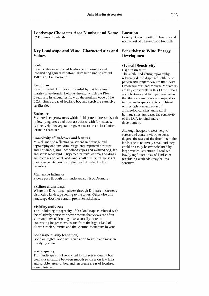
___________________________________________________________________________________
_____________________________________________________________________
225 Julie Martin Associates
Landscape Character Area Number and Name 82 Dromore Lowlands
Location County Down. South of Dromore and north-west of Slieve Croob Foothills.
Key Landscape and Visual Characteristics and Values
Sensitivity to Wind Energy Development
Scale Small scale domesticated landscape of drumlins and lowland bog generally below 100m but rising to around 150m AOD in the south.
Landform Small rounded drumlins surrounded by flat bottomed marshy inter-drumlin hollows through which the River Lagan and its tributaries flow on the northern edge of the LCA. Some areas of lowland bog and scrub are extensive eg Big Bog.
Enclosure Scattered hedgerow trees within field pattern, areas of scrub in low-lying areas and trees associated with farmsteads. Collectively this vegetation gives rise to an enclosed often intimate character.
Complexity of landcover and features Mixed land use reflecting variations in drainage and topography and including rough and improved pastures, areas of arable, small woodland copes and wetland bog, fen and scrub woodland. Dispersed patterns of small holdings and cottages on local roads and small clusters of houses at junctions located on the higher land afforded by the drumlins.
Man-made influence Pylons pass through this landscape south of Dromore.
Skylines and settings Where the River Lagan passes through Dromore it creates a distinctive landscape setting to the town. Otherwise this landscape does not contain prominent skylines.
Visibility and views The undulating topography of this landscape combined with the relatively dense tree cover means that views are often short and inward-looking. Occasionally there are contrasting longer views to and from the higher land of Slieve Croob Summits and the Mourne Mountains beyond.
Landscape quality (condition) Good on higher land with a transition to scrub and moss in low-lying areas.
Scenic quality This landscape is not renowned for its scenic quality but contrasts in texture between smooth pastures on low hills and scrubby areas of bog and fen create areas of localised scenic interest.
Overall Sensitivity High to medium The subtle undulating topography, relatively dense dispersed settlement pattern and longer views to the Slieve Croob summits and Mourne Mountains are key constraints in this LCA. Small scale features and field patterns mean that there are many scale comparators in this landscape and this, combined with a high concentration of archaeological sites and natural heritage sites, increases the sensitivity of the LCA to wind energy development.
Although hedgerow trees help to screen and contain views to some degree, the scale of the drumlins in this landscape is relatively small and they could be easily be overwhelmed by large vertical structures. Localised low-lying flatter areas of landscape (excluding wetlands) may be less sensitive.
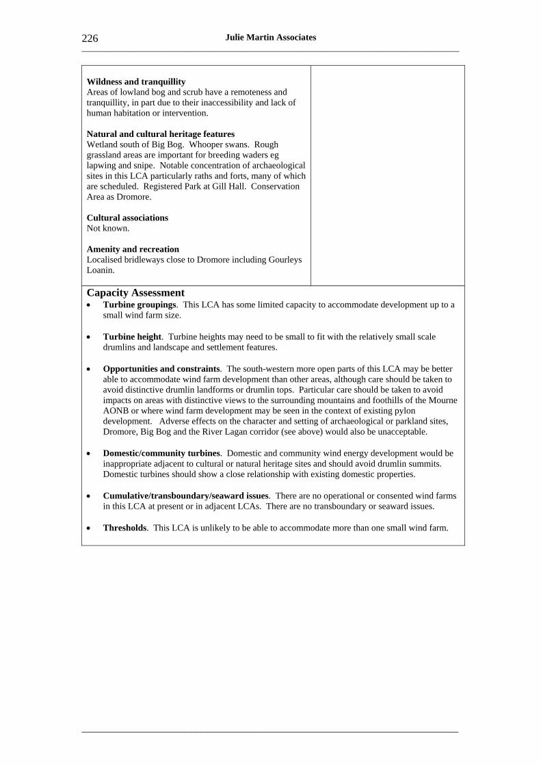
___________________________________________________________________________________
_____________________________________________________________________
226 Julie Martin Associates
Wildness and tranquillity Areas of lowland bog and scrub have a remoteness and tranquillity, in part due to their inaccessibility and lack of human habitation or intervention.
Natural and cultural heritage features Wetland south of Big Bog. Whooper swans. Rough grassland areas are important for breeding waders eg lapwing and snipe. Notable concentration of archaeological sites in this LCA particularly raths and forts, many of which are scheduled. Registered Park at Gill Hall. Conservation Area as Dromore.
Cultural associations Not known.
Amenity and recreation Localised bridleways close to Dromore including Gourleys Loanin.
Capacity Assessment • Turbine groupings. This LCA has some limited capacity to accommodate development up to a
small wind farm size.
• Turbine height. Turbine heights may need to be small to fit with the relatively small scale drumlins and landscape and settlement features.
• Opportunities and constraints. The south-western more open parts of this LCA may be better able to accommodate wind farm development than other areas, although care should be taken to avoid distinctive drumlin landforms or drumlin tops. Particular care should be taken to avoid impacts on areas with distinctive views to the surrounding mountains and foothills of the Mourne AONB or where wind farm development may be seen in the context of existing pylon development. Adverse effects on the character and setting of archaeological or parkland sites, Dromore, Big Bog and the River Lagan corridor (see above) would also be unacceptable.
• Domestic/community turbines. Domestic and community wind energy development would be inappropriate adjacent to cultural or natural heritage sites and should avoid drumlin summits. Domestic turbines should show a close relationship with existing domestic properties.
• Cumulative/transboundary/seaward issues. There are no operational or consented wind farms in this LCA at present or in adjacent LCAs. There are no transboundary or seaward issues.
• Thresholds. This LCA is unlikely to be able to accommodate more than one small wind farm.
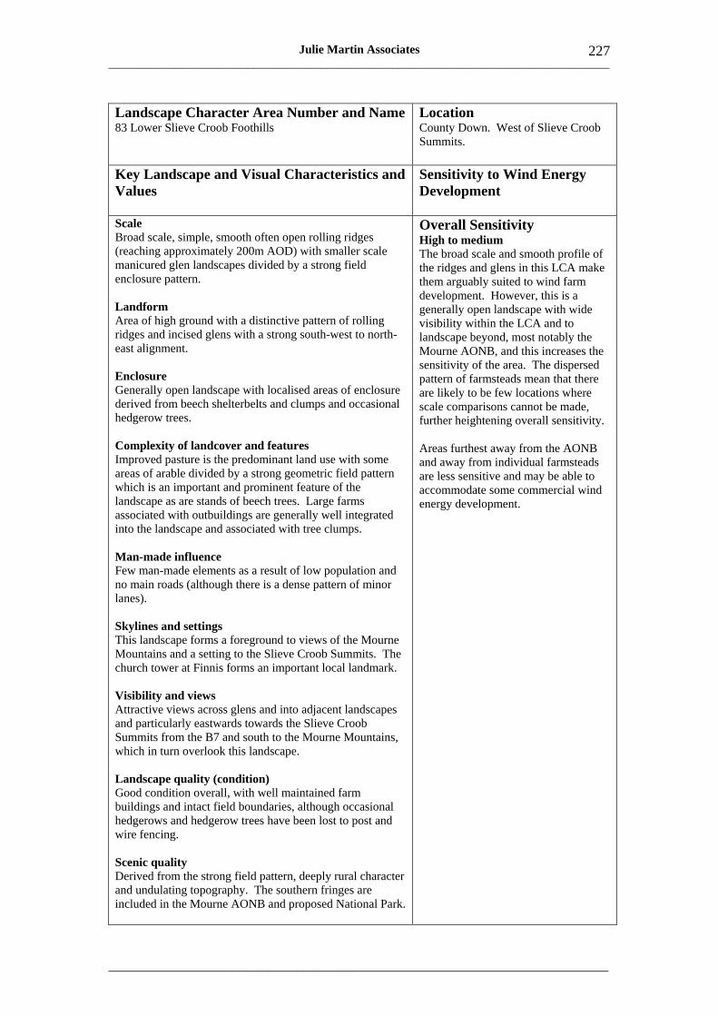
___________________________________________________________________________________
_____________________________________________________________________
227 Julie Martin Associates
Landscape Character Area Number and Name 83 Lower Slieve Croob Foothills
Location County Down. West of Slieve Croob Summits.
Key Landscape and Visual Characteristics and Values
Sensitivity to Wind Energy Development
Scale Broad scale, simple, smooth often open rolling ridges (reaching approximately 200m AOD) with smaller scale manicured glen landscapes divided by a strong field enclosure pattern.
Landform Area of high ground with a distinctive pattern of rolling ridges and incised glens with a strong south-west to northeast alignment.
Enclosure Generally open landscape with localised areas of enclosure derived from beech shelterbelts and clumps and occasional hedgerow trees.
Complexity of landcover and features Improved pasture is the predominant land use with some areas of arable divided by a strong geometric field pattern which is an important and prominent feature of the landscape as are stands of beech trees. Large farms associated with outbuildings are generally well integrated into the landscape and associated with tree clumps.
Man-made influence Few man-made elements as a result of low population and no main roads (although there is a dense pattern of minor lanes).
Skylines and settings This landscape forms a foreground to views of the Mourne Mountains and a setting to the Slieve Croob Summits. The church tower at Finnis forms an important local landmark.
Visibility and views Attractive views across glens and into adjacent landscapes and particularly eastwards towards the Slieve Croob Summits from the B7 and south to the Mourne Mountains, which in turn overlook this landscape.
Landscape quality (condition) Good condition overall, with well maintained farm buildings and intact field boundaries, although occasional hedgerows and hedgerow trees have been lost to post and wire fencing.
Scenic quality Derived from the strong field pattern, deeply rural character and undulating topography. The southern fringes are included in the Mourne AONB and proposed National Park.
Overall Sensitivity High to medium The broad scale and smooth profile of the ridges and glens in this LCA make them arguably suited to wind farm development. However, this is a generally open landscape with wide visibility within the LCA and to landscape beyond, most notably the Mourne AONB, and this increases the sensitivity of the area. The dispersed pattern of farmsteads mean that there are likely to be few locations where scale comparisons cannot be made, further heightening overall sensitivity.
Areas furthest away from the AONB and away from individual farmsteads are less sensitive and may be able to accommodate some commercial wind energy development.
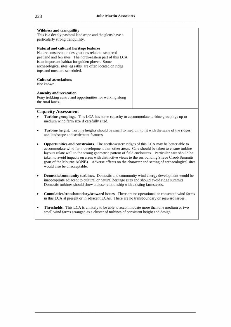
___________________________________________________________________________________
_____________________________________________________________________
228 Julie Martin Associates
Wildness and tranquillity This is a deeply pastoral landscape and the glens have a particularly strong tranquillity.
Natural and cultural heritage features Nature conservation designations relate to scattered peatland and fen sites. The north-eastern part of this LCA is an important habitat for golden plover. Some archaeological sites, eg raths, are often located on ridge tops and most are scheduled.
Cultural associations Not known.
Amenity and recreation Pony trekking centre and opportunities for walking along the rural lanes.
Capacity Assessment • Turbine groupings. This LCA has some capacity to accommodate turbine groupings up to
medium wind farm size if carefully sited.
• Turbine height. Turbine heights should be small to medium to fit with the scale of the ridges and landscape and settlement features.
• Opportunities and constraints. The north-western ridges of this LCA may be better able to accommodate wind farm development than other areas. Care should be taken to ensure turbine layouts relate well to the strong geometric pattern of field enclosures. Particular care should be taken to avoid impacts on areas with distinctive views to the surrounding Slieve Croob Summits (part of the Mourne AONB). Adverse effects on the character and setting of archaeological sites would also be unacceptable.
• Domestic/community turbines. Domestic and community wind energy development would be inappropriate adjacent to cultural or natural heritage sites and should avoid ridge summits. Domestic turbines should show a close relationship with existing farmsteads.
• Cumulative/transboundary/seaward issues. There are no operational or consented wind farms in this LCA at present or in adjacent LCAs. There are no transboundary or seaward issues.
• Thresholds. This LCA is unlikely to be able to accommodate more than one medium or two small wind farms arranged as a cluster of turbines of consistent height and design.
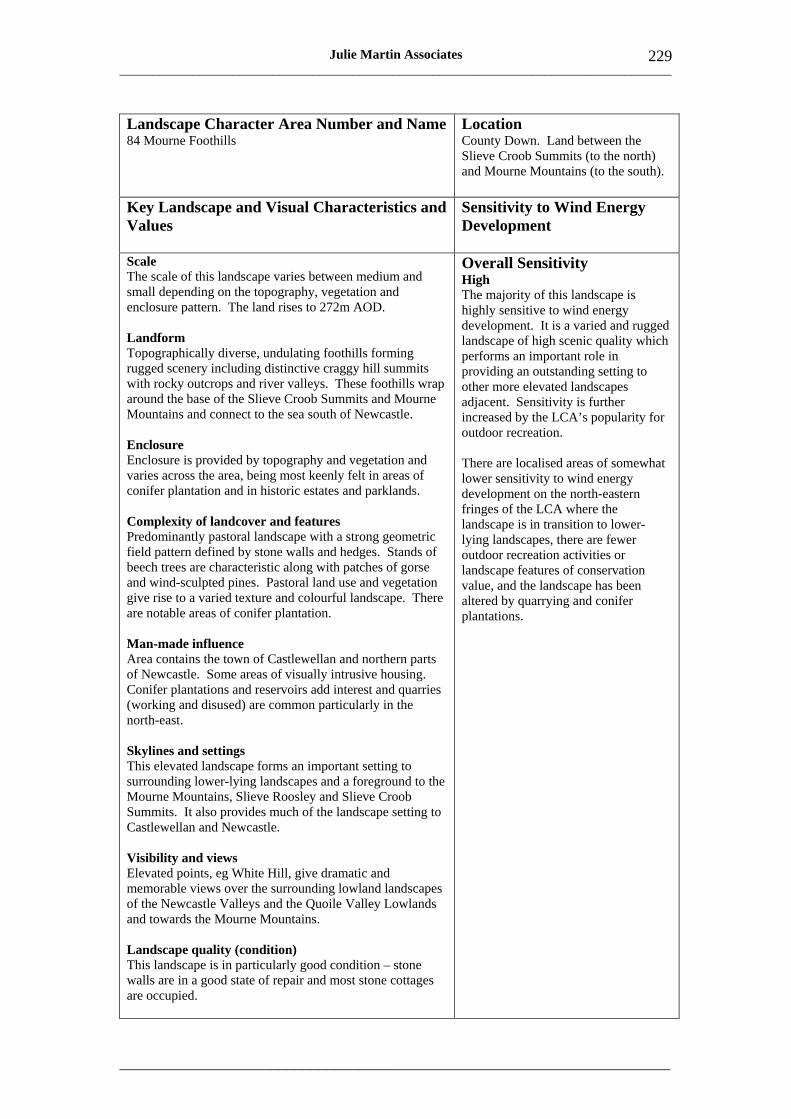
___________________________________________________________________________________
_____________________________________________________________________
229 Julie Martin Associates
Landscape Character Area Number and Name Location 84 Mourne Foothills County Down. Land between the
Slieve Croob Summits (to the north) and Mourne Mountains (to the south).
Key Landscape and Visual Characteristics and Values
Sensitivity to Wind Energy Development
Scale The scale of this landscape varies between medium and small depending on the topography, vegetation and enclosure pattern. The land rises to 272m AOD.
Landform Topographically diverse, undulating foothills forming rugged scenery including distinctive craggy hill summits with rocky outcrops and river valleys. These foothills wrap around the base of the Slieve Croob Summits and Mourne Mountains and connect to the sea south of Newcastle.
Enclosure Enclosure is provided by topography and vegetation and varies across the area, being most keenly felt in areas of conifer plantation and in historic estates and parklands.
Complexity of landcover and features Predominantly pastoral landscape with a strong geometric field pattern defined by stone walls and hedges. Stands of beech trees are characteristic along with patches of gorse and wind-sculpted pines. Pastoral land use and vegetation give rise to a varied texture and colourful landscape. There are notable areas of conifer plantation.
Man-made influence Area contains the town of Castlewellan and northern parts of Newcastle. Some areas of visually intrusive housing. Conifer plantations and reservoirs add interest and quarries (working and disused) are common particularly in the north-east.
Overall Sensitivity High The majority of this landscape is highly sensitive to wind energy development. It is a varied and rugged landscape of high scenic quality which performs an important role in providing an outstanding setting to other more elevated landscapes adjacent. Sensitivity is further increased by the LCA’s popularity for outdoor recreation.
There are localised areas of somewhat lower sensitivity to wind energy development on the north-eastern fringes of the LCA where the landscape is in transition to lower-lying landscapes, there are fewer outdoor recreation activities or landscape features of conservation value, and the landscape has been altered by quarrying and conifer plantations.
Skylines and settings This elevated landscape forms an important setting to surrounding lower-lying landscapes and a foreground to the Mourne Mountains, Slieve Roosley and Slieve Croob Summits. It also provides much of the landscape setting to Castlewellan and Newcastle.
Visibility and views Elevated points, eg White Hill, give dramatic and memorable views over the surrounding lowland landscapes of the Newcastle Valleys and the Quoile Valley Lowlands and towards the Mourne Mountains.
Landscape quality (condition) This landscape is in particularly good condition – stone walls are in a good state of repair and most stone cottages are occupied.
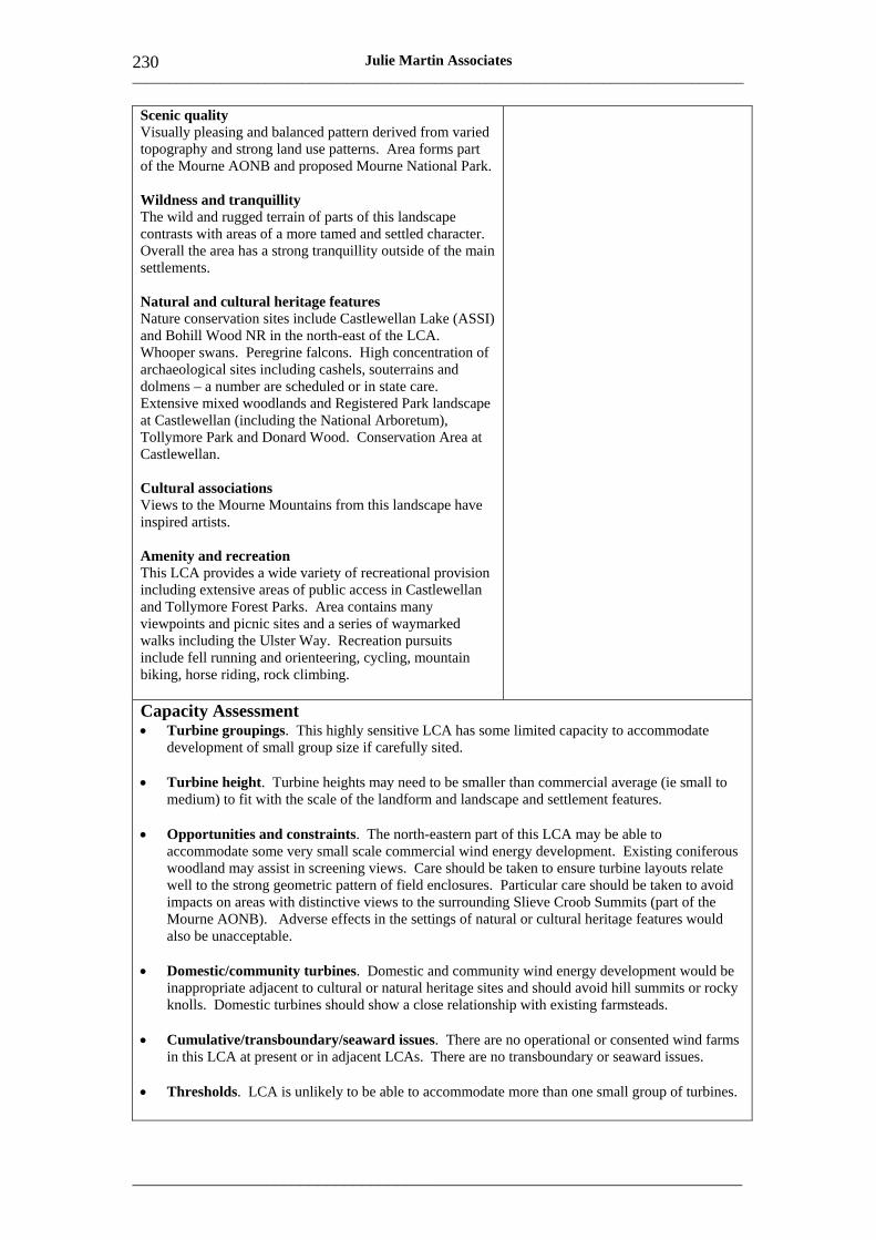
___________________________________________________________________________________
_____________________________________________________________________
230 Julie Martin Associates
Scenic quality Visually pleasing and balanced pattern derived from varied topography and strong land use patterns. Area forms part of the Mourne AONB and proposed Mourne National Park.
Wildness and tranquillity The wild and rugged terrain of parts of this landscape contrasts with areas of a more tamed and settled character. Overall the area has a strong tranquillity outside of the main settlements.
Natural and cultural heritage features Nature conservation sites include Castlewellan Lake (ASSI) and Bohill Wood NR in the north-east of the LCA. Whooper swans. Peregrine falcons. High concentration of archaeological sites including cashels, souterrains and dolmens – a number are scheduled or in state care. Extensive mixed woodlands and Registered Park landscape at Castlewellan (including the National Arboretum), Tollymore Park and Donard Wood. Conservation Area at Castlewellan.
Cultural associations Views to the Mourne Mountains from this landscape have inspired artists.
Amenity and recreation This LCA provides a wide variety of recreational provision including extensive areas of public access in Castlewellan and Tollymore Forest Parks. Area contains many viewpoints and picnic sites and a series of waymarked walks including the Ulster Way. Recreation pursuits include fell running and orienteering, cycling, mountain biking, horse riding, rock climbing.
Capacity Assessment • Turbine groupings. This highly sensitive LCA has some limited capacity to accommodate
development of small group size if carefully sited.
• Turbine height. Turbine heights may need to be smaller than commercial average (ie small to medium) to fit with the scale of the landform and landscape and settlement features.
• Opportunities and constraints. The north-eastern part of this LCA may be able to accommodate some very small scale commercial wind energy development. Existing coniferous woodland may assist in screening views. Care should be taken to ensure turbine layouts relate well to the strong geometric pattern of field enclosures. Particular care should be taken to avoid impacts on areas with distinctive views to the surrounding Slieve Croob Summits (part of the Mourne AONB). Adverse effects in the settings of natural or cultural heritage features would also be unacceptable.
• Domestic/community turbines. Domestic and community wind energy development would be inappropriate adjacent to cultural or natural heritage sites and should avoid hill summits or rocky knolls. Domestic turbines should show a close relationship with existing farmsteads.
• Cumulative/transboundary/seaward issues. There are no operational or consented wind farms in this LCA at present or in adjacent LCAs. There are no transboundary or seaward issues.
• Thresholds. LCA is unlikely to be able to accommodate more than one small group of turbines.
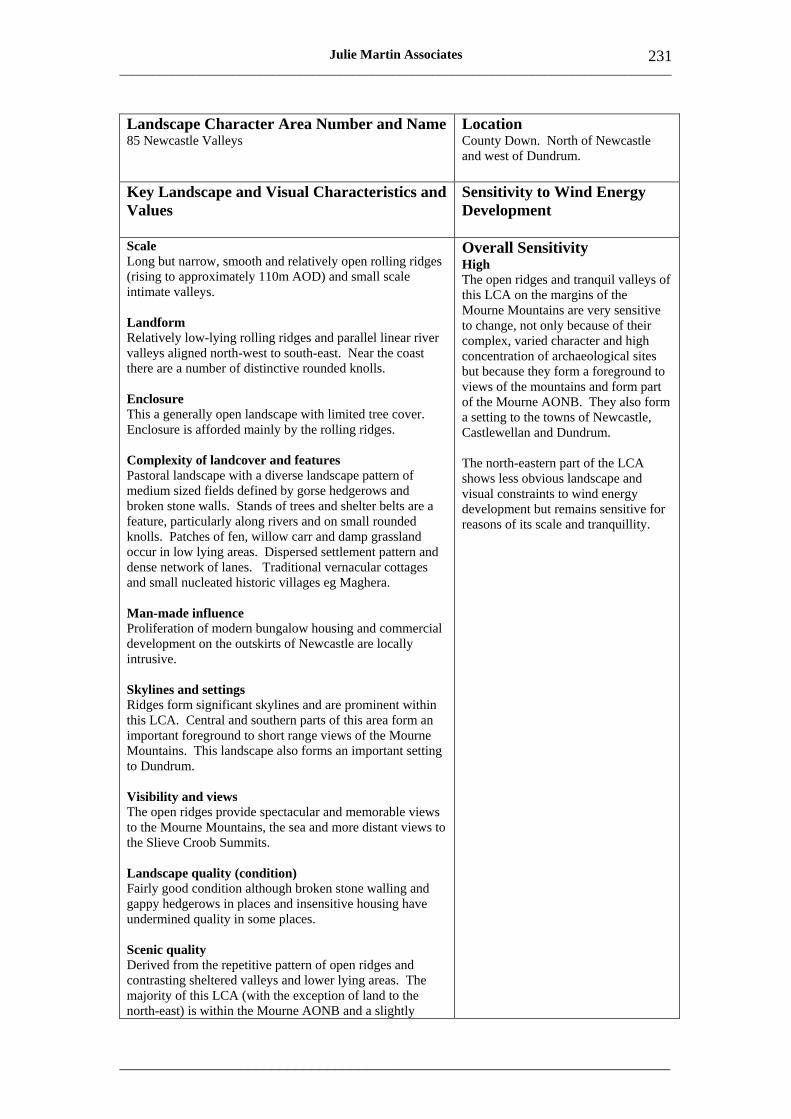
___________________________________________________________________________________
_____________________________________________________________________
231 Julie Martin Associates
Landscape Character Area Number and Name 85 Newcastle Valleys
Location County Down. North of Newcastle and west of Dundrum.
Key Landscape and Visual Characteristics and Values
Sensitivity to Wind Energy Development
Scale Overall Sensitivity Long but narrow, smooth and relatively open rolling ridges High(rising to approximately 110m AOD) and small scale The open ridges and tranquil valleys of intimate valleys. this LCA on the margins of the
Mourne Mountains are very sensitive Landform to change, not only because of their Relatively low-lying rolling ridges and parallel linear river complex, varied character and high valleys aligned north-west to south-east. Near the coast concentration of archaeological sites there are a number of distinctive rounded knolls. but because they form a foreground to
views of the mountains and form part Enclosure of the Mourne AONB. They also form This a generally open landscape with limited tree cover. a setting to the towns of Newcastle, Enclosure is afforded mainly by the rolling ridges. Castlewellan and Dundrum.
Complexity of landcover and features The north-eastern part of the LCA Pastoral landscape with a diverse landscape pattern of shows less obvious landscape and medium sized fields defined by gorse hedgerows and visual constraints to wind energy broken stone walls. Stands of trees and shelter belts are a development but remains sensitive for feature, particularly along rivers and on small rounded reasons of its scale and tranquillity. knolls. Patches of fen, willow carr and damp grassland occur in low lying areas. Dispersed settlement pattern and dense network of lanes. Traditional vernacular cottages and small nucleated historic villages eg Maghera.
Man-made influence Proliferation of modern bungalow housing and commercial development on the outskirts of Newcastle are locally intrusive.
Skylines and settings Ridges form significant skylines and are prominent within this LCA. Central and southern parts of this area form an important foreground to short range views of the Mourne Mountains. This landscape also forms an important setting to Dundrum.
Visibility and views The open ridges provide spectacular and memorable views to the Mourne Mountains, the sea and more distant views to the Slieve Croob Summits.
Landscape quality (condition) Fairly good condition although broken stone walling and gappy hedgerows in places and insensitive housing have undermined quality in some places.
Scenic quality Derived from the repetitive pattern of open ridges and contrasting sheltered valleys and lower lying areas. The majority of this LCA (with the exception of land to the north-east) is within the Mourne AONB and a slightly
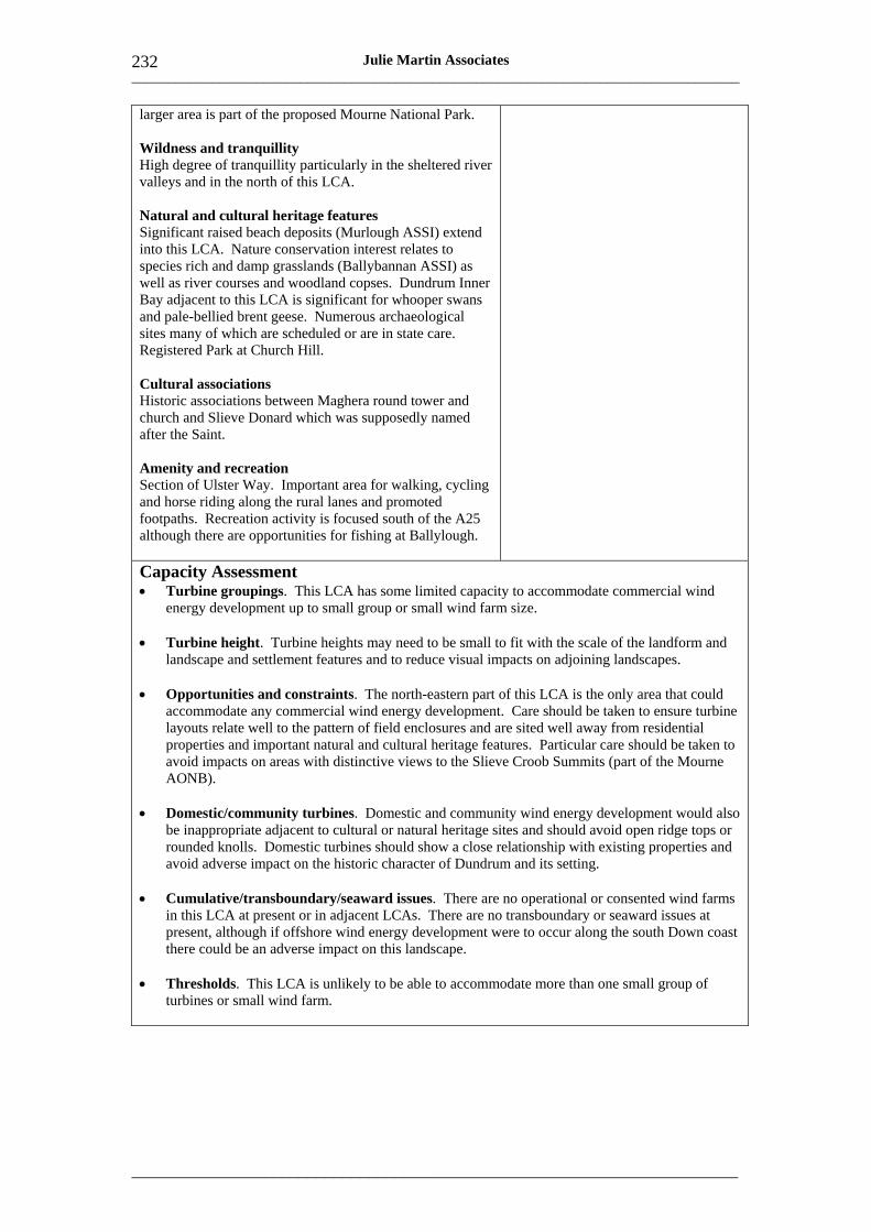
___________________________________________________________________________________
_____________________________________________________________________
232 Julie Martin Associates
larger area is part of the proposed Mourne National Park.
Wildness and tranquillity High degree of tranquillity particularly in the sheltered river valleys and in the north of this LCA.
Natural and cultural heritage features Significant raised beach deposits (Murlough ASSI) extend into this LCA. Nature conservation interest relates to species rich and damp grasslands (Ballybannan ASSI) as well as river courses and woodland copses. Dundrum Inner Bay adjacent to this LCA is significant for whooper swans and pale-bellied brent geese. Numerous archaeological sites many of which are scheduled or are in state care. Registered Park at Church Hill.
Cultural associations Historic associations between Maghera round tower and church and Slieve Donard which was supposedly named after the Saint.
Amenity and recreation Section of Ulster Way. Important area for walking, cycling and horse riding along the rural lanes and promoted footpaths. Recreation activity is focused south of the A25 although there are opportunities for fishing at Ballylough.
Capacity Assessment • Turbine groupings. This LCA has some limited capacity to accommodate commercial wind
energy development up to small group or small wind farm size.
• Turbine height. Turbine heights may need to be small to fit with the scale of the landform and landscape and settlement features and to reduce visual impacts on adjoining landscapes.
• Opportunities and constraints. The north-eastern part of this LCA is the only area that could accommodate any commercial wind energy development. Care should be taken to ensure turbine layouts relate well to the pattern of field enclosures and are sited well away from residential properties and important natural and cultural heritage features. Particular care should be taken to avoid impacts on areas with distinctive views to the Slieve Croob Summits (part of the Mourne AONB).
• Domestic/community turbines. Domestic and community wind energy development would also be inappropriate adjacent to cultural or natural heritage sites and should avoid open ridge tops or rounded knolls. Domestic turbines should show a close relationship with existing properties and avoid adverse impact on the historic character of Dundrum and its setting.
• Cumulative/transboundary/seaward issues. There are no operational or consented wind farms in this LCA at present or in adjacent LCAs. There are no transboundary or seaward issues at present, although if offshore wind energy development were to occur along the south Down coast there could be an adverse impact on this landscape.
• Thresholds. This LCA is unlikely to be able to accommodate more than one small group of turbines or small wind farm.
___________________________________________________________________________________
_____________________________________________________________________
233 Julie Martin Associates
Landscape Character Area Number and Name 86 Tyrella Coastal Dunes
Location County Down. Coastal landscape around Dundrum Bay.
Key Landscape and Visual Characteristics and Values
Sensitivity to Wind Energy Development
Scale Relatively flat, open and expansive with a strong horizontal emphasis. Generally below 40m AOD.
Landform Long sweeping sandy beach and bay, hummocky sand dunes and low-lying gently undulating farmland.
Enclosure Windswept and exposed with little or no tree cover.
Complexity of landcover and features Sandy beach, marram grass and heathland covered sand dunes and inland farmland of pastures and arable give a textured and varied landscape pattern and colours.
Man-made influence Traditional white-finished cottages and town houses in villages and Dundrum coastal town. MOD site and conifer plantations at Ballykinler
Skylines and settings Mourne Mountains form a distinctive skyline in views to the south-west and dunes form a simple and horizontal skyline from the beach. This landscape is an important setting to Dundrum and the Mourne Mountains.
Visibility and views Dramatic views to Mourne Mountains and along the curve of the bay. View inland to undulating farmland from sand dunes.
Landscape quality (condition) Generally high with extensive areas of unspoilt and intact sand dune, mudflat and farmland. Areas closer to Newcastle have been affected by development including caravan parks and loss of field boundaries.
Scenic quality Derived from combination of high landscape quality, open water and backdrop of the Mourne Mountains. This landscape falls partly within the Mourne AONB and partly within the Lecale Coast AONB. The western part of this area is included in the proposed Mourne National Park.
Wildness and tranquillity The windswept nature and evident natural processes give this LCA a wild and remote character.
Natural and cultural heritage features Important area for beach processes and evidence of raised
Overall Sensitivity High The Tyrella Coastal Dunes are highly sensitive to wind energy development of all types and scales. This is due primarily to their open and exposed character, inherent scenic quality and role as a setting to the Mourne Mountains. The openness and wild character of the area mean that any development is likely to interrupt important skylines and would be extremely intrusive, extending an industrial influence into landscapes which are currently pristine and natural. The value of the area for outdoor recreation further increases its sensitivity.
Even domestic and community wind energy needs to be approached with great caution in this LCA.
___________________________________________________________________________________
_____________________________________________________________________
234 Julie Martin Associates
beach deposits. Nature conservation value relates to the heathland, sand dunes and mudflats (Murlough ASSI and NNR and SAC). Largest areas of dunes in Northern Ireland and of rarity value. Dundrum Inner Bay is important for whooper swans and pale-bellied brent geese. Registered Parks at Tyrella House and Mount Panther.
Cultural associations Views of the Mourne Mountains and Dundrum Bay have inspired many artists.
Amenity and recreation This area is highly important for outdoor recreation. Lecale Way footpath passes through this landscape as well as the Dundrum Bay Path, and there are marketed horse riding trials. Wildfowling, angling, and water sports are also important. Area contains Royal County Down golf course and numerous caravan sites along the coast.
Capacity Assessment • Turbine groupings and height. This LCA has no capacity for commercial wind energy
development due to its very high landscape and visual sensitivity and role as a setting to the Mourne Mountains. Any wind energy development should generally be limited to single domestic turbines, as even community scale turbines could have a significant impact on the landscape.
• Opportunities and constraints. Domestic wind energy development should be closely associated with existing development and tree groups and should avoid open sites or areas where there are important views along the coast or across the sand dunes. Care should also be taken to avoid visual clutter where there are overhead telegraph wires. Adverse impact on the historic character of Dundrum should also be avoided..
• Cumulative/transboundary/seaward issues. There are no operational or consented wind farms in this LCA. There are no cumulative or transboundary issues. However, there may in future be seaward issues in relation to potential offshore wind energy development near the mouth of Carlingford Lough, although this would be at least 30km away and would be seen from low elevations. Any closer offshore wind energy development along the south Down coast could have an adverse impact on this landscape.

___________________________________________________________________________________
_____________________________________________________________________
235 Julie Martin Associates
Landscape Character Area Number and Name 87 Slieve Croob Summits
Location County Down. North of the Mourne Mountains and Foothills.
Key Landscape and Visual Characteristics and Values
Sensitivity to Wind Energy Development
Scale Open exposed upland landscape (rising to 534m AOD) with expansive views.
Landform Rolling rounded hills and summits with rocky outcrops and screes giving rise to a mainly rough and rugged landscape.
Enclosure Generally open with occasional stunted or windswept trees and some areas of enclosure by conifer plantations eg Drumkeeragh Forest.
Complexity of landcover and features Rugged and textured character comprising unimproved, wet and semi-improved pastures, patches of heather and blanket bog, rocky outcrops and screes and some areas of conifer plantation. Strong stone wall enclosure pattern in the east, hedgerows elsewhere. Isolated stone cottages (many derelict) and farmsteads and a low density of narrow lanes.
Man-made influence Rural landscape with few overt man-made features except for some conifer plantations and telecommunications masts on summits of Slieve Croob.
Skylines and settings Prominent rugged summits and ridgelines visible from miles around, particularly those formed by the Slieve Croob and Slievenisky complex, but also the summits of Legananny Mountain and Slievegarran.
Overall Sensitivity High In theory the rounded convex profile of the summits in this LCA make it suitable for wind energy development. However the openness of this landscape and subsequent high visibility, coupled with its scenic quality and often rugged, craggy and wild character, increase its sensitivity. Of particular sensitivity is the area’s role in providing a gateway to the Mourne Mountains AONB and providing some of the most spectacular mid-distance views to this iconic upland. Wind energy development in this landscape is therefore likely to have widespread and significant impacts on landscape character and visual amenity.
These sensitivities lessen somewhat in the north-east of this LCA where the lower-lying hills are less sensitive visually, and of lesser scenic quality. In this area the presence of conifer plantations may also assist in screening some views. However the small geographical extent of this area is a key constraint.
Visibility and views Panoramic views over the surrounding area and to and from the Mourne Mountains and Dundrum Bay to the south.
Landscape quality (condition) Relatively good condition with a largely intact pattern of dispersed farmsteads, lanes and pastoral fields and areas of more open rougher ground at higher elevations.
Scenic quality Subtle scenic quality relating to attractive patterns and balance of enclosed pasture fields and rough craggy hills on the most elevated land. Much of the area falls within the Mourne AONB and forms part of the proposed Mourne National Park with the exception of the northern and eastern fringes.
Wildness and tranquillity Strong wild qualities derived from textured vegetation,
___________________________________________________________________________________
_____________________________________________________________________
236 Julie Martin Associates
rocky outcrops, elevation and exposure. Occasional derelict cottages contribute to a sense of desolation and tranquillity.
Natural and cultural heritage features Nature conservation interest relates to peatland on the main summits, mosaic of habitats at Black Lough (ASSI). Whooper swans. Peregrine falcons. Important archaeological sites eg cashels, raths, dolmens and standing stones many of which are scheduled or in state care.
Cultural associations Not known.
Amenity and recreation This landscape is an important recreation gateway to the Mourne Mountains and views to the Mourne Mountains in this landscape are a key part of the area’s recreation experience. Area is important for hiking (Slieve Croob circular walk and other waymarked ways), forest walks, orienteering, horse riding and cycling (Sustrans Cycle Route 2). Hang gliding and paragliding are also popular here. There are a number of popular car parks and viewpoints eg Windy Gap and Cratlieve.
Capacity Assessment • Turbine groupings. This LCA has some limited capacity to accommodate a small group of
turbines if carefully sited.
• Turbine height. Turbine heights may need to be smaller than commercial average (ie small to medium) to fit with the scale of the landform and landscape and settlement features.
• Opportunities and constraints. Sites on prominent ridgelines such as Slieve Croob and Slievegarran should be avoided as any wind farms in these areas would dominate the landscape. The lower slopes on the north-eastern fringe of this LCA, away from the higher ridgelines where views to the wider landscape are less significant and where conifer plantations may assist in screening some views, may be better able to accommodate wind energy development. Particular care should be taken to ensure turbine layouts relate well to the pattern of field enclosures, and to avoid turbines being seen in relation to existing transmission masts. Adverse effects on residential properties and natural and cultural heritage sites would be unacceptable.
• Domestic/community turbines. Domestic and community wind energy development would also be inappropriate adjacent to cultural or natural heritage sites and should avoid open ridge tops or important skylines. Domestic turbines should show a close relationship with existing properties.
• Cumulative/transboundary/seaward issues. There are no operational or consented wind farms in this LCA at present or in adjacent LCAs. There are no transboundary or seaward issues at present, although if offshore wind energy development were to occur along nearby areas of coast the elevated views from this landscape could be affected.
• Thresholds. This LCA is unlikely to be able to accommodate more than one small group of turbines.
___________________________________________________________________________________
_____________________________________________________________________
237 Julie Martin Associates
Landscape Character Area Number and Name Location 88 Craggy Dromara Uplands County Down. North of Slieve Croob
Summits and south-west of Ballynahinch.
Key Landscape and Visual Characteristics and Values
Sensitivity to Wind Energy Development
Scale Gentle terraces of land rising up to 193m AOD on the edge of Slieve Croob Summits to the south. Gently rounded drumlins in lower areas to the east and north and areas of lowland basin.
Landform Rolling elevated terraces and plateau with scattered rocky outcrops to the south. Distinctive rounded or conical drumlins in the east; less distinctive rounded rolling drumlins in the north.
Enclosure Enclosure particularly in lower-lying areas to the north and east (around Montalto House) as a result of hedgerow and parkland trees (mature oaks), stands of Scots pine and topography, giving rise to an intimate character. More exposed on elevated areas to the south and wetland basin surrounding Lough Aghery.
Complexity of landcover and features Marginal pastoral landscape on elevated terraces and drumlins accompanied by wasteland, patches of gorse and rock outcrops. Marshy land in inter-drumlin hollows. Numerous small loughs provide variety in texture and colour. Pastures are enclosed by low stone walls and hedgerows.
Man-made influence Dispersed pattern of derelict farmsteads and modern bungalow development that is sometimes visually prominent along principal roads eg the B2.
Skylines and settings Archaeological sites may form important landmark features eg dolmen north-west of Dromara. The slopes south of the B2 form an important skyline when viewed form the north and north-east. The wooded parkland of Monalto House provides an important setting to the south of Ballynahinch. The prominent conical drumlins in the east of this LCA also contribute to the settings of Ballynahinch and Spa.
Overall Sensitivity High The sensitivity of this landscape relates to its predominantly settled character and small scale, its often rugged form and the range of different landscape features such as loughs and archaeological sites. This landscape also forms a foreground to views of the Mourne AONB and particularly Slieve Croob summits. Commercial wind energy development on the conical drumlin hills found to the east of this LCA would not be appropriate simply because the scale of the drumlins is not sufficiently large to accommodate it. In addition, particular drumlins have an unusual and distinctive form and provide an important setting to adjacent settlements. Development in the low-lying basin around Lough Aghery or on the elevated ridges to the south would also be inappropriate because of the openness of these areas and their visual prominence from elsewhere within the LCA.
Away from ridgetops and on lower lying, less distinctive drumlin landscapes to the north the landscape is somewhat less sensitive but turbine height is strongly constrained by the size of the drumlin landform.
Visibility and views The lowland valley to the east of Ballykeel and the fringes of Lough Aghery are prominent in views across the area. There are notable views northwards from the B2.
Landscape quality (condition) Loss of hedgerows due to farming activity and lack of management of stone walls mean that the condition of this
___________________________________________________________________________________
_____________________________________________________________________
238 Julie Martin Associates
landscape is mixed.
Scenic quality The central southern corner of this LCA is included in the Mourne AONB and proposed Mourne National Park.
Wildness and tranquillity Rugged relatively wild character derived from elevation, textured land uses and untamed character.
Natural and cultural heritage features The loughs form an important habitat for whooper swans. Historic mill buildings at Woodford and archaeological sites eg rath west of Dromara are valued cultural features, as are other archaeological sites many of which are scheduled. Monalto House on the outskirts of Ballynahinch is a Registered Park.
Cultural associations Not known.
Amenity and recreation Begny Lake is valued for its fishing and angling.
Capacity Assessment • Turbine groupings. This LCA may have some limited capacity to accommodate a small group
of turbines if very carefully sited.
• Turbine height. Turbine heights should be domestic/community or small, reflecting the relatively small scale of the landform and landscape and settlement features; and the role of the area s part of the setting of the Mourne AONB to the south.
• Opportunities and constraints. The central area of this LCA away from ridgetops may offer some very limited scope for such development. Here hedgerow trees may provide some screening. Nonetheless great care will need to be taken to avoid prominent ridgelines and key views to the Mourne AONB to the south as well as the settings of landscape features such as loughs or archaeological sites. Domestic wind energy development similarly should avoid prominent drumlins and ridgetops that form important skylines and should be associated with groups of buildings and trees.
• Cumulative/transboundary/seaward issues. There are no operational or consented wind farms in this LCA at present or in adjacent LCAs. There are no transboundary or seaward issues.
• Thresholds. This LCA could potentially accommodate one small group of turbines.
___________________________________________________________________________________
_____________________________________________________________________
239 Julie Martin Associates
Landscape Character Area Number and Name 89 Hillsborough Slopes
Location County Down. South of Lisburn and north of the B2.
Key Landscape and Visual Characteristics and Values
Sensitivity to Wind Energy Development
Scale Medium scale, broad rounded ridges rising to 170m in the centre of this LCA but becoming smaller scale at the edges.
Landform Rounded ridges and hills which are gently rolling and progressively influenced by drumlin forms (egg-shaped and rounded summits) at the fringes of the LCA. Central ridges have an east-west alignment.
Enclosure Windswept farmland on ridge tops. More enclosed on lower slopes due to scattered hedgerow trees and coniferous woodland at Hillsborough Castle Estate and Forest.
Complexity of landcover and features Mixed farmland landscape divided by a varied patchwork of fields and hedgerows – medium scale enclosures on the open slopes and smaller paddocks on lower-lying land and adjacent to settlements. Small farmsteads scattered throughout the area. Historic town of Hillsborough.
Man-made influence Some roads have linear urban development along them. Pylons pass through this landscape over the highest ridge. There is an area of landfill in the southern part of the LCA.
Skylines and settings Church spires of Hillsborough are a key landmark, and the lower slopes below the town are important to its setting. The higher ridges in the LCA form the setting to the Registered Park of Hillsborough Castle; while Cannon Hill (drumlin) contributes to the setting of Dromore.
Overall Sensitivity High While the rounded gently rolling ridges of this landscape are in theory suited to commercial wind energy development, the visual prominence of these ridge tops and small scale of the drumlins on the fringes, along with the overall settled character of this LCA, make much of the area very sensitive to change. Parts of this LCA contain important designed landscapes while other areas perform an important role as a setting to landmarks or settlements and this further heightens sensitivity. From the elevated areas of this LCA there are significant views to the Mourne Mountains and Slieve Croob. Nevertheless this area is not of high scenic value and the pattern of the landscape is in places fragmented.
Away from the ridge tops and main settlements the landscape is slightly less sensitive to change and there may be some scope for small scale wind energy development in these areas if carefully sited.
Visibility and views Long views from ridge tops, particularly to the north but also south towards Slieve Croob.
Landscape quality (condition) Good condition although agricultural intensification of the ridge-tops has lead to field boundary loss and hedges are gappy or replaced with post and wire. Some paddocks show signs of neglect.
Scenic quality Outside the town of Hillsborough, this landscape has no special scenic qualities. There are no landscape designations.
Wildness and tranquillity The windswept character of the upper ridges and their
___________________________________________________________________________________
_____________________________________________________________________
240 Julie Martin Associates
openness give rise to a sense of relative wildness, reduced by the settled character of the area and presence of pylons.
Natural and cultural heritage features There are a few archaeological sites including raths and chambered graves some of which are scheduled. Hillsborough Castle is a Registered Park and its wooded character and stone wall dominate the higher ridges in this landscape. Hillsborough is an important historic town and Conservation Area. Dromore to the west is also a Conservation Area.
Cultural associations Not known.
Amenity and recreation Hillsborough town is an important tourist destination as is Hillsborough Forest. Hillsborough Forest Lake Walk.
Capacity Assessment • Turbine groupings. This LCA may have some limited capacity to accommodate a small group
of turbines if very carefully sited.
• Turbine height. Turbine heights should be domestic/community or small, reflecting the relatively small scale of the landform and landscape and settlement features; the historic character of Hillsborough; and role of the area as part of the setting of the Mourne AONB to the south.
• Opportunities and constraints. The lower slopes on the southern side of the central ridges may be better able to accommodate such development. Sites on the central most elevated and prominent ridges should be avoided as any wind turbines in these areas would be widely visible and would dominate the landscape. Particular care should be taken to ensure turbine layouts relate well to the pattern of field enclosures and avoid sites where turbines may be seen in the context of pylons. Adverse effects on residential properties and setting of natural and cultural heritage sites or landmarks would be unacceptable. Domestic wind energy development similarly should avoid prominent drumlins and ridgetops that form important skylines and should be associated with groups of buildings and trees; its cumulative impacts may also be a consideration.
• Cumulative/transboundary/seaward issues. There are no operational or consented wind farms in this LCA at present or in adjacent LCAs. There are no transboundary or seaward issues.
• Thresholds. This LCA is unlikely to be able to accommodate more than one small group of turbines.
___________________________________________________________________________________
_____________________________________________________________________
241 Julie Martin Associates
Landscape Character Area Number and Name 90 Ravarnet Valley
Location County Down. River valley between Lisburn and Ballynahinch.
Key Landscape and Visual Characteristics and Values
Sensitivity to Wind Energy Development
Scale Broad lowland river valley landscape containing small drumlins which create areas with a distinctly smaller scale. Drumlins rise to 148m in the south-east at Magheraknock Fort.
Landform Drumlins have amorphous, irregular and elongated form with shallow slopes. In between lie marshy inter-drumlin hollows, small loughs and undulating floodplain, through which runs the meandering course of the River Ravarnet.
Enclosure Regenerating areas of willow and birch in lowland bog areas and scattered hedgerow trees as well as woodland associated with Larchfield Estate, together with drumlin topography, create localised enclosure. Otherwise this landscape is mainly open particularly on the floodplain.
Complexity of landcover and features Large pastures and small paddocks on the valley floor with smaller patchwork of mixed farmland on drumlins. Loughs occur on parts of the valley floor, notably north of Magheraknock. Dispersed pattern of traditional farmsteads on mid-slopes of drumlins often associated with mature trees.
Man-made influence Quarrying on more elevated land towards Ballynahinch. Pylons pass though the north-western part of the LCA.
Skylines and settings The rounded form of the drumlins and scattered hedgerow trees form significant skylines in this landscape and have an important visual presence. They form the settings to the loughs, to the villages of Annahilt and Ravarnet and also the northern setting of Ballynahinch. The motte and bailey to the east of Ravarnet is a notable landmark.
Visibility and views The longest views are gained from the most elevated drumlins, particularly to the south-east where there are attractive views northwards across the floodplain or from the open floodplain itself. There are also views to Slieve Croob to the south. Otherwise views are generally short-range and inward-looking.
Landscape quality (condition) Moderately good condition although many hedgerows are neglected and gappy and there are occasional pockets of derelict land.
Overall Sensitivity High to medium The open nature of this valley landscape is visually sensitive to commercial wind energy development which would have a serious impact on character and visual amenity, particularly in the ASQ landscape north of Magheraknock. Development on the drumlins would not be appropriate simply because of their small scale and their importance in forming local skylines.
In the south-east of this LCA, north of Ballynahinch, where existing quarrying activity has influenced the character of the landscape, the landscape may be less sensitive.
___________________________________________________________________________________
_____________________________________________________________________
242 Julie Martin Associates
Scenic quality An area of largely unspoilt tranquil countryside. The loughs on the floodplain north of Magheraknock have a notable scenic quality and have been identified as the Magheraknock Loughs ASQ.
Wildness and tranquillity The broader floodplains express the greatest sense of remote and tranquil character.
Natural and cultural heritage features Valley floor is of local wildlife importance, providing a wildlife corridor linkage to the River Lagan. Numerous archaeological and historic sites, most of which are scheduled or are in state care, including raths, forts and mottes eg Magheraknock Fort. Larchfield is a Registered Park.
Cultural associations Not known.
Amenity and recreation Fishing and horse riding are popular.
Capacity Assessment • Turbine groupings and height. This landscape has no capacity for commercial wind energy
development but could accommodate single or small groups of domestic or community turbines. This reflects the valley setting and the relatively small scale of landscape and settlement features.
• Opportunities and constraints. The only areas in which community turbines might be acceptable are the south-eastern fringes of the LCA in the area already affected by quarrying. Sites near key views, on prominent drumlins, within the ASQ and in areas where turbines would be seen in association with pylons should be avoided. Adverse effects on the settings of the intimate valley floor loughs and wetlands and on archaeological features should be avoided. Domestic wind energy development similarly should avoid prominent drumlins and ridgetops that form important skylines as well as wetland areas. It should be associated with groups of farm buildings and trees.
• Cumulative/transboundary/seaward issues. There are no operational or consented wind farms in this LCA at present or in adjacent LCAs. There are no transboundary or seaward issues.
___________________________________________________________________________________
_____________________________________________________________________
243 Julie Martin Associates
Landscape Character Area Number and Name 91 Quoile Valley Lowlands
Location County Down. West of Downpatrick.
Key Landscape and Visual Characteristics and Values
Sensitivity to Wind Energy Development
Scale Smalls scale landscape of drumlins hills rising to approximately 60-70m AOD but many being smaller.
Landform Pronounced, often steep, rounded drumlins (some with a distinctive egg-shaped form) divided by marshy hollows, loughs and bogs and the course of the Rivers Ballynahinch, Annacloy and Blackstaff. The landscape has a complex topography which becomes progressively shallower towards the south and higher to the north.
Enclosure Relatively enclosed and intimate landscape as a result of topography and the woodland which surrounds some loughs. Avenues of beech trees, stands of pine and estate woodland also provide enclosure.
Complexity of landcover and features Pastoral landscape with a prominent field pattern emphasised by stone walls, hedges and topography. Open water and succession of vegetation types give a textured quality to low lying areas. Areas of parkland and estate give a well wooded and tamed character in parts. Large farmhouses, traditional stone cottages, and small settlements.
Man-made influence Some intrusive modern housing dispersed throughout LCA. Pylons pass though LCA to the east of Ballynahinch.
Skylines and settings Drumlins create a distinctive setting to many clustered settlements including Ballynahinch, Downpatrick, and Drumaness. Raths, standing stones, mottes and churches are often located on the tops of drumlins and create important skyline features. The land surrounding Inner Dundrum Bay is important in defining a setting to this inland expanse of water.
Visibility and views Although generally inward-looking there are some significant views to the south-west towards the Mourne Mountains and Slieve Croob, which overlook this LCA.
Landscape quality (condition) Stone walls and hedgerows are in good condition along with rural buildings, with only a few cottages in a derelict state.
Scenic quality The eastern side of this LCA around Downpatrick, the land
Overall Sensitivity High The extent, intact character and cohesiveness of this drumlin landscape make it sensitive to commercial wind energy development. The small scale of the drumlins, their often distinctive profiles and the high concentration of natural and cultural landscape features found here further heighten the area’s overall sensitivity. Those areas which are designated as AONB may be especially sensitive.
Although this is often a mainly inward-looking landscape, with a relatively high tree cover that theoretically could screen wind energy development to some degree, the scale of the landscape features and subtle, small scale of the topography mean that this landscape is highly sensitive to any commercial wind energy development.
___________________________________________________________________________________
_____________________________________________________________________
244 Julie Martin Associates
surrounding Inner Dundrum Bay, and the southern fringes of this LCA, are all valued for their scenic quality and form part of the Strangford Lough, Mourne and Lecale Coast AONBs respectively. The land around Inner Dundrum Bay is also part of the Proposed Mourne National Park.
Wildness and tranquillity This is a tranquil rural landscape but it does not have strong relative wildness.
Natural and cultural heritage features Inter-drumlin hollows and wetlands are important for their fenland flora eg Woodgrange, Ballykilbeg, Corbally, Ballygallum Ponds and Hollymount ASSIs. Ballykilbeg and Lecale Fens are also SACs. Whooper swans in various parts of the LCA; Dundrum Inner Bay is also important for whooper swans and pale-bellied brent geese. This LCA ha a high concentration of archaeological sites which are scheduled or in state care and the land west of Downpatrick is an ASAI. Registered Parks occur at Rademon, Crossgar House, Seaford House, Mount Panther and Ballydugan House. Conservation Area a Downpatrick.
Cultural associations Ancient landscape strongly associated with local folklore, myth and legends.
Amenity and recreation Lecale Way runs along the coast.
Capacity Assessment • Turbine groupings and height. This LCA has no capacity for commercial wind energy
development due to its complex topography, small scale and concentration of natural and cultural landscape features. Any wind energy development should generally be limited to single or small groups of domestic or community turbines.
• Opportunities and constraints. Any such development should be closely associated with existing buildings and tree groups and should avoid drumlin tops or prominent skyline positions. Care should also be taken to avoid locations that may affect the settings of the area’s key settlements and its many wetland habitats, archaeological sites and Registered Parks. The fringes of Inner Dundrum Bay are particularly sensitive visually.
• Cumulative/transboundary/seaward issues. There are no operational or consented wind farms in or near this LCA. There are no transboundary issues. From higher ground in the south there may be seaward issues in relation to potential offshore wind energy development near the mouth of Carlingford Lough, although this would be at least 30-40km away. Any other offshore wind energy development along the south Down coast could also affect this area.
___________________________________________________________________________________
_____________________________________________________________________
245 Julie Martin Associates
Landscape Character Area Number and Name Location 92 Ballyquintin and Lecale Coast County Down. Coastal landscape
stretching from the southern tip of the Ards peninsula to St John’s Point.
Key Landscape and Visual Characteristics and Values
Sensitivity to Wind Energy Development
Scale Expansive and broad with a strong horizontal emphasis. Elevation rises to approximately 50m AOD.
Landform Gently undulating coastal farmland with low drumlins and open inter-drumlin hollows. Rocky coastline with distinctive headlands and bays.
Enclosure Open, exposed and windswept with sheltered coves along the coast.
Complexity of landcover and features Predominately sheep grazing on pastoral farmland with patches of gorse and scrub which add texture. Fields divided by stone walls and complex pattern of fen and wet inter-drumlin hollows. Small settlements and town of Ardglass and a scattered distribution of individual dwellings, often of traditional vernacular character.
Man-made influence Few intrusive influences apart from disused airfield at Ringawaddy.
Skylines and settings Forts, castles and windmills are often sited on hilltops and form highly visible landmarks eg the church on St John’s Point. The headlands form an important setting to the fishing town of Ardglass.
Visibility and views Uninhibited views of the sea and spectacular views of the Mourne Mountains to the south particularly from St John’s Point.
Landscape quality (condition) Relatively unspoilt with many intact traditional features. Some loss of field boundaries in places.
Scenic quality Much of this LCA (the margins of Strangford Lough and the coast) falls within the Strangford Lough and Lecale Coast AONBs.
Wildness and tranquillity Deeply rural character and high degree of tranquillity. The open windswept character gives rise to a degree of relative wildness, particularly along the coast.
Overall Sensitivity High The open, low lying and relatively gentle topography of this area in theory makes it suitable for wind energy development particularly in areas of brownfield land such as Ringawaddy airfield.
However a significant proportion of this landscape is valued for its scenic quality and the openness of the area, wide-ranging views and high concentration of natural and cultural sites of interest – many along the coast itself – make it highly sensitive. Those areas outside of the AONBs provide an important setting to the areas of designated landscape. Any commercial wind energy development is likely to interrupt important skylines and would be extremely intrusive. Sensitivity is further increased by the LCA’s popularity for outdoor recreation.
___________________________________________________________________________________
_____________________________________________________________________
246 Julie Martin Associates
Natural and cultural heritage features This landscape has significant nature conservation value. Numerous ASSI sites associated with coastal, wetland and fen habitats including Ballycan, Killough Bay and Strand Lough, Tieveshully, Killard and Ballyquintin Point. The latter two are also NRs along with Cloghy Rocks and Granagh Bay; Killough Bay is also a Ramsar site. Whooper swans, pale-bellied brent geese and arctic terns. Peregrine falcons. Numerous archaeological remains many of which are scheduled or in state care including standing stone, castles, chambered graves, crosses and churches. Rich seafaring, fishing and industrial heritage. Conservation Areas at Killough and Ardglass.
Cultural associations Not known.
Amenity and recreation This area is valued for its recreation associated with nature conservation sites, bird watching and water sports. Lecale Way and a number of other beach and coastal walks at Killard, Ballyquintin Farm and Kearney.
Capacity Assessment • Turbine groupings and height. This LCA has no capacity for commercial wind energy
development due to its very high landscape and visual sensitivity. Any wind energy development should generally be limited to single domestic or, exceptionally, community turbines.
• Opportunities and constraints. Any such development should be closely associated with existing development and tree groups and should avoid open sites or areas where there are important views along the coast or across the sand dunes. Care should also be taken to avoid visual clutter where there are overhead telegraph wires. Adverse impacts on the historic character of Killough or Ardglass would be unacceptable.
• Cumulative/transboundary/seaward issues. There are no operational or consented wind farms in or near this LCA. There are no transboundary issues. There may be seaward issues in relation to potential offshore wind energy development near the mouth of Carlingford Lough, although this would be at least 30km away and would be seen from low elevations. Any other offshore wind energy development along the south Down coast could also affect this LCA.
___________________________________________________________________________________
_____________________________________________________________________
247 Julie Martin Associates
Landscape Character Area Number and Name 93 Portaferry and North Lecale
Location County Down. Land adjoining the southern edge of Strangford Lough and Portaferry on the Ards peninsula.
Key Landscape and Visual Characteristics and Values
Sensitivity to Wind Energy Development
Scale Complex, small scale landscape comprising the North Lecale Hills which rise to just over 100m AOD, and drumlin landscapes on the edge of Strangford Lough.
Landform Sharp undulating ridge. Highest points are Castlemahon Mountain and Slieve Patrick. Undulating drumlin foothills and islands below.
Enclosure The hills are prominent in long and medium distance views. Within the LCA itself an enclosed character often prevails as views are contained by gorse scrub and woodland. Robust field pattern with stone walls and gorse hedgerows.
Complexity of landcover and features The area supports grazing and well-structured farmland. Estate and shoreline parkland are an important influence in the landscape, contributing stone walls, deciduous woodland and fine buildings.
Man-made influence Intrusive influences are generally limited.
Skylines and settings The hills form a prominent skyline all along their length, with Patrick’s shrine as a central landmark. They also create the setting for Downpatrick at one end and for both Strangford and Portaferry at the other. They bridge and create a gateway at the mouth of Strangford Lough – a unique landscape feature.
Visibility and views The hills are highly visible from surrounding lowlands and from Strangford Lough and are therefore very sensitive. They also afford stunning views across the Lough.
Landscape quality (condition) The landscape is in extremely good condition: stone walls are continuous, woodlands are well managed and traditional buildings are still in use.
Scenic quality Scenic quality in this LCA is exceptionally high, recognised through inclusion of much of the area in Strangford AONB.
Wildness and tranquillity This is a highly tranquil but not a wild landscape.
Overall Sensitivity High This landscape is of exceptionally high sensitivity to commercial wind energy development due to its small scale and complexity, prominent skylines and important settings, and high visibility. There is a very strong concentration of valued landscape characteristics and features, reflected in the area’s AONB designation. Many of these features are vulnerable to damage or intrusion as a result of wind energy development.
The LCA is less sensitive to domestic and community scale wind energy development.
___________________________________________________________________________________
_____________________________________________________________________
248 Julie Martin Associates
Natural and cultural heritage features The entire coastline of this LCA lies within Strangford Lough, Northern Ireland's first MNR, and features areas of rare saltmarsh and a wealth of wildlife interest. Whooper swans, pale-bellied brent geese, arctic terns, peregrine falcons. Numerous historic and archaeological features including tower houses, castles and other ancient monuments Castleward and Myra Castle are Registered Parks; Conservation Areas at Portaferry and Strangford.
Cultural associations Wealth of cultural associations including important association with St Patrick.
Amenity and recreation Outstanding recreational assets including the nearby lough, islands and ferry; harbours and quays at Portaferry and Strangford; Castleward (National Trust); woodland walks through National Trust land on both sides of the narrows. Coastal walks are part of Lecale Way long distance walking route.
Capacity Assessment • Turbine groupings and height. This LCA has no capacity for commercial wind energy
development due to its small scale, complexity and many valued features. Only single domestic turbines or, exceptionally, community turbines are likely to be acceptable in this landscape.
• Opportunities and constraints. Any such development should be closely associated with existing development and tree groups. It should be located away from the ridge and from the lough edge and should not affect key skylines or settings. Due to the relatively small scale of the landscape, larger community size turbines are only likely to be acceptable on areas of lower ground south of the ridge.
• Cumulative/transboundary/seaward issues. There are no operational or consented wind farms within or near this LCA and no transboundary or seaward issues.
___________________________________________________________________________________
_____________________________________________________________________
249 Julie Martin Associates
Landscape Character Area Number and Name 94 Strangford Drumlins and Islands
Location County Down. Western shores and hinterland of Strangford Lough.
Key Landscape and Visual Characteristics and Values
Sensitivity to Wind Energy Development
Scale Overall Sensitivity Small scale intimate landscape of drumlins and loughs, islands and Highinlets on the western shores of Strangford Lough. Land seldom This landscape is of very high rises higher than 50m AOD. sensitivity to commercial wind
energy development, which Landform would be out of scale with the Landform is dominated by drumlins. Influence of glacial action much smaller drumlin landform has produced a complex, convoluted coastline with rocky islets and would adversely affect the and drowned drumlins rising out of the water as small rounded LCA’s intimate, tranquil islands. Inland there is also a dense pattern of drumlins. character.
Enclosure It is inherently less sensitive to Drumlin farmland with a robust network of stone walls domestic and community scale predominates. The hollows between the drumlins contain marshy wind energy development pasture or attractive small loughs, which often have well-wooded because of the high degree of margins. The many small wooded estates also contribute a enclosure afforded by landform wooded character. and woodland, especially inland
of the lough shore and AONB. Complexity of landcover and features However the many valued Highly complex and varied. On the shores of the lough there are landscape characteristics and many small settlements and local quays with vernacular features remain vulnerable to whitewashed cottages overlooking isolated islands and tranquil damage or intrusion as a result inlets, and the lough edges are grazed by sheep. Inland is a farmed of any poorly sited or landscape with white farmhouses and red outbuildings. Numerous inappropriately scaled turbines. small roads wind around and through the drumlins. Stands of beech and pine, often with stone walls, are distinctive.
Man-made influence Few overt man-made influences except for the main A22 which cuts across the drumlin landform and has some associated development.
Skylines and settings Many distinctive local skylines formed by individual drumlins. The settings of the numerous inter-drumlin loughs are also sensitive. Northern landscape setting of Downpatrick and setting of Killyleagh lie within LCA.
Visibility and views A very contained landscape visually with few long or open views except from drumlin tops and at the water’s edge, which offers many sweeping views to islands and inlets.
Landscape quality (condition) Landscape condition is extremely good with well-maintained stone walls, restored castles, churches and traditional buildings.
Scenic quality A highly scenic and unspoilt landscape, with a particularly attractive interplay of land and water. Most of the eastern part of
___________________________________________________________________________________
_____________________________________________________________________
250 Julie Martin Associates
the LCA lies within Strangford AONB.
Wildness and tranquillity Tranquillity and isolation are key characteristics of this landscape and are especially strongly represented near the water’s edge.
Natural and cultural heritage features Strangford Lough and its intertidal mudflats are recognised as ASSI, SPA, SAC, Ramsar site and MNR. Characteristic inter-drumlin loughs, fens and bogs, some of which are ASSIs. Whooper swans, pale-bellied brent geese, arctic terns. Islands were favoured sites for churches, castles and chambered graves; restored monastic site on Mahee Island. Numerous Registered Parks, particularly in the southern part of the LCA. Killyleagh Conservation Area.
Cultural associations Many historical and cultural associations.
Amenity and recreation Outstanding opportunities for quiet, water-based recreation and nature study, as well as visits to the many historic sites. Castle Espie (Wildfowl and Wetland Trust) lies at the northern end of the LCA.
Capacity Assessment • Turbine groupings and height. This LCA has no capacity for commercial wind energy
development due to its small scale intimate character and range of valued landscape characteristics and features. Only single domestic or possibly community turbines are likely to be acceptable in this landscape.
• Opportunities and constraints. Any domestic or community wind turbines should be located away from prominent drumlin skylines and the edges of Strangford Lough, and should be associated with groups of buildings or trees. Impacts on the settings of inter-drumlin loughs and on the features of natural and cultural heritage interest outlined above should also be avoided.
• Cumulative/transboundary/seaward issues. There are no operational or consented wind farms within or near this LCA and no transboundary or seaward issues.
___________________________________________________________________________________
_____________________________________________________________________
251 Julie Martin Associates
Landscape Character Area Number and Name 95 Ballygowan Drumlins
Location County Down. Area south of Comber.
Key Landscape and Visual Characteristics and Values
Sensitivity to Wind Energy Development
Scale Smooth rolling drumlin landform overlain on ancient Silurian rocks. Elevation up to around 100m AOD.
Landform Ground falls gradually towards Strangford Lough and, in more low-lying areas, the drumlins exhibit a relatively waterlogged character.
Enclosure Open, rolling farmland landscape of large pasture and arable fields divided by low, trimmed hedgerows or wire fences. Loughs and damp woodland are found within lowland hollows between drumlins. Streams and rivers wind between drumlins towards Strangford Lough.
Complexity of landcover and features Generally simple, repetitive landscape patterns. However, the Enler valley in the north of the LCA has a particularly subtle, intimate landscape in which scenic, lush valley slopes contrast with the wetlands and meadows of the valley floor.
Man-made influence Large and complex farmhouses and outbuildings. Settlements of Comber, Ballygowan and Saintfield, linked by fast, straight main roads with some ribbon development.
Skylines and settings The smooth, rolling drumlin landforms create a dynamic landscape pattern and the eye is constantly drawn to landmarks, such as prominent houses and hilltop features as well as to drumlin skylines. Drumlins help form distinctive settings to settlements.
Visibility and views Overlooked by Scrabo to the north. Otherwise fairly contained visually, with few long views, although there are some views from drumlin tops. Many short range residential views due to dense scatter of settlement.
Landscape quality (condition) Landscape is degraded in places due to hedgerow and tree loss. Housing with a diverse mixture of building styles.
Scenic quality Not of high scenic quality except locally in the Enler valley and in some inter-drumlin hollows, such as around the lough just outside Ballygowan.
Wildness and tranquillity No strong sense of either wildness or tranquillity.
Overall Sensitivity High to medium The scale, openness and settled character of this landscape are the key constraints to commercial wind energy development. The northern part of the LCA is also sensitive visually because of its proximity to Scrabo.
Most commercial turbines, unless small and very carefully sited, would be out of scale with the drumlin landform and very few sites would offer adequate separation distances to dwellings, although there may be a few isolated areas of lower sensitivity on larger drumlins and away from dwellings. Scope for domestic and community wind turbines is also constrained by the generally open character of the landscape.
___________________________________________________________________________________
_____________________________________________________________________
252 Julie Martin Associates
Natural and cultural heritage features Some inter-drumlin wetlands of conservation interest eg Aughnadarragh Lough ASSI. Whooper swans; peregrine falcons. Locally rich in historic and archaeological sites, for example north of Saintfield where there is a cluster of raths. Registered Parks at Saintfield House and Rowallane Gardens (National Trust). Saintfield Conservation Area.
Cultural associations Not known
Amenity and recreation Few features of more than local interest, apart from Rowallane Gardens.
Capacity Assessment • Turbine groupings. This LCA has very limited capacity to accommodate commercial wind
energy development in landscape and visual terms. There may be a few isolated areas, eg on larger drumlins and away from dwellings, that could accommodate a single turbine or small group of turbines.
• Turbine height. Turbine heights would need to be towards the lower end of the commercial range (ie small) at most.
• Opportunities and constraints. Care should be taken to avoid siting turbines on prominent drumlin skylines or where they would significantly affect landmark features such as churches or raths, settings to settlements, loughs or Registered Parks, or views from Scrabo Hill.
• Domestic/community turbines. Domestic and community wind energy development should be integrated with landform and tree cover where possible and should be sited on drumlin slopes, not tops. Given the relatively low level of tree cover in this LCA, cumulative impacts may be an issue.
• Cumulative/transboundary/seaward issues. There are no operational or consented wind farms in or near this LCA and no transboundary or seaward issues.
• Thresholds. The LCA is unlikely to be able to accommodate more than one or two small groups of turbines of commercial size. These should be well-separated.
___________________________________________________________________________________
_____________________________________________________________________
253 Julie Martin Associates
Landscape Character Area Number and Name 96 Castlereagh Plateau
Location County Down. Area above the Castlereagh slopes, centred on Carryduff.
Key Landscape and Visual Characteristics and Values
Sensitivity to Wind Energy Development
Scale Compact, undulating terrain rising to around 180m AOD and extending over wide areas. Perceived scale of landscape varies with elevation: small scale to medium scale in low-lying, treed areas and larger scale in raised areas with outward views.
Landform LCA is underlain by Silurian sedimentary rocks but has been strongly influenced by glaciation which has created a rolling landform of small hummocks and narrow valleys.
Enclosure Small fields separated by hedges which rise and fall across the landscape, emphasising contours. Hedges, although often unmanaged and gappy, provide a strong structure, occasionally enhanced by hedgerow trees and copses, together giving sense of a well-wooded landscape, especially in hollows and valleys.
Complexity of landcover and features Occasional areas of scrubby wet woodland and marsh break up the uniformity of the pastures.
Man-made influence Well-settled due to proximity to Belfast. Edges of towns and villages may be ill-defined and intrusive. Modern houses and bungalows, often conspicuously sited. Urban fringe influences such as golf course. Prominent transmission lines running both north-south and east-west. Small quarries in parts.
Skylines and settings Principal skyline is that of the Castlereagh Slopes (LCA 105) to the north.
Visibility and views From high ground, views of sea to east and south-east and to mountainous skyline of Slieve Croob to south-west. Along northern edges of the area, occasional views over Belfast and Belfast Lough.
Landscape quality (condition) Generally good, but landscape is increasingly affected by hedgerow neglect and suburban influences such as inappropriate planting.
Scenic quality Generally not of special scenic quality. However the southwestern edge of the area abuts the Lagan Valley AONB and the Castlereagh Slopes to the north are ASQ. Locally enhanced by fine long distance views.
Overall Sensitivity High to medium In terms of scale, landform, enclosure and man-made influence, this landscape shows considerable internal variation. The higher ground, away from the escarpment and from the intimate valley landscapes, is least sensitive to wind energy development.
Key constraints to commercial wind energy development are the presence of small scale landscape features (such as distinct, undulating hill tops and hedgerow trees), and views towards Strangford and Slieve Croob, as well as the settled character of the landscape.
___________________________________________________________________________________
_____________________________________________________________________
254 Julie Martin Associates
Wildness and tranquillity Relatively tranquil, with many small, quiet, winding lanes.
Natural and cultural heritage features Few features of note. Whooper swans; peregrine falcons.
Cultural associations Not known.
Amenity and recreation Few features of note.
Capacity Assessment • Turbine groupings. The undulating form and settled character of this LCA mean that it
generally offers little scope for commercial wind energy development. However there may be some limited capacity for a small group of turbines or a small wind farm.
• Turbine height. Turbine heights would need to be towards the lower end of the commercial range (ie small).
. • Opportunities and constraints. Turbines should be sited away from the settlement of Carryduff
and the escarpment edge with its views over Belfast Lough, ideally in areas where the landscape scale is relatively large and topography affords some screening. Care should be taken to minimise any impacts on views from Strangford Lough and Slieve Croob (for example by siting turbines on lower ground around the edges of hills and ridges rather than on hill crests). Disruption to small scale field patterns or wetlands should be avoided.
• Domestic/community turbines. Domestic and community wind energy development should be integrated with landform and tree cover where possible and should be sited on hill slopes, not tops.
• Cumulative/transboundary/seaward issues. There are no operational or consented wind farms in or near this LCA and no cumulative or transboundary issues. Due to its high level views, the LCA could, however, be affected if any offshore wind energy development were to take place off the Ards peninsula.
• Thresholds. The LCA is unlikely to be able to accommodate turbines in more than one location.
___________________________________________________________________________________
_____________________________________________________________________
255 Julie Martin Associates
Landscape Character Area Number and Name 97 Belfast/ Lisburn
Location Counties Antrim and Down. Metropolitan area.
Key Landscape and Visual Characteristics and Values
Sensitivity to Wind Energy Development
Scale Topographically a large scale basin landscape defined by steep ridges around the edges, within which are set complex, small scale urban and suburban landscape features and intimate valley landscapes along the river corridors. Generally low-lying but rising to more than 150m AOD on margins, especially to the west.
Landform Lowland basin of the River Lagan. Steep escarpments and ridges surround the LCA: the Belfast Basalt Escarpment (LCA 112) to the north and west; the Castlereagh Slopes (LCA105) to the south and the Craigantlet Escarpment (LCA 012) to the east. West and south of Lisburn the valley sides are lower.
Enclosure Both Belfast and Lisburn are mostly contained within the broad Lagan valley and are heavily built up. The slopes above are (outside the LCA) generally open and unenclosed by significant woodland.
Complexity of landcover and features A highly complex urban landscape. Main industrial areas are concentrated along the banks of the Lagan and the docks are prominent at the head of Belfast Lough. Large red-brick industrial buildings. Residential areas mainly characterised by dense red brick terraces near the city centre; lower densities in outer suburbs.
Overall Sensitivity High to medium The high degree of man-made influence and the mixed landscape quality of this LCA tend to lower its landscape sensitivity to wind energy development. Conversely the basin landform creates visually prominent skylines and edges, which are highly sensitive.
Lower sensitivity to wind energy development is therefore mainly concentrated in brownfield or industrial areas such as those around the city’s docklands. It is important to note, however, that such areas may also be subject to other significant constraints such as ornithological interests associated with Belfast Lough and proximity to Belfast City Airport.
Man-made influence Man-made influence is strong across the LCA. Landscape setting of city is increasingly marred by housing and infrastructure development. Industrial sites and quarries.
Skylines and settings The surrounding hills and escarpments provide a series of landmarks, notably the craggy outline of Cave Hill and Stormont Estate, frequently visible on the eastern edge of the city. The River Lagan and Lagan valley, with extensive open space, also provide an important setting for the city.
Visibility and views Densely settled and much viewed landscape. Long views over urban areas and Belfast Lough from the surrounding escarpments and upland landscapes. Views along the Lagan valley to the city centre, focused on docks and new Laganside development. More industrial views across the lough.
Landscape quality (condition) An urban environment with considerable derelict land and ongoing regeneration. Marginal farmland is often in poor condition, reflecting urban fringe pressures.
___________________________________________________________________________________
_____________________________________________________________________
256 Julie Martin Associates
Scenic quality Urban area is ringed by ASQs of Belfast Basalt Escarpment, Castlereagh Slopes and Craigantlet Escarpment. Adjacent Lagan valley parkland landscapes to the south, in LCA 106, are also of scenic quality and are part of Lagan Valley AONB.
Wildness and tranquillity No special wildness. Localised areas of tranquillity, particularly within river corridors..
Natural and cultural heritage features Belfast Lough ASSI, SPA and Ramsar site. Whooper swans, pale-bellied brent geese, Greenland white-fronted geese, peregrine falcons. Many Registered Parks and Conservation Areas.
Cultural associations Diverse and numerous.
Amenity and recreation Lagan Valley Regional Park with extensive public open space and designed landscapes (mainly outside but adjacent to the LCA). Laganside walkways and towpath. Smaller river corridor parks such as the Connswater, Lagmore and Colin Glen linear parks, providing a valuable link between the urban areas and their landscape setting. Many formal parks such as Ormeau Park, Botanic Gardens, Victoria Park and Lisburn’s Wallace Park. Belfast Castle.
Capacity Assessment • Turbine groupings and height. These urban landscapes lack the space for any significant
commercial wind energy development. However single turbines or small groups of turbines up to community, or exceptionally small commercial height, may be accommodated in localised areas.
• Opportunities and constraints. The most suitable areas for such development are on flat land affected by existing urban or industrial development, where a strong visual and design relationship to existing built structures is possible. Reclaimed industrial land on the northern and southern shores of Belfast Lough my offer the best opportunities. Well designed and sited wind energy development in such areas could form new landmark features, but care should be taken to avoid any visual conflicts with existing structures (such as dockyard cranes) where seen in close proximity; and turbine heights should not exceed those of existing structures. The skylines and settings named above are unsuitable for wind energy development. Any wind energy development should respect the character, setting and views from ASQs, Registered Parks and Conservation Areas. Unacceptable impacts on all features of natural, cultural or recreational interest should also be avoided. There may also be aviation constraints. Domestic turbines would be inappropriate where they affected the open, exposed slopes that surround the city.
• Cumulative/transboundary/seaward issues. There are no operational or consented wind farms in this LCA at present and no cumulative, transboundary or seaward issues.
• Thresholds. The LCA is unlikely to be able to accommodate more than a few single turbines or small well separated groups of up to three turbines.
___________________________________________________________________________________
_____________________________________________________________________
257 Julie Martin Associates
Landscape Character Area Number and Name 98 Carrickfergus Upland Pastures
Location County Antrim. Upland area between Larne and Carrickfergus.
Key Landscape and Visual Characteristics and Values
Sensitivity to Wind Energy Development
Scale Medium to large scale landscape of undulating plateau around 250 to 300m AOD. Smaller scale landscape features on enclosed lower slopes.
Landform Undulating plateau topped by low ridges and shallow valleys. Steep basalt escarpment on south-eastern edge. Western and northern plateau edges more gently sloping and rounded.
Enclosure Small, regular fields enclosed by gappy hedges, earth banks and stone walls, often neglected. Small hedgerow trees and shelterbelts with a wind-blown profile. Large scale pattern of plantation forests and exposed pasture with scrub, heather and rushy bog on the higher ground, creating dramatic contrasts in colour and scale.
Complexity of landcover and features A number of loughs and water supply reservoirs, mainly set within forest and hence having limited visual influence. Area is sparsely settled. Traditional stone farm buildings sheltered by trees.
Man-made influence Transmission lines from Kilroot and Ballylumford Power Stations extend up from the coast and run along the western and northern edges of the area, as well as across the top of Slimero Hill. These and a telecommunications mast exert a strong man-made influence on the area’s skylines, particularly in the north.
Overall Sensitivity High to medium This landscape has characteristics that suggest suitability, in parts, for wind energy development, while other parts of the LCA would be highly sensitive and unsuitable.
The western and northern parts of the area are least sensitive as they lie away from the escarpment edge and Belfast Lough, are partly enclosed by forestry, and are already affected by intrusive influences. The southern and eastern parts of the LCA are much more sensitive, due primarily to their extreme visual prominence. The monument at Knockagh is a particular landmark whose setting is highly sensitive.
Skylines and settings This is the southernmost of a series of moorland summits stretching all along the Antrim Coast. It is prominent in views from the A8 Belfast to Larne road and in views across Belfast Lough from Bangor and the Holywood Hills. The northern edge of the area adjoins and frames the attractive valley landscape of Glenoe and the southern edge provides a distinctive setting to Newtownabbey. The monument at Knockagh is a very prominent landmark.
Visibility and views Views within the area are often restricted by the enclosure of landform and forest, but longer views north to Larne and the Glens of Antrim and south to the Belfast Hills and Belfast Lough are possible from the edges of the area.
Landscape quality (condition) Condition of farmland is mixed. Forestry generally fits fairly well with landform. Some intrusive new housing.
___________________________________________________________________________________
_____________________________________________________________________
258 Julie Martin Associates
Scenic quality Scenic quality is mixed, due to the presence of intrusive man-made influences. However the southern edge of the area is part of the Carrickfergus Escarpment ASQ.
Wildness and tranquillity A relatively remote landscape with some sense of wildness, particularly in comparison with nearby built up areas to the south.
Natural and cultural heritage features Few features of note. Scattering of archaeological sites.
Cultural associations Not known.
Amenity and recreation Monument and caves above cliffs at Knockagh on the southern edge of the area, above Greenisland. Section of the Ulster Way. Otherwise few formal opportunities, although the area is probably used to some extent for recreation by nearby urban populations.
Capacity Assessment • Turbine groupings. This LCA has some capacity to accommodate small or medium wind farm
development in appropriate locations but the upland area, with its undulating top, is not large enough to successfully accommodate a large wind farm.
• Turbine height. Medium or, exceptionally, large turbines heights may be acceptable, provided that they are sited away from distinctive landform features such as the small ridges that occur on the summit and provided that there are no significant impacts on key views (see below).
• Opportunities and constraints. The western and northern slopes of the LCA will be better able to accommodate wind energy development than other areas. A key consideration will be to site any wind farm in the lee of the forested areas and summits and contain visibility from the south by avoiding sites on the highest ground. Any significant impacts on views from Belfast Lough or from the Bangor and Holywood Hills would be unacceptable. Visual conflicts with existing structures, notably electricity transmission lines, should be avoided or minimised. Care should also be taken to avoid any undue intrusion on the skylines to the north, notably in the vicinity of Glenoe, for example by backclothing turbines against higher ground.
• Domestic/community turbines. Domestic and community wind energy development should be closely associated with buildings and tree groups, avoiding open ridges, skylines and settings.
• Cumulative/transboundary/seaward issues. There are no operational or consented wind farms in this LCA, and no cumulative, transboundary or seaward issues at present, although there is one current application. The nearest existing wind farm is at Elliots Hill, around 12km to the north. If offshore wind energy development were to occur along the Antrim coast, there could be effects on this landscape, from which there would be high level views.
• Thresholds. The LCA is unlikely to be able to accommodate more than one medium or two small, well separated wind farms.
___________________________________________________________________________________
_____________________________________________________________________
259 Julie Martin Associates
Landscape Character Area Number and Name 99 Outer Ards Coast
Location County Down. Eastern edge of the Ards peninsula between Groomsport and Cloghy.
Key Landscape and Visual Characteristics and Values
Sensitivity to Wind Energy Development
Scale Open windswept gently sloping shoreline, generally under 20m AOD. Many small scale landscape features and landmarks.
Landform Long narrow strip of gently sloping coastal land with an exposed rocky coastline that extends into the sea as small off-shore rocky islands.
Enclosure Character of the coastal edge landscape alternates between open, exposed pastures and wooded areas, the latter usually associated with estates.
Complexity of landcover and features Simple, repetitive landscape patterns. Estate landscape features such as stone walls, towers and large houses (some now hotels) often form the settings to more recent settlement. Stands of pine and beech. Traditional settlements with a clustered form. Colourful harbours form focal points.
Man-made influence Extensive linear development along the A2 coastal road and around some settlements. Many static caravan sites, often prominent and exposed.
Skylines and settings Historic features and stands of pine and beech stand out as landmarks and distinctive silhouettes against the pale sky and expansive seascapes.
Visibility and views Panoramic coastal views along the rocky coastal edge and out to sea to small islands and skerries.
Landscape quality (condition) Managed estates contribute a strong and well-maintained character, but landscape quality has been adversely affected in parts by development that is poorly sited and designed.
Scenic quality Scenic quality is not particularly high, reflecting the degree of man-made influence. Area adjoins the Strangford Lough AONB at its southern end.
Wildness and tranquillity Although well-settled, many parts of the LCA have a relatively wild character, reflecting the LCA’s exposure to the sea and to the elements.
Overall Sensitivity High Long tracts of open coastal landscape are sensitive to built development which would alter the LCA’s wild and exposed character. Despite its open, horizontal form, this landscape is far from featureless. Any commercial wind energy development would dominate and overwhelm its small scale landscape features and landmarks, which would also accentuate turbine size.
Due to the low-lying landform, commercial wind turbines would have a very extensive visual envelope and hence would also affect landscapes to the west, around Strangford Lough, which are even more sensitive than the coast itself.
___________________________________________________________________________________
_____________________________________________________________________
260 Julie Martin Associates
Natural and cultural heritage features Intertidal foreshores provide a wide range of earth science features, habitats and wildlife. ASSIs all along the coastline (Outer Ards, also of international importance), the Copeland Islands and Ballymacormick Point. Whooper swans, pale-bellied brent geese, arctic terns, peregrine falcons. Churches, mottes, standing stones, raths and castles, often striking landmarks. Registered Parks at Ballywalter Park, Portavo House and Glenganagh. Conservation Area at Donaghadee.
Cultural associations Ballywalter Park has a long history and many cultural associations.
Amenity and recreation Harbours are attractive and popular amenities. Many parking places, picnic areas, small beaches and opportunities to observe coastal wildlife. Ballywalter Park open to the public.
Capacity Assessment • Turbine groupings and height. This LCA has no capacity for commercial wind energy
development due to its inherently high landscape and visual sensitivity and close proximity to Strangford Lough, which is even more sensitive. Community scale wind energy development would also be difficult to accommodate. Any wind energy development within the LCA should be limited to single turbines of domestic scale.
• Opportunities and constraints. Such development should generally be confined to the sections of coast that have significant tree cover and should be associated with groups of buildings and trees. Care should be taken to avoid impacts on natural, cultural and recreational interests outlined above.
• Cumulative/transboundary/seaward issues. There are no operational or consented wind farms within this LCA or nearby and no significant cumulative, transboundary or seaward issues at present. However the character of the LCA (and also that of adjoining LCAs inland) could be affected if any offshore wind energy development were to take place in the Irish Sea off the Ards peninsula. The panoramic sea views that are the setting to this LCA would be transformed.
___________________________________________________________________________________
_____________________________________________________________________
261 Julie Martin Associates
Landscape Character Area Number and Name 100 Ards Farmland and Estates
Location County Down. Ards peninsula except for its eastern, Irish Sea coast and southern tip.
Key Landscape and Visual Characteristics and Values
Sensitivity to Wind Energy Development
Scale Small scale undulating landscape rising to no more than 40m AOD.
Landform Smooth, gently undulating landform with shallow but distinct drumlins and waterlogged inter-drumlin hollows. Slightly higher, drier land, sometimes with a heathy character, along the central spine.
Enclosure Drumlins provide some sense of enclosure in inland areas and there is a good hedgerow network. However there are relatively few hedgerow trees and hence the farmed landscape often has an open and visually exposed character. On the lough edge, large wooded estates such as Mount Stewart and Rosemount have an important influence on the landscape, providing a sheltered woodland backdrop along parts of the lough. They are sometimes visible right across the peninsula.
Complexity of landcover and features Network of small roads and lanes connects scattered farmsteads and houses. Roads across the peninsula are relatively straight but coastal road is sinuous and marked by rocky headlands eg at Kirkcubbin.. Scattered areas of heathland have clumps of gorse and prominent stands of Scots pine, often seen in silhouette. Archaeological and historic features are often prominent in the landscape. Area is also known for its windmills, eg at Ballycopeland, which are unique in Northern Ireland.
Man-made influence Principal influences are variety of building styles and presence of large complexes of farm buildings.
Overall Sensitivity High This landscape has a small scale, undulating landform with relatively little enclosure; it is very exposed visually. Unlike the traditional windmills found in this LCA, any commercial wind energy development would be out of scale with and would wholly dominate the landscape; it would also be very intrusive visually, towering above the many prominent, small scale landscape features.
In addition, coastal areas of the LCA are very highly valued both scenically and in terms of natural and cultural heritage interest. These special qualities, which are also an important resource for tourism and recreation, are very vulnerable to change as a result of wind energy development, which could particularly affect the area’s ornithological interest and the settings of its historic estates.
Skylines and settings Few prominent ridgelines but local skylines may be marked by specific landscape features as above. Mount Stewart and Greyabbey estates are distinctive parts of the eastern setting of Strangford Lough; while parkland also creates a distinctive setting to Carrowdore Castle in the north of the LCA.
Visibility and views LCA is overlooked from western side of Strangford Lough and from Scrabo and other areas of high ground at Holywood Hills and Castlereagh Plateau. A20 passes close to the water’s edge, allowing attractive views to a rural loughside landscape with wooded estates.
Landscape quality (condition) Landscape is generally in good condition, although some field
___________________________________________________________________________________
_____________________________________________________________________
262 Julie Martin Associates
boundaries have been lost through neglect. Recent build development sometimes detracts from character, particularly in the more open parts of the farmland and where it is out of scale with the characteristic small clustered settlements.
Scenic quality Scenic quality is high; the lough and shoreline areas fall within Strangford Lough AONB.
Wildness and tranquillity This is not a wild but a highly tranquil waterside landscape.
Natural and cultural heritage features Strangford Lough’s intertidal mudflats are internationally recognised for their earth science and conservation interest and carry a range of ASSI, NNR and other designations. The waters are also a MNR. Other habitats of note include inter-drumlin carr woodlands. Whooper swans, pale-bellied brent geese and arctic terns are present. Peregrine falcons. There is a variety of monuments, including castles, churches, abbeys, mottes and raths. Registered Parks at Carrowdore Castle, Mount Stewart (National Trust), Greyabbey and elsewhere.
Cultural associations Numerous associations, reflecting the wealth of historic interest attaché do this landscape.
Amenity and recreation Many sites of recreational interest, particularly in coastal areas, including Mount Stewart gardens (National Trust), abbey ruins at Greyabbey, picnic and birdwatching sites, and slipways for sailing.
Capacity Assessment • Turbine groupings and height. This LCA has no capacity for commercial wind energy
development, which would be out of scale with and would dominate landscape character and would be very intrusive visually within this small scale, exposed and highly valued landscape. Only single domestic or possibly community wind turbines are likely to be acceptable in this landscape.
• Opportunities and constraints. Any such turbines should be located away from distinctive drumlin and heathy skylines and the edges of Strangford Lough, and should be associated with groups of buildings or trees. The broader northern part of the LCA may have greater capacity for such development than other areas. Care should be taken to avoid impacts on natural, cultural and recreational interests outlined above.
• Cumulative/transboundary/seaward issues. There are no operational or consented wind farms within this LCA or nearby and no significant cumulative, transboundary or seaward issues at present. However the central spine of the LCA could be affected if any offshore wind energy development were to take place in the Irish Sea off the Ards peninsula.
___________________________________________________________________________________
_____________________________________________________________________
263 Julie Martin Associates
Landscape Character Area Number and Name 101 Scrabo
Location County Down. Land around and south of Newtownards.
Key Landscape and Visual Characteristics and Values
Sensitivity to Wind Energy Development
Scale Overall Sensitivity Relatively large scale low-lying landscape dominated by a single Highlandmark feature, Scrabo Hill, 163m AOD. The scope for wind energy
development in this LCA is Landform severely constrained by the Flat, open farmland at the head of Strangford Lough, including the iconic, landmark character of town of Newtownards and the meandering tranquil landscape of Scrabo Hill and its role as key the Comber estuary. Scrabo Hill, with its distinctive steep rocky element and focal point at the profile, rises dramatically out of the sandstone plain, its head of the lough in many views prominence reinforced by the tower marking the highest point. from around Strangford Lough.
Enclosure Although part of the setting of This landscape has a relatively open character and large scale the hill has been damaged by pattern, with large farms scattered evenly across the patchwork of urban and industrial arable fields. The fields on the lower slopes of Scrabo Hill are development, the landscape particularly prominent, although Killynether Wood, high on the remains highly sensitive to the south-western slopes of the hill, creates a more secluded landscape introduction of new built character in this area. A relative lack of trees or hedgerows adds elements, particularly vertical to the open, expansive character. ones that would stand out
clearly in the flat open Complexity of landcover and features landscape and compete for Strong contrast between Scrabo Hill and the surrounding flat, open attention with Scrabo Hill. landscapes.
Man-made influence Town of Newtownards spreads across the head of Strangford Lough. Several large scale developments on the outskirts, including industry and a small airfield. Some prominent groups of farm buildings. Disused sandstone quarries at Scrabo Hill.
Skylines and settings Scrabo Hill and the slopes that provide its landscape setting are highly sensitive to change. LCA also includes the Comber Estuary, which forms part of the wider setting of Scrabo Hill and the town of Comber (outside the LCA).
Visibility and views Scrabo Hill is a key landmark in views for miles around and provides breathtaking 360 degree views; those along Strangford Lough are especially stunning. Remaining undeveloped flat foreground to Scrabo Hill is visually significant in these long distance views.
Landscape quality (condition) Farmland generally has good field boundaries although hedgerow loss threatens patterns in some areas. Commercial and industrial uses on the outskirts of Newtownards have caused degradation in this area.
Scenic quality High at Scrabo Hill itself. Scrabo Hill and the coastline to the
___________________________________________________________________________________
_____________________________________________________________________
264 Julie Martin Associates
south fall within the Strangford Lough AONB.
Wildness and tranquillity Not particularly marked. However many views have a sense of grandeur.
Natural and cultural heritage features Volcanic landform of Scrabo Hill ASSI is of earth science interest eg South Quarry reveals dolerite sills and a massive dyke. ASSI also includes fine beech woodlands at Killynether and hazel wood beyond on the flank of the hill. Whooper swans, pale-bellied brent geese, arctic terns on Strangford Lough, which is of international conservation importance and designated as a MNR. Peregrine falcons. Scrabo Hill is archaeologically rich, containing a prehistoric hill fort with adjacent enclosures and hut-circles as well as range of other monuments in the surrounding area.
Cultural associations Scrabo Hill is seen as an emblem for the Ards area. Scrabo stone, once quarried at Scrabo Hill, was used in many fine public buildings.
Amenity and recreation Scrabo Country Park includes Scrabo Tower, Killynether Wood and the quarries, and is open to the public for informal recreation.
Capacity Assessment • Turbine groupings and height. This LCA has no capacity for commercial wind energy
development due to its iconic, landmark character and its special role in relation to Strangford Lough. Given the LCA’s open character and high visual sensitivity, community scale development would also be difficult to accommodate and is only likely to be acceptable in the form of single turbines associated with existing industrial or commercial features of similar scale.
• Opportunities and constraints. Any domestic or community wind turbines should be associated with groups of buildings or trees, and would generally not be acceptable in the open landscapes between Scrabo Hill and Strangford Lough.
• Cumulative/transboundary/seaward issues. There are no operational or consented wind farms within this LCA or nearby and no significant cumulative, transboundary or seaward issues at present. However views from Scrabo Hill could be affected if any offshore wind energy development were to take place in the Irish Sea off the Ards peninsula.
___________________________________________________________________________________
_____________________________________________________________________
265 Julie Martin Associates
Landscape Character Area Number and Name 102 Holywood Hills
Location County Down. Hills between Belfast Lough and head of Strangford Lough.
Key Landscape and Visual Characteristics and Values
Sensitivity to Wind Energy Development
Scale Medium to large scale upland landscape rising to over 200m AOD, with windswept summits and steep, wooded escarpment slopes.
Landform Area of undulating upland hills and plateau ringed by Belfast, Bangor, Newtownards and Dundonald. Plateau reaches a high point at Cairngaver, dropping steeply towards the south-west and more gently to the north-east. Small incised river valleys around the edges of the upland area.
Enclosure Landscape of undulating pastures, conifer plantations, deciduous shelterbelts and estate woodlands, creating a well-wooded character and sense of enclosure, except on the highest summits.
Complexity of landcover and features Conifer plantations and gorse scrub on summits. Numerous large reservoirs add an extra visual and recreational element to the landscape.
Man-made influence Sandstone quarries and large upland reservoirs. Scattered housing along networks of small roads, generally not prominent. Electricity transmission lines cross the eastern part of the LCA.
Skylines and settings South-western edge of the area forms edge of skyline above Stormont estate; north-eastern edge helps frame Belfast Lough. Striking gorse-covered ridge line at Whitespots, north of Newtownabbey.
Visibility and views Exposed summits are very visible from surrounding landscapes (including those to the north, across Belfast Lough) and at the same time offer outstanding views from their edges over Belfast Lough and southwards to Scrabo and Strangford.
Landscape quality (condition) Hedgerow and woodland network is generally in good condition. Estates and recreational areas have a managed character.
Scenic quality Relatively unspoilt and scenic with fine views. No scenic quality designations although the Craigantlet Escarpment ASQ lies just to the south-west.
Wildness and tranquillity Exposed, wild character on windswept summits. Relatively
Overall Sensitivity High to medium Convex, undulating landform and an extensive woodland network tend to reduce the landscape and visual sensitivity of this LCA to wind energy development. However, this is offset by its key skyline role in the settings of Belfast Lough, Stormont and Newtownabbey; by its many conservation interests; and by its importance for recreation.
While most of the landscape is of high sensitivity there may be localised areas of somewhat lower sensitivity in the central part of the LCA, for example where the landscape is already affected by forestry and quarrying.
___________________________________________________________________________________
_____________________________________________________________________
266 Julie Martin Associates
undeveloped, tranquil, rural character elsewhere, resulting from undulating landform and tree and hedgerow cover which create a screen between this LCA and nearby urban areas.
Natural and cultural heritage features Upland mixed ash woodlands (Craigantlet Woods ASSI). Whitespots geological ASSI (mineralogy unique in Northern Ireland). Whooper swans. Concentration of monuments at Whitespots (ASAI). Registered parks at Clandeboye (described as one of Ulster’s most extensive examples of Victorian parkland planting) and Cultra Manor.
Cultural associations Range of cultural associations relating to designed and archaeological landscapes.
Amenity and recreation Proximity to surrounding settlements makes the LCA an important recreational resource. Specific recreational assets include a section of the Ulster Way, the Ulster Folk Museum, Whitespots Country Park, the Somme Heritage Centre and a number of golf courses. Forest walks at Cairn Wood.
Capacity Assessment • Turbine groupings. This LCA has very limited capacity for commercial wind energy
development due to its important skyline role. However it might, exceptionally, be possible to accommodate a small group of turbines in the central part of the LCA if very carefully sited and designed.
• Turbine height. Turbines should be of domestic/community or small commercial height at most, reflecting the relatively low elevation of the Holywood Hills and the need to conserve distinctive settings, skylines and views.
• Opportunities and constraints. Land in the central part of the LCA near Cairn Wood where landscape character has already been affected by forestry and/or quarrying may some capacity; other areas have little or none. Particular care should be taken to avoid significant impacts on the distinctive skylines and settings above Belfast Lough, Stormont and Newtownards. Key views to and from Scrabo and Strangford Lough should also be conserved. Any significant impacts on natural, cultural or recreational features, as described above, or on their settings, would be unacceptable.
• Domestic/community turbines. Domestic and community wind energy development can be accommodated in this landscape but should avoid impacts on its distinctive skylines and settings. Such development would be inappropriate on the open, windswept upper slopes.
• Cumulative/transboundary/seaward issues. There are no operational or consented wind farms in or near this LCA and no cumulative or transboundary issues at present. Due to its high level views, the LCA could, however, be affected if any offshore wind energy development were to take place off the Ards peninsula.
• Thresholds. The LCA is unlikely to be able to accommodate more than a single small group of turbines.

___________________________________________________________________________________
_____________________________________________________________________
267 Julie Martin Associates
Landscape Character Area Number and Name 103 Bangor Coastline
Location County Down coastline between Holywood and Bangor.
Key Landscape and Visual Characteristics and Values
Sensitivity to Wind Energy Development
Scale Overall Sensitivity Small scale, intimate, undulating shoreline topography gently Highrising inland to around 70m AOD. This landscape is of high
sensitivity to commercial wind Landform energy development which Linear shorelines coastal strip with gently undulating topography. would be out of keeping with Land rises inland to the edge of the Holywood Hills LCA, from and detract from its small scale, which a series of narrow, wooded glens wind down the slopes complex and highly valued towards the lough shore. landscapes.
Enclosure The only area of slightly lower Patchwork of pasture, mature deciduous woodland and dense sensitivity is the industrial area urban development. Presence of many large estates has created a south-west of Holywood, where landscape of large fields, stone walls and woodland. industrial and other man-made
influences are strong. Complexity of landcover and features A very varied landscape with strong estate and recreational influences. Wild rocky shoreline with gorse scrub and stands of Scots pine. Estates with mixed woodlands overlooking the sea; large country houses and hotels set in ornamental grounds.
Man-made influence Urban development and infrastructure, including the A2 and railway line from Belfast to Bangor. Industrial areas on the southwestern outskirts of Holywood.
Skylines and settings Sequence of landmarks glimpses in views along the coastal roads. Wooded slopes frame Belfast Lough and are in turn enclosed by the Hollywood Hills above.
Visibility and views The LCA is prominent in views south from the north shore of the lough and in approaches to Belfast by sea and by air to Belfast City Airport. Within the LCA views are generally short due to the well-wooded character of the coast, but the exposed coastline has an open rocky edge and provides opportunities for long panoramas across the lough, for example at Cultra, Grey Point and Helen’s Bay.
Landscape quality (condition) Generally good in both urban and rural contexts, with active countryside management. The many large houses, hotels and estates generally have well-maintained grounds, parkland and estate woodlands. Management opportunities offered by the Belfast Hills Partnership.
Scenic quality No scenic designations as such. However, scenic glens, woodlands, open shores and beaches provide the context for extensive urban development and are backed by ASQ land at
___________________________________________________________________________________
_____________________________________________________________________
268 Julie Martin Associates
Craigantlet, in LCA 104.
Wildness and tranquillity Pockets of relatively wild and tranquil character, much valued given the generally urban context.
Natural and cultural heritage features Belfast Lough SPA and Ramsar site. Outer Belfast Lough ASSI. Whooper swans, pale-bellied brent geese, arctic terns. Several Registered Parks, notably Crawfordsburn House and Bangor Castle. Archaeological sites and Conservation Area at Holywood.
Cultural associations Wide range of different cultural associations related to estate landscapes, transport and wartime coastal defences.
Amenity and recreation Many footpaths, parking places and picnic sites. North Down Coastal Path. Ulster Transport Museum at Cultra. Crawfordsburn Country Park and Grey Point. Sailing at Bangor. Beaches at Helen’s Bay and Ballyholme. Golf courses.
Capacity Assessment • Turbine groupings and height. This LCA has no capacity for commercial wind energy
development due to space constraints and high landscape and visual sensitivity. Exceptionally it might accommodate a single turbine or small group of turbines of community height.
• Opportunities and constraints. Industrial land on the south-western edge of the LCA is the only area that might accommodate community scale turbines as a landmark feature, subject to ornithological and aviation constraints. Careful consideration should be given to impacts on views along the lough shore and views from the north across Belfast Lough. Domestic wind energy development should avoid exposed shoreline landscapes.
• Cumulative/transboundary/seaward issues. There are no operational or consented wind farms in or near this LCA and no cumulative, transboundary or seaward issues at present.
___________________________________________________________________________________
_____________________________________________________________________
269 Julie Martin Associates
Landscape Character Area Number and Name 104 Craigantlet Escarpment
Location County Down. Steep ridge east of Belfast between Dundonald and Holywood.
Key Landscape and Visual Characteristics and Values
Sensitivity to Wind Energy Development
Scale Overall Sensitivity Small LCA comprising medium scale escarpment slopes rising to Higharound 150m AOD, with many small scale features. Like other escarpment
landscapes around Belfast, this Landform small LCA is highly sensitive to Steep, prominent ridge containing the eastern urban edge of wind energy development due to Belfast. Forms the western edge of the Holywood Hills. Encloses its intrinsic character, small and shelters the urban edge of east Belfast which pushes up scale features and visually against the ridge. Deep wooded glens incise the slopes, prominent location on the edge particularly east of Stormont. of the urban area
Enclosure A key constraint is its role as Green pastures extend along the ridge, divided by hedgerows and the setting to Stormont Castle shelterbelts. Dense network of woodlands and avenues gives the and Parliament Buildings, which landscape a robust structure, especially around Stormont. are of national importance. It is
also a very important part of the Complexity of landcover and features wider setting of the city. Parliament Buildings at Stormont stand out as a major landmark, situated high up on the ridge. The rural/urban interface is strong and well-defined.
Man-made influence Some encroachment of development from the edges of Belfast. Prominent radio masts on the ridge top.
Skylines and settings Prominence of the escarpment and proximity to Belfast make it a key part of Belfast’s landscape setting, with the Parliament Buildings as a focal point in many views.
Visibility and views Clear views to the ridge from the surrounding lowlands and adjacent escarpments, including an important view across Belfast Lough from the M2 at Newtownabbey. Any development on the ridge is highly visible.
Landscape quality (condition) Landscape is in good condition, with a well structured woodland and hedgerow network.
Scenic quality Scenic quality is high, reflecting the strong landscape structure, fine views and role of the landscape as a setting for Stormont. Area has been identified as Craigantlet Hills ASQ.
Wildness and tranquillity Not particularly high given urban fringe location.
Natural and cultural heritage features Valley woods of upland mixed ash on the southern flank of the
___________________________________________________________________________________
_____________________________________________________________________
270 Julie Martin Associates
Craigantlet Hills represent the largest area of semi-natural woodland remaining in north Down and are an ASSI. Stormont Castle and Parliament Buildings is a Registered Park.
Cultural associations Stormont Castle and Parliament Buildings have many important historical associations.
Amenity and recreation Area provides an important informal recreational resource for nearby urban populations. Public access and walks in parts of Stormont estate.
Capacity Assessment • Turbine groupings and height. This LCA has no capacity for commercial wind energy
development due to its high landscape and visual sensitivity. Even community scale turbines would be inappropriate in this highly prominent location. Any wind energy development should therefore be limited to single domestic turbines.
• Opportunities and constraints. Such turbines should be closely associated with groups of buildings and trees. Particular care should be taken to avoid any impacts on the LCA’s sensitive skylines and views or on the character of parkland within the Stormont estate.
• Cumulative/transboundary/seaward issues. There are no operational or consented wind farms in or near this LCA and no cumulative, transboundary or seaward issues at present.
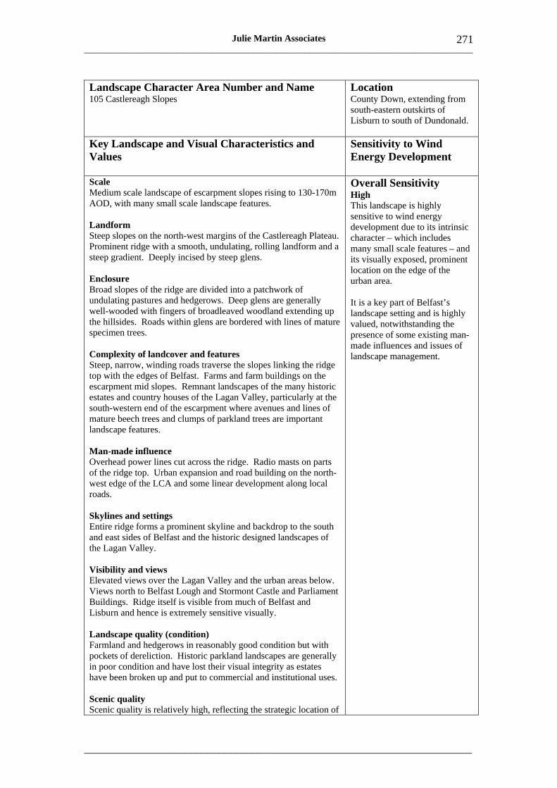
___________________________________________________________________________________
_____________________________________________________________________
271 Julie Martin Associates
Landscape Character Area Number and Name 105 Castlereagh Slopes
Location County Down, extending from south-eastern outskirts of Lisburn to south of Dundonald.
Key Landscape and Visual Characteristics and Values
Sensitivity to Wind Energy Development
Scale Medium scale landscape of escarpment slopes rising to 130-170m AOD, with many small scale landscape features.
Landform Steep slopes on the north-west margins of the Castlereagh Plateau. Prominent ridge with a smooth, undulating, rolling landform and a steep gradient. Deeply incised by steep glens.
Enclosure Broad slopes of the ridge are divided into a patchwork of undulating pastures and hedgerows. Deep glens are generally well-wooded with fingers of broadleaved woodland extending up the hillsides. Roads within glens are bordered with lines of mature specimen trees.
Complexity of landcover and features Steep, narrow, winding roads traverse the slopes linking the ridge top with the edges of Belfast. Farms and farm buildings on the escarpment mid slopes. Remnant landscapes of the many historic estates and country houses of the Lagan Valley, particularly at the south-western end of the escarpment where avenues and lines of mature beech trees and clumps of parkland trees are important landscape features.
Man-made influence Overhead power lines cut across the ridge. Radio masts on parts of the ridge top. Urban expansion and road building on the northwest edge of the LCA and some linear development along local roads.
Skylines and settings Entire ridge forms a prominent skyline and backdrop to the south and east sides of Belfast and the historic designed landscapes of the Lagan Valley.
Visibility and views Elevated views over the Lagan Valley and the urban areas below. Views north to Belfast Lough and Stormont Castle and Parliament Buildings. Ridge itself is visible from much of Belfast and Lisburn and hence is extremely sensitive visually.
Landscape quality (condition) Farmland and hedgerows in reasonably good condition but with pockets of dereliction. Historic parkland landscapes are generally in poor condition and have lost their visual integrity as estates have been broken up and put to commercial and institutional uses.
Scenic quality Scenic quality is relatively high, reflecting the strategic location of
Overall Sensitivity High This landscape is highly sensitive to wind energy development due to its intrinsic character – which includes many small scale features – and its visually exposed, prominent location on the edge of the urban area.
It is a key part of Belfast’s landscape setting and is highly valued, notwithstanding the presence of some existing man-made influences and issues of landscape management.
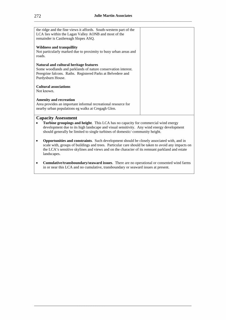
___________________________________________________________________________________
_____________________________________________________________________
272 Julie Martin Associates
the ridge and the fine views it affords. South-western part of the LCA lies within the Lagan Valley AONB and most of the remainder is Castlereagh Slopes ASQ.
Wildness and tranquillity Not particularly marked due to proximity to busy urban areas and roads.
Natural and cultural heritage features Some woodlands and parklands of nature conservation interest. Peregrine falcons. Raths. Registered Parks at Belvedere and Purdysburn House.
Cultural associations Not known.
Amenity and recreation Area provides an important informal recreational resource for nearby urban populations eg walks at Cregagh Glen.
Capacity Assessment • Turbine groupings and height. This LCA has no capacity for commercial wind energy
development due to its high landscape and visual sensitivity. Any wind energy development should generally be limited to single turbines of domestic/ community height.
• Opportunities and constraints. Such development should be closely associated with, and in scale with, groups of buildings and trees. Particular care should be taken to avoid any impacts on the LCA’s sensitive skylines and views and on the character of its remnant parkland and estate landscapes.
• Cumulative/transboundary/seaward issues. There are no operational or consented wind farms in or near this LCA and no cumulative, transboundary or seaward issues at present.

___________________________________________________________________________________
_____________________________________________________________________
273 Julie Martin Associates
Landscape Character Area Number and Name 106 Lagan Parkland
Location Counties Antrim and Down. South of Belfast on the edge of the urban area.
Key Landscape and Visual Characteristics and Values
Sensitivity to Wind Energy Development
Scale Overall Sensitivity Small scale landscape centred on the deep, narrow valley of the HighRiver Lagan south of Belfast. Generally low-lying, under 50m This small LCA is inherently AOD. highly sensitive to wind energy
development due to the Landform landscape’s small scale and Undulating steep slopes of the narrow river valley. Flatter land on complexity. the upper fringes of the river valley including, rolling landscape of estate farmlands to the south. Sensitivity is heightened by its
role as the southern setting for Enclosure the city, and the fact that it is a An amenity parkland landscape set within the historic designed highly valued scenic, heritage landscapes of a series of eighteenth and nineteenth century estates. and recreational asset for the Valley slopes are well-wooded, with dense hedgerows and mature adjacent urban areas. trees. Winding linear woodlands follow the local streams, particularly close to the foot of the Castlereagh slopes. More open landscape of golf courses, public open spaces and playing fields dominates flatter land.
Complexity of landcover and features Variety of formal designed landscapes, commercial forests and natural habitats. Important stands of mature beech and oak. River corridor is characterised by its early industrial heritage reflected in surviving mill buildings, disused canal and numerous minor artefacts along the canal towpath.
Man-made influence Urban edges enclose the area. Some impacts from incremental housing and infrastructure development. Transmission lines in southern part of LCA and some ridgetop communications masts. Golf courses and playing fields have a suburbanising influence.
Skylines and settings LCA is strongly influenced by Castlereagh Slopes (LCA 105) which forms its south-eastern skyline and setting. LCA as a whole is an invaluable part of the southern setting of the city of Belfast. Immediate valley slopes are particularly vulnerable to change visually.
Visibility and views Locally fine views from the valley to surrounding hills and into the valley floor.
Landscape quality (condition) Much of the area is under active management, eg by the National Trust, as amenity parkland. Recreation pressures and vandalism evident in parts. Farmland landscape to the south is in relatively good condition although there is a need for woodland management.

___________________________________________________________________________________
_____________________________________________________________________
274 Julie Martin Associates
Scenic quality High scenic quality. Part of Lagan Valley AONB.
Wildness and tranquillity The riverbank scenery, meadows, woods and the pleasant pastoral land of the Lagan valley make this a peaceful haven. Linked series of wooded spaces within the deep river valley seems remote from its immediate urban surroundings.
Natural and cultural heritage features Some woodland and wetland habitats of interest. Rich cultural heritage, associated not only with impressive monuments such as the Giant's Ring (ASAI), early Christian raths and mottes on the riverbank at Belvoir and Edenderry, and remnants of fine estates, but also important industrial archaeology related to linen production and the old Lagan Canal and its towpath. Registered Parks at Belvoir, Malone House (Barnett Demesne), Wilmont (Sir Thomas and Lady Dixon Park) and Ballydrain (Malone Golf Club)
Cultural associations Many associations related to both the area’s demesnes and industrial heritage.
Amenity and recreation Easy access to countryside for a large urban population. Many parks including Belvoir Forest Park, Barnett Demesne, Sir Thomas and Lady Dixon Park. Lagan towpath. National Trust land at Minnowburn Beeches.
Capacity Assessment • Turbine groupings and height. This LCA has no capacity for commercial wind energy
development due to its high landscape sensitivity. Any wind energy development should generally be limited to single turbines of domestic/community height.
• Opportunities and constraints. Such development should be closely associated with, and in scale with, groups of buildings and trees. Particular care should be taken to avoid impacts on heritage and recreational landscape features, as above.
• Cumulative/transboundary/seaward issues. There are no operational or consented wind farms in or near this LCA and no cumulative, transboundary or seaward issues at present.
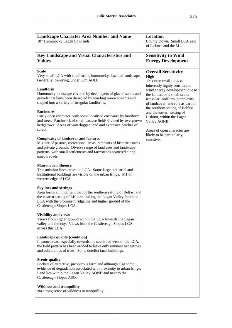
___________________________________________________________________________________
_____________________________________________________________________
275 Julie Martin Associates
Landscape Character Area Number and Name 107 Hummocky Lagan Lowlands
Location County Down. Small LCA east of Lisburn and the M1.
Key Landscape and Visual Characteristics and Values
Sensitivity to Wind Energy Development
Scale Very small LCA with small scale, hummocky, lowland landscape. Generally low-lying, under 50m AOD.
Landform Hummocky landscape covered by deep layers of glacial sands and gravels that have been dissected by winding minor streams and shaped into a variety of irregular landforms.
Enclosure Fairly open character, with some localised enclosure by landform and trees. Patchwork of small pasture fields divided by overgrown hedgerows. Areas of waterlogged land and extensive patches of scrub.
Complexity of landcover and features Mixture of pasture, recreational areas, remnants of historic estates and private grounds. Diverse range of land uses and landscape patterns, with small settlements and farmsteads scattered along narrow roads.
Man-made influence Transmission lines cross the LCA. Some large industrial and institutional buildings are visible on the urban fringe. M1 on western edge of LCA.
Skylines and settings Area forms an important part of the southern setting of Belfast and the eastern setting of Lisburn, linking the Lagan Valley Parkland LCA with the prominent ridgeline and higher ground of the Castlereagh Slopes LCA.
Visibility and views Views from higher ground within the LCA towards the Lagan valley and the city. Views from the Castlereagh Slopes LCA across this LCA.
Landscape quality (condition) In some areas, especially towards the south and west of the LCA, the field pattern has been eroded to leave only remnant hedgerows and odd clumps of trees. Some derelict farm buildings.
Scenic quality Pockets of attractive, prosperous farmland although also some evidence of degradation associated with proximity to urban fringe. Land lies within the Lagan Valley AONB and next to the Castlereagh Slopes ASQ.
Wildness and tranquillity No strong sense of wildness or tranquillity.
Overall Sensitivity High This very small LCA is inherently highly sensitive to wind energy development due to the landscape’s small scale, irregular landform, complexity of landcover, and role as part of the southern setting of Belfast and the eastern setting of Lisburn, within the Lagan Valley AONB.
Areas of open character are likely to be particularly sensitive.

___________________________________________________________________________________
_____________________________________________________________________
276 Julie Martin Associates
Natural and cultural heritage features Some woodland, parkland and wetland habitats of local interest.
Cultural associations Not known.
Amenity and recreation Limited opportunities.
Capacity Assessment • Turbine groupings and height. This very small LCA has no capacity for commercial wind
energy development, reflecting its high landscape sensitivity. Even single turbines of domestic/community height could be difficult to accommodate given the irregular landform, generally open character and presence of transmission lines.
• Opportunities and constraints. There may be some very limited opportunities for domestic wind energy development associated with farmsteads.
• Cumulative/transboundary/seaward issues. There are no operational or consented wind farms in or near this LCA and no cumulative, transboundary or seaward issues at present.
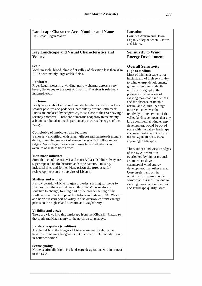
___________________________________________________________________________________
_____________________________________________________________________
277 Julie Martin Associates
Landscape Character Area Number and Name 108 Broad Lagan Valley
Location Counties Antrim and Down. Lagan Valley between Lisburn and Moira.
Key Landscape and Visual Characteristics and Values
Sensitivity to Wind Energy Development
Scale Medium scale, broad, almost flat valley of elevation less than 40m AOD, with mainly large arable fields.
Landform River Lagan flows in a winding, narrow channel across a very broad, flat valley to the west of Lisburn. The river is relatively inconspicuous.
Enclosure Fairly large arable fields predominate, but there are also pockets of smaller pastures and paddocks, particularly around settlements. Fields are enclosed by hedgerows, those close to the river having a scrubby character. There are numerous hedgerow trees, mainly ash and oak but also beech, particularly towards the edges of the valley.
Complexity of landcover and features Valley is well-settled, with linear villages and farmsteads along a dense, branching network of narrow lanes which follow minor ridges. Some larger houses and farms have shelterbelts and avenues of mature beech trees.
Man-made influence Smooth lines of the A3, M1 and main Belfast-Dublin railway are superimposed on the historic landscape pattern. Housing, industrial sites and former Maze prison site (proposed for redevelopment) on the outskirts of Lisburn.
Skylines and settings Narrow corridor of River Lagan provides a setting for views to Lisburn from the west. Area south of the M1 is relatively sensitive to change, forming part of the broader setting of the shallow escarpment slope of the Kilwarlin Plateau LCA. Western and north-western part of valley is also overlooked from vantage points on the higher land at Moira and Maghaberry.
Overall Sensitivity High to medium Most of this landscape is not intrinsically of high sensitivity to wind energy development, given its medium scale, flat, uniform topography, the presence in some areas of existing man-made influences, and the absence of notable natural and cultural heritage interests. However the relatively limited extent of the valley landscape means that any large commercial wind energy development would be out of scale with the valley landscape and would intrude not only on the valley itself but also on adjoining landscapes.
The southern and western edges of the LCA, where it is overlooked by higher ground, are more sensitive to commercial wind energy development than other areas. Conversely, land on the outskirts of Lisburn may be somewhat less sensitive due to existing man-made influences and landscape quality issues.
Visibility and views There are views into this landscape from the Kilwarlin Plateau to the south and Maghaberry to the north-west, as above.
Landscape quality (condition) Arable fields on the fringes of Lisburn are much enlarged and have few remaining hedgerows but elsewhere field boundaries are in better condition.
Scenic quality Not exceptionally high. No landscape designations within or near to the LCA.
___________________________________________________________________________________
_____________________________________________________________________
278 Julie Martin Associates
Wildness and tranquillity Not exceptionally high. Influence of transport corridors.
Natural and cultural heritage features Small areas of wet woodland. Damp grasslands along the River Lagan support wader populations. Few other features of note.
Cultural associations Not known.
Amenity and recreation Few features of note.
Capacity Assessment • Turbine groupings. There is very limited scope for commercial wind energy development in
this LCA in landscape and visual terms. However single or small group development may be acceptable if very carefully sited.
• Turbine height. Turbine heights should generally be domestic/community or, exceptionally, small, reflecting the small extent of the LCA, its low-lying landform character and the proximity of areas of higher ground.
• Opportunities and constraints. Those parts of the LCA that are dominated by large arable fields (especially where field boundaries are in poor condition) or have existing man-made influences, for example brownfield land on the outskirts of Lisburn, may be better suited to such wind energy development than other areas. Care should be taken to avoid undue intrusion on the skylines, settings and views outlined above. Views from the M1 and the mainline railway should also be carefully considered. Siting of turbines where they would be seen in the context of the Belfast Hills when approaching Belfast would be unacceptable.
• Domestic/community turbines. Domestic and community wind energy development should be closely associated with buildings and tree groups, avoiding the area’s more open landscapes.
• Cumulative/transboundary/seaward issues. There are no operational or consented wind farms in or near this LCA, and no cumulative, transboundary or seaward issues at present.
• Thresholds. The LCA is unlikely to be able to accommodate more than one small group of community or small commercial turbines.
___________________________________________________________________________________
_____________________________________________________________________
279 Julie Martin Associates
Landscape Character Area Number and Name 109 Upper Ballinderry Plateau
Location Counties Armagh, Down and Antrim. A linear area extending from the outskirts of Lurgan to near Templepatrick.
Key Landscape and Visual Characteristics and Values
Sensitivity to Wind Energy Development
Scale Undulating farmed landscape rising to around 100m in the south and 150m AOD in the north. Medium scale in terms of topography but with many smaller scale landscape features.
Landform A rolling farmland landscape on the southern and western fringes of Derrykillultagh, which in turn fringes the Belfast Hills LCA. Steep escarpments on the southern margin of the plateau overlooking the Lagan, Friars Glen and Donaghcloney valleys.
Enclosure Views are generally short or contained by avenue, roadside or hedgerow planting. There are numerous hedgerow trees and a consistent patchwork, geometric pattern of medium to large fields and smaller paddocks on settlement edges. Fields tend to be larger in the south, near Lurgan. Some valley-side woodlands, eg Friars Glen.
Complexity of landcover and features A relatively prosperous farmland landscape with fairly large farms and many estates. Settlements are nucleated, often with grand avenues and stands of beech trees and prominent church spires.
Man-made influence Large scale developments such as a prison, poultry farms and factories affect some areas, particularly in the south eg north of Maghaberry. M1 motorway and Belfast-Dublin railway in the area near Lurgan.
Overall Sensitivity High to medium This landscape is of medium scale with relatively few important settings or views and a pattern of large farms, estates and nucleated settlements. Although its condition is generally good, it is not of special scenic quality and has few significant natural or cultural features. All these factors tend to reduce its sensitivity to wind energy development. However the presence of small scale designed landscape features tends to heighten sensitivity, as does the settled character of the landscape.
The southern escarpments and ridges are the most sensitive parts of this landscape; sensitivity may be somewhat lower away from these areas.
Skylines and settings The southern escarpments and the ridges north-east of Ballinderry around White Mountain form skylines. Settings of the ridgetop settlement and castle of Moira, and of the smaller settlements of Ballinderry and Glenavy, are important in landscape terms.
Visibility and views Glimpsed views of large farmsteads and country houses are important local landmarks. Few longer views except from the southern escarpments. Landscape is seen rising above Lough Neagh in some distant views from the west.
Landscape quality (condition) Farmland is generally in good condition, particularly where in estate ownership.
Scenic quality Pleasant rural landscape but with few special scenic qualities.
___________________________________________________________________________________
_____________________________________________________________________
280 Julie Martin Associates
Wildness and tranquillity Not wild but relatively isolated and tranquil over most of its area.
Natural and cultural heritage features Some demesne woodland, wet woodland and meadow habitats of interest eg Ballynanaghten ASSI. A scattering of historic monuments. Moira Castle Registered Park and Moira Conservation Area.
Cultural associations Not known.
Amenity and recreation No particular interests of note except for towpath walks at Broad Water, Moira, where old canal corridor to Lough Neagh is of local nature conservation and historic interest.
Capacity Assessment • Turbine groupings. This LCA may have some limited scope for commercial wind energy
development up to the size of a small group of turbines or small wind farm if very carefully sited.
• Turbine height. Turbines up to small or, exceptionally, medium height may be acceptable in appropriate locations.
• Opportunities and constraints. Those parts of the LCA affected by existing large scale developments are best suited to such commercial wind energy development. Care should be taken to avoid any undue intrusion on the skylines, settings and views outlined above. Views from the M1, the mainline railway and Lough Neagh should also be carefully considered. Turbines should be sited away from small scale, designed landscape features that may accentuate their scale.
• Domestic/community turbines. Domestic and community wind energy development should be closely associated with buildings and tree groups, avoiding open ridges, skylines and settings.
• Cumulative/transboundary/seaward issues. There are no operational or consented wind farms in this LCA at present, and no cumulative, transboundary or seaward issues. The nearest existing wind farm is at Elliots Hill, around 14km to the north.
• Thresholds. The LCA is unlikely to be able to accommodate more than one small group of turbines or small wind farm. Adequate separation distances from any commercial wind energy development in adjoining LCAs (particularly LCA 110 Derrykillultagh and LCA 113 Expansive Crumlin Farmland) will be important.

___________________________________________________________________________________
_____________________________________________________________________
281 Julie Martin Associates
Landscape Character Area Number and Name 110 Derrykillultagh
Location County Antrim. Area ringing western edge of Belfast Hills.
Key Landscape and Visual Characteristics and Values
Sensitivity to Wind Energy Development
Scale Medium scale, rolling, elevated farmland rising to around 250m AOD on the western edge of the Belfast Hills (which in turn rise to 478m AOD at Divis). Some small scale features, particularly in more settled parts of the LCA to the west and south.
Landform Rounded hills and generally shallow slopes with some gullies. Southern boundary of the LCA is marked by a steeper escarpment slope. Many slopes divided by straight, narrow glens. Plateau descends gently to the west.
Enclosure Open moorland character on the highest ground in the northern part of the LCA. Elsewhere, small marginal fields and paddocks on the valley sides with a disconnected pattern of gorse and holly hedges. Lines and stands of mature trees associated with older farmsteads. Gradual transition to a landscape of larger fields, hedgerow trees and more prosperous farmland on the lower, western plateau margins.
Complexity of landcover and features Farmland landscape often has a relatively untidy character with patches of gorse and scrub. Shallow valleys contain areas of marsh and rushes. Small white-rendered farms and smallholdings with scattered barns are sited on mid-slopes or local ridges and connected to roads by straight tracks. Network of straight roads follows the ridges.
Man-made influence Generally limited apart from some modern bungalows and linear development. Several water supply reservoirs, the largest of which is Stoneyford, west of White Mountain. Electricity transmission lines.
Skylines and settings Southern slopes form part of the wider northern landscape setting of Lisburn and include attractive small scale landscape features such as the deep wooded valley at Lagmore and the small valley by Duncan’s Park.
Visibility and views Outstanding views over Belfast from the lower slopes of White Mountain, and views back to this area from Lisburn. Long views of the western parts of the area from roads between Antrim/ Crumlin and Belfast/ Lisburn, the area forming the lower foreground slopes of the Belfast Hills. Landscape is also seen rising above Lough Neagh in some distant views from the west.
Landscape quality (condition) Parts of the LCA have many derelict buildings and patches of
Overall Sensitivity High to medium This medium scale, rolling, elevated landscape is in theory suited to wind energy development, at least in some areas, due to its rounded landform, marginal character, sparse settlement, relatively low visual prominence and limited scenic and heritage value.
These qualities prevail particularly in the northern parts of the LCA, which is visually in the lee of the Belfast Hills when viewed from Belfast and Lisburn. Its southern half is generally much more sensitive in terms of both scale and visibility.
___________________________________________________________________________________
_____________________________________________________________________
282 Julie Martin Associates
waste ground, particularly on the higher ground to the east where farmland is of poorer quality. Evidence of hedgerow removal affecting field patterns.
Scenic quality Not particularly high except in localised areas such as the slopes and wooded valleys north of Lisburn.
Wildness and tranquillity A relatively wild landscape on higher ground, particularly to the north, which is also more sparsely settled.
Natural and cultural heritage features Some important grassland habitats eg ASSI at Leathemstown. NR at Belshaw’s Quarry. Scattering of ancient monuments, principally raths, across the LCA.
Cultural associations Not known.
Amenity and recreation Few formal recreational opportunities, but area provides some informal countryside access, particularly for residents of Lisburn.
Capacity Assessment • Turbine groupings. This LCA has some capacity to accommodate wind farm development of
small or medium size.
• Turbine height. Turbine heights up to medium or even large may be acceptable in appropriate locations.
• Opportunities and constraints. The northern parts of the LCA, where landscape scale is larger and where topography affords some screening in views from Belfast and Lisburn, may be best suited to wind farm development. Development on the southern edge of the LCA, which would be less in keeping with landscape character and more widely visible, is unlikely to be unacceptable in landscape and visual terms. Care should be taken to avoid any undue intrusion on the skylines, settings and views outlined above and to site turbines away from any small scale landform and landcover features that might accentuate their scale. Siting of turbines where they will be seen in close proximity to electricity transmission lines should also be avoided. Any significant impact on views of the Belfast Hills from the south, south-east and east (notably from the escarpments at Castlereagh and Craigantlet) would be unacceptable (notwithstanding the viewing distance), as it would affect the wider setting of Belfast city.
• Domestic/community turbines. Domestic and community wind energy development should be closely associated with buildings and tree groups, avoiding open ridges, skylines and settings.
• Cumulative/transboundary/seaward issues. There are no operational or consented wind farms in this LCA, and no cumulative, transboundary or seaward issues at present. The nearest existing wind farm is at Elliots Hill, around 13km to the north.
• Thresholds. The LCA is unlikely to be able to accommodate more than one medium or two small, well separated wind farms. Adequate separation distances from any commercial wind energy development in nearby LCAs 109 Upper Ballinderry Plateau and 113 Expansive Crumlin Farmland will be important.
___________________________________________________________________________________
_____________________________________________________________________
283 Julie Martin Associates
Landscape Character Area Number and Name 111 Divis Summits
Location County Antrim. High summits of the Belfast Hills.
Key Landscape and Visual Characteristics and Values
Sensitivity to Wind Energy Development
Scale A large scale landscape of broad rounded summits rising to 478m AOD at Divis.
Landform The principal summits of Black Mountains, Squires Hill and Cave Hill reach around 400m, while Divis is higher. The summits generally have gentle slopes, with some gullies and abrupt steep slopes in places. Along the edge of the basalt plateau above Belfast there are much steeper slopes.
Enclosure A relatively open landscape with extensive areas of windswept, often waterlogged, moss and rough farmland on the plateau top. Valley slopes have a more farmed character, with straight, overgrown hedgerows and belts of mature trees. Farmsteads are often sheltered by trees and reached by straight tracks, sometimes embanked.
Complexity of landcover and features Landscape has a rather irregular, patchy pattern, with areas of scrub and wasteland, often associated with abandoned mineral workings, derelict farmsteads and areas of waterlogged or unfarmed land.
Man-made influence Hard rock quarrying was once widespread across this LCA. Radio masts are situated on the highest summits and are prominent in views from surrounding areas. Transmission lines cross the ridge between Divis and Cave Hill.
Overall Sensitivity High The Belfast Hills, of which this LCA forms the summits, is intrinsically the most sensitive of all the upland and escarpment landscapes around Belfast because of their iconic character. Each individual summit is a landmark in its own right and together the summits have a strong influence on the settings of almost all parts of the city as well as Lisburn, Newtownabbey and Belfast Lough. Although there have been issues of intrusion and poor landscape quality in the past, these are now being addressed.
Any commercial wind energy development on these summits would not only fundamentally alter their landscape character but would also be very widely visible indeed. The scenic, natural, cultural and recreational values associated with this LCA further heighten its sensitivity.
Skylines and settings Divis Summits form a dramatic and widely visible backdrop to the city of Belfast and are one of Northern Ireland’s most important landmarks. The south, west and north facing ridges around the edges of the hills, although less dramatic in shape, also form prominent skylines seen over wide areas.
Visibility and views The breathtaking views from the summits stretch across and beyond the city itself. The Mourne Mountains, Strangford and Belfast Loughs, the Castlereagh and Holywood Hills and the Sperrins are all visible.
Landscape quality (condition) Landscape often in poor condition, particularly in areas with a history of mineral extraction. Evidence of hedgerow removal. Much abandoned farmland and widespread fly-tipping. However, marked improvements in recent years, particularly with the acquisition and management of land at Divis and Black Mountain by the National Trust.
___________________________________________________________________________________
_____________________________________________________________________
284 Julie Martin Associates
Scenic quality The eastern slopes of the area have been identified as part of the Belfast Basalt Escarpment ASQ reflecting their unique character and the spectacular views that they afford.
Wildness and tranquillity The area has a strong sense of wildness in areas where there are no major intrusive influences. This wild character is of particular importance because of its rarity and accessibility to urban populations . Natural and cultural heritage features Species-rich grassland ASSIs at Leathemstown and Slievenacloy, the latter an Ulster Wildlife Trust reserve. National Trust land at Divis is of considerable biodiversity significance for its upland vegetation and birds and is under consideration for ASSI designation. Important archaeological remains including megalithic tombs, Bronze Age burial cairns, hut sites and walled enclosures at Divis and Cave Hill.
Cultural associations Many important historical and cultural associations.
Amenity and recreation Public access to National Trust land at Divis and Black Mountain. Section of the Ulster Way. Variety of walks and trails on Divis, Black Mountain and to the south at the Stoneyford River and Slievenacloy. Walks from Belfast Castle to the viewpoint on Cave Hill.
Capacity Assessment • Turbine groupings and height. This LCA has no capacity for commercial wind energy
development due to its very high landscape and visual sensitivity. Even community scale turbines would be inappropriate in this highly prominent location. Any wind energy development should therefore be limited to single domestic turbines.
• Opportunities and constraints. Turbines should be closely associated with groups of buildings and trees. Particular care should be taken to avoid any impacts on the LCA’s sensitive skylines and views and on its range of natural, cultural and recreational interests.
• Cumulative/transboundary/seaward issues. There are no operational or consented wind farms in this LCA and no cumulative, transboundary or seaward issues at present. The nearest existing wind farm is at Elliots Hill, around 15km to the north.
___________________________________________________________________________________
_____________________________________________________________________
285 Julie Martin Associates
Landscape Character Area Number and Name 112 Belfast Basalt Escarpment
Location County Antrim. Slopes and cliffs below the Divis Summits north-west of Belfast.
Key Landscape and Visual Characteristics and Values
Sensitivity to Wind Energy Development
Scale Large scale cliffs with a stepped profile towering above the northern and western edge of Belfast. Land up to around 250m AOD lies within the LCA. Small scale patchwork of improved pasture with scrub encroachment.
Landform Edge of the Antrim plateau, well-defined by a steep scarp slope towering above the city of Belfast. Black basalt cliffs and outcrops with a distinctive, sheer profile, broken by a series of steep, wooded glens. Thin band of contrasting chalk below.
Enclosure A fairly open landscape except within the glens which include, in the west, the steep wooded landscapes of Colin Glen Forest Park; and in the north the designed landscape of Belfast Castle.
Complexity of landcover and features The lower escarpment slopes are a mixture of hummocky open pasture, gappy hedgerows, and stands of deciduous trees on steeper slopes. Extensive areas of regenerating scrub and gorse. Narrow roads providing steep links between the ridgetop road and Belfast, winding up the basalt edge.
Man-made influence Prominent, abandoned quarries and associated fly tipping affect landscape character and quality. Electricity transmission lines along the contour in the central section of the LCA.
Skylines and settings Open, highly prominent skyline all along the escarpment edge.
Visibility and views Basalt edge, like Divis Summits, provides the opportunity for panoramic views over the city of Belfast and south to Strangford Lough and the Mournes.
Landscape quality (condition) Somewhat degraded when seen at close quarters du to neglect and loss of field boundaries, dereliction and fly tipping. These issues are now being tackled by the Belfast Hills Partnership and others.
Scenic quality Despite localised issues of intrusion and landscape quality, the open, landmark character, distinctive profile and stunning views from the escarpment have justified the area’s inclusion in the Belfast Basalt Escarpment ASQ.
Wildness and tranquillity Rugged, brutal character in dramatic contrast to the dense urban
Overall Sensitivity High This prominent edge is part of Belfast Hills, intrinsically the most sensitive of all the upland and escarpment landscapes around Belfast due to their iconic character. The escarpment, with its distinctive profile, has a strong influence on the settings of Belfast and Belfast Lough, despite localised issues of intrusion and poor landscape quality.
Any commercial wind energy development would not only be difficult in practical terms, but would fundamentally alter the character of the escarpment and be visible over a very wide area. The scenic, natural, cultural and recreational values associated with the LCA further heighten its sensitivity.
___________________________________________________________________________________
_____________________________________________________________________
286 Julie Martin Associates
areas below. Strong sense of wildness in exposed areas, particularly where there are no notable intrusive influences.
Natural and cultural heritage features Species-rich grassland ASSI at Slievenacloy, an Ulster Wildlife Trust reserve. Peregrine falcons. Important archaeological remains eg McArt’s Fort on Cave Hill. Registered Parks at Belfast Castle and Bellevue.
Cultural associations Many important historical and cultural associations.
Amenity and recreation Walks around Slievenacloy. Colin Glen Forest Park. Section of the Ulster Way. Belfast Castle, Cave Hill Country Park and Belfast City Zoo. Walks from Belfast Castle to the viewpoint on Cave Hill.
Capacity Assessment • Turbine groupings and height. This LCA has no capacity for commercial wind energy
development due to its very high landscape and visual sensitivity. Even community scale turbines would be inappropriate in this highly prominent location. Any wind energy development should therefore be limited to single domestic turbines.
• Opportunities and constraints. Domestic turbines should be closely associated with groups of buildings and trees. Particular care should be taken to avoid any impacts on the LCA’s sensitive skylines and views and on its range of natural, cultural and recreational interests.
• Cumulative/transboundary/seaward issues. There are no operational or consented wind farms in this LCA and no cumulative, transboundary or seaward issues at present.
___________________________________________________________________________________
_____________________________________________________________________
287 Julie Martin Associates
Landscape Character Area Number and Name 113 Expansive Crumlin Farmland
Location County Antrim. Land south of Antrim around Belfast International Airport and Crumlin.
Key Landscape and Visual Characteristics and Values
Sensitivity to Wind Energy Development
Scale Expansive farmland sloping gently towards Crumlin and Lough Neagh. Highest ground, in the east, is around 150m AOD.
Landform Relatively flat areas underlain by Upper Basalt formation. Land slopes gently from the lower slopes of he Belfast Hills to the fringes of Lough Neagh in the west. Drained by Clady Water and the Dunmore and Crumlin Rivers but these rivers, whose valleys are generally inconspicuous in the landscape.
Enclosure An extensive network of overgrown hedges, hedgerow trees and shelterbelts gives the area a well treed character in parts but overall it appears flat and relatively open. Pastures are large and simple in shape. Town of Crumlin is divided by the steep wooded valley of the Crumlin River.
Complexity of landcover and features Ordered, simple landscape pattern. Scattered farms and small villages form the main settlements. Farms are relatively large and well-spaced, typically sited at the ends of straight tracks some distance from the road. More recent housing tends to be sited alongside the road.
Man-made influence Airfields occupy the flattest land at Nutt’s Corner (former civil airfield, now disused) and Aldergrove. Many straight roads cutting across the landscape.
Skylines and settings No prominent skylines although the Belfast Hills form a gentle backdrop to the area, and the LCA forms part of the wider setting of Lough Neagh. Crumlin Glen provides an attractive setting to the compact town of Crumlin.
Visibility and views Occasional views north to the Six Mile Water valley and Antrim Glens from the northern part of the LCA. Otherwise few notable views either into or out of the area, although for many visitors to Northern Ireland arriving at Belfast International Airport, this landscape will be their entry point.
Landscape quality (condition) The agricultural landscape is in reasonable condition although hedgerow trees are overmature and hedgerows in need of management. Disused airfield affects scale and structure of the landscape.
Overall Sensitivity Medium This landscape is of large to medium scale. Its simple, open, horizontal composition and the presence of existing man-made influences tend to reduce its sensitivity to commercial wind energy development, as do its relatively sparse settlement, lack of important settings or views, and lack of significant natural or cultural features.
Sensitivity is lowest on the southern fringes of the LCA where the former airfield has led to landscape degradation and where turbines would be backclothed against the western slopes of the Belfast Hills.
___________________________________________________________________________________
_____________________________________________________________________
288 Julie Martin Associates
Scenic quality No special scenic quality except in localised pockets such as Crumlin Glen.
Wildness and tranquillity Neither wild nor tranquil given proximity to airport.
Natural and cultural heritage features Broad scatter of monuments including standing stones, raths and churches. Registered Park at Glendarragh (Crumlin Glen).
Cultural associations Not known.
Amenity and recreation Crumlin Glen and Woodland Park is the only formal recreational opportunity.
Capacity Assessment • Turbine groupings. Due to its relatively large scale, simple horizontal composition and lack of
other notable landscape sensitivities, this LCA has some limited capacity for a small or medium wind farm.
• Turbine height. Wind turbines up to medium height may be accommodated in an appropriate location.
• Opportunities and constraints. The southern part of the LCA, where the former airfield has led to landscape degradation and where any wind farm would be backclothed against the western slopes of the Belfast Hills, is most likely to be suited to wind energy development. Care should be taken to avoid any undue intrusion on the settings of Lough Neagh and Crumlin, and turbines should be sited away from any small scale landform and landcover features that might accentuate their scale. Special attention should be paid to the potential visual impact on residents of Crumlin and visitors arriving in Northern Ireland via Belfast International Airport. Aviation constraints will also need to be considered.
• Domestic/community turbines. Domestic and community scale wind energy development should be closely associated with buildings and tree groups, avoiding open skylines and settings.
• Cumulative/transboundary/seaward issues. There are no operational or consented wind farms in this LCA at present, and no cumulative, transboundary or seaward issues at present. The nearest existing wind farm is at Elliots Hill, around 13km to the north.
• Thresholds. The LCA is unlikely to be able to accommodate more than one medium wind farm. Adequate separation distances from any commercial wind energy development in nearby LCAs 109 Upper Ballinderry Plateau and 110 Derrykillultagh will be important.
___________________________________________________________________________________
_____________________________________________________________________
289 Julie Martin Associates
Landscape Character Area Number and Name 114 Three and Six Mile Water Valleys
Location County Antrim. Corridor between Newtownabbey and Antrim.
Key Landscape and Visual Characteristics and Values
Sensitivity to Wind Energy Development
Scale Mixed scales – large scale rolling pastoral landscape rising to 231m AOD on Carnmoney Hill, with more intimate valley floor field pattern near Newtownabbey.
Landform Gently rolling ridges within broad lowland valleys. Some hills are more prominent than others and may have a rugged character.
Enclosure Valley floor has a secluded character due to a high concentration of trees, while skylines and ridgelines are open. There are few woodland blocks in this LCA.
Complexity of landcover and features Large pastures divided by overgrown hedgerows. Densely settled with large farms and key settlements including Antrim, Templepatrick, Doagh, Ballyclare and Newtownabbey.
Man-made influence Urban fringe influences and characteristics lead to a landscape that often lacks visual cohesion. Significant transport corridor containing M2, A6 and A57 as well as railway line and pylons. Widespread large scale industrial development scattered throughout the valleys and especially on outskirts of Newtownabbey and Antrim. Occasional areas of quarrying and landfill.
Skylines and settings Carnmoney Hill is a prominent outlier of the Belfast basalt escarpment which forms a landmark for Newtownabbey. This LCA provides an important gateway and approach to Belfast (from the north-west and from Belfast International Airport and the port of Larne); and the eastern part of the LCA forms the setting to the historic settlements of Ballyclare and Doagh The Registered Parks and estate landscape which are scattered through this area also form important settings to adjacent settlements.
Visibility and views Long views south-east from the M2 along the Three Mile Water valley to the town of Newtownabbey and to Belfast Lough. Also long views from narrow roads lining settlements on the lower valley slopes. The LCA is overlooked from surrounding higher land.
Landscape quality (condition) Generally poor due to incomplete hedgerow network and decline in mature trees. Valley floor between Antrim and
Overall Sensitivity High to medium Although the often degraded quality of this landscape makes it less sensitive to commercial wind energy development, the extent of the long views across the area, the area’s role as a gateway to Belfast, and the fact that it is overlooked by adjacent higher land all increase its sensitivity.
In addition, the general lack of visual coherence makes it difficult to identify areas for wind energy development in this landscape without creating further visual confusion. There are many scale comparators in this landscape and commercial turbines would tend to dwarf existing built structures which are widespread.
___________________________________________________________________________________
_____________________________________________________________________
290 Julie Martin Associates
Templepatrick has richer character and higher quality, and contains some intact glaciofluvial features. Some areas have a more wooded and managed appearance where there are estates.
Scenic quality Much of this area has no special scenic quality but Carnmoney Hill has been identified as an ASQ.
Wildness and tranquillity This landscape is not wild but there are pockets of tranquillity in the valley landscapes away from major transport infrastructure and development.
Natural and cultural heritage features Intact glaciofluvial topography (part of the Six Mile Water complex) in the river valleys. There is only one ASSI in this LCA at Ballypalady, designated for its palaeoenvironmental value. Whooper swans, pale-bellied Brent geese, arctic terns in vicinity of Belfast Lough. Peregrine falcons. Scattering of archaeological sites. Registered Parks are significant in this landscape and include The Steeple, Greenmount. Loughmore, Castleupton and Holestone House. Merville Garden Village and Antrim town centre are Conservation Areas.
Cultural associations Not known.
Amenity and recreation Riverside walks at Antrim.
Capacity Assessment • Turbine groupings. This LCA has some limited capacity to accommodate commercial wind
energy development up to the size of a small group of turbines or small wind farm.
• Turbine height. Turbine heights may need to be smaller than commercial average (ie small or medium) to fit with the scale of the landform and landscape features.
• Opportunities and constraints. The eastern half of the LCA, particularly close to the M2 corridor, may be better able to accommodate wind farm development than land further west. Particular care should be taken to avoid locations where turbines and pylons may be seen close together (creating visual clutter) and areas with valuable long distance views especially views to Belfast Lough. Impacts on key skylines and settings (notably that of Carnmoney Hill) and natural and cultural heritage features (including ornithological interests) should be avoided.
• Domestic/community turbines. Domestic and community wind energy development should avoid open prominent sites and turbines should show a close relationship with existing buildings and settlement.
• Cumulative/transboundary/seaward issues. There are no operational or consented wind farms in this LCA at present, but there is an existing wind farm at Elliots Hill and a consented one at Wolf Bog (both around 10km away to the north); there are also further application sites in the same area (Tardree Upland Pastures LCA 125) and to the east (Carrickfergus Farmed Escarpment, LCA 130). It will therefore be important to assess potential cumulative impacts if commercial wind energy development is proposed in this LCA. There are no transboundary or seaward issues.
• Thresholds. This LCA is unlikely to be able to accommodate more than one small wind farm.
___________________________________________________________________________________
_____________________________________________________________________
291 Julie Martin Associates
Landscape Character Area Number and Name Location 115 Tardree and Six Mile Water Slopes County Antrim. Between the high
ground of Tardree Upland Pastures and Three and Six Mile Water Valleys.
Key Landscape and Visual Characteristics and Values
Sensitivity to Wind Energy Development
Scale Narrow band of land between around 100m and 250m AOD flanking higher hills. Mixed pattern of fields and woodlands of different scales.
Landform Undulating uneven topography. This area forms the intermediate slopes between the Tardree Uplands and lower-lying river valleys. It wraps around the higher ridges and hills and comprises hummocky pastures with hillocks and rocky outcrops. The western limb of the LCA, which runs down to the River Main, is characterised by a series of approximately north-south oriented drumlins.
Enclosure Upper slopes in the west are most open and exposed. Elsewhere hedgerow trees provide a more sheltered character. Highest concentration of woodland occurs in the east.
Complexity of landcover and features Pastoral landscape with irregular field pattern. Hedgerow trees are common and occasional reservoirs and rocky outcrops add visual interest. Numerous small villages, farms and farm holdings scattered throughout the area connected by a dense network of lanes.
Man-made influence Electricity pylons are prevalent in this landscape. Occasional reservoirs.
Skylines and settings These slopes of the Antrim hills are the setting to the lower-lying landscape of the Three and Six Mile Water valleys (including the settlements of Ballyclare and Doagh) and form important skyline ridges. This is especially the case for Donegore Hill, an outlier that protrudes into the valleys.
Visibility and views Extensive views to the south (particularly from the network of lanes) across lower-lying landscapes and to the Belfast Hills to the south.
Landscape quality (condition) Degraded in parts by leggy hedgerows and rush infested pastures.
Scenic quality The north central part of this LCA includes a very limited area of the Antrim Coast and Glens AONB.
Overall Sensitivity High This is a visually prominent landscape, the upper slopes of the LCA forming important skyline ridges, particularly when viewed from lower-lying areas adjacent. The outlier hill of Donegore is especially sensitive. The dispersed settlement pattern, dense lane network and scattering of archaeological sites, varied topography and landscape features eg loughs and rocky outcrops increase the sensitivity of this landscape to commercial wind energy development.
This LCA forms a narrow band of land flanking higher hills. It is not broad in scale and could be overwhelmed by inappropriate wind energy development. Land away from ridgelines and key views may be somewhat less sensitive.
___________________________________________________________________________________
_____________________________________________________________________
292 Julie Martin Associates
Wildness and tranquillity The upper open slopes of this LCA have an increasingly remote and relatively wild character. Elsewhere the landscape is rural and tranquil.
Natural and cultural heritage features Golden plover. Peregrine falcons. Scattering of archaeological sites eg Donegore Hill and Wiley’s Fort, reflecting long history of settlement on these accessible slopes – many are scheduled. Drumnadarragh House is a Registered Park.
Cultural associations Not known.
Amenity and recreation Ulster Way long distance path passes through the north-east of the LCA.
Capacity Assessment • Turbine groupings and height. This LCA has some very limited capacity to accommodate a
small group of turbines of domestic/community or small commercial height at most. Key constraints are the area’s particularly high visual sensitivity and the presence of small scale landscape patterns and features.
• Opportunities and constraints. Land away from prominent ridgelines and outliers such as Donegore Hill is most likely to be able to accommodate such development. Particular care should be taken to avoid creating visual clutter in conjunction with transmission lines, which are widespread. Significant impacts on skylines and long distance views, particularly from nearby settlements and from the Ulster Way, would be unacceptable, and care should be taken to ensure wind energy development relates well to field and lane patterns and does not adversely affect the setting of archaeological sites. Domestic turbines may also be accommodated and should show a close relationship with existing farmsteads, settlement and tree groups.
• Cumulative/transboundary/seaward issues. There are no operational or consented wind farms in this LCA at present, but there is an existing wind farm at Elliots Hill and a consented one at Wolf Bog (both within 3km to the north); there are also further application sites in the same area (Tardree Upland Pastures LCA 125). Visual relationships with any wind farms in LCA 125 should be a key consideration for wind energy development in this LCA. There are no transboundary or seaward issues.
• Thresholds. This LCA is unlikely to be able to accommodate more than one small group of turbines.
___________________________________________________________________________________
_____________________________________________________________________
293 Julie Martin Associates
Landscape Character Area Number and Name 116 Ballymena Farmland
Location County Antrim. East of River Main corridor, north of Antrim.
Key Landscape and Visual Characteristics and Values
Sensitivity to Wind Energy Development
Scale Wide open vale forming broad and extensive landscape, rising to around 200m AOD on the fringes of the LCA.
Landform Rolling farmland within an undulating vale rising towards the fringes of the Larne basalt moorland to the east. The Braid River and Kells Water extend from the surrounding hills through this landscape forming distinctive valleys and joining the River Main valley to the west. Drumlins are particularly striking to the north of Ballymena, but less pronounced to the east.
Enclosure Moderately enclosed as a result of strong hedgerow network, although tree cover is sparse and there are just occasional deciduous woods. The landscape is more exposed on upper slopes to the east.
Complexity of landcover and features Patchwork of farmland. Shelterbelts, stands of mature trees and beech avenues are distinctive local features. Large houses and farms scattered across area.
Man-made influence Includes the significant settlement of Ballymena and towns of Broughshane and Kells. M2 transport corridor and industry east of Ballymena, and some areas of ribbon development along minor roads. Pylons traverse the middle and southern parts of this LCA. Quarrying eg east of Ballymena on lower slopes of Black Top.
Skylines and settings The rising hills of the Larne basalt moorland and Slemish Mountain to the east form an attractive setting to this LCA and its settlements. The Braid River valley forms an important landscape setting to the settlements of Broughshane and Ballymena; while the Kells Water forms a setting to the historic town of Kells.
Visibility and views Views within the vale are often contained by hedgerow network and tree cover but there are more open, longer views from upper slopes.
Landscape quality (condition) Well maintained productive farmland landscape. Hedgerow network is intact and creates a strong landscape pattern.
Scenic quality A small area on the north-eastern fringe of this LCA falls
Overall Sensitivity High to medium The moderately enclosed character of this landscape with its hedgerow trees and shelterbelts helps to reduce its sensitivity to wind energy development. However the upper slopes of this LCA are visually prominent from lower-lying areas in this LCA and land further west. These slopes are also important in forming a setting to the settlements, and any development here is likely to affect much of the LCA. To the south, the river valley of the Kells Water is especially sensitive due to its small intimate character and landscape features.
Areas away from settlements, key ridgelines and existing pylons may be less sensitive, as may the principal transport corridors and industrial areas on the edge of Ballymena.
___________________________________________________________________________________
_____________________________________________________________________
294 Julie Martin Associates
within the Antrim Coast and Glens AONB.
Wildness and tranquillity Relative wildness is only experienced on upper slopes. The river valleys, away from transport corridors, have some intimacy and tranquillity.
Natural and cultural heritage features Golden plover. Peregrine falcons. Occasional scheduled sites concentrated around Ballymena and Hamillstown. People’s Park Ballymena and Random Cottage are Registered Parks.
Cultural associations Not known.
Amenity and recreation A number of outdoor trails and walks particularly in the Ballymena area.
Capacity Assessment • Turbine groupings and height. This LCA has some limited capacity to accommodate small
groups of turbines of domestic/community or small commercial height, reflecting its high visual sensitivity and proximity to settlements.
• Opportunities and constraints. Land on the lower hill slopes to the east, away from settlements and their settings (eg below Black Top) may have some capacity for small scale wind energy development of this kind. There may also be opportunities for wind energy development on brownfield or industrial land near to the M2 transport corridor east of Ballymena, if carefully sited relative to existing man-made structures. Prominent ridgelines, settings to settlements (as above) and areas already affected by transmission lines should be avoided. Care should be taken to ensure wind energy development relates well to field and lane patterns and does not adversely affect the setting of cultural heritage sites. Domestic turbines may also be accommodated and should show a close relationship with existing farmsteads, settlement and tree groups.
• Cumulative/transboundary/seaward issues. There are no operational or consented wind farms in this LCA at present, but there is an existing wind farm at Elliots Hill and a consented one at Wolf Bog (both around 5km to the south-east); there are also further application sites in the same area (Tardree Upland Pastures LCA 125) and to the north-east (Central Ballymena Glens, LCA 117). Cumulative impacts with any wind farms in these two LCAs should be a key consideration for wind energy development in this LCA. There are no transboundary or seaward issues.
• Thresholds. This LCA is unlikely to be able to accommodate more than one or two small, well-separated groups of turbines; and careful consideration will need to be given to separation distances to sites in adjacent LCAs.
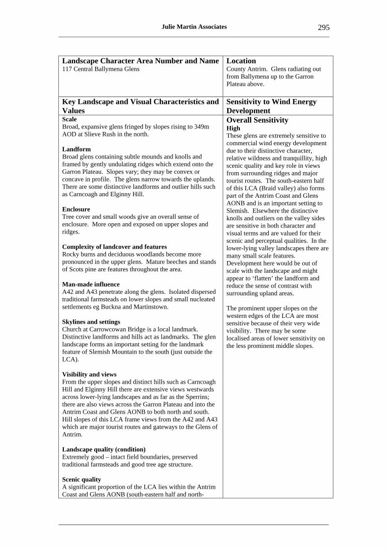
___________________________________________________________________________________
_____________________________________________________________________
295 Julie Martin Associates
Landscape Character Area Number and Name 117 Central Ballymena Glens
Location County Antrim. Glens radiating out from Ballymena up to the Garron Plateau above.
Key Landscape and Visual Characteristics and Values
Sensitivity to Wind Energy Development
Scale Broad, expansive glens fringed by slopes rising to 349m AOD at Slieve Rush in the north.
Landform Broad glens containing subtle mounds and knolls and framed by gently undulating ridges which extend onto the Garron Plateau. Slopes vary; they may be convex or concave in profile. The glens narrow towards the uplands. There are some distinctive landforms and outlier hills such as Carncoagh and Elginny Hill.
Enclosure Tree cover and small woods give an overall sense of enclosure. More open and exposed on upper slopes and ridges.
Complexity of landcover and features Rocky burns and deciduous woodlands become more pronounced in the upper glens. Mature beeches and stands of Scots pine are features throughout the area.
Man-made influence A42 and A43 penetrate along the glens. Isolated dispersed traditional farmsteads on lower slopes and small nucleated settlements eg Buckna and Martinstown.
Skylines and settings Church at Carrowcowan Bridge is a local landmark. Distinctive landforms and hills act as landmarks. The glen landscape forms an important setting for the landmark feature of Slemish Mountain to the south (just outside the LCA).
Overall Sensitivity High These glens are extremely sensitive to commercial wind energy development due to their distinctive character, relative wildness and tranquillity, high scenic quality and key role in views from surrounding ridges and major tourist routes. The south-eastern half of this LCA (Braid valley) also forms part of the Antrim Coast and Glens AONB and is an important setting to Slemish. Elsewhere the distinctive knolls and outliers on the valley sides are sensitive in both character and visual terms and are valued for their scenic and perceptual qualities. In the lower-lying valley landscapes there are many small scale features. Development here would be out of scale with the landscape and might appear to ‘flatten’ the landform and reduce the sense of contrast with surrounding upland areas.
The prominent upper slopes on the western edges of the LCA are most sensitive because of their very wide visibility. There may be some localised areas of lower sensitivity on the less prominent middle slopes.
Visibility and views From the upper slopes and distinct hills such as Carncoagh Hill and Elginny Hill there are extensive views westwards across lower-lying landscapes and as far as the Sperrins; there are also views across the Garron Plateau and into the Antrim Coast and Glens AONB to both north and south. Hill slopes of this LCA frame views from the A42 and A43 which are major tourist routes and gateways to the Glens of Antrim.
Landscape quality (condition) Extremely good – intact field boundaries, preserved traditional farmsteads and good tree age structure.
Scenic quality A significant proportion of the LCA lies within the Antrim Coast and Glens AONB (south-eastern half and north

___________________________________________________________________________________
_____________________________________________________________________
296 Julie Martin Associates
eastern fringes). Visual amenity is enhanced by distinctive landforms such as Skerry Rock or Craignamaddy.
Wildness and tranquillity On exposed upper slopes and prominent ridges there is a high degree of relative wildness and the glens themselves are deeply rural, remote and tranquil.
Natural and cultural heritage features This LCA contains a number of ASSIs including Rathsherry, Cleggan Valley and Glen Burn, all designated for their nature conservation value. Whooper swans, hen harriers, golden plover, peregrine falcons. Scattered archaeological sites and Registered Park at Cleggan Lodge.
Cultural associations Not known.
Amenity and recreation Key gateway to the Antrim Coast and Glens AONB. The upland ridges and more sheltered glens are valued for hill walking, horse riding and cycling.
Capacity Assessment • Turbine groupings. This LCA has very limited capacity to accommodate commercial wind
energy development due to its high visual prominence and many small scale landscape features. It is able to accommodate small turbine groups at most. Any larger turbine groupings would tend to dominate and flatten the often subtle, varied landform of this LCA.
• Turbine height. Turbines should generally be of domestic/community or small commercial height.
• Opportunities and constraints. Mid slope locations with simple, rounded landform are the only areas that may be able to accommodate commercial turbines. Care should be taken to avoid sites on or near prominent, distinctive rocky knolls and outliers, particularly on the eastern edges of the LCA where development would tend to dominate adjacent valley landscapes. Adverse impacts on the settings of cultural heritage sites or settlements should also be avoided. Special care should also be taken to avoid locations where turbines would have a significant impact on perceptual landscape qualities such as wildness and tranquillity or on the setting or special qualities of the AONB. The setting of Slemish, in the south, is particularly sensitive.
• Domestic/community turbines. Domestic and community turbines should avoid open, prominent sites and show a close relationship with existing buildings and tree groups.
• Cumulative/transboundary/seaward issues. There are no operational or consented wind farms in this LCA at present, although there are application sites. The closest operational and consented sites are Corkey and Gruig, around 2km to the north of this LCA in Moyle Moorlands and Forest, LCA 118. There are no transboundary or seaward issues.
• Thresholds. This LCA is unlikely to be able to accommodate more than one small, well-separated turbine clusters. Careful consideration will need to be given to landscape and visual relationships and separation distances from any wind farm sites in adjacent LCAs.
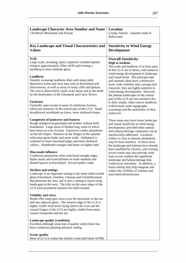
___________________________________________________________________________________
_____________________________________________________________________
297 Julie Martin Associates
Landscape Character Area Number and Name 118 Moyle Moorlands and Forests
Location County Antrim. Uplands south of Ballycastle.
Key Landscape and Visual Characteristics and Values
Sensitivity to Wind Energy Development
Scale Large scale, sweeping, open, expansive rounded upland rising to approximately 550m AOD and forming a backdrop to more intimate glens.
Landform Smooth, sweeping landform often with steep sided distinctive forms and clear tops such as Knocklayd and Slieveanorra, as well as areas of rocky cliffs and plateau. The area is dissected by small rocky burns and in the north by the headwaters of the Glenshesk and Carey Rivers.
Enclosure Generally open except in areas of coniferous forestry, which are extensive in the central part of the LCA. Small broadleaved woodlands on lower, more sheltered slopes.
Overall Sensitivity High to medium The scale and landform of at least parts of this LCA are in theory well-suited to wind energy development in landscape and visual terms. The principal tops and summits often have a distinctive form, wide visibility and a strong wild character; they are highly sensitive to wind energy development. However, the plateau landscapes of the central part of the LCA are less sensitive due to their simple, often convex landform (which lends some topographic screening) and the uniformity of their landcover.
Complexity of landcover and features Rough unimproved grassland and heather without field boundaries. Large areas of blanket bog, some of which have been cut over for peat. Extensive conifer plantations on the hill slopes. Pastures on the fringes of the uplands with some gorse banks and stone walls. Settlement is confined to lower moorland edges and more sheltered valleys. Abandoned cottages and farms on higher land.
Man-made influence Coniferous plantations often with harsh straight edges. Radio masts and wind turbines on some summits and disused quarry at Knocklayd. Several public roads.
Skylines and settings Landscape is an important setting to the steep-sided coastal glens (Glenshesk, Glendun, Glenaan and Glenballyemon) that penetrate the area, and is also a setting to lower-lying landscapes to the west. The hills on the outer edges of the LCA form prominent skylines for miles around.
These areas may have lower landscape and visual sensitivity to wind energy development, provided other natural and cultural heritage constraints can be satisfactorily addressed. Locations within or close to forestry plantations may be least sensitive. In these areas the landscape and habitats have already been modified by forestry, and existing access tracks may also provide wind farm access without the significant landscape and habitat damage that could occur elsewhere. In addition, a forest setting may help integrate and reduce the visibility of turbines and associated infrastructure.
Visibility and views Roads offer long open views over the moorland, to the sea and into adjacent glens. The western edge of the LCA is highly visible from lower-lying land to the west and the coastal fringes of the LCA are highly visible from many coastal viewpoints and the sea.
Landscape quality (condition) Excellent although some loss of quality where there has been coniferous planting and peat cutting.
Scenic quality Most of LCA is within the Antrim Coast and Glens AONB.
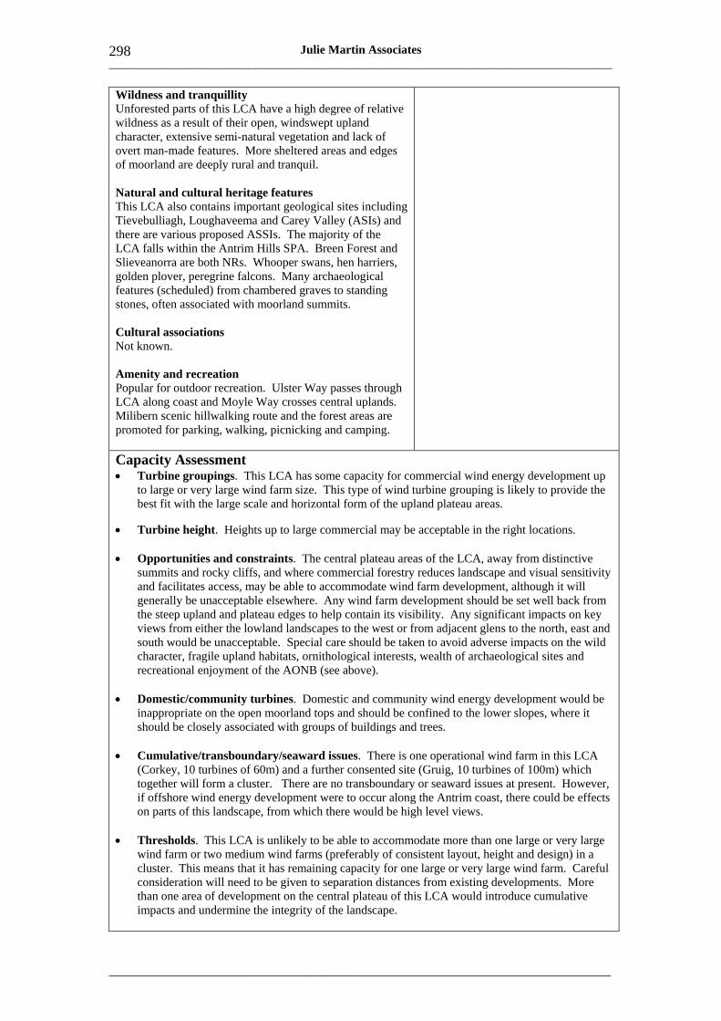
___________________________________________________________________________________
_____________________________________________________________________
298 Julie Martin Associates
Wildness and tranquillity Unforested parts of this LCA have a high degree of relative wildness as a result of their open, windswept upland character, extensive semi-natural vegetation and lack of overt man-made features. More sheltered areas and edges of moorland are deeply rural and tranquil.
Natural and cultural heritage features This LCA also contains important geological sites including Tievebulliagh, Loughaveema and Carey Valley (ASIs) and there are various proposed ASSIs. The majority of the LCA falls within the Antrim Hills SPA. Breen Forest and Slieveanorra are both NRs. Whooper swans, hen harriers, golden plover, peregrine falcons. Many archaeological features (scheduled) from chambered graves to standing stones, often associated with moorland summits.
Cultural associations Not known.
Amenity and recreation Popular for outdoor recreation. Ulster Way passes through LCA along coast and Moyle Way crosses central uplands. Milibern scenic hillwalking route and the forest areas are promoted for parking, walking, picnicking and camping.
Capacity Assessment • Turbine groupings. This LCA has some capacity for commercial wind energy development up
to large or very large wind farm size. This type of wind turbine grouping is likely to provide the best fit with the large scale and horizontal form of the upland plateau areas.
• Turbine height. Heights up to large commercial may be acceptable in the right locations.
• Opportunities and constraints. The central plateau areas of the LCA, away from distinctive summits and rocky cliffs, and where commercial forestry reduces landscape and visual sensitivity and facilitates access, may be able to accommodate wind farm development, although it will generally be unacceptable elsewhere. Any wind farm development should be set well back from the steep upland and plateau edges to help contain its visibility. Any significant impacts on key views from either the lowland landscapes to the west or from adjacent glens to the north, east and south would be unacceptable. Special care should be taken to avoid adverse impacts on the wild character, fragile upland habitats, ornithological interests, wealth of archaeological sites and recreational enjoyment of the AONB (see above).
• Domestic/community turbines. Domestic and community wind energy development would be inappropriate on the open moorland tops and should be confined to the lower slopes, where it should be closely associated with groups of buildings and trees.
• Cumulative/transboundary/seaward issues. There is one operational wind farm in this LCA (Corkey, 10 turbines of 60m) and a further consented site (Gruig, 10 turbines of 100m) which together will form a cluster. There are no transboundary or seaward issues at present. However, if offshore wind energy development were to occur along the Antrim coast, there could be effects on parts of this landscape, from which there would be high level views.
• Thresholds. This LCA is unlikely to be able to accommodate more than one large or very large wind farm or two medium wind farms (preferably of consistent layout, height and design) in a cluster. This means that it has remaining capacity for one large or very large wind farm. Careful consideration will need to be given to separation distances from existing developments. More than one area of development on the central plateau of this LCA would introduce cumulative impacts and undermine the integrity of the landscape.

___________________________________________________________________________________
_____________________________________________________________________
299 Julie Martin Associates
Landscape Character Area Number and Name 119 Ballycastle Glens
Location County Antrim. East of Causeway Coast on the north Antrim coast around Ballycastle.
Key Landscape and Visual Characteristics and Values
Sensitivity to Wind Energy Development
Scale Large scale dramatic landscape in upper glens (rising to 130m AOD) becoming smaller scale and more enclosed in valley bottoms and lower lying areas.
Landform Steep sided glens (Glentaisie and Glenshesk) with undulating sides and rocky rivers in the valley bottoms. Upper reaches of glens are narrow and contained by smooth rounded hills of higher moorland eg Knocklayd. The Carey River is set in more open lowland landscape with distinctive terraces.
Enclosure Valleys are enclosed by topography and have a well vegetated character due to riverside trees and woods. Forestry plantations occur on some valley sides.
Complexity of landcover and features Rough and improved pastures bounded by hedgerows including gorse and thorn, creating a variety of colours and textures. Wetland areas of sedge and alder along watercourses. Dispersed pattern of farmsteads along valley sides. Attractive coastal town of Ballycastle.
Man-made influence Forestry plantations on some valley sides. Some new farm buildings which are visually prominent.
Skylines and settings The western half of this landscape, in association with the distinctive upland topography of Knocklayd, forms an exceptional and scenic setting to Ballycastle and the north coast including Fair Head.
Visibility and views Long views available down the glens to and from the coastal town of Ballycastle and the sea. There are also spectacular elevated views from the rural glen side lanes across Ballyvoy to Fair Head and out to sea.
Landscape quality (condition) Dry stone walls on upper slopes are in a poor state of repair. Some forestry plantations have abrupt straight edges and felling activity has created some localised degradation.
Scenic quality The whole of this LCA is highly scenic and is included within the Antrim Coast and Glens AONB.
Overall Sensitivity High This landscape is highly sensitive due to the strong contrast that it affords with the uplands above and the sea below and the often small scale of its field patterns and landscape features. There is little flat land on which turbines could be accommodated and the hill slopes are visually highly exposed. The more open areas near the coast often have steep slopes, long views, attractive wooded river corridors; and the low-lying areas are also overlooked by glen-side viewpoints. In addition, the LCA is highly valued for its scenic quality, recreation and role as a setting to Ballycastle.
Collectively these landscape and visual characteristics and values make this landscape very sensitive to commercial wind energy development.
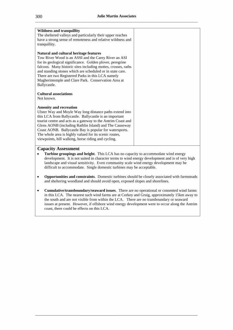
___________________________________________________________________________________
_____________________________________________________________________
300 Julie Martin Associates
Wildness and tranquillity The sheltered valleys and particularly their upper reaches have a strong sense of remoteness and relative wildness and tranquillity.
Natural and cultural heritage features Tow River Wood is an ASSI and the Carey River an ASI for its geological significance. Golden plover, peregrine falcons. Many historic sites including mottes, crosses, raths and standing stones which are scheduled or in state care. There are two Registered Parks in this LCA namely Magherintemple and Clare Park. Conservation Area at Ballycastle.
Cultural associations Not known.
Amenity and recreation Ulster Way and Moyle Way long distance paths extend into this LCA from Ballycastle. Ballycastle is an important tourist centre and acts as a gateway to the Antrim Coast and Glens AONB (including Rathlin Island) and The Causeway Coast AONB. Ballycastle Bay is popular for watersports. The whole area is highly valued for its scenic routes, viewpoints, hill walking, horse riding and cycling.
Capacity Assessment • Turbine groupings and height. This LCA has no capacity to accommodate wind energy
development. It is not suited in character terms to wind energy development and is of very high landscape and visual sensitivity. Even community scale wind energy development may be difficult to accommodate. Single domestic turbines may be acceptable.
• Opportunities and constraints. Domestic turbines should be closely associated with farmsteads and sheltering woodland and should avoid open, exposed slopes and shorelines.
• Cumulative/transboundary/seaward issues. There are no operational or consented wind farms in this LCA. The nearest such wind farms are at Corkey and Gruig, approximately 15km away to the south and are not visible from within the LCA. There are no transboundary or seaward issues at present. However, if offshore wind energy development were to occur along the Antrim coast, there could be effects on this LCA.

___________________________________________________________________________________
_____________________________________________________________________
301 Julie Martin Associates
Landscape Character Area Number and Name 120 Fair Head
Location County Antrim. Coastal strip between Antrim plateau and the sea.
Key Landscape and Visual Characteristics and Values
Sensitivity to Wind Energy Development
Scale Narrow coastal strip with dramatic vertical cliffs rising to approximately 230m AOD.
Landform Steep slopes and dramatic, often precipitous cliffs, on the northern edge of the Antrim plateau. Coastline comprises distinctive and exposed headlands (eg Fair Head) and more sheltered bays (eg Loughham). The steep slopes are dissected by short rocky streams forming minor incised valleys.
Enclosure Landscape of contrasting enclosure and exposure. Few trees, and those that exist are windswept. Below the cliffs are some sheltered woods.
Complexity of landcover and features Small scale rough pastures and moorland on the steep coastal edge separated by degraded stone walls. Small loughs are attractive features.
Man-made influence Few overt man-made influences. Coastal road winds precariously along parts of the cliff edge linking dispersed pattern of cottages and farms, but coast at Fair Head is accessible only on foot.
Overall Sensitivity High The landscape and visual sensitivity of this LCA is extremely high because this is a landmark landscape, visible across much of the north coast, and also widely visible from the sea. It provides an important setting for some of Northern Ireland’s most important tourism and recreational assets. The unspoilt, pristine condition and high scenic quality of this landscape, with its dramatic and memorable views and rich natural and cultural heritage interests, increase its sensitivity still further. There are no areas of lower sensitivity.
In addition, the narrowness, steepness and inaccessibility of much of this coastal landscape would make commercial wind energy development difficult.
Skylines and settings Coastal headlands (Fair Head and Torr Head) form important and highly visible landmarks. Fair Head is particularly visible from the Causeway Coast AONB to the west and forms an important setting to Ballycastle. The steep slopes which back this coastal strip form the landward skyline and overhang the area, emphasising the narrowness of this LCA.
Visibility and views Many dramatic and outstanding views to and from the sea and views along the cliff line throughout this LCA.
Landscape quality (condition) This coastal fringe is in pristine condition with its attractive combination of cliffs of varying rock strata, native woods, pastures, headlands and bays. Some degradation of pastures, stone walls and derelict cottages in places.
Scenic quality The whole of this area is included within the Antrim Coast and Glens AONB.
___________________________________________________________________________________
_____________________________________________________________________
302 Julie Martin Associates
Wildness and tranquillity This is an exceptionally wild landscape as a result of its elevation, dramatic scenery, exposure to the elements and the sea and inaccessibility. More sheltered locations below the cliffs and in the bays are deeply tranquil.
Natural and cultural heritage features Fair Head is a feature of outstanding geological importance. There are a number of ASSI designations including Ballycastle Coalfields and Torr Head. The south-eastern fringe of this LCA also falls within the Antrim Hills SPA. Greenland white-fronted geese, golden plover, peregrine falcons. Concentrated number of chambered graves associated with Fair Head and dispersed pattern of other historic sites.
Cultural associations Rich cultural associations associated with Fair Head.
Amenity and recreation Ulster Way long distance path passes though the south eastern part of this LCA. The coastal road is one of the most spectacular scenic routes in Northern Ireland and has numerous parking bays offering spectacular views. This landscape is highly valued for outdoor recreation including hill walking and water sports.
Capacity Assessment • Turbine groupings and height. This LCA has no capacity to accommodate commercial wind
energy development as a result of high landscape and visual sensitivity and physical constraints. Even community scale wind energy development is unlikely to be acceptable in this exposed, sensitive landmark landscape. Single domestic turbines may be acceptable.
• Opportunities and constraints. Domestic turbines should be closely associated with farmsteads and sheltering woodland and should avoid open, exposed slopes and shorelines. Hence such development too may be difficult to site effectively in this landscape.
• Cumulative/transboundary/seaward issues. There are no operational or consented wind farms in this LCA. The nearest such wind farms are at Corkey and Gruig, approximately 10km away to the south-west and are not visible from within the LCA. There are no transboundary or seaward issues at present. However, if offshore wind energy development were to occur along the Antrim coast, there could be effects on this LCA.
___________________________________________________________________________________
_____________________________________________________________________
303 Julie Martin Associates
Landscape Character Area Number and Name Location 121 Moyle Glens County Antrim. Coastal glens on
north-east edge of the Antrim plateau between upland moors and Irish Sea.
Key Landscape and Visual Characteristics and Values
Sensitivity to Wind Energy Development
Scale Dramatic, broad glacial valleys extend into the Antrim plateau, rising to 315m AOD in their upper reaches. Cross Slieve forms an upland outlier at 205m AOD between Cushendun and Cushendall.
Landform Distinctive flat-topped ridges such as Lurigethan and Tievebulliagh loom over this landscape although they lie just outside the LCA. The southern glens have broad sweeping U-shaped valley profiles, whereas the glens in the north have a more V-shaped profile with undulating sides. The valleys contain rocky mountain steams that fall to the sea as waterfalls or become meandering as they reach the flat floodplains near the coast. Dispersed pattern of stone cottages and historic fishing villages of Cushendun and Cushendall cluster in coastal bays.
Enclosure Prominent hedgerows and trees, and areas of ancient broadleaved woodland give this LCA a sheltered wooded appearance on lower slopes, becoming more exposed on upper slopes.
Complexity of landcover and features Pastoral landscape divided by hedges and stone walls with high concentration of trees and woodlands.
Overall Sensitivity High This landscape is of very high sensitivity for a whole host of reasons. This is one of the most popular and highly valued scenic landscapes in Northern Ireland, its key attraction lying in the extreme contrast between the adjoining uplands and dramatic coastal glens. The landscape of the glens includes many small scale features and its landform is unsuited to most wind energy development at it is either very steep, or flat and tightly contained. There is a great diversity of landscape features, often highly valued for their earth science, nature conservation or historic interest, and the small traditional settlements are visual focal points within each valley.
Commercial wind energy development would be prominent, intrusive and wholly inappropriate to the traditional rural character of these landscapes.
Man-made influence Roads follow the contours of the valley sides. Flat valley floors and steep upper slopes typically lack development although campsites, car parks and other tourist related infrastructure affect some coastal locations.
Skylines and settings Distinctive knolls (eg Cross Slieve and Tieverah) in this LCA and upland summits of the Antrim plateau above form important skylines and distinctive landmarks. The valleys sides of the Glendun River form an important setting to the settlement of Cushendun; lower slopes of Lurigethan frame Cushendall. Historic features and coastal geological features are also landmarks eg Red Arch and Castle.
Visibility and views Long coastal views are afforded throughout this LCA. There are also spectacular views from the coast and sea inland to a wild moorland backdrop.
Landscape quality (condition) Excellent condition overall. Some small plantations on the
___________________________________________________________________________________
_____________________________________________________________________
304 Julie Martin Associates
upper slopes and some degradation of stone walls in places. Caravan parks on coast can be visually intrusive.
Scenic quality High as a result of distinctive valleys and coastal views. All of this LCA is included in the Antrim Coast and Glens AONB.
Wildness and tranquillity Steep upper slopes have a wild and remote character.
Natural and cultural heritage features The Glendun and Glenballyemon Rivers are both proposed SPAs. Glenariff is designated an ASSI and the upper slopes of this areas form part of the Antrim Hills SPA. Golden plover, peregrine falcons. Historic land tenure pattern preserved in stone wall enclosures reflecting early ladder farms. There are many archaeological sites, a large number of which are in state care and some scheduled. Conservation Areas at Cushendall and Cushendun.
Cultural associations Rich history and folklore associated with the glens.
Amenity and recreation Important area for tourism. Ulster Way passes through the LCA. Settlements of Cushendall and Cushendun are local centres and gateways to the Glens providing holiday accommodation. There are many parking areas along the coast and the coast road is a valued scenic route. The glens are valued for their outdoor recreation including hill walking, horse riding and cycling. The coast and sheltered bays are popular for water sports.
Capacity Assessment • Turbine groupings and height. This LCA has no capacity to accommodate commercial wind
energy development due to its exceptionally high landscape and visual sensitivity. Even community scale wind energy development is unlikely to be acceptable in this highly distinctive and valued landscape setting. Single domestic turbines may be acceptable.
• Opportunities and constraints. Domestic turbines should be closely associated with farmsteads and sheltering woodland and should avoid open, exposed slopes, shorelines and cultural heritage sites and their settings.
• Cumulative/transboundary/seaward issues. There are no operational or consented wind farms in this LCA. The nearest such wind farms are at Corkey and Gruig, approximately 8km away to the west and are not visible from within the LCA. There are no transboundary or seaward issues at present. However, if offshore wind energy development were to occur along the Antrim coast, there could be effects on this LCA.
___________________________________________________________________________________
_____________________________________________________________________
305 Julie Martin Associates
Landscape Character Area Number and Name Location 122 Garron Plateau County Antrim. Upland plateau north
east of Ballymena to Garron Point on coast.
Key Landscape and Visual Characteristics and Values
Sensitivity to Wind Energy Development
Scale Large scale, open, expansive upland plateau rising to around 438m AOD at Mid Hill although many summits are over 400m AOD eg Carncormick and Soarns Hill.
Landform Upland plateau with uneven relief due to rocky outcrops, steep descents and deeply incised stream valleys. The uneven landform harbours many upland loughs and reservoirs. The edges of the plateau have a distinctive stepped profile or form rounded knolls and end in dramatic cliffs at the coast.
Enclosure Largely open and exposed landscape with little native tree cover. Coniferous woodland creates localised enclosure.
Complexity of landcover and features Predominately sheep grazing, lower slopes enclosed by stone walls and occasional beech trees or Scots Pine. Peat bogs on more elevated areas comprising a matrix of heather and moorland grasses, rushes and areas of peat cutting. Coniferous woodland at Glenariff Forest Park and Cleggan Forest.
Man-made influence Very limited, as do not penetrate beyond edge of plateau. Some commercial forestry and small reservoirs in the south-west.
Skylines and settings Lurigethan, with its promontory fort, is a distinctive coastal landmark. The edges of the plateau form simple, open skylines when viewed from surrounding areas and are important in providing a setting to adjacent glens, coastal fringes and inland lowlands.
Visibility and views Long views to and from the edges of the plateau over the surrounding landscapes and the sea. Views into the LCA from around Glenariff Forest Park to the north.
Overall Sensitivity High to medium This LCA has large scale, simple expansive landform and landcover that in theory make at least parts of the area suitable for commercial wind energy development. However, the stepped landforms and rounded knolls around the plateau edges form prominent open skylines that are visually highly sensitive and are the setting for the coastal glens of Glenariff and Glencloy to the east. Parts of the LCA are overlooked from slopes and summits to the north around Glenariff Forest Park, and this too heightens sensitivity. The area around Glenariff Forest Park is highly valued for recreation, while the northern reaches of the LCA, as it extends towards the coast, becomes increasingly complex with distinctive upland loughs and rocky outcrops. These factors, together with the area’s scenic quality and outstanding intact peatland habitats result in high sensitivity over most of the LCA.
Areas of lesser sensitivity occur in the south-west, for example in areas of simple terrain within or close to the extensive coniferous plantation of Cleggan Forest, where recreational access limited. Here the forestry may help contain visibility and use of existing forestry access tracks could reduce infrastructure impacts on fragile moorland landscapes and habitats.
Landscape quality (condition) Excellent condition overall.
Scenic quality The whole of this area of very high scenic quality and is included in the Antrim Coast and Glens AONB. Locally, however, scenic quality has been affected by blanket afforestation.
___________________________________________________________________________________
_____________________________________________________________________
306 Julie Martin Associates
Wildness and tranquillity Upland areas have a strong sense of relative wildness remaining largely undisturbed by human activity.
Natural and cultural heritage features This landscape contains valuable peatland habitats designated as the Garron Plateau ASSI, SAC and Ramsar site and is the most extensive area of intact upland blanket bog in Northern Ireland. The majority of the LCA falls within the Antrim Hills SPA. Hen harriers, golden plover, peregrine falcons. There are also ASSI designations at Blackburn (valued for its extensive, active limestone cave system) and Gortnagory (valued for its grassland and rare orchids). Scattered archaeological sites associated with the plateau fringes.
Cultural associations Not known.
Amenity and recreation Glenariff Forest Park is a popular outdoor recreation area and there are a number of walking routes in this locality.
Capacity Assessment • Turbine groupings. Part of this LCA may be able to accommodate commercial wind energy
development up to large or very large wind farm size. This type of turbine grouping is likely to provide the best fit with the large scale and horizontal form of the upland plateau.
• Turbine height. Turbine heights up to large commercial may be acceptable in the right location.
• Opportunities and constraints. The plateau areas adjacent to or within the Cleggan Forest, where commercial forestry reduces landscape and visual sensitivity and facilitates vehicular access, may be most suited to wind farm development. Such development will generally be unacceptable elsewhere. Any wind farm development should be set well back from the steep upland and plateau edges to help contain its visibility. Any significant impacts on key views, particularly views from the coastal glens and the sea to the east, would be unacceptable. Special care should be taken to avoid adverse impacts on the wild character, fragile upland habitats, ornithological interests, archaeological sites and recreational enjoyment of the AONB (see above). Adverse physical and visual effects on areas of complex terrain and areas of upland loughs and rocky outcrops would be unacceptable.
• Domestic/community turbines. Domestic and community wind energy development would generally be inappropriate in this LCA, which is almost entirely open moorland or forestry.
• Cumulative/transboundary/seaward issues. There are no operational or consented wind farms in this LCA at present. The nearest such sites are at Corkey and Gruig, around 7km north-west of this LCA. There are also application sites just to the south-west, in the Central Ballymena Glens LCA. There are no transboundary or seaward issues at present. However, if offshore wind energy development were to occur along the Antrim coast, there could be effects on parts of this landscape, from which there would be high level views.
• Thresholds. This LCA is unlikely to be able to accommodate more than one very large or large wind farm or two medium wind farms (of consistent layout, height and design) in a cluster. Careful consideration will need to be given to separation distances from developments in adjoining LCAs (particularly LCA 117 Central Ballymena Glens). More than one area of development in this LCA would undermine and fragment the character of this open expansive moorland plateau.
___________________________________________________________________________________
_____________________________________________________________________
307 Julie Martin Associates
Landscape Character Area Number and Name Location 123 Larne Glens County Antrim. Deeply incised glens
between the Garron plateau and the coast.
Key Landscape and Visual Characteristics and Values
Sensitivity to Wind Energy Development
Scale Large scale, deeply incised glens rising to stepped moorland summits and reaching approximately 190m AOD. Small to medium scale landscape patterns and features.
Landform Steep-sided and incised glen valleys of the Glencloy and Glenarm Rivers. Towards the coast the glens open out and the terrain is undulating.
Enclosure Broadleaved woodland on steeper glen slopes, and small to medium scale patterns of stone walls and hedges with hedgerow trees, provide enclosure and distinctive pattern. There is also topographic enclosure by the surrounding moorland summits.
Complexity of landcover and features Dramatic contrasts in colour between the lush pastures within the glens and the more exposed moorlands above. Old quarry workings create dramatic features along the steep slopes. Settlements of Carnlough and Glenarm are located on coast at the mouth of the glens. Elsewhere there is a dispersed pattern of farmsteads.
Man-made influence Conifer plantations in Glenarm. Quarry above Carnlough creates a distinctive landmark.
Overall Sensitivity High This landscape is over very high sensitivity. The more open areas nearer the coast offer long coastal views, and although the lower lying areas are relatively well treed they are also overlooked from surrounding higher ground and form a central visual focus within the LCA. Similarly the upper slopes of the glens are of high visual sensitivity, providing an outstanding backdrop and skyline to the valleys. Both these areas are inherently sensitive to commercial wind energy development. The outstanding scenic quality of this landscape and its popularity for visitors and for outdoor recreation increase its sensitivity still further.
This very high sensitivity across the whole area indicates that there is no scope for commercial wind energy development in this LCA.
Skylines and settings The lower lying coastal areas and mouth of the glen rivers provide important landscape settings to the coastal settlements. The upper moorland slopes form high visible and simple open skylines, framing and enfolding these sheltered glen landscapes.
Visibility and views Elevated and spectacular views across the glens and down their length to and from the sea. Also memorable views along the coastline. This landscape is highly visible from surrounding moorland slopes.
Landscape quality (condition) Extremely good condition – well managed landscape elements, robust stone walls, well maintained hedgerows and strong landscape structure.
Scenic quality High – the whole of this LCA is included within the Antrim Coast and Glens AONB.
___________________________________________________________________________________
_____________________________________________________________________
308 Julie Martin Associates
Wildness and tranquillity This is a landscape of contrasts – the upper moorland slopes of the glens and the exposed rocky coastline both express a high degree of relative wildness, whereas the glen landscapes are more sheltered and deeply tranquil.
Natural and cultural heritage features Old quarry sites are of earth science interest and designated ASIs. Much of the deciduous woodland is ancient and designated ASSI eg Glenarm Woods and Straidkilly Wood (the later also being a NR); Lemnalary is a grassland ASSI. Golden plover, peregrine falcons. Much of the Glenarm is a Registered Park as part of the Glenarm Castle Estate; Garron Tower in the north of the LCA is also a Registered Park. Conservation Areas at Carnlough and Glenarm.
Cultural associations Rich history and folklore associated with the glens.
Amenity and recreation This landscape is valued for its recreation opportunities and is a major tourist destination. The Ulster Way long distance follows the coast through this LCA. There are also a number of other walking routes associated with this area.
Capacity Assessment • Turbine groupings and height. This LCA has no capacity to accommodate commercial wind
energy development due to its very high landscape and visual sensitivity throughout. Even community scale wind energy development may be unacceptable in this highly distinctive and valued landscape setting. Single domestic turbines may be acceptable.
• Opportunities and constraints. Domestic turbines should be closely associated with farmsteads and sheltering woodland and should avoid open, exposed slopes, shorelines, prominent knolls and cultural heritage sites and their settings.
• Cumulative/transboundary/seaward issues. There are no operational or consented wind farms in this LCA. The nearest such development is at Elliots Hill and Wolf Bog approximately 10km away to the south-west and not visible from this LCA. There are no transboundary or seaward issues at present. However, if offshore wind energy development were to occur along the Antrim coast, there could be effects on this LCA.
___________________________________________________________________________________
_____________________________________________________________________
309 Julie Martin Associates
Landscape Character Area Number and Name 124 Larne Basalt Moorland
Location County Antrim. Upland moorland between Ballymena and the coast.
Key Landscape and Visual Characteristics and Values
Sensitivity to Wind Energy Development
Scale Large scale, broad, rounded summits reaching between 300 and 400m AOD.
Landform Exposed broad upland area with distinctive rounded summits which often have simplicity of outline. This area extends into a narrower ridge in the north separating Glenarm from the coast. On the east is the dramatic rounded cliff of Sallagh Braes – the product of a massive landslip, and to the south the cliffs of Agnew’s Hill.
Enclosure Windswept, open landscape with little enclosure due to lack of trees, high elevation and expansive topography.
Complexity of landcover and features Derelict pastures on the edge of the moor invaded by rushes and gorse giving rise to strongly textured landscape. The upper slopes and summits are covered in tussocky moorland grasses with areas of peat bog and heather. Small isolated stone dwellings and areas of small scale peat cutting.
Man-made influence Radio masts are prominent vertical features. Commercial forestry in places eg Capanagh and Shillanavogy Woods and Ballyboley Forest. Narrow roads cross the moorland and wind around the edges of the summits.
Skylines and settings The volcanic plug known as Slemish is an exceptional landmark. Outer summits and fringes are prominent landmarks in views from adjacent lowlands and valleys, particularly the Glenwhirry valley.
Overall Sensitivity High to medium This LCA has a large scale, simple landform and land cover that suggest some suitability for wind energy development. However, the outer hills often have a distinctive form and wide visibility; hence they are especially sensitive to commercial wind energy development, whether they lie within the AONB or not. This also applies to the narrow finger of land in the northern part of this LCA which forms an important setting to Glenarm and the coastal landscapes. As in other parts of the Antrim Plateau, areas that can be seen from the coast and coastal glens are of the utmost sensitivity.
The central parts of the LCA have an open plateau landform with simple, uniform land cover and these areas may be less sensitive, particularly where there is some topographic screening and where forestry plantations have already affected the area’s landscapes and moorland habitats.
Visibility and views The steep cliffs of Sallagh Braes are a notable landscape feature and viewpoint. Numerous long distance views are also available from the narrow lanes which cross the moorland and skirt its fringes.
Landscape quality (condition) Good condition overall although some areas of derelict pastures and tumbled down stone walls.
Scenic quality High. Most of this LCA (with the exception of the southern fringes) falls within the Antrim Coast and Glens AONB.
Wildness and tranquillity The upper and central parts of this landscape have a wild
___________________________________________________________________________________
_____________________________________________________________________
310 Julie Martin Associates
character due to their openness and remoteness. The dramatic and majestic knolls and cliffs also have relative wildness as a result of their scale and dominance.
Natural and cultural heritage features The majority of this area is covered by the Antrim Hills SPA for its peat habitats. Slemish and Scawt Hill and Sallagh Braes are ASIs of earth science interest while Scawt Hill is also an ASSI. The majority of the LCA falls within the Antrim Hills SPA. Hen harriers, golden plover, peregrine falcons. Concentration of scheduled archaeological sites on the northern finger of this LCA (Knockdhu ASAI), as well as on its southern fringes and at Slemish.
Cultural associations Not known.
Amenity and recreation Ulster Way and Antrim Hills Way long distance paths pass though this LCA.
Capacity Assessment • Turbine groupings. This LCA has some capacity for commercial wind energy development up
to large or very large wind farm size. This type of wind turbine grouping is likely to provide the best fit with the large scale and horizontal form of the upland plateau areas.
• Turbine height. Turbine heights up to large commercial may be acceptable in the right locations.
• Opportunities and constraints. The central plateau areas of the LCA, away from steep hillsides, distinctive summits and rocky cliffs, and where commercial forestry reduces landscape and visual sensitivity and facilitates access, may be able to accommodate wind farm development, although it will generally be unacceptable elsewhere. Any wind farm development should be set well back from the steep upland and plateau edges to help contain its visibility. Particular care should be taken to avoid adverse effects on the settings of Slemish, Sallagh Braes and Knockdhu ASAI. Any significant impacts on key views from either the lowland landscapes to the west or from the glens and coast to the north and east would be unacceptable. Special care should be taken to avoid adverse impacts on the wild character, fragile upland habitats, ornithological interests, wealth of archaeological sites and recreational enjoyment of the AONB (see above).
• Domestic/community turbines. Domestic and community wind energy development would be inappropriate on the open moorland tops and should be confined to the lower slopes, where it should be closely associated with groups of buildings and trees.
• Cumulative/transboundary/seaward issues. There are no operational or consented wind farms in this LCA. The nearest such development is at Elliots Hill and Wolf Bog, around 4km southwest of the LCA. There are no transboundary or seaward issues at present. However, if offshore wind energy development were to occur along the Antrim coast, there could be effects on parts of this landscape, from which there would be high level views.
• Thresholds. This LCA is unlikely to be able to accommodate more than one very large or large wind farm or two medium wind farms (of consistent layout, height and design) in a cluster. Careful consideration will need to be given to separation distances from existing developments in adjoining LCAs (particularly LCA 125 Tardree Upland Pastures). More than one area of development on the central plateau of this LCA would introduce cumulative impacts and undermine the integrity of the landscape.
___________________________________________________________________________________
_____________________________________________________________________
311 Julie Martin Associates
Landscape Character Area Number and Name Location 125 Tardree Upland Pastures County Antrim. South-west of Larne
Basalt Moorland and northeast of Antrim.
Key Landscape and Visual Characteristics and Values
Sensitivity to Wind Energy Development
Scale Medium scale upland fringe area with hills and ridges rising to 353m AOD.
Landform Transitional landscape comprising undulating topography. Ridges have a smooth stepped profile with some rocky outcrops or crags. The Glenwhirry valley, which cuts through the centre of the LCA, is broad and shallow.
Enclosure Relatively open landscape even in valley. Localised enclosure created by topography and roadside trees and conifer plantations.
Complexity of landcover and features Marginal pastures and poorly drained grassland and heather create a textured landscape divided by a strong pattern of stone walls and hedges. Some commercial forestry on Tobernaveen Hill. Scattered distribution of rural dwellings, concentrating within the Glenwhirry valley.
Man-made influence Electricity pylons pass through the central and southern parts of this landscape. Quarries (disused and existing) eg Craigs Quarry. Existing wind farm (Elliots Hill) on Big Collin.
Skylines and settings The uplands to the north-east of this LCA form an important and prominent skyline. The south-facing slopes of Tobernaveen and Drumdarragh Hill also form prominent skylines and a setting to the town of Antrim.
Visibility and views Long open views across this landscape from main ridges. Also views across the Glenwhirry Valley.
Landscape quality (condition) Condition of this landscape varies. In some areas the stone wall enclosures are intact and well maintained but elsewhere tumbled down. In places the landscape is degraded due to quarries, electricity pylons and prominent development.
Scenic quality Scenic quality in this LCA is mixed. The north and eastern fringes of this LCA fall within the Antrim Coast and Glens AONB.
Overall Sensitivity Medium The visually exposed character of this LCA suggests some sensitivity to commercial energy development. The southern slopes form a setting to Antrim and are particularly visible from the M2; while the northern slopes and ridges protrude into the lower-lying landscape of the Ballymena Farmland (LCA 116) and form part of the Antrim Coast and Glens AONB. Scenic quality in these areas is also relatively good.
However there are some locations in the central and southern parts of the LCA where the ridges have a smooth profile, visibility is reduced by dips in the landform or by forestry, and the landscape has already been affected by man-made influences. In these areas landscape sensitivity may be less.
___________________________________________________________________________________
_____________________________________________________________________
312 Julie Martin Associates
Wildness and tranquillity This is a rural landscape which has a high degree of tranquillity away from main road routes. The upland ridges with their rougher vegetation and more exposed aspect express relative wildness in places.
Natural and cultural heritage features Sandy Braes is an ASI. Whooper swans, hen harriers, golden plover, peregrine falcons. There are a number of archaeological sites which are scheduled, many of which occur on the upland ridges.
Cultural associations Not known.
Amenity and recreation Tardree Forest is valued for recreation with marketed picnic spots and viewpoints.
Capacity Assessment • Turbine groupings. This LCA has some capacity to accommodate commercial wind energy
development up to medium or even large wind farm size if carefully located.
• Turbine height. Turbine heights up to medium or even large commercial may be acceptable, although heights should generally not exceed medium on the lower hills adjacent to lowlands and valleys.
• Opportunities and constraints. The middle slopes of the ridges in the central and southern pars of this LCA (particularly where there are existing man-made influences) may be better able to accommodate wind farm development than other areas. Care should be taken to ensure wind farm development relates well to topography (avoiding rocky knolls, ridge summits and steep slopes) and to field patterns, and to avoid creating visual clutter where turbines are seen in conjunction with pylons. Adverse effects on the settings of settlements, the AONB and cultural heritage sites should be minimised.
• Domestic/community turbines. Domestic and community wind energy development should avoid open prominent sites. Domestic turbines should show a close relationship with existing farmsteads and tree groups.
• Cumulative/transboundary/seaward issues. This LCA has an existing wind farm at Elliots Hill (10 turbines of 65m) and a consented site adjacent at Wolf Bog (5 turbines of 100m). Further wind farms are also proposed within the LCA and in other LCAs to the north and south (although these sites are generally more than 15km away). There are no transboundary or seaward issues.
• Thresholds. This LCA is unlikely to be able to accommodate more than the equivalent of one large wind farm development (possibly comprising smaller sites with consistent turbine layout, height and design) or two smaller well-separated wind farms. This means that although there is still some scope for expansion, it is approaching its landscape capacity.

___________________________________________________________________________________
_____________________________________________________________________
313 Julie Martin Associates
Landscape Character Area Number and Name 126 Larne Coast
Location County Antrim. Coastal strip north of Larne.
Key Landscape and Visual Characteristics and Values
Sensitivity to Wind Energy Development
Scale Relatively narrow coastal strip with dramatic vertical form rising to approximately 200m AOD.
Landform Undulating lowland between upland moorland to northwest and coast. Indented coastline of headlands and cliffs creating a sequence of striking gateways.
Enclosure Small wooded glens on steep slopes, and wind sculpted vegetation along the coast.
Complexity of landcover and features Inland pastures divided by stone walls and a rugged belt of rough pasture along coastline. Exposed rocks form landscape features in places. Settlements include Carncastle, Ballygally and Larne; otherwise there is a dispersed pattern of farmsteads. Dramatic coast road hugs the coastline.
Man-made influence Significant urban, industrial and port development associated with Larne in the south of this LCA. Golf courses and tourism developments are scattered sporadically along the A2.
Skylines and settings Circular cliffs of Sallagh Braes overshadow this landscape and form a distinctive landmark, as do the upper slopes of the Antrim plateau moorlands above.
Visibility and views Expansive seaward views particularly from the coast road.
Landscape quality (condition) Stone walls are an important visual component of this landscape and are in a good state of repair.
Scenic quality High scenic quality. The whole of this area with the exception of Larne is included within the Antrim Coast and Glens AONB.
Wildness and tranquillity Wild windswept character, particularly along the coastal area and on upper slopes to the north and east.
Natural and cultural heritage features Coastal area has a number of important earth science sites including the Waterloo ASSI at Chaine Memorial Park.
Overall Sensitivity High This LCA is highly sensitive to commercial wind energy development because it is highly visible from the A2 tourist route and from elevated land above – particularly from key viewpoints such as Sallagh Braes. Towards Larne urban influences make the area somewhat less sensitive but nevertheless it is still highly visible. This high visibility, together with high scenic quality, dramatic and memorable coastal views, strong natural and cultural heritage interests, and value in terms of tourism and recreation, means that there are no areas within this LCA of lower sensitivity to wind energy development.
The only possible exception is land associated with the port of Larne, where brownfield and industrial sites may have a lower sensitivity to small scale wind energy development.
___________________________________________________________________________________
_____________________________________________________________________
314 Julie Martin Associates
Whooper swans, pale-bellied brent geese, Greenland white-fronted geese, golden plover, peregrine falcons. Wealth of archaeological interest including mottes, standing stones and raths along the upland margins. There are a number of Registered Parks in this landscape including Cairndhu, Carnfunnock Country Park, Chaine Park, and Drumalis.
Cultural associations Not known.
Amenity and recreation Popular area for tourism and recreation. Carnfunnock Country Park. The A2 is an important tourist route though this landscape. The Ulster Way long distant route hugs the coastline. There are also a number of other marketed walking routes eg Linn Glen circular walk.
Capacity Assessment • Turbine groupings and height. This LCA has very limited capacity for commercial wind
energy development due to space constraints and high landscape and visual sensitivity. Exceptionally it might accommodate a single small commercial turbine or small group of community turbines.
• Opportunities and constraints. Exceptionally, industrial land associated with the port of Larne might accommodate a single small commercial turbine or a small group of not more than three community turbines as a landmark feature, subject to ornithological constraints. Only one such feature would be appropriate at Larne harbour (either here or at Ballylumford, see LCA 128). Careful consideration should be given to impacts on views along the coast and from higher ground to the west and to relationships with existing built structures. Domestic wind energy development should avoid exposed upper slopes and shoreline landscapes.
• Cumulative/transboundary/seaward issues. There are no operational or consented wind farms in or near this LCA and no cumulative, transboundary or seaward issues at present. However, if offshore wind energy development were to occur along the Antrim coast, there could be effects on this landscape.
• Thresholds. Any commercial or community wind energy development in this landscape should be limited to a single site.
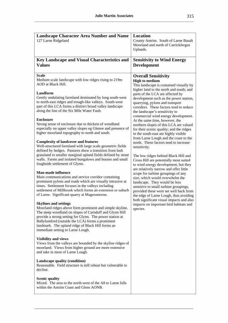
___________________________________________________________________________________
_____________________________________________________________________
315 Julie Martin Associates
Landscape Character Area Number and Name Location 127 Larne Ridgeland County Antrim. South of Larne Basalt
Moorland and north of Carrickfergus Uplands.
Key Landscape and Visual Characteristics and Values
Sensitivity to Wind Energy Development
Scale Medium scale landscape with low ridges rising to 219m AOD at Black Hill.
Landform Gently undulating farmland dominated by long south-west to north-east ridges and trough-like valleys. South-west part of this LCA forms a distinct broad valley landscape along the line of the Six Mile Water Fault.
Enclosure Strong sense of enclosure due to thickets of woodland especially on upper valley slopes eg Glenoe and presence of higher moorland topography to north and south.
Complexity of landcover and features Well-structured farmland with large scale geometric fields defined by hedges. Pastures show a transition from lush grassland to smaller marginal upland fields defined by stone walls. Farms and isolated bungalows and houses and small loughside settlement of Glynn.
Man-made influence Main communications and service corridor containing prominent pylons and roads which are visually intrusive at times. Settlement focuses in the valleys including settlement of Millbrook which forms an extension or suburb of Larne. Significant quarry at Mageramorne.
Skylines and settings Moorland ridges above form prominent and simple skyline. The steep woodland on slopes of Carnduff and Glynn Hill provide a strong setting for Glynn. The power station at Ballylumford (outside the LCA) forms a prominent landmark. The upland ridge of Black Hill forms an immediate setting to Larne Lough.
Overall Sensitivity High to medium This landscape is contained visually by higher land to the north and south; and parts of the LCA are affected by development such as the power station, quarrying, pylons and transport corridors. These factors tend to reduce the landscape’s sensitivity to commercial wind energy development. At the same time, however, the northern slopes of this LCA are valued for their scenic quality; and the ridges in the south-east are highly visible from Larne Lough and the coast to the north. These factors tend to increase sensitivity.
The low ridges behind Black Hill and Cross Hill are potentially most suited to wind energy development, but they are relatively narrow and offer little scope for turbine groupings of any size, which would overwhelm the landscape. They would be less sensitive to small turbine groupings, provided these were set well back from the edge of Larne Lough, thus avoiding both significant visual impacts and also impacts on important bird habitats and species.
Visibility and views Views from the valleys are bounded by the skyline ridges of moorland. Views from higher ground are more extensive and take in most of Larne Lough.
Landscape quality (condition) Reasonable. Field structure is still robust but vulnerable to decline.
Scenic quality Mixed. The area to the north-west of the A8 to Larne falls within the Antrim Coast and Glens AONB.
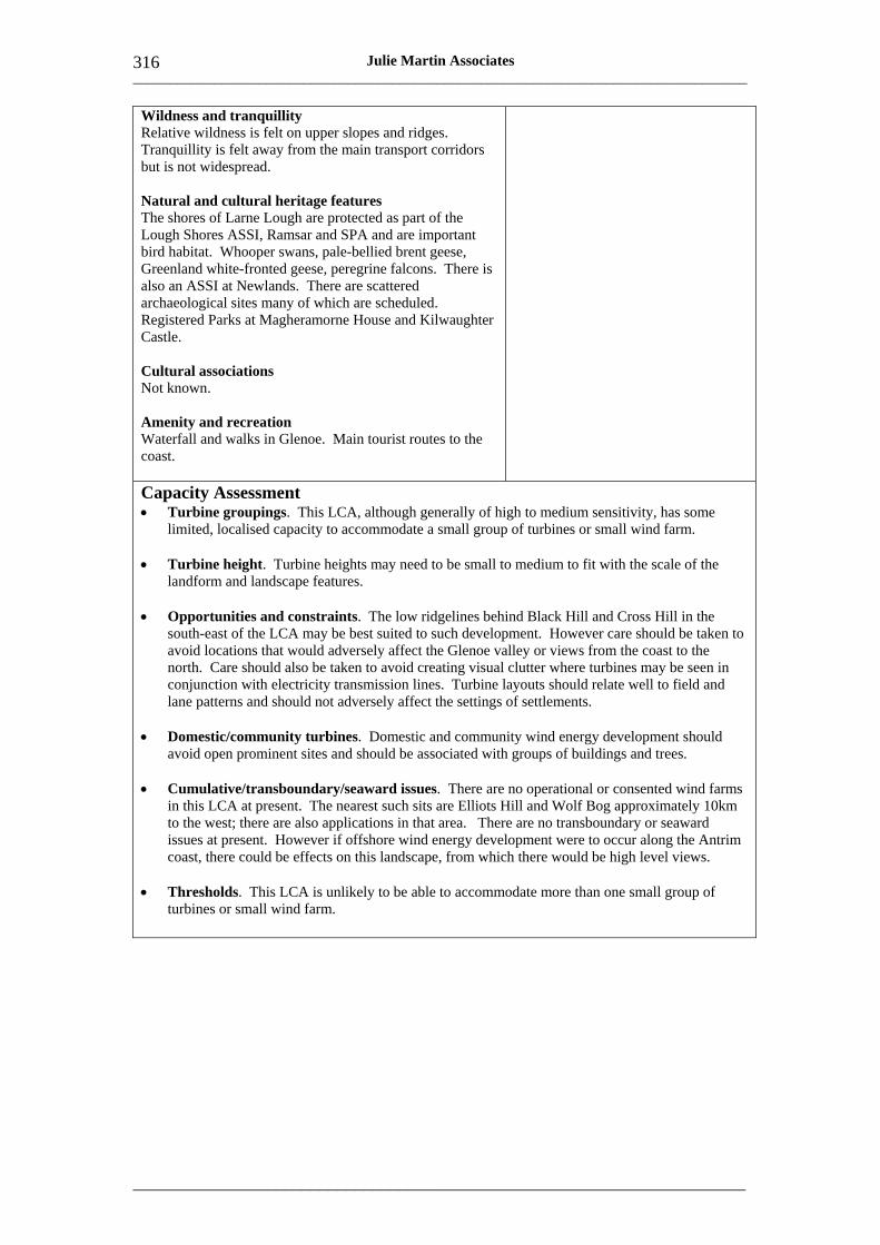
___________________________________________________________________________________
_____________________________________________________________________
316 Julie Martin Associates
Wildness and tranquillity Relative wildness is felt on upper slopes and ridges. Tranquillity is felt away from the main transport corridors but is not widespread.
Natural and cultural heritage features The shores of Larne Lough are protected as part of the Lough Shores ASSI, Ramsar and SPA and are important bird habitat. Whooper swans, pale-bellied brent geese, Greenland white-fronted geese, peregrine falcons. There is also an ASSI at Newlands. There are scattered archaeological sites many of which are scheduled. Registered Parks at Magheramorne House and Kilwaughter Castle.
Cultural associations Not known.
Amenity and recreation Waterfall and walks in Glenoe. Main tourist routes to the coast.
Capacity Assessment • Turbine groupings. This LCA, although generally of high to medium sensitivity, has some
limited, localised capacity to accommodate a small group of turbines or small wind farm.
• Turbine height. Turbine heights may need to be small to medium to fit with the scale of the landform and landscape features.
• Opportunities and constraints. The low ridgelines behind Black Hill and Cross Hill in the south-east of the LCA may be best suited to such development. However care should be taken to avoid locations that would adversely affect the Glenoe valley or views from the coast to the north. Care should also be taken to avoid creating visual clutter where turbines may be seen in conjunction with electricity transmission lines. Turbine layouts should relate well to field and lane patterns and should not adversely affect the settings of settlements.
• Domestic/community turbines. Domestic and community wind energy development should avoid open prominent sites and should be associated with groups of buildings and trees.
• Cumulative/transboundary/seaward issues. There are no operational or consented wind farms in this LCA at present. The nearest such sits are Elliots Hill and Wolf Bog approximately 10km to the west; there are also applications in that area. There are no transboundary or seaward issues at present. However if offshore wind energy development were to occur along the Antrim coast, there could be effects on this landscape, from which there would be high level views.
• Thresholds. This LCA is unlikely to be able to accommodate more than one small group of turbines or small wind farm.
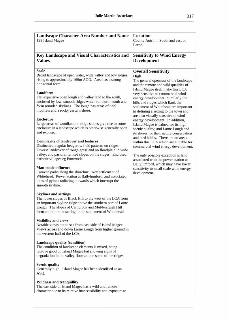
___________________________________________________________________________________
_____________________________________________________________________
317 Julie Martin Associates
Landscape Character Area Number and Name 128 Island Magee
Location County Antrim. South and east of Larne.
Key Landscape and Visual Characteristics and Values
Sensitivity to Wind Energy Development
Scale Broad landscape of open water, wide valley and low ridges rising to approximately 160m AOD. Area has a strong horizontal form.
Landform Flat expansive open lough and valley land to the south, enclosed by low, smooth ridges which run north-south and form rounded skylines. The lough has areas of tidal mudflats and a rocky eastern shore.
Enclosure Large areas of woodland on ridge slopes give rise to some enclosure in a landscape which is otherwise generally open and exposed.
Complexity of landcover and features Distinctive, regular hedgerow field patterns on ridges. Diverse landcover of rough grassland on floodplain in wide valley, and pastoral farmed slopes on the ridges. Enclosed harbour villages eg Portmuck.
Man-made influence Caravan parks along the shoreline. Key settlement of Whitehead. Power station at Ballylumford, and associated lines of pylons radiating outwards which interrupt the smooth skyline.
Skylines and settings The lower slopes of Black Hill to the west of the LCA form an important skyline ridge above the southern part of Larne Lough. The slopes of Carnbrock and Muldersleigh Hill form an important setting to the settlement of Whitehead.
Visibility and views Notable views out to sea from east side of Island Magee. Views across and down Larne Lough from higher ground in the western half of the LCA.
Landscape quality (condition) The condition of landscape elements is mixed, being relative good on Island Magee but showing signs of degradation in the valley floor and on some of the ridges.
Scenic quality Generally high. Island Magee has been identified as an ASQ.
Wildness and tranquillity The east side of Island Magee has a wild and remote character due to its relative inaccessibility and exposure to
Overall Sensitivity High The general openness of the landscape and the remote and wild qualities of Island Magee itself make this LCA very sensitive to commercial wind energy development. Similarly the hills and ridges which flank the settlement of Whitehead are important in defining a setting to the town and are also visually sensitive to wind energy development. In addition, Island Magee is valued for its high scenic quality; and Larne Lough and its shores for their nature conservation and bird habits. There are no areas within this LCA which are suitable for commercial wind energy development.
The only possible exception is land associated with the power station at Ballylumford, which may have lower sensitivity to small scale wind energy development.
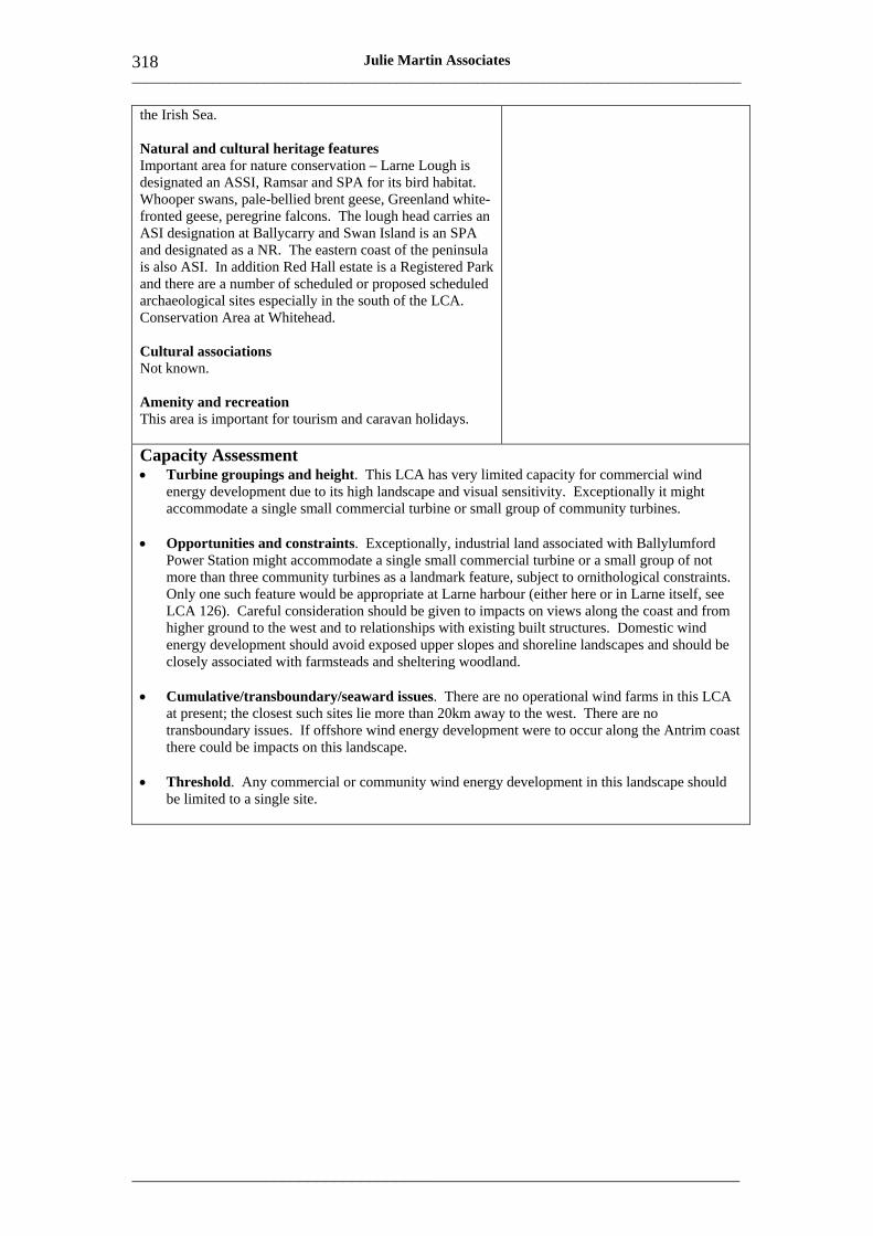
___________________________________________________________________________________
_____________________________________________________________________
318 Julie Martin Associates
the Irish Sea.
Natural and cultural heritage features Important area for nature conservation – Larne Lough is designated an ASSI, Ramsar and SPA for its bird habitat. Whooper swans, pale-bellied brent geese, Greenland white-fronted geese, peregrine falcons. The lough head carries an ASI designation at Ballycarry and Swan Island is an SPA and designated as a NR. The eastern coast of the peninsula is also ASI. In addition Red Hall estate is a Registered Park and there are a number of scheduled or proposed scheduled archaeological sites especially in the south of the LCA. Conservation Area at Whitehead.
Cultural associations Not known.
Amenity and recreation This area is important for tourism and caravan holidays.
Capacity Assessment • Turbine groupings and height. This LCA has very limited capacity for commercial wind
energy development due to its high landscape and visual sensitivity. Exceptionally it might accommodate a single small commercial turbine or small group of community turbines.
• Opportunities and constraints. Exceptionally, industrial land associated with Ballylumford Power Station might accommodate a single small commercial turbine or a small group of not more than three community turbines as a landmark feature, subject to ornithological constraints. Only one such feature would be appropriate at Larne harbour (either here or in Larne itself, see LCA 126). Careful consideration should be given to impacts on views along the coast and from higher ground to the west and to relationships with existing built structures. Domestic wind energy development should avoid exposed upper slopes and shoreline landscapes and should be closely associated with farmsteads and sheltering woodland.
• Cumulative/transboundary/seaward issues. There are no operational wind farms in this LCA at present; the closest such sites lie more than 20km away to the west. There are no transboundary issues. If offshore wind energy development were to occur along the Antrim coast there could be impacts on this landscape.
• Threshold. Any commercial or community wind energy development in this landscape should be limited to a single site.

___________________________________________________________________________________
_____________________________________________________________________
319 Julie Martin Associates
Landscape Character Area Number and Name 129 Carrickfergus Shoreline
Location County Antrim, shoreline between Whitehead and Newtownabbey
Key Landscape and Visual Characteristics and Values
Sensitivity to Wind Energy Development
Scale Fringe of flat land, 1-3km wide, rising to around 100m AOD on the edge of the LCA below the escarpment to the north-west.
Landform Narrow, flat coastal plain, rising gently inland towards the escarpment. Pronounced hilltop at Castle Dobbs and valley of Kilroot river to north-east of LCA.
Enclosure Almost continuous belt of coastal development including Greenisland and Carrickfergus, broken by urban farmland. Well treed in parts but increasingly open towards the east, except for pockets of woodland around Castle Dobbs.
Complexity of landcover and features Communications and service corridor. Peripheral industry and scattered housing along roads links settlements and obscures their separate identities.
Man-made influence Large institutional, commercial and industrial developments along the coastal edge and extensive urban development inland. Prominent industrial structures, notably the stack of Kilroot Power Station, can be seen from miles around. The linearity of the LCA is emphasised by roads, a railway and transmission lines. Ribbon development along A2 and B90.
Skylines and settings Inland the Carrickfergus Escarpment provides the setting to this LCA. The wooded setting of Castle Dobbs and the Kilroot valley is locally important.
Visibility and views Views of the sea are a key characteristic, especially between Newtownabbey and Carrickfergus, but coastal development blocks views from some inland locations. Significant waterfront views, notably at Carrickfergus Castle. East of Carrickfergus the railway follows the shoreline offering fine views across the lough.
Landscape quality (condition) Generally relatively poor.
Scenic quality Only localised areas of scenic quality within the LCA, at Castle Dobbs. However Carrickfergus Escarpment ASQ abuts the LCA north of Greenisland.
Wildness and tranquillity Generally limited.
Overall Sensitivity High to medium This LCA is generally not sensitive in landscape terms due to the existing extent of man-made influence, but is of higher sensitivity visually as it forms the foreground to views of the Carrickfergus Escarpment and is very open to view from Belfast Lough and its southern shores.
There may be some opportunities for wind energy development associated with existing industrial sites, where sensitivity is less.

___________________________________________________________________________________
_____________________________________________________________________
320 Julie Martin Associates
Natural and cultural heritage features Inner and Outer Belfast Lough ASSIs (also SPA and Ramsar) comprise intertidal foreshore important for wintering waders and wildfowl and earth science. Whooper swans, pale-bellied brent geese, arctic terns. A number of castles, notably Norman Carrickfergus Castle and a cluster of historic sites and monuments in the Kilroot valley. Registered Parks at Castle Dobbs and Sea Park. Conservation Area at Carrickfergus.
Cultural associations Many historical associations relating to Carrickfergus Castle.
Amenity and recreation Most opportunities are concentrated in Carrickfergus, on the waterfront.
Capacity Assessment • Turbine groupings. This LCA has some limited capacity for wind energy development up to the
size of a small group of turbines in localised areas on flat land and where a strong visual and design relationship to existing industrial structures is possible.
• Turbine height. Turbines up to medium commercial height may be accommodated, depending on the height and form of nearby industrial buildings and structures.
• Opportunities and constraints. The only area where such wind energy development might be acceptable in landscape and visual terms is close to Kilroot Power Station. Particular care should be taken not to interrupt key views of Belfast Lough from public open space and residential areas within the LCA. The settings of the monument at Knockagh on the cliffs above Greenisland, Carrickfergus harbour and Castle, and Castle Dobbs should also be respected. Ornithological issues will require very careful consideration to ensure that there are no unacceptable impacts on bird life.
• Domestic/community turbines. Domestic and community wind energy development should avoid exposed hill slopes and shoreline landscapes.
• Cumulative/transboundary/seaward issues. There are no operational or consented wind farms in this LCA and no cumulative, transboundary or seaward issues at present.
• Thresholds. The LCA is unlikely to be able to accommodate more than one small group of up to three small commercial or community turbines
___________________________________________________________________________________
_____________________________________________________________________
321 Julie Martin Associates
Landscape Character Area Number and Name 130 Carrickfergus Farmed Escarpment
Location County Antrim. Land between the Carrickfergus shoreline and the upland pastures to the north.
Key Landscape and Visual Characteristics and Values
Sensitivity to Wind Energy Development
Scale Rolling farmland with distinctive field patterns on the steep face of the escarpment at Carrickfergus, generally between 100 and 200m AOD.
Landform Narrow apron of undulating land forming the transition between the Carrickfergus Shoreline (LCA 129) and the Carrickfergus Upland Pastures (LCA 98). Woodburn Glen cuts back into the slope, breaking the otherwise regular and smooth profile. Escarpment is highest and most pronounced in the south-west.
Enclosure Very open to view topographically. Almost wholly pasture land with a grid of small regular fields enclosed by hedges and trees. Scots pine is a characteristic feature in hedges on the steeper slopes. Narrow wooded glens incised into the hill slopes.
Complexity of landcover and features There are two small reservoirs and areas of conifer woodland set within the characteristic small-scale ladder field pattern.
Man-made influence Strong rural character, but new houses form an incongruous recent addition. Numerous transmission lines and pylons along most of the length of the LCA.
Overall Sensitivity High Notwithstanding some intrusive influences, this LCA is intrinsically highly sensitive to wind energy development in landscape and visual terms, sharing many of its characteristics and sensitivities with other escarpment landscapes around Belfast, notably the Belfast Basalt Escarpment, of which it is the geological continuation. It has distinctive small scale field patterns, notable skylines and settings and is visually very exposed, with a relatively wild character.
Any commercial wind energy development would dominate landscape character, and be visually very prominent, intrusive and difficult to access.
Skylines and settings The basalt scarp and monument of Knockagh form notable skyline elements. The gradual transition from small scale pastures to broader, more wooded landscape patterns on the ridge top is very distinctive, and conservation of the visual integrity of the ridge top is important. LCA provides the setting and backdrop to Newtownabbey and Carrickfergus.
Visibility and views Panoramic views over Belfast Lough and its northern and southern shores. Urban development and Kilroot Power Station and its industrial setting are prominent in many views.
Landscape quality (condition) Hedges are gappy and poorly maintained and this is affecting the small scale landscape patterns in places. Much of the farmland retains a rural character although there are strong pressures for housing on the lower slopes.
Scenic quality Notwithstanding some intrusive influences scenic quality is relatively high, reflecting the views and strategic role of this LCA relative to Belfast Lough. The south-western part of the LCA
___________________________________________________________________________________
_____________________________________________________________________
322 Julie Martin Associates
forms part of the Carrickfergus Escarpment ASQ.
Wildness and tranquillity Sense of wildness and grandeur associated with views from the upper slopes.
Natural and cultural heritage features North Woodburn Glen has ash-hazel woodland designated as an ASSI and a cluster of archaeological sites. Peregrine falcons.
Cultural associations Not known.
Amenity and recreation Few formal opportunities but extensive informal use by nearby urban populations eg at North Woodburn Glen and reservoir sites.
Capacity Assessment • Turbine groupings and heights. This LCA has no capacity for commercial wind energy
development due to its very high landscape and visual sensitivity. Even community scale turbines would be inappropriate in this highly prominent location.
• Opportunities and constraints. Any wind energy development should therefore be limited to single domestic turbines, which should be closely associated with groups of buildings and trees. Particular care should be taken to avoid any impacts on the LCA’s sensitive skylines and views.
• Cumulative/transboundary/seaward issues. There are no operational or consented wind farms in this LCA and no cumulative, transboundary or seaward issues at present.
___________________________________________________________________________________
_____________________________________________________________________
323 Julie Martin Associates
Annex 2: Sources of Further Technical Advice
Countryside Agency and Scottish Natural Heritage (2002) Landscape Character Assessment Guidance for England and Scotland, Countryside Agency and Scottish Natural Heritage. http://www.landscapecharacter.org.uk/ca/LCA_Guidance.pdf
Countryside Agency and Scottish Natural Heritage (2004), Landscape Character Assessment Guidance Topic Paper 6: Techniques and Criteria for Judging Sensitivity and Capacity, Countryside Agency and Scottish Natural Heritage. http://www.landscapecharacter.org.uk/ca/LCA_Topic_Paper_6.pdf
Landscape Institute and Institute of Environmental Management and Assessment (2002) Guidelines for Landscape and Visual Impact Assessment, 2nd edition, Spon. http://www.iema.net/shop/product_info.php?cPath=27_26&products_id=57
Scottish Natural Heritage (2001) Guidelines on the Environmental Impacts of Windfarms and Small Scale Hydroelectric Schemes, Scottish Natural Heritage. http://www.snh.org.uk/pubs/results.asp?q=windfarms&selfservice=0&c=1&isbn=&o=title
Scottish Natural Heritage (2005) Guidance: Cumulative Effect of Wind Farms, Scottish Natural Heritage. http://www.snh.org.uk/pdfs/strategy/Cumulativeeffectsonwindfarms.pdf
Scottish Natural Heritage (2006) Visual Representation of Windfarms: Good Practice Guidance, Scottish Natural Heritage. http://www.snh.org.uk/pdfs/publications/heritagemanagement/Visual%20Representati on%20of%20windfarms%20-%20excerpt.pdf
University of Newcastle (2002) Visual Assessment of Windfarms: Best Practice, Scottish Natural Heritage. http://www.snh.org.uk/pdfs/publications/commissioned_reports/f01aa303a.pdf

___________________________________________________________________________________
_____________________________________________________________________
324 Julie Martin Associates

How to give your views
All responses should be made in writing and emailed to [email protected] or sent by post to:
Stephen Hamilton Wind Sensitivity Analysis Consultation DOE Planning & Environmental Policy Group 12th Floor River House 48 High Street Belfast BT1 2AW.
The consultation period will end on the Thursday 5 June 2008.
Electronic copies are available on the Planning Service website: www.planningni.gov.uk or can be obtained by telephoning (028) 9054 7713, textphone at (028) 9054 0642 or by writing to the above address. Should you require a copy of this document in an alternative format, it can be made available upon request in large print, disc, Braille, or audiocassette. It may also be made available in minority languages for those who are not proficient in English.
In keeping with our policy on openness, the Department may make responses to this consultation document publicly available upon request.
At the end of the consultation period the Department will consider all comments received, following which the draft documents will be amended if necessary and, subject to Ministerial approval, published in final form.
Our aim is to protect, conserve and promote the natural and built environment for the benefit of present and future generations.
Environment & Heritage Service Klondyke Building Cromac Avenue Gasworks Business Park Lower Ormeau Road Belfast BT7 2JA Tel: 0845 3020008
www.ehsni.gov.uk
EHS Incident Hotline - 0800 80 70 60 Printed on 100% post consumer waste