wildland fire management plan sacramento national wildlife ... · pdf filewildland fire...
TRANSCRIPT
WILDLAND FIRE MANAGEMENT PLAN
SACRAMENTO NATIONAL WILDLIFE REFUGE COMPLEX
2001
SEPTEMBER 2001
WILDLAND FIRE MANAGEMENT PLAN
SACRAMENTO NATIONAL WILDLIFE REFUGE COMPLEX
Willows, California
Prepared: ____________________________________ _____________
Perry Grissom Date Complex Fire Management Officer Sacramento NWRC ____________________________________ _____________ Kevin Foerster Date Project Leader Sacramento NWRC
Concurred: ____________________________________ ____________
Roger Wong Date Zone Fire Management Officer San Luis NWRC ____________________________________ ____________ Pam Ensley Date Regional Fire Management Coordinator Pacific Region, US Fish and Wildlife Service
Approved: ____________________________________ ____________ Steve Thompson Date Acting Manager California/Nevada Office, US Fish and Wildlife Service
i
TABLE OF CONTENTS
INTRODUCTION .......................................................................................................................................................1
COMPLIANCE WITH USFWS POLICY ................................................................................................................3
FIRE MANAGEMENT OBJECTIVES ....................................................................................................................5
DESCRIPTION OF REFUGE ...................................................................................................................................6 SACRAMENTO NWR...................................................................................................................................................6 DELEVAN NWR .........................................................................................................................................................8 COLUSA NWR..........................................................................................................................................................10 SUTTER NWR ..........................................................................................................................................................12 BUTTE SINK NWR....................................................................................................................................................14 CLIMATE ..................................................................................................................................................................16 CULTURAL RESOURCES............................................................................................................................................16 VEGETATION ............................................................................................................................................................16
Seasonally Flooded Marsh ..................................................................................................................................16 Watergrass/Moist Soil .........................................................................................................................................16 Summer Water .....................................................................................................................................................17 Permanent Ponds.................................................................................................................................................17 Riparian Habitat..................................................................................................................................................17 Uplands................................................................................................................................................................17
FISH AND WILDLIFE .................................................................................................................................................18 Waterfowl ............................................................................................................................................................18 Shorebirds............................................................................................................................................................18 Wading/diving birds ............................................................................................................................................18 Raptors ................................................................................................................................................................18 Gamebirds ...........................................................................................................................................................18 Gulls/terns ...........................................................................................................................................................19 Landbirds.............................................................................................................................................................19 Mammals .............................................................................................................................................................19 Herptiles ..............................................................................................................................................................19 Fish ......................................................................................................................................................................19 Invertebrates........................................................................................................................................................19
THREATENED AND ENDANGERED SPECIES ...............................................................................................................20 PHYSICAL RESOURCES - WATER, TOPOGRAPHY.......................................................................................................20 SOCIO-ECONOMIC CONCERNS ..................................................................................................................................20 STRUCTURES, FACILITIES, AND NEIGHBORING LANDS...............................................................................................20
WILDLAND FIRE MANAGEMENT SITUATION..............................................................................................21 HISTORIC ROLE OF FIRE ...........................................................................................................................................21
Pre-settlement fires..............................................................................................................................................21 Post-settlement Fire History................................................................................................................................21 Prescribed fire history .........................................................................................................................................21
RESPONSIBILITIES.....................................................................................................................................................21 Project Leader .....................................................................................................................................................21 Zone Fire Management Officer ...........................................................................................................................22 Complex Fire Management Officer .....................................................................................................................22 Prescribed Fire Specialist ...................................................................................................................................22 Supervisory Firefighter (Fire Operations) ..........................................................................................................23 Lead Firefighter (Crew Leader) ..........................................................................................................................23 Firefighters (Squad Leaders)...............................................................................................................................23 Seasonal Firefighters...........................................................................................................................................24 Collateral Duty Firefighters ................................................................................................................................24
ii
Incident Commander ...........................................................................................................................................24 INTERAGENCY OPERATIONS .....................................................................................................................................24 PROTECTION OF SENSITIVE RESOURCES ...................................................................................................................26
WILDLAND FIRE ACTIVITIES............................................................................................................................27 FIRE MANAGEMENT STRATEGIES .............................................................................................................................27 PREPAREDNESS.........................................................................................................................................................27
Historical weather ...............................................................................................................................................27 Fire Prevention....................................................................................................................................................28 Mechanical Hazard Reduction ............................................................................................................................28 Staffing Levels......................................................................................................................................................28 Training ...............................................................................................................................................................29 Supplies and Equipment ......................................................................................................................................29
DETECTION...............................................................................................................................................................30 COMMUNICATIONS ...................................................................................................................................................30 PRE-ATTACK PLAN ..................................................................................................................................................30 FIRE MANAGEMENT UNITS ......................................................................................................................................30
Fire Effects by Vegetation Type...........................................................................................................................31 Upland ............................................................................................................................................................................... 31 Wetlands............................................................................................................................................................................ 31 Riparian ............................................................................................................................................................................. 31
Fuel Types and Fire Behavior .............................................................................................................................31 SUPPRESSION TACTICS .............................................................................................................................................32
Protection of Structures.......................................................................................................................................32 Suppression Conditions .......................................................................................................................................33 Initial Attack ........................................................................................................................................................33 Wildland Fire Situation Analysis .........................................................................................................................34 Aircraft Operations..............................................................................................................................................34
EMERGENCY STABILIZATION AND REHABILITATION................................................................................................35 REQUIRED REPORTING .............................................................................................................................................35 FIRE INVESTIGATION ................................................................................................................................................35
PRESCRIBED FIRE ACTIVITIES.........................................................................................................................36 PRESCRIBED BURN PROGRAM OBJECTIVES ..............................................................................................................36 FIRE MANAGEMENT STRATEGIES .............................................................................................................................36 PRESCRIBED FIRE PLANNING....................................................................................................................................37
Annual Activities..................................................................................................................................................37 Prescribed Fire Burn Plan ..................................................................................................................................37 Strategies and Personnel .....................................................................................................................................38 Monitoring and Evaluation..................................................................................................................................38 Required Reports .................................................................................................................................................39 Prescribed Burn Critique ....................................................................................................................................39
AIR QUALITY / SMOKE MANAGEMENT GUIDELINES ...............................................................................40
FIRE RESEARCH ....................................................................................................................................................41
PUBLIC SAFETY .....................................................................................................................................................42
PUBLIC INFORMATION AND EDUCATION.....................................................................................................43
FIRE CRITIQUES AND ANNUAL PLAN REVIEW ...........................................................................................44 FIRE CRITIQUES........................................................................................................................................................44 ANNUAL FIRE SUMMARY REPORT............................................................................................................................44 ANNUAL FIRE MANAGEMENT PLAN REVIEW ...........................................................................................................44
iii
CONSULTATION AND COORDINATION..........................................................................................................45 LIST of FIGURES
FIGURE 1. LOCATION MAP OF THE SACRAMENTO NATIONAL WILDLIFE REFUGE COMPLEX ............2
FIGURE 2. MAP OF SACRAMENTO NATIONAL WILDLIFE REFUGE ..............................................................7
FIGURE 3. MAP OF DELEVAN NATIONAL WILDLIFE REFUGE.......................................................................9
FIGURE 4. MAP OF COLUSA NATIONAL WILDLIFE REFUGE .......................................................................11
FIGURE 5. MAP OF SUTTER NATIONAL WILDLIFE REFUGE ........................................................................13
FIGURE 6. MAP OF BUTTE SINK NATIONAL WILDLIFE REFUGE ................................................................15

iv
1
INTRODUCTION
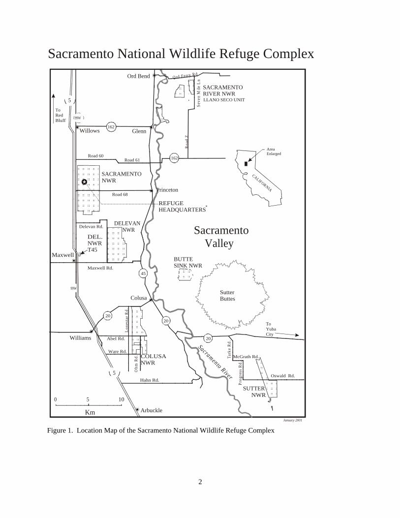
The Department of the Interior (DOI) fire management policy requires that all refuges with vegetation that can sustain fire must have a Fire Management Plan that details fire management guidelines for operational procedures and values to be protected/enhanced. The Fire Management Plan (FMP) for the Sacramento National Wildlife Refuge Complex (SNWRC) will provide guidance on preparedness, prescribed fire, wildland fire, and prevention. Values to be considered in the Fire Management Plan include protection of Refuge resources and neighboring private properties, effects of burning on refuge habitats/biota, and firefighter safety. Refuge resources include properties, structures, cultural resources, trust species including endangered, threatened, and species of special concern, and their associated habitats. The Fire Management Plan will be reviewed periodically to ensure that the fire program is conducted in accordance and evolves with the U.S. Fish and Wildlife Service (USFWS) mission and the SNWRC’s goals and objectives. The SNWRC consists of six Refuges: Sacramento, Delevan, Colusa, Butte Sink, Sutter, and Sacramento River NWRs, and three Wildlife Management Areas. This Fire Management Plan covers only five Refuges: Sacramento, Delevan, Colusa, Butte Sink, and Sutter NWRs. Fire Management at Sacramento River NWR will be covered in a separate FMP. The Complex is located in Northern California’s Sacramento Valley (north section of California’s Central Valley) and is part of the North District of the Central Valley Eco-region Fire Management Zone. The Valley lies between the Coast Range Mountains to the west and the Sierra Nevada /Cascade Ranges to the east. Presently the total acreage for the Complex is approximately 35,000 acres located in Tehama, Butte, Glenn, Colusa, and Sutter Counties (Figure 1).
2
Figure 1. Location Map of the Sacramento National Wildlife Refuge Complex
Road 61Road 60
Delevan Rd.
Maxwell Rd.
Road 68
McGrath Rd.
Oswald Rd.Hahn Rd.
Tark
e R
d.
Prog
ress
Rd.
Lone
star
Rd.
Roa
d Z
Princeton
Willows Glenn
ToRedBluff
Colusa
ToYubaCity
Williams
Maxwell
Arbuckle
AreaEnlarged
CALIFORNIA
Sacramento R iver
SutterButtes
Sacramento Valley
Ord Bend
5
5
99W
99W
162
162
45
2020
20
REFUGE HEADQUARTERS
SACRAMENTORIVER NWRLLANO SECO UNIT
SACRAMENTONWR
DELEVAN NWR
DEL.NWRT45
BUTTESINK NWR
COLUSA NWR
SUTTERNWR
Abel Rd.
Ware Rd.
Ohm
Rd.
0 5 10
O rd Ferry R d
Seve
n M
ile L
n
Km
Sacramento National Wildlife Refuge Complex
January 2001
3
COMPLIANCE WITH USFWS POLICY Authority and guidance for implementing this plan are found in:
< Protection Act of September 20, 1922 (42 Stat. 857; 16 U.S.C.594): authorizes the Secretary of the Interior to protect from fire, lands under the jurisdiction of the Department directly or in cooperation with other Federal agencies, states, or owners of timber.
< Economy Act of June 30, 1932: authorizes contracts for services with other Federal agencies.
< Reciprocal Fire Protection Act of May 27, 1955 (69 Stat. 66, 67; 42 U.S.C. 1856, 1856a and b): authorizes reciprocal fire protection agreements with any fire organization for mutual aid with or without reimbursement and allows for emergency assistance in the vicinity of agency lands in suppressing fires when no agreement exists.
< Disaster Relief Act of May 22, 1974 (88 Stat. 143; 42 U.S.C. 5121): authorizes Federal agencies to assist state and local governments during emergency or major disaster by direction of the President.
< National Wildlife Refuge System Administrative Act of 1966 as amended by the National Wildlife Refuge System Improvement Act of 1997, 16 U.S.C. 668dd et seq.: defines the National Wildlife Refuge System as including wildlife refuges, areas for the protection and conservation of fish and wildlife which are threatened with extinction, wildlife ranges, game ranges, wildlife management areas and waterfowl production areas. It also establishes a conservation mission for the Refuge System, defines guiding principles and directs the Secretary of the Interior to ensure that biological integrity and environmental health of the system are maintained and that growth of the system supports the mission.
< Federal Fire Prevention and Control Act of October 29, 1974 (88 Stat. 1535; 15 U.S.C.2201): provides for reimbursement to state or local fire services for costs of firefighting on federal property.
< Wildfire Suppression Assistance Act of 1989. (Pub.L. 100-428, as amended by Pub.L 101- 11, April 7, 1989).
< Departmental Manual (Interior), Part 620 DM, Chapter 1, Wildland Fire Management: General Policy and Procedures (April 10, 1998): defines Department of Interior fire management policies.
< Service Manual, Part 621, Fire Management (February 7, 2000): defines U.S. Fish and Wildlife Service fire management policies.
< National Environmental Policy Act of 1969: regulations implementing the National Environmental Policy Act (NEPA) encourages the combination of environmental comments with other agency documents to reduce duplication and paperwork (40 CFR 1500.4(o) and 1506.4).
< Clean Air Act (42 United State Code (USO) 7401 et seq.): requires states to attain and maintain the national ambient air quality standards adopted to protect health and welfare. This encourages states to implement smoke management programs to mitigate the public health and welfare impacts of Wildland and prescribed fires managed for resource benefit.
< Endangered Species Act of 1973. < U.S. Fish & Wildlife Service Fire Management Handbook.
4
This plan meets NEPA / NHPA compliance and will be implemented in cooperation with the Endangered Species Act of 1973, as amended, under the section 7 programmatic review, and will take appropriate action to identify and protect from adverse effects on any rare, threatened, or endangered species. (See Appendix A). The authority for funding (normal fire year programming) and all emergency fire accounts is found in the following authorities:
Section 102 of the General Provisions of the Department of Interior's annual Appropriations Bill provides the authority under which appropriated monies can be expended or transferred to fund expenditures arising from the emergency prevention and suppression of wildland fire.
P.L. 101-121, Department of the Interior and Related Agencies Appropriation Act of 1990, established the funding mechanism for normal year expenditures of funds for fire management purposes.
31 US Code 665(E)(1)(B) provides the authority to exceed appropriations due to wildland fire management activities involving the safety of human life and protection of property.
Authorities for procurement and administrative activities necessary to support wildland fire suppression missions are contained in the Interagency Fire Business Management Handbook.
5
FIRE MANAGEMENT OBJECTIVES The following considerations were used to develop the SNWRC fire management goals and objectives, as outlined in the Refuge’s Master and annual Habitat Management Plans. Appendix B contains a list of terminology definitions. Considerations
< Fire is an essential part of maintaining the refuge’s native biotic communities. < Prescribed fire has positive effects on vegetation and wildlife when conducted during the
appropriate burning conditions, time of year, and plant phenology, using the proper techniques.
< Uncontrolled wildland fire has the potential for negative impacts (out of season, increased intensity, fire trespass, burning onto neighboring properties...).
< Use of Minimum Impact Suppression Tactics (MIST) concept to minimize environmental damage.
Fire Management Objectives (General)
< Protect life and resources / property. < Use prescribed fire for hazard fuel reduction and habitat improvement.
Fire Management Objectives (Specific)
< Safely suppress all wildland fires using strategies and tactics appropriate to safety considerations and values at risk (Fire Use not feasible).
< Provide for and protect habitat for trust species, especially endangered, threatened, and species of concern.
< Use prescribed fire to reduce hazardous fuels and improve habitat conditions. < Prevent human-caused wildland fires. < Educate the public regarding fire management.
6
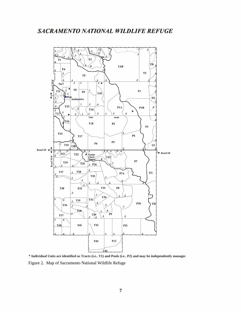
DESCRIPTION OF REFUGE This section provides background information on the individual Refuges covered under this plan, including: Sacramento, Delevan, Colusa, Sutter, and Butte Sink. Information includes the year established, purpose, location, percentages of habitat, planning status, and Refuge objectives. SACRAMENTO NWR Sacramento National Wildlife Refuge was established in 1937 by Executive Order No. 7562 and acquired with funds from the Emergency Conservation Fund Act of 1933 in order to alleviate crop depredation problems as well as provide wintering habitat for waterfowl. The Refuge is located in the Sacramento Valley of north central California, and is situated about 90 miles north of the metropolitan area of Sacramento and six miles south of the town of Willows. The Refuge comprises 10,783 acres located in both Glenn and Colusa Counties (Figure 2). The region is generally rural in nature with a low population density. Use of lands surrounding the Refuge include farming (mostly rice) and private duck-hunting clubs (seasonal wetlands). The area is a major historical wintering area for migratory waterfowl of the Pacific Flyway. Approximately 75 percent of the Refuge’s acreage consists of wetlands such as seasonally flooded marsh, watergrass, permanent and summer ponds, and riparian habitat, while the remainder consists of upland habitats. These are described in further detail in the Vegetation section. Fuel and vegetation types characteristic of the Refuge are:
< Fuel Model 1: approximately 2,796 acres of uplands. < Fuel Model 3: approximately 7,583 acres of wetlands. < Fuel Model 9: approximately 404 acres of riparian woodland.
At present, Sacramento National Wildlife Refuge does not have an approved Comprehensive Conservation Plan (planned for 2003). The Refuge currently uses annual Habitat Management Plans that identify habitat needs including objectives which pertain to fire management. The primary objectives of the Refuge are to:
< Provide feeding and resting habitat for migrating and wintering waterfowl and other water birds.
< Provide habitat and manage for endangered, threatened, or sensitive species of concern. < Preserve a natural diversity and abundance of flora and fauna. < Provide opportunities for understanding and appreciation of wildlife ecology, and the
human role in the environment; and provide high-quality wildlife-dependent recreation and education.
< Provide an area for compatible, management-oriented research. < Alleviate crop depredation.
7
Figure 2. Map of Sacramento National Wildlife Refuge
Road 68Road 68
.
Roa
d 99
WR
oad
99W
* Individual Units are identified as Tracts (i.e.. T1) and Pools (i.e.. P2) and may be independently managed
8
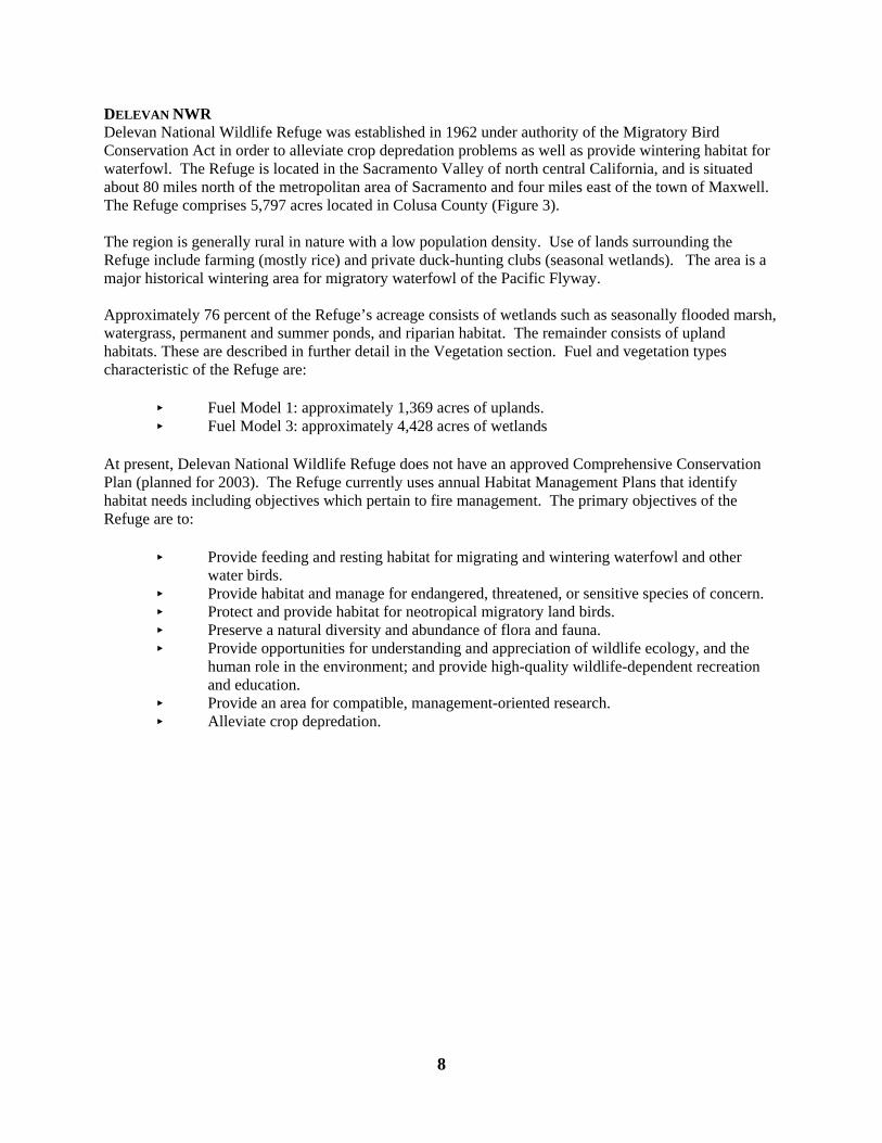
DELEVAN NWR Delevan National Wildlife Refuge was established in 1962 under authority of the Migratory Bird Conservation Act in order to alleviate crop depredation problems as well as provide wintering habitat for waterfowl. The Refuge is located in the Sacramento Valley of north central California, and is situated about 80 miles north of the metropolitan area of Sacramento and four miles east of the town of Maxwell. The Refuge comprises 5,797 acres located in Colusa County (Figure 3). The region is generally rural in nature with a low population density. Use of lands surrounding the Refuge include farming (mostly rice) and private duck-hunting clubs (seasonal wetlands). The area is a major historical wintering area for migratory waterfowl of the Pacific Flyway. Approximately 76 percent of the Refuge’s acreage consists of wetlands such as seasonally flooded marsh, watergrass, permanent and summer ponds, and riparian habitat. The remainder consists of upland habitats. These are described in further detail in the Vegetation section. Fuel and vegetation types characteristic of the Refuge are:
< Fuel Model 1: approximately 1,369 acres of uplands. < Fuel Model 3: approximately 4,428 acres of wetlands
At present, Delevan National Wildlife Refuge does not have an approved Comprehensive Conservation Plan (planned for 2003). The Refuge currently uses annual Habitat Management Plans that identify habitat needs including objectives which pertain to fire management. The primary objectives of the Refuge are to:
< Provide feeding and resting habitat for migrating and wintering waterfowl and other water birds.
< Provide habitat and manage for endangered, threatened, or sensitive species of concern. < Protect and provide habitat for neotropical migratory land birds. < Preserve a natural diversity and abundance of flora and fauna. < Provide opportunities for understanding and appreciation of wildlife ecology, and the
human role in the environment; and provide high-quality wildlife-dependent recreation and education.
< Provide an area for compatible, management-oriented research. < Alleviate crop depredation.
9
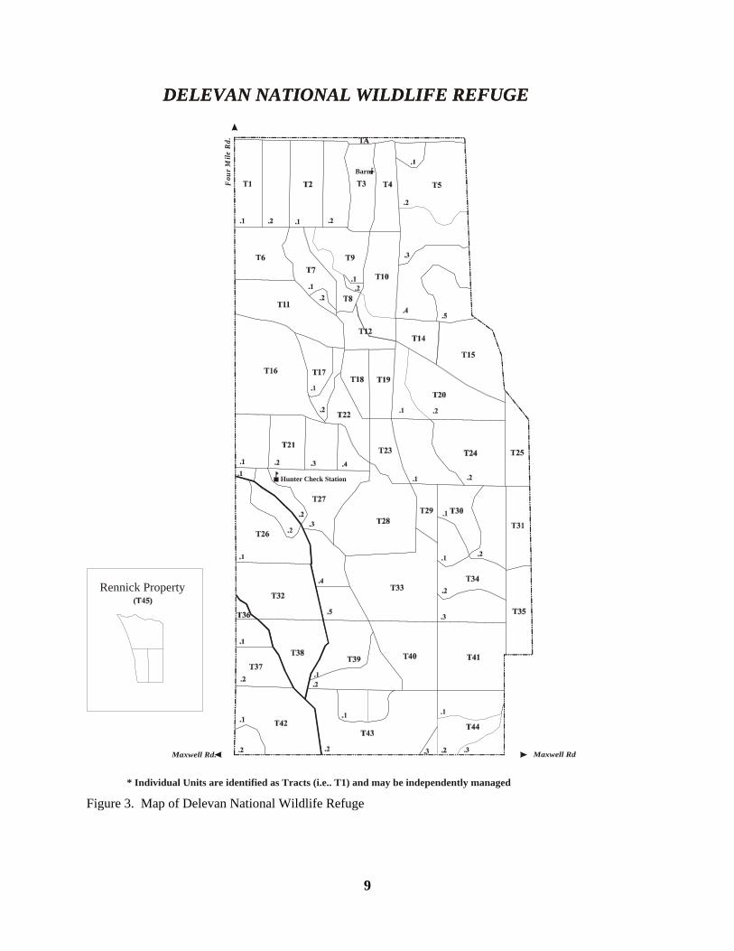
Figure 3. Map of Delevan National Wildlife Refuge
DELEVAN NATIONAL WILDLIFE REFUGE
Rennick Property
DELEVAN NATIONAL WILDLIFE REFUGE
Barn
Hunter Check Station
Maxwell Rd. Maxwell Rd.
Fou
r M
ile R
d.
* Individual Units are identified as Tracts (i.e.. T1) and may be independently managed
10
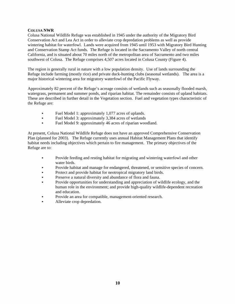
COLUSA NWR Colusa National Wildlife Refuge was established in 1945 under the authority of the Migratory Bird Conservation Act and Lea Act in order to alleviate crop depredation problems as well as provide wintering habitat for waterfowl. Lands were acquired from 1945 until 1953 with Migratory Bird Hunting and Conservation Stamp Act funds. The Refuge is located in the Sacramento Valley of north central California, and is situated about 70 miles north of the metropolitan area of Sacramento and two miles southwest of Colusa. The Refuge comprises 4,507 acres located in Colusa County (Figure 4). The region is generally rural in nature with a low population density. Use of lands surrounding the Refuge include farming (mostly rice) and private duck-hunting clubs (seasonal wetlands). The area is a major historical wintering area for migratory waterfowl of the Pacific Flyway. Approximately 82 percent of the Refuge’s acreage consists of wetlands such as seasonally flooded marsh, watergrass, permanent and summer ponds, and riparian habitat. The remainder consists of upland habitats. These are described in further detail in the Vegetation section. Fuel and vegetation types characteristic of the Refuge are:
< Fuel Model 1: approximately 1,077 acres of uplands. < Fuel Model 3: approximately 3,384 acres of wetlands < Fuel Model 9: approximately 46 acres of riparian woodland.
At present, Colusa National Wildlife Refuge does not have an approved Comprehensive Conservation Plan (planned for 2003). The Refuge currently uses annual Habitat Management Plans that identify habitat needs including objectives which pertain to fire management. The primary objectives of the Refuge are to:
< Provide feeding and resting habitat for migrating and wintering waterfowl and other water birds.
< Provide habitat and manage for endangered, threatened, or sensitive species of concern. < Protect and provide habitat for neotropical migratory land birds. < Preserve a natural diversity and abundance of flora and fauna. < Provide opportunities for understanding and appreciation of wildlife ecology, and the
human role in the environment; and provide high-quality wildlife-dependent recreation and education.
< Provide an area for compatible, management-oriented research. < Alleviate crop depredation.
11
Figure 4. Map of Colusa National Wildlife Refuge
T1T2
T3 T4
T5
T6
T7
T8
T11
T9
T10
T12
T13 T14
T16
T17
T18 T19
T20T21
T22
T23
T24
T2A
T13A
T15A
T10A
T6A
P1 P2
P3 P4
P5 P6
T12A
HunterCheckStation
COLUSA NATIONAL WILDLIFE REFUGEWilliams
Abel Road Abel Road
Ware Road
Ohm
Roa
d
.1
.2
.3
.1
.2
.1
.2
.3
.4
.1
.2
.3
.4
.2
.1
.1 .3
.2 .4
.1
.2
.3
.4
.2
.1
.3.4
.1
.3
.2
.1 .2
.1.2
Hwy. 20
Private
Private Priv
ate
T15
.2
.2
.3
.3 .10
.12 .13
.11.5
.4
.4 .9.7
.8
.6
.7A
.1
.1
.1 .2
Colusa
PS
T25T25
* Individual Units are identified as Tracts (i.e.. T1) and Pools (i.e.. P2) and may be independently managed
12
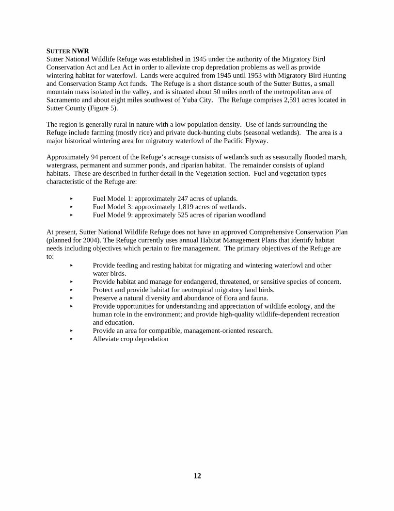
SUTTER NWR Sutter National Wildlife Refuge was established in 1945 under the authority of the Migratory Bird Conservation Act and Lea Act in order to alleviate crop depredation problems as well as provide wintering habitat for waterfowl. Lands were acquired from 1945 until 1953 with Migratory Bird Hunting and Conservation Stamp Act funds. The Refuge is a short distance south of the Sutter Buttes, a small mountain mass isolated in the valley, and is situated about 50 miles north of the metropolitan area of Sacramento and about eight miles southwest of Yuba City. The Refuge comprises 2,591 acres located in Sutter County (Figure 5). The region is generally rural in nature with a low population density. Use of lands surrounding the Refuge include farming (mostly rice) and private duck-hunting clubs (seasonal wetlands). The area is a major historical wintering area for migratory waterfowl of the Pacific Flyway. Approximately 94 percent of the Refuge’s acreage consists of wetlands such as seasonally flooded marsh, watergrass, permanent and summer ponds, and riparian habitat. The remainder consists of upland habitats. These are described in further detail in the Vegetation section. Fuel and vegetation types characteristic of the Refuge are:
< Fuel Model 1: approximately 247 acres of uplands. < Fuel Model 3: approximately 1,819 acres of wetlands. < Fuel Model 9: approximately 525 acres of riparian woodland
At present, Sutter National Wildlife Refuge does not have an approved Comprehensive Conservation Plan (planned for 2004). The Refuge currently uses annual Habitat Management Plans that identify habitat needs including objectives which pertain to fire management. The primary objectives of the Refuge are to:
< Provide feeding and resting habitat for migrating and wintering waterfowl and other water birds.
< Provide habitat and manage for endangered, threatened, or sensitive species of concern. < Protect and provide habitat for neotropical migratory land birds. < Preserve a natural diversity and abundance of flora and fauna. < Provide opportunities for understanding and appreciation of wildlife ecology, and the
human role in the environment; and provide high-quality wildlife-dependent recreation and education.
< Provide an area for compatible, management-oriented research. < Alleviate crop depredation
13
Figure 5. Map of Sutter National Wildlife Refuge
T1
T2
T3
T4 T5
T6
T7
T8
T10
T11T12
T20
T19
T18
T14T13
T15
T17
T16
.2
.1
.2 .1
.3
.1
.2
.1
.2.4
.1
.2
.3
T9T1.2
T1.3
.1 .2 .3
.5 .6.4
.7 .8
.1
.2
.3.4
.1
.3
.2
.1
.2
.3
.4
Hughes Rd.
CheckingStation
SUTTER NATIONAL WILDLIFE REFUGE
Hughes Rd.
Shop
* Individual Units are identified as Tracts (i.e.. T1) and may be independently managed
14
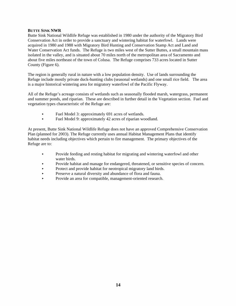
BUTTE SINK NWR Butte Sink National Wildlife Refuge was established in 1980 under the authority of the Migratory Bird Conservation Act in order to provide a sanctuary and wintering habitat for waterfowl. Lands were acquired in 1980 and 1988 with Migratory Bird Hunting and Conservation Stamp Act and Land and Water Conservation Act funds. The Refuge is two miles west of the Sutter Buttes, a small mountain mass isolated in the valley, and is situated about 70 miles north of the metropolitan area of Sacramento and about five miles northeast of the town of Colusa. The Refuge comprises 733 acres located in Sutter County (Figure 6). The region is generally rural in nature with a low population density. Use of lands surrounding the Refuge include mostly private duck-hunting clubs (seasonal wetlands) and one small rice field. The area is a major historical wintering area for migratory waterfowl of the Pacific Flyway. All of the Refuge’s acreage consists of wetlands such as seasonally flooded marsh, watergrass, permanent and summer ponds, and riparian. These are described in further detail in the Vegetation section. Fuel and vegetation types characteristic of the Refuge are:
< Fuel Model 3: approximately 691 acres of wetlands. < Fuel Model 9: approximately 42 acres of riparian woodland.
At present, Butte Sink National Wildlife Refuge does not have an approved Comprehensive Conservation Plan (planned for 2003). The Refuge currently uses annual Habitat Management Plans that identify habitat needs including objectives which pertain to fire management. The primary objectives of the Refuge are to:
< Provide feeding and resting habitat for migrating and wintering waterfowl and other water birds.
< Provide habitat and manage for endangered, threatened, or sensitive species of concern. < Protect and provide habitat for neotropical migratory land birds. < Preserve a natural diversity and abundance of flora and fauna. < Provide an area for compatible, management-oriented research.
15
Figure 6. Map of Butte Sink National Wildlife Refuge
BUTTE SINK NATIONAL WILDLIFE REFUGE
Sac Outing Duck Club
T5
WestButteDuckClub
StackDuck Club
Colusa Shooting ClubRice
.3
.2
.2
.3
.2
.1
.1
.1T4
Butt e
Ou t
ing
Duc
k C
lub
T1
T3
T2
El Anzar Duck Club
* Unit/cell acreages changes this year to reflect GIS estimates. Configurations of T3/T4 corrected this year; maps from1996-2000 were incorrect.
* Individual Units are identified as Tracts (i.e.. T1) and may be independently managed
16
CLIMATE The climate throughout the Complex is classified as Mediterranean, with cool, wet winters and hot, dry summers. Rainfall is fairly well distributed throughout the winter, occurring in steady but gentle two or three day storms. The annual average precipitation is 16-18 inches. Heavy fogs are common during the winter months, while thunderstorms, hail and snow are a rare occurrence. The mean annual temperature is 61.7EF with extremes of 118EF and 15EF. South winds are associated with storms in the winter and the cooling trends in the summer. North winds are usually dry following winter storms, and hot and dry in the summer, creating the most hazardous wildland fire conditions during the summer. CULTURAL RESOURCES Most refuges have historically been farmed or cultivated and subjected to some disturbance over the years. Where native soils have not been disturbed by farming or past refuge activities, no firelines will be constructed unless deemed absolutely necessary by the Refuge Manager or designate. Structures and areas of historical significance are identified in Appendix C. VEGETATION SNWRC consists of 24,411acres of wetlands, uplands, and riparian habitats. Because of the importance of Central Valley wetlands to Pacific Flyway waterfowl populations, wetland units are intensively managed. The primary objective of this management is to provide a variety of successional stages and thus a diversity and abundance of desirable plants in the wetland units. For a complete listing of plant species common to the Complex, see Appendix D. Wetland units are divided into seasonally flooded marsh, watergrass/moist soil, summer water, and permanent ponds. Uplands are comprised mostly of vernal pools, alkali meadow, and alkali non-native grassland. Descriptions of wetland, upland, and riparian habitats and their associated plant/wildlife species are as follows. Distributions of habitats within each refuge can be seen in Appendix E. Seasonally Flooded Marsh The most numerous and diverse of the wetland habitat types, these units comprise about 70 percent of the wetland habitat base and are typically flooded from early September through mid-April. Their diversity is the product of a variety of water depths which result in diverse patterns of vegetation species that, in combination, provide habitat for the greatest number of wildlife species throughout the course of a year. Seasonally flooded marshes are used during the fall and winter by great concentrations of waterfowl and lesser numbers of other waterbirds including shorebirds, egrets, herons, ibis, and grebes. In addition, many species of raptors migrate into the area following the waterbird prey base upon which they depend. As water is removed in the spring, large concentrations of shorebirds utilize the shallow depth and exposed mudflats on their northern migration. Seed-producing plants germinate and grow to maturity on the moist pond bottoms during the spring and early summer. Flood-up in the fall makes this food available to early migrant waterfowl and other waterbirds. Common plants to seasonally flooded marsh include swamp timothy, sprangletop, smartweed, alkali and hardstem bulrush, cattail, and bermuda grass. Watergrass/Moist Soil Comprising approximately 12 to 15 percent of the wetland habitat base, these units are typically flooded from late August through early May. An irrigation is usually accomplished in mid-June to bring large quantities of watergrass, sprangletop, and smartweed plants to maturity. During these irrigation periods, these units are often utilized by locally-nesting colonial waterbirds (egrets, herons). Because this habitat type often results in thick monocultures, openings are disced or mowed prior to flood-up. Though not as diverse, once flooded these units provide an abundant food source for early migrant waterfowl at a very important time of the year. It also helps minimize potential crop depredation, which is one of the Complex’s goals. In addition, a number of wading-bird species such as curlews, whimbrel, ibis, herons, and egrets frequent them throughout the year.
17
Summer Water Combined with permanent ponds, these habitats make up 5 to 10 percent of the wetland base. During the summer growing season, water is often used to encourage growth in certain sparsely-vegetated units. Two water management strategies are employed: in some units, water removal will not take place until late July; in others, normal drawdown (April) is done, scheduled work is completed, and then the unit is flooded for the remainder of the year. Both practices serve to promote plant growth while providing habitat for “resident” wildlife during the hot summer months. Permanent Ponds Combined with summer water, these habitats make up 5 to 10 percent of the wetland base and remain flooded throughout the year. Characterized by both emergent and submergent aquatic plants, these units provide brood and molting areas for waterfowl, secure roosting and nesting sites for wading birds (herons, egrets, bitterns, ibis) and other over-water nesters (grebes, coots, blackbirds, marsh wrens), and feeding areas for species like cormorants and pelicans. These units are drawn down every four to five years to recycle nutrients to increase their productivity and discourage carp populations. Common plants to permanent ponds include hardstem bulrush, cattail, alkali bulrush, arrowhead, burhead, and several species of pondweeds. Riparian Habitat Comprised of a variety of mixed riparian vegetation, these habitats include black willow, sandbar willow, Fremont’s cottonwood, and a variety of other trees, shrubs, and herbaceous vegetation. Riparian habitat occurs along creeks and other managed waterways of the Complex. This habitat provides nesting, roosting, and feeding habitat for passerine and raptor species. Deer, small mammals, and duck broods utilize riparian zones during summer when most marsh units are dry. Uplands “Uplands” on the Complex are mostly comprised of vernal pools, alkali meadows, and alkali non-native annual grasslands. Most plant species in these communities are natives and occur in a variety of patterns, which yield the most diverse vegetation on the Complex. Fourteen Federal, State, and California Native Plant Society (CNPS) special status plant species occur in these habitats; as well as three special status invertebrates. Characteristic plants of vernal pools include button-celery, smooth-stemmed popcornflower, stipitate popcornflower, white-flowered navarretia, dwarf woolly-heads, Oregon woolly-heads, Fremont’s goldfields, and several species of downingia. Typifying the alkali meadow are saltgrass, alkali heath, alkali weed, Great Valley gumplant, common spikeweed, pappose spikeweed, eleven chenopod species, bush seepweed, horned sea-blite, and pickleweed. Alkali non-native grassland species include dwarf barley, foxtail barley, barbed oat, Pacific bentgrass, ripgut brome, soft chess, red brome, tall fescue, Mediterranean barley, annual ryegrass, Mediterranean beardgrass, and foxtail fescue. During the wet season, Canada geese, wigeon, and coots graze on the depauperate grasses in the alkali meadows, and dabbling ducks and shorebirds feed in the vernal pools. Killdeer, stilts, and avocets nest in these habitats. Alkali meadows and vernal pools are the native indigenous habitats of the Colusa Plains (Basin), once known as the “hard alkali gooseland”; now, Sacramento NWR, Delevan NWR, and Colusa NWR are virtually all that remain. When properly applied, prescribed fire may stimulate native upland species production by reducing some non-native plants and their thatch. It can benefit wetlands by opening up overly dense stands of emergent vegetation or by reducing problem species such as jointgrass. Burning also removes accumulated residual fuels, thus reducing wildland fire potential. Sensitive vegetation may be impacted by fire that occurs at the wrong time of year, and growing plants may be killed by fire, which may or may not be a desired result. A recent study conducted at Sacramento
18
NWRC documents the effects of fire on four rare plants, and is summarized under the “Fire Research” section. FISH AND WILDLIFE Many avian groups, such as waterfowl, shorebirds, wading/diving birds, raptors, game birds, gulls/terns, and landbirds, are found on the Complex at various times throughout the year. Also present are mammalian, herptile, fish, and invertebrate species. While many species are common year-round, others are here only for the winter, or during spring and summer months to breed. Appendix F contains a complete list of wildlife species common to the SNWRC. An overview of wildlife use of the Complex follows. Waterfowl Primary wildlife use of the Complex is by wintering waterfowl during the months of August through March. Peak wintering populations occur during November and December, when approximately 1.5 to 2 million ducks and 200,000 to 300,000 geese are present. A small percentage remain through spring and summer months to nest. Common wintering duck species include northern pintail, mallard, wigeon, green-winged teal, gadwall, northern shoveler, wood duck, ring-necked duck, canvasback, redhead, and ruddy duck. Wintering goose species include lesser snow goose, Ross’ goose, white-fronted goose, and Canada goose (mostly cackling and Aleutian subspecies). Those species that stay through the spring and summer to nest include mallard, cinnamon teal, gadwall, wood duck, and a lesser numbers of pintail and redheads. Shorebirds Shorebirds use the Complex in greatest numbers during their fall and spring migrations, with populations peaking in April when approximately 10,000-50,000 seek out shallow seasonal marsh and vernal pools. Common fall and spring migrants include western and least sandpipers, dunlin, dowitcher, black-necked stilt, American avocet, black-bellied and semi-palmated plovers, greater yellowlegs, long-billed curlew, and whimbrel. The American avocet, black-necked stilt, and killdeer may remain to nest. Wading/diving birds Many wading and diving birds use the Complex year-round, utilizing all wetland habitat types for foraging, roosting, and nesting. Such species include great blue heron, great, snowy and cattle egrets, green heron, American bittern, black-crowned night heron, white-faced ibis, Virginia rail, sora, moorhen, American coot, pied-billed and Western grebes, and double-crested cormorant. Other waterbirds use refuge wetlands at various times throughout the year, such as western/Clark’s grebe, eared grebe, and American white pelican. Greater Sandhill cranes forage and roost in seasonal marsh and upland habitats in Butte Sink NWR throughout the winter. Raptors Raptor populations are largest during the winter when the waterfowl prey base is greatest. These birds are most often perching along riparian corridors where they roost, and hunting in wetland and upland areas. The most abundant wintering species are red-tailed hawk and Northern harrier, but bald eagle, golden eagle, white-tailed kite, sharp-shinned hawk, Cooper’s hawk, peregrine falcon, and short-eared owl also occur regularly. Turkey vulture, red-tailed hawk, red-shouldered hawk, white-tailed kite, northern harrier, American kestrel, barn-owl, and great-horned owl are breeding species. Swainson’s hawk and burrowing owl are most common during spring and summer when they are nesting in riparian and upland areas, respectively. Gamebirds Gamebirds occur year-round. Mourning doves and California quail can be found in riparian areas, while
19
ring-necked pheasant are commonly seen in seasonal wetland and upland areas. Gulls/terns Ring-billed gull and herring gull are common during fall and into spring. The black tern occurs during the spring and summer and nests in wetlands and nearby rice fields. Forster’s and Caspian terns occur infrequently, but are often seen in small numbers during spring and fall migration periods. Landbirds The Complex attracts a large array of both resident and migrant landbird species. Common year-round wetland residents include marsh wren, brewer’s blackbird, brown-headed cowbird, and black phoebe. Tricolored blackbirds nest in large colonies in wetland units. Resident species that can be found in riparian and upland areas include belted kingfisher, Nuttall’s woodpecker, northern flicker, California towhee, scrub jay, yellow-billed magpie, American crow, common raven, bushtit, Bewick’s wren, mockingbird, northern shrike, European starling, savannah sparrow, western meadowlark, and housefinch. Additional breeding species supported by these habitats include yellow-billed cuckoo, western wood pewee, ash-throated flycatcher, western kingbird, house wren, American robin, blue and black-headed grosbeaks, lazuli bunting, Bullock’s oriole, titmouse, and tree, violet-green, cliff, and barn swallows are found in upland and riparian areas during the nesting season. Wintering species including ruby-crowned kinglet, American pipit, yellow-rumped warbler, lark sparrow, golden-crowned sparrow, white-crowned sparrow, dark-eyed junco, and lesser and American goldfinches may be found in wetland, upland, or riparian areas during the winter. Other commonly seen migrants include Anna’s hummingbird, downy woodpecker, olive-sided flycatcher, horned lark, Wilson’s warbler, song sparrow, and Lincoln’s sparrow. Mammals Many mammalian species are year-round residents of the Complex. The more aquatic beaver, muskrat, mink, and otter occur in wetlands and riparian corridors along waterways. Upland species include black-tailed deer, black-tailed jackrabbit, desert cottontail, raccoon, spotted and striped skunk, coyote, beechy ground squirrel, deer mouse, California vole, and Mexican free-tailed bat. Herptiles Reptiles are common residents in upland and riparian areas, and include common garter snake, gopher snake, western yellowbelly racer, common kingsnake, western fence lizard, and alligator lizard. A few species, such as giant garter snake and western pond turtle, are wetland-dependent residents. The American bullfrog and Pacific tree frog are the only amphibians found on the Complex. Fish Fish species are found in Complex waterways, permanent ponds, and seasonal marshes. Common species include Gambusia (mosquitofish), carp, channel catfish, mosquitofish, and green sunfish. Chinook salmon, steelhead, and Sacramento splittail can be found occasionally in waterways. Invertebrates Invertebrate populations are greatest and most diverse in seasonal marsh, and provide an important food base for many waterfowl, shorebird, and other avian species. Common aquatic invertebrates include waterfleas, snails, clams, dragonflies, damselfiles, waterboatmen, backswimmers, beetles, midges, crayfish and worms. Generally, the direct impacts of fire on wildlife include disturbance or infrequent injury/mortality of individuals or groups of individuals, particularly slow moving and/or sedentary species. The long term results of fire on wildlife are positive due to the benefits of increased habitat quality and diversity.
20
THREATENED AND ENDANGERED SPECIES Sacramento National Wildlife Refuge Complex contains a number of threatened, endangered, and candidate species including both plant and animal species. The fire management program will be implemented in accordance with the Endangered Species Act of 1973 and will take appropriate action to identify and protect from adverse effects on any rare, threatened, or endangered species. The Complex has consulted with the Sacramento Field Office on operations and maintenance activities of the SNWRC, including the use of prescribed burning for habitat management. The resulting biological opinion (Appendix A) stated these activities would not jeopardize continuing existence of any federally endangered/threatened species on the SNWRC. U.S. Fish and Wildlife Service policy requires that State threatened and endangered species and Federal candidate species will be incorporated into any planning activities. Appendix G contains a list of Threatened and Endangered species found on the Complex. PHYSICAL RESOURCES - WATER, TOPOGRAPHY The Complex lies in the northern and central portion of the Sacramento River Valley along many natural and human-made waterways. All the refuges in the Complex are divided into separate habitat management units (e.g., tracts and pools), most of which can be independently managed for water levels through a series of canals, levees, and water control structure. Annual habitat management plans outline water management objectives and are determined each spring by the Refuge Manager, biologist, fire staff, public use staff, and irrigator. The Complex, except for Butte Sink NWR, currently relies on a firm water supply which is made available by the Bureau of Reclamation from the Central Valley Project. This water is delivered to the Complex by the Glenn-Colusa Irrigation District under cooperative agreement with the Bureau of Reclamation. Butte Sink NWR currently obtains its water from Butte Creek through appropriate licenses (water rights) from the California State Water Resources Control Board. Each refuge’s irrigator is responsible for carrying out the water management as outlined in the habitat management plan. The Sacramento Valley is generally flat with a gradual slope from northwest to southeast. Elevations around the Complex range from 137' to 30' above sea level. SOCIO-ECONOMIC CONCERNS Sacramento National Wildlife Refuge Complex has limited public use. The headquarters, located at Sacramento NWR, hosts a visitor center that is open to the public year-round on weekdays and on weekends during the winter. Other facilities include a 6-mile auto tour, a 2-mile walking trail, and 2 photography blinds at Sacramento NWR, and a 4-mile auto tour and 1-mile walking trail at Colusa NWR, which provide for wildlife viewing, photography, and environmental education. Sacramento, Delevan, Colusa, and Sutter have areas (30-40%) open to waterfowl and pheasant hunting during the regular seasons. Wildland fire may impact habitat which could limit or enhance hunting and wildlife viewing opportunities. STRUCTURES, FACILITIES, AND NEIGHBORING LANDS Sacramento, Colusa, Delevan, and Sutter NWRs all have structures within the boundaries. These structures range from office buildings to houses to historic structures. A complete list of structures within the Complex is located in Appendix C. Refuges are bordered by private agricultural lands of mostly irrigated ricelands and private duck-hunting clubs. Preventing the spread of wildland fire to/or from adjacent private lands provides for the safety of the general public and protection of private and public lands. Refuge maps with adjacent properties and owners are included in the Complex Fire Dispatch Plan.
21
WILDLAND FIRE MANAGEMENT SITUATION HISTORIC ROLE OF FIRE The period of high fire danger is from May through early November. Occasional fires have occurred from December through April. Wildland fires have ranged in size from less than 1 to 150 acres, and prescribed fires between 30-200 acres per day. Most fires on the Complex have lasted no more than a few days with containment usually being completed within a few hours of report of ignition. Pre-settlement fires The presence of fire in the landscape has been one of the major evolutionary factors determining the composition of flora throughout California. Lightning is the most common natural ignition source. Generated by summer thunder storms, lightning is responsible for much of the wildland fires that occur throughout the western United States each year. Fire, flood, and drought all played an important role in plant succession prior to settlement of the area. Post-settlement Fire History The recent fire history from1980 is compiled from entries into the Shared Applications Computer System (SACS) and the Habitat Management Plan database. Most wildland fires that occur each year are along the boundaries (fire trespass), public use areas, adjacent roadways, and railroad. Damage from these fires may have potential negative effects on resident or nesting wildlife, threatened and endangered species, and habitat depending on the time of year. Generally, damage is temporary and after one or two years, areas return to their original condition. Sacramento National Wildlife Refuge Complex wildland fire history is listed in Appendix H. Prescribed fire history Prescribed fire has been utilized since the 1950's as part of habitat management throughout the Complex. Fire is used based on its ability to produce desired habitat conditions to meet the specific needs of wildlife or reduce non-native plant species. Sacramento National Wildlife Refuge Complex prescribed fire recent history is listed in Appendix H. RESPONSIBILITIES Principal members of the SNWRC fire management organization are the Refuge Managers, Zone Fire Management Officer (based at San Luis NWRC), Complex Fire Management Officer, Prescribed Fire Specialist, Supervisory Firefighter, Lead Firefighter, Firefighters (Squad Leaders), Seasonal, and Collateral Duty Firefighters. Fire assignments are made on the basis of individual qualifications and position requirements. A listing of fire management team members by name, position, and qualifications can be found in Appendix I. Project Leader
< Responsible for the overall management of the Refuge including the fire program < Insure that Department, Service, and Complex policies are maintained and followed < Insure sufficient collateral duty firefighters meeting Service standards are available for
initial attack. < Supervise the resource management activities of the Refuge, working with Refuge
Biologists in setting goals and objectives and selecting methods/actions to achieve them including prescribed fire
< Review and approve prescribed burn plans for SNWRC
22
Zone Fire Management Officer < Responsible for oversight of the Zone fire program and coordinates budget preparation
and fire activities. (Located at San Luis NWRC in Los Banos, CA) Complex Fire Management Officer
< Delegated the responsibility for coordination and supervision of the fire management program by the Refuge Manager
< Prepares and manages the Complex’s fire budget < Administers the payroll, purchasing and travel for the fire staff < Supervises the Complex’s fire staff < Responsible for planning, coordinating, and directing all Preparedness activities
including: < Fire training < Physical fitness testing and Interagency Fire Qualification System and data entry < Fire weather station operation and data entry < Fire cache and equipment inventory accountability, maintenance and operation < Coordinates with cooperative agencies. Revises agreements as necessary < National Fire Danger Rating System (NFDRS) use < Insures the step-up preparedness plan is followed < Prepares annual Fire Base budget request, tracks use of funding < Informs Refuge staff of fire situation and potential
< Responsible for coordinating and directing all suppression activities including < Dispatching < Fire command < Insures fire management and safety policies are observed < Advises Refuge Managers of the status of fire suppression operations
< Maintains liaison with Regional Fire Management Coordinator and Cooperators < Prepares a Complex fire prevention plan, and coordinates fire prevention duties with
other employees < Coordinates Complex fire training needs < Annually updates the Fire Management Operations Plan, maintains fire records, and
reviews completed DF-1202's for accuracy < Administers the suppression evaluation process on wildland fires
Prescribed Fire Specialist
< Responsible for managing prescribed fire activities including: < Coordinates annual prescribed fire program to meet management objectives < Prepares or approves individual prescribed fire plans < Serves as or designates Prescribed Fire Burn Boss < Provides daily validation that prescribed fires are under prescription and meet all
other Service policy requirements < Assists Refuge Biologists with fire research and fire effects monitoring. < Assists with fire aspects of the public relations program < Responsible, with the Public Use Staff, for planning programs to educate the public
regarding the role of fire in the Complex and fire prevention < Prepares and presents slide programs, video presentations and displays about the Fire
Management Program
23
Supervisory Firefighter (Fire Operations) < Supervises the Complex Engine Crews. < Assists the FMO with planning, coordinating, and directing all Preparedness activities
including: < Fire training < Physical fitness testing and Interagency Fire Qualification System and data entry. < Fire weather station operation and data entry. < Fire cache and equipment inventory accountability, maintenance and operation. < Coordinates with cooperative agencies. < National Fire Danger Rating System (NFDRS) use. < Insures the step-up Preparedness plan is followed.
< Assist with coordinating and directing all suppression activities including: < Dispatching < Fire Command < Insures fire management and safety policies are observed < Advising Refuge Manager of the status of fire suppression operations
< Responsible for supervising prescribed fire activities including: < Prepares and reviews individual prescribed fire plans < Serves as Prescribed Fire Burn Boss < Provides daily validation that prescribed fires are under prescription
Lead Firefighter (Crew Leader)
< Leads Engine Crew on and off Refuge assignments. < Assists the Supervisory Firefighter with planning, coordinating, and directing all
Preparedness activities including: < Fire training < Physical fitness testing < Fire weather station operation < Fire cache and equipment inventory accountability, maintenance and operation < Coordinates with cooperative agencies < National Fire Danger Rating System (NFDRS) use < Insures the step-up Preparedness plan is followed.
< Assist with coordinating and directing suppression activities including: < Dispatching < Fire Command < Insures fire management and safety policies are observed < Advising supervisors of the status of fire suppression operations
< Responsible for prescribed fire activities including: < Ignition or holding leaders < Monitors fire effects and other parameters as required
Firefighters (Squad Leaders)
< Lead Engine Crew as needed with on -Refuge assignments < Assist the Supervisory Firefighter with planning, coordinating, and directing all
Preparedness activities including: < Fire weather station operation and data entry < Fire cache and equipment inventory accountability, maintenance and operation < National Fire Danger Rating System (NFDRS) use
24
< Insures the step-up Preparedness plan is followed. < Assist with coordinating and directing suppression activities including: < Insures fire management and safety policies are observed < Advises supervisors of the status of daily crew operations
< Responsible for prescribed fire activities including: < Ignition or holding leaders < Monitors fire effects and other parameters as required
Seasonal Firefighters
< Maintain assigned fire equipment in ready state and use all safety gear assigned < Participate on fire assignments as firefighters (ignition, holding, and engine operation)
Collateral Duty Firefighters
< Maintain assigned fire equipment in ready state and use all assigned safety gear < Participate on fire assignments as firefighters (ignition, holding, and engine operation)
Incident Commander Incident Commanders (of any level) use strategies and tactics as directed by the Refuge Manager and WFSA where applicable to implement selected objectives on a particular incident. A specific Limited Delegation of Authority (Appendix J) will be provided to each Incident Commander prior to assuming responsibility for an incident. Major duties of the Incident Commander are given in NWCG Fireline Handbook, including:
< Brief subordinates, direct their actions and provide work tools < Ensure that safety standards identified in the Fire Orders, the Watch Out Situations, and
agency policies are followed at all times < Personally scout and communicate with others to be knowledgeable of fire conditions,
fire weather, tactical progress, safety concerns and hazards, condition of personnel, and needs for additional resources
< Order resources to implement the management objectives for the fire < Inform appropriate dispatch of current situation and expected needs < Coordinate mobilization and demobilization with dispatch and the Collateral FMO < Perform administrative duties; i.e., approving work hours, completing fire reports for
command period, maintaining property accountability, providing or obtaining medical treatment, and evaluating performance of subordinates
< Assure aviation safety is maintained to the highest standards INTERAGENCY OPERATIONS Interagency contacts are established at the Federal, State, and Local levels to provide the most efficient level of fire management operations. Agreements and Memorandums of Understanding (MOU) (sample MOU in Appendix K). should be established and used to foster guidelines for assistance from local cooperators. The MOU allows the responding agency to assume command of the incident until a representative of the Complex arrives to establish a unified command or assume responsibility for the incident if qualified. Depending on time of year federal, state, or local resources may perform initial attack for the Refuges. The Complex Dispatch Plan (Appendix L) Contains the guidelines for a reported fire and the proper dispatching to affect a quick and orderly initial attack by the closest local resource. Radio frequencies are available in Appendix M.
25
Cooperative Agreements/MOU’s exist between Sacramento NWRC and the following agencies:
Cooperating Agency
MOU/Coop Agreement Document Number
Project Officer
Phone Number
USDA Forest Service and USDI Fish and Wildlife Service
04A-05-FPM-HO
Ord Bend Fire Protection District
1448-11620-1-K246 Fire Chief, Ord Bend FPD
530-934-3323
Glenn-Colusa Fire Protection District - Butte City
1148-11620-1-K131 Mike Shouten, Fire Chief, Butte City FD
530-982-2206
Hamilton City Fire Protection District
1448-11620-1-K128 Jose Puente, Fire Chief, Hamilton City FPD`
530-826-3355
Sacramento River Rural Fire Protection District
1448-11620-1-K243 Fire Chief, Sacramento River Rural FPD
530-439-2235
Willows City and Rural Fire Protection District
1448-11620-1-K245 Bradley Mallory, Fire Chief, Willows FPD
530-934-3323
Maxwell Fire Protection District
1148-11620-1-K130 David Well, Fire Chief, Maxwell, FPD
530-438-2428 (home) 530-701-2346 (cell)
Colusa Rural Fire Protection District
14-48-0001-95508 DCN-11620-5-0054
Jeff Winters, Fire Chief, Colusa FPD
530-458-0239
Williams Fire Protection District
14-48-0001-95509 DCN-11620-5-0053
Mark Marshall, Fire Chief, Williams FPD
530-473-2269
Bayliss Fire Protection District
1448-11620-1-K244 Fire Chief, Bayliss Fire Protection District
530-934-3323
Closest Fire Departments and Fire Districts (by Refuge): Sacramento NWR - Mendocino National Forest (all Refuges) (530) 934-7758 Willows Fire Department (Glenn Co.): (530) 934-3323 Maxwell Fire Department (Colusa Co.): (530) 458-0200 Delevan NWR - Maxwell Fire Department (Colusa Co.): (530) 458-0200 Colusa NWR - Williams Fire Department (West side): (530) 473-2424 Sacramento River Fire Department (Colusa): (530) 458-0200 Butte Sink NWR - Sutter County Fire: (530) 673-2804 Sacramento River Fire Department (Colusa): (530) 458-4994 Sutter NWR - Sutter County Fire: (530) 673-2804
26
PROTECTION OF SENSITIVE RESOURCES To protect the Refuge’s resources, mechanical line construction (dozers, discing) and off- road travel must be authorized by the Refuge Manager or their designate. Sensitive areas include areas containing endangered, threatened, or sensitive species, as well as habitats or cultural resources (i.e. vernal pools/archeological sites) that could incur damage due to mechanical manipulation. These areas are designated in Pre-Attack Plans located in each fire vehicle. In the event of a new sensitive resource is discovered during any fire activity, the area will be noted and protected from further disturbance. A report will be made and the proper agencies notified. The Regional Archaeologist and/or his/her staff will work with fire staff, project leaders, and incident commanders to ensure that cultural resources are protected from fire and fire management activities. The “Request For Cultural Resource Compliance” form (RCRC, Appendix N) will be used to inform the Regional Archaeologist of impending activities, thereby meeting the regulations and directions governing the protection of cultural resources as outlined in Departmental Manual Part 519, National Historic Preservation Act (NHPA) of 1966, Code of Federal Regulations (36CFR800), the Archaeological Resources Protection Act of 1979, as amended, and the Archaeological and Historic Preservation Act of 1974. The NHPA Section 106 clearance will be followed for any fire management activity that may affect historic properties (cultural resources eligible to the National Register of Historic Places). Impacts to archaeological resources by fire resources vary. The four basic sources of damage are (1) fire intensity, (2) duration of heat, (3) heat penetration into soil, and (4) suppression actions. Of the four, the most significant threat is from equipment during line construction for prescribed fires or wildfire holding actions. The following actions will be taken to protect archaeological and cultural resources: Wildland Fires
• Minimum impact fire suppression tactics will be used to the fullest extent possible. • Resource Advisors will inform Fire Suppression personnel of any areas with cultural
resources. The Resource advisor should contact the Regional Archaeologist and/or his/her staff for more detailed information.
• Foam use will be limited in areas known to harbor surface artifacts. • Mechanized equipment should not be used in areas of known cultural significance. • The location of any sites discovered as the result of fire management activities will be
reported to the Regional Archaeologist. • Rehabilitation plans will address cultural resources impacts and will be submitted to the
Regional Archaeologist using the RCRC. Prescribed Fires and Mechanical Fuel Manipulation Projects
• The Complex Fire staff will submit a completed RCRC to the Regional Archaeologist and/or his/her staff as soon as the site is identified (i.e., as soon as feasible).
• Upon receipt of the RCRC, the Regional Archaeologist and/or his/her staff will be responsible for consulting with the FMO and evaluating the potential for adverse impacts to cultural resources.
• When necessary, the Regional Archaeologist and/or his/her staff will coordinate with the State Historic Preservation Officer (SHPO). The SHPO has 30 days to respond. The Refuge will consider all SHPO recommendations.
• Mechanized equipment should not be used in areas of know cultural significance. • The location of any sites discovered as the result of fire management activities will be
reported to the Regional Archaeologist.
27
WILDLAND FIRE ACTIVITIES Fire program management describes the operational procedures necessary to implement fire management functions at Sacramento NWRC. Program management includes: fire prevention, preparedness, step-up plan, fire detection, fire suppression, training, and documentation. All fires not classified as prescribed fires are wildland fires and will be appropriately suppressed. All fire operations will be coordinated out of the Sacramento NWR. A well-established mutual aid program will be utilized for suppression operations on all refuges. FIRE MANAGEMENT STRATEGIES
< The following strategies will be employed to meet the fire management objectives: < Suppress all wildland fires in a safe and cost effective manner consistent with resources
and values at risk. < Minimum impact suppression tactics (MIST) will be used < Conduct all fire management programs in a manner consistent with applicable laws,
policies and regulations. < Maintain an Initial Attack organization capable of suppressing wildland fires within the
Complex. Initial Attack equipment and personnel shall maintain a minimum response time of one hour during the fire season.
< Maintain Memorandums of Understanding with local fire protection agencies to promote cooperative prevention, suppression, and prescribed fire activities. Provide assistance to local or federal cooperators under the “closest resources” principles in accordance with Service policy.
< Prepare and implement an effective fire prevention plan to minimize wildland fires, particularly fires occurring outside the fire season when adequate suppression resources may not be available.
< Integrate fire ecology, management, and prevention themes into existing interpretive and education programs.
PREPAREDNESS Preparedness is the work accomplished prior to fire occurrence to ensure that the appropriate response, as directed by the Fire Management Plan, can be carried out. Preparedness activities include: budget planning, equipment acquisition, equipment maintenance, dispatch (Initial attack, extended, and expanded), equipment inventory, personnel qualifications, and training. The preparedness objective is to have a well trained and equipped fire management personnel to manage all fire situations within the Complex. Preparedness efforts are to be accomplished in the time frames outside the normal fire season dates. Fire preparedness planning is to be done on an annual basis. This will ensure that all personnel, engines, fire cache, PPE, and training are identified and prepared for the fire season. Lists of engines, equipment, and inventory are located in Appendix O. Historical weather The largest number of fires are in the summer season, which generally starts about June and runs through early November. However there is potential for prescribed and wildland fires year-round. No historical data is available from a refuge NFDRS weather station. A station is presently established (SAC NWR, 041102) and gathering the data for an analysis. This data needs to be collected for a period of at least 3 years to obtain a proper analysis. To best estimate the NFDRS indices the Stonyford, CA
28
station (MENDO FS, 04153) will be used until the Sacramento NWR station has the proper data. Analysis data is provided in Appendix P. Fire Prevention An active fire prevention program will be conducted by Sacramento NWRC fire staff in conjunction with other agencies to protect human life and property, and prevent damage to cultural resources or physical facilities. A program of internal and external education regarding potential fire danger will be implemented. Visitor contacts, bulletin board materials, handouts and interpretive programs may be utilized to increase visitor and neighbor awareness of fire hazards. Trained employees need to relate to the public the beneficial effects of prescribed fires as opposed to unwanted human-caused fires, with emphasis on information, essential to understanding the potential severity of human-caused wildland fires and how to prevent them. It is essential that employees be well informed about fire prevention and the objectives of the Complex's fire management program. Further, employees must be kept informed about changes in existing conditions throughout the fire season. During periods of extreme or prolonged fire danger emergency restrictions regarding refuge operations, or area closures may become necessary. Such restrictions, when imposed, will usually be consistent with those implemented by cooperators. Closures will be authorized by the Refuge Manager. Mechanical Hazard Reduction Mechanical methods (discing and mowing) will be used to create and maintain fuel breaks where necessary to protect cultural resources, natural resources, structures and improvements, and adjacent private property. These activities will conform to the Endangered Species Act and historic preservation mandates. Typically these fuel breaks will be in previously farmed areas where soil disturbance had been practiced before. Staffing Levels National and State Preparedness Levels are designed to increase readiness and response to wildland fire incidents. The levels range from I to V with V being the most severe. These levels are changed depending on fire activity, weather, or lack of adequate fire personnel. Each level has a set of guidelines as to crew activities and movement that should correspond to the Complex Step-up Planning. In the event that the State and National Preparedness Levels are different, the refuges will follow the guidelines based on the higher of the two levels. The following are the guidelines for each of the levels:
Level I: Normal Staffing and activities to include prescribed fires. Level II: Normal Staffing and activities to include prescribed fires. Level III: Normal Staffing and activities to include prescribed fires, monitor conditions and
prepare for step-up plan activation. Level IV: Activate the Complex step-up plan and prescribed fire activity must be approved
by Regional Fire Management Coordinator (RFMC). Level V: Activate the Complex step-up plan and suspend prescribed fire activity.
Daily fire danger will coincide with the Tehama - Glenn Ranger Units daily calculations of the spread component. These are based on the Stonyford RAWS. These break points will be used until the Sacramento NWR station has the necessary database to run a historical analysis and to be the primary NFDRS station. The data from the Sacramento Station will be downloaded to WIMS via GOES and will be the responsibility of the Complex Fire Management Officer.
29
The step-up plan (Appendix Q) is reviewed annually, and is used to provide adequate staffing commensurate with fire danger. Elements of the plan include: implementation and staffing levels, crew and equipment placement, and funding (additional firefighters [emergency hire/casual] may be hired temporarily to supplement the existing fire crew). The Fire Staff will monitor current and predicted fire weather reports and preparedness levels for daily staffing. Training Departmental policy requires that all personnel engaged in suppression and prescribed fire duties meet the standards set by the National Wildfire Coordinating Group (NWCG). Sacramento NWRC will conform strictly to the requirements of the wildland fire management qualification and certification system and USFWS guidelines. Individual training needs will be identified in a training plan and will utilize Interagency training opportunities. Service policy sets training, qualification, and fitness standards for all fire positions. All fire personnel (full time fire or collateral duty) will be provided with the training (classroom and on-the-job) required to meet Service fire position qualification standards for the positions they are expected to perform. All firefighters will be required to participate in an annual refresher to remain qualified. Refreshers will focus on local needs, fire shelter deployment, LCES, fire orders, and watch out situations. On-the job training is encouraged and will be conducted at the field level. Whenever appropriate, the use of fire qualification task books will be used to document fire experience of trainees. The FMO will coordinate fire training needs with those of other nearby refuges, cooperating agencies, and the RO. Personnel should be hired and prepared for the start of the fire season by June. All fire qualified employees are required to pass the mandatory fitness and training requirements prior to June or within 2 weeks of entering duty. Employees not meeting fitness and training requirements may assist in support capacities, but will not be permitted on the fireline. Personnel will not perform fire jobs they are not qualified for. Engines are the primary initial attack resource, with fire trailers serving as back up resources, on the Refuge because of the predominance of areas with fine fuels and good vehicle access. All primary engines will be equipped with tools, firing devices, and water handling accessories. To ensure engine readiness all annual maintenance should be completed in the off season or at the latest by June. The Complex supports the development of individual Incident Command System (ICS) overhead personnel from among qualified and experienced refuge staff for assignment to overhead teams at the local, regional, and national level. Supplies and Equipment The Fire Cache will be located at the Complex Headquarters. The Supervisory Firefighter will be the cache manager. All equipment should be in a ready state and inventoried prior to the start of the fire season or by June. The cache will be supplied for 10 people. Equipment includes: hand tools, hoses, fittings, firing devices, and ATV’s and trailer. An inventory of cache equipment is located in Appendix O. Service guidelines determine fire cache size in relation to number of fire-qualified personnel. All firefighters will be issued the required personal protective equipment to include: Nomex pants and shirts, gloves, helmet and goggles, field pack with shelter, overnight pack, sleeping bag, headlamp, and personal first aid kit. Fire-funded personnel may receive up to $200.00 every third year to assist with purchase or repair of boots. Additional equipment and supplies are available through cooperators and the interagency cache system. Requests for additional personnel and equipment are made through the servicing Dispatch for the area
30
DETECTION The Complex relies on staff, neighbors, visitors, and cooperators to detect and report fires. Reports of fires reach the refuge directly or through dispatch offices of the Mendocino National Forest or county law enforcement or fire agencies. The dispatch plan (Appendix L) will be reviewed and updated annually. Copies will be kept at all Refuges, check stations, and with local cooperators. The Fire Management Plan does not discriminate between human-caused and lightning-caused fire. All wildland fires will be appropriately suppressed. However, detection shall include a determination of fire cause. Moreover, human-caused fires will require an investigation and report by law enforcement personnel. For serious human-caused fires, including those involving loss of life, a qualified arson investigator will be requested. COMMUNICATIONS A Daily resource summary should be provided to the Mendocino NF dispatch to maintain a quick response. The Complex fire radios will be programmed with the Mendocino NF and selected local frequencies (Appendix M) to maintain communication with the local response area. Inter -Refuge - Cell phones are the primary communication link. Most administrative staff are issued cell phones. Fire staff phones include FMO, PFS, and Sup FF with 1 per engine. A complete cell phone list is included in Appendix L. During fire operations radios will be issued to the overhead staff and at least 1 radio to each crew. The main operational channel for the complex will be the TAC2 CREW, channel 7 (168.200). Interagency - Most of the local agencies have capability to communicate using the NIFC and CDF tactical Channels. The most frequently used for all operations on the refuges is NIFC tactical channel 2 (168.200). For those local agencies that do not have that capability a USFWS radio will be provided and cell phone information exchanged to ensure communication during the incident. Cell phones are not to be used for conveying tactical information on the fire because firefighters are excluded from hearing potentially critical information. PRE-ATTACK PLAN Pre-attack planning data will be reviewed annually by the fire staff. Pre-attack plans will be placed in each Engine, the Fire Management Office, and with the Dispatch plan at each Refuge. Pre-attack plans should include:
< Response map: roads, gates, water sources, fire cooperator districts. < Hazard/Risk map: power lines, main ditches and canals. < Natural and Cultural Resources map: sensitive zones, non-sensitive zones, restricted
vehicle access areas. < Structure list. < Current Habitat maps. < Adjacent Landowner maps.
FIRE MANAGEMENT UNITS Each of the refuges will be a separate Fire Management Unit (FMU) due to the distance between refuges. Although the refuges are separated by distance, suppression strategies, management restrictions, fuels, fire environment, and values at risk are similar throughout the Complex.
31
Initial attack of wildland fires at all refuges may be conducted by the Complex fire staff. Because of the geographic location of all the refuges (see Figure 1), many of the fires on the Complex are reported to 911 and the local county dispatchers initiate suppression actions. For Sacramento and Delevan NWRs, fires reported to 911 are dispatched through Willows to the local fire departments and reported to Complex fire personnel. Complex fire staff and/or Willows Dispatch will report the fire to Mendocino Dispatch. Wildland fires on Colusa, Butte Sink, and Sutter NWRs are also reported to 911 by the public. Local fire departments respond to these fires and initiate suppression actions. Refuge personnel who may be on scene will notify Complex fire staff of any wildland fire. Complex fire staff will notify Mendocino dispatch of fire activities. Due to staff limitations, relatively small land management parcels, long response times, valuable resources, and values at risk on neighboring lands, this plan does not recommend wildland fire managed for resource benefit as an option for any of the units. Wildland fires will be suppressed using the appropriate suppression response. Prescribed fires will be used to reduce hazardous fuels and to meet resource management objectives. Fire Effects by Vegetation Type Burning removes accumulated residual fuels, thus reducing wildland fire potential. Sensitive vegetation may be impacted by fire that occurs at the wrong time of year, and growing plants may be killed by fire, which may or may not be a desired result. Upland Preliminary data indicates that when properly applied, prescribed fire stimulates native upland species production by reducing some non-native plants and their thatch. Results are within the first year of the burn. Wetlands Wetlands benefit by opening up overly dense stands of emergent vegetation or by reducing problem species such as jointgrass and managing tule. The results are found within the first year and are documented through the yearly bird use data. Riparian Little data exists as to the results of burning in these areas. However research is presently being conducted to see how these areas respond to burning under various conditions. Data from prescribed burns and wildfires in Riparian zones show some impact to the areas. However, these areas start to recover within 1 - 2 years. Fuel Types and Fire Behavior The following behaviors are based on the average conditions found on the Complex in a normal fire season or mid-July averages for the 14:00 weather. These averages include: maximum temp of 98 degrees Fahrenheit, 25% relative humidity, mid-flame wind speed of 6 mph, and 4% average 1hr (< 1/4 A diameter) dead fuel moisture. The slope is 0 to 2% and the rate of spread is for a head fire. The outputs are from the BEHAVE - Fire Behavior Prediction Models based on the conditions above and for the major fuel models found within the Refuge Complex: < Fuel Model 1 - Upland Grass and Vernal Pools: Fire spread is governed by the fine and continuous herbaceous fuels that have cured or are nearly cured. Fires are surface fires that move rapidly through the cured grass and associated material. The fire behavior is directly related to the fuel moisture and windspeed. Fuel loading is 0.74 tons/acre and consists of 1/4" or smaller (1 hr) dead fuel component.
32
Spot fires are generally not produced because fuels are consumed too quickly and thoroughly. Resistance to control is low to moderate, depending on windspeed. The behavior output includes:
< Rate of Spread - 275 chains/hr (3.5 mph) < Flame Length - 7.7 feet
< Fuel Model 3 - Seasonal Marsh: Fires in this model display high rates of spread under the influence of wind. Wind may drive fire into the uppers heights of the bulrush and across standing water. Stands are tall, averaging about 3 to 6 ft., but considerable variation may occur. Approximately 1/3 or more of the stand is considered dead or cured and maintains the fire. Fuel loading is 3.0 tons/acre and consists of up to 1/4" (1 and 10 hr) dead fuel component. Fire behavior is directly related to the fuel moisture and windspeed. Short-range (up to 100') spotting usually occurs and causes high to extreme control problems. The behavior output includes:
< Rate of Spread - 259 chains/hr (3.0 mph) < Flame Length - 20.4 feet
< Fuel Model 9 - Riparian Woodland: Fires are carried by dead, loosely compacted leaves and understory grasses. Wind tumbled leaves and torching trees may cause short-range spotting that may increase the rate of spread above the predicted value. Fuel loading is 3.5 tons/acre and consists of <3"of dead and live fuel. Fire behavior is directly related to the fuel moisture and fuel loading with windspeed in exposed areas. Resistance to control is moderate except during drought conditions when extreme fire conditions are present. The behavior output includes:
< Rate of Spread - 22 chains/hr (0.2 mph) < Flame Length - 4.8 feet
SUPPRESSION TACTICS Wildland fires will be suppressed in a prompt, safe, aggressive, and cost-effective manner to produce fast, efficient action with minimum damage to resources. Suppression involves a range of possible actions from initial attack to final suppression. All wildland fires will be appropriately suppressed. Personnel and equipment must be efficiently organized to suppress fire effectively and safely. To this end, the FMO assumes the command function on major or multiple fire situations, setting priorities for the use of available resources and establishing a suppression organization. There will be only one Incident Commander responsible through the FMO to the Refuge Manager. The Incident Commander will designate all overhead positions on fires requiring extended attack. Reference should be made to a Delegation of Authority (Appendix J). Protection of Structures Service-owned structures on the refuge will be inventoried and assessed for surrounding hazardous fuels by the refuge fire staff. If needed, annual maintenance will be done to prevent hazardous fuel buildup around the structures. Structures on the Complex are listed in Appendix C. Many structures are metal, concrete, or masonry, but some wood structures are present. During the main part of the fire season and when fire behavior can be extreme (June-September), visitors are present only on Sacramento NWR on the walking trail and automobile tour loop. During fall pheasant and waterfowl hunting, hunters in uplands could be present when wildland fires occur, however, fires then are rare and small and pose little threat. In dry conditions, hunters should be cautioned about preventing fires and to be alert for fires. Priorities for protection are listed below: 1. Safety of employees and visitors. 2. Buildings and facilities.
33
3. Power lines along rights-of-way. Specific tactics for fire suppression:
1. Use existing roads, canals, parking lots, and natural features for control lines, anchor points, safety zones, and escape routes.
2. Use burnouts to stabilize and reinforce control lines. 3. Heavy equipment is allowed if there has been an archaeological clearance or if necessary to
protect life and buildings. 4. Retardant is allowed with standard restrictions on use near waterways. On Sacramento NWR most structures are clustered in the main headquarters area (residences, shop facilities, and office buildings). Buildings are protected by gravel parking lots, roads, and/or maintained lawns. Hydrants are present. The hunter check station is within a large gravel parking lot. Fires actively burning within one mile of the headquarters should prompt the IC or Refuge Manager to consider evacuation of visitors and employees. On Colusa NWR, the residence and shop facilities are currently surrounded by gravel and dirt from new construction. Some fuelbreak (gravel or lawn) will be maintained in the future. The hunter check station is within a gravel parking lot. On Delevan NWR, the main shop is located in a large gravel parking lot. The hunter check station is wooden and also located in a gravel parking lot. At Sutter NWR, the structures are in a gravel parking lot. Suppression Conditions The Refuge Manager will ensure that a qualified Incident Commander (IC) is assigned for each fire occurring on the Complex. If a qualified IC is not available, one will be ordered and a unified command with be established with a representative from the Complex. The IC will be responsible for all aspects of the fire’s management. The IC will select the appropriate suppression strategies and tactics. Minimum impact tactics will be used whenever possible. Dozers, plows, discs, or graders will not be used inside Refuge boundaries without permission from the Refuge Manager or their designate. Mutual aid resources responding from fire departments or districts to Service fires will not be required to meet Service fire qualification standards, but must meet the standards set by their own department and equipment restrictions as listed above. Mutual aid resources will report to the IC (in person or by radio) for assignment and will be the first priority for release. The IC will notify the Refuge Manager whenever it appears that a fire will exceed initial attack efforts, threaten Service/private lands, or when fire complexity will exceed the capabilities of command or operations. The Refuge Manager will be responsible for coordinating with the IC all extended attack actions including:
< completion and daily review of a WFSA (wildland fire situation analysis). < assignment or ordering of appropriate resources. < completion of Delegation of Authority if needed. < Develop standards and guidelines for use of heavy equipment, foam, retardant, aircraft,
etc. using an interdisciplinary process. Initial Attack Upon receipt of a fire or smoke report, answer the questions in the Complex fire dispatch plan (Appendix L). If the fire is on FWS land, or is threatening (usually restricted to burning within a mile of the boundary), then dispatch firefighting resources based on information at hand. A record of phone or radio contacts should be kept. As soon as possible, notify both the FMO and the Project Leader about the
34
ignition. Prompt decisive action during the early stages of a fire often determines the success or failure of the initial attack (IA). After the resources arrive at the fire, the Refuge FMO or Refuge Manager should request a field report from the IC. The IA Incident Commander (IC) (IAIC) should follow the Fire Line Handbook, which covers IA with details about duties and responsibilities, checklists, and general descriptions of both strategy and tactic. Both the IAIC and Refuge staff should be assessing the possibility that the fire will transition to an extended attack operation using the following list:
1. The IAIC requests additional resources. 2. Fire will not be contained by the beginning of the second full operational period. 3. Fire activity has required a change in strategy or tactics. 4. The IAIC request an Extended Attack IC. 5. Or, the Refuge staff wants a more experienced IC.
The Refuge FMO should complete the following tasks during the transition period to an extended attack operation:
1. Prepare a complexity analysis. 2. Prepare a briefing package for incoming IC and overhead.
3. Prepare a Wildland Fire Situation Analysis (WFSA) in conjunction with the incoming IC. The Refuge Manager should complete the following tasks during the transition period:
1. Based upon the WFSA prepared by the FMO and IC, complete and approve the WFSA. 2. Prepare a Delegation of Authority. 3. Assign a Resource Advisor to the incident. 4. Consider using a Unified Command (e.g., refuge and local VFD or CDF). 5. Prepare and deliver a briefing to incoming overhead.
Wildland Fire Situation Analysis For fires that cannot be contained in one burning period, a Wildland Fire Situation Analysis (WFSA) must be prepared. In the case of a wildland fire, the Incident Commander, in conjunction with the FMO, will prepare the WFSA. Approval of the WFSA resides with the Project Leader. Sample WFSA is located in Appendix R. The purpose of the WFSA is to allow for a consideration of alternatives by which a fire may be controlled. Damages from the fire, suppression costs, safety, and the probable character of suppression actions are all important considerations. Public safety will require coordination between all Refuge staff and the IC. Notices should be posted to warn visitors, trails may be closed, traffic control will be necessary where smoke crosses roads, etc. Where wildland fires cross roads, the burned area adjacent to the road should be mopped up and dangerous snags felled. Every attempt will be made to utilize natural and constructed barriers, including changing fuel complexes, in the control of wildland fire. Rehabilitation efforts will concentrate on the damages done by suppression activities rather than on the burned area itself. Aircraft Operations Aircraft may be used in all phases of fire management operations. All aircraft must be Office of Aircraft Services (OAS) or Forest Service approved. An OAS Aviation Policy Department Manual will be provided by OAS.
35
Helicopters may be used for reconnaissance, bucket drops and transportation of personnel and equipment. Natural helispots and parking lots are readily available in most cases. Clearing for new helispots should be avoided where possible. Improved helispots will be rehabilitated following the fire. As in all fire management activities, safety is a primary consideration. Qualified aviation personnel will be assigned to all flight operations. EMERGENCY STABILIZATION AND REHABILITATION When suppression action is taken, rehabilitation is appropriate. The most effective rehabilitation measure is prevention of impacts through careful planning and the use of minimum impact suppression techniques. Rehabilitation will be initiated by the Incident Commander, FMO, or Refuge Manager. Rehabilitation will be directed toward minimizing or eliminating the effects of the suppression effort and reducing the potential hazards caused by the fire. These actions may include:
1. Backfill control lines, scarify, and seed. 2. Install water bars and construct drain dips on control lines to prevent erosion. 3. Install check dams to reduce erosion potential in drainages. 4. Restore natural ground contours. 5. Remove all flagging, equipment and litter. 6. Consider and plan more extensive rehabilitation or revegetation to restore sensitive impacted
areas. If revegetation or seeding is necessary, only native plant species will be used. If Emergency Stabilization and Rehabilitation (ESR) measures are needed or if rehabilitation is needed to reduce the effects of a wildland fire then the Refuge can request appropriate funding through the burned area ESR fund. The ESR fund is administered through the Service’s ESR coordinator at the National Interagency Fire Center. Fire rehabilitation will be as prompt as possible to prevent erosion and spread of non-native plants. This will be developed by the Refuge staff and submitted to the Regional Fire Management Coordinator for review within 90 days of the unplanned ignition being declared out. REQUIRED REPORTING The fire staff will complete all situation reports as soon as practical. The IC will complete the DI-1202 Fire Report and Crew Time Reports for all personnel assigned to the fire, and return these documents to the Fire Program Manager for entry into the DOI Computer (SACS). The Fire Management Officer will ensure that all expenses and/or items lost on the fire are reported, that the timekeeper is advised of all fire time and premium pay to be charged to the fire, and that expended supplies are replaced. FIRE INVESTIGATION Fire management personnel will attempt to locate and protect the probable point of origin and record pertinent information required to determine fire cause. They will be alert for possible evidence, protect the scene and report findings to the fireline supervisor. Prompt and efficient investigation of all suspicious fires will be carried out. However, fire management personnel should not question suspects or pursue the fire investigation unless they are a qualified fire investigator or commissioned law enforcement personnel. Fire investigations should follow the guidelines outlined in Service Fire Management Handbook.

36
PRESCRIBED FIRE ACTIVITIES PRESCRIBED BURN PROGRAM OBJECTIVES Sacramento National Wildlife Refuge Complex has been active with prescribed burning as part of the overall management of the resources. Prescribed fire has been an integral part of the resource management on the Complex since 1980. The prescribed fire activity is established and coordinated annually as part of each Refuge’s Habitat Management Plan. The planning allows for an annual target of 5-10% of each Refuge’s total acreage to be treated. The use of prescribed fire to remove excess vegetation in wetlands and uplands reduces the accumulation of dead fuels and creates open water and an emergent vegetation mosaic that provides for less intense fires and provides quality habitat desirable for many waterfowl, waterbird, and other species. The prescribed fire program goals are hazard fuel reduction and resource/habitat management. Hazard fuel reduction (mechanical removal or prescribed fire) should occur within or near Refuge development zones, sensitive natural resources, and boundary areas to reduce the risk from wildfire. To the greatest extent possible, hazard fuel burns should compliment resource management objectives. Goals of hazard fuel reduction prescribed burning include:
< maintain fuel loadings within the natural ranges (determined by fuel type). < protect resources/habitat from wildland fire trespass. < establish defensible space around improvements and structures.
Resource management prescribed fire is used to restore/create/enhance/maintain a diversity and quality of habitats in order to restore and perpetuate native or desirable wildlife species and plant communities that meet goals of the Refuge. To achieve these goals, prescribed burns may be required as often as every 5-10 years in wetland units and every 1-5 years in upland units. Goals of resource management burns include:
< control dense excessively emergent vegetation growth in wetlands. < enhance native upland species production. < enhance native upland species production. < aid in control of noxious weeds such as cocklebur, jointgrass, bermuda grass, and
starthistle. < maintain/rejuvenate quality “green browse” for ducks and geese in upland areas. < maintain/rejuvenate perennial grasslands used for nesting/winter cover.
Complexity is dependent upon location, fuels, vegetation, objectives, fuel breaks, crew size, burn size, adjacent landownership, presence of improvements or facilities, and smoke considerations. Burns on the Refuge vary from low-medium in fuel models 1 and 3, which represents approximately 80 to 90% of the total acres treated, to low- high in the model 9 fuels. The Refuge reserves the option to utilize an interagency team approach for complex burns carried out on the boundaries and close to developed areas or burns of large acreage. The most highly qualified and experienced personnel in the regional interagency community would be requested to serve on this team.
FIRE MANAGEMENT STRATEGIES The following strategies will be employed to meet the fire management objectives:
< Conduct all fire management programs in a manner consistent with applicable laws, policies and regulations.
< Maintain Memorandums of Understanding with local fire agencies and protection districts to promote cooperative prevention, suppression, and prescribed fire activities.
37
Provide assistance to local or federal cooperators under the “closest resources” principles in accordance with Service policy.
< Utilize prescribed fire as a management treatment for achieving hazard fuel reduction and resource management objectives.
< Initiate cost effective fire monitoring which will assist managers whether objectives are being met. Monitoring information will also be used to refine burn prescriptions to better achieve objectives.
< Integrate fire ecology, management, and prevention themes into existing interpretive and education programs.
PRESCRIBED FIRE PLANNING The climate of the Sacramento Valley and the diverse vegetation combined with habitat management objectives, allows prescribed burns to be conducted at any time of the year,. However, most burning occurs from June through November. Annual Activities The FMO will be responsible for completing an annual fire summary report. The report will contain the number of fires by type, acres burned by fuel type, cost summary, personnel utilized, and fire effects. The prescribed fire planning begins with the annual Habitat Management Plans for the refuge. From the plan, the Refuge Biologist and Assistant Refuge Manager are responsible for developing resource goals and treatment objectives for those units/areas. The fire staff determines if prescribed fire can be utilized to meet the treatment objectives and prepares the Prescribed Fire Plan (see below). Smoke permits from the local air quality districts should be obtained. Permit parameters and fees vary by air district and are subject to change. A list of air quality districts and fee structures is located in Appendix S. An estimate of total acres should be provided early in the planning process to allow the air districts to complete and coordinate for the proposed emissions. Prescribed Fire Burn Plan Individual prescribed fire burn plans will be the primary document used to record prescribed fire information. Burn plans document air quality requirements, personnel, costs, fire behavior, weather, fire summary, and burn critique information. Prescribed burns will also be documented on DI-1202 forms and entered into the DOI shared applications computer system (SACS) The Prescribed Fire Burn Boss will conduct a field reconnaissance of the proposed burn location with the FMO, PFS, Biologist, and/or Refuge Manager to discuss objectives, special concerns, and gather all necessary information to write the burn plan. After completing the reconnaissance, the Prescribed Fire Burn Boss will write the prescribed fire burn plan. All prescribed fires will have prescribed burn plans. The prescribed burn plan is a site specific action plan describing the purpose, objectives, prescription, and operational procedures needed to prepare and safely conduct the burn. The treatment area, objectives, constraints, and alternatives will be clearly outlined. No burn will be ignited unless all prescriptions of the plan are met. Fires not within those parameters will be suppressed. Prescribed Burn Plans will follow the format contained in Appendix T. Each burn plan will be reviewed by the Refuge Manager, Biologist, and Refuge FMO and must meet technical review standards set in the Service Fire Management Handbook. The Project Leader has the authority to approve the burn plan. The term “burn unit” refers to a specific tract of land to which a prescribed fire burn plan applies.
38
Strategies and Personnel The fire staff will oversee and assist the Refuge field staff with the unit preparations including equipment maintenance, fuel break mowing, and blacklining. The Public Use Specialist will be responsible for assisting with public relations and education regarding the use of fire as a management practice. The Refuge FMO or PFS will assign a burn boss of the appropriate level to implement the burn. The burn boss will follow all guidelines and procedures that are contained in the Prescribed Fire Plan. The Complex will meet or exceed standard and qualification requirements as outlined in USFWS Fire Management Handbook and Interagency prescribed fire qualification (NWCG publication 310-1). The Refuge Manager shall delegate to the Fire Program Manager responsibility for ensuring that Refuge personnel maintain the qualifications necessary to implement the fire program. The Complex will develop and maintain employees at the burn boss II level, with a target of 2 fully-qualified employees. An updated spot weather forecast will be obtained on the day of ignition and all prescription elements will be rechecked to determine if all elements are still within the approved ranges. If all prescription and plan elements are met using the Go-No-Go checklist, and a test fire will be ignited to determine on-site fire behavior conditions as affected by current weather. If conditions are not satisfactory, the test fire will be suppressed and the burn will be rescheduled. If conditions are satisfactory the burn will continue as planned. If a prescribed burn escapes the predetermined burn area, all further ignition will be halted except as needed for suppression efforts. Suppression efforts will be initiated, as discussed in the pre-burn briefing. The Refuge FMO will be notified immediately of any control actions on a prescribed burn. If the burn exceeds the initial suppression efforts, the burn will be declared a wildland fire and suppressed using guidelines established in this plan. A WFSA will be completed and additional personnel and resources ordered when the fire exceeds initial attack capabilities. If the fire continues to burn out of control, additional resources will be called from the local cooperating agencies via the servicing dispatch. Monitoring and Evaluation Monitoring of prescribed fires is intended to provide information for quantifying and predicting fire behavior and its ecological effects on Refuge resources while building a historical record. Monitoring measures the parameters common to all fires: fuels, topography, weather and fire behavior. In addition, ecological changes such as species composition and structural changes will be monitored after a fire. This information will be very useful in fine-tuning the prescribed burn program. All wildland fires will be appropriately suppressed. However, monitoring wildland fires may be appropriate and potentially valuable in mapping and documenting the growth of the fire, measuring on-site weather and fuel loading to provide the fire staff with present and expected fire behavior and effects. During prescribed burns, monitoring can serve as a precursor to invoking suppression action by determining if the fire is in prescription, assessing its overall potential, and determining the effects of the prescribed burn. Monitoring and evaluation are part of the prescribed fire process. Monitoring is completed in 3 steps: pre-burn, burn day, and post-burn.
< Pre-burn evaluations use photo points or general photos, gross visual species composition and vigor and, if requested, plots.
< Burn day evaluations document temperature, relative humidity, windspeed, fine fuel moisture, rate of spread, flame length, smoke dispersal, objectives, and % scorch of woody species.
39
< Post burn evaluations use photo points or general burn photos, and qualitative estimates of bird use by species as well as native species response and effectiveness in achieving objectives.
Required Reports All prescribed burn forms will be completed as outlined by the Prescribed Burn Boss. A monitor will be assigned to collect all predetermined information and complete all necessary forms prior to, during, and after the burn. All records will be archived in the Refuge's fire records for future use and reference. The Prescribed Burn Boss will prepare a final report on the prescribed burn. Information will include a narrative of the burn operation, a determination of whether objectives were met, weather and fire behavior data, map of the burn area, photographs of the burn, number of work hours, and final cost of the burn. Prescribed Burn Critique Prescribed fires will be critiqued by the burn boss and documented in the burn plan. The FMO and Refuge Manager will conduct a formal critique if:
< significant injury/accident. < an escape prescribed fire occurs. < significant safety concerns are raised. < smoke management problems occur.
40
AIR QUALITY / SMOKE MANAGEMENT GUIDELINES Visibility and clean air are primary natural resource values. The protection of these resources must be given full consideration in fire management planning and operations. In addition, smoke management can have serious health and safety effects which must be considered during the planning and approval process. All prescribed burns must comply with the State of California Air Quality Regulations for Burning (CCR TITLE 17, Sub-chapter 2. “Smoke Management Guidelines for Agricultural and Prescribed Burning”), and local implementation plans. The Sacramento Valley Air Basin is comprised of 8 Air Quality Districts located in 9 Counties. All burn projects are required to have a permit from the local air quality or pollution control district (listed in Appendix S). Projects must be submitted to the local district for compliance review and approval at least 3-4 weeks in advance of the planned burn date by submitting a copy of the smoke management plan (Appendix S) with the required fees. The management of smoke will be incorporated into the planning of prescribed fires, and, to the extent possible, in the suppression of wildland fires. Sensitive areas will be identified and precautions will be taken to safeguard visitors and Refuge neighbors. When burning is done adjacent to roads and highways, close attention will be kept on wind conditions to prevent a driving hazard. There will be no hesitation to postpone a burn when the wind conditions are questionable.
41
FIRE RESEARCH The effects of fire upon the Complex’s plant and animal populations needs to be better understood. Through applied research and careful application of fire, data collected can provide managers with a better understanding of the natural ecological effects of fire, and the information needed to refine prescriptions to meet resource objectives. Fire behavior data will be collected on all fires occurring on Refuge lands. Monitoring will comply with accepted scientific methods. This data, along with information gathered through research studies, will be used to improve the effectiveness of the fire management program. The following Fire Research is needed at SNWRC:
< comprehensive inventory and assessment of each Refuge’s hazard fuels, and the identification and prioritization of hazard fuel units.
< assessment of hazard fuel management options, and their effects upon Refuge resource objectives
< assessment of long and short term fire effects in the uplands, wetlands, and vernal pools of the Refuge with recommendations for using prescribed fire in conjunction with other management tools to meet resource objectives.
< assessment of fire effect monitoring needs and preparation of fire effect monitoring plan. Preliminary research results from a recent study conducted at Sacramento NWRC indicate that the rare halophytes, Cordylanthus palmatus (palmate-bracted bird’s-beak), Atriplex joaquiniana (San Joaquin spearscale), Atriplex cordulata (heartscale), and Atriplex depressa (brittlescale) are not fire-adapted species. Seeds are destroyed when subjected to laboratory heat experiments. Field investigations show a decrease in total number of plants for these species the year following a fire, but abundance increased in the second season. Palmate-bracted bird’s-beak responds better after fall burns, while heartscale recovers better after spring burns. San Joaquin spearscale responded equally poorly in the first season following both spring and fall burns. Brittlescale abundance was not affected because it mostly occurs on alkali scalds that do not carry fire. While post burn abundance decreased for these plants, the size of individual plants increased. A large seed bank, shielded from killing heat, is indicated in the increasing abundance in the second year following prescribed fire. Future fire management research should focus on population dynamics of palmate-bracted bird’s-beak, especially plant reproductivity (seed counts on live plants) and the role of the soil seed bank in population recovery and maintenance.
42
PUBLIC SAFETY Firefighter and public safety will always take precedence over property and resource protection during any fire management activity. The greatest threat to public safety from Refuge wildland fires or escaped prescribed fires is entrapment by extremely fast moving fire fronts or fingers. Of particular concern are hunters or visitors who may be present in the area of the fire, and neighbors who initiate their own suppression actions without proper training, equipment, or communication. Complex staff will attempt to keep the fire scene clear of people except for Service firefighters and any resources requested from cooperators. Another concern is smoke from a Refuge wildland or prescribed fire, particularly smoke that drifts into a roadway causing dangerously reduced visibility. The fire dispatcher will notify the local Law Enforcement Agency whenever the IC believes that smoke may be causing a safety hazard. The County Sheriff can assess the situation and take action as needed. The final concern is for fires which might escape from the Refuge and spread to inhabited private property. The IC is responsible for making sure that the public is warned and evacuated if necessary, by going through county law enforcement offices or the California Highway Patrol. A Pre-attack Plan will include names and phone numbers of adjacent landowners and can be found in each engine, in the fire management office and within the Dispatch Plan at Refuge Headquarters. The Pre-attack Plan will be updated annually to ensure land ownership information is still valid.
43
PUBLIC INFORMATION AND EDUCATION Informing the public is an important part of fire suppression, fire prevention, prescribed fire, and the USFWS mission. During fire operations the IC / Burn Boss is responsible for providing fire information to the press and the public. The IC may delegate this task as needed. Informing the public is a vital element of the prescribed fire program. Areas that have been burned will present an opportunity for the public to actually see the effects of fires, and offer staff members an excellent opportunity to explain the purpose of the burns to the public. These programs should demonstrate the Refuge’s capability to safely conduct prescribed fire operations, and increase the public’s tolerance of the aesthetic effects. Between 90 and 95 percent of the Complex’s fires have been human caused (including equipment, power poles) and thus could have been prevented. Human caused fires have the potential to be the most damaging because they can occur at a time of the year when fewer initial attack resources are available and fuels are cured. In general, the local public and many visitors to the Refuge are very aware of fire prevention. As a reminder, the Refuge will do the following:
< signing. < closures when necessary. < public contacts through press releases and verbal contacts. < enforcement of regulations and prosecution of violators. < employee training and awareness. < implementation of State regulations and restrictions. < contacts with Complex cooperators and neighbors. < maintain fuel breaks.
44
FIRE CRITIQUES AND ANNUAL PLAN REVIEW FIRE CRITIQUES Wildland fires with be critiqued by the IC. The FMO will conduct formal fire critiques in the event of:
< significant property or resource damage. < significant safety concerns are raised. < an extended attack is necessary. < significant injury/accident
ANNUAL FIRE SUMMARY REPORT The FMO will be responsible for completing an annual fire summary report. The report will contain the number of fires by type, acres burned by fuel type, cost summary (prescribed burns and wildland fires), personnel utilized, and fire effects. ANNUAL FIRE MANAGEMENT PLAN REVIEW The Fire Management Plan will be reviewed annually. Necessary updates or changes will be accomplished prior to the next fire season. Any additions, deletions, or changes will be reviewed by the Refuge Manager to determine if such alterations warrant a re-approval of the plan.
45
CONSULTATION AND COORDINATION The following agencies, organizations and/or individuals were consulted in preparing this plan. All fire management program activities will be implemented in cooperation and coordination with federal, state, county, and local agencies. Other agencies and organizations will be consulted with as needed. Roddy Baumann, Prescribed Fire Specialist, Pacific Region, USFWS, Portland, OR. Michael Durfee, former Prescribed Fire Specialist, Sacramento NWRC, USFWS, Willows, CA Steve Emmons, Assistant Refuge Manager, Sacramento NWRC, Willows, CA Richard Hadley, Assistant Refuge Supervisor, California/Nevada Operations, Sacramento, CA Jennifer Isola, Wildlife Biologist, Sacramento NWRC, Willows, CA. Amanda McAdams, Fire Planner, Pacific Region, USFWS, Portland, OR. Greg Mensik, Deputy Refuge Manager, Sacramento NWRC, Willows, CA. Joel Miller, Assistant Refuge Supervisor, California/Nevada Operations, Sacramento, CA Dave Paullin, Refuge Supervisor, California/Nevada Operations, Sacramento, CA Mike Peters, Assistant Refuge Manager, Sacramento NWRC, Willows, CA. Joe Silveira, Wildlife Biologist, Sacramento NWRC, Willows, CA. Mike Wolder, Wildlife Biologist, Sacramento NWRC, Willows, CA.

Appendices on file at Sacramento NWRC.