water and hazards - centre for ecology & hydrology | ganga...water and hazards rajiv sinha...
TRANSCRIPT

Water and Hazards
Rajiv Sinha
Department of Earth Sciences
IIT Kanpur
Future Ganga: Science needs for water securityIndia-UK workshop, 2-4 December, 2015, Delhi

River Hazards in the Ganga basin
Sediment
dynamics
River
Dynamics
Extensive
flooding
Bank instability
Channel readjustments
Stream power
Sediment supply
Precipitation
Runoff
• What do we know about the process and impacts?
• What has been done for their mitigation?
• What needs to be done for mitigation and prevention?

The Ganga Basin: Modern climatic factors
Consequences:• Complex spatial response of rivers• Stream power variable water & sediment discharge, slope• Changes river’s equilibrium profile Incision / Aggradation• Geomorphic diversity across the plains
• Monsoonal climate –
2000 mm in 3 mths
• Precipitation 2x
W to E in Plains
• Slopes variable
600 mm 1200 mm
1400 mm
(Sinha et al., 2005, Himalayan Geology)

(Courtesy: J. Lave)
Spatial Variability in River Energy
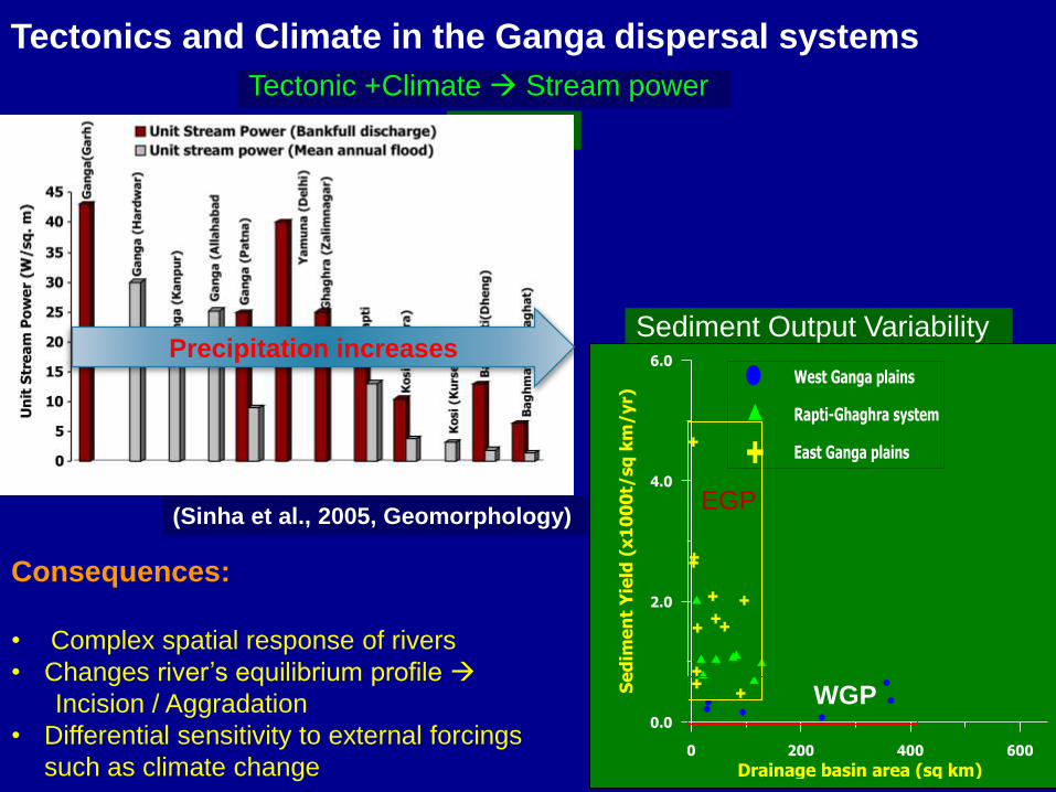
Tectonics and Climate in the Ganga dispersal systems
Consequences:
• Complex spatial response of rivers
• Changes river’s equilibrium profile
Incision / Aggradation
• Differential sensitivity to external forcings
such as climate change
WGP EGP
= .Q.S/w
(Sinha et al., 2005, Geomorphology)
Tectonic +Climate Stream power
Sediment Output Variability
0 200 400 600
Drainage basin area (sq km)
0.0
2.0
4.0
6.0
Se
dim
en
t Y
ield
(x
10
00
t/sq
km
/yr)
West Ganga plains
Rapti-Ghaghra system
East Ganga plains
Precipitation increases
WGP
EGP

Legend
River Style No.I
II
III
IV
IX
V
VI
VII
VIII
X
Tributary
Reach
Intervention
Canal
III
III
IV
VI
VIII
IXVII
VIIV
V
X
VIII
IV
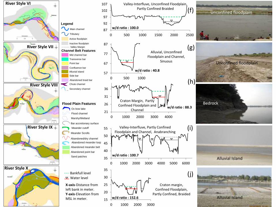
River Styles of the Ganga River
(Sinha et al., Submitted, Geomorphology)

3 | P a g e
a
b
c
Figure 6 a, b, c: River Style 3entire view with the actual field photographs
225
230
235
0 500 1000
2 | P a g e
a
b
Figure 5 a, b: River Style 2 entire view and actual photograph showing the channel belt
River Style II
River Style III
960
965
970
975
0 50 100 150
343
348
353
358
363
0 50 100 150 200 250
1 | P a g e
Appendix I- Geomorphic maps of the different River Styles of the Ganga River and field characteristics
a
b
c
d
e
Figure 4 a, b c, d, e: River Style 1 entire view; Zoomed view of River style 1 near Uttarkashi; Zoomed view of River style 1 near Sunagarh; actual field photographs showing bed material and the river valley along with the channel belt
River Style I
Himalayan, Partly Confined Floodplain and Channel, Braided
Himalayan, steep valley
Steep, confined valley
Floodplain pocket
No floodplain
River Style IV
River Style V
5 | P a g e
c
d
e
f
g
Figure 7 c, d, e, f, g: River Style 4 from Fatehgarh to Bilhaur, River Style 4 from Bilhaur to Fatehpur, actual field photograph showing the river bank, cultivated mid channel bars and the high cliffs near Jajmau
Cliff line
Floodplain
6 | P a g e
a
b
c
d
e
Figure 8 a, b, c, d, e: River Style 5(Narora to Qadirganj); River Style 5(Qadirganj to Fatehgarh); River Style 5(Sirathu to Allahabad); actual field photograph showing the cultivated side bar and the extensional view of the river
Unconfined floodplain and channel
191
196
201
0 500 1000
128
133
138
0 500 1000 1500 2000 2500
Valley-Interfluve, Partly Confined Floodplain and
Channel, Braided
Valley-Interfluve, Unconfined Floodplain and Channel, Braided
Piedmont, Partly Confined Floodplain and Channel, Braided
Flood Plain Features
Flood channel
Marshy/Wetland
Bar accretionary surface
Sand patches
Meander Scrolls
Abandoned meander belt
Abandoned point bar
Ox bow lake
Abandoned/dry channel
Abandoned meander loop
Meander cutoff
Channel Belt Features
Point bar
Alluvial island
Side bar
Secondary channel
Chute channel
Confluence bar
Mid channel bar
Abandoned braid bar
Transverse bar
Legend
Tributary
Main channel
Valley Margin
Inactive floodplain
Active floodplain
w/d ratio : 40.8
w/d ratio : 60
w/d ratio : 193.4
w/d ratio : 87.2
w/d ratio : 138
X-axis-Distance from left bank in meter.Y-axis-Elevation from MSL in meter.
Water level
Bankfull level
(a)
(b)
(c)
(d)
(e)
21
26
31
36
0 1000 2000 3000 4000
87
92
97
102
107
0 500 1000 1500 2000 2500
River Style VII
Flood Plain Features
Flood channel
Marshy/Wetland
Bar accretionary surface
Sand patches
Meander Scrolls
Abandoned meander belt
Abandoned point bar
Ox bow lake
Abandoned/dry channel
Abandoned meander loop
Meander cutoff
Channel Belt Features
Point bar
Alluvial island
Side bar
Secondary channel
Chute channel
Confluence bar
Mid channel bar
Abandoned braid bar
Transverse bar
Legend
Tributary
Main channel
Valley Margin
Inactive floodplain
Active floodplain
River Style VIII
River Style VI
Floodplain pocket
River Style IX
River Style X
7 | P a g e
a
b c
Figure 9 a, b, c: River Style 6(Fatehpur to Sirathu) and actual field photographs showing the cultivated mid channel bars and an extensional view of the river
Unconfined floodplain
10 | P a g e
a
b
c d
Figure 12 a, b, c, d: River Style 9(Chapra to Barh), River Style 9(Barh to Pansalla); actual field photographs showing loose unconsolidated material in the river bank and the extensional view of the river
9 | P a g e
a
b
c
d
Figure 11 a, b, c, d: River Style 8(Gopiganj to Chunar), River Style 8(Pansalla to Kursela), Actual field photograph showing the active floodplain coinciding with the valley margin defined by the craton boundary and muddy river bank
8 | P a g e
a
b
c
d
e
f
g
Figure 10 a, b, c, d, e, f, g: River Style 7(Allahabad to Gopiganj), River Style7(Chunar to Gahmar), River Style 7(Gahmar to Chapra); actual field photographs showing unconfined nature of channel, cultivated active floodplain, unused active floodplain covered with vegetation and calcrete cliffs near Rudauli(~ 15 Km upstream of Varanasi)
Bedrock
Unconfined floodplain
57
67
77
87
0 500 1000
35
40
45
50
55
0 1000 2000 3000 4000 5000 6000
Alluvial, Unconfined Floodplain and Channel,
Sinuous
Valley-Interfluve, Unconfined Floodplain, Partly Confined Braided
Craton Margin, Partly Confined Floodplain and
Channel
15
20
25
30
35
0 1000 2000 3000
Craton margin, Confined Floodplain,
Partly Confined, Braided
Valley-Interfluve, Partly Confined Floodplain and Channel, Anabranching
BedrockPhoto not available
w/d ratio : 100.0
w/d ratio : 40.8
w/d ratio : 88.3
w/d ratio : 100.7
w/d ratio : 152.6
X-axis-Distance from left bank in meter.Y-axis-Elevation from MSL in meter.
Water level
Bankfull level
11 | P a g e
a
b c
Figure 13a, b, c: River Style 10(Kursela to Farakka); actual field photographs showing extensively cultivated floodplain and vegetated alluvial islands with settlements and the extensional view of
the river
Alluvial Island
Alluvial Island
(f)
(g)
(h)
(i)
(j)

Buxar
Geomorphic
Diversity
Ganga River
Incised valleys
Wide floodplain on
one side
Geomorphic
map
Western
Ganga plains
11 | P a g e
a
b c
Figure 13a, b, c: River Style 10(Kursela to Farakka); actual field photographs showing extensively cultivated floodplain and vegetated alluvial islands with settlements and the extensional view of
the river
Ganga River
Geomorphic
map
Eastern
Ganga plains
Aggradational valleys
Migratory rivers
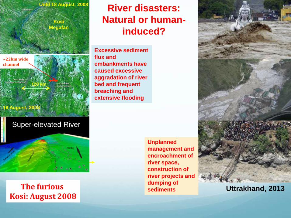
River disasters:
Natural or human-
induced?
Uttrakhand, 2013The furious Kosi: August 2008
Kosi
Megafan
Until 18 August, 2008
120 km
18 August, 2008
~22km widechannel
Emban
kmen
t
Seep
age C
hannel
Kosi River
Super-elevated River
Excessive sediment
flux and
embankments have
caused excessive
aggradation of river
bed and frequent
breaching and
extensive flooding
Unplanned
management and
encroachment of
river space,
construction of
river projects and
dumping of
sediments
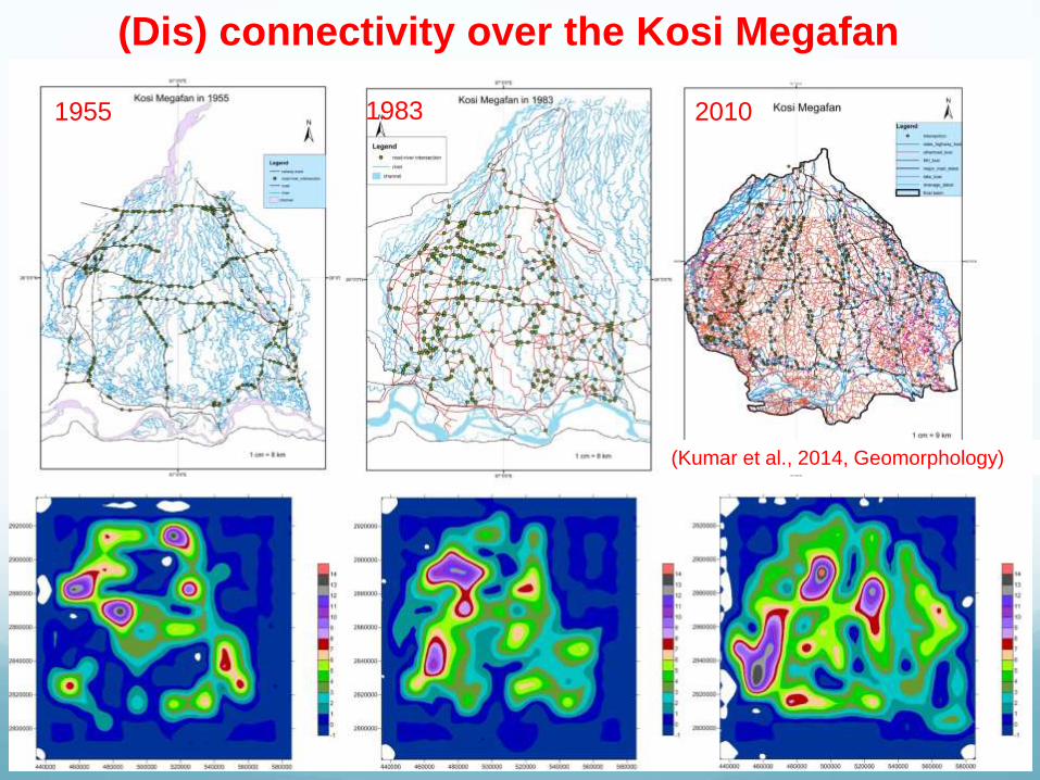
(Dis) connectivity over the Kosi Megafan
1955 1983 2010
(Kumar et al., 2014, Geomorphology)

Waterlogged area is positively correlated to the density of intersection point – results in major drainage congestion and longer periods of inundation (Kumar et al., 2014, Geomorphology)

Sediment Management: a central problem!
Hinterland characteristics
River dynamics
Aggradation/
degradation
Flooding
Tectonics
Precipitation
Runoff
Deforestation
Bank instability
and Erosion +
+
++
Sediment
Flux
Drainage congestion
and Waterlogging
Human
Interventions

Major Research Questions• How to define the resilience and threshold of geomorphic
system to floods and its relationship to other river processes such as river dynamics and bank erosion?
• How do we develop the best engineering practices for flood management in sediment-charged Himalayan rivers?
• How to quantify sediment dynamics in high and middle mountains and its linkage with basin properties? Impact on infrastructures?
• How to assess the impact of floods on ecological services?• How do we develop effective floodplain zoning and policy
options for the Ganga basin taking into account biophysical as well as socio-economic factors?
• How can we develop an efficient flood warning system and building codes against flood resistant buildings?
• How can we map vulnerability and resilience to flooding and standardize the methodology to help the policy managers?