walkability as an urban design problem - diva portal551283/fulltext01.pdf · of walkability with...
TRANSCRIPT

WALKABILITY AS AN URBAN DESIGN PROBLEM
Understanding the activity of walking in the urban environment
Eunyoung Choi

Author : Eunyoung Choi Title : Walkability as an Urban Design Problem :Understanding the activity of walking in the urban environment Licentiate Thesis 2012 TRITA-ARK-Forskningspublikationer 2012:5 ISSN 1402-7453 ISRN KTH/ARK/FP—12:05—SE ISBN 978-91-7501-480-7 KTH Royal Institute of Technology Architecture and the Built Environment School of Architecture SE-100 44 Stockholm Sweden www.kth.se

Abstract
The planning and design of the walkable environment is receiving more and
more attention for its various benefits related to public health, sustainability,
economy, or social life. Therefore, there is a growing need for knowledge about
the walkability of the built environment. While urban planning, design, and
transportation research have also examined walking in urban environments, a
recently growing field of research usually referred to as walkability research
have been actively investigating the relation between the built environment
and walking behavior through correlation analysis. Although one must
acknowledge the value of current walkability research to be used as the
framework which can make significant contributions to urban design research
and practice, it also has a few shortcomings in terms of applicability. There is
also a problem that the design factors that are often discussed as promoting
walking or creating ‘pedestrian-friendly environments’ in urban design
theories and discourses are often based on little evidence and that these factors
have been shown to be insignificant in the quantitative analyses on the amount
of walking. This project aims to support urban design knowledge and practice
and to contribute to the broader field of “walkability” by refining the methods
and measures used to analyze the relation between walking behavior and
physical environment. Its goal is to integrate knowledge from the medical field
of walkability with urban design research and provide new empirical
knowledge about the concrete level in which urban design and architectural
practice operates.
What has been done during the earlier part of this PhD research project
and is presented in this licentiate thesis is producing knowledge for a better
understanding of the complexity behind the relationship between the built
environment and walking. Through literature review from different fields and
also through an empirical study, this project tried to investigate the concept of
walkability by trying to understand the different ways/aspects in which the
built environment influences walking, e.g. directly influencing the quantity of
walking through providing destinations, or enhancing the experiential quality

of walking by determining the condition as a walking environment. It also
investigated the different aspects of walking by partitioning walking activities
in understanding how they are influenced by different properties of the built
environment. By partitioning both the influence of the built environment on
walking and walking activity, the knowledge that this thesis tries to produce is
not only on whether or not, but more on how and why the built environment
influences walking behavior. Three residential areas from Stockholm were
selected for the empirical study. The results of the empirical study show how
the various factors and condition of the built environment influence walking
with different effects and leverage and the importance of investigating the
factors on different levels and from different aspects. Also, it seems that the
different types of walking are related to how they are influenced by the built
environment, and the different conditions of the environment also seem to
influence the presence and characters of the walking activities of their
inhabitants. The findings from this project provide insights into how we can
better understand the interaction between the built environment and walking
behavior in influencing each other.

Acknowledgements
I would like to gratefully acknowledge the financial support from Riksbyggens
Jubileumsfond. The full financial support for the work leading up to this Licentiate thesis
from Riksbyggen made it possible to start and conduct this PhD project.
I am most grateful to my supervisor, Dr. Daniel Koch, who has provided extensive advice
and input for the project as well as guidance in conducting PhD research in general. His
work, support, and advice have truly made possible the publication of this dissertation. I
would like to also thank Dr. Lars Marcus, also my supervisor, who has first introduced me
the topic of walkability, assisted the start of my PhD research, and supported me in
various ways during these years. I feel most grateful to have met such insightful and
supportive supervisors.
I wish to express my gratitude to all of my colleagues, the staff and faculty at KTH, SU
and other institutions for their support, and in particular to my research group, Spatial
Analysis and Design including Jesper Steen, Alexander Ståhle, Ann Legeby, Eva Minoura,
Sara Sardari Sayyar(especially for the content in this thesis from the co-authored paper),
and Pablo Miranda.
I am also grateful to my friends and family who have supported me in their love and
prayers, especially to my grandparents and Ms. Yeo Myunggeun.
My special thanks go to my mother, my father, and my sister Hwayoung. I can never
express how much I am grateful for their love and support in every way and in every
moment, which have kept me all the way here.
And above all, my greatest thanks and love to God.


Contents
1 Introduction ............................................................................................................. 1
2 Walking and the Built Environment ..................................................................... 9
2.1 Walkability Research ................................................................................................. 9
2.2 Studies and Writings on Walking and the Urban Environment ........................ 21
2.3 Reflections on the Walking-Environment Relationship ...................................... 39
2.4 Research Questions, Aim, and Method of this Project ........................................ 47
3 The Empirical Study ............................................................................................. 61
3.1 The Observation Study - Description of the method and data ......................... 63
3.2 Results of the Observation Study ......................................................................... 69
- Summary and Examples from the Data
3.3 Analysis of the Observation Results I .................................................................. 91
- Comparison with the Spatial Analysis of the Areas
3.4 Analysis of the Observation Results II ............................................................... 103
- The Major Factors Identified in Correlation Studies on Walkability
3.5 Analysis of the Observation Results III .............................................................. 111
- Other Design Factors Discussed in Urban Design Literature
3.6 Different Walking Activities and their Route Choices .................................... 127
4 Discussion ............................................................................................................ 139
5 Conclusion............................................................................................................ 155
References............................................................................................................. 163
List of figures ....................................................................................................... 170


1
1 Introduction
The issue of pedestrian-friendly urban environments has been of increasing
importance lately in urban planning and design, be it for reasons of social life,
experiential quality, sustainability, economy, or health. For instance, in terms
of the health benefits of walking which are supported by scientific evidence,
changes in the built environment may help people reach their physical activity
goals in addition to individually oriented behavior-change interventions, by
promoting sustainable and healthy life style choices. Therefore, there is a
growing need for knowledge about the walkability of the built environment.
While urban planning, design, and transportation research have also examined
walking in urban environments (Gehl, 1980; Hillier, 1996; Kockelman, 1997),
what is usually referred to as “walkability” research is a multidisciplinary form
of research which has been initiated from the preventive medicine field with
the health beneficial aspect of walking as the most significant motivation
(Saelens et al., 2003a). Walkability studies have provided evidence through
statistical analysis that walking behavior is related to the condition of the built
environment, as well as regarding the health benefits it may bring. Walkability
research aims at identifying walkability factors of the environment, most often
through correlation analyses between different attributes of the built
environment and the amount of time spent on walking by individuals.

2
However, although the value of current walkability research to be used as
a framework which can make significant contributions to urban design
research and practice must be acknowledged, it also has a few shortcomings in
terms of applicability. This has to do with, first, a set of measures that in the
design process are too vague to give support, or could support almost any
solution, and second, a way of studying urban form which lacks specificity,
leading to some conclusions being in need of re-examination. The quantitative
research which tries to prove correlation between properties of the built
environment with either the amount of individuals’ walking or the amount of
pedestrian movement on given segments is having difficulty in showing
consistent results and also often lack the applicability in the design and
planning process. There is also the problem that the design factors which are
often discussed as promoting walking or creating a ‘pedestrian-friendly
environment’ in urban design theories and discourses are often based on little
evidence and that some of these factors have been shown to be insignificant in
the quantitative analyses on the amount of walking. In order to obtain
knowledge about how to deal with these differences, limitations,
contradictions which exist in the theories and research on walking, a better
understanding of the relationship between the built environment and walking
is crucial.
This project aims at supporting urban design knowledge and practice and
contributing to the broader field of “walkability” by refining the methods and
measures used to analyze the relationship between walking behavior and
physical environment. Its goal is to integrate knowledge from the medical field
of walkability with urban design research and to provide new empirical
knowledge at the concrete level in which urban design and architectural
practice operates. In order to integrate knowledge from theories and research
on walkability from different fields and of different perspectives, it is crucial to
first build a broader view and a more comprehensive understanding of how
the built environment influences walking. What has been done during the
earlier part of this project, and will be shown in this thesis, is to provide a
better understanding of the complexity of the relationship between the built
environment and walking and also the complexity that lies in both of these
entities, the urban form and walking activity. Such an insight would allow
different studies and discourses to be positioned within the broad research
field of walking according to which aspect of the built environment and
walking relationship each of them captures and also a better understanding of
the scope and the degree they may contribute to.

3
Therefore, through literature review from different fields and also through
an empirical study, this project tries to investigate the concept of walkability by
trying to understand the different ways/aspects the built environment
influences walking, e.g. directly influencing the quantity of walking through
providing destinations, or enhancing the experiential quality of walking by
determining the condition as a walking (route) environment. It also
investigates the different aspects of walking by subdividing walking activities
according to how they are influenced by different properties of the built
environment. By partitioning both the influence of the built environment (on
walking) and walking activities, the knowledge that this thesis tries to produce
is not only whether or not, but more on how and why the built environment
influences walking behavior. The Swedish context of the empirical study
assisted the investigation of these issues. While the majority of the walkability
studies are from a setting where the conditions of the built environment often
impede walking, such as North America or Australia, the Scandinavian urban
context offers the possibility of exploring a broader range of walkability. As
well as the better conditions of the built environment, other factors, such as
cultural factors or the provision of public transport provided at a more
desirable level, may support the investigation of the walkability factors at
urban design level.
The empirical study
Three residential areas from Stockholm were selected for the empirical study.
Two areas are located in the inner city of Stockholm and the other is a
suburban neighborhood situated in the southern part of the city (Figure 1.1).
The two areas in the inner city are situated close to each other in the center of
Södermalm, where one is a traditional urban area and the other is a more
recently redeveloped area. The area with the traditional urban blocks is often
referred to as the SoFo area (meaning “South of Folkungagatan” and a pun on
SoHo in New York), as it will also be in this thesis. In contrast to the other two
areas, SoFo is an area created prior to the 20th century. In recent years, the area
has begun to function as a center of creative and innovative fashion and
retailing, which offers a wide selection of restaurants, bars, coffee shops, and
art galleries. The area is described as consisting of publicly exposed and well-
used spaces, and, compared to the rest of Södermalm, the area is quite distinct
and has a lot more movement than most areas. The area is shown to have a
strong connection to the rest of the city in its spatial analysis, which

4
characterizes the area as a part of the inner city of Stockholm, rather than as a
localized sub-area (Marcus, 2000).
Figure 1.1 Map of the three studied neighborhoods in Stockholm
The other selected area in Södermalm, which will be called Södra Station
area in this thesis, is a redeveloped area planned in the 1980s, where over 3000
flats were newly built after the renovation of the Södra Station, which is the
southern railway station of Stockholm. In this area, the Folkungagatan street was
transformed into a treed avenue and the area was given a series of urban open
spaces surrounded by groups of buildings, which in size and shape tried to
follow the pattern of the central part of the city. In the design of the area, it was
intended that one side of a group of buildings always opens onto a network of
parks and planted areas, which was considered a unique feature in this central
location in the city (Andersson, 1997). This area is a highly fragmented area
and somewhat segregated from the rest of Södermalm, to such a degree that it
can even be described as disurbanism (Marcus, 2000). The spatial analysis of
the area implies that the area is not part of the general movement pattern of
Södermalm, instead creating an enclave through which not many people pass
unless they have direct errands there. It is analyzed that there is a possibility
that the area differentiated categories of movement into different spaces, e.g.
separating inhabitants from visitors. Therefore it seems to segregate many of its

5
spaces, often directing them towards very localized usages and characterizing
the area as of a rather domestic character (Marcus, 2000).
Hökarängen, the third area, is a suburban neighborhood planned in the
1940s, inspired by neighborhood unit planning. The area was designed to have
access to a planned neighborhood shopping center, centrum, in which the first
pedestrian street in Sweden was designed. Most of the housing is from the
years around 1950 and the Hökarängen centrum was built in 1953, close to the
subway station. The idea was that the car-free shopping street would have the
character of a city street, like that of the inner city. While this neighborhood
center was designed and anticipated to be populated by the residents, serving
as a living room of the area, the actual use of the place nowadays is far less than
the desired level (Borén & Koch, 2009). Around the centrum, there is a mixture
of narrow lamellar blocks and medium high point blocks, and the area has a
slightly idyllic character (Andersson, 1997). In large parts of Hökarängen, the
buildings have three to four stories, being widely spaced with green spaces and
yards. The preference for yards in which the entrances to the residential
buildings are often located was an intention of the architect who planned the
area, David Helldén, and also includes a degree of separation from the traffic
(Helldén, 1951: 430). While the population numbers are similar in the three
selected areas, the population density in Hökarängen is significantly lower
than in the areas in the inner city.
Being an explorative study, the observation study in the selected
neighborhoods investigated the walkability of the study areas and the walking
behavior of the pedestrians in the areas by observing the perceived subjective
measurement of pedestrian density and its patterns, the route choices made for
the walking trips by tracking pedestrians, the details in the walking behavior
during the walking activity tracked, and the presence of different types of
walking activities taking place in the area. It aimed at observing the study
areas, not only in the detailed condition of their physical environments, but
also how the areas function as the setting for walking activities by observing
who walks where and when, what kind of walking activities occur, what
patterns could be found in them over different times, days, and seasons, what
happens during the walking activities tracked and observed, and how the
condition of the built environment seems to have influenced them. The issue of
partitioning walking activities was one important aspect which the observation
study on walkability tried to capture. While current research does not yet
provide systematical knowledge about how the categorization of walking
activities can best be done, in this observation study, the walking trips
observed were documented with their specific purposes, e.g. walking to the

6
public transit, walking to school, walking the dog, walking to a specific kind of
retail outlet, etc.
The results of the empirical study are analyzed through comparison
between and within the neighborhoods and also through comparison of the
observation data with the spatial analysis of the areas. The results are
described and discussed mainly around the major factors that the existing
walkability studies have identified, such as land-use diversity, density, and
connectivity, and also consider other pedestrian-friendly urban design factors
and programs often discussed in urban design literature. The description of the
different purposes and aspects of walking activities is also an important part.
The results of the empirical study confirm the significance of the major
walkability factors. More importantly, they provide insights into how the
factors function in close relation to each other, and how the various factors and
the condition of the built environment influence walking with different effects
and leverage. The importance of investigating the factors on different levels
and aspects is also suggested, with discussions on how urban design seems to
work as and with the various factors of walkability. As well as the
understanding of the different effects of the built environment factors on
walking, the importance of acknowledging the different aspects of walking
activity is also elaborated. The different types of walking seem to influence
how the built environment influences walking, and the different conditions of
the environment also seem to influence the presence and character of the
different walking activities of the inhabitants. The findings from this project
provide insights into how the interaction between the built environment and
walking behavior in influencing each other can be better understood.
The structure of the thesis
Following this introduction, Chapter 2 introduces and discusses different
theories and research on walkability and walking. First, the walkability
research initiated by public health benefits which often conducts statistical
analysis between the amount of walking and the built environment factors are
described and discussed. Following this, examples of studies and guidelines on
urban design for pedestrian-friendly or walkable environments are introduced.
The theories and discourses on walking and the pedestrian-friendly
environment from the field of architecture, urban design and planning, other
than the quantitative research on walkability, are also described. While
research and theory from the urban design field regarding walking activity and
pedestrians provide knowledge focused primarily on the built environment,
7
there are works from anthropology which also deal with walking behavior and
the urban environment. Although these works do not discuss the specific
characteristics of the built environment, they provide insight into how walking
as an individual behavior is conducted in the urban environment. Some
example of these works, such as the ones by Michel de Certeau, Marcel Mauss,
and Grosz, are also discussed. Based on the review of the various literature
from different fields, some reflections on how to view and investigate the
relationship between the built environment and walking is presented. At the
end of the chapter, the research questions, method, and aim of the project are
described.
In Chapter 3, the empirical study is presented. The description of how the
observation study was conducted and how the data was collected and
documented is given. To describe the content of the observation data, a general
description of the walking behavior patterns and the walking conditions in the
study areas follows. Examples of individual walking trip data are also
provided here. In the analysis of the result of the observation study,
comparison of the data with the quantitative spatial analysis of the areas is first
presented. The results and their analyses are then discussed in relation to the
major walkability factors (e.g. land-use diversity, connectivity, and density). As
well as the major factors from the correlation studies on walkability, the results
and analysis regarding other urban design attributes often discussed in
literature are also discussed. One example is how the car-free design functions
and influences walking in the studied areas. Lastly, results regarding the
different types of walking activities and their route choices are described and
discussed.
The discussion chapter follows Chapter 3, presenting reflections and
arguments on how to understand and investigate the relationship between
walking and the built environment. How to understand and acknowledge the
different aspects of influence the built environment has on walking is
discussed. Also, the importance of acknowledging the different types or
aspects of walking activities in understanding walkability is described. Insights
into how and why urban design influences walking based on the results of the
empirical study are discussed here. The thesis will then end with the
conclusion.

8

9
2 Walking and the Built Environment
2.1 Walkability Research
Walkability research & public health
While urban planning and design research and transportation research have
examined walking in urban environments (Frank & Pivo, 1994; Handy, 1996;
Kockelman, 1997; Hillier, 1996; Gehl, 1980), a more systematic body of research
focusing on the “walkability” of the built environment has appeared rather
recently. This growing field of research on walkability is a multi-disciplinary
research subject, which was first initiated by preventive medicine (Saelens et al.,
2003b; Leslie et al., 2005; Heath et al., 2006). An alarming increase in obesity was
one of the reasons walkability research was initiated within the medical field
(Saelens et al., 2003a). The World Health Organization (WHO) has declared
obesity a significant global epidemic, affecting the population of both
industrialized and non-industrialized countries. An estimated 200,000 to
300,000 premature deaths occur each year in the US due to physical inactivity
(McGinnis & Foege, 1993). Although obesity is less prevalent in most European
countries than in the United States, the International Obesity Task Force
indicates that the prevalence of obesity has increased during the last decade in

10
Europe as well (Skidmore & Yarnell, 2004). Although obesity is leveling off in
many countries (Sundquist et al., 2010), there are few to no signs of a decline.
Because of the increasing prevalence and costly consequences, obesity can no
longer be considered as a purely medical issue, but rather as a threat to public
health, requiring national and global strategies for prevention and
management.
To combat obesity and promote physical health, “walkability” research
has focused on how the built environment can serve to assist reaching these
goals of physical activity. The reason for this field to investigate walking is that
physical activity improves long-term health, and that walking is the most
common form of adult physical activity. Because moderate intensity physical
activity – acquired from walking, for example – significantly improves health,
public health officials and policies recommend moderate intensity physical
activity, including walking and cycling, most days of the week (Saelens et al.,
2003a). However, despite the benefits of regular physical activity, it is
estimated that over 60% of the world’s population is not physically active
enough to achieve health benefits (Bell et al., 2002). Ecological models
emphasize that behaviors have multiple levels of influence that include
intrapersonal, interpersonal, environmental, and policy variables. Ecological
hypotheses suggest that the combination of psychosocial and environmental
policy variables will best explain physical activity (Saelens et al., 2003a).
Although psychosocial correlates of physical activity have been extensively
studied, psychological and social factors explain much less variance in
moderate intensity physical activity, compared to vigorous physical activity.
Unlike most vigorous physical activities engaged in for health-related or
recreational purposes, activities such as walking and cycling can be done for
multiple purposes, likely making them more susceptible to environmental
influence. Also, while other factors influencing walking behavior, such as
socio-demographic characteristics, lifestyles, and beliefs, differ for everyone,
urban form could affect many people on a relatively permanent basis. Based on
these ideas, walkability research, which is still at a comparatively early stage,
examines the influence of the built environment on walking behaviors.
Earlier findings from transportation & urban planning research
With the scientific evidence on how physical activity, such as walking, may
positively affect health, the multidisciplinary research on walkability started by
trying to prove a correlation between the condition of the built environment
and the amount of physical activity (walking). Many studies in transportation

11
and urban planning fields have examined the relationship between community
design variables and walking or cycling for transportation. They have
consistently shown that people walk and cycle more when their neighborhoods
have higher residential density, a mixture of land uses, and connected streets.
Other characteristics, such as the condition of sidewalks, presence of bike paths,
street design, traffic volume and speed, are hypothesized to be related, but
have not been systematically examined or proven to have significant influence.
Transportation research was considered to provide the best evidence that
environmental factors can contribute to low levels of lifestyle physical activity
(Saelens et al., 2003a). Transportation studies indicate that people living in
traditional neighborhoods (higher residential density, mixture of land uses,
grid-like street patterns with short block lengths) engage in more walking and
cycling trips for transport than do people living in sprawling neighborhoods.
More specifically, they have also explained that factors that influence the
choice to use motorized or non-motorized transport are based primarily on two
fundamental aspects of the way land is used : Proximity (distance) and
Connectivity (directness of travel). Proximity relates to the distance between
trip origins and destinations, whereas connectivity characterizes the ease of
moving between origins and destinations within existing street and sidewalk-
pathway structure. Connectivity is high when streets are laid out in a grid
pattern and there are few barriers to direct travel between origins and
destinations. With high connectivity, route distance is similar to straight-line
distance. In addition to direct routes, grid patterns offer the choice of taking
alternative routes to the same destination (Saelens et al., 2003a).
Using earlier findings from transportation and urban planning research as
a basis, earlier walkability studies have determined the main factors to be
examined, such as density, connectivity, and land use. Existing studies have
found positive associations between physical activity and the presence of
mixed land uses (Cervero, 1996; Moudon et al., 1997; Saelens et al., 2003b),
better connectivity (Boarnet & Crane, 2001; Crane & Crepeau, 1998; Kitamura et
al., 1997), and higher density (Cervero, 1996; Frank & Pivo, 1994; Messenger &
Ewing, 1996). Studies that have examined neighborhood characteristics related
to walking rates and their result indicate that population density is among the
most consistent positive correlates of walking trips (Frank & Pivo, 1994). Land
use mix – especially the close proximity to shopping, work, and other
nonresidential land use to housing – appeared related to greater walking rates
among residents (Kockelman, 1997).

12
The research field of ‘walkability’
Existing walkability studies have used mainly two methods which also seem to
have been influenced by the research method of transportation studies:
neighborhood comparison studies and correlational studies. The neighborhood
comparison studies examine differences in walking rates between residents of
neighborhoods with respect to environmental characteristics. Earlier
walkability studies led by preventive medicine have frequently used this
method of selecting high and low walkable neighborhoods in order to provide
evidence on the influence of the built environment on the amount of walking
(Saelens et al., 2003b; Leslie et al., 2005). Also, since it is not feasible to conduct
controlled intervention trials manipulating neighborhood built design, some
researchers have relied on quasi-experimental designs (Wells & Yang, 2008;
Shadish et al., 2002). The other commonly used method, correlational studies,
use analyses and regression models which provide continuous measures of
neighborhood characteristics that can quantify the relation between
neighborhood characteristics and non-motorized transport, while controlling
either or both individual and neighborhood sociodemographic variables
known to be associated with walking.
While the earlier walkability studies were led more by preventive
medicine with the aim of providing evidence that the built environment does
affect the rate of walking of individuals, in order to develop the research in
producing more specific knowledge in how different attributes of the built
environment influences walking, the input of knowledge from the urban
planning and design field has become essential. Therefore, the involvement of
urban planning and design research in walkability studies is increasing and
studies trying to prove correlation between different factors of the urban form
with walking are being actively conducted. Recent studies also address the
combined effects of ‘bundles’ or ‘packages’ of environmental factors (Wineman
et al., 2009). Also, regarding factors other than the major factors which have
been most consistently proven, some studies suggest that neighborhood design
features may not sufficiently affect walking when these features do not work in
connection with accessibility afforded by land-use mix and street-network
patterns in a broader context (Wells & Yang, 2008). Still, the existing evidence
raises many questions regarding characteristics that seem to be related to
physical activity and we need additional evidence regarding the magnitude of
the relationship between micro-level measures of the built and natural
environments and physical activity (Rodriguez et al., 2006).
To fully complete this type of inquiry and also, equally importantly, to be
able to provide useful urban planning and design guidelines which encourage
13
physical activity, more specific knowledge about urban form and the
conditions of urban design is required. This is not meant to invalidate the
research done in the medical field. Rather, walkability studies provide a
number of findings and a framework which can significantly contribute to
urban design research and practice, but which also has a few shortcomings in
terms of applicability; however, once these shortcomings are dealt with, such
an approach may strengthen walkability research. These shortcomings are the
result of broad measures that support almost any solution, so such approaches
to urban form lack the clarity and specificity that could support concrete
solutions.
Limitations and challenges of walkability research
Research from the medical field provides valuable data which links the built
environment to individuals’ physical activity, as well as to the effect it has on
promoting health. However, there are limitations to this research, especially in
dealing with the built environment and walking behavior. Although existing
studies discuss the limitations of current walkability research, they often fail to
identify the questions and factors of importance at the design level for the
human-environment relations they are investigating, due to lack of knowledge
on the urban environment and its design. For example, existing studies on the
environmental determinants of physical activity behavior mostly use cross-
sectional designs (Saelens et al., 2003b). What is often written in existing articles
is that, since cross-sectional studies do not establish causal linkage, the key
challenge for research is to demonstrate that the associations of environmental
attributes with physical activity behavior are actually causal and that future
studies require the use of prospective or intervention designs (Boehmer et al.,
2006). However, this is an inevitable limitation in studying the built
environment, since it is seldom possible to conduct a true experiment. This
would always remain a challenge. In addition, the cause-effect relation in a
more rigid sense may not be what is most important; rather, establishing
interrelations is not only what is possible, but is what is important (e.g.
Foucault, 2000 [1982]; Tschumi, 1996). In more pragmatic terms, the challenge
is to find factors that affect walking positively rather than cause people to walk
more. Walking behavior will always emerge through interplay between
conscious decisions, habits, social and cultural traditions and situations, and
the various properties of the built environment. These factors may also differ
for different walkers or types of walking; a focus that will be examined later in
this study.

14
The reason why medical studies focus on proving the causal relationship
between the built environment and walking activity may be due to the fact that
walkability research is at an early stage, and it is necessary to first provide
evidence on whether or not walking behavior is affected by the built
environment. Medical research has actually played an important role in this
task, and this is quite understandable as the medical field specializes in
investigating health benefits, and the nature of medical research requires large
populations to be investigated to establish scientific evidence. In these
investigations, the medical field is well developed. However, when it comes to
providing design guidelines, the kind of investigations and the factors
provided are weak; specifically, they are imprecise due to lack of knowledge
about how the factors can be realized in built form. In the end, this also
questions their significance: although it has been clearly established that
enhancing walkability as described by the medical field improves long-term
health – and this is important in itself, as it provides the data and the advocacy
needed to make neighborhoods more conducive to physical activity – this
effort would be meaningless unless the urban environment was actually
designed by urban planners and architects so as to encourage walking. Current
walkability research lacks systematic information about what may be the most
effective approach to guide population-wide interventions, and this is the task
for the urban design field. Knowing that the built environment is associated
with walking behavior alone is insufficient. In order for walkability research to
have a positive influence on walking habits through urban design, future
studies may need to keep in mind that what is more necessary at this point is
trying to build knowledge about providing intervention guidelines.
To produce findings that could contribute to urban design guidelines, it is
important to deal with the limited variability of possible environmental
features in current studies. More comprehensive identification of various
factors is required. As well as better identification of factors, it is necessary to
improve the measurement of built environment attributes. Within the medical
field, measurement tools for the data on environment were defined a priori, on
the basis of previous findings, a conceptual model, and specific hypotheses
rather than empirically by factor analyses (Saelens et al., 2003b). Accurate and
efficient measurement of the built environment is a key challenge in
walkability research. With the existing studies lacking comparability and
transferability in their results, better identification and measurement of the
built environment is an urgent task for future research.
Thus, existing evidence raises many questions, and we need additional
knowledge regarding the magnitude of the relationship between micro-level
15
measures of the built and natural environments and physical activity
(Rodriguez et al., 2006). Possible assistance in this development comes from the
urban design field. However, while there are attempts to develop lists or
indexes of walkability (Stonor et al., 2002; Ewing & Handy, 2009), perhaps
more can be gained from widening the scope to research into walking,
although care must be taken as to what contributions it can make. While
research on walking within the field dates (at least) back to Benjamin (2002), it
can be argued that works by Gehl (1980), Jacobs (1961), and to some extent
Hillier (1996) are more topical within the concurrent Nordic urban planning
context. These studies deal primarily with the question of urban design as
support for collective patterns of behavior. Of these, especially Hillier uses an
empirical-quantitative approach in a similar tradition to the medical field,
whereas Gehl and Jacobs come from traditions more reliant on qualitative
methods. While these suggest a number of factors that are important for
pedestrian behavior, they do not quite correspond to questions raised by
walkability research. Refinements and further studies (e.g. Ståhle, 2005;
Klasander, 2003; Westford, 2010) have also addressed other questions, and in a
wider context the environmental design research (as overviewed by Rapoport,
2008) offers many possibilities for providing knowledge, questions, and
answers. In addition, studies that use GIS tracking devices, a comparatively
new technique to gather and aggregate individual walking behavior, can
provide both material and knowledge of importance (e.g. van Schaick, 2008).
Developing the field: measuring the environment
To conduct studies on the relationship between the attributes of the built
environment and physical activity more effectively, it is essential to improve
the measurement of environmental variables. There are different ways in
which these environmental factors are measured in current studies. The survey
method, for example, allows the researcher to measure how the built
environment attributes are perceived. The other main source of environmental
measure is unobtrusive indicators or measures where data can be collected
without the awareness of an individual or a community. They include
examining physical conditions, archival records, institutional records, and
other personal documents. Systematic direct observations of features of the
physical environment within communities have often been used as a reliable
method for collecting data and the use of GIS technologies helps in the
mapping and analyzing of data regardless of how it is collected (Boehmer et al.,
2006).

16
Current research indicates that both perceived and observed
environmental indicators are associated with physical activity behavior and
obesity (Brownson et al., 2004), yet it is unclear whether there is agreement
between measurement methods or whether one method is better for evaluating
the suitability of neighborhood environments for physical activity. Although
there is a need to evaluate the relationship between observed environment
measures and perceived environment measures in order to identify accurate
assessments of neighborhood environments, defining the best method may not
be necessary at this point. What is more necessary is improving the
measurement of the built environment, whether it is observed or perceived
data. For example, the observed data for the factors associated with physical
activity should be further studied and developed, as well as the methods with
which they are observed, and the items of the questionnaires used in the
survey methods. The method for how to measure the built environment, for
which specific kind of observed data needs to be developed, and, in the case of
perceived data, the composition of the questions in the survey method, also
need to be more sophisticated in order to best obtain the necessary data.
Another key issue in measuring the built environment is the issue of
‘boundary’, or the area of a defined environment. Walkability research suffers
from the Modifiable Area Unit Problem (Openshaw, 1984). This is due to the
fact that walkability studies often compare properties and restrictions of an
area defined for other purposes than walking. The defined area of an
individual’s environment for physical activity is unknown, as is whether
individuals are influenced by the environmental characteristics of entire
neighborhoods or by the specific areas around residences or whether it is route
choice or general characteristics. This issue of setting the boundary of the area
for study is a key challenge, since it requires methods for aggregating street-
level data that take into account individual perceptions of neighborhood
boundaries and can re-define the area using more precise locations in the
urban fabric. Also, if objective data measurements are performed only within
the study area boundaries, environmental data for respondents, whose buffers
extend beyond the measured study area, may be left out. Recent technological
developments enable aggregation of street level data based on distances from
an individual point (e.g. a plot or a building entrance), re-defining the area of
influence for each point (Ståhle et al., 2008).
There are potentials and problems with integrating walkability research
into urban design and urban design research. While urban design research
does provide tools and understanding that are important, there are
methodological and theoretical problems in how to translate these into the

17
kind of questions walkability research tries to answer. This is the case since
urban design research often focuses on other aspects of walking than those
more considered by the field of walkability. This primarily requires translation
and development rather than new models and methods. These problems and
potentials will be illustrated and discussed in the following paragraph using
somewhat caricatured descriptions of investigations into walking behavior
within the field.
One focus of urban design research which shares the empirical-
quantitative approach with the medical field deals primarily with collective
patterns of behavior and their relation to the physical environment. Such
approaches tend to focus on flows and degrees of presence, numbers of
walkers, and how these affect space or place. Typically, these approaches are
targeted observational studies which often examine the pedestrian flows in
given parts of the built environment. Although much has been learned about
the different factors that influence pedestrian behavior in terms of where
people walk, it has severe limitations: it fails to capture the meanings of the
rates or flows, since it seldom captures many of the qualitative aspects of these
flows, and it has little to nothing to say about individual routes or lengths of
walks and walking routines. These kinds of studies range from more
qualitative studies, such as Gehl (e.g. 1980; 2010), to the more rigorously
statistical ones, such as in the ‘space syntax’ field (e.g. Hillier, 1996). While
providing much important knowledge regarding walking behavior, there are
inherent problems in these methods when it comes to key questions about
walkability research, such as distances, recurrences, and routes of walking.
Relations between individual behavior and collective patterns are complex and
not always apparent (see Hayles, 1991; Lefebvre, 1996; Johnson, 2002; Koch &
Sand, 2010). Although there are indications and preliminary results that show
some of these relationships, it is a question that deserves more investigation.
While these studies are the ones that at first glance seem to provide most
direct input into walkability research, other parts of urban design research
characterized mainly by qualitative studies of walking offer more indirect, yet
highly significant input. These studies tend to focus on the experience of the
walker: how walking constructs narratives, generates impressions,
(re)produces habits and identities, or how walking formulates lived
experiences or life practices in a broader sense (e.g., Augoyard, 2007; Cardiff &
Shaub, 2005; Grillner, 2000; Lefebvre, 1996; de Certeau, 1984). Although not
always specifically from within the urban design field, these tend to be more
readily adopted, or at least accepted, by many designers, as they account for
individual choice and experience. These approaches provide rich opportunities

18
to question, nuance, and refine the methods and findings of the quantitative
research and, to some extent, the normative research that focuses on
‘walkability’. Often, but not always, when they are translated into design
guidelines, the aim is to examine how walking can be made a richer experience.
While at times it is expected to increase the amount of walking, this is often
neither the purpose nor the claim. Also, providing walkability research
findings are correct, this research seems to focus on walking activities which
are less influenced by urban form and its long-term health effect in terms of
physical activity than sociodemographic and other factors. Such research deals
less with ‘utilitarian’ walking and more with ‘walking for pleasure’. The
question can be raised, however, whether or not these walking experiences
have more impact outside the specific activity itself than other kinds and thus
would more strongly support walking rates indirectly.
Within this quite broad field of qualitative research, research on walking
habits and how these formulate lived experience or life in a broader sense (e.g.
Augoyard, Lefebvre) seems to be of direct importance. Such qualitative
research may be closer to ‘walkability’ research, since it reveals everyday
behavioral patterns, yet it is also different in that it deals with walking once
people are actually walking rather than the choice of walking over either other
modes of transport or to not walk at all. This, however, is a rough
characterization of a highly nuanced and rich field. Similar to the targeted
observational studies, these studies are not directly applicable to walkability
research, due to the nature of the questions and methods used; they provide
knowledge that the methods traditionally applied would never reach. The
translation from these primarily qualitative studies into urban design factors is
complex and also necessitates a number of judgment calls, prerequisites that
make it valuable in the design process but difficult to adapt for walkability
research. Yet, actively using this sort of research and the findings from it in the
development of walkability research can provide valuable information, while
acknowledging that there are differences and conflicts in both methods and
purpose. This melding of approaches requires recognizing both as equals when
it comes to the interchange between them (Koch & Sand, 2010).
Walking behavior is thus an area where urban design research both excels
and has significant shortcomings, where the shortcomings tend to be in the
areas that would contribute most to walkability research. This seems to suggest
that there are methodological and theoretical problems with how to translate
urban design knowledge into the kind of questions walkability research tries to
answer, and the other way around. A richer understanding should better
integrate the knowledge from the urban design field in the rather blunt

19
measurements and methods of walkability research, while taking the
knowledge gained in the latter into account when developing the former.
Urban design research will benefit from adapting methods and findings used
by medical research that focuses on walkability, but for this to become true
measurements, factors, and guidelines need to be more refined in order to be
applicable in the design process. Also the guidelines need to be sensitive to the
local situations and conditions, as well as to different aims and intentions, as
compared to normative policies, in order to be of more value in the design
process. Hence these approaches – the medical approach and the urban design
approach – can be seen as complementing one another. In addition to the direct
input of the relationship between built environment and behavior, fields that in
one way or another have managed to bridge the gap between research and
design input may also be helpful. Here, there seems to be a lot to learn from
environmental design studies as these, while not unique in claims regarding
this relation, do provide an interesting perspective: “[…] moves beyond those
to consider design as part of organizational, behavioral, and social systems,
and – even more importantly – because it applies the results, theories and
techniques, and methodologies of behavioral and social sciences to address
design problems and improve the quality of the resultant product” (Wener,
2008: 283; see also Szczepańska & Skorupka, 2010), but also from Gehl (1980)
and the space syntax field (Hillier, 1996; Stonor et al., 2002).

20

21
2.2 Studies and Writings on
Walking and the Urban Environment
Studies and guidelines on urban design for pedestrian-friendly / walkable environment
This section will introduce some of the recent studies and guidelines from the
urban design field which discuss the design qualities that are argued to be
supporting pedestrians. Although the walkability studies initiated from public
health interests are also ultimately aiming at generating knowledge for
guidelines on walkable environment, the guidelines and theories on urban
planning and design currently available are not yet reflecting the results of
these correlation studies, partly due to the field being at a relatively early stage,
with inconsistent results. These studies and guidelines include the factors
which are considered most central in walkability studies, based partly on
results from transportation research, such as density, land-use diversity, and
connectivity, but also, to a major part, include other design qualities which
often operate at a detailed level. While there are guidelines discussing the
design that is considered ‘pedestrian-friendly’ in specific details, there are also
studies and guidelines which discuss the more abstract qualities of the
environment that may support walking. Some examples from these various
studies and guidelines will be presented here.

22
Pedestrian and Transit-friendly Design: a Primer for Smart Growth (Ewing, 1999)
Pedestrian and Transit-friendly Design: a Primer for Smart Growth (Ewing, 1999)
offers a design checklist for pedestrian-friendly features. This primer and
manual draws primarily on classic urban design literature and other transit-
oriented design manuals and studies. The checklist consists of features at urban
design level and sorts the features into three categories : Essential features,
highly desirable features, and nice additional features.
Essential Features
#1 Medium-to-High Densities
#2 Mix of Land Uses
#3 Short to Medium Length Blocks
#4 Transit Routes Every Half-Mile
#5 Two- or Four-Lane Streets (with Rare Exceptions)
#6 Continuous Sidewalks Wide Enough for Couples
#7 Safe Crossings
#8 Appropriate Buffering from Traffic
#9 Street-Oriented Buildings
#10 Comfortable and Safe Places to Wait
Highly Desirable Features
#11 Supportive Commercial Uses
#12 Gridlike Street Networks
#13 Traffic Calming along Access Routes
#14 Closely Spaced Shade Trees along Access Routes
#15 Little Dead Space, or Visible Parking
#16 Nearby Parks and Other Public Spaces
#17 Small-Scale Buildings (or Articulated Larger Ones)
#18 Classy Looking Transit Facilities
Nice Additional Features
#19 Streetwalls
#20 Functional Street Furniture
#21 Coherent, Small-Scale Signage
#22 Special Pavement
#23 Lovable Objects, Especially Public Art

23
A Healthy City is an Active City: a physical activity planning guide (Edwards &
Tsouros, 2008)
A healthy city guidebook, published by the World Health Organization’s
Regional Office for Europe, is a planning guide which provides tools for
developing a comprehensive plan for creating a healthy, active city by
enhancing physical activity in the urban environment. The strategies at urban
design level suggested here are as follows.
Action Strategies in Urban Design
# Reduce urban sprawl by embedding workplaces, shops, schools and
health care facilities within integrated neighborhoods that facilitate
walking and cycling.
# Provide easy access to seashores, rivers, lakes and forests on the periphery
of the city.
# Conserve and develop green spaces. Provide incentives for developing
vacant lots and run-down areas into green and/or open spaces. Work
toward an urban green network accessible to all residents complemented
by a network of squares and other small outdoor places for active living.
# Provide convenient and visible stairs and signage for public spaces that
encourage people to take the stairs. Design buildings that encourage the
use of stairs and ensure that stairwells are unlocked in office buildings
and health care facilities.
This guideline is for the purpose of encouraging physical activity in
general and therefore may be different from the strategies that aim specifically
at encouraging walking activity. However, although guidelines such as these
share the aim of enhancing public health with the walkability research initiated
by the preventive medicine, some of the suggestions made here contradict the
existing findings from the correlation studies on walkability. Since these
guidelines are often based on existing literature, they share more similarity
with the theories and guidelines on pedestrian-friendly design from the urban
planning and design field, such as the one presented above (Ewing, 1999).
However, some of the design features encouraged here have failed to be
proven as valid in the statistical studies.

24
Research Project on Walkability Index by Space Syntax Limited (Stonor et al.,
2002)
Transport for London (TfL), the regional transport authority for Greater
London, conducted a project to develop a monitoring framework for walking,
and defined the requirement for an analytic toolkit, with which they could
index walkability. It was decided to base such an index on ‘space syntax’
techniques of pedestrian movement analysis. Using these techniques, forecasts
are made on the basis of ‘spatial integration’ calculations, where the
accessibility of individual pedestrian route segments is calculated based on
their position in the overall movement network. This project investigated the
development of a ‘walkability’ index for London and the aims were a) to
identify the factors that influence the degree of usage of a particular piece of
footway, b) to establish which of these factors can be controlled and affected by
walking policy, design and implementation, c) to rank the various factors
according to their degree of influence and d) to form a walking policy that
responds as far as possible to various factors, and prioritizes those factors
which affect walkability more. This research work tried to quantify the degree
to which different factors influence pedestrian flows (Stonor et al., 2002).
As a result, the following factors were identified:
Presence or Absence of Other Moving People
Presence or Absence of Other Stationary People
Footway Quality
Footway Width
Footway Accessibility
Proximity to Road Traffic
Gradient
Pedestrian Crossing Design
Traffic Signal Phasing
Ground Level Activity
Movement Generators (e.g. Transport Nodes and Tall Buildings)
Others
Among these factors, the ones with greater importance were Footway
Accessibility, Ground Level Activity, Pedestrian Crossing Design, Traffic
Signal Phasing, and Time of Day.

25
Measuring the Unmeasurable: Urban Design Qualities Related to Walkability
(Ewing & Handy, 2009)
A recent study from the urban design field has attempted to measure
subjective qualities of the urban street environment, with the purpose of
providing researchers with operational definitions which they can use to
measure the street environment and test for significant associations with
walking behavior (Ewing & Handy, 2009). Arguing that physical features
individually may not capture people’s overall perceptions of the street
environment, this study investigated numerous perceptual qualities that may
affect the walking environment to which the urban design literature points
(Ewing, 1996). While the urban design literature has not attempted to
objectively measure these perceptual qualities with few exceptions, this study
tries to objectively measure seemingly subjective qualities of the walking
environment. The conceptual framework presented here, shown below, is an
interesting analysis of the relationship between the perception of the
environment, physical features of the built environment and walking behavior.
Figure 2.1 Conceptual framework for the influence on walking behavior (Ewing & Handy, 2009)

26
The approach is to link specific physical features to urban design quality
ratings by a panel of experts for a sample of commercial streets. Of the 51
perceptual qualities, eight were selected for further study based on the
importance assigned to them in the literature: imageability, enclosure, human
scale, transparency, complexity, legibility, linkage and coherence. Among these,
the first five were successfully operationalized. The operational definitions are
based on ratings made by the expert panel of video clips of 48 commercial
streets from across the United States (Ewing et al., 2006). The consensus
qualitative definition of the urban design qualities will be briefly described
here, followed by a table showing the significant physical features of each
quality.
# Imageability is the quality of a place that makes it distinct, recognizable and
memorable. A place has high imageability when specific physical elements
and their arrangement capture attention, evoke feelings and create a lasting
impression.
# Enclosure refers to the degree to which streets and other public spaces are
visually defined by buildings, walls, trees and other vertical elements. Spaces
where the height of vertical elements is proportionally related to the width of
the space between them have a room-like quality.
# Human scale refers to a size, texture, and articulation of physical elements
that match the size and proportions of humans and, equally important,
correspond to the speed at which humans walk. Building details, pavement
texture, street trees, and street furniture are all physical elements
contributing to human scale.
# Transparency refers to the degree to which people can see or perceive what lies
beyond the edge of a street and, more specifically, the degree to which people
can see or perceive human activity beyond the edge of a street. Physical
elements that influence transparency include walls, windows, doors, fences,
landscaping and openings into mid-block spaces.
# Complexity refers to the visual richness of a place. The complexity of a place
depends on the variety of the physical environment, specifically the numbers
and types of buildings, architectural diversity and ornamentation, landscape
elements, street furniture, signage and human activity. (Ewing & Handy,
2009).

27
The following table shows the significant physical features that have been
defined for each urban design quality.
Table 2.1 Urban design qualities related to walkability (Ewing & Handy, 2009)
Some Reflections
The different guidelines and papers presented here list various urban design
factors that contribute to creating a pedestrian-friendly environment. They try
to identify and classify the factors with the aim of informing the practitioners
and researchers about how walking may be encouraged through urban design
practices. However, although the factors listed in these sources may be
positively related to supporting pedestrians, they seem to lack systematical
investigation and identification of the factors in terms of their scale and detail
of implementation, and also in terms of the significance to walkability. The
28
urban design factors discussed here differ to a considerable degree in the scale
at which they are measured or implemented. While the details regarding the
pavement or small street furniture or detailed design of the buildings are at a
fine scale, there are also factors such as density, connectivity, and land-use
diversity that may be managed at larger scales. Also, while there are factors
that may be identified in the detail of implementation and measurement in
different scales, such classification in terms of scale is rarely provided. Some of
the sources also show that, while the factors that are at the finest scale are
discussed in detail (e.g. sidewalk width, pavement condition), the factors for
which identification of how they can be measured and managed on different
scales is more complicated tend to not yet have been investigated and
discussed in detail. Another issue with the list of the factors provided here is
that, while some of these guidelines also share the aim of enhancing
walkability for individuals with the health benefit oriented walkability studies,
some of the factors listed here as central have been excluded from being
significant factors in the results of the correlation studies in relation to the
amount of walking. As mentioned earlier, other than factors such as density,
connectivity and land-use diversity, the design factors which are related to the
condition and aesthetic of the walking facilities (i.e. of the street and the design
of the buildings) have not been consistently proven as valid in statistical
analysis.
The reason for the difference between the lists of factors in the urban
design guidelines and the statistical analysis of the walkability studies may be
the difference and inaccuracy in the evidence underlying the identification of
factors. This concerns the context of the urban environment and walking and
also the data or argument behind claiming the significance for supporting
walking. While the correlation walkability studies have mostly been conducted
in residential neighborhoods, many of the urban design guidelines and studies
deal in large part with main streets in city centers, such as shopping streets.
Therefore, they often deal with urban contexts with significantly different
conditions and potentials, and also with different types of pedestrians. Also,
while the correlation studies are comparing the factors with the amount of time
spent on walking, the urban design guidelines and studies are more dependent
on knowledge from existing literature and expert experience and judgments.
Some of the studies test the factors based on the degree of use, or the amount of
pedestrian movement (such as Stonor et al., 2002), but in most cases, setting up
the preliminary or the final list of factors is based on existing literature, which
often lack empirical evidence.

29
Discourses on walking, pedestrians, and the street from the
architecture, urban design and planning field
Although a systematic investigation of the relationship between walking
behavior and the condition of the urban form, as in the public health-initiated
walkability research, is a relatively recent phenomenon, there have been
numerous works of literature and practices in the urban design and planning
field exploring the use of street design and planning that supports pedestrians.
In this part, the discourses related to walking and the urban environment from
different times and perspectives will be discussed. These works of literature
have also provided a basis for the recent works attempting to provide
guidelines for a walkable environment, such as those introduced in the
previous section. While the issue of pedestrian-friendly design is continuing to
receive increasing attention, there are writings which have been central to
supporting the importance of considering the pedestrian and providing
understanding about the use of streets, such as the work of Appleyard, Whyte,
Lynch, and Jane Jacobs. As mentioned in the discussion regarding the
guidelines for urban design that support walking, the discourses and theories
from the urban planning and design literature are somewhat weak in their
evidence comparing to the statistical analysis of the recent walkability studies.
They are mostly based on expert knowledge or simple, not very systematic
observations, and therefore some of the details regarding pedestrian-
friendliness contradict each other among different works of literature, and also
partially contradict the findings of the recent walkability studies. However,
compared to the statistical analysis on walkability, these works of literature
offers more insights on why and how the urban environment may support
walking. Some of the main ideas and arguments from these works which
provide knowledge that may assist the understanding of walkability will be
briefly introduced here.
Appleyard, in the book Public Streets for Public Use (Ed. Moudon, 1987),
describes how streets have always been scenes of conflict (Appleyard, 1987).
Streets are and have always been public property, but power over them is
ambiguous, for the street has an open and easily changeable nature. Unlike
buildings, with their defined activity areas and controlled entrances, the street
is open to all. Its detailed design, however, can subtly favor one group over
another. Appleyard argues that it should be the policy of public agencies and
their representatives to support the weaker users of the streets – pedestrians,

30
residents, children, old people, the disabled, and the poor (Appleyard, 1987).
Streets that are friendly to pedestrians and livable for residents are the key
issue discussed in this book. Healthy streets, according to Appleyard, are used
by different people for a variety of activities. A lively and successful street
demands a balanced mix of different user groups and activities. It does not
exclude motorists, but provides space for vehicles by striking a more equitable
balance with other street users (pedestrians, bicyclists, etc.). User diversity
exists when a variety of age groups and social classes can interact in a place, or
at least tolerate one another without major physical or social controls
(Appleyard, 1987). The well-known works by Jane Jacobs have also provided a
strong argument for and the understanding of a lively street. Terms such as
‘eyes-on-streets’ are widely used to demonstrate the importance of making a
safe, livable street that may also contribute to enhancing the walkability of the
streets as well (Jacobs, 1989).
Similarly, Whyte (1980) has pointed out that people-watching is one of the
primary activities shared by different classes of people in public spaces. Simple
amusements, such as walking, talking, eating, and sports, also give a street
diverse life. Whyte describes that, in democratic streets, a social connection
links ground floor building uses to the adjacent street space, and that a truly
public street has a healthy relationship between the private or semi-public life
inside buildings and the public world outside. Whyte argues that “dead” uses,
such as businesses without display windows, banks, offices, parking garages,
and storage areas with blank walls, should not be placed along the public street.
On the other hand, uses such as news-stands or restaurants can enhance street
life. In residential neighborhoods, the placement of kitchen windows and other
lived-in spaces overlooking the street, as well as of building elements, such as
ledges and stoops that encourage sitting, can enhance the social life of the
street and improve the sense of safety for residents. Whyte’s recommendations
for providing “sittable space” (1980) have also been considered useful to the
design and management of the streets.
While the writings above focus more on the use of streets in general,
Rapoport describes how walking in particular is supported by the urban
environment. He argues that it is done, other things being equal, by
maintaining high levels of interest and that this is achieved through high levels
of perceptual complexity (Rapoport, 1987). It is argued that the perceptual
characteristics increase the pleasure of walking by stimulating exploratory
activity and is related to the latent functions of pleasure, delight, interest,
exploration, ludic behavior, and the like. According to Rapoport, while
environments are not determining but supportive, they can also be seen as

31
catalysts. Furthermore, the perception of the city is dynamic and sequential.
The city is experienced over time and its image is made up of the integration of
successive partial views, each of which, however, must be noticeably different,
and never wholly predictable. The integration of partial views is affected by
speed and the nature of the environment, both of which influence the rate of
noticeable differences. Assuming that the environment provides potential
noticeable differences, speed influences how often noticeable differences occur,
how long they are seen, and hence, whether they are observed. Pedestrians
thus have a much better awareness of places and clearer ideas of the meaning
and activities in the city than have either drivers or users of public transport.
Because of the lower speed and lower criticality of their movement, pedestrians
can perceive many more differences in form and activity. Rapoport also argues
that, at the scale of the city, the existence of many levels of complexity and their
appropriate relationship to the context is important. For example, designers
could modulate complexity levels to reflect the nature of areas and their
activities, their importance in the urban hierarchy, and the speed at which they
will be perceived. It has also been noted that pedestrians rarely look above eye
level in enclosed urban spaces, where perception of detail is almost inevitable
(Rapoport, 1987).
Jan Gehl’s works (Gehl, 1980; Gehl, 2010) are also one of the most cited
works of literature concerning designing the city for pedestrians. Gehl
discusses issues in urban design which may contribute to creating urban
environments that support and enhance walking activity. Similar to the other
literature that emphasizes the design at the street and ground level, Gehl also
describes how the treatment of the city’s edges, particularly the lower floors of
buildings, has a decisive influence on life in the city space. In explaining what
he refers to as soft edges, he describes how pedestrians experience ground
floors closely and intensely. Walking in the city leaves ample time to
experience everything that ground floors have to offer, and to savor the wealth
of detail and information. An ideal “soft edge” would be a street with shops
lined up, transparent facades, large windows, many openings and goods on
display, where there is much to see and touch. Gehl argues that the city at eye
level is the most important scale for city planning, and that the battle for
quality is on the small scale. In his book, Cities for People, Gehl presents details
for how to design good cities for walking. He discusses in specific detail the
urban design issues related to walking, such as the acceptable walking distance,
providing room to walk freely and unhampered, avoidance of stairs,
pavements, straight sightlines, and interesting things to see at the eye level
(Gehl, 2010).
32
Gehl emphasizes that in lively, safe, sustainable and healthy cities, the
prerequisite for city life is good walking opportunities. He explains that a
multitude of valuable social and recreational opportunities naturally emerge
when you reinforce life on foot. There is direct contact between people and the
surrounding community, experiences and information. Gehl argues that where
conditions for life on foot are improved, the extent of walking activities
increases significantly and that even more extensive growth in social and
recreational activities can be seen. He explains that by improving conditions
for pedestrians, not only is pedestrian traffic strengthened, but also city life.
Gehl emphasizes the importance of diversity in the activities taking place on
the streets. One of Gehl’s ideas frequently referred to is his classification of
activities in the city. He categorized activities into three types : necessary
activities, optional activities, and social activities. Necessary activities are an
integrated, non-optional part of everyday. Here we have no choice. Optional
activities are recreational and fun. City quality is a decisive prerequisite for this
important group of activities. Social activities include all types of contacts
between people and take place everywhere people go in city space (Gehl, 2010).
Other works from the field of architecture
While the literature introduced above includes writing by architects on how
the design of the built environment may support walking, the discussion in
this part is about how walking is reflected and depicted in discourses and
theories of architecture. Two doctoral dissertations will be introduced, the first
being Ramble, linger, and gaze by Katja Grillner (2000). This work explores a
method of architectural research based on narrative dialogue and examines the
garden theories and literary garden representations of Thomas Whately and
Joseph Heely. It has the form of a narrated dialogue between these two writers
and the narrator, and it is located at Hagley Park, Worchestershire, England.
Through its fictional character, the author tries to show how the landscape
garden provides an opportunity to move within interpretative layers and
spiraling horizons and how it celebrates a point of view on the move, literally,
physically, and imaginatively (Grillner, 2000).
In the text which presents the dialogues from the landscape garden, as the
title of the book shows, the three characters ramble, being on the move, while
continuing to linger, gaze, reflect and discuss. Walking through different
spaces is how the characters explore the given world, which leads to the
experiencing, reflecting, and sharing of the reflections. In this text, a rich
description of the walk in its nature and value as an activity with experiential

33
quality is an interesting point. The characters describe not only the spatial path
of their walk, but also its more innate nature as an experience. For instance,
Heely describes how a walk within the text was sometimes gay and light and
sometimes more quiet and contemplative (Grillner, 2000: 54). Moreover, the
narrator translates Heely’s description of the walk into a verbal representation
of a piece of music, trying to capture the rapid succession of emotions and the
rhythmical composition. In this representation the various details of how the
walk is depicted shows the complexity and the richness of walking in its
experiential quality:
“We begin by the house in a scanning tempo. We are taking in the landscape and
are pleased with it. Gradually the happiness increases as we form our perceptions
of it. But on leaving the house the tones darken as we approach the church. The
tempo slows down and we have time to reflect on the memory of the dead.
Melancholy we walk on and are confronted with the gay sound of a pebbly rill.
The still contemplative tempo fades out and is replaced by that of a continuous
walk. … When we climb the bank to discover the view the voices again unite into
a strong and happy accord. … We are gazing, exclaiming our admiration in
sudden crescendos. After a silent moment we continue on a new tone. …”
(Grillner, 2000: 62)
In another doctoral dissertation by Åsa Dahlin, walking is also described
by experiencing the space and architecture. On Architecture, Aesthetic Experience,
and The Embodied Mind is a dissertation consisting of seven essays colored by
the conviction that the aesthetics-ethics of architecture is deep and rich, and
that it is ultimately grounded on experiential values (Dahlin, 2002). In one of
the seven essays, Pompeii in in My Mind x 2, the author has used the form of
imaginative literature. This essay describes the private experiences from two
occasions of encounter with the excavated classical city of Pompeii. The author
explains that the aim was to illustrate something of the ways in which a person
utilizes her or his capacity for experience to create relations with places and
architectural objects. Here, again, walking is the means of experiencing the
space and architecture. The author describes how walking around the city is
the act of using one’s own body in the physical encounter with the place,
registering sense impressions, proportions, emotions, and thoughts which
emerge (Dahlin, 2002: 129). An interesting point is that for the experiment on
the experiential dynamism which emerges in relation to the body emotionally
and intellectually, an extreme case of an unearthed city from antiquity has been
chosen. The author argues that the described situations are extreme and not
comparable to common architectural experience, but this fact may also

34
challenge everyday views, since extraordinary events in our lives are evaluated
with reference to common situations (Dahlin, 2002: 12).
In these writings from architecture research, walking is an activity for
experiencing the environment which stimulates emotions and reflections. The
walks described in them are more than an activity for everyday chores, but a
contemplative activity involving observing and experiencing the environment.
Another term which focuses on a similar aspect of walking activity is the
flâneur. Introduced by Baudelaire, the flâneur is "a person who walks the city in
order to experience it" (Ferguson, 1994). Walter Benjamin describes the flâneur
as an uninvolved but highly perceptive bourgeois dilettante, making social and
aesthetic observations during long walks through Paris (Shaya, 2004). The title
of Benjamin’s unfinished “Arcades Project” comes from the covered shopping
streets of Paris. For Benjamin, the experience of walking through the arcades
was a Proustian exercise in involuntary memory, except, instead of personal
memories, the arcades were a storehouse of collective memories (Benjamin,
2002). The flâneur has been portrayed as a well-dressed man, strolling leisurely
through the Parisian arcades of the nineteenth century - a shopper with no
intention to buy, an intellectual parasite of the arcade. He strolls to pass the
time that his wealth affords him, treating the people who pass and the objects
he sees as texts for his own pleasure. As a member of the crowd that populates
the streets, the flâneur participates physically in the text that he observes, while
performing a transient and aloof autonomy with a "cool but curious eye",
which studies the constantly changing spectacle that parades before him
(Rignall, 1989: 112).
Just as “flâneur” describes a particular type of pedestrian conducting a
specific kind of walking activity, the literature from the field of architecture,
urban design, and planning often focuses on certain aspects of walking activity
or types of pedestrians. Although terms such as flâneur may specify the
aspects being focused on in the discourse, in most cases the same simple term
walking is used to discuss the activity in various contexts by various types of
pedestrians. While the literature from these fields often provides a specific, in-
depth knowledge on walking and the built environment, the specification of
such detail is mostly vague. This may be a partial reason for the inconsistency
or contradiction among urban design guidelines on pedestrian-friendly design
and also with the correlation studies on walkability.

35
From the field of Anthropology
While research and theory from the urban design field concerning walking
activity and pedestrians provide knowledge focused primarily on the built
environment, there are works from anthropology that also deal with walking
behavior and the urban environment. Although these works do not discuss the
specific characteristics of the built environment, they provide insight into
walking as an individual behavior conducted in the urban environment. They
may be of useful assistance in understanding how individuals interact with the
built environment in their walking behavior. Some example of these works,
such as those by Michel de Certeau, Marcel Mauss, and Grosz will be
presented here.
Walking in the City – Michel de Certeau
The Practice of Everyday Life, a book by Michel de Certeau, is one of the key texts
in the study of everyday life behaviors. "Walking in the City", one of the
chapters in The Practice of Everyday Life, offers a persuasive theoretical
framework for understanding the ways in which bodies, subjects and built
environments are interlinked and enmeshed (Morris, 2004). In this chapter,
Certeau describes "the city" as a "concept" generated by the strategic
maneuvering of institutional bodies, which produce things like maps that
describe the city as a unified whole, as it might be experienced by someone
looking down from high above. By contrast, he argues that the walker at street
level moves in ways that are tactical and never fully determined by the plans of
organizing bodies, taking shortcuts or meandering aimlessly in spite of the
utilitarian layout of the grid of streets. He describes that people walk their own
way through the grid of city streets, zigzagging, slowing down, preferring
streets with certain names, making turns and detours - their own "walking
rhetoric" (Certeau, 1984: 99).
Certeau’s central argument is that space and place are not merely inert or
neutral features of the built environment; instead, they must be activated by
the ‘rhetorical’ practices of users and passers-by. He comments:
“If it is true that a spatial order organizes an ensemble of possibilities (e.g. by a
place in which one can move) and interdictions (e.g. by a wall that prevents
one from going further), then the walker actualizes some of these possibilities.
In that way, he makes them exist as well as emerge. But he also moves them

36
about and invents others, since the crossing, drifting away, or improvisation of
walking privilege, transform or abandon spatial elements.” (Certeau, 1984: 98).
For Certeau, the rhetoric and performativity of walking “affirms, suspects,
tries out, transgresses, respects, etc., the trajectories it speaks”. The walker’s
selection, rejection, manipulation (and so on) of spatial elements are described
by Certeau as the “chorus of idle footsteps”. It is the “turns” and “detours” of
the walker that transform place into space, according to Certeau. He gives a
characterization of the dynamic relationship between the practices of
individual walkers and the “official” urban landscape and discourse with
which they interact. He explains that the bodies of walkers “follow the thicks
and thins of an urban ‘text’ they write without being able to read.” According
to him, walking is a process of multiple bodily inscriptions of “the city” where
“the networks of these moving, intersecting writings compose a manifold story
that has neither author nor spectator, shaped out of fragments of trajectories
and alterations of spaces : in relation to representations, it remains daily and
indefinitely other” (Certeau, 1984: 93). However, some criticism can be made
about the limits that stem from Certeau’s opposition between “the official” and
“the everyday” and his subsequently rigid differentiation between strategies
and tactics. Practices of walking rarely conform to this either/or model. It is
never simply a case of “us” and “them”, or individual walkers versus the city
authorities who seek to organize the movement and dispositions of bodies in
urban space, as Certeau’s model implies (Morris, 2004).
Mind-Body-City : Certeau, Mauss, and Grosz
Certeau’s account of walking in the city is considered to assume “a general
dialectical relation between attributes that might be identified as bodily or
mental” (Hunter, 1993). This means that Certeau’s account implies a universal
relationship between the body and subjectivity, the body and society. Such
assumptions emerge in particular in the way Certeau repeatedly figures the
walking body as existing in a singular, psychoanalytic relationship to
subjectivity (Morris, 2004). However, there also exists criticism about how
universal, or general, Certeau’s account of walking can be. This criticism is
associated with the issue of different types of walking. Cultural geographer
Steve Pile, in his commentary on Certeau, argues that while Certeau provides a
useful partial account of aspects of the psychodynamics of place that
essentially follows in the specialized footsteps of the flâneur, he cannot,
however, account for other practices of walking, such as the routines of going
37
to work, picking up children from school, and shopping (Pile, 1996: 228). For
instance, according to Certeau:
“To walk is to lack a place. It is the indefinite process of being absent and in
search of a proper. The moving about that the city multiplies and concentrates
makes the city itself an immense social experience of lacking a place … a
universe of rented spaces haunted by a nowhere or by dreamed-of spaces.”
(Certeau, 1984: 103).
It may be easy to think of pleasurable walking practices that exemplify this
poetic and rather romantic sense of being unconsciously taken wherever one’s
footsteps lead. However, it seems that the metaphors of “absence” and
“presence” are not so helpful when considering a range of more regimented or
functional instances of walking.
A useful corrective to the limits of the mind-body dialectic in Certeau’s
account of walking is the work of the French sociologist Marcel Mauss, and his
notion of mind and body techniques. Mauss points to the fact that the most
basic and transparent of bodily actions and dispositions, including walking,
have no neutral or natural form but are always culturally and socially
produced, often through mimetic processes (Mauss, 1973). Mauss’s key point is
that there are separate domains of socially transmitted techniques of “the body”
and “the self”, and that these techniques are assembled together in different
social formations. Mauss’s work suggests that habitual bodily attributes, such
as walking, are not necessarily “unconscious” bodily performances. Instead,
“they fall neither within nor beyond the reach of knowledge, because they
belong to another department of existence”, one identified as that of “training”,
a social process whose distinguishing trait is “not scientific circumspection but
habitual virtuosity” (Hunter, 1993). Mauss’s understanding of walking as a
habitual practice, organized and transmitted through different forms of social
authority, offers a useful corrective to Certeau’s more restricted dialectical
understanding of the relation between the subject and the body (Morris, 2004).
Another issue that lacks explanation in Certeau’s work is the way how the
techniques of walking are articulated with formations of subjectivity within
particular urban contexts. Certeau’s account of walking puts the emphasis on
the actions and choices of the embodied walker, and it seems that the walker
acts on a quite static urban territory. However, the possibility of the
relationship between body-subject and city being more of a two-way process
needs to be considered. Anthropologist Elizabeth Grosz, in “Bodies-Cities”
(1992), argues for a “two way linkage which could be defined as an interface”
between body and city. Her article criticizes what she calls the "body politic"
and "political bodies", two pervasive models of the interrelation of bodies and

38
cities. In the first model, the city is viewed as a "product or projection" of the
body. Humans make cities and cities develop according to the needs and
designs of people. In this model, cities and bodies are binary opposites which
have a contingent or causal relationship. In the second model, there is a
"parallelism or isomorphism" between the body and the city, where the two are
seen as "analogues...in which the features...of one are reflected in the other".
The city reflects the "natural" organization of the body, where hierarchical
relationships are "justified and naturalized" as for the "good of the whole"
(Grosz, 1992).
Grosz proposes an alternative to the causal and representative relations
described above by combining the two. She writes, “Like the causal view, the
body (and not simply a disembodied consciousness) must be considered active
in the production and transformation of the city. But bodies and cities are not
causally linked and the body does not have an existence separate from the city,
for they are both defining. Like the representational model, there may be an
isomorphism between the body and the city. But it is not a mirroring of nature
in artifice. Rather there is a two-way linkage which could be defined as an
interface, perhaps even a cobuilding" (Grosz, 1992). Her proposed model sees
bodies and cities as "assemblages capable of crossing thresholds" or a
"fundamentally disunified series of systems and interconnections, a series of
disparate flows, energies, events or entities, and spaces, brought together or
drawn apart in more or less temporary alignments."
According to Grosz, the city is made and made over into the simulacrum
of the body, and the body, in its turn, is transformed, “citified”, urbanized as a
distinctively metropolitan body. This notion of complex feedback relation
between body and city moves away from a dialectic model where one term
(either body or city) is privileged over another. Instead, Grosz’s “interface”
offers a way of thinking about mind/body/city relations that is not
“symptomatic” or limited to a psychoanalytic framework as in the case of
Certeau. Moreover, Grosz directs towards the idea that “there is no natural or
ideal environment for the body, no ‘perfect’ city judged in terms of the body’s
health and well-being, and that if bodies are not culturally pre-given, built
environments cannot alienate the very bodies they produce.” (Grosz, 1992).

39
2.3 Reflections on Walkability
- Discussions on how to view and approach
the relationship between walking and the environment
As presented so far, walkability, or the pedestrian-friendliness of the built
environment, has been discussed from different approaches with different
methods in various fields. The discussion presented here consists of reflections
on how to view the built environment and walking. By trying to understand
the nature of the relationship between the built environment and walking, the
discussion made here may assist the understanding of the different aspects, the
value, and the applicability of the different studies, theories, and discourses on
walkability. The ideas presented in the discussion here have stemmed from the
reflections from the critical literature review of various studies and writings
from different fields, and also to a large part from the contemplations that have
been made during and after conducting the empirical study of this project. The
reason for introducing these discussions in this part is that it allows
understanding about how to position and evaluate the different approaches
and theories on walkability, and also because the view on the relationship
between the built environment and walking presented here will be the
conceptual framework for how the results of the empirical study are analyzed
and presented in this thesis.

40
The built environment’s influence on walking : encouraging vs. discouraging
The walkability research initiated by the field of preventive medicine has made
a contribution by proving that the built environment is one of the factors
affecting walking behavior through correlation studies. Earlier works from this
recent body of research, such as the neighborhood comparison studies (e.g.
Saelens et al., 2003b; Leslie et al., 2005), provide statistical evidence of the
validity of the built environment’s influence on the amount of walking activity.
However, although it may have become evident that the built environment
affects walking behavior, very little has been made clear about specifically how
and to what degree it influences walking. The discussions presented here are
some reflections on how to view and approach walkability, the relationship
between the built environment and walking.
In walkability studies which analyzed the condition of the built
environment against the amount of individuals’ time spent on walking, the
definition of “walkable” is often described as “encouraging walking” or more
specifically “increasing the amount of walking activity”. This is from the
reason that many of these studies have been initiated with the aim of
increasing individuals’ amount of physical activity for health benefits. In
literature and studies that deals with the “pedestrian-friendly” environment
from the urban design and planning field also often seem to discuss the
method in how to “support” and “enrich” walking activity. These definitions
lead to the perception that they explore the built environment’s power to
encourage walking. This is partially true, but thinking carefully, having the
power to encourage means that it also has the power to discourage walking. The
usefulness of such a reversal of the term is made clear when the background
circumstances in which the field of the preventive medicine started to initiate
walkability research are understood.
While a large part of these studies are from the North American context,
the settings of these studies are often the problematic suburbs created by
severe urban sprawl, which are highly dependent on automobiles. They are
where the urban development has led to the creation of an environment that
does not allow walking to be included among the options as a possible or
realistic mode of travel. In other words, these studies are investigating urban
environment that hinders or disallows walking activity. Many of the
neighborhood comparison studies from these contexts, where neighborhoods
with high walkability and low walkability have been compared, demonstrate,
not how the neighborhoods with high walkability encourage walking, but
rather how neighborhoods with low walkability disallow walking. They

41
investigate the conditions of the built environment that hinders walking
activity and provide arguments about why and how these conditions should
be avoided. It shows the seriousness of the possible ‘discouraging’ power the
built environment has on walking activity. The results of these studies are
valuable in themselves also for investigating the minimum conditions that
should be preserved in the environment in order to make it possible for
walking to be included in people’s choice of mode of traveling. Many of the
walkability studies often investigate, not how walkable the given environment is,
but how unwalkable it is. They teach us what not to do.
From the reversal of the term between ‘encouraging’ and ‘discouraging’
walking, the influence of the built environment on walking can be viewed as
being divided into these two effects, which are the same, but also the opposite.
And if these two effects are compared, it could be argued that the discouraging
or disallowing effect has a stronger influential power and also can be
investigated and proven more easily. The reason for this may be easier to
understand if we consider the larger framework for the process of making the
choice whether to walk or not to walk. There are various intra- and extra-
personal factors influencing an individual’s choice whether to walk or not,
such as individual motives, demographic factors, or the social context, and the
built environment is one of these. Therefore, in terms of the power to
encourage an individual to choose to walk, the built environment has a rather
limited leverage, because of the existence of many other competing or
simultaneously functioning factors. The individual behavior is determined by
diverse and complex factors, and the convenience or the attractiveness of the
built environment may not always function as the dominant factor.1 However,
when it comes to hindering walking, the built environment can and often does
become the determining factor. If the built environment is of a condition where
the walkability factors are at the level where the environment disallows walking,
walking activity would not occur, regardless of the other factors influencing
the individuals’ decision-making process (e.g. an individual’s willingness to
walk).
Since the built environment is the setting in which the walking activity
takes place, if a sufficient condition is not provided, it may deprive the
individuals of any opportunity for the activity to occur at all. This is why it is
important to study the built environment as a factor of walkability and develop
1 And this may be one of the reasons that explain why the existing walkability research has
difficulty in obtaining statistically significant results to prove the correlation between some
of the built environment factors and the amount of walking activity.

42
knowledge about how to prevent creating unwalkable urban environments.
Also, compared to other intra-personal factors, such as the motive for walking
or willingness to walk, the condition of the built environment is a factor over
which the decision-making (i.e. the decision to walk or not) individual does not
have control, and, as often described in walkability studies, a factor which
influences a large population over a long period of time.
How the built environment influences walking : the quantity & the quality of
walking
The significance of the environment in influencing walking in terms of
allowing or not allowing walking is mainly concerned with the role of the built
environment in the process of making the choice to walk or not. As most of the
correlation studies on walkability are measuring and analyzing, this concerns
the quantity, and very often the total amount of walking activity. However,
such an approach may have limitations in terms of capturing the full aspect of
the built environment/walking relationship. If the view of the influence of the
built environment on walking activity is broadened, there are aspects of the
urban environment that can be described more accurately in terms of affecting
the ‘quality’ of the walking activity.
The quantity of walking may be more related to how often the walking
activity takes place. Therefore, the number of occurrences of walking
determines the quantity of walking, so the decision making process of choosing
to walk or not becomes the main concern when considering this aspect. And as
discussed above, the allowing or disallowing influence of the built
environment captures the role of the environment in this decision-making
process which occurs before the actual walking activity takes place. However,
as mentioned, the built environment is the scene in which the walking activity
takes place. Therefore, the significance it has on walking activity is that, once
the walking activity takes place, the condition of the built environment is often
the dominant factor that influences the quality of the walking activity,
determining how convenient, pleasant, interesting, and safe it becomes.
Regardless of how influential the condition of the built environment is among
the different intra- and extra-personal factors in an individual’s decision-
making process, once the walking activity takes place, it is inevitable that the
quality of walking is heavily determined by the condition of the built
environment, since it constitutes the physical setting of the activity.
Therefore, it may be suggested that the various ways in which the built
environment influences walking behavior could be differentiated into whether
43
it has a more direct influence on the amount or the quantity of walking or a
more indirect influence on the behavior by affecting the quality of the activity.
Factors more directly involved in strongly influencing the quantity of walking
activity are the ones identified by the correlation studies from walkability
research based on public health interests. In terms of this quantity aspect, the
dominant factors are those that contribute more directly to providing
destinations (e.g. through high level of land-use diversity and density) and
those that contribute to possible and convenient access to these destinations
(e.g. through good connectivity). However, there are also attributes of the built
environment that do not have such strong effects, but influence the quality of
the walking activity more directly. They include urban design qualities (e.g. the
pedestrian-friendly design interventions often discussed in urban design
literature and factors related to aesthetics, etc.), and since they have been
shown as being less significant in the correlation studies on walkability, they
have been less investigated in the recent walkability studies from the difficulty
in relating them to the quantity of walking. Therefore, while the urban design
conditions that are better described as influencing the quality of walking are
more often discussed with focus and details in the literature and guidelines
from the field of urban design and planning, these factors have been
considered as less significant in the correlation studies on walkability.
However, although these factors may be less influential in affecting the
quantity of walking than the major walkability factors identified in these
studies, they may also indirectly influence the quantity of walking. The level of
quality of the walking activity experienced in previous walking activities may
influence the individuals in making the choice to walk, especially when the
perceptions are accumulated.
The aspect of the built environment as a dominant factor determining the
quality of the walking activity may be related to understanding the importance
of developing better knowledge about how the built environment influences
walking, regardless of the issue on promoting or increasing the amount of
walking. Even if the discussion about if and to what degree the built
environment could influence the amount of walking is put aside, since the
urban environment is the setting where walking occurs, it could be argued that
almost all aspects and conditions of how the built environment is designed
would affect the quality of walking activities, either enhancing or decreasing it.
Therefore, it is important to develop knowledge that investigates and explains
how various conditions and design qualities would affect walking.
Although the various ways the built environment influences walking
activity may be described differently by emphasizing either the quantity or the

44
quality of walking, this does not mean that the different attributes of the built
environment can be strictly classified according to this division. Some factors
may influence the walking activity strongly in both aspects, but others factors
may be strong at functioning in one aspect but not as much in the other. For
example, although factors such as land-use diversity and density are defined as
the dominant factors directly affecting the quantity of walking, they seem to be
important factors also in relation to the experiential quality of the walking, (as
the results of the observation study from this project indicates).
On the other hand, this classification of the ways in which the built
environment influences walking could be useful in understanding the different
stages of how the built environment influences walking. This is related to how
individuals conduct the decision-making process and the actual walking,
during the different stages throughout the walking activity. The factors
influential in the process of making the choice to walk or not, whether they are
directly generating the occurrence of walking activity or promoting the choice
of walking over other modes of travel, are the factors described as related more
to the quantity of walking. These factors are influential in the decision-making
process before the actual walking activity takes place, functioning together
with other intra- and extra-personal factors influencing the choice. The built
environment’s influence more related to the quality of the walking has a more
important function on the stage following this decision process. It comes into
effect once the individual starts walking. And, as described in the previous
paragraph, the result of the later stage may again become one of the factors
influencing the choice of walking during the previous (decision-making) stage
as a feedback process.
Walkability at the urban design level
How the built environment influences walking behavior can be understood
and examined on different levels or scales. Walkability factors related to the
physical environment discussed in different studies and literature range from
the regional planning level, such as the provision of public transit, through the
urban planning and design level, such as density and land-use diversity, and
down to the micro-level of urban design and architecture. This shows both in
the measurement of the built environment attributes related to walkability and
in the intervention suggested for improving walkability. The most relevant
factors identified from the correlation studies that deal with the quantity of
walking, such as density, land-use diversity, and connectivity, are mostly
measured at the urban planning and larger-scale urban design level in their

45
analyses. The measurement and the suggested improvement for these factors
often operate at the neighborhood scale. And as far as dealing mainly with the
amount of walking, it may be true that this level best captures the most
influential factors.
Although this research project discusses also the walkability factors at the
urban planning level, one of its main aims is to explore walkability factors at
the urban design level. In both the walkability research dealing with the
amount of walking and urban design theories on pedestrian-friendly design,
the urban design level is where it has, relatively speaking, not yet been
thoroughly investigated. While the major factors mentioned above are usually
measured and discussed at the neighborhood scale, when it comes down to the
micro-level of urban design and architecture, the attributes measured or
discussed are often limited to design qualities such as street width, aesthetics,
landscape design (e.g. presence of trees), or street furniture. And, as discussed
in the previous chapter, these factors are often the ones mainly discussed in
urban design literature,, although the evidence behind the recommended
guidelines for these factors needs to be carefully reflected on, as well as the
validity of their influence on walking behavior and applicability.
What seems to be insufficient in current research on walkability is the
investigation of the built environment attributes at the more detailed urban
design scale (i.e. at the street and building level), and the provision of better
evidence for design qualities, including both the ones mentioned above and
others less explored. The major walkability factors should be measured and
investigated more thoroughly at the street level as well as the neighborhood
level, which would contribute to a better understanding of how and why they
influence walking behavior. Also, the investigation of these factors at the urban
design and architectural level is important, since how they are implemented at
this detailed level by design could influence to what degree they could be
effective in influencing walking behavior. For example, in cases where the
degree of land-use diversity or density measured at the area or neighborhood
level is the same, the effectiveness of their influence on both the quantity and
the quality of walking activity may differ slightly, according to how they are
designed at the street and building level in accordance with the qualities, such
as design of the ground level, number and position of building entrances,
design related to sidewalk-ground level interaction, building types, etc. As Jan
Gehl argues, the provision of possibilities is provided at the macro level, but
the battle is fought at the micro level (Gehl, 2010).

46

47
2.4 Research Questions, Aim, and Method of this Project
Challenges and tasks for research on walkability
Research on walkability is at an active but still rather early stage, strongly
requiring better insight and knowledge about the relationship between the
built environment and walking. In terms of the limitations and the research
challenge and tasks for current research, some of the earlier studies have been
discussing and focusing on issues that are practically inevitable. For example,
existing studies on the environmental determinants of physical activity
behavior mostly use cross-sectional designs (Saelens et al., 2003b). What is often
written in existing articles is that, since cross-sectional studies do not establish
causal linkage, the key challenge for research is to demonstrate that the
associations of environmental attributes with physical activity behavior are
actually causal, and that future studies require the use of prospective or
intervention designs (Boehmer et al., 2006). However, this is an inevitable
limitation in studying the built environment, since it is seldom possible to
conduct a true experiment. In addition, the cause-effect relation in a more rigid
sense may not be what is most important; rather, establishing interrelations is
not only what is possible, but is what is important (e.g. Foucault, 2000 [1982];
Tschumi, 1996). As the correlation studies on walkability have been testing
various factors of the built environment, trying to develop the measurement of

48
built environment attributes and analyzing their correlation to amount of
walking, recent studies are increasingly addressing the necessity of
understanding the complexity behind the relationship of the built environment
to walking, which they point to as the main reason behind the difficulty in
obtaining significant or consistent results in statistical analyses on walkability
(Cervero & Duncan, 2003; Crane, 2000; Forsyth et al., 2008).
Better exploration of the walkability factors of the built environment
In addition to developing the statistical analyses of the correlation between
built environment attributes and walking, when it comes to providing design
guidelines, the kind of investigations and the factors provided in current
research on walkability are also limited. They lack both the knowledge of how
the factors can be realized in built form, and systematic information on what
may be the most effective approach to guide population-wide interventions. To
produce findings that could contribute to urban design guidelines, it is
important to deal with the limited variability of possible environmental
features in current studies. More comprehensive identification of various
factors is required. Also, in order to conduct studies on the relationship
between the attributes of the built environment and physical activity more
effectively, it is essential to improve the measurement of environmental
variables. There are different ways in which these environmental factors are
measured in current studies. In the earlier walkability studies initiated from
the preventive medicine, measurement tools for the data on environment were
defined a priori, on the basis of previous findings, a conceptual model, and
specific hypotheses rather than empirically through factor analyses (Saelens et
al., 2003b). Specifically, there is a strong need for additional knowledge about
the magnitude of the relationship between micro-level measures of the built
environments and physical activity (Rodriguez et al., 2006). Accurate and
efficient measurement of the built environment is a key challenge in
walkability research.
With the existing studies lacking comparability and transferability in their
results, better identification and measurement of the built environment is an
urgent task for future research. However, in order to conduct these tasks, better
insight into and understanding of the how walkability works, the complexity
behind how the built environment influences walking. Trying to investigate
this relationship as an interrelation, rather than focusing on identifying causal
relationship, we need to understand that the influence of the built environment
on walking can have different aspects according to the context of the walking

49
environment and the condition of the urban form. The discussion about
distinguishing the notion between ‘encouraging’ and ‘discouraging’ walking
would be one aspect of acknowledging the complexity of walkability. Also, in
exploring various attributes of the built environment, we should perhaps also
consider the difference in leverage of the factors that might exist. The factors of
the built environment might vary in how strongly they influence walking and
at which stage or what effect they have on walkability. Another practical
challenge for walkability studies is to identify and measure the built
environment factors at different scales. The factors identified and labeled under
a single term may be explored and investigated more in detail at different
scales, which would allow better understanding of how they function in
relation to walkability, and also how they could be more accurately measured.
The complexity of walking: partitioning walking in investigating walkability
As well as understanding the complexity behind how the built environment
attributes influence walking, in order to develop the knowledge on walkability,
it is also important to acknowledge and understand the complexity behind
walking behavior. Walking behavior will always emerge through interplay
between conscious decisions, habits, social and cultural traditions and
situations, and the various properties of the built environment. These factors
may also vary for different walkers or different kinds of walking. In Culture: A
Reformer’s Science, Tony Bennett notes that, “if we are to understand how cities
are used by ordinary people in their everyday lives, we need to pay attention
to the differentiated ways in which their relations to urban space are organized
by the urban trajectories, maps, and itineraries that arise from their differential
relations to a range of economic, social and cultural associations and forms of
life” (Bennett, 1998). Furthermore, although social factors influence individual
behaviors directly, they also influence the relationship between the individuals
and the built environment. For instance, the way in which individuals are
affected by or use the built environment may differ according to social factors
such as gender, age, and income. Although dividing the individuals according
to these standards could support better and more detailed understanding of
the relationship between their walking behavior and the built environment,
this is more of a challenge for the future, considering the early stage of our
knowledge about walkability. While these factors concern the complex
classification of individual users or pedestrians, what could be more beneficial
and practical at this stage is perhaps to consider the classification of walking
activity itself.

50
Walking behavior is very complex, as it involves different aspects and
types of activities. As shown in the introduction of the theories, studies, and
discourses on walking from different fields, there are differences between them
in terms of the aspect of walking activity in focus. Walking can be seen as a
physical activity behavior, as a travel behavior, as personal recreation, as a
social activity, and so on. And the questions to be put forward depend on the
purpose of the investigation. For instance, the travel behavior aspect of
walking is what makes transportation research the basis for walkability
research initiated from the preventive medicine, focusing on statistical analyses.
Although much of the findings and research methods from transportation
research have been adapted in building the ground for walkability research,
the two fields have different approaches to walking behavior, because of
different perspectives and goals. While public health research sees walking
more as a physical activity behavior, transportation research considers walking
as one of multiple modes of travel. This difference influences the perspective
on the duration of walking. While walkability research considers additional
time spent walking as a healthy activity, transportation research considers
walking in terms of impedance, and additional time spent walking thus
constitutes a problem with respect to using other modes of transportation. In
short, more walking is preferable from a health perspective, while less walking
is preferable from a transportation perspective (Lachapelle, 2009). These
differences and different aspects of walking must be carefully considered in
research. Transportation research could contribute to the understanding of
how walking could be chosen in preference to other (motorized) modes of
transport with respect to certain kinds of walking behavior, but many other
questions should be raised as well outside of the issue of transport itself.
While the literature from the urban planning and architecture field seldom
specifies which aspect of activity or the context of walking it is dealing with or
focusing on when discussing walking, the walkability research with public
health interest have been relatively better at acknowledging and investigating
these differences in walking. In investigating walkability, it can be argued that
different aspects of walking need to be explored, because the degree of
association with the built environment and physical activity may vary
according to the type of walking. While simplified and limited both in
categorization and refinement, medical research has provided evidence for the
usefulness of subdividing walking activities. In a neighborhood comparison
study, where residents in neighborhoods with high walkability reported
approximately two times more walking trips per week than residents of
neighborhoods with low walkability, utilitarian trips, such as walking to work

51
and walking for errands, were the main source of overall differences in
walking trips, while walking for exercise did not differ between neighborhoods
with high and low walkability (Handy, 1996). In a recent study comparing the
amount of walking between areas, the difference was due to walking more for
utilitarian purposes rather than for leisure (Rodriguez et al., 2006). Furthermore,
several studies focusing on walking for recreation/exercise found that socio-
demographic factors show a stronger association than the built environment,
and that the built environment has more influence on individual behavior in
terms of walking for transport or for errands (Saelens et al., 2003a).
Separating walking types is important also because attributes of the built
environment may influence walking behavior in different ways and to
different degrees, since a walker’s disposition and attitude may vary according
to the type of walking. For instance, compared to walking for exercise,
utilitarian walking shows more associations with factors such as land use mix
and diversity than with factors related to the existence and condition of
walking facilities. According to a study on correlates of walking for
transportation and recreation purposes (Lee & Moudon, 2006a), sidewalks
were associated with frequency of recreation walking only. Walking for
transportation had more to do with reaching a certain place along the shortest
route rather than the quality of the route (e.g. having sidewalks), while
recreational walking can be more flexible and people may choose certain routes
based on route qualities.
Although partitioning walking behavior is crucial in walkability research,
there are difficulties in systematically categorizing walking behavior, which
also appear in existing categorizations. Some examples of defined walking
types used in existing walkability research are general neighborhood walking,
walking for transport, walking for exercise, walking for pleasure, walking the
dog, and destination walking. These categorizations are not only incomplete,
but are defined on the basis of a variety of different factors, which make the
categories overlapping and contradictory without being constructive or
contributing to the research. Although these small steps may have been
adequate in the early stages of research, further understanding requires refined
definitions. For instance, it is difficult to say whether ‘walking the dog’ is
recreational, for pleasure, destination walking, walking for exercise, or simply
a forced activity. Moreover, the walking activity would likely be different
depending on which of those characters were important in a particular
situation. With this in mind, the given tasks for urban design research in
developing walkability would be to develop both a better definition and
understanding of the kinds of walking involved, since “walking in general”

52
seems to be too imprecise and contains contradictory conditions, and also to
develop a more precise understanding of the properties of built form that affect
the given mode of walking. For instance, if the walking to be studied has a
comparatively utilitarian character, then it must also be investigated in terms of
whether both repetition and other modes of transport are also available as
choices. When this has been specified, the investigation can be more precise,
and thereby better answer the questions at hand and provide more precise
information on the factors of the physical environment that affect this kind of
walking, how they do this, and in what combinations.
The research question of this project
Based on the future task for the research on walkability discussed above, this
research project aims to produce better knowledge about the relationship
between the built environment and walking behavior. Especially in the earlier
part of the PhD project that will be presented in this Licentiate thesis, the
investigation focuses on understanding the complexity of how the urban form
influences walking and also the complexity of the walking behaviors that
should be acknowledged when examining their relation to the built
environment. Better insights into how the factors of the built environment
function in influencing walking and how walking activities should be
identified, classified and examined should be obtained first, in order to
properly deal with the issue of developing the identification and measurement
of walkability factors of the built environment, both for testing their
relationship with walking for researchers, and for providing urban design
guidelines for practitioners.
Through literature review and empirical study, the more specific research
question this thesis investigates is to understand the relationship between
urban form and walking, by carefully understanding the context and condition
of the given environment, and, based upon that context, to study in detail how
the different factors of the built environment appears to influence walking. The
major factors identified in correlation studies on walkability will be focused on
in order to investigate in greater detail how and why they influence walking,
but the urban design qualities that have been emphasized more in the urban
design literature are also investigated. One aim of the study is to understand
how the various factors function separately and together in influencing
walking, and also if there are any differences among factors in their influential
power in affecting walking behavior. Another main research question in this
thesis is exploring the complexity of walking behavior which should be dealt

53
with in understanding walkability. As discussed above, there is little
information available on how walking activities could best be classified and
measured for effectively understanding and testing their relation to the built
environment. In this thesis, through empirical study, the differences between
walking activities are explored, both in terms of how they differ in their nature,
and also in terms of how according to that difference, their relation to the
condition of the built environment in being influenced may also be different.
The aim & method of this project
Aim & approach
While a large part of recent studies on walkability have focused on proving
correlations between attributes of the urban environment with the amount of
walking through statistical analysis, this project has taken a rather different
aim, with a different methodological approach. While recent studies have often
experienced difficulty in proving such correlations and, even more importantly,
in developing productive policy due to lack of understanding of the
complexity underlying this relationship, this project aims to gain knowledge
about and insight into this complexity through an explorative study of walking
behavior. Based on the existing findings on the built environment’s influence
on walking activity, it aims to investigate not only whether or not different
attributes of the built environment influence walking, but also, and more
importantly, why, how, and when they do so. This is done through detailed
investigation of both the built environment and the walking behaviors with
regard to their complexity.
What this project aims at contributing to is not a direct suggestion for the
best possible quantification or the practical measurement of built environment
attributes that leads to calculating the walkability of an area/neighborhood.
While many walkability studies (such as Lee & Moudon, 2006b; Forsyth et al.,
2007 and many others that deal with the amount of walking) are searching for
ways to simplify the built environment-walking relationship, so that it can be
easily measured, this project, especially the observation study combining also a
qualitative method, tries, conversely, to subdivide the built environment-
walking relationship. Although it may seem to go in the opposite direction
compared to the existing walkability studies, it may be argued that through
investigating these details, the knowledge gained here could contribute, both
directly and indirectly, to assisting the development of a measurement of
walkability as well. Considering the lack of knowledge about the complexity
underlying the built environment-walking relationship and how the current

54
research is pointing it out as the reason for the difficulty in quantifying the
walkability factors, we may first need better understanding of the complex
relationship between built environment and walking before we can simplify
them, in order to either prove a correlation or measure walkability.
Also, another important reason for the method and content this study has
chosen is that it not only aims at contributing to the development of the
existing (quantitative/statistical analysis) walkability studies, but also aims at
producing knowledge that may be useful in the planning and design process,
where the current walkability study findings often lack applicability, especially
when it comes to the scale at which urban design operates. Although the
attempts to suggest a rather simple and practical way of measuring the built
environment which can reflect an overall walkability of an area may be useful
as an easy assessment of significance of the built environment conditions that
disallow or hinder walking (which is often the case in the North American
urban context), they are weak in capturing exactly how and why certain
conditions of the built environment influence walking behavior, especially
different kinds of walking behavior. This is critical knowledge if we wish to
build and design the built environment with awareness of the potential
influence it may have on walking activities.
Method & methodology
In order to investigate the research issues in walkability research discussed in
the previous chapters and to deal with the research questions of this project,
one important aim of this project is to provide a system for methodology
criticism in conducting research on walkability. In order to deal with the
weakness of the results of the existing studies, such as inconsistency in the
statistical analysis results in proving correlation, this project has combined a
qualitative approach with the existing quantitative research method of
walkability studies. The qualitative method is combined in the collection of
data relating to walking behavior through an observational field study.
Dealing with both the built environment and the ‘people’, the empirical study
from this project combines the observation method often used in studies on
urban form with the anthropological approach in observing human behavior.
In the treatment and analysis of the case and the data, the methodology from
the existing walkability studies is also reflected. Therefore, this project has
combined different approaches and methods in both collecting and analyzing
data and deriving knowledge from the results in its empirical study. Added to
the fact that the project is trying to develop a system of criticism of both the

55
ideals and the research method in walkability studies, the method this project
has used may be called an explorative one.
The methods of the observation study were chosen to combine different
approaches and perspectives. It includes the observation of the physical
environment, as many of the studies from the urban design fields do, but the
more important focus is in the observation of the walking behaviors. Being a
explorative study on walking behavior, it is different from the more common
studies on walkability in that it has not measured the objective amount of
walking done by the residents living in the areas, usually measured by the time
spent walking. Instead, at the stage where the project is currently at, by
obtaining hard data on real behaviors of walking in different situations, it tries
to provide a detailed description of the walking behaviors and their pattern in
each area and to gain insight into the complexity of walking activities and their
relationship to the built environment.
In the empirical study, the walking behaviors of the individuals of the
areas were documented in detail, based on observation on site. Combining a
qualitative and a quantitative method, it investigated the walkability of the
areas and the walking behavior of the pedestrians in the areas by observing:
the perceived relative level of pedestrian density and its patterns
the route choices made for the walking trips by tracking pedestrians
the details in the walking behavior during the walking activity tracked
the presence of different types of walking activities taking place in the area
It aimed at observing the study areas, not only in their detailed condition of the
physical environment, but also in how the areas function as the setting for
walking activities, by observing who walks where and when, what kind of
walking activities occur, what patterns could be found in them over different
times, days, and seasons, what happens during the walking activities tracked
and observed, and how the condition of the built environment seems to have
influenced them. Also, the issue of partitioning walking activities was one
important aspect the observation study tried to investigate.
The gathering of the data by observation on site over a period of time and
the method of documenting the observation in the form of field notes is
influenced by qualitative research method. In the collection of data, the
methodology of the field of anthropology e.g. participant observation, has also
had an influence. However, since the data relates to different aspects and
details, the data itself is both qualitative and quantitative. It is similar to the
data from the quantitative research as well, e.g. the data on the perceived
amount of pedestrians, the degree of use of street sectors, etc. Then, the

56
analysis of the (observation field study) data combines different methods, and
the influence of the quantitative method is found in the analyses, being similar
to existing walkability studies. These include the analyses regarding the
perceived relative amounts of pedestrians or walking activities and the use of
street segments. Also, the design and the analysis of the data through
comparing the data between the three neighborhoods is similar to the
neighborhood comparison studies often used in the statistical research in
existing walkability studies.
Since this project includes different methods and aims (regarding research
questions), the analysis or the generalizations from the case study are not
statistical, but more analytical and based on reasoning. In deriving knowledge
from the results of the field study, the principles used in the generalization in
this project is also not limited to a single one, but have combined and used
different ones, according to the type of knowledge or the research question it
tries to seek and answer. Such a combination of different strategies is similar to
what is often done in architectural research. One example is the Grounded
Theory, a case study methodology which merged qualitative field study
methods with quantitative methods of data analysis (Glaser & Strauss, 1967).
As this project does, different modes of generalization are often combined in
research. In the book Sociological Practice by Derek Layder (1998), Layder
argues that theory testing and theory generating are combined in practice.
Such a combined approach is named “adaptive theory approach”.
Reflections on the observation study from an anthropological perspective
In the planning and conducting of the empirical study, the issue of how
observation study is conducted in the field of anthropology has also had an
important influence. By learning how field studies are conducted in
anthropological studies and through the literature from the field dealing with
the research issues in conducting anthropological field studies, valuable
assistance was gained in how to deal with the delicate issues that may be faced
in conducting an observation study. This relates to the awareness of the
influence ‘I’, the researcher, have on the field study, which is related to the
concept of ‘reflexivity’.
Although it may be an unrealistic aim to conduct “fieldwork with the ideal
of objective observation”, “the personal cannot be so easily separated from
intellectual endeavour”(Okely & Callaway, 1992). How “I” read others, which
determines the result of my research, is dependent on who “I” am, what “I”
know and think. Okely and Callaway explain that “the autobiography of

57
fieldwork is about lived interactions, participatory experience and embodied
knowledge” (Okely & Callaway, 1992). In relation to this issue, I have reflected
on how I am participating in the field, and whether the observation I am
conducting could be considered a participant observation. If seen from the
perspective that “in a sense…all social research takes the form of participant
observation that it involves participating in the social world, in whatever role,
and reflecting on the products of that participation” as described by
Hammersley and Atkinson, it may be considered a participant observation in a
sense (Hammersley & Atkinson, 2003).
Another issue that is related to the “I” in conducting fieldwork is the issue
of description vs. interpretation. I may think I am ‘describing’ what I have
observed, but at the same time, I am “interpreting” what has taken place. The
interpretation is in the text that analyzes what I have observed, but also in the
text that I might feel is objectively documenting the incidents that have taken
place, since I am making the choice of what to be noted and what not. In any
case, I would not be able to fully document everything that has happened in
the field on the time of my observation, but I would be writing on events that I
have “selected” as worth being noted.
And in dealing with the “field notes”, these may be seen as more of “raw”
data, and “as a record that helps prevent bias and provides data that can be
used for other ends” (Sanjek, 1990). However, they are also texts that have
gone through selection and interpretation by the researcher. The field notes
help me reconstruct the scene, and especially as time passes from the point of
fieldwork, their role in this reconstruction would play a bigger role as my
memory retreat. The interplay between the field notes and my memory may be
a unique process, which is limited to myself to some extent. Sanjek describes
the field notes saying: “It’s not a random sample, it’s much better designed. But
because the design and values are in my head, it’s dead data without me.”
(Sanjek, 1990). The literature from anthropology as presented here allowed
reflection and awareness on both the importance and the limitation of the
researcher as an individual conducting the empirical study.
The “Swedish” context of the empirical study
Since the empirical study was conducted in Stockholm, Sweden, it responds to
one of the main aims of this research project, which is to translate the
walkability research into the Swedish context, examining how it corresponds
and rejects the findings from a mostly North American context, and

58
investigating what walkability in the Swedish context would be. This is related
to the difference in the conditions of the urban form, as well the difference in
the cultural and geographic context, which may also have a strong influence on
life style, values, and walking behavior as well. From this perspective, this
study is aiming at contributing to the knowledge and practice for Swedish
urban planning and design in terms of walkability.
However, it could be argued that this empirical study based in the
Swedish urban setting, with its rather distinct character, may in turn contribute
also to the broader research field on walkability. One advantage of the Swedish
context is that its urban form, generally speaking, creates rather good
walkability conditions, compared to the North American context and many
other places. Another advantage is that the cultural and social context supports
a higher motivation for walking, once again speaking in general terms, than
other more automobile-oriented cultures. Also, there is support for walking
through the generally good infrastructure of the public transport system,
including a good level of security and a cultural context that supports the use
of it. Together, these settings allow good conditions for observing how the built
environment, especially factors at the urban design level, influences walking,
since other intra- and extra-personal factors are impeding walking to a lower
degree. This is since urban design factors, especially in their aspect of
influencing the quality of walking, would be difficult to examine if other
factors, such as the infrastructure at the larger scale and other intra- and extra-
personal factors that often have more influential power, affect walking, often
by hindering walking. While the existing studies on walkability, mostly
conducted in the North American context, have been examining the situation
where the poor degree of the built environment factors have negatively
influenced walking, a study such as this project makes it possible to examine
the urban design factors on a detailed scale that could not be examined in those
situations, and also examine the urban planning and design factors in terms of
how they may actually have a positive influence on walking in a certain
situation. With this project, it may be possible to, perhaps more easily than
projects from other contexts, examine not only how walkability does not
function but also how walkability actually functions by observing the case
where it ‘works’.
This reason for examining the factors of urban form where other factors
are supportive of walking may also be related to the seasonal context of when
the observation study was conducted. Sweden may present a context where the
season is a significant factor, as it has a long winter season with very low
temperatures, few sunshine hours, and a high amount of snowfall, which
59
creates a difficult or unpleasant setting for walking. Since the observation was
conducted mostly between May and June, it took place during the best weather
conditions for walking, and all of the observations were carried out during
sunlight hours. Since these months have the best weather conditions in terms
of sunlight and temperature – compared to the long months of difficult winter
– it may be estimated that it is the time of the year when the willingness to
carry out outdoor activities, including walking, is the greatest. Although
additional observation was conducted during a few occasions between October
and February following the main part of the observation, it was not sufficient
in quantity to enable discussion of the influence of seasonal variance This may
instead be more thoroughly examined at a later stage of the research project.
However, varying weather conditions, both rain and sunshine, were
investigated in this observation.

60
61
3 The Empirical Study

62
63
3.1 The Observation Study
- Description of the Method and Data
Here follows a detailed description of how the field study was conducted on
site and how the results were documented. The observation study was
conducted in three areas in Stockholm. Since an important aim of the field
study was to observe the individuals’ walking activities in the urban
environment immediately surrounding their residences in order to observe
walking behavior as part of everyday life, the areas chosen are all residential
neighborhoods, although there are differences among the areas in terms of
urban morphology. Two of the three selected areas, SoFo and Södra Station, are
located in the inner city of Stockholm, whereas Hökarängen is situated in the
southern suburbs of the city. The selection of these areas allowed the
opportunity to observe, through neighborhood comparison, the difference in
walkability between a suburban area and inner-city areas and also between
inner-city areas with different conditions and characteristics in the built
environment.
64
For the three neighborhoods studied, some area boundaries were set prior
to conducting the observation study in order to define the areas to be studied.
These boundaries defined the area by its urban character, shaped by its
planning, development or redevelopment and not necessarily by its size. The
areas were selected in order to observe how the different areas are used as the
setting for walking activities, but also to define the neighborhoods where the
walking behavior of the individuals living there was investigated. Therefore,
the areas were defined so that the population number in each area is similar.
This is the reason why the boundary set for the suburban neighborhood of
Hökarängen covers a much larger area than the other two neighborhoods in
the inner city. The field study aimed at investigating the walking activities of
the individuals in the area immediately surrounding their residences, mostly
starting and ending from their home address points situated within the set
boundaries. Therefore, the boundaries are not identical to the boundaries for
the environment that affect the individuals’ walking behaviors. In this sense,
they were rather loosely defined during the actual observation on the scene,
especially in tracking the walking trips when the tracking often continued to a
certain extent even outside the set boundaries.
The site observation was conducted by the author alone for more than 30
days in total. The main part of the observation was carried out intensively,
every day including weekends between 11 May 2010 and 2 June 2010, and an
additional 10, or slightly more, observations were conducted between June and
September 2010 to further complement observations conducted on weekends/
holidays and in different weather conditions, such as rain. The observation
included both working days and weekends and holidays, and covered the
hours between 7am and 8pm. Due to the season when the observation was
carried out, the hours all fell between sun-rise and sun-set, and for the majority
of the days of observation, the weather conditions were remarkably pleasant
for walking. In terms of observation time spent within each area, Södra Station
and SoFo were observed for a similar length of time, while both a higher
number of occasions and hours were spent in Hökarängen, since the size of the
area was larger and fewer walking trips were available for observation due to
the lower pedestrian density.
The observation examined both the built environment and the walking
activities as combined walking situations. That is, as well as observing the
detailed condition of the physical environment at street and building scale, the
amount and pattern of pedestrian movement in the given environment was
simultaneously observed. Although a precise count of the number of
pedestrians was not conducted, the relative amount of walking trips or

65
pedestrian density was documented. Relative level of pedestrian density here
refers to the comparative amount between the areas, between different times of
the day or days of the week, and also between different streets or segments
within an area on a given occasion. Although these measurements are based on
relative perceived amounts, since all of the observations were done by a single
observer, the documentation of the relative amount of walking trips were
sought to be carried out as reliable as possible. Thus, the observations
examined the walking behavior based on the built environment, for instance
comparing the different areas with different conditions of the urban form and
also examined how the streets may accommodate or influence walking
activities differently according to the condition of urban design factors. Since
this method limits the investigation of the condition of the urban form to very
local observations, quantitative analysis of the more structural properties of the
areas urban form and built environment factors has been compensated for (see
Section 3.3).
While the part of the observation described so far still resembles the
investigation of walkability or pedestrian-friendliness in urban design research
or walkability studies, the other main part of the field study was the tracking of
walking trips on site, which is more unusual for a study of walkability. Since
this project aims to develop a better understanding of walking behavior, and
especially to classify walking activities, the more significant part of the field
study was in the detailed observation of individual walking trips. Although the
tracking of the pedestrians was not initially planned before the observation
was actually conducted, during the observation on site, it became clear that
tracking the walking trips was rather inevitable in order to make a thorough
examination of individual walking trips, and this thus became a significant
part of the observation study. In the selection of the walking trip to be tracked
and observed, mainly pedestrians who seemed to be residents of the given area
were chosen. In terms of age group and gender, the choice of the walking trips
was made randomly, but with concern for allowing variety. However, tracking
the walking trips of elderly persons and children was often not possible, for
reasons of difficulty with slow speed or the possibility of psychologically
offending the pedestrian Instead, the walking activities of these age groups
were documented based on the location in which they were observed.
The preferred case for observation was tracking a walking trip of a
resident, starting from the home address point, but since this was not always
the given possibility, many of the walking trips tracked and observed are
partial. If the walking trip started from the home address point within the area,
they were often tracked beyond the set boundaries to the destination point

66
(including transfer to another mode of transport), unless the destination was
too far outside the set boundary. For walking trips returning to the home
address, the tracking started more often from within the area, partially
covering the walking trip as a whole. Therefore, approximately 25% of the
walking trips that were tracked led from their origin to the destination, and the
rest are partial. During the entire observation, approximately 2000 walking
trips were tracked and observed in the three areas. Due to the significantly
lower pedestrian density in Hökarängen compared to the other two areas, the
trips tracked in Hökarängen are fewer in number (approximately 500) than in
SoFo and Södra Station, despite the fact that more days and time were spent in
Hökarängen. The number of observed walking trips in Södra Station is also
slightly less than in SoFo, due to the difference in the pedestrian density
between the two areas (with higher density in SoFo).
The on-site tracking of walking trips allowed not only recording of the
data on the origin/destination points and the route taken, but also observation
of details of the walking trip being tracked, including specific and detailed
route choices at street-level, speed, facial expressions, attitudes, and other
details. Combining these different data obtained during the tracking allows
assumption and analysis of the purpose of walking, as well as the reason for
the route choice and the possible influence of the condition of urban form on
the given walking behavior. It allowed the observation of how, when, where,
by whom, and why walking activities are carried out. Such an investigation not
only supports better understanding of walking behavior in general, but also
allows the comparison of different kinds of walking activities. From the field
study on site, although a direct inquiry or interview was not conducted, the
observation alone often produced rich material for determining or assuming
the purpose or type of walking, e.g. the destination, the time, the attitude and
speed, the dog accompanied, the grocery bag being carried, etc. How the
walking activities differed in their route choices according to the purpose of the
trip, for example, was one of the important parts of the data that allowed the
classification of the walking. While current research does not yet provide
systematical knowledge on how the categorization of walking activities can
best be done, in this observation study, the walking trips observed were
documented with their specific purposes or destination, e.g. walking to the
public transit, walking to school, walking the dog, walking to a specific type of
retail outlet, etc.
The documentation of the observations is mainly in the form of field notes.
During the observation, since the tracking the pedestrians constituted a large
part of the field work and required care in order to not offend the pedestrian

67
being observed, photographing or filming was avoided during most of the
observation, and photographs of the site was taken on separate occasions
following the main part of the observation. During the observation, simple,
short notes were taken regularly (at least once every hour) on site regarding the
condition of the area, both in terms of the built environment and pedestrian
movement. The notes on the walking trips tracked and observed were also
briefly noted after each occasion or after a few occasions, and for trips longer
than a certain distance, the route was drawn on small maps prepared and
carried during the observation for documentation on site. The notes and route
maps taken in the field were mostly for the purpose of recollection of the
observation, and the proper field notes were written up thoroughly to cover
the observed data over several hours every day after returning from the site.
Therefore, the field notes have become an extensive database with a lengthy
text complemented by notes and routes drawn on maps.
Figure 3.1 Example of the handwritten field notes and the route maps drawn on site

68
69
3.2 Results of the Observation Study
– Summary and Examples from the Data
To further clarify what the result data from the observation contains, part of
the data will be presented. First, a few examples of the observation records for
the walking trips tracked and observed will be presented to show in detail
what the observation data contains. After examples of individual walking trips
from each area, the general content of the observation results from each area
will be briefly described. This contains the information about overall walking
behavior patterns and the use of the areas as a setting for walking in each area.
The examples of data on individual walking trips consist of a direct
presentation of the texts and route maps from the field notes, and the general
description of the areas are a summary of part of the field notes. As discussed
in the earlier parts about the method used in this project, the data from the
observation study may inevitable include in part the interpretation of the
observer. While what is presented here is more of a direct description of the
results of the observation, the analysis of the data, especially in relation to the
condition of the built environment, will be presented in the parts following this
chapter. The description and a first-hand analysis of the data are presented in
Chapter 3, and more reflective interpretations and discussion will continue in
Chapter 4, the Discussion chapter.

70
Examples from the field notes on individual walking trips tracked and observed
Case #1 Hökarängen
May 27, 2010 Thursday around 4.30 pm. (from the subway station to an apartment)
Figure 3.2 Route choice map of the given example & photograph of the path taken
From the south exit of Hökarängen subway station, a pedestrian coming out
from the station was chosen and observed by tracking the walking activity. It
was a young man (estimated age around 18-25), dressed casually, wearing a
cap, and carrying a bag. He started walking towards the west, walking on the
pedestrian-only path across the green area, which is the shortest route to the
residential buildings in the southwestern part of the area. The walking speed
during the first minute from the station seemed to be slightly faster than the
average for other people at this time of day. Soon after starting to walk, he took
out a mobile phone and started a call. The speed of walking decreased when
the call started. There were a few other pedestrians (around six) walking on the
same path in the same direction, who were mostly walking behind him (all of
whom emerged from the subway station). As he started to walk more slowly,
due to the call on the mobile phone, he moved slightly more to the side of the
sidewalk in order to provide space for other pedestrians to pass by, and also
looked behind 3-4 times while talking on the phone, to see if there were other
pedestrians coming behind him. The looking back occurred in particular when
71
another pedestrian passed by him from behind, walking ahead at a faster
speed in the same direction.
At the point where the pedestrian-only path meet the car street
(Pepparvägen), he walked along the spontaneously developed trail on the lawn,
instead of the properly paved path, which was also the route taken by the
pedestrians walking ahead of him. There was no car passing on Pepparvägen
at the time when he was crossing the street, which may be due to significantly
less car traffic on Pepparvägen at this time caused by construction work at the
north end of the street, partially blocking car traffic. He looked briefly in both
directions, checking for car traffic, crossed the street and continued on the
pedestrian path running through the green area between Pepparvägen and
Tobaksvägen. He was still talking on the mobile phone, but the call ended soon
after he started walking on this path. The walking speed slightly increased
after ending the call. After ending the call, he did not look back or look to the
side during the rest of his walk along the path, and seemed to only look
straight ahead while there was no other pedestrian close to him at this point.
Although there is a paved pedestrian path that leads to Tobaksvägen, he
walked on the spontaneously developed trail made by people walking on the
green space towards the back of a building on Tobaksvägen. From there, he
continued along a narrow pass between the building and some rocks, a pass
that was observed to be used in several other walking trips as well (shown in
the photograph in Figure 3.2). Since this area was covered by tall trees and had
no lighting, it was rather dark in this narrow passage, even though it was still
day time, but the person seemed to be well acquainted with the path, and
continued walking fast behind the building, making a turn towards
Tobaksvägen on the trail developed next to the building. When arriving at
Tobaksvägen, he looked out for car traffic, and while doing so, he also looked
behind himself and noticed the author. Apart from this, the pedestrian did not
look to the side during walking, neither at the green area nor by the residential
buildings. There were cars passing on Tobaksvägen at this time, and he
stepped down from the sidewalk in order to cross the street. There was a car
passing and he stopped. The car seemed to have noticed the pedestrian, but
passed first, and the pedestrian crossed (jaywalked) the street to the other side
of Tobaksvägen. He continued at a fast speed for a few meters in direction
south on Tobaksvägen, and then entered through one of the entrances of the
residential building.

72
Case #2 SoFo
May 17, 2010 Monday around 1 pm. (from a grocery store to an apartment)
Figure 3.3 Route choice map of the given example & photograph from the path taken
A walking trip of a person coming out of the large grocery store on
Folkungagatan was chosen and tracked. It was a woman, estimated to be in her
forties, dressed casually and carrying a bag of groceries. She continued along
Folkungagatan eastwards, where there were many other pedestrians walking
in both directions. She was walking at the average speed of the other
pedestrians, which was not very fast, keeping pace with the others. She
occasionally looked at other pedestrians and turned right at Östgötagatan
without crossing the street. She was walking on the right side of the sidewalk
and on the first block of the route on Östgötagatan, she looked at the window
display of the store on the ground level while walking, which a few other
pedestrians walking at the same time were also glancing at. She walked at a
speed that was not slow, but there was a pedestrian walking at high speed in
the same direction who passed by her. In doing so, since there were also other
pedestrians walking in the opposite direction in this sector, the pedestrian
passing her came very close to her, making her slightly tilt her body when
noticing this.
She continued down Östgötagatan, crossing Kocksgatan, and, while
crossing this one-way car-street, briefly looked to one side for cars passing, and
seeing one that had already stopped at the intersection in order to let the
pedestrians cross, she also crossed the street, maintaining the same speed she
had when walking on the sidewalk. While crossing the street, she did not look
for cars, but mainly looked forward, seemingly looking at other pedestrians
coming in the opposite direction. When passing the block between Kocksgatan

73
and Åsögatan, she crossed the street (jaywalked), quickly watching out for cars.
While continuing down Östgötagatan, she was looking at the window displays,
and the products frequently displayed in front of the stores on the sidewalk,
now walking at a slightly slower speed than other pedestrians passing by. She
stopped once in front of one store that had products displayed on the sidewalk,
looking closely at the goods displayed for about 15 seconds, and then
continued to walk.
She took a left turn and continued eastwards on Skånegatan, walking on
the northern part of the sidewalk. There were also many other pedestrians on
this street at this time, and also many people sitting at the restaurants and cafés
located here. She continued walking at a slightly faster speed, continuing to
look to the side at the buildings on both sides, although the street is wide and
the building on the other side is at a certain distance. There were parts,
especially in front of the restaurant or the café where tables are put out on the
sidewalk (with people sitting at this hour), where the space left for pedestrians
on the sidewalk was too narrow, and the pedestrians walking in the opposite
direction had to step aside or stop for her to pass by. On this street, there were
also products displayed on the sidewalk belonging to the stores on the ground
level, which she seemed to look at while passing. She continued to
Nytorgsgatan and then turned left. She walked a few meters northwards on
Nytorgsgatan, and went in through the entrance of one of the apartment
buildings on this street.
Case #3 Södra Station
May 31, 2010 Monday around 7.30 pm. (from the apartment to multiple destinations)
Figure 3.4 Route choice map of the given example & photograph of the path

74
A walking trip starting from the entrance of a residential building on Fatburs
Kvarngata was tracked and observed. The person was a man, estimated to be
in his thirties, dressed casually and pushing a stroller with two very young
children. He was also carrying a plastic bag. There were less than ten
pedestrians on the entire street during this time. Emerging from the apartment
building, he turned right and walked in a westerly direction on Fatburs
Kvarngata. After approximately 50m, he arrived at a recycling container,
where he stopped, took out some clothing from the plastic bag and put it in the
container. Then he turned and walked back the same way he came, passing the
entrance of the apartment he had emerged from. He continued walking all the
way down Fatburs Kvarngata, which then becomes Fatburs Brunnsgata. Since
there were not many pedestrians at this time of day, he only passed very few
pedestrians and, since the street is wide, the other pedestrians moving in the
opposite direction passed by at some distance, and there did not seem to be
any direct eye contact or any other interaction between the pedestrians. The
person observed was walking in a purposeful manner, and the speed was not
slow, but also not very fast, since he was pushing a baby stroller. Without
looking to the side, but mostly looking straight ahead, he rapidly continued
down to Swedenborgsgatan.
He crossed the street, watching out for cars in both directions, waiting for
a bus in the opposite lane to pass, and then crossed the street, which had not
many cars passing at the time. He turned left after crossing Swedenborgsgatan,
and again turned right quite soon, walking in an easterly direction on the
pedestrian street leading to and through Farbursparken. There were many
more pedestrians walking on this pedestrian street in both directions than on
Fatburs Kvarngata or Södermallmsallén. Since the path leading through
Fatbursparken is rather narrow in relation to its high pedestrian density, there
seemed to be a lot of eye contact and less distance between the pedestrians
passing each other along this part of the walk. Since the pedestrians on this
street were walking in a very purposeful attitude at a rather fast speed, the
pedestrian being observed was also walking at a similar pace. However, at the
end of this path at the steps leading up to Medborgarplatsen, the walking pace
seemed to slow down. The Medborgarplatsen square was full of people at this
time of day, partly due to the long hours of sunlight at this season and the
pleasant weather conditions on this particular day. The person being observed
seemed to have come to the square for a stroll, and continued to walk very
slowly around the square, occasionally stopping to look at the activities going
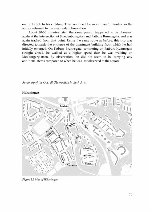
75
on, or to talk to his children. This continued for more than 5 minutes, so the
author returned to the area under observation.
About 20-30 minutes later, the same person happened to be observed
again at the intersection of Swedenborsgatan and Fatburs Brunnsgata, and was
again tracked from that point. Using the same route as before, this trip was
directed towards the entrance of the apartment building from which he had
initially emerged. On Fatburs Brunnsgata, continuing on Fatburs Kvarnsgata
straight ahead, he walked at a higher speed than he was walking on
Medborgarplatsen. By observation, he did not seem to be carrying any
additional items compared to when he was last observed at the square.
Summary of the Overall Observation in Each Area
Hökarängen
Figure 3.5 Map of Hökarängen

76
Hökarängen had the lowest pedestrian density in the streets of the three
neighborhoods. It is a quiet suburban neighborhood and the area is mainly
residential, apart from the ‘shopping center’, centrum, where a small square,
some shops, and the subway station are located. Even the centrum had a low
amount of activity and few pedestrians, with the street where the shops are
located often being empty. The grocery store attracted the most visitors among
the few stores there, but the small square had only few visitors and users at
most times. One reason for this central part of the area being quiet and empty
may be that, although the subway station, which has users consistently during
most hours, is close to the centrum, very few of the pedestrians emerging from
the subway station visit or pass the centrum. While there are two exits from the
subway station, the one that leads to the central square is used by relatively
fewer people than the other exit, which is closer to most of the residential
buildings. This exit is not directly connected to the centrum, but to the
pedestrian paths that are the only or the shortest routes to the residential
buildings from the subway station. While there is a limited number and variety
of shops in the shopping center, compared to the areas in the inner city, the
area is used for very few purposes other than residential, e.g. retail, service or
office uses.
Figure 3.6 Hökarängen centrum (left) / Lingvägen (right)
The size of the area is the largest of the three, but the number of walking
trips available for observation was the lowest. Because of this, it was difficult to
both observe patterns in the pedestrian movement and find walking trips to be
tracked and observed. The difficulty in tracking walking trips was partly due
to the simple problem of finding pedestrians to track, especially during day

77
time when the streets in the area are largely empty, and partly due to the fact
that since the number of pedestrians was very low during most of the hours, it
happened several times that the pedestrian being observed became aware of
being tracked and the observation had to stop in order not to offend the person
being tracked.2 At the beginning of the observation in Hökarängen, most of the
observation took place near the centrum and the main car streets (with
sidewalks), as shown on the map of the area. However, these streets had very
low number of pedestrians to be observed and tracked, and the number of cars
passing in the street often outnumbered the number of pedestrians. As the
observation proceeded and the tracking of the pedestrians accumulated, it was
shown that the walking trips in Hökarängen took place relatively less often in
the streets with cars, but was rather concentrated to the pedestrian paths that
connect the areas between these car streets.
Hökarängen has a large amount of green areas, and green spaces of
different kinds fill most of the space between the residential buildings. The
pedestrian paths along which walking trips are concentrated either run
through green areas with small woods or along the in-between green spaces,
most often in the form of lawns. The pedestrian paths are not only car-free, but
also usually separated from immediate contact with buildings, so that a park-
like rather than an urban walking environment is created along these paths,
which is reinforced by the low pedestrian density during most hours. Not only
along these pedestrian paths, but also in most of the streets, there is space
(usually in the form of a lawn) between the sidewalk and the buildings. Since
the pedestrian paths and the sidewalks are often next to green space,
spontaneously developed trails on the green spaces were observed in
numerous locations throughout the area, made by people crossing over the
lawn in order to make a shorter distance route. These were usually made on
the corners of streets or near residential buildings, cutting across to the
entrance of the buildings instead of following the route provided by the paved
pedestrian paths. The use of these trails was observed very often, and for all of
the different purposes of walking, e.g. walking to school, walking to the
subway station, walking for pleasure, walking the dog.
2 While this happened quite often in Hökarängen, during the observations in SoFo and
Södrastation it happened only once or twice in each area.
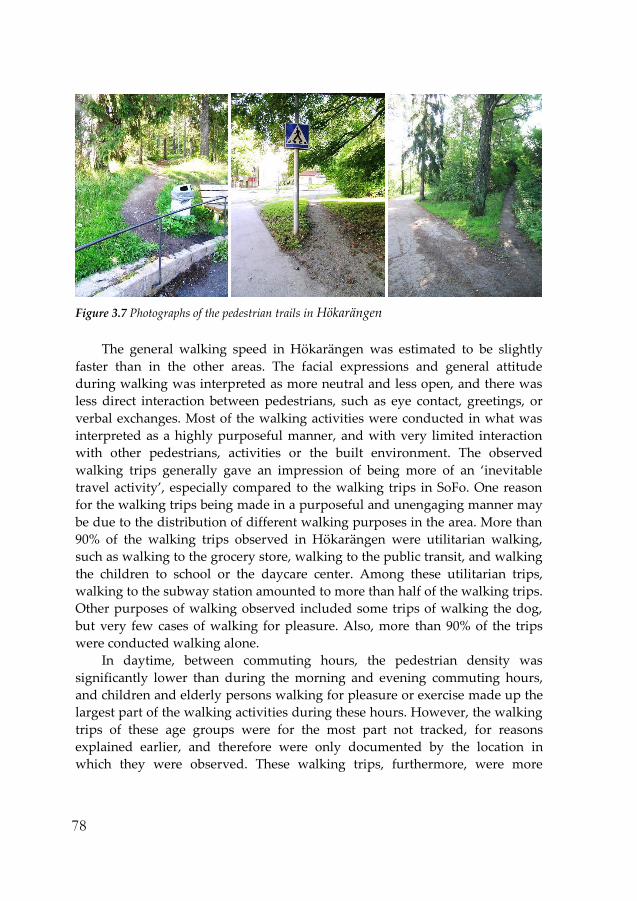
78
Figure 3.7 Photographs of the pedestrian trails in Hökarängen
The general walking speed in Hökarängen was estimated to be slightly
faster than in the other areas. The facial expressions and general attitude
during walking was interpreted as more neutral and less open, and there was
less direct interaction between pedestrians, such as eye contact, greetings, or
verbal exchanges. Most of the walking activities were conducted in what was
interpreted as a highly purposeful manner, and with very limited interaction
with other pedestrians, activities or the built environment. The observed
walking trips generally gave an impression of being more of an ‘inevitable
travel activity’, especially compared to the walking trips in SoFo. One reason
for the walking trips being made in a purposeful and unengaging manner may
be due to the distribution of different walking purposes in the area. More than
90% of the walking trips observed in Hökarängen were utilitarian walking,
such as walking to the grocery store, walking to the public transit, and walking
the children to school or the daycare center. Among these utilitarian trips,
walking to the subway station amounted to more than half of the walking trips.
Other purposes of walking observed included some trips of walking the dog,
but very few cases of walking for pleasure. Also, more than 90% of the trips
were conducted walking alone.
In daytime, between commuting hours, the pedestrian density was
significantly lower than during the morning and evening commuting hours,
and children and elderly persons walking for pleasure or exercise made up the
largest part of the walking activities during these hours. However, the walking
trips of these age groups were for the most part not tracked, for reasons
explained earlier, and therefore were only documented by the location in
which they were observed. These walking trips, furthermore, were more

79
evenly distributed throughout the area than walking trips in general, which
showed a strong pattern or concentration to and from the centrum and the
subway station. As in the other two areas, there was an increased amount of
walking trips by residents during commuting hours, especially in the morning.
One interesting fact was that the peak hour for walking trips during the
morning commuting hours was between 7 am and 8 am, one whole hour
earlier than in the areas in the inner city, which may be due to its suburban
location. The walking trips during these hours were also concentrated to the
pedestrian paths leading to the subway station. However, the concentration
was not as high as in the other areas in terms of pedestrian density relative to
other areas, and this may be due again to the larger area size. Also, while many
trips walking small children to school or day care center were observed during
the commuting hours, these were relatively fewer than in the other two areas.
Together with the fact that a large number of children being brought to school
by car were observed in the area, something rarely observed in the other areas,
this may indicate that this particular walking activity is more often replaced by
car travel in Hökarängen than in the other areas.
During weekends, there was an even lower amount of walking trips than
during weekdays. While there was a concentration of walking trips at least
during commuting hours which created a lively environment in certain parts of
the area during weekdays, during the weekend the area was generally very
quiet, with very few pedestrians during most hours. In the afternoon at
weekends, almost half of all walking trips were made by residents carrying
grocery or similar items, and took place either from the shopping street or from
the subway station. Therefore, just as on weekdays, trips to and from the
subway station made up more than half of all walking trips. There were very
few walking activities for pleasure observed. Also, in contrast to the other areas,
even at weekends there was a lower ratio of walking trips in company than in
the other areas. Furthermore, both during the weekend and weekdays, it was
difficult to find a pedestrian who did not seem to be a resident of the area. Also,
although this may be due to the area being larger in size than the other areas,
there was almost no observed case of a walking trip that extended beyond the
set boundary of the area.

80
Södra Station
Figure 3.8 Map of Södra Station
The area of Södra Station has a character of a quiet and calm residential area,
despite its central location in the inner city of Stockholm. Being a redeveloped
area, the area within the set boundary gives a feeling of being slightly
separated from its surrounding context. The inner part of the area is mainly
residential, with a park and schools and daycare center for small children. The
area is designed to exclude most car traffic and also has a lay-out with streets
on different levels as well as a general design that hinders visibility and
orientation. The segregated feeling of the neighborhood is intensified by the
absence of car traffic and the low pedestrian density in the area. Compared to
the surrounding areas and the streets set as its boundary in this study
(Swedenborgsgatan, Magnus Ladulåsgatan, Rosenlundsgatan), there were
significantly fewer pedestrians in the inner part of the area during most hours
of the observation. The streets set as the boundary of the area had high
pedestrian density during weekdays, most probably since these streets had
mixed use at ground level, including office buildings, and also Södra Station,
an important commuter train station (giving its name to the area) and many
bus routes passing by.
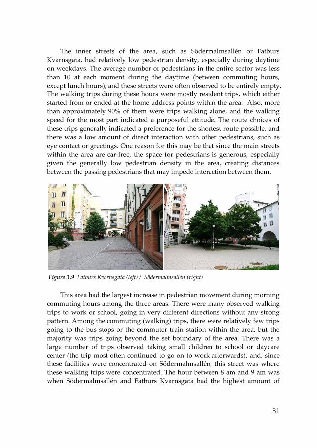
81
The inner streets of the area, such as Södermalmsallén or Fatburs
Kvarnsgata, had relatively low pedestrian density, especially during daytime
on weekdays. The average number of pedestrians in the entire sector was less
than 10 at each moment during the daytime (between commuting hours,
except lunch hours), and these streets were often observed to be entirely empty.
The walking trips during these hours were mostly resident trips, which either
started from or ended at the home address points within the area. Also, more
than approximately 90% of them were trips walking alone, and the walking
speed for the most part indicated a purposeful attitude. The route choices of
these trips generally indicated a preference for the shortest route possible, and
there was a low amount of direct interaction with other pedestrians, such as
eye contact or greetings. One reason for this may be that since the main streets
within the area are car-free, the space for pedestrians is generous, especially
given the generally low pedestrian density in the area, creating distances
between the passing pedestrians that may impede interaction between them.
Figure 3.9 Fatburs Kvarnsgata (left) / Södermalmsallén (right)
This area had the largest increase in pedestrian movement during morning
commuting hours among the three areas. There were many observed walking
trips to work or school, going in very different directions without any strong
pattern. Among the commuting (walking) trips, there were relatively few trips
going to the bus stops or the commuter train station within the area, but the
majority was trips going beyond the set boundary of the area. There was a
large number of trips observed taking small children to school or daycare
center (the trip most often continued to go on to work afterwards), and, since
these facilities were concentrated on Södermalmsallén, this street was where
these walking trips were concentrated. The hour between 8 am and 9 am was
when Södermalmsallén and Fatburs Kvarnsgata had the highest amount of

82
walking trips out of all the hours observed. It was also the hour when the
walking trips of non-residents passing Södermalmsallén (which seemed to be
commuting trips) were noticeable. Since the walking trips with children not
only contributed to higher pedestrian density, but also often generated sounds
of conversation within the family and also greetings between people near
daycare centers and schools, the liveliness of the area increased significantly
during this morning hour, a feature that could not be observed at other times,
either on weekdays or at weekends.
During the weekends, the overall amount of walking trips was estimated
to be lower than during working days. The inner streets of the area were quiet,
with pedestrian density slightly lower than on weekdays, with the streets being
occasionally empty. Most of the walking trips were walking to do grocery
shopping or returning home, with many of the pedestrians carrying shopping
bags. Walking trips for pleasure were relatively few in number. The walking
speed was estimated to be significantly slower in general compared to
weekdays, and trips conducted in the company with others were relatively
more frequent. However, the facial expressions or the attitude during walking
was not significantly different from weekdays, being quite neutral and not very
interactive with other pedestrians. Another difference compared to weekdays
was that the difference in pedestrian density between the inner streets of the
area, such as Södermalmsallén and Fatburs Kvarnsgata, and the surrounding
streets, such as Swedenborgsgatan, Magnus Ladulåsgatan and
Rosenlundsgatan, significantly decreased at the weekend.
Södermalmsallén, compared to Fatburs Kvarnsgata - a parallel inner street
of the area - had a greater decrease in pedestrian density during the weekend.
Although the street is connected to a small park in the center and the design of
the street is wide itself with green spaces, many trees, and seating places, there
was not only few pedestrians, but also very few users and activities in this
street during the weekend. During weekdays, it had more walking trips
passing through, especially by non-residents, than Fatburs Kvarnsgata, but less
than Magnus Ladulåsgatan, the two immediate parallel streets. During
daytime on weekdays, this wide car-free street was used as a play and sports
area for the small children from the daycare center and elementary school
situated there. The low pedestrian density in Södermalmsallén was interpreted
as partly being due to the fact that it was designed at a different level than
surrounding streets for reasons of traffic safety. It is mostly connected to these
streets by staircases and only a few ramps, and it was observed that many
pedestrians took a detour in their choice of route, which was interpreted to be
done in order to avoid passing Södermalmsallén and the extra effort of using

83
the staircases. There were also walking trips observed that made a detour
resulting in a longer walking distance in order to use a ramp instead of a
staircase. Walking trips with baby strollers or trips by elderly persons in
particular seemed to have a strong tendency to avoid Södermalmsallén or the
connecting staircases. Also, a spontaneous trail on the lawn right next to a
stairway was observed to be used in several cases.3
Figure 3.10 Photographs of spontaneous pedestrian trails made next to a stairway (Left : Södra
Station / Right : Hökarängen)
Perhaps this was one reason why, generally speaking, there were more
people observed sitting on benches in Fatburs Kvarnsgata than in
Södermalmsallén. The people sitting on benches, predominantly watching
other pedestrians, in Fatburs Kvarnsgata were mostly elderly. In
Södermalmsallén, there were many sitting places throughout the street, but
during most of the observation time, most of them were empty. There was only
one day (June 1, 2010) during the entire observation when the street attracted
many people in daytime, especially around noon, both walking and staying
and many of the sitting places were occupied by people enjoying the sun,
having lunch or talking with a friend, etc. This was the day with perhaps the
best weather conditions possible in Stockholm, and the many trees on the street
was full of flowers, activating the potential the street has as an attractive,
beautifully landscaped, wide, car-free and safe street to its full extent. However,
within the entire observation, this occurred for only a very limited time.
Although there were very few walking trips for pleasure observed in
3 Such an avoidance of the use of staircases, evidenced by a spontaneous trail next to a
staircase, was also observed in Hökarängen, as shown in the picture to the right in Figure
3.10.

84
Södermalmsallén in general, one type of walking that seemed to be
concentrated to Södermalmsallén was walking the dog. Walking with a dog
was constantly observed in Södermalmsallén during all hours, and, apart from
the commuting hours when there was a high number of other types of walking
trips taking place, around one third to one half of the walking trips taking
place in Södermalmsallén involved walking the dog. The proportion of trips
walking the dog compared to other types of walking was the highest in Södra
Station out of all the three areas.
In terms of the different purposes or destinations of walking, Södra Station
had the most number of trips where the exact destination could not be
identified. A distinction between walking for pleasure, walking the dog, and
other utilitarian walking, could be made by the attitude and the context of the
trip (time and location), as well as by other traits, but there were many trips
that seemed to belong to the utilitarian trips where the exact (or final)
destination could not be documented. This was because a large number of
these walking trips originated and/or ended beyond the area boundary. For
return trips to the area, it was by nature difficult to identify their origin, but for
trips originating in Södra Station, even trips to grocery stores and to public
transit continued a considerable distance beyond the area boundary. This
happened less often in SoFo, and very seldom in Hökarängen. Again, this may
be due to the defined area being relatively small, but even compared to SoFo,
the rate of walking trips going outside the boundary was significantly higher
and therefore the distance of the trips on average was estimated to be longer,
especially when comparing utilitarian walking trips. During the tracking of
walking trips, the tracking often continued beyond the area boundary, even up
to Götgatan or Mariatorget in some cases. Sometimes the tracking had to stop
for practical reasons, so as to not spend too much time on one single
observation.
SoFo
Among the three areas observed, SoFo was estimated to be the area with the
highest amount of walking trips. This includes not only walking trips
conducted by residents of the area, but also pedestrians visiting the area,
mostly visiting the shops, restaurants, and cafés, which make the area one of
the most popular places to visit in Stockholm, not just for tourists, but also for
locals from surrounding areas. As well as the walking trips of the residents,
these visitors to the area largely contributed to the significant difference in
pedestrian density between SoFo and the other two areas. These walking trips

85
of non-residents especially contributed to the pedestrian density and the
liveliness of the area during the hours between the commuting hours and also
during weekends, when the pedestrian density decreased in the other two
areas. In contrast to the other areas, where the hours between commuting
hours were mostly empty of pedestrians, in SoFo there were visiting
pedestrians during these hours making up for the significantly fewer walking
trips among the residents.
Figure 3.11 Map of SoFo
As in the other areas, the morning commuting hours during weekdays
was the time when the density of walking trips conducted by residents was the
highest. These walking trips were the most concentrated between 8 am and 9
am, which included many walking trips with small children, taking them to the
daycare center or to the elementary school within or near the area. The trips
that was interpreted as going to work or school originated at different home
address points within the area, with a large number of them going towards
Folkungagatan or Götgatan, (many of the trips observed were going to the
subway station Medborgarplatsen on Folkungagatan). So, on streets such as
Östgötagatan, there was a strong pattern among the pedestrians of moving
northwards. With the large number of walking trips, mostly by residents
during this morning peak hour, many involved small children, which created

86
an atmosphere of a lively, residential neighborhood. It was due not only to the
presence of many pedestrians on the street, but also to the sounds of the
conversation with the children and also the greetings between the residents.
While the commuting trips were concentrated to approximately one hour,
there was a significant drop in the number of pedestrians within the area after
9 am until around 10 am. After 10 am, the number of pedestrians started to
increase again, mostly due to visitors to the area from the outside. During the
morning hours, there were in particular quite a number of people walking with
strollers with babies, taking a walk, visiting the stores, and going to the cafés
and restaurants for a drink or for lunch, and also often socializing (meeting up
with friends). During weekdays, walking trips conducted by residents started
to increase again after 4 pm. At around 5 pm, there was an equal or greater
amount of walking conducted by residents than by visitors, mostly coming
back from work and/or picking up children. During the early summer season,
with pleasant weather conditions and long sunlight hours when most of the
observation was conducted, there were many walking trips made both by
residents and by visitors also during the evening hours of weekdays, and many
pedestrians who appeared to be tourists were also observed. In the more
detailed observations by tracking, residents were prioritized over non-
residents, but when the number of walking trips by residents was limited,
visitors were also tracked. 4 The residents of the area could mostly be
distinguished from the visitors by the origin or destination of their trip being
entrances to the residential buildings in the area, by the items being carried e.g.
grocery bags, gym bags, etc., and also to some extent by the attitude and the
speed of walking. An experience from the observations is that residents, being
more familiar to the area, tend to walk in a more purposeful and accustomed
manner, and, since utilitarian trips are the most common among walking trips
conducted by residents, the speed of walking of residents is usually faster than
that of visitors.
The buildings within the area are mostly for residential use, but a high
ratio of them has other uses on the ground level, creating a highly mixed use
environment. While the ground level of the buildings are directly facing and
connected to the sidewalk in the manner of traditional urban blocks in the area,
there is a wide range of retail outlets, many cafés and restaurants, and also
offices in these streets. Since the design of the buildings in relation to the
4 For these trips, it was documented that the pedestrian seemed to not reside in the area,
and the observation of these trips allowed the comparison between the walking trips of
the residents and the visitors.
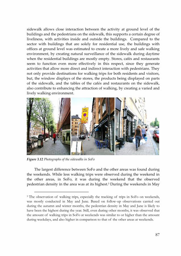
87
sidewalk allows close interaction between the activity at ground level of the
buildings and the pedestrians on the sidewalk, this supports a certain degree of
liveliness, with activities inside and outside the buildings. Compared to the
sector with buildings that are solely for residential use, the buildings with
offices at ground level was estimated to create a more lively and safe walking
environment, by creating natural surveillance of the sidewalk during daytime
when the residential buildings are mostly empty. Stores, cafés and restaurants
seem to function even more effectively in this respect, since they generate
activities that allow more direct and indirect interaction with pedestrians. They
not only provide destinations for walking trips for both residents and visitors,
but, the window displays of the stores, the products being displayed on parts
of the sidewalk, and the tables of the cafés and restaurants on the sidewalk,
also contribute to enhancing the attraction of walking, by creating a varied and
lively walking environment.
Figure 3.12 Photographs of the sidewalks in SoFo
The largest difference between SoFo and the other areas was found during
the weekends. While less walking trips were observed during the weekend in
the other areas, in SoFo, it was during the weekend that the observed
pedestrian density in the area was at its highest.5 During the weekends in May
5 The observation of walking trips, especially the tracking of trips in SoFo on weekends,
was mostly conducted in May and June. Based on follow-up observations carried out
during the autumn and winter months, the pedestrian density in May and June is likely to
have been the highest during the year. Still, even during other months, it was observed that
the amount of walking trips in SoFo at weekends was similar to or higher than the amount
during weekdays, and also higher in comparison to that of the other areas at weekends.

88
and June, there was a high amount of pedestrian movement and activity in the
area, especially around noon on Saturdays. There was generally a higher rate
of walking with company in SoFo than in the other areas, but the rate was
especially high at weekends, with only approximately one out of four trips
being walking conducted alone. The high pedestrian density was estimated to
a large extent to have been due to visitors. Also, on weekends, apart from
utilitarian walking trips, such as going to the grocery store, the walking trips
conducted by residents were more difficult to distinguish from those
conducted by visitors. This may be due to the fact that there was a great
number of visiting pedestrians, and also due to the fact that the residents
walking for pleasure or going to the cafés and restaurants could not easily be
distinguished from non-residents, especially when the start of the trip was not
observed. Still, walking trips for pleasure conducted by residents could be
observed to a considerable extent, which was a significant difference compared
to the other areas.
The walking trips of residents at weekends, especially walking trips for
pleasure (or non-utilitarian walking trips), took place in the more crowded
streets, with pedestrians observing and interacting with other pedestrians,
activities in the streets and objects, people, and activities in the stores, cafés,
and restaurants. The small park in Nytorget and the many cafés and
restaurants nearby, popular for brunch, were full of visitors and created
liveliness on the streets with tables for serving also on the sidewalks. There was
variety among the pedestrians in terms of age and gender (but relatively less in
ethnicity), and also in the mix among the pedestrians between visitors,
residents, and tourists. There was not only a large number of people walking,
but also many people stopping in between walking, staying, sitting, and
socializing on the sidewalk. The speed of the walking in general was
significantly slower than on weekdays and compared to the other areas. There
was more eye-contact between pedestrians passing by each other, compared to
both other days or times of day and the other areas, and, since the most
crowded streets had a pedestrian density that seemed to exceed the capacity of
the sidewalk, the pedestrians were constantly caring for others passing by,
through tilting the body to make space or even climbing off the sidewalk.
However, from the attitude or the facial expressions of the pedestrians,
discomfort or complaint was seldom detected. Finally, route choices for the
walking trips, both utilitarian and for pleasure, were concentrated to the most
crowded streets, which were usually the streets with highest amount of mixed-
use at ground level of the buildings, e.g. stores, cafés and restaurants.

89
Not only during the weekend, but also during weekdays, the streets where
the stores, cafés, and restaurants are more concentrated had a relatively higher
pedestrian density than other streets, and the tracking of the walking trips of
the residents also passed along these streets more often than other streets. The
route choice may carry more meaning in SoFo than in the other areas, since
while there are less alternative route choices offered by the street structure in
other areas, the grid-structure street network in SoFo usually provides
alternative routes. During walking trips, even during the utilitarian walking
trips conducted by residents, pedestrians usually showed a more open attitude,
generally speaking, watching and interacting with the activities at ground level
of the buildings and also with other pedestrians. There seemed in general to be
more eye contact6 with other pedestrians during walking in SoFo than in the
other areas. Also, in addition to the often-observed scenes of visitors of the area,
who seemed to have planned to meet at the area, greeting each other in the
streets, there were several observed occasions when pedestrians, who were
interpreted to be residents of the area, greeted each other or stopped for a
conversation when meeting each other on the sidewalk by coincidence.
With the pedestrian density occasionally being higher than the capacity of
the sidewalk on the most crowded streets in SoFo, the condition of the
sidewalk was one factor which was generally in better condition in the other
areas (especially in Södra Station). The width of the sidewalk differed within
the area, and in some parts it was too narrow and caused difficulty in passing
other pedestrians, especially beyond certain thresholds of pedestrian density.
Also, the displays of products from the stores or restaurant and café tables and
chairs placed on the sidewalk often took up the sidewalk space partially or
sometimes almost entirely. However, as described, despite such conditions of
the sidewalk, the streets with a greater degree of mixed-use were the ones with
a greater pedestrian density, and were also more often included in the route
choices of the residents. One result that seemed to be related to the condition of
the sidewalk was that walking trips conducted with baby strollers seemed to
prefer Åsögatan ahead of the parallel streets. This applied especially to the
section of Åsögatan between Södermannagatan and Götgatan, where the
sidewalk width is relatively wider than in other streets and also had a
pedestrian density which was not too high, making it easier to pass with a
6 The relative amount of eye contact between pedestrians during walking was documented
based on actual observation of pedestrians and their eye contact with others and also by
the amount of eye contact that the author received from the pedestrians in different areas
and at different times.

90
stroller. Many of the walking trips conducted by residents were with a baby
stroller, and it seemed that this specific group, for which the condition of the
sidewalk may be more significant, showed a preference for specific segments,
mostly with adequate sidewalk capacity for the stroller, which was slightly
different from the preferred route of the general group.
Among the three studied areas, SoFo was where most variety in the
purpose or destination of walking was observed and documented. This is
interpreted as most likely due to the higher degree of mixed use, and especially
to the fact that there is more variety in the kind of retail outlets and services
within the area. This affected the variety of destinations for the utilitarian
walking trips of the residents most directly. There was not only more variety in
the purposes of walking, but the distribution of different walking purposes
was less concentrated on a certain kind than the other areas. In terms of the
ratio of each walking purpose within the entire amount of walking trips (by
residents), the only kind that showed a lower percentage than the other areas
was walking the dog, and the kind that showed a significantly higher
percentage than in other areas was walking for pleasure.

91
3.3 Analysis of the Observation Results I
– Comparison with the Spatial Analysis of the Areas
As introduced and presented in Section 3.2, the results of the observation study
have formed a large part of the detailed description of walking activities. While
examples and summaries of the data on walking was presented in Section 3.2
in order to describe the contents of the observation data, from this section the
results of the empirical study will be presented through the analysis of the
observation data. First, in this section, the results of the observation study are
presented and discussed in relation to the spatial analysis of the areas done
through GIS.7 The analysis of the observation data done here is carried out, in
large part, through the comparison between the study areas. This is, to some
extent, similar to the neighborhood comparison method of the correlation
studies on walkability. However, the difference lies in that it not only compares
the neighborhoods in terms of the rather simple measurement of amount of
walking but also investigates how the areas differ in terms of the detail of the
walking behavior of the residents.
7 The GIS analysis of the areas presented here was carried out by Sara Sardari Sayyar at
the School of Architecture, Royal Institute of Technology in Stockholm. The contents of
Section 2.3 are from the co-authored paper, Urban Diversity and Pedestrian Behavior -
Refining the concept of land-use mix for walkability, presented at the 8th International
Space Syntax Symposium (Choi & Sardari Sayyar, 2012).

92
Quantitative analysis of the areas
Table 3.1: Residents, working population, total population and population density values
(person per hectare) for each neighborhood.
The axial map8 which was used for the configuration analysis is comprised of
66,000 lines covering Stockholm and some other municipalities in the vicinity.
Data used for the accessibility analysis includes census data for all of the
residential and working population from early 2000. Data regarding various
activities include all registered economical activities from 2006, sorted
according to their branch codes (SNI code). Both data sets offer highly detailed
resolution at address level, yet at certain steps in the study the data was
aggregated in order to compare neighborhoods based mainly on the measured
mean values. Figure 3.13 represents total population density values at plot
level.
Figure 3.13 Total population density (persons/hectare) per plot
8 The axial map is merged from several different axial maps made by researchers in the
research group Spatial Analysis and Design at the School of Architecture at the Royal
Institute of Technology in Stockholm, and by the consultancy firm Spacescape.

93
Integration analyses at global level (radius 30) and district level (radius 9)
show that SoFo and Södra Station are highly integrated with the whole city as a
system on an urban scale, as well as highly connected at district level with their
surroundings, whereas Hökarängen has the lowest integration at both levels
(Figure 3.14). At local level (radius 3), comparing first two areas as illustrated
in Figure 3.15, Södra Station appears to be slightly less integrated than SoFo in
some parts of the area, while Hökarängen on the other hand has a fragmented
structure with few integrated routes.
Figure 3.14 Spatial integration analysis: global level (radius 30) (left), and district level (radius
9) (right)
Figure 3.15 Local integration analysis (radius 3) with most integrated lines highlighted

94
Analysis of the access to population within walking distances, measured
by combination of both metric distances and axial steps, illustrates that, within
short walking distances (500m/3 axial lines), SoFo has higher access to both
residents (Mean 11,885) and total population (Mean 18,931) compared to Södra
Station (7,621 and 12,575 persons respectively), whereas within 1,500m and 9
axial steps, both areas have a similar degree of access to both groups (on
average 60,000 residents and more than 100,000 persons in total)(Table 3.2).
Table 3.2 Accessible residential and total population in each area
The empirical results show that, although SoFo and Södra Station have
similar population densities, the accessible population rate differs at local level,
which is the effect of their built environment. It appears that SoFo is highly
accessible at both levels by large numbers of non-residents, while Södra Station
is accessible on average by fewer non-residents at local level. Hökarängen is
accessed by the least numbers at both levels, which is around 10-13% of
accessible population in other areas at both levels, containing mainly the
residents. The minimum number of residents accessible from the home address
points in this area (28 persons) at local level shows how empty some parts of
the area could be. As it is represented in Figure 3.16and Figure 3.17,
Hökarängen, just as other neighborhoods located in the southern part of
Stockholm, have access to a significantly smaller number of non-residents at
both levels.
Figure 3.16 Access to residents (left), and total population (right) at home address point level,
within 1500 m and 9 axial lines (longer walking distance)

95
Figure 3.17 Access to residents (left), and total population (right) at home address point level,
within 500 m and 3 axial lines (shorter walking distance)
Access to some activities that are recognized as belonging to common
destinations of the walking trips during the walking behavior observation
study is also tested. The data includes various registered activities such as:
retail outlets, restaurants/bars, leisure and recreational activities (e.g. cinemas,
museums, sports facilities), other services (e.g. hairdressing, beauty salons and
dry cleaning), and educational services (such as day care centers, schools), as
shown in Table 3.3.
Table 3.3 Number of registered activities in each area (in five selected categories)
Comparison between the areas in the analysis on access to activities from
address points shows that within short walking distances (500 m/3 axial lines),
SoFo has the highest access to various activities (e.g. 161 retail shops and 118

96
restaurants) on average, followed by Södra Station with access to less than one-
third of the numbers of activities in SoFo (45 shops and 35 restaurants)(Table
3.4). Hökarängen has the lowest access to various activities at this level (e.g. on
average 5 retail shops and 2 restaurants). Although there are 100 registered
activities in total belonging to the chosen categories in Hökarängen, only 14%
of them are accessible to the home address points at local level on average.
Within longer distances (1500 m/9 axial lines) SoFo and Södra Station have
access to a similar number of activities (Mean: 650 shops, 400 restaurants),
while Hökarängen has the lowest access (both shops and restaurants on
average 49 stores) (Table 3.5). In Hökarängen, although there are a greater
number of activities accessible at longer distances than within short walking
distances, the numbers are still significantly lower.
Table 3.4 Accessible activities and their numbers on address point level within short walking
distances
Table 3.5 Accessible activities and their numbers on address point level within longer walking
distances
In all areas, retail shops comprise the major activities, while in
Hökarängen there are too few accessible shops consisting mostly of
convenience shops, catering for the local neighborhood (this comparison is
according to type of the shops regardless of their offered good). On the other
hand, in Södra Station and particularly in SoFo, there is access to more shops
with greater variety (Figure 3.18). In these areas, as well as convenience
shopping (possible to access at shortest time), there is access to shops offering
comparative shopping (possible to compare the quality and price) in addition
to a number of specialist facilities and exclusive shops.

97
Figure 3.18 Access to various activities at address point level on average, within 500 m/3 axial
lines (left) and within 1500 m/9 axial lines (right)
Comparison of the Spatial Analysis with Observation Data
Comparison of the amount of walking in the three areas
Although the observation study from this project did not measure the objective
amount of walking and this study does not aim to prove any (statistical)
correlation between the amount of walking and built environment attributes,
the perceived relative amount of pedestrian density during the observation in
the three areas was documented. In terms of the average or overall pedestrian
density of the streets in the study areas, SoFo has the highest, followed by
Södra Station, and Hökarängen has a significantly lower density than the other
areas. When comparing also the perceived relative rate of walking trips made
by the residents of the neighborhood assumed from the subjective
measurement of walking trips, and considering the population of the areas,
this order remains the same, although one difference with the pedestrian
density would be that the difference between SoFo and Södra Station seems to
be smaller for the amount of walking trips made by the residents of the areas.
These differences in the relative amount of walking in the three areas form the
basis for the discussions made here, but the main purpose of the discussion is
to investigate in greater depth the type of pedestrians and walking activities
that make up this amount of walking, as well as how and why, which may also
explain why these differences occur in relation to the conditions in each area.

98
Composition of the pedestrians
In this section, the areas will be discussed with the focus on how the defined
study areas are used as the setting for walking. One difference between the
pedestrian populated streets of SoFo and the often-empty streets of
Hökarängen is in the composition of pedestrians in the areas. SoFo, compared
to the other two areas, has a large number of pedestrians originating outside
the area, whereas in Hökarängen there are very few or almost none. In Södra
Station, although the number is higher than in Hökarängen, it is still
significantly smaller compared to SoFo. As well as the difference in the amount
of walking done by the residents of the areas, the difference in the number of
pedestrians in the areas who are non-residents seems to be a strong reason for
the difference in pedestrian density between the three areas. The lower rate of
residents walking and the absence of pedestrians from outside the area in
Hökarängen explain the significantly lower pedestrian density compared to the
other two areas. Also, the fact that the difference in the pedestrian density
between SoFo and Södra Station is greater than the difference in the rate of
residents walking is due to the large difference in the number of pedestrians
coming from outside the area.
These differences in the relative amount of walking trips and pedestrian
density between the areas could be discussed in relation to the result of the
analyses on integration and on access to different populations and various
activities. Hökarängen is far less integrated at the global and district level,
while SoFo and Södra Station are well integrated within the rest of the city.
Hökarängen also has the least access to different populations and various
activities at all levels of the analysis, and has few accessible shops, which
mostly consist of convenience stores. On the other hand, while SoFo and Södra
Station are both highly integrated at the global and district level and well
integrated with their adjacent areas, the reason why SoFo has a greater number
of pedestrians from outside the area by far than Södra Station may be
explained, not just by the difference in the degree of integration, but also
perhaps more strongly by the analysis of access to various activities. In the
results for short walking distances, explaining more or less the condition
within the area itself, SoFo has the greatest access (e.g. 108-210 retail shops, and
73-141 restaurants), while Södra Station has access to less than half the amount
compared to SoFo (20-95 shops and 20-75 restaurants). It corresponds with the
observation that the walking trips made by non-residents in SoFo consisted
mostly of visiting the shops, cafés, and restaurants.

99
Difference in pedestrian density over different times of the day and days of the
week
The differences between the areas in the composition of pedestrians or the rate
of pedestrians coming from outside of the area affect not only the overall
pedestrian density of the areas, but also the pattern in the distribution of
pedestrian density in the areas over different times of the day and also the days
of the week. In Hökarängen, with few pedestrians in most parts of the area
during most hours, there is only a slight increase in pedestrian density twice a
day, during commuting hours (in the morning and in the evening), consisting
mostly of trips to public transport (the subway station). During the rest of the
daytime hours, the streets of the area have very few pedestrians. In Södra
Station, the pedestrian density is also at its highest during the commuting
hours, but the density itself and also the degree of increase compared to the
rest of the daytime hours is much higher than in Hökarängen. However,
although Södra Station has higher pedestrian density than Hökarängen during
most of the hours, when compared to SoFo, it has lower overall pedestrian
density, which is due to lower pedestrian density during the daytime (on
weekdays). While SoFo also shows a concentration or peaks of pedestrian
density, consisting of the residents, during commuting hours in the morning
and the evening of the degree similar to that of Södra Station, the area also has
a relatively high number of pedestrians during daytime between these two
peaks, which consists of not only residents, but to a large degree non-residents
who visit the shops, cafés, and restaurants in the area.
The difference in the number of pedestrians coming from outside the area
not only seems to affect the pattern of pedestrian density over different hours
of the day, but also over the days of the week, between the weekdays and the
weekends. In Hökarängen and Södra Station, with a lower number of
pedestrians who are non-residents, the pedestrian density decreases at
weekends compared to weekdays, probably due to the absence of commuting
trips which make up the highest percentage among the walking trips taking
place there. However, in SoFo, although the commuting trips of the residents
are absent at weekends, the overall pedestrian density at weekends seems to be
similar or even higher than during weekdays, which may be related to the
increase in the amount of visitors to the shops, cafés, and restaurants from
outside the area, which was especially high during the spring and early
summer season with better weather conditions (when most of this observation
study was conducted).
100
Pedestrian density as a walkability factor
As discussed so far, the density of pedestrians in an area seems to be the result
of the conditions of the built environment related to the walkability. Although
pedestrian density captures a slightly different aspect of the walkability of the
environment from the amount of time spent on walking by individuals in the
sense that it is more focused on how the built environment itself is used as a
setting for walking, it is also often used as an outcome or the dependent
variable for measuring the walkability of the built environment, especially in
the studies from the urban design field. However, although it could be
measured as the outcome of the condition of other walkability factors, it may
also itself be related to the walkability of the given area as a factor, which is an
important reason why the distribution of pedestrian densities and their pattern
is presented and discussed here. The pedestrian density in the areas, especially
the distribution and patterns of the number of pedestrians over different hours
and days are closely linked to the liveliness of the area and may enhance the
experiential quality of the walking activities by providing increased chances of
(both direct and indirect) interaction with other people and activities during
walking. The presence of other pedestrians contributes not only to the feeling
of safety, but may become an attraction factor, especially for certain types of
walking activities (e.g. walking for pleasure) which will be discussed in the
later part. Therefore, pedestrian density, when rising above a certain level, may
itself become a factor promoting walkability by increasing the quality of the
walking activity and also possibly increasing the quantity of walking by
providing the destination or reason for walking.
Distribution of walking purposes/types in the three areas
An important description of the walking behavior of the areas is on the
presence and proportion of different purposes or types of walking activities.
Examining the trips made by the residents of the areas, the variety and the
distribution of walking activities varied among the areas. In Hökarängen, more
than approximately 80% of all the walking trips of the residents observed were
walking to the public transport. Other kinds of walking activities with much
lower frequency included walking the dog, going to school, going to the
convenience store, and walking for exercise or pleasure. In SoFo, there was far
more variety in the types of walking activities compared to Hökarängen. The
walking trips there consisted of different activities, such as walking to the

101
public transport, walking to school/day care center, walking to different kinds
of shopping (from grocery to specialized retail), walking for pleasure, walking
the dog, walking to the park, walking to recreational facilities, walking to the
cafés/restaurants, etc. More importantly, the area not only had more variety in
terms of activities, but the proportions among the different walking activities
making up the total number of walking trips were more evenly distributed.
Södra Station, both in its variety and distribution of different walking activities,
showed a result that fell between the other two areas. The description of the
detailed walking behavior of the areas in terms of walking purposes/types will
be continued in the discussion in Section 3.6.
Diversity and walkability
This discussion about the presence of different types of walking activities in
relation to the analysis of the urban form may suggest that the diversity in the
built environment may contribute to the diversity in the walking activities as
well. SoFo, which shows the highest levels in the results from the quantitative
analysis in terms of density, connectivity, and land-use diversity, also shows a
greater degree of diversity in walking behavior by variety in both the
composition of pedestrians and the type of walking activities. This may be
related to the built environment’s influence on the quantity of walking aspect,
as land-use diversity seems to contribute to the destination- (or purpose-)
providing effect of walkability. Moreover, although briefly described above,
this diversity in both the urban form and the walking activities is an important
factor in enhancing the quality of walking, which will be discussed in detail in
the following sections.
How the factors work closely together (in determining the walkability)
The description of how the major factors of walkability, density, connectivity,
and land-use diversity influence the given built environment in terms of the
degree and nature of the walking activities/behaviors taking place there
demonstrates the close relationship between the factors. The way in which the
main factors work together in determining the walkability of an area shows the
importance of the co-presence of factors and how they affect each other. The
degree of density, connectivity and land-use diversity through their
combination determine the character of the area in terms of the types of
walking activities it supports, and to what degree. The explanation for the
difference in pedestrian density, the composition of pedestrians and the

102
diversity in the walking purposes among the areas is provided when the
degree of the factors are observed together. For example, in SoFo, the high level
of integration at the global level illustrating the connectedness to the rest of the
city, together with the high diversity in land-use, especially in the detailed
types of commercial use and services, determine the diversity of the walking
purposes and the composition of pedestrians. Whether the high degree of land-
use diversity could take effect because of the context of high integration/
connectivity or the high (global) connectivity resulted in the high degree of
land-use diversity, (and likewise with regard to density and the other factors),
these factors seem to be closely related and linked together, because the
condition of the other factors affect and determine how the given factor will
appear.

103
3.4 Analysis of the Observation Results II
– The Major Factors Identified in Correlation Studies on Walkability
Density, Connectivity, Land-use Diversity
These terms are the factors most often discussed in walkability. Since these
factors have been most consistently proven to be strongly associated with the
amount of walking, this section will focus on these factors in presenting and
analyzing the results of the observation study of this project. Although the
attributes of the built environment in terms of these factors are frequently
discussed by using the same terminology, these qualities can be investigated
and measured on different levels and scales which may capture different
aspects of influencing walking behavior. For example, although often placed
under the same label, ‘connectivity’, different qualities of connectivity can be
investigated and measured on different levels. According to the different
aspect or scale of connectivity, they differ in the influence they have on
walking. Also, a given area may show different degrees of connectivity
according to the level at which they were measured. The same applies to the
other two factors, density and land-use diversity. Here, recognizing these
differences, how these factors on different scales/levels seemed to affect
walking behavior were analyzed.9
9 While the discussion is focusing on the two factors, connectivity and land-use diversity,
the factor of density is not directly discussed alone, but the condition of the density is
rather a factor that supports and boosts the effect of the two other factors.
104
The “context” or connectivity at the global scale
Hökarängen
The walking trips in Hökarängen differed from the walking behavior in SoFo
or Södra Station in that the trips almost never went outside the set
neighborhood boundary. One reason for this may be the fact that in
Hökarängen, the area boundary was set to cover a much larger surface area,
and also that it is a somewhat pre-defined, existing boundary which defines
the neighborhood as a suburb. However, another possible explanation may be
in its connectivity to the rest of the city, shown by the low degree shown in the
analysis on global integration (Hillier, 1996), due to the urban context it has as
a suburb, opposed to the other two areas, which are in the center of the city.
This might be a reason why almost none of the trips involved going to other
areas of the city by walking. It could be argued that this limits the
opportunities for certain types of walking from occurring, and this may also
affect the frequency of the walking trip occurring. In SoFo and in Södra Station,
many of the trips went beyond the set neighborhood boundary, entailing
accessing the rest of the city by foot, implying that many trips of different
kinds and purpose can be done by walking, due to the close accessibility/
distance to the destinations offered by good connectivity to the rest of the city.
Södra Station & Sofo
With its large number of walking trips directed towards outside the area,
compared to both Hökarängen and SoFo, Södra Station is a good example
where global connectivity or the context of the area plays a significant role in
determining walkability. This is especially the case when considering the
walkability level for the residents living in the area. When observing the
conditions within the area in terms of factors such as land-use mix or
pedestrian density, the value is lower than in SoFo. Therefore, the destination
and also the motivation-providing power of the area itself is weaker than in
SoFo. However, what differentiates Södra Station from Hökarängen is the
opportunity for walking trips directed outside the area to occur through the
area being highly connected to adjacent areas and to the rest of the city. The
central location and good connectivity to other areas greatly increase the
number of possible walking destinations and support the walking activities of
the residents. This is also shown in the quantitative analysis of the areas. In the

105
analysis of access to various activities and their average numbers in each area,
Hökarängen has low values at both short walking distance and long walking
distance levels. However, in the case of Södra Station, while the analysis for
short walking distances (500 m/3 axial lines) shows large differences in the
results with Södra Station having access to less than half the amount of
destinations and activities compared to SoFo (See Figure 3.18 in Section 3.3),
the two areas have similar values in the results in the analysis of longer
walking distances (1500 m/9 axial lines).
These comparisons between the areas show that connectivity at the global
level, together with the condition of other main factors, affect the pattern and
the nature of the walking behavior of the residents. Although it is difficult to
prove objectively the amount or frequency of walking in the different areas
from this observation study, the difference in the rate or frequency of walking
between SoFo and Södra Station is partly related to the fact that walking trips
in Södra Station more often went outside the area than in SoFo. This is also
related to the distribution of different types of walking activities as well. While
residents in Södra Station showed a similar amount of walking trips compared
to SoFo for walking trips such as going to the public transit for commuting,
going to school or day care center, and going to the grocery stores, the
difference lay more in the presence and frequency of other walking activities
than these basic necessary activities. And these walking activities were the trips
that were most frequently directed towards outside the area. Although the
frequency of these walking trips may be slightly lower in Södra Station than
SoFo, the observation study results and also the quantitative analysis showed
that for Södra Station, access to destinations significantly increased for longer
walking distances (than for shorter walking distances). This may also suggest
that these trips in Södra Station may be of longer distances on average than in
SoFo.
Connectivity and distance – walking distance to destinations
As described above, connectivity is one of the main factors that determine the
distance to the walking destinations, together with land-use diversity and
density. Distance itself can be considered, as in some studies on walkability
(Lee & Moudon, 2006b), as the main factor of walkability, or the determinant
factor in the decision to walk. However, although the distance to a possible
destinations or the number of destinations within a given distance can be
measured, the complexity of understanding distance as a factor is that the
distance willingness to walk, as in the maximum distance that a person would

106
consider walkable or desirable when making the decision the walk, is difficult
to define. A ‘walkable distance’ would vary from individual to individual, and
might also vary according to the type of walking activity. Although further
investigation needs to be done in order to understand this complex issue, what
could be suggested from the observation study experience is that the ‘walkable
distance’ is the perceived distance, which the metric distance or route distance
alone cannot fully capture, and involves different factors, such as walking
purpose and the condition and the context of the walking route. While it could
be argued that the longer the distance is, the less likely or frequent it is that the
walking trip would occur, and, considering the subjective measurement of rate
of walking in the study areas, it seems that the walkable distance (as in
distance willing to walk for individuals) is longer in the inner city than in the
suburban area. However, the reason for this may not only be the context or the
connectivity at the global level, but also, as importantly, the difference in
condition in the density and the land-use diversity in the environment
surrounding the walking route that exists between the inner-city area and the
suburbs.
Another issue related to the walking distance is the different perspectives
put on distance. As discussed, the increase in the walking distance would
reduce the willingness or the possibility of walking. Therefore, in dealing with
walkability, distance is often dealt with using this perspective of seeing
increase as an impediment, which corresponds to how walking activities are
dealt with in transportation research. However, while most walkability studies
are interdisciplinary, in research done within the field of preventive medicine
with the aim of promoting walking, in order to increase the benefit of walking
as a physical activity, longer distances would be desired. Therefore, combining
these rather contradictory perspectives, the aim of walkability studies where
the main interest is in health benefits would be to find the balance between
these. If the destinations are given within a distance that is not too far as to
impede walking, longer walking trips would be more desirable. Although
measuring or evaluating the walkability of the study areas is not the purpose of
this observation study, from this perspective of the walkability research, Södra
Station would be a more ideal living environment in terms of walkability, if the
frequency of walking trips meets the recommended level for health benefits,
with its walking trips that often go outside the area and last for longer
distances than in SoFo.

107
Connectivity at the local level – the condition of the street network
Connectivity at the local level or the condition of the street network in the area
is also identified as a factor often associated with the amount of walking. For
the study areas, Hökarängen has a street network that is more difficult to read,
with irregular patterns and cul-de-sacs. Also, in Hökarängen, the subway
station and subway tracks that run through the middle of the area divide the
area into two large parts, which also seems to lower the connectivity within the
area. The other two areas in the inner city have grid street networks. The
condition of the street network contributes to providing convenient routes to
destinations within walkable distance and providing a choice of possible routes.
SoFo, with its traditional city blocks, is in an ideal situation in this aspect. With
the grid system with block sizes that are not too large, the walking trips
occurring in this area often include different possible routes, with the same or
similar route distances, whereas in Hökarängen, there are often only one given
route choice from home address points to the walking destinations, such as the
subway station, retail outlets, or schools. Having multiple route choices may
have a positive influence on walking behavior, especially for routine walking
activities around the residences, since it may increase the perceived level of
safety and increase the possibility of meeting various needs for different
qualities.
Land-use diversity at the local level
The result of the observation study, especially the comparison between the
study areas, demonstrates how land-use mix influences walking behavior. It
confirms how the presence of different land-uses other than residential use
supports walking in residential areas by providing destinations for walking,
shown in the (subjectively measured) frequency of walking and in the presence
and distribution of purposes/destinations of walking trips. In terms of
destination providing aspect, retail and service uses were the significant factor,
both in the amount and variety. The comparison of the walking behavior and
the analysis on the amount of access to different activities (Figure 3.18 in
Section 3.3) illustrates this, and as described in the discussion on connectivity
at the global level, depending on the context of the area, the amount of the non-
residential land-use within the area itself could be compensated for or
supplemented by a high degree of connectedness to surrounding areas, as in
the case of Södra Station. However, what is determined by land-use diversity

108
within the area is how well the given area serves as a walking environment,
which is strongly related to influencing the quality of walking.
Land-use diversity at the street level
Vertical land-use mix
Land-use diversity is a key factor in terms of not only the quantity of walking
through direct provision of destinations, but also the quality of walking. This is
done through determining how well the given built environment serves as the
route environment for walking. It is especially influential in enhancing the
experiential quality of walking by providing the potential for direct and
indirect interaction with the space, the buildings, and the people and activities
in them. How land-use diversity contributes to the shaping of a given built
environment as a setting for walking is related not only to the amount of
different land-use there is in a given area, but also more strongly to the
distribution of land-use mix and the implementation and design of land-use
diversity at the street and building level. Therefore, it should be measured and
dealt with at a finer scale than how it should be measured for capturing the
destination-providing effect of land-use mix. Since the design and use of the
ground level of the buildings are important factors in determining the quality
of a walking environment, vertical land-use mix seems to be an efficient and
effective method for maximizing the effect of land-use diversity on the quality
of walking.
The presence of other land-uses, especially different types of retail outlets
and services at ground floor level of residential buildings, may contribute to
creating a walking environment that is interesting, lively, and safe. The stores,
restaurants, and cafés at ground level create an interface where there are
contacts /communications between the building and the pedestrians by
providing the pedestrians with things to look at and the possibility of being
looked at. This may increase the experiential quality during walking and also
enhance the feeling of security, through providing surveillance, the eyes-on-
street (Jacobs, 1961; Gehl, 2010). In SoFo, with its grid street network, the route
choices were concentrated to the streets with the highest degree of land-use
diversity, to the streets which provide the greatest amount of interaction
between the ground level land-use (mostly retail and service use) and the
sidewalk. Land-use diversity affects how a given segment of the built
environment serves as a lively and interesting walking environment not only
by providing the interaction with the buildings and the activity inside them,

109
but also by contributing to pedestrian density. This can be especially effective if
the different land-use can attract (or become the walking destination for)
pedestrians from outside the area as well as the residents of the area. The
presence of other people, both stationary and walking, seems to be an
attractive factor which enhances the experiential quality of walking from the
observation of the walking behavior.
The difference between SoFo and Södra Station in how the defined areas
function as a walking environment may be related to the degree and
distribution of land-use diversity. SoFo has a high amount of retail and service
use (as a residential area) and a high degree of vertical land-use mix that is well
spread throughout the area, which contributes to forming a lively and
interactive walking environment. However, in Södra Station, vertical land-use
mix in the residential buildings is present to a much lower degree, and the
existing retail and service use is mostly concentrated to the few segments of the
area which are the set boundaries of the neighborhood. The inner part of the
residential area is dominantly single use (residential), with very few other uses
which are mostly day care centers and elementary schools. Therefore, the
streets within the area are very low in pedestrian density during most of the
daytime hours and create a calm and less interactive/interesting walking
environment. Although the integration analysis at the global scale shows that
the streets in both of these areas show a high degree of connectedness to the
rest of the city, the large difference in the pedestrian density and the condition
as a walking environment may to a large extent be due to the difference in the
degree of land-use diversity.
Office use
While there is a need for better investigation of how detailed land-use diversity
should be identified and measured for studying walkability, the influence of
office use has been relatively less discussed and investigated in the existing
studies. Here, the discussion will focus on this use, trying to provide
information on how it seems to influence walking activities in detail, also
partly because this use is a good example that shows the importance of
measuring it at the detailed level.
Office use may not influence walking by directly providing destinations
for the residents of an area as does retail and service use, but may still
influence walking by affecting the condition of the walking environment
related to the quality of walking. The observation from the three areas show
that the presence of office use in the area may have a positive effect on the

110
condition of the area as a walking environment, through increasing pedestrian
density, providing surveillance and potential for interaction between the
building and the pedestrians. Office use may increase pedestrian density
through the working population and also visitors to the offices. It could also
support the liveliness of the area through providing eyes-on-street and
activities going on in the building, and such contributions may be valuable,
especially in residential areas, since they enhance the liveliness and the feeling
of security in the area during the hours in the day-time when activities in the
residential buildings and by the residents are scarce. Therefore, the difference
in the amount of office use in the areas, with almost none existing in
Hökarängen and relatively more in the other two areas, seems to be one of the
factors that resulted in the difference between the areas in supporting the
quality of walking.
As well as in the case of retail and service use, for office use, how it is
implemented and distributed in the area and also in the building seems to be
important in terms of the degree to which it influences walking as described
above. This is shown from comparing the influence of office use in Södra
Station and SoFo, both of which areas have a fair mix of office use for
residential neighborhoods. If the size of the working population and also its
ratio to the residential population are compared, Södra Station has a higher
size and ratio than SoFo. However, the degree to which the office use seems to
have a positive influence on the quality of walking may be higher in SoFo,
which is related to how the mix of office use is distributed and implemented
within the areas. In Södra Station, the office spaces, just like the retail use, is
concentrated within certain segments, and none in the inner part of the area. It
is also often separated into different buildings from the residential use.
However, in SoFo, most of the office space is situated at ground level of the
residential buildings, and more evenly distributed over the area, taking up a
larger floor area. Therefore it can more effectively contribute to the liveliness,
attractiveness, and safety of the area by providing eyes-on-streets, visitors
during day-time, and interaction with the pedestrians on the sidewalk. This
again points to the importance of the design issue of vertical land-use mix.

111
3.5 Analysis of the Observation Results III
– Other Design Factors Discussed in Urban Design Literature
Other design factors
The description and discussion of the observation results given so far in terms
of the major factors – density, connectivity, and land-use diversity – confirm
that they are significant factors in the walkability of the area through different
aspects. While the earlier discussions have been directly about these factors,
describing the condition of the built environment and urban design that shows
the degree of these factors at different levels and aspects, what will be
described here are other design qualities or practices that seem to affect
walking activities. The reason for analyzing and discussing these factors is that,
although they have been less investigated and established as significant factors
in correlation studies on walkability, they are the factors rather often discussed
in urban planning and design literature in relation to pedestrian-friendly
design of the environment. The discussion here will also include how some of
them are related to how the major factors are implemented and some are not,
but, as will be described, they all seem to function both directly and indirectly
with the other factors, especially the major factors, in influencing walking
behavior.

112
Design of the ground level
As discussed regarding the importance of vertical land-use mix, the use of the
ground level is an important factor influencing walking. The design and the
use of the ground-level seem closely related to how effective land-use diversity
is in positively influencing walking. The influence here may not be significant
in affecting the quantity of walking through providing destinations, but it is
more related to the quality of walking aspect, how the different uses present in
the buildings may enhance the quality of walking through creating a good
walking environment. Design at the detailed street and building level that
allows direct interaction between the sidewalk and building, especially active
use of the ground level, such as shops, restaurants, or cafés, creates a walking
environment that is safe, vibrant, and interesting. Design that allows the
pedestrian on the sidewalk to see the displays of the shops and have both
direct and indirect contact and interaction with people and activities in the
retail and service use in the building would maximize these effects of having
mixed-use. Such an interaction between building and the sidewalk is better
supported where there is less or no distance between the sidewalk and the
building, and in these conditions the shops, cafés, and restaurants on the
ground level may often appropriate space, even reaching out onto parts of the
sidewalk, by having product display or tables with people sitting, providing
pedestrians more closely and directly with things and people to see and hear.
SoFo is a good example where this is allowed and is present to a high degree.
The observation of the walking trips shows that this mixed-use at ground level
not only provides destinations for walking, but the segments with these uses,
with the highest and closest interaction between the sidewalks, are where the
route choices are concentrated.
The buildings as interfaces
Although it may not provide an effect as strong as retail or service use, for
residential use, design that allows close contact with the sidewalk also seems to
affect the quality of walking. It is important that the residential buildings are
designed so as to offer the possibility of accommodating other use, especially at
ground level. However, while it is difficult in practice to have a high degree of
land-use mix in residential areas, design that maximizes the influence on the
sidewalk would also be relevant for residential buildings, even for single-use

113
residential buildings. Entrances, windows, and balconies facing and close to
the sidewalk contribute to surveillance over the street, which supports the
feeling of safety (Jacobs, 1961; Gehl, 2010). Although they may be limited in
activating the street in terms of creating liveliness and a feeling of safety,
especially if the density is low and during the hours when the buildings are
mostly empty, e.g. during daytime on weekdays, if the contact with sidewalk is
at very close distance or direct, then even single-use residential buildings may
have a positive influence on the quality of walking.
Hökarängen, where there is a low degree of land-use diversity compared
to the other areas and there are different building types which are mostly
single-use residential, demonstrates the difference in this effect of residential
buildings on the quality of walking according to building types. For instance,
the buildings directly facing the sidewalk (e.g. row houses), standing parallel
and close to the street with entrances, balconies, and windows, had the highest
potential of creating a feeling of liveliness and safety, whereas other types,
such as tall point-house buildings, create a rather different walking
environment. These taller buildings often stand at a distance from the street,
with green space between the pedestrian sidewalk and the buildings, and with
poor visibility of the location of the entrances allow less surveillance or the
feeling of having eyes-on-street. Also, such a design of the building and its
relation to the sidewalk creates an environment of a larger scale, which may
affect the perceived walking distance to be longer, by creating a simple and
uninteresting walking environment.
This influence of the residential buildings on pedestrians are discussed by
means of different building types here, but this is because the design often
differs according to building type, so this division by building type is not a
suggestion for understanding these differences. Rather, it is how the façade
facing the street is designed that is important, especially the part that is in
closer and more direct contact with the sidewalk, . For instance, although the
buildings in SoFo are all similar in their height and distance to the sidewalk
(which is in direct contact with the sidewalk), the difference in the design and
the condition/use of the ground level results in different walking environments.
The condition that the buildings stand directly on the sidewalk, with no space
in between, supports maximizing the influence of having non-residential use at
ground level, which is present in many segments of the area. However, the
same condition, since it increases the influence of the ground level use of
buildings on sidewalks, which is often the space to which the visual
influence/allowance of the pedestrian on the sidewalk is limited, may create a
very monotonous environment where there are no or few entrances to the

114
building and the windows lie higher than the eye level of the pedestrians,
leaving a bland and empty wall facing the sidewalk. Segments with this
condition also exists in part of SoFo and these were the segments with lower
pedestrian density, which seemed to be less frequently selected in the route
choices of both residents and non-residents.
Legibility / Visibility
While Södra Station is relatively highly integrated at both the global and
district level, as the quantitative analysis also shows, the segments within the
area have a rather low degree of pedestrian density considering their
connectedness at the district level, for instance compared to the streets of SoFo.
As discussed, an important factor causing this condition is how these parts lack
provision of destinations for walking through a low degree of land-use
diversity. Another factor that may explain the rather empty streets within the
area, which creates a feeling of separation between this residential area and the
surrounding parts of the city, is the design of the neighborhood, which hinders
the legibility and visibility of the area. The arrangement and design of the
buildings and streets at the entry points to the area, which disallow visibility
and create a difficulty in orientation, as shown in the images, may also partly
explain the low pedestrian density. This would especially disallow pedestrians
who do not reside in the area to use the streets. These factors would have
relatively less influence on the walking behavior of the residents than on first-
time users of these streets or area, since residents would be better aware of the
street system. However, these factors may indirectly influence the walking
activities of the residents by creating a walking environment with low
pedestrian density, which could have a negative effect on the quality of
walking.
Condition of the sidewalk
The observation result seems to point in different directions in terms of the
condition of the sidewalk. Since the sidewalk may be considered a requisite for
walking, it may strongly influence walking, especially when it comes to
whether the sidewalk exists or not. This is partly shown in the results for
Hökarängen, where pedestrian sidewalks were often absent or only partly

115
existent in the detached house area (e.g. on only one side of the street or in
partial segments of a street, being disconnected), the existence and the
condition of the sidewalk may be one of the significant factors in the low
amount of walking activities. However, given that there is an existing sidewalk
along all parts of the streets, the comparison between the areas and also
between the segments within the area show that the condition of the sidewalk,
such as its width or aesthetics, had a limited influence in both attracting
pedestrians or being selected in the route choices of the residents. The
commercial streets in Hökarängen centrum and the wide pedestrian streets in
Södra Station with low degree of use demonstrates the limited power of the
condition (not the existence of a sidewalk) on positively influencing the
quantity of walking. In SoFo, while the streets with highest amount of different
uses, such as shops and restaurants, often had sidewalks of less convenient
condition, with widths lacking the capacity to hold all pedestrians considering
the high pedestrian density of these segments, they were still the most
frequently selected route choices in the walking trips observed.
Car-free design
One of the most frequently discussed design practices relating to pedestrian-
friendly urban environments is the design of car-free or car-light streets. The
pedestrianization of streets has often been described as a successful scheme for
making the urban environment walkable (Moudon, 1987; Gehl, 2010). It has, in
fact, been particularly successful in cases where the restoration of an adequate,
safe and pleasant physical space for pedestrians in conditions that often favor
the automobiles over pedestrians was one of the key solutions in enhancing the
walkability. These are often inner-city areas that satisfy other conditions/factors
for walkability, such as having a central location with good connectedness to
the rest of the city, having a high degree of pedestrian density or the potential
for facilitating it through attractions with a high degree of land-use diversity.
Since these areas in the inner part of cities, especially in Europe, are limited in
its space, car-free design was an effective solution for creating a safe and
comfortable environment for pedestrians.

116
Hökarängen
There are pedestrian-only streets of different types existing in the three study
areas. Hökarängen has one in its shopping center, which is often referred to as
the first pedestrian street in Sweden (Andersson, 1998). This street was
designed to serve as the main commercial street of the neighborhood. While
many of the most successful pedestrian-only streets are commercial streets, and
often the main shopping streets of cities, the use of this car-free shopping street
in Hökarängen demonstrates how the co-existence of other factors supporting
the walkability is crucial for the functioning of such a street. Although this
street has a spacious and pleasant physical infrastructure for pedestrians, with
its car-free design and the ground level of the buildings fully reserved for
commercial use, designed for good interaction with the street, the street has
very low pedestrian density. Due to the low residential density, low degree of
connectedness to the rest of the city, and the range of existing retail outlets that
lack the capacity to attract either the local or non-local customers/visitors, this
pedestrian-friendly street does not seem to fully function as the active, lively
main street of the area it may have planned to serve as.
Other than this street with the pedestrian-only design resembling inner-
city shopping streets, there are also many other segments of streets that are car-
free in Hökarängen. These are the pedestrian paths spread over the area,
usually in the green areas between the residential buildings. While the car
streets are limited in connectedness within the area, often ending up in cul-de-
sacs and forming a network that is difficult to read, these pedestrian paths
connect different parts of the area to each other. While most parts of the car
streets run in a north-south direction, the streets that run through the area in a
west-east direction are mostly these pedestrian paths. While the car-streets
alone would have created a condition often present in suburban
neighborhoods with low walkability, with poor level of connectivity both to
the rest of city as well as within the area, the pedestrian paths contribute to
increasing the connectivity within the area. However, although the car-free
streets also mostly have sidewalks for pedestrians, since these pedestrian-only
paths are crucial in connecting different parts of the areas, this design of the
streets has resulted in a situation where separation occurs between car traffic
and pedestrian movements. This separation is in partly due to the planning
and the design of the infrastructure, but also realized and intensified by the
walking behavior of the residents of the area.

117
Figure 3.19 Map illustrating the (paved) pedestrian paths in Hökarängen
While the streets with cars have very few pedestrians during most of the
daytime hours, the tracking of walking trips on site during the field study
showed that the pedestrian paths, somewhat hidden in the green areas in
between houses, are where most walking trips occur. The reason for this could
be that these pathways are the ones that allow connection in an east-west
direction in the western part of the area and, in most parts, the paths that
connect the residential buildings/areas to the subway station. Since going to the
subway station makes up the largest proportion of all walking trips taking
place in the area, these pedestrian paths are rather inevitably included in the
route choices. The walking trips that occur on these pedestrian paths, which
are almost all of the walking trips occurring in the area, are mostly activities
such as going to the subway station, going to the bus stop, going to school or
day care center, and going to the convenience stores. They are the type of
activities that could be classified as necessary activities.

118
Figure 3.20 Photographs of the pedestrian paths in Hökarängen
Since the walking trips taking place on the pedestrian paths are mostly
necessary activities and, given the fact that for most of these walking trips there
is no other route choice (as in providing similar route distance), the pedestrian
streets are chosen in route choices for the walking trips since they are either the
only or the shortest route to the destinations. Even though these paths are
chosen mostly for reasons of distance convenience, the design of the streets
could also to some degree affect the quality of the walking trips, although there
may be limitations to discussing this based only on observation data. These
pedestrian paths are rather distinctive in that they are designed to cut through
the green areas. There are few buildings surrounding or facing the streets in
most cases, and other than those that lead across open green areas, many
sectors of these paths lead through green areas often with tall woods, creating a
very calm and natural walking environment. However, the fact that they are
surrounded almost only by greenery, and seldom by buildings, creates a rather
monotonous environment on the other hand. The observation of the walking
trips during tracking showed that walking trips in Hökarängen were made at a
higher average speed than those in other areas. The facial expression and the
attitude of the pedestrians during walking on these pedestrian paths also
seemed to be more unenthusiastic comparing to the same type of activities in
the other two areas.
Although these pedestrian paths are designed and built as pavement on
green areas, there are also many trails made from traces of attempts to cross
green spaces by a shorter route. They are found on most corners of these streets,
as well as on lawns and even on hills leading directly to residential buildings.
As there are no possibilities for interaction with experiential quality to occur
caused by buildings and activities around and within them along these paths,
the quality that people seem to most desire during these walking trips seem to

119
be in providing the quickest route possible. One benefit of car-free streets is
that it reduces the risk from car traffic and enhances road safety. However, in
terms of other kinds of safety, such as crime prevention, the way the car-free
street design is implemented may influence the walkability in a negative way,
as in the case of these pedestrian paths in Hökarängen. The design of theses
streets that are separated from the buildings and also the car traffic, together
with the overall low pedestrian density, means that these streets significantly
lack, not only the possibility of creating experiential quality through interaction
with other, but also surveillance, or the eyes-on-street, which are crucial for
creating a feeling of safety. Although most parts of these pedestrian paths are
supported by lighting, the fact that there can be long dark hours depending on
the season in Sweden, means that such a condition may reduce the quality of
walking, especially for certain group of pedestrians more sensitive to this issue.
Although these pedestrian paths are where the largest proportion of
walking trips occur within the area, since the overall amount or density of
pedestrian is very low, even these streets are often empty during most of the
daylight hours except during commuting hours, when there is a concentration
of walking trips to the subway station and to schools within the area. The
absence of other pedestrians, as well as car traffic and different, or any, land-
use in the surrounding buildings creates a monotonous environment in which
it is difficult to create liveliness. These streets have many seating places, such
as benches along the pathways, but during the entire field study, only one
incident of use of these seating places along these pedestrian paths was
observed. The route choices for the walking trips, other than the necessary
walking activities that have no other route choice except these pedestrian paths,
show that they rarely include these pedestrian paths. Although the area itself
has a very low frequency of more optional or social activity types of walking
trips, even those that do occur are concentrated to the streets with car traffic.
Södra Station
Södra Station also serves as an example of the implementation of car-free
design in a residential neighborhood. In this area, the two main roads running
in an east-west direction within the area are designed to be car-light. First,
there is a street (or combination of two streets) which includes a car-free
segment in the middle of the area connected to Fatburs Kvarnsgatan and
Fatburs Brunnsgatan at each end. The car-free segment of the street is also
connected to the corner of Timmermansgatan and Fatbursgatan, and this sector,

120
which is the entering point to the residential area from the northern part
therefore well demonstrates the car-light character of this area. Together with
the street running parallel also through the middle of the area which is
pedestrian-only along its entire length, these car-light streets within the area
allows no car traffic to penetrate through the area from any direction. This
resulted in making this redeveloped residential area somewhat segregated or
isolated from the surrounding area and creates a rather quiet and calm
environment.
Figure 3.21 Map illustrating the car-free sectors in Södra Station
Figure 3.22 Car-free sector on Fatburs Kvarnsgatan (left) / Södermalmsallén (right)
The other car-free street in the Södra Station area, Södermalmsallén, is an
interesting case of the use of a pedestrian-only street. This wide street, which
lies in the middle of the area, has a pedestrian path, a bicycle lane and a strip of
greenery running in parallel. It is connected to a park situated in the middle of
the area and has seating places (benches) set near the lawns and trees on the
street. On this streets, with residential buildings on each side, there are
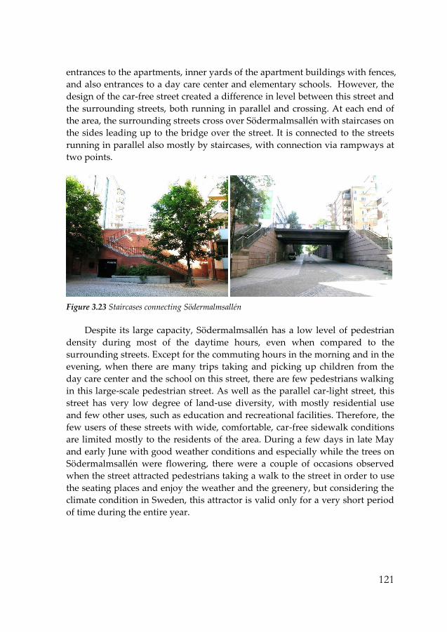
121
entrances to the apartments, inner yards of the apartment buildings with fences,
and also entrances to a day care center and elementary schools. However, the
design of the car-free street created a difference in level between this street and
the surrounding streets, both running in parallel and crossing. At each end of
the area, the surrounding streets cross over Södermalmsallén with staircases on
the sides leading up to the bridge over the street. It is connected to the streets
running in parallel also mostly by staircases, with connection via rampways at
two points.
Figure 3.23 Staircases connecting Södermalmsallén
Despite its large capacity, Södermalmsallén has a low level of pedestrian
density during most of the daytime hours, even when compared to the
surrounding streets. Except for the commuting hours in the morning and in the
evening, when there are many trips taking and picking up children from the
day care center and the school on this street, there are few pedestrians walking
in this large-scale pedestrian street. As well as the parallel car-light street, this
street has very low degree of land-use diversity, with mostly residential use
and few other uses, such as education and recreational facilities. Therefore, the
few users of these streets with wide, comfortable, car-free sidewalk conditions
are limited mostly to the residents of the area. During a few days in late May
and early June with good weather conditions and especially while the trees on
Södermalmsallén were flowering, there were a couple of occasions observed
when the street attracted pedestrians taking a walk to the street in order to use
the seating places and enjoy the weather and the greenery, but considering the
climate condition in Sweden, this attractor is valid only for a very short period
of time during the entire year.

122
Figure 3.24 Children’s use of Södermalmsallén
As discussed in the case of Hökarängen, an advantage of car-free design is
that it solves the road safety problem. This is important for certain group of
pedestrians, especially children. Since there are schools and a day care center
for small children surrounding the street, the car-free situation creates a safe
walking environment for children, and during daytime, together with the
connected park area, the wide street is occasionally used as space for their play
and recreation as well. However, in general, with the low pedestrian density,
wide street width, and limited land-use diversity alongside, the street creates a
calm but monotonous walking environment.
The tracking of the walking trips showed that Södermalmsallén was
avoided in the route choices for many walking activities. Walking for pleasure
trips almost never included Södermalmsallén in the route, but were instead
directed to other surrounding streets with higher pedestrian density and more
activities supported by land-use mix. In the walking trips for necessary
activities, other than the walking trips made by the residents of the area where
the destination or residence was located on Södermalmsallén, there were few
commuting trips that passed through or crossed the street. While the difference
in levels and car-light design has created difficulty in the orientation of these
streets from surrounding streets, these commuting trips were made by
individuals who seemed to be well aware of the area and able to orientate
through the complicated staircases and ramps, since these provided the
shortest route to their destination. An interesting result from the observation
was that in some walking trips, Södermalmsallén was avoided even at the cost
of a detour. Although these were necessary activities, such as going to the
public transit or the grocery store, the car-free street was avoided, probably
due to the inconvenience of having to use the staircases. The observation

123
showed that the number of persons who avoided using the stairways was
higher than the author expected.
SoFo
While car-free design has been rather strongly implemented in the other two
areas, SoFo is different in this respect. When evaluating the effect of the car-
free program in the other areas, the walking environment created by the
pedestrian-only streets seem to partially decrease the quality of walking,
mostly due to the way it has been designed and implemented. Due to the
context and the design method, the effect of car-free design is rather different
in these areas compared to the effect it has had in other cases that are
considered to be successful, such as in Venice, Italy or major shopping streets
in cities. For SoFo, in terms of an argument for better walking facilities, e.g.
regarding sidewalk width and traffic safety, the necessity may be rather high,
considering the high number of pedestrians during the crowded hours that
seem to overload the sidewalk capacity. However, most streets in the area
allow car traffic, and there is only a small sector where vehicles are restricted.
Figure 3.25 Map and photograph of the car-free sector of Södermannagatan
Part of Södermannagatan between Bondegatan and Skånegatan is
designated a car-free sector (“gågata”). This sector is where the street width is
narrower than in other parts of the area, but has higher number of pedestrians.
The restriction of car traffic and the change of the street into a pedestrian street
was implemented recently (in 2006), initiated by requests from the residents
and shopkeepers of the area. While the designed sidewalk is very narrow, now
that the sector is only for pedestrian use, it provides a comfortable and safe
walking environment. The shops and cafés situated there are using the space

124
for tables and for displaying products. During the hours when the area has
many visitors, the street is actively used by passers-by, café and shop visitors,
and other people sitting and staying. It is a good example of a context where
the implementation of car-free design may be effective in supporting walking
and the use of streets.
Götgatan
Götgatan is an example of a street with car-free design that provides an
interesting contrast to Södermalmsallén. The streets are situated close to each
other on Södermalm, both centrally located within the entire city. Götgatan is
one of the main commercial streets in the inner city of Stockholm, with a great
concentration of retail outlets and services at ground level. It has a large
number of pedestrians visiting the street on average. Therefore, the car-free
environment creates a safe and comfortable walking environment for the high
pedestrian density, consisting of different walking speeds and activities. The
strong contrast in the intensity of use of the two streets during the same hours
at weekends illustrates the effect of land-use diversity in the context of similar
high connectivity at the city level.
Figure 3.26 Photographs of Götgatan and Södermalmsallén on the same day (weekend afternoon)
Götgatan is a good example where a car-free program is an effective way of
supporting pedestrian comfort in settings such as major shopping streets,
where there is high pedestrian density and lack of facilities for walking on
sidewalks only. In Södermalmsallén, however, in the context of the street
which is a quiet residential neighborhood, the car-free design rather reinforces
the quiet, sparsely peopled and park-like atmosphere, creating a very different

125
environment from Götgatan. This illustrates that, although both
implementations may be referred to with the same label of ‘car-free street’, the
disallowing of vehicles may have different effects for the pedestrian
environment depending on the context and the specific design.
Car traffic vs. pedestrians
As discussed so far, one benefit of designing car-free streets in residential areas
is the improvement in traffic safety. Hökarängen is an example of an
environment where the separation of car traffic and pedestrian movement is
implemented through the planning and layout of car streets and pedestrian
paths. However, although the risks from car traffic are solved in the car-free
segments, in places where pedestrians intersect with car traffic, which still
exists extensively and inevitably, conditions for pedestrians are not as
“pedestrian-friendly”, when compared to the other study areas. Compared to
the other two areas, SoFo allows car traffic almost entirely throughout the area.
The amount of car traffic is similar to that of Hökarängen. However, with the
higher pedestrian density in SoFo during most of the daytime hours, the
dynamics between car traffic and pedestrians differs between the two areas.
SoFo has a somewhat pedestrian-dominated environment, where vehicles
move at slow speed with care for the pedestrians. In Hökarängen, vehicles
move higher speed, and the observation showed that at intersections,
pedestrians often waited for the car to pass and then crossed the street, while in
SoFo the opposite was nearly always the case.
While a car-free design could be a key solution for activating inner-city
streets with high (levels or potential for) pedestrian density, connectivity, and
land-use diversity, it is difficult to achieve this effect in residential areas
through car-free design alone. The various cases of car-free streets in the study
areas show that, despite the advantages the implementation of a car-free
concept can bring, such as improvements to traffic safety, there is also a risk of
impeding walkability, such as creating inconveniences in walking conditions
through differences in level, and limiting the possibility for land-use diversity,
which is an important factor in enhancing walkability through both quality
and the quantity aspects of walking.

126

127
3.6 Different Walking Activities and their Route Choices
During the field observation, especially in the detailed observation of
individual walking trips during tracking of pedestrians, the destination or the
estimated purpose of the walking was documented. What will be discussed
here are the different walking trips and their route choices through describing
specific examples or patterns in an area. The route choices and the presence
and distribution of different walking activities in each area may allow
discussion on the difference between various purposes of walking in how they
interact with the built environment.
Utilitarian walking trips
In this thesis, walking trips that involve the daily activities of residents, such as
going to work, school, grocery shopping, and other ‘necessary’ purposes,
including going to the public transit in order to take a trip for these purposes,
will be called ‘utilitarian’ walking trips. Although there are many different
specific purposes among this kind of walking trip, the reason they are
discussed together here is because of the similarity in the behavior of these
activities, such as the attitude of the pedestrian and the quality of the factor
that influences the route choices. And the most important factor in the route
choice these walking trips have in common seems to be the issue of walking
128
the shortest distance. Since the origin and the destination of these utilitarian trips
are more fixed points compared to other types of walking, such as walking for
pleasure or walking the dog, in most cases they took one of the shortest, or the
only shortest route possible. Although efficiency of movement may be the
strongest factor or quality sought by the pedestrian for utilitarian walking trips,
(which was a common factor for all three areas), other factors involved in how
pedestrians interact with the built environment during walking will also be
discussed here, on the basis of specific route choices and some differences in
the patterns between areas.
Hökarängen
Hökarängen is the area where the ratio of utilitarian walking (within entire
walking trips) was the highest. Due to its street network, including the
pedestrian paths, the area does not allow different route choices (of the same or
similar distance) for most of the walking trips. Therefore, the utilitarian
walking trips usually took the only shortest route, which in most cases
included the pedestrian paths through the green areas. In this area, especially
for utilitarian walking activities, the dominant and often the only factor in the
route choice seemed to be the efficiency of movement. What seems to illustrate
this strongly is the fact that, while the paved pedestrian paths and sidewalks
usually provide the reasonably shortest route distance between the start and
the destination, the pedestrians in this area were very often creating
spontaneous trails which made an even shorter distance. As described earlier,
these are trails that usually pass across or through the green areas and
sometimes even pass through very narrow, dark spaces between buildings,
creating a less comfortable and safe walking environment than the paved
pedestrian paths (see individual walking trip case #1 in Section 3.2).
SoFo
Contrary to Hökarängen, SoFo is where the pedestrians are usually given
alternative route choices due to the grid street network. Therefore, although
the route choices of the utilitarian trips were mostly based on selecting the
shortest route distance with the least number of turns, there were cases where
different routes with similar conditions in this sense were possible. In the
tracking of these cases, the results show that there are streets or sectors that the
residents seem to choose or include in their routes more often. These were the
sectors which had relatively higher number of pedestrians, both residents and

129
visitors, and which were often also the sectors with higher level of non-
residential use at ground level. The close observation during the tracking of
trips suggests that these sectors seem to offer the pedestrian greater
opportunities for direct and indirect interaction with other people and the
activities both inside and outside the buildings, which may enhance the
experiential quality of the walking activity (see individual walking trip case #2
in Section 3.2).
In the observation of the utilitarian trips in SoFo, there were a large
number of cases when the pedestrian was actively interacting with the
buildings, such as looking closely into the displays of the shops or the people
and the activities in the cafés and restaurants. The offices at ground level of the
buildings also seemed to contribute to the quality of walking, by creating a
feeling of liveliness and surveillance. The design of the ground level of the
buildings providing good visibility between the pedestrians on the sidewalk
and the activities inside the building seems to contribute greatly to this effect.
The presence of office spaces, compared to residential-use only buildings,
seems to be especially effective during the daytime in influencing the
atmosphere of the walking environment, when residential buildings are mostly
empty and quiet. There were many cases of both the observer and other
pedestrians observed having eye contact during walking with persons sitting
in the offices close to the windows of the buildings. These observations may be
related to possible reason why sectors with higher ratio of other uses and
pedestrian density seemed to be chosen more often in the route choices for
utilitarian trips (compare: Demerath & Levinger, 2003; Du Toit et al., 2007).
This preference for streets with more pedestrians or shops, restaurants,
cafés, etc. in the route choices was consistently observed during various times
and days. It was a strong pattern, observed during commuting hours as well as
during daytime, and also throughout the week including weekends. The
utilitarian trips with such preferences included various purposes, such as
walking to and from work, to the public transit, to the grocery store, and many
others. Even from the morning time commuting trips, there were several
observed cases when the pedestrian was looking closely into the window
displays of the shops not yet open. One difference between morning
commuting time and daytime was that the sector with mostly office space at
ground level seemed to be chosen less often in the morning, since it had the
opposite effect from the daytime with no activity in these spaces during this
time. However, such a difference did not seem to apply as much to the sectors
with more retail use, since the shops, although closed, still often provided

130
window displays of the products that the pedestrians could see and interact
with.
Figure 3.27 Photographs of sidewalks in SoFo
In the weekends during the observation study in SoFo, there was
significantly high pedestrian density, largely due to the high number of visitors
to the area. Since the visitors or non-residents seemed to make up more than
half of all pedestrians, the trips of these pedestrians were predominantly
concentrated to the streets with uses such as retail, cafés and restaurants. On
the other hand, the segments with residential-use only buildings had
significantly smaller number of pedestrians, often less than five at a time. The
difference in the pedestrian density between the streets was so large that the
segments with higher pedestrian density were in a condition where the
number of pedestrians seemed to overload the capacity of the sidewalk. An
interesting result from the observation was that, even in these situations, the
residents making utilitarian trips still chose to pass through the busy and lively
part of the streets more often than the less crowded parts. Since there were
many pedestrians visiting the area for non-utilitarian purpose walking, the
overall speed was relatively slow and the crowdedness often made it difficult
to pass ahead of other pedestrians. There was very little space between the
pedestrians in both directions, and there were frequently situations when
pedestrians had to tilt the body or step down into the street in order to make
space for pedestrians coming from the opposite direction. Therefore, the speed
of utilitarian trips of residents, such as going to the grocery store or other
shopping, was slower than the average speed during weekdays. Despite this
condition of the walking environment, in the majority of the cases observed,
residents making utilitarian trips nevertheless kept their preference for route

131
choices including these segments with higher numbers of pedestrians and
other uses in the buildings (compare: Ewing, 1999; Moudon, 1987; Gehl, 2010).
Although this was a dominant pattern, there were still a few cases that
showed a different behavior. While the majority of the residents did not seem
to mind choosing the segments with high pedestrian density which might
cause uncomfortable walking conditions, there were a few occasions observed
during the busiest hours of the weekend where residents seemed to partially
avoid the busy segments. One example is a walking trip of a resident on a
Saturday around noon. The pedestrian was a man pushing a small boy in a
stroller and also carrying a bag of groceries, (although the actual scene of
emerging from the grocery store was not observed). This walking trip was
partially tracked and observed, beginning from when the pedestrian was
found walking southwards on Östgötagatan. The reason this trip was chosen
for observation was the fact that the pedestrian was walking at a significantly
faster speed than the other pedestrians. Pushing the stroller with a grocery bag,
the man walked in a hurried manner, overtaking many of the pedestrians who
were mostly walking at a slow speed during this time. An interesting fact was
that although the man seemed to be walking at a fast speed and in a very
purposeful manner, he did look into the displays of the stores a few times
during the walk, as most other pedestrians at this time were also doing. The
route this pedestrian took was the segments with higher pedestrian density
(Östgötagatan and Skånegatan), but while walking on Skånegatan, he took a
detour, choosing to walk through the less crowded streets (see the map in
Figure 3.28). The reason for this may be that the high number of pedestrians as
well as the space in the sidewalk occupied by the tables and chairs from the
cafes and restaurants in this part made it difficult for him to walk with the
comfort and at the speed he wanted, especially since he was also pushing a
stroller.
Figure 3.28 Route map of the given example from SoFo and photographs of the avoided path

132
As is the example of the walking trip described above, there were
pedestrians who seemed to be more affected in their route choice by certain
factors, such as the condition of the sidewalk, than other pedestrians were.
From the observation, these pedestrians were often people pushing baby
carriages and elderly persons. These pedestrians were more often observed
making a detour in order to avoid segments with less comfortable (e.g. narrow,
crowded, or with staircase) conditions on the sidewalk. Nevertheless, in SoFo,
the unusual cases in route choice were significantly fewer in number than the
dominant pattern, and in the majority of cases, the high density of pedestrians
and other uses in the building had a more positive effect of attracting walking
and enhancing its experiential quality than the negative effect of creating a
walking environment with less convenient or comfortable infrastructure
(sidewalk condition).
Another result from the observation that supports the dominant pattern in
the route choice in SoFo is the difference between normal weather and rainy
conditions. In order to check whether there was any difference in the walking
behavior between different weather conditions, observations during rainy
condition were conducted during the field study. Although the amount of time
spent on observation during rainy conditions was far less than during normal
weather conditions, some differences were documented. Since SoFo was the
area where such differences seemed to exist more obviously than in the other
areas, more observation during rainy conditions were conducted here (seven
occasions, each consisting of several hours). What seemed to be different
during rainy conditions was that walking trips or their route choices seemed to
be more evenly distributed among different streets and segments compared to
comfortable weather conditions, when they were more concentrated on certain
segments as described in the previous paragraphs. This was found in both the
observation of the overall distribution of pedestrians in the area and also in the
individual tracking of walking trips. It may be that during rainy conditions,
pedestrians are more influenced in their route choice by efficiency of
movement and comfort of the walking environment.
Södra Station
The tracking of utilitarian trips in Södra Station also showed that the route
choices were mostly based on the shortest distance. However, one interesting
result found in Södra Station was the avoidance of the Södermalmsallén. Due
to the difference in level between Södermalmsallén and the surrounding streets,

133
this street is connected to the other streets mostly by staircases. During
commuting hours, there were many walking trips on this street due to the fact
that many daycare centers and elementary schools were located here. However,
at other times, a strong tendency to avoid Södermalmsallén was found in the
route choices for utilitarian trips, such as going to the grocery store or going to
public transit. Even for walking trips that had to pass Södermalmsallén in
order to find the shortest route distance, a large number of them avoided
including the street at the cost of a longer distance. The fact that there were
several observed cases where the ramp way connecting Södermalmsallén was
chosen instead of the staircases despite a detour, and that such a detour was
almost always present in the walking trips with baby carriages, may suggest
that the presence of the staircases and people’s avoidance of them is the main
reason for these route choices.
Figure 3.29 Route choice map of the case avoiding Södermalmsallén
Walking for pleasure
Walking for pleasure or recreational reasons was an activity that showed an
observably different behavior from the more necessary walking activities.
Excluding walking for exercise, these walking trips were generally conducted
with a much less purposeful attitude and at a slower speed, with more
flexibility between moving and sojourning. The route choices for these
activities also proved to be distinctly different from the route choices for
utilitarian trips. The destinations of these walks were less fixed and the
movement between different locations was also not always directed by the
shortest distance route, as in the case of utilitarian trips. In the observation of
these walking trips, the quality that the pedestrian pursues may be

134
investigated through the destinations and moreover the route choices during
the walk.
SoFo was the area in which the greatest amount of walking for pleasure
was observed out of the three areas. It was also the area where the ratio of
walking for pleasure as a proportion of the entire number of walking trips was
the highest. Also, a large number of these trips were conducted within the area
(as opposed to the result in Södra Station). The observation of these trips
showed that they were in most cases directed towards and through the sectors
with higher amounts of other pedestrians and activities. During the weekdays
and the hours with relatively fewer pedestrians in the area, the strolls of the
residents were directed more towards specific sectors with retail stores or
Nytorget. In the weekends, with significantly higher pedestrian density, the
residents took their strolls in the streets with greater numbers of other
pedestrians, which were often the sectors with non-residential use at ground
level of the buildings. During the walk, the pedestrians observed other
pedestrians as well as people sitting or staying in and outside the buildings in
stores, cafes, and restaurants, and also looked at the displays of the shops,
often stopping as well. Since there seemed to be a strong preference for these
specific sectors during these walking activities, the routes were often circular in
shape, or moving back and forth on the same street.
While the sectors with a higher number of pedestrians and non-residential
use were the routes most often chosen for recreational walking, another street
with a slightly different characteristic was often observed to accommodate this
type of walking activities as well. This was Katarina Bangata, which has a tree-
lined pedestrian path running down the middle of the street, as well as
sidewalks connected to the buildings. While pedestrians making utilitarian
trips and some of the recreational walking trips seemed to prefer the sidewalks
near the buildings, where it is possible to see the displays of the stores and the
activities within the building, walking trips by the elderly and pedestrians with
baby carriages, especially those making recreational walking trips, seemed to
prefer the pedestrian path in the center, which provided a wider width,
benches, and a more comfortable walking environment.
In Södra Station, as for the other types of walking, walking for pleasure
was also mostly directed towards places outside the set boundaries of the area.
There were very few strolls that were going to or passing Södermalmsallén.
These few cases were either observed on the day with exceptionally pleasant
(sunny) weather conditions, when the trees on Södermalmsallén blossomed
and attracted visitors staying on the street, or were observed on accompanied
strolls. In walking for pleasure alone or pedestrians with baby carriages, there

135
was, reversely, a tendency to avoid Södermalmsallén. Medborgarplatsen, a
crowded square close to the Södra Station area, was a popular destination for
the strolls(pleasure/social walking) of the residents of Södra Station (e.g.
individual walking trip case #3 in Section 3.2). While the streets within the area
are rather quiet, walking for pleasure seemed to be directed towards places
with more activities and people.
One example illustrating this is the walking trip tracked and observed on
an afternoon during the weekday (May 11, 2010, Tuesday, around 2 pm). The
pedestrian tracked was a middle-aged man, coming out from an apartment on
Fatburs Kvarnsgatan. He walked towards the east on Fatburs Kvarnsgatan at a
rather slow speed. On this street while walking, he was observing other
pedestrians and also carefully reading the flyers attached to the walls and the
lamp posts. Instead of walking straight forward to Swedenborgsgatan, he took
a detour by turning left and walked down Fatbursgatan, which is a street with
cars and also more pedestrians. On Swedenborgsgatan, he slowed down in
front of the entrance to the commuter train stations where many people were
both moving about and staying, observing the activities and people there. He
stopped to look at some teenagers performing with their skateboards for a few
minutes, and continued to walk along the pedestrian path leading to Fatburs
parken and onto Medborgarplatsen.
Figure 3.30 Route choice map of given example for walking for pleasure in Södra Station
Hökarängen was the area where the least number of persons walking for
pleasure was observed. Very few could be found in the first place, and
moreover, the tracking of these trips was difficult, since the walking speed
tended to be slower and the pedestrian in most cases became conscious of the

136
observer and the tracking had to be stopped. Therefore, there was difficulty
finding a pattern in the route choices of these walking activities. However,
compared to the utilitarian walking trips which were concentrated in the
pedestrian paths, the recreational walking trips were mostly observed in the
car streets, and also often directed towards or passing through the centrum.
Walking the dog
Walking the dog was another type of walking that showed a significantly
different behavior from both utilitarian trips and walking for pleasure. This
was the only type/purpose of walking that was significantly less present in
SoFo than in the other two areas, whereas walking for most other purposes
was more frequently observed in SoFo. In Hökarängen and in Södra Station,
walking the dog was the type of trip that made up a significant part of all
walking trips, especially during daytime, when there were relatively fewer
pedestrians. However, this seems to be due not to the fact that these trips were
more likely to take place during these hours, but more to the fact that the
number of other trips was significantly lower than during other hours. In that
sense, the number of instances of walking the dog observed in SoFo may be
low also because of the higher frequency of other purposes of walking, but the
absolute number of instances of walking the dog seemed still to be relatively
lower than in the other areas.
Walking the dog, especially when excluding walking “with” a dog for
other (utilitarian) purposes, was an activity that showed a different pattern
from other walking activities. Since it involved frequent stopping and staying
during the walking activity and was often conducted in a slow speed, tracking
these walking trips was very difficult. Therefore, these trips were documented
mainly by the location in which they were observed and only partial
observation was possible. Södra Station was the area where relatively more
instances of walking the dog was observed. Comparing the amount of walking
activities found within the defined areas in Södra station with SoFo, there were
fewer instances of walking for pleasure but far more instances of walking the
dog. One reason for this may be that Södermalmsallén seemed to attract this
specific walking activity, probably due to its design which resembles a linear
park. Walking the dog was consistently observed in this street over the entire
hours observed. Although tracking of these trips was limited, it seemed that
these walking trips were not only made by the residents living within the
defined area, but to a large degree by residents from the surrounding areas.

137
The fact that Södermalmsallén has a greater area of lawn compared to the other
streets in the surrounding area in the inner city seems to be a key factor in
attracting this specific walking activity.
In Hökarängen as well, walking the dog was an activity that was observed
over various hours. As in Södra Station, the route choices for walking the dog
showed a slightly different pattern from route choices for utilitarian walking
activities. However, a difference was that whereas pedestrians walking the dog
seemed to be attracted to the street with more green space in Södra Station, this
was not the case in Hökarängen when analyzing where these walking trips
were observed. On the contrary, walking the dog was more often observed in
the car-streets than the utilitarian walking trips which were concentrated more
to the pedestrian paths that run across the green areas and thus have the
largest amount of green space along the route. The reason for this difference
between Södra Station and Hökarängen may be that, compared to Södra
Station, Hökarängen has a significantly greater amount of green space in the
area and most of the streets have patches of lawn along the sidewalk, which
seemed to be an important factor for walking the dog. Also another reason for
such a pattern of route choices may be that people seemed to avoid streets with
higher pedestrian density when walking the dog.

138

139
4 Discussion
Through the empirical study, not only the analysis of the obtained data, but
also the different lessons and reflections on walkability obtained throughout
the course of conducting the observation study allowed speculations about
how to view and approach walking in relation to the built environment. The
discussion presented here is based on ideas and insights gained from such
reflections, the results of the observation study, and also reflections from
literature reviews. The discussion first considers the various attributes of the
built environment that seem to affect walking behavior, not only whether or
not they are valid as walkability factors, but more why and how they seem to
affect walking. The differing relevance of various factors, how they function
together with or over other factors, and how different factors function and
could be positioned in relation to the different aspects of the built
environment’s influence on walking are also discussed. As well as on how to
view the built environment factors, the discussion will continue about how to
deal with walking in understanding and investigating walkability, especially
how to understand the different aspects of walking activities. This includes
discussion of the importance of acknowledging the different types of walking
activities in dealing with how they are influenced by the built environment.
Also, the importance of recognizing and understanding the aspect of walking
as a social activity will be discussed.
140
On different factors of the built environment
Density, connectivity, land-use diversity – significance of the major factors
Factors identified as major in correlation studies of walkability, such as density,
connectivity, and land-use mix affect walking behavior especially by directly
providing destinations within walkable distances, which may be the reason
why they have been identified most frequently as significant in studies dealing
with the quantity of walking. If walkability of the built environment is
considered distinguishing the aspect of directly influencing the quantity of
walking by providing destinations within walkable distances and rather
indirectly influencing the quantity by affecting more the quality of the walking
experience, what has been mostly identified in terms of major walkability
factors is the former aspect. This is due to the method and data used for the
studies that have identified these factors, as well as the context of these studies,
which are mostly urban environments with highly problematic settings that
prohibit walking. The results of the empirical study of this project, from
analyzing the difference in perceived amounts and rates of walking between
the neighborhoods studied in relation to the spatial analysis of the areas, seem
to also confirm the significance of the major factors in the destination-
providing aspect.
However, a more interesting implication of the results of this observation
study is that, in investigating in detail how these factors seem to influence
walking behavior, these major factors are also of significance to the aspect of
influencing the quality of the walking experience. The way built environment
influences the quality of the walking experience seems to function by creating
qualities related to making a comfortable and interesting environment for
walking. As the results and the analysis of the observation study show, the
qualities created by the conditions of the different factors, often together by
means of combinations or co-presence, that strongly influence the walking
activity are liveliness, safety, attractiveness, sociability, or the possibility to
interact with buildings, activities, and other people (both stationary and
moving). Although some qualities, such as legibility and orientation, are
determined more strongly by the design and planning of the streets and
buildings at the detailed level, the key factors, such as liveliness, safety, or
sociability, are created and determined more strongly by the main factors
defined as influencing the quantity of the walking as well (i.e. density,
connectivity and land-use mix).

141
The understanding of the different aspects of the major factors influencing
walking (i.e. providing destinations and routes / influencing the quality of the
activity) also points to the importance of investigating the factors at different
scales, especially in terms of the scales at which urban design operates. Urban
design influences the walkability of the urban environment on different scales
and in different aspects. In terms of these main factors already defined, if the
destination and route-providing aspect of these factors is first considered, they
are realized or determined more by large-scale planning and design practices.
The aspect of determining the quality of the walking experience is instead
more related to urban design more on a micro-scale, such as at street-level and
building-level. This urban design at micro-scale is concerned with how the
factors are implemented at more detailed level in practice. This is important in
the sense that they may determine how the condition or degree of the factors
provided at the larger-scale planning and design practices may fully function
in influencing walking behavior. They would determine how effective the
given condition of the factors are, so given the same degree is provided when
measured in the larger scale, this condition of urban design at micro-level
would determine the degree to which they would be influential. And this
condition of urban design at street- and building-level not only determines
how the factors would be influential in the quantity-influencing aspect, but
they are especially important in determining the quality of walking aspect. It
could be considered that, in terms of the main factors defined for walkability,
urban design related to these factors at a larger scale is more related to the
quantity-influencing aspect, while urban design at detailed scale in how the
factors are implemented is more related to the quality of walking aspect.
The description on how the main factors, density, connectivity, and land-
use diversity influence the degree and nature of the walking activities/
behaviors in the areas studied during the observation demonstrates the close
relationship between these factors in influencing walking (as presented in
Section 3.3). The way in which the main factors work together in determining
the walkability of an area shows the importance of the co-presence of factors
and how they affect each other. The degree of density, connectivity and land-
use diversity through their combination determine the character of the area in
terms of the kinds of walking activities it supports, and to what degree. The
explanation for the differences in pedestrian density, the composition of
pedestrians and the diversity in walking purposes between the areas may be
more properly provided when the degrees of the factors are observed together
rather than by considering single factors separately. For example, in SoFo, the
high degree of integration at the global level, illustrating the connectedness to

142
the rest of the city, together with the high diversity in the land-use, especially
in the detailed types of commercial use and services, determine the diversity of
the walking purposes and the composition of the pedestrians. Moreover, as the
main factors function in close relation to each other, other design factors
related to walkability also seem to function while being influenced in their
effect by the condition of other factors, especially the main factors discussed
here.
Other urban design factors related to the walkable environment
Other than the main factors identified in correlation studies, which are related
to the measurement at a larger neighborhood scale, there are other factors at
the more detailed urban design level. In these factors, there are qualities or
practices that can be discussed as related more directly to how the main factors
(density, connectivity, land-use mix) are realized, and there are also those that
are not as directly related to these main factors, but are classified or identified
more as “pedestrian-friendly” design. These are urban design programs,
schemes, or practices that are often considered to be related to the pedestrians’
quality needs in terms of convenience, safety, pleasure, etc. They often deal
with the very direct setting of the walking, the sidewalks, how they should be
designed in detail, and also include some programs or schemes such as car-free
design. These are more related to the convenience and aesthetics of the
physical setting for walking. Other design factors related to walkability would
be design conditions that determine the legibility or visibility of the urban
environment. As can be also assumed from the fact that the correlation studies
dealing with the quantity of walking have been failing to prove consistently the
significance of these other factors, they may seem to be more related to the
built environment’s aspect of influencing the quality of the walking experience.
Also, as described e.g. in the discussion on the use and influence of car-free
design in the study areas, how effective they are in positively influencing
walking in real situations seems to be dependent on the context of the given
environment, which is closely related to the condition of the main factors.
The discussion here does not intend to underestimate the importance of
these factors. For example, other than the main factors, the factor related to the
securing and designing of the sidewalk is one of the most often discussed
factors (especially in urban design-related literature). It is true that this is an
essential factor in walkability, both in providing the possibility to walk and not
hinder walking, and also in terms of the quality of walking by making it more

143
pleasant, convenient and safe. Also, it may sometimes become the key solution
to improving walkability in certain contexts. However, what should not be
misinterpreted is that this does not imply that it will always be the case, and
that in many other situations, considering and managing this factor alone may
not be sufficient, such as in the case of dealing with residential neighborhoods,
especially the problematic suburbs with which the health-oriented walkability
studies are mainly concerned. In these situations, in solving the problem of the
built environment disallowing walking, the existence or the aesthetics of the
sidewalk did not show as much significance as other factors did, such as
density, connectivity, and land-use mix. Of course, this may partly be due to
the limitation and weaknesses of the existing walkability studies in dealing
with the proper identification and measurement of built environment
attributes and walking activity. Still, it seems that this factor is often rather
minor in the hierarchy of walkability factors in many of the most serious
situations of low walkability. But, as claimed above, this does not imply that
the sidewalk as a factor is not significant, especially regarding the existence or
provision of a space for pedestrians (as partially opposed to the “design” of the
sidewalks). It could be rather argued that the existence of a proper sidewalk is
the very basic precondition for walking. Their influence may be difficult to
measure and prove in relation to the amount of walking, because they are
actually too essential.
The fact that the projects, discourses, and theories from the urban design
field that deal with walking have concentrated on central areas in the inner city
is also the reason why they have disagreeing perspectives in terms of the
design related to the condition of the sidewalk. While providing a pleasant and
convenient infrastructure for walking (often the sidewalk), by means of design,
with careful consideration for pedestrians is often emphasized in urban design
practice and research, the public health-oriented walkability studies have often
failed to prove the correlation between the amount of walking and factors
related to the condition and the aesthetics of the sidewalk. The reason that the
provision and improvement in the design of streets, especially sidewalks, have
been discussed often is that this has actually been a key solution to improving
the walkability of the urban environment in projects in city centers. But if the
background to this is carefully observed, it occurred in a situation where the
proper provision of infrastructure/space for pedestrians had been neglected in
the planning and designing of the urban environment with the development of
a car-dependent society, resulting in an urban environment that hinders
walking activities. When the pedestrian-friendly environment started to regain
its proper place in urban planning and design, the solution to increasing the

144
walkability of areas in the city center was to rebuild and redesign the space for
pedestrians. This reconstruction and renovation of the sidewalks was the key
solution, since it took place in an environment where other key factors in
attracting and assisting pedestrians, such as land-use mix, density, and
connectivity were already existent to some degree, or at a rather high level in
these inner-city areas, and the infrastructure was the missing part.
As it appears, understanding or improving walkability and knowing what
factors to measure and manage seem to depend largely on the context and the
type of walking. This issue is important for understanding the various ways in
which the built environment influences walking, and also for understanding
how the different factors as discussed above seem to work together or over
each other. Therefore, in order to gain a better understanding of walkability, a
key issue is knowing what these different 'kinds' and ‘aspects’ of walking are in
particular and understanding how they relate to and interact with the built
environment.
On different aspects of walking
Walking in the city vs. everyday walking
As mentioned above, many of the theories and discourses on walking from the
fields of urban planning, design and architecture have focused rather on
specific types of walking, such as walking in the city center or walking in the
park. On the other hand, the walkability research that has been developing in
cooperation with the fields of preventive medicine or transportation research
have conducted their studies more often in a residential context, such as
suburbs. Although both are dealing with ‘walking’, they are in fact dealing
with very different aspects of walking activity. The statistical studies on
walkability which deal with the quantity of walking in the built environment-
walking relationship approach walkability with the focus more on the walking
done by individuals in their everyday life around their residence in residential
areas. Based on the findings from their correlation analysis, they are often more
interested in utilitarian walking in residential neighborhoods, while the
theories and discourses from the field of urban design are often discussing
walking in the city center, which is a very different type of activity. This
difference between everyday utilitarian walking and walking in the city (as in
the central areas) is one of the reasons why the two bodies of research are often
discussing different aspects of urban planning and design as being of main
145
interest when discussing walking in relation to the condition of the urban
environment.
For instance, although design qualities related to legibility or ease of
orientation are often discussed as important factors when discussing walking
in the city, since this walking often includes first-time or less-frequent users of
the area under consideration, these qualities may have significantly less
influence on the everyday embodied walking of an individual taking place in
the area around the individual’s residence, where the individual would be well
aware of the condition and layout. The fact that qualities that may be valid in
influencing one type of walking may not be as valid for another type of
walking may explain why the different theories and studies on walking seem
to make contradictory statements. This may explain why Jan Gehl’s
classification of activities in the city (Gehl, 2010) argues that necessary activities,
in which the utilitarian walking would be included, would occur regardless of
the condition of the built environment. This is explaining the aspect that it is
not as influenced by the qualities or factors that influence the type of walking
that takes place in city centers. However, the statistical walkability studies
focusing more on the quantity of walking aspect, have been arguing that the
analysis of the correlation between amount of time spent walking and different
measures of built environment factors shows that utilitarian walking is the
type of walking perhaps most influenced by the condition of urban form. These
contradictory statements are made because the two bodies of research are
dealing with different types of walking and also different aspects and factors of
the built environment-walking relationship.
The difference between walking activities
The reason why different kinds of walking are associated with the built
environment in different ways and to different degrees is that people desire
slightly different qualities in the environment depending on the different types
of walking. The qualities desired here relate to determining the quality of the
walking during the actual course of the activity, but also relate to determining
whether to walk or not. The reason why utilitarian walking has been most
often proven as being most significantly influenced by built environment in the
statistical studies on walkability is because it is most affected by the
destination-providing aspect of the environment, the aspect that has been most
explicitly measured and was the main problem in the condition of the US
suburbs, where the walkability research was initiated. And the reason why

146
walking for pleasure has not so often been proven to be as much influenced by
built environment as utilitarian walking is that it was analyzed with the same
kind of data as was measured for the built environment’s aspect in hindering
walking by not providing destinations and possible environment to walk,
when walking for pleasure in particular is more sensitive to other aspects of
influencing the quality of walking. As described, this aspect is related to the
qualities that are made by built environment factors other than just the
provision of destinations and possible, convenient routes to and from them.
From the observation, walking for pleasure was more sensitive to these
qualities, as shown by the difference in the route choices made by pedestrians
engaged in this walking activity, and perhaps the type most influenced in
terms of its quality by the built environment.
The issues discussed so far, such as the influence on quantity / quality of
walking and the different types of walking activities, may also be related to the
issue of making to choose walking over other modes vs. generating walking
activities(i.e. more as an activity that can only be done by walking).If we think
about Jan Gehl’s division of different activities in mind (Gehl, 2010), there are
on the one hand necessary activities, which have to take place whatever the
conditions are. For these activities, such as going to the grocery store, going for
errands, going to work/school, the influence of the built environment on them
would be to determine whether they can (as in “possible”) be done as a
walking trip. This is related to the quantity influencing aspect, providing
destinations within walking distance and also a possible, convenient, and safe
route. However, as discussed before, this influential power is more about
whether it is allowed or not, in other words, whether conditions will hinder it
or not. It does not mean that the presence of these conditions will automatically
generate walking trips. When the built environment conditions are above the
level that does not prohibit walking from happening, then the role of the built
environment for these necessary activities would expand into making people
choose walking over other modes of transport, if we assume that we take the
standpoint of walkability research initiated from the preventive medicine field
and have the aim of promoting and encouraging increased amounts of walking.
As in the situations of trying to make individuals choose walking over
other modes of transport which may seem more physically convenient, such as
taking the automobile, when it comes to the point of actually promoting
walking (not just disallowing it), there are so many other strong factors, both
intra- and extra-personal, that are part of this equation that the influence of the
built environment inevitably decreases when compared to its potential power
of hindering walking from happening at all. And, just as for the quality-

147
influencing aspect, this forcing a choice in preference to other modes of
transport for necessary activities has to do with providing the built
environment conditions that contribute to increased quality of the walking
activity over its duration. Although this issue requires further investigation, it
may concern providing the qualities that people desire in a walk, with possible
examples being liveliness, sociability, interaction, experiential quality, etc.
Therefore, it seems that, for necessary activities, the quantity-influencing aspect
has to do with the ability to generate them and the quality-influencing aspect
with making to choose walking over other modes of transport when they occur.
However, when it comes to optional and social activities, the mechanism
seems slightly different. The types of walking that may belong to these kinds of
activities are activities such as walking for pleasure or for recreation. These
activities are slightly different from the activities discussed above, in that they
naturally involve walking, which means that they can almost only be done by
walking and seldom compete with other modes of transport. Because of this,
they are different in that they are involved mainly with the generating walking
trips aspect, but this aspect does not involve so much of the quantity
influencing aspect of the built environment as in the case of the necessary
activities. This is because they often do not involve a fixed destination point,
but take place according to the condition of the built environment, which has
more to do with the quality-influencing aspect of the environment. The reason
for or the desire to generate these walking activities, as in deciding to do them
or not, is often same as the qualities that are desired during walking which
determine the quality of the activity, and these qualities are the ones discussed
above.
Walking together vs. walking alone: on walking with company
In dealing with the different kinds of walking, one aspect that could be
considered is the presence of company during the walking activity. In
comparing walking alone and walking with someone else, it is difficult to say
what the difference may be in terms of the frequency or the quantity of
walking. Since walking with someone else is more dependent on the situation
in terms of possibility, it is difficult to discuss the influence it may have in
generating walking activities. In the observation study of this project, there
were significantly fewer pedestrians who were accompanied by one or more
148
than pedestrians walking alone. 10 Accompanied walking trips were more
frequently observed during the weekends than on weekdays. Also, among the
study areas, SoFo had a significantly higher amount of accompanied walking
trips than the other two areas. Although it is difficult to discuss the influence
of having a company on the frequency and quantity of walking, the difference
between walking together and walking alone in the quality of walking may be
considered. From the detailed observation of the walking trips, how the
pedestrians’ interaction with the environment seems to differ when walking
alone compared to when walking with someone else may be discussed.
In many of the walking trips consisting of two persons walking together,
the pedestrians often seemed to interact less with the surrounding
environment during walking than pedestrians who were walking alone. These
cases were most often observed in SoFo. The pedestrians in SoFo were very
often observed interacting actively with the environment, looking at the
activities and people, both inside the building and on the street. However, for
pedestrians who were walking together, especially in cases where the two
people were actively interacting and having a conversation during walking,
they seemed to be less aware, interested, or influenced by the condition of the
environment, especially in the activities and ground level uses of the buildings
next to the sidewalk. The interaction in these cases was concentrated more
between the pedestrians walking together than with the surrounding
environment. Again, the interaction and influence in terms of the built
environment discussed here is what takes place during the actual walking
activity, and not about how the built environment affects the occurrence,
frequency, or duration of these walking trips. On the other hand, there were
accompanied walking trips where the walkers still seemed to observe the
environment actively. These were walking trips where the pair of pedestrians
seemed to be close family members or friends where the pedestrians were
consciously observing the built environment. These cases were observed in
SoFo and in Södra Station. In SoFo, there were a few observed cases where the
pedestrians were walking slowly together, often without conversation, and
both actively looking into the ground levels of the buildings or even looking up
10 In the perceived relative amount of pedestrians documented in the study areas, the
amount of pedestrians walking alone is significantly higher than pedestrians with company.
There is an even greater difference in the number of “observed” trips between walking
alone and walking together, since walking trips with company may have been chosen less
often than for individual trips. The total amount of walking trips with company that has
been tracked and observed during the field study is less than 50, if excluding walking with
children.

149
to observe the building architecture. Also, in Södra Station, there was a case
observed where a middle-aged couple was taking a walk where they were
actively observing and discussing the environment and the facades of the
buildings. Still, these cases were less frequent than the accompanied walking
trips, where the pedestrians seemed to observe and interact with the built
environment less during walking.
Also, in relation to the walking trips involving more than two people, a
slight difference in the route choices was observed. These cases were collected
in Södra Station mainly, and were related to the use of Södermalmsallén. For
example, there was a walking trip of a couple (May 29, 2010 Saturday 2 pm)
walking from Magnus Ladulåsgatan to Swedenborgsgatan. At the cost of
making additional turns and also using of the staircases going down and up
from Södermalmsallén, the couple passed through Södermalmsallén.
Considering the situation that they were walking hand-in-hand and that the
sidewalk on Magnus Ladulåsgatan was not wide enough for two pedestrians
to walk side by side if another pedestrian walking in the opposite direction
passed them by, the choice of Södermalmsallén for their route may have been
partly due to the fact that the street offers a spacious walking environment, and
also possibly a pleasant landscape design to pass through on a weekend
afternoon.
Figure 4.1 Route choice map of the given example (June 1, 2010, group of five passing
Södermalmsallén)
Another similar case with the same route choice passing Södermalmsallén
was on a weekday (June 1, 2010 Tuesday noon) lunchtime, when a group of
five people came out from an office building on Magnus Ladulåsgatan. Also,

150
going down and going up the stairs from Södermalmsallén, they chose to walk
on Södermalmsallén instead of Magnus Ladulåsgatan, which may be partly
due to the width of the sidewalk on Magnus Ladulåsgatan, and also the fact
that on this day, the trees on Södermalmsallén were in flower and the weather
was sunny, attracting many visitors to the street to enjoy the park-like
environment and the pleasant weather. These cases are different from more
frequent cases in Södra Station, where the use of Södermalmsallén, especially
the use of the staircases was avoided in route choices, even at the cost of
detours. It may suggest that when walking together with others, the factors
determining the condition of the sidewalk, such as the width of the sidewalk,
may function more strongly in certain situations.
On partitioning walking
Although the difference between the various aspects or types of walking
should be acknowledged in order to better understand the relationship
between walking and the built environment, there is not yet any systematic
knowledge about how to best categorize walking activities. In the observation
study data of this project, the walking trips were documented by their specific
purposes, assumed from the destination or the origin of the trips (either where
they actually began or the point where the observation by tracking had started),
or sometimes by means of the route, attitude and conduct of the pedestrian
involved in the walking trip being made. The specific walking purposes
include e.g. going to the grocery store, going to the public transit, going to day-
care/school, walking the dog, walking for pleasure, going to the restaurant/café,
going to the park, going to other specialized retail outlets, etc. The analysis of
the differences between various walking activities have been presented and
discussed in Section 3.6. While the data from the observations documented the
individual activities separately by their specific purpose, the analysis of these
various walking activities suggested some standards that may be used in the
classification of different walking activities. It seems that in order to best
understand their relationship to the built environment, the categorization of
the walking activities could be carried out in view of their differences in terms
of the effort, goal, efficiency, frequency, continuity, intensity, duration, etc. It
also seemed that by partitioning the walking trips by means of the specific
purposes could be helpful to some extent in classifying walking by
categorization based on the degree of these standards (i.e. effort, goal,
frequency, intensity, etc.). However, we should also be aware that although
some walking activities might belong to the same category if subdivided by the

151
purpose as classified above (e.g. going to the grocery store, walking the dog,
etc.), they may differ in the degree of the standards (e.g. effort, goal, intensity).
It is crucial to note this, because according to these standards, the qualities
of the walking environment desired or prioritized by the pedestrians may
differ, and this would affect the degree and the reason/factor that might more
or most strongly influence the walking activity. Also, one weakness of the
classification of walking activities by their specific purpose is that people may
often combine different purposes simultaneously, and here again, what would
determine the nature of the walking activity is not only its purposes or
destinations, but also the attitude or the desire of the walker, which is
determined by its effort, goal, intensity, etc. Although the documentation of the
walking trips in this study were done by means of their specific purposes, what
the observation of this project tried to investigate is this difference on how the
different natures of walking activities, based on the standards discussed above,
are influenced in different ways by the built environment, not just by their type
in a simplified categorization, which lacks precision and deeper understanding
of the complexity of walking behavior.
As well as the specific purposes of walking, the different aspects of
walking activity, such as being a travel activity, physical activity, social activity,
etc., should be carefully investigated. These different aspects of walking are
related to how research and investigation on walking is done from the
perspectives of different fields, for different reasons and with different interests
and aims. The most dominant fields, such as the transportation field and the
preventive medicine field, with their respective focus on different aspects
(travel activity vs. physical activity), are a good example of how walking is
investigated from very different perspectives. While they tend to focus each on
a specific aspect of walking, whether it is as a travel behavior or as a physical
activity, at the current stage of research, both fields in their studies are
addressing difficulties caused by the fact that the relationship of how the built
environment influences walking is extremely complex. The difficulties the
different studies on walking are experiencing may be due to the very fact that
they are often considering or focusing only on a single aspect of walking. This
indicates that understanding walking by incorporating all of these aspects and
obtaining a full, broad, and extensive overview of the complexity of walking is
difficult but crucial. The fact that there exists such different aspects and types
of walking and that they do matter in fully understanding the relationship
between walking and the built environment was one of the main issues that
this project tried to explore, and what the observation study managed to
investigate.

152
Walking as a social activity
To explore the issues of walking together, the interaction with other
pedestrians during walking, and how private a walking activity is, a simple
experiment was carried out by the author on the streets of Stockholm (April,
2011). The purpose of the experiment was to test if it is possible to walk with an
unknown pedestrian. The goal set for success was to walk side by side with an
unknown pedestrian for at least 10 seconds. The experiment was first carried
out on Södermalmsallén on a Saturday afternoon. However, after several
attempts during an hour, it was impossible to walk even at a close distance of
the pedestrians passing. It was especially due to the fact the street is very wide,
and the number of the pedestrians passing by was few, and the fact that the
pedestrians could see and notice each other even from long distances. The
unknown pedestrian would consciously change speed or direction slightly,
showing avoidance of being within a certain distance of other pedestrians
walking. The same experiment was continued (on the same day) on Götgatan,
one of the highly populated shopping streets located short distance away from
Södermalmsallén. As it was on a Saturday afternoon, the street had a high
pedestrian density, with the street being car-free as well. Still, the width of the
street is narrower than Södermalmsallén and number of pedestrians was
significantly higher, so the distances between pedestrians were much closer.
However, the experiment did not succeed in Götgatan either. When the author
approached and tried to accompany them walking side by side, the pedestrians
altered their position or direction or changed the speed of walking in order to
avoid walking together with a stranger. Such a tendency of pedestrians
keeping certain distances to other pedestrians was observed throughout the
observation study as well. Pedestrians tend to keep their own rhythm while
walking with other pedestrians, managing and making the rhythm so that it
falls within the entire movement rhythm of a given environment, but still
remains individual, unique, and private,
The experiment of walking together with a stranger demonstrates how
people walk alone even when walking amongst others, and also how one
person walks amongst others even when walking alone. Although the attempt
of walking together with a stranger failed, it showed that people are conscious
of and interact with other pedestrians in conducting the activity of walking
(alone). The interaction with other pedestrians and the effect of other people in
walking is closely related to understanding the aspect of walking as a social
activity. This is related to how the presence of others and the potential
possibility of interacting with others seem to have a positive effect on walking.

153
There are various works of literature that argue the significance of these
interactions. For example, Goffman (1971) observed nonverbal interactions
between passing pedestrians and found that pedestrians communicate and
express significant cultural meanings in subtle acts. It is frequently argued that
the greater the activity on the street, the greater the potential for interaction
(Demerath & Levinger, 2003). Jan Gehl also emphasizes the design of the city
as a meeting place and argues that the city’s greatest attraction is people and
“man is man’s greatest joy”. He describes that people gather where things are
happening and spontaneously seek the presence of other people and that
people prefer to walk on more lively streets with life and activity and feel the
walk to be more interesting and safer (Gehl, 2010).
The empirical study from this project has provided different examples
regarding this aspect. In Södra Station, many cases of walking for pleasure
were directed towards Medborgarplatsen, a public square and surrounding
streets that were more crowded, with a large number of other people present.
In SoFo, the walking trips of different purposes showed a tendency to make
their route choices and destinations on the streets with a greater number of
other pedestrians. The liveliness created by the presence of other people
seemed to be closely linked to enhancing the experiential quality of walking.
This illustrates how people are attracted to other people. However, this study
suggests that while this is true, what attracts pedestrians is primarily being
among other people, especially if these are strangers. People seek to walk among
but still not with other people. Considering how the presence of other people
was one of the significant aspects of how the built environment, especially the
major factors such as density, connectivity, and land-use diversity, positively
affected walking, understanding how to encourage walking as a social activity
may be a very important issue in dealing with the walkability of the
environment.

154

155
5 Conclusion
The planning and design of walkable environments is receiving more and
more attention for its various benefits related to public health, sustainability,
economy, or social life. Therefore, there is a growing need for knowledge about
the walkability of the built environment. Studies on how the built environment
affects walking - whether it is about designing a pedestrian-friendly
environment or preventing an unwalkable environment - are conducted from
different perspectives using different methods with the aim of producing such
knowledge. An active body of research, the field often referred to as walkability
research, has been conducting correlation studies between various attributes of
the built environment with the amount of walking. Initiated and encouraged
by the public health interests, it is currently providing most concrete evidence
through statistical analysis that walking behavior is related to the condition of
the built environment. Through comparison with the quantity of walking,
some attributes of the built environment have been identified as major factors
related to the walkability of the environment. While these major factors include
density, connectivity, and land-use diversity, other factors also often discussed
in literature and studies dealing with pedestrian-friendly design from the
urban design field have not been very successfully proven statistically in their
significance regarding their effect on walking. These are often the factors

156
related to the facility for walking such as the sidewalk and aesthetics or
convenience of the environment at the detailed scale.
In order to fully understand the value of the statistical studies on
walkability, and also understand why there are differences in the results of
these studies and the factors that are discussed as important in some of the
urban design literature, we need to consider the context of the different studies
and what aspect they are capturing within the complex mechanism of
walkability. Most of the correlation studies on walkability have been
conducted in highly car-dependent, problematic (from the perspective of
walkability) contexts (e.g. residential neighborhoods in USA, Canada, or
Australia). These studies often deal with situations where the condition of the
built environment disallows or hinders walking. They are capturing the effect,
or rather the absence, of the destination and route providing aspect of walking.
Although the aim of the walkability research is often described as to encourage
walking, these studies are dealing with the situation where the environment
prohibits walking.
The influence the built environment has on walking is not only the
positive effect of encouraging it, but also the power to negatively affect
walking by prohibiting it. The impeding aspect of the environment is an
important issue to be aware of, since if the condition of an environment is in
such a state, the negative influence will inevitably affect the walking behavior
in the given environment. Considering the setting of the majority of the
existing walkability studies, the correlation studies on walkability have mostly
captured this aspect, and the main contribution they are providing is the
knowledge about how certain minimum conditions in terms of the major
factors in the built environment must be secured in order for the environment
to serve as a setting for walking (and not prohibit the activity). The reason that
the correlation studies have been successful in identifying the major factors
(density, connectivity, and land-use diversity), but not as successful with the
other, more detailed design factors concerning aesthetics or convenience often
discussed as important in urban design literature may be that the major factors
have higher leverage among the different factors within walkability, and that
other factors may not have such significant influence unless the major factors
are first secured in order to allow walking.11 The other design factors at the
11 As discussed earlier in Chapter 2, another possible reason why some of the factors
discussed as important in urban design literature regarding pedestrian-friendliness have not
been proven significant in walkability research may be that some of the urban design
literature is not based on empirical or scientific evidence, but often rather more dependent
on expert knowledge or speculations.

157
more detailed level may take effect more strongly in the higher level of the
walkability, when the walkability mechanism is more concerned with actually
encouraging walking. These differences in the leverage among factors, or the
hierarchy among them, may also be related to the discussion about how some
factors are more directly involved in providing destinations for walking, while
others are more related to enhancing the quality of the experience during the
actual walking activity (presented in detail in Section 2.3).
While most of the existing walkability studies have been examining rather
severely problematic conditions for walking, this research project, based on an
empirical study in Stockholm, was able to examine walkability in a slightly
different context from the majority of existing studies. For example, comparing
to the studies which examine the suburban neighborhoods in North America,
the residential neighborhoods in Stockholm studied in this project allow
investigation of walkability at a higher level, which does not only deal with the
impeding aspect of walking, but also why and how certain condition of the
environment seems to encourage or enhance walking activities. This condition
allows us to investigate the effect of the major factors regarding both the
quantity and quality of walking, and also to better examine the effect of other
urban design factors. With the major built environment attributes and other
cultural and public transport related factors at a more desirable level, it
becomes more feasible, in a context such as Stockholm, to better examine the
influence of the factors at the urban design level which have relatively lower
leverage than the major factors.
Figure 5.1 Different level of walkability captured by walkability studies
As well as exploring the different factors in terms of the various effects
they have on walking at various scales, another main purpose of this project
was to explore the different aspects of walking activity. The reason for the
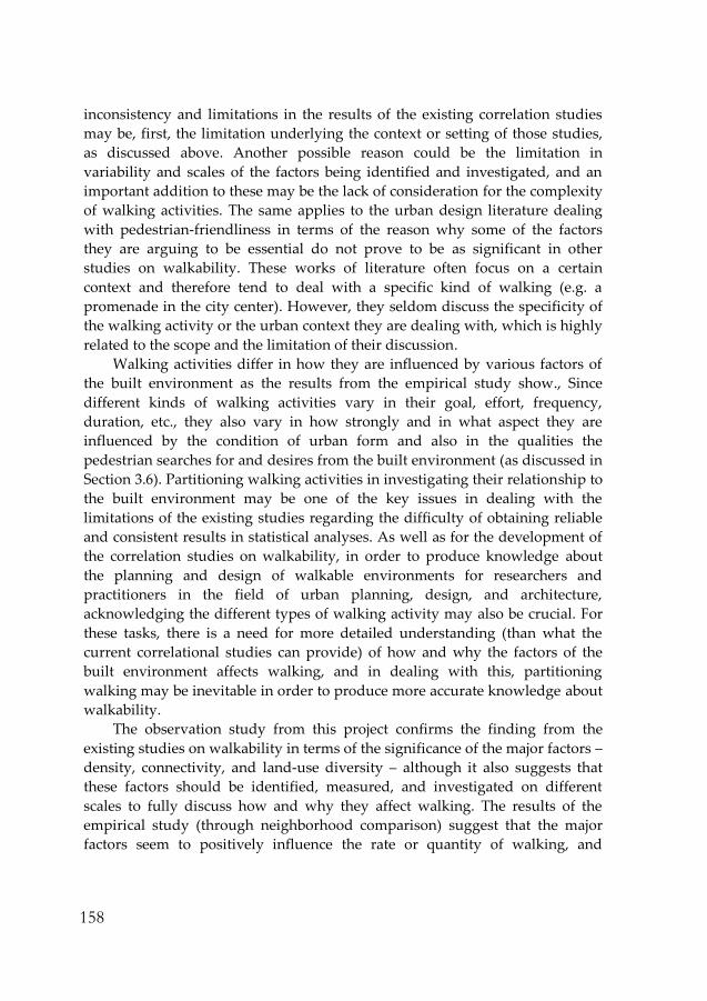
158
inconsistency and limitations in the results of the existing correlation studies
may be, first, the limitation underlying the context or setting of those studies,
as discussed above. Another possible reason could be the limitation in
variability and scales of the factors being identified and investigated, and an
important addition to these may be the lack of consideration for the complexity
of walking activities. The same applies to the urban design literature dealing
with pedestrian-friendliness in terms of the reason why some of the factors
they are arguing to be essential do not prove to be as significant in other
studies on walkability. These works of literature often focus on a certain
context and therefore tend to deal with a specific kind of walking (e.g. a
promenade in the city center). However, they seldom discuss the specificity of
the walking activity or the urban context they are dealing with, which is highly
related to the scope and the limitation of their discussion.
Walking activities differ in how they are influenced by various factors of
the built environment as the results from the empirical study show., Since
different kinds of walking activities vary in their goal, effort, frequency,
duration, etc., they also vary in how strongly and in what aspect they are
influenced by the condition of urban form and also in the qualities the
pedestrian searches for and desires from the built environment (as discussed in
Section 3.6). Partitioning walking activities in investigating their relationship to
the built environment may be one of the key issues in dealing with the
limitations of the existing studies regarding the difficulty of obtaining reliable
and consistent results in statistical analyses. As well as for the development of
the correlation studies on walkability, in order to produce knowledge about
the planning and design of walkable environments for researchers and
practitioners in the field of urban planning, design, and architecture,
acknowledging the different types of walking activity may also be crucial. For
these tasks, there is a need for more detailed understanding (than what the
current correlational studies can provide) of how and why the factors of the
built environment affects walking, and in dealing with this, partitioning
walking may be inevitable in order to produce more accurate knowledge about
walkability.
The observation study from this project confirms the finding from the
existing studies on walkability in terms of the significance of the major factors –
density, connectivity, and land-use diversity – although it also suggests that
these factors should be identified, measured, and investigated on different
scales to fully discuss how and why they affect walking. The results of the
empirical study (through neighborhood comparison) suggest that the major
factors seem to positively influence the rate or quantity of walking, and

159
moreover, show that an environment with better conditions in terms of these
factors also increases the diversity of walking activities. The results also
confirmed the hypothesis that other urban design factors related more to
aesthetics or convenience of the walking environment at the street and building
levels (which are often discussed in urban design literature) seem to be more
related to determining the quality of the walking experience than directly
influencing the quantity of walking. However, what is more interesting from
the observation study is that, the major factors are not only significant in
determining the amount and the variety of the walking activities the given
environment accommodates, but also as significant in determining the quality
of walking. The degree of these factors, as well as the attributes related to how
they are implemented at the detailed street and building level which assists
them to function more effectively, seem to be crucial in creating some of the
major qualities of the environment that have a positive effect on the walking
experience. These qualities include liveliness, surveillance and sense of security
as well as sociability, which are related to how the built environment provides
the pedestrian with other people, objects, and activities to see, hear, and
interact with.
The differing conditions for these aspects among the study areas seem to
be important in understanding why the frequency, diversity and other details
of the walking activities taking place in these areas differ. Through detailed
observation of walking activities, the observation study explored how the
various kinds of walking activities are different in their relation to the built
environment. By observing the details of the walking behavior, such as route
choices, the study investigated how they are differently affected by the built
environment, which is related to what qualities or condition the pedestrian
mainly desires or requires from the environment for a given kind of walking. If
a preliminary classification of the walking activities according to these criteria
is tried out, the walking activities – in a rather general and simple
categorization - may be divided up into utilitarian walking, walking the dog,
and pleasure/social walking(promenade). This is only a rough division of how
they may be classified, and walking activities may also often include different
purposes at the same time.
Also, if we also consider the experiential quality of the walking activities
that are provided by the condition of the built environment, the nature of the
walking activities seem to be very different according to the given environment,
although they may be for the same purpose of walking. For example, walking
the dog in Södra Station and walking the dog in Hökarängen may be a rather
different activity in terms of the experiential qualities the urban form can
160
provide the pedestrian with during the walking (as illustrated in Figure 5.2).
Similarly, utilitarian walking in Hökarängen and utilitarian walking in SoFo
may be different in that that the latter has more possibilities for the interaction
with the environment that people seem to desire, especially during a
promenade. These details illustrate how urban form influences and interacts
with walking activities and the pedestrians.
Figure 5.2 Different walking activities
The walkable environment is argued for from many perspectives. There
are various benefits from walking – physical health benefits, psychological
benefits, social benefits, etc. In promoting walking, much of the focus,
especially in the studies initiated from the field of preventive medicine, has
been on its nature as a physical activity and its potential health benefits.
However, a suggestion that could be made from the results of the empirical
study of this project is that if the aim is to actually encourage walking through
the condition of the built environment, the focus may have to be put more on
the aspect of walking as a social activity. This concerns more the enhancement
of walkability at the higher level, where the condition of the built environment
is equipped with a possible setting for walking and does not impede walking.
From there, one of the key issues in encouraging walking through urban
design seems to be related to how walking may be enriched as a social activity,
especially through interacting with others. Planning and designing an urban
environment which offers pedestrians greater opportunities for spontaneous
161
exchanges with other people, activities, objects, or buildings may be an
important strategy for creating an environment which offers a greater amount
of walking destinations and also improves the experiential quality of walking
activities.
The continuing part of the research project
In the next phase of this PhD research project, the analysis and discussion of
the various purposes and aspects of walking will continue, and may produce
knowledge contributing to the development of taxonomy of walking. As well
as investigating how walking could best be classified and measured in order to
understand walkability, a critical investigation and discussion of how the built
environment factors may better be identified and measured will continue. In
the later part of the project, based on the findings and insights into walkability
gained from the earlier part of the project, the way in which built environment
attributes are identified and measured in the quantitative analyses relating to
walkability will be examined. The aim of this project is to produce knowledge
about the complexity underlying walking, in terms of both the built
environment and walking. It aims at contributing to provide suggestions of
how urban form and walking could better be analyzed and measured in
walkability studies through various methods, including quantitative analysis,
and also aims at producing knowledge that may assist practitioners in how the
design of the environment may affect walking. In doing so, one of the
important issues that this project will investigate is how the management and
measurement of the condition of the built environment in terms of its influence
on walking may be differentiated between factors and strategies.

162

163
References
Andersson, Magnus, ed. 1998. Stockholm’s Annual Rings. Stockholm: Stockholmia Förlag.
Appleyard, Donald. 1987. Foreword. In Public Streets for Public Use, Ed. Anne Vernez
Moudon. New York: Van Nostrand Reinhold.
Augoyard, Jean-François. 2007 [1979]. Step by Step. Minneapolis: University of
Minnesota Press.
Bell, A. Collin, Keyou Ge and Barry M. Popkin. 2002. The road to obesity or the path to
prevention: Motorized transportation and obesity in China. Obesity Research 10:
277-283.
Benjamin, Walter. 2002 [1927-40]. Arcades Project. Cambridge: Harvard University Press.
Bennett, Tony. 1998. Culture: A Reformer’s Science. St Leonards: Allen and Unwin.
Boarnet, Marlon and Randall Crane. 2001. Travel by Design: The Influence of Urban Form
on Travel. New York: Oxford University Press.
Boehmer, Tegan K., Christine M. Hoehner, Kathleen W. Wyrwich, Laura K. Brennan
Ramirez and Ross C. Brownson. 2006. Correspondence between perceived and
observed measures of neighborhood environmental supports for physical
activity. Journal of Physical Activity and Health 3: 22-36.
Borén, Thomas and Daniel Koch. 2009. Platser i praktiken och social hållbarhet. Hökarängen
och andra små centrumbildningar i fokus. KTH Arkitektur och Samhällsbyggnad.
Stockholm: TRITA-ARK-Forskningspublikationer.
Brettel, Caroline. 1993. When They Read What We Write. Westport: Bergin & Garvey.
Brownson, Ross C., Jen Jen Chang, Amy A. Eyler, Barbara E. Ainsworth, Karen A.
Kirtland, Brian E. Saelens and James F. Sallis. 2004. Measuring the Environment
for Friendliness Toward Physical Activity: A Comparison of the Reliability of 3
Questionnaires. American Journal of Public Health 94 (3): 473-483.
Cardiff, Janet and Mirjam Schaub. 2005. Janet Cardiff - the walk book. Köln: Walther
König.
Cerin, Ester, Brian E. Saelens, James F. Sallis and Frank D. Lawrence. 2006.
Neighborhood environment walkability scale: Validity and development of a
short form. Medicine & Science in Sports & Exercise 38 (9): 1682-1691.
Certeau, Michel De. 1984. The Practice of Everyday Life, Trans. Steven Rendall. Berkeley:
University of California Press.

164
Cervero, Robert. 1996. Mixed land-uses and commuting: Evidence from the American
Housing Survey. Transportation Research A 30 (5):361-377.
Cervero, Robert and Michael Duncan. 2003. Walking, bicycling, and urban landscapes:
evidence from the San Francisco Bay area. American Journal of Public Health 93 (9):
1478–1483.
Choi, Eunyoung and Sara Sardari Sayyar. 2012. Urban Diversity and Pedestrian
Behavior - Refining the concept of land-use mix for walkability. In Proceedings of
the 8th International Space Syntax Symposium, Eds. Margarita Greene, José Reyes
and Andrea Castro, 8073:1-8073:15. Santiago de Chile: PUC.
Crane, Randall and Richard Crepeau. 1998. Does neighborhood design influence travel?
A behavioral analysis of travel diary and GIS data. Transportation Research D 3
(4): 225-238.
Crane, Randall. 2000. The influence of urban form on travel: an interpretive review.
Journal of Planning Literature 15: 3–23.
Dahlin, Åsa. 2002. On Architecture, Aesthetic Experience and the Embodied Mind. PhD diss.,
Royal Institute of Technology. Stockholm: KTH.
Demerath, Loren and David Levinger. 2003. The Social qualities of being on foot: A
theoretical analysis of pedestrian activity, community, and culture. City &
Community 2 (3): 217-237.
Edwards, Peggy and Agis D. Tsouros. 2008. A Healthy City is an Active City: a physical
activity planning guide. Denmark: WHO Regional Office for Europe.
Ewing, Reid. 1999. Pedestrian and Transit-friendly Design: a Primer for Smart Growth.
Washington, DC: International City/County Management Association.
Ewing, Reid, Susan Handy, Ross Brownson, Otto Clemente and Emily Winston. 2006.
Identifying and measuring urban design qualities related to walkability. Journal
of Physical Activity and Health 3: s223–s240.
Ewing, Reid and Susan Handy. 2009. Measuring the Unmeasurable: Urban Design
Qualities Related to Walkability. Journal of Urban Design 14(1): 65-84.
Ferguson, Priscilla Parkhurst. 1994. Paris as Revolution: Writing the Nineteenth-
Century City. Berkeley: University of California Press.
Foucault, Michel. 2000 [1982]. Space, Knowledge, and Power, interview with Paul
Rabinow. In Architecture theory since 1968, Ed. K. Michael Hays, 430-439.
Cambridge: MIT Press.
Forsyth, Ann, J. Michael Oakes, Kathryn H. Schmitz and Mary Hearst. 2007. Does
residential density increase walking and other physical activity? Urban Studies 44
(4): 679–697.

165
Forsyth, Ann, Mary Hearst, J. Michael Oakes and Kathryn H. Schmitz. 2008. Design and
destinations: factors influencing walking and total physical activity. Urban
Studies 45 (9): 1973–1996.
Frank, Lawrence and Gary Pivo. 1994. Impacts of mixed use and density on utilization
of three modes of travel: Single-occupant vehicle, transit, and walking.
Transportation Research Record 1466: 44-52.
Gehl, Jan. 1980. Livet mellem husene. Köpenhamn: Arkitektens förlag.
Gehl, Jan. 2010. Cities for People. Washington DC: Island Press.
Glaser, Barney and Anselm Strauss. 1967. The Discovery of Grounded Theory: Strategies for
Qualitative Research. New York: Aldine Publishing Company.
Goffman, Erving. 1971. Relations in Public: Micro studies of the Public Order. New York:
Basic Book.
Grillner, Katja. 2000. Ramble, linger, and gaze. PhD diss., Royal Institute of Technology.
Stockholm: KTH.
Grosz, Elizabeth. 1992. Bodies-cities. In Sexuality and Space, Ed. Beatriz Colomina, 241-
254. Princeton: Princeton Architectural Press.
Gupta, Akhil and James Ferguson. 1997. Anthropological Locations. Berkeley: University
of California Press.
Hammersley, Martyn and Paul Atkinson. 2003. Ethnography. London: Routledge.
Handy, Susan. 1996. Urban form and pedestrian choices: Study of Austin
neighborhoods. Transportation Research Record 1552: 135-144.
Heath, Gregory W., Ross C. Brownson, Judy Kruger, Rebecca Miles, Kenneth E. Powell
and Leigh T. Ramsey. 2006. The effectiveness of urban design and land use and
transport policies and practices to increase physical activity: A systematic
review. Journal of Physical Activity and Health 3: S55-S76.
Hayles, N. Katherine, ed. 1991. Chaos and Order: Complex Dynamics in Literature and
Science. Chicago: University of Chicago Press.
Helldén, David. 1951. Hökarängen i Stockholm. Byggnästaren 1951 (14): 430–31.
Hillier, Bill and Julienne Hanson. 1984. The social logic of space. London: Cambridge
University Press.
Hillier, Bill. 1996. Space is the Machine. Cambridge: Cambridge University Press.
Hunter, Ian. 1993. Mind games and body techniques. Southern Review 26 (2): 172-185.
Jacobs, Jane. 1961. The Death and Life of Great American Cities. New York: Vintage Books.
Johnson, Steven. 2002. Emergence. London: Penguin Book.

166
Kim, Young Ook. 2001. The Role of Spatial Configuration in Spatial Cognition. Paper
presented at the 3rd International Space Syntax Symposium, Atlanta, USA.
Kitamura, Ryuichi, Patricia L. Mokhtarian and Laura Laidet. 1997. A micro-analysis of
land use and travel in five neighborhoods in the San Francisco Bay Area.
Transportation 24 (2): 125-158.
Klasander, Anna-Johanna. 2003. Suburban navigation: structural coherence and visual
appearance in urban design. PhD diss., Chalmers Tekniska Högskola, Sektionen för
Arkitektur. Göteborg: Chalmers.
Koch, Daniel and Monica Sand. 2010. Rhythmanalysis – Rhythm as mode, methods and
theory for analyzing Urban Complexity. In Urban Design Research: Method and
Application: Proceedings of the International Conference held at Birmingham City
University, Eds. Mohsen Aboutorabi and Andreas Wesener, 61-72. Birmingham:
Birmingham City University.
Kockelman, Kara Maria. 1997. Travel behavior as function of accessibility, land use
mixing, and land use balance: Evidence from San Francisco Bay area.
Transportation Research Record 1607: 116-125.
Lachapelle, Ugo. 2009. Reconciling the construct of walking in physical activity and
transportation research. American Journal of Preventive Medicine 37 (4): 372-373.
Layder, Derek. 1998. Sociological practice: linking theory and social research. London:
Thousand Oaks.
Lee, I-Min, Chung-cheng Hsieh and Ralph S. Paffenbarger, Jr. 1995. Exercise intensity
and longevity in men: The Harvard Alumni Health Study. Journal of the American
Medical Association 273 (15): 1179-84.
Lee, Chanam and Anne Vernez Moudon. 2006a. Correlates of walking for
transportation or recreation purposes. Journal of Physical Activity and Health 3:
S77-S98.
Lee, Chanam and Anne Vernez Moudon. 2006b. The 3Ds + R: Quantifying land use and
urban form correlates of walking. Transportation Research Part D 11: 204-215.
Lefebvre, Henri. 1996. Writings on Cities, Trans. Eds. Elinor Kofman and Elizabeth
Lebas. Oxford: Basil Blackwell.
Leslie, Eva, Brian Saelens, Lawrence Frank, Neville Owen, Adrian Bauman, Neil Coffee
and Graeme Hugo. 2005. Residents’ perceptions of walkability attributes in
objectively different neighbourhoods: a pilot study. Health & Place 11: 227-236.
Marcus, Lars. 2000. Architectural knowledge and urban form: The functional performance of
architectural urbanity. PhD diss., Royal Institute of Technology. Stockholm: KTH.
Mauss, Marcel. 1973. Techniques of the Body. Economy and Society 2 (1): 70-88.

167
McGinnis, J. Michael and William H. Foege. 1993. Actual causes of death in the United
States. Journal of the American Medical Association 270: 2207-2212.
Messenger, Todd and Reid Ewing. 1996. Transit-oriented development in the Sunbelt.
Transportation Reseach Record 1552: 145-152.
Morris, Brian. 2004. What we talk about when we talk about ‘walking in the city'.
Cultural Studies 18 (5): 675-697.
Moudon, Anne Vernez, ed. 1987. Public Streets for Public use. New York: Van Nostrand
Reinhold.
Moudon, Anne Vernez, Paul M. Hess, Mary Catherine Snyder and Kiril Stanilov. 1997.
Effects of site design and pedestrian travel in mixed-use, medium density
environments. Transportation Research Record 1578: 48-55.
Okely, Judith and Helen Callaway. 1992. Anthropology and Autobiography. London:
Routledge.
Openshaw, Stan. 1984. The Modifiable Areal Unit Problem. Norwich: Geo Books.
Pile, Steve. 1996. The Body and the City: Psychoanalysis, space and subjectivity. London:
Routledge.
Randall, Todd A. and Brian W. Baetz. 2001. Evaluating pedestrian connectivity for
suburban sustainability. Journal of Urban Planning and Development 127: 1-15.
Rapoport, Amos. 2008. Environment-Behavior Studies: Past, Present, and Future. Journal
of Architectural and Planning Research 25 (4):276.
Rapoport, Amos. 1987. Pedestrian Street Use: Culture and Perception. In Public Streets
for Public Use, Ed. Anne Vernez Moudon. New York: Van Nostrand Reinhold.
Rignall, John. 1989. Benjamin's Flâneur and the Problem of Realism. In The Problems of
Modernity: Adorno and Benjamin, Ed. Andrew Benjamin. London: Routeledge.
Rodriguez, Daniel A., Asad J. Khactak and Kelly R. Evenson. 2006. Can New Urbanism
Encourage Physical Activity?: Comparing a New Urbanist Neighborhood with
Conventional Suburbs. Journal of the American Planning Association 72 (1): 43-54.
Sanjek, Roger, ed. 1990. Fieldnotes: The Making of Anthropology. Ithaca: Cornell University
Press.
Saelens, Brian E., James F. Sallis, Jennifer B. Black and Lawrence D. Frank. 2003a.
Environmental correlates of walking and cycling: findings from the
transportation, urban design, and planning literatures. Ann. Behav. Med. 24: 80-
91.
Saelens, Brian E., James F. Sallis, Jennifer B. Black and Diana Chen. 2003b.
Neighborhood-based differences in physical activity: an environment scale
evaluation. American Journal of Public Health 93 (9): 1552-1558.

168
Schaick, Jeroen van, ed. 2008. Urbanism on Track. Amsterdam: Ios Press.
Shaya, Gregory. 2004. The Flâneur, the Badaud, and the Making of a Mass Public in
France, circa 1860–1910. American Historical Review 109 (1): 41-77.
Shadish, William R., Thomas D. Cook and Donald T. Campbell. 2002. Experimental and
quasi-experimental designs for generalized causal inference. Boston: Houghton
Mifflin.
Skidmore, Paula M. and John W. Yarnell. 2004. The obesity epidemic: prospects for
prevention. Quarterly Journal of Medicine 97: 817–25.
Stockholm. 2010. Promenadstaden: Översiktsplan för Stockholm. Stockholm: Stockholms
Stadsbyggnadskontor.
Stonor, Tim, María Beatriz de Arruda Campos and Andrew Smith. 2002. Towards a
`walkability index'. Paper presented at Walk 21: 3rd International Conference,
San Sebastian, Spain.
Ståhle, Alexander. 2005. Mer Park i Tätare Stad. Lic. diss., Royal Institute of Technology.
Stockholm: KTH.
Ståhle, Alexander, Lars Marcus, Anders Karlström, and Daniel Koch. 2008. Place syntax:
Geographic attraction-accessibility analysis with axial lines. In Compact Sprawl,
Alexander Ståhle. PhD diss., Royal Institute of Technology. Stockholm: KTH.
Sundquist Jan, Sven-Erik Johansson and Kristina Sundquist. 2010. Levelling off of
prevalence of obesity in the adult population of Sweden between 2000/01 and
2004/05. BMC Public Health 2010 (10):119.
Szczepańska, Joanna and Aga Skorupka. 2010. Evidence Based Planning in the City of
Warsaw: Environmental Psychology Methods Employed in Research Projects
Informing Urban Planning Processes. In Urban Design Research: Method and
Application: Proceedings of the International Conference held at Birmingham City
University, Eds. Mohsen Aboutorabi and Andreas Wesener, 215-225.
Birmingham: Birmingham City University.
Toit, Lorinne du, Ester Cerin, Evie Leslie and Neville Owen. 2007. Does Walking in the
Neighbourhood Enhance Local Sociability? Urban Studies 44 (9): 1677-1695.
Troped, Philip J., Ruth P. Saunders, Russell R. Pate, Belinda Reininger, John R. Ureda
and Shirley J. Thompson. 2001. Associations between self-reported and objective
physical environmental factors and use of a community rail-trail. Prev Med 32 (2):
191-200.
Tschumi, Bernard. 1996. Architecture and Disjunction. Cambridge: MIT Press.
Unwin, David. 1996. GIS, spatial analysis and spatial statistics. Progress in Human
Geography 20: 540-551.

169
Visscher, Tommy and Jacob Seidell. 2001. The public health impact of obesity. Annu.
Rev. Public Health 22: 355–75.
Wagner, A., C. Simon, P. Ducimetière, M. Montaye, V. Bongard, J. Yarnell, A. Bingham,
G. Hedelin, P. Amouyel, J. Ferrières, A. Evans and D. Arveiler. 2001. Leisure-
time physical activity and regular walking or cycling to work are associated with
adiposity and 5y weight gain in middle-aged men: The PRIME Study.
International Journal of Obesity and Related Metabolic Disorders 25: 940-948.
Wells, Nancy M. and Yizhao Yang. 2008. Neighborhood Design and Walking. American
Journal of Preventive Medicine 34 (4):313-319.
Wener, Richard. 2008. History and Trends in Environmental Design Research (EDR).
Journal of Architectural and Planning Research 25 (4): 282.
Westbrook, David. 2008. Navigators of the Contemporary: Why Ethnography Matters.
Chicago: University of Chicago Press.
Westford, Pia. 2010. Neighborhood Design and Travel. PhD diss., Royal Institute of
Technology. Stockholm: KTH.
Whyte, William. 1980. The Social Life of Small Urban Places. Washington, D.C.:
Conservation Foundation.
Wineman, Jean D., Robert W. Marans, Amy J. Schulz, Diaan L. van der Westhuizen,
Sonya Grant-Pierson and Paul Max. 2009. Contributions of Accessibility and
Visibility Characteristics to Neighborhood Typologies and their Predictions of
Physical Activity and Health. In Proceedings of the 7th International Space Syntax
Symposium, Eds. Daniel Koch, Lars Marcus and Jesper Steen, 131:1-131:10.
Stockholm: KTH.

170
List of Figures
Except for the figures listed below, all of the figures including photographs,
maps, and graphs are produced by and belongs to the author.
Figure 1.1 from Urban Diversity and Pedestrian Behavior - Refining the concept of land-
use mix for walkability. 2012. Choi, Eunyoung and Sara Sardari Sayyar. In
Proceedings of the 8th International Space Syntax Symposium, Eds. Margarita Greene,
José Reyes and Andrea Castro, 8073:1-8073:15. Santiago de Chile: PUC.
Figure 2.1 from Measuring the Unmeasurable: Urban Design Qualities Related to
Walkability. 2009. Ewing, Reid and Susan Handy. Journal of Urban Design 14(1): 65-
84.
Figure 3.13, 3.14, 3.15, 3.16, 3.17 & 3.18 from Urban Diversity and Pedestrian Behavior -
Refining the concept of land-use mix for walkability. 2012. Choi, Eunyoung and
Sara Sardari Sayyar. In Proceedings of the 8th International Space Syntax Symposium,
Eds. Margarita Greene, José Reyes and Andrea Castro, 8073:1-8073:15. Santiago de
Chile: PUC.

