vegetation and landscape dynamics under natural and
TRANSCRIPT
Vegetation and landscape dynamics under natural and anthropogenic forcing on the
Azores Islands: A 700-year pollen record from the São Miguel Island
Valentí Rulla,*,
, Arantza Larab, María Jesús Rubio-Inglés
a, Santiago Giralt
a, Vítor
Gonçalvesc, Pedro Raposeiro
c, Armand Hernández
d, Guiomar Sánchez-López
a, David Vázquez-
Loureiroe, Roberto Bao
e, Pere Masqué
f, g, h, Alberto Sáez
i
a Institute of Earth Sciences Jaume Almera (ICTJA-CSIC), Barcelona, Spain
b Botanic Institute of Barcelona (IBB-CSIC), Barcelona, Spain
c Centro de Investigação em Biodiversidade e Recursos Genéticos (CBIO), Ponta Delgada, Portugal
d Instituto Dom Luiz (IDL), Faculty of Sciences, University of Lisboa, Lisbon, Portugal
e Centro de Investigaciones Científicas Avanzadas (CICA), Facultade de Ciencias, Universidade da Coruña, A
Coruña, Spain f School of Science, Edith Cowan University, Joondalup, Australia
g Department of Physics & Institute of Environmental Science and Technology (ICTA), Universitat Autònoma
de Barcelona Barcelona, Bellaterra, Spain h Oceans Institute & School of Physics, The University of Western Australia, Crawley, Australia
i Department of Earth and Ocean Dynamics, Universitat de Barcelona, Barcelona, Spain
Quaternary Science Reviews, Volume 159, 1 March 2017, Pages 155–168
Received 22 November 2016, Revised 27 January 2017, Accepted 27 January 2017, Available online 7
February 2017
How to cite:
Rull, V., Lara, A., Rubio-Inglés, M.J., Giralt, S., Gonçalves, V., Raposeiro, P., Hernández, A.,
Sánchez-López, G., Vázquez-Loureiro, D., Bao, R., Masqué, P., Sáez, A., 2017. Vegetation and
landscape dynamics under natural and anthropogenic forcing on the Azores Islands: A 700-year
pollen record from the São Miguel Island. Quaternary Science Reviews 159, 155-168.
http://dx.doi.org/10.1016/j.quascirev.2017.01.021
Abstract
The Azores archipelago has provided significant clues to the ecological, biogeographic and evolutionary
knowledge of oceanic islands. Palaeoecological records are comparatively scarce, but they can provide
relevant information on these subjects. We report the palynological reconstruction of the vegetation and
landscape dynamics of the São Miguel Island before and after human settlement using the sediments of Lake
Azul. The landscape was dominated by dense laurisilvas of Juniperus brevifolia and Morella faya from ca.
1280 CE to the official European establishment (1449 CE). After this date, the original forests were replaced
by a complex of Erica azorica/Myrsine africana forests/shrublands and grassy meadows, which remained
until ca. 1800 CE. Extractive forestry, cereal cultivation (rye, maize, wheat) and animal husbandry
progressed until another extensive deforestation (ca. 1774 CE), followed by the large-scale introduction
(1845 CE) of the exotic forest species Cryptomeria japonica and Pinus pinaster, which shaped the present-
day landscape. Fire was a significant driver in these vegetation changes. The lake levels experienced a
progressive rise during the time interval studied, reaching a maximum by ca. 1778–1852 CE, followed by a
hydrological decline likely due to a combination of climatic and anthropogenic drivers. Our pollen record
suggests that São Miguel were already settled by humans by ca. 1287 CE, approximately one century and a
half prior to the official historically documented occupation of the archipelago. The results of this study are
compared with the few palynological records available from other Azores islands (Pico and Flores).
Keywords: Palynology; Palaeoecology; Palaeoclimates; Last millennium; Azores; Early settlement
Highlights
The original Azorean laurisilvas were removed after the official human settlement (1449 CE).
Current vegetation established after a second deforestation (1774 CE) and the introduction of exotic
trees.
Modern landscapes are almost totally anthropogenic, climatic shifts have been less influential.
Lake levels increased until a maximum (1778–1852 CE) and then decreased to present-day values.
The island was likely colonized by humans a century and a half before the official settlement.
1. Introduction
Islands, in particular oceanic islands, have been
considered natural microcosmic laboratories to study
fundamental ecological and evolutionary issues and
their biogeographical expression (Whittaker and
Fernández-Palacios, 2007). Since the proposal of the
dynamic equilibrium model of island biogeography
by MacArthur and Wilson (1967), island biotas and
their communities have been viewed as the result of
the continuous interaction of ecological and
evolutionary patterns and processes across spatial
and temporal scales (Whittaker et al., 2008). A key
aspect of island ecology is the assembly of their
ecological communities and how they change
through time under the influence of internal (e.g.,
species’ autoecology, competition, predation), and
external (e.g., immigration, environmental change)
ecological drivers (Whittaker and Fernández-
Palacios, 2007). In the last millennium, human
colonization of oceanic islands has become a
paramount ecological factor that has determined
profound changes in the composition and ecological
functioning of island biotas and ecosystems, mainly
by the introduction of exotic elements, the extinction
of autochthonous species and the replacement of
original communities. The role of humans in the
shaping of current biotic patterns of oceanic islands
has been decisive worldwide (Gillespie and Clague,
2009). Paleoecology has been successfully used to
record the timing and the ecological consequences of
human colonization of oceanic islands (e.g., Prebble
and Dowe, 2008; Prebble and Wilmshurst,
2009; Connor et al., 2012 ; Rull et al., 2016). In this
paper, we use paleoecological methods to
reconstruct the vegetation dynamics of the last
millennium in the Atlantic Azores archipelago and
their main drivers of ecological change, with
emphasis on climate changes and the timing of the
initial human settlement and its further
consequences. The main aim is to understand how
present-day plant communities and landscapes have
been shaped.
The Azores Islands have been the target of
biogeographic, evolutionary and ecological studies
(e.g., Tuya and Haroun, 2009; Schaefer et al.,
2011a; Illera et al., 2012 ; Whittaker et al., 2014).
Evolutionarily, this volcanic archipelago is of
relatively recent origin, ranging from <1 to 8 million
years, and the origin and further evolution of its
flora have been the subject of debate (Schaefer et al.,
2011b ; Triantis et al., 2012). Ecologically, the
Azores may be viewed as the home of a large-scale,
unintentional experiment, in which plants introduced
by humans from disparate geographical and
ecological origins have replaced the original
vegetation and have developed new communities,
whose composition and ecological functioning are
unprecedented (Dias, 2007; Dias et al.,
2005 ; Schaefer et al., 2011a).
The ecological study of the Azores flora and
vegetation may benefit significantly from
palaeoecology, especially from palynology, but this
discipline has not been thoroughly applied to the
archipelago. To date, only a few records from a
couple of islands of the archipelago are available,
covering the last 6000 years (Björck et al.,
2006 ; Connor et al., 2012). In spite of this paucity,
these past environmental and ecological records
have provided relevant and useful results. For
example, van Leeuwen et al. (2005) demonstrated
that Selaginella kraussiana, a species that had been
previously considered as introduced by Europeans,

Fig. 1. Location map. A) The Azores archipelago in the Macaronesian context. A – Azores Islands (Portugal), M –
Madeira Islands (Portugal), C –Canary Islands (Spain), V – Cape Verde Islands. P – Portugal (highlighted in black), S -
Spain. B) Topographic map of the island of São Miguel with its calderas and the lakes inside them (blue areas). C) The
caldera of Sete Cidades, showing the lakes inside (LA – Lake Azul, LV – Lake Verde, LS – Lake Santiago). The coring
site is indicated by a red dot. SC – Village of Sete Cidades. (For interpretation of the references to colour in this figure
legend, the reader is referred to the web versión of this article.)
was native to the Azores because its spores were
present in the pollen records prior to human
arrival. Björck et al. (2006) reconstructed the
climatic and volcanic history of Pico Island (Fig. 1)
during the last 6000 years using multiproxy analysis
of sediments from Lake Caveiro. Despite the
dominant volcanic signal, these authors were able to
unravel the palaeoclimatic trends, suggesting that
precipitation changes since the mid Holocene were
linked to the North Atlantic drift-ice variation, with
a remarkable effect of the North Atlantic Oscillation
(NAO) during the last millennia. Björck et al.
(2006) identified a number of centennial-scale
cooler/drier and wetter phases, of which the most
significant for the time frame of this study
correspond to 400–800 cal y BP (1150–1550 CE)
(cooler/drier) and 300–400 cal y BP (1550–1650
CE) (wetter).
The previous palynological studies of the Azores
were performed on the islands of Pico (Lake Caveiro
and Pico bog) and Flores (Lake Rasa) (Connor et al.,
2012). According to these studies, human
colonization had a greater impact on the pristine
vegetation than climatic change and volcanic
activity in the last millennia. Human impact was
manifested in the form of a sudden shift (<100
years) to open vegetation, which was maintained for
centuries by burning, grazing and edaphic changes.
Endemic species were especially affected by
humans. For example, the native Juniperus
brevifolia communities declined and at least two
native fern species of Ophioglossum went extinct on
Pico. Connor et al. (2012) also reported that a
number of species previously considered as human
introductions were in fact native. These authors
concluded that the pre-anthropogenic palaeoclimatic
variation was not clearly reflected as changes in the
Holocene forest composition or structure and that
major volcanic eruptions favored the establishment
of endemic species as first colonizers of newly
formed soils, but the vegetation did not change
significantly.
The palaeoecological study of the Azores
archipelago could provide important clues to the
understanding of the present-day landscape and the
natural or anthropogenic drivers involved, which has
relevant implications for conservation management
(Connor et al., 2012). An additional advantage is
that many aspects of landscape development and
transformation after human settlement have been

reported in historical documents (e.g., Fructuoso,
1589; Tutin, 1953; Moreira, 1987; Silva and Smith,
2004; Dias et al., 2005 ; Dias, 2007), enabling
comparison with palynological records, which can
significantly improve ecological reconstructions.
The comparison of the ecosystem composition and
development before and after human colonization of
the islands could also provide useful clues to
disentangle the natural environmental and
anthropogenic drivers of ecological change. In this
paper, we address the palynological study of São
Miguel using sediments from Lake Azul. This island
is devoid of palaeoecological studies of this nature.
Previous surveys using lake sediments were
conducted in Lake Azul and others from the same
island (Fogo, Furnas) to assess the ecological effect
of recent introductions of exotic fish species (Skov
et al., 2010; Buchaca et al., 2011 ; Raposeiro et al.,
2017). We use pollen and spore analysis combined
with charcoal and selected non-pollen palynomorphs
(NPP) to reconstruct the development of the
vegetation of the island before and after European
settlement. Additionally, we use pollen from aquatic
plants and algal remains to infer preliminary
palaeoenvironmental trends, in terms of lake levels.
Finally, we attempt an integrated reconstruction of
the landscape dynamics using all these data. The
record covers the last ∼700 years at decadal to
multidecadal resolution.
1.1. Study site
1.1.1. General description
The island of São Miguel is in the volcanic Azores
archipelago, situated near the middle of the North
Atlantic, 1400 km from Europe and 1800 km from
North America (Fig. 1). The Azores Islands lie at the
intersection of three major tectonic structures: the
Eurasiatic, the African and the American plates.
Currently, there are 12 active volcanoes, five of
which are submarine, and the main volcanic
manifestations are fumaroles and hot springs. Due to
its geographic dispersion, the archipelago has been
subdivided into three groups of islands: the Western
Group (Flores and Corvo), the Central Group
(Terceira, São Jorge, Graciosa, Pico and Faial) and
the Eastern Group (Santa Maria and São Miguel)
(Gillespie and Clague, 2009). The maximum
elevation is Montanha do Pico (2350 m) on Pico
Island. São Miguel is the largest (745 km2) and most
populated (125,000 inhabitants) island of the
archipelago and contains the capital, Ponta Delgada.
The maximum elevation of this island is Pico da
Vara (1100 m). There are three active volcanic
calderas on the island: Furnas, Fogo and Sete
Cidades, all of which contain lakes (Fig. 1).
The Azorean climate is temperate oceanic with low
thermal variation throughout the year but significant
seasonal and interannual variability in precipitation
(Cropper and Hanna, 2014 ; Hernández et al.,
2016). In São Miguel, the average annual
temperature at sea level is approximately 17 °C, and
it decrease with elevation at a rate of >0.7°C/100 m
(Moreira, 1987). Atmospheric humidity is high (80–
90%), and the formation of dense mists is frequent,
especially above 300 m elevation. Precipitation is
also dependent on elevation, ranging from 960 mm
on the coasts to >2500 mm above 600 m elevation.
The average precipitation is ∼1700 mm per year
with a rainy season between October and March,
when ∼75% of the precipitation occurs (Cruz et al.,
2015 ; Hernández et al., 2016).
The most accepted date of human colonization of the
Azores Islands is 1432, when Gonzalo Velho Cabral
arrived at Santa Maria and took possession of the
island in the name of the King of Portugal. The same
navigator reached São Miguel in 1432. The official
settlement of the islands began in 1449 (Fructuoso,
1589). Some historians believe the Azores Islands,
like many other archipelagos of the North Atlantic
region, were already known, although not settled, a
century before the Portuguese colonization. This
idea is based on maps from the 14th century (1339
CE), where the islands Corvo and São Miguel were
already present, though with different names:
Corvinaris for Corvo and Caprara for São Miguel
(Moreira, 1987).
1.1.2. Flora and vegetation
The Azores Islands are part of the biogeographical
region known as Macaronesia (Fig. 1), together with
Madeira, the Canary Islands and Cape Verde
(Fernández-Palacios et al., 2011). Compared with
other Macaronesian islands, for example, Madeira
and the Canaries, the Azorean flora is comparatively
poor –although some recent studies suggest that taxa
richness would be significantly higher if the cryptic
genetic variability was considered (Schaefer et al.
(2011b)- likely due to geographical isolation, stable
climate, younger geological origin, small island size
and habitat homogeneity (Carine and Schaefer,
2010 ; Triantis et al., 2012). The Azorean flora
consists of 811 species, of which 197 are considered
native and 70 are endemic to the Azores (Schaefer,
2003; Schaefer, 2005 ; Borges et al., 2010). The
number of single-island endemisms is low, which
contrasts with other archipelagos, notably the
Canary Islands, where local endemisms are frequent
(Carine and Schaefer, 2010). A high proportion of
the Azorean endemics (∼75%) occur on São Miguel.
The current vegetation of the Azores Islands is
largely anthropogenic. After several centuries of
deforestation and the introduction of exotic species,
the native vegetation has been drastically reduced to
a few small sites that are now under active
protection (Schaefer, 2002 ; Connor et al., 2012).
According to historical documents, when Portuguese
colonizers arrived at the Azores, the islands were
covered with luxuriant and dense laurisilvas
dominated by Laurus azorica, Juniperus
brevifolia, Prunus azorica and Morella faya ( Dias,
2007). In addition to these dominant species, the
laurisilvas of São Miguel contained Ilex
perado, Erica azorica, Myrsine africana, Vaccinium
cylindraceum, Viburnum tinus, Frangula
azorica, Taxus baccata, Picconia
azorica and Calluna vulgaris ( Moreira, 1987).
Some historical descriptions seem to suggest that
higher elevations of the Flores Island were covered
by grasslands, but this has not been confirmed (Dias,
2007).
The Azores Islands were seen by the Portuguese
crown as a new space for economic development,
primarily for cereal cultivation—mainly wheat
(Triticum spp.) but also rye (Secale cereale), barley
(Hordeum spp.) and oats (Avena spp.)—and meat
production. As a consequence, the native forests
were destroyed by felling and burning. With time,
the deforestation of the islands progressed and more
and more exotic species were introduced for
cultivation (woad, sugar, vines, pepper, pineapple,
and oranges), forestry and ornamental purposes, thus
shaping the present-day Azorean landscape,
which Dias (2007) describes as “a botanical garden
in the Atlantic”. São Miguel is one of the Azorean
islands with a higher proportion (∼70%) of non-
indigenous species ( Silva and Smith, 2004 ; Silva
and Smith, 2006).
Today, most of the Azores surface (75%) is
dedicated to human activities (46% to crops, 15% to
towns and 14% to other purposes), whereas forests
occupy only 25% of the area (Dias, 2007). A large
part of these forested areas is dominated by
introduced trees. In the forests of São Miguel, the
dominant trees are Pittosporum undulatum, Acacia
melanoxylon, and Eucalyptus globulus, which were
introduced from Australia, Cryptomeria
japonica from Japan, and few representatives of the
native forests, mainly Morella faya and Laurus
azorica. Pittosporum undulatum, initially introduced
as a hedgerow species, is considered one of the more
successful and dangerous invaders of the island,
along with Hedychium gardnerianum, Gunnera
tinctoria and Clethra arborea ( Hortal et al.,
2010 ; Gil et al., 2013). Cryptomeria japonica and
the Mediterranean Pinus pinaster were introduced
for silviculture and transformed the island's
landscape by establishing dense forests that replaced
the former laurisilvas above 300 m elevation
( Moreira, 1987). The present landscape of São
Miguel is almost totally cultural, in contrast with
other islands, such as Pico and Flores, where human
pressure has been less intense (Dias, 2007).
2. Material and methods
2.1. Coring lake
The sediments analyzed in this study were obtained
from Lake Azul, situated in the São Miguel Island.
A ∼1.5 m long sediment core (AZ11-02-01;
37º52′20″ N-25º46′26″ W) was taken in October
2011 using a UWITEC© gravity corer at a water
depth of 25.1 m (Fig. 1). Lake Azul is located within
the caldera of Sete Cidades (∼5 km diameter and
∼400 m maximum elevation), together with three
smaller lakes, named Lake Verde, Lake Santiago
and Lake Rasa (Fig. 1). The caldera is the result of
explosive volcanic activity during the last 200,000
years. In the last 5000 years, 17 eruptions have been
documented, the last (P17) ending 667 years BP
(Shotton and Williams, 1971; Cole et al.,
2008 ; Queiroz et al., 2008). Lake Azul and Lake
Verde are two sedimentary basins that are
hydrologically connected by a narrow passage.
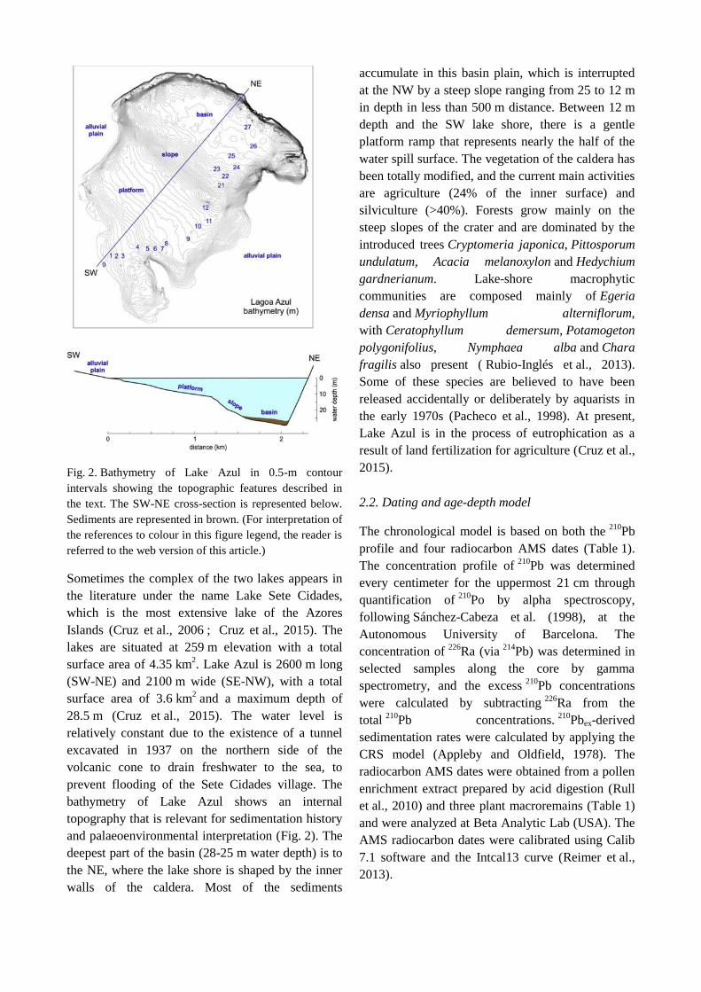
Fig. 2. Bathymetry of Lake Azul in 0.5-m contour
intervals showing the topographic features described in
the text. The SW-NE cross-section is represented below.
Sediments are represented in brown. (For interpretation of
the references to colour in this figure legend, the reader is
referred to the web version of this article.)
Sometimes the complex of the two lakes appears in
the literature under the name Lake Sete Cidades,
which is the most extensive lake of the Azores
Islands (Cruz et al., 2006 ; Cruz et al., 2015). The
lakes are situated at 259 m elevation with a total
surface area of 4.35 km2. Lake Azul is 2600 m long
(SW-NE) and 2100 m wide (SE-NW), with a total
surface area of 3.6 km2 and a maximum depth of
28.5 m (Cruz et al., 2015). The water level is
relatively constant due to the existence of a tunnel
excavated in 1937 on the northern side of the
volcanic cone to drain freshwater to the sea, to
prevent flooding of the Sete Cidades village. The
bathymetry of Lake Azul shows an internal
topography that is relevant for sedimentation history
and palaeoenvironmental interpretation (Fig. 2). The
deepest part of the basin (28-25 m water depth) is to
the NE, where the lake shore is shaped by the inner
walls of the caldera. Most of the sediments
accumulate in this basin plain, which is interrupted
at the NW by a steep slope ranging from 25 to 12 m
in depth in less than 500 m distance. Between 12 m
depth and the SW lake shore, there is a gentle
platform ramp that represents nearly the half of the
water spill surface. The vegetation of the caldera has
been totally modified, and the current main activities
are agriculture (24% of the inner surface) and
silviculture (>40%). Forests grow mainly on the
steep slopes of the crater and are dominated by the
introduced trees Cryptomeria japonica, Pittosporum
undulatum, Acacia melanoxylon and Hedychium
gardnerianum. Lake-shore macrophytic
communities are composed mainly of Egeria
densa and Myriophyllum alterniflorum,
with Ceratophyllum demersum, Potamogeton
polygonifolius, Nymphaea alba and Chara
fragilis also present ( Rubio-Inglés et al., 2013).
Some of these species are believed to have been
released accidentally or deliberately by aquarists in
the early 1970s (Pacheco et al., 1998). At present,
Lake Azul is in the process of eutrophication as a
result of land fertilization for agriculture (Cruz et al.,
2015).
2.2. Dating and age-depth model
The chronological model is based on both the 210
Pb
profile and four radiocarbon AMS dates (Table 1).
The concentration profile of 210
Pb was determined
every centimeter for the uppermost 21 cm through
quantification of 210
Po by alpha spectroscopy,
following Sánchez-Cabeza et al. (1998), at the
Autonomous University of Barcelona. The
concentration of 226
Ra (via 214
Pb) was determined in
selected samples along the core by gamma
spectrometry, and the excess 210
Pb concentrations
were calculated by subtracting 226
Ra from the
total 210
Pb concentrations. 210
Pbex-derived
sedimentation rates were calculated by applying the
CRS model (Appleby and Oldfield, 1978). The
radiocarbon AMS dates were obtained from a pollen
enrichment extract prepared by acid digestion (Rull
et al., 2010) and three plant macroremains (Table 1)
and were analyzed at Beta Analytic Lab (USA). The
AMS radiocarbon dates were calibrated using Calib
7.1 software and the Intcal13 curve (Reimer et al.,
2013).

Table 1.
AMS 14
C dates obtained for core AZ11_02 (Rubio-Inglés, 2016).
Depth (mm) Lab. reference Radiocarbon age Calibrated age (2σ) α13C (‰) Material
55 Beta-326594 154.4 ± 0.4 pMC 1989–1991 AD −32.7 Plant macrorest
460 Beta-316595 200 ± 30 BP 141-303 BP −28.6 Plant macrorest
610 Beta-331408 410 ± 30 BP 330-519 BP −25.8 Pollen concentrate
860 Beta-331410 690 ± 30 BP 563-684 BP −25.3 Plant macrorest
The age-depth model of the Lake Azul sequence was
calculated using the dynamic age model technique
(Rubio-Inglés, 2016). This method calculates the age
of the samples of a given historical sequence by
redistributing the time along the profile according to
the amount of terrigenous material present in
samples. It derives the short- and long-term
sedimentation rate changes from the chemical
composition of the terrigenous sediments obtained
from the XRF core scanner dataset. The main
advantage of this method is that it assumes that the
sedimentary environment does not have previous
“memory” and, hence, abrupt sedimentation rate
changes are possible. This method was applied from
the top to a core depth of 86 cm, where the last
radiocarbon date was found. The age of the pollen
samples from 86 cm to 113 cm, i.e., the base of the
pollen diagram (Fig. 3), was obtained by applying a
linear regression model considering that the
lithology of the bottom of the core represents the
latest phase of the last volcanic eruption (P17) that
affected the lake (Shotton and Williams, 1971). The
age-depth model obtained in this way has been
successfully used in a chironomid-based
paleoecological study of the same lake (Raposeiro
et al., 2017).
2.3. Sample processing and analysis
A total of 57 samples were taken at regular intervals
for pollen analysis (one sample every 2 cm, on
average). After spiking with Lycopodium clavatum,
these samples were submitted to KOH, HCl and HF
digestion and acetolysis. The residues were
suspended in glycerine, and the microscopic slides
were mounted in the same medium ( Bennett and
Willis, 2001). Processing was carried out at the
Institute of Plant Science, University of Bern
(Switzerland) and the Botanic Institute of Barcelona
(Spain). The identification of pollen and fern spores
followed Moore et al., 1991; Reille, 1992-
1998 ; Beug, 2004 and Demske et al. (2013). Non-
pollen palynomorphs (NPP) were identified
according to van Geel and Aptrot, 2006; van Geel
et al., 2011; Cugny et al., 2010 ; Gerolini et al.,
2011 and Montoya et al. (2012). Conifer stomata
were identified with the help of Sweeney
(2004) and Zhang et al. (2011). Laurus
azorica stomata were identified by comparison with
living material from the Botanical Garden of
Barcelona. Cerealia were separated from the rest of
the Poaceae using the diameter of the pollen grain
(>47 μm) and the annulus (>11 μm) ( Joly et al.,
2007). Zea mays and Secale cereale were identified
according to Beug (2004). Counting followed the
criteria of Rull (1987), ranging from 306 to 1051
(average 580) pollen grains and pteridophyte spores
per sample. The pollen sum included all pollen types
except those from aquatic and semi-aquatic taxa
(Cyperaceae, Myriophyllum and Potamogeton).
Diagrams were plotted and zoned with psimpoll
4.27 using the method of optimal splitting by
information content (OSIC) ( Bennett, 1996).
3. Results and interpretation
3.1. Sedimentary facies
According to the obtained results, the recovered
lacustrine sedimentary infill (133 cm thick) from
Lake Azul records the time period between 1273
CE±40 and 2010 CE±1. Core AZ11-02-01 was
retrieved from the deepest plain of the offshore zone
of the lake. The sedimentary sequence represented in
this core was described in detail and interpreted in
terms of sedimentary environments by Rubio-Inglés
(2016). Here, a brief summary is presented. The
section encompassed four lithological units named
U1 (base) to U4 (top) (Fig. 3). Unit 1 (133-103 cm)
was composed mainly of volcanic ash and lapilli

Fig. 3. Percentage pollen diagram of core AZ11-02-01. Cereals are expressed in presence (yellow dots)/absence patterns. Elements below 0.5% of the total were represented as
“others”, which include Prunus azorica, Quercus ilex and Tilia (trees), Daboecia azorica, Vaccinium cilindraceum and Viburnum treleasei (shrubs) and
Chenopodiaceae/Amaranthaceae, Echium, Euphorbia, Fabaceae, Frangula azorica, Galium, Rubus and Sedum (herbs). Elements outside the pollen sum are depicted at the right side,
after the pollen summary column. Introduced species are marked with an asterisk. Charcoal is expressed in concentration units (particles per gram of sediment). Solid lines indicate
x10 exaggeration. (For interpretation of the references to colour in this figure legend, the reader is referred to the web version of this article.)

interbedded with thin muddy lacustrine layers. These
deposits indicate the occurrence of lacustrine
environments with frequent input of volcaniclastic
material from an active volcano inside the Sete
Cidades caldera. According to the age-depth model,
this interval likely corresponds to the end of the P17
eruption phase, dated to ca. 1280 CE by Shotton and
Williams (1971). Unit 2 (103-85 cm) was composed
mainly of light-gray laminated mud rich in volcanic
particles. This unit is interpreted as the result of the
reworking of volcanic ash sediments previously
deposited elsewhere in the catchment. Unit 3 (85-
61 cm) consists of brownish-green laminated fine to
coarse silts. These fine offshore deep deposits are
interbedded with dark layers rich in plant debris and
terrestrial aerophilous diatoms and barren of
chironomids, representing episodic terrigenous
input, likely from flood events in the catchment.
Unit 4 (61-0 cm) was composed of massive to
poorly laminated light-brown silty clays deposited in
offshore conditions similar to today (i.e., 25 m water
depth). Interbedded layers corresponding to rapid
flooding sedimentation are more frequent in this
unit, especially in its lower half, with a relevant
event of this type between ca. 40 and 46 cm (Fig. 3).
3.2. Vegetation shifts and human activities
The pollen diagram was subdivided into three
significant assemblage zones, which are described
and discussed in the following.
3.2.1. Zone AZ1 (74–113 cm, 15 samples, 1273
CE±40 to1358 CE±40)
This zone is dominated by the native trees Juniperus
brevifolia and Morella faya, together with the native
shrub Myrsine africana, followed by Poaceae and
another native shrub, Erica azorica ( Fig. 3). Also
noteworthy is the presence of Picconia
azorica pollen and the occurrence of stomata
of Laurus azorica ( Fig. 4), whose pollen is poorly
preserved in sediments and/or was lost during
laboratory processing (Connor et al., 2012). This
assemblage strongly suggests the dominance of the
native laurisilvas that covered the island before the
arrival of the first settlers (Moreira, 1987), which are
preserved today as small remnants—known as
“laurifolia” forests—restricted to protected sites
mainly on the less disturbed islands (Dias et al.,
2005). Among the ferns, Culcita
macrocarpa reaches its maximum values in this
zone. This fern is typical of the extant laurifolia
forests, where it forms a dense and diverse
herbaceous layer together with other ferns, such
as Dryopteris spp. and Pteris incompleta, whose
spores are also present in this pollen zone.
In this pollen zone, which corresponds to the post-
eruption phase, Juniperus brevifolia experiences a
significant reduction starting at 107 cm (1281
CE±40) and culminating at 87 cm (1290 CE±40),
when its pollen almost disappears from the record.
During the Juniperus decline, the pollen of Secale
cereale (rye) ( Fig. 4) and other cereals began to
appear (93–98 cm, 1286-88 CE±40), showing a
consistent occurrence pattern until the top of the
zone. The Juniperus collapse coincided with the
initiation of a decreasing trend in Morella faya and
with increases in Erica azorica, Myrsine africana,
Poaceae, psilate monoletes, Botryococcus and the
coprophilous fungi. At the same time, there is also a
slight increase in fire incidence, as shown by the
charcoal curve, and a lithological change from ash-
rich to ash-free lacustrine mud, indicating the
cessation of the latest volcanic event (P17). The
whole picture is suggestive of limited but
recognizable human disturbance of the landscape,
possibly in the form of local forest burning and the
first attempts of cereal cultivation around the lake.
The consistent occurrence of coprophilous fungi
(Sordaria, Sporormiella, Cercophora, Podospora) is
suggestive of animal husbandry because the only
mammals living on the island before European
contact were bats ( Moreira, 1987). Forest burning is
also supported by the increase of Pteridium and
psilate monoletes, as representative of the secondary
fern growth that is common after forest disturbance,
as well as the increase of shrubs, which is possibly
favored by forest clearing.
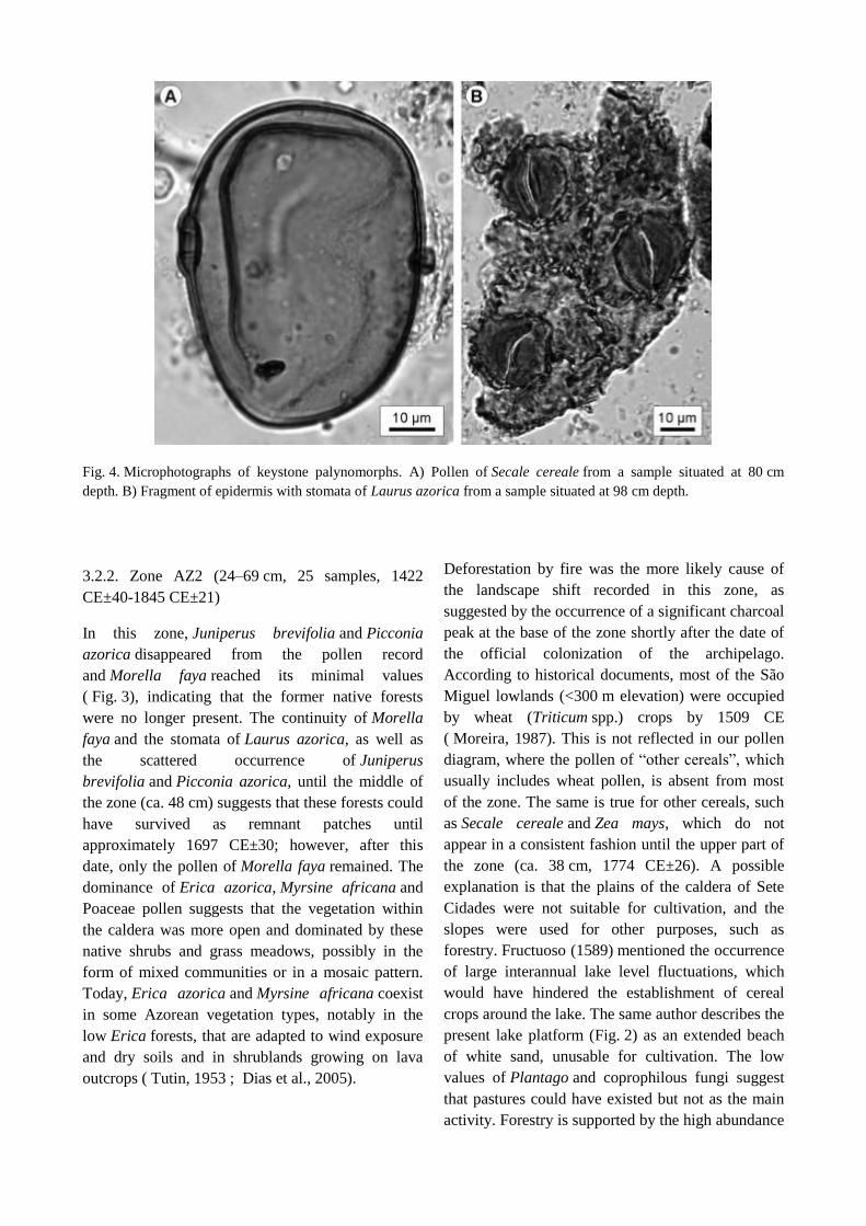
Fig. 4. Microphotographs of keystone palynomorphs. A) Pollen of Secale cereale from a sample situated at 80 cm
depth. B) Fragment of epidermis with stomata of Laurus azorica from a sample situated at 98 cm depth.
3.2.2. Zone AZ2 (24–69 cm, 25 samples, 1422
CE±40-1845 CE±21)
In this zone, Juniperus brevifolia and Picconia
azorica disappeared from the pollen record
and Morella faya reached its minimal values
( Fig. 3), indicating that the former native forests
were no longer present. The continuity of Morella
faya and the stomata of Laurus azorica, as well as
the scattered occurrence of Juniperus
brevifolia and Picconia azorica, until the middle of
the zone (ca. 48 cm) suggests that these forests could
have survived as remnant patches until
approximately 1697 CE±30; however, after this
date, only the pollen of Morella faya remained. The
dominance of Erica azorica, Myrsine africana and
Poaceae pollen suggests that the vegetation within
the caldera was more open and dominated by these
native shrubs and grass meadows, possibly in the
form of mixed communities or in a mosaic pattern.
Today, Erica azorica and Myrsine africana coexist
in some Azorean vegetation types, notably in the
low Erica forests, that are adapted to wind exposure
and dry soils and in shrublands growing on lava
outcrops ( Tutin, 1953 ; Dias et al., 2005).
Deforestation by fire was the more likely cause of
the landscape shift recorded in this zone, as
suggested by the occurrence of a significant charcoal
peak at the base of the zone shortly after the date of
the official colonization of the archipelago.
According to historical documents, most of the São
Miguel lowlands (<300 m elevation) were occupied
by wheat (Triticum spp.) crops by 1509 CE
( Moreira, 1987). This is not reflected in our pollen
diagram, where the pollen of “other cereals”, which
usually includes wheat pollen, is absent from most
of the zone. The same is true for other cereals, such
as Secale cereale and Zea mays, which do not
appear in a consistent fashion until the upper part of
the zone (ca. 38 cm, 1774 CE±26). A possible
explanation is that the plains of the caldera of Sete
Cidades were not suitable for cultivation, and the
slopes were used for other purposes, such as
forestry. Fructuoso (1589) mentioned the occurrence
of large interannual lake level fluctuations, which
would have hindered the establishment of cereal
crops around the lake. The same author describes the
present lake platform (Fig. 2) as an extended beach
of white sand, unusable for cultivation. The low
values of Plantago and coprophilous fungi suggest
that pastures could have existed but not as the main
activity. Forestry is supported by the high abundance

of Erica, of which the frequent use for wood
production has been documented historically ( Dias,
2007), and the decline of fire incidence. Both cereal
cultivation and grazing require frequent and
extensive burning to create open meadows at the
expense of forest, whereas forestry practices avoid
fire to preserve wood. Historical documents provide
support of forestry practices, as they note that during
the phase of colonization and further development of
cereal cultivation, which consequently increased the
population, forests were intensively used to provide
charcoal and wood for housing and sheep habitat
construction and repair ( Moreira, 1987 ; Dias,
2007). During this phase, earthquakes were also
frequent, and the reconstruction of human
settlements was not unusual ( Silveira et al.,
2003 ; Ferreira, 2005). At present, Erica azorica is a
grazing-tolerant species, which is also frequent in
the form of secondary regrowth after disturbance (S.
Connor, pers. comm.). It is possible that this fact has
also contributed to its higher abundance in this zone.
The upper part of the zone (1774 CE±26 onwards)
shows a different situation, with the decline of Erica
azorica and Myrsine africana and the disappearance
of Picconia azorica and Laurus azorica, coupled
with the increase of Morella faya, Rumex
acetosella and Plantago lanceolata and the first
appearances—although still in very low quantities—
of introduced trees, such as Pinus
pinaster and Cryptomeria japonica. Additionally,
the cereals started to appear in a consistent manner.
These traits were accompanied by an increase in
charcoal concentration, Pteridium aquilinum and
psilate monoletes, indicating an increase of fire
incidence. The overall picture suggests a second
event of deforestation by fire, this time affecting
the Erica/Myrsine forests/shrublands, and their
partial replacement by cereal crops (rye, maize,
wheat) and pastures. This phase was transitional
towards the greater landscape modification that
occurred in the uppermost zone.
3.2.3. Zone AZ3 (0–22 cm, 17 samples, 1848 CE±21
to 2010 CE±1)
This zone represents a major revolution that
accounts for the shaping of present-day landscapes.
The most relevant feature is the strong decline
of Erica azorica and Myrsine africana, coupled with
the increase of Morella faya and the appearance and
subsequent increase of the imported trees Pinus
pinaster and Cryptomeria japonica ( Fig. 3). Also
noteworthy is the appearance of Alnus, Olea
europaea and Hydrangea macrophylla and the
disappearance of Secale cereale. Plantago
lanceolata also declines significantly. Most elements
outside the pollen sum also decrease—Myriophyllum
alterniflorum, Pteridium aquilinum, psilate
monoletes and the coprophilous fungi. The charcoal
concentration indicates that fire incidence was
similar to the uppermost part of the former zone.
Therefore, fire was likely used to remove
the Erica/Myrsine forests/shrublands, which were
replaced by exotic forests dominated
by Cryptomeria japonica and Pinus pinaster,
together with the native Morella faya. This
interpretation has strong support in the historical
documents, including the use of Morella faya in
modern reforestation ( Dias, 2007). The base of the
zone coincides with the well-documented, large-
scale introduction of Pinus
pinaster and Cryptomeria japonica for forestry
purposes (1845-46 CE), whereas the increase
in Hydrangea macrophylla is synchronous with the
massive introduction of ornamental plants to São
Miguel Island (1853-72 CE) ( Moreira, 1987). This
zone, however, is not completely homogeneous, as
the dominant trees show disparate trends in
time. Pinus experienced a significant increase
shortly before its introduction by 1889 CE±15
(18 cm), whereas Cryptomeria increased gradually
and attained its acme more recently, by 1997 CE±2
(4 cm). This is likely the palynological reflection of
a change in forestry practices that occurred in the
mid-20th century, when the local Forestry Service
began to prioritize Cryptomeria japonica over Pinus
pinaster due to its faster growth and higher
resistance to wind ( Dias, 2007). An outstanding
charcoal peak occurs at 3 cm (2002 CE±1), but there
is no record of a significant fire on that dates.
3.3. Lake levels
Because the historical vegetation changes in the
Lake Azul catchment have been driven mostly by
humans, pollen and spores are not reliable
palaeoenvironmental and palaeoclimatic proxies.
Therefore, we used selected aquatic palynomorphs,
combined with inferences from lithology, as proxies
for lake levels to derive preliminary
palaeohydrologic insights. Here we concentrated on
the major palaeoecological tendencies. Minor
oscillations existed, but their detailed study will be
addressed in the future using a high-resolution
multiproxy approach (geochemistry, pollen, diatoms,
and chironomids). The elements selected here, due
to their indicator character and their abundance in
the Lake Azul sediments, were two aquatic
plants: Myriophyllum
alterniflorum and Potamogeton spp. and the
alga Botryococcus spp. Myriophyllum
alterniflorum is a widely distributed freshwater
species that lives submersed near the shoreline of
oligotrophic and mesotrophic lakes ( Kohler and
Labus, 1983 ; Gacia et al., 2009). Potamogeton is
represented in the Azores Islands by four species
growing in small ponds ( Tutin, 1953 ; Dias et al.,
2005). Botryococcus is a cosmopolitan genus of
planktonic algae that lives in a wide range of aquatic
environments, which has been used in
palaeolimnological studies on lake sediments as a
proxy for water-level shifts ( Bradbury et al., 2001).
The abundance of Botryococcus tends to increase
with water depth in a quantifiable fashion, which has
been used to reconstruct past water-level
fluctuations since the Last Glacial Maximum
(e.g., Ybert, 1992; Jankovská and Komárek,
2000; Rull et al., 2008; Niehmann and Behling,
2009; Koff and Terasmaa, 2011; Cohen,
2012; Leroy et al., 2014 ; Zhao et al., 2015). The
stratigraphic variation of the selected indicators is
depicted in a separate diagram for more clarity
(Fig. 5). It is important to stress that lake-level
shifts, as reconstructed in this study, significantly
agree with the same trends as deduced from diatom
assemblages, whose study is in progress (Vázquez-
Loureiro et al., in prep.).
The selected palynomorphs
(Potamogeton, Myriophyllum and Botryococcus)
represent taxa that have not as affected as terrestrial
plants by human activities for several reasons. First,
these taxa were present since the beginning of the
sequence, well before island settlement,
demonstrating that they are indigenous taxa not
introduced by humans. Second, the stratigraphic
variations of these taxa do not follow the same
patterns of terrestrial plants, whose shifts are
primarily the consequence of human activities. This
is well depicted in Fig. 5, where it can be seen that
shifts in Potamogeton,
Myriophyllum and Botryococcus do not agree with
the zonation based on anthropogenic changes in
terrestrial vegetation. Third, there are no historical
reports of human introductions and local extinctions
of aquatic plants and planktonic algae comparable to
the abundant and detailed literature on the
management of terrestrial plants. Given the
thoroughness and accuracy of historical documents
about human impact on plant ecology in the
archipelago, it would be expected that, if aquatic
plants had been managed in a similar fashion as
terrestrial plants, this fact would have been clearly
reported in historical documents. The only
references available to date about the anthropogenic
influence on aquatic plant communities of Lake
Azul correspond to the 20th century and report the
former presence of macrophytic green algae such
as Chara and Nitella ( Cunha, 1939), and the likely
accidental introduction of exotic species
(Egeria, Elodea) by aquarium enthusiasts since the
1970s ( Pacheco et al., 1998).
The sequence begins with the dominance
of Potamogeton (90–113 cm; 1273 CE±40 to
1289±40), minimum abundances
of Botryococcus and the absence of Myriophyllum.
This assemblage suggests low water levels, prior to
the inundation of the platform ( Fig. 2). Preliminary
data on diatom assemblages, however, indicate that
the euplanktonic Aulacoseira granulata, typical of
moderate to high water levels ( Wolin and Stone,
2010), was one of the dominant taxa in the interval
110–114 cm (Vázquez-Loureiro et al., in prep.). This
apparent discrepancy can be explained by either
oscillating water levels, or by the mixing of
sediments with pollen and diatoms derived from
littoral and pelagic environments, respectively.
Afterwards, Potamogeton decreased progressively
as Botryococcus increased, indicating that the water
level was rising and the basin was being steadily
filled. The first significant and consistent appearance
of Myriophyllum occurred at 75 cm (1349 CE±40),
suggesting that the platform started to be inundated
and Myriophyllum was able to grow in the shallow
and flat environment with light availability. The lake
infilling progressed—likely with minor yearly
oscillations, as noted by Fructuoso (1589)—with a
net increasing trend until it reached a water depth

Fig. 5. Percentage diagram showing the palynomorphs selected for lake-level reconstruction, together with the lithology
and the pollen zones for comparison. Present-day values of Myriophyllum alterniflorum and Botryococcus spp. are
indicated by vertical dashed lines. Green arrows – rising lake levels; brown arrow – dropping lake levels. OC – Official
Colonization, ES – Early Settlement, DT – Drainage Tunnel. (For interpretation of the references to colour in this figure
legend, the reader is referred to the web version of this article.)
and extension similar to today (∼50–65 cm; 1447
CE±40 to 1673±30), which is supported by the
abundance
of Myriophyllum and Botryococcus similar to the
present. The increase in Botryococcus indicates lake
deepening, and the increase
in Myriophyllum suggests that the shallower parts of
the platform were likely occupied by populations of
this macrophyte similar to today. After this phase, a
dramatic decrease in
both Botryococcus and Myriophyllum occurred. At
first sight, this could be interpreted as a reversal to
lower water levels between ∼40 and 45 cm (1771
CE±26 to 1774±26). However, this interval
corresponds to an event of instantaneous flooding
sedimentation, and the more likely interpretation is a
palynomorph dilution effect caused by the massive
input of sediments to the lake.
The Myriophyllum maximum occurred later,
between 22 and 37 cm (1778 CE±26 to 1852±20),
reaching values significantly higher than today. This
could suggest expansion of the platform surface due
to lake levels that were higher than today, leading to
the inundation of the alluvial plain. Since those
times, the lake level experienced a gradual decline
until its present level. This lake lowering was due to
natural (i.e., climatic) causes until 1937 CE, when
the drainage tunnel that maintains the lake level in
its present position was built ( Fig. 5).
However, Myriophyllum alterniflorum is also
sensitive to changes in water quality, mainly
eutrophication ( Kohler and Labus, 1983).
Therefore, the decline of this aquatic plant at the
beginning of the 19th century could also be due to a
combination of lake-level dropping and the
eutrophication trend in the lake in modern times as a
consequence of agricultural intensification (Cruz
et al., 2015). This is supported by the presence of
pollen from Zea mays and other cereals ( Fig. 3) and
the historical records, which document the large-
scale introduction of maize cultivation on São
Miguel Island by 1832 CE (Moreira, 1987).
The lowstand phase at the base of the record (1273
CE±40 to 1289±40) coincided with the end of the
Medieval Climate Anomaly (MCA), which in SW
Europe, was characterized by drier climates than the
present (Fig. 6) (Nieto-Moreno et al.,
2013 ; Sánchez-López et al., 2016). The extended
phase of the lake-level increase, with minor
oscillations, of Lake Azul (1289 CE±40 to 1771±26)
was coeval with the European Little Ice Age (LIA),
during which climates were equally characterized by
oscillating moisture trends. The phase of the
maximum lake levels (highstand) identified in Lake
Azul between 1778 CE±26 and 1852 CE±20
corresponds to the transition between the LIA and
the Industrial Period (IP) in Europe, where climates
were also humid. The modern decline of water levels
in Lake Azul could be interpreted in terms of drier
climates (Rubio-Inglés, 2016) or the artificial
draining of Lake Azul, or both. Between 1852
CE±20 and the construction of the drainage tunnel
(1937 CE), the roles of climate and water quality on
the composition of the macrophytic community
could not be resolved by the available information,
and any inference would be speculative. After these
dates, the lowering of the lake levels was due to
artificial draining and coincided with wetter
climates, as documented in both the palaeoclimatic
and instrumental records (Björck et al.,
2006 ; Hernández et al., 2016). Correlations with
the palaeoclimatic record of Lake Caveiro on Pico
Island (Björck et al., 2006), in terms of the moisture
balance, are difficult to establish at this stage, but the
information is provided to facilitate eventual
comparisons (Fig. 6). Dating errors should also be
taken into account, although they do not
significantly affect comparisons. Further and more
detailed paleoclimatic studies based on the same
core analyzed here using independent proxies,
notably biomarkers, is in progress (Rubio-Inglés,
2016).
4. Discussion and conclusions
4.1. Early settlement
The possibility of human settlement far before the
official human occupation of the Azores deserves
special attention. Pollen zone AZ1 (1273 CE±40 to
1358±40) has been interpreted in terms of limited
human disturbance manifested as local forest
burning, cereal cultivation and possibly animal
husbandry within the caldera of Sete Cidades. There
is no known historical documentation in support of
this hypothesis, as the purported disturbance would
have taken place by 1287 CE±40, between 100 and
180 years before the official discovery of São
Miguel Island (1427 CE) and between 120 and 200
years before the official settlement of the
Archipelago (1449 CE). The date of the potential
landscape disturbance is closer, but still ca. 50 years
earlier, to the first maps representing São Miguel
Island (1339 CE). An eventual artifact of the age-
depth model is unlikely because the suggested
disturbance event coincides with a radiocarbon date
calibrated to 1291 CE (1266-1387) (Table 1).
Downward pollen percolation through sediments and
sample contamination can also be dismissed because
other pollen types from introduced plants—
notably Pinus pinaster and Cryptomeria japonica,
whose abundance is significantly higher than that of
cereals—do not show similar patterns. Therefore, it
is suggested that the caldera of Sete Cidades was
settled by humans by the end of the 13th century,
almost immediately after the cessation of the latest
known volcanic event. The extent of this settlement,
both in space and time, cannot be inferred from the
available information, but it suggests that São
Miguel Island was already colonized about a century
and a half before its official suggests that São
Miguel Island was already colonized about a century

Fig. 6. Correlations between the Lake Azul record and other pertinent palaeoclimatic reconstructions. OC – Official
Colonization, ES – Early Settlement, DT – Drainage Tunnel.
and a half before its official discovery. This situation
is not unique in the Macaronesian archipelagos. For
example, Rando et al. (2014), using radiocarbon
dating of vertebrate bones, proposed that humans
could have reached Madeira four centuries before its
official colonization by Europeans. Similar
“surprises” have been recorded in other oceanic
islands abroad, for example, Easter Island (South
Pacific), where recent palynological studies
suggested human settlement more than a millennium
before the more accepted dates (Cañellas-Boltà
et al., 2013). It would be interesting to investigate
whether this phenomenon is more general than
usually thought.
4.2. Landscape dynamics
Comparison of vegetation changes, as deduced from
the pollen and spores of terrestrial plants, with
palaeoenvironmental trends inferred from
sedimentology, aquatic plants and algae provide an
initial comprehensive view of landscape
development in the São Miguel Island. As a first
appraisal, this view should be verified by further
multiproxy studies that are already in progress. On
the basis of the currently available evidence, the
following insights may be advanced as working
hypotheses. At the end of the MCA, the catchment
was occupied by laurifolia forests dominated by
native trees (Juniperus brevifolia and Morella faya).

Lake Azul was shallower than at present (lowstand)
and likely restricted to its present-day deeper part
(NE) and its present basin was likely covered by
forests. Juniperus brevifolia, a species that tolerates
permanent inundation ( Dias et al., 2005), could
have been especially important in the wetlands
around the lake, as indicated by the pollen peak at
the base of the diagram (Fig. 3). Laurifolia forests
continued to be dominant at the beginning of the
LIA, but Morella faya was the main tree due to
a Juniperus brevifolia decline. Climates then became
wetter, and lake levels started to steadily increase.
The latest volcanic eruption (P17) was already
completed when the first human settlers reached the
caldera, where they began to perform cereal
cultivation and animal husbandry. Settlements were
small, and the effects on vegetation were local and
limited, except in the case of Juniperus brevifolia,
which virtually disappeared from the catchment by
the end of the 14th century. The wood of this
species, locally called “cedro do mato” (bush cedar),
is highly valued and has been intensively used
throughout history for a variety of purposes in the
quotidian human life, whereas the wood of Morella
faya is not of the same quality ( Dias, 2007). In
addition, as mentioned above, Juniperus
brevifolia develops well in permanent aquatic
habitats, where other forest species cannot survive.
The combination of water availability and quality
wood makes the present-day basin of Lake Azul the
preferred site for initial human settlement. If this is
true, the deeper parts of the basin should contain the
corresponding evidence. It would be interesting to
develop complementary palaeobotanical (seeds,
phytoliths, starch) and biomarker (DNA, fecal
lipids) studies to corroborate this possibility.
The first significant vegetation change recorded in
Lake Azul occurred at the onset of the large-scale
occupation of the island by the Portuguese (1449
CE), when a lake similar to the present Lake Azul
occupied the basin. The native forests were removed
by fire and were replaced by a mosaic vegetation of
low forests/shrublands dominated by Erica
azorica and Myrsine africana, as well as pastures.
The climate and lake levels would have been
oscillating during those times, but further studies are
needed to define these trends more precisely. The
main economic activity was forest (mainly Erica)
exploitation until 1774 CE, when cereal crops and
pastures took the lead, coinciding with lake levels
higher than today (highstand). The latest remarkable
landscape transformation, i.e., the large-scale
establishment of forests dominated by introduced
trees (Pinus pinaster, Cryptomeria japonica),
coincided with the end of the highstand phase, when
lake levels began to decrease likely due to climatic
forcing, at least until 1937 CE, when the drainage
tunnel contributed to lake lowering. A change in
forest dominance from Pinus
pinaster to Cryptomeria japonica occurred in the
middle 20th century for official management
reasons. The continued development of agricultural
and animal husbandry activities significantly
contributed to the eutrophication of Lake Azul,
causing changes in the extent and composition of the
littoral vegetation and the planktonic communities.
4.3. Comparison with other Azores records
The results of our study agree with the general
conclusion of Connor et al. (2012) that human
activities overcame natural factors, such as climatic
change or volcanic events, as the drivers of
vegetation change in the Azores. Overall, our pollen
record is similar to those of Connor et al. (2012) in
both taxonomic composition and ecological
succession, with some differences likely due to local
conditions and differences in elevation, as well as to
the degree of anthropic disturbance. In this sense,
São Miguel is one of the more modified islands of
the archipelago, whereas Pico and Flores, the islands
studied by Connor et al. (2012), are among the more
pristine (Dias, 2007). In addition, our lake (Azul) is
situated at 260 m elevation, whereas those of Connor
et al. (2012) are at 530 m (Lake Rasa), 903 m (Lake
Caveiro) and 873 m (Pico bog), which results in
differences in terms of vegetation. A significant
difference is that in all the Pico and Flores diagrams
available, Juniperus brevifolia is dominant and did
not disappear after human colonization as it did in
our Azul record. This could be due to a combination
of differential human impact and elevation because
the species is currently restricted to a few protected
locations on São Miguel, in contrast to to Pico,
where it is a significant element of the mid- to high-
elevation forests and shrublands ( Dias et al., 2005).
Another remarkable difference is the relatively high
abundance of Erica azorica in our record compared
to Pico and Flores, which may also be explained by

differences in elevation and human practices across
islands. Also noteworthy is the high abundance
of Cryptomeria japonica and Pinus pinaster in our
record during the last centuries and their scarcity in
the pollen diagrams of Pico and Flores Islands. The
grasses also show relevant disparities; they are
relatively constant in Azul, whereas in Pico and
Flores, they remain at lower levels until human
colonization, when they experience a significant and
relatively abrupt increase. Due to the poor
taxonomic resolution of this pollen type, any
explanation would be highly speculative; however,
the development of extensive historically
documented pastures could be involved. The
similarity of the Poaceae and the Plantago
lanceolata curves in the Rasa, Caveiro and Pico
diagrams supports this statement.
A major difference between the São Miguel and the
Pico/Flores records is the presence/absence of
cultivated grasses or cereals. As discussed
previously, the patterns of occurrence of Secale
cereale, Zea mays and other cereals are essential to
appraise the colonization history of São Miguel
Island and the further development of cereal
cultivation through history. In the Pico and Flores
records, however, Secale cereale, Zea mays and
other cereals appear in very low amounts only in the
Rasa diagram after human settlement ( Connor et al.,
2012). Historical documents report that cereal
cultivation was restricted to the lowlands for
climatic reasons (Moreira, 1987). This fact, together
with the lower anthropogenic incidence on Pico and
Flores Islands, could explain the significant
occurrence of all types of cereal pollen in the
lowland Azul record of São Miguel, their poor
representation in the mid-elevation Lake Rasa record
(Flores) and their absence in the high-elevation Pico
diagrams (Lake Caveiro and Pico bog). The cereal
pollen records also have noticeable differences with
regard to human settlement patterns. The pre-impact
phase of Connor et al. (2012) extends to 400–500 cal
BP, depending on the site, which coincides with our
São Miguel record, where the large-scale
colonization of the island started after 1420 CE
(∼530 cal BP). These figures agree with the official
settlement dates documented in historical records.
However, one of the more striking results of our
analysis is the likely earlier human occupation of
São Miguel, possibly some 100–180 years before the
official dates, a fact that has not been recorded in the
Pico and Flores diagrams. Again, local differences,
notably the above-mentioned unsuitability of the
mid-high elevation Pico and Flores coring sites to
capture cereal cultivation, may explain this
discrepancy. It is possible that early colonization
events were restricted to the lowlands and/or that
they were not widespread across the whole
archipelago. In either case, the local nature of these
initial settlements and their limited impact on
general landscape features, as well as the paucity of
palaeoecological studies available to date, make a
sound assessment difficult. Our results suggest that
the lowland lakes near the coast would be the most
suitable sites to document potential early
colonization events; hence, the palaeoecological
study of such environments is encouraged.
Acknowledgements
This research was funded by The Ministry of
Economy and Competititvity, projects PaleoNAO
(CGL2010-15767), RapidNAO (CGL2013-40608-
R) and PaleoMODES (CGL2016-75281-C2-1-R).
Arantza Lara is especially grateful to Jacqueline van
Leeuwen, Florencia Oberli, Willi Tinner and Pim
van der Knaap, for their help in different aspects of
sample processing and pollen identification during
her short stay in the Institute of Plant Science,
University of Bern (Switzerland). Armand
Hernández was supported by the Portuguese Science
Foundation (FCT) through a post-doctoral grant
(SFRH/BPD/79923/2011). Juli López-Vila
collaborated in the identification of non-pollen
palynomorphs. The authors are grateful to Simon
Connor for his thorough and accurate revision,
which contributed to improve the original
manuscript.
References
Appleby, P.G., Oldfield, F., 1978. The calculation of lead-
210 dates assuming a constant rate of supply of
unsupported 210
Pb to the sediment. Catena 5, 1-8.
Bennett, K.D., 1996. Determination of the number of
zones in a biogeographical sequence. New. Phytol.
132, 155-170.
Bennett, K.D., Willis, W.J., 2001. Pollen. In: Smol, J.P.,
Birks, H.J.B., Last, W.M. (Eds.), Tracking
Environmental Change Using Lake Sediments,
Terrestrial, Algal and Siliceous Indicators, 3. Kluwer,
Dordrecht, pp. 5-32.
Beug, H.-J., 2004. Leitfaden der Pollesbestimmung für
Mitteleuropa und angrenzende Gebiete. München: Dr.
Friedrich Pfeil.
Bjorck, S., Rittenour, T., Rosén, P., França, Z., M oller,
P., Snowball, I., et al., 2006. A Holocene lacustrine
record in the central North Atlantic: proxies for
volcanic activity, short-term NAO mode variability,
and long-term precipitation changes. Quat. Sci. Rev.
25, 9-32.
Borges, P.A.V., Costa, A., Cunha, R., Gabriel, R.,
Gonçalves, V., Frias Martins, A.M., et al., 2010. A
List of the Terrestrial and Marine Biota from the
Azores. Princípia, Cascais.
Bradbury, J.P., Grosjean, M., Stine, S., Sylvestre, F.,
2001. “Full and Late Glacial Lake Records along the
PEP 1 Transect: Their Role in Developing
Interhemispheric Paleoclimate Interactions. In:
Markgraf, V. (Ed.), Interhemispheric Climate
Linkages. Academic Press, San Diego, pp. 265-291.
Buchaca, T., Skov, T., Amsinck, S.L., Gonçalvez, V.,
Azevedo, J.M.N., Andersen, T.J., et al., 2011. Rapid
ecological shift following piscivorous fish
introduction to increasingly eutrophic and warmer
Lake Furnas (Azores Archipelago, Portugal): a
paleoecological approach. Ecosystems 14, 458-477.
Canellas-Boltá, N., Rull, V., S aez, A., Margalef, O., Bao,
R., Pla-Rabes, S., Blaauw, M., et al., 2013. Vegetation
changes and human settlement of Easter Island during
the last millennia: a multiproxy study of Lake Raraku
sediments. Quat. Sci. Rev. 72, 36-48.
Carine, M.A., Schaefer, H., 2010. The Azores diversity
enigma: why are there so few Azorean endemic
flowering plants and why are they so widespread? J.
Biogeogr. 37, 77-89.
Cohen, A.S., 2012. Scientific drilling and biological
evolution in ancient lakes: lessons learned and
recommendations for the future. Hydrobiologia 682,
3-25.
Cole, P.D., Pacheco, J.M., Gunasekera, R., Queiroz, C.,
Gonçalves, P., Gaspar, J.L., 2008. Contrasting styles
of explossive eruption at Sete Cidades, São Miguel,
Azores, in the last 5000 years: hazard implications for
modellig. J. Volcanol. Geotherm. Res. 178, 574-591.
Connor, S.E., van Leeuwen, J.F.N., Rittenour, T.M., van
der Knaap, O., Ammann, B., Bjork, S., 2012. The
ecological impact of oceanic island colonization – a
palaeoecological perspective from the Azores. J.
Biogeogr. 39, 1007-1023.
Cropper, T.E., Hanna, E., 2014. An analysis of the
climate of Macaronesia, 1865e2012. Int. J. Climatol.
34, 604-622.
Cruz, J.V., Antunes, P., Amaral, C., França, Z., Nunes,
J.C., 2006. Volcanic lakes of the Azores archipelago
(Portugal): geological setting and geochemical
characterization. J. Volcanol. Geotherm. Res. 156,
135-157.
Cruz, J.V., Pacheco, D., Porteiro, J., Cymbron, R.,
Mendes, S., Malcata, A., et al., 2015. Sete Cidades
and Furnas lake eutrophication (São Miguel, Azores):
analysis of long-term monitoring data and remediation
measures. Sci. Tot. Environ. 520, 168-185.
Cugny, C., Mazier, F., Galop, D., 2010. Modern and
fossil non-pollen palynomorphs from the Basque
mountains (western Pyrenees, France): the use of
coprophilous fungi to reconstruct pastoral activity.
Veg. Hist. Archaeobot. 19, 391-408.
Cunha, A.G., 1939. Sur la flore charologique des iles
Açoreennes. Bull. Soc. Port. Sci. Nat. 13, 67-70.
Demske, D., Tarasov, P.E., Nakagawa, T., Suigetsu
Project Members, 2013. Atlas of pollen, spores and
further non-pollen palynomorphs recorded in the
glacialinterglacial la Quaternary sediments of lake
Suigetsu, central Japan. Quat. Int. 290e291, 164-238.
Dias, E., 2007. Açores e Madeira: A Floresta das Ilhas.
Fundação Luso Americana, Lisboa.
Dias, E., Mendes, C., Melo, C., Pereira, D., Elias, R.,
2005. Azores central islands vegetation and flora field
guide. Quercetea 7, 123-173.
Fernandez-Palacios, J.M., de Nascimiento, L., Otto, R.,
Delgado, J.D., García-del-Rey, E., Arevalo, J.R., et
al., 2011. A reconstruction of Palaeo-Macaronesia,
with particular reference to the long-term
biogeography of the Atlantic island laurel forests. J.
Biogeogr. 38, 226-246.
Ferreira, A., 2005. Geodinamica e peligrosidade natural
nas ilhas dos Açores. Finisterra 40, 103-120.
Fructuoso, G., 1589. Saudades da Terra. Ponta Delgada.
Instituto de Cultura de Ponta Delgada (reprinted
1998).
Gacia, E., Chappuis, E., Lumbreras, A., Riera, J.L.,
Ballesteros, E., 2009. Functional diversity of
macrophyte communities within and between
Pyrenean lakes. J. Limnol. 68, 25-36.
Gerolini, V., Verbeken, A., van Geel, B., Cocquyt, C.,
Verschuren, D., 2011. Modern non-pollen
palynomorphs from East African lake sediments. Rev.
Palaeobot. Palynol. 164, 143-173.
Gil, A., Lobo, A., Abadi, M., Silva, L., Calado, H., 2013.
Mapping invassive woody plants in Azores Protected
Areas by using very high-resolution multispectral
imagery. Eur. J. Rem. Sens. 46, 289-304.
Gillespie, R.G., Clague, D.A., 2009. Encyclopedia of
Islands. University of California Press, Berkeley.

Hernandez, A., Kutiel, H., Trigo, R.M., Valente, M.A.,
Sigr o, J., Cropper, T., Santo, F.E., 2016. New Azores
archipelago daily precipitation dataset and its links
with large-scale modes of climate variability. Int. J.
Climatol. http://dx.doi.org/10.1002/joc.4642.
Hortal, J., Borges, P.A.V., Jimenez-Valverde, A., de
Azevedo, E.B., Silva, L., 2010. Assessing the areas
under risk of invasion within islands through potential
distribution modelling: the case of Pittosporum
undulatum in São Miguel, Azores. J. Nat. Conserv. 18,
247-157.
Illera, J.C., Rando, J.C., Richardson, D.S., Emerson, B.C.,
2012. Age, origins and extinctions of the avifauna of
Macaronesia: a synthesis of phylogenetic and fossil
information. Quat. Sci. Rev. 50, 14-22.
Jankovska, V., Kom arek, J., 2000. Indicative value of
Pediastrum and other coccal green algae in
paleoecology. Folia Geobot. 35, 59-82.
Joly, C., Barille, L., Barreau, M., 2007. Grain and annulus
diameter for distinguishing pollen grains of cereals
from wild grasses. Rev. Palaeobot. Palynol. 146, 221-
223.
Koff, T., Terasmaa, J., 2011. The sedimentary sequence
from the Lake Kūži outcrop, central Latvia:
implications for late glacial stratigraphy. Est. J. Earth
Sci. 60, 113-122.
Kohler, A., Labus, B.C., 1983. Eutrophication Processes
and Pollution of Freshwater Ecosystems Including
Waste Heat. In: Lange, L.O., Nobel, P.S., Osmond,
C.B., Ziegler, H. (Eds.), Physiological Plant Ecology
IV. Ecosystem Processes: Mineral Cycling,
Productivity and Man's Influence. Springer, Berlin,
pp. 413-464.
Leroy, S.A.G., Lopez-Merino, L., Tudryn, A., Chalié, F.,
Gasse, F., 2014. Late Pleistocene and Holocene
palaeoenvironments in and around the middle Caspian
basin as reconstructed from a deep sea core. Quat. Sci.
Rev. 101, 91-110.
MacArthur, R.H., Wilson, E.O., 1967. The Theory of
Island Biogeography. Princeton University Press,
Princeton.
Montoya, E., Rull, V., Vegas-Vilarrúbia, T., 2012. Non-
pollen palynomorph studies in the Neotropics: the case
of Venezuela. Rev. Palaeobot. Palynol. 186, 102-130.
Moore, P.D., Webb, J.A., Collinson, M.E., 1991. Pollen
Analysis. Oxford: Blackwell.
Moreira, J.M., 1987. Alguns Aspectos de Intervençao
Humana Evolucão da Paisagem da Ilha de São Miguel
(Açores). Serviço Nacional de Parques, Reservas e
Conservação da Naturaleza, Lisboa.
Niehmann, H., Behling, H., 2009. Late Pleistocene and
Holocene environmental change inferred from the
Cocha Caranga sediment and soil records in the
southeastern Ecuadorian Andes. Palaeogeogr.
Palaeocliamtol. Palaeoecol. 276, 1-14.
Nieto-Moreno, V., Martinez-Ruiz, F., Giralt, S., Gallego-
Torres, D., Garcia-Orellana, J., Masque, P., et al.,
2013. Climate imprints during the ‘medieval climate
anomaly’ and the ‘Little ice age’ in marine records
from the alboran sea basin. Holocene 23, 1227-1237.
Pacheco, D.M., Macedo, M., Goulart, M.E., Santos,
M.C.R., Rodrigues, A.M.F., Santana, F., 1998.
Aquatic plants in Sete Cidades lake (S. Miguel Island
e Azores): an overview and attemptive management.
In: Proceedings of the 10th
EWRS Symposium on
Aquatic Weeds 393-396.
Prebble, M., Dowe, J.L., 2008. The late Quaternary
decline and extinction of palms on oceanic Pacific
islands. Quat. Sic. Rev. 27, 2546-2567.
Prebble, M., Wilmshurst, J.M., 2009. Detecting the initial
impact of humans and introduced species on island
environments in remote Oceania using paleoecology.
Biol. Invasions 11, 1529-1556.
Queiroz, G., Pacheco, J.M., Gaspar, J.L., Aspinal, W.P.,
West, J.E., Ferreira, T., 2008. The last 5000 years of
activity at Sete Cidades volcano (São Miguel Island,
Azores): implications for hazard assessment. J.
Volcanol. Geotherm. Res. 178, 562-573.
Rando, J.C., Harald, P., Alcover, J.A., 2014. Radiocarbon
evidence for the presence of mice on Madeira island
(North Atlantic) one millennium ago. Proc. R.Society
B 281, 20133126.
Raposeiro, P.M., Rubio-Ingles, M.J., Gonz alez, A., Hern
andez, A., S anchez-López, G., Vazquez-Loureiro, et
al., 2017. Impact of the historical introduction of
exotic fishes on the chironomid community of Lake
Azul (Azores Islands). Palaeogeogr. Palaeoclimatol.
Palaeoecol. 466, 77-88.
Reille, M., 1992-1998. Pollen et Spores d’Europe et
d’Afrique du Nord, 1-3. Laboratoire de Botanique
Historique et Palynologie, Marseille.
Reimer, P.J., Bard, E., Bayliss, A., Beck, J.W., Blackwell,
P.G., Ramsey, C.B., et al., 2013. IntCal13 and
Marine13 radiocarbon age calibration curves 0e50,000
Years cal BP. Radiocarbon 55, 1869-1887.
Rubio-Ingles, M.J., Sánchez, G., Sáez, A., Vazquez-
Loureiro, D., Bao, R., Pueyo, J.J., et al., 2013.
Paleoenvironmental reconstruction of Lake Azul
(Azores archipelago, Portugal) and its implications for
the NAO signal. Geophys. Res. Abstr. 15. EGU2013-
7260-3.
Rubio-Ingles, M.J., 2016. Late Holocene Climate
Variability in the North Atlantic Based on Biomarker
Reconstruction. The Lake Azul (São Miguel Island,

Azores Archipelago) Case. University of Barcelona,
Faculty of Earth Sciences, Barcelona. PhD diss.
Rull, V., 1987. A note on pollen counting in
palaeoecology. Pollen Spores 29, 471-480.
Rull, V., Lopez-Sáez, J.A., Vegas-Vilarrúbia, T., 2008.
Contribution of non-pollen palynomorphs to the
paleolimnological study of a high-altitude Andean
lake (Laguna Verde Alta, Venezuela). J. Paleolimnol.
40, 399-411.
Rull, V., Stansell, N.D., Montoya, E., Bezada, M., Abbott,
M.B., 2010. Palynological signal of the younger dryas
in the tropical Venezuelan andes. Quat. Sci. Rev. 29,
3045-3056.
Rull, V., Cañellas-Boltà, N., Margalef, O., Pla-Rabes, S.,
Sáez, A., Giralt, S., 2016. Three millennia of climatic,
ecological and cultural change on Easter Island: a
synthetic overview. Front. Ecol. Evol. 4, 29.
http://dx.doi.org/10.3389/fevo.2016.00029.
Sánchez-Cabeza, J.A., Masque, P., Ani-Ragolta, I., 1998.
Lead-210 and Po-210 analysis in sediments and soils
by microwave acid digestion. J. Radioanal. Nucl.
Chem. 227, 19-22.
Sánchez-Lopez, G., Hern andez, A., Pla-Rabes, S., Trigo,
R.M., Toro, M., Granados, I., et al., 2016. Climate
reconstruction for the last two millennia in central
Iberia: the role of East atlantic (EA) and North
Atlantic oscillation (NAO) and their interplay over the
Iberian Peninsula. Quat. Sci. Rev. 149, 135-150.
Schaefer, H., 2002. Flora of the Azores: a Field Guide.
Margraf, Weikersheim. chaefer, H., 2003. Chorology
and Diversity of the Azorean Flora. J. Cramer,
Stuttgart.
Schaefer, H., 2005. Endemic Vascular plants of the
Azores: an updated list. Hoppea 6, 275-83.
Schaefer, H., Hardy, O.J., Silva, L., Barraclough, T.,
Savolainen, V., 2011a. Testing Darwin's naturalization
hypothesis in the Azores. Ecol. Lett. 14, 389-96.
Schaefer, H., Moura, M., Maciel, M.G.B., Silva, L.,
Rumsey, F.J., Carine, M.A., 2011b. The Linnean
shortfall in oceanic island biogeography: a case study
in the Azores. J. Biogeogr. 38, 1345-1355.
Shotton, F.W., Williams, R.E.G., 1971. Birmingham
University Radiocarno Dates. Radiocarbon, 13, pp.
141-156.
Silva, L., Smith, C.W., 2004. A characteriztion of the
non-indigenous flora of the Azores Archipelago. Biol.
Inv. 6, 193-204.
Silva, L., Smith, C.W., 2006. A quatitative approach to
the study of non-indigenous plants: an example from
the Zaores Archipelago. Biodiv. Conserv. 15, 1661-
1679.
Silveira, D., Gaspar, J.L., Ferreira, T., Queiroz, G., 2003.
Reassessment of the historical seismic activity with
major impact on São Miguel Island (Azores). Nat.
Haz. Earth Syst. Sci. 3, 615-623.
Skov, T., Buchaca, T., Amsink, S.L., Landkildehus, F.,
Odgaard, D.V., Azevedo, J., et al., 2010. Using
invertebrate remains and pigments in the sediment to
infer changes in trophic structure after fish
introduction in Lake Fogo: a crater lake in the Azores.
Hydrobiologia 654, 13-25.
Sweeney, C.A., 2004. A key for the identification of
stomata of the native conifers of Scandinavia. Rev.
Palaeobot. Palynol. 128, 281-290.
Triantis, K.A., Hortal, J., Amorim, I., Cardoso, P., Santos,
A.M.C., Gabriel, R., et al., 2012. Resolving the
azorean knot: a response to carine & Schaefer. J.
Biogeogr. 39, 1179-1187.
Tutin, T.G., 1953. The vegetation of the Azores. J. Ecol.
41, 53-61.
Tuya, F., Haroun, R.J., 2009. Phytogeography of
Lusitanian Macaronesia: biogeographic affinities in
species richness and assemblage composition. Eur. J.
Phycol. 44, 405-413.
van Geel, B., Aptrot, A., 2006. Fossil ascomycetes in
Quaternary deposits. Nova Hedwig. 82, 313-329.
van Geel, B., Gerolini, V., Lyaruu, A., Aptroot, A.,
Rucina, S., Marchant, R., et al., 2011. V. Rull et al. /
Quaternary S Diversity and ecology of tropical
African fungal spores from a 25,000-year
palaeoenvironmental record in southeastern Kenya.
Rev. Palaeobot. Palynol. 164, 174-190.
van Leeuwen, J.F.N., Schaefer, H., van der Knaap, W.O.,
Rittenour, T., Björck, S., Ammann, B., 2005. Native
or introduced? Fossil pollen and spores may say e an
example from the Azores Islands. Neobiota 6, 27-34.
Whittaker, R.J., Fernandez-Palacios, J.M., 2007. Island
Biogeography. Oxford University Press, Oxford.
Whittaker, R.J., Triantis, K.A., Ladle, R.J., 2008. A
general dynamic theory of oceanic island
biogeography. J. Biogeogr. 35, 977-994.
Whittaker, R.J., Rigal, F., Borges, P.A.V., Cardoso, P.,
Terzopoulou, S., Casanoves, et al., 2014. Fucntional
biogeography of oceanic islands and the scaling of
functional diversity in the Azores. Proc. Natl. Acad.
Sci. U. S. A 111, 13709-13714.
Wolin, J.A., Stone, J.R., 2010. Diatoms as Indicators of
Water-level Change in Freshwater Lakes. In: Smol,
J.P., Stoermer, E.F. (Eds.), The Diatoms: Applications
for the Environmental and Earth Sciences. Cambridge
University Press, Cambridge, pp. 174-185.
Ybert, J.P., 1992. Ancient Lake Environments as Deduced
from Pollen Analysis. In: Dejoux, C., Iltis, A. (Eds.),

Lake Titicaca: a Synthesis of Limnological
Knowledge. Kluwer, Dordrecht, pp. 49-62.
Zhang, K., Zhao, Y., Guo, X.L., 2011. Conifer stomata
analysis in paleoecological studies on the loess
plateau: an example from Tianchi lake, Liupan
mountains. J. Arid. Environ. 75, 1209-1213.
Zhao, W.W., Andreev, A.A., Wennrich, V., Tarasov, P.E.,
Anderson, P., Lohzkin, A.V., et al., 2015. The
Reunion Subchron vegetation and climate history of
the northeastern Russian Arctic inferred from the Lake
El’gygytgyn pollen record. Palaeogeogr.
Palaeoclimatol. Palaeoecol. 436, 167-177.