united states department of the interior … · organic geochemistry, lithology, and paleontology...
TRANSCRIPT
UNITED STATESDEPARTMENT OF THE INTERIOR
GEOLOGICAL SURVEY
ORGANIC GEOCHEMISTRY, LITHOLOGY, AND PALEONTOLOGY OF
TERTIARY AND MESOZOIC ROCKS FROM WELLS ON THE ALASKA PENINSULA
By
Hugh McLean
U.S. Geological Survey345 Middlefield Road
Menlo Park, California 94025
OPEN-FILE REPORT 77-813
This report is preliminary and has not been edited or reviewed for conformity with Geological Survey standards and nomenclature
Menlo Park, California November 1977
Page
12. Saturate hydrocarbon analyses ............... 52
13. Visual kerogen assessment worksheet ............ 54
14. Vitrinite reflectance summary ............... 55
Appendix 3. Analytical data on maturity of coal samples .......... 56
Appendix 4. Thin section descriptions ................... 58
Appendix 5. Paleontology and palynology--sample lists ........... 60
FIGURES
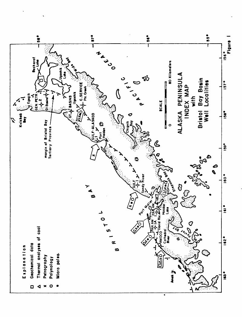
Figure 1. Alaska Peninsula index map with Bristol Bay well localities ... 3
Figure 2a and 2b. Stratigraphic cross section of Bristol Bay region of 11 Alaska Peninsula ........................ 12
n
ORGANIC GEOCHEMISTRY, LITHOLOGY, AND PALEONTOLOGY OF TERTIARY AND MESOZOIC ROCKS FROM WELLS ON THE ALASKA PENINSULA
By
Hugh McLean U.S. Geological Survey345 Middlefield Road
Menlo Park, California
ABSTRACT
Core chips and drill cuttings from eight of the nine wells drilled along
the Bering Sea lowlands of the Alaska Peninsula were subjected to lithologic
and paleontologic analyses. Results suggest that at least locally, sedimentary
rocks of Tertiary age contain oil and gas source and reservoir rocks capable
of generating and accumulating liquid and gas hydrocarbons.
Paleogene strata rich in organic carbon are immature. However, strata in
offshore basins to the north and south may have been subjected to a more pro
ductive thermal environment. Total organic carbon content of fine grained
Neogene strata appears to be significantly lower than in Paleogene rocks, pos
sibly reflecting nonmarine or brackish water environments of deposition. Neogene
sandstone beds locally yield high values of porosity and permeability to depths
of about 8,000 feet (2,439 m). Below this depth, reservoir potential rapidly
declines.
The General Petroleum, Great Basins No. 1 well drilled along the shore of
Bristol Bay reached granitic rocks. Other wells drilled closer to the axis of
the present volcanic arc indicate that both Tertiary and Mesozoic sedimentary
rocks have been intruded by dikes and sills of andesite and basalt. Although
the Alaska Peninsula has been the locus of igneous activity throughout much of
Mesozoic and Tertiary time, thermal maturity indicators such as vitrinite re
flectance and coal rank suggest, that on a regional scale, sedimentary rocks
have not been subjected to abnormally high geothermal gradients.
INTRODUCTION
Core chips and washed cuttings from several wells dri.lled on the Alaska
Peninsula were studied to determine the petroleum potential, lithology, and
age relations of subsurface rocks on the peninsula and in adjacent offshore
sedimentary basins. The Bristol basin is to the north and the Shumagin Shelf
is to the south. This study reports on the paleontology, and lithology of
rock samples from wells drilled mainly along the Bristol Bay coastal lowlands
from Lake Becharof to the Black Hills (Fig. 1).
The first part of the study investigated the oil and gas source rock
potential of this area. Three wells were selected for detailed source rock
analyses, but cuttings from the AMOCO Cathedral River No. 1 well were found
to be contaminated from 8,600 feet to T.D. with a petroleum based mud additive
that could not be removed. The contaminated part of the well was eliminated
from the study. Supplemental data (thermal analysis/pyrolysis-FID) on coal
and black shale from five wells was provided by George Claypool of the U.S.
Geological Survey in Denver, Colorado.
The second part of the study involved petrographic examination of sel
ected intervals in seven wells. Fifty-one grain mount thin sections were made
where sandstone or crystalline rocks were observed in the washed cuttings.
Eight thin sections of sandstone from selected core chips were cut for petro
graphic examination. Thin sections were studied to determine sandstone texture,
composition, and degree of alteration, as these parameters can be helpful in
predicting reservoir characteristics. The effects of intrusive igneous activity
on sedimentary rocks were noted to determine the extent to which petroleum
potential has been affected by contact metamorphism.
The third part of the study deals with paleontology, principally foram-
inifera, and the palynology of carbonaceous intervals. It was hoped that
D A * O
E K
plo
na 1
1 on
Gto
chtm
ical
da
ta
Ther
mal
an
alys
ts
of
coal
P
etro
grap
hy
Pal
ynol
ogy
Mic
ro
palto
-
§?
mor
gin
of
Bri
sto
l B
oy
Ttr
tio
ry
Pro
vin
ce
G A*
U
* 0»
SC
ALE
Amok
80
Kll
om
tttr
t
ALA
SK
A
PE
NIN
SU
LA
IND
EX
M
AP
w
ithB
risto
l B
ay
Bas
in
Wel
l Lo
calit
ies
56*
1*3
162
161
160
159°
137
156° F
igu
rt
the microfauna would provide additional information on the ages of rocks which
now rely mainly on reconnaissance field work by Burk (1965) and a stratigraphic
section published by Brockway and others (1975). Unfortunately, fossil recovery
was poor, probably because only washed cuttings were available from most of the
wells. Better microfaunal control might be possible if outcrop or core samples
were available. In Tertiary rocks recovery of palynomorphs was more encouraging
and age calls were possible in several sequences.
ACKNOWLEDGMENTS
The study was made possible through the cooperation and financial assistance
of the General Crude Oil Company, Houston, Texas and coordinated by Dr. Claude
C. Rust. Additional geochemical data were provided by George E. Claypool, U.S.
Geological Survey, Denver, Colorado. Foraminifera were identified by Kristen
McDougall, and palynomorphs by Jack A. Wolfe, both of the U.S. Geological Survey,
Menlo Park, California. Paleontological samples were prepared by Milton Randall.
GEOCHEMISTRY
Oil and gas source rock analyses of washed cuttings were run on two wells
from the Alaska Peninsula. Cuttings from the General Petroleum Corporation
Great Basins No. 1 (2-27S-49W) were examined from a depth of 1,300 to 11,080
feet (total depth). Material from the Pan American Hoodoo Lake No. 2 well (35-
50S-76W) was analyzed between 227 and 11,243 feet (T.D.).
At GeoChem Laboratories, Inc. in Houston, Texas, cuttings were hand-picked
by a geologist and a small sample (approximately 5 grams) was collected at 150
feet intervals. Each sample was analyzed for organic carbon content. Based
on these results, various single, or composite samples were selected for more
detailed study. The analytical data for this study are documented in Appendix
1 for the Great Basin well and Appendix 2 for the Hoodoo Lake well.

Summary of Results
General Petroleum Corporation, Great Basins No. 1: The strati graphic
intervals penetrated by the Great Basins No. 1 are as follows: (Data from
Brockway and others, 1975).
Geochemical Age Formation Formation Top Subunit
Pliocene Milky River ?
Miocene Bear Lake 2,110 feet al
Oligocene Stepovak 5,600 feet a2
Jurassic Granitic basement 10,970 feet
Total Depth 11,080 + feet
In terms of organic richness, source rock maturity, type of organic matter,
and lithology, the Bear Lake and Stepovak formations can be summarized in the
following manner. The Bear Lake Formation consists of tuffaceous shale, car
bonaceous shale, and coal, with secondary amounts of siltstone and sandstone.
Organic carbon averages 13%, extractable bitumen averages 5,000 ppm, and kerogen
is predominantly woody with a minor amount of amorphous-sapropel. The high ex-
tractable bitumen content with a correspondingly low hydrocarbon fraction is
interpreted to reflect the coal-rich and/or woody character of the organic
material in the formation.
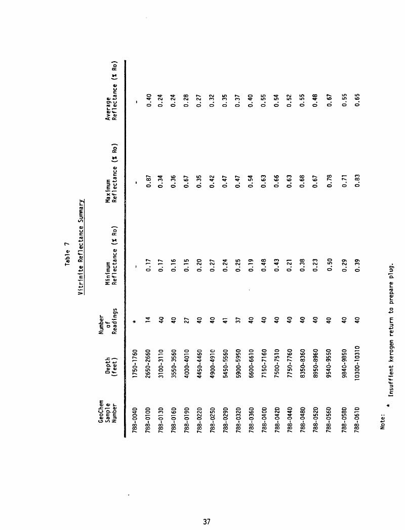
Vitrinite reflectance values (R ) average 0.29%,suggesting that the Bear
Lake Formation is immature. Significant amounts of steranes and terpanes, a
pronounced odd carbon preference in the Coo~C?o normal paraffins, and a low
paraffin-naphthene/aromatic hydrocarbon ratio (average 0.55) also suggest im
mature source rock.
Source rocks in the underlying Stepovak Formation are characterized by
an average organic carbon content of 11%, a mean value of extractable bitumen

6,600 ppm, and a predominance of woody kerogen with minor amounts of herbareous
kerogen.
Maturation indices suggest immature source rocks. R averages 0.51% and
steranes and terpanes are present in significant amounts. Odd-even carbon
ratios and paraffin-naphthene/aromatic hydrocarbon ratios are similar to those
reported in the overlying Bear Lake Formation.
The hydrocarbon potential of the Bear Lake and Stepovak formations are
similar. Organic carbon is abundant but immature. Presumably, if source rocks
similar to those in the Great Basins No. 1 well were present in deeper offshore
parts of Bristol basin, probably at depths of 15,000 feet or greater, then
chances of petroleum generation would be greatly improved because of higher
temperatures.
Pan Am-Socal, Hoodoo Lake No. 2: The strati graphic interval penetrated by the
Hoodoo Lake No. 2 well includes seven geologic formations. Specific tops of
the formations reported by Brockway and others,(1975) areas follows:
Age
Pliocene
Miocene
Oligocene
Eocene
Upper Cretaceous
Lower Cretaceous
Lower Cretaceous- Upper Jurassic
Formation
Milky River
Bear Lake
Stepovak
Tolstoi
Chignik
Herendeen Limestone
Staniukovich
Total Depth
Formation top
?
I,000 ± feet
2,160 feet
5,780 feet
7,700 feet
8,650 feet
9,670 feet
II,243 feet
Geochemical Subunit
A 200- 5,500 feet
B 5,500- 7,700 feet
C 7,700-11,243 feet
The stratigraphic section of the Hoodoo Lake No. 2 well can be subdivided
into 3 subunits based on percentage of total organic carbon, type of kerogen,
abundance and composition of the extractable bitumen. The zonation is inde
pendent of formation tops and is as follows:
Subunit A 200 jf to 5,500 +_ feet
Subunit B 5,500 ± to 7,700 ± feet
Subunit C 7,700 +_ to 11,243 ± feet (Total Depth)
Subunit A (200 _+to 5,500 ± feet) roughly correlates with the Milky River,
Bear Lake, and Stepovak formations. The section comprises light colored clay-
stone, shale, siltstone and sandstone. Near the base, the light colored rocks
grade downward into darker strata higher in organic content. Geochemically,
subunit A is characterized by generally low organic carbon contents (average
0.26%) and low values of extractable bitumen (average 36 ppm). Kerogen is pre
dominantly woody with lesser amounts of amorphous-sapropel and coal. Maturity
indices indicate the sequence is immature. R averages 0.65%.
Compared with the organic richness of the Bear Lake and Stepovak formations
in the Great Basins No. 1 well, subunit A has little potential of generating
substantial quantities of petroleum.
Subunit B occurs within the Tolstoi Formation of Eocene age. The section
consists of carbonaceous, dark gray to black siltstone, shale, and mudstone
with minor thicknesses of coal. Zone B is characterized by high organic carbon
content (average 9.69%), a moderate amount of extractable bitumen (average 469
ppm) and an average hydrocarbon fraction of 225 ppm. The kerogen type is pre
dominantly woody with some accessory amounts of amorphous-sapropel.
Maturity indicators in subunit B suggest that the rocks are mature. Vit-
rinite reflectance values average 1.15%. Other indicators include an absence
of any apparent odd carbon dominance in the Cp2~^33 norma ^ paraffins, ancl a
paraffin-naphthene (P-N) hydrocarbon curve skewed toward more mature C-ic-Cp?
hydrocarbons. Whether or not a significant amount of petroleum has been gen
erated and entrapped in the local area is problematic.
Subunit C includes the Chignik Formation (Upper Cretaceous), Herendeen
Limestone (Upper Jurassic-Lower Cretaceous), and Staniukovich Formation (Upper
Jurassic). Strata in subunit C include sandstone, conglomerate, carbonaceous
shale, and limestone, all locally cut by intrusive rocks. This zone is char
acterized by a variable organic carbon content averaging 4%,by low values of
extractable bitumen (average 41 ppm),and by a low hydrocarbon fraction averaging
about 16 ppm. Kerogen type includes wood and coal with a minor constituent of
amorphous-sapropel.
Analyses indicate that organic matter in subunit C is mature. R values
average 1.76%, and an odd carbon preference index is apparently absent. Also,
hydrocarbons in the C-ic-Cp? range are more common. The woody-coaly character
of subunit C organic matter suggests that these rocks have not generated liquid
hydrocarbons and very little gas. The extent to which nearby intrusive bodies
have affected maturity and reservoir rock properties is unknown.
AMOCO, Cathedral River No. 1: A third well, the AMOCO Cathedral River No. 1
(Sec. 29-51S-83W) with a total depth of 14,300 feet, was included in the source
rock and maturity study. Formation tops reported in the well history released
by AMOCO are as follows:Geochemical
Age Formation Formation Tops Subunit
Upper Jurassic Naknek Fm. surface
Middle Jurassic Shelikof Fm. 3,600 feet 0-8,600 feet
Lower Jurassic Kialagvik Fm. 10,240 feet
Lower Jurassic 11,980 feet 8,600 feet
Triassic 14,200 feet
8
Due to contamination (gilsonite? was added to the drilling mud) reliable
data could only be obtained from samples collected above 8,600 feet. Only the
percentage of organic carbon was measured on samples from 50 + feet to T.D.
Percentage of organic carbon between 50 +_ and 8,600 feet is low, averaging
0.20%. Although contamination was present from 8,600 +_ to 14,300 +_ feet, per
centages of organic carbon remained low, averaging 0.68%.
Detailed analyses of six samples selected between 12,400 and 13,650 feet
were made to determine the type of mud contaminant, and whether or not the
contamination could be washed from samples to permit further work. It was
concluded that the contaminant could not be washed from the samples and addi
tional analyses were suspended.
Thermal Analyses of Coal and Black Shale
Twenty hand picked samples of coal and black shale were analyzed from five
wells to determine coal rank and level of organic maturity. Results of thermal
analysis and pyrolysis-FID measurements are listed in tabular form in Appendix
3. The following observations were made by George E. Claypool, Research Chemist
with the Branch of Oil and Gas Resources, U.S. Geological Survey, Denver, Colo
rado: (1) In the Pan Am Hoodoo Lake No. 1 well the samples are immature through
out; coals are lignite rank above 5,000 feet, and subbituminous below, (2) the
Pan Am Hoodoo Lake No. 2 coal samples are mature, ranging from medium to low-
volatile bituminous rank. The two Hoodoo Lake wells are separated by an east-
west trending fault with several thousand feet of vertical displacement. The
north side has moved down with respect to the south side, (3) the Pan Am David
River 1-A has immature low rank (subbituminous) coal at 4,250 and 7,230 feet,
and mature high-volatile to low-volatile bituminous coals between 8,500 and
10,250 feet, (4) the single sample from the Cities Service Painter Creek well

(1,018-1,019 feet) is a mature, medium-volatile bituminous coak, (5) samples
from the AMOCO Cathedral Rive No. 1 well are contaminated with gilsonite,
but otherwise appear to be mature coals of high-volatile bituminous rank.
LITHOLOGY
Washed cuttings from several wells were examined to determine depths of
major changes in lithology and to correlate the lithologies of the cuttings
with the published strati graphic cross section of Brockway and others (1975).
Selected intervals containing sandstone and siltstone were sampled for grain
mount thin section petrography. Brief lithologic descriptions of grain~mount
and core chip thin sections are included in Appendix 4.
The following summary discusses the major rock types observed in seven
Alaska Peninsula wells. In some wells, good correlations exist between pub
lished formation boundaries and lithologic changes observed in cuttings. In
other cases however, there appears to be little or no correlation. General
strati graphic relations are shown in Figure 2.
Mesozoic Rocks
Sedimentary rocks of Mesozoic age were drilled in only three wells out
side of the Wide Bay area on the Alaska Peninsula. The lithology of each
well will be discussed below on a well-by-well basis.
AMOCO Cathedral River No. 1: The oldest rocks drilled south of Wide Bay on the
Alaska Peninsula occur in the AMOCO Cathedral River No. 1 well that spudded in
the Upper Jurassic Naknek Formation and reached total depth in Triassic age
rocks. These rocks are calcareous arkosic sandstone interbedded with carbon
aceous siltstone, and fine grained calcarenite. The Triassic age is apparently
based on a radiolarian fauna. Lithologies studied in thin section agree reason-
10

w
Fig
urt
2A
ST
RA
TIG
RA
PH
IC
CR
OS
S
SE
CTI
ON
B
RIS
TO
L
BA
Y
RE
GIO
N
AL
AS
KA
P
EN
INS
UL
AN
E
GU
LP
G
UL
F-A
LA
SK
CO
G
RE
AT
B
AS
INS
G
EN
ER
AL
P
ET
RO
LEU
M
ontfy
R
l»«r
P«
tf«
«l
1 P
«rt
H
«l4
«n
1
Ugoth
lk
1 G
rta
t B
mlM
8
w.
20
, 37S
.59 W
S
«c. 8
.32
S.5
2W
N
o 1
No
t
S«
fc2
,27
S,4
8W
S
at.
39,2
61,
SOW
ft
77 m
l *
48
ml
A
40
ml
A
Mm
l t\
i -
-
B
i t P 1
0- T.
13,0
7
ar
St«
e«vok
Pm
^^
ft
V 1^>
_
_,
Mllk
y R
lva
r P
trm
atlan
Laka
F
orm
ation
-*
"
T 94
Md
t hlk
V
' "j
T^nT
-^
>*?
15,0
15*
°C
h
ag
t un
know
n
50
00
-
<^--
-;>
S
t«p a
v a
k
<^"
Fo
rma
tio
n
._ _
76
' ^-^
-..^
^^s+
i^^^
8,8
65
olc
a"lc
t ^^-^^^1
1,0
80
<|r/~
/^
Ju
rott
le
Gro
nltlc
R
oe
kt
m«U
ri
- 2000
-10
00
10
20
kllo
m«t«
r«
10
20
mod
lflt
d fr
om
Bro
ckm
ay
end
oth
irt
(197
9)

fig
urt
2B
ST
RA
TIG
RA
PH
IC
CR
OS
S
SE
CT
ION
B
RIS
TO
L
BA
Y
RE
GIO
N8W
A
LA
SK
A
PE
NIN
SU
LA
NE
"*"
*"
PAN
AM
+
+
PA
N
AM
AM
OC
O
PAN
A
M
., ..
. L
, tl
. ,
. H
oodo
o Loktl
Hoo
doo
I th
tdra
l ftlv
tr
1 O
ovld
R
iv.r
I-
A
8ff
t 21,5
08,
78W
S
te.
33
,50
e.
29
,51
8,
83 W
S
tc.
12,
508,
SO
W
A
t3 m
l. A
0--
*
»
\ .
)
i \. T.
14
,S
Ox
'^J
: ,X\
^^
"^:
-10
\
X\
\^^
'
\ %
?-^
'"--
WX
\
X
^
" ^^
o \
x
:°i^
^*-?
^X\ N
\ '"
'3|1 «>
*-^-.
-10
*-
~-*
'/*V
b'\
/C '*
f*
ft
50
00
- -
1000- (
A
22 m
i 1
»,
-
Bto
r L
ok
~~^~
- --^
? ^--
» 8
C
9 ,A
2ml ^1 :l 4
9
"^- ?
m«t
«rt
-20
0O
-10
00
5 10
ki
lom
tttr
t i
i\
i i
5 10
m
iles
"^ \
\\ -^
T.D
. "\
f 1
1^4
3'
^
f
Fau
lt
«.../
mo
dif
ied
fr
om
Bro
ck w
ay
and
o
tfit
rs
(1975)

ably well with formation tops reported in the well history. However, arkosic
sandstone similar to that of the Naknek Formation was observed at 5,500 feet,
considerably deeper than the base of the formation reported in the well history
at 3,598 feet.
Pan American-David River No. 1-A: Published data on the age of the rocks in
the Pan American-David River No. 1-A well conflicts with palynological ages
presented herein (see Appendix 5). Palynomorphs from 3,270 to 11,300 feet
suggest an early to middle Eocene age, whereas Brockway and others (1975) list
the following formation tops:
Brockway andothers (1975) This report
Bear Lake Formation (Miocene) 2,430 feet
Stepovak Formation (Oligocene) 4,400 feet 3,200 feet
Tolstoi Formation (Eocene) 7,240 feet
Chignik Formation (Upper Cret.) 12,200 feet 11,300 feet
No change in lithology of cuttings was noted at 4,400 feet although coal con
tent increases in the cuttings downward in the section between 3,500 and 4,400
feet. At a depth of 7,200 feet arkosic sandstone is interbedded with carbon
aceous siltstone. A major change in lithology occurs at 11,640 feet where
chert bearing arkosic sandstone of probable Upper Cretaceous age becomes abun
dant. Sandstone of similar composition occurs in the Chignik Formation, drilled
by the Pan American Hoodoo Lake No. 2 well and in the Gulf Sandy River well
between 13,003 and 13,110 feet in rocks of uncertain age.
The David River 1-A well contains volcanic derived siltstone and sandstone
with thin coal stringers from about 2,540 feet down to 11,640 feet where early
to middle Eocene strata appear to either unconformably overlie, or be in fault
13

contact with arkosic sandstone and mudstone of the Chignik Formation.
Pan American Hoodoo Lake No. 2: Rocks of Mesozoic age were also drilled in
the Pan American Hoodoo Lake No. 2 well. Arkosic sandstone and limy siltstone
presumably correlate with the Staniukovich Formation from 9,670 to 11,250 feet
(T.D.). This section is cut by several diabase intrusions and appears to have
minimal porosity and permeability. The Herendeen Limestone (8,650-9,670 feet)
conformably overlies the Staniukovich Formation. It consists of gray, silty
limestone with locally abundant Inoeeramus prisms and contains numerous calcite
filled veinlets. Herendeen strata are in turn overlain by the Chignik Formation
(7,770-8,650 feet), which consists of interbedded siltstone, coal, and volcanic
derived sandstone and pebble conglomerate.
Cities Service, Painter Creek No. 1: Conglomerate and sandstone of the Chignik
Formation was drilled in the Cities Service-Painter Creek No. 1 well from approxi
mately 200 to 1,260 feet. Sandstone framework grains consist mainly of chloritic
basalt and andesite. Fractures are filled with a zeolite mineral that is probably
laumontite.
The Staniukovich Formation (1,260 to 2,040 feet) consists mainly of polymict
conglomerate containing clasts of metachert, dacite porphyry, granodiorite, al
tered mafic volcanic porphyry, and pyroxene diabase. Sandstone in this interval
consists of fine- to medium-grained, poorly sorted quartz-lithic subwacke. Some
chips are well sorted and tightly packed whereas others are poorly sorted and
have abundant matrix.
The Naknek Formation (2,040 to 6,510 feet) consists primarily of polymictic
conglomerate that contains an abundance of granitic and granulitic metamorphic
rocks. Much of the granitic material is presumably derived from nearby Jurassic
14

plutonic rocks (Naknek Lake Batholith). Naknek conglomerate overlies conglom
erate of the Shellkof Formation (6,750 feet to T.D.). Clasts in the Shelikof
conglomerate sequence contain a significantly higher percentage of porphyritic
volcanic rocks than in the Naknek Formation, particularly epidote and chlorite-
prehnite bearing andesites. At 7,800 feet, volcanic clasts consist of altered
diabase, granitic fragments are highly sericitized and a variety of metamorphic
clasts includes amphibolite, quartzite, and jadeite bearing granulite. It
should be noted that palynomorphs from coal beds between 1,800 and 2,300 feet
are reported to be Pal eocene or Eocene (see Appendix 5). This age conflicts
with the Late Cretaceous (Chignik Formation) age assignment of Brockway and
others (1975).
Gulf, Sandy River Federal No. 1:
A pronounced change in sandstone composition and a 30 increase in the
angle dip suggests that rocks below about 12,525 feet in the Sandy River well
may be correlative with the Upper Cretaceous Chignik Formation in the David
River 1-A well. A core sample at 13,003-13,009 feet consists of medium to
coarse grained pebbly sandstone containing grains of quartz, plagioclase,
dacite, porphery, and rare granitic rock fragments. Quartz and dacite are
more abundant, giving the rock a light color. Core descriptions in the well
history describe the rocks as "granite wash sandstone" which is a misnomer.
Tertiary Rocks
Thin sections from grain mounts and core chips of Tertiary rocks were
studied petrographically from the following five wells:
Cities Service, Painter Creek No. 1
Gulf-Alaskco, Port Heiden No. 1
15
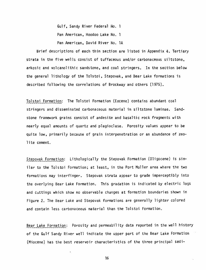
Gulf, Sandy River Federal No. 1
Pan American, Hoodoo Lake No. 1
Pan American, David River No. 1A
Brief descriptions of each thin section are listed in Appendix 4. Tertiary
strata in the five wells consist of tuffaceous and/or carbonaceous siltstone,
arkosic and volcano!ithic sandstone, and coal stringers. In the section below
the general lithology of the Tolstoi, Stepovak, and Bear Lake formations is
described following the correlations of Brockway and others (1975).
Tolstoi Formation: The Tolstoi Formation (Eocene) contains abundant coal
stringers and disseminated carbonaceous material in siltstone laminae. Sand
stone framework grains consist of andesite and basaltic rock fragments with
nearly equal amounts of quartz and plagioclase. Porosity values appear to be
quite low, primarily because of grain interpenetration or an abundance of zeo
lite cement.
Stepovak Formation: Lithologically the Stepovak Formation (Oligocene) is sim
ilar to the Tolstoi Formation; at least, in the Port Moller area where the two
formations may interfinger. Stepovak strata appear to grade imperceptibly into
the overlying Bear Lake Formation. This gradation is indicated by electric logs
and cuttings which show no observable changes at formation boundaries shown in
Figure 2. The Bear Lake and Stepovak formations are generally lighter colored
and contain less carbonaceous material than the Tolstoi Formation.
Bear Lake Formation: Porosity and permeability data reported in the well history
of the Gulf Sandy River well indicate the upper part of the Bear Lake Formation
(Miocene) has the best reservoir characteristics of the three principal sedi-
16

mentary formations of Tertiary age on the Alaska Peninsula. In the Gulf Sandy
River No. 1 well,Bear Lake sandstone above 6,300 feet has porosity values as
high as 36.5% and permeability as high as 1,268 rods. Below 6,300 feet, high
values for porosity and permeability are 29% and 43 mds, respectively.
The Bear Lake Formation contains an abundance of tuffaceous siltstone and
the ratio of quartz and feldspar grains to volcanic rock fragments in sandstone
is higher than in the Tolstoi and Stepovak formations. This difference in
lithology was first noted by Burk (1965).
Igneous Rocks
Drilling logs from the Gulf-Alaskco, Port Heiden No. 1 and Pan Am Hoodoo
Lake No. 2 indicate that igneous rocks were drilled in each well.
Gulf-Alaskco Port Heiden No. 1: Data from the Gulf-Alaskco, Port Heiden No.
1 well indicates that volcanic rocks were drilled from approximately 9,300 to
15,000 feet. Thin sections of core samples from 11,833-11,834 feet and 11,955-
11,956 feet consist of mildly altered dacite microbreccia, sandy tuff, and por-
phyritic dacite flow rocks. Hornblende phenocrysts in the dacite are replaced
by chlorite and epidote. Plagioclase is partly altered to calcite and sericite.
Radiometric dates reported by Brockway and others (1975) in the volcanic section
of the Port Heiden well are 42 +_ 4 m.y. (11,832-11,850 feet) and 36+8 m.y.
(13,980 feet).
Two thin sections were cut from core samples near the bottom of the well
at 15,001 and 15,015 feet. The textures of these samples suggest a granitic
rock. Both are medium grained, salt and pepper colored quartz diorite or gran-
odiorite. Phenocrysts include plagioclase and quartz with local graphic inter-
growths, green hornblende and biotite. The age of the granitic rocks in the
17
Port Heiden well is unknown, as is their strati graphic relation to the overlying
volcanic sequence. Granitic and metamorphic rocks were also drilled in the bot
tom of the General Petroleum Great Basins Nos. 1 and 2 wells. The age of these
granitic rocks is reported to be Jurassic.
Pan American Hoodoo Lake No. 2: Cuttings with crystalline textures were studied
from two intervals in the Pan American Hoodoo Lake No. 2. The lithologies from
intervals of 1,210 to 10,220 feet and 1,480 to 10,490 feet deep consists of
basalt, diabase, and coarser grained fragments that may be gabbro. The rocks
are interpreted as hyabyssal bodies that have intuded the Staniukovich Formation.
It should be noted that dikes and sills cutting rocks as young as Miocene are
widespread all along the Alaska Peninsula, especially in the Port Moller area,
as indicated on the geologic map of Burk (1965).
PALEONTOLOGY AND PALYNOLOGY
In an attempt to better document published stratigraphic correlations of
wells drilled on the Alaska Peninsula, samples of washed well cuttings were
analyzed for foraminifera by Kristin McDougall and palynomorphs by Jack Wolfe
(Appendix 5). Forty-two samples from six wells were selected for paleontological
studies. Thirty-nine of these samples were found to be barren of foraminifera.
Fossils of probable early Tertiary age were recovered from only one well, the
Pan Am Hoodoo Lake No. 2, where forams were found between 2,100 and 7,690 feet.
Because of the poor percentage of foram recovery, additional sample material
was examined for palynomorphs. A total of 27 samples from five wells were ana
lyzed. Thirteen samples from four wells contained palynomorphs.
The palynomorphs from the Gulf Sandy River No. 1 (11,686-11,691 feet) and
those from the Pan Am Hoodoo Lake No. 1 (4,010-4,180 feet and 2,590-2,840 feet)
are very similar to one another and resemble the Alaskan Neogene (especially
18
Miocene) reported from other areas. The similarities in the two wells include
(1) dominance of PICEA, (2) common representation of TSUGA, (3) low representa
tion of broadleaved exotics (PTEROCARYA, ULMUS/ZELKOVA), and (4) presence of
some herbaceous types (Centrospermae, Cyperaceae). These palynornorphs are of
Neogene age and are thus probably from the Bear Lake Formation.
However, palynornorphs in the David River 1-A well from 3,200 to 9,100 feet
are dominated by broadleaved exotics while TSUGA is absent suggesting an Eocene
age. It should be emphasized however, that there is almost no palynological
control material available for the Alaskan Eocene (J. A. Wolfe, written commun.,
1977).
REFERENCES
Brockway, R., Alexander, B., Day, P., Lyle, W., Hiles, R., Decker, W., Polski,
W., and Reed, B., 1975, Bristol Bay region, "Stratigraphic correlation
section" southwest Alaska: The Alaska Geological Society, P. 0. Box 1288,
Alaska 99510.
Burk, C. A., 1965, Geology of the Alaska Peninsula Island arc and continental
margin: Geol. Soc. America Mem. 99, 250 p.
Cernock, P. J., 1976a, Hydrocarbon source rock evaluation study - organic geo-
chemical analyses of dry well cuttings, Pan Am-Socal USA Hoodoo Lake No.
2 well, sec. 35-50S-76W, Aleutian Island Recording District, Alaska:
Confidential Geochemical Service Report prepared by GeoChem Labs., Inc.,
1143-C Brittmore Rd., Houston, Texas, 11 p.
____1976b, Hydrocarbon source rock evaluation study, organic geochemical
analyses of dry well cuttings, General Petroleum Corporation, Great Basins
No. 1 well, sec. 2-27S-48W, Bristol Bay area, Alaska: Confidential Geo
chemical Service Report prepared by GeoChem Labs., Inc., 1143-C Brittmore
Rd., Houston, Texas, 11 p.
19
APPENDIX 1
Geochemical Data for General
Petroleum Great Basins No. 1 Well
1976c, Hydrocarbon source rock evaluation study organic geochemical
analyses of dry well cuttings AMOCO Production Company, Cathedral River
Unit No. 1 well, sec. 29-51S-83W, Cold Bay County, Alaska: Confidential
Geochemical Service Report prepared by GeoChem Labs., Inc., 1143-C
Brittmore Rd., Houston, Texas, 8 p.
20
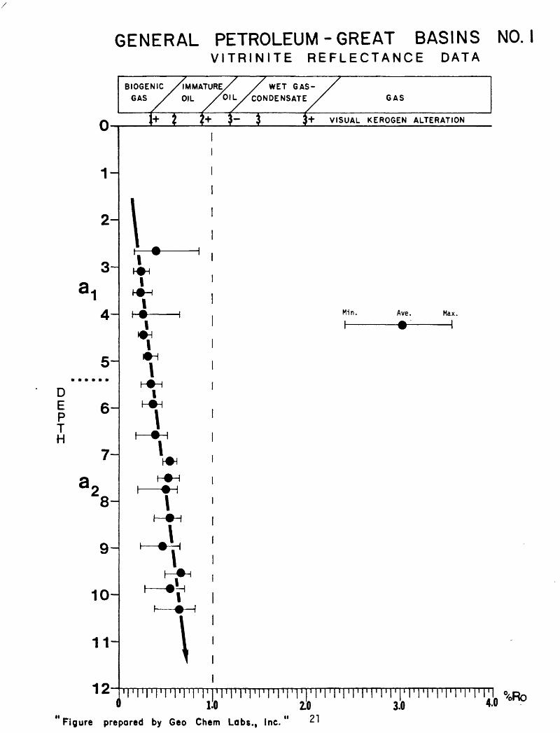
GENERAL PETROLEUM - GREAT BASINS NO. IVITRINITE REFLECTANCE DATA
DE P T H
O-i
1-
2-
a4-
5-
6-
7-
\-
9-
10-
11-
10
B I OGEN 1C /IMMATURE/ / WET GAS- /
GAS y' OIL /OIL /CONDENSATE ,/ GAS
1+J !!+ j- $ J+ VISUAL KEROGEN ALTERATION
i1
1
i
\ ;'i * ' it-A-iT 'I.A-IT i|-0 | Min. Ave. Max.
1 1 i - I
T 'h^H |
nl |
£
nin
' *\' 1h-^H ,
1 -!
1
.'I'l'rriMM'rrrprrTTrrrr' i i i ' i i i i i 1 i i « i ' i ' i* 1:0 2.0 3.0 *-°
Figure prepared by Geo Chem Labs., Inc." ^1
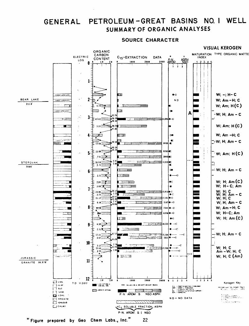
GENERAL PETROLEUM-GREAT BASINS NO. I WELLSUMMARY OF ORGANIC ANALYSES
SOURCE CHARACTER
ORGANIC
CoS?EI^ ^EXTRACTION DATA
VISUAL KEROGENMATURATION TYPE ORGANIC MATTE'
INDEX
uwu A 1.1 M <
BEAR LAKE
2110'
STEPOVAK5(10'
JURASSIC
GRANITE ll.97«'
VARIED UTHOLCXn
\ARicr Lrmnux;i
f::-- ft!
\AHItLLlTOOUIG}
F:;;*Wx::
' t» -Vco
1 I"- -
"»K »-" ?.."
=.
^
' |
: i
_J i
.._!
' $' ' " '
= -
S-B
" "] '-LAY
") S , LT
"] ->ANO
3 COAL
' ^\ OOLCUlIE
" "] KlNtOUS
^ | CHLBT
: 3i
-
5-
^
_
7q
8^
I
91
11-
10 ~
' l '
- 4 1 .42 "::v!: ::::: ::: ;:: : :-:
*r^
:: 36.99 : ;:S:^^- '- 71 f
;.:.x :: :: : :x:::^;:: :::::;'!
,»,,1S4
^ 5^ AC :-/:v^;-:^T7
' 9 JO '-: :: : : ;-: :-:>::
.^r-r^-'.- f1- 11 ' < ' ' ' ' '
: "S
. j«___.," ^ I 9 1-T-:":"TTT? ± . ^ J / .v^v^u^.*
. J 3 6 v:-.^^^*"
, I ,
,52.74 ,50.58 ,48.54
,80.74 ,47.12
,4« 54
,48 54,50. ?4
, 2.01 2.00
,51.12 , 2.23
,6042 ,59,80 , 2 47 ,5986
,67 17
,65.30
, 2 70 ,63 «4
, 2.08
** 1 11 2«TO 11.080' __,; l«Etu,, 1 «S4
|Tx"j iwrosnc ojniwti
1MO 2111 3111 AR75M NS(,,...,, 1 |
m
i mmrnmfMF^^
in
re vM//mm?Mm®=s=tl==
1 ;:;:::;:;:;:s;:; :;:; :»;:s;:;x::;:s;:;x;:;:;fe^^^
i mfm===i1 8:v: ::: :: : ::V:'-:: :J
^^^ ., r .............| l:::^??:^1 :; ^.r^"--- 1^ r.
' l^S^SSip
I };: : : : : : : ji':v:.:-;?^==jS^=
*= _ .. . f W,-- .HI |-.- ;.. .' . -. yy.v . . ;-. -.^ -^
1 V =)1 e : : :P=:
'' ' ^ ^^.^....JiS^^^gi
j i u j j i . . 1 !
31,195
6436
8263
3146
11.513
15.915
17.1(1
51(7
7547
(351
18.133
25.1(4 3121
13.39S
1 1110 2111 3111
rrm »»LUIS ON A WIGHT \WCIGM1 BASIS
IHHH! F/^^lr^^'-'-jr 1P-N AROM S NSOASPH
vnC 5 SOLUBLE FRACTION, ASPH
i i i 1 2 3
ND
C<
- >
0*
4E
Q
«E
©
»^
O
e 4>-e
4> >
e
e>
e
i i i
p 12345
A
4 43
11234
AN* MM*'!. MtDAOUUIKJ'i
ttf ftlTIJb!* Swl'uA-tiJU UK. . UMuliW
N D = NO DATA
i ii
i1234
t
W; -; H- C
W; Am-H; C
W; Am; H (C )
-W; H; Am - C j
W; Am; H(C)
W; Am -H; C
~VW; H; Am-C
~ W; Am; H(C>
i
W; H; Am-C
W; H; Am(C) W; H-C; Am
W; H; C W; H; Am-C W;H;C W; H; Am - C W; Am-H;C W; H-C; Am W; H; Am(C)
i
-rW; H; Am-CH
"" W; H; C Am -W; H; CW; H; C (Am)
5Kerogen Key
v-c^r ?:--n -2c"
! ' ' :;., :,.: « : = :-
P-N. AROM. S t NSO
11 Figure prepared by Geo Chem Labs., Inc 22

Table I
Organic Carbon and Uthology Screen Analyses
GeoChem Sample Number
788-001788-002788-003788-004788-005788-006788-007788-008788-009788-010788-011788-012788-013788-014788-015788-016788-017788-018788-019788-020788-021788-022788-023788-024788-025788-026788-027788-028788-029788-030788-031788-032788-033
Well Depth Interval
1300'-1450'-1600'-1750'-1900'-2050'-2200'-2350'-2500'-2650'-2800'-2950'-3100'-3250'-3400'-3550'-3700'-3850'-4000'-4150'-4300'-4450'-4600'-4750'-4900'-5050'-5200'-5350'-5500'-5650'-5800'-5940'-6100'-
1310'1460'1610'1760'1920'2060'2210'2360'2510'2660'2810'2960'3110'3260'3410'3560'3710'3860'4010'4160'4310'4460'4610'4760'4910'5060'5210'5360'5510'5660'5810'5950'6110'
Percent Organic
Description Carbon
Composite.Composite.Dark gray shale.Dark gray shale.Composite.Medium dark gray shale.Medium dark gray shale,Claystone.Dark gray shale.Dark gray shale.Claystone.Coal.Coal.Coal.Claystone.Coal.Coal.Claystone.Claystone.Sandstone.Claystone.Coal.Siltstone.Coal.Coal.Siltstone.Siltstone.Siltstone.Siltstone.Siltstone.Siltstone.Siltstone.Siltstone.
0.181.520.251.40; 1.39 R0.830.56
chert, sand, sandstone. 0.291.37; 1.36 R1.321.421.06
52.7450.58; 50.82 R48.541.23
80.7447.820.86; 0.83 R0.700.340.84
48.541.28; 1.21 R
48.5450.241.251.561.21; 1.21 R2.012.001.871.071.75; 1.78 R
23

Table I
Organic Carbon and Uthology Screen Analyses
GeoChem Sample Number
788-034788-035788-036788-037788-038788-039788-040788-041788-042788-043788-044788-045788-046788-047788-048788-049788-050788-051788-052788-053788-054788-055788-056788-057788-058788-059788-060788-061788-062788-063788-064788-065788-066
Well Depth Interval
6250'- 6260'6400'- 6410'6600'- 6610'6700'- 6710'6850'- 6860'7000'- 7010'7150'- 7160'7300'- 7310'7500'- 7510'7600'- 7610'7750'- 7760'7900'- 7910'8050'- 8060'8200'- 8210'8350'- 8360'8500'- 8510'8650'- 8660'8800'- 8810'8950'- 8960'9100'- 9110'9240'- 9250'9400'- 9410'9540'- 9550'9700'- 9710'9840'- 9850'
IDOOO'-IOOIO'10140'-10150'10300' -10310'10440'-10450'10600'-10610'10740'-10750'10900'-10910'11060'-11070'
Description
SlUstone.SIHstone.S1Hy gray shale.S1Hy gray shale.S1Hy gray shale.S1Hy gray shale.Coal.Silty gray shale.Coal.Coal.Sllty gray shale.Coal.Greenish gray siltstone.Medium gray-medium light gray slltstone.Medium light gray slltstone.Medium light gray siltstone.Medium light gray slltstone.Medium gray sllty shale.Medium gray silty shale.Medium gray sllty shale.Medium gray silty shale.Medium gray sllty shale.Coal.Medium gray silty shale.Coal.Medium gray silty shale.Medium gray silty shale.Coal.Medium dark gray silty shale.Medium dark gray silty shale.Medium dark gray silty shale.Medium dark gray silty shale.Medium dark gray silty shale.
Percent Organic Carbon
1.471.701.451.421.19; 1.191.39
58.122.23
60.4259.80;60.042.47
59.860.460.380.67; 0.690.670.871.241.571.09; 1.101.081.45
67.121.67
65.30;66.081.332.70
63.942.080.73; 0.710.980.601.04
R
R
R
R
R
R
24
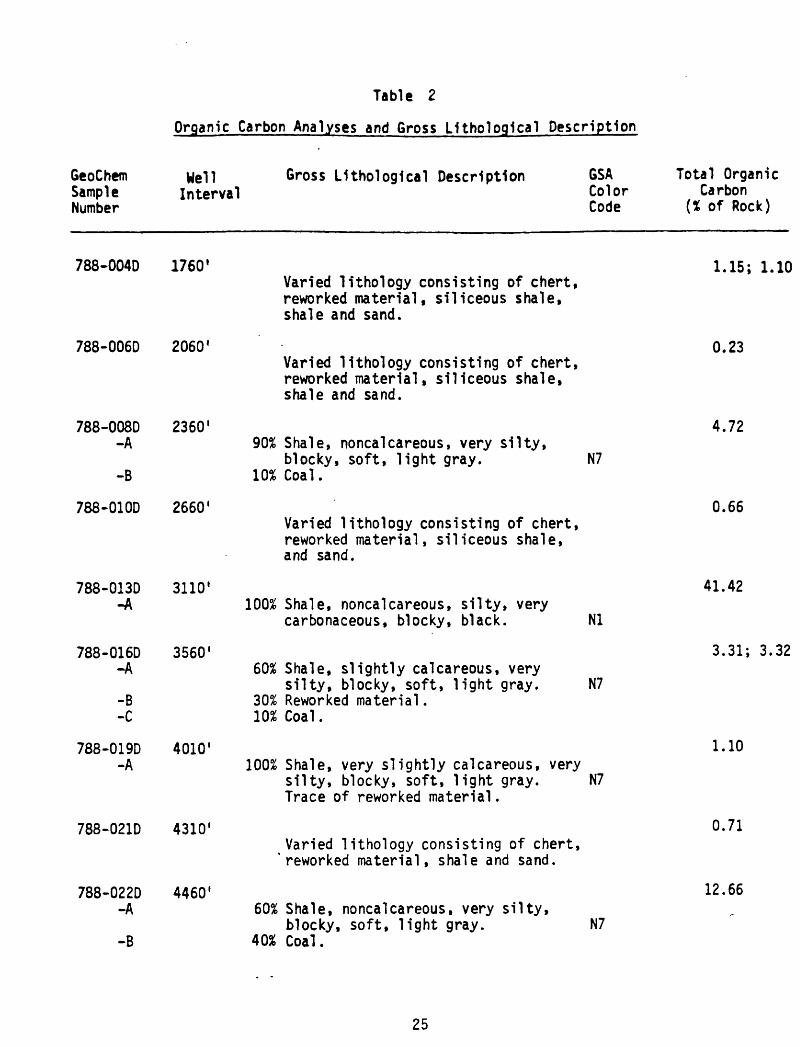
Table 2
Organic Carbon Analyses and Gross Lithologlcal Description
GeoChemSampleNumber
Well Interval
Gross Uthologlcal Description GSA Total OrganicColor CarbonCode (X of Rock)
788-004D 1760'
788-006D 2060'
788-008D 2360'-A
-B
788-01OD 2660'
788-013D -A
788-016D-A
-B-C
788-019D-A
788-022D-A
-B
3110 1
3560'
4010'
788-021D 4310'
4460'
Varied lithology consisting of chert, reworked material, siliceous shale, shale and sand.
Varied lithology consisting of chert, reworked material, siliceous shale, shale and sand.
90% Shale, noncalcareous, very silty,blocky, soft, light gray. N7
10% Coal.
Varied lithology consisting of chert, reworked material, siliceous shale, and sand.
100% Shale, noncalcareous, silty, verycarbonaceous, blocky, black. Nl
60% Shale, slightly calcareous, verysilty, blocky, soft, light gray. N7
30% Reworked material. 10% Coal.
100% Shale, very slightly calcareous, very silty, blocky, soft, light gray. N7 Trace of reworked material.
Varied lithology consisting of chert, 'reworked material, shale and sand.
60% Shale, noncalcareous, very silty,blocky, soft, light gray. N7
40% Coal.
1.15; 1.10
0.23
4.72
0.66
41.42
3.31; 3.32
1.10
0.71
12.66
25
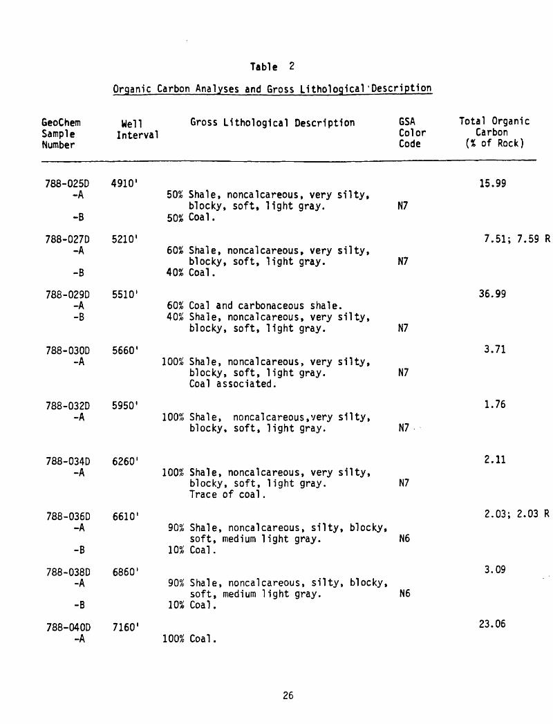
Table 2
Organic Carbon Analyses and Gross Litholoqical'Description
GeoChemSampleNumber
Well Interval
Gross Lithologlcal Description GSA Total OrganicColor CarbonCode (% of Rock)
788-025D-A
-B
788-027D-A
-B
788-029D-A-B
788-030D -A
788-032D -A
4910 1
5210 1
5510'
5660'
5950 1
50% Shale, noncalcareous, very silty,blocky, soft, light gray. N7
502 Coal.
60% Shale, noncalcareous, very silty,blocky, soft, light gray. N7
40% Coal.
60% Coal and carbonaceous shale. 40% Shale, noncalcareous, very silty,
blocky, soft, light gray. N7
100% Shale, noncalcareous, very silty,blocky, soft, light gray. N7 Coal associated.
100% Shale, noncalcareous,very silty,blocky, soft, light gray. N7
15.99
7.51; 7.59 R
36.99
3.71
1.76
788-034D -A
788-036D-A
-B
788-038D-A
-B
788-040D-A
6260'
6610 1
6860'
7160'
100% Shale, noncalcareous, very silty,blocky, soft, light gray. N7 Trace of coal.
90% Shale, noncalcareous, silty, blocky,soft, medium light gray. N6
10% Coal.
90% Shale, noncalcareous, silty, blocky,soft, medium light gray. N6
10% Coal.
100% Coal.
2.11
2.03; 2.03 R
3.09
23.06
26
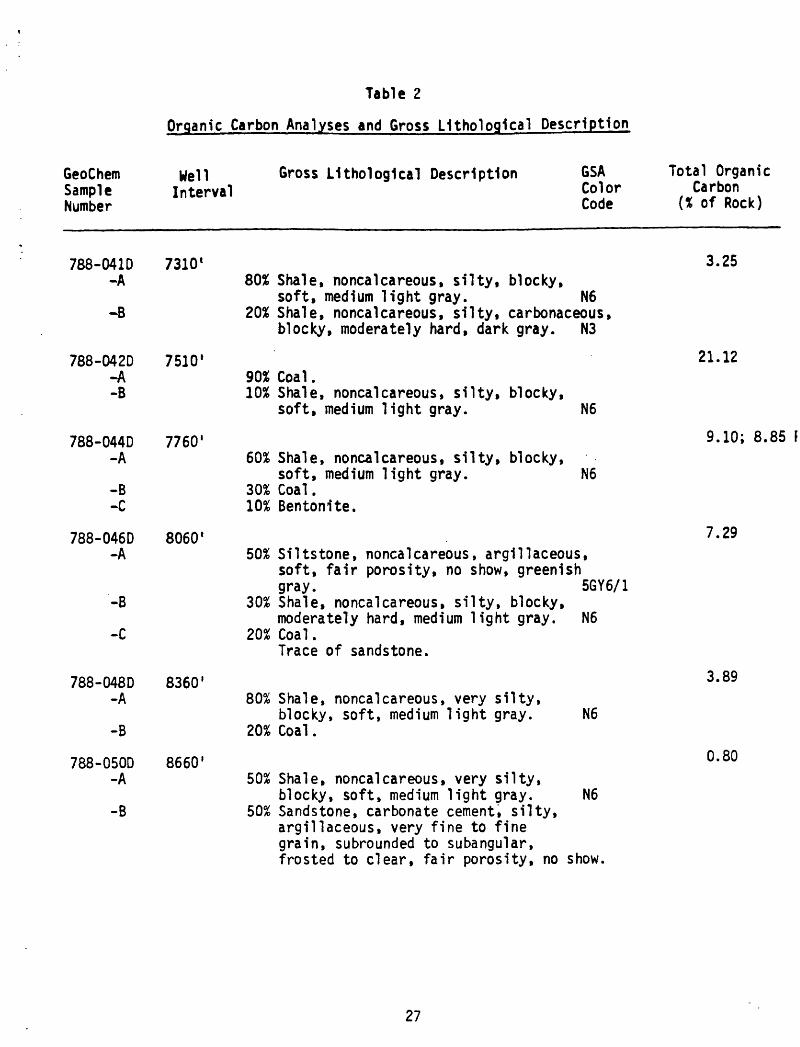
Table 2
Organic Carbon Analyses and Gross L1tholog1cal Description
GeoChemSampleNumber
Well Interval
Gross LUhologlcal Description GSA Total OrganicColor CarbonCode (X of Rock)
788-041D 7310 1-A
-B
788-042D 7510'-A-B
788-044D-A
-B-C
788-046D-A
'-B
788-048D-A
-B
788-050D-A
-B
7760'
8060 l
8360'
8660'
80$ Shale, noncalcareous, silty, blocky, soft, medium light gray. N6
20% Shale, noncalcareous, silty, carbonaceous, blocky, moderately hard, dark gray. N3
90% Coal.10% Shale, noncalcareous, silty, blocky,
soft, medium light gray. N6
60% Shale, noncalcareous, silty, blocky,soft, medium light gray. N6
30% Coal. 10% Bentonite.
50% Siltstone, noncalcareous, argillaceous, soft, fair porosity, no show, greenish gray. 5GY6/1
30% Shale, noncalcareous, silty, blocky, moderately hard, medium light gray. N6
20% Coal.Trace of sandstone.
80% Shale, noncalcareous, very silty,blocky, soft, medium light gray. N6
20% Coal.
50% Shale, noncalcareous, very silty,blocky, soft, medium light gray. N6
50% Sandstone, carbonate cement, silty, argillaceous, very fine to fine grain, subrounded to subangular, frosted to clear, fair porosity, no show.
3.25
21.12
9.10; 8.85 F
7.29
3.89
0.80
27

Table 2
Organic Carbon Analyses and Gross lithological Description
GeoChemSampleNumber
Well Interval
Gross Lithologlcal Description GSA Total OrganicColor CarbonCode (% of Rock)
788-052D 8960'-A
-B
-C
788-054D 9250' -A
-B
788-056D-A-B
-C
-B
788-060D-A
-B
-C
9550 1
788-057D 9710' -A
10150'
50% Shale, noncalcareous, silty, blocky, moderately hard, medium light gray. N6
30% Siltstone, noncalcareous, veryargillaceous, blocky, moderately hard, poor porosity, no show, medium light gray. N6
20% Coal.Trace of sandstone.
90% Shale, noncalcareous, very silty, blocky, moderately hard, medium light gray. N6
10% Coal.Trace of sandstone.
80% Coal.10% Shale, noncalcareous, very silty,
blocky, moderately hard, medium light gray. N6
10% Sandstone, carbonate cement, silty, argillaceous, very fine to fine grain, subrounded to subangular, frosted to clear, good porosity, no show.
60% Shale, noncalcareous, silty to very silty, blocky, moderately hard, light gray.
40% Coal and very carbonaceous shale.N7
70% Shale, noncalcareous, silty, blocky, moderately hard, medium dark gray. N4
20% Limestone, chalk, moderately hard,poor porosity, no show, white. N9
10% Coal.
4.99
2.11; 2.11
17.21
5.62
3.12
28

GeoChemSampleNumber
Table 2
Organic Carbon Analyses and Gross LUhologlcal Description
Well Interval
Gross Uthologlcal Description GSAColorCode
Total OrganicCarbon
(X of Rock)
788-061D-A-B
-C
10310'50% Coal.30% Siltstone, noncalcareous, argillaceous,
hard, little porosity, no show, light gray. N7
20% Shale, noncalcareous, silty, blocky, hard, medium dark gray. N4
23.48;23.54
788-062D 10450 1-A
-B-C
788-064D 10750'
3.3660% Shale, noncalcareous, silty to very
silty, blocky, hard, medium dark gray.N420% Coal.20% Limestone, chalk, moderately hard, poor
porosity, no show, white. N9
Varied lithology consisting of shales, siltstone, limestone and coal.
1.01
29

Table 3
Summary of Organic Carbon and Visual Kerogen Analysis
GeoChem Sample Number
788-004D788-006D788-008D788-010D788-013D788-016D788-019D788-021D788-022D788-025D788-027D788-029D788-030D788-032D788-034D788-036D788-038D788-040D788-041D788-042D788-044D788-046D788-048D788-050D788-052D788-054D788-056D788-057D788-060D788-061D788-062D788-064D
Well Depth
Interval
1750- 17602050- 20602350- 23602650- 26603100- 31103550- 35604000- 40104300- 43104450- 44604900- 49105200- 52105450- 55605650- 56605900- 59506250- 62606600- 66106850- 68607150- 71607300- 73107500- 75107750- 77608050- 80608350- 83608650- 86608950- 89609240- 92509540- 95509700- 9710
10140-1015010300-1031010440-1045010740-10750
Organic Carbon.
(% of Rock)
1.15; 1.10R0.234.720.66
41.423.31; 3.32R1.100.71
12.6615.997.51; 7.59R
36.993.711.762.112.03; 2.03R3.09
23.063.25
21.129.10; 8.85R7.293.890.804.992.11; 2.11R
17.215.623.12
23.48; 23. 54R3.361.01
VisualType
W;-;H-CW;Am-H;CW;Am;H (C)W;H;Am-CW;H;Am-CW;Am;H (C)W;Am-H;CW;H;Am-CW;H;Am-CW;Am;W (C)W;Am;H (C)W;H;Am-CW;H;Am-CW;H;Am-CW;H;Am-CW;H;Am (C)W;H-C;AmW;H;CW;H;Am-CW;H;CW;H;Am-CW;Am-H;CW;H-C;AmW;H;Am (C)W;H;Am-CW;H;Am-CW;H;Am-CW;H;Am-CW;H;Am-CW;H;CAm-W;H;CW;H;C (Am)
KerogenAlteration (1-5 Scale)
1+ to 2-1+ to 2-1+1+1+ to 2-1+ to2-1+ to 2-1+ to 2-1+ to 2-1+ to 2-1+ to 2-1+ to 2-1+ to.2-2-2- to 22- to 22-1+ to.2-1+ to 2-1+ to 2-1+ to 2-1+ to 2-2-2-2-2-2-2-2-2-2-2- to 2
(2-)*(2-)*
(2- to 2)*(2- to 2)*
(1+)*(1+)*(1+)*(1+)*
(1+ to 2-)
30

Tabl
e 4
Sum
mar
y o
f C
15+
Sox
hiet
Ext
ract
ion
, D
easp
halte
nlng
an
d Liq
uid
Chr
omat
ogra
phy
A.
Wei
ghts
of
Ext
ract
s an
d C
hrom
atog
raph
lc
Fra
ctio
ns
GeoC
hem
Samp
leNu
mber
788-004D
788-
006D
788-
008D
788-01 OD
788-
01 3D
788-
0160
788-
0190
788-
0210
788-0220
788-
0250
788-
0270
788-
0290
788-
0300
788-0320
788-
0340
788-
0360
788-0380
788-
0400
788-
0410
788-0420
788-
0440
788-0460
788-
0480
788-0500
788-0520
788-
0540
788-0560
788-0570
788-
0600
788-
0610
788-
0620
788-0640
Well In
terv
al*
1750
- 1760
2050
- 20
6023
50-
2360
2650-
2660
3100
- 3110
3550-
3560
4000
- 40
1043
00-
4310
4450
- 44
6049
00-
4910
5200
- 52
105450-
5560
5650
- 56
605900-
5950
6250
- 6260
6600
- 66
1068
50-
6860
7150-
7160
7300
- 7310
7500
- 75
107750-
7760
8050
- 8060
8350-
8360
8650
- 8660
8950
- 8960
9240
- 9250
9540-
9550
9700
- 97
1010
140-
1015
010300-10310
10440-10450
1074
0-10
750
Weight o
f Ro
ck E
xtd
(gra
ms)
80.0
100.
080.0
85.0
85.0
85.0
85.0
80.0
90.0
90.0
50.0
90.0
80.0
90.0
95.0
85.0
80.0
80.0
80.0
90.0
85.0
55.0
80.0
70.0
100.
085.0
80.0
75.0
85.0
80.0
80.0
90.0
Tota
l . Extract
(gra
ms)
0.0262
0.0094
0.16
250.0285
2.7111
0.1678
0.0459
0.0208
0.5792
0.74
370.1523
1.0362
0.1292
0.0872
0.07
460.
0962
0.09
931.2732
0.1457
1.5445
0.4392
0.41
510.
5080
0.0375
1.81
330.
1227
2.0131
0.28
660.
2073
1.07
180.1868
0.0820
Precipitated
N-C5
Asphaltenes
Soluble
(grams)
0.0118
0.0058
0.03
620.0079
1.2753
0.0311
0.01
290.
0075
0.1803
0.21
130.
0448
0.31
700.
0361
0.0241
0.0388
0.0307
0.0251
0.44
270.
0577
0.5581
0.17
680.
1731
0.2114
0.01
340.
8269
0.0591
1.1363
0.13
770.
0978
0.39
570.0980
0.0483
(gra
ms)
0.0144
0.00
360.
1263
0.02
071.4358
0.1367
0.0330
0.0133
0.39
890.5324
0.1075
0.71
920.0931
0.0631
0.0358
0.06
550.
0742
0.83
050.0880
0.9864
0.26
240.
2420
0.2966
0.0241
0.9864
0.06
360.8768
0.14
890.
1095
0.6761
0.08
880.
0337
Sul fu
r(grams)
0.00
21N.D.
N.D.
N.D.
N.D.
N.D.
0.0025
0.0020
0.03
97N.D.
N.D.
N.D.
N.D.
0.00
39N.D.
N.D.
0.00
26N.
D.N.D.
N.D.
N.D.
N.D.
N.D.
0.00
23N.
D.N.
D.N.
D.N.D.
N.D.
N.D.
N.D.
N.D.
Para
ffin
s-
Eluted
Naph
then
es
Aroma ti
cs
NSO'S
(grams)
0.0028
N.D.
0.00
600.0029
0.04
790.
0055
0.00
350.
0014
0.01
460.
0261
0.00
460.0284
0.00
680.0058
0.0053
0.0076
0.00
770.
0437
0.00
950.
0771
0 J0211
0.0268
0.02
330.
0034
0.1626
0.0107
0.16
350.
0154
0.02
570.
1471
0.01
020.0070
(gra
ms)
0.00
25N.D.
0.0241
0.0038
0.15
950.
0146
0.00
380.
0019
0.0292
0.09
130.
0211
0.09
100.
0170
0.0070
0.0113
0.01
890.
0157
0.21
310.
0225
0.2801
0.08
460.
0736
0.08
050.
0060
0.35
470.0224
0.38
270.
0502
0.0480
0.32
250.0387
0.0158
(gra
ms)
0.00
41N.
D.0.0553
0.0068
0.56
900.0583
0.01
750.0063
0.16
080.
2166
0.05
710.2843
0.04
970.
0304
0.01
470.
0291
0.0371
0.3415
0.04
810.
3369
0.10
690.0970
0.1112
0.00
970.3805
0.0256
0.21
920.
0567
0.02
660.
1584
0.03
670.0108
None
lute
d NS
O'S
(grams )
0.00
29N.D.
0.04
090.0072
0.65
940.
0583
0.0057
0.0017
0.15
460.
1984
0.0247
0.3155
0.0196
0.0160
0.0045
0.00
990.
0111
0.2322
0.0079
0.2923
0.04
980.
0446
0.08
160.0027
0.0886
0.0049
0.11
140.
0266
0.0092
0.04
810.
0032
0.00
01
In f
eet

Table
4 (continued)
B. Co
ncen
trat
ion
of E
xtracted M
aterials in
Roc
k
GeoC
hem
Sample
Numb
er
788-
004D
788-
006D
788-0080
788-0100
788-0130
788-01 6D
788-0190
788-
021 D
788-0220
788-0250
788-
0270
788-0290
788-0300
788-0320
788-
034D
788-036D
788-0380
788-0400
788-0410
788-
042D
788-0440
788-
0460
788-0480
788-
0500
788-
052D
788-
054D
788-
0560
788-0570
788-0600
788-
061 D
788-
0620
788-0640
Well Interval*
1750
- 17
6020
50-
2060
2350
- 2360
2650
- 2660
3100
- 3110
3550
- 35
6040
00-
4010
4300
- 4310
4450
- 44
6049
00-
4910
5200
- 52
1054
50-
5560
5650-
5660
5900
- 5950
6250
- 62
6066
00-
6610
6850
- 68
607150-
7160
7300
- 7310
7500
- 75
1077
50-
7760
8050
- 8060
8350-
8360
8650
- 8660
8950
- 8960
9240
- 92
509540-
9550
9700
- 9710
1014
0-10
150
1030
0-10
310
1044
0-10
450
1074
0-10
750
Total
Extr
act
(ppm)
328 94
2031 335
3189
51974 540
260
6436
8263
3046
1151
31615 969
785
1132
1241
1591
518
2117161
5167
7547
6350 536
1813
314
4425164
3821
2439
1339
82335 911
Total
Extr
act
(ppm)
328 94
2031 335
3189
51974 540
260
6436
8263
3046
1151
31615 969
785
1132
1241
1591
518
2117161
5167
7547
6350 536
1813
314
4425164
3821
2439
1339
82335 911
Paraffin-
Naphthene
(ppm)
35 . 75 34 564 65 41 18 162
290 92 316 85 64 56 89 96 546
119
857
248
487
291 49
1626 126
2044 205
302
1839 128 78
Arom
atic
.(p
pm)
31 . 301 45
1876 172 45 24 324
1014 422
1011 213 78 119
222
196
2664 281
3112 995
1338
1006 86
3547 264
4784 669
565
4031 484
176
Total
(ppm
)
66 . 376 79
2440 236 86 41 487
1304 514
1327 298
142
175
312
293
3210 400
3969
1244
1825
1298 134
5173 389
6828 875
867
5870 611
253
Sulfur
(ppm
)
26 . . . . . 29 25 441 - - . . 43 . . 33 - . . - . . 33 . . . . . - .
Preci
ptd.
Asph
alte
ne(p
pm)
148 58 453 93
15004
366
152 94
2003
2348 896
3522 451
268
408
361
314
5534 721
6201
2080
3147
2643 191
8269 695
1420
418
361151
4946
1225 537
Elut
edNSO'S
(ppm
)
51 . 691 80
6694 686
206 79
1787
2407
1142
3159 621
338
155
342
464
4269 601
3743
1258
1764
1390 139
3805 301
2740 756
313
1980 459
120
Noneluted
NSO'
S(p
pm)
36 . 511 85
7758 686 67 21
1718
2204 494
3506 245
178 47 116
139
2903 99
3248 586
811
1020 39 886 58
1393 355
108
601 40 1
Total
(ppm
)
261 .
1655 256
2945
517
38 454
219
5949
6959
2532
10187
1318 827
611
820
949
1270
514
2113192
3924
5722
5053 401
12960
1054
18336
2947
1572
7528
1724 658
In f
eet
PPM
values ar
e ex
pres
sed
on a we
ight
/wei
ght
basi
s
Table
4 (C
onti
nued
)
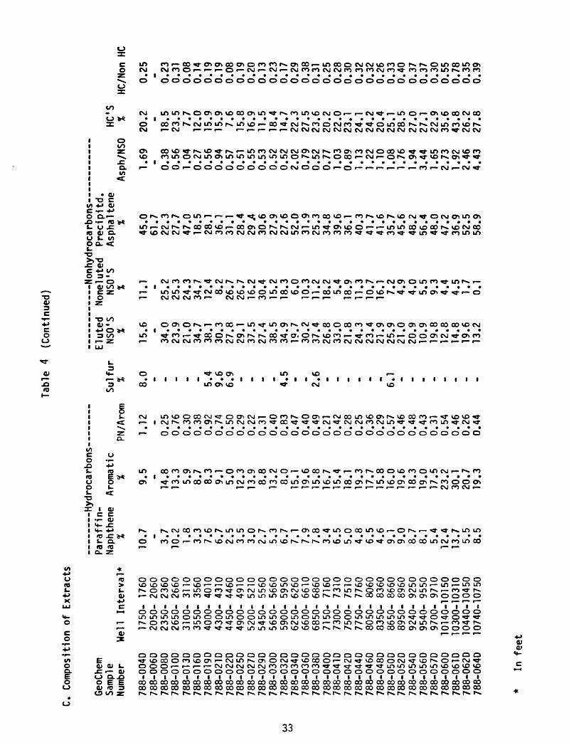
C. Co
mposition
of E
xtracts
GeoC
hem
Samp
leNu
mber
788-
0040
788-006D
788-
008D
788-
01 OD
788-
01 3D
788-
01 60
788-
019D
788-
021 D
788-
022D
788-
0250
788-027D
788-029D
788-
030D
788-0320
788-034D
788-036D
788-
038D
788-040D
788-
04 ID
788-042D
788-044D
788-
046D
788-048D
788-050D
788-052D
788-
0540
788-056D
788-
057D
788-
060D
788-061 D
788-0620
788-
0640
Para
ffin
- Na
phth
ene
Aromatic
Sulf
urWell Interval*
1750
- 1760
2050-
2060
2350-
2360
2650-
2660
3100-
3110
3550-
3560
4000
- 4010
4300
- 43
104450-
4460
4900
- 49
1052
00-
5210
5450
- 55
6056
50-
5660
5900-
5950
6250
- 62
6066
00-
6610
6850
- 6860
7150-
7160
7300-
7310
7500-
7510
7750-
7760
8050
- 80
6083
50-
8360
8650-
8660
8950
- 89
6092
40-
9250
9540
- 95
5097
00-
9710
1014
0-10
150
10300-10310
10440-10450
1074
0-10
750
%
10.7 - 3.7
10.2 1.8
3.3
7.6
6.7
2.5
3.5
3.0
2.7
5.3
6.7
7.1
7.9
7.8
3.4
6.5
5.0
4.8
6.5
4.6
9.1
9.0
8.7
8.1
5.4
12.4
13.7 5.5
8.5
% 9.5 -
14.8
13.3 5.9
8.7
8.3
9.1
5.0
12.3
13.9 8.8
13.2 8.0
15.1
19.6
15.8
16.7
15.4
18.1
19.3
17.7
15.8
16.0
19.6
18.3
19.0
17.5
23.2
30.1
20.7
19.3
PN/A
rom
%
1.12
8.0
-0.25
0.76
0.30
0.38
0.92
5.4
0.74
9.6
0.50
6.9
0.29
0.22
0.31
0.40
0.83
4.5
0.47
0.40
0.49
2.6
0.21
0.42
0.28
0.25
0.36
0.29
0.57
6.1
0.46
0.48
0.43
0.31
0.54
0.46
0.26
0.44
E lut
ed
NSO'S
None
lute
d Precipitd.
NSO'S
Asph
alte
neHC
'S%
% %
Asph
/NSO
%
15.6 -
34.0
23.9
21.0
34.7
38.1
30.3
27.8
29.1
37.5
27.4
38.5
34.9
19.7
30.2
37.4
26.8
33.0
21.8
24.3
23.4
21.9
25.9
21.0
20.9
10.9
19.8
12.8
14.8
19.6
13.2
11.1
25.2
25.3
24.3
34.7
12.4 8.2
26.7
26.7
16.2
30.4
15.2
18.3 6.0
10.3
11.2
18.2 5.4
18.9
11.3
10.7
16.1 7.2
4.9
4.0
5.5
9.3
4.4
4.5
1.7
0.1
45.0
61.7
22.3
27.7
47.0
18.5
28.1
36.1
31.1
28.4
29 A
30.6
27.9
27.6
52.0
31.9
25.3
34.8
39.6
36.1
40.3
41.7
41.6
35.7
45.6
48.2
56.4
48.0
47.2
36.9
52.5
58.9
1.69 - 0.38
0.56
1.04
0.27
0.56
0.94
0.57
0.51
0.55
0.53
0.52
0.52
2.02
0.79
0.52
0.77
1.03
0.89
1.13
1.22
1.10
1.08
1.76
1.94
3.44
1.65
2.73
1.92
2.46
4.43
20.2 -
18.5
23.5 7.7
12.0
15.9
15.9 7.6
15.8
16.9
11.5
18.4
14.7
22.3
27.5
23.6
20.2
22.0
23.1
24.1
24.2
20.4
25.1
28.5
27.0
27.1
22.9
35.6
43.8
26.2
27.8
HC/N
on H
C
0.25 - 0.23
0.31
0.08
0.14
0.19
0.19
0.08
0.19
0.20
0.13
0.23
0.17
0.29
0.38
0.31
0.25
0.28
0.30
0.32
0.32
0.26
0.33
0.40
0.37
0.37
0.30
0.55
0.78
0.35
0.39
* In
fee
t

Tab
le
5-A
Sat
urat
e H
ydro
carb
on A
naly
ses
Sum
mar
y of
Par
affln
-Nap
hthe
ne D
istr
ibu
tio
n
CO
GeoChem
Sample
Number
788-0040
788-006D
788-
008D
788-01 OD
788-
0130
788-01 6D
788-
019D
788-021 D
788-0220
788-0250
788-
027D
788-0290
788-
0300
788-032D
788-
034D
788-
0360
788-0380
788-
040D
788-
041 D
788-0420
788-
0440
788-046D
788-048D
788-0500
788-
052D
788-0540
788-056D
788-057D
788-060D
788-061D
788-062D
788-0640
Well In
terv
al*
1750-
1760
2050
- 2060
2350
- 23
602650-
2660
3100
- 3110
3550-
3560
4000-
4010
4300-
4310
4450-
4460
4900
- 49
105200-
5210
5450
- 5560
5650
- 5660
5900-
5950
6250-
6260
6600
- 6610
6850
- 6860
7150
- 7160
7300-
7310
7500-
7510
7750
- 77
608050-
8060
8350-
8360
8650-
8660
8950-
8960
9240
- 9250
9540-
9550
9700-
9710
1014
0-10150
1030
0-10310
1044
0-10
450
1074
0-10750
%Paraffin
5.6
4.3
16.3 6.4
18.9 7.7
5.8
7.3
11.9
18.1
12.5
15.7 9.5
11.7
15.0
23.2
10.2
22.5 9.2
28.4
19.7 8.0
7.8
8.5
2.9
8.7
20.9
19.8
13.4
17.9
22.1
14.9
%Is
opre
nold
0.1
0.1
2.3
1.1
14.5 2.5
1.4
0.3
6.9
22.5 8.6
8.0
2.9
1.8
0.8
3.6
3.3
13.4 2.8
18.8 7.3
4.5
3.8
0.8
1.3
2.9
7.0
5.2
3.2
5.8
3.4
1.0
%Na
phth
ene
94.3
95.5
81.4
92.5
66.7
89.8
92.8
92.4
81.2
59.3
78.9
76.2
87.6
86.6
84.2
73.2
86.4
64.1
88.0
52.8
73.0
87.4
88.4
90.7
95.9
88.4
72.1
75.0
83.3
76.3
74.6
84.2
C-P
Index
A
1.07
1.24
2.37
1.39 _ . .
1.09 - - . . - - . - - . - - - - .
1.46 . - .22
.25
.26
.12
.19
1.24
C-P
Inde
x B
1.12
2.26
4.21
1.72 . . .
1.25 . - . _ - . . - . . - . . - .
1.69 - .
1.50
1.48
1.55
1.27
1.44
1.51
1pl9
/1p20
4.00
7.00
8.69
45.5
094
.00
17.0
032
.67
12.5
026
.50
72.6
736
.17
15.2
59.
863.
202.
535.
8311
.29
21.6
49.
2922
.92
20.1
4,8
1,6
6,4
0,5
86.1
38.
538.
774.
237.
244.
373.
28
In fe
et
OOOOCOOOOOOOOOOOOOOOCOOOCOOOOOOOOOCOCOCQCOOOCOOOOOOOCOCOCOCOCCCO CO* rO 0000 CD CO CO COCO CO CO CO CO CO CO CO CO CO CO CD CO CD CO CO CD CD CO CO CO CO CD CD CO CO 3 3 O
oooooooooooooooooooooooooooooooo ro a- o o o i ro ro-*» oooooooooooooooooooooooooooooooofOro
oooooooooooooooooooooooooooooooo -«
* > cr> cr> cr> tn cr> cr> - cr> *OOOOOOOOOOOOOOOOOOOOOOOOOOOOOOOO
oocoooroo 'OO-jo Jo j 'tnoooooo ioo 'Oro-«4 ' o ro » 'tnco-^cneooioi co Co en - en
o 'to rvj o r\j o '"^ooo 'Oorooo 'OoiNJ-^ o................................ _jtri 'WOO-&rsjCT»rocn-c> '-efctnoicororvjrocootritncocnrsj so <n vi «> - w
' .tfc U> - ' fS3 ' 3-^oo *rs)cocno->rs)O o
«co '
* f«o « « rsj r«o ivj rotorvjcorocorsj - « rsj co co en to i\> .e» 'tnooro «oi~«4-N4roLnooOLnro «U)O ' vojs.cntovocoro** «ro
3 < * o
'Oorsjoiooioo «-«4~N40ooi4* oo
o-joo oo-^oo -a........... ro
-e* o
o o« c ....... X -? - to ro o ua -t^ u> vo -* a»
3 ro ro 'ro-P>rocoroix>.»cnoo o a. .......... f«o M z »Cooj-Ckvococnoo-^ >cn o ~o ^ o»
a» o. a- ' 3 1 1 '
ocoooocoi-fr-e»tnocoitnoctr~^oci>3 o at o roi\3»« -*i r> ' -»» at ,_
_^ -, Ul ' 3 3 CT I
o o m ...................... ro M o 3" oo to -> O"> -t» >03-^o^rororocooootnu>rv}9%vou> ro -<.
trt > _. t __ _*_! r\j « _- _ _i ro 3 r* 3'»«Jtnvoa>~^ '.^oico '-^tnooo** o i ai ............... rox -u to -«» o ^» UD co u> oo oo tn <-n <r> oo to cr *<
c w_. -j < 3 (f ro "Oooro -*» o - </»
> ^ r<o ^ o > ^o ^o -^ c~>................................ rovoooocn-v4vooooooooocnocno^coCocnco"»40ocotof\jrs3OO<T>ooco en
3o^ ^ co en ^k ^ o o w o o o o o o o o o o o o o o o co o o o co co M ro o ................................ rocouDfooenooo-^ooooooooooooooo-iiOoooooo^rvj 91
o
cncoroco*»cooo-t*ooooooooooooooopooootooo o................................ ro **coco-^cororooo 'Ooooooooooo^cocnoo 'oooaicnj* * co
-- _. _ _ ^ 'ooo 'Cncovo >a^oco ' o............. ro M
' vo
'OOOOOOtOOOOOOOOOO -OOOOOOOOOOOOOO O................................ to**
'tncncoro ' ' 'OtAcocntocorocococorocororo-'co-^ o
roooooo 'tn »--ooo 'Oro-- «o o
ooooooorooooooooooooooooooooooooo o ................................ to«ps3 »psj ._ tnoocooooo ' ' ooooorvjrsjtorsjpo 'to^ ro
3o o o o o o o -^ o o o o o o o o o o o o o o o o o o o o o o o o o ................................ to »«ro - ! .tocnrooorooocooto 'co^ooooooivjjktorocorocoo to
oooooooooooooooooooooooooooooooo o ................................ CO »«OOfvjOOOOOOOOOOOOOOOOOOOOOOOOOOOOO £*
3
CO «
Tab
le 6
Vis
ual
Ker
ogen
Ass
essm
ent
Wor
kshe
et
TYP
E
OF
OR
GA
NIC
CO
LOR
O
FM
AT
TE
R
ST
AT
E
OF
OR
GA
NIC
M
AT
TE
R
Dt P
OS
ITIO
NA
L
EN
VIR
ON
ME
NT
MA
TU
RA
TIO
N
IND
EX
MA
T T
FR
OR
GA
NIC
788-
0250
788-
027D
788-
040D
788-
041D
788-
042D
788-
044D
W;A
m-H
;C
W;H
-C;A
m
788j
-050
D
788-
0520
788-
0540
788^
0560
788-
0570
1015
0^
1031
0;
1045
0'
Tabl
e 7
VltrlnU
e R
efle
ctan
ce
Sum
mar
y
GeoChem
Samp
le
Numb
er
788-0040
788-0100
788-0130
788-
0160
788-0190
788-022D
788-
025D
788-
0290
788-
0320
788-0360
788-0400
788-0420
788-0440
788-0480
788-0520
788-0560
788-0580
788-0610
Dept
h (f
eet)
1750
-1760
2650-2660
3100
-311
0
3550
-3560
4000-4010
4450-4460
4900-4910
5450
-556
0
5900-5950
6600
-6610
7150-7160
7500
-7510
7750-7760
8350-8360
8950
-896
0
9540-9550
9840-9850
1030
0-10
310
Numb
er
of
Read
ings
* 14 40 40 27 40 40 41 37 40 40 40 40 40 40 40 40 40
Mini
mum
Reflectance
(X R
o)
- 0.17
0.17
0.16
0.15
0.20
0.27
0.24
0.25
0.19
0.48
0.43
0.21
0.38
0.23
0.50
0.29
0.39
Maximum
Refl
ectance
(X R
o)
- 0.87
0.34
0.36
0.67
0.35
0.42
0.47
0.47
0.54
0.63
0.66
0.63
0.68
0.67
0.78
0.71
0.83
Aver
age
Refl
ecta
nce
(X R
o)
. 0.40
0.24
0.24
0.28
0.27
0.32
0.35
0.37
0.40
0.55
0.54
0.52
0.55
0.48
0.67
0.55
0.65
Note:
Insu
ffle
nt k
erog
en r
eturn
to p
repa
re p
lug.

APPENDIX 2
Geochemical Data for Pan
American Hoodoo Lake Unit No. 2

PAN AM-SOCAL-HOODOO LAKE NO. 2VITRINITE REFLECTANCE DATA
BIOGENIC /IMMATURE/ / WET GAS-
GAS / OIL /OIL /CONDENSATE GAS
3!+ 1- T H- VISUAL KEROGEN ALTERATION
1-
2-
3-
4-
5-
DETP
HB 7-
ft
9-
10-
11-
Min. Ave. Max.
12- 'iMTITITITITnTH'HTHVITrnTI'l'riTn'nTr 0 * 0 rn *n 4.02.0 3.0
Figure prepared by Geo Chem Labs., Ir 38

PAN AM - Socal USA HOODOO LAKE UNIT 2 WELL
SUMMARY OF ORGANIC ANALYSES
SOURCE CHARACTER
ORGANIC f* ARBON
ELECT ' C CONTENT C 15 .E)CTRACTION DATA
VISUAL KEROGENMATURATION TYPE ORGANIC MATTER
INDEX
A 1 U U * II* 1*1 » « Ml II
BEAM LAKE
i»ir
STEPOVAK
Illl'
TOLSTOI
CHIGNIKTill'
HERENDEEN
LIMESTONE » '
«CT»m«»«
i t : >°:*:l
li'i '
V. E
t .4*
VAMreD UtMOUJOf
tf '.«
! :
S t -.: 'fl
..«c,Lr»ioc,
-».,,T~\ CM
s 1?' : ""'
=? 11 / .; .
= it
[
«.-Mit- untaouit
r H
r, J]j 2 l\ 1 . ;
lai ' ; 1 j.
if 4 in \ -' ' 5-i
i-
- 7-
-' 8-H-j:
r 9 :
-
ZT
(
1
«
i
i
\I1 U». \
T )l T x^1
4.M
. 7.44 £^2L
Tlr^T^
ji 25 rn" i u.f^zA~^s
ff
^1.51
.31)4,S 1C ,] 1C1 >' 1 >' 1 ".1 .11 ,1 II > «l
» uI -*2 1 »
I U U
| | CLAY ^^», «n«.
E3 SILT
H COAL
g| DOLOMITE
E3 IGNEOUS
E3 CHERT
.'li'i
' 1 1
1 1
1 1
: \i i
i' 1 1 ti ' ' i i i
t_x^
1 I1 11 '
1
1
1 ' 1 1i 1 i I i 1 i ! i
" 4
mi
ROW T$SI I 1
* *
*
*
*
*
*
o*9
9*s-» -O
*
*
A
B
C
12342
I
B
tsa
SWB r-j KsaBB
r-s E
mmBOB KSfoe rz MM
1
1 1 1
11 11 1 1
I 3
a
i
W; H; Am(C)
W; Am;H-C W; Am-H;C
W; C; H (Am )
W;H;Am(Al)-C
W; C; H(Am) W; C;Am(Al)-H
W- C; H; Am
W-C;Anr-H: -
^W; Am(Al);H(C)
W; Am(Al)-C; H
W; Am;C(H) W; Am(Al)-H-C Am-W:-:H-C W; Am;H-C W; Am;C W; Am; H- C
W; Am-C; H W; C; Am
-)-W - C: -: Am - H W - C; Am; H W-C; -; Am - H
-W-C; Am; H
W-C;Am-H; - W-C; Am;-
W - C; -; Am -H
W-C; Am; H
w * . «m\ IMX tan Kerogen K«y
^H^HI f /^i " j PN AROM S NSO ASPH
5
^>C 5 SOLUBLE FRACTION, A8W
P-N. AROwC S t NSO
*NO DATA r : 2p" " *""nal
Figurt prepared by Geo Chem Lobt., Inc."39
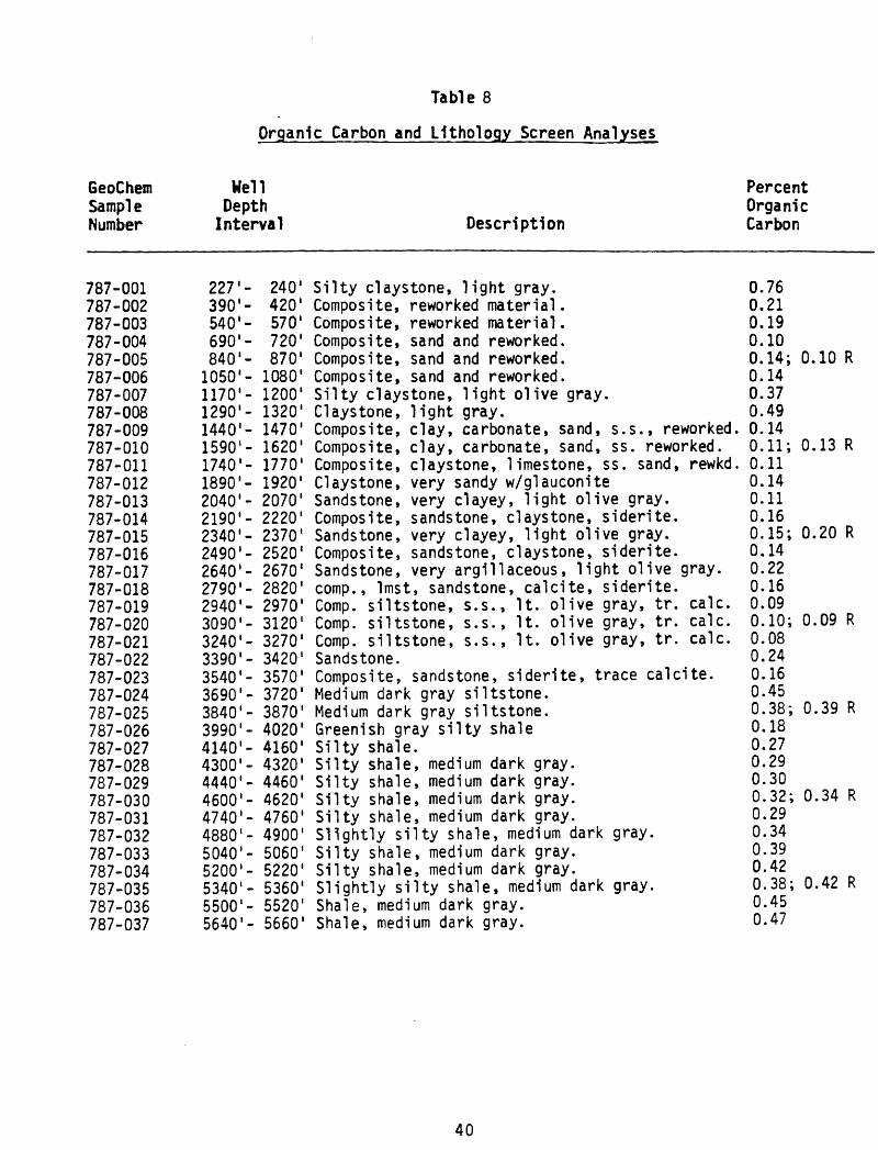
Table 8
Organic Carbon and Lithology Screen Analyses
GeoChem Sampl e Number
787-001787-002787-003787-004787-005787-006787-007787-008787-009787-010787-011787-012787-013787-014787-015787-016787-017787-018787-019787-020787-021787-022787-023787-024787-025787-026787-027787-028787-029787-030787-031787-032787-033787-034787-035787-036787-037
Well Depth Interval
227'-390'-540'-690'-840'-1050'-1170'-1290'-1440'-1590'-1740'-1890'-2040'-2190'-2340'-2490'-2640'-2790'-2940'-3090'-3240'-3390'-3540'-3690'-3840'-3990'-4140'-4300'-4440'-4600'-4740'-4880'-5040'-5200'-5340'-5500'-5640'-
240'420'570'720'870'1080'1200'1320'1470'1620'1770'1920'2070'2220'2370'2520 12670 12820'2970'3120'3270'3420'3570'3720'3870'4020'4160'4320'4460'4620'4760'4900'5060'5220'5360'5520'5660'
Description
Silty claystone, light gray.Composite, reworked material.Composite, reworked material.Composite, sand and reworked.Composite, sand and reworked.Composite, sand and reworked.Silty claystone, light olive gray.Claystone, light gray.Composite, clay, carbonate, sand, s.s., reworked.Composite, clay, carbonate, sand, ss. reworked.Composite, claystone, limestone, ss. sand, rewkd.Claystone, very sandy w/glauconiteSandstone, very clayey, light olive gray.Composite, sandstone, claystone, siderite.Sandstone, very clayey, light olive gray.Composite, sandstone, claystone, siderite.Sandstone, very argillaceous, light olive gray.comp., Imst, sandstone, calcite, siderite.Comp. siltstone, s.s., It. olive gray, tr. calc.Comp. siltstone, s.s., It. olive gray, tr. calc.Comp. siltstone, s.s., It. olive gray, tr. calc.Sandstone.Composite, sandstone, siderite, trace calcite.Medium dark gray siltstone.Medium dark gray siltstone.Greenish gray silty shaleSilty shale.Silty shale, medium dark gray.Silty shale, medium dark gray.Silty shale, medium dark gray.Silty shale, medium dark gray.Slightly silty shale, medium dark gray.Silty shale, medium dark gray.Silty shale, medium dark gray.Slightly silty shale, medium dark gray.Shale, medium dark gray.Shale, medium dark gray.
Percent Organic Carbon
0.760.210.190.100.14;0.140.370.490.140.11;0.110.140.110.160.15;0.140.220.160.090.10;0.080.240.160.450.38;0.180.270.290.300.32;0.290.340.390.420.38;0.450.47
0.10 R
0.13 R
0.20 R
0.09 R
0.39 R
0.34 R
0.42 R
40

Table 8
Organic Carbon and Uthology Screen Analyses
GeoChem Sample Number
787-038787-039787-040787-041787-042787-043787-044787-045787-046787-047787-048787-049787-050787-051787-052787-053787-054787-055787-056787-057787-058787-059787-060787-061787-062787-063787-064787-065787-066787-067787-068787-069787-070787-071787-072787-073787-074
Well Depth Interval
5800'- 5820'5940'- 5960'6100'- 6120'6240'- 6260'6400'- 6420'6540'- 6560'6700'- 6720'6840'- 6860'7000'- 7020'7140'- 7160'7300'- 7320'7440'- 7460'7600'- 7610'7750'- 7760'7900'- 7910'8050'- 8060'8200'- 8210'8350'- 8360'8500'- 8510'8660'- 8670'8800'- 8810'8950'- 8960'9100'- 9110'9250'- 9260'9400'- 9410'9550'- 9560'9700'- 9710'9860'- 9870'
lOOOO'-lOOlO'10150'-10160'10300'-10310'10450'-10460'10600'-10610'10750'-10760'10900'-10910'11050'-11060'11240'-11243'
Description
Silty coal.Silts tone, medium gray.Silty coal.Coal.Silty coal.Silty shale, black, carbonaceous.Silty shale, black, carbonaceous.Silty shale, black, carbonaceous.Shale, black, carbonaceous.Shale, black, carbonaceous.Shale, black, carbonaceous.SandstoneShale, black, carbonaceous.Shale, black.Shale, black, carbonaceous.Shale, black, carbonaceous.Coal.Shale, black, slightly carbonaceous.Shale, slightly silty, grayish black.Shale, medium dark gray.Shale, slightly silty, dark gray.Shale, slightly silty, dark gray.Shale, slightly silty, dark gray.Limestone.Limestone.Shale, silty, dark gray.Shale, silty, dark gray.Shale, silty, dark gray.Sandstone.Tuffaceous sandstone.Tuffaceous sandstone.SandstoneShale, sllty, medium dark gray.Sandstone.Intrusives, igneous.Composite, intrusives, igneous.Composite, intrusives, igneous.
Percent Organic Carbon
21.520.9030.74;29.9657.3016.906.585.845.46; 5.3811.3817.089.080.255.14; 5.223.9213.3210.7473.725.42; 5.301.170.590.540.462.08; 2.070.120.131.031.851.11; 1.100.080.060.080.050.05; 0.060.110.060.210.13
R
R
R
R
R
R
R
41
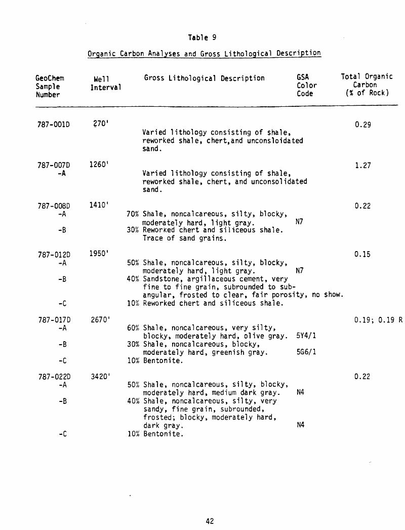
Table 9
Organic Carbon Analyses and Gross Lithological Description
GeoChemSampleNumber
Well Interval
Gross Lithological Description GSA Total OrganicColor CarbonCode (% of Rock)
787-001D 270'
787-007D -A
787-008D-A
-B
787-012D-A
-B
-C
787-017D-A
-B
-C
787-022D-A
-B
-C
1260'
1410'
I960 1
2670'
3420'
Varied lithology consisting of shale, reworked shale, chert,and unconsloidated sand.
Varied lithology consisting of shale, reworked shale, chert, and unconsolidated sand.
70% Shale, noncalcareous, silty, blocky,moderately hard, light gray. N7
30% Reworked chert and siliceous shale. Trace of sand grains.
50% Shale, noncalcareous, silty, blocky, moderately hard, light gray. N7
40% Sandstone, argillaceous cement, very fine to fine grain, subrounded to sub- angular, frosted to clear, fair porosity, no show,
10% Reworked chert and siliceous shale.
60% Shale, noncalcareous, very silty,blocky, moderately hard, olive gray. 5Y4/1
30% Shale, noncalcareous, blocky,moderately hard, greenish gray. 5G6/1
10% Bentonite.
50% Shale, noncalcareous, silty, blocky, moderately hard, medium dark gray. N4
40% Shale, noncalcareous, silty, very sandy, fine grain, subrounded, frosted; blocky, moderately hard, dark gray. N4
10% Bentonite.
0.29
1.27
0.22
0.15
0.19; 0.19 R
0.22
42

Table 9
Organic Carbon Analyses and Gross Lithological Description
GeoChemSampleNumber
Well Interval
Gross Lithological Description GSA Total OrganicColor CarbonCode (% of Rock)
787-024D-A
-B
3720'
787-027D -A
-B
-C
787-030D-A
787-033D-A
-B
787-035D-A
-B
787-037D
4180'
4640
5060'
5380'
5680'
70% Shale, noncalcareous, silty, blocky, moderately hard, medium dark gray. N4
30% Shale, noncalcareous, silty, very sandy; fine grain, subrounded, frosted; blocky, moderately hard, medium dark gray. N4
50% Shale, noncalcareous, silty, very sandy; fine grain, subrounded, frosted; blocky, moderately hard, medium dark gray.
40% Shale, noncalcareous, silty, blocky, moderately hard, medium dark gray.
10% Bentonite.
0.28
60% Shale, noncalcareous, silty, very sandy; fine grain, subrounded, frosted; blocky, moderately hard, medium dark gray.
40% Shale, noncalcareous, silty, blocky, moderately hard, medium dark gray.
N4
N4
N4
N4
60% Shale, slightly calcareous, silty, blocky, hard, medium light gray.
40% Shale, noncalcareous, silty, blocky, moderately hard, medium dark gray. N4
60% Shale, noncalcareous, silty, blocky, moderately hard, medium dark gray. N4
40% Igneous,? diorite, gabbro. Mud additives associated.
Varied lithology consisting of shale, siltstone, sandstone, weathered igneous, coal and mud additive.
0.14
0.21
0.20; 0.17 R
0.29
1.48
43

Table 9
GeoChem Sample Number
Well Gross Lithological Description Interval
GSA Color Code
Total Organic Carbon
(% of Rock)
787-039D
787-040D-A
-B
-C
787-042D-A
-B
-C
787-043D-A
-B
-C
787-044D-A-B-C
5980'
6140'
6440'
6560'
6740'
4.25Varied lithology consisting of shale, carbonaceous shale, coal, sandstone and siltstone.
50% Shale, noncalcareous, silty, blocky, moderately hard, medium dark gray. N4
30% Sandstone, silica cement, veryargillaceous, very fine to fine grain, subangular to subrounded, clear to frosted, fair porosity, no show.
20% Coal.
60% Shale, noncalcareous, silty, blocky, hard, medium dark gray. N4
20% Sandstone, silica cement, veryargillaceous, fine grain, subangular to subrounded, clear to frosted, fair porosity, no show.
20% Coal.
60% Shale, noncalcareous, very carbon aceous, grading into a coal, blocky, N3 to
7.28
4.39; 4.44 R
5.25
hard, dark gray to black. 30% Shale, noncalcareous, very silty,
blocky, hard, medium dark gray. 10% Sandstone, carbonate cement, fine
grain, subrounded to subangular,frosted to clear, good porosity,no show.
60% Shale, same as 787-043D-A. 20% Shale, same as 787-043DrB. 20% Sandstone, same as 787-043D-C.
Nl
N4
7.44
44

Table 9
Organic Carbon Analyses and Gross Lithological Description
GeoChemSampleNumber
Well Interval
Gross Lithological Description GSA Total OrganicColor CarbonCode (% of Rock)
787-046D -A
-B
7040'
787-048D -A
-B
787-050D
787-052D
787-053D
787-054D -A
-B
7360'
7640'
7920'
8070'
8220'
60% Shale, noncalcareous, very carbonaceous, grading into a coal, blocky, hard, N3 to dark gray to black. Nl
40% Sandstone, carbonate cement, argillaceous, very fine to fine grain, subrounded to subangular, frosted to clear, fair porosity, no show. Mud additives associated.
60% Sandstone, carbonate cement, very fine to fine grain, subrounded to subangular, frosted to clear, fair porosity, no show.
40% Shale, noncalcareous, very carbonaceous, grading into a coal, blocky, hard, N3 to dark gray to black. Nl Mud additives associated.
Varied lithology consisting of shale, coal, siltstone, sandstone and mud additives.
Varied lithology consisting of shale, siliceous shale, sandstone, siltstone, igneous and mud additives.
Varied lithology consisting of shale, siliceous shale, sandstone, coal, igneous and mud additives.
80% Shale, noncalcareous, very carbon aceous, grading into a coal, blocky, N3 to hard, dark gray to black. Nl
20% Sandstone, carbonate cement, argillaceous, fine grain, subrounded to subangular, frosted to clear, fair porosity, no show. Mud additives associated.
3.38
3.23
6.85; 6.92 R
0.92
3.63
26.25
45
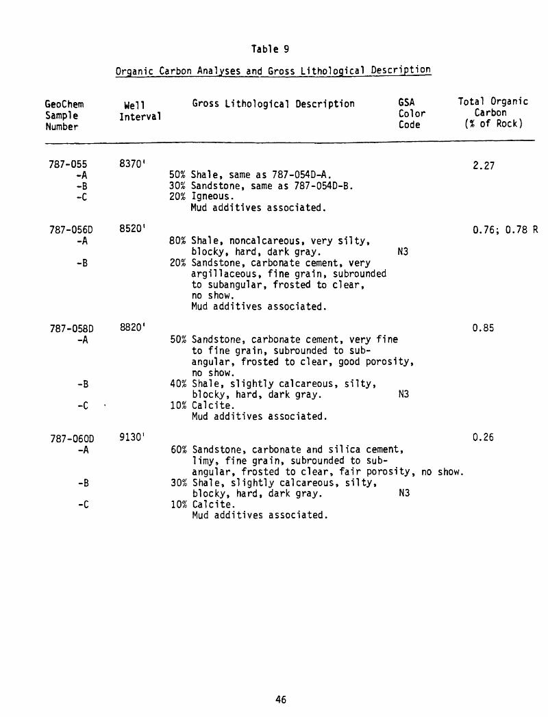
Table 9
GeoChem Sample Number
Well Gross Lithological Description Interval
GSA Color Code
Total Organic Carbon
(X of Rock)
787-055-A-B-C
787-056D-A
-B
787-058D -A
-B
-C
787-060D -A
-B
-C
8370
8520'
8820'
9130'
50% Shale, same as 787-054D-A. 30% Sandstone, same as 787-054D-B. 20% Igneous.
Mud additives associated.
80% Shale, noncalcareous, very silty,blocky, hard, dark gray. N3
20% Sandstone, carbonate cement, very argillaceous, fine grain, subrounded to subangular, frosted to clear, no show. Mud additives associated.
50% Sandstone, carbonate cement, very fine to fine grain, subrounded to sub- angular, frosted to clear, good porosity, no show.
40% Shale, slightly calcareous, silty,blocky, hard, dark gray. N3
10% Calcite.Mud additives associated.
60% Sandstone, carbonate and silica cement, limy, fine grain, subrounded to sub- angular, frosted to clear, fair porosity, no show.
30% Shale, slightly calcareous, silty,blocky, hard, dark gray. N3
10% Calcite.Mud additives associated.
2.27
0.76; 0.78 R
0.85
0.26
46
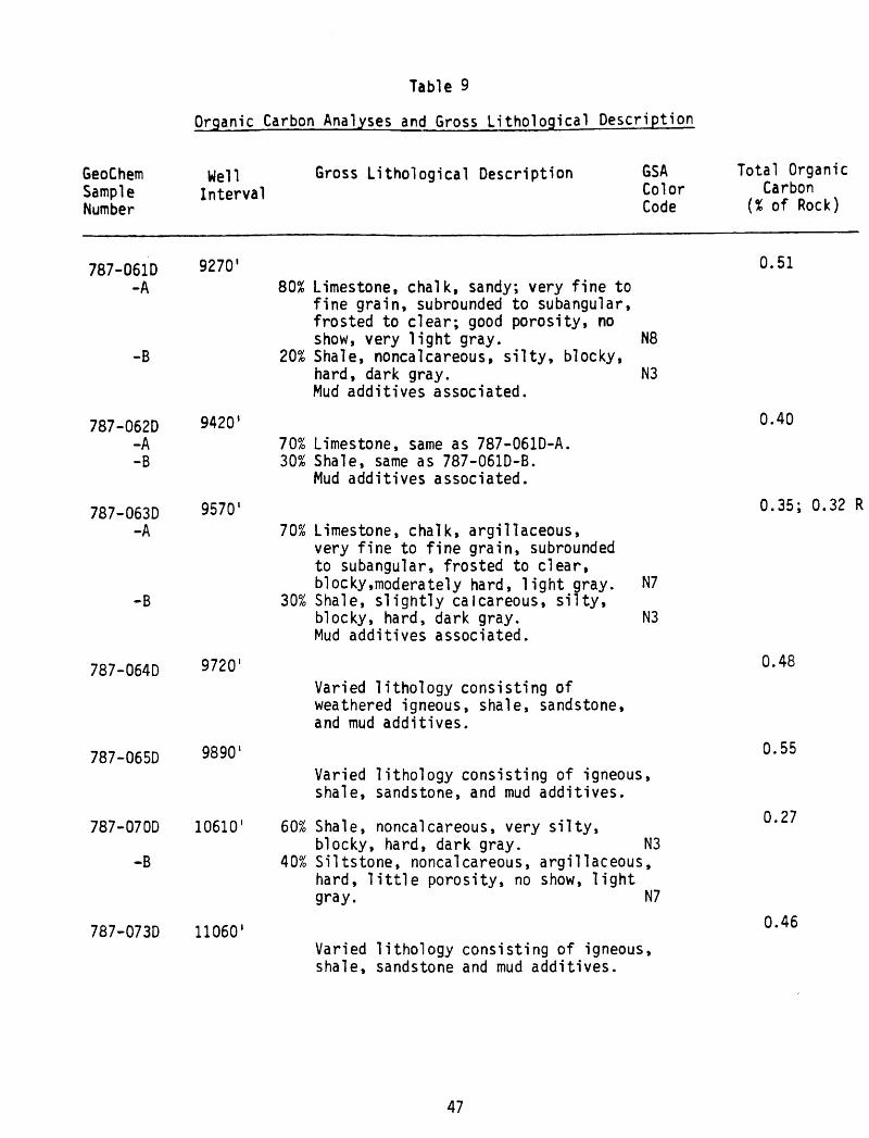
-B
787-062D-A-B
787-063D -A
787-064D
787-065D
787-070D
-B
Table 9
Organic Carbon Analyses and Gross Lithological Description
GeoChemSample Number
787-061D-A
WellInterval
9270'
Gross Lithological Description GSAColor Code
80% Limestone, chalk, sandy; very fine to
Total OrganicCarbon
(% of Rock)
0.51
9420'
9570'
9720'
9890 1
10610'
787-073D 11060'
fine grain, subrounded to subangular, frosted to clear; good porosity, no show, very light gray. N8
20% Shale, noncalcareous, silty, blocky, hard, dark gray. N3 Mud additives associated.
70% Limestone, same as 787-061D-A. 30% Shale, same as 787-061D-B.
Mud additives associated.
70% Limestone, chalk, argillaceous, very fine to fine grain, subrounded to subangular, frosted to clear, blocky.moderately hard, light gray. N7
30% Shale, slightly calcareous, silty,blocky, hard, dark gray. N3 Mud additives associated.
Varied lithology consisting of weathered igneous, shale, sandstone, and mud additives.
Varied lithology consisting of igneous, shale, sandstone, and mud additives.
60% Shale, noncalcareous, very silty,blocky, hard, dark gray. N3
40% Siltstone, noncalcareous, argillaceous, hard, little porosity, no show, light gray. N7
Varied lithology consisting of igneous, shale, sandstone and mud additives.
0.40
0.35; 0.32 R
0.48
0.55
0.27
0.46
47

Table 10
Summary of Organic Carbon and Visual Kerogen Analysis
GeoChem Sample Number
787-001D787-007D787-008D787-012D787-017D787-022D787-024D787-027D787-030D787-033D787-035D787-037D787-039D787-040D787-042D787-043D787-044D787-046D787-048D787-050D787-052D787-053D787-054D787-055D787-056D787-058D787-060D787-061D787-062D787-063D787-064D787-065D787-070D787-073D
Well Depth
Interval
227- 2701080- 12601260- 14101890- 19502610- 26703360- 34203660- 37204140- 41804580- 46405020- 50605320- 53805620- 56805940- 59806080- 61406380- 64406520- 65606640- 67406960- 70407240- 73607570- 76407870- 79208050- 80708190- 82208350- 83708490- 85208790- 88209080- 91309250- 92709390- 94209540- 95709700- 97209860- 9890
10590-1061011040-11060
Organic Carbon
(% of Rock)
0.291.270.220.150.19;0.19R0.220.280.140.210.20; 0.17R0.291.484.257.284.39; 4.44R5.257.443.383.236.85; 6. 92R0.913.63
26.252.270.76; 0.78R0.850.260.510.400.35; 0.32R0.480.550.270.46
VisualType
W;H;Am (C)W;Am;H-CW;Am-H;CW;C;H (Am)W;H;Am (Al)-CW;C;H (Am)W;C;Am (Al)-HW-C;H;AmW-C;Am-H;-W;Am (A1);H (C)W;Am (A1);H (C)W;Am (A1)-C;HW;Am;C (H)W;Am(Al)-H-C;-Am-W;-;H-CW;Am;H-CW;Am;CW;Am;H-CW;Am-C;HW;C;AmW-C;-;Am-HW-C;-;Am-HW-C;Am;HW-C;-;Am-HW-C;Am;HW-C;Am;HW-C;Am;HW-C;Am;HW-C;Am;HW-C;Am;HW-C;Am-H;-W-C;Am;-W-C;-;Am-HW-C;Am;H
KerogenAlteration (1-5 Scale)
2-1+to^- (2)*2- to 2 (l)2- to 2 (1)2- to 2 (1)22 (l+to2-)*2 (1)*2 to 2+ (1+ to 2-)*2 to 2+ (l+to2-)*2 to 2+ (l+to2-)*2 to 2+ (1+ to 2-)*22 (l-i- to 2-)*2 to 2+2 to 2+2 to 2+2 to 2+2 to 2+2 to 2+22 to 2+2 to 2+2 to 2+ (2- to 2)*2+2+2+ to 3- (£- to 2)*2 to 2+ (2- to 2)*2+ to 3- (2-)*2 to 2+2+ to 3- (1)*2+ to 3-2+ to 3- (1+)*2 to 2+
48

Table
11
Summary
of C
15+
Soxhlet
Extr
acti
on,
Deas
phal
teni
ng
and
Liqu
id C
hrom
atog
raph
y
A. We
ight
s of E
xtracts
and
Chromatographlc
Frac
tion
s
vo
GeoChem
Sample
Number
Well Interval*
787-001D
787-
007D
787-008D
787-
012D
787-017D
787-022D
787-
024D
78
7-02
7D
787-
030D
787-0330
787-
0350
78
7-03
70
787-
039D
787-0400
787-0420
787-
0430
78
7-04
40
787-0460
787-
0480
78
7-05
00
787-0520
787-
0530
78
7-05
40
787-0550
787-0560
787-
0580
787-0600
787-
0610
787-0620
787-
0630
78
7-06
40
787-
0650
78
7-07
00
787-0730
227-
1080
- 1260-
1890-
2610
- 33
60-
3660
« 41
40-
4580-
5020
- 5320-
5620
- 5940-
6080-
6380
- 65
20«
6640-
6960
- 72
40-
7570
- 78
70-
8050
- 81
90-
8350
- 8490-
8790-
9080
- 9250-
9390-
9540-
9700-
9860-
10590-
11040-
27
0 1260
1410
1950
26
70 34
20 37
20 41
80 46
40 50
60 5380
56
80 59
80 61
40 64
40 65
60 67
40 70
40 73
60 7640
79
20 8070
82
20 83
70 85
20 88
20 9130
92
70 94
20 95
70 97
20 98
90 1
0610
11060
Weig
ht of
Total
Rock E
xtd. Extract
(grams)
(gra
ms)
80.0
60.0
55.0
80.0
75.0
70.0
70.0
75.0
85.0
70.0
85.0
65.0
75.0
75.0
95.0
80.0
60.0
65.0
60.0
75.0
95.0
85.0
75.0
70.0
85.0
80.0
75.0
85.0
80.0
80.0
80.0
85.0
80.0
85.0
0.00
140.
0035
0.00
400.0031
0.00
450.
0024
0.00
150.
0014
0.00
300.0011
0.0017
0.00
360.
0508
0.04
460.
0393
0.09
180.0170
0.0384
0.01
360.
0172
0.0115
0.00
360.
0020
0.0014
0.0065
0.0011
0.00
130.
0050
0.0029
0.00
230.0011
0.00
140.0069
0.00
12
Prec
ipit
ated
N-C5
Asphaltenes
Soluble
(gra
ms)
(gra
ms)
0.0008
0.0014
0.0024
0.0011
0.0015
0.0009
0.0009
0.0001
0.0010
0.0001
0.0005
0.0020
0.0053
0.0058
0.0041
0.0044
0.00
480.0032
0.0016
0.0015
0.0016
0.0016
0.0006
0.0010
0.0043
0.0007
0.0005
0.0008
0.0003
0.0007
0.0002
0.00
080.
0032
0.0005
0.0006
0.0021
0.0016
0.00
200.
0030
0.0015
0.0006
0.0013
0.00
200.
0010
0.0012
0.00
160.0455
0.03
880.0352
0.0874
0.0122
0.0352
0.0120
0.0157
0.0099
0.00
200.0014
0.0004
0.0022
0.0004
0.00
080.0042
0.0026
0.0016
0.0009
0.00
060.0037
0.0007
Sulfur
(gra
ms)
N.D.
N.D.
N.D.
N.D.
N.D.
N.D.
N.D.
N.D.
N.D.
N.D.
N.D.
N.D.
N.D.
N.D.
N.D.
N.D.
N.D.
N.D.
N.D.
N.D.
N.D.
N.D.
N.D.
N.D.
N.D.
N.D.
N.D.
N.D.
N.D.
N.D.
N.D.
N.D.
N.D.
N.D.
Para
ffin
s-Na
phth
enes
(gra
ms)
N.D.
N.D.
N.D.
N.D.
N.D.
N.D.
N.D.
N.D.
N.D.
N.D.
N.D.
N.D.
0.0102
0.0072
0.0077
0.01
640.0028
0.0090
0.00
350.0034
0.00
31N.D.
N.D.
N.D.
N.D.
N.D.
N.D.
N.D.
N.D.
N.D.
N.D.
N.D.
N.D.
N.D.
Arom
atic
s(g
rams
)
N.D.
N.D.
N.D.
N.D.
N.D.
N.D.
N.D.
N.D.
N.D.
N.D.
N.D.
N.D.
0.01
600.
0136
0.0118
0.01
950.
0052
0.0103
0.0055
0.00
740.
0030
N.D.
N.D.
N.D.
N.D.
N.D.
N.D.
N.D.
N.D.
N.D.
N.D.
N.D.
N.D.
N.D.
E lut
edNSO'S
(gra
ms)
N.D.
N.D.
N.D.
N.D.
N.D.
N.D.
N.D.
N.D.
N.D.
N.D.
N.D.
N.D.
0.0071
0.0071
0.0061
0.00
950.0039
0.00
600.
0027
0.00
450.0033
N.D.
N.D.
N.D.
N.D.
N.D.
N.D.
N.D.
N.D.
N.D.
N.D.
N.D.
N.D.
N.D.
Noneluted
NSO'S
(gra
ms)
N.D.
N.D.
N.D.
N.D.
N.D.
N.D.
N.D.
N.D.
N.D.
N.D.
N.D.
N.D.
0.0122
0.01
090.0096
0.0420
0.00
030.
0099
0.0003
0.00
040.
0005
N.D.
N.D.
N.D.
N.D.
N.D.
N.D.
N.D.
N.D.
N.D.
N.D.
N.D.
N.D.
N.D.
Tn
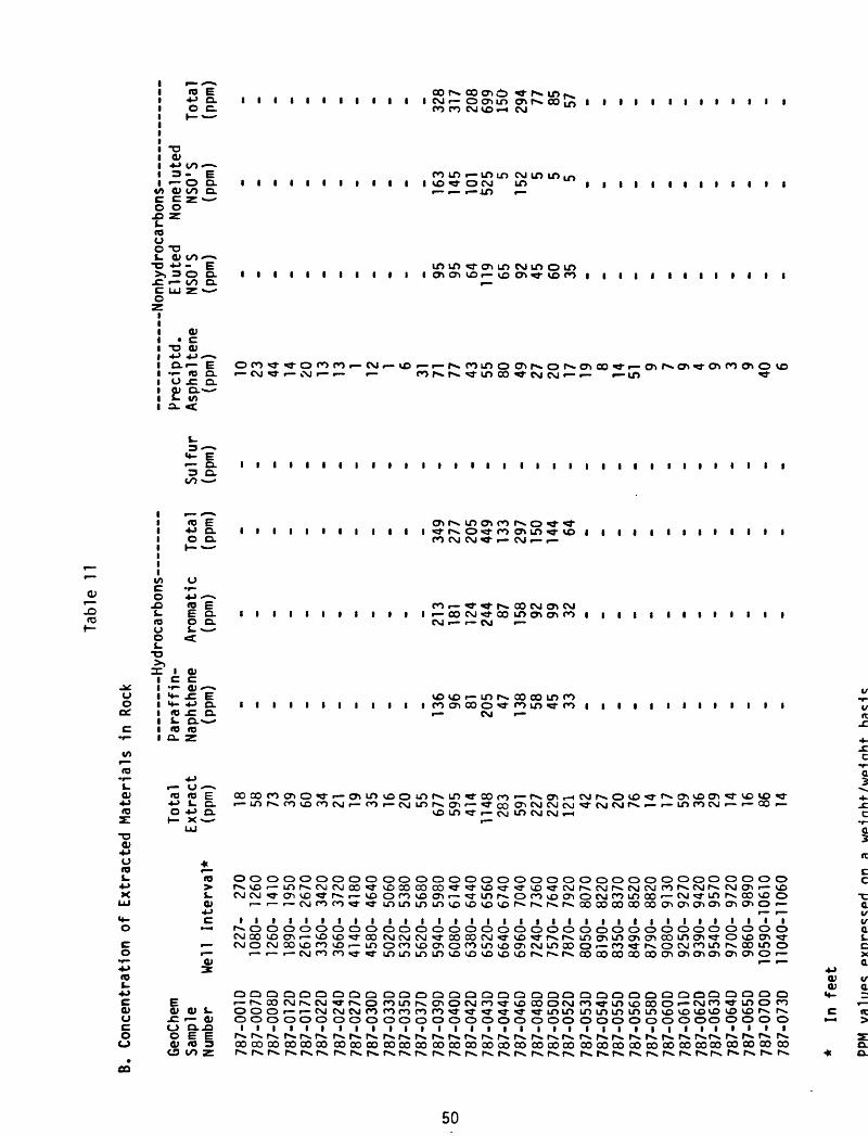
Tab
le
11
B.
Conce
ntr
atio
n of
Ext
ract
ed
M
ate
rials
in
R
ock
Geo
Che
m
Sam
ple
Num
ber
Wel
lIn
terv
al*
787-
0010
787-0070
787-0080
787-
0120
787-0170
787-0220
787-
0240
787-0270
787-0300
787-0330
787-0350
787-
0370
787-0390
787-0400
787-042D
787-0430
787-0440
787-0460
787-0480
787-0500
787-0520
787-0530
787-
0540
787-055D
787-056D
787-0580
787-060D
787-0610
787-
0620
787-0630
787-0640
787-065D
787-070D
787-0730
227-
270
1080
- 12
6012
60-
1410
1890-
1950
2610
- 26
7033
60-
3420
3660-
3720
4140-
4180
4580-
4640
5020-
5060
5320-
5380
5620-
5680
5940-
5980
6080
- 61
406380-
6440
6520
- 65
6066
40-
6740
6960-
7040
7240-
7360
7570-
7640
7870
- 7920
8050-
8070
8190-
8220
8350-
8370
8490
- 8520
8790-
8820
9080
- 91
309250-
9270
9390
- 94
209540-
9570
9700
- 97
209860-
9890
1059
0-10
610
1104
0-11
060
18 58 73 39 60 34 21 19 35 16 20 55 677
595
414
1148 283
591
227
229
121 42 27 20 76 14 17 59 36 29 14 16 86 14
Total
Extract
(ppm)
18 58 73 39 60 34 21 19 35 16 20 55 677
595
414
1148 283
591
227
229
121 42 27 20 76 14 17 59 36 29 14 16 86 14
Para
ffin
-Naphthene
(ppm)
- - - - - - - - - - - 136 96 81 205 47 138 58 45 33 - - - - - - - - - - - - -
Arom
atic
(ppm
)
- - - - - - - - - - - 213
181
124
244 87 158 92 99 32 - - - - - - - - - - - - -
Tota
l(ppm)
» - - - - - - - - - - - 349
277
205
449
133
297
150
144 64 - - * - - - - - - - - - -
Sulfur
(ppm
)
«. - - - - - - - - - - - - - - - - * - - - - - -.
- . - . - - - - -
Prec
iptd
.Asphaltene
(ppm
)
10 23 44 14 20 13 13 1 12 1 6 31 71 77 43 55 80 49 27 20 17 19 8 14 51 9 7 9 4 9 3 9 40 6
Nonhydrocarbons
Eluted
Noneluted
NSO'
S NS
O'S
Total
(ppm)
(ppm)
(ppm
)
95 95 64 119 65 92 45 60 35
163
145
101
525 5
152 5 5 5
328
317
208
699
150
294 77 85 57
* In
fe
et
PPM
va
lue
son
a
wpin
ht/u/p
-fnhf-

Table
11 (Continued)
C. Composition
of E
xtra
cts
GeoChem
Samp
leNu
mber
787-001 D
787-007D
787-008D
787-01 2D
787-0170
787-0220
787-0240
787-0270
787-0300
787-
0330
787-0350
787-0370
787-
039D
787-
0400
787-042D
787-0430
787-
0440
787-0460
787-0480
787-050D
787-052D
787-0530
787-
0540
787-0550
787-0560
787-0580
787-
0600
787-
0610
787-0620
787-
0630
787-064D
787-
0650
787-070D
787-0730
Well In
terv
al
227-
270
1080-
1260
1260-
1410
1890
- 1950
2610
- 26
7033
60-
3420
3660-
3720
4140-
4180
4580-
4640
5020-
5060
5320-
5380
5620-
5680
5940
- 5980
6080-
6140
6380-
6440
6520
- 65
6066
40-
6740
6960-
7040
7240
- 7360
7570
- 7640
7870
- 79
2080
50-
8070
8190-
8220
8350
- 83
7084
90-
8520
8790-
8820
9080-
9130
9250-
9270
9390
- 94
2095
40-
9570
9700
- 97
2098
60-
9890
1059
0-10
610
1104
0-11
060
Hydrocarbons
Paraffin-
Nap
hthe
ne
Aro
ma
tic%
% P
N/A
rom
Sulfur
N
on
hyd
roca
rbo
ns
Elu
ted
Non
elut
ed
NSO
'S
NSO
'S
20.1
16.1
19.6
17.9
16.5
23
.42
5.7
19.8
30.0
31
.530.5
30
.02
1.2
30
.62
6.8
40
.443.0
26.1
0.6
40
.53
0.6
50
.84
0.5
40
.87
0.6
40
.46
1.03
14.0
15.9
15.5
10.3
22.9
15.6
19.9
26.2
28.7
24.0
24.4
24.4
45.8
1.8
25.8
2.2
2.3
4.3
ecip
itd
.ip
halte
ne
%
57.1
40
.06
0.0
35
.533.3
37.5
60
.07.
13
3.3
9.1
29 A
55.6
10.4
13.0
10.4
4.8
28
.28
.311.8
8.7
13.9
44
.43
0.0
71.4
66
.26
3.6
38.5
16
.01
0.3
30.4
18
.257
.146.4
HC
'S
Asp
h/N
SO
%
. .
- - - - - - - - - - - 0.2
7
51
.60
.32
4
6.6
0.2
6
49
.60.0
9
39.1
1.14
4
7.1
0.2
0
50
.30
.53
66.2
0.31
62.8
0.4
2
53
.0. - - - - . - - . - - -
HC
/Non
HC
1.07
0.8
70.
980.
640.
891.
011
.96
1.69
1.13
41.7
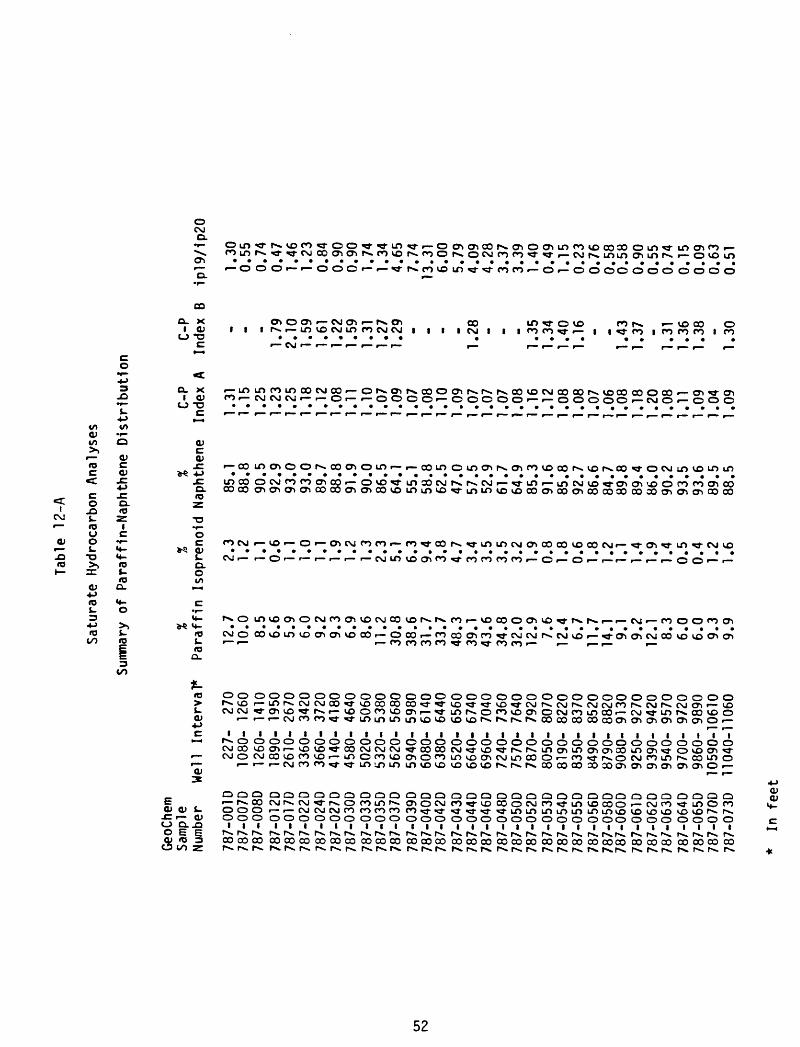
Table
12-A
Saturate H
ydrocarbon A
nalyses
Summary
of P
araffln-Naphthene
Distribution
GeoC
hem
Samp
leNumber
787-
001 D
787-
0070
787-0080
787-
01 2D
787-
01 7D
787-022D
787-024D
787-
027D
787-030D
787-033D
787-
035D
787-0370
787-039D
787-040D
787-
042D
787-043D
787-
0440
787-
046D
787-0480
787-0500
787-0520
787-0530
787-0540
787-0550
787-
0560
787-0580
787-0600
787-0610
787-
0620
787-0630
787-
0640
787-0650
787-0700
787-
0730
Well In
terv
al*
227-
270
1080-
1260
1260
- 1410
1890-
1950
2610
- 26
703360-
3420
3660-
3720
4140
- 41
8045
80-
4640
5020
- 5060
5320-
5380
5620
- 56
805940-
5980
6080-
6140
6380-
6440
6520-
6560
6640-
6740
6960-
7040
7240-
7360
7570-
7640
7870-
7920
8050
- 80
708190-
8220
8350-
8370
8490-
8520
8790
- 88
2090
80-
9130
9250-
9270
9390-
9420
9540
- 95
709700-
9720
9860-
9890
1059
0-10
610
1104
0-11
060
%Paraffin
12.7
10.0 8.5
6.6
5.9
6.0
9.2
9.3
6.9
8.6
11.2
30.8
38.6
31.7
33.7
48.3
39.1
43.6
34.8
32.0
12.9 7.6
12.4 6.7
11.7
14.1 9.1
9.2
12.1 8.3
6.0
6.0
9.3
9.9
%%
C-P
Isoprenoid N
apht
hene
Index
A
2.3
1.2
1.1
0.6
1.1
1.0
1.1
1.9
1.2
1.3
2.3
5.1
6.3
9.4
3.8
4.7
3.4
3.5
3.5
3.2
1.9
0.8
1.8
0.6
1.8
1.2
1.1
1.4
1.9
1.4
0.5
0.4
1.2
1.6
85.1
88.8
90.5
92.9
93.0
93.0
89.7
88.8
91.9
90.0
86.5
64.1
55.1
58.8
62.5
47.0
57.5
52.9
61.7
64.9
85.3
91.6
85.8
92.7
86.6
84.7
89.8
89.4
86.0
90.2
93.5
93.6
89.5
88.5
1.31
1.15
1.25
1.23
1.25
1.18
1.12
1.08
1.11
1.10
1.07
1.09
1.07
1.08
1.10
1.09
1.07
1.07
1.07
1.08
1.16
1.12
1.08
1.08
1.07
1.06
1.08
1.18
1.20
1.08
1.11
1.09
1.04
1.09
C-P
Index
B
_ .1.79
2.10
1.59
1.61
1.22
1.59
1.31
1.27
1.29 - _ - -
1.28 - . -
1.35
1.34
1.40
1.16 - «.
1.43
1.37 -
1.31
1.36
1.38 -
1.30
ip!9/1p20
1.30
0.55
0.74
0.47
1.46
1.23
0.84
0.90
0.90
1.74
1.34
4.65
7.74
13.31
6.00
5.79
4.09
4.28
3.37
3.39
1.40
0.49
1.15
0.23
0.76
0.58
0.58
0.90
0.55
0.74
0.15
0.09
0.63
0.51
* In f
eet

*n oooooooooooooooooooooooooooooooooo ro ..................................ooooooooooooooooooooooooooooooooooc
w ooooooooooooooooooooooooooooooooooro ..................................CJ OOOOOOOOOOOOOOOOOOOOOOOOOOOOOOOOOO
O O O O O O r O CM O O r OOOOOOOOOOOOOOr OOOOOOO
cCM OOOCMr CMr r CMr r c OOOOr OOOr r r CMOOCMrOOr CMCMOr
»« ro ..................................CJ OOOOOOOOOOOOOOOOOOOOOOOOOOOOOOOOOO
oooinr-.ooo>rom«a-CMCMr Or or oocMrocM««-Or m«-............................. .....OOOOOOOOOOOOOOOOOOOOOOOOOOOOOOOOOO
O ooororoin«-roroincMro» Or ocMr r r cM>o-r «e-ororo«e-oromcM» f ro ..................................CJ OOOOOOOOOOOOOOOOOOOOOOOOOOOOOOOOOO
cri f CMf voor oor invoroocMr r r incMCM» ««-r>.ro«e-oinr».rooinc^r*.«e-roM CM .......................... ... .....
CJ OOOOr r r OOOOr OOOOOOOOOOOOOOOOOOOOOO
CO f CMr ro^CMCMr rovO'*voroCMCMCMr*.«o-«9-r «e-ooro«-r eriinr CMroinin» ro
CJ OOOOOr f OOOOr OOOOOOOOOOOOOOOOOOOOOO
OOOOr CMrOOOr OrOr OOOr r r OOr OOOr OOOOO» OO
vo cMOQvDr «« » invooocMCMor CMCMror cocyif ooror».cjorocM«CMinoocMr».r».CM . ........................ .^ ......CJ OOOf r COCOOr rOr «e-CMOr f CMCM» Or r f OOrOr OOOr f r Ocin vDC^ino'O'roo^'vors.invor^oovOinOO^j-rooinr^ooroinocroin CM«o-CMOom »* CM ..................................CJ Or r rorOVOVOr CM^-CMVDrOi CMCM'O-'O-rOCMCMrOCMr CMinCMr Or
c « roO « CM .
ift T- cj f 01 *-> c:
>, ^3 ro rovocccMCTiOOoooorOf crvCMororors.rs.cyiOtf>oooooOr r «e-rs.CJO«3-ocjOcyiinr».r -r- fe«CM*o t- Oc *> c
<C tom -r- CM rorocMroinoocMvocMOinvoroc^r vo^r*.cyiO^oovocMOOinvoocMOcyiinr CM
C O »*CM .................................. o «_> vDCTicrtr r*.r*.Of^oOoor*-cyioovooOf^.crtfnoocoinof^rofyiOcyir*.f^.oo» CMCMOO(N^ac c ,_,_ _ ,_ ,_ ,_ ^_ ,_
1C <4- r CMOr r rOinOOr ^-CTir*.CMr^r COr ^-vDCTl'3'CMCJOCyi'O-CMinr rs.VDr CTl«O-r OOo <«- «CM ..................................
CD o re o r ro«-x>crtcoc^cr>c^3Ococ^3O30crt^ooc^O3OCMOOinor r Or r *3-inc^o, r r ^- l_ r w ^^^ ^^^ __ ^^^ ^^ ^ __ T -__ j, .,- __ __ ^ _ _ .^ ^p..
-Q TJ «T3ITS >, o. O vDinOvovDCMroooooror^inoor*-cMroOOinr^.inr cor r^.f Z XCM .........................
D <_) rOinvDvOr CTlOCMr OOOOOOCOOO' r Or r «3-r rs.i
10 »- C* ocMr uic^oD^vDr ^-r cMrs.voroororoOr CMOOOr*.or^vooorocyir*.oinrs.I. r >fi r ..................................3 us O inr^r^-vooOr in^-r rooooooOO' < CM
r r
O vOr ^rovDCMOOC^oOcyi'*invDVDinrovD«e-r ororor^QO^-r oor*.inCMinrs.r CM ..................................c. vor^vO
oo oocMOr ....................
^-rs-oor^-cyir ooo>
CL OOCO^ r- r- r CM
r-. invooooocMCTioOr cMOlnoroln^s.^JOO*3 « o^ors ^O^^vDCMr^ro« r CMCMCTIr ..................................
.r ovoinCr r
VO VDCM^CMOf^r f^r-»«3-O«3-CTiCMCyir roinr 01" ^DCTtCMOO' r*-00' rOCMCMi « r ..................................<_> ^-oooror or CMrocMCM^-rovOcyiinLnf^.vDr^ovOOCMOO' r oOr o
in c^ror ror r r r CMincMvDv£>CMOinr r , «3-ooocMLnror roror incMr r r ..................................CJ OOOOOOOOOOOO^-CMVOrs-CMrom^CMi r OOOOOOOOOOOc
OOOOOOOOOOOOOOOOOOOOOOOOOOOOOOOOOO
C I I I I I I I I I I I I I I I I I I I I I I I I I I I I I I I I I I t-sOOOOOOOOOOOOOOOOOOOOOOOOOOOOOOOOO'
QOOQOOOOOOOOOOOOQOOCIOOCIOOOOOOOOOOO
U OOOr r o; OOOOOOOOOOOOOOOOOOOOOOOOOOOOOOOOOO.O I I I I I I I I I I I I I I I I I I I I I I I I I I I I I I I I I I "^ '
> ooooaoaoaoooaoaoaoooooooaoaooooocDooooooooaoooaoaoaoaoooaoaoooooaooo*
53

Table 13
Visual Kerogen Assessment Worksheet
TYPE OF
ORGANIC
COLOR OFMATTER
STATE OF
ORGANIC MATTERDEPOSITIONAL
VIRONMFNTMATURATION INDEX
MATTER ORGANIC
2 or more maturation pop ~2I to 20% Ulati °nS
20% to 45S
45% to 802 BOX 4
W;H;Am (Al)-C
W;C;Am (Al)-H
W;Am (AI)-.H (C)
W;Am A1)-C;H
W;Am(Al)-H-C;
Wr.CitiAm.-H W-C;-;Am-H
W-C ;^ W-C;Am;H
* Mineral charcoal in sampl<
54

Table 14
Vitrinite Reflectance Summary
GeoChem Sample Number
787-008D
787-024D
787-030D
787-035D
787-040D
787-042D
787-044D
787-046D
787-048D
787-050D
787-052D
787-054D
787-056D
787-060D
787-063D
787-065D
Depth (feet)
1260-1410
3660-3720
4580-4640
5320-5380
6080-6140
6380-6440
6640-6740
6960-7040
Population
Population
Population
7240-7360
7570-7640
Population
Population
Population
7870-7920
8190-8220
8490-8520
9080-9130
9540-9570
9860-9890
Number of
Readings
*
40
*
*
40
44
40
43
1 2
2 16
3 25
40
47
1 4
2 11
3 32
28
41
*
*
*
*
Minimum Reflectance (X Ro)
-
0.33
-
-
0.90
0.80
0.74
0.74
0.74
1.14
1.63
0.49
0.27
0.27
0.69
1.00
1.15
1.56
-
-
-
-
Maximum Reflectance (X Ro)
-
0.96
-
-
1.29
1.42
1.41
2.14
0.96
1.54
2.14
1.52
1.94
0.42
0.99
1.94
1.80
2.26
-
-
-
-
Average Reflectance (% Ro)
-
0.65
-
-
1.09
1.18
1.17
1.40
0.85
1.34
1.89
1.07
0.99
0.35
0.87
1.52
1.56
1.95
-
-
-
-
Note:* Insuffient kerogen return to prepare plug.
55

APPENDIX 3
Analytical Data on Maturity of Coal Samples
Alaska Peninsula Coals
Item
Pan Am
1
2
3
4
5
6
7
Pan Am
8
9
10
Pan Am
11
12
13
14
15
16
Depth Fm. Organic Interval Carbon
(ft.) wt. %
Hoodoo Lake No.
1,220-50
1,940-70
3,440-70
4,430-90
5,840-70
7,460-90
8,030-40
Hoodoo Lake No.
5,620-40
6,780-6,800
7,580-90
David River No.
4,220-50
7,220-30
8,490-8500
9,660-70
10,240-40
12,240-50
1
54.6
58.4
47.0
58.8
51.3
36.8
59.3
2
40.1
49.1
76.6
1-A
43.2
63.0
13.4
59.4
13.8
0.25
Pyrolytic HC yield
wt. %
9.34
7.35
5.17
6.82
2.84
4.30
10.37
6.96
5.76
7.79
9.59
14.97
0.39
7.95
2.66
Volatile HC content
ppm
n.d.*
ii
ii
ii
ii
n
ii
4,230
7,500
5,250
5,260
9,090
200
9,870
1,830
Pyrol. HC Org. Carbon
%
17.1
12.6
11.0
11.6
5.54
11.7
17.5
17.4
11.7
10.17
22.2
23.4
2.9
13.4
19.3
Tmax °C
399
395
391
393
455
458
453
490
509
511
455
453
481
506
478
Cities Service Painter Creek No. 1
17 1,018-19 29.1 4.41 830 15.2 489
56

APPENDIX 3 (continued)
Depth Fm. Organic Interval Carbon
Item (ft.) wt. %
AMOCO Cathedral River No. 1
18 9,400-10 7.5
19 12,200-10 5.7
20 14,100-10 1.5
Pyrolytic HC yield
wt. %
4.76
2.45
0.34
Volatile HC content
ppm
17,380
1,690
no
Pyrol. HC Org. Carbon
%
63.5
(40.3)
TmaxQC
471
461
467
*n.d. = no data
Data supplied by George Claypool, U.S. Geological Survey, Denver, Colorado
57
APPENDIX 4
Thin Sections
All thin sections are grain mounts of representative grains selected from bags of washed cuttings except core chips denoted by C after depth.
Cities Service Painter Creek No. 1500-530 SS & SLST., Volcaniclastic.
1035-1036 Cgl. with clasts of vfg basalt and andesite. 1037-1038 SS, Volcanolithic subwacke, laumontite? vein filling. 1310-1340 Cgl. - With alt. basalt & andesite, granodiorite, stretched
metachert.1700-1710 SS - Qtz. & chert & aphanitic voles.,SLST. 2700-2710 Cgl. - Alt. basalt, granodiorite, qtz-hbl. schist, epidote
granulite.3940-3950 Cgl. - as above. 3980-3990 Cgl. - as above.5340-5350 Cgl. - alt. basalt & diabase, granodiorite & gabbro, vole. SS. 6050-6060 Cgl. - chert, qtzite, granodiorite, alt. mafics?, rare SS. 6070-6080 Cgl. - as above: higher % of alt. mafic voles. 7000-7010 Cgl. - mafic voles, alt. to Ab-Ep; granodiorite, jadeitized
sed. rocks?7410-7420 Cgl. - Alt. voles.;chert, qtzite, lithic subwacke SS. 7800-7810 Cgl. - Alt. voles. & granodiorite; jadeite granulite, chlorite-
prehnite bearing porphyry.
Gulf-AlaskaGO Port Heiden No. 111,833-34 C Lt. gray alt. dacite microbreccia or crs. sandy tuff. 11,955-56 C Alt. vfg vesicular dacite porphyry. 15,000-01 C Hbl. - qtz. diorite, med. grd., equigranular. 15,014-15 C Hbl. - Biot. qtz. diorite, slightly altered.
Gulf Sandy River Federal No. 111,681-11,686 C SS - Qtz. - lithic arenite (liths. = chert, slst. & vole.
porph.).12,100-13,105 C SS - Qtz. lithic subwacke, heulandite? cement. 13,003-13,009 C SS - med. grd.feldspathic arenite, minor qtz. & vole, liths. 13,009-13,015 C Mudstone, v. dark gray, sheared, w/calcite veins.
Pan American Hoodoo Lake No. 11040-1070 SS and SLST., tuffaceous matrix, angular plag., pumice and
glass shards.3140-3170 SS and SLST., as above but contains rare diatoms. 4190-4220 Loose sand grains; Qtz., chert, plag., qtzite, vole, porph.,
garnet, m'cline, biot., brn.- hbl., slst.
Pan American David River No. 1A3270-3480 SLST. - Dark brown, rare rounded sand-size qtz. grains.4410-4740 SLST. - As above, carbonaceous; rare med. grd. vole. lith. SS.6750-7100 SS - silty, v.f.g. to med. grd.; some tuffaceous matrix.7220-7500 SLST. - sandy, abundant carbonaceous laminae.7950-8000 SS, f-med. grd., vole, liths.>Qtz.>chert, (vole. lith. arenite)9320-9330 SS - Albitized, chloritized volcano-lithic arenite.
58

APPENDIX 4 (continued)
Pan American David 10,680-10690 11,640-11,710 11,740-11,750 11,880-11,890 11,980-11,990 12,120-12,130 12,210-12,220 12,870-12,880 13,350-13,360 13,430-13,440
River No. 1ASLST. - dark brown, laminated, carbonaceous.SS - med. - crs. grd.; chert>plutonic liths.>qtz., CO3 cement.SLST. - It. brn., carbonaceous>SS, feldspathic-volc. lith. wackSS - crs. - v. crs. grd., Qtz.>plag.>chert>volc. liths.SS - as above, recrystallized qtz. cement & abundant zeolites.Sandy SLST - carbonaceous; probably vole, derived.SS crs. - v.crs. grd., plag.>volc. liths>qtz., chloritic cementSLST. - and f. grd. SS; strongly sericitized.Sandy SLST. - brownish green chlorite?, vole, derived.SS, similar to 12,210-12,220.
AMOCO Cathedral River No. 1690-700 Sandy SLST. - massive, quartzofeldspathic.2800-2810 SS - med. grd., arkose w/grn. hbl. laumontite veins & cement.3700-3710 Sandy SLST. - same as 690-700.4900-4910 SLST. - gray, massive; SS-v.f.g., arkosic wacke and arenite.5500-5510 SS - f. grd., feldspathic wacke, angular grains.7400-7410 SS - f. grd., volc.-lithic feldspathic wacke, abund. hbl. & Cp*7600-7610 SS - same as 7400-7410; lithics altering to clay minerals.8600-8610 Calcareous mudstn. - sandy, dark brown, carbonaceous.
11,690-11,700 Sandy mudstn. - carbonaceous laminae.13,300-13,310 SS - volcanolithic subwacke & pebble cgl.; sparry CO3 veins.14,290-14,300 Mixed liths. - sandy calcarenite, lam. carbonaceous SLST.,
calcareous arkosic SS.
Pan Am Hoodoo Lake No. 21980-2010 4480-4680
7510-76008100-8200
10,210-10,22010,480-10,49011,240-11,243
SS - well sorted, med. grd., fspathic-vole 1 lithic subwacke. SS - mostly basaltic lithic frags., various grain sizes,
subwacke texture.SS - well sorted, f. grd., volcanolithic wacke & subwacke. SS - volcaniclastic, with abund. CO3 matrix, basalt, diabase. Diabase & SS/med. to f. grd., qtz.-feldspar arenite, SLST. Diabase, gabbro, rare sandy SLST., and arkose SS. (T.D.) Tightly packed arkosic SS, SLST., diabase, rare basalt.
grd.
Abalt.biot.ccgl.C03Cpxcrs.Ep.hbl.liths.m'clineqtz.qtzitesed. rxs.SLST.SSvfg.vole. SS
Abbreviation Key
albitealteredbiotitecore sampleconglomeratecalciteclinopyroxenecoarse grainedepidotehornblendelithic or rock fragmentsmicroclinequartzquartzitesedimentarysiItstonesandstonevery fine grainedvolcaniclastic sandstone
59

APPENDIX 5
Paleontology
Sample intervals (in feet)
Cities Service Painter Creek No. 1 1800-1810 Barren 2280-2310 Barren
Gulf, Sandy River Federal No. 1 11,686-11,691 Barren
Pan Am, Hoodoo Lake No. 12590-2840 Barren4010-4180 Barren
Section-Township-Range (Seward Meri-dian)
14-35S-51W
10-46S-70W
21-50S-76W
Pan Am, Hoodoo Lake No. 1519-1710 1710-1830 2100-2250
3690-3930
54 DO- 5800- 6600- 7510- 7680-
Age:-5600-6000-6800-7700-7690
Age:8350-8540 8650-8660 9480-9490 9900-9910
11,090-11,100
Pan Am David River No. 3270-3480
4410- 6750- 7270- 9000-
11,290- 12,110- 12,370- 12,970- 13,ISO- 13,290- 13,360-
13,650-
474071007500910011,30012,12012,38012,98013,19013,30013,37013,660
2 35-50S-76W Barren BarrenBATHYSIPHON sp. Sponge Spicules ELPHIDIUM CALIFORNICUM Cook GLOBOBULIMINA PACIFICA? Cushman Probably Early Tertiary Barren Barren Barren BarrenELPHIDIUM CALIFORNICUM Cook Diatom (pyritized) Probably Early Tertiary Barren Barren Barren Barren Barren
1-A 12-50S-80W Plant and wood debris Bivalve fragments Coaly Coaly Barren Barren Barren Barren Barren Barren Barren Barren Barren Barren
60
APPENDIX 5 (continued)
AMOCO Cathedral River No. 1 29-51S-83W100-1000 Barren1100-1930 Barren3700-4700 Barren6500-7400 Barren8600-9600 Barren9700-10,600 Barren
10,700-11,700 Barren11,800-12,800 Barren12,900-14,000 Barren14,220-14,300 Barren
Palynomorphs
Cities Service Painter Creek No. 1 1800-1810
ALNUS MOMIPITES
2280-2330MOMIPITES NYSSAEPOLLENITES
Age: Paleocene or Eocene
Gulf Sandy River Federal No. 1 11,686-11,691
LARIX/PSEUDOTS UGA PICEA PINUS TSUGA ALNUS BETULA PTEROCARYA
Age: Neogene, probably from Bear Lake Formation
Pan Am Hoodoo Lake No. 1 2590-2840 feet
LARIX/PSEUDOTSUGAPICEAPINUSTSUGATaxodiaceae/CupressaceaeALNUSBETULAULMUS/ZELKOVACENTROSPERMAELONICERACyperaceae
4010-4180 feetPICEAPINUSTaxiodiaceae/CupressaceaeTSUGAALNUSBETULAPIEROCARYA
Cypearaceae
61
APPENDIX 5 (continued)
Pan Am David River 1-A (continued) 6750-7100 feet
PICEAPINUSTaxodiaceae/CupressaceaeALNUSBETULAFAGUScf. QUERCUSPTEROCARYAILEX
9000-9100 feet - Pollen sparse PINUS TSUGA? ALNUS CARYAcf. QUERCUS
Age: 3270-9100 feet Eocene? Tolstoi or possibly Stepovak Formation
11,290-11,300 feetPICEA ALNUS CARYA PTEROCARYA MOMIPITES TILIAEPOLLENITES PISTILIPOLLENITES
Age: Early to middle Eocene
12,110-12,120 Barren12,370-12,380 Barren12,970-12,980 Barren13,180-13,190 Barren13,290-13,300 Barren13,360-13,370 Barren13,650-13,660 Barren
62
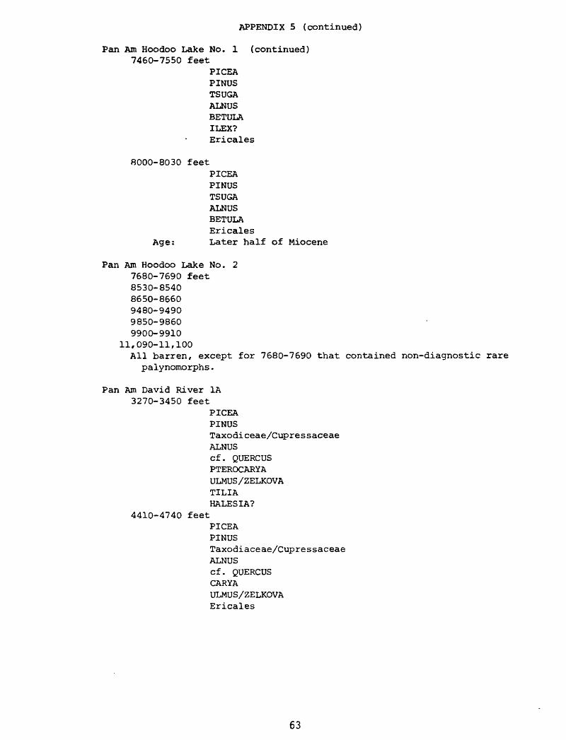
APPENDIX 5 (continued)
Pan Am Hoodoo Lake No. 1 (continued) 7460-7550 feet
PICEAPINUSTSUGAALNUSBETULAILEX?Ericales
8000-8030 feetPICEA PINUS TSUGA ALNUS BETULA Ericales
Age: Later half of Miocene
Pan Am Hoodoo Lake No. 2 7680-7690 feet 8530-8540 8650-8660 9480-9490 9850-9860 9900-9910
11,090-11,100All barren, except for 7680-7690 that contained non-diagnostic rare
palynomorphs.
Pan Am David River 1A 3270-3450 feet
PICEAPINUSTaxodiceae/CupressaceaeALNUScf. QUERCUSPTEROCARYAULMUS/ZELKOVATILIAHALESIA?
4410-4740 feetPICEAPINUSTaxodiaceae/CupressaceaeALNUScf. QUERCUSCARYAULMUS/ZELKOVAEricales
63