transport report - home - ntepa | ghd | report for arafura resources limited - nolans project...
TRANSCRIPT

Appendix V
V
volume four
Arafura Resouces Ltd
TransportReport
Nolans Environmental Impact Statement

Arafura Resources Limited
Nolans Project Environmental Impact Statement Appendix V: Transport Report
May 2016


Disclaimer
This report has been prepared by GHD for Arafura Resources Limited and may only be used and relied on by Arafura Resources Limited for the purpose agreed between GHD and the Arafura Resources Limited as set out in section 1.2 of this report.
GHD otherwise disclaims responsibility to any person other than Arafura Resources Limited arising in connection with this report. GHD also excludes implied warranties and conditions, to the extent legally permissible.
The services undertaken by GHD in connection with preparing this report were limited to those specifically detailed in the report and are subject to the scope limitations set out in the report.
The opinions, conclusions and any recommendations in this report are based on conditions encountered and information reviewed at the date of preparation of the report. GHD has no responsibility or obligation to update this report to account for events or changes occurring subsequent to the date that the report was prepared.
The opinions, conclusions and any recommendations in this report are based on assumptions made by GHD described in this report. GHD disclaims liability arising from any of the assumptions being incorrect.
GHD has prepared this report on the basis of information provided by Arafura Resources Limited and others who provided information to GHD (including Government authorities), which GHD has not independently verified or checked beyond the agreed scope of work. GHD does not accept liability in connection with such unverified information, including errors and omissions in the report which were caused by errors or omissions in that information.


Glossary
Term Description REO Rare earth oxides
EMPP Effective mine production period AADT Average annual daily traffic GWA Genesee Wyoming Australia (rail operator between Tarcoola (SA)
and Berrimah (NT) ARTC Australian Rail Track Corporation TEU Twenty-foot equivalent container unit ISO International Standards Organisation size tanks FIFO Fly-in/fly-out BIBO Bus-in/bus-out vpd Vehicles per day vph Vehicles per hour BAL Basic auxiliary left (turn treatment) BAR Basic auxiliary right (turn treatment) NB North Bound SB South Bound


GHD | Report for Arafura Resources Limited - Nolans Project Environmental Impact Statement | i
Table of contents
1. Introduction..................................................................................................................................... 1
1.1 Overview .............................................................................................................................. 1
1.2 Purpose of this report........................................................................................................... 1
1.3 Methodology ........................................................................................................................ 1
2. Existing conditions ......................................................................................................................... 2
2.1 Road network ....................................................................................................................... 2
2.2 Rail network ......................................................................................................................... 4
2.3 Sea transport ....................................................................................................................... 7
2.4 Air transport ......................................................................................................................... 7
3. Proposed development .................................................................................................................. 8
3.1 Overview of the project ........................................................................................................ 8
3.2 Location and vehicle access ................................................................................................ 8
3.3 Consumables ....................................................................................................................... 8
4. Impacts on the road and rail network ........................................................................................... 10
4.1 Projected road traffic volumes ........................................................................................... 10
4.2 Traffic impacts on the road network ................................................................................... 13
4.3 Impacts on rail freight services .......................................................................................... 15
5. Mitigation of impacts .................................................................................................................... 19
5.1 Overview ............................................................................................................................ 19
5.2 Nolans site access from the Stuart Highway ..................................................................... 19
5.3 Rail freight impacts ............................................................................................................ 20
6. Summary and conclusions ........................................................................................................... 21
Table index
Table 1 2014 AADT survey volumes within study area .................................................................... 4
Table 2 Overview of mine site consumables .................................................................................... 8
Table 3 Trip generation from delivery of mine site consumables ................................................... 11
Table 4 Daily trip generation from site ............................................................................................ 12
Table 5 Projected background AADT volumes ............................................................................... 13
Table 6 Peak hour trip generation .................................................................................................. 13
Table 7 Comparison of overall peak hour volumes ........................................................................ 14

ii | GHD | Report for Arafura Resources Limited - Nolans Project Environmental Impact Statement
Figure index
Figure 1 Study area and proposed access route from Alice Springs ................................................. 3
Figure 2 Alice Springs freight terminal area and surrounds ............................................................... 5
Figure 3 Berrimah(Darwin) Rail Terminal, Vopak Bulk Fuel Facility and East Arm Port ................... 6
Figure 4 General GWA intermodal growth ....................................................................................... 17
Figure 5 GWA intermodal services including container and ISO tank transport .............................. 18
Figure 6 BAR and BAL treatments (reproduced from Austroads) ................................................... 20
Figure 7 Channelised turn treatments (reproduced from Austroads) .............................................. 20

GHD | Report for Arafura Resources Limited - Nolans Project Environmental Impact Statement | 1
1. Introduction
1.1 Overview
Arafura Resources Limited (herein referred to as Arafura) has commissioned GHD to undertake a transport study in relation to the proposed Nolans Rare Earths Project (Nolans Project) near Aileron, Northern Territory.
An open pit mine, concentrator, intermediate plant and related infrastructure are proposed to be constructed at the Nolans site, located approximately 135 km north of Alice Springs, NT. Construction would take up to 30 months, with rare earth oxide (REO) production and export to follow, and continue for an expected Effective Mine Production Period (EMPP) of 41 years.
Consumables required to facilitate the mining and processing of REO will be imported to the site from Darwin via Alice Springs using the Adelaide-Darwin railway and the Stuart Highway. REO product will be exported from site to Darwin Port via Alice Springs, also using the Stuart Highway and the Adelaide-Darwin railway.
The railway is located approximately 65 km to the east of the Nolans site with limited direct roadway access and services. Access to rail services is more appropriate at Alice Springs terminal, with highway connection via the Stuart Highway for linking road services.
1.2 Purpose of this report
This report analyses the operational impacts of the Nolans project on the public road network and on rail freight services, and provides recommendations for mitigation where required.
1.3 Methodology
The following tasks have been completed as part of this study:
Review of existing conditions. While this focuses on road transport, rail, sea and air transport have also been examined.
Review of the proposed development in terms of location, access and the amount of material being imported and exported.
Assessment of the impacts on the road network. This includes an analysis of the amount of traffic the mine is expected to generate and how it will use the road network. Impacts are described in terms of reductions in spare capacity, based on published capacity guidelines.
Assessment of impacts on the rail network. This includes an examination of current rail services and the ability of the rail network to handle additional freight, together with an assessment of how existing services will be affected.
Selection of mitigation measures to offset or reduce the identified impacts. These are generally physical changes to the road network to enhance capacity and/or road safety.

2 | GHD | Report for Arafura Resources Limited - Nolans Project Environmental Impact Statement
2. Existing conditions
2.1 Road network
The Nolans site is approximately 135 km north of Alice Springs and 10 km west of the all-weather Stuart Highway.
2.1.1 Key roads within the study area
Key roadways within the study area are Whittaker Street, Smith Street and the Stuart Highway. A map of the study area is shown in Figure 1.
Whittaker Street
Whittaker Street comprises of two sections – an east-west undivided road that provides access to local traffic, and a north-south divided road which is the primary access to the Alice Springs freight rail terminal. Both sections have one lane in each direction and the default (i.e. not signposted) speed limit of 60 km/h applies.
Smith Street
Smith Street is a generally east-west single carriageway road with one lane in each direction. It is linked to the north-south section of Whittaker Street via a four-leg roundabout, which has a large overrun area for long vehicles in the central island. The east end of Smith Street connects with the Stuart Highway via an unsignalised T-junction, thereby forming the main route for vehicles accessing the Alice Springs freight terminal from the Stuart Highway. A default speed limit of 60 km/h applies to Smith Street.
Stuart Highway
Stuart Highway (National Route 1/National Route 87) is a national highway connecting Darwin, Katherine, Daly Waters, Tennant Creek, Alice Springs and Port Augusta in South Australia. Throughout the study area it is a sealed, approximately 7 m wide, generally two-lane single carriageway road with one lane in each direction. The maximum posted speed limit is 130 km/h, except for a 204 km section directly north of the Tanami Road intersection, where open speed limit trials commenced in 2014 and have since been made permanent. The intersection with the proposed site access will be located within this open speed limit section.
In Alice Springs, the Stuart Highway is a dual carriageway north of Smith Street through to Dixon Road. There are two lanes in the north bound direction until just north of Head Street, and two lanes in the south bound direction from Tietkens Avenue. At Dixon Road, the Stuart Highway reverts to a single carriageway, still with one lane in each direction, and remains in this configuration through to the site access at Aileron. From the city centre to Bitzer Road, the speed limit varies from 60 km/h to 70 km/h, gradually increasing to 110 km/h leaving Alice Springs. North of Tanami Road, the open speed limit zone commences as described above.

GHD | Report for Arafura Resources Limited - Nolans Project Environmental Impact Statement | 3
Figure 1 Study area and proposed access route from Alice Springs
2.1.2 Road closures
According to DoT records, for the years 2003 through 2014, the Stuart Highway between Tanami Road and Aileron was closed twice due to flooding. In both cases, the closure was in effect for less than 24 hours.
There is no practical alternative route between the Alice Springs and the Nolans site.
2.1.3 Traffic volumes
Traffic volumes are available from the Department of Transport (DoT) 2014 Annual Traffic Report (DoT, 2014). Annual average daily traffic (AADT) volumes at permanent counter locations have been collated for the study area road network.
Where there are multiple counting stations on one section of road, the highest traffic volume collected within each section has been reported. The existing traffic volumes in 2014 along each road section have been summarised in Table 1. These include both heavy vehicles and light vehicles.
The DoT does not currently maintain any permanent counting stations along Whittaker or Smith Streets, so no volumes are available for these short sections.
Average daily traffic volumes vary significantly along the Stuart Highway, ranging from 13,522 vehicles per day (vpd) in Alice Springs to 381 vpd near Aileron roadhouse.

4 | GHD | Report for Arafura Resources Limited - Nolans Project Environmental Impact Statement
Table 1 2014 AADT survey volumes within study area1
Survey Location AADT Volumes (vpd) (2014)
Whittaker Street Unknown
Smith Street Unknown
Stuart Highway, between Smith Street and Woods Terrace 13,522
Stuart Highway, between Dixon Road and Sargent Street 6,974
Stuart Highway, 3.0 kilometres north of Alice Springs 978
Stuart Highway, 1.5 kilometres north of Tanami Rd 608
Stuart Highway, 8 kilometres north of Aileron Roadhouse 381
2.2 Rail network
Genesee Wyoming Australia (GWA) operates the rail corridor from Tarcoola (SA) to Berrimah (Darwin) under long term lease agreement with the AustralAsia Railway Corporation who are the government owners of the infrastructure. GWA maintain and operate the track and also provide rail access to other rail companies, including the Great Southern Railway. GWA also operate regular freight trains on the network.
At Tarcoola, the rail corridor connects with the Adelaide to Perth interstate rail corridor operated by the Australian Rail Track Corporation. The rail corridor north of the connection at Tarcoola is a single line with passing loops at various intervals relative to the demand requirements on the corridor.
Through traffic from Adelaide to Darwin and return includes the intermodal containerised freight service operated by GWA six days a week and the Ghan tourist train one or two times weekly (seasonal). Mining trains carrying NT bulk mining outputs to ports in South Australia or to Darwin Port.
A number of regular mining trains have run on the network over recent years although recent changes in commodity prices have currently resulted in a reduction of services. There is currently significant capacity available on the corridor as a result.
GWA access information indicates freight train access is available with axle weight capacities as follows:
Northgate (SA) to Alice Springs: 21 tonne axle load up to 110 km/h
Alice Springs to Darwin (NT) 23 tonne axle load up to 115 km/h.
The rail line provides access to the intermodal facilities at the Alice Springs Freight Terminal (see Figure 2).
1 Source: Northern Territory Department of Transport Annual Traffic Report 2014

GHD | Report for Arafura Resources Limited - Nolans Project Environmental Impact Statement | 5
Figure 2 Alice Springs freight terminal area and surrounds
The rail corridor connects to the Port of Darwin at Berrimah with direct access onto port for unloading of containerised freight. Bulk unloading facilities are also available outside port environs although a further transport movement is required for loading to ship.
The northern end of the rail corridor at Berrimah (Darwin) is adjacent to the Port of Darwin East Arm Port facility which is the location of commercial port operations for containerised and bulk products (see Figure 3). The rail corridor connects from the rail terminal to the port past a bulk fuel terminal operated by Vopak (also relevant to the supply chain) and directly onto the port berths.

6 | GHD | Report for Arafura Resources Limited - Nolans Project Environmental Impact Statement
Figure 3 Berrimah(Darwin) Rail Terminal, Vopak Bulk Fuel Facility and East Arm Port
GHD | Report for Arafura Resources Limited - Nolans Project Environmental Impact Statement | 7
2.3 Sea transport
port facilities are located in Darwin (approximately 1430 km north of the Alice Springs Rail Terminal, which would be used as a rail connection) and in Adelaide (approximately 1570 km to the south of this location).
Shipping options are available with rail connectivity at both Darwin (East Arm Port) and Port Adelaide. The East Arm Port at Darwin can provide access for the movement of containerised products, bulk materials and liquid bulk through the adjacent Vopak bulk liquids terminal (see Figure 3).
2.4 Air transport
Alice Springs Airport is located approximately 145 km south of the proposed mine access road on Stuart Highway, just south of Alice Springs township. A large number of domestic flights depart from and arrive at Alice Springs Airport each day from capital cities and smaller regional airports in the NT.

8 | GHD | Report for Arafura Resources Limited - Nolans Project Environmental Impact Statement
3. Proposed development
This section discusses various aspects of the proposed development, including its location, land uses, and scale.
3.1 Overview of the project
Arafura Resources proposes to construct and operate an open pit mine, concentrator, intermediate plant and related infrastructure at the Nolans site. The resource is estimated to contain 706 000 tonnes (t) of measured and indicated rare earth ore, as well as 511 000 t of inferred REO, for a total of 1,217 000 t. Expected rare earth concentrate production from the site is expected to be 20 000 tonnes per annum (tpa) in a typical year.
Construction at the site would take up to 30 months, with production and export to commence in 2019 and continue for an EMPP of 41 years.
3.2 Location and vehicle access
The proposed site is located approximately 10 km to the west of the Stuart Highway at Aileron Station, NT. Access to the site will be restricted to authorised commercial vehicles only, via a newly constructed site access road connecting with the Stuart Highway approximately 5 km south of Aileron Roadhouse. The site access alignment currently exists as an unsealed track, which will be upgraded to a two lane two way sealed road during the construction phase of the project.
3.3 Consumables
The consumables required for ongoing operation of the mine consist primarily of fuels and chemical reagents. All of this material will be transported to the site by road from the Alice Springs Freight Terminal, having been shipped into Darwin Port and transported to Alice Springs by rail. For each consumable delivered, estimates of typical yearly consumption are presented in Table 2.
Note that an additional 136,974 tpa of limestone (or four additional vehicle trips per day) will be sourced from a quarry close to the site. As the transport of this material to the site will not be on public roads, it has been omitted from this assessment.
Table 2 Overview of mine site consumables
Consumable State Estimated annual consumption (tonnes)
CMC Solid 184
Grinding balls Solid 400
Oleic acid Liquid 1,284
F8920 Liquid 550
Sodium silicate Liquid 461
Diesel Liquid 4,992
MgO Solid 75

GHD | Report for Arafura Resources Limited - Nolans Project Environmental Impact Statement | 9
Consumable State Estimated annual consumption (tonnes)
Sodium Carbonate (Soda Ash) - Dense
Solid 10,650
Barium chloride (99%) Solid 22
Sulphur (solid) Solid 87,990
Hydrochloric Acid (32% Concentration)
Liquid 28,701
Flocculant Solid 268
Quicklime (CaO) Solid 29,992
Caustic soda (dry pill) Solid 26,442
Hydrogen Peroxide (50%) Liquid 1,364
Total - 193,375
10 | GHD | Report for Arafura Resources Limited - Nolans Project Environmental Impact Statement
4. Impacts on the road and rail network
4.1 Projected road traffic volumes
Information on construction traffic is not available at the time of writing. Therefore, this assessment focuses on the operational phase of the project only. Each of the operational aspects and their associated trip generation is discussed in the following sections.
4.1.1 Traffic generation
The site is expected to generate traffic as a direct result of the following operational aspects of the mine:
Imports of mine consumables/reagents to the site
Exports of REO product from the site
Transportation of workers to/from the site.
Import of consumables
Forecast yearly demands for consumables over the EMPP have been sourced from Arafura for the project.
An analysis has been carried out to determine the number of heavy vehicle return trips (Alice Springs to site to Alice Springs) generated as a result of consumables being delivered to the Nolans site.
While personnel transport vehicle movements are expected to be consistent from year to year, demand for some minor consumables is expected to fluctuate over the EMPP. The summary results presented in Table 3 are based on the following assumptions:
Each TEU Twenty-foot equivalent container unit (TEU) can carry 25 tonnes of solid consumables
Each International Standards Organisation size tanks (ISO) can carry 20 tonnes of liquid consumables
Quadruple road trains are to be used for each trip (i.e. 4 TEU/ISO per truck)
The mine site is operational for 365 days per year.
It is noted that the vast majority of the consumables required for the Nolans site are fixed quantities and do not vary over the EMPP. Accordingly, Table 3 shows that the number of TEU/ISO to be delivered to the site is forecast to remain relatively steady throughout the mine’s operational phase, fluctuating by less than one percent to a maximum rate of 8,126 TEU/ISO per annum. Consequently, the number of return trips generated is also relatively constant from year to year at around 2,000 annual trips, or 6 return trips per day.
For the purposes of this study, and the simplicity of subsequent calculations, it is both conservative and reasonable to assume a constant trip generation rate of 6 return trips per day as a result of consumable deliveries to the site. As a return trip consists of both an arrival and a departure, this amounts to 12 one-way trips on average per day.

GHD | Report for Arafura Resources Limited - Nolans Project Environmental Impact Statement | 11
Table 3 Trip generation from delivery of mine site consumables
Yearly ISO/TEU demand
Yearly return trip generation
Average return trips per day
Lowest demand (Year 1 )
7,994 1,999 6
Highest demand (e.g. Year 10 to 25)
8,126 2,032 6
Empty containers will be returned to their points of origin once delivery of imported materials is complete.
Exports of products
Arafura intends to export rare earth concentrates by road to Alice Springs freight terminal, where they will be transported to Darwin Port via freight trains. Incoming road trains delivering consumables to the site would normally return empty to Alice Springs, so it is likely that Arafura would make use of the available capacity on these returning road trains to transport rare earth concentrate.
The export of mine product from the site will be back-freighted in empty containers (used to import material to site) and therefore is not expected to generate any additional traffic.
Transportation of site workers
The operations workforce is expected to be in the range of 250-300.
Workers at the mine will be based on site in a 300-person accommodation village, and would rotate shifts according to a fly-in/fly-out (FIFO) or bus-in/bus-out (BIBO) roster. It is anticipated that FIFO workers will be flown into Alice Springs and taken by bus up to the mine site via the Stuart Highway. BIBO workers could come from a range of locations in the surrounding area, but generally no further away than Alice Springs.
An indicative breakdown of the workforce is as follows:
70% FIFO (for the purposes of this assessment this means they originate at Alice Springs, as that is where their road journey starts)
10% relocated interstate workers (Alice Springs based)
10% local (effectively Alice Springs based)
10% regional communities (based elsewhere in the NT).
Assuming that 10% of the 300 workers will be rotated each weekday (i.e. a full rotation occurs every fortnight), 30 workers will depart the site and 30 more will arrive at the accommodation site each day. This demand would likely require no more than two buses (one to service Alice Springs, one to service regional areas north of Aileron), resulting in four trips per day for the purpose of transporting workers to and from the site (i.e. two daily departures and two daily arrivals).
To provide a robust analysis, it is assumed that bus movements occur during the peak hour; however, in reality at least half of these will be timed to coincide with aircraft arrivals and departures at Alice Springs Airport (which may or may not occur during peak hour).
In addition to rostered employees, external contractors are expected to access the site in their own vehicles. These trips are expected to originate in or near Alice Springs and not exceed five arrivals and departures per day at the site. In instances when the accommodation village is fully

12 | GHD | Report for Arafura Resources Limited - Nolans Project Environmental Impact Statement
occupied, staff may stay at the Aileron Roadhouse, near the access road intersection with Stuart Highway.
Summary of trip generation
Table 4 summarises the daily trip generation resulting from the mine operations. Note that this includes only those trips made on the public road network. It does not include internal vehicle movements such as to and from the accommodation village or the limestone quarry.
Table 4 Daily trip generation from site
Trip purpose No. of daily trips
Imports of consumables (road train) 12
Exports of products (road train) 0 (refer section 4.1.1)
Transportation of site workers from Alice Springs (bus) 2
Transportation of site workers from north of Aileron (bus) 2
External contractors’ vehicles (small vehicle/4WD) 10
Total 26
4.1.2 Background traffic growth
Since development generated traffic is assumed to be constant over the EMPP, its impact in terms of proportional increase in AADT will be most apparent in the first year operation, reducing over subsequent years until the final year of operation i.e. Nolans’ traffic will not increase over time, but background traffic volumes will and therefore, as a proportion of total traffic, the Nolans contribution to traffic volume will represent less and less each year. On this basis, it is reasonable to consider the impact of the Nolans Project in its first year of operation, i.e. year 1, expected to be 2019.
The AADT volumes counted in 2014 along each road section in Table 1 have been extrapolated to 2019 in order to estimate the background traffic volumes (i.e. traffic volumes independent of the development). The annual growth rate used is the average historical increase observed between 2005 and 2014, according to the DOT 2014 Annual Traffic Report.
The escalation from surveyed 2014 AADT surveys to 2019 AADT projections is shown in Table 5, and includes both heavy and light vehicles.

GHD | Report for Arafura Resources Limited - Nolans Project Environmental Impact Statement | 13
Table 5 Projected background AADT volumes
Road section Annualised AADT growth (2005 –
2014)
Surveyed AADT volumes (2014)
Projected AADT volumes (2019)
Whittaker Street Unknown Unknown Unknown
Smith Street Unknown Unknown Unknown
Stuart Highway, between Smith Street and Dixon Road
0.29% 13,522 13,716
Stuart Highway, between Dixon Road and Sargent Street
3.21% 6,974 8,168
Stuart Highway, between Sargent Street and Tanami Rd
0.20% 978 988
Stuart Highway, between Tanami Rd and Aileron
1.76%* 608 663
*Permanent counter installed in 2011
4.1.3 Peak hour traffic volumes
In the absence of additional information, for the purposes of this analysis it is assumed that peak hour traffic volumes are represented by 10% of the daily volumes (truck movements) and 100% daily volumes of bus movements generated by the project.
Based on this assumption, the peak hour trip generation of the site is shown in Table 6.
Table 6 Peak hour trip generation
Trip purpose No. of daily trips Peak hour proportion
No. of peak hour trips
Imports of consumables 12 10% 2
Exports of products 0
(refer section 4.1.1)
10% 0
Transportation of site workers from Alice Springs
2 100% 2
Transportation of site workers from north of Aileron
2 100% 2
External contractors’ vehicles (assume from Alice Springs)
10 100% 10
Total (from Alice Springs) 26 (24) - 16 (14)
4.2 Traffic impacts on the road network
Austroads publishes guidance on the capacity of roads and traffic lanes (Austroads, 2009). The capacity of a traffic lane is expressed as a number of vehicles per hour (vph).

14 | GHD | Report for Arafura Resources Limited - Nolans Project Environmental Impact Statement
In uninterrupted flow conditions (such as those usually found on rural highways) a traffic lane can carry about 1,800 vph. In interrupted flow conditions (such as on urban arterial roads) a traffic lane can carry about 900 vph. On the basis of estimated capacity remaining in the road network in year 1, Table 7 compares outcomes both with and without the impact of the Nolans Project.
Table 7 Comparison of overall peak hour volumes
Road Section Capacity (vph)
Projected 2019 peak hour without Nolans
Project
Projected 2019 peak hour with Nolans
Project
Volume (vph)
Remaining capacity
Volume (vph)
Remaining capacity
Stuart Highway, between Smith Street
and Dixon Road*
NB 900 667 26% 674 25%
SB 900 705 22% 712 21%
Stuart Highway, between Dixon Road and Sargent Street
NB 900 472 48% 479 47%
SB 900 348 61% 352 61%
Stuart Highway, between Sargent Street
and Tanami Road
NB 1,800 31 98% 38 98%
SB 1,800 36 98% 43 98%
Stuart Highway, between Tanami Road
and Aileron
NB 1,800 18 99% 25 99%
SB 1,800 20 99% 27 99%
* Approximately 75% of this section has two lanes in one or both directions. To be conservative, the assessment has
been made on the one-lane section.
4.2.1 Within Alice Springs
The intersections of Smith Street/Stuart Highway and Smith Street/Whittaker Street, as well as Smith and Whitaker Streets themselves; are on an established truck access route into the Alice Springs Freight Terminal.
Table 7 shows that the Stuart Highway in Alice Springs is expected to have at least 25% spare capacity in year 1 with or without Nolans project traffic. While background traffic will continue to increase throughout the EMPP, traffic generated by the Nolans project will remain constant from year to year, gradually decreasing as a proportion of total traffic. Any necessary upgrades to the Stuart Highway in Alice Springs would be required regardless of the Nolans Project.
4.2.2 Stuart Highway (rural)
Although Table 7 shows that Nolans project traffic forms a more significant proportion (approximately 6%) of overall vehicles on the less trafficked sections of the Stuart Highway, it also demonstrates that the remaining capacity in these areas is abundant and therefore is not significantly impacted by the Nolans Project.
The number of vehicles generated by the mine during its operational phase is not significant. It is expected that the mine will have no significant adverse impacts on surrounding roads or intersections, both in terms of performance and road safety.

GHD | Report for Arafura Resources Limited - Nolans Project Environmental Impact Statement | 15
4.2.3 Other potential road impacts
Road surface conditions
To enable an assessment to be made of the potential impacts on the road surface of the Nolans project, a comparison would need to be made of the projected life of the pavement and how the additional vehicles generated by Nolans would affect this.
Road pavements are normally designed to withstand a certain number of heavy axle repetitions over a certain design life (e.g. 30 years). The addition of 26 vehicles per day over the EMPP is significantly less than that added by background growth in that time (depending on the section of Stuart Highway in question). Consequently, it is considered that the Nolans project will have a negligible impact on the condition of the road surface on Stuart Highway.
Access to emergency and other essential services
It is considered that the addition of 26 vpd (14 vph in the peak periods) would comprise an imperceptible increase in traffic volumes that would not limit the ability of members of the public to access essential services, or limit the ability of emergency services vehicles to access emergency situations.
Road closures
The expected frequency of road closures due to flooding (i.e. twice within an eleven-year period, for less than 24 hours) is considered not high enough to significantly affect the transport of materials and personnel to and from the site.
4.3 Impacts on rail freight services
4.3.1 Projected rail volumes
The Nolans project will bring in a range of products including:
bulk imported sulphur, sulphuric acid and reagents sourced internationally
quicklime sourced domestically at Mataranka (and transported by road to Katherine for rail loading).
These products are to be transported in intermodal containers or ISO tanks which can be handled with currently available rail resources and lifting equipment.
The volume of inbound traffic to be carried on the Darwin to Adelaide railway is approximately 8,850 TEU pa (twenty-foot equivalent containers) in total indicated as:
Quicklime - 1300 TEU, to be loaded at Darwin (if imported) or Katherine Intermodal Freight Terminal for transport to Alice Springs Freight Terminal
Bulk sulphur – 3900 TEU, to be containerised by the rail operator GWA at Darwin port or rail terminal and transported by rail to Alice Springs
Containerised reagents – 1650 ISO tanks, Darwin Port to Alice Springs
Containerised reagents and other – 2000 TEU, Darwin Port to Alice Springs.
There is no specific breakdown of the proposed flow of products at this stage, although the annual bulk sulphur is estimated to arrive in four shiploads assumed to be approximately three months apart. Storage of this product could be at the port or the project site, and a constant flow of products will generally fit with the use of common infrastructure and rail services on the railway. It is assumed product flows will be at a consistent level with some capability to ramp up or down to meet best transport opportunities.

16 | GHD | Report for Arafura Resources Limited - Nolans Project Environmental Impact Statement
The volume of the outbound material to be carried on rail is indicated to be approximately 8,950 TEU pa including outbound traffic to the East Arm Port in Darwin and empty containers returning to Darwin and Katherine for the next loads. As this total varies from the indicative incoming task there is likely to be some balancing of containers in line with the month by month task. This variance is minor (2 containers per week) and is not likely to alter the general level of demand or impacts. The outbound traffic is indicated as:
Empty quicklime containers – 1,300 TEU Alice Springs to Darwin for reloading
Empty sulphur containers – 3,900 TEU Alice Springs Freight Terminal to Darwin Terminal for reloading of bulk materials
Empty containers local supply – 50 TEU Alice Springs to Darwin
Intermodal containers – 3,700 TEU Alice Springs to Darwin Port including:
– RE intermediate – 2000 TEU
– Empty containers/ISO tanks 1,700 TEU.
4.3.2 Rail traffic generated by the project
Current planning includes the use of both bulk and containerised facilities at Darwin Port for import and export requirements. Port Adelaide provides a secondary or back up option, particularly for containerised products.
Rail transport is planned to utilise the existing intermodal services operated by Genesee Wyoming Australia between Darwin (Berrimah) and Alice Springs, with sufficient capacity to carry the planned demand.
The planned demand comprises containerised freight including tank containers, applied on a weekly or daily demand basis for the Nolans project represents:
151 Inbound TEU from Darwin to Alice Springs weekly or 22 TEU daily
26 Inbound TEU from Katherine to Alice Springs weekly or 4 TEU daily
151 outbound TEU from Alice Springs to Darwin weekly or 22 TEU daily
26 outbound TEU from Alice Springs to Katherine weekly or 4 TEU daily.
4.3.3 Rail capacity
Genesee Wyoming Australia (GWA) operates the Tarcoola to Darwin Railway and its intermodal (container) trains from Adelaide to Darwin operate across Australian Rail Track Corporation territory from Adelaide to Tarcoola.
The GWA container trains operate 6 days a week to Darwin with return journeys on alternative days. The northern loadings from Adelaide to Darwin are quite high but vary according to days of the week and times of the year. The southbound loadings from Darwin to Adelaide include a number of empty containers and significantly lower tonnages and allow capacity to cater for many of the needs of the Nolans Project.
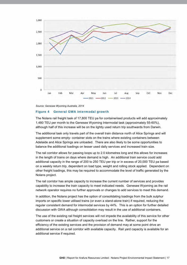
Intermodal traffic on the line continues to grow and the figure below provides information on the general trends of containerised traffic.
Figure 4 shows significant growth trends over recent years, resulting in additional services being applied to the intermodal task with the number of daily services increased from 5 trains to 6 trains per week. GWA is prepared to employ an additional train on Sundays (or other days) if demand increases.
GHD | Report for Arafura Resources Limited - Nolans Project Environmental Impact Statement | 17
Source: Genesee Wyoming Australia, 2014
Figure 4 General GWA intermodal growth
The Nolans rail freight task of 17,800 TEU pa for containerised products will add approximately 1,480 TEU per month to the Genesee Wyoming Intermodal task (approximately 55-60%), although half of this increase will be on the lightly used return trip southwards from Darwin.
The additional task only travels part of the overall train distance north of Alice Springs and will supplement some empty- container slots on the trains where existing containers between Adelaide and Alice Springs are unloaded. There are also likely to be some opportunities to balance the additional loadings on lesser used daily services and increased train size.
The rail corridor allows for passing loops up to 2.0 kilometres long and this allows for increases in the length of trains on days where demand is high. An additional train service could add additional capacity in the range of 200 to 250 TEU per trip or in excess of 20,000 TEU pa based on a weekly return trip, dependent on load type, weight and rolling stock applied. Dependent on other freight loadings, this may be required to accommodate the level of traffic generated by the Nolans project.
The rail corridor has ample capacity to increase the current number of services and provides capability to increase the train capacity to meet indicated needs. Genesee Wyoming as the rail network operator requires no further approvals or changes to add services to meet this demand.
In addition, the Nolans project has the option of consolidating loadings from the bulk sulphur imports on specific lower utilised trains (or even a stand-alone train) if required, reducing the regular consistent demand for intermodal services by 44%. This is an option for further detailed discussion with GWA although consolidation may result in the use of additional containers.
The use of the existing rail freight services will not impede the availability of this service for other customers or create a situation of capacity overload on the line. Rather, support for the efficiency of the existing services and the provision of demand may at some point drive an additional service on a rail corridor with available capacity. Rail yard capacity is available for an additional service if required.

18 | GHD | Report for Arafura Resources Limited - Nolans Project Environmental Impact Statement
4.3.4 Alignment with traffic needs
The GWA Intermodal trains (Figure 5 below) currently include capacity for a range of ISO and domestic rail based containers and ISO tanks aligned to the needs of the Nolans Project, ensuring that relevant lifting equipment is in place at all locations and all necessary safety and management processes are already in place.
Figure 5 GWA intermodal services including container and ISO tank
transport
The Darwin Terminal at Berrimah does not currently load bulk materials into containers as a separate service; however, Genesee Wyoming have indicated they are prepared to develop a facility for this need. This enables direct transfer of loaded containers to intermodal trains to Alice Springs. The Nolans transport task will add to the current throughput at some locations but should not impact the needs or practices in terminals and on train.
Loading of quicklime containers at Katherine and unloading on the return journey is directly aligned to current practices and should not alter current operations at this terminal.
4.3.5 Weather conditions
It is well known that extreme weather conditions are sometimes present in central Australia and flooding can occur across vast areas of the country. These conditions can cause delays on the rail services, although progressive improvements to the rail corridor have limited service disruptions to extreme events.
If necessary recovery times are generally quite short however the transport task should be managed to ensure a current supply of necessary materials is available at the operational sites to cater for some risk.
GHD | Report for Arafura Resources Limited - Nolans Project Environmental Impact Statement | 19
4.3.6 Derailments and accidents
Derailments and accidents on the Tarcoola to Darwin Corridor are rare, and the level of constant freight and passenger traffic on the line ensure relevant maintenance levels are maintained. Consistent with weather condition risks, the transport task should provide some allowance for potential delays related to rare occurrences.
5. Mitigation of impacts
5.1 Overview
Sections 4.2 and 4.3 present the assessment of traffic and rail impacts. This section details how identified impacts will be dealt with to minimise disruption to the public road and rail networks.
5.2 Nolans site access from the Stuart Highway
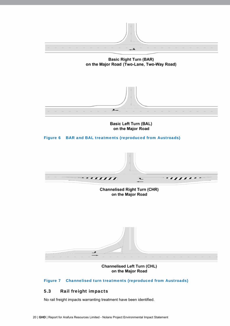
Section 4.8 of the Austroads Guide to Road Design – Part 4A: Unsignalised and Signalised Intersections specifies warrants for various left and right turn treatments leaving a major road. These warrants consider the number of vehicles making the turning movement, the volume of through traffic in one or both directions, and the design speed of the major road.
At the location of the proposed Nolans site access near Aileron Roadhouse, the Nolans Project traffic is forecast to comprise less than 4% of daily traffic along Stuart Highway in 2019 (i.e. year 1 operations). No more than 52 vehicles are expected to use the Stuart Highway during the 2019 peak hour, assuming that the peak hour traffic volume is equal to 10% of the daily volume (refer section 4.1.3).
For a design speed equal to or greater than 100 km/h, the Austroads warrants specify that a basic auxiliary left/right treatment is suitable if there are less than 100 vehicles per hour travelling along the major road, or if there are less than five vehicles turning right or left onto the minor road. A basic auxiliary left/right treatment (“BAL” or “BAR”) is a localised road widening to allow a through vehicle to pass a turning vehicle, as shown in Figure 6. However, the type of turning treatment provided should also consider other elements of the actual intersection location, such as steepness of grades, sight distances and speed limit. In particular, Austroads suggests that a BAL treatment would not be appropriate where numerous heavy vehicles travel quickly down a steep grade, and that a channelised left turn is a more suitable treatment in such instances. It is also considered that the open speed limit in this location potentially makes a BAL/BAR treatment unsafe.
Thus, a BAR/BAL treatment would be sufficient in terms of intersection capacity. However, the open speed limit warrants the provision of a channelised treatment to improve road safety. An example of a channelised treatment is shown in Figure 7. No other road impacts warranting treatment have been identified.
No other road impacts warranting treatment have been identified.
20 | GHD | Report for Arafura Resources Limited - Nolans Project Environmental Impact Statement
Figure 6 BAR and BAL treatments (reproduced from Austroads)
Figure 7 Channelised turn treatments (reproduced from Austroads)
5.3 Rail freight impacts
No rail freight impacts warranting treatment have been identified.

GHD | Report for Arafura Resources Limited - Nolans Project Environmental Impact Statement | 21
6. Summary and conclusions
This report has analysed the impacts of the proposed Nolans project on the road network at the intersection of Stuart Highway and the proposed access point to the site, and on local roads within Alice Springs where freight traffic to and from the site is likely to travel.
The proposed site is located 135 km north of Alice Springs and approximately 10 km to the west of the Stuart Highway at Aileron Station, NT. Access to the site will be restricted to authorised commercial vehicles only, via a site access road connecting with the Stuart Highway approximately 5 km south of Aileron.
The site access alignment currently exists as an unsealed track, which will be upgraded to a two lane two way sealed road during the construction phase of the project. Mine site consumables and REO products will be imported and exported respectively from/to Darwin via Alice Springs, using the Adelaide-Darwin railway and the Stuart Highway.
Based on the quantity of consumables required to be imported, the trip generation of the site is expected to be an average of 26 daily one-way-trips. The forecast total daily generation of 26 vehicles and peak hour generation of 16 vehicles indicate that mining operations at the site are likely to result in low impacts on the existing road network.
An assessment of the requirements for the intersection of the access road with Stuart Highway indicates that basic auxiliary left/right treatments would be sufficient from a traffic capacity perspective. However, it is considered that the open speed limit on this section of the highway warrants a channelised treatment from the Stuart Highway into the site access road to improve road safety.
the Nolans Project will have minimal impacts on the existing road network (including on the road pavement and the ability of the public to access essential services). No upgrades or modifications are required to support the development, aside from the upgrade of the site access intersection with the Stuart Highway.
It is further concluded that the rail transport will not adversely impact capacity on the Alice Springs to Darwin rail freight line, nor will it impede the availability of existing services to other users.


GHD
Level 5, 66 Smith Street Darwin NT 0800 GPO Box 351 Darwin NT 0801 T: (08) 8982 0100 F: (08) 8981 1075 E: [email protected]
© GHD 2016
This document is and shall remain the property of GHD. The document may only be used for the purpose for which it was commissioned and in accordance with the Terms of Engagement for the commission. Unauthorised use of this document in any form whatsoever is prohibited. G:\43\22301\WP\36801.docx
Document Status
Rev No.
Author Reviewer Approved for Issue Name Signature Name Signature Date
0 H. Klein P. Templer
C Hall
N Conroy 29/03/16

www.ghd.com