public environmental report - ntepa
TRANSCRIPT

DRAFT GUIDELINES FOR THE PREPARATION OF A PUBLIC ENVIRONMENTAL REPORT
HARTS RANGE GARNET PROJECT
AUGUST 2004
TABLE OF CONTENTS 1. PURPOSE OF THE PUBLIC ENVIRONMENTAL REPORT.................................................................. 1
2. PROJECT DESCRIPTION..................................................................................................................... 1
3. CONTENT OF THE PER ....................................................................................................................... 1
3.1 Executive Summary .................................................................................................................... 1 3.2 Introduction ................................................................................................................................. 1 3.3 Description of the Proposed Development.................................................................................. 2 3.4 Objectives and Benefits of the Proposed Project ........................................................................ 5 3.5 Alternatives ................................................................................................................................. 5 3.6 Existing Environment, Potential Impacts of the Project and Management .................................. 6 3.7 Environmental Management Plan.............................................................................................14 3.8 Public Involvement and Consultation ........................................................................................ 14 3.9 References ............................................................................................................................... 14 3.10 Appendices and Glossary ......................................................................................................... 15
4. ADMINISTRATIVE REQUIREMENTS .................................................................................................15

Draft PER Guidelines Harts Range Garnet Project August 2004
1
1. PURPOSE OF THE PUBLIC ENVIRONMENTAL REPORT The purpose of the Public Environmental Report (PER) is to provide the Government with concise and comprehensive information regarding the design, construction and operation of the proposed mining operation and associated works and facilities. It should contain sufficient information to enable understanding and assessment of the scope and environmental implication of the proposal. The PER should clearly identify the main environmental impacts associated with the development, and should contain a management strategy to minimise these impacts. Information should be presented in a concise format, using maps, overlays, tables and diagrams to clarify the text where appropriate. 2. PROJECT DESCRIPTION Olympia Resources Pty Ltd intends to mine sand-sized garnet from fluvial and dune sediments on the floodplain of Aturga Creek in the Harts Range area. It is proposed that 1.25 Mt of sand be processed annually, producing 50 000 t of garnet and 200 000 t of alumino-magnesio-hornblende (AMH). Primary processing will be undertaken in a wet plant approximately 500 m south of the Plenty Highway within the project area. The concentrate will then be transported to a secondary processing plant in the Brewer Estate in Alice Springs. Processing involves wet screening to separate the >2 mm fraction and the <180 µm, which is then returned to the pit. The remaining sand will then be treated through spirals, jigs and tables to produce fine (180-250 µm) and coarse (>250 µm) concentrate. No chemical reagents are required during the process. 3. CONTENT OF THE PER The PER should include the following sections, but need not be limited to these sections or inferred structure. 3.1 Executive Summary The Executive Summary should provide a brief outline of the project and each chapter of the PER, allowing the reader to obtain a clear understanding of the proposed project, it’s environmental implications and management objectives. The Executive Summary should be written as a stand-alone document, able to be reproduced on request for interested parties who may not wish to read or purchase the PER in it’s entirety. 3.2 Introduction Brief introduction of the proponent and the proposal, including, but not limited to, the following: • Name and address of proponent, including contact officers; • Outline of proposal; • History of the project; • Explanation of the objectives, benefits and justifications; • Tenement status for project area; and • Summaries of the scope, purpose and structure of the PER.

Draft PER Guidelines Harts Range Garnet Project August 2004
2
3.3 Description of Proposed Development This section should describe in detail the infrastructure design and engineering, and all stages of construction and operation of the project to allow a detailed understanding of all stages of the proposal, and assist in determining impacts from the proposal. The project description should include (but not be limited to): • Location of the project, indicating distance from Alice Springs and local homesteads
and/or communities, including illustrative maps.
• The general arrangement of the mining facilities and infrastructure, including pits, processing facilities, waste dumps, tailing storage facilities, power supply, access and transport routes, other infrastructure (e.g. workshops), rivers and existing features of interest.
• Maps and diagrams illustrating: �� the above information and total mine footprint (i.e. total area of disturbance); and �� topography and land tenure.
• Mineral resources, including resource estimates and detailed mine plan, include mineralogy and geology of orebody.
• Project schedule.
• Design criteria for each component of the project including design limitations imposed by site characteristics.
• Land requirements, land tenure, acquisition requirements (permits, rezoning and native title tenure/agreements – e.g. ILUAs) and the tenures under which the project would be held including details of relevant legislative processes required to grant proposed tenure.
• Infrastructure requirements and specifications (permanent and temporary) and ancillary activities (e.g. storage areas, waste areas etc).
• Transport systems, location, methods and routes for delivering construction and maintenance materials and processed product (temporary or permanent), including consideration of any interruption to other land activities.
• Water requirements, usage, source, storage, transport, treatment and disposal.
• Employment and business opportunities (direct and indirect) including sources of workforce, skill levels required and opportunities for Aboriginal people and businesses.
• Methods for storage, handling, containment and emergency management of chemicals and other hazardous substances, including fuel.
• Anticipated energy usage.
• Proposed environmental, safety and emergency management arrangements including risk assessments, contingency and response plans.
For the construction phase the project description should consider, as a minimum, the following: • Construction timing and methods. • Equipment required. • Use of materials (types, sources and quantities) including hazardous substance
(e.g. fuel) use and storage. • Footprint for construction compared with operation.

Draft PER Guidelines Harts Range Garnet Project August 2004
3
For the operational phase the project description should consider as a minimum, the following: Mine • Outline design of pits and their dimensions (including maps, plans and geological
cross-sections). • Describe on-site and off-site borrow material requirements, extraction methods and
uses. • Describe mining methods, scale of operations and timetable for extraction. • Detail drilling and blasting requirements (including frequency). • Outline possible future extensions to the mine operation, and discuss the probability of
mining satellite garnet sources. • Outline erosion and sedimentation control measures for haul roads, pits, borrow pits
and infrastructure.
Processing • Detail options for processing the product. Include flow diagrams. • Describe types of sand i.e. particle size, and quantities of sand to be processed. • Describe sand mineralogy and sampling methodology. • Indicate all input products (solids, gases and liquids) and pathways for each item in the
process. • Indicate all output products (solids, gases and liquids) and pathways for each item in
the process. • Provide details on the waste products produced, including characterisation of the clay
slimes (e.g. mineralogy, water holding capacity etc). • Provide details on the quantity of waste produced and storage, i.e. direct return or
temporary storage. Rehabilitation and Decommissioning The rehabilitation program should be integrated into the mine plan and considered as part of the mining operation, rather than as a separate phase at the end of the mine life. The project description should consider, as a minimum, the following: • Identification of a post mining land use and rehabilitation objectives.
• Rehabilitation commitments and timetables (for both temporary and permanent facilities) including waste management, pollution control and stabilisation and rehabilitation plans for mined areas.
• Include a commitment to submit a security bond in case of failure of the project.
• Description of backfilling program of pits.
• In detail describe the following: �� Progressive and final rehabilitation plans for pits, waste rock dumps, roads,
infrastructure sites and tailings storage facilities. �� Design of rehabilitated landforms, in particular rehabilitation techniques, including
methods to reconstruct the landscape using the materials available (reject sands, silts and clay slimes).
�� Profile reconstruction and viability for the growth of native species, including the accessibility of water held in the clay slimes.
�� Collection and selection strategy for native species, e.g. native grasses and other vegetation.

Draft PER Guidelines Harts Range Garnet Project August 2004
4
�� Runoff and erosion control measures of rehabilitated areas. �� Final topographic and drainage morphology. �� Maintenance of water quality. �� Revegetation procedures.
For the decommissioning phase the project description should consider, as a minimum, the following: • Arrangements for the removal of the process plant and associated machinery. • Post mining uses of associated infrastructure, e.g. roads, office buildings etc. Transport For the proposed transport requirements and infrastructure, the project description should consider, as a minimum, the following: • Description of proposed haul road, including length, location, land requirements and
tenure and acquisition requirements. • Description of construction methods and timeframes of the haul road. • Description of necessary approvals required. • Description of transport systems and methods to convey product from the mine site to
Brewer Estate, including: �� Size and number of trucks required. �� Likely number of return trips from the mine site to Brewer Estate through Alice
Springs township. �� Additional road works required, including upgrades (e.g. filter lanes, additional
signage etc) associated with the transport of the concentrate. • Description of transport systems and methods to convey product from Brewer Estate to
proposed markets, including proposed storage and Port facilities required at Darwin as well as possible need for Railway siding construction.
Water Requirements Describe water requirements and management for the whole operation, including (but not limited to) the following: • Domestic, industrial and process water requirements, sources, annual extraction
volumes, delivery rates and methods of extraction and treatment including chemistry and quality.
• Contingency plans for 1:100 year rainfall events and wet season releases and predicted water quality on release.
• Intended design annual exceedence probability for discharge to the environment, operational hydrological and hydraulic design criteria for each major water system component including transfer, losses and on-site disposal.
• Details on alteration to drainage lines. • Details of water storage requirements, including any alternative storage, i.e. dams. For
dams include geotechnical and construction details including freeboard estimates and allowances, seepage potential, provision for overflow and silt traps.
• Provide a water balance diagram illustrating all water inputs and outputs. NOTE: • Provisions of the Water Act will apply to alterations to drainage lines and discharge. • Quantitative terms should be used wherever possible.

Draft PER Guidelines Harts Range Garnet Project August 2004
5
Infrastructure Describe infrastructure requirements for the whole operation, including (but not limited to) the following: • Administration, staff amenity and workshop buildings. • Hazardous substances, including fuel, oil and lubricants, i.e. types storage, use,
transport and disposal. • Options for power supply, including required infrastructure, servicing easements. • Sewage and refuse disposal and disposal of any solid waste. • Outline road access corridor and power line access corridor, including construction and
any upgrade requirements, design of stream crossings and erosion control measures. • Communication requirements. • Security arrangements. Workforce For the proposed workforce, provide, as a minimum, the following: • Estimates of numbers and shift requirements during construction, operation, and
rehabilitation. • Recruitment and training policy. • Health, safety and emergency procedures. • Accommodation, amenity, office and transportation requirements for staff. • Professional staffing details. 3.4 Objectives and Benefits of the Proposed Project Discuss the social, environmental and financial objectives and benefits of the project. This should include: • Socio-economic objectives and benefits, including reference to local and global
markets, other economic activities in the affected area (e.g. tourism, pastoral etc), foreign trade objectives, occupational health and safety objectives, and benefit to the local workforce, land users and indigenous people.
• Commercial objectives (e.g. predicted volume of product and proportion of market demand to be met by output).
• Local, regional and global environmental objectives (e.g. reference to the company’s environmental policies and the implications of the project with respect to the National Greenhouse Strategy).
• Details and results of all public communication and negotiation that has been undertaken to support the proposal.
3.5 Alternatives Alternative proposals, which may still allow the objectives of the project to be met, should be discussed, detailing reasons for the selection and rejection of particular options. The selection criteria should be discussed, and the advantages and disadvantages of preferred options and alternatives detailed. The potential impacts of the alternatives should be described.
Draft PER Guidelines Harts Range Garnet Project August 2004
6
Alternatives to be discussed should include: • Not proceeding with the project. • Locations, including process plant. • Sources of raw materials for the project, including water supply. • Extraction and processing technologies considered. • Environmental management technologies considered, such as treatment and disposal
of waste products. • Workforce accommodation. • Power supply options and service corridors. • Transport options, including the haul road location. 3.6 Existing Environment, Potential Impacts of the Project and Management Studies to describe the existing environment should be of a scope and standard sufficient to serve as a benchmark against which the impacts of the project may be assessed over an extended period. Control areas not impacted by the project should be included in studies and long term monitoring locations established. This section of the PER should also clearly identify, qualify and quantify, where appropriate, the potential environmental impacts expected to result from the project and from any feasible alternatives. The section should also include an assessment of the level of significance of the impact, be it global, regional or local (e.g. global and national implications of greenhouse gases and the localised impact of service roads or artificial water bodies). The possibility of remediation should also be discussed. Performance indicators for all potential impacts and remediation efforts should be identified. Environmental Management Plans will need to be developed in order to minimise and manage impacts associated with the project. Cumulative impacts should also be discussed. The reliability and validity of forecasts and predictions, confidence limits and margins of error should be indicated as appropriate. Description of those areas potentially impacted by the project should, as a minimum, include: Air Quality and Noise Baseline Provide details of the existing ambient air quality conditions and noise levels at locations likely to be impacted by the proposal. The data provided should include descriptions of all meteorological conditions including but not limited to: • Prevailing wind directions and strengths. • Maximum wind gusts. • Precipitation data (maximum, minimum, average, rainfall intensities). • Temperature data. • Evaporation data.
Draft PER Guidelines Harts Range Garnet Project August 2004
7
Impacts Describe how the project will, or has the potential to, impact on air quality and noise during the construction and operational phases of the proposal and ongoing activities, with particular consideration given to the following: • Potential air emissions. • Dust, including projected particle size and distribution. • Noise, including levels, timing and duration and comparison to current levels with
respect to the nearest sensitive receptors, including noise associated with road traffic and transport generated by the proposal.
Management Detail the safeguards, management and monitoring strategies that will be used to minimise impacts of construction and operation phases on air quality and noise. Landform Baseline The baseline information should include, but not be limited to, the following: • Discuss local and regional geology and geomorphology, providing maps illustrating
geology and geomorphological units. • Discuss the soil types and provide maps and cross sections of typical dunes and
swales indicating soil change with depth and catenary sequences. • Determine land units of the site and peripheral areas. • Provide seismic information for the site and peripheral areas. • Detail the level of existing soil erosion and other disturbances. Impacts Describe how the project will or has the potential to impact on each element with particular consideration given to the following: • Discuss limiting properties of landform considering erosion, rehabilitation etc. This
information may be provided through the development of a landform evolution model for the life of the project and beyond (this would also have benefit in assisting in progressive rehabilitation over the life of the project).
• Discuss the changed landforms and soil profiles on completion of mining and determine impacts on peripheral land systems.
• Detail any other impacts of mining on the landform. Management Detail the safeguards, management and monitoring strategies that will be used to minimise impacts of construction and operation phases, including: • Measures to avoid or minimise impacts. • Management of top soil. • Erosion and sediment control procedures and associated erosion and sediment control
management plan.

Draft PER Guidelines Harts Range Garnet Project August 2004
8
Hydrology/Hydrogeology Baseline Describe the surface water systems of the minesite, borefield area and surrounding region including: • rivers; • creeks; and • streamlines.
Describe the ground water systems of the minesite, borefield area and surrounding region including: • confined aquifers; • unconfined aquifers; and • ground soaks, expressions etc.
For both ground water and surface water systems, discuss: • their significance; • current uses; • beneficial uses; • flows (including flood contours) and discharge rates; • water quality; • release or seepage of heavy metals; • characterisation of all water sources (both surface and groundwater); and • identify present users of surface water and groundwater, including a discussion on
issues associated with the water management zone. Impacts Describe how the project will or has the potential to impact on each element with particular consideration given to the following: • Impacts on surface and groundwater from mining, water extraction from the borefield,
ancillary activities and associated infrastructure requirements, including impacts on: �� water quality; �� changes to/ diversion of surface waters; and �� aquatic flora and fauna.
• Possible chemical constituents in drainage, specifying test methods (provide all test information).
• Site water requirements and sources. • Site water balance (all inputs and outputs) based on long term modelling using
rainfall/runoff data for a period equivalent to the expected mine life, including rehabilitation and no more than monthly time steps.
• Current users and their requirements of site water sources. Management Detail the safeguards, management and monitoring strategies that will be used to minimise impacts of construction and operation phases, including:

Draft PER Guidelines Harts Range Garnet Project August 2004
9
• Consider defining the project area in terms of sub-catchments and in zones related to
potential contaminant source to facilitate the development of a catchment management strategy.
• Treatment, storage and disposal of waste water, including stormwater run off. • Management of clean, dirty and contaminated water. • Management of high/ extreme rainfall events. • Management of process waters. • Protection of beds and banks of watercourses. • Continued water monitoring and discharge requirements following decommissioning. • Protection of groundwater from potential pollution sources. Include a map of water management system showing all structures and routes. Ecology Baseline Provide baseline information and maps on flora and fauna communities of the immediate area and surrounds as determined by literature search, survey and sampling programs. This should include communities downstream of site, which may be impacted by variations in water quality and siltation. Include a comprehensive description of the methodologies used to gather information and the survey and sampling techniques. The baseline and survey information should include, but be limited to: • Specification of the extent of clearing. • Flora and fauna species (including migratory species) and biological communities.
Include details of feral animals and weed species present. Survey methodology should: • Follow best practice and advice from relevant agencies. • Consider seasonality, species rarity, potential for occurrence of significant species and
sensitivity of species to disturbance. • Be included in appendices. • Identify rare, threatened and endangered species against NT and Commonwealth
legislation, and species with indigenous conservation values. • Include a timeline to obtain permits and meet other statutory obligations under NT
legislation (IDCO No12. – Planning Act 1999 and s.38 Pastoral Land Act 1992) for vegetation clearing.
Special consideration should be given to the following: • Ecologically outstanding areas. • Vegetation that is the habitat of rare, threatened or endangered species or has
outstanding diversity. • Communities that are exceptional examples of their type. • Vegetation outside its normal distribution or of other biogeographical significance. Provide overall evaluation of flora and fauna communities of site and surrounds in relation to the Harts Range district and the Northern Territory.

Draft PER Guidelines Harts Range Garnet Project August 2004
10
List unique, rare, endangered and vulnerable native species and communities of species, and evaluate the significance of occurrence of such species and communities at Aturga Creek in relation to their overall status, distribution and condition. Provide information on habitats and populations of mosquitos and other biting insects. Impacts Describe how the project will or has the potential to impact on each element identified above with particular consideration given to the following: • Impacts of clearing. • Impacts on species or communities or habitats of local or regional or national
significance. Detail this with reference to the inputs and outputs from the mining and processing operations.
• Rate the risk and seriousness of each impact. • Identify noxious weeds that may result from the project activity. Management Detail the safeguards, management and monitoring strategies that will be used to minimise impacts of construction and operation phases, including: • Minimisation of disturbance. • Rehabilitation methods including revegetation strategies. • Weed management plan to be included in EMP and to follow best practice and advice
from advisory agencies (NT Weeds Management Act 2001). • Vegetation Clearing Plan to be developed as part of EMP. • Actions to prevent the development of mosquito and other biting insect breeding
habitats. • Details of proposed management of feral animals during construction, operation and
rehabilitation. Cultural Environment Baseline This section should describe the anthropological, archaeological and heritage values of the development area, including sites and objects of Aboriginal significance. As a minimum, information should be provided on the following: • Historical uses of the site (Aboriginal and non-Aboriginal). • Current use by Aboriginal people. • Descriptions of the cultural values that could be impacted by the project. These should
include: �� areas nominated for listing or listed on the Register of the National Estate or the
Interim list of the Register of the National Estate. �� nominated, proposed and declared heritage places and objects under the NT
Heritage Conservation Act 1991. �� prescribed archaeological and heritage places and objects (Aboriginal) under the
NT Heritage Conservation Act 1991. �� areas with special values to indigenous and non-indigenous people, e.g.
traditional land use, landscape, visual environment, recreational, commercial, tourism, scientific and educational.
Draft PER Guidelines Harts Range Garnet Project August 2004
11
�� areas of significance to the Aboriginal population and culture, including sacred sites within the meaning of the Aboriginal Land Rights Northern Territory Act 1976 and the Northern Territory Aboriginal Sacred Sites Act.
�� National Parks, conservation reserves or any other category of Territory Park or Reserve.
�� Consultation arrangements and any agreements with Local Aboriginal Groups or the Northern Land Council (NLC) under the Native Title Act 1993.
�� Local society and regional centres. For each of these cultural values, indicate: importance, conservation status, national and international treaty obligations, and clearance permits required or obtained. Maps should be provided indicating the precise location of places and/or objects of cultural or heritage value protected under the Heritage Conservation Act. The methodology by which these sites and areas were identified, and their importance assessed, should include survey details such as dates, consultants, survey area and methods. A ground survey should be undertaken to ensure that other unrecorded sites, which are also protected by the Act, are not included in the development area. The protocol to be followed in the event of discovery of new archaeological or heritage sites or objects during the construction phase should be documented and included in the EMP. Advice should be sought from the Heritage Conservation Services Branch of the Department of Infrastructure, Planning and Environment. Describe the significance of the places and objects which are to be impacted by the proposal; and options for mitigation of loss of heritage value of places and objects that lie within the area of impact. Information should be provided on the following: • Results of the inspection of the Register of Sacred Sites maintained by the Aboriginal
Areas Protection Authority. • Details of the application lodged with the Aboriginal Areas Protection Authority for an
Authority Certificate within the meaning of Part 3, Division 1 of the Northern Territory Aboriginal Sacred Sites Act.
• A copy of the Certificate issued by the Authority as a result of that application containing conditions, if any, relating to the protection of sacred sites on, or in the vicinity of, the project area.
• Results of any negotiations with native title claimants/Northern Land Council/ Central Land Council or other requirements under the Native Title Act.
Impacts This section should describe the anticipated or potential impacts the project will have on each cultural value indicated in the previous section. Consideration is to be given to the impact of the proposal on local Aboriginal employment levels and the influx of additional workers into local centres. Management Consider management options and describe proposed measures to mitigate impacts or to conserve the heritage significance of the sites or relics. Management options should be based on discussions with the landowner/manager and Aboriginal community groups.

Draft PER Guidelines Harts Range Garnet Project August 2004
12
Waste Management Identify and describe all sources of waste and provide details for, as a minimum, the following: • Effluent and putrescibles disposal from the mining camp. • Disposal of non-putrescent waste, e.g. packing crates, paper etc. • Management of controlled waste as per the Waste Management and Pollution Control
Act. Characterise mining waste material in terms of net acid generation and net acid potential from drill core samples and in-situ assessments (kinetic tests and field trials). Also provide results of a detailed mineralogical analysis of the waste material; including characterisation of the clay slimes in terms of: • Water holding capacity and accessibility of the water to vegetation. • Infiltration (will water flow along the interface between the sand and clay slimes). • Salinity and sodicity. • Root penetration, i.e. induration during drying, does it become impenetrable? Provide a description of the methods for backfilling the pits with waste material; including sample selection methodology to direct different waste types to appropriate locations for disposal. Problematic waste will require strategic positioning and management. Also include cross sections of the proposed infilled pits indicating slimes disposal and sand disposal. Discuss the impact of the waste disposal strategy on landform, surface water and groundwater flows, rehabilitation and regeneration. Management Detail the safeguards, management and monitoring strategies that will be used to minimise impacts of construction and operation phases, including: • Waste management program including reuse, recycling, storage, transport and
disposal. • Details of any pollutants that are likely to be released into the environment and
measures to prevent or minimise this release of pollutants. Fire Detail the safeguards and management that will be used to prevent fires and the actions required in case of a fire. Social Environment Baseline To determine the impact on the social environment the following baseline details are required as a minimum: • Identification of key stakeholders. • Regional community structures and vitality including (but not limited to):
�� demography; �� health;
Draft PER Guidelines Harts Range Garnet Project August 2004
13
�� education; �� social well being; �� access to services; and �� housing.
• Identification of the number and capacity of existing human services to support a remote construction work force: �� skills audit of affected communities; �� workforce characteristics; and �� housing accommodation type and quantity.
Impacts and Management Discuss general social impacts of the proposal during construction and operation, including: • The impacts of the construction workforce/maintenance teams on affected landowners
(including native title holders and claimants) and communities, recreational users, health and housing, property values and local authority rates.
• The potential of the local communities and the strategies used to meet the demands for employment in the company’s workforce and as a source of provisions for construction, rehabilitation and operation phases of the project.
• Relations between groups, in particular those based on age, sex, kinship, and place of origin and how this will be impacted by the Project.
• Opportunities for training and employment during construction of the Project (e.g. employment, monitoring and maintenance contracts) and how this will be structured, managed and implemented.
• Options for possible external commercial arrangements. • Possible future benefits following construction. • Opportunities for ongoing involvement in the project operation. • The provision of cultural awareness programs and behavioural guidelines to project
employees and monitoring regimes to monitor and evaluate the management of the above mentioned impacts. Provide for modifications to existing measures where mitigation strategies fail to prevent negative impacts.
Identify relevant government policies related to employment in regional areas and discuss compatibility of the project with these policies (liaise with the Office of Indigenous Policy, Department of the Chief Minister). Hazards and Risks to Humans and Facilities The PER should include a preliminary hazard analysis and assessment of the risks to people, the environment and nearby facilities from potential accidents associated with the construction, operation and maintenance of the various components of the proposal, storage and transport of materials to and from the complex. The preliminary hazard analysis and risk assessment should outline and take into account emergency plans that detail strategies, response procedures and staff responsibilities in the event of an emergency or accident. Issues such as floods, bush fires, lightning strikes, mine collapse and landslip should be considered. Contingency plans for dealing with spillage of any hazardous materials should be detailed. The risks in relation to open pit rescue should also be discussed. The hazard and risk analysis will identify the critical areas that need to be addressed in management plans, monitoring programs, contingency and emergency plans.

Draft PER Guidelines Harts Range Garnet Project August 2004
14
Summary A summary table listing undertakings and commitments made in the PER, including performance indicators, with cross-references to the text of the report should be provided. 3.7 Environmental Management Plan A draft Environmental Management Plan (EMP) should be provided in a form suitable for inclusion in a Mining Management Plan as required under the Mining Management Act. The draft EMP should be strategic, describing a framework for environmental management. Where possible specific management policies, practices and procedures should be included in the draft EMP. A final EMP would be prepared at the conclusion of the assessment, taking into consideration comments on the PER and on the Supplement and incorporating the Assessment Report recommendations. The draft EMP should: • Define the management structure of both the construction and operational phases and
the relationship to the environmental management of the site. • Describe the proposed measures to minimise adverse impacts and the effectiveness of
these safeguards (e.g. provide performance indicators by which all anticipated and potential impacts can be measured).
• Describe monitoring to allow early detection of adverse impacts. • Describe remedial action for any impacts that were not originally predicted. • Detail how monitoring will be able to determine the differences between predicted and
actual impacts. • Provide for the periodic review of the management plan itself. Reference should be made to relevant legislation and standards, and proposed arrangements for necessary approvals and permits should be noted. The agencies responsible for implementing and overseeing the management plan should be identified. Proposed reporting procedures on the implementation of the management plan, independent auditing or self auditing and reporting of accidents should also be described. 3.8 Public Involvement and Consultation Public involvement and the role of government organisations should be clearly identified. The outcomes of surveys, public meetings and liaison with interested groups should be discussed, and any resulting changes made to the proposal clearly identified. Details of any ongoing liaison should also be discussed including any negotiations with native title claimants. Negotiations and discussions with local and community government, the Territory Government and the Commonwealth Government should be detailed, and any outcomes referenced. Details of any ongoing negotiations and discussion should also be presented. 3.9 References Any source of information such as studies, research, maps and personal communications used in the preparation of the PER should be clearly identified, cited in the text and referenced in the bibliography.

Draft PER Guidelines Harts Range Garnet Project August 2004
15
3.10 Appendices and Glossary Information and data related to the PER but unsuitable for inclusion in the main body of the statement should be included as appendices. This may include detailed analyses, monitoring studies, baseline surveys, raw data. A glossary should be provided, defining the meaning of technical terms, abbreviations and colloquialisms. Throughout the PER, technical terms and jargon should be minimised. 4. ADMINISTRATIVE REQUIREMENTS • Prior to the report being distributed for comment, a preliminary draft of the Public
Environmental Report should be lodged with the Department of Infrastructure, Planning and Environment (DIPE) for review and comment.
• Once the draft PER is ready for comment, 40 copies of the draft PER should be
submitted to DIPE for distribution to NT Government advisory bodies. • The PER should be placed on public review at the Alice Springs Public Library, DIPE
offices in Alice Springs and Darwin, DBIRD offices in Alice Springs and Darwin and the NT Library, Parliament House, Darwin.
• If possible the PER should be on CD ROM disc so that the PER can be placed on the
Department’s Internet site. The CD ROM copies should be in ABODE� *.pdf format for placement on the Internet
• The DIPE action officer for this project is Peter Bannister - telephone (08) 8951 9201,
facsimile (08) 8951 9222.

APPENDIX 2
Basic Water Balance
W:\Olympia Resources\Harts Range\PER\Public Environmental Report Final 13 11 04.doc
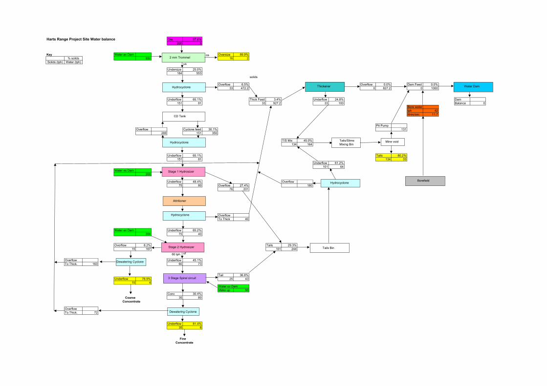
Harts Range Project Site Water balance Ore 97.6%200 5
Key Water ex Dam Oversize 89.9%% solids 550 16 2
Solids (tph) Water (tph)
Undersize 25.0%184 553
solids
Overflow 6.5% Overflow 0.0% Dam Feed 0.0%33 472.2 0 827.2 0 1000
Underflow 65.1% Thick Feed 3.4% Underflow 24.8% Dam151 81 33 927.2 33 100 Balance 0
Bore watertph 42litres/sec 11.7
Pit PumpOverflow Cyclone feed 30.1% 131
269 151 350
T/S Mix 45.0%134 164
Underflow 65.1% Tails 80.2%151 81 134 33
Underflow 61.2%101 64
Water ex Dam200
Underflow 48.4% Overflow75 80 Overflow 27.4% 180
76 201
OverflowTo Thick 40
Water ex Dam Underflow 65.2%200 75 40
Overflow 8.2% Tails 29.3%15 167 101 244
Overflow Underflow 45.1%To Thick. 163 60 73
Tail 36.8%Underflow 78.9% 25 43
15 4Water ex DamMake up 50
Conc 30.4%35 80
OverflowTo Thick. 72
Underflow 81.4%35 8
2 mm Trommel
Hydrocyclone
CD Tank
Stage 1 Hydrosizer
Stage 2 Hydrosizer
3 Stage Spiral circuit
Hydrocyclone
Tails/SlimeMixing Bin
Thickener
Tails Bin
Water Dam
Coarse Concentrate
FineConcentrate
Borefield
Attritioner
Hydrocyclone
Hydrocyclone
os
us
of60 tph
Dewatering Cyclone
Dewatering Cyclone
Mine void
APPENDIX 3 Olympia Resources Environmental Policy, Indigenous People, Quality, and
Occupational Health and Safety Policies
W:\Olympia Resources\Harts Range\PER\Public Environmental Report Final 13 11 04.doc

Olympia Resources Limited
Corporate Environmental Policy
Olympia Resources Limited views environmental management as essential to its own future and that of the mineral exploration and mining industry in general. The company considers that sound environmental management benefits all stakeholders, including shareholders, employees, nearby residents and the broader community. Olympia directors recognise that environmental management is an integral part of all activities, from exploration and mining to processing and exporting. Consequently, for all its operations, the company is committed to developing, implementing and maintaining an Environmental Management System that is consistent with international best practice. The objectives of the company’s commitment to environmental management are to: •
•
•
•
•
•
•
•
•
•
Comply with all environmental legislation, licences and regulations. Recognise conservation and heritage values. Identify, manage and monitor potential environmental impacts, striving to comply with international best practice. Rehabilitate disturbed land surfaces. Review and evaluate environmental performance. Seek continuous improvement in exploration, mining, waste management and the use of resources. Promote cross-cultural awareness, and wherever possible, protect sites of cultural significance. Have timely and effective communications with landowners, relevant indigenous people and others who may be directly affected by company operations. Communicate regularly with employees, suppliers, contractors and customers about the aims of the Corporate Environmental Policy and the responsibilities implied. Provide information to the community, shareholders and government authorities about the company’s environmental performance.
James Hudleston Chairman 8 November 2004

Olympia Resources Limited
OCCUPATIONAL HEALTH AND SAFETY POLICY
Olympia Resources Limited is fully committed to the establishment and maintenance of a safe and healthy work environment for all employees without compromising employee job productivity.
Company and Employee Commitment:
•
•
•
Work environment and conditions for employees are above those prescribed by relevant laws and statutory regulations.
The Company will educate all employees in best and safe work practices in their working environment to ensure that they are not exposed to any necessary health and safety risk.
All employees will support, implement and adhere to the Company Occupational, Health and Safety Programme.
James Hudleston Chairman 8 November 2004

OLYMPIA RESOURCES LTD
QUALITY POLICY STATEMENT
Olympia Resources Ltd quality objectives are to: •
•
•
•
•
Develop and maintain a reputation as a reliable supplier of heavy minerals. Identify our Customer’s requirements in terms of quality of product.
Provide heavy minerals products that consistently meet Customer’s specification. Create and maintain an awareness of quality products and services and the need for Product consistency at all levels within the Company. Identify and employ suppliers and contractors who share our vision and commitment to our Customer’s requirements.
James Hudleston Chairman 8 November 2004

Olympia Resources Limited
INDIGENOUS PEOPLE’S POLICY
Olympia Resources Limited wishes to establish and maintain a good working relationship with Indigenous People who may be affected by the Company’s operations. To achieve this it is Olympia’s policy to:
•
•
•
•
•
•
Respect the culture and heritage of Indigenous People affected by the Company’s operations.
Undertake appropriate heritage surveys to ensure that sites of cultural heritage to Indigenous People are not inadvertently damaged by the Company’s operations.
Regularly consult with relevant Indigenous People to ensure that they are kept informed of the Company’s activities and that their concerns are considered in the design and management of the Company’s activities.
Promote cross-cultural awareness.
Whenever feasible, provide employment and training for Indigenous People affected by the Company’s operations.
The Company can not guarantee a successful exploration outcome that will benefit all stakeholders (Indigenous People, landowners, the Company and its Shareholders and the community at large), but in the event of an economic discovery the Company will engage in open negotiations with Indigenous People landowners to complete an agreement on the development of the discovery to the satisfaction and benefit of all parties.
James Hudleston Chairman 8 November 2004

APPENDIX 4
Greenhouse Gas Emissions Estimate
W:\Olympia Resources\Harts Range\PER\Public Environmental Report Final 13 11 04.doc

Item Type Make & model Fuel Consumption
Total annual hours
Annual fuel consumption
Carbon Dioxide Emissions
Methane Emissions
Nitrious Oxide Emissions
Nitrogen Oxides
emissions
Carbon Monoxide emissions
Volatile Organic
Compounds emissions
litres/hour litres/year tonnes tonnes tonnes tonnes tonnes tonnes1 Front end Loader (2 of) Caterpillar 992 91 13140 1,195,740 3,185 0.060 0.028 7.1 0.6 0.152 Dozer - (1 of) Caterpillar D7 29 876 25,404 68 0.001 0.001 0.2 0.0 0.003 Grader (1 of) Caterpillar 14/16 35 876 30,660 82 0.002 0.001 0.2 0.0 0.004 Water Carts (1 of) Caterpillar 769/773 36 1314 47,304 126 0.002 0.001 0.3 0.0 0.015 Scraper (1 of) Caterpillar 633 87 438 38,106 101 0.002 0.001 0.2 0.0 0.006 Light vehicles (14 of) 10,000 27 0.001 0.000 0.1 0.0 0.00
Total Average Annual Emissions (tonnes) 3,588 0.068 0.031 8.0 0.7 0.2
Energy content of ADO 38.6 MJ/lCarbon dioxide emissions Factor for Diesel* 69700 t CO2/PJ
Oxidation factor of oil 99%
Methane Emissions factor for diesel** 0.0013 g/MJNitrous Oxide Emissions factor for diesel** 0.0006 g/MJ
Nitrogen Oxides Emissions factor for diesel** 0.154 g/MJCarbon Monoxide Emissions factor for diesel** 0.014 g/MJ
Volatile Organic Compounds Emissions factor for diesel** 0.0032 g/MJ
Reference *Emissions factor for carbon dioxide taken from Table 4 Workbook for Fuel Combustion Activities (Stationary Sources)**Emissions factors for non-carbon dioxide greenhouse gas emissions Table 6 Workbook for Fuel Combustion Activities (Stationary Sources)
Emissions from Equipment Use for Production

APPENDIX 5
Low Ecological Services Baseline Studies
W:\Olympia Resources\Harts Range\PER\Public Environmental Report Final 13 11 04.doc

OLYMPIA RESOURCES LIMITED ENVIRONMENTAL IMPACT ASSESSMENT OF HARTS RANGE GARNETBLENDE PROJECT WITHIN EL10150
August 2004
Prepared for OLYMPIA RESOURCES LIMITED
Suite 29, Level 4, 25 Walters Drive HERDSMAN WA 6016
(08 9244 1411)
by
Tim Leane, Else Foster and W.A. Low LOW ECOLOGICAL SERVICES Pty Ltd
ABN 55 064 311 502 P.O. Box 3130
Alice Springs, N.T. 0871 [email protected]
September, 2004

Fauna and Flora Survey for Proposed Olympia Garnetblende Mine on Mt Riddock, August 2004 2
ENVIRONMENTAL IMPACT ASSESSMENT OF HARTS RANGE GARNETBLENDE PROJECT WITHIN EL10150
1 INTRODUCTION.......................................................................................................5
2 OBJECTIVES: ..........................................................................................................5
3 LOCATION ...............................................................................................................6
4 LAND SYSTEMS ......................................................................................................8
5 METHODS ..............................................................................................................10 5.1 FLORA...........................................................................................................10 5.2 FAUNA ..........................................................................................................11
6 RESULTS ...............................................................................................................12 6.1 FLORA...........................................................................................................12 6.2 FAUNA ..........................................................................................................16 6.3 LAND SYSTEMS .............................................................................................18
7 DISCUSSION..........................................................................................................19 7.1 SOIL AND EROSION .......................................................................................19 7.2 FLORA...........................................................................................................19 7.3 FAUNA ..........................................................................................................21 7.4 LAND SYSTEMS .............................................................................................22
8 ACKNOWLEDGEMENTS.......................................................................................23
9 REFERENCES........................................................................................................24
10 APPENDIX 1: PLANT LIST FOR SURVEY SITES AND POINTS OF INTEREST..............................................................................................................25
11 APPENDIX 2 – SITE PHOTOGRAPHS..................................................................28
Cover Plate: View of proposed mining area from high sand dunes of Simpson Land System westward to sand plains adjacent to Aturga Creek in Kanandra Land System.
Low Ecological Services
September 2004

Fauna and Flora Survey for Proposed Olympia Garnetblende Mine on Mt Riddock, August 2004 3
Summary Olympia Resources Limited proposes to mine garnet sands in ML(A) 23868 at Aturga Creek, 170 km north east of Alice Springs on Mt Riddock Station. The area has been in pastoral production for more than 90 years and vegetation and soil surfaces have been disturbed by livestock. The proposed mine lease area is approximately 26 km2 which will be progressively mined over a period of at least 25 years. Mining will consist of an open cut operation with overstorey vegetation and topsoil removed, 5 to 7 m of sandy alluvium mined and processed hydraulically and gravitationally to separate garnet and alumino-magnesio-hornblende (AMH). Waste material will be returned to the pit prior to top soil and overstorey vegetation being returned and rehabilitation allowed to proceed naturally. This will be conducted in an efficient sequential manner so that apart from the first block where the need for stockpiling can not be avoided, two or three blocks will be worked on concurrently with reject material from the active mining area deposited in the previous block until the depth is adequate, topsoil removed from the previous block is placed on top of the back filled area and mining of the next block commences. Clearing of 100-150 ha may occur in any one year. The biological survey conducted as part of this report recorded 131 plant species (including nine introduced species), six mammal species (including one native), 33 bird species and five reptile species. None of these are of conservation significance. No Environmental Protection and Biodiversity Conservation Act (1999) listed species are known from the area. The Central Brush-tailed Possum (Trichosurus vulpecula vulpecula) is listed as Endangered in the Northern Territory. This species has been sighted 20 km west of Aturga Creek within the Sandover River catchment at Ongeva Creek on the Pastoral Station by the property manager within the last year. No conclusive evidence of this species was found within the Plenty River catchment during the field survey. Introduced plants such as Buffel Grass (Cenchrus ciliaris), Spiked Malvastrum (Malvastrum americanum), Common Sowthistle (Sonchus oleraceus) and Ruby Dock (Acetosa vesicaria) were recorded on the lease area. Their occurrence is facilitated by disturbance and possibly, in the case of Buffel Grass, intentional seed spread. These species, could potentially colonise rehabilitation areas more rapidly than native species and management may be necessary to prevent weeds out-competing native species. Revegetation will be from natural revegetation from the seed bank of reapplied topsoil. Vegetation removal and soil modification and disturbance will result in a change of vegetation cover and biomass in the short term but it is anticipated long term revegetation will result in return of overall biodiversity and community health typical of the alluvial flood plains. Preservation of the riparian vegetation habitat along Aturga Creek is desirable to prevent erosion of the flood plains adjacent to Aturga Creek before or after
Low Ecological Services
September 2004
Fauna and Flora Survey for Proposed Olympia Garnetblende Mine on Mt Riddock, August 2004 4
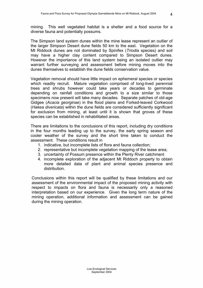
mining. This well vegetated habitat is a shelter and a food source for a diverse fauna and potentially possums. The Simpson land system dunes within the mine lease represent an outlier of the larger Simpson Desert dune fields 50 km to the east. Vegetation on the Mt Riddock dunes are not dominated by Spinifex (Triodia species) and soil may have a higher clay content compared to Simpson Desert dunes. However the importance of this land system being an isolated outlier may warrant further surveying and assessment before mining moves into the dunes themselves to establish the dune fields conservation value. Vegetation removal should have little impact on ephemeral species or species which readily recruit. Mature vegetation comprised of long-lived perennial trees and shrubs however could take years or decades to germinate depending on rainfall conditions and growth to a size similar to those specimens now present will take many decades. Separate patches of old-age Gidgee (Acacia georginae) in the flood plains and Forked-leaved Corkwood (Hakea divericata) within the dune fields are considered sufficiently significant for exclusion from mining, at least until it is shown that groves of these species can be established in rehabilitated areas. There are limitations to the conclusions of this report, including dry conditions in the four months leading up to the survey, the early spring season and cooler weather of the survey and the short time taken to conduct the assessment. These conditions result in
1. indicative, but incomplete lists of flora and fauna collection; 2. representative but incomplete vegetation mapping of the lease area; 3. uncertainty of Possum presence within the Plenty River catchment 4. incomplete exploration of the adjacent Mt Riddoch property to obtain
more detailed data of plant and animal species presence and distribution.
Conclusions within this report will be qualified by these limitations and our assessment of the environmental impact of the proposed mining activity with respect to impacts on flora and fauna is necessarily only a reasoned interpretation based on our experience. Given the long term nature of the mining operation, additional information and assessment can be gained during the mining operation.
Low Ecological Services
September 2004

Fauna and Flora Survey for Proposed Olympia Garnetblende Mine on Mt Riddock, August 2004 5
1 Introduction Olympia Resources Ltd plan to develop a garnet sand mining operation at the Aturga Creek prospect north-east of Alice Springs on Mt Riddock Station. The mineralisation along the banks of Aturga Creek was discovered by Olympia Resources Ltd while exploring EL10150. The lease area has been used for rangeland pastoral production for 90 years and has not previously been mined (Low and Strong 1985). The proposed mine lease area is approximately 26 km2 which will be progressively mined over a period of at least 25 years. Clearing of 100-150 ha to a depth of about 7m may occur in any one year. Once the complete progressive sequence is in operation, mining will involve progressive removal of vegetation and topsoil from an area of 20 ha for placement on top of redeposited mined subsoil in the previously mined 20 ha section. Mining for garnet and alumino-magnesio-hornblende (AMH) will initially commence from the palaeochannel and floodplain sediments of the Aturga Creek floodplain and take 10 to 15 years. All surface vegetation and topsoil to a depth of 300 mm will be removed and stockpiled on site. The sub-soils will then be extracted to a depth of 5 to 7m to the clay or calcrete bedrock basement. In later stages the river beds and sand dunes will be mined. The waste material, mainly quartz sand, will be returned to the pit as backfill and contoured appropriately to the natural relief before mining occurred. Topsoil will be reapplied to thereshaped areas. Haul roads will be constructed between the pit and plant and between the plant and the Plenty Highway. Existing roads from the Mining Lease to Alice Springs or Darwin will be used to transport material to port facilities. Water for the first stage of processing will be supplied from additional bores to be installed at Spinifex Bore north of the Harts Range Police Station. 2 Objectives: The objectives of this report are to: • Identify, assess and map vegetation types present within the project
area. • Determine whether flora species of conservation significance were
present within the area proposed to be used for mining and associated activities.
• Determine whether fauna species of conservation significance were present within the area proposed to be used for mining and associated activities.
• Identify habitats where significant flora and fauna may occur within the project areas.
Low Ecological Services
September 2004
Fauna and Flora Survey for Proposed Olympia Garnetblende Mine on Mt Riddock, August 2004 6
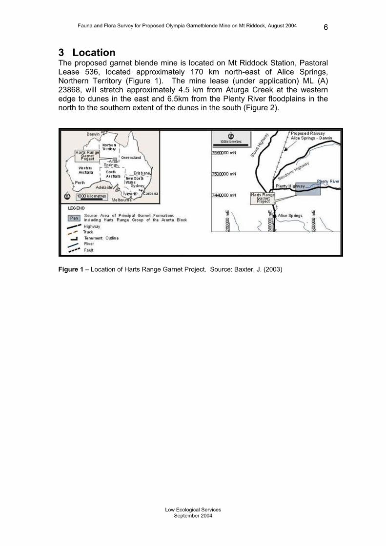
3 Location The proposed garnet blende mine is located on Mt Riddock Station, Pastoral Lease 536, located approximately 170 km north-east of Alice Springs, Northern Territory (Figure 1). The mine lease (under application) ML (A) 23868, will stretch approximately 4.5 km from Aturga Creek at the western edge to dunes in the east and 6.5km from the Plenty River floodplains in the north to the southern extent of the dunes in the south (Figure 2).
Figure 1 – Location of Harts Range Garnet Project. Source: Baxter, J. (2003)
Low Ecological Services
September 2004

Fauna and Flora Survey for Proposed Olympia Garnetblende Mine on Mt Riddock, August 2004 7
Figure 2 – GPS tracks and fauna/flora survey sites within and adjacent ML (A) 23868.
Low Ecological Services
September 2004

Fauna and Flora Survey for Proposed Olympia Garnetblende Mine on Mt Riddock, August 2004 8
4 Land Systems Land systems are defined as an area or group of areas throughout which there is a recurring pattern of topography, soils and vegetation within a climatic region (Perry et al. 1962). Three land systems are present within the lease area namely Simpson (land system 71), Sandover (land system 78) and Kanandra (land system 80) (Perry et al. 1962) (Figure 3). The Simpson land system is extensive in the NT and covers most of the Simpson Desert to the southeast of Mt Riddock. On Mt Riddock Station it is present as an isolated unit of dunes and swales with stable flanks comprised of red dune sands and red clayey sands. Dominant vegetation consists of Ironwood (Acacia estrophiolata), with tall shrubs of Witchetty Bush (Acacia kempeana) and Cassia (Senna artemisioides subsp. filifolia) with scattered Whitewood (Atalaya hemiglauca). The understorey includes grasses Wiregrass (Aristida holathera and A. strigosa), Woolly Butt (Eragrostis eriopoda), and Buffel Grass (Cenchrus ciliaris). The patch of dunes at Mt Riddick is surrounded by the Kanandra land system and is an outlier of the larger dune systems in the Simpson Desert. The Kanandra land system. is widespread on Mt Riddock and in the mining lease application area. It consists of floodplains and alluvial plains including Aturga Creek and surrounds the sand dunes of the Simpson land system. Kanandraland system is characterised by sparsely timbered, red sandy plains mostly situated on the north side of Harts Range. The system can contain low dunes and the dunes present in the project area are a gradation between Kanandra land system dunes and the larger Simpson land system dunes. The vegetation in this sytem within the project area was dominated by scattered Ironwood trees (Acacia estrophiolata), tall shrubs of Witchetty Bush (Acacia kempeana), Cassia (Senna artemisioides subsp. filifolia), low shrubs such as Saltbushes (Rhagodia species) and grasses (Aristida species and Eragrostis species). The Sandover land system on Mt Riddock Station is represented by a small floodplain along the Plenty River in the northern part of the project area. Soil consists of alluvial clayey sands and alluvial sandy red earths, containing coarse grained garnets. Dominant vegetation consists of River Red Gum (Eucalyptus camaldulensis) and occasional Coolibah (Eucalyptus coolabah subsp. arida) trees overlying various grasses (Aristida species and Eragrostis species) and low shrubs (Rhagodia species). Introduced Buffel Grass now dominates the ground storey.
Low Ecological Services
September 2004

Fauna and Flora Survey for Proposed Olympia Garnetblende Mine on Mt Riddock, August 2004 9
Figure 3 – Land systems within the Harts Range Garnet Project (Perry et al.,1962; Low & Strong, 1985).
Low Ecological Services
September 2004

Fauna and Flora Survey for Proposed Olympia Garnetblende Mine on Mt Riddock, August 2004 10
5 Methods Field surveying took place between the 16th and 19th of August 2004 by Dr W A Low, Mr T Leane and Ms E Foster of Low Ecological Services Pty Ltd. Seven sites covering the three land systems were surveyed for fauna and flora with three additional sites surveyed for flora. Land systems were identified through site-specific inspection of soil types, topography and plant species in conjunction with aerial photographs. Where an obvious difference in vegetation existed, such as the Lignum (Muehlenbeckia cunninghamii) dominated edge of the clay depression, sites were also divided into habitat zones. Sites 1, 2 and 3 were located south of the Plenty Highway and Sites 4 - 6 to the north of the highway Coordinates of each survey site are given in Table 1 and the sites displayed in Figure 2. Table 1: GPS co-ordinates for fauna and flora sites/places of interest. (GPS datum: WGS 66)
Location Easting Northing Elevation Description Gidgee Patch 471900 7457223 583 SE corner of Gidgee Patch
Spinifex Bore 491490 7463200 540 North of Harts Range Police Station
Red Gums on Plenty River 481305 7463196 552 Fenceline on Plenty River
Coolibah swamp 471768 7457214 581 Mature stand of Coolibah trees on Aturga Creek
Line 1- east end Witchetty Bush swale Line 1- west end 471626 7456384 583 Aturga Creek Line 2- east end Witchetty swale Line 2- west end 472157 7456389 584 Rhagodia spiniscens flat Line 3 - east end 474290 7456362 591 Witchetty Bush swale Line 3- west end 474031 7456426 600 Dune flank Line 4 - east end 472602 7457958 576 Witchetty Bush swale Line 4- west end 472304 7458000 581 Rhagodia spinescens flat Line 5A - east end 471431 7459028 573 Levee bank of Plenty River Line 5A - west end 471393 7459044 561 Large Red Gum, 1.5 diameter
Line 5B - east end 472310 7459062 574 Witchetty Bush swale, Adjacent to track
Line 5B - west end 472194 7459017 571 Witchetty Bush swale Line 6 - east end 475725 7458943 580 Witchetty Bush swale Line 6 - west end 475508 7458889 578 Clay Depression
5.1 Flora Flora was surveyed in detail along traplines comprised walking along the 250m transect. Vegetation was also surveyed at a stand of Gidgee, a Red Gum riparian zone on the Plenty River and at Spinifex Bore. General observations were made along the GPS tracks shown in Fig. 2 and species of
Low Ecological Services
September 2004

Fauna and Flora Survey for Proposed Olympia Garnetblende Mine on Mt Riddock, August 2004 11
conservation significance or significant sites were opportunistically searched for along drilling survey access tracks. A vegetation transect recording different habitat zones was also completed from Aturga Creek to Site 3 on the high dunes, a distance of approximately three kilometres. The distance from Aturga Creek was recorded using vehicle mileage and vegetation characteristics were recorded at several dune ridges and swales. Photos were taken at all sites, including a photo of most habitat zones e.g. riparian, swale, Lignum depression. The percent cover of dominant species were recorded at each site and vegetation was categorised as one of five structural layers, namely: Forb – ephemeral forbs, non-woody dicotyledons, generally under 0.5m; Grass – grass species, generally under 1m tall; Lower-storey – low perennial shrubs generally under 1m tall; Mid-storey – tall shrubs, up to 3m height; Upper-storey – trees.
5.2 Fauna Fauna in the region were identified from tracks, scats and other sign as well as from animals temporarily restrained in box and pit traps. Twenty-five Elliott traps, situated 10 to 15m apart, were set for three nights at all sites except 5A and 5B where 11 and 14 traps were set respectively. One pitfall trap was set at each of Sites 1, 2 and 3 for three nights and at sites 4, 5A, 5B and 6 for two nights. Any fauna trapped were identified, details recorded, then released. Opportunistic sightings and evidence of fauna were as also recorded. Birds were recorded at sites during the 15 to 20 minutes taken to check the traps or opportunistically by observation or call.
Low Ecological Services
September 2004

Fauna and Flora Survey for Proposed Olympia Garnetblende Mine on Mt Riddock, August 2004 12
6 Results Forty-two species of animals and 131 species of plant were recorded during the current survey. No species of conservation significance were recorded during the survey or found to occur within the project area through literature searches (EPBC Act 1999; Low and Strong 1985; NT Fauna Atlas. Domestic House Mice were the only mammal species captured. Weed species present in the area include Buffel Grass and Ruby Dock.
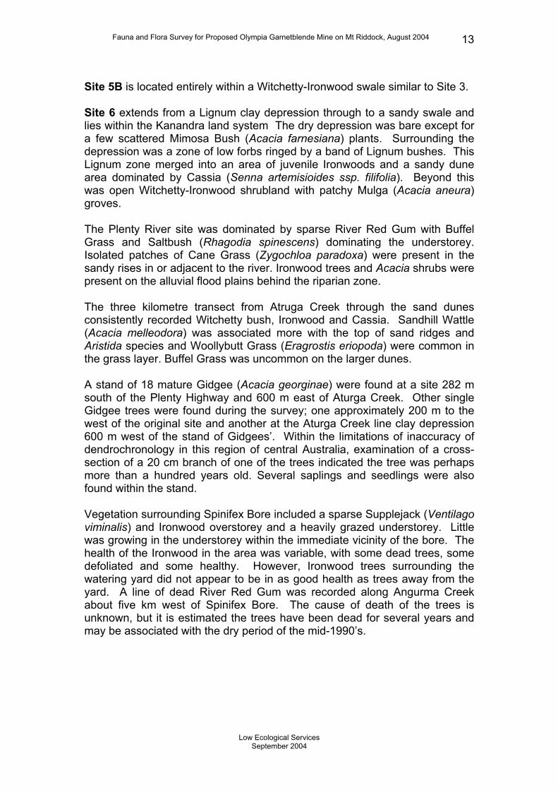
6.1 Flora One hundred and thirty-one plant species were recorded during the survey (Appendix 1). Non-riparian zones (Sites 2, 3, 4, 5B and 6) were dominated by Ironwood, Witchetty Bush, Cassia and Saltbush (Table 2). Riparian zones (Sites 1, 5A and the Plenty River site) were dominated by Coolibah, Red Gum and Buffel Grass (Table 2). No species of conservation significance were recorded, but some areas are recommended for preservation due to their size and local significance. Site 1 is within the Kanandra land system and encompasses Aturga Creek, the associated riparian zone and a levy bank/floodplain. Creek vegetation is sparse Coolibah trees over coarse alluvial sands. The riparian zone is approximately 10m wide lined with Coolibahs and some trees e.g. Native Plum (Santalum lanceolatum), over Buffel Grass. The gradually sloping levy bank consisted of various mid-layer shrubs, including Turpentine Bush (Eremophila sturtii) indicating the area has been highly utilised by stock. Site 2 spans the ecotone between the Saltbush (Rhagodia spinescens) flats on the floodplains of the Kanandra land system and the first low dunes and swale of the Simpson land system The Saltbush flats are characterised by open Saltbush (Rhagodia spinescens) shrublands with interspersed perennial grasses and widely scattered Ironwoods. The site also contained a Lignum (Muehlenbeckia cunninghamii) dominated drainage line before grading into juvenile and mature Ironwoods on the low dune. Four old, very mature Corkwood (Hakea divaricata) trees were also located at Site 2 and are considered significant by their age. Site 3 is located on dune and inter-dune swale within the Simpson land system. The area is open Witchetty-Ironwood shrubland with various perennial grasses and low shrubs and forbs. Site 4 traverses similar habitat zones to Site 2, but is located north of the Plenty Highway and extends from the Saltbush flats through to sand dune and swales. However the sand dune are larger than at Site 2 and the vegetation is dominated by Witchetty and Ironwood similar to Site 3. Site 5A is similar to Site 1 and extends from the Aturga Creek riparian zone into the levee bank and swale. The riparian zone is dominated by open River Red Gums. The swale is dominated by Cassia (Senna artemisioides ssp. Filifolia) with interspersed grasses.
Low Ecological Services
September 2004
Fauna and Flora Survey for Proposed Olympia Garnetblende Mine on Mt Riddock, August 2004 13
Site 5B is located entirely within a Witchetty-Ironwood swale similar to Site 3. Site 6 extends from a Lignum clay depression through to a sandy swale and lies within the Kanandra land system The dry depression was bare except for a few scattered Mimosa Bush (Acacia farnesiana) plants. Surrounding the depression was a zone of low forbs ringed by a band of Lignum bushes. This Lignum zone merged into an area of juvenile Ironwoods and a sandy dune area dominated by Cassia (Senna artemisioides ssp. filifolia). Beyond this was open Witchetty-Ironwood shrubland with patchy Mulga (Acacia aneura) groves. The Plenty River site was dominated by sparse River Red Gum with Buffel Grass and Saltbush (Rhagodia spinescens) dominating the understorey. Isolated patches of Cane Grass (Zygochloa paradoxa) were present in the sandy rises in or adjacent to the river. Ironwood trees and Acacia shrubs were present on the alluvial flood plains behind the riparian zone. The three kilometre transect from Atruga Creek through the sand dunes consistently recorded Witchetty bush, Ironwood and Cassia. Sandhill Wattle (Acacia melleodora) was associated more with the top of sand ridges and Aristida species and Woollybutt Grass (Eragrostis eriopoda) were common in the grass layer. Buffel Grass was uncommon on the larger dunes. A stand of 18 mature Gidgee (Acacia georginae) were found at a site 282 m south of the Plenty Highway and 600 m east of Aturga Creek. Other single Gidgee trees were found during the survey; one approximately 200 m to the west of the original site and another at the Aturga Creek line clay depression 600 m west of the stand of Gidgees’. Within the limitations of inaccuracy of dendrochronology in this region of central Australia, examination of a cross-section of a 20 cm branch of one of the trees indicated the tree was perhaps more than a hundred years old. Several saplings and seedlings were also found within the stand. Vegetation surrounding Spinifex Bore included a sparse Supplejack (Ventilago viminalis) and Ironwood overstorey and a heavily grazed understorey. Little was growing in the understorey within the immediate vicinity of the bore. The health of the Ironwood in the area was variable, with some dead trees, some defoliated and some healthy. However, Ironwood trees surrounding the watering yard did not appear to be in as good health as trees away from the yard. A line of dead River Red Gum was recorded along Angurma Creek about five km west of Spinifex Bore. The cause of death of the trees is unknown, but it is estimated the trees have been dead for several years and may be associated with the dry period of the mid-1990’s.
Low Ecological Services
September 2004

Fauna and Flora Survey for Proposed Olympia Garnetblende Mine on Mt Riddock, August 2004 14
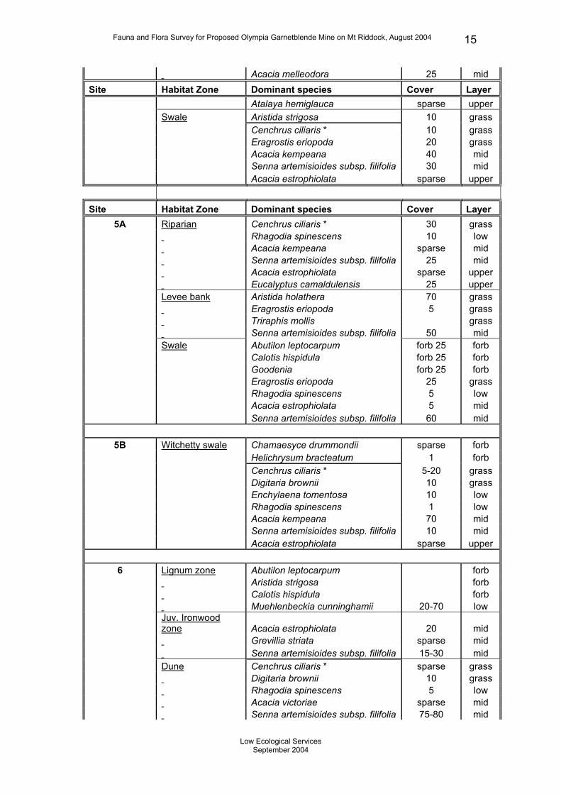
Table 2: – Cover and structure of dominant species at each site. Descriptions of layer (forb, grass, lower-, mid-, upper-storey) are in Section 4.1. Cover for Coolibah (Eucalyptus coolabah subsp. arida) and Red Gum (Eucalyptus camaldulensis) refers to canopy cover. Ironwood (Acacia estrophiolata) in the mid-layer refers to juveniles (estimated age approximately 30 years) and in the upper-layer to mature trees. Sparse cover generally means less than 5% cover or a scattered but consistent distribution. Species without an adjacent cover value are considered to be a dominant or conspicuous species within the given habitat zone. Site Habitat Zone Dominant species Cover Layer
1 Aturga Creek Eucalyptus coolabah subsp. arida sparse upper Riparian Santalum lanceolatum sparse mid Eucalyptus coolabah subsp. arida 50 upper Levy bank Calotis hispidula patchy grass Lepidium muelleriferdinandi patchy grass? Cenchrus ciliaris * sparse grass Salsola tragus patchy low Acacia kempeana 10-50 mid Eremophila sturtii dominant mid Senna artemisioides subsp. filifolia dominant mid 2 Rhagodia flat Aristida holathera 10 grass Eragrostis eriopoda 10 grass Rhagodia spinescens 10 low Acacia estrophiolata sparse upper Low dune Aristida strigosa 50 grass Acacia estrophiolata 5-50 mid Rhagodia spinescens sparse mid Senna artemisioides subsp. filifolia sparse mid Acacia estrophiolata 5 upper 3 Sand ridge Trachymene glauca 5 forb Aristida holathera 15 grass Cenchrus ciliaris * grass Eragrostis eriopoda grass Ptilotus obovatus 15 low Acacia kempeana 10 mid Acacia melleodora 10 mid
Senna artemisioides subsp. helmsii mid
4 Rhagodia flat Eragrostis eriopoda 10 grass Lechenaultia divaricata 5 low Rhagodia spinescens 5 low Senna pleurocarpa sparse low Senna artemisioides subsp. filifolia sparse mid Acacia estrophiolata sparse upper Cenchrus ciliaris * sparse grass Sand ridge Melhania oblongifolia forb Swainsona phacoides sparse forb Cenchrus ciliaris * 20 grass Rhagodia spinescens 25 low Senna pleurocarpa 10 low Acacia estrophiolata sparse mid
Low Ecological Services
September 2004
Fauna and Flora Survey for Proposed Olympia Garnetblende Mine on Mt Riddock, August 2004 15
Acacia melleodora 25 mid Site Habitat Zone Dominant species Cover Layer
Atalaya hemiglauca sparse upper Swale Aristida strigosa 10 grass Cenchrus ciliaris * 10 grass Eragrostis eriopoda 20 grass Acacia kempeana 40 mid Senna artemisioides subsp. filifolia 30 mid Acacia estrophiolata sparse upper
Site Habitat Zone Dominant species Cover Layer 5A Riparian Cenchrus ciliaris * 30 grass Rhagodia spinescens 10 low Acacia kempeana sparse mid Senna artemisioides subsp. filifolia 25 mid Acacia estrophiolata sparse upper Eucalyptus camaldulensis 25 upper Levee bank Aristida holathera 70 grass Eragrostis eriopoda 5 grass Triraphis mollis grass Senna artemisioides subsp. filifolia 50 mid Swale Abutilon leptocarpum forb 25 forb Calotis hispidula forb 25 forb Goodenia forb 25 forb Eragrostis eriopoda 25 grass Rhagodia spinescens 5 low Acacia estrophiolata 5 mid Senna artemisioides subsp. filifolia 60 mid
5B Witchetty swale Chamaesyce drummondii sparse forb Helichrysum bracteatum 1 forb Cenchrus ciliaris * 5-20 grass Digitaria brownii 10 grass Enchylaena tomentosa 10 low Rhagodia spinescens 1 low Acacia kempeana 70 mid Senna artemisioides subsp. filifolia 10 mid Acacia estrophiolata sparse upper 6 Lignum zone Abutilon leptocarpum forb Aristida strigosa forb Calotis hispidula forb Muehlenbeckia cunninghamii 20-70 low
Juv. Ironwood zone Acacia estrophiolata 20 mid
Grevillia striata sparse mid Senna artemisioides subsp. filifolia 15-30 mid Dune Cenchrus ciliaris * sparse grass Digitaria brownii 10 grass Rhagodia spinescens 5 low Acacia victoriae sparse mid Senna artemisioides subsp. filifolia 75-80 mid
Low Ecological Services
September 2004
Fauna and Flora Survey for Proposed Olympia Garnetblende Mine on Mt Riddock, August 2004 16
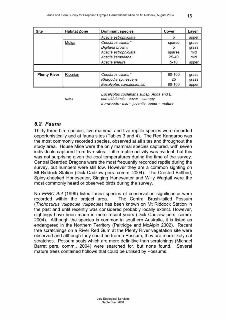
Site Habitat Zone Dominant species Cover Layer Acacia estrophiolata 5 upper Mulga Cenchrus ciliaris * sparse grass Digitaria brownii 5 grass Acacia estrophiolata sparse mid Acacia kempeana 25-40 mid Acacia aneura 5-10 upper
Plenty River Riparian Cenchrus ciliaris * 80-100 grass
Rhagodia spinescens 25 grass Eucalyptus camaldulensis 80-100 upper
Notes Eucalyptus coolabahs subsp. Arida and E. camaldulensis - cover = canopy
Ironwoods - mid = juvenile, upper = mature
6.2 Fauna Thirty-three bird species, five mammal and five reptile species were recorded opportunistically and at fauna sites (Tables 3 and 4). The Red Kangaroo was the most commonly recorded species, observed at all sites and throughout the study area. House Mice were the only mammal species captured, with seven individuals captured from five sites. Little reptile activity was evident, but this was not surprising given the cool temperatures during the time of the survey. Central Bearded Dragons were the most frequently recorded reptile during the survey, but numbers were still low. However they are a common sighting on Mt Riddock Station (Dick Cadzow pers. comm. 2004). The Crested Bellbird, Spiny-cheeked Honeyeater, Singing Honeyeater and Willy Wagtail were the most commonly heard or observed birds during the survey. No EPBC Act (1999) listed fauna species of conservation significance were recorded within the project area. The Central Brush-tailed Possum (Trichosurus vulpecula vulpecula) has been known on Mt Riddock Station in the past and until recently was considered probably locally extinct. However, sightings have been made in more recent years (Dick Cadzow pers. comm. 2004). Although the species is common in southern Australia, it is listed as endangered in the Northern Territory (Paltridge and McAlpin 2002). Recent tree scratchings on a River Red Gum at the Plenty River vegetation site were observed and although they could be from a Possum, they are more likely cat scratches. Possum scats which are more definitive than scratchings (Michael Barret pers. comm.. 2004) were searched for, but none found. Several mature trees contained hollows that could be utilised by Possums.
Low Ecological Services
September 2004

Fauna and Flora Survey for Proposed Olympia Garnetblende Mine on Mt Riddock, August 2004 17
Table 3: –Mammals and reptiles recorded during fauna survey conducted within the proposed project area on Mt Riddock Station.
Species Common Name L1 L2 L3 L4 L5A L5B L6Plenty River Other Evidence
Mammals
Macropus rufus Red Kangaroo * * * * * * * * * Scats, tracksand sightings
Mus musculus* Mouse 2 1 1 1 2 6 captures Vulpes vulpes* Fox * * tracks Felis catus* Cat * * tracks Canis familiaris* Dingo * tracks
Bos taurus Cattle * * * * * * * * * Scats, tracksand sightings
Reptiles
Pogona vitticeps Central Bearded
Dragon 1 2 3 sightings Ctenotus schomburgkii (skink) 1 1 2 captures Menetia greyii (skink) 2 2 captures Tiliqua multifasciata Centralian Blue Tongue Lizard 2 2 sightings Lialis burtonis Burton’s Legless Lizard 1 1 specimen
Table 4: - Birds recorded during fauna survey conducted within the proposed project area on Mt Riddock Station. Fauna sites Species L1 L2 L3 L4 L5A L5B L6 Other Total Banded Whiteface * 1 Black-faced Cuckoo-shrike * * 2 Black-faced Woodswallow * * * 3 Brown Falcon * * 2 Budgerigar * 1 Chiming Wedgebill * * 2 Collared Sparrowhawk * 1 Crested Bellbird * * * * * * 6 Crested Pigeon * * 2 Galah * * 2 Grey-crowned Babbler * 1 Hooded Flycatcher * 1 Hooded Robin * 1 Little Corella * 1 Little Crow * * 2 Magpie * 1 Pied Butcherbird * 1 Rainbow Bee-eater * 1 Red-tailed Black Cockatoo * 1 Red-capped Robin * 1 Singing Honeyeater * * * * * 5 Slaty-backed Thornbill * 1 Spiny-cheeked Honeyeater * * * * * 5 Splendid Fairy-wren * * * 3 Tawny Frogmouth * 1 Torresian Crow * * 2
Low Ecological Services
September 2004

Fauna and Flora Survey for Proposed Olympia Garnetblende Mine on Mt Riddock, August 2004 18
Wedge-tailed Eagle * 1 White-browed Babbler * 1 Fauna sites Species L1 L2 L3 L4 L5A L5B L6 Other Total White-winged Fairy-wren * 1 Willy Wagtail * * * * * 5 Yellow-rumped Thornbill * 1 Yellow-throated Miner * * * 3 Zebra finch * * * * 4
33 2 8 2 9 6 6 10 23 0
6.3 Land systems Three land systems were identified within the mine lease area namely the Simpson land system, Sandover land system and Kanandra land system. Mt. Riddock station is the primary location of the Kanandra land system, comprising 35% of the total area in Perry et al.’s 1962 survey of the southern NT (Table 5). However only 1% of the Kanandra land system on Mt. Riddock will be within theproject area. Only one patch of dunes within Mt. Riddock represents the Simpson land system, of which approximately two thirds will bedisturbed. As shown in Table 5, the area of each land system within the project area represents less than 1% of the total coverage for each of the land systems in southern NT. Table 5 – Land system area present within the Mine lease (estimation), Mt. Riddock Station (Low & Strong, 1985) and in the Alice Springs area/Southern NT (Perry et al., 1962). Note: area of Simpson land system was recalculated to be 18 km2 not 13 km2 as stated in (Low & Strong, 1985).
Land type
Estimated area (km2) on ML(A) 23868
Area (km2) on Mt Riddock Station
Area (km2) in south NT (1962)
% area of land system on Mt. Riddock also within ML(A)
% area of land system in Mt. Riddock Station/south NT
ML(A) 23868 26 0.6% [100%] Mt. Riddock Station 4628 4628 [100%] Simpson LS 11.5 18 98000 63.9% 0.01%
Sandover LS 2.5 91 4400 2.7% 2.07%
Kanandra LS 12 1208 3400 1.0% 35.53%
Low Ecological Services
September 2004
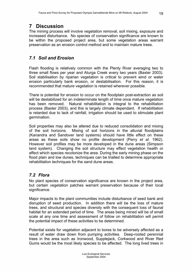
Fauna and Flora Survey for Proposed Olympia Garnetblende Mine on Mt Riddock, August 2004 19
7 Discussion The mining process will involve vegetation removal, soil mixing, exposure and increased disturbance. No species of conservation significance are known to be within the proposed project area, but some vegetation areas warrant preservation as an erosion control method and to maintain mature trees.
7.1 Soil and Erosion Flash flooding is relatively common with the Plenty River averaging two to three small flows per year and Aturga Creek every two years (Baxter 2003). Soil stabilisation by riparian vegetation is critical to prevent wind or water erosion particularly bank erosion, or destabilisation. For this reason, it is recommended that mature vegetation is retained wherever possible. There is potential for erosion to occur on the floodplain post-extraction as soil will be destabilized for an indeterminate length of time once mature vegetation has been removed. Natural rehabilitation is integral to the rehabilitation process (Baxter 2003), and this is largely climate dependant. If rehabilitation is retarded due to lack of rainfall, irrigation should be used to stimulate plant germination. Soil properties may also be altered due to reduced consolidation and mixing of the soil horizons. Mixing of soil horizons in the alluvial floodplains (Kanandra and Sandover land systems) should have little effect on these areas as these soils show no profile development (Perry et al. 1962). However soil profiles may be more developed in the dune areas (Simpson land system). Changing the soil structure may effect vegetation health or affect which species recolonize the area. During the early mining phase on the flood plain and low dunes, techniques can be trialled to determine appropriate rehabilitation techniques for the sand dune areas.
7.2 Flora No plant species of conservation significance are known in the project area, but certain vegetation patches warrant preservation because of their local significance. Major impacts to the plant communities include disturbance of seed bank and disruption of seed production. In addition there will be the loss of mature trees, and structural and species diversity with the consequent loss of faunal habitat for an extended period of time. The areas being mined will be of small scale at any one time and assessment of follow on rehabilitation will permit the potential impact of these activities to be determined. Potential exists for vegetation adjacent to bores to be adversely affected as a result of water draw down from pumping activities. Deep-rooted perennial trees in the area such as Ironwood, Supplejack, Corkwood and River Red Gums would be the most likely species to be affected. The long lived trees in
Low Ecological Services
September 2004

Fauna and Flora Survey for Proposed Olympia Garnetblende Mine on Mt Riddock, August 2004 20
the area have experienced severe droughts in the past 100 or more years and monitoring of tree health will permit assessment of the impact of water drawdown.
A search of the EPBC Act (1999) website listed only one species of conservation significance that could potentially be in the area, the Macdonnell Ranges Cycad (Macrozamia macdonnellii). This species is known in the rugged Harts Ranges lying south of the project area (Low and Strong, 1985) well outside the mining area. Vegetation clearance will reduce all phenological stages (i.e. mature trees, juvenile trees, seedlings) of the vegetation communities to seed stored within the topsoil. This will have little impact on ephemeral species which respond to rain or species which recruit readily such as forb species (Rhodanthe species, Chrysocephalum), grasses (Aristida species, Eragrostis species) and some mid-layer shrubs (Senna species). However the recovery time for long-lived tree species, such as Ironwood, Gidgee and Corkwood may be decades. The recorded Ironwood juveniles were almost wholly from the 1974 high rainfall recruitment phase. These species may not germinate until after a similar high rainfall event and may take decades to reach a size similar to those specimens now present. The species is widespread and common. An added consideration is those species such as Eremophila, Hakea and Acacia which may require fire or high temperatures or a combination of fire followed by rainfall for successful germination. The ability of the newly revegetated areas to carry a sufficiently hot fire may take considerable time and it may be many years after mining before a suite of species comparable to that which existed pre-mining emerges. Conversely, there may not be viable seed in the seed store if a fire has not passed through recently enough to release seed from mature trees or shrubs. Given the long mining process trials can be instigated to encourage germination of these species. This has consequences for loss of habitat for fauna such as birds and bats (e.g. the Little Cave Eptisicus (Eptesicus pumilus) and Hill’s Sheathtail Bat (Taphozous hilli) which have been recorded in the area) which may utilise hollows or shedding bark found in older trees or smaller birds which favour structurally diverse habitat. In recognition that replacing mature trees will take considerable time, and that the stand of Gidgees, 280 m south of the Plenty Highway and 600 m east of Aturga Creek represents an iconic species for the region, it is recommended that the Gidgee stand and the four Corkwood trees on the floodplain, both of which were infrequently distributed, should be preserved until it is shown that the rehabilitation process can reproduce these stands. A clay depression located approximately 1.5 km north of the Plenty Highway, but south of the Plenty River, represents a relatively rare habitat zone for the area and an area of high historical Aboriginal use (Ben Gunn pers. comm. 2004). This area, currently not within in the proposed mining area, should be conserved if mining is proposed for the area at a later date. During high
Low Ecological Services
September 2004

Fauna and Flora Survey for Proposed Olympia Garnetblende Mine on Mt Riddock, August 2004 21
rainfall wet seasons the depression may also be important ephemeral wetland for migratory birds. Vegetation removal and soil disturbance could facilitate weed and other species associated with disturbance. Buffel Grass is widespread in the area and could potentially out-compete other plants in the early stages of revegetation. Other weed species or disturbance associated species could also adversely effect revegetation resulting in a lower biodiversity. Newly regenerating sites will require monitoring and weed management to prevent weeds dominating the successional sequence. Rehabilitated sites will need to be fenced off from cattle grazing to protect regenerating seedlings. Rabbits numbers are currently minimal on Mt Riddock Station, but if in the future their abundance increases around rehabilitation sites, management involving warren destruction or fumigation would be advised. Red Kangaroos, abundant in the area, should be deterred where possible from rehabilitation sites, but are less of a priority.
7.3 Fauna The major impacts of the mine to fauna will be the destruction and disturbance of resident terrestrial populations, disturbance of avifauna and the loss of habitat resources through complete removal or long-term modification of habitat. Relatively few reptiles were recorded during the survey. Low and Strong (1985) reported only five reptile species for Mt Riddock Station, none of which were recorded during the current sampling period. This current survey has therefore increased the reptile knowledge of the property by five species. These are widespread species and do not currently have conservation significance. Reptile diversity may be low within the region, but as the current survey was conducted when minimum temperatures were below zero, a comprehensive sampling of reptile diversity was not likely to be achieved. The current survey may therefore not accurately reflect the number or abundance of reptile species in the area and a further summer survey is warranted. A search of the EPBC Act (1999) website listed four threatened species that could potentially be in the area: Mulgara (Dasycercus cristicauda), Bilby (Macrotis lagotis), Black-footed Rock Wallaby (Petrogale lateralis MacDonnell Ranges race) and Central Rock Rat (Zyzomys pedunculatus). The Black-footed Rock Wallaby and Central Rock Rat, however, have a strong preference for rocky hill habitat (Paltridge and McAlpin, 2002) and in this region would be restricted to the Harts Ranges south of the mining area and will have no impact. Mulgara occur in Spinifex dominated sand plain and dune fields of which there was only a few patches of Spinifex (Triodia schinzii) found at Site 4. There is no record of Mulgara at Mt Riddock Station (Low and Strong 1985) and it is
Low Ecological Services
September 2004

Fauna and Flora Survey for Proposed Olympia Garnetblende Mine on Mt Riddock, August 2004 22
unlikely that such a small distribution of Spinifex would be enough to support a viable population. There is no record of Bilby at Mt Riddock Station (Low and Strong 1985) and changes to traditional burning practices and habitat degradation by grazing, which are thought to be the major threatening processes, would have reduced the amount of suitable habitat on the Station for Bilby. For these reasons it is unlikely any of the EPBC Act (1999) listed threatened species would be present within the project area. Central Brush-tail Possums (Trichosurus vulpecula vulpecula) listed as Endangered in the Northern Territory (Paltridge and McAlpin 2002) have been sighted recently at Ongeva Creek on Mt Riddock Station (Dick Cadzow pers. comm. 2004). They have previously been recorded at a homestead on the Station and in the head waters of the Sandover River on adjacent Alcoota Station in the 1980’s (Low and Strong 1985). Both these sightings are within the Sandover River catchment to the west of the Plenty River catchment in which the project area is situated. Central Brush-tail Possums, which formerly occupied several habitat types, are now restricted to Eucalypt-lined riparian zones close to rocky ranges or rock outcrops (Paltridge and McAlpin 2002). The Plenty river catchment floodplains within the mine lease may be suitable habitat for the Possum and further investigation of their potential distribution may be valuable to determine whether they are within the lease or could potentially colonise it. Hollows only form in mature Red Gums and Coolibahs and their destruction during mining operations would inhibit Possums inhabiting the creek line. Therefore preserving mature Eucalypts along creeklines for erosion control and to protect potential habitat resources for Central Brush-tail Possum is recommended. The loss of habitat resources in mature trees which may take decades to regenerate and may represent the greatest mining impact on fauna and wherever possible preservation of such habitat is recommended.
7.4 Land systems All land systems within the mine lease are represented elsewhere on Mt. Riddock station and in southern NT. In 1985, Low & Strong assessed whether any land systems on Mt. Riddock Station warranted reservation, on the basis of the extent they were reserved elsewhere (in National Parks), their conservation value (biodiversity, unique/threatened species) and the area they covered on the station. The Kanandra land system, primarily located on Mt. Riddock Station is not well represented in reservations and was deemed as “low priority for reservation” (Low & Strong, 1985). Sandover and Simpson land systems along with several other land system’s on Mt. Riddock were thought to have too limited occurrence to warrant reservation. Despite the criteria and purpose of Low & Strong’s assessment being quite different from this report, it
Low Ecological Services
September 2004

Fauna and Flora Survey for Proposed Olympia Garnetblende Mine on Mt Riddock, August 2004 23
substantiates that the land systems within the mine lease are represented elsewhere. The Simpson land system dunes within the mine lease may warrant preservation as they represent an outlier of the larger Simpson Desert dunes. Vegetation on the Mt Riddock dunes are not dominated by Spinifex (Triodia species) and soil may have a higher clay content compared to Simpson Desert dunes. However the importance of this land system being an isolated outlier may warrant its preservation or further surveying to establish its conservation value. The main plant communities associated with the land systems on Mt. Riddock Station are Low Open Woodlands (Ironwood, Mulga, Whitewood etc) and Open Shrublands (Cassia, Witchetty, Rhagodia sp.). The majority of the project area was dominated by varying densities of generally sparsely scattered Ironwood overstorey and Cassia/Witchetty tall shrubs, a common association throughout arid NT. Gidgee , which was primarily located in one patch, was the least common overstorey community, but is represented elsewhere on Mt. Riddock (Low & Strong, 1985) and is well within its national distribution (Albrecht et al., 1997). Preserving the Gidgee patch, riparian Eucalypt vegetation and old Corkwood trees however are recommended for other reasons stated elsewhere. 8 Acknowledgements We would like to thank Ben Gunn (Anthropologist), Kristy Sell (Environmental Officer, MBS Environmental), Dick and Anne Cadzow (lessees of Mt Riddock Station), Jeff Cole (P&WCNT ), Ben Sparrow (P&WCNT) and John Baxter (Non-executive director, Olympia Resources) for facilitating the field survey, advice and assistance in the preparation of this report.
Low Ecological Services
September 2004
Fauna and Flora Survey for Proposed Olympia Garnetblende Mine on Mt Riddock, August 2004 24
9 References Albrecht, D., Duguid, A.W., Latz, P.K., Coulson, H. and Barritt, M.J. (1997) Vascular Plant Checklist for the Southern Bioregions of the Northern Territory: Nomenclature, Distribution and Conservation Status. Parks and Wildlife Commission of the Northern Territory, Alice Springs. Baxter, J (2003) Notice of Intent to Mine Harts Range Garnet Project, Northern Territory. Unpublished document, Olympia Resources LTD . Baxter, J. (2003) Harts Range Garnetblende Project Mining Management Plan (MMP). Unpublished document, Olympia Resources LTD. Environmental Protection and Biodiversity Conservation (EPBC) Act, 1999. Web Site: www.ea.gov.au/epbc Low, W.A. and Strong, B. (1985) Resource Appraisal of Mt Riddock Station Pastoral Leases 536, 601 and 602. Report prepared for the Conservation Commission of Northern Territory, Alice Springs. Paltridge, R. and McAlpin, S. (2002) A Guide to Rare and Threatened Animals in Central Australia. WWF, Sydney. Perry, R.A., Mabbutt, J.A., Litchfield, W.H. and Quinlan, T. (1962) Land Systems of the Alice Springs Area, Northern Territory, Australia. CSIRO, Canberra. Walker, J. and Hopkins, M.S. (1984) Vegetation. In: Australian Soil and Land Survey Field Handbook (McDonald, R.C., Isbell, R.F., Speight, J.G., Walker, J. and Hopkins, M.S.), Inkata Press, Melbourne.
Low Ecological Services
September 2004