environmental audit report - ntepa · environmental audit report 6 stuart highway (dinah beach...
TRANSCRIPT
Environmental Audit Report
6 Stuart Highway, Stuart Park
Darwin, Northern Territory 0800
Prepared for: Mobil Oil Australia Ltd
Prepared by: Australian Environmental Auditors Pty Ltd
Date: 11 October 2013
Project Number: EA0263
NT EPA Ref No: EN2010/0198-02~0071
Our Ref: EA0263 Date: 11 October 2013
Mr Graeme Phillips
Project Manager Exxon Mobil Environmental Services Mobil Oil Australia Pty Ltd GPO Box 4507 Melbourne VIC 3001
Environmental Audit Report Former Mobil Darwin Coastal Bulk Plant
6 Stuart Highway (Dinah Beach Road), Stuart Park Darwin, Northern Territory 0800
Dear Graeme,
This Environmental Audit Report (‘EAR’) and attached Statement of Environmental Audit (‘SEA’) present the findings of the Environmental Audit (audit) undertaken for the property identified as: former Mobil Darwin Coastal Bulk Plant (21XX), 6 Stuart Highway (Dinah Beach Road), Stuart Park, Darwin, Northern Territory (‘the site’).
The audit was undertaken in accordance with the Northern Territory of Australia Waste Management and Pollution Control Act (as in force on 1 January 2013) ‘the Act’ by Mr Charles Barber, registered in accordance with Section 68 of the Act by means of Section 69(b). The EAR and SEA were prepared in accordance with applicable guidelines issued by the Environment Protection Authority Victoria (EPAV) for conducting audits to determine the condition of a site and its suitability for use(s).
The audit is considered ‘voluntary’ and was project managed by Mr Sachindra Ram of Mobil Oil Australia Pty Ltd.
Please contact me on (03) 8542 7500 or [email protected] if you have any questions.
Sincerely,
Australian Environmental Auditors Pty Ltd
Charlie Barber
Environmental Auditor (Contaminated Land), appointed pursuant to the Environment Protection Act (1970)

Environmental Audit Report 6 Stuart Highway (Dinah Beach Road), Stuart Park, Darwin, NT 0800
Environmental Audit Report 6 Stuart Highway, Stuart Park, Darwin, Northern Territory 0800
Prepared for:
Mr Graeme Phillips
Project Manager Exxon Mobil Environmental Services Mobil Oil Australia Pty Ltd GPO Box 4507 Melbourne VIC 3001
Prepared by:
Australian Environmental Auditors Pty Ltd
Suite 2, 1 Ricketts Road
Mount Waverley VIC 3149
T: (+61) 3 8542 7500
F: (+61) 3 9544 4786
Report Issued: 11 October 2013
Author: Charles D Barber
Environmental Auditor (Contaminated Land)
Appointed pursuant to Section 53S (1) of the Environment Protection Act (1970)
Distribution:
CLIENT: 1 x Hard Copy, 1 x Electronic Copy
Thomsons Laywers 2 x Electronic Copy
NTEPA: 1 x Hard Copy, 1 x Electronic Copy
AEA: 1 x Hard Copy, 1 x Electronic Copy
Disclaimer:
THIS DOCUMENT IS SUBJECT TO LIMITATIONS NOTED
VERSION CONTROL RECORD
Document File Name Date Issued Version Author
AEA0263-EAR 11 October 2013 V1 CDB
Environmental Audit Report 6 Stuart Highway (Dinah Beach Road), Stuart Park, Darwin, NT 0800
EA0263 i
Executive Summary
This environmental audit is considered voluntary, having been commissioned by Mobil Oil Australia Pty Ltd (Mobil), and has undertaken in accordance with the Northern Territory of Australia Waste Management and Pollution Control Act (the ‘Act’) by Mr Charles Barber, registered in accordance with Section 68 of the Act by means of Section 69(b). The audit has also been performed in accordance (in so far as applicable) with Part IXD of the Environment Protection Act 1970 of Victoria. As such, the result is this Environmental Audit Report (EAR) and associated Statement of Environmental Audit (SEA) completed in accordance with the guidelines issued by the Environment Protection Authority Victoria (EPAV) for conducting audits to determine the condition of a site and its suitability for use. Mr Barber took over the audit in early 2013 as the previous auditor (Mr Luke Cattlin, formerly of Tonkin and Taylor Pty Ltd) terminated his audit role.
The site, 6 Stuart Highway (Dinah Beach Road), Stuart Park, Darwin NT, was previously utilised as Mobil’s Darwin Coastal Bulk Fuel Terminal from 1968 until 2006 and was Crown Land prior to that. As a bulk fuel terminal, the sites potential sources of contamination included: above ground and underground storage tanks (AST and UST), truck filling gantry, lube store, drum store filling area, drum store and two oil–water separators.
Surface water and shallow groundwater flow follows the topography towards the south–southeast. The adjacent property in this direction is a former Caltex Depot, also now decommissioned but reported to be still undergoing monitoring pending potential remediation. An unnamed seasonal creek is located ~100m east of the site boundary, Railway Dam is located 200 m south east of the site and Frances Bay is ~480 m east of the site.
In 1996, a diesel fuel release from the transfer line to the filling gantry occurred, triggering the installation of a series of groundwater monitoring wells, recovery wells and two oil–water separators. Some 23 000 L of diesel was recovered in response to the release. A further line failure occurred in 1997 from a product transfer line between the Mobil and Caltex depots. A further 16 610 L of product was recovered up to November 1997 when a recovery system was installed. A series of site investigation, remediation and monitoring programs ensued.
The buildings and the hydrocarbon storage and transfer infrastructure were decommissioned in 2006. The site is now completely vacant, with all infrastructure having been removed. Soil and groundwater remediation was deemed necessary to return the site to a condition suitable for the likely rezoning of the area and sale of the site.
Soil and groundwater remediation works were conducted under a Remediation Management Plan (RMP), which was developed by URS in 2011 and reviewed and endorsed by the previous auditor. Soil remediation activities involved excavation of shallow soils and groundwater, dewatering and creation and use of bio-piles to reduce petroleum hydrocarbon impact through biological degradation.
Validation samples were collected from the base and walls of the excavation, and from the removed soils both pre- and post-treatment. Validation consisted of collection and analysis of 935 soil samples (plus QA/QC samples) from the walls and bases of excavations.
Following treatment and validation of ~42 500 tonnes of soil, the excavations were backfilled following the original auditor’s verification (Mr Luke Cattlin) of the results. Backfilled soils were then rolled and compacted in situ and the site surface leveled.
Post-remediation vapour sampling at one area in the vicinity of former Tank 1 indicated residual hydrocarbon contamination. This area was excavated and a further 135 m3 of impacted soil removed, treated, validated, returned to its original excavation and compacted. Vapour wells were reinstalled and concentrations of CoPCs indicated that the excavation and remediation of soils from the area were successful.
Environmental Audit Report 6 Stuart Highway (Dinah Beach Road), Stuart Park, Darwin, NT 0800
EA0263 ii
Post-remediation groundwater investigations have shown no LNAPL, and the residual concentrations of hydrocarbons were at a level that does not pose a risk to human health under a high-density residential (sensitive) setting. The site is considered to be a source of pollution based on the presence of benzene at one down-gradient, boundary location. Groundwater investigations indicate natural levels of arsenic, copper, nickel and zinc are present and pose a potential risk to human health and the environment.
Based upon the review of the provided information, the auditor is of the opinion that the history of the site was adequately characterised and that the assessment and sampling procedures provided acceptable coverage of the audit site and areas that could have been affected by contamination sources. The range of chemicals analysed was suitable to reflect the potential contamination at the site pre-, during and post-remediation. The sampling frequency was sufficient for characterisation of contamination in the excavations, in the soil pre- and post-treatment, in the groundwater and vapours on the site. The sampling procedures were considered appropriate with QA/QC data confirmed to be acceptable and to be suitably reliable for the purpose of the audit.
Residual concentrations of hydrocarbons in soil and groundwater are suitable for high-density residential development or less sensitive land uses. Groundwater contains elevated concentrations of benzene (above drinking water levels), which preclude this beneficial use, while naturally occurring arsenic levels and low pH in the groundwater also preclude this beneficial use.
As the condition of the site is detrimental or potentially detrimental to any (one or more) beneficial land uses of the site, a Certificate of Environmental Audit has not been issued for the site in its current condition. The terms and conditions that need to be complied with before a Certificate of Environmental Audit may be issued are set out as follows:
residual concentrations of hydrocarbons in soil along the eastern site boundary remain in situ and require remediation (subject to agreement with adjoining property owners);
residual concentrations of hydrocarbons in soil remain in situ at one on-site location require remediation; and
residual concentrations of hydrocarbons in groundwater at the eastern site boundary require remediation.
Based on this assessment, a Statement of Environmental Audit has been issued for the audit site, and is included as Appendix A. The site is suitable for the beneficial uses associated with high-density residential use (Sensitive Use – High Density; no access to soil) and less sensitive uses, including commercial and industrial, subject to the following conditions, that:
1. groundwater contains elevated concentrations of naturally occurring metals (arsenic) and must not be utilised as a potable source;
2. groundwater contains elevated concentrations of benzene at one location, MW39D, and is considered to be pollution and must not be utilised as a potable source; and
3. groundwater may impact building footings or underground services due to its natural acidity and corrosiveness potential. Design and construction of these structures must therefore take this into account.

Environmental Audit Report 6 Stuart Highway (Dinah Beach Road), Stuart Park, Darwin, NT 0800
EA0263 iii
Table 1: Summary of Audit Information
Item Detail
NT EPA Reference No. EN2010/0198-02~0071
Auditor Charles David Barber
Auditor term of appointment 28 May 2010–25 July 2014
Name of person requesting audit Graeme Phillips
Relationship to premises / location Representative for Owner (Mobil Oil Australia Pty Ltd)
Date of request 11 February 2013
Date EPA notified of audit 23 March 2013
Completion date of the audit 16 April 2013
Reason for audit Voluntary audit upon decommissioning for sale
Current land use zoning Commercial/industrial (hazardous and noxious industry)
Municipality Town of Darwin
Dominant - Lot on plan Lot 1661 on Survey Plan OP 001533, Town of Darwin
Site/premises name Former Mobil Darwin Coastal Bulk Plant
▪ Street/Lot - 6
▪ Street Name Stuart Highway (Dinah Beach Road)
▪ Suburb Stuart Park
▪ Postcode 0820
GIS coordinate of site centroid
▪ Latitude (GDA94) –12.453281 S
▪ Longitude (GDA94) 130.841271 E
Site area (hectares) 4.45 ha (44 500 m2)
Members and categories of support team utilised Ismail Gulec (Human Health Risk Assessment)
Outcome of the audit A conditional Statement of Environmental Audit
Further works or requirements None
Nature and extent of continuing risk Heavy metals (arsenic), low groundwater pH and residual hydrocarbons in groundwater preclude potable use

Environmental Audit Report 6 Stuart Highway (Dinah Beach Road), Stuart Park, Darwin, NT 0800
EA0263 iv
Table 2: Summary of Physical Site Information
Item Detail
Site aquifer formation Bathurst Island Formation, sedimentary surface aquifer which discharges into Frances Bay locally
Average depth to groundwater <3 m locally
Groundwater flow direction East
Past use/site history Former Bulk Fuel Terminal
Surrounding land use Mix of commercial, residential and bush land
Proposed future use Unknown, but likely commercial/industrial

Environmental Audit Report 6 Stuart Highway (Dinah Beach Road), Stuart Park, Darwin, NT 0800
EA0263
Table of Contents
EXECUTIVE SUMMARY ................................................................................................................................................. I
1 INTRODUCTION ..................................................................................................................................... 1
1.1 PURPOSE OF DOCUMENT .................................................................................................................................... 1 1.2 SITE IDENTIFICATION .......................................................................................................................................... 1 1.3 AUDIT DETAILS ................................................................................................................................................. 1 1.4 CONFLICT OF INTEREST ....................................................................................................................................... 2 1.5 PREVIOUS AUDIT REPORTS .................................................................................................................................. 2 1.6 BACKGROUND INFORMATION .............................................................................................................................. 2 1.7 AUDIT SCOPE ................................................................................................................................................... 3
2 SITE FEATURES, SURROUNDS AND ENVIRONMENTAL SETTING ............................................................. 6
2.1 SITE FEATURES .................................................................................................................................................. 6 2.2 SURROUNDING PROPERTIES ................................................................................................................................ 9 2.3 ENVIRONMENTAL SETTING .................................................................................................................................. 9
3 SITE HISTORY AND POTENTIAL CONTAMINANT SOURCES .................................................................... 12
3.1 SITE HISTORY REVIEW ...................................................................................................................................... 12 3.1.1 Scope ................................................................................................................................................. 12 3.1.2 Main Findings .................................................................................................................................... 13
3.2 CHEMICALS OF POTENTIAL CONCERN AND POTENTIAL SENSITIVE RECEPTORS .............................................................. 13
4 SUMMARY OF INVESTIGATIONS AND REMEDIATION ........................................................................... 15
4.1 GENERAL ....................................................................................................................................................... 15 4.2 PRE-AUDIT HISTORICAL INVESTIGATIONS AND PHASE 1 ESA .................................................................................... 15
4.2.1 URS (2007b) Phase 1 Environmental Site Assessment ...................................................................... 15 4.2.2 URS (2007a) Tank Excavation Assessment, Mobil Coastal Bulk Plant, Darwin, Northern Territory, February
2007................................................................................................................................................ 17 4.2.3 URS (2008) Post-Phase 2 Environmental Site Assessment, Former Mobil Coastal Bulk Plant, Darwin,
Northern Territory (as cited in URS (2008) Stage 2 Environmental Site Assessment) .................... 18 4.2.4 URS (2008) Stage 2 Environmental Site Assessment, Former Mobil Coastal Bulk Plant, Stuart Park, Darwin,
Northern Territory, 21 November 2008 .......................................................................................... 18 4.2.5 URS (2009a) Annual Groundwater Monitoring Event, Former Mobil Coastal Bulk Plant (104842), Dinah
Beach Road, Stuart Park, Northern Territory 0800, 3 July 2009 (draft) ......................................... 18 4.2.6 URS (2009b) October 2009 Groundwater Monitoring Event, Former Darwin Coastal Bulk Plant (104842),
Dinah Beach Road, Stuart Park, Northern Territory 0800, 30 June 2010 ....................................... 19 4.2.7 URS (2010) July 2010 Groundwater Monitoring Event, Former Darwin Coastal Bulk Plant (104842), Dinah
Beach Road, 24 September 2010 ................................................................................................... 19 4.3 QUANTITATIVE RISK ASSESSMENT AND RELATED UPDATES ...................................................................................... 19
4.3.1 QRA (URS 2011a) .............................................................................................................................. 19 4.3.2 Proposed Revised RBTLs (URS 2011d) ............................................................................................... 21
4.4 REMEDIATION MANAGEMENT PLAN ................................................................................................................... 21 4.4.1 Proposed Soil Remediation ............................................................................................................... 22 4.4.2 Proposed Groundwater Remediation ................................................................................................ 22
4.5 DATA GAP TEST PITTING – MARCH 2011 ............................................................................................................ 22 4.6 SOIL VALIDATION REPORT ................................................................................................................................. 23
4.6.1 Soil remediation activities and remediation areas ............................................................................ 23 4.6.2 Treatment bed preparation............................................................................................................... 26 4.6.3 Excavation works .............................................................................................................................. 26
4.6.3.1 Area A .................................................................................................................................................................. 26 4.6.3.2 Area B .................................................................................................................................................................. 27

Environmental Audit Report 6 Stuart Highway (Dinah Beach Road), Stuart Park, Darwin, NT 0800
EA0263
4.6.3.3 Areas C and D ....................................................................................................................................................... 27 4.6.3.4 Additional Trial Pitting ......................................................................................................................................... 27
4.6.4 Soil treatment ................................................................................................................................... 27 4.6.5 QA/QC Sampling ............................................................................................................................... 28 4.6.6 Monitoring well installation .............................................................................................................. 28
4.7 POST REMEDIATION GME AND SOIL VAPOUR SAMPLING – MAY 2012 ..................................................................... 34 4.7.1 Purpose ............................................................................................................................................. 34 4.7.2 Adopted Criteria ................................................................................................................................ 34 4.7.3 Methodology ..................................................................................................................................... 34 4.7.4 Groundwater Results......................................................................................................................... 35
4.7.4.1 Gauging ................................................................................................................................................................ 35 4.7.4.2 BTEX ..................................................................................................................................................................... 35 4.7.4.2 TPH ...................................................................................................................................................................... 35 4.7.4.3 Metals .................................................................................................................................................................. 35 4.7.4.3 PAHs and others .................................................................................................................................................. 36 4.7.4.4 QA/QC Program ................................................................................................................................................... 36
4.7.5 Soil Vapour Results ............................................................................................................................ 36 4.8 POST REMEDIATION GME AND SOIL VAPOUR SAMPLING – SEPTEMBER 2012............................................................ 36
4.8.1 Purpose ............................................................................................................................................. 37 4.8.2 Adopted Criteria ................................................................................................................................ 37 4.8.3 Methodology ..................................................................................................................................... 37 4.8.4 Groundwater Results......................................................................................................................... 37
4.8.4.1 Gauging ................................................................................................................................................................ 37 4.8.4.2 BTEX ..................................................................................................................................................................... 37 4.8.4.3 TPH ...................................................................................................................................................................... 38 4.8.4.4 Metals .................................................................................................................................................................. 38 4.8.4.5 PAHs and others .................................................................................................................................................. 38 4.8.4.6 QA/QC Program ................................................................................................................................................... 38
4.8.5 Soil Vapour Results ............................................................................................................................ 39 4.8.5.1 Naphthalene ........................................................................................................................................................ 39 4.8.5.2 Other Volatiles ..................................................................................................................................................... 39 4.8.5.3 Duplicate Analysis ................................................................................................................................................ 39
4.9 ADDITIONAL SOIL REMEDIATION AND SOIL VAPOUR SAMPLING – SG5 ...................................................................... 45 4.9.1 Excavation works SG5 area ............................................................................................................... 45 4.9.2 Validation results .............................................................................................................................. 45 4.9.3 Excavation reinstatement ................................................................................................................. 46 4.9.4 Soil vapour bore replacement and sampling ..................................................................................... 46 4.9.5 Hydraulic conductivity testing ........................................................................................................... 46
5 AUDITOR VERIFICATION ACTIVITIES ..................................................................................................... 48
6 EVALUATION OF REMEDIATION ACTIVITIES ......................................................................................... 48
6.1 REMEDIATION APPROACH ................................................................................................................................. 48 6.2 REMEDIATION WORKS ...................................................................................................................................... 48 6.3 VALIDATION WORKS ......................................................................................................................................... 49
7 AUDITOR’S ASSESSMENT ..................................................................................................................... 50
7.1 BENEFICIAL USES OF LAND ................................................................................................................................ 50 7.1.1 Maintenance of Ecosystems .............................................................................................................. 50 7.1.2 Human Health ................................................................................................................................... 50 7.1.3 Buildings and Structures ................................................................................................................... 51 7.1.4 Aesthetics .......................................................................................................................................... 51 7.1.5 Production of Food, Flora and Fibre .................................................................................................. 51
7.2 GROUNDWATER .............................................................................................................................................. 52 7.2.1 Maintenance of Ecosystems .............................................................................................................. 52 7.2.2 Potable Water Supply ....................................................................................................................... 54 7.2.3 Potable Mineral Water Supply .......................................................................................................... 54

Environmental Audit Report 6 Stuart Highway (Dinah Beach Road), Stuart Park, Darwin, NT 0800
EA0263
7.2.4 Agriculture, Parks and Gardens ........................................................................................................ 54 7.2.5 Stock Watering .................................................................................................................................. 56 7.2.6 Industrial Water Use ......................................................................................................................... 56 7.2.7 Primary Contact Recreation .............................................................................................................. 56 7.2.8 Buildings and Structures ................................................................................................................... 56 7.2.9 Summary of Beneficial Uses .............................................................................................................. 56
7.3 AUDITOR’S ASSESSMENT – SURFACE WATER ........................................................................................................ 58 7.4 AUDITOR’S ASSESSMENT – AMBIENT AIR ............................................................................................................. 58
8 AUDIT OUTCOME ................................................................................................................................. 59
9 OTHER RELEVANT INFORMATION ........................................................................................................ 60
10 REFERENCES ......................................................................................................................................... 61
List of Tables
Table 1: Summary of Audit Information .................................................................................................... iii
Table 2: Summary of Physical Site Information .......................................................................................... iv
Table 3: Site Identification Details ..............................................................................................................1
Table 4: Audit Details ................................................................................................................................1
Table 5: Audit Scope .................................................................................................................................4
Table 6: Summary of Site Features .............................................................................................................6
Table 7: Surrounding Property Details ........................................................................................................9
Table 8: Summary of Environmental Setting Information .............................................................................9
Table 9: Scope of Historical Information Review ...................................................................................... 12
Table 10: Scope of Historical Information Review .................................................................................... 13
Table 11: RBTLs for shallow (<0.5 m BGS) and deeper (>0.5 m BGS) soils (Source: URS 2011a)..................... 21
Table 12: Summary of Soil Exceedances of Criteria ................................................................................... 51
Table 13: Summary of Post-remediation Groundwater Exceedances - May 2012 ........................................ 52
Table 14: Summary of Post-remediation Groundwater Exceedances - September 2012 .............................. 53
Table 15: Summary of Post-remediation Groundwater Exceedances - May 2012 ........................................ 55
Table 16: Summary of Post-remediation Groundwater Exceedances - September 2012 .............................. 55
Table 17: Assessment of Protected Beneficial Uses of Groundwater .......................................................... 57
List of Figures
Figure 1 – Site Location (Source: URS 2013a) ..............................................................................................7
Figure 2 – Historic Features and Detailed Site Layout (Source: URS 2007b) ...................................................8
Figure 3 – Surrounding Land Uses and Geology (Source: URS 2007b) ......................................................... 11
Figure 4 – Data Gap Test Pitting Locations and Remediation Areas (Source: URS 2011b) ............................. 24
Figure 5 – Locations of Biobeds Used for Remediating Impacted Soils (Source: URS 2013b) ........................ 25
Figure 6 – Extent of ‘Area A’ Excavation (Source: URS 2013a) .................................................................... 29
Figure 7 –Extent of ‘Area B’ Excavations (Source: URS 2013a) ................................................................... 30
Figure 8 – Extent of ‘Areas C and D’ Excavations Plus Additional Trial Pitting (Source: URS 2013a) ............... 33
Figure 9 – Groundwater flow direction - September 2012 (Source: URS 2012b).......................................... 40
Figure 10 – September 2012 Contamination Summary - BTEX and TPH (Source: URS 2012b) ....................... 41
Figure 11 – September 2012 Contamination Summary - Metals Northern Wells (Source: URS 2012b) .......... 42
Figure 12 – September 2012 Contamination Summary - Metals Southern Wells (Source: URS 2012b) .......... 43
Figure 13 – September 2012 MNA Summary (Source: URS 2012b) ............................................................ 44
Figure 14 – Excavation Extent in Area of SG5a and Location of Nested Bores SG5A (Source: URS 2013b) ...... 47

Environmental Audit Report 6 Stuart Highway (Dinah Beach Road), Stuart Park, Darwin, NT 0800
EA0263
List of Appendices
Title .......................................................................................................................................... Appendix
Statement of Environmental Audit ...................................................................................................................... A
Certificate of Title Details ..................................................................................................................................... B
Copies of Assessor Reports (Digital files on CD) ................................................................................................... C
Auditor Correspondence ...................................................................................................................................... D

Environmental Audit Report 6 Stuart Highway (Dinah Beach Road), Stuart Park, Darwin, NT 0800
EA0263
List of Abbreviations
Abbreviation Meaning
ACM asbestos containing material
ADWG Australian Drinking Water Guideline
AHD Australian height datum
AMG Australian map grid
AS-SVE air sparge-soil vapour extraction
AST aboveground storage tank
BGS below ground surface
BOD biological oxygen demand
BTEX benzene, toluene, ethylbenzene and xylenes
C16–C34 hydrocarbon chain length fraction
CL concentration limit
COD chemical oxygen demand
COC chain-of-custody
CoPC contaminant of potential concern
CoT Certificate of Title
CT contaminant threshold
CUTEP clean up to the extent practicable
DO dissolved oxygen
DSI detailed site investigation
DTW depth to water
DQI data quality indicator
DQO Data quality objective
EAR environmental audit report
EC electrical conductivity
EIL ecologically-based investigation level
EMP environmental management plan
EQO environmental quality objective
ERA environmental risk assessment
ESA environmental site assessment
ESO environmental significance overlay
FB field blank
GME groundwater monitoring event
HASP health and safety plan
HIL Health-based investigation level
HRA health risk assessment
HSL health screening level
IL investigation level
LEL lower explosive limit
LHG landfill gas
LNAPL light non-aqueous phase liquid
LOR limit of reporting
LPG liquid petroleum gas
LRP lead replacement petrol
MAH monocyclic aromatic hydrocarbons
MAR mandatory auditor’s report
List of Abbreviations
Abbreviation Meaning
m BGL or m BGS metres below ground level or below ground surface
MTBE methyl tertiary butyl ether
MW monitoring well
NA not applicable
NE not established
OCP organochlorine pesticide
OPP organophosphorous pesticides
ORC oxygen releasing compound
OWS oil water separator
PAH polycyclic aromatic hydrocarbons
PCB poly chlorinated biphenyl
PID photoionisation detector
ppb parts per billion
ppm parts per million
PSA plume status assessment
PSI preliminary site assessment
PSH phase separate hydrocarbons
QA quality assurance
QRA qualitative risk assessment
QC quality control
RA risk assessment
RAP remediation action plan
RB rinsate blank
RBL risk based levels
RPD relative percent difference
SAP sampling and analysis plan
SB soil bore
SRVP site remediation validation report
SS suspended solids
SIW solid inert waste
SSTL site-specific target levels
SVE soil vapour extraction
SWL standing (static) water level
TB trip blank
TDS total dissolved solids
TIP triple interceptor trap
TKN total Kjedahl nitrogen
TOC total organic carbon
TPH total petroleum hydrocarbon
TWA trade waste agreement
UST underground storage tank
VOC volatile organic compound
VCH volatile chlorinated hydrocarbons

Environmental Audit Report 6 Stuart Highway (Dinah Beach Road), Stuart Park, Darwin NT 0800
EA0263 Page 1
1 Introduction
This Environmental Audit Report (EAR) presents the findings of an environmental audit (the ‘audit’) undertaken for the property identified as 6 Stuart Highway (Dinah Beach Road), Stuart Park, Darwin, Northern Territory (the ‘site’).
1.1 Purpose of Document
This environmental audit is considered voluntary, having been commissioned by Mobil Oil Australia Pty Ltd (Mobil), and undertaken in accordance with the Northern Territory of Australia Waste Management and Pollution Control Act (the Act) by Mr Charles Barber, registered in accordance with Section 68 of the Act by means of Section 69(b).
The audit has also been performed in accordance (in so far as applicable) with Part IXD of the Environment Protection Act (1970) of Victoria. As such, the result is this EAR and associated Statement of Environmental Audit (SEA) (Appendix A) completed in accordance with the guidelines issued by the Environment Protection Authority Victoria (EPAV) for conducting audits to determine the condition of a site and its suitability for use(s).
1.2 Site Identification
Table 3 presents the key identification information for the site.
Table 3: Site Identification Details
Site Identification Aspect Details
Site address 6 Stuart Highway, Stuart Park, Darwin, Northern Territory
Land title description Lot 1661 on Survey Plan OP 001533, Town of Darwin
Site owner Mobil Oil Australia Pty Ltd
Municipality Town of Darwin
Site zoning Commercial/industrial (hazardous and noxious industry)
GIS Coordinates (Lat./Long.) 12.453281/130.841271
Site area 4.45 ha (44 500 m2)
The site details in the table above are consistent with the information provided in the Notification of Audit issued to NT EPA on 23 March 2013. A copy of the Certificate of Title is contained in Appendix B.
1.3 Audit Details
Table 4 presents the key audit details for the site.
Table 4: Audit Details
Audit Aspect Details
NT EPA reference number EN2010/0198-02~0071
Audit type Voluntary
Name of environmental auditor (contaminated land)
Charles David Barber
Auditor term of appointment 28 May 2010–25 July 2014

Environmental Audit Report 6 Stuart Highway (Dinah Beach Road), Stuart Park, Darwin NT 0800
EA0263 Page 2
Table 4: Audit Details
Audit Aspect Details
Name of person requesting the audit
Graeme Phillips
Relationship of person requesting the audit
Representative for Owner (Mobil Oil Australia Pty Ltd)
Date of request 11 February 2013
Dated of EPA notification 23 March 2013
Site assessor URS Australia Pty Ltd
Completion date 11 October 2013
The site details in the table above are consistent with the information provided in the Notification of Audit issued to NT EPA on 23 March 2013.
1.4 Conflict of Interest
The auditor advises that there are no real or perceived conflicts of interest which should prevent the audit from being completed.
1.5 Previous Audit Reports
This document represents the only EAR and SEA in relation to the site. However, an audit was initially commenced by Mr Luke Cattlin then of Tonkin and Taylor Pty Ltd for Mobil. Mr Cattlin has since ceased auditing and as such, terminated his original audit. The audit was then re-assigned to the auditor Mr Charles Barber of AEA, commissioned by Mobil.
1.6 Background Information
The site was previously utilised as Mobil’s Darwin Coastal Bulk Fuel Terminal from 1968 until 2006. Prior to Mobil’s occupation, the site was Crown Land with no apparent areas of environmental concern or potential sources of contamination. As a bulk fuel terminal, site potential sources of contamination included ASTs and USTs, filling gantry, lube store, drum filling area, drum store and two oil–water separators. All of the potential sources of contamination were associated with various types of hydrocarbons.
In 1996, a diesel fuel release from the transfer line to the filling gantry occurred triggering the installation of a series of groundwater monitoring wells, recovery wells and two oil-water separators. Some 23 000 L of diesel was recovered in response to the release. A further line failure occurred in 1997 from a product transfer line between the Mobil and Caltex depots. A further 16 610 L of product was recovered up to November 1997 when a recovery system was installed. A series of site investigation and monitoring programs ensued.
In 2006, the buildings and the hydrocarbon storage and transfer infrastructure were decommissioned. Validation and/or characterisation testing of the soil beneath the removed USTs, ASTs and other infrastructure were performed subsequent to removal of the infrastructure. Based on this and historical environmental investigations, soil and groundwater remediation was necessary to return the site to a condition suitable for the likely rezoning of the area and sale of the site.
Soil and groundwater remediation works were conducted under a Remediation Management Plan (RMP), which was developed by URS in 2011. The RMP was reviewed and endorsed by the previous auditor (Mr Luke Cattlin). The majority of the soil and groundwater remediation works were completed under the
Environmental Audit Report 6 Stuart Highway (Dinah Beach Road), Stuart Park, Darwin NT 0800
EA0263 Page 3
supervision of Mr Cattlin, prior to appointment of the auditor authoring the present report. However, some final soil, groundwater and soil vapour validation sampling was still pending at the time of appointment of the current auditor.
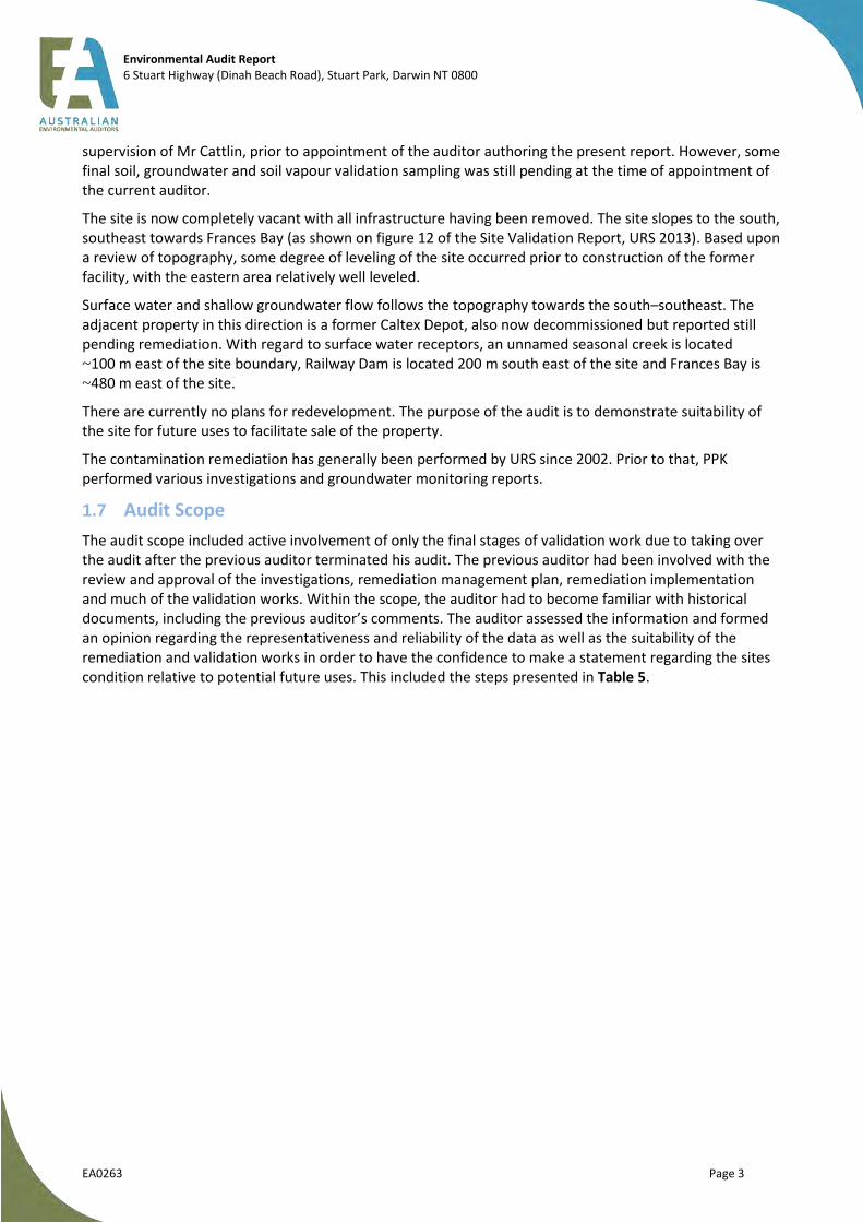
The site is now completely vacant with all infrastructure having been removed. The site slopes to the south, southeast towards Frances Bay (as shown on figure 12 of the Site Validation Report, URS 2013). Based upon a review of topography, some degree of leveling of the site occurred prior to construction of the former facility, with the eastern area relatively well leveled.
Surface water and shallow groundwater flow follows the topography towards the south–southeast. The adjacent property in this direction is a former Caltex Depot, also now decommissioned but reported still pending remediation. With regard to surface water receptors, an unnamed seasonal creek is located ~100 m east of the site boundary, Railway Dam is located 200 m south east of the site and Frances Bay is ~480 m east of the site.
There are currently no plans for redevelopment. The purpose of the audit is to demonstrate suitability of the site for future uses to facilitate sale of the property.
The contamination remediation has generally been performed by URS since 2002. Prior to that, PPK performed various investigations and groundwater monitoring reports.
1.7 Audit Scope
The audit scope included active involvement of only the final stages of validation work due to taking over the audit after the previous auditor terminated his audit. The previous auditor had been involved with the review and approval of the investigations, remediation management plan, remediation implementation and much of the validation works. Within the scope, the auditor had to become familiar with historical documents, including the previous auditor’s comments. The auditor assessed the information and formed an opinion regarding the representativeness and reliability of the data as well as the suitability of the remediation and validation works in order to have the confidence to make a statement regarding the sites condition relative to potential future uses. This included the steps presented in Table 5.

Environmental Audit Report 6 Stuart Highway (Dinah Beach Road), Stuart Park, Darwin NT 0800
EA0263 Page 4
Table 5: Audit Scope
Audit Scope Aspect Details
Audited review of reports prepared by site assessors
The auditor reviewed the following reports/letters provided by the client and completed by URS (the assessor) in an ‘audit’ capacity:
URS (2011b) Data Gap Test Pitting Report (March 2011)
Tonkin and Taylor (2012) Auditor’s Review of Preliminary Site Validation Report (29 March 2012)
URS (2011d) Addendum – Updated Risk Based Trigger Levels for Former Mobil Darwin Coast Bulk Plant (104842), October 2011
URS (2012a) Former Mobil Darwin Coastal Bulk Fuel Terminal, Groundwater Monitoring Event and Soil Vapour Sampling, September 2012 (URS ref: 42645927) (16 April 2013)
URS (2013a) Site Validation Report including earlier revisions and TPR Comments (6 July 2012) and associated letter
URS (2013b) Additional Soil Remediation and Soil Gas Well SG5A Reinstatement and Sampling Report (42645927), 21 June 2013
Copies of the reports are attached as Appendix C.
Background review of reports prepared by site assessors and responses provided by the previous auditor
The auditor reviewed the following reports for background purposes and to assess suitability of the conclusions drawn regarding the works performed at that time:
URS (2006) – Post Phase 2 ESA Coastal Bulk Plant Darwin (draft)
URS (2007a) Tank Excavation Assessment, Mobil Coastal Bulk Plant, Darwin, Northern Territory, February 2007
URS (2007b) Phase 1 Environmental Site Assessment, Darwin Mobil Coastal Bulk Plan, URS, 10 October 2007
URS (2008) Stage 2 Environmental Site Assessment, Former Mobil Coastal Bulk Plant, Darwin, Northern Territory
URS (2009a) Annual Groundwater Monitoring Event May 2009 (draft), Former Coastal Bulk Plant (104842), Dinah Beach Road, Stuart Park NT 0800
URS (2009b) October 2009 Groundwater Monitoring Event, Former Darwin Coastal Bulk Plant (104842), Dinah Beach Road, Stuart Park NT 0800.
URS (2010) July 2010 Groundwater Monitoring Event, Former Darwin Coastal Bulk Plant (104842), Dinah Beach Road, 24 September 2010
URS (2011a) Quantitative Risk Assessment (QRA) (dated February 2011)
Tonkin and Taylor (2011) Auditor’s Review of Quantitative Risk Assessment (8 April 2011)
URS (2011c) Remediation Management Plan (dated June 2011)
URS (2012a) Groundwater Monitoring Event and Soil Vapour Sampling, May 2012 (dated 12 September 2012)
Copies of the reports are attached as Appendix C.

Environmental Audit Report 6 Stuart Highway (Dinah Beach Road), Stuart Park, Darwin NT 0800
EA0263 Page 5
Table 5: Audit Scope
Audit Scope Aspect Details
Issue of advice letters
The auditor has issued formal correspondences (attached as Appendix D):
AEA Reference: EA0263-C1, Auditor Review RE: Draft GME and SV Sampling, Sept 2012 (19 March 2013)
AEA Reference: EA0263-C2, Auditor Review RE: Addendum – Updated risk Based Trigger Levels, Oct 2011 (3 April 2013)
AEA reference: EA0263-C3, Auditor Review RE: Comments on URS Response to Auditor Comments C2 (RBTLs) (9 May 2013)
AEA Reference: EA0263-C4, Auditor Review RE: URS Report - Additional Soil Remediation and Soil Gas Well Sampling (10 July 2013)
AEA Reference: EA0263 - C5 - Mobil Darwin Additional Soil Remediation and Soil Gas Well Sampling Report (30 August 2013)
Site visits The auditor visited the site for familiarisation on 20 and 21 March 2013
Verification sampling The auditor did not take any verification samples during the audit
Correspondence with NT EPA
The auditor met with the NT EPA on site on 21 March 2013
The auditor notified the NT EPA on 23 March 2013.
The auditor provided brief email updates thereafter
Consultation with expert support
The auditor utilised his expert internal and external support team as follows:
Ismail Gulec – External (Environmental Risk Assessors) for the HRA works and verification of RBTLs
Kane Mitchell – Internal (Australian Environmental Auditors) for soil vapour sampling related works
Greg Foster – for report preparation and data (including quality) analysis

Environmental Audit Report 6 Stuart Highway (Dinah Beach Road), Stuart Park, Darwin NT 0800
EA0263 Page 6
2 Site Features, Surrounds and Environmental Setting
2.1 Site Features
Table 6 presents a summary of the key features at the site at the time the audit commenced, as reported by URS and observed by the auditor during site visits.
Table 6: Summary of Site Features
Site Feature Aspect Details
Property use Vacant and fenced, formerly a bulk fuel depot
Potentially sensitive onsite receptors
None at present; however, future development will lend to receptors as developed
Built structures None remained, former structures detailed in documentation including: 13 ASTs, four USTs, a truck filling gantry, lube store, drum filling plant, drum store; and two oil/water separators
Evidence of historical industrial processes
No obvious evidence, but detailed in documentation relating to storage, transfer and packaging of various hydrocarbon fuels and lubricants including: ULP, LRP, diesel, kerosene, lube oil and slop wastes
Evidence of chemical storage areas
None remained, but well documented and summarised above
Evidence of waste disposal areas
None remained, but details of oil–water separators provided in documentation
Evidence of potentially hazardous building materials
None remained or documented
Evidence of filling Some of the area had been worked over during soil remediation. One area requiring soil vapour sampling was inundated with water due to an uphill stream active during the wet season, saturating the fill material
Evidence of vegetation stress None during audit process
Evidence of chemicals leaks/spills
No evidence during the audit process, however, two historical spills prior to remediation have been discussed in the documentation
Olfactory evidence of contamination
None during audit process
A site location plan is provided as Figure 1. A plan displaying significant features at the site as reported prior to the present auditor’s involvement is provided in Figure 2.
Environmental Audit Report 6 Stuart Highway (Dinah Beach Road), Stuart Park, Darwin NT 0800
EA0263 Page 7
Figure 1 – Site Location (Source: URS 2013a)

Environmental Audit Report 6 Stuart Highway (Dinah Beach Road), Stuart Park, Darwin NT 0800
EA0263 Page 8
Figure 2 – Historic Features and Detailed Site Layout (Source: URS 2007b)
Environmental Audit Report 6 Stuart Highway (Dinah Beach Road), Stuart Park, Darwin NT 0800
EA0263 9
2.2 Surrounding Properties
The following table presents a summary of the key surrounding property details. The table is based on current conditions. The historical use of surrounding properties is discussed in Section 3.1.
Table 7: Surrounding Property Details
Surrounding Property Aspect Details
Surrounding land use: North Commercial (Darwin Honda) and residential (former BP Terminal redeveloped for residential use)
Surrounding land use: South Vacant land, including bush land and ephemeral creek (Crown Land)
Surrounding land use: East Commercial (former Caltex depot) followed by a storage dam (Railway Dam) and low density residential dwellings
Surrounding land use: West Industrial (Darwin Toyota, across Stuart Highway)
Potentially sensitive off-site receptors
With regard to surface water receptors, an unnamed seasonal creek is located ~100 m east of the site boundary, Railway dam is located 200 m south east of the site and Frances Bay is ~480 m east of the site
Proximity of site to any likely contamination sources
The site is up gradient of the Caltex Terminal which lies immediately southeast of the site. The former BP Terminal is down and cross gradient of the site
A plan displaying the location of surrounding properties is provided below in Figure 3.
2.3 Environmental Setting
Table 8 presents a summary of the environmental setting for the site.
Table 8: Summary of Environmental Setting Information
Environmental Setting Aspect
Environmental Setting Sub-Aspect
Details
Climate Mean temperaturesA Minimum: 19.3°C in July, maximum: 33.3°C in November
Mean rainfallB Minimum is 1.2 mm in July, maximum is 423.8 mm in January
Atmospheric pressure Variable
Hydrology On-site surface water features None: however, during the wet season, partial site saturation is
not uncommon with local surface flooding
Nearby surface water features Un-named ephemeral creek 100 m east
Storage dam (Railway Dam) 200 m south
Frances Bay 480 m away
Geology Likely soil profileC Quaternary marine alluvial sediments
ABoM reference http://www.bom.gov.au/climate/averages/tables/cw_014015.shtml BBoM referencehttp://www.bom.gov.au/climate/averages/tables/cw_014015.shtml CURS Remediation Management Plan.

Environmental Audit Report 6 Stuart Highway (Dinah Beach Road), Stuart Park, Darwin NT 0800
EA0263 10
Table 8: Summary of Environmental Setting Information
Environmental Setting Aspect
Environmental Setting Sub-Aspect
Details
Likely rock profile
D Burrell Creek formation of the Finniss River Group which consists
of siltstone, shale, sandstone, quartz pebbles conglomerate and metamorphosed greenschist facies (phyllite) (Figure 3)
Hydrogeology Depth to water table aquiferE Range 0.5–10 m BGS depending on wet/dry season
Depth to base of water table aquifer
F
Unknown
TDS content of water table aquifer
G
>3000 mg/L near coast; however, site measurements indicate fresh water TDS < 1000 mg/L acidic (pH 3.3–6.4)
Yield of water table aquiferH 0.5–5.0 L/s
Registered bores in the vicinity of the Site utilising the water table aquifer
I
13 wells within 1 km radius ranging from 8.9 to 63.3 m deep; installed from 1913 to 1972 with standing water levels ranging from 2.74 to 17.68 m: two have been abandoned, none of the use are known
Likely flow direction in water table aquifer
East, with gradient ~0.039m/m and flow rate ranging from 0.008 to 8 m/year, depending on dry/wet season
Known contamination status of water table aquifer at nearby properties
Caltex property immediately down-gradient to the southeast (Figure 3) which is contaminated with hydrocarbons
Likely recharge/ discharge relationship of water table aquifer with surface water
Likely connection between siltstone and overlaying clays/fill is in hydraulic communication and likely to discharge into Frances Bay
Relevance of aquifers beneath water table aquifer
Typically not much reliance on shallow groundwater aquifer due to proximity to coast (typical high salinity) and abundance of seasonal rainfall
D http://maps.ubspatial.com.au/vvg.php E http://maps.ubspatial.com.au/vvg.php F http://maps.ubspatial.com.au/vvg.php G http://maps.ubspatial.com.au/vvg.php H http://maps.ubspatial.com.au/vvg.php I NRETA database search

Environmental Audit Report 6 Stuart Highway (Dinah Beach Road), Stuart Park, Darwin NT 0800
EA0263 11
Figure 3 – Surrounding Land Uses and Geology (Source: URS 2007b)
Environmental Audit Report 6 Stuart Highway (Dinah Beach Road), Stuart Park, Darwin NT 0800
EA0263 12
3 Site History and Potential Contaminant Sources
3.1 Site History Review
3.1.1 Scope
The following table presents a summary of the historical information obtained and documented by URS (2007b) and reviewed by the auditor against typical historical information sources that can be of use for contamination assessments.
Table 9: Scope of Historical Information Review
Historical Information Source Source Utilised by Site Assessor
Historical land title information Transferred Lot 1661 on Survey Plan OP 001533, Town of Darwin, Volume 009 Folio 109 to Mobil Oil Australia Pty Ltd on 08 February 1973. Previously Crown Land.
Historical aerial photographs Series of historical photos contained in Final Report Soil Validation Report (URS 2013a, appendix L)
Anecdotal information from persons familiar with the site
None relevant
Local planning authority records Records from Building Advisory Services, Department of Planning and Infrastructure (DPI)
Dangerous goods storage records Records from Building Advisory Services, Department of Planning and Infrastructure (DPI)
Historical trade waste agreement records Records from Darwin City Council, NT EPA and DPI indicated no such licenses despite the use of onsite oil water separators
Historic release records Mobil records indicate a diesel release in 1996 resulting from a leaking diesel transfer line near the former filling gantry. The investigation was triggered by a notice of a sheen in the ephemeral creek adjacent the site. A subsequent investigation resulting in delineation of the plume and remediation resulted in the recovery of 23 000 L of diesel fuel
Discharge from the on-site oil water separator system (OWS) consistently released water above NSW EPA criteria for freshwater ecosystems into the ephemeral creek
Records from NT EPA indicate a jointly used Mobil-Caltex pipeline leaked in 1997 with ~16 000 L recovered
Historic as-built diagrams of plant and equipment Several provided by Mobil to URS during various stages of work
The auditor considers that the scope of the historical information review presented by URS (2007b) - Phase 1 ESA - Mobil Darwin and summarised in the Final Soil Validation Report (URS 2013a) was adequate to identify potential areas and contaminants of concern.

Environmental Audit Report 6 Stuart Highway (Dinah Beach Road), Stuart Park, Darwin NT 0800
EA0263 13
3.1.2 Main Findings
The main findings of the historical review with respect to potential contamination issues are discussed below.
On-site
o The historical use of the site is limited to one primary source of pollution, which is the storage, transfer and packaging of various hydrocarbon products. This includes:
four USTs and associated piping; 13 ASTs and associated piping; filling gantry and associated piping; lubricant store; drum store; drum filling plant; two oil–water separators; and sludge and waste water from tank cleaning operations.
o A significant event occurred in 1996 being the release of diesel fuel from the transfer piping near the filling gantry at the Mobil facility. This resulted in on and off-site impact in the form of PSH which was recovered over time. Short-term recovery resulted in 23 000 L of diesel.
Off-site
o former Caltex Depot (down-gradient, but immediately adjacent to the site on the eastern boundary);
o a relatively significant event occurred in 1997 being a Caltex pipeline leak, immediately adjacent but down gradient of the site. This release resulted in the recovery of 16 000 L of PSH; and
o former BP Depot (cross gradient to the north-east, across Dinah Beach Road), which has been remediated and redeveloped for residential purposes.
3.2 Chemicals of Potential Concern and Potential Sensitive Receptors
The auditor has reviewed the available information and identified the following areas/contaminants of concern and receptors of concern. Figure 2 indicates the locations of site features described in Table 10.
Table 10: Scope of Historical Information Review
Potential Area of
Concern
CoPCs Comments
USTs (four) MAH, TPH, PAH, phenols, metals Small capacity USTs:
2kL (waste and slops), 5kL (ULP), 2 X 10kL (diesel and ULP)
ASTs (13) MAH, TPH, PAH, phenols, metals Including:
scattered large vertical tanks (2750–5115 kL designated as T1, T2, T7 and T8),
four clustered 55 000 L vertical tanks (designated as V1-V4), four clustered horizontal lube oil tanks (T11 -T14), and one horizontal kerosene tank (T15)
Filling gantry MAH, TPH, PAH, phenols, metals Area of former release in 1997
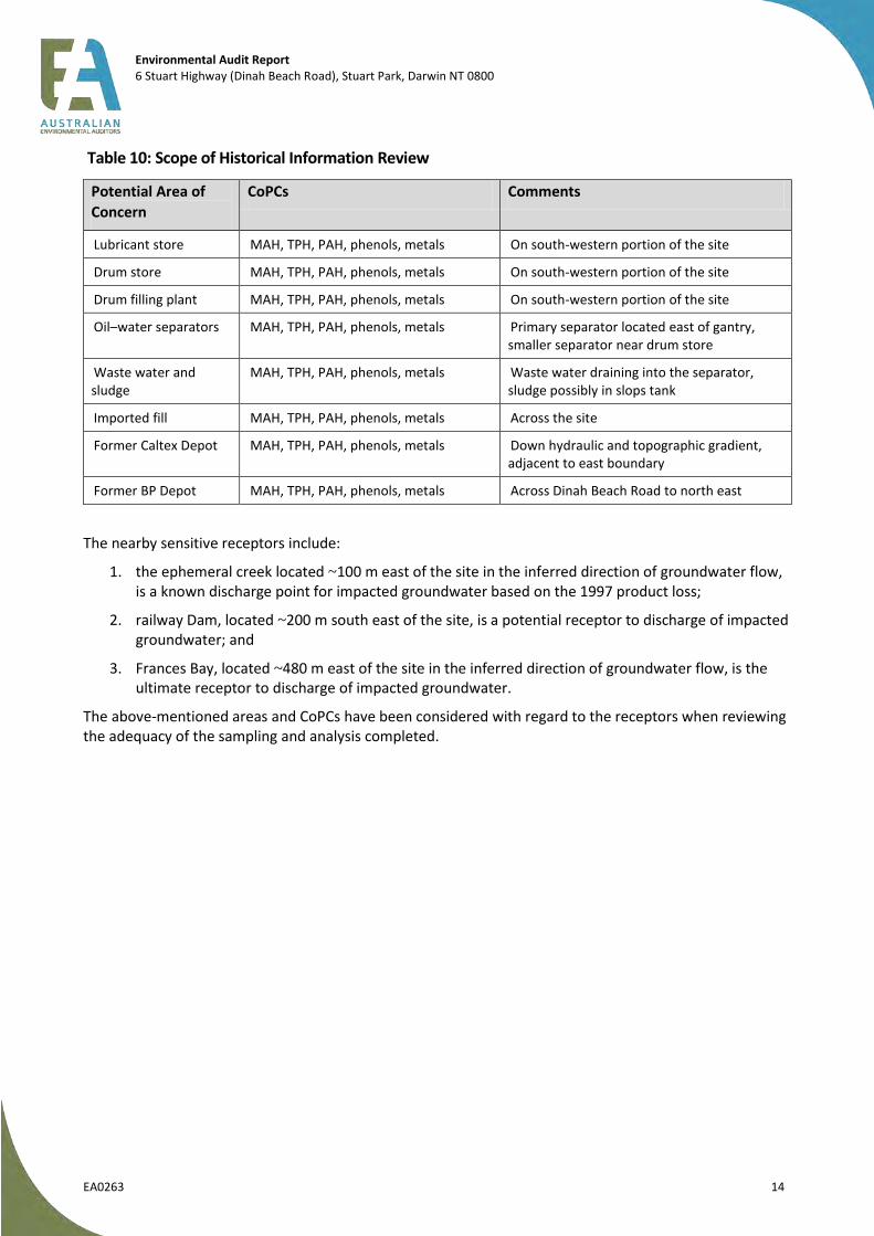
Environmental Audit Report 6 Stuart Highway (Dinah Beach Road), Stuart Park, Darwin NT 0800
EA0263 14
Table 10: Scope of Historical Information Review
Potential Area of
Concern
CoPCs Comments
Lubricant store MAH, TPH, PAH, phenols, metals On south-western portion of the site
Drum store MAH, TPH, PAH, phenols, metals On south-western portion of the site
Drum filling plant MAH, TPH, PAH, phenols, metals On south-western portion of the site
Oil–water separators MAH, TPH, PAH, phenols, metals Primary separator located east of gantry, smaller separator near drum store
Waste water and sludge
MAH, TPH, PAH, phenols, metals Waste water draining into the separator, sludge possibly in slops tank
Imported fill MAH, TPH, PAH, phenols, metals Across the site
Former Caltex Depot MAH, TPH, PAH, phenols, metals Down hydraulic and topographic gradient, adjacent to east boundary
Former BP Depot MAH, TPH, PAH, phenols, metals Across Dinah Beach Road to north east
The nearby sensitive receptors include:
1. the ephemeral creek located ~100 m east of the site in the inferred direction of groundwater flow, is a known discharge point for impacted groundwater based on the 1997 product loss;
2. railway Dam, located ~200 m south east of the site, is a potential receptor to discharge of impacted groundwater; and
3. Frances Bay, located ~480 m east of the site in the inferred direction of groundwater flow, is the ultimate receptor to discharge of impacted groundwater.
The above-mentioned areas and CoPCs have been considered with regard to the receptors when reviewing the adequacy of the sampling and analysis completed.
Environmental Audit Report 6 Stuart Highway (Dinah Beach Road), Stuart Park, Darwin NT 0800
EA0263 15
4 Summary of Investigations and Remediation
Investigation works at the site date back to 1996 and were triggered by the diesel fuel release from the transfer line to the filling gantry. A series of investigations was performed at the site from 1996 to May 2001 by PPK, including investigation, remediation and groundwater monitoring. In 2002, URS took over for environmental investigations and monitoring at the site. Mobil commenced decommissioning with the main works (removal of all remaining tanks and most infrastructures) performed in 2006. In 2011, Mobil engaged URS to develop a remediation strategy for the site in preparation for divestment. A previous auditor was engaged during remediation, but terminated the audit. The present auditor (Mr Charles Barber) was engaged by Mobil in 2013 after remediation works were done, but prior to finalisation of several reports. This section discusses the content of the various reports.
4.1 General
The auditor has assessed the adequacy of the sampling and analysis methodology and field and laboratory quality assurance/quality control measures for the remediation validation works associated with the audit. The previous works, including, for example, product recovery efforts, groundwater monitoring events, were not subject to audit but were reviewed for contextual purposes. The auditor has made his assessment with respect to the relevant requirements presented in the following documents referred to (directly and indirectly) in appendix 3 of EPAV (September 2007, Publication 759.1) Environmental Auditor (Contaminated Land), Guidelines for Issue of Certificates and Statements of Environmental Audit:
Australian Standard AS 4482.1 (Standards Australia 2005) Guide to the sampling and investigation of potentially contaminated soil. Part 1: Non-volatile and semi-volatile compounds;
Australian Standard AS 4482.2 (Standards Australia 1999) Guide to the sampling and investigation of potentially contaminated soil. Part 2: Volatile Substances;
Australian Standard AS 5667.6 (Standards Australia 1998) Water quality - Sampling - Guidance on sampling of groundwaters;
EPAV (April 2000, Publication 669) Groundwater Sampling Guidelines;
EPAV (September 2006, Publication 668) Environmental Auditing, Hydrogeological Assessment (Groundwater Quality) Guidelines;
Land and Water Biodiversity Committee (2003) Minimum Construction Requirements for Water Bores in Australia (Edition 2, Revised September 2003); and
National Environment Protection Council (1999) National Environment Protection (Assessment of Site Contamination) Measure.
The NEPM (1999) amendment was introduced nationally in May 2013 and occurred after completion of the majority of field works. As such this audit has been completed with respect to the NEPM (1999) documentation.
4.2 Pre-Audit Historical Investigations and Phase 1 ESA
This audit commenced with the review of the Phase 1 Environmental Site Assessment by URS dated 10
October 2007 (URS 2007b). The document provided a summary of historical reports associated with the site
at the time of the ESA as well as a summary of the site history prior to and including development of the
site for fuel storage use. Additional investigation reports were also provided to the auditor to aid with
gaining historical context of investigations and are also briefly summarised in the following sections.
4.2.1 URS (2007b) Phase 1 Environmental Site Assessment
Prior to 1973 the site was owned by the Commonwealth of Australia before being purchased by Mobil Oil
Australia Limited. The site was zoned for use as hazardous or noxious industry under the Darwin Town Plan.
Between 1968 and 2006, a total of 13 ASTs and four USTs were installed on site (Figure 2). At various times
between 1998 and 2006 the tanks were removed from the site, with major earthworks and building

Environmental Audit Report 6 Stuart Highway (Dinah Beach Road), Stuart Park, Darwin NT 0800
EA0263 16
demolition completed in 2006 when the tank filling gantry, the drum filling plant, drum store and two oil–
water separators also removed.
Following the detected release of product from a fuel transfer line in 1996 and a loss of product from a
jointly operated fuel Mobil-Caltex pipeline in 1997 a series of investigations was instigated. The historical
reports are itemised below, with a summary of findings provided after each report.
PPK (1996). Fuel Investigation Works, Darwin Coastal Bulk Plant Final Report, November 1996.
This report discusses the investigation of the diesel release discovered in 1996, which included the
installation of 24 groundwater monitoring wells, eight recovery trenches (six on-site being T1 to T6 and 2
offsite being T7 and T8) as well as two oil–water separators installed along the creek to capture any fugitive
PSH. By 22 October 1996 some 23 000 L of diesel was recovered. Dissolved phase hydrocarbon plume was
found to be following the direction of groundwater flow towards the east.
PPK (1997). Darwin Coastal Bulk Plant, October 1997.
The 1997 report discusses the results of groundwater monitoring completed in 1997 and the extent of
groundwater impact across the site. The phase separated hydrocarbon (PSH) was defined to the east and to
the south. Pumping of groundwater ceased in March 1997 with reported rebound of PSH noted between
March and July 1997. Fortnightly pumping of trenches resumed between July and October 1997 with 40–
60 L of product recovered and a general decrease in product thickness reported in 13 of 24 monitoring
wells located on- and off-site. An increase in PSH thickness was reported in five wells. Maximum PSH
thickness reported at this time was 45 mm in well DW20.
PPK (1999). Darwin Coastal Bulk Plant Quarterly Report, September 1998.
The report discusses the results of groundwater and surface monitoring completed in 1998 and the extent
of groundwater impact across the site. Increases in PSH thickness was reported in 17 monitoring wells from
February to June 1998. Greatest thickness of PSH reported at DW11 (22 mm). One well reported PSH
decrease (DW3). Six monitoring wells without PSH sampled. Dissolved phase TPH concentrations in well
DW13, DW14, DW16 and DW17 exceeded adopted criteria. Decrease in PSH thicknesses across the site
between June 1997 and June 1998 overall. Reinstatement of fortnightly pumping of PSH from wells
recommended.
PPK (2000). Darwin Coastal Bulk Plant November 1999 Groundwater Monitoring Report, February
2000.
The report titled above discusses the results of installation and sampling of additional monitoring wells
(DW26-DW35, DW35D and DW37) in January 1999 and sampling in November 1999 as well as long-term
trend analysis/comparison. Reinstatement of fortnightly pumping and other remedial activities were not
completed. PSH thicknesses increased in six wells (DW4, DW6, DW9, DW21, DW24 and DW25) whereas 10
wells were reported to have decreasing PSH thicknesses (DW1-3, DW5, DW10, DW11, DW13, DW20,
DW20, DW22 and DW23). The PSH plume remained constant in extent. BTEX concentrations were low or
below detection limits, whereas TPH concentrations generally showed decreases or no changes. Natural
attenuation of hydrocarbons was demonstrated via detection of elevated methane concentrations and low
redox potential mid-plume. Groundwater flow was reported to be towards the east to south east. Further
monitoring, periodic sampling of the creek west of the site to evaluate potential effluent from the oil
water–separator discharge pipe was recommended.
PPK (2001). Darwin Coastal Bulk Plant December 2000 Groundwater Monitoring Report, May 2001.
The report discusses incorporation of groundwater monitoring data collected by Dames and Moore in
December 2000 into the data set (results of 22 monitoring wells). Gauging data indicated PSH thickness
decreases at two locations (DW4, DW6), increases in 12 wells (DW1-DW3, DW5, DW9, DW10, DW21-23,

Environmental Audit Report 6 Stuart Highway (Dinah Beach Road), Stuart Park, Darwin NT 0800
EA0263 17
DW25, MW1 and DW34) and no change at 19 wells with no PSH (DW7, DW11-DW13, DW15-DW18, DW20,
DW26-DW33, DW35 and DW37) between 1999 and 2000. The extent of the PSH plume appeared to have
increased. TPH concentrations decreased between November 1999 and December 2000 in 10 wells (DW7,
DW11-DW13, DW15, DW16, DW29- DW31 and DW33) whereas four wells reported increases in TPH
concentrations (DW18, DW20, DW28 and DW32). BTEX concentrations were low or below detection limits.
Natural attenuation of the plume appeared to have been inhibited by the increased extent of the plume.
Recommendations for further sampling were made, consistent with previous reports.
URS (2002). Groundwater Monitoring Report, September 2002, Coastal Bulk Plant, Dinah Beach Road, Darwin, Northern Territory, November 2002.
Twenty-nine monitoring wells were gauged and sampled (on- and off-site). PSH was note detected at any location; however sheens were noted in purged water from DW1-DW6, DW9, DW10, DW14-DW18, DW21, DW23 and DW25-DW29. Benzene was reported above guideline level in well DW14 and ethyl-benzene was above guideline level in well DW28. Lead was detected above guideline levels in DW1-DW5, DW9, DW25, DW28, DW32, DW35, DW35D and MW1. Overall it was concluded that the dissolved phase plume had decreased in size since 2001.
URS (2004). Post Phase 2 Annual Groundwater Monitoring Event (GME), Mobil Coastal Bulk Plant, Darwin, Northern Territory, January 2004.
The 2004 report discusses the status of the groundwater conditions as part of ongoing monitoring of hydrocarbon impact previously identified at the site; the effectiveness of the ongoing passive skimmer remediation program; and the potential risks that any reported contaminants may pose to human health and the environment. Twenty-five monitoring wells were gauged and sampled in September–October 2003. No PSH was detected. BTEX was reported at concentrations below adopted guidelines. TPH fractions were reported in the majority of wells with TPH C10–C36 concentrations in excess of 50 mg/L reported in wells DW1, DW3, DW4, DW13, DW23, DW25 and DW31 and a maximum value of 1.53 g/L reported for the triplicate sample from well DW25. Lead, where detected, was reported at concentrations below guideline levels. The total PAH concentrations reported for wells DW31 (7 µg/L), DW16 (34 µg/L) and DW23 (97 µg/L) were above the adopted guideline level of 3 µg/L.
4.2.2 URS (2007a) Tank Excavation Assessment, Mobil Coastal Bulk Plant, Darwin, Northern Territory, February 2007
All petroleum-related storage and dispensing equipment was removed from the site between 9 May and 28 June 2006. The infrastructure removed included:
• four USTs and associated fuel and vent lines; • four bulk ASTs and associated fuel lines; • truck filling gantry; • office building; • former drum filling plant and storage warehouse; and • two open oil–water separators.
The former diesel, two ULP USTs and product lines removed appeared in relatively good condition, with no obvious breaches noted. Staining of surface soils and hydrocarbon odours were observed towards the southern end of the former drum filling warehouse area and across the base of the four bulk ASTs. Hydrocarbon impact was observed in soil at the base of both oil/water separators and both UST excavations (Pit 1 former location of UST1 and UST2 and Pit 2 former location of UST3).
Limited soil validation sampling indicated elevated concentrations of hydrocarbons in the area of: base and northeastern wall of Tank Pit 1 (UST1/2); base of Tank Pit 2 (UST3), base of AST bunded area; base and southern wall of the oil–water separator; south-western and western end of the former drum warehouse. The post-phase 2 investigation (summarised below) was instigated to delineate the extent of impact.
Environmental Audit Report 6 Stuart Highway (Dinah Beach Road), Stuart Park, Darwin NT 0800
EA0263 18
4.2.3 URS (2008) Post-Phase 2 Environmental Site Assessment, Former Mobil Coastal Bulk Plant, Darwin, Northern Territory (as cited in URS (2008) Stage 2 Environmental Site Assessment)
The report discusses the results of a detailed site investigation completed between 12 September and 10 November 2006 that included completion of 55 soil bores, analysis of soils samples for TPH, BTEX, lead and selected analysis for PAH, phenols, metals and VCHs. Fourteen soil bores were converted to monitoring wells. Groundwater monitoring of 32 monitoring wells included assessment of presence of LNAPL, purging and sampling of 29 monitoring wells for TPH, BTEX, lead and selected samples analysed for PAH, phenols, metals, VCHs and natural attenuation parameters.
Soil results indicated hydrocarbon impact above adopted criteria at depths between 1 and 3 m BGS in the areas of the: former drum store warehouse, separator and filling plant; the former AST bunded areas (ASTs T11-T14); the truck filling gantry and main OWS; the former Tank 1; and south of former Tank 7. Localised metal impact (with results above EIL) was also reported but all results were below HIL-F (commercial/industrial) and HIL-A (residential) land use criteria.
Groundwater impact by hydrocarbons were generally characterised by elevated concentrations of TPH C10–C36 in the area of the former drum store and eastern site boundary with LNAPL detected at MW7 (0.06 m apparent thickness). Benzene was present at concentrations above adopted guidelines at well DW6 (355 µg/L) and PAHs above adopted guidelines at wells DW3, DW4, DW9, MW5 and DW23. Low hydrocarbon concentrations were reported in wells in the north eastern portion of the site in the vicinity of the former AST and UST locations.
Groundwater flow velocity was estimated to be between 5.5 and 45.6 m/year in an easterly direction. TDS values were measured below 1000 mg/L (potable water quality). Natural attenuation of hydrocarbons appeared to be supported at the site to varying degrees depending on the vicinity to secondary soil sources.
4.2.4 URS (2008) Stage 2 Environmental Site Assessment, Former Mobil Coastal Bulk Plant, Stuart Park, Darwin, Northern Territory, 21 November 2008
The purpose of this investigation was to supplement previous works and provide enough data for a quantitative risk assessment (QRA) to be performed. Field investigations were completed between 17 and 22 August 2008 and included: test pitting (51 test pits; 124 primary 11 duplicate and 10 triplicate soil samples analysed) and a GME (30 wells gauged; 25 wells samples collected and analysed).
Test pit depths ranged between 1 and 4 m depth depending on site location. Soil sampling confirmed and delineated the extent of impact detected in the previous ESA (URS 2006). Analytical results confirmed the presence of medium to heavy end petroleum hydrocarbons associated with diesel and lube oils (as detected previously). New (localised) impact was identified in the former tank farm around Tanks 1 and 2.
The GME confirmed two on-site areas of LNAPL – one down-gradient of the former filling gantry and the other adjacent to the former drum store warehouse separator. LNAPL was detected at well locations: DW01 (0.008 m), DW03 (0.005 m), DW04 (0.020 m), DW09 (0.003 m) and MW7 (0.045 m). Two wells (MW12, DW35D) were unable to be sampled. BTEX and PAH impact was limited in extent (as reported previously) with groundwater impact predominantly associated with medium to heavy TPH fractions. Metal concentrations detected in groundwater were considered to be naturally occurring (background) and a function of the site mineralogy.
4.2.5 URS (2009a) Annual Groundwater Monitoring Event, Former Mobil Coastal Bulk Plant (104842), Dinah Beach Road, Stuart Park, Northern Territory 0800, 3 July 2009 (draft)
This report was provided in draft form to the auditor and has not been finalised. The report discusses the results of a GME completed between 12 and 24 May 2009. Thirty-two on-site monitoring wells were gauged and 29 of those sampled. Off-site wells were not accessible for sampling for this event. Groundwater flow at the time of this event was towards the east.

Environmental Audit Report 6 Stuart Highway (Dinah Beach Road), Stuart Park, Darwin NT 0800
EA0263 19
Groundwater impact was present up to the down-gradient boundary of the site consistent with results from 2008. LNAPL was detected in one shallow well DW09 (0.005 m) adjacent to the former oil–water separator and in one deep (bedrock) well MW7 (0.012) adjacent to the former drum store warehouse. Hydrocarbon sheens were noted in the purged water obtained from wells DW01 (which previously reported measurable LNAPL) and DW6 – across and down-gradient of DW9.
Groundwater impact confirmed the general absence of BTEX and where present contained mid- to heavy-end TPHs hydrocarbon impact. This was considered to be consistent with the previous monitoring round.
4.2.6 URS (2009b) October 2009 Groundwater Monitoring Event, Former Darwin Coastal Bulk Plant (104842), Dinah Beach Road, Stuart Park, Northern Territory 0800, 30 June 2010
The report discusses the results of a GME completed between 9 and 10 October 2009. Thirty-two on-site monitoring wells were gauged and 27 of those were sampled.
LNAPL was detected in four wells: DW01 (0.010 m), DW03 (0.037 m) DW09 (0.040 m – an increase since May 2009) and MW07 (0.010 m – similar to the May 2009 result). Groundwater salinity was confirmed as being in the potable range and flow direction remained towards the east.
Groundwater results were consistent with the previous event in 2009 with: LNAPL impact reported in two areas (former filling gantry and former oil–water separator) – consistent with earlier events; and with medium to heavy end TPH fractions predominating impacted areas in the south east of the site around the former tank filling gantry and the former drum store warehouse oil–water separator. The extent of dissolved phase impact not delineated to the east.
4.2.7 URS (2010) July 2010 Groundwater Monitoring Event, Former Darwin Coastal Bulk Plant (104842), Dinah Beach Road, 24 September 2010
The report discusses the results of a GME completed between 28 and 30 July 2010. Thirty-two on-site monitoring wells were gauged and 30 of those were sampled.
LNAPL was encountered in two wells DW03 (0.049 m) and DW09 (0.012 m) – a slight increases since 2009 but in consistent locations. Consistent with previous investigation dissolved phase hydrocarbon (predominantly mid- to heavy-end TPH) impact in groundwater were predominantly located in the south-eastern portion of the site in two locations – the former drum store warehouse (near MW7) and near the former oil–water separator (near DW3 and DW9). URS considered that overall the dissolved phase hydrocarbon and LNAPL impact had decreased since the previous GME in October 2009.
4.3 Quantitative Risk Assessment and Related Updates
4.3.1 QRA (URS 2011a)
URS completed a Quantitative Risk Assessment (QRA) report in February 2011 (URS 2011a) to address the presence of impacted soil and groundwater beneath the site.
URS (2011). Quantitative Risk Assessment, Former Darwin Coastal Bulk Plant (104842), February 2011.
The QRA assessed potential risks for commercial and residential land use (at the site) based upon the type of construction permitted under the current site zoning (commercial) and most conservative potential zoning of the site but did not address potential off-site risk.
The QRA and revisions were reviewed by the previous auditor (Mr Luke Cattlin) and his expert support team member, Dr Ismail Gulec (who is also a member of the auditor, Mr Barber’s, expert support team). The previous auditor’s review found that the QRA is generally in accordance with the guidelines recommended by enHealth 2004 that draw on and are supplemented by those provided by Schedule B (4) NEPM 1999 and ANZECC/NHMRC 1992. However, the original auditor noted that:

Environmental Audit Report 6 Stuart Highway (Dinah Beach Road), Stuart Park, Darwin NT 0800
EA0263 20
the QRA did not consider draft enHealth 2011 Guidelines and draft enHealth 2010 Australian exposure factor guidance which draw on and are supplemented by the draft NEPM 2010. However, if these guidelines were considered, the QRA method and the obtained results would be still acceptable due to the less conservative approach and exposure factor parameters;
the QRA was conducted only for receptors on-site;
the identified contaminants of concern at the site (TPH fractions in soil and groundwater and lead in soil) are sufficient and considered appropriate;
the toxicity assessment and the adopted toxicity values for the contaminants of concern are considered appropriate;
the identified receptors (child, adult, commercial and intrusive workers) are considered appropriate;
the identified complete exposure pathways (ingestion, dermal contact with surface soil and inhalation of volatiles from light non-aqueous phase liquids (LNAPL) and deep soil are considered appropriate;
the values used for the exposure parameters were in accordance with the publications of respected authorities;
the calculations were double checked and considered to be accurate; and
the adopted acceptable risk criterion (hazard index = 1) in the QRA is in accordance with EPA Victoria expectations and current risk assessment practises.
The original auditor also found that the following risk characterisations as outlined in the QRA were considered appropriate and accepted:
due to the non-carcinogenic classification and/or unavailable carcinogenic quantification of the contaminants of potential concern (CoPCs), carcinogenic risk assessment was not conducted;
the calculated hazard index was greater than the adopted target level (hazard index = 1) for residents living in both basement or slab on ground type buildings at the site;
the calculated hazard index was 1 (equal to target level) for commercial workers occupying both basement or slab on ground type buildings at the site; and
the calculated hazard index was 0.4 (less than the target level) for intrusive workers at the site.
Overall, the following conclusions have been drawn from the QRA:
the current CoPC concentrations in soil and groundwater will pose unacceptable risks to future residents and/or commercial workers occupying both with basement and/or slab on ground type building(s) at the site;
the current CoPC concentrations in soil and groundwater will not pose an unacceptable risk to intrusive workers at the site;
if contaminated soil were to be removed, potential risks would be low and acceptable for residents living in slab on ground type building;
if contaminated soil were to be removed, an unacceptable risk will remain for residents living in a building with a basement due to the inhalation exposures from LNAPL which was assumed by URS in their QRA to be present adjacent to the basement walls; and
if contaminated soil were to be removed, the potential risks would be low and acceptable for commercial workers both in a building with a basement and/or a slab on ground type of construction.
The original auditor also noted a series of items that were not part of the scope of the QRA as conducted by URS:
the dissolved phase plume has not been delineated. There is a potential for off-site groundwater contamination;

Environmental Audit Report 6 Stuart Highway (Dinah Beach Road), Stuart Park, Darwin NT 0800
EA0263 21
there is a potential for off-site soil contamination due to surface runoff during the previous spills at the site;
off-site soil and groundwater contamination assessment and following an offsite QRA might be necessary in the future; and
the QRA used Domenico fate and transport modelling for the TPH contaminated groundwater discharge to the nearest down gradient unnamed seasonal creek. The model found no potential discharge to the creek. The quality and accuracy of this model will require further review and assurance with some offsite soil and groundwater data.
From the QRA URS also derived a set of risk-based trigger levels (RBTLS) for the site where contaminants could remain on-site (for a residential end use) while ensuring health risks would remain low and acceptable. The RBTLs were derived for contaminants (both volatile and non-volatile) that were historically above guideline values. URS RBTLs are presented in the following table.
Table 11: RBTLs for shallow (<0.5 m BGS) and deeper (>0.5 m BGS) soils (Source: URS 2011a)
Chemical Residential RBTL (soil <0.5 m BGS) (mg/kg)
Residential RBTL (soil >0.5 m BGS) (mg/kg)
TPH C6–C9 21 40
TPH C10–C14 380 4000
TPH C15+ 2758 –
Lead 127 –
4.3.2 Proposed Revised RBTLs (URS 2011d)
Late in 2011 and subsequent to the results of excavation of site soils and availability of speciation of aromatic/aliphatic TPH data, URS (2011d) issued a set of revised RBTLs for the site for review to the previous auditor. However, the audit by the previous auditor was terminated before verification of the site. The present auditor had the new RBTLs and associated documentation reviewed by his expert support team member, Dr Ismail Gulec, in 2013.
The revised RBTLs were not endorsed by the auditor or his support team due to a disagreement of methods and ratios used (refer to auditor letters C2 dated 3 April 2013 and C3 dated 9 May 2013; Appendix D). As such, URS adopted the initial RBTLs as being more robust and reliable for application at the site. The initial RBTLs were used as the acceptance criteria to finalise the soil validation report (see Section 4.6 below).
4.4 Remediation Management Plan
URS provided the original auditor with a Remediation Management Plan (RMP) for the site, which was approved and subsequently implemented.
URS (2011c). Former Darwin Coastal Bulk Plant, Remediation Management Plan, 3 June 2011.
The RMP outlined the proposed soil and groundwater remediation required to facilitate a change in land use from commercial industrial to residential land use following re-zoning of the area. The plan also provided a series of control measures and procedures, including stormwater control, traffic control, dust control, noise, waste water treatment, odours, vapours, and sanitation.
The plan focused on contaminated soils located in the vicinity of the former filling gantry, the drum loading and storage area, localised soil impact associated with the former tank farms, the area of the main oil–water separator and the area formerly affected by the diesel release. Groundwater impact was also recorded in these areas with LNAPL reported historically (see section 4.2). The excavation works were aimed at removing the both soil and groundwater impact, due to the shallow nature of groundwater in the area of remediation.

Environmental Audit Report 6 Stuart Highway (Dinah Beach Road), Stuart Park, Darwin NT 0800
EA0263 22
4.4.1 Proposed Soil Remediation
URS conducted a review of available remedial options in accordance with the waste hierarchy provided by the Northern Territory of Australia Waste Management and Pollution Control Act (1999). The technologies considered included:
off-site disposal;
select on-site reburial and subdivision of property accordingly;
soil vapour extraction; and
soil vapour extraction and ex situ land farming/bioremediation.
URS proposed a strategy of excavation and on-site treatment of soils via bio-remediation (through use of biopiles) given the COPCs being amenable to bio-remediation, the local climate and the lack of availability of landfill. Soils would be validated to concentrations below the RBTLs established in the initial QRA, which was verified by the auditor’s expert support team in this area.
4.4.2 Proposed Groundwater Remediation
URS proposed removal of LNAPL via excavation, given the shallow nature of impact, to a depth of ~0.5 m below the seasonal low groundwater table. The soil material would also be treated via bio-piling. LNAPL that accumulated in the excavation would be pumped out, separated from any groundwater component and removed via contractor for off-site disposal. The groundwater component would be discharged to sewer or re-used on-site for dust suppression.
Groundwater monitoring well infrastructure would be re-instated where removed/lost and a long-term groundwater monitoring plan adopted. The results of GMEs would be used to update the QRA, assess the potential for any rebound, assess the potential for natural attenuation (an already approved method for groundwater remediation at other local sites) and development of fate and transport modeling.
4.5 Data Gap Test Pitting – March 2011
URS proposed a series of data gap test pits to confirm the extent of excavations required, identify any local
impacted soil hotspots and allow inspection of soils to assess grain size distribution for treatment method
confirmation.
URS completed the initial test pitting program as outlined in the RMP. The following report was provided to
the previous auditor for review:
URS (2011b). March 2011 Data Gap Test Pitting Program, Darwin Coastal Bulk Plant (104842), Dinah Beach Road, July 2011.
Nineteen test pits were completed, 44 soil samples (plus three blind duplicate samples and one triplicate
sample) collected and analysed during the period from 14 to 18 March 2011 (Figure 4) with the following
conclusions drawn.
The surface geology and depth to bedrock is highly variable, but generally a 1.0 m thick layer
consisting of gravelly silty fill material was present in most test pits. Typically the depth to bedrock
is shallower in the western and northern areas of the site where bedrock in some cases outcrops at
ground surface. In the south-east corner of the site bedrock was typically encountered at depths
below 3 m. The geology encountered during these investigations is consistent with that reported in
previous investigation reports.
In general, the findings from this investigation are consistent with those presented in URS 2008 PP2
ESA. The majority of the soil impact is associated with operations in and around the former filling
gantry, separator and drum filling and storage warehouse. Impact are predominantly medium to

Environmental Audit Report 6 Stuart Highway (Dinah Beach Road), Stuart Park, Darwin NT 0800
EA0263 23
heavy molecular weight hydrocarbons associated with diesel and a blend of diesel and lube oil
range hydrocarbons – samples from locations A3, B1, B2, B3, C4 contained concentrations of TPH
fractions above the RBTLs (Figure 4). Additional delineation testing has been effective in clarifying
the extent of the identified remediation areas.
All BTEX, PAH and phenols results were below laboratory limits of reporting.
Testing below former ASTs and adjacent to the former USTs did not indicate concentrations of TPH
above the adopted soil criteria (RBTLs) indicating historic hotspots identified in these areas to be
very limited in extent.
Arsenic, chromium (non-speciated) and zinc were detected at the site at concentrations above
adopted guideline (EIL) levels and lead was reported at concentrations below the RBTL.
4.6 Soil Validation Report
URS completed soil excavations and validation sampling at the site in mid-late 2011 and provided the
following report.
URS (2013a). Soil Validation Report, Mobil Darwin Former Bulk Fuel Terminal, 26 June 2013.
This report was initially submitted to the previous auditor (Mr Luke Cattlin) for review, who provided a
review comments letter (dated 29 March 2012; T&T Ref 1405) to which URS responded (6 July 2012) and
provided a revised report indicating where changes were to be made.
A final version of the report (dated 26 June 2013) was provided to the auditor (Mr Charles Barber) for
inclusion in this report; however, the report did not include all data requested by the previous auditor –
including copies of QA/QC summary tables and data evaluation (indicated as being provided as appendix E
in that report). Despite requests for this information to be provided it was not forthcoming by the issue of
this EAR.
4.6.1 Soil remediation activities and remediation areas
Soil remediation works were completed in accordance with the RMP (URS 2011c). Soil remediation activities comprised of dewatering, excavation, and creation and use of bio-piles to reduce petroleum hydrocarbon impact through biological degradation.
Prior to excavation activities the site was divided into four investigation areas (A, B, C and D) based upon the results of historical investigations and the data gap test pitting exercise (as shown in Figure 4).
o Area A – located in the south-eastern portion of the site and associated with the former filling gantry where the initial spill in 1996 occurred and the former separator location.
o Area B – located in the south to southwestern portion of the site in the area of the former lube store, former drum filling plant, former drum store/warehouse, former separator, former office block, kerosene tank UST15, and former AST bunded area.
o Area C – located in the northern portion of the site in the area of the former larger ASTs. This area was further sub-divided into four – areas C1 to areas C4 (Figure 4) where individual ASTs were located.
o Area D – located in the north-eastern portion of the site near Dinah Beach Road in the area where four former USTs were located.
The following sections provide brief summaries of works completed.
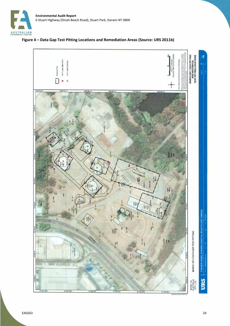
Environmental Audit Report 6 Stuart Highway (Dinah Beach Road), Stuart Park, Darwin NT 0800
EA0263 24
Figure 4 – Data Gap Test Pitting Locations and Remediation Areas (Source: URS 2011b)

Environmental Audit Report 6 Stuart Highway (Dinah Beach Road), Stuart Park, Darwin NT 0800
EA0263 25
Figure 5 – Locations of Biobeds Used for Remediating Impacted Soils (Source: URS 2013b)
Environmental Audit Report 6 Stuart Highway (Dinah Beach Road), Stuart Park, Darwin NT 0800
EA0263 26
4.6.2 Treatment bed preparation
Prior to excavation works, two treatment beds (Biobed 1 and Biobed 2) were constructed. Vegetation was scraped off and overlapping low-density polyethylene (LDPE) plastic sheeting emplaced. Above the LDP a 50 mm layer of non-impacted soil material was placed to act as a tracking layer (to prevent tyre/track damage). Each bed was created with a slight gradient to enable loose water (run-off) to be collected in a drain/sump for later treatment/disposal. A further treatment bed (Biobed 3) was created during later phases of works due to space limitations.
4.6.3 Excavation works
Excavated soils and exposed excavation surfaces were observed for visual and olfactory signs of impact (e.g. staining, presence of LNAPL and odours). A PID was used to screen soils for VOCs as they were excavated, stockpiled or at the final validation stage once it was believed impacted soils had been removed sufficiently. Any visually impacted soil or soils with elevated PID results were removed for treatment.
URS reported discrepancies in PID results at various times during the field program and attributed them to varying climatic conditions. Field calibration of equipment was conducted to ensure that discrepancies were minimised.
Validation samples were typically collected from the excavation base at a rate of one sample for 100 m3 and for the walls of each excavation at a rate of one sample per 10 linear metres of wall. For treated soils a sampling frequency of one per 100 m3 was adopted in agreement with the previous auditor (Mr Luke Cattlin) to ensure that soils were eventually suitable for re-use on site. QA/QC samples (blind and split duplicates) were collected at a general frequency of one per 20 primary samples.
Samples were placed in appropriately preserved jars and placed on ice within a cooler for transport to the laboratory under a chain of custody. Sampling nomenclature was consistent throughout the program. Each area was divided into a 10 ×10 m grid to enable sample locations to be accurately recorded based upon their grid location, sample number and depth.
4.6.3.1 Area A
Between 10 July and 6 September 2011, ~21 000 tonnes of impacted soils and ~4000 tonnes of clean soil material were excavated from this area. Soils from this area generally consisted of clayey silts with intermittent sand horizons to a point where (unweathered) siltstone was encountered (at ~3–4 m BGS).
The upper 0.5 m of material was scraped and put aside for re-use at the site. Approximately 388 tonnes of the initial scraped material were stockpiled and formed into Biobed 1 (Figure 5) for remediation. Following initial scraping the excavation extended to a depth of ~3–4 m BGS along a 150 × 20 m area from which ~18 304 tonnes of material were removed and placed into Biobed 3 (Figure 5) for treatment.
Following receipt of initial validation results the excavation extent was increased (referred to by URS 2013c as the ‘secondary step out’) to capture impact both laterally to the north and west. Further excavations followed after validation results indicated additional impact. An additional ~2684 tonnes of material was removed for treatment.
During the course of excavations buried site infrastructure was removed, including: former piping (stormwater, fuel lines, water lines), a sump associated with the filling gantry and stormwater drains.
A total of 177 validation samples were collected. Of those, 33 reported results above the RBTLs and required additional excavations (step outs described above).
The final extent of the Area A excavation is shown in Figure 6. Additional validation activities were completed as close to the site boundary as practicable to remove impacted soils; however, initial RBTL failures were noted at three locations (D-2.0-PF, K-2.0, P-2.0) and these were able to be extended further. Resulting follow-up validation samples collected on 22 September 2011 from locations D, K and P contained residual hydrocarbon impact but these were below the applicable deep RBTLs.

Environmental Audit Report 6 Stuart Highway (Dinah Beach Road), Stuart Park, Darwin NT 0800
EA0263 27
At location D (Figure 6) against the site boundary, residual TPH C6–C9 impact remains at depth of 2.0 m BGS at a concentration (71 mg/kg) above the deeper soil RBTL (40 mg/kg). This could not be removed due to the proximity of the site perimeter. URS do not consider this residual impact to pose a risk to future residential development.
At location Q (Figure 6) residual petroleum (TPH C6–C9) impact above the deeper RBTL of 40 mg/kg remain at depths of 2.0 m BGS (292 mg/kg) and 3.0 m BGS (88 mg/kg). These residual concentrations at the site boundary could not be excavated further are considered by URS to pose no risk to future development of the site.
4.6.3.2 Area B
Excavation works in Area B commenced on 16 June 2011 and continued to 9 July 2011. A total of ~16 000 tonnes of impacted material and ~1000 tonnes of clean soil were excavated from Area B.
Based upon the initial validation results (Figure 7a) the excavations were extended to the northwest in two additional phases (Figure 7b, Figure 7c) to eventually join up with excavation Area A.
Of the initial samples collected for validation purposes, 11 samples failed the RBTLs and required excavations to be extended and an additional 10 validation samples were collected and analysed. At the final extent of excavations all results were below the RBTLs.
4.6.3.3 Areas C and D
Excavations were performed in two areas – identified as Area C and Area D (see Figure 8) where historical investigations had identified impact above the adopted RBTLs. Initial excavations were performed on 5 × 5 m areas to a depth of ~2.2 m to bedrock. An estimated 508 tonnes of material was excavated from Areas C and D.
Excavation C3 was extended after initial and subsequent screening indicated results above the RBTLs.
All final validation results for both areas were below the RBTLs with the exception of one sample location (C3-NW2.0; TPH C6–C9 77 mg/kg) where the residual soil was above the shallow soil RBTL but lower than the deeper soil (>0.5 m) RBTL of 40 mg/kg. The result was also below the recently adopted CRC CARE HSL for vapour intrusion and was not considered by URS to be significant, was not investigated further and remains in situ.
4.6.3.4 Additional Trial Pitting
A series of trial pits were also excavated at locations in the vicinity of Areas C and D and to the north of Area A (refer to Figure 8) to assess and confirm ground conditions outside the targeted remediation areas.
The results indicated residual contamination at two locations (TP-B-2.0, TPH C6–C9 23 mg/kg; and TP-S-2.0, TPH C10–C14 400 mg/kg) with results above their respective shallow RBTLs but below the deeper (2 m) RBTLs. As such, URS considers the residual impact to pose no risk and that the based on the available data no significant contaminated material remains outside these excavated areas.
4.6.4 Soil treatment
Once soils were placed into each treatment bed, samples of stockpile material were collected to provide a baseline for comparison. Based upon those initial results soil nutrients (fertiliser with C:N:P ratio of 100:10:1) were added. Soil moisture was also monitored to ensure 30–40% field capacity. Following nutrient loading the biopiles were turned via excavator, mixed and screened to ensure disaggregation, adequate mixing and aeration occurred.
Based upon the treatment regime hydrocarbon impact was reduced to below the RBTLs within 2–3 weeks of commencing treatment. Soil stockpile samples were collected at the nominated frequency (one per 100 m3).

Environmental Audit Report 6 Stuart Highway (Dinah Beach Road), Stuart Park, Darwin NT 0800
EA0263 28
Following treatment and validation of treated materials, ~42 500 tonnes of material were then backfilled into excavations across the site following the original auditor’s verification of the results (Mr Luke Cattlin). Backfilled soils were then rolled and compacted in situ and the site surface leveled.
4.6.5 QA/QC Sampling
As part of the validation sampling program QA/QC samples were collected and analysed. The following provides a brief summary of the QA/QC program.
Forty-five work orders (916 samples and 46 duplicates) were provided to the primary laboratory, ALS Laboratory Group (Brisbane, Sydney, Perth and Melbourne). Fourteen work orders (31 triplicate/split) samples were sent to mgt-Labmark Environmental Laboratories (Sydney and Melbourne). All samples were sent under appropriate COC and were appropriately preserved.
A total of 916 primary samples and 46 blind duplicate samples analysed (ratio 19.9:1) in accordance with the sampling rate specified in AS4482.1-2005. An evaluation of the RPD data was not provided in the report.
A total of 916 primary samples and 31 split duplicate samples analysed (ratio 29.5:1) at a frequency lower than the sampling rate specified in AS4482.1-2005 (20:1). No explanation of this has been provided despite a request from the previous auditor (TNT letter March 2012). An evaluation of the RPD data was not provided in the report.
Four batches of samples were reported by URS as being received at the laboratory at temperatures above the recommended value (< 4oC). These were not considered to affect the outcome of the validation program as the results were consistent with batches of samples from a similar time period and location.
The outcome of blank analysis (field/equipment) was not provided in the report.
The auditor considers that the lack of detailed summary or evaluation of QA/QC within the report (despite requests for its inclusion) to be a discrepancy. However, given the volume of data provided, the inclusion of duplicate sample data in summary tables and the systematic approach taken to complete the validation works this discrepancy does not affect the outcomes of this report.
4.6.6 Monitoring well installation
URS reported that eight monitoring wells (MW36S (shallow), MW36D (deep), MW37S, MW37D, MW38S, MW39S and MW39D) were installed and four sets of soil vapour (SG1-SG4) probes were also installed for post-remediation sampling and reporting.

Environmental Audit Report 6 Stuart Highway (Dinah Beach Road), Stuart Park, Darwin NT 0800
EA0263 29
Figure 6 – Extent of ‘Area A’ Excavation (Source: URS 2013a)
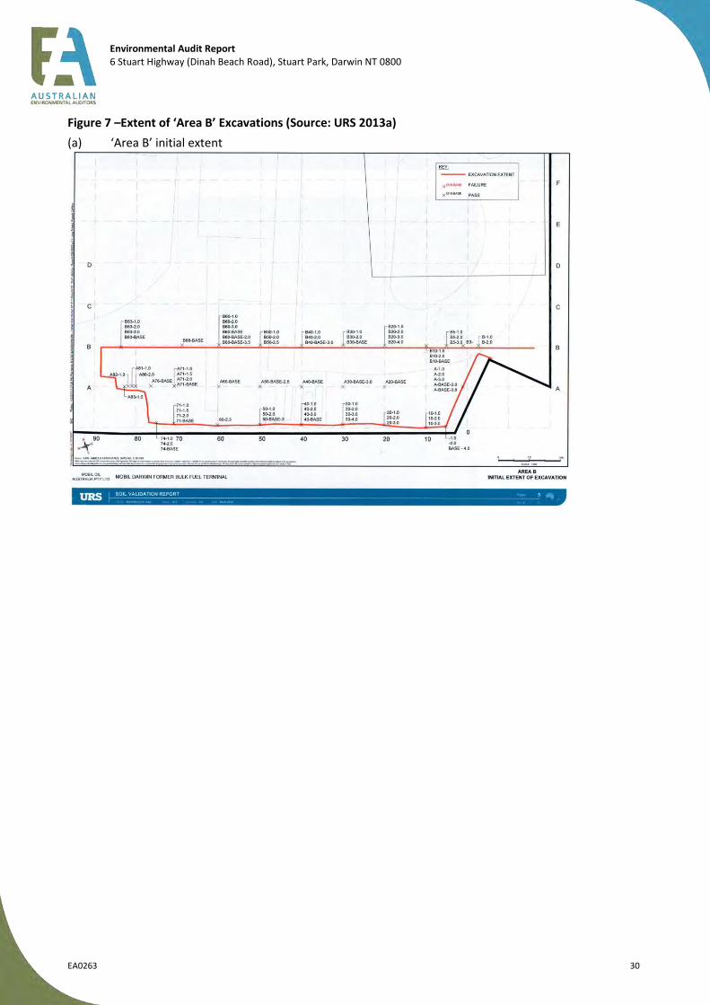
Environmental Audit Report 6 Stuart Highway (Dinah Beach Road), Stuart Park, Darwin NT 0800
EA0263 30
Figure 7 –Extent of ‘Area B’ Excavations (Source: URS 2013a)
(a) ‘Area B’ initial extent
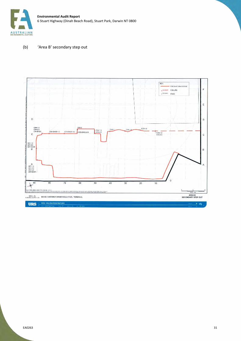
Environmental Audit Report 6 Stuart Highway (Dinah Beach Road), Stuart Park, Darwin NT 0800
EA0263 31
(b) ‘Area B’ secondary step out
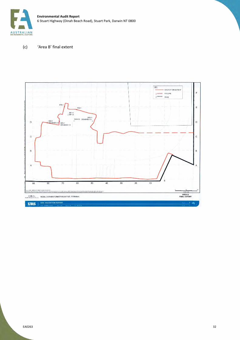
Environmental Audit Report 6 Stuart Highway (Dinah Beach Road), Stuart Park, Darwin NT 0800
EA0263 32
(c) ‘Area B’ final extent

Environmental Audit Report 6 Stuart Highway (Dinah Beach Road), Stuart Park, Darwin NT 0800
EA0263 33
Figure 8 – Extent of ‘Areas C and D’ Excavations Plus Additional Trial Pitting (Source: URS 2013a)

Environmental Audit Report 6 Stuart Highway (Dinah Beach Road), Stuart Park, Darwin NT 0800
EA0263 34
4.7 Post Remediation GME and Soil Vapour Sampling – May 2012
Two rounds of post-remediation groundwater monitoring and soil vapour sampling were completed at the site. The first sampling event was performed in May 2012 and reported in
URS (2012a). Groundwater Monitoring Event and Soil Vapour Sampling, May 2012, 12 September 2012.
This report was provided to the original auditor for review; however, a detailed review was not completed prior to the change in auditors and was provided to the present auditor as is.
The report is summarised in the following sections.
4.7.1 Purpose
The purpose of these investigations was to assess post-remediation site conditions for groundwater and soil vapour. Field works were conducted between 1 and 11 May 2012 and included gauging and sampling of 24 on-site monitoring wells and sampling of one soil gas well, SG2, of the 10 wells (five nested pairs) installed. The remaining nine soil gas wells were flooded by surface water and unable to be sampled.
Sampling locations are shown on the Figure 9.
4.7.2 Adopted Criteria
Section 6.2 of the report refers to the use of groundwater investigation levels and remediation criteria based on the following documents: URS (2011a) QRA and the URS (2011c) RMP. The reports do not, however, provide groundwater investigation levels or remediation:
URS (2011a) provides the RBTLs for soil remediation only; and
URS (2011c) Section 5.3.2 indicates that removal of LNAPL is the primary criteria and that “no other remediation criteria are proposed over and above soil and PSH removal”.
The auditor’s review has shown the adopted criteria used in the report appear to be a combination of the ANZECC (2000) 95% species protection trigger levels for fresh water and the Australian Drinking Water Guidelines (ADWG) (2011) health-based criteria. These criteria are considered acceptable for the site given that historical TDS values have indicated that groundwater is of acceptable potable quality (TDS <1000 mg/L) and the proximity of the closest receptors (a seasonal creek and a storage dam 150 m east–southeast).
URS also refer to the CRC CARE (2011) Health Screening Levels (HILs) for vapour intrusion for low-density residential land use (HSL-A) for silts at a depth of 2 to <4 m for the site. The auditor considers these to be appropriate for use at the site given the potential use of the site for residential purposes.
Soil vapour criteria had not been adopted for this report. This discrepancy was addressed by URS in the follow up September 2012 report.
4.7.3 Methodology
Groundwater sampling was completed using low-flow methods, which are considered by the auditor as appropriate for the site conditions and the contaminants of concern (predominantly petroleum hydrocarbons). Samples were then forwarded to the laboratory under chain of custody conditions in appropriately preserved containers and chilled.
No detailed sampling method was provided with the report. This discrepancy was addressed by URS in the follow up September 2012 report. Sample analysis was completed by ALS Newcastle using the USEPA TO15 suite method.
Environmental Audit Report 6 Stuart Highway (Dinah Beach Road), Stuart Park, Darwin NT 0800
EA0263 35
4.7.4 Groundwater Results
During these works, groundwater levels were measured and flow was calculated, sampling and analytical testing was completed. The following sections provide and discuss the various groundwater results.
4.7.4.1 Gauging
Static water levels ranged between 6.783 m AHD (at MW37D) and 14.280 m AHD (MW11) across the site. No LNAPL was observed in any monitoring wells.
Groundwater flow was measured to be towards the east and the groundwater velocity calculated as 0.012–11.73 m/year based upon: an effective porosity of 14% assumed for the siltstone; a measured hydraulic gradient of 0.045; and hydraulic conductivity based on a published estimate for the strata of 10–6 to 10–
7 cm/s.
4.7.4.2 BTEX
Benzene was detected in one well MW39D (4 µg/L) at a concentration above adopted guideline levels (for drinking water). The remaining results for BTEX, where detected, were below adopted guidelines levels. This benzene concentration was below the CRC CARE HSL-A (low density residential) level of 4300 µg/L for silt at a depth of 2 to <4 m.
4.7.4.2 TPH
Detectable concentrations of TPHs were found in eight of 24 wells sampled:
MW13 (C15–C28 390 μg/L);
DW27 (C15–C28 130 μg/L);
MW36S (C15–C28 160 μg/L);
MW37D (C15–C28 160 μg/L);
MW37S (C15–C28 950 μg/L);
MW38S (C15–C28 1280 μg/L);
MW39S (C15–C28 390 μg/L); and
MW39D (C6–C9 370 μg/L, C15–C28 110 μg/L).
While TPH C6–C9 fraction was detected in MW39D (370 µg/L), located down-gradient for former Tank 7 and in the locality of excavation Area C, the result is well below the CRC CARE HSL-A for the C6–C10 fraction (minus BTEX) value of 5.7 mg/L.
4.7.4.3 Metals
The results of metals analyses in groundwater were not discussed in detail in the report. This discrepancy was addressed later by URS in the September 2012 sampling report.
The auditor provides the following summary of results.
Arsenic was detected at concentrations above ADWG guideline level (0.007 mg/L) and/or the ANZECC 2000 freshwater guideline level (0.013 mg/L) in wells: MW13 (0.014 mg/L); MW36S (0.01 mg/L); MW37 D (0.01 mg/L); MW37S (0.014 mg/L); MW37S (0.016 mg/L); MW38D (0.021 mg/L); MW38S (0.009 mg/L); MW39D (0.016 mg/L) and MW39S (0.011 mg/L).
Chromium (total) was detected in one well MW39D (0.001 mg/L) at a concentration equivalent to the ANZECC 2000 freshwater guideline level.
Copper was detected at concentrations above ANZECC 2000 freshwater guideline level (0.0014 mg/L) at the following locations: MW01A (0.002 mg/L); MW03 (0.004 mg/L); MW08 (0.004 mg/L), MW09 (0.007 mg/L), DW35D (0.007 mg/L), DW35S (0.002 mg/L), MW36D (0.006 mg/L), MW37D (0.002 mg/L) and MW39D (0.002 mg/L).
Environmental Audit Report 6 Stuart Highway (Dinah Beach Road), Stuart Park, Darwin NT 0800
EA0263 36
Lead was detected at concentrations above ANZECC 2000 freshwater guideline level (0.0034 mg/L) in wells: MW36D (0.007 mg/L); MW37D (0.004 mg/L) and MW39D (0.004 mg/L);
Nickel was detected across the site in the majority of wells and at concentrations above ANZECC 2000 freshwater guideline level (0.011 mg/L) in the following wells: MW06 (0.016 mg/L); MW09 (0.019 mg/L); DW26 (0.014 mg/L); DW35D (0.014 mg/L); MW38S (0.012 mg/L) and MW39S (0.012 mg/L).
Zinc was detected in all wells across the site with all but one result (for MW12) above the ANZECC 2000 freshwater guideline level (0.008 mg/L) and ranging from 0.009 mg/L (at MW13 triplicate sample QC10) to 0.064 mg/L (at DW35D).
4.7.4.3 PAHs and others
With regard to PAHs, phenols, halogenated aromatic and aliphatic compounds, trihalomethanes, and fumigants, all results were below the laboratory limits of reporting for these compounds.
4.7.4.4 QA/QC Program
Three blind duplicate samples were collected for the 23 primary samples – at a rate (1:8) above the recommended rate (of 1:20). RPD failures for the blind duplicate pairing MW13:QC09 (for arsenic, barium and zinc) were tabulated by URS but not explained in the report.
Three split duplicate samples were collected for the 23 primary samples – at a rate (1:8) above the recommended rate (of 1:20). RPD failures were tabulated but not reported upon for:
arsenic, barium, zinc, TPH C15–C28 and TRH >C16–C34 in the pairing: MW13:QC10;
arsenic, TPH C15–C28 and TRH >C16–C34 in the pairing: MW37S:QC04; and
TPH C6–C9 and TRH C6–C10 in the pairing: MW39D:QC06.
All samples were received and analysed within holding times.
URS reported that all blank samples (three rinsate, three trip/field blanks) reported concentrations of COPCs below laboratory detection limits; however, the auditor review of results tables showed that zinc was detected in rinsate blank (QC01) at a concentration within the range of results reported at the site. No explanation for this result was provided by URS.
Section 6.5 of the May 2012 GME and SV report provides a detailed summary of QA/QC sampling.
4.7.5 Soil Vapour Results
Only one well was not waterlogged and so was able to be sampled during the period. The soil vapour sample was obtained from location SG2S (the shallow well of the nested pair) with the following results reported:
toluene 2 ppbv;
xylenes 0.5 to 1.6 ppbv;
naphthalene 10.1 ppbv; and
hexane 0.5 ppbv.
These results fall well below the respective CRC CARE HSL-A (low density residential) for toluene (3 713 528 ppbv), m-xylene (668 203 ppbv), naphthalene (2290 ppbv) in silt at depths of 1 to <2 m.
4.8 Post Remediation GME and Soil Vapour Sampling – September 2012
The second post-remediation groundwater and soil vapour sampling event was performed in September 2012 and reported in:
Environmental Audit Report 6 Stuart Highway (Dinah Beach Road), Stuart Park, Darwin NT 0800
EA0263 37
URS (2012b). Former Mobil Darwin Bulk Fuel Terminal, Groundwater Monitoring Event and Soil Vapour Sampling, September 2012, 16 April 2013.
This report was initially provided to the auditor (Mr Charles Barber) for review in March 2013 upon his appointment. The auditor provided comments (auditor letter C1, 19 March 2013) regarding the adequacy of information provided and seeking clarification of issues (including but not limited to sampling methodology of soil vapour). A revised report was provided to the auditor on 22 April 2013. The report is summarised in the following sections.
4.8.1 Purpose
The purpose of these investigations was to assess post-remediation site conditions for groundwater and soil vapour. Field works were conducted between 10 and 14 September and 30 and 31 October 2012 and included gauging and sampling of 24 on-site monitoring wells and sampling of seven soil gas wells (of the 10 installed). Sampling locations are shown on the following figure, Figure 9.
4.8.2 Adopted Criteria
Adopted groundwater criteria used for this report were the same as those used in the previous (URS 2012a - May 2012 GME & SV) report with limitations noted above.
Soil vapour criteria were adopted from the CRC CARE (2011) health based levels for low-density residential land use (HSL-A) with reference to the US EPA 2012 Regional Screening Levels. Considering the current land use (a former bulk petroleum depot) and proposed future use of the site (residential or commercial/industrial), the auditor considers these to be appropriate for use.
4.8.3 Methodology
Groundwater sampling was completed using low-flow methods that are considered by the auditor as appropriate for the site conditions and the CoPCs (predominantly petroleum hydrocarbons). Samples were then forwarded to the laboratory under COC conditions in appropriately preserved containers and chilled.
A total of five nested soil gas wells, each comprising two wells, were investigated for gas flow using a vacuum pump and helium gas tracer testing to ensure that ambient air was not drawn into the sample. Samples are collected under vacuum into summa canisters following purging of three well volumes. The canisters were then provided to a laboratory for analysis under COC.
The auditor sought clarification of the sampling procedures (auditor letter C1, 19 March 2013) and URS issued a revised report with additional supporting documentation. Following provision of this information the methodology used is considered by the auditor to be appropriate.
4.8.4 Groundwater Results
During these works, groundwater levels were measured and flow was calculated, sampling and analytical testing was completed. The following sections provide and discuss the various groundwater results.
4.8.4.1 Gauging
One well (MW39S) was dry at the time of sampling, with remaining wells reporting SWLs between 5.338 and 12.51 m AHD across the site. No LNAPL was observed in any monitoring wells.
Groundwater flow was determined to be towards the east with a groundwater velocity calculated as 0.003–10.16 m/year based on an estimated effective porosity of 14–43% for the siltstone, a measured hydraulic gradient of 0.045 and published estimates of hydraulic conductivity of 10–6 to 10–9 cm/s.
4.8.4.2 BTEX
Benzene was detected at one location (MW39D; 16 µg/L) at a concentration above the adopted ADW (2011) guideline level of 1 µg/L but well below the CRC CARE value of 4300 µg/L for residential land use.
Environmental Audit Report 6 Stuart Highway (Dinah Beach Road), Stuart Park, Darwin NT 0800
EA0263 38
This result was an increase over the previous monitoring round in May 2012 (4 µg/L). No other BTEX compounds were detected in groundwater above guidelines values (see Figure 10).
4.8.4.3 TPH
TPH fractions were detected in six of 23 wells sampled (shown in Figure 10):
MW13 (C10–C14 60 μg/L, C15–C28 390 μg/L);
MW36S (C15–C28 190 μg/L);
MW37D (C10–C14 150 μg/L, C15–C28 160 μg/L);
MW37S (C10–C14 240 μg/L, C15–C28 1330 μg/L);
MW38S (C10–C14 100 μg/L, C15–C28 950 μg/L); and
MW39D (C6–C9 200 μg/L, C10–C14 110 μg/L, C15-C28 190 μg/L).
Although TPH C6–C9 was detected in MW39D (200 µg/L), located down-gradient of former Tank 7 and in the locality of excavation Area C; however, the result is well below the CRC CARE HSL-A for the C6–C10 fraction (minus BTEX) value of 5.7 mg/L.
4.8.4.4 Metals
The following results were reported by URS:
arsenic was reported above the LOR for four samples analysed and was reported in excess of the adopted ILs for a further eight samples analysed and ranged between 0.008 mg/L (MW37D) and 0.034 mg/L (QC15, duplicate sample of MW14);
barium was reported above the LOR but below the adopted ILs in all samples analysed and ranged between 0.005 mg/L (MW08) and 0.22 mg/L (QC19, triplicate sample of MW09);
copper was reported below the LOR for all samples analysed with the exception of MW36S which reported concentrations in excess of the adopted ILs for this investigation (0.002 mg/L);
nickel was reported above the LOR but below the adopted ILs in 19 of the samples analysed and ranged between 0.001 mg/L (MW13, DW27, DW33, DW35D, QC22, MW36D and MW38S) and 0.005 mg/L (MW12); and
zinc was reported above the LOR in seven of the samples analysed and was reported in excess of the adopted ILs for a further 16 of the samples analysed and ranged between 0.009 mg/L (DW35S and MW39D) and 0.046 mg/L (DW33).
Summary results are shown in Figure 11 and Figure 12 below.
4.8.4.5 PAHs and others
PAHs, phenols, halogenated aromatic and aliphatic compounds, trihalomethanes, and fumigants results were all below the laboratory LOR for these compounds.
4.8.4.6 QA/QC Program
Three blind duplicate samples were collected for the 23 primary samples –a rate that is above the recommended rate (of 1:20). Two dissolved metals, arsenic and barium, reported RPDs >100% for sample DW35D and duplicate QC15. URS did not provide any explanation for this variation within the report.
Three split duplicate samples were collected for the 23 primary samples – a rate that is above the recommended rate (of 1:20). All RPD results were considered by URS to be acceptable.
All samples were received and analysed within holding times.
Environmental Audit Report 6 Stuart Highway (Dinah Beach Road), Stuart Park, Darwin NT 0800
EA0263 39
All blank samples (rinsate, trip/field blanks) reported concentrations of CoPCs below laboratory detection limits with the exception of chloroform – detected in five samples and attributed to the laboratory supplied rinsate water as this analyte was not (and has not been) detected in groundwater samples from the site.
Section 6.5 of the September 2012 GME and SV (URS 2012b) report provides a detailed summary of QA/QC sampling.
4.8.5 Soil Vapour Results
Three wells were waterlogged and were unable to be sampled (SG1A, SG3A, SG5A) with the remaining seven available for sampling.
Helium leak detection results were below detection limits and acceptable for the site.
Minor concentrations of select volatile organic compounds (VOCs) were detected in the soil vapours recovered from samples SG2B_20120914 (1.2 m BGL), SG3B_20120914 (1. 2 m BGL), SG4A_20120913 (1.5 m BGL), SG4B_20120914 (2.5 m BGL), SG5B_20120914 (1.5 m BGL), SG5A_20121030 (2.5 m BGL) and SG5B_20121030 (1.5 m BGL).
4.8.5.1 Naphthalene
Comparison of the reported analyte concentrations indicated that naphthalene from the shallow soil profile (1.5 m BGL) at location SG5 (25.2 mg/m3) in September was in excess of the CRC CARE (2011) guideline (12 mg/m3) for naphthalene in silt 1 to <2 m depth for HSL-A (low-density residential). In response to this observed result, URS remobilised to site on 30 October 2012 to obtain another sample for confirmation purposes. Results of the resampling showed an order of magnitude decrease in the concentrations of several compounds from location SV5 (e.g. ethyl benzene, 1,2,4-trimethylbenzene); however, naphthalene concentrations from SV5B (13.1 mg/m3) still reported in excess of the CRC CARE (2011) guideline (12 mg/m3) for naphthalene in silt 1 to <2 m depth for HSL-A.
The measured naphthalene concentration at SG5 was not consistent with previous soils investigation and validation data and relevant surrounding monitoring wells (MW2, DW26, MW12 and DW35), which have previously shown naphthalene concentrations below the LOR.
Based upon the detection of compounds above adopted criteria at SG5, URS recommended excavation and treatment of soils in this area as a precautionary measure.
4.8.5.2 Other Volatiles
Exceedances of the USEPA 2012 regional screening levels were reported in SG4A (1,2,4-trimethylbenzene concentration of 0.678 mg/m3), SG4B (1,2,4-trimethylbenzene concentration of 19.2 mg/m3 and cyclohexane concentration of 80.5 mg/m3), SG5A (1,2,4-trimethylbenzene concentration of 147 mg/m3 and hexane concentration of 65.5 mg/m3) and SG5B (1,2,4-trimethylbenzene concentration of 2830 mg/m3 and hexane concentration of 26.1 mg/m3).
No other concentrations of soil vapour analytes that were reported to be above the specified LOR exceeded the adopted guidelines, where such guidelines exist.
Based upon the detection of compounds above adopted criteria at SG5, URS recommended excavation and treatment of soils in this area as a precautionary measure.
4.8.5.3 Duplicate Analysis
All results were below the LOR for the single soil vapour duplicate analysis completed.

Environmental Audit Report 6 Stuart Highway (Dinah Beach Road), Stuart Park, Darwin NT 0800
EA0263 40
Figure 9 – Groundwater flow direction - September 2012 (Source: URS 2012b)

Environmental Audit Report 6 Stuart Highway (Dinah Beach Road), Stuart Park, Darwin NT 0800
EA0263 41
Figure 10 – September 2012 Contamination Summary - BTEX and TPH (Source: URS 2012b)

Environmental Audit Report 6 Stuart Highway (Dinah Beach Road), Stuart Park, Darwin NT 0800
EA0263 42
Figure 11 – September 2012 Contamination Summary - Metals Northern Wells (Source: URS 2012b)

Environmental Audit Report 6 Stuart Highway (Dinah Beach Road), Stuart Park, Darwin NT 0800
EA0263 43
Figure 12 – September 2012 Contamination Summary - Metals Southern Wells (Source: URS 2012b)

Environmental Audit Report 6 Stuart Highway (Dinah Beach Road), Stuart Park, Darwin NT 0800
EA0263 44
Figure 13 – September 2012 MNA Summary (Source: URS 2012b)

Environmental Audit Report 6 Stuart Highway (Dinah Beach Road), Stuart Park, Darwin NT 0800
EA0263 45
4.9 Additional Soil Remediation and Soil Vapour Sampling – SG5
Based upon the recommendations of the September 2012 GME and SV report (URS 2013b) an additional area of soil remediation was required surrounding the location of soil vapour monitoring bore SG5, reinstatement of a replacement soil bore and a round of soil vapour sampling of the replacement bores was completed. Additional works in the form of slug tests to assess hydraulic conductivity of site soils was also completed and results reported.
The works were reported in the following report:
URS (2013b). Additional Soil Remediation and Soil Gas Well SG5A Reinstatement and Sampling, 28 July 2013.
This report was initially provided to the auditor for review in June 2013. The auditor provided comments (auditor letters C4, 10 July 2013 and C5, 30 August 2013) regarding the adequacy of information provided and seeking clarification of several issues (including reporting, sampling methodology, sample locations, exceedances of RBTLs).
The report is summarised in the following sections.
4.9.1 Excavation works SG5 area
The following scope of works was completed for the excavation:
excavation of soils at location SG5 completed on 11-13 December 2012;
remediation of 135 m3 of excavated soil material;
validation sampling of walls and base of excavation once PID readings and visual observations of soils indicated impact had diminished; and
collection and analysis of 19 soil samples for COPCs. Samples were collected at a 2–4 m spacing along each wall (see Figure 14 for sample locations).
The maximum depth of the excavation reached 3.2 m BGS.
4.9.2 Validation results
Validation results reported detectable concentrations of TRH fractions at the following locations:
EX01_31: C16–C40 140 mg/kg, C34–C40 110 mg/kg;
EX01_36: C16–C40 160 mg/kg, C34–C40 120 mg/kg;
EX01_37: C16–C40 160 mg/kg;
EX01_38: C16–C40 150 mg/kg, C34–C40 110 mg/kg; and
EX01_39: C16–C40 130 mg/kg, C34–C40 140 mg/kg.
The above results are all below the RBTLs and the CRC CARE HSLs for both vapour intrusion (for low-density residential use) and direct contact.
All BTEX and TRH C6–C10 and C10–C16 fractions were below analytical detection limits.
Lead was also detected at location EX01_31 at a concentration of 147 mg/kg. Although the result exceeded the shallow RBTL of 127 mg/kg (soil <0.5 m) the sample was collected from a depth of 1.6 m BGS and not considered to be a risk to human health.
Despite some reported anomalies (LCS recoveries, laboratory duplicates, holding times for batch ES1229788), the QA/QC data collected during the soil sampling was considered by URS to be representative and of an acceptable standard for use. Section 2 of the report provides a detailed summary of QA/QC data.
Environmental Audit Report 6 Stuart Highway (Dinah Beach Road), Stuart Park, Darwin NT 0800
EA0263 46
4.9.3 Excavation reinstatement
Material resulting from the excavation was placed into two stockpiles based upon PID results. Following aeration and exposure to the atmosphere the concentrations of TRH were reduced the materials were re-instated into the excavation.
4.9.4 Soil vapour bore replacement and sampling
The nested soil vapour bores SG5A-shallow and SG5A-deep (Figure 14) were installed adjacent to the excavation area described above to replace soil vapour bore SG5 that was removed during the excavation works. The location was chosen to avoid seasonal ponding of the area.
Following installation on 28 March 2013 the bores were left to equilibrate and were sampled on 17 April 2013 in a period of stable (dry) weather conditions. Leak testing was performed using helium gas under a shroud – all results were below detection limit.
Soil vapour samples were collected under vacuum into summa canisters after three well volumes were purged. Samples were analysed by ALS using the USEPA TO-15 method.
No detectable concentrations of BTEX or naphthalene were reported. Volatile organic carbons in the form of 2-propanol, carbon disulphide and ethyl alcohol were detected (range from 0.00038 mg/m3 to 0.0121 mg/m3) but at concentrations below investigation levels.
The non-detection of naphthalene, cyclohexane, hexane, and 1,3,5-trimethylbenzene, in particular, was considered by URS to indicate that the excavation and remediation of soils from the area of SG5 to be successful at reducing a potential risk to human health.
QA/QC data collected by URS was considered to be representative of site conditions and of suitable quality for use.
4.9.5 Hydraulic conductivity testing
Slug tests to assess hydraulic conductivity of site soils (fill material and siltstones) were completed at selected wells: MW10, MW37S, MW37D, MW38S, MW38D, MW39S and MW39D on 1–2 May 2013.
Monitoring wells installed within fill material – MW37S, MW38S, MW39S reported hydraulic conductivities of 1.79, 0.06 and 4.60 m/day, respectively. These results are considered by URS to represent the primary component of fill material at each area (silty clay at MW38S, gravelly or sandy silts at MW39S).
The deeper bores MW37D, MW38D and MW39D installed within siltstone reported hydraulic conductivities of 0.31, 0.41 and 0.44 m/day, respectively. URS considered these results to confirm installation of the bores within the same unit given the comparable results and may indicate a level of fracturing within the siltstones given that the results were higher than published values for similar settings.
The result for MW10 of 0.02 m/day and installed within siltstone and clays is also considered to be representative of the siltstone aquifer.
The results were compared with the hydraulic conductivity values used in the ‘fate and transport’ model used to derive the RBTLs for soil remediation works (URS 2011 QRA) and the result for MW38S were found to be comparable. Based upon these results, URS concluded that no significant environmental risk to the nearest environmental receptors from groundwater.

Environmental Audit Report 6 Stuart Highway (Dinah Beach Road), Stuart Park, Darwin NT 0800
EA0263 47
Figure 14 – Excavation Extent in Area of SG5a and Location of Nested Bores SG5A (Source: URS 2013b)

Environmental Audit Report 6 Stuart Highway (Dinah Beach Road), Stuart Park, Darwin NT 0800
EA0263 48
5 Auditor Verification Activities
The Auditor conducted the following verification activities as part of the audit.
The auditor reviewed historical reports and on-going reports once engaged for the project.
This auditor reviewed the methodology and QA/QC components of each sampling event.
The auditor reviewed historical communications between the previous auditor (Mr Luke Cattlin) and the assessor.
The auditor visited the site post-remediation on 20 and 21 March 2013 to inspect site conditions and in particular, the condition of the existing soil vapour groundwater monitoring wells.
The auditor did not perform any verification sampling.
6 Evaluation of Remediation Activities
6.1 Remediation approach
The assessor considered various remedial options prior to adopting and implementing the selected remediation program. Impacted soil and groundwater was historically identified in the areas of the former filling gantry (Area B), main oil–water separator and drum filling areas (Area A). It was anticipated that the order of 20 000 m3 of impacted material was present. In addition, isolated areas of impacted soil were known to be present in the main tank farm and former underground storage tank areas (Areas C/D). Additional delineation of soil impact removed a large amount of uncertainty around the Initial Phase 2 data with a targeted approach.
Given the large quantities of impacted soil (in the order of 42 500 tonnes) and the nature of the impact (predominantly hydrocarbon), it was considered most feasible to attempt to remediate the soils on-site. Bio-remediation pilot trials were undertaken to determine remediation times, as the works could not successfully extend through the wet-season. Once the trials were successfully completed, remediation via excavation and bioremediation was selected and implemented.
This process was accompanied by a health risk assessment which was performed to determine site specific threshold levels to serve as remediation targets. The site was subject to soil and vapour validation after remediation as well as groundwater monitoring throughout the process.
6.2 Remediation works
Remediation consisted of:
initial consideration of various remediation methodologies and technologies;
bioremediation trials to determine treatment timescales within a limited dry season weather window;
the trials indicated that oxygen was the rate limiting factor for biodegradation. To compensate for this, an Allu bucket would be used to allow oxygen to come into contact with the hydrocarbons;
recognition that photo-oxidation (remediation of hydrocarbons by oxidation through sunlight) would be a natural contributor to remediation, due to the long days of sunlight during the dry season;
site preparation including lined treatment beds and surface run-off collection and subsequent water treatment plant;
excavation of soils, placement into the treatment cells;
adding nitrogen and phosphorous were added at a C:N:P ratio of 100:10:1 to further stimulate biological growth and hydrocarbon degradation;
associated recovery and treatment of contaminated groundwater; and

Environmental Audit Report 6 Stuart Highway (Dinah Beach Road), Stuart Park, Darwin NT 0800
EA0263 49
re-instatement of excavations with bio-remediated (treated) soils that were rolled and compacted (no compaction specification) as they were placed.
Additional remediation works were also performed in a small area of the site surrounding a soil vapour
bore location, SG5 – adjacent to former Tank 1, which had returned an elevated concentration of
naphthalene and other volatile organic carbons above adopted screening levels during post-remediation
soil vapour investigations.
6.3 Validation works
The major validation phase of works consisted of collection and analysis of 916 soil samples (plus QA/QC samples) from the walls and bases of excavations. The additional excavations around SG5 resulted in a further 19 (plus QA/QC samples) being collected for analysis.
All reported soil results for petroleum hydrocarbons were finally (after additional excavations and treatment) reported at concentrations below the risk-based target levels for soils at the site. A single elevated concentration of lead was detected at one location at a depth (1.6 m BGS) where it was considered not to present a risk to human health as it exceeded a shallow (<0.5 m) depth criteria.
Post-remediation soil vapour investigations across the site eventually returned results indicating that the remediation of soils across the site had been successful and had reduced any potential risk to human health.
Post-remediation groundwater investigations have shown that LNAPL has been successfully removed and that where any residual hydrocarbon contamination remains it does not pose a risk to human health under a low-density residential (sensitive) setting. However, groundwater investigations have shown that there are several species of metals, namely arsenic, copper, nickel and zinc, which may pose a potential risk to human health (arsenic) and the environment.

Environmental Audit Report 6 Stuart Highway (Dinah Beach Road), Stuart Park, Darwin NT 0800
EA0263 50
7 Auditor’s Assessment
The following sections describe the final condition of the site at the time of the audit, discuss the risk associated with these conditions and introduce any measures required to manage risks.
7.1 Beneficial Uses of Land
7.1.1 Maintenance of Ecosystems
Arsenic
Concentrations of arsenic that exceeded Maintenance of Ecosystems criteria were reported at 20 locations (within a range from <5 to 54 mg/kg) and at a variety of depths in the URS 2011 Data Gap Test Pitting Report as summarised in Table 12. These regions of soil were subsequently excavated, the soils blended as a part of the bio-remediation process and re-instated back into excavations across the site as part of the petroleum hydrocarbon remediation program completed by the assessor.
Chromium
Concentrations of chromium that exceeded Maintenance of Ecosystems criteria were reported at 24 locations (within a range of 7 to 140 mg/kg) and variety of depths in the URS 2011 Data Gap Test Pitting Report as summarised in Table 12. These regions of soil were subsequently excavated, the soils blended as a part of the bio-remediation process and re-instated back into excavations across the site as part of the petroleum hydrocarbon remediation program completed by the assessor.
Zinc
Concentrations of zinc that exceeded Maintenance of Ecosystems criteria were reported at one location (at depth; 399 mg/kg) in the URS 2011 Data Gap Test Pitting Report as summarised in Table 12. This location was subsequently excavated, the soils blended as a part of the bio-remediation process and re-instated back into excavations across the site as part of the petroleum hydrocarbon remediation program completed by the assessor.
Summary
These occurrences of arsenic, chromium and zinc are considered to be naturally/regionally occurring and not considered contamination. Similarly, the remediation works completed did not target and had no effect on these natural concentrations of metals. As the concentrations are natural, the beneficial use of Maintenance of Ecosystems is not precluded by site contamination.
7.1.2 Human Health
Five occurrences of concentrations of contaminants were reported that exceeded the QRA derived RBTLs. The contaminants of concern are total petroleum hydrocarbons at four sample locations and lead at one location (Table 12).
Locations D-2.0, Q-2.0 and Q-3.0-base (shown in Figure 6) contained residual concentrations of TPH C6–C9 that are located in deeper soils (at 2–3 m BGS) along the eastern site boundary (with the adjoining former fuel depot location Q; vegetated crown land – location D) and remain in-situ as they were unable to be excavated for remediation. However, these results are below the CRC CARE vapour intrusion HSLs for low-density residential land use (HSL-A) in silt at a depth of 1 to <2 m BGS and at least an order of magnitude lower and as such are considered to pose negligible risk to human health in a low-density residential scenario.
Location C3-NW2.0 (shown in Figure 8) contained residual concentrations of TPH C6–C9 that are located in deeper soils (at 2–3 m BGS) at a concentration (77 mg/kg) above the deeper RBTL (40 mg/kg) but is below the CRC CARE vapour intrusion HSL for residential land use. As such, URS did not remediate this area further and impact remains in situ.
Environmental Audit Report 6 Stuart Highway (Dinah Beach Road), Stuart Park, Darwin NT 0800
EA0263 51
Lead was detected at concentration (150 mg/kg) above the risk-based target levels for shallow soils in one sample O16-1 at depth of 1 m BGS. Although this result exceeded the RBTL it is well below the NEPM 1999 HIL-A (low-density residential land use) value of 300 mg/kg and the HIL-F (commercial/industrial land use) value of 1500 mg/kg and is at a depth where direct contact by humans is unlikely to occur.
Based upon the assessment and remediation works that have been completed, the beneficial use of Human Health is not precluded by contamination.
7.1.3 Buildings and Structures
Based upon the site history and identified contaminants of concern, there is no evidence of corrosive risk posed to unprotected steel materials in contact with soils at the site. In the auditor’s opinion, the current soil status represents no potential harm or detriment to the Building and Structures beneficial use for the site.
7.1.4 Aesthetics
The site has been a subject of a series of major infrastructure removal and site remediation programs. The site has been inspected by the auditor following remediation activities. The auditor observed that a large water tank remained at the site at the time of inspection but it was scheduled for imminent removal. The fate of this feature is unknown. No aesthetically detrimental material was observed.
On this basis it is the auditor’s opinion that the Aesthetics beneficial use of the land is not affected.
7.1.5 Production of Food, Flora and Fibre
The residual concentrations of total petroleum hydrocarbons and the presence of regionally occurring metals as defined in Table 12 are not considered to be a potential risk to the production of Food, Flora and Fibres due to their nature as naturally occurring background concentrations.
Table 12: Summary of Soil Exceedances of Criteria
Locations or site area
Sample ID Beneficial use
Analyte Sample range
(mg/kg)
Exceedance (mg/kg)
Criterion (mg/kg)
Comment
Test Pit Samples
Remediation Area A
A1-1-2.5,A2-1, A2-2,A3-1, A3-2, A4-1
Ecological Arsenic <5 to 54 20 samples above EIL
Arithmetic mean 24 mg/kg > EIL
20 Remediation areas have been
excavated and soils blended/mixed during the bio-
remediation process for
hydrocarbons. Bio-remediated soils placed back into
excavations
Remediation Area B
B1-2, B1-3, B3-3
Remediation Area C
C1-1-1, C1-2-1, C2-1-1, C2-1-1.5, C2-1-2.0, C2-2-2.0, C3-1-1, C4-1-1, C4-1-2.0,
C4-1-3.0
Remediation Area D
TPD-1
Remediation Area A
A1-1-0.5, A1-1-1, A2-1, A2-2, A3-1, A3-2, A4-1, A4-2
Ecological Chromium 7 to 140 24 samples above EIL Arithmetic mean
53.71 mg/kg
50 Remediation areas have been excavated
and soils blended/mixed during the bio-
remediation process for hydrocarbons.
Remediation Area B
B1-1, B1-2, B1-3, B3-3
Remediation Area C
C1-1-1, C1-1-2, C1-2-1, C2-1-1, C2-1-
1.5, C2-1-2.0, C2-2-
Environmental Audit Report 6 Stuart Highway (Dinah Beach Road), Stuart Park, Darwin NT 0800
EA0263 52
Table 12: Summary of Soil Exceedances of Criteria
Locations or site area
Sample ID Beneficial use
Analyte Sample range
(mg/kg)
Exceedance (mg/kg)
Criterion (mg/kg)
Comment
1.0, C3-1-1, C4-1-1 Bio-remediated soils placed back into
excavations Remediation Area D
TPD-1, TPD-2
Validation Samples
Remediation Area A
D-2.0 Human Health
TPH C6–C9 N/A 71 RBTL >0.5m BGS -
40
Locations cannot be excavated further
as against the eastern site
boundary with former Caltex fuel
depot
Q-2.0 292
Q-base-3.0 88
Remediation Area A
O16-1 Human Health
Lead N/A 150 RBTL <0.5m BGS -
127
Result above shallow RBTL but
below NEPM HIL-A and at depth where
direct contact unlikely
Remediation Area B
B3-3 Ecological Zinc N/A 399 200 Remediated location. Likely
diluted during soil blending
Remediation Area C
C3-NW2.0 Human Health
TPH C6-C9 N/A 77 RBTL >0.5m BGS -
40
Result above RBTL but below CRC CARE HSL for
residential landuse
7.2 Groundwater
7.2.1 Maintenance of Ecosystems
Concentrations of arsenic, copper, chromium, lead, nickel and/or zinc were reported in excess of the Maintenance of Ecosystems guideline values in a wide range of monitoring wells across the site in post-remediation groundwater samples (refer to Tables 13 and 14 below). The concentrations observed were relatively consistent across each of the groundwater monitoring wells, including monitoring wells MW9, MW10 and MW11, which are considered to represent background conditions, being on the most up-gradient portions of the site. The concentrations are considered naturally occurring representing regional groundwater conditions rather than previous land use at the site and are not considered to be pollution.
Table 13: Summary of Post-remediation Groundwater Exceedances - May 2012
Beneficial Use
Exceedance
Analyte Criterion
(mg/L)
Monitoring well ID and Exceedance (mg/L)
Maintenance of
Ecosystems
Arsenic 0.0013 MW13, 0.014
MW36S, 0.01
MW37D, 0.01
MW37S, 0.015
MW38D, 0.021
MW38S, 0.009
MW39D, 0.016
MW39S, 0.011
Copper 0.0014 MW01A ,0.002
MW03, 0.004
MW08, 0.004
MW09, 0.007
DW35D, 0.007
DW35S, 0.002
MW36D, 0.006
MW37D, 0.002
MW39D, 0.002

Environmental Audit Report 6 Stuart Highway (Dinah Beach Road), Stuart Park, Darwin NT 0800
EA0263 53
Table 13: Summary of Post-remediation Groundwater Exceedances - May 2012
Beneficial Use
Exceedance
Analyte Criterion
(mg/L)
Monitoring well ID and Exceedance (mg/L)
Chromium 0.001 MW39D, 0.001
Lead 0.034 MW36D, 0.007, MW37D, 0.004, MW39D, 0.004
Nickel 0.011 MW06, 0.016
MW09, 0.019
DW26, 0.014
DW35D, 0.014
MW38S, 0.012
MW39S, 0.012
Zinc 0.008 MW01A, 0.046
MW02, 0.013
MW03, 0.051
MW06, 0.056
MW08, 0.043
MW09, 0.093
MW10, 0.012
MW11, 0.031
MW13, 0.013
MW14, 0.017
DW26, 0.036
DW27, 0.018
DW33, 0.01
DW35D, 0.064
DW35S, 0.033
MW36D, 0.061
MW36S, 0.022
MW37D, 0.057
MW37S, 0.016
MW38D, 0.032
MW38S, 0.011
MW39D, 0.015
MW39S, 0.014
Table 14: Summary of Post-remediation Groundwater Exceedances - September 2012
Beneficial Use
Exceedance
Analyte Criterion
(mg/L)
Monitoring well ID & Exceedance (mg/L)
Maintenance of
Ecosystems
Arsenic 0.0013 QC15 (duplicate of MW14),
0.034
MW36S, 0.01
MW37D, 0.008
MW37S, 0.018
MW38D, 0.031
MW38S, 0.01
MW39D, 0.021
Copper 0.0014 MW36S, 0.002
Zinc 0.008 MW02, 0.012
MW03, 0.014
MW06, 0.01
MW08, 0.01
MW09, 0.012
MW13, 0.025
DW26, 0.01
DW27, 0.01
DW33, 0.046
DW35D, 0.018
DW35S, 0.009
MW36S, 0.012
MW37D, 0.01
MW39D, 0.009

Environmental Audit Report 6 Stuart Highway (Dinah Beach Road), Stuart Park, Darwin NT 0800
EA0263 54
7.2.2 Potable Water Supply
Groundwater quality at the site is of a potentially potable standard with measurable TDS across the site being below 1000 mg/L.
The widespread occurrence of arsenic in groundwater across the site at concentrations above the Australian Drinking Water Guideline (2011) (Table 15 and Table 16 below) level in both rounds of post-remediation monitoring events precludes this beneficial use.
Benzene has been detected in one monitoring well location MW39D, located on the eastern site boundary adjacent to the Caltex Depot (illustrated in Figure 10) in both post-remediation sampling events at concentrations above the guideline value – precluding the use of groundwater for this beneficial use.
Generally the groundwater can be described as acidic with pH values measured in the latest monitoring event (September 2012) ranging from pH 3.63 (DW27) to 6.65 (MW38S), average pH 5.48. These results are outside the preferred range of pH 6 to 8.5 and may preclude this beneficial use without substantial treatment.
Although groundwater at the site is of potable quality (TDS < 1000 mg/L), the low yield and shallow nature of the aquifer may preclude extraction for drinking water purposes.
7.2.3 Potable Mineral Water Supply
Groundwater at the site is of potable quality (TDS < 1000 mg/L) but the site is not within a recognised mineral water production zone and as such this protected beneficial use is not considered to be relevant.
7.2.4 Agriculture, Parks and Gardens
No concentrations of CoPCs were reported in excess of the Agriculture, Parks and Gardens Guideline values (ANZECC 2000, Primary Industries) in monitoring wells across the site. As such, this beneficial use is not precluded.
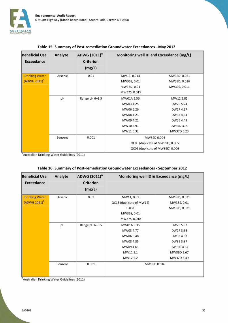
Environmental Audit Report 6 Stuart Highway (Dinah Beach Road), Stuart Park, Darwin NT 0800
EA0263 55
Table 15: Summary of Post-remediation Groundwater Exceedances - May 2012
Beneficial Use
Exceedance
Analyte ADWG (2011)A
Criterion
(mg/L)
Monitoring well ID and Exceedance (mg/L)
Drinking Water
(ADWG 2011)A
Arsenic 0.01 MW13, 0.014
MW36S, 0.01
MW37D, 0.01
MW37S, 0.015
MW38D, 0.021
MW39D, 0.016
MW39S, 0.011
pH Range pH 6–8.5 MW01A 5.56
MW03 4.25
MW06 5.26
MW08 4.23
MW09 4.21
MW10 5.91
MW11 5.32
MW12 5.85
DW26 5.24
DW27 4.37
DW33 4.64
DW35 4.49
DW35D 3.90
MW37D 5.23
Benzene 0.001 MW39D 0.004
QC05 (duplicate of MW39D) 0.005
QC06 (duplicate of MW39D) 0.006
AAustralian Drinking Water Guidelines (2011).
Table 16: Summary of Post-remediation Groundwater Exceedances - September 2012
Beneficial Use
Exceedance
Analyte ADWG (2011)A
Criterion
(mg/L)
Monitoring well ID & Exceedance (mg/L)
Drinking Water
(ADWG 2011)A
Arsenic 0.01 MW14, 0.01
QC15 (duplicate of MW14)
0.034
MW36S, 0.01
MW37S, 0.018
MW38D, 0.031
MW38S, 0.01
MW39D, 0.021
pH Range pH 6–8.5 MW01A 5.35
MW03 4.77
MW06 5.48
MW08 4.35
MW09 4.61
MW11 5.1
MW12 5.2
DW26 5.82
DW27 3.63
DW33 4.63
DW35 3.87
DW35D 4.67
MW36D 5.67
MW37D 5.49
Benzene 0.001 MW39D 0.016
AAustralian Drinking Water Guidelines (2011).

Environmental Audit Report 6 Stuart Highway (Dinah Beach Road), Stuart Park, Darwin NT 0800
EA0263 56
7.2.5 Stock Watering
No concentrations were reported in the samples analysed that exceeded the assessment criteria and as such, this beneficial use, albeit unlikely to be realised in this area, has not been precluded.
7.2.6 Industrial Water Use
The natural salinity of groundwater is considered the main constraint associated with the use of groundwater from the site for industrial water use. The presence of naturally occurring metals (arsenic, copper, lead, nickel and/or zinc) in groundwater beneath the site may also preclude this use; however, given the site’s location and residential zoning this beneficial use is unlikely to be realised, and has not been precluded.
7.2.7 Primary Contact Recreation
No concentrations were reported in the samples analysed that exceeded the assessment criteria and as such, this beneficial use, albeit unlikely to be realised in this area, has not been precluded.
7.2.8 Buildings and Structures
Generally the groundwater can be described as acidic with pH values measured in the latest monitoring event (September 2012) ranging from pH 3.63 (DW27) to 6.65 (MW38S), average pH 5.48. Sulphate concentrations ranged from <1 (MW11) to 219 mg/L (MW38S) across the site.
The results demonstrate that groundwater conditions at the site range from non-aggressive (based on measured sulphate results – range <1 to 219 mg/L) to aggressive (based on pH results – range 3.63 to 6.65) towards concrete piles according to the exposure classifications presented in AS2159 Piling – Design and Installation. Given the depth to groundwater (range of ~2–7 m BGL) it is possible that services or pilings at the site may come into contact with shallow groundwater.
7.2.9 Summary of Beneficial Uses
Based upon the assessment of groundwater quality at the site, Table 17 presents the associated implications for the following beneficial use of groundwater for which exceedances of the assessment criteria were reported:
maintenance of ecosystems;
potable water supply; and
buildings and structures.
Based upon the evaluation in Table 17, below, it is considered likely that beneficial uses would be precluded based upon the presence of contaminants in groundwater. The site is considered to be a source of pollution based on the presence of benzene (at one location) and the former use of the site for fuel storage and distribution. Other chemicals (arsenic) or conditions (low pH) that are present are considered to represent regional groundwater conditions and are present at concentrations that are above drinking water guideline levels, thus precluding the use of groundwater for this purpose.
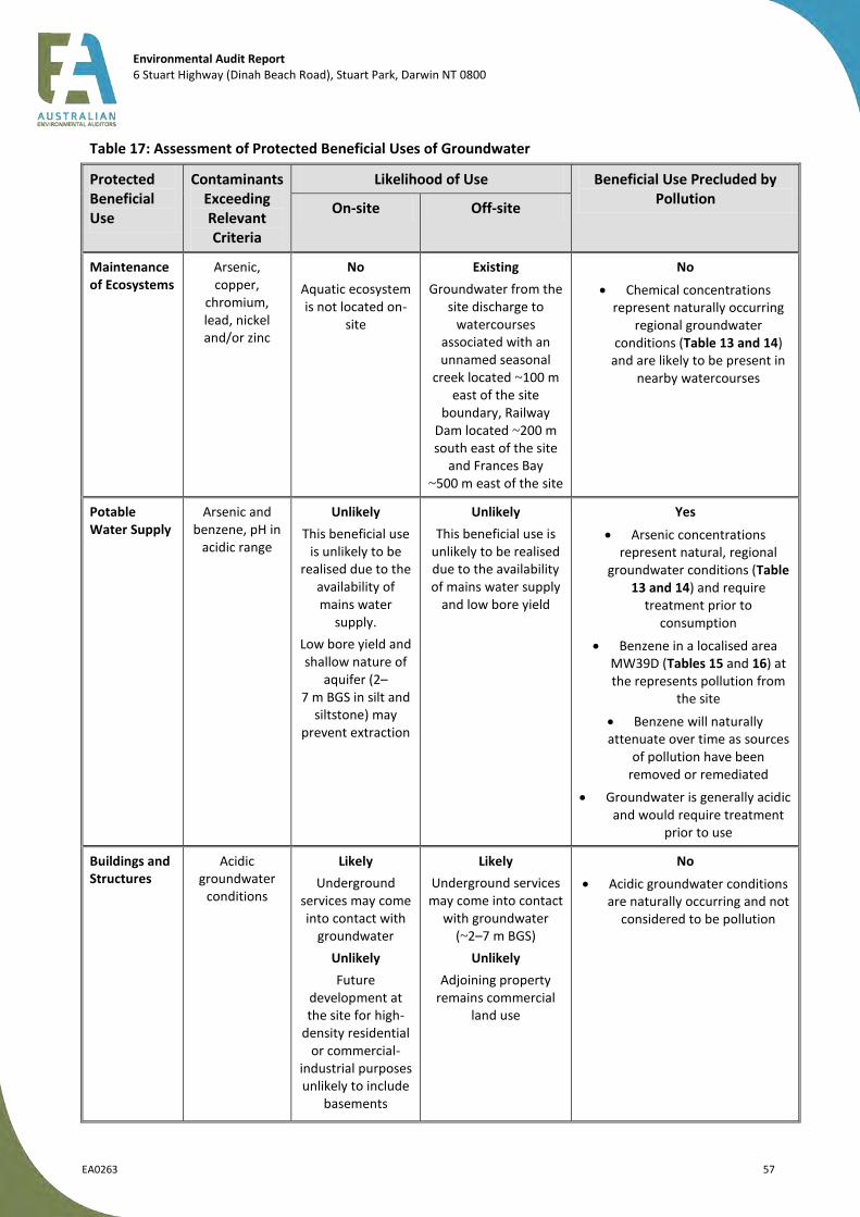
Environmental Audit Report 6 Stuart Highway (Dinah Beach Road), Stuart Park, Darwin NT 0800
EA0263 57
Table 17: Assessment of Protected Beneficial Uses of Groundwater
Protected Beneficial Use
Contaminants Exceeding Relevant Criteria
Likelihood of Use Beneficial Use Precluded by Pollution
On-site Off-site
Maintenance of Ecosystems
Arsenic, copper,
chromium, lead, nickel and/or zinc
No
Aquatic ecosystem is not located on-
site
Existing
Groundwater from the site discharge to
watercourses associated with an unnamed seasonal
creek located ~100 m east of the site
boundary, Railway Dam located ~200 m south east of the site
and Frances Bay ~500 m east of the site
No
Chemical concentrations represent naturally occurring
regional groundwater conditions (Table 13 and 14)
and are likely to be present in nearby watercourses
Potable Water Supply
Arsenic and benzene, pH in
acidic range
Unlikely
This beneficial use is unlikely to be
realised due to the availability of mains water
supply.
Low bore yield and shallow nature of
aquifer (2–7 m BGS in silt and
siltstone) may prevent extraction
Unlikely
This beneficial use is unlikely to be realised due to the availability of mains water supply
and low bore yield
Yes
Arsenic concentrations represent natural, regional
groundwater conditions (Table 13 and 14) and require
treatment prior to consumption
Benzene in a localised area MW39D (Tables 15 and 16) at the represents pollution from
the site
Benzene will naturally attenuate over time as sources
of pollution have been removed or remediated
Groundwater is generally acidic and would require treatment
prior to use
Buildings and Structures
Acidic groundwater
conditions
Likely
Underground services may come into contact with
groundwater
Unlikely
Future development at the site for high-
density residential or commercial-
industrial purposes unlikely to include
basements
Likely
Underground services may come into contact
with groundwater (~2–7 m BGS)
Unlikely
Adjoining property remains commercial
land use
No
Acidic groundwater conditions are naturally occurring and not
considered to be pollution

Environmental Audit Report 6 Stuart Highway (Dinah Beach Road), Stuart Park, Darwin NT 0800
EA0263 58
7.3 Auditor’s Assessment – Surface Water
Surface water and shallow groundwater flow follows the topography towards the south, southeast. The adjacent property in this direction is a former Caltex Depot, also now decommissioned but reported still pending remediation. An unnamed seasonal creek is located ~100 m east of the site boundary, Railway Dam is located 200 m south-east of the site and Frances Bay is ~480 m east of the site.
Past site conditions had significant potential to contribute to contamination of surface waters on the site,
or in the catchment beyond the site boundaries, owing to the proximity of the site to the receptors and the
potential nature of the source areas. The diesel release in 1996 would have likely resulted in some degree
of impact into the surface water receptors. However, the site’s current potential impact to surface water
receptors is low for the following reasons:
with the exception of minor concentrations of hydrocarbons, groundwater at the audit site is not
polluted from site sources and so has low potential to impact on surface water quality; and
the soil conditions on the site do not present a significant potential source of surface water
contamination via stormwater runoff.
7.4 Auditor’s Assessment – Ambient Air
Vapours resulting from the residual hydrocarbon contamination are below CRC CARE values for residential
use and as such, vapours are not a risk to ambient air. The soil has been validated and contains low
concentrations of hydrocarbons and those present are typically non-volatile, longer chained TPH fractions.
The ground is reasonably well vegetated and presents a minimal dust risk, pending redevelopment.

Environmental Audit Report 6 Stuart Highway (Dinah Beach Road), Stuart Park, Darwin NT 0800
EA0263 59
8 Audit Outcome
Based on review of the provided information, the auditor is of the opinion that the history of the site has been adequately characterised, and the assessment and sampling procedures provided acceptable coverage of the audit site and areas that could have been affected by contamination sources. The range of chemicals analysed was suitable to reflect the potential contamination at the site. The sampling frequency was sufficient for characterisation of contamination on the site and the sampling procedures were considered appropriate. QA/QC data confirmed acceptable reliability of the chemical results.
In 1996, a diesel fuel release from the transfer line to the filling gantry occurred triggering the installation of a series of groundwater monitoring wells, recovery wells and two oil-water separators. A total of ~23 000 L of diesel was recovered in response to the release. A further line failure occurred in 1997 from a product transfer line between the Mobil and Caltex depots. A further 16 610 L of product was recovered up to November 1997 when a recovery system was installed. A series of site investigation, remediation and monitoring programs ensued. In 2006, the site infrastructure was decommissioned and validation and/or characterization testing of the soil were performed.
More recently, soil and groundwater remediation works were conducted under a Remediation Management Plan (RMP), which was developed by URS in 2011. The RMP was reviewed and endorsed by the previous auditor (Mr Luke Cattlin). Most of the soil and groundwater remediation works were complete under the supervision of Mr Luke Cattlin, prior to the present auditor (Mr Charles Barber, author of this report) being appointed. However, some final soil, groundwater and soil vapour validation sampling that was still pending at the time of appointment of the present auditor has subsequently been completed.
The site is now completely vacant with all infrastructure removed and contaminated material removed and remediated, excavations validated and then backfilled. Residual hydrocarbon concentrations in both the soil and groundwater, where present, are suitable for high-density residential development or less sensitive land uses. Groundwater contains elevated concentrations of benzene (above drinking water levels), which preclude this beneficial use, although naturally occurring arsenic levels and low pH in the groundwater would also preclude this beneficial use.
Surface water and shallow groundwater flow follows the topography towards the south, southeast. The adjacent property in this direction is a former fuel depot, also now decommissioned but reported still pending remediation. With regard to surface water receptors, an unnamed seasonal creek is located ~100 m east of the site boundary, Railway Dam is located ~200 m south east of the site and Frances Bay is ~480 m east of the site. The site’s current potential impact to surface water receptors is low for the following reasons: with the exception of minor concentrations of hydrocarbons, groundwater at the audit site is not polluted from site sources and so has low potential to impact on surface water quality; and the soil conditions on the site do not present a significant potential source of surface water contamination via stormwater runoff.
As the condition of the audit site is detrimental or potentially detrimental to any (one or more) beneficial land uses of the site, a Certificate of Environmental Audit has not been issued for the site in its current condition. The terms and conditions that need to be complied with before a Certificate of Environmental Audit may be issued are set out as follows.
Residual concentrations of hydrocarbons in soil at select locations along the eastern site boundary remain in situ and require remediation (subject to agreement with adjoining property owners).
Residual concentrations of hydrocarbons in soil remain in situ at one on-site location and require remediation.
Residual concentrations of hydrocarbons in groundwater at the eastern site boundary would be require remediation.

Environmental Audit Report 6 Stuart Highway (Dinah Beach Road), Stuart Park, Darwin NT 0800
EA0263 60
Based on this assessment, a Statement of Environmental Audit has been issued for the audit site, and is included as Appendix A. The site is suitable for the beneficial uses associated with sensitive high density residential use (sensitive use – high-density residential) and less sensitive uses, including commercial and industrial, subject to the following conditions.
1. Groundwater contains elevated concentrations of naturally occurring metals (arsenic) and must not be utilised as a potable source.
2. Groundwater contains elevated concentrations of benzene at one location, MW39D, and is considered to be pollution and must not be utilised as a potable source.
3. Groundwater may impact building footings or underground services due to its natural acidity and corrosiveness potential. Design and construction of these structures must therefore take this into account.
9 Other Relevant Information
This audit was conducted on the behalf of Mobil Oil Australia for the purpose of determining the suitability of the land pending divestment. It is not possible in an Environmental Audit Report to present all data that may be of interest to readers of this report. Readers are referred to the referenced investigation reports for further data. Users of this document should satisfy themselves concerning its application to, and where necessary seek expert advice in respect to, their situation.
This Environmental Audit Report is based on best practice assessment at the time of the issue of the report. It is noted that guidelines and interpretation can change over time (particularly where quantitative risk assessment is undertaken) and accordingly data need to be reassessed in the future.
The auditor notes that any comments and conclusions provided in this document regarding the suitability of the site for the proposed land use are implicitly limited to consideration of contamination related issues as defined under the Victorian Environment Protection Act (1970).

Environmental Audit Report 6 Stuart Highway (Dinah Beach Road), Stuart Park, Darwin NT 0800
EA0263 61
10 References
Legislation and Regulations
1. Environment Protection Act (1970) (Act No.8056/1970), Victoria. 2. Water Act (1989) (Act No. 80/1989), Victoria. 3. Government of Victoria (1997) State Environment Protection Policy (Groundwaters of Victoria).
Victorian Government Gazette, S160, 17 December. 4. Government of Victoria (2002) State Environmental Protection Policy (Prevention and
Management of Contamination of Land). Victorian Government Gazette, S95, 4 June. 5. Government of Victoria (2003) State Environment Protection Policy (Waters of Victoria). Victorian
Government Gazette, S107, 4 June.
6. Northern Territory of Australia (1999) Waste Management and Pollution Control Act (1999)
Guidelines
1. ANZECC (Australian & New Zealand Environment & Conservation Council) (1992) Australian Water Quality Guidelines for Fresh and Marine Waters. National Water Quality Management Strategy.
2. ANZECC (Australian & New Zealand Environment & Conservation Council) (1992) Guidelines for the Assessment & Management of Contaminated Sites.
3. ANZECC and ARMCANZ (Australian & New Zealand Environment & Conservation Council and Agriculture & Resource Management Council of Australia and New Zealand) (2000) Australian and New Zealand Guidelines for Fresh and Marine Water Quality. National Water Quality Management Strategy.
4. EPA Victoria (2000) Groundwater Sampling Guidelines. Publication 669, April 2000, Environment Protection Authority, Victoria.
5. EPA Victoria (2002) Groundwater Quality Restricted Use Zone. Publication 862, July, Environment Protection Authority, Victoria.
6. EPA Victoria (2002) The Clean Up and Management of Polluted Groundwater. Publication 840, April, Environment Protection Authority, Victoria.
7. EPA Victoria (2006) Environmental Auditing, Hydrogeological Assessment (Groundwater Quality) Guidelines, Publication 668, September 2006, Environment Protection Authority, Victoria;
8. EPA Victoria (2007) Environmental Auditor Guidelines for the Preparation of Environmental Audit Reports on Risk to the Environment, Publication 952.2, September, Environment Protection Authority, Victoria.
9. EPA Victoria (2009) Sampling and Analysis of Waters, Wastewaters, Soils and Wastes. Publication IWRG701, June, Environment Protection Authority Victoria.
10. EPA Victoria (2009) A Guide to the Sampling and Analysis of Air Emissions and Air Quality Publication IWRG702, June 2009 Environment Protection Authority, Victoria.
11. Friebel, E & Nadebaum, P (2011) Health Screening levels for Petroleum Hydrocarbons in Soil and Groundwater. CRC CARE Technical Report no. 10.
12. Land and Water Biodiversity Committee (2003) Minimum Construction Requirements for Water Bores in Australia (Edition 2, Revised September 2003);
13. Ministry of Housing and Spatial Planning (1994) Environmental Quality Objectives in the Netherlands.
14. National Environmental Health Forum (2008) Guidelines for Managing Risks in Recreational Water.
15. National Environmental Health Forum (1998) Health-based Soil Investigation Levels, Soil Series No 1, 1996 and 1998.

Environmental Audit Report 6 Stuart Highway (Dinah Beach Road), Stuart Park, Darwin NT 0800
EA0263 62
16. NEPC (National Environment Protection Council) (1999) National Environment Protection (Assessment of Site Contamination) Measure, December.
17. NHMRC and NRMC (National Health and Medical Research Council & Natural Resource Management Council) (2004) Australian Drinking Water Guidelines. National Water Quality Management Strategy.
18. Standards Australia (1998) Water quality - Sampling - Guidance on sampling of groundwater’s; AS5667.6-1998.
19. Standards Australia (1999) Guide to the Sampling and Investigation of Potentially Contaminated Soil, Part 2: Volatile Compounds, AS4482.2-1999.
20. Standards Australia (2005) Guide to the Sampling and Investigation of Potentially Contaminated Soil, Part 1: Non-Volatile and Semi-Volatile Compounds, AS4482.1-2005.
21. Standards Australia (2009) Piling – Design and Installation, AS2159-2009.
Reports
1. PPK (1996) Fuel Investigation Works, Darwin Coastal Bulk Plant Final Report, November 1996. 2. PPK (1997). Darwin Coastal Bulk Plant, October 1997. 3. PPK (1999). Darwin Coastal Bulk Plant Quarterly Report, September 1998. 4. PPK (2000). Darwin Coastal Bulk Plant November 1999 Groundwater Monitoring Report, February
2000. 5. PPK (2001). Darwin Coastal Bulk Plant December 2000 Groundwater Monitoring Report, May
2001. 6. URS (2002). Groundwater Monitoring Report, September 2002, Coastal Bulk Plant, Dinah Beach
Road, Darwin, Northern Territory, November 2002. 7. URS (2004). Post Phase 2 Annual Groundwater Monitoring Event (GME), Mobil Coastal Bulk Plant,
Darwin, Northern Territory, January 2004. 8. Tonkin and Taylor (2011) Auditor’s Review of Quantitative Risk Assessment (8 April 2011). 9. Tonkin and Taylor (2012) Auditor’s Review of Preliminary Site Validation Report (29 March 2012).
10. URS (2006) Post Phase 2 ESA Coastal Bulk Plant Darwin (draft) (December 2006). 11. URS (2007a) Tank Excavation Assessment, Mobil Coastal Bulk Plant, Darwin, Northern Territory,
February 2007. 12. URS (2007b) Phase 1 Environmental Site Assessment, Darwin Mobil Coastal Bulk Plan, URS, 10
October 200. 13. URS (2008) Stage 2 Environmental Site Assessment, Former Mobil Coastal Bulk Plant, Stuart Park,
Darwin, Northern Territory, 21 November 2008. 14. URS (2009a) Annual Groundwater Monitoring Event May 2009 (draft), Former Coastal Bulk Plant
(104842), Dinah Beach Road, Stuart Park NT 0800. 15. URS (2009b) October 2009 Groundwater Monitoring Event, Former Darwin Coastal Bulk Plant
(104842), Dinah Beach Road, Stuart Park, NT 0800. 16. URS (2010) July 2010 Groundwater Monitoring Event, Former Darwin Coastal Bulk Plant (104842),
Dinah Beach Road, 24 September 2010. 17. URS (2011a) Quantitative Risk Assessment (QRA) (dated February 2011). 18. URS (2011b) Data Gap Test Pitting Report (Mar 2011). 19. URS (2011c) Remediation Management Plan (dated June 2011). 20. URS (2011d) Addendum – Updated Risk Based Trigger Levels for Former Mobil Darwin Coast Bulk
Plant (104842), October 2011. 21. URS (2012a) Groundwater Monitoring Event and Soil Vapour Sampling, May 2012 (dated 12
September 2012). 22. URS (2012b) Former Mobil Darwin Coastal Bulk Fuel Terminal, Groundwater Monitoring Event and
Soil Vapour Sampling, September 2012 (URS ref: 42645927) (dated 16 April 2013).

Environmental Audit Report 6 Stuart Highway (Dinah Beach Road), Stuart Park, Darwin NT 0800
EA0263 63
23. URS (2013a) Site Validation Report. Mobil Darwin Former Bulk Fuel Terminal, 26 June 2013. 24. URS (2013b) Additional Soil Remediation and Soil Gas Well SG5A Reinstatement and Sampling
Report (42645927), 21 June 2013.

Environmental Audit Report 6 Stuart Highway (Dinah Beach Road), Stuart Park, Darwin NT 0800
EA0263 Appendix
APPENDICES
Appendix A – Statement of Environmental Audit
Appendix B – Certificate of Title
Appendix C – Copies of Assessor Reports (Digital files on CD)
Appendix D – Auditor Correspondence

Environmental Audit Report 6 Stuart Highway (Dinah Beach Road), Stuart Park, Darwin NT 0800
EA0263 Appendix
Appendix A
Statement of Environmental Audit
STATEMENT OF ENVIRONMENTAL AUDIT
I, Charles David Barber of Australian Environmental Auditors Pty Ltd, a person appointed by the Environment Protection Authority of Victoria (‘the Authority’) under the Environment Protection Act 1970 (‘the Act’) as an environmental auditor for the purposes of the Act, as recognised in the Northern Territory in accordance with Section 47d of the Waste Management and Pollution Control Act 1999 (NT), having:
1. been requested by Mr Graeme Phillips of Mobil Oil Australia Pty Ltd to issue a Certificate of Environmental Audit in relation to the site located at 6 Stuart Highway (Dinah Beach Road), Stuart Park, Darwin, Northern Territory 0800 (‘the site’).
2. had regard to, among other things, (i) relevant guidelines issued by the Authority and endorsed by the Northern Territory Environment
Protection Authority, including guidelines issued by the National Environment Protection Council, (ii) the beneficial uses that may be made of the site, and (iii) relevant state environment protection policies/industrial waste management policies, and planning
instruments,
in making a total assessment of the nature and extent of any harm or detriment caused to or the risk of any possible harm or detriment that may be caused to any beneficial use made of the site by any industrial processes or activity, waste or substance (including any chemical substance), and
3. completed an Environmental Audit Report in accordance with section 53X of the Act so far as it applies to the Northern Territory, a copy of which has been sent to the Northern Territory Environment Protection Authority and the relevant planning and responsible authority.
HEREBY STATE that I am of the opinion that:
The site is suitable for the beneficial uses associated with:
I. sensitive use (high-density); and
II. commercial/industrial use,
subject to the following conditions attached thereto:
1. groundwater contains elevated concentrations of naturally occurring metals (arsenic) and must not be utilised as a potable source;
2. groundwater contains elevated concentrations of benzene at one location, MW39D, and is considered to be pollution and must not be utilised as a potable source; and
3. groundwater may impact building footings or underground services due to its natural acidity and corrosiveness potential. Design and construction of these structures must therefore take this into account.
The condition of the site is detrimental or potentially detrimental to any (one or more) beneficial uses of the site. Accordingly, I have not issued a Certificate of Environmental Audit for the site in its current condition, the reasons for which are presented in the Environmental Audit Report. The terms and conditions that need to be complied with before a Certificate of Environmental Audit may be issued are set out as follows:
residual concentrations of hydrocarbons in soil at select locations along the eastern site boundary remain in situ would require remediation (subject to agreement with adjoining property owners);
residual concentrations of hydrocarbons in soil remain in situ at one on-site location would require remediation; and
residual concentrations of hydrocarbons in groundwater at the eastern site boundary would require remediation.
Other related information
The site, 6 Stuart Highway (Dinah Beach Road), Stuart Park, Darwin NT 0800, was previously utilised as Mobil’s Darwin Coastal Bulk Fuel Terminal from 1968 until 2006 and was Crown Land prior to that. As a bulk fuel terminal, the site’s potential sources of contamination included: aboveground and underground storage tanks (ASTs and USTs), truck filling gantry, lube store, drum store filling area, drum store and two oil–water separators.
In 1996, a diesel fuel release from the transfer line to the filling gantry occurred triggering the installation of a series of groundwater monitoring wells, recovery wells and two oil–water separators. A total of ~23 000 L of
diesel was recovered in response to the release. A second line failure occurred in 1997 from a product transfer line between the adjoining Mobil and Caltex fuel depots. A further 16 610 L of product was recovered up to November 1997 when a recovery system was installed. A series of site investigation and monitoring programs ensued.
The buildings and the hydrocarbon storage and transfer infrastructure were decommissioned in 2006. The site is now completely vacant with all infrastructure removed. Characterisation testing was performed after the facility was decommissioned. Soil and groundwater remediation was deemed necessary to return the site to a condition suitable for the likely rezoning of the area and sale of the site.
Soil and groundwater remediation works were conducted under a Remediation Management Plan (RMP) developed by URS in 2011 and reviewed and endorsed by the previous auditor. Soil remediation activities comprised of dewatering, excavation, and creation and use of bio-piles to reduce petroleum hydrocarbon impact through biological degradation.
Validation samples were collected from the excavation base, walls and soils both pre- and post-treatment. Validation consisted of collection and analysis of 935 soil samples (plus QA/QC samples) from the walls and bases of excavations.
Following treatment and validation of ~42 500 tonnes of materials, the excavations were backfilled following the original auditor’s verification of the results. Backfilled soils were then rolled and compacted in situ and the site surface levelled.
Post-remediation vapour sampling in the area of SG5, in the vicinity of former Tank 1, indicated residual hydrocarbon contamination. This area was excavated and a further 135 m
3 of impacted soil removed, treated,
validated, returned to its original excavation and compacted. Vapour wells were reinstalled and concentrations of CoPCs indicated that the excavation and remediation of soils from the SG5 area were successful.
Soil at select locations on the site (two locations on the eastern site boundary with the adjoining former fuel depot and one on-site location) contains residual concentrations of hydrocarbons above the site specific risk-based target levels for low-density land use. These concentrations are, however, below relevant the CRC CARE HSLs for vapour intrusion for the same use and depth and are considered to not represent a risk to less sensitive land uses.
Groundwater at one location on the site, adjacent to the eastern site boundary with the adjacent former fuel depot, contains elevated concentrations of benzene (above drinking water levels) that constitutes pollution given the former site use and adjacent site use. Natural attenuation of hydrocarbons has been demonstrated and given that the on-site sources of hydrocarbon impact have been removed and/or remediated (via removal of infrastructure and soil remediation) this residual impact is considered likely to reduce with time.
Groundwater at the site contains elevated concentrations of arsenic (above drinking water guideline level), chromium (total), copper, nickel, zinc and low pH – all typical of the regional groundwater quality that does not constitute pollution.
Groundwater monitoring bores present at the site should be decommissioned in accordance with the ‘Minimum Construction Requirements for Water Bores in Australia’, published by the Land and Water Biodiversity Committee (Edition 2, September 2003).
This Statement forms part of Environmental Audit Report – Australian Environmental Auditors Pty Ltd, Environmental Audit Report, 6 Stuart Highway (Dinah Beach Road), Stuart Park, Darwin, Northern Territory 0800, Report Ref: EA0263, 11 October 2013.
Further details regarding the condition of the site may be found in the Environmental Audit Report.
Dated 11 October 2013
Signed
Charles David Barber
ENVIRONMENTAL AUDITOR
(Appointed pursuant to the Environmental Protection Act 1970)

Environmental Audit Report 6 Stuart Highway (Dinah Beach Road), Stuart Park, Darwin NT 0800
EA0263 Appendix
Appendix B
Certificate of Title Details

Printed by IllS on. Page 1 of 4
' ,_
r ~ /
!/
•
REGISTER BOOK - As 10 COMMONWEALTH OF AUSTRALIA. , ~~e ......................... Folio .............. .
. ... .•.•• •. .. ......... ··"""'JC..·· • eglstrar-General NORTHERN TERRITORY OF AUSTRAL -·-· '-"'
~rant itt 3Jl'.rr ~iutplr
is the lessee of the lands leased under Lease No ..... §J4 .... : __ "" ____ _issued under the provisions oL .. "" ... :!ih§!.Jl:a;rwin __
-~2f:!P.: ... A:!:.~~---~-~.§#..~~'"'.Q;;;5l:f.nance .1)L4I.-J.i5.g_ .... ~ ..... ~ ... ~.Y!.m._'r.9Yill....~k~!~t ............ _
"------------,,, ................... ,,._. ____ ., ___________ _
-------------"~---------'--
is entitled by virtue of the Freehofd Titks Ordinance 1962-1963 to be granted an estate in fee simple of the lands specified
in the First Schedule to thls instrument:
1<0',7 Tl!EREFORE I, FREDERICK CH.Uitl!S CH8llEY the Administrator , ... -AJ N~f 'fit'E~Sl!R L.o:t:: .. the ... fulrlh= .. Ter;dJ;.= ..... the . .del..egat.e .• oL::.. ________ the Minister of State for
yr or ern :.texxl. ory ;;? the~ subject to the laws of the Northern Territory and in pursuance of those laws and all other powers enabling
Jv-..I me to do so DO HEREBY GRANT to the said .... _____ • __ t~Q!liL OIL AU::iJ.TRALT!J. Ll1\ti:TEJ;p_-_________ ---
all that piece or parcel of land specified in the First Schedul~ to this instrument reserving however the minerals, nrineral
substances and.rights specified in the Second Schedule to this instrument TO HOLD, subject to such easements as
are specified in the Third Schedule to this instrument and subject to the Jaws of the Northern Territory, unto and to
. J.IOBIL OIL AUSTRALIA LIMITED the use of the satd .................................................................................... ., .... ¥.··--~-------
................................................... _ .............................. ----·--·--------·--· -------------------and ..................... ;h:t.~ ...................... heirs for ever.
IN WITNESS WHEREOF I hereunto set my hand and seal this .......... ~--: ........ :day o~-• 19.?.':? .. .
. _ SIGNED SEALED AND DELIVERED by the sru.a /'v' .::t'-P . by t:Be eeitl MHHs~eF iB t:he pfeseaee ef
~FREDERICK CR.AR.LID3 CTI-IANEY t the A&iu.nistrator of the N6rthe~·Ter~tory, the delegate of the Minister o:r State fox the Northern IJ:"e:t.Tit"ory;-i'l'i'""ttie----p:res·eace·-or-.... -...
. . . . . . . . . . . . . . . . . .
_:;2// ~ . ··-----~---~---.... -'-~ ._ __
Afiliia1u efSta:cfe. tiM :Eue: is• Delegate of the Minister of State for the Northe~ Texritory
I WIll IIIII~ /IIIII II I II Ill IIIII IIIII /Ill I II Ill l/llllllllll/11 1111111 'CUFT /009/1090'

Printed by ILlS on . Page 2 of 4
LAND INCLUDED IN GRANT
AJlthatpieceorparceloflandbeing Lot Noa 1661
situated in the Town at: Da.rwi~ in th.-e :Noxt:he:rn Te:::d tory of: Austzalia
containing an area of eleven ac.xes th:cee pe!'ches o_r ~ereabouts
and delineated in the Public plans deposited in the office of the Regi~trat'-General and in the portion coiomed green of
the follo'rving pian:
RESERVATION
A reservation to the Crown of all minerals and mineral substances in or upon the land included in this grant, including go1d, silver, copper~ tin, metals, ores and substances containing metals, gems~ precious stones, coal, shale1 ~neral oils, and vaJuable earths and substances, together \vith the right to author~se any persons ~o enter -upo11 the land to mine. work for, win, recover and remove them or any of them and to do all things necessary or convenien:t for ~hose purposes.
EASEMENTS
•
j
·--
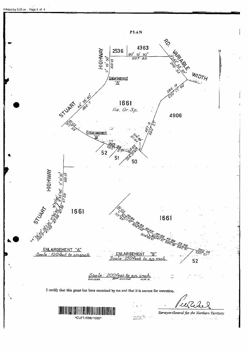
Printed by ILlS on . Page 3 of 4
-
•
~ s :c (!)
:c
16 61
Erjlargement "8" ..... _ · ..
PLAN
Enlarnement "£
1661 /Ia. Or.3p.
51
N
4906
ENLARGEMENT "A" Sca..le : IOQ(id m .~ .. ENLARGEMENT "B"
SOak ."JOOf'ed- to an. V=..t 52
S c.a.le. : 200Fed ta ~ i:n.c.J,... a.P../593 . ;;;:;;>.,.y.......,.~ C:.M.H.
I certify that this grant has been examined by me and that it is correct for execution.
·~~ '""--·-·«·~- .. --·-- _ .. __
I ~m I~ ~~1111!11 ~I! IIIII~ IIIII II! I~ I~ IIIII mill!~ IIIII II Surveyor._General for the Northern Territory
'CUFT/009/1090'
I
'

Printed by !LIS on . Page 4 of 4
-
·'
•
.... )
/
12Qil)6~

Environmental Audit Report 6 Stuart Highway (Dinah Beach Road), Stuart Park, Darwin NT 0800
EA0263 Appendix
Appendix C
Assessor Reports (digital files on CD)

Environmental Audit Report 6 Stuart Highway (Dinah Beach Road), Stuart Park, Darwin NT 0800
EA0263 Appendix
Appendix D
Auditor Correspondence
Reference: EA0263‐C1 19 March 2013
Mr Sachindra Ram Project Manager ExxonMobil Environmental Services ‐ Mobil Oil Australia Pty Ltd 12 Riverside Quay Southbank, VIC 3006 Email: [email protected]
AUDITOR REVIEW
DRAFT GROUNDWATER MONITORING EVENT AND SOIL VAPOUR SAMPLING, SEPTEMBER 2012
FORMER MOBIL DARWIN COASTAL BULK PLANT (21XX)
DINAH BEACH ROAD
STUART PARK, DARWIN, NORTHERN TERRITORY Dear Sachindra,
In preparation of the upcoming field visit to Darwin, I have reviewed several of the URS Australia Pty Ltd (URS) reports provided to me to date. This document is in regards to the URS (12 November 2012) “Draft Report, Former Mobil Darwin Coastal Bulk Fuel Terminal, Groundwater Monitoring Event and Soil Vapour Sampling, September 2012” (ref: 42645927). Having reviewed the document I provide the following comments regarding groundwater in general and the soil vapour testing in particular for consideration, address and clarification prior to endorsement.
1. Table 4‐1: Brief reference is made to the soil vapour sampling being conducted in accordance with a procedure provided as Appendix J. No detailed discussion has been provided in the text and no auditable supporting documentation has been provided (e.g. photographs, field sheets). Please provide:
a. Field sampling sheets;
b. Photographs showing the leak testing set‐up and sampling set‐up;
c. Confirmation that the leak testing procedure does not include the duplicate t‐piece, flow regulator or Summa canister. It appears as though the vacuum line test, which is difficult to audit, is relied upon to assess leaks at these points;
d. A discussion of leak testing results;
e. A discussion of pre/post purging PID data;
f. A discussion of pre/post purging O2/CO2/CH4 data;
g. A discussion of sampling times and the consistency of Summa canister vacuum pressure drops with those expected based on the flow controllers which were used;
h. Confirmation that the sampling procedure adopted does not include quantitative or qualitative assessment of the development of vacuum conditions within the soil vapour well.
EA0263‐C1 GME review, 19 March 2013 Page 2 of 3
2. Table 4‐3: Can URS provide comment as to why some of the soil vapour wells were water logged (e.g. poor seal in borehole annulus? perched aquifer? capillary fringe? water table aquifer?).
3. Section 5.1.1 Groundwater:– the groundwater flow has been determined to be toward the south‐east, however the rate of flow ranges nearly 5 orders of magnitude. This is in part due to the high range of estimated hydraulic conductivity based on published values and perhaps due to the extremes in wet and dry season conditions. It would be prudent to conduct rising or falling head tests to determine site specific hydraulic conductivity values get a more useful estimation of groundwater flow.
4. Section 6.3: It is unclear why no fractionated total petroleum hydrocarbon or O2/CO2/CH4 analysis was conducted.
5. Section 6.4: If the HSL‐A soil vapour criteria are to be adopted, the applicability spreadsheet provided by CRC CARE should be completed.
6. Section 6.5: The summary tables indicate that a single blind duplicate (QC26) was collected during the September 2012 soil vapour sampling event. The rationale for field QA/QC during the soil vapour sampling should be defined and the QC26 data should be discussed.
7. Section 7.2:
a. The soil vapour data should be compared to applicable soil and groundwater data in order to determine whether or not there are any outstanding site characterization issues (e.g. is the detection of naphthalene in SG5 consistent with relevant soil and groundwater data?).
b. It is not considered defensible to infer that the September 2012 soil vapour data is not likely to be representative of average soil vapour conditions on the basis of a single subsequent additional round of sampling. There are a number of factors which must be considered when comparing results from different rounds of soil vapour sampling (e.g. laboratory error, weather conditions).
c. There are numerous aromatic and aliphatic compounds which have been detected in soil vapour above laboratory reporting limits but no screening criteria have been applied to determine whether or not the concentrations detected are significant. Screening criteria should be adopted for each chemical detected above laboratory reporting limits.
8. Section 7.3 Monitored Natural Attenuation: The evaluation of Natural Attenuation appears somewhat generic and references Appendix I which only has tabulated data. The section does not go into any detail or discussion as to whether MNA is occurring, if it’s aerobic or anaerobic or both and what the limiting factors are. A set of plots showing up‐gradient, mid‐plume, down‐gradient well results would aid this discussion and re‐ordering of the Table 7‐1 into up‐, mid‐ and down‐gradient groupings or lines of wells (given their distribution across the site) would also make interpretation easier.
9. Section 8.1: Bullet Point 10: See Comment 6b.
10. Appendix B includes calibration records for field instruments which based on Appendix J should have been used during the soil vapour sampling (i.e. Minirae 2000 PID, Impact Pro Multi‐Gas Detector, GasCheck). No data which has been obtained using these field instruments has been provided apart from what appears to be ambient air monitoring data in Appendix A.
11. Appendix E: Some sections of the chain of custody documentation for the soil vapour samples have not been completed (i.e. time at start/finish of sampling, pre/post sampling vacuum pressure, vacuum pressure at receipt).

EA0263‐C1 GME review, 19 March 2013 Page 3 of 3
Please provide a revised version of the report for final review and endorsement. Please contact the undersigned should you have any questions.
Sincerely,
Australian Environmental Auditors
Charlie Barber WA DEC Contaminated Sites Auditor [email protected] 0418 247 375

Reference: EA0263‐C2 3 April 2013
Mr Sachindra Ram Project Manager ExxonMobil Environmental Services ‐ Mobil Oil Australia Pty Ltd 12 Riverside Quay Southbank, VIC 3006 Email: [email protected]
AUDITOR REVIEW
ADDENDUM ‐ UPDATED RISK BASED TRIGGER LEVELS FOR
FORMER MOBIL DARWIN COASTAL BULK PLANT (104842)
DINAH BEACH ROAD
STUART PARK, DARWIN, NORTHERN TERRITORY Dear Sachindra,
I have now had time for my expert support to review the Addendum – Updated risk Based Trigger Levels for Former Mobil Darwin Coast Bulk Plant (104842), October 2011 prepared by URS Australia Pty Ltd. A number of issues have been identified which require further clarification. They are:
Issue Comments
Introduction The introduction section indicates that the new RBTLs are calculated due to the new
site specific information on aliphatic and aromatic ratio of TPH fractions. Apparently
the previous assessment was also very conservative. The new obtained ratio is 80%
aliphatic and 20% aromatic. The old adopted ratio was 50% and 50%.
This new ratio would not really increase the calculated RBTLs greatly. In fact, the new
ratio could decrease the RBTLs further. Henry’s Law Constants for aliphatic TPHs are
around 1,000 times greater than for the aromatic fractions. Therefore, the inhalation
exposure risk for aliphatics would be around 100 times greater than the aromatics.
Adopting the TPH fractions as 20% aromatic and 80% aliphatic is a more realistic but
potentially more conservative estimate for inhalation exposure risk.
Regarding the exposure parameters used in the new RBTL calculations, it seems like
they have not changed when compared to the exposure parameters used in the
previous QRA. Therefore, it is not really clear how the new RBTLs increased.
Regarding the RBTL
calculations
RBTLs are generally calculated after conducting a basic risk assessment of the site
including every potential exposure scenario. From the risk assessment, the percentage
risk contribution of the each scenario is calculated. The allowed risk value (Hazard Index
of 1) is then divided based upon the contribution factor of the each scenario and is
allocated accordingly. Later the most obvious scenario is selected with the allocated
risk value for the back calculations of the RBTLs. It appears that this process has not
been followed.
The calculations look like forward calculations not back calculations.
EA0263‐C2 Updated HRA Review, 3 April 2013 Page 2 of 2
Issue Comments
Regarding the RBTL
calculations (cont’d)
The groundwater contribution to the overall risk should be calculated separately and
excluded during the RBTL calculations for soil.
The risk contribution of each of the soil exposure pathways is not known.
Regarding to the
exposure parameters The latest RBTLs are greater than the CRC Care HSLs. Therefore, the exposure
parameters in the RBTL calculations are compared with the exposure parameters in CRC
Care HSLs. It is found that the exposure parameters in RBTL calculations are less
conservative compared to CRC Care values. This could be accepted with sufficient
reasoning and explanation, however this was not provided in the report.
For example, the adopted soil temperature value is 17°C in RBTL calculations. This
provided less conservative Henry’s Constant values as compared to values used in CRC
Care HSLs. However, the 17°C soil temperature is not realistic for the Darwin area.
If any exposure parameter is going to be less conservative than CRC Care an explanation
is required.
The paragraph below the
deeper soil RBTLs
This paragraph doesn’t make sense. It is not clear why there is no diffusion in warmer
climates. If there is no diffusion it should be advection flow which in‐turn would provide
a greater level of risk. Please explain which section of the CRC Care guideline indicates
that no diffusion occurs in warm climates.
CRC Care suggests using the most risk contributing source only for the risk assessment,
even if the contamination is in two different levels of the soil. CRC Care suggests not
combining the risk from these two sources. However, this is only appropriate for the
risk assessment not for RBTL calculations. Because RBTLs will be the specific target
levels for the remediation of surface and deep soil separately, they should be calculated
independently of each other.
Please provide a revised version of the report for final review and endorsement. Please contact the undersigned should you have any questions.
Sincerely,
Australian Environmental Auditors
Charlie Barber EPAV Appointed Environmental Auditor – Contaminated Land [email protected] 0418 247 375
Ref: EA0263‐C3 9 May 2013
Mr Sachindra Ram ExxonMobil Environmental Services ‐ Mobil Oil Australia Pty Ltd 12 Riverside Quay Southbank, VIC 3006 Email: [email protected]
Auditor Review Comments on URS Response to Auditor Comments C2 (RBTLs)
Former Mobil Darwin Coastal Bulk Plant (104842) Dinah Beach Road
Stuart Park, Darwin, Northern Territory
Dear Sachindra,
I have had my expert support review URS’s response to my last correspondence C2, dated 3 April 2013 regarding the Addendum – Updated risk Based Trigger Levels for Former Mobil Darwin Coast Bulk Plant (104842), October 2011 prepared by URS Australia Pty Ltd.
The response from URS isn’t sufficient to close out the HRA and RBTL issues noted. The following is the response from my expert on human health risk assessments and toxicology. I have reviewed the comments from URS and the responses from my expert and concur with my expert’s opinion. The comments below provide the back and forth responses with the most recent position in red.
Issue Auditor’s Expert Support Comments
Introduction Auditor’s Original Comment: The introduction section indicates that the new RBTLs are calculated due to the new site specific information on aliphatic and aromatic ratio of TPH fractions. Apparently the previous assessment was also very conservative. The new obtained ratio is 80% aliphatic and 20% aromatic. The old adopted ratio was 50% and 50%.
This new ratio would not really increase the calculated RBTLs greatly. It is quite the opposite that the new ratio could decrease the RBTLs further. Henry’s Low Constants for aliphatic are around 1000 times greater than for aromatics. Therefore, the inhalation exposure risk for aliphatic would be around 100 times greater than the aromatics. Adopting the TPH fractions as 20% aromatic and 80% aliphatic is a more realistic but potentially more conservative estimate for inhalation exposure risk.

EA0263 – C3, 9 May 2013 Page 2 of 5
Auditor Review Comments on URS Response to Auditor Comments C2 (RBTLs)
Issue Auditor’s Expert Support Comments
Introduction (cont.) Regarding the used exposure parameters in the new RBTL calculation, it seems like they did not change compared to the exposure parameters used in previous QRA. Therefore, it is not really clear how the new RBTLs increased.
URS Response: The differences between the two sets of RBTLs will relate to compositional changes (aromatics have lower volatility but higher toxicity). The auditor agrees that it could relate to the compositional changes, however that being the case, it will reduce the RBTLs, not increase them, due to the above explained differences in volatility. Higher toxicity of aromatics is already considered in the above description. Ipso facto, the above description indicates that there is a 100 times greater risk for aliphatics compared to the aromatics while the volatility difference is 1000 times. This is only applicable for inhalation risk calculations. Therefore, adopting 20% and 80% aromatic aliphatic ratio would not cause any increase in RBTLs. The Introduction section should be changed accordingly.
Additionally as the RBTLs assume additivity between COPC it should be noted that there is inherent flexibility in how the risk is apportioned. Agree. But we don’t understand the purpose of this comment.
The differences between the RBTLs and the HSLs are overwhelmingly due to the assumption that advection isn’t active and that additivity between COPC is active. The above comment is asking for the reasons for the differences between the two RBTLs; not RBTLs and HSLs. However, this difference could not be explained by the use of diffusive flow only as the RBTLs are calculated using the scenario for an exposure pathway of dermal contact and ingestion, additionally it appears that inhalation is not accounted for in the RBTL calculation.
Regarding to the RBTL calculations
RBTLs are generally calculated after conducting a basic risk assessment of the site including every potential exposure scenarios. From the risk assessment, the percentage risk contribution of the each scenario is calculated. The allowed risk value (Hazard Index of 1) is than divided based on the contribution factor of the each scenario and allocated. Later the most obvious scenario is selected with the allocated risk value for the back calculations of the RBTLs. It looks like this process has not been followed up.
The calculations look like forward calculations not back calculations.
The groundwater contribution to the overall risk should be calculated separately and excluded during the RBTL calculations for soil.
The risk contribution of the each soil exposure pathways is not known.
URS Response: The RBTLs considered the one (most sensitive) scenario, for which multiple exposure pathways are potentially active. Yes, there are multiple exposure pathways scenarios for receptors; however they are not accommodated in the RBTL calculation. They can only be accommodated by following up the above described calculation procedure. Therefore, the suggested soil RBTLs are not protective of human health and not acceptable.
The RBTLs are set to be the concentrations which result in a HQ of 1.0 should a single receptor (a future site resident) be exposed via ingestion, dermal and vapour pathways.

EA0263 – C3, 9 May 2013 Page 3 of 5
Auditor Review Comments on URS Response to Auditor Comments C2 (RBTLs)
Issue Auditor’s Expert Support Comments
This is forward calculation which does not accommodate every exposure pathway into the overall risk. The calculation appears as if it is testing the suggested RBTLs for every exposure pathway.
URS does not consider it necessary to consider a contribution from the groundwater source in deriving the soil RBTLs. Independent calculation is appropriate and is what we have done. This is not acceptable, as the soil and groundwater sources are generally combined during the risk assessment. The previous risk assessment conducted by URS also combined the risk contribution of the soil and groundwater sources at the site. Therefore, conducting the RBTL calculations for soil and groundwater independently and assuming they are not additive is contradictory and not acceptable.
It is not considered appropriate to treat the risks from two sources as additive, as the level of risk will be driven solely by the source associated with the highest risk. Consider an elevated source at depth which is calculated to result in higher levels of risk than an overlying source with lower concentrations. The modelling conservatively does not assess partitioning back into soil once impacts enter vapour from the deeper source. If the higher risk is associated with the deeper source, the vapour concentrations passing through overlying soils will be higher than the vapour concentrations in equilibrium with these overlying soils, and as such, further partitioning will not occur. Agreed. However, this is only applicable to two or more sources of soil contamination at different depths and to groundwater contamination in different aquifers. This is not the scenario at the site therefore, this is not applicable to the soil and groundwater contamination at the site.
URS can provide details of the relative contribution from each pathway. Note that the risk is currently driven by ingestion (as a result of no advection in vapour models limiting risk via these pathways). Simply, providing the relative contribution from each exposure pathway is not sufficient. These should be accommodated into the RBTL calculation with the procedure described above.
Regarding to the exposure parameters
The latest RBTLs are greater than the CRC Care HSLs. Therefore, the exposure parameters in RBTL calculations are compared with the used exposure parameters in CRC Care HSLs. It is found that the exposure parameters in RBTL calculations are less conservative compared to CRC Care values. This could be accepted with sufficient reasoning and explanation, but was not provided in the report.
For example, the adopted soil temperature value is 17°C in RBTL calculations. This provided less conservative Henry’s Constant values compared to values used in CRC Care HSLs. However, the 17°C soil temperature is not realistic for the Darwin area.
If any exposure parameter is going to be less conservative than CRC Care an explanation would be appreciated.
URS Response: Although there is a field for temperature in the models, the results are not actually sensitive to changes in this parameter. The auditor disagrees, Henry’s Law constant changes with the temperature.

EA0263 – C3, 9 May 2013 Page 4 of 5
Auditor Review Comments on URS Response to Auditor Comments C2 (RBTLs)
Issue Auditor’s Expert Support Comments
Regarding to the exposure parameters (cont.)
This is because fixed values for Henry’s Law (i.e. not temperature dependent) have been incorporated. There is no fixed value for Henry’s Law Constant; it is always pressure and temperature dependent.
Henry’s Law constants are slightly less conservative than (but comparable with) the values used in the HSLs (with slightly different TPH/TRH banding). The dimensionless Henry’s Law Constant values are set at a 25ᵒC degree temperature within CRC Care HSLs which may be more applicable for the Darwin area.
Updating these values to be in line with the values in the HSLs results in only small changes to the risk level. The auditor believes the changes will be in the order of between 10% and 20% if the inhalation exposure pathway is accommodated into the RBTL calculation.
Exposure parameters are generally the same as those assumed in the HSLs. Some other parameters are also less conservative compared to the ones used in HSLs, such as foundation thickness, exposure frequency, etc.
The paragraph below the deeper soil RBTLs
This paragraph doesn’t make sense. It is not clear why there is no diffusion in warmer climates. If there is no diffusion it should be advection flow which would provide greater risk. Please explain in what section CRC Care indicates no diffusion in warm climates.
CRC Care suggests using the most risk contributing source only for the risk assessment, even if the soil contamination is in two different levels of the soil. CRC Care suggests not combining the risk from these two sources. However, this is only appropriate for the risk assessment not for RBTL calculations. Because RBTLs will be the specific target levels for the remediation of surface and deep soil separately, it should be calculated as independent of each other.
URS Response: The term ‘diffusion’ in the paragraph is a typo and will be replaced with ‘advection’ in the report. Accepted.
What we have done in the models is to exclude advection as an active pathway (for the reason that houses are unlikely to be heated in Darwin, and heating is the primary mechanism for creating negative pressure within the building). Houses which are air‐conditioned would generally be at positive pressure, and the net advection rate (over a year) would be expected to be zero or lower in Darwin. Agreed.
This is the key consideration in the RBTLs which less conservative than in the HSLs. The auditor doesn’t understand how this results in any changes to the RBTLs, considering the inhalation exposure pathway was not accommodated into the RBTL calculation anyway.
For contributions from multiple sources, see the discussion above (under “regarding to RBTL concentrations”). The same argument applies. We have assumed independence of each source and this is considered appropriate. Agreed, for two sources of soil contamination at different depths, but not for soil and groundwater contamination at the same site as is the case at the site.
EA0263 – C3, 9 May 2013 Page 5 of 5
Auditor Review Comments on URS Response to Auditor Comments C2 (RBTLs)
Given the obvious disagreements between the consultant and the auditor’s expert, it may be more beneficial to have a conference call discussing these aspects unless the consultant can adequately address these issues otherwise. Either provide a revised version of the report for additional review or initiate a conference call for the relevant parties. Please contact the undersigned should you have any questions.
Sincerely,
Australian Environmental Auditors
Charlie Barber
EPAV Appointed Environmental Auditor – Contaminated Land

Reference: EA0263‐C4 10 July 2013
Mr Sachindra Ram ExxonMobil Environmental Services ‐ Mobil Oil Australia Pty Ltd 12 Riverside Quay Southbank, VIC 3006 Email: [email protected]
AUDITOR REVIEW
COMMENTS ON URS REPORT
ADDITIONAL SOIL REMEDIATION AND SOIL GAS WELL SAMPLING
FORMER MOBIL DARWIN COASTAL BULK PLANT (104842)
STUART PARK, DARWIN, NORTHERN TERRITORY Dear Sachindra,
I have reviewed URS’s report Additional Soil Remediation and Soil Gas Well SG5A Reinstatement and Sampling Report (42645927), 21 June 2013 prepared by URS Australia Pty Ltd. Whilst the Auditor agrees with the report conclusions regarding low levels of residual contaminants remain which do not pose a risk, some comments require address before the report can be endorsed. Some of these are mere report corrections for accuracy whilst others require additional information.
Report Corrections
Section 2 – Extent of Additional Remedial Excavation
1. The Background section refers to Figure 1 showing the location of SG5 and SG5A. The figure itself refers to SG4 in the legend and SG5a is not depicted is labelled SG5 (revised).
2. A figure that places the site and bore locations into context would be useful (e.g. detailed site layout).
3. The first paragraph under Excavation Works and PID Testing refers to Figure 2; however there is only one figure (Figure 1) in the report.
4. It is unclear on Figure 1 as to whether the locations shown are final validation sample locations or progressive locations. This should be clearly stated in the text and the heading.
5. Figure 1 contains a typo – “valiation” sample in key.
6. Inconsistent terminology is used where the report mostly refers to “Attachment X” whilst the Table of Contents and report addendums are referred to as “Appendix X”.
7. The third paragraph under the same heading has a typo “bot” should probably be “not”.
8. Results paragraph one (p3) refers to results included in Appendix B when the tables are within Appendix D.
9. The discussion in the Excavation Samples section includes EX01_29 as a characterisation sample; however that sample appears to be a validation sample from 1.6m.
10. Sample EX01_35 does not appear on Figure 1; however there is a sample location “xx” that looks like it may be its location based on the field notes.
11. It would be useful to indicate the maximum depth of excavation on the figure.
12. A cross reference to the appropriate table for stockpile results should be included.

EA0263‐C4 Additional Soil Remediation and Soil Gas Well Sampling Review, 10 July 2013 Page 2 of 2
13. The COC144565 indicates that particle size distribution analysis was requested however insufficient samples were received at the laboratory. What affect does this have on comparison of results with CRC CARE HSLs? Is the soil type used an estimate or based on soil data from the reinstated excavated area or elsewhere on the site? Have appropriately conservative values for soils type been used?
Section 3 – Soil Gas Bore Installation
14. As above, rectify the “Appendix” and “Attachment” cross‐references.
15. The photographs of the soil gas testing provided in Appendix G of this report, should be referenced.
Areas Requiring Further Detail
Section 2 – Extent of Additional Remedial Excavation
16. The section discussing Soil Sample Collection and Analysis (s2.3) should include more information regarding the logic or systematic approach behind the sampling regime. Page 1 of the field notes refers to quadrants and depths of samples, but the quadrant concept discontinues. Once away from the quadrants, excavation depths were limited to 1.6m, regardless of PID readings (see samples EX01‐: 21, 27 and 34).
17. The Validation Samples section (s2.4.2) should discuss the lead detection above RBTLs in EX01‐31.
18. The Conclusions section (s2.5.3) regarding laboratory data notes all non‐conforming samples and analyses were considered and it was reasoned these did not affect the overall quality. More detailed is required on how each of these non‐conformances were individually considered and discounted.
19. The Summary section (s2.6) requires a discussion regarding the Lead concentration in excess of RBTLs.
20. The locations of the samples obtained for “characterisation” purposes should be shown on a separate figure for relativity.
Section 3 – Soil Gas Bore Installation
21. Please provide discussion for installation of the gas bore to 1.5mBGS when previous impacts were reported in a silt layer at 1.6mBGS? Clarify that the bore is outside the excavation surrounding SG5.
22. The SRN for EN1301508 notes that for “EP101 – sample canisters were received at sub‐ambient pressures and required dilution in the laboratory prior to analysis”. Please comment on the effects of dilution of the samples on the results.
23. The adopted HSL screening levels presented in Table 1 and the following table (Soil Gas Results ‐ September/October 2012 ) appear to be for HSL B (high density residential) rather than HSL A (low density residential) as indicated in the text (e.g. benzene 1.1/11 should be 1.3/13 and so on for TEX, TPHs and Naphthalene).
Section 4 – Additional Hydraulic Conductivity Testing
24. How do the results of the hydraulic testing affect the previous calculations regarding groundwater flow velocity at the site? A discussion should be included which relates these actual measured results with those that were estimated based on published values in the previous discussion of groundwater and plume movement.
Please provide a revised version of the report for final review and endorsement. Please contact the undersigned should you have any questions.
Sincerely,
Australian Environmental Auditors
Charlie Barber EPAV Appointed Environmental Auditor – Contaminated Land [email protected] 0418 247 375

Reference: EA0263‐C5 30 August 2013
Mr Sachindra Ram ExxonMobil Environmental Services ‐ Mobil Oil Australia Pty Ltd 12 Riverside Quay Southbank, VIC 3006 Email: [email protected]
AUDITOR REVIEW
COMMENTS ON REVISED URS REPORT
ADDITIONAL SOIL REMEDIATION AND SOIL GAS WELL SAMPLING
FORMER MOBIL DARWIN COASTAL BULK PLANT (104842)
STUART PARK, DARWIN, NORTHERN TERRITORY Dear Sachindra,
I have reviewed URS’s revised report Additional Soil Remediation and Soil Gas Well SG5A Reinstatement and Sampling Report (42645927/A/01; Final Rev 1), 28 July 2013 prepared by URS Australia Pty Ltd. The report addresses the comments provided previously. There are however a few minor corrections suggested for consideration for finalising the report, being:
1. Typo’s on Page 5 discussion of RPDs – “primate” should be “primary”; and Page 13 discussion – “blow” should probably be “below”.
2. Additional references have been added (to tables and text) including CRC CARE, Amended NEPM, the “initial quantitative risk assessment” and so on, but these references are not included in the reference section.
Please provide the final report when considered complete. If you have any questions, please contact me.
Sincerely, Australian Environmental Auditors
Charlie Barber EPAV Appointed Environmental Auditor – Contaminated Land [email protected] 0418 247 375