assessment report 82 - ntepa
TRANSCRIPT
ASSESSMENT REPORT 82
INTRAPAC PROJECTS PTY LTD NOONAMAH RIDGE ESTATE
September 2017
Assessment Report 82
2
Environmental impact assessment process timelines Date Progress stage
22/12/2013 Receipt of Notice of Intent
7/04/2014 NT EPA decision Environmental Impact Statement issued
03/11/2014 Draft Terms of Reference (ToR) released for public comment
28/11/2014 Final ToR issued to proponent
28/11/2015 Draft EIS released for public comment
4/03/2016 NT EPA direction to prepare EIS Supplement issued
17/6/2016 EIS Supplement received
8/7/2016 Additional information requested
15/02/2017 Additional information received
9/03/2017 Additional information requested
17/08/2017 Additional information received
28/09/2017 Assessment Report issued
Dr Paul Vogel Chairman 28 September 2017
Northern Territory Environment Protection Authority GPO Box 3675 Darwin Northern Territory 0801
© Northern Territory Environment Protection Authority 2017
Important Disclaimer
This document has been prepared with all due diligence and care, based on the best available information at the time of publication. Any decisions made by other parties based on this document are solely the responsibility of those parties.
The Northern Territory Environment Protection Authority and Northern Territory of Australia do not warrant that this publication, or any part of it, is correct or complete. To the extent permitted by law, the Northern Territory Environment Protection Authority and Northern Territory of Australia (including their employees and agents) exclude all liability to any person for any consequences, including but not limited to all losses, damages, costs, expenses and other compensation, arising directly or indirectly from using, in part or in whole, any information or material contained in this publication.
Assessment Report 82
3
Contents Abbreviations and glossary .................................................................................... 4
Summary and recommendations ........................................................................... 5
1 Introduction and background ......................................................................... 10
1.1 Purpose of this report ..................................................................................... 10
1.2 Scope of the assessment ............................................................................... 10
1.3 Approval and regulatory framework ................................................................ 10
2 The project ....................................................................................................... 11
2.1 Proponent ....................................................................................................... 11
2.2 Project description .......................................................................................... 11
3 Key environmental factors.............................................................................. 16
4 Environmental impact assessment ................................................................ 17
4.1 Terrestrial flora and fauna ............................................................................... 19
4.2 Hydrological processes................................................................................... 34
4.3 Inland water environmental quality ................................................................. 37
4.4 Social, economic and cultural surroundings .................................................... 41
5 Conclusion ....................................................................................................... 46
6 References ....................................................................................................... 47
Appendix 1 ............................................................................................................. 49
Appendix 2 ............................................................................................................. 50
Appendix 3 ............................................................................................................. 51

Assessment Report 82
4
Abbreviations and glossary Advisory bodies Agencies having administrative responsibilities in respect
of the proposed action
draft EIS Draft Environmental Impact Statement
DCA Development Consent Authority
EA Act Environmental Assessment Act
EAAP Environmental Assessment Administrative Procedures
EIS Environmental Impact Statement
Environment All aspects of the surroundings of man including the physical, biological, economic, cultural and social aspects (Section 3 of the Environmental Assessment Act)
ESD Ecologically Sustainable Development
NOI Notice of Intent
NT EPA Northern Territory Environment Protection Authority
Relic Aboriginal archaeological object as per Section 8 of the Heritage Act
Responsible Minister Northern Territory Minister for Infrastructure, Planning and Logistics
The Minister Minister for Environment and Natural Resources
The Project Noonamah Ridge Estate
The Proponent Intrapac Projects Pty Ltd
The Supplement The Supplement to the draft EIS
the/this Report This Assessment Report 82, for the Noonamah Ridge Estate Project
TPWC Act Territory Parks and Wildlife Conservation Act
Assessment Report 82
5
Summary and recommendations Environmental impact assessment (EIA) is a process for identifying the potential environmental impacts and risks of a proposed action, evaluating the significance of those impacts and risks and determining appropriate avoidance, minimisation/mitigation measures to reduce those potential impacts and risks to acceptable levels. This Assessment Report (the Report) examines the EIA of the Noonamah Ridge Estate proposed by Intrapac Projects Pty Ltd (the Proponent). This Report marks the end of the assessment process by the Northern Territory Environment Protection Authority (NT EPA).
This Report is provided to the Northern Territory Minister for Environment and Natural Resources (the Minister) who must provide the report to the Minister for Infrastructure, Planning and Logistics (the responsible Minister) to be taken into account in decisions made by the Territory Government. This Report is not intended to provide an environmental approval.
The Proponent is proposing to develop the Noonamah Ridge Estate (the Project) at Lloyd Creek in the Northern Territory. The Project is situated approximately 36 km south-east of Darwin and 7 km east of Noonamah. The Project would be built over a period of 30 years and provide an orderly expansion of the rural subdivision pattern, clustered around neighbourhood/activity centres. The Project would provide up to 4200 residential lots, a new local town centre and associated services and infrastructure. The NT EPA has assessed the Project at the level of an Environmental Impact Statement (EIS) under the Environmental Assessment Act (EA Act).
The NT EPA initially identified that potential environmental impacts and risks to flora/fauna species and vegetation with conservation significance; groundwater and surface water quantity and quality; historic and culturally significant sites and socio-economic environment and public amenity, contributed to the decision to assess the Project at the level of an EIS:
In making this Report, the NT EPA had regard to the information provided by the Proponent, submissions on the draft EIS and Supplement, advice from specialists from across the NT Government, and relevant guidelines and standards. The NT EPA assessed the Project against the NT EPA’s objectives for the key environmental factors of: Terrestrial Flora and Fauna, Hydrological Processes, Inland Water Environmental Quality, Air Quality and Greenhouse Gases and Social, Economic and Cultural.
Occurring before the Planning Scheme Amendment, this assessment has been strategic in nature, in that it has identified site constraints and significant environmental values across the entire site, and has conceptualised a master planned development accordingly. In doing so, the Proponent has established a systematic basis for sequential subdivision. As a staged development, the Project would be developed incrementally, providing a gradual, buffered transition of land use both spatially and temporally.
The proponent’s EIS presents aspirational goals for the development to protect and maintain areas of high conservation value, including areas that support significant populations of threatened species that are found only in Darwin’s surrounds. While the Proponent has presented its aspirational goals as commitments, there is uncertainty about how these goals will be achieved, with the NT EPA noting that the protection and management arrangements for environmental values still need to be finalised. In particular, there is residual uncertainty relating to:

Assessment Report 82
6
the surface and groundwater hydrology of the Project area
the surface and sub-surface hydrology of the sandsheet heath and habitat for Cleome insolata and Uperoleia daviesae
the dispersal distance and Dry season habitat use by U. daviesae
initial and ongoing management arrangements for protection of significant environmental values
the source and sustainability of potable water for the Project
long-term effects of on-site and community sewage discharges
the risks associated with the recreational lake.
These uncertainties are largely due to the strategic and conceptual nature of the development and the need for additional time to undertake technical/scientific studies and negotiate/finalise management arrangements. The Proponent has committed to undertaking further investigations, and to further develop arrangements to implement its commitments to address these residual uncertainties.
The NT EPA recommends that the Planning Scheme amendment includes the requirement for the development and implementation of a management framework. The management framework should detail how the results of the above investigations will be incorporated into the Masterplan, and the subsequent development of management arrangements that are to be detailed in each Development Application.
The management framework is to provide for the finalisation of funding provisions, person(s) or entity responsible, management actions and monitoring provisions, prior to the submission of each Development Application. The inclusion of feedback mechanisms into the management framework for Water Sensitive Urban Design (WSUD) would introduce further checks and balances that the design of each stage is meeting the Proponent’s commitments. The inclusion of the feedback mechanisms into subsequent stages of the Project would facilitate continual improvement and progressively better environmental outcomes.
The NT EPA considers that this assessment provides a reasonable basis for the Project to proceed in a manner in which potentially significant environmental impacts are acceptable. The NT EPA emphasises that the environmental commitments, safeguards and recommendations detailed in the EIS, this Assessment Report and in the final management plans, must be implemented to deliver acceptable environmental outcomes. Furthermore, the Proponent will be required to monitor the performance of safeguards and management actions against agreed objectives, and ensure that this information informs the design and management of future stages.
The NT EPA makes 11 recommendations as an outcome of the EIA of the Project. These recommendations are for the Proponent and decision-makers to consider in future approval processes and for the execution of the proposed action.

Assessment Report 82
7
List of recommendations
Recommendation 1
The Proponent shall ensure that the Noonamah Ridge Estate proposal is implemented in accordance with all environmental commitments and safeguards:
identified in the Environmental Impact Statement for the Noonamah Ridge Estate (draft Environmental Impact Statement, Supplement and additional information)
recommended in this Assessment Report 82.
The Northern Territory Environment Protection Authority considers that all safeguards and mitigation measures outlined in the Proponent’s Environmental Impact Statement are binding commitments made by the Proponent.
Recommendation 2
The Proponent shall provide written notice to the Northern Territory Environment Protection Authority and the responsible Minister if it alters the Project and/or the master plan and/or environmental commitments in such a manner that the environmental significance of the action may change, in accordance with clause 14A of the Environmental Assessment Administrative Procedures.
Recommendation 3
The areas of high conservation value, (or an area that the NT EPA agrees is adequate to protect those values, such as the agreed integrated conservation network identified at Figure 3), is to be appropriately formalised in the NT Planning Scheme.
Recommendation 4
The Planning Scheme Amendment shall include a requirement to develop and implement a management framework to protect the significant environmental values on the site that describes:
a) measures to protect the identified significant environmental values on the Project site, informed by Recommendation 4 (b) below
b) the systems to ensure significant environmental values are protected, including: studies, investigations, monitoring and control systems including reporting arrangements to support adaptive management of emerging risks to significant environmental values
c) the entity accountable for implementation of systems outlined in Recommendation 4 (b)
d) the site selection criteria for each component of Project infrastructure located within and/or adjacent to the agreed integrated conservation network
e) options for appropriate funding arrangements to achieve an agreed level of environmental management over the long term, one or a
Assessment Report 82
8
number of which need to be agreed prior to implementation of the Project.
The management framework is to be prepared to the satisfaction of the NT EPA, Department of Infrastructure, Planning and Logistics, and Department of Environment and Natural Resources prior to implementation of the first Development Application.
Recommendation 5
The Proponent shall define and fund an investigation to understand the pre-development hydrology of the sandsheet heath associated with supporting C. insolata. The investigation should be designed in a manner that would inform the Development Consent Authority of the risks and potential impacts of siting a lake near the heath habitat.
Recommendation 6
The objectives, scope, timing and design of the study to identify the Dry season dispersal and habitat use by the Howard River toadlet (U. daviesae) should be identified in the management framework outlined in Recommendation 4. The study should be adequate to justify the use of adjacent land so that unacceptable impacts to hydrology and U. daviesae are avoided.
Recommendation 7
Outcomes of the study of U. daviesae Dry season habitat and hydrology requirements of seasonally inundated habitat are to inform the boundaries of the agreed integrated conservation network. Revision of the conservation network should incorporate the Dry season habitat for U. daviesae and be sufficient to maintain the surface/sub-surface hydrology of breeding habitat.
Recommendation 8
In accordance with Recommendation 4, the Proponent shall design and implement a Water Quality Monitoring Plan. The Water Quality Monitoring Plan shall include provisions to monitor the performance of WSUD and stormwater basins during the first stages of the Project. The results of the monitoring shall be used to inform the design of subsequent stages to improve the management of stormwater and improve the quality of run-off from the site.
Recommendation 9
The Proponent shall prepare and implement an Erosion and Sediment Control Plan (ESCP) for each stage of the Project. Each ESCP should:
be prepared by a suitably qualified and experienced professional in erosion and sediment control planning; and be reviewed and approved by a Certified Professional in Erosion and Sediment Control
be prepared in accordance with the IECA Best Practice Erosion and Sediment Control Guidelines 2008, as amended from time to time (or higher standard)
be the final environmental management plan to be prepared (as it relies on completion of final design) and be a stand-alone document which
Assessment Report 82
9
contains all necessary information to facilitate its implementation without requiring the user to reference other documents
be cross-referenced with other relevant environmental management plans to ensure consistency (e.g. plans relating to water management, stormwater management, site rehabilitation, etc.)
include details of both temporary and permanent erosion and sediment control methods and treatments to be implemented for all stages of the project (pre, during and post works)
comprise an over-arching strategic document outlining the principles, practices and methods to be implemented, as well as site-specific dimensioned plans identifying the location of works and prescribed controls; and be accompanied by relevant Standard Drawings and Construction Notes
include information regarding proposed timing and staging of works, site manager contact details, maintenance and monitoring requirements, and reporting procedures.
Implementation of the ESCP should be regularly monitored by a suitably qualified third party auditor, to the satisfaction of the Consent Authority.
Recommendation 10
The Proponent shall include the historical aircraft wreckage within a conservation reserve with a 200 m buffer around the centroid of the debris.
Recommendation 11
Prior to the commencement of the first subdivision, the Proponent must undertake a full archival photographic record of the WWII aircraft wreck. The full archival photographic record must be consistent with the Queensland Government’s ‘Guideline: Archival Recording of Heritage Places’.
The full archival photographic record must be undertaken by a suitably qualified professional with experience in the preparation of archival recordings. The archival record must be submitted to the Department responsible for administering the Heritage Act within three months of commencing construction.

Assessment Report 82
10
1 Introduction and background
1.1 Purpose of this report Intrapac Projects Pty Ltd (the Proponent), proposes to develop the Noonamah Ridge Project (the Project) at Lloyd Creek in the Northern Territory. The Project is largely a staged residential estate which will be constructed over a period of 30 years. The Project is situated approximately 36 km south-east of Darwin and 7 km east of Noonamah and involves the development of up to 4200 residential lots, two rural activity centres and associated services and infrastructure.
The Project has been assessed by the Northern Territory Environment Protection Authority (NT EPA) at the level of Environmental Impact Statement (EIS) under the Environmental Assessment Act (EA Act).
The NT EPA has prepared this Assessment Report (this Report) in accordance with section 7(2)(g) of the EA Act and clause 14(3) of the Environmental Assessment Administrative Procedures (EAAP). The purpose of this Report is to ensure that matters affecting the environment to a significant extent are fully examined and reported. This Report is provided to the Northern Territory Minister for the Environment (the Minister), the Minister for Infrastructure, Planning and Logistics (the responsible Minister) and the Development Consent Authority to be considered in decisions made by the Territory Government; it is not intended to provide an environmental approval.
1.2 Scope of the assessment The NT EPA assessed the potential environmental impacts and risks associated with the Project in accordance with the requirements under the EA Act.
The matters relating to the environment the NT EPA considered necessary to be dealt with in the EIS for the Project were identified in the Terms of Reference (NT EPA, 2015) in accordance with clause 8(3) to (6) of the Environmental Assessment Administrative Procedures.
The draft EIS for the Project underwent a 12-week public exhibition period between 28 November 2015 and 19 February 2016. Thirteen submissions on the draft EIS were received from Government agencies and 17 from members of the public. All submissions were forwarded to the Proponent and were responded to individually in the Supplement to the EIS.
In preparing this Report, the NT EPA has considered each of the submissions where the comments related to the Project’s potential environmental impacts and risks.
1.3 Approval and regulatory framework The approving legislation for the Project is the Planning Act. For the Project to proceed, the NT Planning Scheme needs to be amended to rezone the site from ‘Rural’ and ‘Rural Living’ to a ‘Specific Use Zone’. The Planning Scheme Amendment would include the planning principles for the site which will inform the concept master plan and subsequent Area Plans and Principles for the development.
The NT EPA provides this Report to the Minister for the Environment (the Minister). The Minister for the Environment is required to provide a copy of the Report to the responsible Minister (the Minister for Infrastructure, Logistics and Planning). The responsible Minister, taking into consideration this Report, will then decide whether to approve the Planning Scheme Amendment under the Planning Act.
Assessment Report 82
11
Section 8A(2)of the EA Act requires the responsible Minister to give the NT EPA notice of the decision as soon as practicable, but within seven days, after making the decision. Alternatively, if the decision by the responsible Minister is contrary to this Report, the responsible Minister must comply with reporting obligations to the NT EPA and the Legislative Assembly in accordance with Section 8A(3) of the EA Act.
Following a decision on the Planning Scheme Amendment and the issuing of this Report, each stage of the Project will require the submission of staged Development Applications under Section 46 of the Planning Act. The Proponent has prepared a ‘framework for achieving conservation goals’. The framework outlines how the environmental values of the site will be avoided, mitigated or managed to meet the NT EPA’s objectives. If the framework becomes a requirement with the Masterplan for the Project, each Development Application will need to identify how it has addressed the identified commitments.
2 The project
2.1 Proponent The Proponent is Intrapac Projects Pty Ltd (ABN: 107 291 805). Intrapac Projects Pty Ltd was established in 1984 and is a privately-owned property development company. The company has developed properties in Victoria, Queensland, Western Australia and New South Wales. The Proponent states in the draft EIS that it possesses the capacity to fund projects in excess of $1 billion gross realisation value.
The Proponent states that it has not been subject to any proceedings under Commonwealth, State or Territory law with respect to the protection of the environment or the conservation and sustainable use of natural resources.
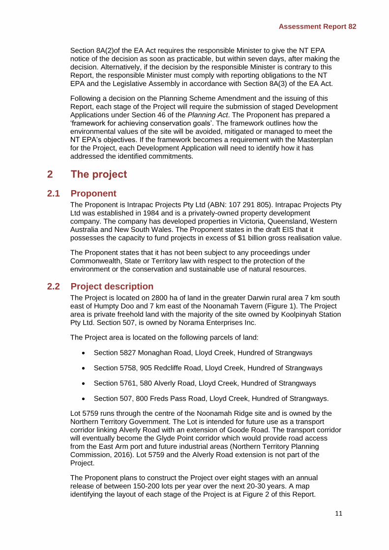
2.2 Project description The Project is located on 2800 ha of land in the greater Darwin rural area 7 km south east of Humpty Doo and 7 km east of the Noonamah Tavern (Figure 1). The Project area is private freehold land with the majority of the site owned by Koolpinyah Station Pty Ltd. Section 507, is owned by Norama Enterprises Inc.
The Project area is located on the following parcels of land:
Section 5827 Monaghan Road, Lloyd Creek, Hundred of Strangways
Section 5758, 905 Redcliffe Road, Lloyd Creek, Hundred of Strangways
Section 5761, 580 Alverly Road, Lloyd Creek, Hundred of Strangways
Section 507, 800 Freds Pass Road, Lloyd Creek, Hundred of Strangways.
Lot 5759 runs through the centre of the Noonamah Ridge site and is owned by the Northern Territory Government. The Lot is intended for future use as a transport corridor linking Alverly Road with an extension of Goode Road. The transport corridor will eventually become the Glyde Point corridor which would provide road access from the East Arm port and future industrial areas (Northern Territory Planning Commission, 2016). Lot 5759 and the Alverly Road extension is not part of the Project.
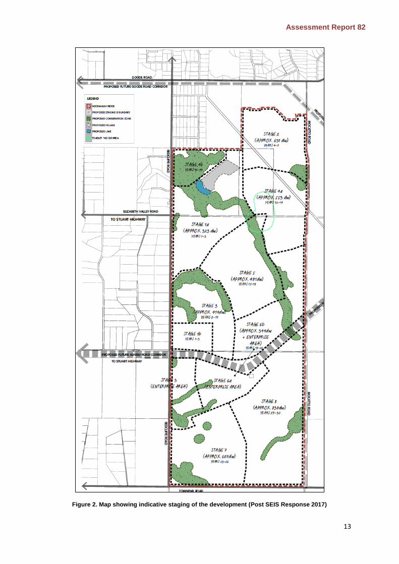
The Proponent plans to construct the Project over eight stages with an annual release of between 150-200 lots per year over the next 20-30 years. A map identifying the layout of each stage of the Project is at Figure 2 of this Report.
Assessment Report 82
12
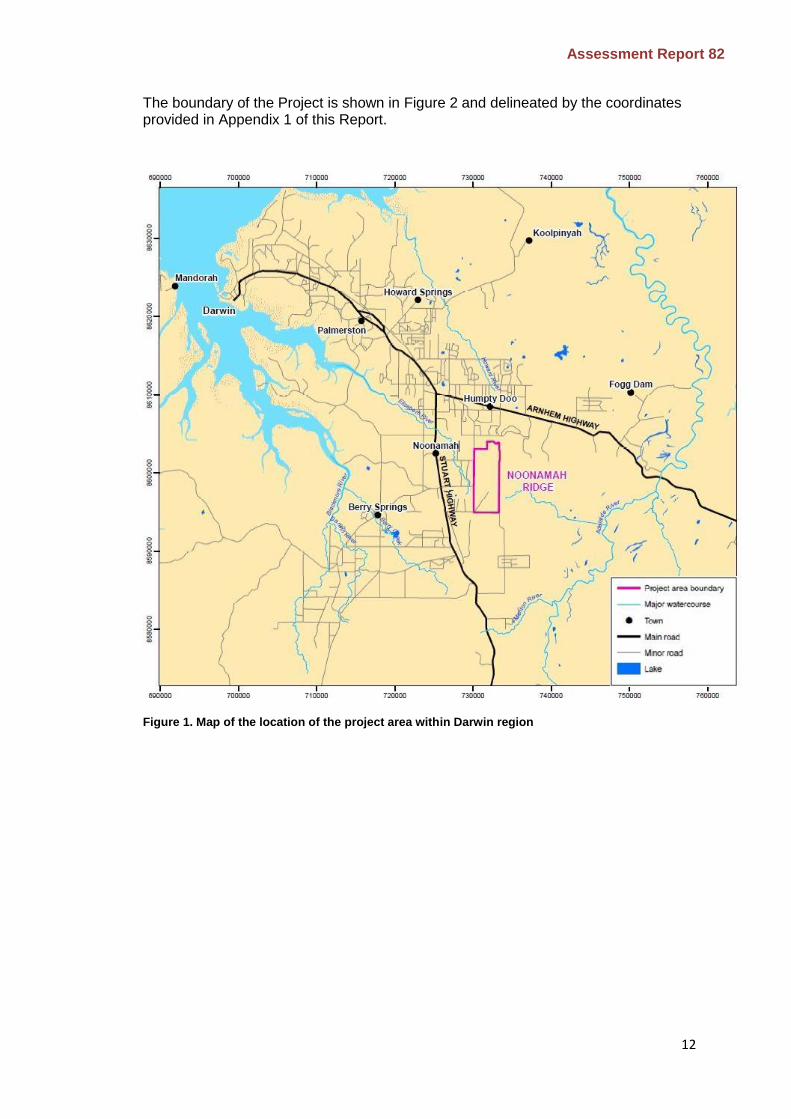
The boundary of the Project is shown in Figure 2 and delineated by the coordinates provided in Appendix 1 of this Report.
Figure 1. Map of the location of the project area within Darwin region
Assessment Report 82
13
Figure 2. Map showing indicative staging of the development (Post SEIS Response 2017)
Assessment Report 82
14
2.2.1 Residential development
The Project would be a master-planned ‘rural character’ community with a maximum of 4200 lots. It is estimated that the Project would accommodate around 11 000 people. The Project will include a range of different sized residential lots which would be zoned the following:
SD (Single Dwelling) 800 m2 3999 m2
RR (Rural Residential) or Restricted Rural Residential 4000 m2 9999 m2
RL (Rural Living) 1 ha - 7.9h a
R (Rural) >8 ha.
The smaller lots would be located around the two rural activity centres and would be configured in a way that reflects an ‘urban setting’ with a tighter network of streets/blocks with wide footpaths, aligned tree planting and buildings close to the street frontage.
Lots will be subject to a maximum building envelope. For lots greater than 2000 m2, the building envelope will be up to 25% for the purposes of constructing dwellings, outbuildings and other infrastructure. A further 15% of each lot can be cleared without a permit for the creation of formal landscaped gardens.
Development at the site would include provision of community facilities including:
primary, middle and high schools
family services hub, early childhood services and childcare centres
neighbourhood meeting rooms
multi-purpose community centres.
2.2.2 Commercial and industrial components
Two areas have been identified for commercial development in the Project area. The first area is a rural activity centre (village) which will accommodate retail, office space, health services and entertainment activities. This would be developed as part of Stage 1 of the development in the northwest portion of the site.
The second commercial area is located in the north-west portion of section 5761, Redcliffe Road, Hundred of Strangways, Lloyd Creek. The area has been identified as an enterprise district which may include the following industries:
light or general industry
transport-related industry
transport hub
science and technology-related industry.
The enterprise area is located close to land which has been set aside for a future arterial road connecting Glyde Point with the East Arm precinct. The intent of establishing an enterprise area is to establish local businesses and activities that would provide employment opportunities.
Assessment Report 82
15
2.2.3 Open space
The Project would include areas of open space which will be broken down into four broad categories:
land requiring active management because it is identified as having significant conservation values, such as land critical to the conservation of threatened species including relevant buffers (identified as a proposed conservation network)
land containing environmental values (such as along creek lines), but not requiring active management in the proposed conservation network
public open space would be provided at the rate required under the NT Planning Scheme (and where this formal/active open space does not include conservation land), and would be zoned as Public Space
land set aside for stormwater management may fall into the conservation areas, however it would not include land set aside for active management of threatened species.
Further clarification around the location and extent of the open space framework is proposed to be provided in a master plan which would be submitted with the first stage subdivision application.
2.2.4 Utilities
Roads
An indicative plan for the internal road network was provided in the EIS. The design of the road will be finalised at a future design stage. Traffic generated from the Project will require additional external road infrastructure to be upgraded or built.
The Proponent notes that road upgrades external to the Project area are the responsibility of the Northern Territory Government and have not been included in the scope of the Project or this assessment.
Electrical infrastructure
The Proponent is planning to provide power to the site through the provision of three dedicated feeders (one overhead and two underground). The requirement for the second underground feeder would be considered at a later stage of the development. It is proposed that power will be connected to the new Strangways Zone Substation which has capacity for at least two feeders. Alternative sources of electricity (solar etc.) would be investigated for servicing schools, dwellings, commercial buildings and recreational areas.
Water infrastructure
The Proponent is planning to service the first 300 lots (Stage 1) with potable water sourced from bore-fields onsite. Water extracted from the bore-field would be pumped to a holding tank and then piped to properties. Water supply for future stages of the development would be determined through ongoing investigations into the viability of the Koolpinyah Aquifer as an ongoing water supply for the development. If the Koolpinyah Aquifer is not viable as a water supply, the Proponent intends to enter into an agreement with Power and Water Corporation to connect the site to mains water.
Assessment Report 82
16
Wastewater treatment
The Proponent notes in its draft EIS that reticulated municipal sewer treatment services are not proposed for the area for the foreseeable future. The development would be serviced using Kele Effluent Wastewater Treatment System (KEWT). The KEWT system would operate under a staged wastewater treatment approach to produce Tertiary Quality (Class A) effluent. Treated effluent from the facility would be reused onsite for irrigation. The KEWT systems would service the parts of the development where the lots are relatively close together. Larger lots would have their own on-site wastewater treatment system.
Stormwater infrastructure
Stormwater infrastructure would be constructed to manage surface run-off from the site. The drainage management system would be designed to maintain pre-development flows and reduce the discharge of pollutants from the development. Infrastructure that is being considered for the development includes grassed swales, detention basins, gross pollutant traps and porous pavement. The final design and location of water management infrastructure would be determined at the detailed subdivision stage once more detailed hydrology modelling is complete.
Recreational lake
The conceptual masterplan for the Project includes a recreational lake adjacent to the first rural activity centre. The lake would be 6 ha in size and is proposed to be constructed north of the main creek in the north-west portion of the site (Figure 2).
The Proponent is proposing to cut the lake into the ground with a cut-batter on the north-eastern side of the lake. Water during the Wet season would be diverted from the main creek line through an inlet on the southern side of the lake. An outlet is proposed to be constructed which would discharge water from the lake back into the main creek. During the Dry season, the lake would need to be topped up using groundwater. The Proponent estimates that this would require 83 ML of groundwater per year. Additional water may be required if there is some water loss from the lake through soil seepage.
3 Key environmental factors Having regard to the Notice of Intent, the draft EIS and Supplement, and comments from the public and advisory bodies during the EIS review, the NT EPA identified the following key environmental factors that may be impacted by the Project:
Terrestrial flora and fauna
Hydrological processes
Inland water environmental quality
Social, economic and cultural surroundings.
The NT EPA has considered the importance of other environmental factors during the course of its assessment. Those factors that were not identified as key environmental factors are summarised at Appendix 2 of this Report.
The key environmental factors are discussed in sections 4.1 to 4.4 of this Report. The description of each factor shows why it is relevant and how it would be affected by
Assessment Report 82
17
the Project. The assessment of the factors is where the NT EPA decides whether or not the Project is likely to meet the NT EPA’s environmental objective for each factor.
The NT EPA identified the following potential environmental impacts and risks that contributed to the decision to assess the Project at the level of an EIS:
limited availability of existing services and infrastructure, particularly main roads, water and electricity supply
potential impacts to groundwater quality from septic/sewage discharge and changes to hydrology
potential for inadequate stormwater and effluent disposal strategies to create mosquito breeding sites and impact on the waterways via erosion, sedimentation and increased nutrients and pathogens
land constraints associated with areas that have a moderate to high degree of erosion vulnerability with lowland areas at risk of periodic inundation
potential impacts to areas that contain significant conservation and biodiversity values including listed threatened species
disturbance to and potential loss of individuals of species listed under the Environment Protection and Biodiversity Conservation Act 1999 and the Territory Parks and Wildlife Conservation Act
spread or introduction of weed/pest species
limited availability of public transport, waste and recycling collection and emergency services as well as the risk that poorly planned road networks will limit the ability of these services to access the site
potential impacts to historic and culturally significant sites
changes to the existing socio-economic environment and public amenity
cumulative impacts of the development in the context of existing, proposed and future developments in the Noonamah/Humpty Doo region.
Information requirements based upon identified potential environmental impacts and risks were described in the Terms of Reference for the Project (NT EPA, 2015). The Proponent submitted the EIS to address the NT EPA’s requirements.
4 Environmental impact assessment The purpose of this section is to evaluate the Project and to present the view of the NT EPA on the environmental acceptability of the Project. The environmental acceptability of this Project is based on an analysis of:
the proposed action (particularly which components or activities are likely to significantly impact the environment)
the existing environment (particularly environmental values and sensitivities)
the potential environmental impacts and risks of the Project and the evaluation of the significance of those impacts and risks
Assessment Report 82
18
proposed avoidance or minimisation/mitigation measures to reduce potential impacts and risks to acceptable levels and to meet NT EPA objectives.
Conclusions drawn and recommendations made in this Report are derived from consultation on the final EIS with advisory bodies, the NT EPA’s examination of the EIS and responses from the Proponent to comments/consultation. Recommendations are made in this Report to add, emphasise or clarify any commitments made by the Proponent, where the proposed avoidance or minimisation/mitigation measures are considered insufficient or where a safeguard is deemed particularly important.
In this Report, the recommendations (in bold) are preceded by text that identifies issues and undertakings associated with the Project. For this reason, the recommendations should not be considered or read in isolation.
The NT EPA acknowledges that the Project is still at a preliminary planning stage. This Report will inform the decision on the initial Planning Scheme Amendment, the detailed master plan and the subdivision design for each stage. It is likely that there will be minor and insubstantial changes in the Project following the conclusion of the EIA process. It will be necessary for approval mechanisms to accommodate subsequent changes to the environmental safeguards described in the final EIS and recommendations in this Report. Provided the Proponent is able to demonstrate that changes are unlikely to significantly increase potential impacts on the environment, an adequate level of environmental protection can still be achieved by modifying the conditions attached to relevant statutory approvals governing the Project. Otherwise, further environmental assessment may be required.
Recommendation 1
The Proponent shall ensure that the Noonamah Ridge Estate proposal is implemented in accordance with all environmental commitments and safeguards:
identified in the Environmental Impact Statement for the Noonamah Ridge Estate (draft Environmental Impact Statement, Supplement and additional information)
recommended in this Assessment Report 82.
The Northern Territory Environment Protection Authority considers that all safeguards and mitigation measures outlined in the Proponent’s Environmental Impact Statement are binding commitments made by the Proponent.
Recommendation 2
The Proponent shall provide written notice to the Northern Territory Environment Protection Authority and the responsible Minister if it alters the Project and/or the master plan and/or environmental commitments in such a manner that the environmental significance of the action may change, in accordance with clause 14A of the Environmental Assessment Administrative Procedures.
The remainder of this section of this Report discusses the key environmental factors and potential impacts and risks to those factors based on likely significance, and the Proponent’s investigations and studies and/or commitments to identify, avoid, mitigate, monitor and manage the potentially significant environmental impacts and
Assessment Report 82
19
risks. For each key environmental factor, the NT EPA assesses whether or not the proposal meets its environmental objective for that factor.
4.1 Terrestrial flora and fauna
4.1.1 NT EPA objective:
Protect the NT’s flora and fauna so that biological diversity and ecological integrity are maintained
4.1.2 Terrestrial flora and vegetation
Noonamah Ridge is largely undisturbed with intact vegetation communities. An area of approximately 17.7ha was disturbed previously through the construction of tracks, telecommunication infrastructure and use of the site for extractive operations. The site is relatively free of weeds.
Surveys of the site identified infestation of gamba and mission grass along access tracks and areas that have been previously disturbed. The site has medium density infestations of hyptis (10-30% cover) along some drainage lines and in the northwest and south west portions of the site. Snakeweed was identified on the site in high and medium densities within the creeks along the western side of the site.
Vegetation surveys were undertaken between April and May 2015 in accordance with the Northern Territory Guidelines and Field Methodology for Vegetation Survey (Brocklehurst, et al., 2007).
4.1.3 Significant or sensitive vegetation
4.1.3.1 Environmental values
The Darwin Regional Land Use Plan 2015 identifies the areas that are significant for concentrations of threatened species and establishes those as localities where an emphasis should be placed on the assessment of potential impacts of development. Vegetation on the site was described in the EIS in accordance with Level 4 of the National Vegetation Information System (NVIS). Ecoz (2015) identified 12 vegetation communities with three of those communities defined as ‘significant or sensitive vegetation types.
Significant or sensitive vegetation types identified on the site includes riparian vegetation types (open and rainforest) sandsheet heath and monsoon rainforest. The significant and sensitive vegetation types correspond with the following vegetation communities identified by EcOz (2015):
Sandsheet heath:
Melaleuca viridiflora +/- Grevillea pteridifolia mid high open shrubland, over Eriachne burkittii and Rhynchospora logisetis mid high tussock grassland.
Monsoon Rainforest:
Lophostemon grandifloras, Erythrophleum chlorostachys and Acacia auriculiformis mid high open forest, over Canarium australianum, Carpentaria acuminate and Clerodendrum floribundum mid high shrubland over Mnesithea rottboellioides and Cheilanthes tenuiflora mid high tussock grassland.

Assessment Report 82
20
Riparian Vegetation:
Lophostemon grandifloras, Erythrophleum chlorostachys and Acacia auriculiformis mid high open forest, over Canarium australianum, Carpentaria acuminata and Clerodendrum floribundum mid high shrubland, over Mnesithea rottboellioides and Cheilanthes tenuiflora mid high tussock grassland.
Eucalyptus alba var. australasica and Melaleuca viridiflora +/- Corymbia polycarpa mid high woodland, over Lophostemon lactifluus and Pandanus spiralis mid high shrubland over Ischaemum austral mid high tussock grassland.
4.1.3.2 Potential impacts
Construction and occupation of the site has the potential to directly impact on significant or sensitive vegetation through clearing, including for:
road corridors
service infrastructure
detention and water management basins
firebreaks and boundary fencing
building envelopes.
There is also potential for indirect impacts on vegetation through:
altered hydrology
erosion and sedimentation
dust
introduction and spread of weeds
altered fire regime
edge effects.
4.1.3.3 NT EPA assessment
Clearing of native vegetation
Development of the site would result in the direct removal of up to 1570 ha of vegetation. Most of the vegetation that would be cleared are eucalyptus dominated vegetation communities which are common across the Top End of the Northern Territory. The final extent of clearing has not been quantified and would depend on the final alignment of each stage of the Project. The final alignment of each stage may be further refined in a master plan and subdivision design process.
The clearing of vegetation on the site would be regulated under Clause 10.2(5) of the NT Planning Scheme, which sets out the land-clearing regulations for lots 2 ha and larger. For lots less than 2 ha in size, the Proponent has committed to including a new clause in its Planning Scheme Amendment which requires landholders to obtain a permit to clear native vegetation >1000 m2 (excluding the assigned building envelope).

Assessment Report 82
21
The NT EPA supports the inclusion of appropriate mechanisms to encourage the retention of native vegetation within individual lots.
Conservation of significant or sensitive vegetation
The EIS has identified significant or sensitive vegetation on the Project site. The NT EPA considers that an appropriate extent of these vegetation types require conservation and management as a component of the Project.
The Proponent recognises the value of these vegetation types, and has worked closely with the Flora and Fauna Division of the Department of Environment and Natural Resources (DENR) to identify the spatial extent of the significant or sensitive vegetation that should be protected to achieve acceptable conservation outcomes. The proposed conservation network is presented at Figure 3.
The NT EPA has considered the proposed conservation area and notes that the area includes the following vegetation types:
sandsheet heath - 15.4 ha of the 46.18 ha identified within the Project area
monsoon forest (1.89 ha)
riparian vegetation (91.83 ha)
The NT EPA notes that the Proponent’s proposed conservation area, in addition to protecting each significant or sensitive vegetation type, largely overlaps with mapped areas of high conservation value (mapped by the DENR, at Appendix 3) for other significant environmental values (threatened flora species, threatened fauna species and appropriate buffers) creating an integrated conservation network.
The NT EPA agrees that the integrated conservation network covers a specific spatial area that maximises retention of significant or sensitive vegetation and threatened species habitat, in an efficient and practical area. The NT EPA agrees that the integrated conservation network conserves an adequate spatial extent of the areas of high conservation value, including an appropriate area of each significant or sensitive vegetation type.
The Proponent has committed to proposing a future amendment to the NT Planning Scheme to rezone the agreed integrated conservation network to Zone CN (Conservation) under the NT Planning Scheme
Recommendation 3
The areas of high conservation value, (or an area that the NT EPA agrees is adequate to protect those values, such as the agreed integrated conservation network identified at Figure 3), is to be appropriately formalised in the NT Planning Scheme.
The appropriate long-term management of the agreed integrated conservation network has not been finalised. It is currently proposed that Principles of the Specific Use Zone will require preparation of a master plan for the development that establishes principles to ensure the agreed integrated conservation network will be appropriately protected from the identified impacts of the development of the project. Conditions attached to any future development permits will provide a mechanism to ensure these principles are satisfied. The Proponent has committed to a range of measures and is negotiating with a range of stakeholders (landowners, Litchfield Council and DENR) to finalise the arrangements, however in the absence of

Assessment Report 82
22
clear management actions and identification of the person(s) or entity responsible for maintaining the conservation network there is still considerable uncertainty around how effective management of the conservation network will be maintained over time, who will undertake the activities and to what standard. Until the long-term management of the conservation network is resolved, there is considerable risk that the conservation network and the associated sensitive vegetation types will be degraded over the life of the Project.

Assessment Report 82
23
Figure 3. Agreed integrated conservation network to protect the significant environmental values of the
Project area

Assessment Report 82
24
Management of significant or sensitive vegetation types
The NT EPA considers that the appropriate mechanism to address the uncertainties around the future management of the site would be to include a requirement in the initial Planning Scheme Amendment to present a framework that outlines the studies, investigations, monitoring plans, and details that are necessary to inform decisions on how the proponent will meet its commitments to design and implement the Project in a manner that maintains the environmental values protected in the agreed integrated conservation network. The management framework will establish the process for developing specific management arrangements for the agreed integrated conservation network. This would allow the resultant specific management arrangements to be presented with each future Subdivision or Development application for the Project (as required in proposed Principles for the Specific Use Zone).
The Proponent states that some essential infrastructure may need to be constructed through the agreed integrated conservation network. It is important that the management framework addresses infrastructure planning so that decisions on future infrastructure appropriately respond to environmental values protected within the conservation network by not having a direct or indirect impact on any threatened species area or significant or sensitive vegetation protected within the agreed integrated conservation network. Further, where essential infrastructure needs to cross riparian vegetation, the Proponent should demonstrate in each Development Application that the crossing site is appropriate and that the impacts to riparian vegetation have been minimised to the greatest extent practicable.
Recommendation 4
The Planning Scheme Amendment shall include a requirement to develop and implement a management framework to protect the significant environmental values on the site that describes:
a) measures to protect the identified significant environmental values on the Project site, informed by Recommendation 4 (b) below
b) the systems to ensure significant environmental values are protected, including: studies, investigations, monitoring and control systems including reporting arrangements to support adaptive management of emerging risks to significant environmental values
c) the entity accountable for implementation of systems outlined in Recommendation 4 (b)
d) the site selection criteria for each component of Project infrastructure located within and/or adjacent to the agreed integrated conservation network
e) options for appropriate funding arrangements to achieve an agreed level of environmental management over the long term, one or a number of which need to be agreed prior to implementation of the Project.
The management framework is to be prepared to the satisfaction of the NT EPA, Department of Infrastructure, Planning and Logistics, and Department of

Assessment Report 82
25
Environment and Natural Resources prior to implementation of the first Development Application.
Indirect impacts – weeds and bushfires
The arrangement of the lots would be determined in the Development Application for each stage. The Proponent suggests that some lots could be configured to include some of the conservation area under ‘split zoning’. As this configuration may make it possible for clearing to occur within the agreed integrated conservation network (such as for boundary fencing, firebreaks and/or asset protection zones) this is not supported by the NT EPA. To ensure the values associated with the conservation areas are protected, it is recommended that each stage is designed to ensure that the property boundaries and firebreaks are located outside the agreed integrated conservation network.
The Project will require considerable ground disturbance during the construction of each stage. The disturbance of the site and construction activity provides a potential vector for the introduction and spread of weeds. The significant or sensitive vegetation within the Project area are vulnerable to weed invasion, particularly gamba grass, mission grass and humidicola. Without appropriate management and control, severe infestations can form monocultures which compete with native species and increase the risk of serious fire events.
The Project would increase the potential for weed invasion by disturbing the site and facilitating propagule transport during construction and occupation. During construction activities, the contractor will be the person responsible for implementing the Weed Management Plan. The Plan will include appropriate weed hygiene measures as well as the protocols for identifying and controlling any weed incursions. Development of the Weed Management Plan should be considered in context of Recommendation 4 above.
Once the site has been constructed and occupied, the responsibility for the ongoing management of weeds will become the responsibility of individual landholders under the Weeds Management Act.
Bushfires are an annual occurrence in the Top End of the Northern Territory and the increased frequency and/or intensity is linked to a reduction in the diversity and changes to the structure of vegetation communities. To address the potential impacts from bushfires on sensitive vegetation, the Proponent has committed to preparing a Bushfire Management Plan which will set out the fire control procedures and responsibilities for the site. Development of the Bushfire Management Plan should be considered in context of Recommendation 4 above.
4.1.3.4 NT EPA conclusion
The Proponent, in consultation with DENR, has identified an agreed integrated conservation network that is considered to be sufficient to protect three significant or sensitive vegetation types present on the Project site. Principles of the Specific Use Zone will require each Development Application submitted under the Planning Act to demonstrate how the agreed integrated conservation network will be appropriately protected from the identified impacts of the development of the project. The Proponent proposes to zone the agreed integrated conservation network as Conservation under the NT Planning Scheme when the lots are normalised.
The management framework outlined in Recommendation 4 of this Report would outline the process for making decisions regarding the siting and design of service infrastructure and the ongoing management arrangements for the agreed integrated
Assessment Report 82
26
conservation network. The framework is to be prepared by the Proponent to inform the Planning Scheme Amendment. The resultant management arrangements would be submitted with each Development Application, consistent with the Principles for the Specific Use Zone.
4.1.4 Typhonium praetermissum
4.1.4.1 Environmental values
Typhonium praetermissum is listed as vulnerable under the Territory Parks and Wildlife Conservation Act. Surveys identified 183 (revised from 193 due to the incorrect identification of 10 plants) individual plants across the Noonamah Ridge site between 2014-15. An assessment of the species against the IUCN Criteria for subpopulations found that the site contained two distinct subpopulations (‘Noonamah north’ and ‘Noonamah south’).
4.1.4.2 Potential impacts
Construction and occupation of the site has the potential to result in the following impacts to T. praetermissum:
clearing of habitat/individual T. praetermissum
competition from invasive flora
degradation of habitat through intense fires
degradation of habitat as a result of inappropriate development of adjacent land
4.1.4.3 NT EPA assessment
The Proponent has committed to conserving 120 of the 183 known T. praetermissum within the agreed integrated conservation network. The agreed integrated conservation network was mapped in consultation with the Flora and Fauna Division of the DENR. The agreed integrated conservation network includes the largest patches of T. praetermissum and incorporates a minimum 100 m buffer around each plant.
The total area of T. praetermissum habitat that is proposed to be conserved within the agreed integrated conservation network area is 72 ha of land units 2a1 and 3c. Where T. praetermissum occurs outside of the agreed integrated conservation network, the Proponent may retain the occurrence in-situ. The NT EPA notes that the translocation of T. praetermissum has no demonstrated benefit to the conservation of the species and should not be considered a ‘mitigation measure’.
The Proponent has committed to managing the indirect impacts associated with weeds and fire through long-term management plans which will be developed in consultation with the DENR. To ensure the ongoing management of the remnant T. praetermissum patches, the NT EPA considers it appropriate that the ongoing management arrangements are presented for each stage of the development, including the ongoing management, funding and monitoring arrangements for this species, in accordance with the provisions of Recommendation 4.
4.1.4.4 NT EPA conclusion
The NT EPA considers that the inclusion of 120 T. praetermissum within the agreed integrated conservation network is reasonable. Further, the inclusion of a 100 m minimum buffer around each patch of T. praetermissum within the agreed integrated
Assessment Report 82
27
conservation network would provide some protection from indirect impacts, particularly anthropogenic disturbance, weeds and fire.
The ongoing management of the agreed integrated conservation network would be achieved by identifying specific management arrangements in accordance with the agreed management framework identified in Recommendation 4.
4.1.5 Cleome insolata (yellow spiderflower)
4.1.5.1 Environmental values
Surveys of the site located 247 C. insolata within and immediately adjacent to the Project area were conducted. The largest patch (207 plants) occurs within the sandsheet heath in the north-west portion of the site. Two smaller patches were identified outside the Project area but within the Redcliffe Road corridor. The patches outside the Project area are not considered further in this assessment.
4.1.5.2 Potential impacts
Construction and occupation of the site has the potential to result in the following impacts to C. insolata:
clearing of habitat and/or individual plants
changes to the hydrology of C. insolata habitat
indirect impacts associated with changes to the fire regime, invasive flora/fauna
degradation of habitat as a result of inappropriate development of adjacent land.
4.1.5.3 NT EPA assessment
The Proponent proposes to avoid the direct impacts of the Project on C. insolata through the inclusion of all occurrences within the agreed integrated conservation network at Figure 3.
The Proponent has identified an option to construct a recreational lake approximately 50 m from the southern boundary of the C. insolata patch in Stage 1 of the Project. The lake has the potential to significantly alter the local hydrology by capturing surface run-off and potentially altering sub-surface flows through seepage into soils. The extent of any changes to the local hydrology, as a result of the construction of a lake is unknown.
The location of habitat for C. insolata (in sandsheet heath) indicates that the species is likely to have specific hydrological requirements. However, such hydrological requirements are largely unknown.
The Proponent has committed to undertaking further investigations and studies to better understand the hydrology of sandsheet heath. The scope and purpose of the further investigations has not yet been fully defined, but it appears that the outcomes of the hydrological investigations would be completed to inform Stage 4B of the Project. Given the potential for the construction of a lake in Stage 1 to impact on the habitat requirements of C. insolata, it is recommended that the investigations about the hydrological requirements of C. insolata be completed to inform the design of the lake (and any other nearby infrastructure) that has the potential to impact on the species. The investigation should be considered a component of the framework outlined in Recommendation 4.

Assessment Report 82
28
Recommendation 5
The Proponent shall define and fund an investigation to understand the pre-development hydrology of the sandsheet heath associated with supporting C. insolata. The investigation should be designed in a manner that would inform the Development Consent Authority of the risks and potential impacts of siting a lake near the heath habitat.
The potential indirect impacts relating to weeds and fire would be managed through the development and implementation of management arrangements in accordance with Recommendation 4 for the agreed integrated conservation network.
4.1.5.4 NT EPA conclusion
The Proponent has suitably avoided the direct impacts on C. insolata associated with clearing through the inclusion of relevant areas within the agreed integrated conservation network.
The uncertainty of potential impacts and risks associated with the development of a proposed recreational lake in close proximity to the known habitat for the species requires additional investigation.
Ongoing risks associated with indirect impacts (weeds, fire) will need to be finalised by the development of suitable ongoing management arrangements for the agreed integrated conservation network, to the satisfaction of the DENR, before each Development Application is approved.
4.1.6 Cycas armstrongii
4.1.6.1 Environmental values
The site contains ~2677 ha of suitable habitat for C. armstrongii with an estimated 789 500 individual plants occurring on the site. Much of the site (2223.06 ha) contains low-medium density habitat (200-400 cycads per hectare). Two areas (~63.11 ha) were mapped as having high densities (>400 cycads per hectare) of C. armstrongii.
4.1.6.2 Potential impacts
Construction and occupation of the site has the potential to result in the following impacts to C. armstrongii:
clearing of habitat and loss of individual plants
changes to fire regime
invasive species.
4.1.6.3 NT EPA assessment
The Proponent has not identified specific mitigation measures for C. armstrongii. However, some C. armstrongii are likely to occur within agreed integrated conservation network. Furthermore, the retention of vegetation within individual lots is likely to reduce the loss of individual plants across the site. Additional management plans (fire and invasive weeds) will further reduce the threats to the species onsite.
4.1.6.4 NT EPA conclusion
The NT EPA considers that the impacts to the population of C. armstrongii at Noonamah Ridge will not affect the regional population to the extent that the species

Assessment Report 82
29
will be eligible for listing as either endangered or critically endangered species (under the IUCN Criteria and Categories - Version 3.1).
While the Project will contribute to the ongoing loss of habitat and decline of the species, the NT EPA notes that the commitment to minimise the overall loss of cycads from the development site through the retention of native vegetation in larger lots and in open space networks is generally consistent with the ‘principles’ outlined in the Management Program for the species (Liddle, 2009). The NT EPA is satisfied that the environmental objective in relation to potential impacts and risks to C. armstrongii is likely to be met.
4.1.7 Threatened fauna
4.1.7.1 Introduction
Fauna surveys were undertaken between October 2015 and March 2015 and provided as an appendix (Appendix I) to the draft EIS. The surveys and vegetation mapping were generally consistent with the Guidelines for Assessment of Impacts on Terrestrial Biodiversity (Version 2.0). The NT EPA considers that there is sufficient information provided in the EIS to adequately assess the impacts of the development on biodiversity and threatened fauna species.
An assessment of the species habitat requirements suggest that the following species are likely to occur on the site and could be impacted by the Project:
Howard River toadlet (Uperoleia daviesae)
Partridge pigeon (Geophaps smithii)
Black-footed tree rat (Mesembriomys gouldii).
4.1.8 Howard River toadlet (Uperoleia daviesae)
4.1.8.1 Environmental values
The vulnerable Howard River toadlet (Uperoleia daviesae) is a small myobatrachid frog which is endemic to the Top End region and is restricted to sand sheet heathland within the Howard River and the Elizabeth River catchments (Anstis, 2013).
U. daviesae was found at nine locations within the site with a further 14 incidental records along the western boundary of the Project area. Two of the locations (Populations 1 and 2) are considered to be the largest known sub-populations. A third site (Population 3), situated along the western boundary of the site provides a breeding site for a smaller sub-population (Figure 3).
4.1.8.2 Potential impacts
Construction and occupation of the site has the potential to result in the following impacts to U. daviesae:
clearing and degradation of calling, breeding and Dry season habitat for U. daviesae
mortality of U. daviesae where infrastructure crosses Dry season habitat
changes to the hydrology of the sandsheet heath may impact the triggers and duration of annual breeding activity as well as potentially increasing the level of mortality for eggs and tadpoles
Assessment Report 82
30
indirect impacts on suitable habitat associated with fire, weeds and disturbance.
4.1.8.3 NT EPA assessment
The habitat preferences of U. daviesae are largely unknown except that it is known to breed during the Wet season in seasonally inundated sandsheet heath. The unknowns about the species ecology and habitat requirements make assessing the potential impacts of the Project difficult.
Surveys identified the ‘calling habitat’ for Population 1 which is associated with the sandsheet heath in the north-west part of the site. The ‘calling habitat’ was defined by Ecoz (2015) as the area that U. daviesae were actively calling from during targeted surveys. The calling habitat for Population 1 has been protected within the agreed integrated conservation network.
The calling habitat for Populations 2 and 3 have been inferred based on the available habitat. The inferred calling habitat for Population 2 has been identified as a ‘no-go area’ pending the results of a study investigating the Dry season habitat use and dispersal of the species away from the calling habitats.
The results of the study will be used to determine the extent of habitat used by U. daviesae during the Dry season and incorporate that habitat into the agreed integrated conservation network. It is noted that the results of the study may require the existing protected area for Population 1 to be increased to accommodate the required Dry season habitat.
The Proponent proposes that the study of the habitat requirements of U. daviesae would investigate and define:
the pre-development hydrology of the sandsheet heath and the seasonally inundated habitat used by Population 2
a hydrological model of the two areas (Populations 1 and 2) to inform whether components of the Project can be constructed without altering the hydrology of the habitat
the dispersal of U. daviesae when not calling/breeding, and Dry season habitat requirements
the extent (if any) that the agreed integrated conservation network requires amendment to incorporate Dry season habitat of U. daviesae.
The Proponent proposes to commence the studies within the first two Wet seasons after a decision has been made on the Planning Scheme Amendment. Given the significance of the U. daviesae population, it is important that the dispersal and hydrology studies are robust and accurately reflect the ecological requirements of the species. The results of the studies would identify significant areas of habitat which need protection as well as inform the management arrangements that need to be developed in accordance with the framework required in Recommendation 4. The studies would inform further development/identification of management measures in the relevant management framework.
The Proponent has committed to retaining the pre-development hydrology for the sandsheet heath and breeding habitat for ‘Population 2’. As the construction of services and infrastructure has the potential to change the hydrology, it will be important that planning for the location of infrastructure takes the outcomes of the
Assessment Report 82
31
hydrology study into account. The investigation and details around how the hydrological requirements of the habitat would be retained should be included in the framework outlined in Recommendation 4.
Recommendation 6
The objectives, scope, timing and design of the study to identify the Dry season dispersal and habitat use by the Howard River toadlet (U. daviesae) should be identified in the management framework outlined in Recommendation 4. The study should be adequate to justify the use of adjacent land so that unacceptable impacts to hydrology and U. daviesae are avoided.
Recommendation 7
Outcomes of the study of U. daviesae Dry season habitat and hydrology requirements of seasonally inundated habitat are to inform the boundaries of the agreed integrated conservation network. Revision of the conservation network should incorporate the Dry season habitat for U. daviesae and be sufficient to maintain the surface/sub-surface hydrology of breeding habitat.
There is little information about other threats to U. daviesae, however it is likely that weeds would alter the habitat species composition and microhabitat of the breeding habitat for the species. The ongoing management arrangements of the agreed integrated conservation network to reduce ongoing threats to the species would need to be developed in accordance with the framework outlined in Recommendation 4 of this Report. The management actions should include specific requirements for the funding and person(s) or entity responsible for the long-term management of threats to U. daviesae.
The Proponent has not identified specific measures for maintaining the hydrology or amending the agreed integrated conservation network around Population 3. The NT EPA considers this to be a smaller and less significant breeding site for U. daviesae. The NT EPA considers that formal protection of Population 3 is not required at this time, due to the late stage of development in the vicinity of that population. Further, the outcomes of investigations and monitoring of Populations 1 and 2 will inform whether the agreed integrated conservation network sufficiently protects the species.
4.1.8.4 NT EPA conclusion
The NT EPA acknowledges that there are knowledge gaps with respect to the ecology and habitat requirements of U. daveisae. The Proponent has been proactive in identifying the knowledge gaps and has proposed two studies which will inform the detailed design of the relevant stages.
There are still substantial uncertainties around the ongoing management arrangements for the agreed integrated conservation network. The requirement to submit a Management Framework (Recommendation 4) will ensure that the management actions, funding and person(s) or entity responsible have been agreed prior to the submission of the relevant Development Application.
The NT EPA considers that the avoidance of important habitat for U. daviesae as well as the implementation of ongoing management of habitat for the species is likely to meet the NT EPA’s environmental objective for this factor.
Assessment Report 82
32
4.1.9 Black-footed tree rat (Mesembriomys gouldii)
4.1.9.1 Environmental values
Suitable habitat for the vulnerable black-footed tree-rat (Mesembriomys gouldii) occurs through much of the Noonamah Ridge site with areas of suitable foraging habitat identified along the creeks and associated riparian habitat. Habitat in the north-west portion of the site is contiguous with tributaries of the Elizabeth River where M. gouldii have been recorded recently.
4.1.9.2 Potential impacts
Construction and occupation of the site has the potential to result in the following impacts to M. gouldii:
clearing of suitable habitat for M. gouldii is likely to reduce the occupancy of the site
introduction and spread of invasive weeds is likely to degrade suitable habitat and alter the fire regime (intensity and duration)
increased mortality associated with road-strike.
4.1.9.3 NT EPA assessment
The riparian habitat within Noonamah Ridge is linked to other areas of riparian habitat to the west and north-west of the site where black-footed tree-rats have been found previously. The agreed integrated conservation network identified in the EIS will include and protect some of the areas, including riparian vegetation associated with stream order 2 and some stream order 1 watercourses.
The assessment of the potential impacts to the species assumed that the species is restricted to riparian vegetation which is not necessarily correct. M. gouldii uses these areas for denning and foraging habitat, however suitable habitat for the species includes Eucalyptus woodland which occurs across much of the site.
While the Project will require some clearing of suitable habitat for M. gouldii, the land clearing restrictions under the NT Planning Scheme (Clause 10.2(5)) limit clearing on lots zoned Rural, Rural Living and Rural Residential to one hectare unless consent has been provided. For lots less than 2 ha, the Proponent is also proposing to introduce a new clause to the NT Planning Scheme requiring landholders to seek consent to clear more than 1 000 m2 of native vegetation (excluding the building envelope).
The change in land use to residential will reduce the frequency and intensity of fires through the requirement for asset protection zones on individual lots. A reduction in the fire frequency in the area may favour M. gouldii. This has been observed in other parts of the Darwin rural area particularly from heterogeneous habitats with few fire events (Price, et al., 2005).
It is acknowledged that there is likely to be mortality of M. gouldii associated with attacks from domestic pets and road-strike. These impacts are likely to be incidental and largely unavoidable. It should be noted that sub-populations of M. gouldii still persist in some Darwin suburbs and in the greater Darwin rural area despite these threats.
The ongoing management of the agreed integrated conservation network will need to be resolved through the development and implementation of the Management Framework identified in Recommendation 4.

Assessment Report 82
33
4.1.9.4 NT EPA conclusion
Suitable foraging and denning habitat for the species was identified as being the riparian vegetation along the main watercourses of the site. The Proponent has committed to protecting these areas from clearing by including them within the agreed integrated conservation network. The ongoing management of these areas would be resolved before the approval of each Development Application.
Fire frequency and intensity is likely to be reduced across the Project area through early Dry season burning, the network of roads, residential areas as well as the requirements for asset protection zones around each rural lots. The reduced fire risk has the potential to improve the habitat within the site for the species.
The NT EPA considers that the protection of M. gouldii habitat within the agreed integrated conservation network is likely to meet the NT EPA’s environmental objective for this factor.
4.1.10 Partridge pigeon (Geophaps smithii)
4.1.10.1 Environmental values
Targeted surveys for the partridge pigeon were undertaken by the Proponent using a mixture of transects and camera trapping. The targeted survey for the species as outlined in the Flora and Fauna Report did not meet the Australian Government’s minimum standard for surveying for the species in an area over 20 ha in size (DEWHA, 2010). Despite the inadequate survey effort, the species was recorded on seven occasions (six incidental and one camera trap record). All sightings of the species were of pairs with all but one sighting being made along established tracks.
4.1.10.2 Potential impacts
The Project has the potential to directly and indirectly impact approximately 2040 ha of partridge pigeon habitat across the site due to:
clearing of vegetation
changes to fire regimes
introduction and spread of invasive fauna/flora.
4.1.10.3 NT EPA assessment
The Project area provides suitable habitat for G. smithii, however the importance of the site and density of the species is unknown. A regional assessment of the species suggests that G. smithii from the site are part of the larger Berry Springs/Litchfield sub-population which is significant from a national perspective.
The Proponent has predicted that ~2040 ha of the site will no longer be suitable for G. smithii once the Project has been constructed. This is due to the removal of habitat through land clearing, weeds and changes to the fire regime. The Proponent has assessed the risks to the species and concludes that G. smithii is unlikely to persist on the site once the Project has been constructed.
The NT EPA notes that a number of the mitigation/management measures proposed may favour the species and make degraded habitat more favourable. In particular, the adoption of early Dry season burning and the inclusion of asset protection zones will reduce the frequency of burning. Provided the burning regime is suitable, there may be an increase in foraging habitat and a reduction in fire related mortality.

Assessment Report 82
34
While weeds are not currently a threat to the species on the site, the Project will introduce new vectors for introducing and spreading invasive pasture grasses. These grasses compete with native seed species which are preferred by G. smithii. Furthermore, invasive pasture grasses can produce high fuel loads resulting in more intense bushfire events. These bushfire events alter the vegetation composition and are a source of mortality for G. smithii. The Proposed weed management measures have been described in detail in Chapter 4.1.3.3 of this Report.
The NT EPA does not necessarily agree with the Proponent’s assertion that the species will no longer persist within the Project area. Recent observations of G. smithii from the Berry Springs/Darwin River region suggest that the species does persist in a rural residential environment. The proposed combination of weed control and bushfire management over the life of the Project may improve the quality of the remaining habitat for G. smithii.
4.1.10.4 NT EPA conclusion
The NT EPA acknowledges that suitable habitat for the species will be cleared over the life of the Project. Despite this, the land clearing restrictions proposed to be included in the Specific Use Zone will limit clearing within lots over 2 ha in size.
The NT EPA acknowledges that there would be initial impacts to this species. The ongoing requirements for weed and bushfire management are likely to reduce the level of threat to the species and potentially improve habitat quality in undisturbed habitat. The NT EPA considers that the objective for this factor is likely to be met.
4.2 Hydrological processes
4.2.1 NT EPA objective
To maintain the hydrological regimes of groundwater and surface water so that environmental values are protected.
4.2.2 Surface hydrology
4.2.2.1 Environmental values
The Project area straddles the catchment boundary for the Elizabeth River and the Adelaide River. Most of the site is within the Elizabeth River catchment (~63%) with the site containing a significant proportion (22%) of the Elizabeth River catchment upstream of the Stuart Highway.
The water courses on the site are ephemeral first and second order streams and are heavily influenced by rainfall events during the Wet season. During the Dry season, water courses within the Project area are largely dry except for the occasional pool.
The Project contains areas that are seasonally inundated during the Wet season and early Dry season from surface and sub-surface flows. These flows provide habitat requirements for significant or sensitive vegetation types and for two threatened species.
4.2.2.2 Potential impacts
Surface hydrology of the site is likely to change as a result of the clearance of 1570 ha of vegetation and the construction of 880 ha of impervious surfaces (bitumen, concrete, rooftops etc.). The removal of vegetation and construction of impervious surfaces will facilitate surface runoff and reduce infiltration of water into the soils. Changes to surface hydrology have the potential to increase the risk of flooding, erosion and scouring watercourses.

Assessment Report 82
35
4.2.2.3 NT EPA assessment
The Proponent has committed to designing each stage of the Project so that it maintains the pre-development hydrology and does not increase the flooding of adjacent areas offsite.
To meet this commitment, the Proponent is proposing to construct Water Sensitive Urban Design (WSUD) infrastructure and sediment detention basins along the main drainage lines.
The Proponent has provided preliminary estimates of the hydrology of the site in its EIS and acknowledged that detailed hydrological modelling informed by monitoring data from stations along the major watercourses would inform the type, design and placement of stormwater infrastructure for each stage. Decisions about the design and location of WSUD infrastructure must be made in accordance with the framework described in Recommendation 4 to ensure that the values of the agreed integrated conservation zone and hydrology of those areas are retained as close to pre-development as possible.
The Proponent has committed to preparing a Water Management Plan to manage the hydrology of each stage of the Project. The development of the Water Management Plan should be considered in context of Recommendation 4 of this Report. In addition, the Water Management Plan should include provisions for feedback on the performance of the WSUD measures/detention basins. This feedback would contribute to better informing the design of WSUD and stormwater infrastructure for later stages.
The potential impacts of changing the hydrology of the site have not been discussed in detail in the EIS with the main focus being on the Proponent’s commitment to maintain pre-development hydrology and the mitigation of flood events. The capture of peak flows within the detention basins will remove the flushing flows which are an important part of the hydrology for maintaining riverine processes. The NT EPA acknowledges that the capture of the peak flows needs to occur to address the risks of flooding and that the changes to riverine processes are largely unavoidable. Changes to the hydrograph of streams in the Project area and removal of peak flow events (flushing flows) will alter the physical attributes of the stream. In particular, flushing flows are important for removing fine sediment, detritus and periphyton growth. The NT EPA considers that these impacts are unavoidable once the Project has been constructed with the detention basins installed.
4.2.2.4 NT EPA conclusion
The NT EPA considers that the Project would change the pre-development hydrology with respect to the hydrograph and rate that flows are discharged. This is likely to be unavoidable given the significant increase in runoff that is expected from the Project. The proposed stormwater management measures will contain peak flow events and allow significant amounts of water to be discharged at a slower rate.
The NT EPA acknowledges that some WSUD infrastructure would potentially be constructed within the agreed conservation network. Decisions about the design and location of such infrastructure must be made in accordance with the framework identified in Recommendation 4.
Provided the stormwater infrastructure operates as intended and manages peak flows, the NT EPA considers that the Project is likely to meet the environmental objective for Hydrological Processes.

Assessment Report 82
36
4.2.3 Groundwater hydrology
4.2.3.1 Environmental values
The major geological feature of this site which influences groundwater is the Noonamah fault. The Noonamah fault runs north-west through the site and is associated with fractured quartzite ridges (Acacia Gap Quartzite). Drilling was undertaken as part of a groundwater sustainability study targeted at understanding the groundwater pathways across the site.
The study found that there are at least three types of aquifer underlying the site. The first aquifer is dolomitic and consists of a porous, high yielding sandstone aquifer adjacent to the major fault zone. This aquifer appears to be relatively limited in area. North and south of the Noonamah fault zone aquifers occur in fractured fresh and weathered shales and siltstones associated with the Acacia Gap Quartzite and the phyllitic interbeds.
4.2.3.2 Potential impacts
The Project has the potential to impact the hydrology of groundwater on the site through extraction and changes to local recharge.
4.2.3.3 NT EPA assessment
The Proponent proposes to service 300 lots in Stage 1 by establishing a bore-field within the Project area. Water from the bore-field would be extracted and pumped to a holding tank for piping to individual properties. A further 100 lots in Stage 1 would not be connected to the holding tank due to lot size or location and subsequently would have their own, or share adjoining bores in the event that there is insufficient groundwater.
The Proponent has applied for a Water Extraction Licence under the Water Act to take 571 ML/annum of groundwater from the Wildman Siltstone Formation for the purposes of supplying Stage 1. In the Northern Territory, the issuing of a Water Extraction Licence is by the Controller of Water Resources.
In deciding whether to grant a Water Extraction Licence, the Controller of Water Resources will consider the Northern Territory Water Allocation Planning Framework. This framework sets out a precautionary threshold for annual extraction based on the area in question and knowledge about the aquifer.
The Project overlies several groundwater management zones with the majority of overlying the Mount Partridge resource (upper Elizabeth River zone). This management zone is estimated to be 35% utilised with an estimated sustainable yield of 1236 ML/year. The existing annual use is estimated to be 438 ML/year. The DENR advises that provided water use for stage 1 is restricted to 1.4 ML/block/year, then the resource would have the capacity to supply the stage. The DENR notes that a full hydrogeological study would still be required to confirm the groundwater resource(s) for the Project. This information would inform the Water Controller’s consideration of any current or future Water Extraction Licence application. The Proponent has committed to a thorough groundwater investigation to inform sustainable yields of groundwater extraction.
The source of potable water for future stages of the Project has not yet been confirmed. The Proponent acknowledges that there is likely to be insufficient groundwater available within the Project area to service the entire development and that additional sources would need to be identified for later stages. The identification of sufficient water to service future stages has the potential to limit the rate and scale
Assessment Report 82
37
of future growth of the Project, and the delivery of social and economic benefits of the Project.
The location of the recreational lake was clarified by the Proponent in its response to further information in August 2017. The response noted that the operation of the lake would be filled using Wet season flows diverted from a nearby creek. During the Dry season, high rates of evaporation would require ‘topping up’ using groundwater. The Proponent estimates that the annual extraction volume for topping up the lake over a 12-month period would be 83 ML. This value does not consider the effects of water loss through soil seepage or additional flows entering the lake from surface run-off.
The Proponent has acknowledged that more detailed investigations need to be completed for the detailed design process. The NT EPA recommends that the investigations are designed and implemented in a manner which informs the management framework in Recommendation 4 of this Report. The study should consider the proposed location of the lake in relation to the agreed integrated conservation network and validate its appropriateness through a detailed environmental and economic cost-benefit analysis. The cost-benefit analysis should fully consider the use of a significant component of the groundwater allocation for stage 1.
4.2.3.4 NT EPA conclusion
The NT EPA is satisfied that the potential impacts and risks to groundwater and groundwater dependent ecosystems from Stage 1 can be managed through the implementation of the Northern Territory Water Allocation Planning Framework and the requirement for a water extraction licence under the Water Act.
The NT EPA notes that the approval of subsequent stages of the project will be dependent on demonstration of the sustainable availability of potable water to service the development.
The NT EPA has formed the view that its objective for Hydrological Process is therefore likely to be met.
4.3 Inland water environmental quality
4.3.1 NT EPA objective
To maintain the quality of groundwater and surface water so that environmental values including ecological health, land uses, and the welfare and amenity of people are protected.
4.3.1.1 Environmental values
The Project area is located at the headwaters of the Elizabeth River, which contributes significant flows to the Darwin Harbour Site of Conservation Significance.
Water quality sampling was undertaken at six sites over the 2014-2015 Wet season. The results found that water quality leaving the Project area was described as being generally very good with samples varying little from reference sites. The waterways on the site generally have low turbidity as well as low concentrations of suspended solids, dissolved ions and heavy metals. Concentrations of nutrients were found to be slightly elevated at some sampling sites.
Macroinvertebrate surveys were undertaken at three locations in accordance with the AUSRIVAS protocols for the Darwin/Daly region (Lamche, 2007). The results suggest that two of the sites were similar to the reference site. A third site was consistent with
Assessment Report 82
38
a ‘significantly impaired’ waterway. This result from the third sampling site was assumed to be due to poor habitat availability at the sampling site and/or the recent hydrological conditions at that location.
4.3.1.2 Potential impacts
The development of the Project has the potential to impact on the quality and quantity of water draining off the site and into the Elizabeth River. Increasing the density of human populations increases the risk that activities (such as effluent disposal, pollutants spills, fertiliser application and construction of drainage systems) will impact on the values associated with inland water environmental quality.
Residential developments have the potential to increase the concentration and pollutant loadings of gross pollutants, nutrients and sediment in receiving waters. Concentrated loads of pollutants in stormwater have the potential to have significant adverse impacts on receiving waters. Sources of water quality pollutants that must be appropriately managed include:
sediment loading from surface erosion and construction sites
nutrient from organic matter, fertilisers, sewage and detergents
toxic organics such as pesticides, herbicides
heavy metals from corrosion of buildings/fittings, transport and industrial activities/accidental spills
surfactants from households, asphalt pavements, car washing, vehicle leakages
water temperature increases from run-off from impervious surfaces and the removal of riparian vegetation
spillage and illegal discharges to water ways and catchments.
4.3.1.3 NT EPA assessment
The NT EPA recognises that management of water quality on the site will benefit downstream systems, including the Elizabeth River and potentially Darwin Harbour. Given this, it is important that details of the management of stormwater and industrial waste waters are considered early in the planning stage of any future subdivision.
The NT EPA expects that through all stages of the development, there will be clear differentiation between stormwater and industrial waste water as distinct waste streams requiring different management approaches and headworks. Stormwater is to be prevented, as far as possible, from entraining any contaminants before it flows to the natural environment. Contaminated or industrial waste water however, should be managed through:
capture and recycling
capture and removal by an appropriately licensed collector/transporter, or
discharge of contaminated wastes to the sewerage system under a trade waste agreement with the sewerage provider.

Assessment Report 82
39
The Proponent has committed to ensuring that the Project does not significantly change the pre-development surface water quality being discharged from the site. To meet this objective, the Project will include a range of WSUD and stormwater detention basins which will receive flows and potentially capture any contaminants, nutrients and pollutants that have inadvertently become entrained in stormwater or overland flows. Furthermore, the Proponent has committed to protecting ~91.83 ha of riparian vegetation within the agreed integrated conservation network. The inclusion of the riparian vegetation will provide ecosystem services to filter contaminants, nutrients and pollutants from entering watercourses and being discharged from the site.
To monitor the success of the mitigation and management measures, the Proponent will monitor water quality at six monitoring sites (one control, five treatment sites). The water quality data would be collected prior to any construction occurring and will be compared to site-specific trigger values which have been determined using baseline data collected over a 24-month period in accordance with the ANZECC Guidelines for 95% species protection. The Proponent proposes to monitor water quality on an annual basis during the late Wet season recessional flow period in accordance with the Stormwater Monitoring Plan.
The NT EPA considers that investing in the design and implementation of appropriate headworks and avoidance measures in accordance with the framework identified in Recommendation 4 will be critical to achieving an acceptable development. The implementation of a water quality monitoring plan will confirm if the avoidance/mitigation measures are adequate to maintain the pre-development water quality. In the event of a water quality exceedance, the inclusion of follow up investigation and contingency measures into the Water Quality Monitoring Plan would ensure that the Proponent is meeting its commitment over the life of the Project. The Water Quality Monitoring Plan should be prepared to address the requirements identified in Recommendation 4.
While the NT EPA supports the Proponent’s commitment to maintain the pre-development water quality, it considers that this needs to be demonstrated through designing and delivering appropriate infrastructure as the Proponent will not have ongoing control of activities occurring within individual lots. The results of the water quality monitoring plan should inform the design of subsequent stages of the Project for maintaining or improving the quality of stormwater from the site.
Recommendation 8
In accordance with Recommendation 4, the Proponent shall design and implement a Water Quality Monitoring Plan. The Water Quality Monitoring Plan shall include provisions to monitor the performance of WSUD and stormwater basins during the first stages of the Project. The results of the monitoring shall be used to inform the design of subsequent stages to improve the management of stormwater and improve the quality of run-off from the site.
The NT EPA has identified an increased risk of erosion where the gradient of the Project site exceeds 5%. The Proponent will need to develop a best practice Erosion and Sediment Control Plan (ESCP) and works will require significant engineering with a high level of on-going land management. Where possible, areas at very high risk of erosion should be protected from disturbance. For land with a gradient of 0.75-5%, the NT EPA considers that disturbance will be acceptable with the implementation of a best practice ESCP.
Assessment Report 82
40
The land suitability assessment for the Project area identified ~1754 ha of the site has a gradient of between 0.75-5% and is considered to be a moderate to high risk of having erosion/sediment control issues. Approximately 259 ha is considered to be a very high erosion risk with a gradient of >5%. Erosion and sedimentation from soils that have been mobilised from the site can significantly degrade the quality of receiving waters.
To manage the risks and potential impacts associated with the soil mobilisation and deposition into watercourses, the Proponent has committed to preparing stage specific ESCPs as part of the Environmental Management Plan for each stage of the development. Each ESCP will be prepared with reference to the IECA Guideline (IECA, 2008) and will be provided to the consent authority for review and comment. The endorsed ESCP will be submitted to the consent authority with each subdivision application. The construction contractor will be responsible for implementing the ESCP during construction activities.
Recommendation 9
The Proponent shall prepare and implement an Erosion and Sediment Control Plan (ESCP) for each stage of the Project. Each ESCP should:
be prepared by a suitably qualified and experienced professional in erosion and sediment control planning; and be reviewed and approved by a Certified Professional in Erosion and Sediment Control
be prepared in accordance with the IECA Best Practice Erosion and Sediment Control Guidelines 2008, as amended from time to time (or higher standard)
be the final environmental management plan to be prepared (as it relies on completion of final design) and be a stand-alone document which contains all necessary information to facilitate its implementation without requiring the user to reference other documents
be cross-referenced with other relevant environmental management plans to ensure consistency (e.g. plans relating to water management, stormwater management, site rehabilitation, etc.)
include details of both temporary and permanent erosion and sediment control methods and treatments to be implemented for all stages of the project (pre, during and post works)
comprise an over-arching strategic document outlining the principles, practices and methods to be implemented, as well as site-specific dimensioned plans identifying the location of works and prescribed controls; and be accompanied by relevant Standard Drawings and Construction Notes
include information regarding proposed timing and staging of works, site manager contact details, maintenance and monitoring requirements, and reporting procedures.
Implementation of the ESCP should be regularly monitored by a suitably qualified third party auditor, to the satisfaction of the Consent Authority.

Assessment Report 82
41
4.3.1.4 NT EPA conclusion
The NT EPA considers that the commitment to have no significant change in the pre-development water quality will require investment in WSUD design and the implementation of adequate and appropriate infrastructure. The performance of the WSUD and stormwater infrastructure should be evaluated during the early stages of the Project with the results and learnings improving the design of future stages.
The inclusion of riparian vegetation into the agreed integrated conservation network will provide an important filter for any contaminants, pollutants and nutrients from being discharged into waterways. Furthermore, the NT EPA acknowledges that the use of WSUD and stormwater detention basins will contribute to capturing and improving the quality of run-off from the site.
The NT EPA considers that the Project has the potential to degrade the quality of water leaving the site to some extent. The inclusion of WSUD measures, protection of riparian vegetation and follow up monitoring/contingency measures will ensure that the extent of the degradation is identified, investigated and responded to when necessary. The NT EPA is satisfied that the environmental objective for this factor is likely to be met.
4.4 Social, economic and cultural surroundings
4.4.1 NT EPA objective
To protect the rich social, economic, cultural and heritage values of the Northern Territory.
4.4.2 Local amenity and construction noise
4.4.2.1 Environmental values
Existing residents in Darwin’s rural area consider the rural character of the area to hold particular value.
The Project is located in a rural locality within Litchfield Municipality. The major land uses of the surrounding land are associated with rural residential living, horticulture/agriculture uses, undeveloped land and existing extractive mining operations.
Submissions received on the draft EIS identified that the rural ‘lifestyle’ of residents is the most significant social value. In particular, commenters noted that they chose to live in the area due to the low population density and ‘personal space’. In addition, submitters noted that the low traffic and noise, wildlife and recreational opportunities were other reasons for living in the region.
4.4.2.2 Potential impacts
The Project will significantly increase the population size of the region through the creation of 4200 new lots and 11 000 additional residents. The changes to the region will increase the population density resulting in more traffic, noise, and potential for and segregation between the existing and future residents in the region.
4.4.2.3 NT EPA assessment
The addition of 11 000 new residents, village centres and commercial areas is expected to significantly change the character of the Lloyd Creek area from one that is dominated by rural residential properties to a more ‘urbanised’ environment with
Assessment Report 82
42
higher density housing close to the village centres. The increase in population would be gradual, with the Project being developed over 30 years.
The Project is intended to be a ‘rural character’ style development which seeks to retain some of the existing character of the region. To achieve this, the Proponent has committed to replicating the existing development pattern used in the region which includes smaller lots close to the village centres with larger lots radiating outwards.
The Proponent is planning to buffer existing residents from higher density areas of the site by designing relevant stages to have larger ‘rural’ blocks next to adjacent existing large residential properties that border the Project site. The placement of larger lots in these areas will reduce the visual impacts of the Project as well as protecting some of the pre-development amenity for existing residents in the region.
The Project has the potential to introduce significant benefits to the local community including new community facilities for the region and provide future business and employment opportunities for existing and new residents. Furthermore, the Proponent has committed to introducing a range of social and community measures to help transition the existing and future residents of Lloyd Creek/Noonamah to the future land use of the site.
Construction noise has the potential to impact on some existing residents. Construction noise and vibration impacts are expected as a result of machinery and equipment operation, blasting and other earthworks techniques and from construction traffic.
Construction activities on the site should be outlined in the Development Application and prescribed in the CEMP for each stage. The construction activities should be undertaken in a manner that is consistent with the NT EPA’s guidelines for construction related noise (NT EPA, 2014).
4.4.2.4 NT EPA conclusion
The NT EPA acknowledges that the Project will alter the character of the local region by introducing 11 000 new residents as well as a range of new land uses. The incremental rate of change is likely to mitigate the impacts associated with the increase of residents by providing a gradual transition to higher density living.
The Proponent has considered the existing amenity of the region and has proposed a range of measures to reduce the adverse impacts on the amenity of existing residents in the region, including by buffering the neighbours by developing large blocks on the Project boundaries.
The NT EPA considers that construction noise can be appropriately addressed through requiring the Proponent or developer to adopt appropriate construction noise guidelines. The NT EPA is satisfied that the environmental objective for this factor is likely to be met.
4.4.3 Cultural heritage - wreck of B-25D Mitchell bomber
4.4.3.1 Environmental values
The wreck of a B-25D Mitchell bomber is located in the southern half of the Project area. The Proponent engaged a heritage expert to undertake an archaeological survey of the site. The survey identified and mapped out debris from the crash and identified the site as being highly significant from a historical and scientific perspective.

Assessment Report 82
43
4.4.3.2 Potential impacts
The B-25 crash site is not currently listed on the Northern Territory Heritage Register and is being considered for listing under the Heritage Act. While the site does not have formal protection under the Heritage Act, the site has heritage values which may be degraded or lost if the development of the Project proceeds without appropriate avoidance, mitigation or management measures.
4.4.3.3 NT EPA assessment
The NT EPA has considered the principles and processes outlined in the Burra Charter (ICOMOS, 2013) to fully consider the Project’s risks to the fabric and cultural significance of the crash site. The adequacy of the conservation and management measures proposed for the Project have also been considered in line with the principles, processes and practices outlined in the Burra Charter.
The Environmental Management Plan has identified an objective for high significance site reserves which is to ‘[c]onserve, preserve and manage sites of high significance in their original conditions (pre-development)’. To achieve this, the Proponent is proposing to undertake the following mitigation and management actions:
install interpretive signage to explain the significance and meaning of the reserves
establish bollards to restrict vehicle access in vicinity of sites and objects
maintain the reserves to preserve their fabric from weeds and fires
investigate listing the aircraft wreck on the NT Heritage Register.
In accordance with the Burra Charter, the process for managing the cultural significance of a place first requires that the place or items cultural heritage significance is understood. This should comprise an investigation into its history, use, association and the fabric. With regards to the wreck site, the archaeological survey has documented much of the history of the site but acknowledges that there were still unknowns and information gaps that could be addressed through further investigation. In particular, additional information could include the history of the plane, its crew and the circumstances around the crash. This information would contribute to the preparation of a significance statement and a full assessment of the cultural significance of the site.
The development and occupation of the Project will increase visitation of the site. In other locations, increased visitation of WWII aircraft and shipwrecks were found to result in direct and indirect impacts, including vandalism, looting, collection of souvenirs and moving artefacts. Disturbance of the site can impact the historical and archaeological context and make understanding the site more difficult.
Maintaining a heritage place (such as an aircraft wreckage) is difficult due to the likely public interest in the site and the potential for visitors to take souvenirs from the site. The Proponent has identified this as a potential risk in its EIS and is proposing to create a ‘protection zone’ of 200 m around the centre of the debris field. The intent of the protection zone is to stop contamination of the site and limit souveniring or relocation of heritage fabric.
4.4.3.4 NT EPA conclusion
The NT EPA acknowledges that it will be difficult for the Proponent to ensure that the fabric of the site remains intact due to the large increase of residents to the site. The
Assessment Report 82
44
adoption of a buffer of 200 m around the centroid of the debris will reduce the risk that the site will be disturbed and/or fabric removed.
Recommendation 10
The Proponent shall include the historical aircraft wreckage within a conservation reserve with a 200 m buffer around the centroid of the debris.
Recommendation 11
Prior to the commencement of the first subdivision, the Proponent must undertake a full archival photographic record of the WWII aircraft wreck. The full archival photographic record must be consistent with the Queensland Government’s ‘Guideline: Archival Recording of Heritage Places’.
The full archival photographic record must be undertaken by a suitably qualified professional with experience in the preparation of archival recordings. The archival record must be submitted to the Department responsible for administering the Heritage Act within three months of commencing construction.
4.4.4 Aboriginal heritage
4.4.4.1 Environmental values
A search on the NT Heritage database indicates that there are no heritage items/places registered under the Heritage Act on the Project site. The Proponent engaged an archaeologist to survey the site for items and places that may have heritage significance (Jung, 2014). The report identified 14 sites/items that may have heritage importance. The majority of the sites/items are Aboriginal heritage with six stone artefact isoliths and seven stone artefact scatters identified.
Jung (2014) noted the rock shelter (NRS07) may have high significance. The report acknowledged that the shelter is significant from a regional perspective as there are no other rock shelter sites are known to occur this close to Darwin. The rock shelter comprises a laterite cap which has eroded to form a shelter. The archaeological survey found a range of artefacts on the surface, including quartzite cores, flakes and quartz flakes. Jung (2014) concluded that the shelter is likely to be of high significance due to potential for further archaeological material in deposits beneath the occupation floor.
4.4.4.2 Potential impacts
Construction and occupation of the site has the potential to result in the following potential impacts on Aboriginal heritage items:
The removal of Aboriginal relics will impact on the understanding of those items in the landscape.
The disturbance of archaeological material related to the traditional use of the rock shelter by Aboriginals.
4.4.4.3 NT EPA assessment
A contractor will be required to develop a CEMP for each of the subdivisions which will include a specific Heritage Management Plan. The Heritage Management Plan will outline the requirements for site avoidance and procedures to follow, in the event that an unknown site is identified. Heritage items in the Northern Territory with cultural significance are protected under the Heritage Act. Under the Heritage Act, it
Assessment Report 82
45
is an offence to disturb/remove items with heritage significance without prior approval.
The Proponent has acknowledged the significance of the rock shelter and has proposed to incorporate the site and the adjacent area of monsoon rainforest into the agreed integrated conservation network. The identification of the area for protection would provide sufficient certainty that the site will be protected from directly being impacted by the Project.
4.4.4.4 NT EPA conclusion
The NT EPA considers that the Proponent has adequately identified the cultural heritage items (Aboriginal relics) and documented the location and archaeological significance. The ongoing protection of heritage items is the responsibility of the Department of Tourism and Culture (Heritage Branch). The Proponent will require approvals under the Heritage Act prior to relocating or removing any Aboriginal relics.
4.4.5 Registered sacred sites
4.4.5.1 Environmental values
Sacred sites are places that have special meaning or significance under Aboriginal tradition. These places can be hills, rocks, waterholes, trees, plains, waterways and other natural features in the landscape. A registered sacred site (5172-61) is located along the eastern boundary of the Project area. The sacred site is described as a spring with the extent of the sacred site extending east and south from the Project area. Part of the Restricted Works Area for the sacred site is located within the Project area.
4.4.5.2 Potential impacts
Construction and occupation of the site has the potential to result in the following potential impacts on Registered Sacred Sites:
changes to the hydrology of a Registered Sacred Site
potential for impacts to the ‘Restricted Works Area’.
4.4.5.3 NT EPA assessment
The NT EPA is satisfied that the Proponent has engaged with Aboriginal Areas Protection Authority (AAPA) to identify the registered sacred sites that could be impacted by the Project. The AAPA has issued an Authority Certificate which establishes a Restricted Works Area around the registered site. The inclusion of the Restricted Works Area into the agreed integrated conservation network meets the conditions on AAPA’s certificate and hence the NT EPA’s environmental objective for this environmental factor is likely to be met.
4.4.5.4 NT EPA conclusion
The ongoing protection of registered sacred sites is the responsibility of AAPA under the Northern Territory Aboriginal Sacred Sites Act. Provided the Project is constructed in a manner consistent with the conditions of the AAPA certificate - C2015/111, the NT EPA is satisfied that the environmental objective for this factor is likely to be met.
Assessment Report 82
46
5 Conclusion In making this Report, the NT EPA had regard to the information provided by the Proponent, submissions on the draft EIS and Supplement, advice from specialists from across the NT Government, and relevant guidelines and standards. The NT EPA assessed the Project against the NT EPA’s objectives for the key environmental factors of: Terrestrial Flora and Fauna, Hydrological Processes, Inland Water Environmental Quality, Air Quality and Greenhouse Gases and Social, Economic and Cultural.
Occurring before the Planning Scheme Amendment, this assessment has been strategic in nature, in that it has identified site constraints and significant environmental values across the entire site, and has conceptualised a master planned development accordingly. In doing so, the Proponent has established a systematic basis for sequential subdivision. As a staged development, the Project would be developed incrementally, providing a gradual, buffered transition of land use both spatially and temporally.
The proponent’s EIS presents aspirational goals for the development to protect and maintain areas of high conservation value, including areas that support significant populations of threatened species that are found only in Darwin’s surrounds. While the Proponent has presented its aspirational goals as commitments, there is uncertainty about how these goals will be achieved, with the NT EPA noting that the protection and management arrangements for environmental values still need to be finalised. In particular, there is residual uncertainty relating to:
the surface and groundwater hydrology of the Project area
the surface and sub-surface hydrology of the sandsheet heath and habitat for Cleome insolata and Uperoleia daviesae
the dispersal distance and Dry season habitat use by U. daviesae
initial and ongoing management arrangements for protection of significant environmental values
the source and sustainability of potable water for the Project
long-term effects of on-site and community sewage discharges
the risks associated with the recreational lake.
These uncertainties are largely due to the strategic and conceptual nature of the development and the need for additional time to undertake technical/scientific studies and negotiate/finalise management arrangements. The Proponent has committed to undertaking further investigations, and to further develop arrangements to implement its commitments to address these residual uncertainties.
The NT EPA recommends that the Planning Scheme amendment includes the requirement for the development and implementation of a management framework. The management framework should detail how the results of the above investigations will be incorporated into the Masterplan, and the subsequent development of management arrangements that are to be detailed in each Development Application.
The management framework is to provide for the finalisation of funding provisions, person(s) or entity responsible, management actions and monitoring provisions, prior to the submission of each Development Application. The inclusion of feedback

Assessment Report 82
47
mechanisms into the management framework for Water Sensitive Urban Design (WSUD) would introduce further checks and balances that the design of each stage is meeting the Proponent’s commitments. The inclusion of the feedback mechanisms into subsequent stages of the Project would facilitate continual improvement and progressively better environmental outcomes.
The NT EPA considers that this assessment provides a reasonable basis for the Project to proceed in a manner in which potentially significant environmental impacts are acceptable. The NT EPA emphasises that the environmental commitments, safeguards and recommendations detailed in the EIS, this Assessment Report and in the final management plans, must be implemented to deliver acceptable environmental outcomes. Furthermore, the Proponent will be required to monitor the performance of safeguards and management actions against agreed objectives, and ensure that this information informs the design and management of future stages.
The NT EPA makes 11 recommendations as an outcome of the EIA of the Project. These recommendations are for the Proponent and decision-makers to consider in future approval processes and for the execution of the proposed action.
6 References Anstis, M., 2013. Tadpoles and Frogs of Australia. Limited ed. London: New Holand.
Brocklehurst, P., Lewis, D., Napier, D. & Lynch, D., 2007. Northern Territory Guidelines and Field Methodology for Vegetation Survey and Mapping, Palmerston, Northern Territory: Department of Natural Resources, Environment and the Arts.
DEC, 2005. Approved methods for the modelling and assessment of air pollutants in New South Wales, Sydney, NSW: Department of Environment and Conservation .
DEWHA, 2010. Survey guidelines for Australia's threatened birds, Canberra: Department of the Environment, Water, Heritage and the Arts.
EcOz, 2015. Flora and Fauna Assessment, Noonamah Ridge, 2014/15, Darwin, Northern Territory: EcOz Environmental Consultants.
ICOMOS, 2013. The Burra Charter: The Australia ICOMOS Charter for Places of Cultural Significance, Burwood, Victoria: Australia International Council of Monuments and Sites Incorporated.
IECA, 2008. Best Practice in Erosion and Sediment Control Manual. Picton, NSW: International Erosion Control Association (Australasia).
Jung, S., 2014. Noonamah Ridge Estate - Archaeological Survey Report, Darwin, Northern Territory: Ellengowan Enterprises.
Lamche, G., 2007. The Darwin-Daly Regional AUSRIVAS models - Northern Territory User Manual, Report 06/2007D, Darwin, Northern Territory: Department of Natural Resources, Environment and the Arts.
Liddle, D. T., 2009. Management Program for Cycads in the Northern Territory of Australia 2009-2014.. Darwin: Norethern Territory Department of Natural Resources, Environment, the Arts and Sport.
Northern Territory Planning Commission, 2016. Litchfield Subregional Land Use Plan 2016, Darwin: Northern Territory Government.

Assessment Report 82
48
NT EPA, 2014. Noise guidelines for development sites in the Northern Territory, Darwin NT: Northern Territory Environment Protection Authority.
NT EPA, 2015. Terms of Reference for the Preparation of an Environmental Impact Statement, Noonamah Ridge Estate, Intrapac Projects Pty Ltd, Darwin, Northern Territory: Northern Territory Environment Protection Authority.
Price, O. et al., 2005. Regional patterns of mammal abundance and their relationship to landscape variables in eucalypt woodlands near Darwin, northern Australia. Wildlife Research, Volume 32, pp. 435-446.
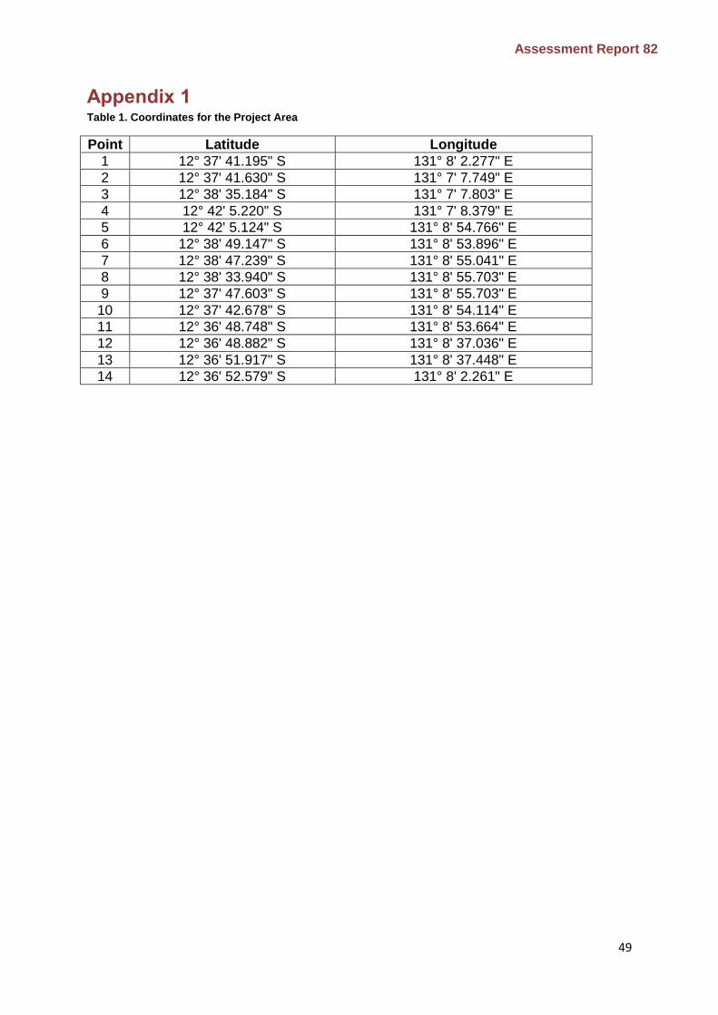
Assessment Report 82
49
Appendix 1
Table 1. Coordinates for the Project Area
Point Latitude Longitude
1 12° 37' 41.195" S 131° 8' 2.277" E
2 12° 37' 41.630" S 131° 7' 7.749" E
3 12° 38' 35.184" S 131° 7' 7.803" E
4 12° 42' 5.220" S 131° 7' 8.379" E
5 12° 42' 5.124" S 131° 8' 54.766" E
6 12° 38' 49.147" S 131° 8' 53.896" E
7 12° 38' 47.239" S 131° 8' 55.041" E
8 12° 38' 33.940" S 131° 8' 55.703" E
9 12° 37' 47.603" S 131° 8' 55.703" E
10 12° 37' 42.678" S 131° 8' 54.114" E
11 12° 36' 48.748" S 131° 8' 53.664" E
12 12° 36' 48.882" S 131° 8' 37.036" E
13 12° 36' 51.917" S 131° 8' 37.448" E
14 12° 36' 52.579" S 131° 8' 2.261" E

Assessment Report 82
50
Appendix 2 Environmental Factor Description of the Project’s likely
impacts on the environmental factor Evaluation of why the factor is not a key environmental factor
Air quality and Greenhouse Gases
Potential impacts to air quality and greenhouse gas (GHG) emissions would occur through the following construction related activities:
clearing of 1570 ha of vegetation
construction of built infrastructure
transport of building materials to and around the site
dust generated through clearing and transport of materials around the site.
The occupation of the site will generate GHG emissions through the following activities:
energy usage by households, businesses and industry
use of vehicles to transport residents around the site and to/from the greater Darwin region.
Air Quality and Greenhouse Gases were not identified as a preliminary key environmental factor in the NT EPA’s decision that the Project required assessment at the level of an EIS. Having regard to:
the clearing of 1570 ha of vegetation is unlikely to result in GHG emissions that are significant on a national scale
incorporation of architectural design guidelines which will meet a standard of energy efficiency and reduce energy usage and avoid GHG emissions
the possible use of public transport to connect the site to other areas in the greater Darwin region will reduce vehicle trips and GHG emissions
the implementation of a Dust Management Plan during construction will control the mobilisation of dust and impacts on sensitive receptors.
The NT EPA considers that it is unlikely that the proposal would have a significant impact on Air Quality and Greenhouse Gases and can be managed to meet the NT EPA’s environmental objective. The NT EPA does not consider that Air Quality and Greenhouse Gases is a key environmental factor at the conclusion of its assessment.

Assessment Report 82
51
Appendix 3
Figure 4. Conservation areas and buffers proposed by DENR