traditional architecture of bodrum: the factors generating
TRANSCRIPT

79
Intercultural Understanding, 2011, volume 1, pages 79-87
Traditional Architecture of Bodrum: The Factors Generating and Affecting the Architectural Culture and Identity
Sezin H. Tanröver1
1 Department of Interior Architecture and Environmental Design, Faculty of Architecture and Design, Bahçeşehir University, Istanbul, Turkey Corresponding author: Sezin H. Tanröver, Department of Interior Architecture and Environmental Design, Bahçeşehir University, Çrağan Cad. Osmanpaşa Mektebi Sok. No:4-6, 34353 Beşiktaş, Istanbul, Turkey, E-mail: [email protected] Keywords: Bodrum, architectural culture, architectural identity, traditional architecture, urban transformation, preservation, tourism.
Abstract: Anatolia, home of many civilizations throughout centuries, is loaded with substantial cultural and traditional accumulation. Unquestionably, settlements are the most significant indicators of this accumulation. Several regions of Anatolia house various examples of settlements thus far as antiquity. The architectural culture and identity of Bodrum in Western Anatolia, with its impressive nature is considered different from the Ottoman Architecture unique to Central Anatolia and Rumelia. The unique architecture in the Peninsula originates from the ever-continuing interactions with the opposite coasts rather than inland, therefore is considered as a transitional area, and classified within the Island Architecture. The unique natural and built environment of Bodrum has undergone a tremendous change after 1960’s. This modest fishermen town, with plain, white cubic houses, once depending on agriculture, fishing and livestock breeding, had turned into the most famous touristic resort of Turkey in 40 years. Especially after 1980’s, immigration and urban sprawl became serious threads for the distinguished identity of the town. Instead of the today’s existing approach in preservation which is rather fetishistic towards the traditional houses, preservation of traditional life-style that has already been replaced by tourism, seems more meaningful for the future of the peninsula which once has been so attractive for many. Therefore, here aimed is to expose and remind the life-style that generated the unique architectural culture and identity of Bodrum before 1960’s by a detailed literature survey and point out the factors that had a significant role in the generation of traditional architecture.
1. Introduction
The known history of Bodrum goes back to the 7th century B.C. and reaches to the Anatolian local people of the peninsula, thus far as Carians, Lelegs and then Dorians. The epic story of the Aegean local people making a living from sea trade, agriculture, seamanship, fishing, and sponge fishing, starts from Zephria, the first settlement on the peninsula; continues as Halicarnassus, the magnificent capital of Caria; as one of the significant ports of Rome, Byzance, Seljuk Empire and Mentese Beylic in the Middle Ages; as the gradually impoverished town of Ottoman Empire from 15th to 19th centuries; and finally as the most popular resort of today’s Bodrum of Turkish Republic with a great historical heritage (Mansur, 1972).
Today’s popularity of Bodrum, once a small fishing town with invaluable historical heritage and amazing nature, is owed to a group of artists and intellectuals who has recognized and introduced the town to public and pioneered by famous writer Cevat Şakir Kabaağaçl, also known as the “Fisherman of Halicarnassus” who has been exiled to Bodrum as a political prisoner in the early 20th century (Türe, 2006).
Above and beyond the priceless historical heritage and amazing nature, Bodrum Peninsula is remarkable with its unique architectural culture and identity. Traditional residential architecture of the peninsula gained recognition as a significant
type within Anatolian residential architecture which is classified in two groups by many scholars as the coastal and hinterland architecture when analyzed on the basis of local-regional differences or characteristics (Ergül and Kaya, 2008). The hinterland residential architecture shows certain similarities and some unifying characteristics regarding the traditions in spatial organization and construction technologies which enable researchers to classify. However coastal residential architecture, due to ever continuing interactions with the opposite coasts and islands does not have a unity within itself, and therefore can be categorized as transitional. According to Sözen (2006), especially the coastal architecture in Bodrum, Foça and Assos are influenced extremely by the architectural culture in the Dodecanese Islands. Consequently, Bodrum Peninsula and Aegean coasts in general, by means of certain characteristics that differentiate them from the Ottoman Architecture unique to Central Anatolia and Rumelia, can be considered within Island architecture (Ergül and Kaya, 2008). Especially the plan scheme that does not include ‘sofa’ (hall) and the use of stone as the major construction material are the significant characteristic of coastal architecture of Western Anatolia which distinguishes it from hinterland architecture (Sözen, 2006).
Sözen (2006) mentions Bodrum as one of the settlements in Western Anatolia that reflects the characteristics of the environment surrounding in the most successful way. Geography,
80
Sezin H. Tanröver
climate, natural environment; and the historical, social and economical background of the peninsula, where different cultures and societies interact, are the basis for evaluating the architectural culture and identity of Bodrum (Ergül and Kaya, 2008). Therefore, the subject matter has been analyzed by a detailed literature survey and presented in this study in three sections namely, the introduction, including geography, climate and the natural environment; built environment, including the traditional houses of Bodrum and traditional construction techniques and materials, and finally the evaluation of the factors that affected the architectural culture and identity of the peninsula throughout history.
The rapid transformation that the natural and built-environment in Bodrum have been subject to since mid 20th century with the emergence of tourism and immigration which affected the identity, architectural culture and life-style in the peninsula is another lively and hot debate about Bodrum Peninsula, but also out of the focus of this study. Today, after 40 years of intense change, Bodrum is the most well-known and visited resort in Turkey.
1.1. GEOGRAPHY, CLIMATE AND THE NATURAL ENVIRONMENT
Bodrum Peninsula, located on the southwest edge of Anatolia, approaches massively to the Aegean Sea on the west with its many large and small bays and it is surrounded by Güllük Bay on the north, Gökova Bay on the South (Türe, 2006) Mountains Belen and Tirman, as Mansur (1972) mentions, are encircling the city of Bodrum towards the sea. The tops and sides of these mountains are bare of trees, causing erosions, as a result of demand for timber and land prepared for farming. After the first rain fall, these mountains are covered with flowers, green grass, anemones, wild orchids and narcissus which completely dry out in summer months. The thyme, sage and some other fragrant plants can be found everywhere. With its warm, dry and sometimes mild climatic condition of the Aegean coast, Bodrum reflects a local life that is bound to the fertility of olive, fig and tangerine trees on one side, and sea on the other (Türe, 2006).
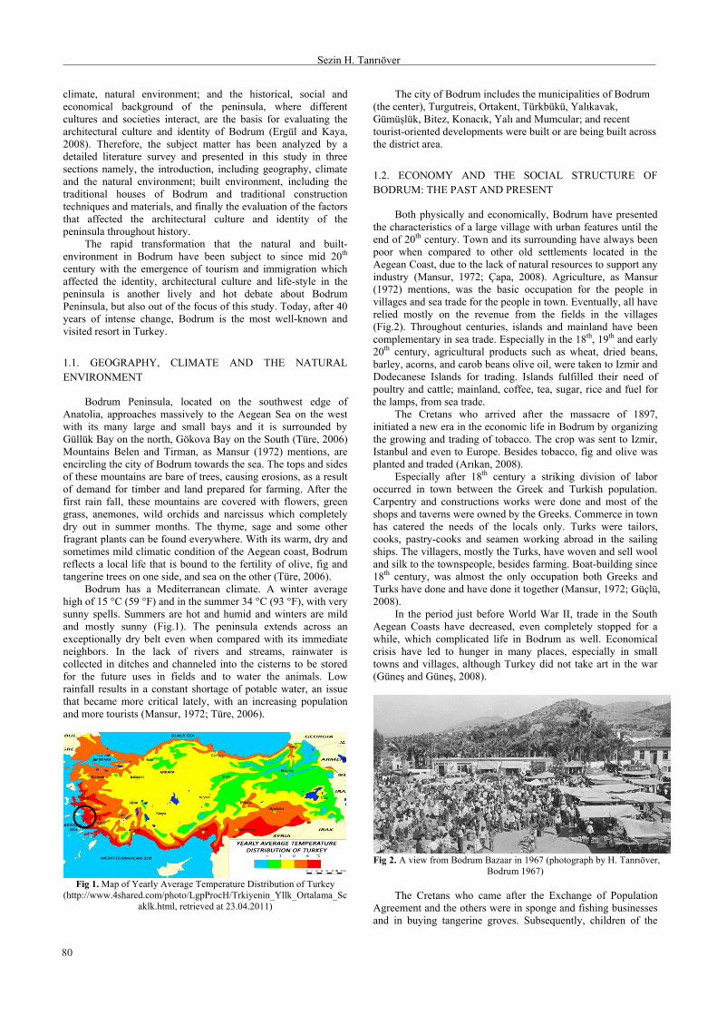
Bodrum has a Mediterranean climate. A winter average high of 15 °C (59 °F) and in the summer 34 °C (93 °F), with very sunny spells. Summers are hot and humid and winters are mild and mostly sunny (Fig.1). The peninsula extends across an exceptionally dry belt even when compared with its immediate neighbors. In the lack of rivers and streams, rainwater is collected in ditches and channeled into the cisterns to be stored for the future uses in fields and to water the animals. Low rainfall results in a constant shortage of potable water, an issue that became more critical lately, with an increasing population and more tourists (Mansur, 1972; Türe, 2006).
Fig 1. Map of Yearly Average Temperature Distribution of Turkey
(http://www.4shared.com/photo/LgpProcH/Trkiyenin_Yllk_Ortalama_Scaklk.html, retrieved at 23.04.2011)
The city of Bodrum includes the municipalities of Bodrum (the center), Turgutreis, Ortakent, Türkbükü, Yalkavak, Gümüşlük, Bitez, Konack, Yal and Mumcular; and recent tourist-oriented developments were built or are being built across the district area.
1.2. ECONOMY AND THE SOCIAL STRUCTURE OF BODRUM: THE PAST AND PRESENT
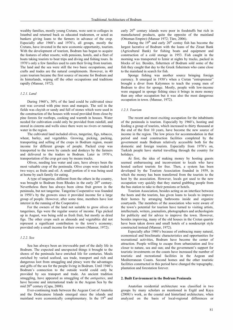
Both physically and economically, Bodrum have presented the characteristics of a large village with urban features until the end of 20th century. Town and its surrounding have always been poor when compared to other old settlements located in the Aegean Coast, due to the lack of natural resources to support any industry (Mansur, 1972; Çapa, 2008). Agriculture, as Mansur (1972) mentions, was the basic occupation for the people in villages and sea trade for the people in town. Eventually, all have relied mostly on the revenue from the fields in the villages (Fig.2). Throughout centuries, islands and mainland have been complementary in sea trade. Especially in the 18th, 19th and early 20th century, agricultural products such as wheat, dried beans, barley, acorns, and carob beans olive oil, were taken to Izmir and Dodecanese Islands for trading. Islands fulfilled their need of poultry and cattle; mainland, coffee, tea, sugar, rice and fuel for the lamps, from sea trade.
The Cretans who arrived after the massacre of 1897, initiated a new era in the economic life in Bodrum by organizing the growing and trading of tobacco. The crop was sent to Izmir, Istanbul and even to Europe. Besides tobacco, fig and olive was planted and traded (Arkan, 2008).
Especially after 18th century a striking division of labor occurred in town between the Greek and Turkish population. Carpentry and constructions works were done and most of the shops and taverns were owned by the Greeks. Commerce in town has catered the needs of the locals only. Turks were tailors, cooks, pastry-cooks and seamen working abroad in the sailing ships. The villagers, mostly the Turks, have woven and sell wool and silk to the townspeople, besides farming. Boat-building since 18th century, was almost the only occupation both Greeks and Turks have done and have done it together (Mansur, 1972; Güçlü, 2008).
In the period just before World War II, trade in the South Aegean Coasts have decreased, even completely stopped for a while, which complicated life in Bodrum as well. Economical crisis have led to hunger in many places, especially in small towns and villages, although Turkey did not take art in the war (Güneş and Güneş, 2008).
Fig 2. A view from Bodrum Bazaar in 1967 (photograph by H. Tanröver,
Bodrum 1967)
The Cretans who came after the Exchange of Population Agreement and the others were in sponge and fishing businesses and in buying tangerine groves. Subsequently, children of the
81
Traditional Architecture of Bodrum
wealthy families, mostly young Cretans, were sent to colleges in Istanbul and returned back as educated tradesmen, or acted as bankers giving loans to the farmers in advance of the crop. Especially after 1960’s and 1970’s, all groups, mostly the Cretans, have invested in the new economic opportunity, tourism. With the development of tourism, Bodrum has begun to acquire the features of other resorts; with pensions, hotels, and a fleet of boats taking tourists to boat trips and diving and fishing tours. In 1970’s only a few families used to earn their living from tourism. The land and the sea were still the two basic occupations, and crafts and trades are the natural complements. However, in 40 years tourism became the first source of income for Bodrum and its hinterlands, wiping off the other occupations and traditions rapidly (Mansur, 1972).
1.2.1. Land
During 1960’s, 30% of the land could be cultivated since rest was covered with pine trees and marquis. The soil in the fields was clayish or sandy and full of stones which were used in the construction of the houses with wood provided from close-by pine forests for rooftops, cooking and warmth in houses. Water needed for cultivation could only be provided from rainfall, and stored in cisterns and wells since there were no rivers or running water in the region.
The cultivated land included olives, tangerine, figs, tobacco, wheat, barley, and vegetables. Growing, picking, packing, transporting and selling of the crops in Bodrum region, meant income for different groups of people. Packed crop was transported to the town by camels and donkeys by the farmers and delivered to the traders in Bodrum. Later in 1970’s, transportation of the crop got easy by means trucks.
Olives, needing less water and care, have always been the most valuable crop of the peninsula. Olive crops were traded in two ways; as fruits and oil. A small portion of it was being used at home by each family for eating.
A type of tangerine, different from the others in the country, was brought to Bodrum from Rhodes in the early 20th century. Nevertheless there has always been citrus fruit grown in the peninsula, but not tangerine. Tangerine Cooperative was founded in 1950’s by the growers since it provided income for a large group of people. However, after some time, members have lost interest in the running of the Cooperative.
For the owners of the land not suitable to grow olives or tangerines, figs were the regular source of income. Figs picked up in August, was being sold as fresh fruit, but mostly as dried figs. The other crops such as almonds and vegetables did not represent a significant contribution to the town’s economy; provided only a small income for their owners (Mansur, 1972).
1.2.2. Sea
Sea has always been an irrevocable part of the daily life in Bodrum. The expected and unexpected things it brought to the shores of the peninsula have enriched life for centuries. Meals enriched by varied seafood, sea trade, transport and rich and dangerous loot from smuggling and piracy were the advantages and gifts of the sea for the people living in Bodrum. Until 1940’s Bodrum’s connection to the outside world could only be provided by sea transport and trade. An ancient tradition smuggling, have appeared as smuggling of the antiquities, and have become and international trade in the Aegean Sea by the mid 20th century (Çapa, 2008).
Ever-continuing trade between the Aegean Cost of Anatolia and the Dodecanese Islands emerged since the islands and mainland were economically complementary. In the 19th and
early 20th century islands were poor in foodstuffs but rich in manufactured products, quite the opposite of the mainland (Ottoman Empire) (Mansur 1972; Türe, 2006).
During the 19th and early 20th centuy fish has become the largest lucrative of Bodrum with the loans of the Ziraat Bank (Agricultural Bank) for fishing boats and equipment and construction of a cold storage in 1953. Fish caught in the morning was transported to İzmir at nights by trucks, packed in blocks of ice. Besides, fishermen of Bodrum sold some of the fish they caught that day to the Greek fishermen who came close to the mainland in search for fish.
Sponge fishing was another source bringing foreign currency. It emerged in 1930’s when a Cretan “entrepreneur” brought a diver from Kalymnos to teach the young men of Bodrum to dive for sponge. Mostly, people with low-income were engaged in sponge fishing since it brings in more money than any other occupation but it was also the most dangerous occupation in town. (Mansur, 1972).
1.2.3. Tourism
The recent and most exciting occupation for the inhabitants of the peninsula is tourism. Especially by 1960’s, hosting and feeding a group of tourists, which increased to thirty thousand at the end of the first 10 years, have become the new source of income in the region. The low prices for accommodation in that period and road construction facilities completed by the government made Bodrum relatively accessible both for the domestic and foreign tourists. Especially from 1970’s on, Turkish people have started travelling through the country for holidays.
At first, the idea of making money by hosting guests seemed embarrassing and inconvenient to locals who have hosted earliest tourists for free. Then, a system has been developed by the Tourism Association founded in 1959, in which the money has been transferred from the tourists to the host by the association. However, locals got used to the new occupation very quickly that they started grabbing people from the bus station to take to their pensions or hotels.
Tourism Association, besides acting as an interface between the hosts and the tourists, has given loans to locals to improve their homes by arranging bathrooms inside and organize courtyards. The members of the association who were aware of the town’s potential for tourism have turned to visiting artists, intellectuals, writers, journalists, photographers and archeologists for publicity and for advice to improve the town. However, besides improving, many of the old houses in the Cretan quarter have been taken down and small hotels of a nondescript style constructed instead (Mansur, 1972).
Especially after 1980’s because of embracing many natural, economical and bioclimatic characteristics and opportunities for recreational activities, Bodrum have become the center of attraction. People willing to escape from urbanization and live closer to nature, sea and sun; and the government’s support for touristic investments on the coasts have increased the number of touristic and recreational facilities in the Aegean and Mediterranean Coasts. Second homes and the other touristic facilities constructed in this period have changed the topography, plantation and forestation forever.
2. Built Environment in the Bodrum Peninsula
Anatolian residential architecture was classified in two groups by many scholars as mentioned in Ergül and Kaya (2008)’s work, as the coastal and hinterland architecture, when analyzed on the basis of local-regional differences or

82
Sezin H. Tanröver
characteristics. The hinterland residential architecture shows certain similarities and some unifying characteristics regarding the traditions in spatial organization and construction technologies which enable researchers to classify. However coastal residential architecture, because of the ever continuing interactions with the opposite coasts and islands does not have unity within itself, and therefore can be categorized as transitional.
Bodrum Peninsula, and Aegean and Mediterranean coasts in general, by means of certain characteristics that differentiate them from the Ottoman Architecture unique to Central Anatolia and Rumelia, can be considered within Island architecture (Ergül and Kaya, 2008).
2.1. BUILT ENVIRONMENT BETWEEN 1600’S AND 1960’S
Bodrum was situated on the two coves, enclosing sea and meeting at a point where the Castle (St. Petrum or Petronium) arises. “Kumbahce”, the eastern cove has been occupied by the Muslims and non-Muslims from Crete and other islands; and the western cove, by the Turkish people from Anatolia. Between these two groups of settlements “Merkez” (Center) where once a graveyard, today the bazaar and commercial buildings takes place (Uğurlu, 2008; Güneş,Güneş, 2008).
Karaman (2001) mentions that the first settlements out of the Castle (Petronium) were assumed to be built around 1600’s in a way that resembles the castle to serve for the self-protection of the locals from piracy and banditry. Settlements in the peninsula have increased in numbers and types after the domination of the Ottoman Empire in 1600’s and on. In order that the locals could benefit from the advantages of the sea, settlements have been located mostly on the shores rather than inland.
The coastal belt made up of two coves, as told by Bektaş (2004) has acquired different characteristics regarding order and density. Kumbahce district on the east cove has been occupied by the Cretans since the supremacy of Suleiman the magnificent and was more uniformly occupied and was wider than “Turk Koyu” (Turkish Cove) on the west. Cretans and people from the islands were making a living from fishing and Turks on the west cove mainly occupied by agriculture. This social structure had existed in the last century as well. The houses in this eastern district had small stone courtyards side-by-side forming narrow, shady streets in between while the settlement on west coastal belt was less constant, less dense and newer. The number of houses in the west cove was very few in 19th century (Fig.3), however increased after the opening of the coast road (Fig 4).
Fig 3. Bodrum in 18th century (Basgelen, 1998).
Fig 4. Bodrum in 21th century (retrieved on 22.04.2011,
http://maps.google.co.uk/).
The garden belt that separates the populated areas on the coast and mountain slopes was flat and suitable for cultivation. It was narrower on the west part of the town since the mountains here are closer to the sea when compared to the east part. Therefore, sea was more accessible on the west cove. The layout of the populated belt along the mountain slopes in two coves was different from each other as well. Houses on west cove have developed around secondary nucleuses, forming neighborhoods Türk Kuyusu, Eski Çeşme and Tepecik, along an invisible line and joined to form a continuous belt while the ones on the east have stood as unrelated single houses. This configuration of the upper belt in the west cove has maintained the development of the services more and easier than the east cove. (Bektaş, 2004)
In the region, sea and land were valued the same and no separation of any kind existed in between the sea and the inhabitants of the town. Sea has always been a part of the houses on the coast, which seemed to extend towards courtyards and interiors with the vegetation along the coast (Bektaş, 2004). The shady, narrow streets, formed by the high courtyards and garden walls, were the common features of both coves.
Until 1960’s and 1970’s the narrow and densely populated belt following the coastline have existed as it is, with charming white houses forming a harmonious whole with well-proportioned windows, doors and interesting chimney pots resembling Mausoleum (Fig.5). The variety and richness of the folklore reflected on the cubic white architecture of the peninsula emerged as the result of the balanced intermingling of different religions, languages, and different life styles in time. There existed pure unity both with nature and each other. Today, despite all deteriorations houses are still the most striking aspect of Bodrum (Türe, 2006).
Fig 5. A view towards the Castle and Turkish Cove, Bodrum, 1967 (photograph by H. Tanröver, Bodrum 1967)

83
Traditional Architecture of Bodrum
2.1.1. Traditional Houses of Bodrum
Bodrum Houses are the products of generations’ experience of using small spaces in the most effective way. Although they vary in plan, the significant items that bring in identity to these houses are the sizes, proportional relationships, material and techniques of construction, monumental chimneys, battlements on the edges of the roofs, and definitely the white color, achieved by the use of albarium (Türe, 2006; Bektaş, 2004; Uğurlu, 2008).
Before the tourism boom in Bodrum, the houses were planned and built according to the life of the family and the source of income, farming, fishing, livestock breeding or trade. They were constructed by the local craftsmen and his two apprentices, by using the materials available in the near surrounding. Other significant criterion in designing and positioning the house on the site was the tradition of respecting the neighbors. Arif Kaptan, one of the oldest craftsmen in the peninsula quoted by Bektaş (2004), mentioned the importance of neighborliness and stated the significance of having intent not to look into each other, and not to block the sun, air and view of the neighbors. Houses were somewhat individual as well, because in addition to the family’s source of income, the type and size of the house, the locations of windows and doors, were decided by the owner. Therefore, it is possible to observe several variations within the three major types of traditional houses.
Bektaş (2004) classifies Bodrum houses in three categories by referring to their major properties as Kule Ev (Tower House), Musandral Ev (Mezzanine House) and Sakz Ev (Khios House). Aysel (2006) makes an addition to the typology with Single Room Houses, having very similar characteristics with Mezannine House. Among all types, Tower House is the oldest and most have been abandoned many years ago. Craftsmen, who are still building traditional houses, quoted by Bektaş (2004) mention that the most common type was Mezzanine House and together with the Khios Houses, they were built until the mid 20th century.
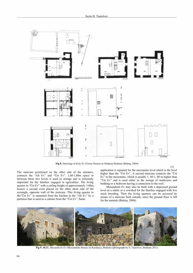
Kule Ev (Tower House)
“Kule Ev” is the oldest type of traditional house in the peninsula. First neighborhoods that have been developed out of but close to the castle walls were formed as “Kule Ev” (Fig.6 and 7). Later they have been built also in the other districts of Bodrum. These houses are simply the mezzanine type houses with a square plan (4,5 x 4,5 x 4,5) with stables on the ground level in which the living quarters are elevated to the upper level for easy defense (Fig.8).
They were named as the “Kule Ev” by the local people simply because they have been built higher than the other houses. Another typical characteristic of these houses is the access to the living quarters that is located at a higher level than the ground. Entrances are designed only to be reached by a drawbridge operable manually from inside which leads to a stone staircase constructed away from the doorway. Moreover, entrances in “Kule Ev” are located on the opposite side of the sea (facing north-east) on the contrary to all other types. All these specific features and the embrasures on the edges of the roofs point to the significant need for defense from pirates and banditry, ever since settlements have moved out off the castle. Later, especially the embrasures on the roofs have become one of the most significant architectural features of Bodrum (Türe, 2006). In addition to the specific features mentioned above, Bektaş (2004) mentions the existence of services such as lavatory and WC inside the house on the ground level which enables inhabitants to manage to stay in for several days, in times of conflict.
Fig 6. Kule Ev (Tower House) in Ortakent Bodrum
(photograph by S. Tanröver, Bodrum 2011)
Fig 7. Kule Ev (Tower House) in Ortakent Bodrum (photograph by S.
Tanröver, Bodrum 2011)
Musandral Ev (Mezzanine House)
Musandral Ev, with a rectangular plan, were mostly inhabited by the farmers. In this type usually having 4,20-4,60 x 6,50-7,50m dimensions (including the thickness of the walls), narrow side of the rectangle depends on the size of the mezzanine and the long side depends on the size of the pole made up of a complete tree which has a four-cornered section. The harmony in plan achieved by these proportions and the locations of the doors (placed on 1/3 of a long side of the rectangle) and windows indicates the presence of golden ratio, succeeded unconsciously (Türe, 2006) (Fig.9, 10, 11).
The house has two levels where the first level is called the “Alt Ev” (Lower House) and the second is the “Üst Ev” (Upper House). The “Lower House” is being used as the entrance and kitchen. Oven is located either on the wall adjacent or on the opposite wall of the entrance. Bathroom which is positioned on one side of the kitchen consists of a can full of water and a drainage only that leads the used water out. In some cases, bathroom is placed outside the house (Fig.12).
84
Sezin H. Tanröver
Fig 8. Drawings of Kule Ev (Tower House) in Ortakent Bodrum (Bektaş, 2004)
(1)
The staircase positioned on the other side of the entrance, connects the “Alt Ev” and “Üst Ev”. 1,60-1,80m space in between these two levels is used as storage and is extremely important for the families engaged in agriculture. The living quarter in “Üst Ev” with a ceiling height of approximately 3.00m, houses a second oven placed on the other short side of the rectangle, opposite wall of the staircase. This living quarter in the“Üst Ev” is separated from the kitchen in the “Alt Ev” by a partition that is used as a cabinet from the “Üst Ev”. Same
application is repeated for the mezzanine level which is the level higher than the “Üst Ev”. A second staircase connects the “Üst Ev” to the mezzanine, which is usually 1, 60-1, 80 m higher than “Üst Ev” and is used either as the storage of mattresses and bedding or a bedroom having a connection to the roof.
Musandral Ev may also be built with a depressed ground level as a stable or a cowshed for the families engaged with live stock breeding. Then the living quarters can be accessed by means of a staircase built outside, since the ground floor is left for the animals (Bektaş, 2004).
Fig 9, 10,11. Musandral Ev (Mezzannine House) in Karakaya, Bodrum (photograph by S. Tanröver, Bodrum 2011)

85
Traditional Architecture of Bodrum
Fig 12. Musandral Ev (Mezzannine House) in Bodrum (Bektaş, 2004)
Sakz Ev (Khios House)
Sakz Ev with two identical floors have almost the same dimensions with Musandral Ev. Entrance located on one of the long walls of the rectangle, is oriented to east in order to benefit from the morning sun and prevailing wind, coming from the sea.
The narrow sofa accessed from the entrance has two doors on opposite side walls opening to two similar rooms on two sides. The staircase on the opposite wall of the entrance connects two levels. The upper level also has the same configuration with the level below. In some Sakz Ev, a projection covering the entrance, “ayazlk”, is added directly above the front door and even in some cases it is constructed as a bay, “cumba”, as a part of the interior (Fig. 13 and 14).
“Yer Evi” (Lower Level) has a lower ceiling than the “Üst Ev” (Upper Level). The main living quarter of the family takes place in the lower level and has oven in both rooms. One of these rooms is used as the kitchen in winter months and includes a bathroom corner similar to “Musandral Ev”. The “Üst Ev” usually is furnished with the best furniture that the family can afford and only used to host the guests. In some variations of this type of houses, entrance hall has been neglected and the entrance door opens into one of the rooms on the ground floor. The access to the other room on this level and to “Üst Ev” is provided from this room. For “Üst Ev” several
variations have been adopted such as portioning the room by means of a built in cabinets.
The widespread similarity in the volumes enclosed, building materials and technologies, the proportions of doors and windows create unity between the different districts and neighborhoods of Bodrum. Yet again similar in all houses except the ones in “Kumbahçe” district, lavatory has been placed outside, which in “Kumbahçe” located on a corner of the garden enclosed by a semi-cylindrical volume.
Both in Musandral Ev and Sakz Ev, courtyards are the places to spend the summer months. Therefore, they contain all the elements of a life which is lived outside, in the most functional way. Usually all courtyards have stoves and wells; and are organized diligently with pergolas and plants for the provision of shade and enclosed by high walls for protection from the strangers’ glances (Bektaş, 2004) (Fig.15).

86
Sezin H. Tanröver
Fig 13. Sakz Ev (Khios House) Bodrum (Bektaş, 2004)
Fig 14. Sakz Ev (Khios House) Gümüşlük, Bodrum (photograph by S. Tanröver, Bodrum 2011)
Fig 15. Sakz Ev (Khios House) Bodrum (Bektaş, 200

87
Traditional Architecture of Bodrum
2.1.2. Construction and Materials
Stone is the typical construction material in the Aegean coast. The foundation, walls, indoor floor, door and window lintels and jambs of the houses are all made up of stone, provided from the near surrounding. Farmers, as told by Sönmez and Bilgin in the interviews, use to prepare soil for cultivation by collecting the stones and use them in the construction of their houses. For the courtyard floors, slate was frequently being used. Kaoline generated by mixing white soil with soil mortar or cement mortar was a tradition in masonry. If application of sand to the cement mortar is the case, sand was provided from a longer distance, from Milas or Kemer. The most accepted and used timber for the beams, floors and other parts of the house was the pitch pine.
Fig 16. Soil rooftop of a typical Bodrum House (photograph by H.
Tanröver, Bodrum 1967) Perfect insulation for heat and water on the soil rooftops
was accomplished by the successful use of local materials (Fig.16). The slitting that is covered by sedge put side by side without space, supported by tree branches and covered with timber. For the upper layer a bush rich in leaf “ac çals” and another that grows in marshland “kovalk” was being used. The following 3-4 cm thick layer was made up of seaweed “erişte”, and lastly 5-7 cm thick layer of soil was laid to cover the whole surface. In order to avoid the growth of plants on the roof salt was laid on the soil. These layers that avoid heat transfer lastly were covered with a type of clay that was brought from “Üçpnar” district to avoid the water transfer and was pressed by a stone steamroller. Roofs were designed with a slope towards one of the sides in order to deliver rainwater from roof to soil with the rainspouts from fired clay.
Most of the houses were plastered both inside and outside. However in some, the use of plaster is different. The technique called “Çakr” or “Sakar” requires less use of plaster, only to apply on the the speces in between the stones and is 4-5 cm thick. This technique was being used to decrease both the amount of plaster and to create an air current in between the sunny and shady parts of the outside walls to cool the interior. It is for the same cause that both interior and exterior of most houses are painted with lime in pure white color.
3. Conclusion
In order to conclude a subject matter that includes many factors as mentioned briefly in the previous sections, interpretation will focus on the interactions among the coasts that is triggered by the environmental conditions in the first place.
As mentioned by many scholars, the ever-continuing interactions between the Western Anatolia and the islands, rather than the Central Anatolia was owed to the rough and impassable topography in the region and lack of transportation technology other than sea transport until late 20th century.
Similar geographical and climatic conditions and natural resources shaped similar living environments on both sides.
Construction techniques on one side had been transferred to the other with minor changes since the climatic conditions and materials available have permitted to. Daily life mostly spent outside working either in the fields or on the sea; mild climatic conditions even in winters, have shaped plain and functional interior spaces on both mainland and islands to satisfy the basic needs of the occupants.
The economical and social bonds set up in different scales between the Dodecanese Islands and Western Anatolia, regardless of the dominating power in the region, was another major factor in shaping life and the settings of life, the settlements, on both sides. Different crops on each side created complementary economical and social bonds in between the communities of the mainland and the islands. However, this crucial bond in between has been minimized in the 20th century, after World War I and II.
Fundamental and dynamic interactions in between Western Anatolia and the islands that existed throughout history until 20th century, today continues within a different formation. Many people from all over the world, also from Greece and Turkey are moving from coast to coast mostly for touristic purposes.
Acknowledgements
Sincere acknowledgements to architects Tevfik Bilgin and Ahmet Sönmez for their support and generous contributions to the study.
References
Aysel, R. Nezih. (2006). Bodrum Ortakent (Müsgebi): Bir Mimari İnceleme. İstanbul Arkeoloji ve Sanat Yaynlar.
Başgelen, Nezih (1998). Bir Zamanlar Bodrum. Istanbul. Arkeoloji ve Sanat Yaynlar.
Bektaş, Cengiz. (2004). Halk Yap Sanatndan Bir Örnek: Bodrum. Istanbul. Bileşim Yaynevi.
Bilgin, Tevfik, architect (personal communication, April 15, 2011) Ergül, Emre, Can Kaya. (2008/2). Datça Konut Mimarlğ. Ege Mimarlk,
65 16-25. Güçlü, Kamuran. (2011) Ülkemizde Sahil Bantlarnda İnşa Edilen Yazlk
Evler ve Yarattğ Sorunlar. Retrieved April 05, 2011 fromhttp://edergi.atanuni.edu.tr/index.php/zfd/article/viewFile/5770/5566
Güneş, Günver, Müslime Güneş. (2008). II. Dünya Savaş Yllarnda Bodrum. 1522-2007 Osmanl’dan Günümüze Bodrum. 22-25 October 2007 Bodrum Sempozyumu. Bodrum. Ortakent-Yahşi Belediyesi Kültür Yaynlar.
Karaman, Aykut. (2001). Bodrum Yarmadas Müsgebi-Ortakent:Kentsel Morfolaji Analizleri. Bodrum. Chamber of Architects of Turkey, Bodrum Office.
Klçaslan, Çiğdem. (2006/1). İkinci Konutlarn Deniz Kylarna Etkisi. Süleyman Demirel Üniversitesi Orman Fakültesi Dergisi, Seri: A, 147-156,
Mansur, Fatma. (1972). Bodrum: A Town in the Aegean. Leiden. E.J. Brill.
Sönmez, Ahmet, architect and urban planner (personal communication, April 17, 2011)
Sözen, Metin (2006), Gelenekten Geleceğe Anadolu’da Yaşama Kültürü, Çekül Vakf Yaynlar, Istanbul
Türe, Altan. (2006). Karia’dan Bugüne Bodrum. Istanbul. Yap Endüstrisi Kültür Yaynlar.
Uğurlu, Kamil. (2008). Bodrum’un Bacalar: Türk Evi Plan Tipinde Bodrum Örneği. 1522-2007 Osmanl’dan Günümüze Bodrum. 22- 25 October 2007 Bodrum Sempozyumu. Bodrum. Ortakent-Yahşi Belediyesi Kültür Yaynlar.