theme implementation plan for cadastral theme · cadastral theme implementation plan report - april...
TRANSCRIPT

Cadastral Theme Implementation Plan Report - April 2017 Progress Page 1
Theme Implementation Plan for Cadastral Theme
Bureau of Land Management - Cadastral Survey
Federal Geographic Data Committee (FGDC)
2017 – 2021
April 2017 - Progress and Update

Cadastral Theme Implementation Plan Report - April 2017 Progress Page 1
Cadastral (Cadastre) Theme FY 2017 Implementation Plan Report
Theme Personnel Theme Lead (Co-Leads): Don Buhler and Robert Ader Theme Lead Agency(ies): Bureau of Land Management (BLM) - Cadastral
Survey/Geosciences Executive Theme Champion(s): Tod Dabolt
Executive Champion Agency(ies): Department of Interior
Cadastral Theme NGDA Datasets NGDA Agency U.S. Army Corps of Engineers Civil Work Land Data DOD-USACE BIA Indian Lands Dataset (Indian Lands of the United States) DOI-BIA Public Land Survey System (PLSS) Dataset Catalog DOI-BLM Department of Defense Land Parcels and Sites DOD-AT&L BLM National Surface Management Agency: Area Polygons, Withdrawal Area Polygons, and Special Public Purpose Withdrawal Area Polygons
DOI-BLM
FS National Forest Dataset (US Forest Service Proclaimed Forests) USDA-USFS FWS Interest DOI-FWS NPS National Parks Dataset DOI-NPS Outer Continental Shelf Active Renewable Energy Leases DOI-BOEM Outer Continental Shelf Block Aliquots DOI-BOEM Outer Continental Shelf Lease Blocks - Alaska Region NAD83 DOI-BOEM Outer Continental Shelf Lease Blocks - Atlantic Region NAD83 DOI-BOEM Outer Continental Shelf Lease Blocks - Gulf of Mexico Region NAD27 DOI-BOEM Outer Continental Shelf Lease Blocks - Pacific Region - West Coast NAD83 DOI-BOEM Outer Continental Shelf Official Protraction Diagrams - Alaska Region NAD 83 DOI-BOEM Outer Continental Shelf Official Protraction Diagrams - Atlantic Region NAD 83 DOI-BOEM Outer Continental Shelf Official Protraction Diagrams And Lease Maps - Gulf Of Mexico Region NAD27 DOI-BOEM Outer Continental Shelf Official Protraction Diagrams - Pacific Region - West Coast NAD 83 DOI-BOEM Protected Areas Database of the United States (PAD-US) DOI-USGS
Strategic Theme Plan: http://nationalcad.org/download/StrategicPlanCadastral-Submitted.pdf

Cadastral Theme Implementation Plan Report - April 2017 Progress Page 2
Human and Financial Resources Needed for Theme Management This table includes an estimate of resources needed for managing the Theme and includes the roles that support theme management, coordination, and support. The percent Full Time Equivalent and grade are an estimate. This estimate does not include the resources required to develop and maintain the Cadastral data sets or agency core mission requirements.
Description of Theme Management Activities Role
(Theme Lead, Dataset Manager, Coordinator, other as specified)
% FTE FTE Grade
A–16 NGDA Theme management (e.g., attend meetings, review NGDA documents, develop Theme Strategic Plans, etc.) (repeat for co-Theme Leads)
Theme Lead
.10
13
Other Theme administration activities Workgroup coordination and support (three workgroups)
3 - Workgroup support
.30
12
Provide community information, publish and disseminate standards of interest, coordinate with vendors and private sector to implement standards and provide standardized cadastral data, maintain an inventory of authoritative sources, maintain a listing of workgroup participants and Cadastral Subcommittee members, and provide FGDC annual reports.
Reporting and Administrative Theme
Support
.15
12
Theme Administration Total %FTE & Estimated $ .55 $
The Cadastral Theme, unlike many of the other framework themes, is reliant on local and state data producers for data set collection, maintenance, and publication and the private sector and vendor support for technology and standards implementation. The federal agencies do not have the authority regarding national cadastral data production and are limited to federally managed surface and subsurface lands. The Cadastral Subcommittee efforts in this arena are limited to providing guidance through standards development, which is completed, and to provide coordination and education support as possible.

Cadastral Theme Implementation Plan Report - April 2017 Progress Page 1
Goal 1: Cadastral Reference - Including the Pubic Land Survey System (PLSS) and Others Identify state and federal data stewards for Cadastral Reference, coordinate and support the effective collection and maintenance of the Cadastral Reference National Geospatial Data Asset (NGDA) Datasets, facilitate sharing and data availability socialization of the Cadastral Reference data sets, and provide outreach and communication mechanisms for data stewards Objective 1.1: Complete PLSS Data Steward Program Agency and/or Stakeholders Involved: All Federal Land management agencies, state agencies and local governments in the 30 Public Domain States Anticipated Outcome: Maintained PLSS data sets for all 30 public domain states, updated at least annual as needed, establishing a single authoritative PLSS data set for each state
Actions Milestones Performance Action Responsibility Projected (Describe discrete activities) (A significant change in
development with associated date)
Indicators (A metric to assess
progress of the action)
(Agency, individuals, and/or groups leading the action) Completion Date (FY )
1.1.1 Continuous update of PLSS complete update Data set BLM Cadastral Survey 2017 and ongoing data sets data improvement
occurs incrementally
1.1.2 Publish updates of PLSS data to NGDA services
published data sets
published data sets
BLM Cadastral Survey 2017
Agency and/or Stakeholder Activity through FY 2017 1.1.1 - BLM Cadastral Survey 4-1-17- over 125 townships are under contract and the new contract should complete 100 additional
townships. The number of special surveys ranges from 48 to more than 800 in a single township. Over 20,000 special surveys have been added thus far in 2017. State boundaries and new control are added on a continuous basis.
1.1.2 - BLM Cadastral Survey 4-1-17 - BLM data publishing site exposes PLSS Data sets and metadata, feature services coming later this year https://navigator.blm.gov/data?keyword=cadastral

Cadastral Theme Implementation Plan Report - April 2017 Progress Page 2
Objective 1.2: Complete non-PLSS Cadastral Reference Data Set Definitions Agency and/or Stakeholders Involved: All Federal Land Management Agencies, state agencies and local governments in the 20 non-PLSS States Anticipated Outcome: Define, review, and adopt a cadastral reference system for each of the 20 non-PLSS states. Maintainable published cadastral reference data set for each of the 20 non-PLSS states with data documentation. This is not a funded activity therefore establishing milestones and projected completion is not feasible. Volunteer contributions from non-federal stakeholders and the private sector are being advanced voluntarily.
Actions (Describe discrete activities)
Milestones (A significant change in development with
associated date)
Performance Indicators
(A metric to assess progress of the action)
Action Responsibility (Agency, individuals, and/or groups leading the action)
Projected Completion Date
(FY)
1.2.1 Establish a non-PLSS cadastral reference community
None Draft Non-PLSS reference documented
This is an identified objective but no funding or resources have been identified to accomplish this objective.
None
1.2.2 Develop and socialize draft non-PLSS cadastral data set to gather input from non-PLSS data stewards.
None input gathered from data producers and users
This is an identified objective but no funding or resources have been identified to accomplish this objective.
None
1.2.3 Finalize non-PLSS cadastral reference data set with documentation and publish to nationalcad.org
None Non-PLSS reference documented
This is an identified objective but no funding or resources have been identified to accomplish this objective.
None
Agency and/or Stakeholder Activity through FY 2017 1.2.1 - Volunteer Efforts Initial investigations of the need and examples of non-PLSS reference systems have started. This is a volunteer
effort that is being accomplished by non-federal and private sector stakeholders
Cadastral Theme Implementation Plan Report - April 2017 Progress Page 3
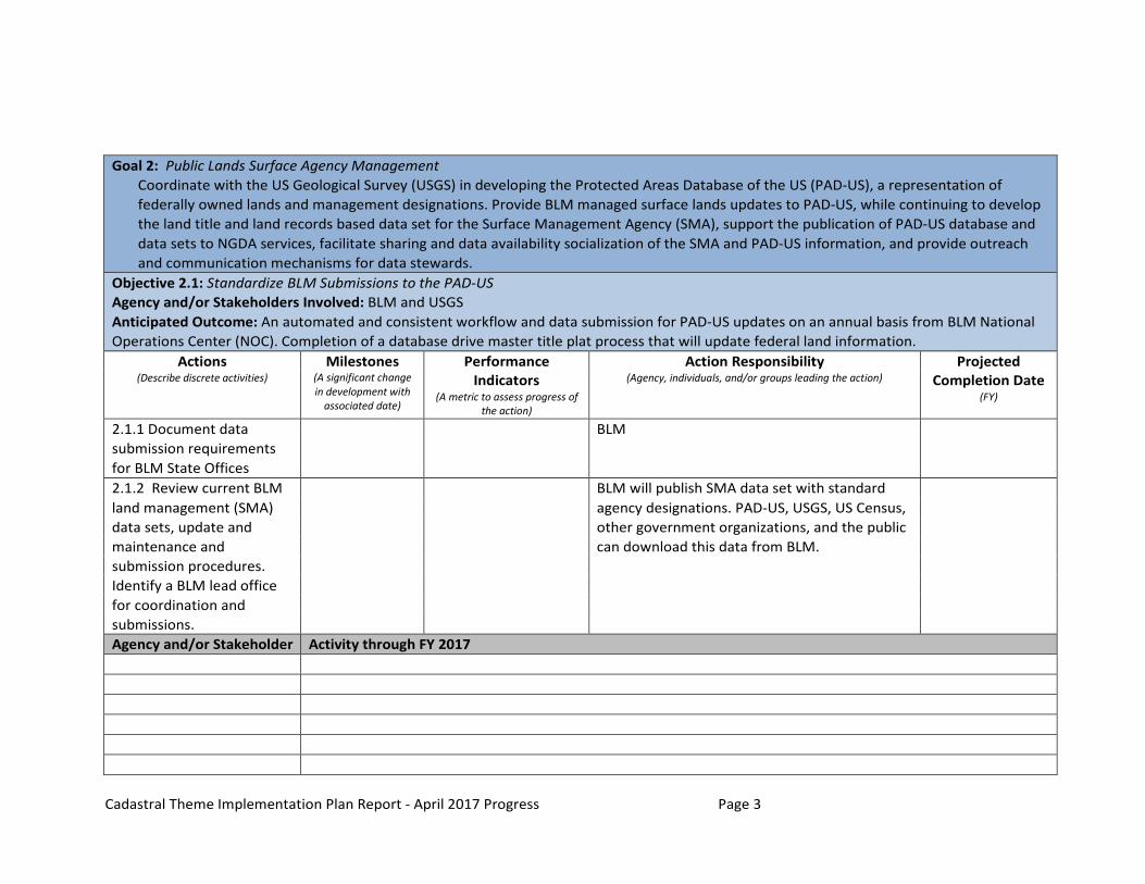
Goal 2: Public Lands Surface Agency Management Coordinate with the US Geological Survey (USGS) in developing the Protected Areas Database of the US (PAD-US), a representation of federally owned lands and management designations. Provide BLM managed surface lands updates to PAD-US, while continuing to develop the land title and land records based data set for the Surface Management Agency (SMA), support the publication of PAD-US database and data sets to NGDA services, facilitate sharing and data availability socialization of the SMA and PAD-US information, and provide outreach and communication mechanisms for data stewards.
Objective 2.1: Standardize BLM Submissions to the PAD-US Agency and/or Stakeholders Involved: BLM and USGS Anticipated Outcome: An automated and consistent workflow and data submission for PAD-US updates on an annual basis from BLM National Operations Center (NOC). Completion of a database drive master title plat process that will update federal land information.
Actions Milestones Performance Action Responsibility Projected (Describe discrete activities) (A significant change
in development with associated date)
Indicators (A metric to assess progress of
the action)
(Agency, individuals, and/or groups leading the action) Completion Date (FY)
2.1.1 Document data submission requirements for BLM State Offices
BLM
2.1.2 Review current BLM BLM will publish SMA data set with standard land management (SMA) agency designations. PAD-US, USGS, US Census, data sets, update and other government organizations, and the public maintenance and can download this data from BLM. submission procedures. Identify a BLM lead office for coordination and submissions. Agency and/or Stakeholder Activity through FY 2017
Cadastral Theme Implementation Plan Report - April 2017 Progress Page 4
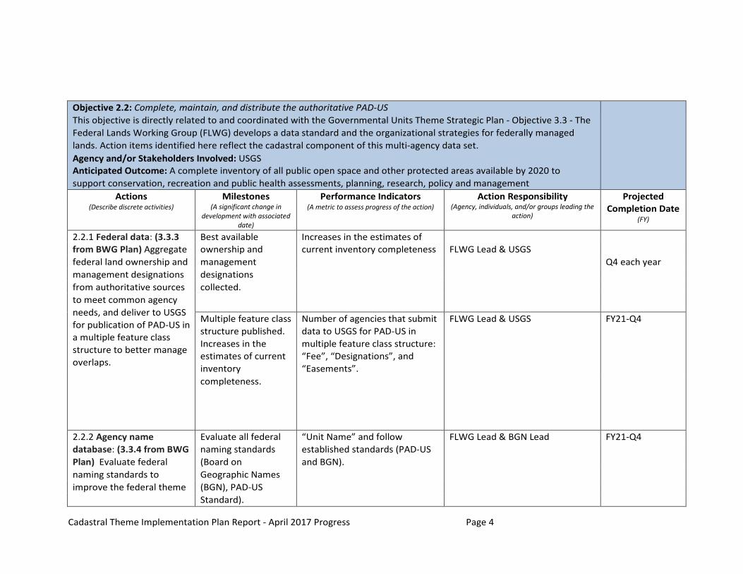
Objective 2.2: Complete, maintain, and distribute the authoritative PAD-US This objective is directly related to and coordinated with the Governmental Units Theme Strategic Plan - Objective 3.3 - The Federal Lands Working Group (FLWG) develops a data standard and the organizational strategies for federally managed lands. Action items identified here reflect the cadastral component of this multi-agency data set. Agency and/or Stakeholders Involved: USGS Anticipated Outcome: A complete inventory of all public open space and other protected areas available by 2020 to support conservation, recreation and public health assessments, planning, research, policy and management
Actions Milestones Performance Indicators Action Responsibility Projected (Describe discrete activities) (A significant change in
development with associated date)
(A metric to assess progress of the action) (Agency, individuals, and/or groups leading the action)
Completion Date (FY)
2.2.1 Federal data: (3.3.3 Best available Increases in the estimates of from BWG Plan) Aggregate ownership and current inventory completeness FLWG Lead & USGS federal land ownership and management Q4 each year management designations designations from authoritative sources collected. to meet common agency needs, and deliver to USGS for publication of PAD-US in a multiple feature class structure to better manage overlaps.
Multiple feature class structure published. Increases in the estimates of current inventory
Number of agencies that submit data to USGS for PAD-US in multiple feature class structure: “Fee”, “Designations”, and “Easements”.
FLWG Lead & USGS FY21-Q4
completeness.
2.2.2 Agency name Evaluate all federal “Unit Name” and follow FLWG Lead & BGN Lead FY21-Q4 database: (3.3.4 from BWG naming standards established standards (PAD-US Plan) Evaluate federal (Board on and BGN). naming standards to Geographic Names improve the federal theme (BGN), PAD-US
Standard).

Cadastral Theme Implementation Plan Report - April 2017 Progress Page 5
2.2.3 Boundary Reconciliation (3.3.5 from BWG Plan) Complete boundary adjudication effort with all applicable sources and agencies to reduce topology errors (overlaps and gaps) between agency datasets.
Assess ”Fee” lands topology errors (comparison with Current PLSS CadNSDI one of the steps)
Adjudication completed.
Number of agencies that collaborate to reduce topology errors.
Area of topology overlap errors reduced.
FLWG Lead
FLWG Lead
FY21-Q4
FY21-Q4
Agency and/or Stakeholder Activity through FY 2017 2.2.1 - FLWG Lead FLWG agencies have reviewed the plan for PAD-US 2.0 update, indicating whether updated data are available or if
no changes are required. Three agencies (US Forest Service, National Park Service and US Fish & Wildlife Service) have submitted data in the PAD-US 2.0 multiple feature class structure. The BLM is assessing whether easements are available for PAD-US 2.0 or 2.1.
2.2.2 - FLWG Lead NOTE: This activity is in conformance with the recommendations in the FGDC Cadastral Content Standard V 1.4 for Agency Name. No activity this quarter
2.2.3 - FLWG Ongoing progress

Cadastral Theme Implementation Plan Report - April 2017 Progress Page 6
Goal 3: Federal Subsurface Management Areas - Including offshore and continental There are two federal agencies responsible for federal subsurface rights management, the BLM on continental lands and Bureau of Ocean and Energy Management (BOEM) for offshore lands. Develop an effective aggregation and publication of BLM subsurface records and coordinate with BOEM offshore subsurface records, facilitate sharing and data availability socialization of the Subsurface Management Areas data sets, and establish ongoing coordination mechanisms. Objective 3.1: Develop an onshore (continental) nationwide federal subsurface rights data set Establish the standards of achievement in terms of a proportionate improvement in the existing condition. Objectives should be specific, measurable, audience- or issue-directed, realistic, and time-bound. Agency and/or Stakeholders Involved: BLM Anticipated Outcome: A nationwide data set that delineates lands where there is a federal interest in the minerals or other subsurface continental or onshore resources.
Actions (Describe discrete activities)
Milestones (A significant
change in development with associated date)
Performance Indicators
(A metric to assess progress of the action)
Action Responsibility (Agency, individuals, and/or groups leading the action)
Projected Completion Date
(FY )
3.1.1 Develop a core or essential data set content for subsurface rights
BLM
3.1.2 Develop pilot data sets for eastern (non-PLSS) and western (PLSS) and Alaska data sets and distribute for review and feedback.
BLM
3.1.3 Develop strategic plan and identified requirements to complete nationwide subsurface data set
BLM
Agency and/or Stakeholder Activity through FY 2017

Cadastral Theme Implementation Plan Report - April 2017 Progress Page 7
Objective 3.2: Develop an offshore nationwide federal subsurface rights data set for publishing and access through the NGDA services. This effort is the responsibility of BOEM. The following are the NGDA data sets and activities. Agency and/or Stakeholders Involved: BOEM Anticipated Outcome: A nationwide data set that delineates lands where there is a federal interest in the minerals or other subsurface offshore resources
Actions (Describe discrete activities)
Milestones (A significant
change in development with associated date)
Performance Indicators
(A metric to assess progress of
the action)
Action Responsibility (Agency, individuals, and/or groups leading the action)
Projected Completion Date
(FY )
3.2.1 Import NAD27 Outer Continental Shelf (OCS) Lease Blocks for the Gulf of Mexico Region into geodatabases and publish.
Contract awarded FY17/Q1
BOEM 2018
3.2.2 Generate and publish WGS84 OCS Lease Blocks and Official Protraction Diagrams of the principal islands of Hawaii (Pacific Islands dataset)
Blocks generated FY16/Q4
BOEM 2017
3.2.3 Update Official Protraction Diagrams to reflect the 200 nautical mile boundary (Exclusive Economic Zone boundary).
Approval from DOI SOL
BOEM 2018
3.2.4 Generate and publish WGS84 OCS Leases Blocks and Official Protraction Diagrams of Guam and the Northern Mariana Islands (Pacific Islands dataset)
BOEM 2019
3.2.5 Generate and publish BOEM 2018
Cadastral Theme Implementation Plan Report - April 2017 Progress Page 8
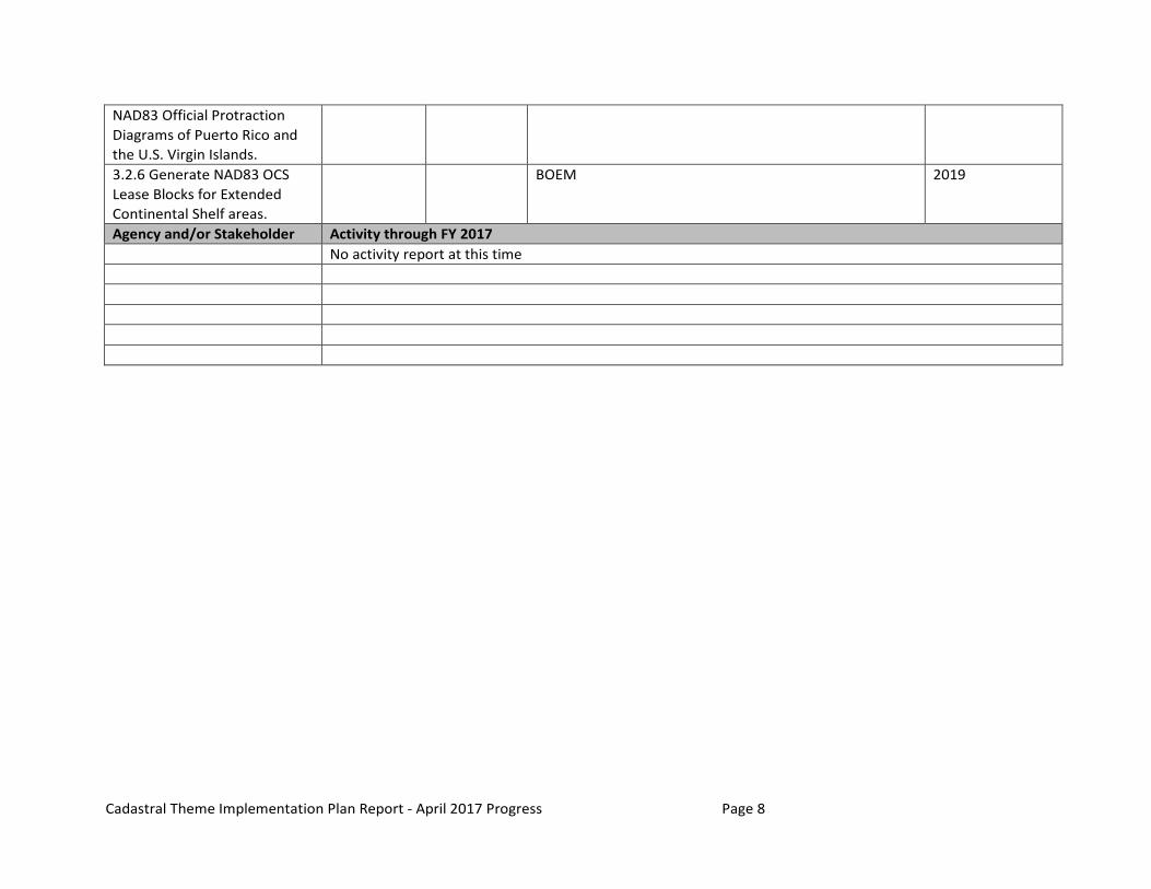
NAD83 Official Protraction Diagrams of Puerto Rico and the U.S. Virgin Islands.
3.2.6 Generate NAD83 OCS Lease Blocks for Extended Continental Shelf areas.
BOEM 2019
Agency and/or Stakeholder Activity through FY 2017 No activity report at this time

Cadastral Theme Implementation Plan Report - April 2017 Progress Page 9
Goal 4: Land Management Agency Coordination (Federal Land Management Agency Cadastral Coordination) Provide coordination with other land management agencies and support collection, maintenance, standardization, access, and publication within the scope and responsibilities of A-16. The objectives and action items are identified and are the responsibility of the lead agency listed in the objective.
Objective 4.1: National Park Service (NPS) Agency and/or Stakeholders Involved: NPS and BLM Anticipated Outcome: NPS is committed to providing regular updates to the best available geospatial data representing both the legislative boundary and parcel ownership information for all park system areas. NPS will continue efforts to improve the maintenance and standardization of this authoritative data in support of efforts like the Protected Areas Database for the US (PAD-US) and, over time the land title based SMA. NPS will continue to actively participate in inter-agency groups whose goal is to improve communication and coordination of multi- agency cadastral data.
Actions Milestones Performance Action Responsibility Projected (Describe discrete activities) Indicators (Agency, individuals, and/or groups leading the action) Completion
(A metric to assess progress of the action)
Date (FY )
4.1.1 NPS will continue to publish a national set of NGDA boundaries on Geoplatform.gov along with a data collection record containing links to ownership data layers and park specific metadata for each individual NPS unit.
NPS
4.1.2 NPS will continue to provide park specific downloads of legislative boundaries, primary ownership data, and park specific metadata on the NPS data clearinghouse, (IRMA). (https://irma.nps.gov/Portal)
NPS
4.1.3 NPS will continue to update this NGDA data quarterly as well as provide notification to the Federal geospatial data community whenever the data is
NPS

Cadastral Theme Implementation Plan Report - April 2017 Progress Page 10
updated. 4.1.4 NPS will continue work with FWS and USGS Gap Analysis Program to refine PAD-US translation routines as necessary. NPS will work with FWS to finalize and distribute documentation of this effort in order to provide potential guidance to other agencies.
NPS
4.1.5 NPS will continue to be an active participant in inter-agency groups that are dedicated to the sharing and standardization of cadastral data like the NBG, the FGDC Cadastral Subcommittee, and the FLS.
NPS
Agency and/or Stakeholder Activity through FY 2017 No activity report at this time
Cadastral Theme Implementation Plan Report - April 2017 Progress Page 11
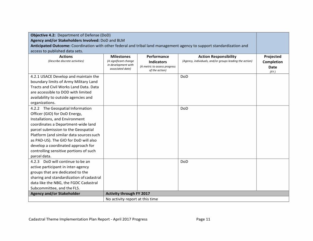
Objective 4.2: Department of Defense (DoD) Agency and/or Stakeholders Involved: DoD and BLM Anticipated Outcome: Coordination with other federal and tribal land management agency to support standardization and access to published data sets.
Actions (Describe discrete activities)
Milestones (A significant change in development with
associated date)
Performance Indicators
(A metric to assess progress of the action)
Action Responsibility (Agency, individuals, and/or groups leading the action)
Projected Completion
Date (FY )
4.2.1 USACE Develop and maintain the boundary limits of Army Military Land Tracts and Civil Works Land Data. Data are accessible to DOD with limited availability to outside agencies and organizations.
DoD
4.2.2 The Geospatial Information Officer (GIO) for DoD Energy, Installations, and Environment coordinates a Department-wide land parcel submission to the Geospatial Platform (and similar data sources such as PAD-US). The GIO for DoD will also develop a coordinated approach for controlling sensitive portions of such parcel data.
DoD
4.2.3 DoD will continue to be an active participant in inter-agency groups that are dedicated to the sharing and standardization of cadastral data like the NBG, the FGDC Cadastral Subcommittee, and the FLS.
DoD
Agency and/or Stakeholder Activity through FY 2017 No activity report at this time

Cadastral Theme Implementation Plan Report - April 2017 Progress Page 12
Objective 4.3: Forest Service (FS) Agency and/or Stakeholders Involved: FS and BLM Anticipated Outcome: Coordination with other federal and tribal land management agency to support standardization and access to published data sets.
Actions (Describe discrete activities)
Milestones Performance Indicators
Action Responsibility (Agency, individuals, and/or groups leading the action)
Projected Completion
Date (FY )
4.3.1 Continue to provide updates to FS managed lands to PAD-US, for citizen access on web sites, and other agencies or requesters.
FS
4.3.2 Continue to maintain the FS Land Status Record System (LSRS) data sets
FS
4.3.3 FS will continue to be an active participant in inter-agency groups that are dedicated to the sharing and standardization of cadastral data like the NBG, the FGDC Cadastral Subcommittee, and the FLS.
FS
4.3.4 Explore registering the FS LSRS to PLSS CadNSDI on a continuing basis
This is an identified objective but no funding or resources have been identified to accomplish this objective.
None
Agency and/or Stakeholder Activity through FY 2017 4.3.1 - FS Provided data updates to PAD-US

Cadastral Theme Implementation Plan Report - April 2017 Progress Page 13
Objective 4.4: Fish and Wildlife Service (FWS) Agency and/or Stakeholders Involved: FWS and BLM Anticipated Outcome: Coordination with other federal and tribal land management agency to support standardization and access to published data sets.
Actions (Describe discrete activities)
Milestones (A significant change in
development with associated date)
Performance Indicators
(A metric to assess progress of the action)
Action Responsibility (Agency, individuals, and/or groups leading the action)
Projected Completion Date
(FY )
4.4.1 Continue to provide updates to FWS managed lands to PAD-US, for citizen access on web sites, and other agencies or requesters.
FWS
4.4.2 Continue to maintain the FWS lands data sets.
FWS
4.4.3 FWS will continue to be an active participant in inter- agency groups that are dedicated to the sharing and standardization of cadastral data like the NBG, the FGDC Cadastral Subcommittee, and the FLS.
FWS
Agency and/or Stakeholder Activity through FY 2017 4.4.1 - FWS Provided data updates to PAD-US
Cadastral Theme Implementation Plan Report - April 2017 Progress Page 14
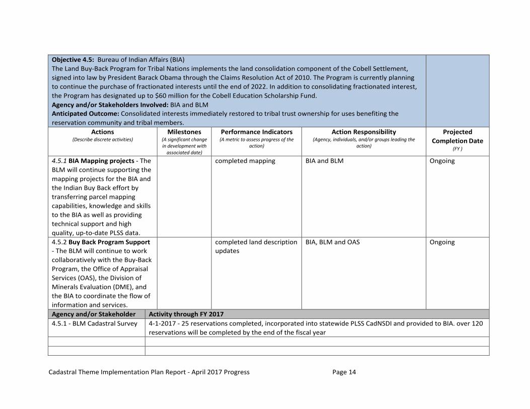
Objective 4.5: Bureau of Indian Affairs (BIA) The Land Buy-Back Program for Tribal Nations implements the land consolidation component of the Cobell Settlement, signed into law by President Barack Obama through the Claims Resolution Act of 2010. The Program is currently planning to continue the purchase of fractionated interests until the end of 2022. In addition to consolidating fractionated interest, the Program has designated up to $60 million for the Cobell Education Scholarship Fund. Agency and/or Stakeholders Involved: BIA and BLM Anticipated Outcome: Consolidated interests immediately restored to tribal trust ownership for uses benefiting the reservation community and tribal members.
Actions (Describe discrete activities)
Milestones (A significant change in development with
associated date)
Performance Indicators (A metric to assess progress of the
action)
Action Responsibility (Agency, individuals, and/or groups leading the
action)
Projected Completion Date
(FY )
4.5.1 BIA Mapping projects - The BLM will continue supporting the mapping projects for the BIA and the Indian Buy Back effort by transferring parcel mapping capabilities, knowledge and skills to the BIA as well as providing technical support and high quality, up-to-date PLSS data.
completed mapping BIA and BLM Ongoing
4.5.2 Buy Back Program Support - The BLM will continue to work collaboratively with the Buy-Back Program, the Office of Appraisal Services (OAS), the Division of Minerals Evaluation (DME), and the BIA to coordinate the flow of information and services.
completed land description updates
BIA, BLM and OAS Ongoing
Agency and/or Stakeholder Activity through FY 2017 4.5.1 - BLM Cadastral Survey 4-1-2017 - 25 reservations completed, incorporated into statewide PLSS CadNSDI and provided to BIA. over 120
reservations will be completed by the end of the fiscal year
Cadastral Theme Implementation Plan Report - April 2017 Progress Page 15
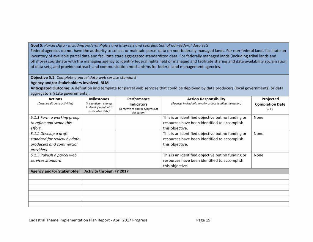
Goal 5: Parcel Data - Including Federal Rights and Interests and coordination of non-federal data sets Federal agencies do not have the authority to collect or maintain parcel data on non-federally managed lands. For non-federal lands facilitate an inventory of available parcel data and facilitate state aggregated standardized data. For federally managed lands (including tribal lands and offshore) coordinate with the managing agency to identify federal rights held or managed and facilitate sharing and data availability socialization of data sets, and provide outreach and communication mechanisms for federal land management agencies.
Objective 5.1: Complete a parcel data web service standard Agency and/or Stakeholders Involved: BLM Anticipated Outcome: A definition and template for parcel web services that could be deployed by data producers (local governments) or data aggregators (state governments).
Actions (Describe discrete activities)
Milestones (A significant change in development with
associated date)
Performance Indicators
(A metric to assess progress of the action)
Action Responsibility (Agency, individuals, and/or groups leading the action)
Projected Completion Date
(FY )
5.1.1 Form a working group to refine and scope this effort.
This is an identified objective but no funding or resources have been identified to accomplish this objective.
None
5.1.2 Develop a draft standard for review by data producers and commercial providers
This is an identified objective but no funding or resources have been identified to accomplish this objective.
None
5.1.3 Publish a parcel web services standard
This is an identified objective but no funding or resources have been identified to accomplish this objective.
None
Agency and/or Stakeholder Activity through FY 2017

Cadastral Theme Implementation Plan Report - April 2017 Progress Page 16
Goal 6: Coordination (Across Themes and Levels of Government and the Private Sector) Cadastral data by its nature is used by many other themes and also consumes data from other themes. We have identified several coordination agencies and themes and will continue to work with these other themes to ensure consistent standardization, vertical alignment, and appropriate currency.
Objective 6.1: Inputs - Identify themes that collect data that affect cadastral data Agency and/or Stakeholders Involved: BLM and Cadastral data stewards Anticipated Outcome: Continuous improvement and update of cadastral data themes and vertical integration with other themes
Actions (Describe discrete activities)
Milestones (A significant change in
development with associated date)
Performance Indicators
(A metric to assess progress of the action)
Action Responsibility (Agency, individuals, and/or groups leading the action)
Projected Completion Date
(FY )
6.1.1 Integrate coordinates for international boundaries from International Boundary Commission as they become available
International Boundary Commissions
6.1.2 Define and pilot the accommodation of non-PLSS boundaries that may or may not be surveyed but are needed to map parcels with federal interests and may or may not have coincident boundaries with federal authority surveys (e.g., boundaries that reference cultural or physical features).
Federal Land Agencies affected by non-PLSS features.
Agency and/or Stakeholder Activity through FY 2017

Cadastral Theme Implementation Plan Report - April 2017 Progress Page 17
Objective 6.2: Outreach Identify and establish connections with Data Stewards and known and new data users Agency and/or Stakeholders Involved: BLM and Cadastral data stewards Anticipated Outcome: Provide data updates to data users, track how the data are used, identify feedback from users, and provide updates.
Actions Milestones Performance Action Responsibility Projected (Describe discrete activities) (A significant change in
development with associated date)
Indicators (A metric to assess
progress of the action)
(Agency, individuals, and/or groups leading the action) Completion Date (FY )
6.2.1 Coordinate and work with the Government Units Strategic Plan Objective 3.1 Action 3.1.4 and Action 3.1.5 - Collaboration on identifying cadastral and boundary coincidence.
BLM, Boundaries Working Group
6.2.2 Provide access to updated data sets on an easily accessible web site. Socialize the availability of updates through social media outlets and direct emailing
Covered under Objective 2.1 included here for reference under outreach
6.2.3 Identify state level This is an identified objective but no funding or None data stewards and their resources have been identified to accomplish needs and capacity to this objective. support updates. Agency and/or Stakeholder Activity through FY 2017 6.2.1 - BLM and volunteer contributions
Participated in Esri Federal UC Conference with presentation on activities and progress. Participated in IAAO/URISA conference on National parcel forum
Cadastral Theme Implementation Plan Report - April 2017 Progress Page 18
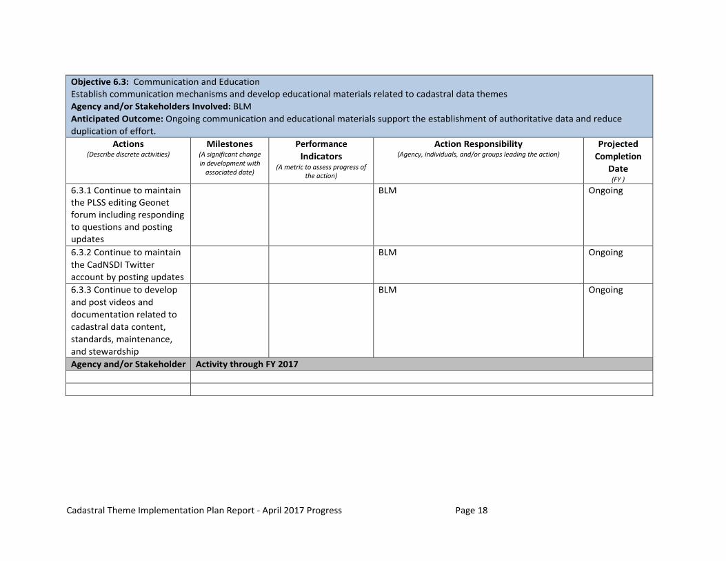
Objective 6.3: Communication and Education Establish communication mechanisms and develop educational materials related to cadastral data themes Agency and/or Stakeholders Involved: BLM Anticipated Outcome: Ongoing communication and educational materials support the establishment of authoritative data and reduce duplication of effort.
Actions (Describe discrete activities)
Milestones (A significant change in development with
associated date)
Performance Indicators
(A metric to assess progress of the action)
Action Responsibility (Agency, individuals, and/or groups leading the action)
Projected Completion
Date (FY )
6.3.1 Continue to maintain the PLSS editing Geonet forum including responding to questions and posting updates
BLM Ongoing
6.3.2 Continue to maintain the CadNSDI Twitter account by posting updates
BLM Ongoing
6.3.3 Continue to develop and post videos and documentation related to cadastral data content, standards, maintenance, and stewardship
BLM Ongoing
Agency and/or Stakeholder Activity through FY 2017