theme strategic plan for cadastral theme - national...
TRANSCRIPT

CadastralThemeImplementationPlanReport-April2017ProgressPage1
ThemeStrategicPlanfor
CadastralTheme
BureauofLandManagement-CadastralSurvey
FederalGeographicDataCommittee(FGDC)
2017–2021
April2017-ProgressandUpdate

CadastralThemeImplementationPlanReport-April2017ProgressPage1
Cadastral(Cadastre)ThemeFY2017ImplementationPlanReport
ThemePersonnelThemeLead(Co-Leads): Don Buhler and Robert AderThemeLeadAgency(ies): Bureau of Land Management (BLM) - Cadastral
Survey/GeosciencesExecutiveThemeChampion(s): Tod Dabolt
ExecutiveChampionAgency(ies): Department of Interior CadastralThemeNGDADatasets NGDAAgencyU.S.ArmyCorpsofEngineersCivilWorkLandData DOD-USACEBIAIndianLandsDataset(IndianLandsoftheUnitedStates) DOI-BIAPublicLandSurveySystem(PLSS)DatasetCatalog DOI-BLMDepartmentofDefenseLandParcelsandSites DOD-AT&LBLMNationalSurfaceManagementAgency:AreaPolygons,WithdrawalAreaPolygons,andSpecialPublicPurposeWithdrawalAreaPolygons DOI-BLMFSNationalForestDataset(USForestServiceProclaimedForests) USDA-USFSFWSInterest DOI-FWSNPSNationalParksDataset DOI-NPSOuterContinentalShelfActiveRenewableEnergyLeases DOI-BOEMOuterContinentalShelfBlockAliquots DOI-BOEMOuterContinentalShelfLeaseBlocks-AlaskaRegionNAD83 DOI-BOEMOuterContinentalShelfLeaseBlocks-AtlanticRegionNAD83 DOI-BOEMOuterContinentalShelfLeaseBlocks-GulfofMexicoRegionNAD27 DOI-BOEMOuterContinentalShelfLeaseBlocks-PacificRegion-WestCoastNAD83 DOI-BOEMOuterContinentalShelfOfficialProtractionDiagrams-AlaskaRegionNAD83 DOI-BOEMOuterContinentalShelfOfficialProtractionDiagrams-AtlanticRegionNAD83 DOI-BOEMOuterContinentalShelfOfficialProtractionDiagramsAndLeaseMaps-GulfOfMexicoRegionNAD27 DOI-BOEMOuterContinentalShelfOfficialProtractionDiagrams-PacificRegion-WestCoastNAD83 DOI-BOEMProtectedAreasDatabaseoftheUnitedStates(PAD-US) DOI-USGS
StrategicThemePlan:http://nationalcad.org/download/StrategicPlanCadastral-Submitted.pdf

CadastralThemeImplementationPlanReport-April2017ProgressPage2
HumanandFinancialResourcesNeededforThemeManagementThistableincludesanestimateofresourcesneededformanagingtheThemeandincludestherolesthatsupportthememanagement,coordination,andsupport.ThepercentFullTimeEquivalentandgradeareanestimate.ThisestimatedoesnotincludetheresourcesrequiredtodevelopandmaintaintheCadastraldatasetsoragencycoremissionrequirements.
DescriptionofThemeManagementActivitiesRole
(ThemeLead,DatasetManager,Coordinator,otherasspecified)
%FTE FTEGrade
A–16NGDAThememanagement(e.g.,attendmeetings,reviewNGDAdocuments,developThemeStrategicPlans,etc.)(repeatforco-ThemeLeads)
ThemeLead .10 13
OtherThemeadministrationactivitiesWorkgroupcoordinationandsupport(threeworkgroups)
3-Workgroupsupport .30 12
Providecommunityinformation,publishanddisseminatestandardsofinterest,coordinatewithvendorsandprivatesectortoimplementstandardsandprovidestandardizedcadastraldata,maintainaninventoryofauthoritativesources,maintainalistingofworkgroupparticipantsandCadastralSubcommitteemembers,andprovideFGDCannualreports.
ReportingandAdministrativeTheme
Support.15 12
ThemeAdministrationTotal%FTE&Estimated$ .55 $TheCadastralTheme,unlikemanyoftheotherframeworkthemes,isreliantonlocalandstatedataproducersfordatasetcollection,maintenance,andpublicationandtheprivatesectorandvendorsupportfortechnologyandstandardsimplementation.Thefederalagenciesdonothavetheauthorityregardingnationalcadastraldataproductionandarelimitedtofederallymanagedsurfaceandsubsurfacelands.TheCadastralSubcommitteeeffortsinthisarenaarelimitedtoprovidingguidancethroughstandardsdevelopment,whichiscompleted,andtoprovidecoordinationandeducationsupportaspossible.

CadastralThemeImplementationPlanReport-April2017ProgressPage1
Goal1:CadastralReference-IncludingthePubicLandSurveySystem(PLSS)andOthersIdentifystateandfederaldatastewardsforCadastralReference,coordinateandsupporttheeffectivecollectionandmaintenanceoftheCadastralReferenceNationalGeospatialDataAsset(NGDA)Datasets,facilitatesharinganddataavailabilitysocializationoftheCadastralReferencedatasets,andprovideoutreachandcommunicationmechanismsfordatastewardsObjective1.1:CompletePLSSDataStewardProgram Agencyand/orStakeholdersInvolved:AllFederalLandmanagementagencies,stateagenciesandlocalgovernmentsinthe30PublicDomainStatesAnticipatedOutcome:MaintainedPLSSdatasetsforall30publicdomainstates,updatedatleastannualasneeded,establishingasingleauthoritativePLSSdatasetforeachstate
Actions(Describediscreteactivities)
Milestones(Asignificantchangein
developmentwithassociateddate)
PerformanceIndicators
(Ametrictoassessprogressoftheaction)
ActionResponsibility(Agency,individuals,and/orgroupsleadingtheaction)
ProjectedCompletionDate
(FY)
1.1.1ContinuousupdateofPLSSdatasets
completeupdatedata
Datasetimprovementoccursincrementally
BLMCadastralSurvey 2017andongoing
1.1.2PublishupdatesofPLSSdatatoNGDAservices
publisheddatasets
publisheddatasets
BLMCadastralSurvey 2017
Agencyand/orStakeholder ActivitythroughFY20171.1.1-BLMCadastralSurvey 4-1-17-over125townshipsareundercontractandthenewcontractshouldcomplete100additional
townships.Thenumberofspecialsurveysrangesfrom48tomorethan800inasingletownship.Over20,000specialsurveyshavebeenaddedthusfarin2017.Stateboundariesandnewcontrolareaddedonacontinuousbasis.
1.1.2-BLMCadastralSurvey 4-1-17-BLMdatapublishingsiteexposesPLSSDatasetsandmetadata,featureservicescominglaterthisyearhttps://navigator.blm.gov/data?keyword=cadastral

CadastralThemeImplementationPlanReport-April2017ProgressPage2
Objective1.2:Completenon-PLSSCadastralReferenceDataSetDefinitionsAgencyand/orStakeholdersInvolved:AllFederalLandManagementAgencies,stateagenciesandlocalgovernmentsinthe20non-PLSSStatesAnticipatedOutcome:Define,review,andadoptacadastralreferencesystemforeachofthe20non-PLSSstates.Maintainablepublishedcadastralreferencedatasetforeachofthe20non-PLSSstateswithdatadocumentation.Thisisnotafundedactivitythereforeestablishingmilestonesandprojectedcompletionisnotfeasible.Volunteercontributionsfromnon-federalstakeholdersandtheprivatesectorarebeingadvancedvoluntarily.
Actions(Describediscreteactivities)
Milestones(Asignificantchangeindevelopmentwithassociateddate)
PerformanceIndicators
(Ametrictoassessprogressoftheaction)
ActionResponsibility(Agency,individuals,and/orgroupsleadingtheaction)
ProjectedCompletionDate
(FY)
1.2.1Establishanon-PLSScadastralreferencecommunity
None DraftNon-PLSSreferencedocumented
Thisisanidentifiedobjectivebutnofundingorresourceshavebeenidentifiedtoaccomplishthisobjective.
None
1.2.2Developandsocializedraftnon-PLSScadastraldatasettogatherinputfromnon-PLSSdatastewards.
None inputgatheredfromdataproducersandusers
Thisisanidentifiedobjectivebutnofundingorresourceshavebeenidentifiedtoaccomplishthisobjective.
None
1.2.3Finalizenon-PLSScadastralreferencedatasetwithdocumentationandpublishtonationalcad.org
None Non-PLSSreferencedocumented
Thisisanidentifiedobjectivebutnofundingorresourceshavebeenidentifiedtoaccomplishthisobjective.
None
Agencyand/orStakeholder ActivitythroughFY20171.2.1-VolunteerEfforts Initialinvestigationsoftheneedandexamplesofnon-PLSSreferencesystemshavestarted.Thisisavolunteer
effortthatisbeingaccomplishedbynon-federalandprivatesectorstakeholders

CadastralThemeImplementationPlanReport-April2017ProgressPage3
Goal2:PublicLandsSurfaceAgencyManagementCoordinatewiththeUSGeologicalSurvey(USGS)indevelopingtheProtectedAreasDatabaseoftheUS(PAD-US),arepresentationoffederallyownedlandsandmanagementdesignations.ProvideBLMmanagedsurfacelandsupdatestoPAD-US,whilecontinuingtodevelopthelandtitleandlandrecordsbaseddatasetfortheSurfaceManagementAgency(SMA),supportthepublicationofPAD-USdatabaseanddatasetstoNGDAservices,facilitatesharinganddataavailabilitysocializationoftheSMAandPAD-USinformation,andprovideoutreachandcommunicationmechanismsfordatastewards.
Objective2.1:StandardizeBLMSubmissionstothePAD-USAgencyand/orStakeholdersInvolved:BLMandUSGSAnticipatedOutcome:AnautomatedandconsistentworkflowanddatasubmissionforPAD-USupdatesonanannualbasisfromBLMNationalOperationsCenter(NOC).Completionofadatabasedrivemastertitleplatprocessthatwillupdatefederallandinformation.
Actions(Describediscreteactivities)
Milestones(Asignificantchangeindevelopmentwithassociateddate)
PerformanceIndicators
(Ametrictoassessprogressoftheaction)
ActionResponsibility(Agency,individuals,and/orgroupsleadingtheaction)
ProjectedCompletionDate
(FY)
2.1.1DocumentdatasubmissionrequirementsforBLMStateOffices
BLM
2.1.2ReviewcurrentBLMlandmanagement(SMA)datasets,updateandmaintenanceandsubmissionprocedures.IdentifyaBLMleadofficeforcoordinationandsubmissions.
BLMwillpublishSMAdatasetwithstandardagencydesignations.PAD-US,USGS,USCensus,othergovernmentorganizations,andthepubliccandownloadthisdatafromBLM.
Agencyand/orStakeholder ActivitythroughFY2017

CadastralThemeImplementationPlanReport-April2017ProgressPage4
Objective2.2:Complete,maintain,anddistributetheauthoritativePAD-USThisobjectiveisdirectlyrelatedtoandcoordinatedwiththeGovernmentalUnitsThemeStrategicPlan-Objective3.3-TheFederalLandsWorkingGroup(FLWG)developsadatastandardandtheorganizationalstrategiesforfederallymanagedlands.Actionitemsidentifiedherereflectthecadastralcomponentofthismulti-agencydataset.Agencyand/orStakeholdersInvolved:USGSAnticipatedOutcome:Acompleteinventoryofallpublicopenspaceandotherprotectedareasavailableby2020tosupportconservation,recreationandpublichealthassessments,planning,research,policyandmanagement
Actions(Describediscreteactivities)
Milestones(Asignificantchangein
developmentwithassociateddate)
PerformanceIndicators(Ametrictoassessprogressoftheaction)
ActionResponsibility(Agency,individuals,and/orgroupsleadingthe
action)
ProjectedCompletionDate
(FY)
2.2.1Federaldata:(3.3.3fromBWGPlan)Aggregatefederallandownershipandmanagementdesignationsfromauthoritativesourcestomeetcommonagencyneeds,anddelivertoUSGSforpublicationofPAD-USinamultiplefeatureclassstructuretobettermanageoverlaps.
Bestavailableownershipandmanagementdesignationscollected.
Increasesintheestimatesofcurrentinventorycompleteness
FLWGLead&USGS
Q4eachyear
Multiplefeatureclassstructurepublished.Increasesintheestimatesofcurrentinventorycompleteness.
NumberofagenciesthatsubmitdatatoUSGSforPAD-USinmultiplefeatureclassstructure:“Fee”,“Designations”,and“Easements”.
FLWGLead&USGS
FY21-Q4
2.2.2Agencynamedatabase:(3.3.4fromBWGPlan)Evaluatefederalnamingstandardstoimprovethefederaltheme
Evaluateallfederalnamingstandards(BoardonGeographicNames(BGN),PAD-USStandard).
“UnitName”andfollowestablishedstandards(PAD-USandBGN).
FLWGLead&BGNLead
FY21-Q4

CadastralThemeImplementationPlanReport-April2017ProgressPage5
2.2.3BoundaryReconciliation(3.3.5fromBWGPlan)Completeboundaryadjudicationeffortwithallapplicablesourcesandagenciestoreducetopologyerrors(overlapsandgaps)betweenagencydatasets.
Assess”Fee”landstopologyerrors(comparisonwithCurrentPLSSCadNSDIoneofthesteps)Adjudicationcompleted.
Numberofagenciesthatcollaboratetoreducetopologyerrors.Areaoftopologyoverlaperrorsreduced.
FLWGLeadFLWGLead
FY21-Q4FY21-Q4
Agencyand/orStakeholder ActivitythroughFY20172.2.1-FLWGLead FLWGagencieshavereviewedtheplanforPAD-US2.0update,indicatingwhetherupdateddataareavailableorif
nochangesarerequired.Threeagencies(USForestService,NationalParkServiceandUSFish&WildlifeService)havesubmitteddatainthePAD-US2.0multiplefeatureclassstructure.TheBLMisassessingwhethereasementsareavailableforPAD-US2.0or2.1.
2.2.2-FLWGLead NOTE:ThisactivityisinconformancewiththerecommendationsintheFGDCCadastralContentStandardV1.4forAgencyName.Noactivitythisquarter
2.2.3-FLWG Ongoingprogress

CadastralThemeImplementationPlanReport-April2017ProgressPage6
Goal3:FederalSubsurfaceManagementAreas-IncludingoffshoreandcontinentalTherearetwofederalagenciesresponsibleforfederalsubsurfacerightsmanagement,theBLMoncontinentallandsandBureauofOceanandEnergyManagement(BOEM)foroffshorelands.DevelopaneffectiveaggregationandpublicationofBLMsubsurfacerecordsandcoordinatewithBOEMoffshoresubsurfacerecords,facilitatesharinganddataavailabilitysocializationoftheSubsurfaceManagementAreasdatasets,andestablishongoingcoordinationmechanisms.Objective3.1:Developanonshore(continental)nationwidefederalsubsurfacerightsdatasetEstablishthestandardsofachievementintermsofaproportionateimprovementintheexistingcondition.Objectivesshouldbespecific,measurable,audience-orissue-directed,realistic,andtime-bound.Agencyand/orStakeholdersInvolved:BLMAnticipatedOutcome:Anationwidedatasetthatdelineateslandswherethereisafederalinterestinthemineralsorothersubsurfacecontinentaloronshoreresources.
Actions(Describediscreteactivities)
Milestones(Asignificantchangein
developmentwithassociateddate)
PerformanceIndicators
(Ametrictoassessprogressoftheaction)
ActionResponsibility(Agency,individuals,and/orgroupsleadingtheaction)
ProjectedCompletionDate
(FY)
3.1.1Developacoreoressentialdatasetcontentforsubsurfacerights
BLM
3.1.2Developpilotdatasetsforeastern(non-PLSS)andwestern(PLSS)andAlaskadatasetsanddistributeforreviewandfeedback.
BLM
3.1.3Developstrategicplanandidentifiedrequirementstocompletenationwidesubsurfacedataset
BLM
Agencyand/orStakeholder ActivitythroughFY2017

CadastralThemeImplementationPlanReport-April2017ProgressPage7
Objective3.2:DevelopanoffshorenationwidefederalsubsurfacerightsdatasetforpublishingandaccessthroughtheNGDAservices.ThiseffortistheresponsibilityofBOEM.ThefollowingaretheNGDAdatasetsandactivities.Agencyand/orStakeholdersInvolved:BOEMAnticipatedOutcome:Anationwidedatasetthatdelineateslandswherethereisafederalinterestinthemineralsorothersubsurfaceoffshoreresources
Actions(Describediscreteactivities)
Milestones(Asignificantchangein
developmentwithassociateddate)
PerformanceIndicators(Ametricto
assessprogressoftheaction)
ActionResponsibility(Agency,individuals,and/orgroupsleadingtheaction)
ProjectedCompletionDate
(FY)
3.2.1ImportNAD27OuterContinentalShelf(OCS)LeaseBlocksfortheGulfofMexicoRegionintogeodatabasesandpublish.
ContractawardedFY17/Q1
BOEM 2018
3.2.2GenerateandpublishWGS84OCSLeaseBlocksandOfficialProtractionDiagramsoftheprincipalislandsofHawaii(PacificIslandsdataset)
BlocksgeneratedFY16/Q4
BOEM 2017
3.2.3UpdateOfficialProtractionDiagramstoreflectthe200nauticalmileboundary(ExclusiveEconomicZoneboundary).
ApprovalfromDOISOL
BOEM 2018
3.2.4GenerateandpublishWGS84OCSLeasesBlocksandOfficialProtractionDiagramsofGuamandtheNorthernMarianaIslands(PacificIslandsdataset)
BOEM 2019
3.2.5Generateandpublish BOEM 2018

CadastralThemeImplementationPlanReport-April2017ProgressPage8
NAD83OfficialProtractionDiagramsofPuertoRicoandtheU.S.VirginIslands.3.2.6GenerateNAD83OCSLeaseBlocksforExtendedContinentalShelfareas.
BOEM 2019
Agencyand/orStakeholder ActivitythroughFY2017 Noactivityreportatthistime
CadastralThemeImplementationPlanReport-April2017ProgressPage9
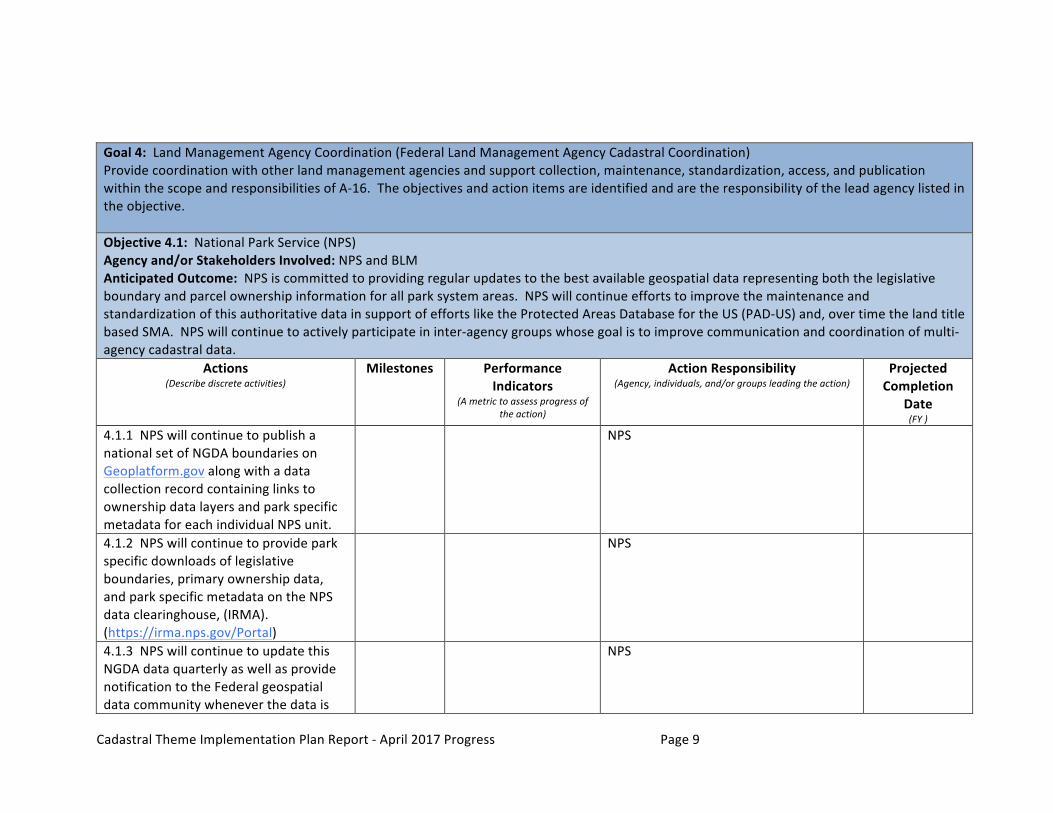
Goal4:LandManagementAgencyCoordination(FederalLandManagementAgencyCadastralCoordination)Providecoordinationwithotherlandmanagementagenciesandsupportcollection,maintenance,standardization,access,andpublicationwithinthescopeandresponsibilitiesofA-16.Theobjectivesandactionitemsareidentifiedandaretheresponsibilityoftheleadagencylistedintheobjective.Objective4.1:NationalParkService(NPS)Agencyand/orStakeholdersInvolved:NPSandBLMAnticipatedOutcome:NPSiscommittedtoprovidingregularupdatestothebestavailablegeospatialdatarepresentingboththelegislativeboundaryandparcelownershipinformationforallparksystemareas.NPSwillcontinueeffortstoimprovethemaintenanceandstandardizationofthisauthoritativedatainsupportofeffortsliketheProtectedAreasDatabasefortheUS(PAD-US)and,overtimethelandtitlebasedSMA.NPSwillcontinuetoactivelyparticipateininter-agencygroupswhosegoalistoimprovecommunicationandcoordinationofmulti-agencycadastraldata.
Actions(Describediscreteactivities)
Milestones
PerformanceIndicators
(Ametrictoassessprogressoftheaction)
ActionResponsibility(Agency,individuals,and/orgroupsleadingtheaction)
ProjectedCompletion
Date(FY)
4.1.1NPSwillcontinuetopublishanationalsetofNGDAboundariesonGeoplatform.govalongwithadatacollectionrecordcontaininglinkstoownershipdatalayersandparkspecificmetadataforeachindividualNPSunit.
NPS
4.1.2NPSwillcontinuetoprovideparkspecificdownloadsoflegislativeboundaries,primaryownershipdata,andparkspecificmetadataontheNPSdataclearinghouse,(IRMA).(https://irma.nps.gov/Portal)
NPS
4.1.3NPSwillcontinuetoupdatethisNGDAdataquarterlyaswellasprovidenotificationtotheFederalgeospatialdatacommunitywheneverthedatais
NPS

CadastralThemeImplementationPlanReport-April2017ProgressPage10
updated.4.1.4NPSwillcontinueworkwithFWSandUSGSGapAnalysisProgramtorefinePAD-UStranslationroutinesasnecessary.NPSwillworkwithFWStofinalizeanddistributedocumentationofthiseffortinordertoprovidepotentialguidancetootheragencies.
NPS
4.1.5NPSwillcontinuetobeanactiveparticipantininter-agencygroupsthatarededicatedtothesharingandstandardizationofcadastraldataliketheNBG,theFGDCCadastralSubcommittee,andtheFLS.
NPS
Agencyand/orStakeholder ActivitythroughFY2017 Noactivityreportatthistime

CadastralThemeImplementationPlanReport-April2017ProgressPage11
Objective4.2:DepartmentofDefense(DoD)Agencyand/orStakeholdersInvolved:DoDandBLMAnticipatedOutcome:Coordinationwithotherfederalandtriballandmanagementagencytosupportstandardizationandaccesstopublisheddatasets.
Actions(Describediscreteactivities)
Milestones(Asignificantchangeindevelopmentwithassociateddate)
PerformanceIndicators
(Ametrictoassessprogressoftheaction)
ActionResponsibility(Agency,individuals,and/orgroupsleadingtheaction)
ProjectedCompletion
Date(FY)
4.2.1USACEDevelopandmaintaintheboundarylimitsofArmyMilitaryLandTractsandCivilWorksLandData.DataareaccessibletoDODwithlimitedavailabilitytooutsideagenciesandorganizations.
DoD
4.2.2TheGeospatialInformationOfficer(GIO)forDoDEnergy,Installations,andEnvironmentcoordinatesaDepartment-widelandparcelsubmissiontotheGeospatialPlatform(andsimilardatasourcessuchasPAD-US).TheGIOforDoDwillalsodevelopacoordinatedapproachforcontrollingsensitiveportionsofsuchparceldata.
DoD
4.2.3DoDwillcontinuetobeanactiveparticipantininter-agencygroupsthatarededicatedtothesharingandstandardizationofcadastraldataliketheNBG,theFGDCCadastralSubcommittee,andtheFLS.
DoD
Agencyand/orStakeholder ActivitythroughFY2017 Noactivityreportatthistime
CadastralThemeImplementationPlanReport-April2017ProgressPage12
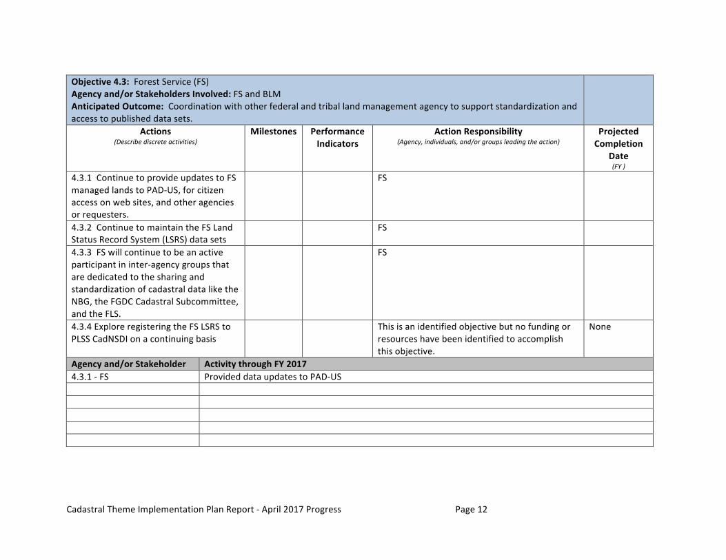
Objective4.3:ForestService(FS)Agencyand/orStakeholdersInvolved:FSandBLMAnticipatedOutcome:Coordinationwithotherfederalandtriballandmanagementagencytosupportstandardizationandaccesstopublisheddatasets.
Actions(Describediscreteactivities)
Milestones
PerformanceIndicators
ActionResponsibility(Agency,individuals,and/orgroupsleadingtheaction)
ProjectedCompletion
Date(FY)
4.3.1ContinuetoprovideupdatestoFSmanagedlandstoPAD-US,forcitizenaccessonwebsites,andotheragenciesorrequesters.
FS
4.3.2ContinuetomaintaintheFSLandStatusRecordSystem(LSRS)datasets
FS
4.3.3FSwillcontinuetobeanactiveparticipantininter-agencygroupsthatarededicatedtothesharingandstandardizationofcadastraldataliketheNBG,theFGDCCadastralSubcommittee,andtheFLS.
FS
4.3.4ExploreregisteringtheFSLSRStoPLSSCadNSDIonacontinuingbasis
Thisisanidentifiedobjectivebutnofundingorresourceshavebeenidentifiedtoaccomplishthisobjective.
None
Agencyand/orStakeholder ActivitythroughFY20174.3.1-FS ProvideddataupdatestoPAD-US

CadastralThemeImplementationPlanReport-April2017ProgressPage13
Objective4.4:FishandWildlifeService(FWS)Agencyand/orStakeholdersInvolved:FWSandBLMAnticipatedOutcome:Coordinationwithotherfederalandtriballandmanagementagencytosupportstandardizationandaccesstopublisheddatasets.
Actions(Describediscreteactivities)
Milestones(Asignificantchangein
developmentwithassociateddate)
PerformanceIndicators
(Ametrictoassessprogressoftheaction)
ActionResponsibility(Agency,individuals,and/orgroupsleadingtheaction)
ProjectedCompletionDate
(FY)
4.4.1ContinuetoprovideupdatestoFWSmanagedlandstoPAD-US,forcitizenaccessonwebsites,andotheragenciesorrequesters.
FWS
4.4.2ContinuetomaintaintheFWSlandsdatasets.
FWS
4.4.3FWSwillcontinuetobeanactiveparticipantininter-agencygroupsthatarededicatedtothesharingandstandardizationofcadastraldataliketheNBG,theFGDCCadastralSubcommittee,andtheFLS.
FWS
Agencyand/orStakeholder ActivitythroughFY20174.4.1-FWS ProvideddataupdatestoPAD-US

CadastralThemeImplementationPlanReport-April2017ProgressPage14
Objective4.5:BureauofIndianAffairs(BIA)TheLandBuy-BackProgramforTribalNationsimplementsthelandconsolidationcomponentoftheCobellSettlement,signedintolawbyPresidentBarackObamathroughtheClaimsResolutionActof2010.TheProgramiscurrentlyplanningtocontinuethepurchaseoffractionatedinterestsuntiltheendof2022.Inadditiontoconsolidatingfractionatedinterest,theProgramhasdesignatedupto$60millionfortheCobellEducationScholarshipFund.Agencyand/orStakeholdersInvolved:BIAandBLMAnticipatedOutcome:Consolidatedinterestsimmediatelyrestoredtotribaltrustownershipforusesbenefitingthereservationcommunityandtribalmembers.
Actions(Describediscreteactivities)
Milestones(Asignificantchangeindevelopmentwithassociateddate)
PerformanceIndicators(Ametrictoassessprogressofthe
action)
ActionResponsibility(Agency,individuals,and/orgroupsleadingthe
action)
ProjectedCompletionDate
(FY)
4.5.1BIAMappingprojects-TheBLMwillcontinuesupportingthemappingprojectsfortheBIAandtheIndianBuyBackeffortbytransferringparcelmappingcapabilities,knowledgeandskillstotheBIAaswellasprovidingtechnicalsupportandhighquality,up-to-datePLSSdata.
completedmapping BIAandBLM Ongoing
4.5.2BuyBackProgramSupport-TheBLMwillcontinuetoworkcollaborativelywiththeBuy-BackProgram,theOfficeofAppraisalServices(OAS),theDivisionofMineralsEvaluation(DME),andtheBIAtocoordinatetheflowofinformationandservices.
completedlanddescriptionupdates
BIA,BLMandOAS Ongoing
Agencyand/orStakeholder ActivitythroughFY20174.5.1-BLMCadastralSurvey 4-1-2017-25reservationscompleted,incorporatedintostatewidePLSSCadNSDIandprovidedtoBIA.over120
reservationswillbecompletedbytheendofthefiscalyear

CadastralThemeImplementationPlanReport-April2017ProgressPage15
Goal5:ParcelData-IncludingFederalRightsandInterestsandcoordinationofnon-federaldatasetsFederalagenciesdonothavetheauthoritytocollectormaintainparceldataonnon-federallymanagedlands.Fornon-federallandsfacilitateaninventoryofavailableparceldataandfacilitatestateaggregatedstandardizeddata.Forfederallymanagedlands(includingtriballandsandoffshore)coordinatewiththemanagingagencytoidentifyfederalrightsheldormanagedandfacilitatesharinganddataavailabilitysocializationofdatasets,andprovideoutreachandcommunicationmechanismsforfederallandmanagementagencies.Objective5.1:CompleteaparceldatawebservicestandardAgencyand/orStakeholdersInvolved:BLMAnticipatedOutcome:Adefinitionandtemplateforparcelwebservicesthatcouldbedeployedbydataproducers(localgovernments)ordataaggregators(stategovernments).
Actions(Describediscreteactivities)
Milestones(Asignificantchangeindevelopmentwithassociateddate)
PerformanceIndicators
(Ametrictoassessprogressoftheaction)
ActionResponsibility(Agency,individuals,and/orgroupsleadingtheaction)
ProjectedCompletionDate
(FY)
5.1.1Formaworkinggrouptorefineandscopethiseffort.
Thisisanidentifiedobjectivebutnofundingorresourceshavebeenidentifiedtoaccomplishthisobjective.
None
5.1.2Developadraftstandardforreviewbydataproducersandcommercialproviders
Thisisanidentifiedobjectivebutnofundingorresourceshavebeenidentifiedtoaccomplishthisobjective.
None
5.1.3Publishaparcelwebservicesstandard
Thisisanidentifiedobjectivebutnofundingorresourceshavebeenidentifiedtoaccomplishthisobjective.
None
Agencyand/orStakeholder ActivitythroughFY2017
CadastralThemeImplementationPlanReport-April2017ProgressPage16
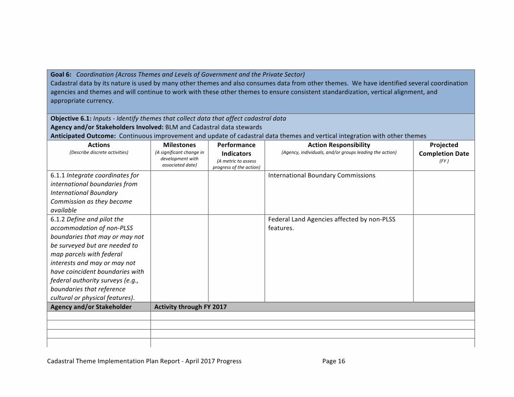
Goal6:Coordination(AcrossThemesandLevelsofGovernmentandthePrivateSector)Cadastraldatabyitsnatureisusedbymanyotherthemesandalsoconsumesdatafromotherthemes.Wehaveidentifiedseveralcoordinationagenciesandthemesandwillcontinuetoworkwiththeseotherthemestoensureconsistentstandardization,verticalalignment,andappropriatecurrency.Objective6.1:Inputs-IdentifythemesthatcollectdatathataffectcadastraldataAgencyand/orStakeholdersInvolved:BLMandCadastraldatastewardsAnticipatedOutcome:Continuousimprovementandupdateofcadastraldatathemesandverticalintegrationwithotherthemes
Actions(Describediscreteactivities)
Milestones(Asignificantchangein
developmentwithassociateddate)
PerformanceIndicators
(Ametrictoassessprogressoftheaction)
ActionResponsibility(Agency,individuals,and/orgroupsleadingtheaction)
ProjectedCompletionDate
(FY)
6.1.1IntegratecoordinatesforinternationalboundariesfromInternationalBoundaryCommissionastheybecomeavailable
InternationalBoundaryCommissions
6.1.2Defineandpilottheaccommodationofnon-PLSSboundariesthatmayormaynotbesurveyedbutareneededtomapparcelswithfederalinterestsandmayormaynothavecoincidentboundarieswithfederalauthoritysurveys(e.g.,boundariesthatreferenceculturalorphysicalfeatures).
FederalLandAgenciesaffectedbynon-PLSSfeatures.
Agencyand/orStakeholder ActivitythroughFY2017

CadastralThemeImplementationPlanReport-April2017ProgressPage17
Objective6.2:OutreachIdentifyandestablishconnectionswithDataStewardsandknownandnewdatausersAgencyand/orStakeholdersInvolved:BLMandCadastraldatastewardsAnticipatedOutcome:Providedataupdatestodatausers,trackhowthedataareused,identifyfeedbackfromusers,andprovideupdates.
Actions(Describediscreteactivities)
Milestones(Asignificantchangein
developmentwithassociateddate)
PerformanceIndicators
(Ametrictoassessprogressoftheaction)
ActionResponsibility(Agency,individuals,and/orgroupsleadingtheaction)
ProjectedCompletionDate
(FY)
6.2.1CoordinateandworkwiththeGovernmentUnitsStrategicPlanObjective3.1Action3.1.4andAction3.1.5-Collaborationonidentifyingcadastralandboundarycoincidence.
BLM,BoundariesWorkingGroup
6.2.2Provideaccesstoupdateddatasetsonaneasilyaccessiblewebsite.Socializetheavailabilityofupdatesthroughsocialmediaoutletsanddirectemailing
CoveredunderObjective2.1includedhereforreferenceunderoutreach
6.2.3Identifystateleveldatastewardsandtheirneedsandcapacitytosupportupdates.
Thisisanidentifiedobjectivebutnofundingorresourceshavebeenidentifiedtoaccomplishthisobjective.
None
Agencyand/orStakeholder ActivitythroughFY20176.2.1-BLMandvolunteercontributions
ParticipatedinEsriFederalUCConferencewithpresentationonactivitiesandprogress.ParticipatedinIAAO/URISAconferenceonNationalparcelforum

CadastralThemeImplementationPlanReport-April2017ProgressPage18
Objective6.3:CommunicationandEducationEstablishcommunicationmechanismsanddevelopeducationalmaterialsrelatedtocadastraldatathemesAgencyand/orStakeholdersInvolved:BLMAnticipatedOutcome:Ongoingcommunicationandeducationalmaterialssupporttheestablishmentofauthoritativedataandreduceduplicationofeffort.
Actions(Describediscreteactivities)
Milestones(Asignificantchangeindevelopmentwithassociateddate)
PerformanceIndicators
(Ametrictoassessprogressoftheaction)
ActionResponsibility(Agency,individuals,and/orgroupsleadingtheaction)
ProjectedCompletion
Date(FY)
6.3.1ContinuetomaintainthePLSSeditingGeonetforumincludingrespondingtoquestionsandpostingupdates
BLM Ongoing
6.3.2ContinuetomaintaintheCadNSDITwitteraccountbypostingupdates
BLM Ongoing
6.3.3Continuetodevelopandpostvideosanddocumentationrelatedtocadastraldatacontent,standards,maintenance,andstewardship
BLM Ongoing
Agencyand/orStakeholder ActivitythroughFY2017