the wmo rolling review of requirements (rrr) · wmo rolling review of requirements (rrr) ... other...
TRANSCRIPT
The WMO Rolling Review of Requirements (RRR)
Etienne Charpentier Chief, Observing Systems Division
CAeM Management Group, 24 Jan. 2018

WMO Rolling Review of Requirements (RRR)
http://www.wmo.int/egos
• Addressing the requirements for all WMO applications • Initiated in early 2000s’ through the WMO Space
Programme in cooperation with CEOS • Regulated in the WIGOS Manual (WMO No. 1160, para
2.2.4 and Appendix 2.3), and GOS Manual (WMO No. 588) Members, both directly and through the participation of their experts in the activities of regional associations and technical commissions, shall contribute to the RRR process and assist the designated Points of Contact for each application area in performing their roles in the RRR
• Commission for Basic Systems (CBS) in charge of RRR – Inter Programme Expert Team on Observing System Design and
Evolution (IPET-OSDE) • Chairperson, Erik Andersson, ECMWF

WMO Application Areas
Definition: an activity involving primary use of observations, in a chain of activities which allow NMHSs or other organizations to render services contributing to public safety, socio-economic well-being and development in their respective countries, in a specific domain related to weather, climate and water. The concept of a WMO Application Area is used in the framework of the WMO Rolling Review of Requirements (RRR) and describes a homogeneous activity for which it is possible to compile a consistent set of observational user requirements agreed by community experts working operationally in this area. 1. Global Numerical Weather Prediction 2. High Resolution Numerical Weather Prediction 3. Nowcasting and Very Short Range Forecasting 4. Sub-seasonal to longer predictions 5. Aeronautical Meteorology 6. Forecasting Atmospheric Composition 7. Monitoring Atmospheric Composition 8. Providing Atmospheric Composition information to support services in urban and
populated areas 9. Ocean Applications 10. Agricultural Meteorology 11. Hydrology 12. Climate Monitoring (GCOS) 13. Climate Applications (Other aspects, addressed by the Commission for Climatology) 14. Space Weather 15. Climate Science Cross cutting:
• Global Cryosphere Watch (GCW) • Global Framework for Climate Services (GFCS)

Observing systems contributing to WIGOS
• Space-based
– Geostationary
– Polar orbiting LEO
– Eliptical orbit, ....
• Surface-based
– Surface stations (RBSN, RBCN, AWS ..)
– Climate stations (GSN)
– Upper air soundings (incl. GUAN, GRUAN)
– Wind profilers
– Weather radars
– Lightning detection systems
– Aircrafts (e.g. AMDAR)
– Aeronautical stations
– Hydrological stations (WHOS)
– Atmospheric composition, air quality monitoring (GAW)
– Cryosphere observations (GCW)
– Marine observations (drifters, floats, moorings, tide gauges, ships, gliders …)
– Terrestrial observations (GTOS)
– Surface-based space weather observations
– GNSS radio-occultation
– …
USERS
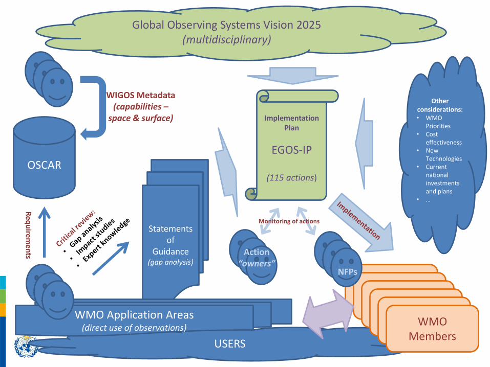
Global Observing Systems Vision 2025 (multidisciplinary)
OSCAR
Req
uirem
ents
Statements of
Guidance (gap analysis)
WMO Application Areas (direct use of observations)
WIGOS Metadata (capabilities –
space & surface) Implementation Plan
EGOS-IP
(115 actions)
Other considerations: • WMO
Priorities • Cost
effectiveness • New
Technologies • Current
national investments and plans
• …
WMO Members
Action “owners”
NFPs
Monitoring of actions

The RRR process
• OSCAR Platform (oscar.wmo.int) includes – OSCAR/Requirements (“technology free”) – Observing systems capabilities
• OSCAR/Space: Space-based capabilities • OSCAR/Surface: Surface-based capabilities (operated with MeteoSwiss)
• Critical review – Assessing gaps by comparing capabilities vs. requirements – Undertaking Impact Studies, e.g.
• Observing System Experiments (OSEs) • Observing System Simulation Experiments (OSSEs) • Forecast Error Contribution (FEC), Forecast Sensitivity to Observations (FSO), …
– Analysed by Experts to produce gap analysis and Statements of Guidance (SoGs)
• SoGs reviewed by IPET-OSDE • Feeds into the ET-EGOS Implementation plan, and Vision of the GOS
– Current EGOS-IP responding to the Vision of the GOS in 2025 – Vision for WIGOS Component Observing Systems in 2040 in development
with Cg-18 approval target

7
How user requirements are specified in OSCAR/Requirements
• Technology free, quantitative
• For each application & each geophysical variable
– Horizontal resolution
– Vertical resolution
– Accuracy
– Observing cycle
– Timeliness (Delay)
– Long term stability
• For each parameter
– “min” (or threshold)
• value below which observations are worthless
– “max” (or goal)
• value beyond which improvement gives no additional value
– “breakthrough” (or optimum)
• proposed target for significant progress
• optimal cost/benefit
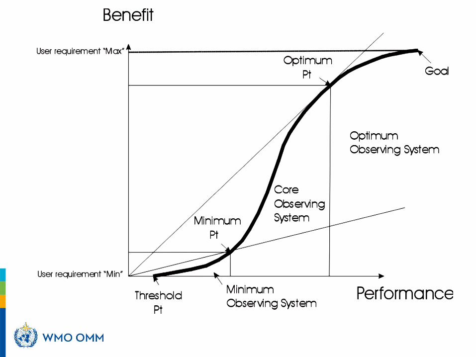
Performance-benefit curve for an observing system


Aeronautical Meteorology Requirements (example)

Statements of Guidance (gap analysis)
• The Statement of Guidance interprets the output of the critical review as a gap analysis and identifies priorities for action: the most feasible, beneficial and affordable initiatives to deal with the identified gaps or shortcomings in WMO observing systems for an application area. This draws on the subjective judgement and experience of the Points of Contact, the experts and other stakeholders they consult within their application area.
• This stage of the RRR requires the Points of Contact to coordinate with their application area community and stakeholders, as needed, in order to produce, review and revise the Statement of Guidance for the application area.

Statement of Guidance for Aeronautical Meteorology
• Developed (coordinated) by PoC for Aeronautical Meteorology, Dr Jitze van der Meulen
• Latest version : June 2016
• Support to air traffic safety in first place
• Then support to efficiency & capacity for economical and environmental benfits

Statement of Guidance for Aeronautical Meteorology – Summary 1/2
• Locally higher vertical resolution is required for development and verification of turbulence forecast algorithms as well as in support of future 4D trajectory planning of aircraft. Enhanced collection of aircraft data (e.g. AMDAR / ADS-B / Mode-S) may improve accuracy in support of more efficient ATM in the terminal areas of busy airports
• For warnings, satellite imagery and higher-level products such as multi-spectral images, provide good guidance for location and intensity of convection. However scanning radars in networks combined with lightning detection systems currently have the cycle times of less than 10 min required for air traffic control and supporting air traffic management. It is expected that the next generation of geostationary satellites with more frequent scanning capabilities in conjunction with improved lightning imagers is getting closer to these requirements
• For turbulence and gravity wave detection and prediction, current in-situ instruments have acceptable vertical resolution, but are not available in sufficient density for all areas of the globe. The AMDAR / ADS / Mode-S is a data source with a high potential to fill existing data gaps in the medium term, water vapour imagery is beginning to show potential for subjective detection of steepening waves and vorticity advection, leading to Clear Air Turbulence

Statement of Guidance for Aeronautical Meteorology – Summary 2/2
• For forecasts and warnings in the wider terminal area, in-situ and ground-based remote sensing technology has the potential to meet requirements, but its high cost inhibits general, global availability. In particular, the possible extension of data requirements for new terminal forecasts and warnings for the larger approach-and departure areas, to be developed in close collaboration with ICAO, meso-networks, including lightning detection, LIDAR and Doppler WXR (increasingly with dual-polarization functionality) coupled with Nowcasting algorithms, may become necessary for larger airports. Deployment of automatic instruments for measuring conventional parameters at airport such as surface wind, pressure, visibility and cloud will also need continuous improvements. In support of winter operations, runway pavement temperature measurements should be envisaged. Freezing point depression and runway (surface) condition measurements could be envisaged as well.
• For en route forecasts for VFR flights, ground based observations are not meeting the required data density except for some densely populated areas. Satellite imagery and specialized products have acceptable horizontal resolution, but lack the information on visibility and ceiling height for low cloud.
• For forecasts and real time nowcasting in the terminal zone ground based observations shall be as required and documented in the WMO Technical Regulations (WMO-No. 49, Vol. II). In practice these requirements are fully met, although the transition from human (visual) observations to fully automized observations is challenging resulting in a reconsideration of observational requirements. To improve short-term forecasts high resolution (in time and space) NWP models are introduced, modeling in real time the atmosphere above the aerodrome and its vicinity. This practice requires new observation technologies to support model initialization, developed for atmospheric research and mainly with remote sensing.
• For the detection of volcanic ash clouds and eruptions, satellite and ground based remote-sensing has significant detection and quantitative determination capability. Close cooperation with the CTBTO in using seismic and sonic data is improving the detection of volcanic eruptions in remote areas.
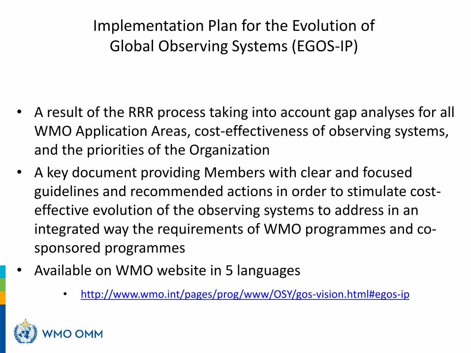
Implementation Plan for the Evolution of Global Observing Systems (EGOS-IP)
• A result of the RRR process taking into account gap analyses for all WMO Application Areas, cost-effectiveness of observing systems, and the priorities of the Organization
• A key document providing Members with clear and focused guidelines and recommended actions in order to stimulate cost-effective evolution of the observing systems to address in an integrated way the requirements of WMO programmes and co-sponsored programmes
• Available on WMO website in 5 languages
• http://www.wmo.int/pages/prog/www/OSY/gos-vision.html#egos-ip

115 EGOS-IP Actions
13 Overarching and cross-cutting actions (C1 to C13)
– e.g. C8 - For WMO and co-sponsored observing systems, ensure continued adherence to WMO data sharing principles irrespective of origin of data, including data provided by commercial entities
59 Surface-based observing systems actions (G1 to G59)
– E.g. G22 - Continue the development and operational implementation of humidity sensors as an integrated component of the AMDAR system to ensure that humidity data is, processed and transmitted in the same way as wind and temperature
– E.g. G23 - Enhance and extend the capability to report observations of atmospheric turbulence and icing variables as an integrated component of the AMDAR system and in line with the requirements of the relevant programme areas and data users
– E.g. G45 - Increase the deployment, calibration and use of dual polarization radars in those regions where it is beneficial
35 Space-based observing systems actions (S1 to S35)
– e.g. S6 - Maintain and develop the GSICS inter-comparisons and inter-calibrations between GEO and LEO sensors on an operational basis.
8 Space weather actions (W1 to W8)
– E.g. W2 - To coordinate and to standardize the existing ground-based solar observation data, and to expand them where required for redundancy, and to develop a common data portal or virtual observatory within the WIS

Current focus of WMO regarding RRR
1. CBS monitoring implementation of EGOS-IP actions by Members and identified agents
2. CBS providing additional guidance to Members for better addressing the gaps (i.e. in addition to EGOS-IP)
3. Updating observational user requirements in OSCAR/Requirements and the Statements of Guidance (liaison with identified Points of Contact)
4. Making sure observing systems capabilities are up to date in OSCAR/Surface and OSCAR/Space
5. Conducting impact studies per list of science questions identified by CBS-16 per Recommendation 31 (CBS-16) and Decision 24 (EC-69)
6. Development of new WIGOS Vision 2040 (to replace the current Vision for the GOS in 2025) – target Cg-18 in 2019

More information
Website: http://www.wmo.int/pages/prog/www/OSY/GOS-redesign.html
Vision for the GOS in 2015: http://www.wmo.int/pages/prog/www/OSY/gos-vision.html
Statements of Guidance: http://www.wmo.int/pages/prog/www/OSY/GOS-RRR.html#SoG
EGOS-IP: http://www.wmo.int/pages/prog/www/OSY/gos-vision.html#egos-ip
OSCAR: http://oscar.wmo.int
Contact : [email protected]

Thank you Merci