the urban transformation of traditional city …
TRANSCRIPT

Sabeeh L. Farhan, Mohamed Gamal Abdelmonem, Zuhair A. Nasar Archnet-IJAR, Volume 12 - Issue 3 - November 2018 - (53-67) – Regular Section
Copyright © 2018 | Copyrights are granted to author(s), Archnet-IJAR, and Archnet @ MIT under the terms of the "CC-BY-NC-ND" License.
53
Archnet-IJAR: International Journal of Architectural Research www.archnet-ijar.net/ -- https://archnet.org/collections/34
THE URBAN TRANSFORMATION OF TRADITIONAL CITY CENTRES: HOLY KARBALA AS A CASE STUDY DOI: http://dx.doi.org/10.26687/archnet-ijar.v12i3.1625
Sabeeh L. Farhan, Mohamed Gamal Abdelmonem, Zuhair A. Nasar
Keywords Abstract
holy Karbala; urban transformation; architectural preservation; traditional urban fabric; holy shrines
Karbala is one of the metropolitan cities in Iraq, its historic and religious centre has a long history, yet many of its buildings are under threat because of unclear conservation management due to urban transformation. The history of religious rituals and processions reflects an array of values, concepts and planning philosophy that has used the power of religion and holiness of the city as a source of homogeneity and integration. By looking at the mass-pilgrimage spatial practices to the Holy Shrines in Karbala city centre and the adaptation by its residents of their domestic neighbourhoods, this paper analyses the spatial conditions of the city and offers insights into a set of factors that have shaped its historical evolution and urban spaces. The paper is in three parts; first, it discusses the causes of the urban transformation in this holy city. Secondly, it documents a set of everyday practices and problems in Karbala city, focusing on the urban level (the traditional fabric), following the analytical method of the historic evolution of Karbala as a religious centre as well as the incompatibility of the modern development with the centre’s historical heritage. Thirdly, it analyses the transformation of the urban structure by discussing the characteristics of the historical centre and the role of legislation in urban transformation of traditional city centres.
ArchNet-IJAR is indexed and listed in several databases, including: • Avery Index to Architectural
Periodicals • EBSCO-Current Abstracts-Art
and Architecture • CNKI: China National
Knowledge Infrastructure • DOAJ: Directory of Open
Access Journals • Pro-Quest • Scopus-Elsevier • Web of Science
Sabeeh L. Farhan, Wasit University, Iraq; School of Architecture, Design and Built Environment, Nottingham Trent University; e-mail: [email protected] & [email protected] M. G. Abdelmonem, School of Architecture, Design and Built Environment, Nottingham Trent University; e-mail: [email protected] Zuhair A. Nasar, University of Kufa, Iraq; School of Architecture; [email protected], University of Liverpool; [email protected]
*Corresponding Author’s email address: [email protected]

International Journal of Architectural Research
Sabeeh L. Farhan, Mohamed Gamal Abdelmonem, Zuhair A. Nasar Archnet-IJAR, Volume 12 - Issue 3 - November 2018 - (53-67) – Regular Section
Copyright © 2018 | Copyrights are granted to author(s), Archnet-IJAR, and Archnet @ MIT under the terms of the "CC-BY-NC-ND" License.
54
INTRODUCTION
Cities with holy Islamic shrines are characterized by similar features (Akbar, 1988), where the mosque represents the core of the city morphology surrounded by the traditional markets (bazaars or souqs) (Hakim,1986) and then followed by the residential areas, and in some cases, a fortified wall to protect it (Abdelmonem et al., 2017). The only difference with the traditional Islamic Cities is that the Holy Shrine and its mosque represent the city's urban centre (Nasar, 2015). Many factors have transformed the urban structure of traditional holy cities including social, economic, legislative and functional (Demet, 2018). The transformation of the urban structure may end up to the point of interruption (Hussam, 2013 and Rossi, 1973). Likewise, that transformation is measured not only by space but by its timeline (Shimma & Habibi, 2004; Rossi, 1973). Changing needs create new urban functions that must be responded to by the urban structure (Bilal, 1995), which leads to the introduction of new architectural and urban forms (Rossi, 1982). The urban structure is not just an independent and steadily evolving entity, (Abdelmonem, 2017) but rather part of an ongoing developmental and evolutionary process (Nakanishi, 2014).
There are two approaches to understanding the transformation of the urban structure (Laursen, 2009). Such transformation cannot occur unless the residents gain special meaning from the surrounding environment (Montgomery, 2004). Urban transformation has two aspects: either positive, via interacting the new elements with the existing components of the old city and its traditional functions (Atanur, 2006), or negative, as in 1960s Turkey when the migration and displacement of the countryside and villages to the city began in parallel with rapid industrialization and economic development. The negative pressures caused by the concentration of the country's population into urban centres, lead to unplanned urbanization, destruction of agricultural land, lack of transportation, poor infrastructure and environmental problems (Sophia, 2012). This type of event may lead to unplanned urban land use, mainly when there is a weak or absent supervisory role to regulate the administration of the city.
The holy city of Karbala is considered one of the most important spiritual and ideological cities amongst both Iraqi Shi’ite Muslims and Shi’ite Muslims in other parts of the Islamic world (Khalili, 1978). Karbala contains the tomb of Imam Al Hussein (grandson of the Prophet Muhammad) and his brother Abbas, and all the heroes of the Al Taf massacre (Attia, 1997). Thus, visitor numbers to this city throughout the year have been increasing steadily. According to The General Administration, Secretariat of Imam Hussein Holy Shrine, there are 36 holy events during the Shi'ite Islamic Calendar (The General Secretariat of the Holy Husseiniya, 2017). However, two events are considered the busiest where millions of Shia Muslims visit the site twice a year. The first is the anniversary of Imam Hussein’s death, where up to 8 million pilgrims visit the city to observe the tenth of Muharram; and the second, larger event, is forty days later, when up to 30 million pilgrims visit the Holy Shrine. This second event continues for about two weeks (Husein, 2018), and most of the pilgrim’s travel by foot from all over Iraq and many other countries. Additionally, there are two other events where up to 4 million Shia Muslims gather near the Holy Shrines (Al Baladiyya, 1988). One is the 15th of Shaban (the birthday of the last Imam of Shia) and the other is the 9th of Dhul Hijjah, the Day of Arafah which is the second day of the Hajj pilgrimage in Mecca (Hiyam, 2012).
Due to the gradual increase in the numbers of pilgrims, the old traditional city centre has transformed with urban renewal, expansion, development, etc., all carried out with one approach, namely demolition and destruction of the traditional urban fabric (Faraj, 2012).

International Journal of Architectural Research
Sabeeh L. Farhan, Mohamed Gamal Abdelmonem, Zuhair A. Nasar Archnet-IJAR, Volume 12 - Issue 3 - November 2018 - (53-67) – Regular Section
Copyright © 2018 | Copyrights are granted to author(s), Archnet-IJAR, and Archnet @ MIT under the terms of the "CC-BY-NC-ND" License.
55
Karbala currently has two main challenges. First, it is historically similar to the rest of the Arabic and Islamic world on several issues, and most importantly, its growing importance as a pilgrimage destination. Secondly and more significantly, because Karbala is more complicated than other pilgrimage cities, due to the unlimited high number of visitors throughout the year (Attia, 2008). This puts a large burden on the city’s services as the population swells from a few thousand permanent residents to several million people in times of pilgrimage. The impact of this rapid commercial growth in the city, which is an outcome of the continuing increase in visitors, has initiated the growth and random expansion of commercial areas with these now overtaking the residential areas. It is worth mentioning that the old city of Karbala comprises of 6 neighbourhoods which are Bab Baghdad, Bab Al Taq, Bab Al Salalima, Bab Al Khan and Bab Al Najaf (Al-Kalidar, 1971). The open area between the shrines was created by demolishing a huge number of housing units after the Shabaniyya Revolution in 1991, after which no signs of urban development occurred. Karbala has expanded towards the south and south-west side, due to the existence of green areas (figure 2).
Even though there is an urgent need to improve the urban infrastructure, this improvement must be studied, planned, and very well designed, taking into consideration the spiritual history, the heritage, and urban aspects of this ancient city centre. Therefore, it could be said there is a lack of awareness of how the historical centre is changing, consequently deforming its character. This research paper aims to study the architecture of the historical city centre of Holy Karbala. It attempts to identify the nature of the urban transformation in the face of the evolving pilgrimage routes and the subsequent socio-economic forces with a view to recommending how to manage this change and preserve the urban characteristics and history of the city centre.
METHODOLOGY
This paper is based on the descriptive and analytical approach. By collecting data from different sources, such as previous studies, official reports and government documents, there is evidence to show how the historical city centre of Karbala has changed. The Directorate of Urban Planning in Karbala also provided materials: namely the two main master plans of Karbala post 2003. The first study was conducted in 2007 by World Research Centre, in association with the Ministry of Municipalities and Public Works. The study attempted to set out the master plan of Karbala city, including the old town. In 2011 the Ministry of Municipalities and Public Works / General Directorate of Physical Planning contracted Dewan Architects and Engineers to set out the urban renewal of the historical centre of Karbala.
The Karbala archives had insufficient materials. Interviews have proved to be one of the most powerful ways of gathering information to understand specific approaches to urban transformation. Therefore, this paper depends on the theoretical investigation, spatial analysis and analytical discussions with local authorities (provincial councils), architects, planners, decision-makers (government officials), religious scholars, local residents and people who have visited the city frequently. Twenty interviews were conducted in Karbala. The information was gathered through talking with experts in the city and asking about their experiences, perceptions and practices. The questionnaire for experts in urban planning and architecture was limited to this specific sample because the research is specialized, requiring academic opinion coupled with scientific experimentation to provide an accurate assessment

International Journal of Architectural Research
Sabeeh L. Farhan, Mohamed Gamal Abdelmonem, Zuhair A. Nasar Archnet-IJAR, Volume 12 - Issue 3 - November 2018 - (53-67) – Regular Section
Copyright © 2018 | Copyrights are granted to author(s), Archnet-IJAR, and Archnet @ MIT under the terms of the "CC-BY-NC-ND" License.
56
of the situation. This methodology offers the opportunity to answer the question about Karbala’s urban transformation.
HISTORIC EVOLUTION OF KARBALA AS A RELIGIOUS CENTRE
The city of Karbala is located 100km south of Baghdad (Capital of Iraq) (Figure 1). It covers an area of 5023 km2 (Iraq- Ministry of Planning, 2010 and Republic of Iraq Ministry of Planning Central Statistical Organization, 2010). Demographic statistics are available from http://cosit.gov.iq/en/joomla-templates.
According to Iraqi Central Statistical Organization, Karbala Governorate has a population of 1,003,516 citizens, (Al-Mufid, 1981) and the city dates back to Babylonian times about 1736 BC. It has been called Karbala, Karbala+Ta, in the cuneiform plates, since the first millennium BC. However, it became significant after the martyrdom of Imam Hussein and his family and supporters, in the Battle of Karbala, in 680 AD (al-Tabari, 1991). This coincided with year 61 in the Islamic or Hijri calendar. Imam Hussein is buried in Karbala, on the site of his death and the battle.
According to Al-Qarashi (2007) and Nakash (1993), Imam Hussein was a grandson of the Islamic Prophet Muhammad, and the second son of Ali ibn Abi Talib (the first Shia Imam and the fourth Rashid caliph of Sunni Islam). He is an important and honoured figure in Islam as he was a member of Ahl al-Bayṫ of Muhammad, the Prophet family, as well as being the third Shia Imam, after his father and his older brother Imam Al-Hassan.
As reported by Abu al-Faraj al-Isfahani (897– 967AD), historian of Arab-Quraysh, the battle of Karbala is also called Al-Taff battle. It was an epic event that took place on 10 Muharram,
Figure 1. The Geographic location of Karbala: (Source: General Authority for Geological Survey, 2000).

International Journal of Architectural Research
Sabeeh L. Farhan, Mohamed Gamal Abdelmonem, Zuhair A. Nasar Archnet-IJAR, Volume 12 - Issue 3 - November 2018 - (53-67) – Regular Section
Copyright © 2018 | Copyrights are granted to author(s), Archnet-IJAR, and Archnet @ MIT under the terms of the "CC-BY-NC-ND" License.
57
year 61 of the Hijra, Islamic calendar, (Nakash, 1993) which corresponds to October 10, 680 AD. The battle took place between a small group of around 70 supporters and relatives of Imam Hussein, and a larger military detachment from the forces of Yazid, the Umayyad caliph (Faraj, 2012). Although this battle is of little military importance, the battle has a central place in Shia history, tradition and theology, and it has frequently been recounted in Shia Islamic literature (Howard, 1990). The tomb of Imam Al-Hussein in Karbala became a holy place for Shias where visits are accompanied by the echo of special supplications during the various events.
After the tenth of Muharram, which is the first month in the Islamic calendar, (61 AH / 680 AD), many pilgrims visit his holy grave. Consequently, many of them settled nearby. This led to the beginnings of the holy city of Karbala, which has evolved and expanded since that time. Initially, the various settlements were very small due to severe water shortages in the area (Aqil, 2004). The most significant change was in the early 18th century when a dam was built at the head of the Husseiniyya Canal, and consequentially the old city started to expand tremendously from that point.
Due to the influx of visitors, many residential and religious buildings were constructed around the mausoleum (Al-Kildar, 1967). The ancient city of Karbala is densely built up around the mausoleum in the form of elongations due to the characteristics of the site. Narrow paths have penetrated the area leading to the formation of seven irregular neighbourhoods (Ansari, 2006).
THE CITY OF KARBALA AND ITS CURRENT URBAN SITUATION
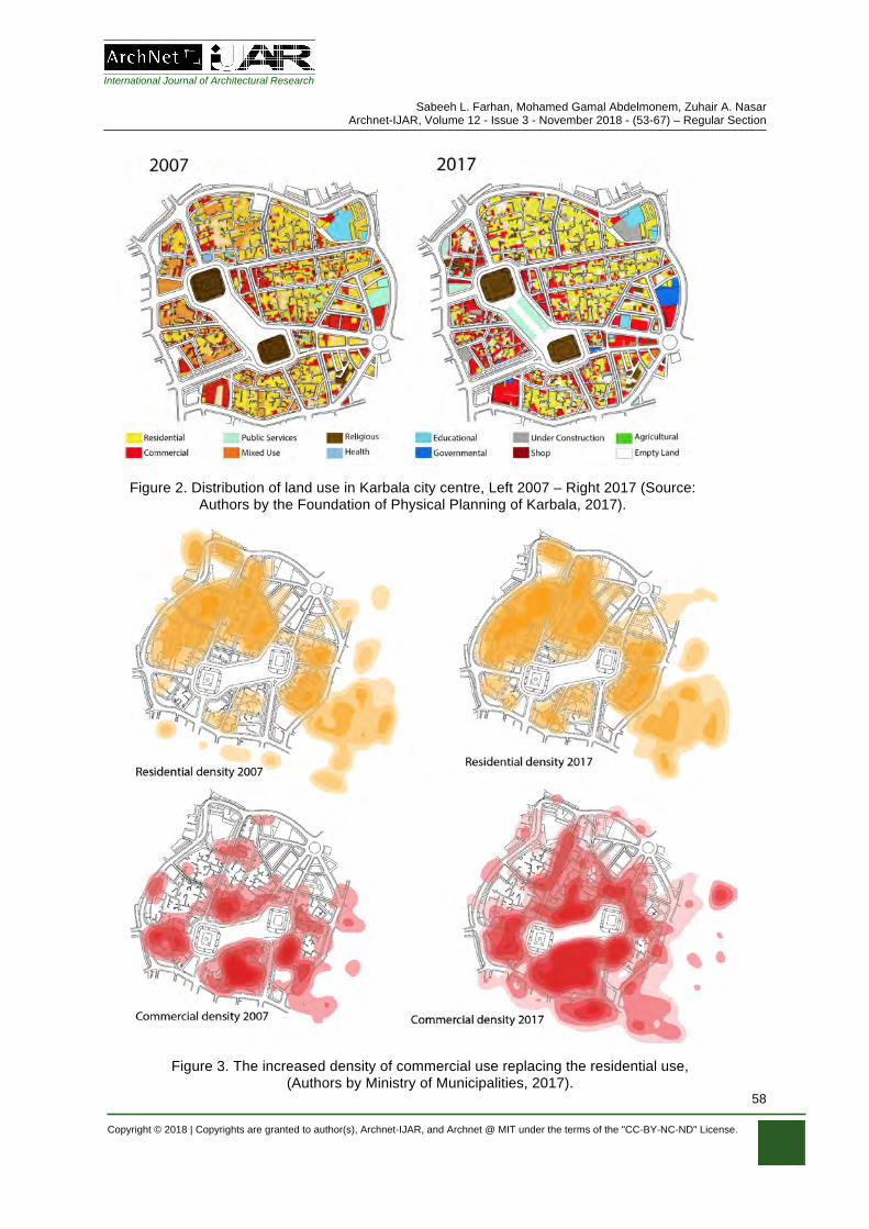
There are four major types of land use within the city: religious and scientific, commercial, residential and transportation (Sadiq, 2007). Based on the analysis of land use in the study area in 2017 compared with 2007, one of the main changes is the relatively massive decrease in residential land use and how this has converted into commercial uses, due to the improved economic situation and the need for visitor- related services. Figure 3 shows how commercial use has started to dominate the old city, 2007 vs. 2017. Moreover, by enumerating these uses with GIS software, the increased density of commercial use and its replacement of residential use, is clear to see, especially in the southern areas of the old city and around the area between the two Holy Shrines (Error! Reference source not found.).
The city of Karbala reached the summit of urban integration when it acquired the basic components of an Islamic city. It consists of a religious centre with all other public activities such as the bazaar, gathered around the sacred centre. Going out from there are the residential neighbourhoods, just like other old-historic cities such as Al-Najaf, (Doxiadis, 1958) see Figure 8. The city of Karbala achieved the characteristics of the original Islamic city, as the result of various activities, ideologies, and civilizations, which have led to the current balance of land usage. After many transformations in the urban fabric - for example, the construction of wide straight streets and the removal of traditional areas - there has been a substantial negative impact on the mix of land use. The religious, educational and residential functions have been squeezed out by the new commercial uses, for example more restaurants and hotels opening, while the traditional areas near the Holy Shrines have been demolished.
International Journal of Architectural Research
Sabeeh L. Farhan, Mohamed Gamal Abdelmonem, Zuhair A. Nasar Archnet-IJAR, Volume 12 - Issue 3 - November 2018 - (53-67) – Regular Section
Copyright © 2018 | Copyrights are granted to author(s), Archnet-IJAR, and Archnet @ MIT under the terms of the "CC-BY-NC-ND" License.
58
Figure 3. The increased density of commercial use replacing the residential use, (Authors by Ministry of Municipalities, 2017).
Figure 2. Distribution of land use in Karbala city centre, Left 2007 – Right 2017 (Source: Authors by the Foundation of Physical Planning of Karbala, 2017).

International Journal of Architectural Research
Sabeeh L. Farhan, Mohamed Gamal Abdelmonem, Zuhair A. Nasar Archnet-IJAR, Volume 12 - Issue 3 - November 2018 - (53-67) – Regular Section
Copyright © 2018 | Copyrights are granted to author(s), Archnet-IJAR, and Archnet @ MIT under the terms of the "CC-BY-NC-ND" License.
59
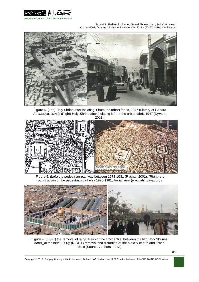
There were seven significant demolitions starting in 1947, where much of the residential area surrounding the Holy Shrines and religious schools, was removed to expand the Holy Shrine courtyard. The pretext for this was organising the traffic for cars and visitors; this led to isolating the Holy Shrine from the urban organic fabric. The second was the removal of the famous minaret of the Holy Shrine (Attia, 2013), which was considered one of the most beautiful architectural monuments in the city, as well as the small courtyard attached to it and some religious schools and mosques. Thirdly, isolating the Shrine from the surrounding urban fabric, so that the Shrine has a wall separating it from the street, while the only parts of the wall which could be seen from the outside, were the gates of the Holy Shrine (Department of Planning and Engineering, 1977), (Figure ).
In 1978, because of the construction of the pedestrian pathway between the Holy Shrines of Imam Hussein and of Al-Abbas, there was destruction of a part of the famous market (Souk Al-Hussein) northeast of the Holy Shrine of Imam Hussein. Also, Al-Safi Mosque, the school of Hassan Khan, and many heritage buildings have been destroyed. Then, in 1980, the neighbourhoods surrounding the Holy Shrines were removed; this was considered essential to annexe the shrines, as shown in (Error! Reference source not found.). The sixth removal was in 1991 after the civil rebellion, when large areas of the city centre, between the two Holy Shrines, were removed (Figure 4). Finally, in 2006, the upgraded masterplan for the city of Karbala was approved, which included more removal and distortion of the old city centre and its urban fabric (Jinan, 2011), see (Figure 4).
The indiscriminate removal of the sacred centre of Karbala under the pretext of providing car parks, traffic networks, open spaces and guest/rest houses during religious events, has caused massive urban upheaval over the past few decades. While alternative solutions could have been developed for exceptional and extraordinary events to provide visitors with comfort and ease, while also preserving the historic structure, this was not done, and many of the unique architecture has disappeared forever. This emphasises the need to preserve the ancient buildings and character of the old city that remains.
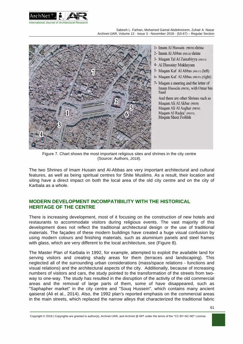
The uniqueness of the historical centre of Karbala has not happened in a vacuum, but through the characteristics and advantages that have been singular to it and that distinguish it from other cities. Figure 7 illustrates the most important shrines and mausoleums in the city centre that are accessible to visitors, in addition to the two Holy Shrines which host the Imam Al Hussein’s household members in their martyrdom locations.
Some include documentation regarding certain events such as the Imam Al Hussein’s standers and speakers with Omar Bin Saad, as well as Tal Zainabiyya, where Al Hussein’s sister (Zainab) stood to monitor the course of the battle on a small hill which is slightly elevated (the land is still there to this day). These historical sites are linked to events that have a high symbolism among Shiites and to the movement of visitors within the city. It is also worth mentioning that the city centre is full of heritage sites and houses such as the houses of Islamic theologians, Ayatollah Al-Sayed Al-Khoei and Ayatollah Saqakhana.
International Journal of Architectural Research
Sabeeh L. Farhan, Mohamed Gamal Abdelmonem, Zuhair A. Nasar Archnet-IJAR, Volume 12 - Issue 3 - November 2018 - (53-67) – Regular Section
Copyright © 2018 | Copyrights are granted to author(s), Archnet-IJAR, and Archnet @ MIT under the terms of the "CC-BY-NC-ND" License.
60
Figure 6
Figure 5. (Left) the pedestrian pathway between 1978-1981 (Rasha , 2001); (Right) the construction of the pedestrian pathway 1978-1981, Aerial view (www.ahl_bayat.orq).
Figure 4. (LEFT) the removal of large areas of the city centre, between the two Holy Shrines dorar_aliraq.net/, 2006); (RIGHT) removal and distortion of the old city centre and urban
fabric (Source: Authors, 2012).
Figure 4. (Left) Holy Shrine after isolating it from the urban fabric, 1947 (Library of Hadara Abbassiya .2005 , ); (Right) Holy Shrine after isolating it from the urban fabric,1947 (Dywan,
2011).
Figure 5
International Journal of Architectural Research
Sabeeh L. Farhan, Mohamed Gamal Abdelmonem, Zuhair A. Nasar Archnet-IJAR, Volume 12 - Issue 3 - November 2018 - (53-67) – Regular Section
Copyright © 2018 | Copyrights are granted to author(s), Archnet-IJAR, and Archnet @ MIT under the terms of the "CC-BY-NC-ND" License.
61
The two Shrines of Imam Husain and Al-Abbas are very important architectural and cultural features, as well as being spiritual centres for Shite Muslims. As a result, their location and siting have a direct impact on both the local area of the old city centre and on the city of Karbala as a whole.
MODERN DEVELOPMENT INCOMPATIBILITY WITH THE HISTORICAL HERITAGE OF THE CENTRE
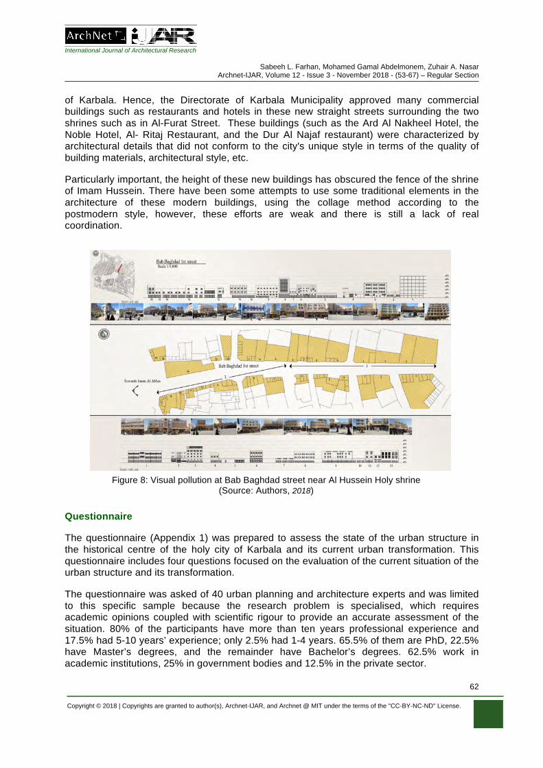
There is increasing development, most of it focusing on the construction of new hotels and restaurants to accommodate visitors during religious events. The vast majority of this development does not reflect the traditional architectural design or the use of traditional materials. The façades of these modern buildings have created a huge visual confusion by using modern colours and finishing materials, such as aluminium panels and steel frames with glass, which are very different to the local architecture, see (Figure 8).
The Master Plan of Karbala in 1992, for example, attempted to exploit the available land for serving visitors and creating shady areas for them (terraces and landscaping). This neglected all of the surrounding urban considerations (mass/space relations - functions and visual relations) and the architectural aspects of the city. Additionally, because of increasing numbers of visitors and cars, the study pointed to the transformation of the streets from two-way to one-way. The study has resulted in the disruption of the activity of the old commercial areas and the removal of large parts of them, some of have disappeared, such as "Saphapher market" in the city centre and "Souq Hussein", which contains many ancient qaiserat (Ali et al., 2014). Also, the 1992 plan’s reported emphasis on the commercial areas in the main streets, which replaced the narrow alleys that characterized the traditional fabric
Figure 7. Chart shows the most important religious sites and shrines in the city centre (Source: Authors, 2018).
International Journal of Architectural Research
Sabeeh L. Farhan, Mohamed Gamal Abdelmonem, Zuhair A. Nasar Archnet-IJAR, Volume 12 - Issue 3 - November 2018 - (53-67) – Regular Section
Copyright © 2018 | Copyrights are granted to author(s), Archnet-IJAR, and Archnet @ MIT under the terms of the "CC-BY-NC-ND" License.
62
of Karbala. Hence, the Directorate of Karbala Municipality approved many commercial buildings such as restaurants and hotels in these new straight streets surrounding the two shrines such as in Al-Furat Street. These buildings (such as the Ard Al Nakheel Hotel, the Noble Hotel, Al- Ritaj Restaurant, and the Dur Al Najaf restaurant) were characterized by architectural details that did not conform to the city's unique style in terms of the quality of building materials, architectural style, etc.
Particularly important, the height of these new buildings has obscured the fence of the shrine of Imam Hussein. There have been some attempts to use some traditional elements in the architecture of these modern buildings, using the collage method according to the postmodern style, however, these efforts are weak and there is still a lack of real coordination.
Questionnaire
The questionnaire (Appendix 1) was prepared to assess the state of the urban structure in the historical centre of the holy city of Karbala and its current urban transformation. This questionnaire includes four questions focused on the evaluation of the current situation of the urban structure and its transformation.
The questionnaire was asked of 40 urban planning and architecture experts and was limited to this specific sample because the research problem is specialised, which requires academic opinions coupled with scientific rigour to provide an accurate assessment of the situation. 80% of the participants have more than ten years professional experience and 17.5% had 5-10 years’ experience; only 2.5% had 1-4 years. 65.5% of them are PhD, 22.5% have Master’s degrees, and the remainder have Bachelor’s degrees. 62.5% work in academic institutions, 25% in government bodies and 12.5% in the private sector.
Figure 8: Visual pollution at Bab Baghdad street near Al Hussein Holy shrine (Source: Authors, 2018)
International Journal of Architectural Research
Sabeeh L. Farhan, Mohamed Gamal Abdelmonem, Zuhair A. Nasar Archnet-IJAR, Volume 12 - Issue 3 - November 2018 - (53-67) – Regular Section
Copyright © 2018 | Copyrights are granted to author(s), Archnet-IJAR, and Archnet @ MIT under the terms of the "CC-BY-NC-ND" License.
63
ANALYSIS OF THE URBAN TRANSFORMATION IN THE URBAN STRUCTURE CHARACTERISTICS OF THE REALITY OF THE HISTORICAL CENTRE OF THE HOLY CITY OF KARBALA
When asked to think about the problems with the historical centre and its causes, more than half (52.5%) of the respondents indicated that it is the steady increase in the population and the disproportionate number of services provided to them, that are the main problems. While nearly half of the experts (45%) believe that a lack of awareness amongst the general public of the concept of a local environment and urban fabric, and the emergence of individuality in the local community, are the reasons for these problems. About one-third (35%) of the experts said that the issues are caused by people not missing the traditional spatial values, while 30% indicated that there is a need to change the economic functions of the traditional city centre.
These percentages show us that these experts believe that population growth rates are not compatible with various strategical plans and services because the city is growing in population. That has led to moving the economic activities and changing the land usage according to the economic aspects and omission of spiritual and moral aspects of the city, along with the weaknesses of architectural planning.
The population numbers in Karbala governorate have increased in the last three decades. There were several reasons for this, namely: the presence of the two shrines which makes it a popular and active tourist attraction, as well as the barbaric action in 2003 which forced people to migrate. These actions have affected Karbala’s demography, especially increasing the numbers of people looking for jobs, as Karbala has many areas of employment which are active throughout the year.
Despite the increase in Karbala's population, all the residential expansion has occurred in the new areas, whether planned or not (like Al Gaber area and Al-Abbas area) but the population in the old city has decreased due to the huge population influx in the fifties which led to the need for establishing modern neighbourhoods with larger houses. This encouraged people to move out of the old city into these new neighbourhoods, as well as the expansion and construction of new streets, especially in the city centre, many homes were removed, andfront sections and ground floors of those houses were transformed into commercial shops to bring an economic return.
Holy Karbala city is facing many challenges in planning and design. We mention here random commercial activities: as these businesses are not in harmony with the religious status of the city - they are spreading randomly which could disturb the religious spirit of this city, by not respecting religious privacy and its importance, especially of the architectural trends and buildings in the shrine area. Our interviewees said that there is no harmony between the pedestrian areas and streets; there are huge buildings and car parks in the old city which may destroy the urban fabric of this area and there is inefficiency in the way land is used, and no rigour applied to what is built or how these will coexist with functions related to religion and services such as hotels, cafes, shops, public services, police stations, etc.

International Journal of Architectural Research
Sabeeh L. Farhan, Mohamed Gamal Abdelmonem, Zuhair A. Nasar Archnet-IJAR, Volume 12 - Issue 3 - November 2018 - (53-67) – Regular Section
Copyright © 2018 | Copyrights are granted to author(s), Archnet-IJAR, and Archnet @ MIT under the terms of the "CC-BY-NC-ND" License.
64
CURRENT FACTORS AFFECTING THE URBAN STRUCTURE
Due to the predominance of commercial and tourism related construction, there is a direct threat to the visual dominance of the Holy Shrines. Therefore, the majority of the participants (82.5%) pointed out that the economic reasons are the main driver of the transformation of the historic centre. The urban fabric has been exposed to many factors due to the extensive and unplanned development of the area, which poses a serious threat to the urban and social cohesion of the Old City. Consequently, there has been an effect on the historical values that are embodied in this fabric. It also has affected the privacy of the city, with the loss of the distinctive urban fabric of the old city which consisted of residential neighbourhoods, small shops, places of worship and education.
Most of the respondents (92.5%) agreed that the laws and legislation contribute to limiting the impact of transformation on the urban historical centre. Half of the experts (50%) stressed the importance of ensuring the preservation of the original urban landscape of the historic centre, with 42.5% emphasizing the need for establishing a legal and legislative framework controlling the participation of the local and regional councils within the urban landscape of the historic centre. Also, confirmed by nearly half of the experts (45%), there is a need to change the laws and legislation on long-term plans to ensure that the future development of the historic city centre is positive.
The experts pointed out the necessity of establishing structural controls to determine the height of buildings in the old city to ensure that the shrines dominate on the skyline, while members of Karbala province council pointed out the need to develop special legislation for the old city to ensure the preservation of the style of the traditional urban fabric, especially with respect to the architectural details. On the other hand, the municipal engineers interviewed explained that they are keen to apply urban laws, but the law itself may need to be reviewed or added to be commensurate with the spirit of the times.
DISCUSSIONS
The Holy Shrines of Imam Hussein and Abbas in the holy city of Karbala, have influenced the urban structure of the historic centre. Currently, the historical centre of the city of Karbala is under tremendous pressure, as there are a series of urgent needs; the enormous numbers of pilgrims means that there is a growing demand for more hotels and restaurants. This has led to a transformation in the urban structure, with economic factors playing the main role in this change.
Likewise, there are mosques, libraries and religious schools in the historic centre, in addition to empty spaces. The destroyed buildings offer opportunities for renovation or redevelopment with an appropriate design to assist in accommodating visitors. The main feature of the historical centre is the solidity of its historical and urban areas. Despite the recent destruction and reconstruction of roads, the historical centre is a distinct entity, characterised by a series of features that distinguishes it from the new development areas. These features include: visual and urban control of the Holy Shrines of Imam Hussein and Al-Abbas on the urban landscape of the old city, the planning of streets and narrow alleys unsuited to vehicle movement, the traditional brick-built buildings, which dominate the irregular streets.
Without a comprehensive study of the characteristics of the urban structure, it is inappropriate to construct straight, grid-like streets in the heart of the historical centre of
International Journal of Architectural Research
Sabeeh L. Farhan, Mohamed Gamal Abdelmonem, Zuhair A. Nasar Archnet-IJAR, Volume 12 - Issue 3 - November 2018 - (53-67) – Regular Section
Copyright © 2018 | Copyrights are granted to author(s), Archnet-IJAR, and Archnet @ MIT under the terms of the "CC-BY-NC-ND" License.
65
Karbala. There should be a redevelopment plan to meet the requirements of the pilgrims without this tremendous indiscriminate transformation, which has a huge impact on the traditional urban fabric. Protecting the historical centre and its urban structure should be the priority in any redevelopment plan that is specific to the holy city of Karbala, not the changing needs (for example the increase in visitors that has varied throughout history). Tourism planning should be based on assimilation and organisation so that tourism is not affecting the shape of city itself.
CONCLUSIONS
There are a series of dangers that may hinder the process of historical re-development and planning. While the increasing commercial functions, such as hotels and restaurants, represent the most significant threat to the original urban fabric, which includes unique architectural structure, the most pressing problem in the historical centre of Karbala could be defined as the difficulty of absorbing the tremendous movement of pilgrims to the Holy Shrines during the numerous religious events. Additional threats could be changes in the demographics of the area; lack of maintenance of public services; the shortage of public investment in the infrastructure; the increasing industrial activity in the old residential neighbourhoods; transportation problems due to access difficulties; and the decline and loss of green areas.
The pressures, which have been exerted by the private sector on the development process in many areas of Karbala’s historic centre, has been identified. Also, the visual dominance of the Holy Shrines (Imam Hussein and Abbas) is directly threatened by the increase of these developments. Additionally, the lack of investment in the maintenance of existing buildings threatens the future of them in the long term, and there are many buildings that have been demolished or destroyed. Therefore, there must be an immediate law to protect the historic fabric of the old city from any further destruction.
The historical and urban shape of the historical centre of Karbala is still largely intact. However, there are many examples of dismantling due to unresearched development and demolition. For example, many historical, religious and non-religious buildings, with great architectural design have been destroyed due to the collapse of the building, a lack of investment and all social and political conditions have contributed to this collapse. Additionally, many people own these historic buildings, making it is very difficult to renew and re-develop these areas sympathetically to modern standards.
A large part of the historic centre, between the two Holy Shrines, was removed by the Directorate of Urban Planning, to start the urban redevelopment of the area. Furthermore, some other historical spaces, houses and religious schools, were demolished due to the construction of many new grid streets and new hotels. The visual and physical control of the Holy Shrines of Imam Hussein (PBUH) and Al-Abbas emphasize the main role of the city, which hosts two of the most important Muslim shrines in the world. Likewise, the golden domes are a focal point and treated as the most important the visual axes. Therefore, the two Holy Shrines are at the core of the religious activities, and since they are the focal points of the religious and Islamic culture, it is very important that the dominance of the Holy Shrines prevails over the urban redevelopment plans in the historic centre.
International Journal of Architectural Research
Sabeeh L. Farhan, Mohamed Gamal Abdelmonem, Zuhair A. Nasar Archnet-IJAR, Volume 12 - Issue 3 - November 2018 - (53-67) – Regular Section
Copyright © 2018 | Copyrights are granted to author(s), Archnet-IJAR, and Archnet @ MIT under the terms of the "CC-BY-NC-ND" License.
66
REFERENCES
Abdelmonem, M.G. (2017). Architectural and Urban Heritage in the Digital Age: Dilemmas of Authenticity, Originality and Reproduction. Archnet-IJAR: International Journal of Architectural Research, 11(3), 5-15.
Abdelmonem, M.G., Selim, G., Mushatat, S., and Almogren, A. (2017). Virtual Platforms for
Heritage Preservation in the Middle East: The Case of Medieval Cairo. Archnet-IJAR: International Journal of Architectural Research, 11(3), 28-41.
Akbar, J. (1988). Crisis in the Built Environment: The Case of the Muslim City. Singapore: Concept Media.
Al Baladiyya, Al-Abbas and Al Mualimeen Mustafa, Shaker. (1988). Cities in Islam until the Ottoman era: Part II. Dar Al-Sallas: Kuwait.
Ansari, R.M.A. (2006). Karbala - Architectural and Planning Study (1st ed.). Al-Salhani Foundation for Printing: Damascus.
Al-Kalidar, M.H.M. (1971). The History Of Karbala or The City Of Al-Hussein. July Printing Press: Karbala.
Al-Kildar, A-J. (1967). History of Karbala and Hajir al-Husayn (peace be upon him). Al-Haydariya Printing Press: Najaf.
Al-Mufid, S. (1981). Kitab al-Irshad. I. K. A. Howard: London.
Al-Qarashi, B.S. (2007). The life of Imam Hussain. Qum: Ansariyan Publications.
Aqil A. H. (2004). A Dialog of Recent Physical Structure and its Effects on the Formation of the Arabian City. A Study of Continuous / Discontinuous in the Structure of Karbala City. A thesis for the Degree of Master of Science in Urban and Regional Planning, Baghdad University.
Al-Tabari, M. I. (1991). History of the Prophets and Kings; Volume XIX the Caliphate of Yazid ibn Muawiyah, translated by I.K.A Howard, SUNY Press.
Atanur, O. (2006). Urban Transformation Process: Ulus Historical City Center Planning Project. In Partial Fulfillment Of The Requirement For The Degree Of Master Of Science In Urban Design In City And Regional Planning Middle East Technology University.
Attia, H. N. (2008). Notes on the expansion of the sanctuary roofing Al-Husseini Al-Sharif. Taf Printing Press: Karbala.
Attia, H. N. (1997). The Ability to Development of the Holy Shrines in Karbala city, a thesis for the Degree of Master of Science in Architecture Engineering Baghdad University College of Engineering.
Attia, H. N. (2013). Activation of urban renewal centers Iraqi city: An analytical study of religious cities, A thesis for the Degree of PhD of Science in Architecture Engineering Baghdad University College of Engineering.
Bilal, A. (1995). Urbanization and urban development in the Muslim World: From the Islamic City Model to megacities. Geo Journal, 37(1), 113-123.
Department of Planning and Engineering. (1977). Project of the development of holy shrines in Karbala. Department of Planning and Studies: Baghdad.
Doxiadis. (1958). The future of Karbala. Ministry of Planning, Iraq. Faraj, H. H. (2012). The Development of Iraqi Shi’a Mourning Rituals in Modern Iraq: A Thesis
Presented in Partial Fulfillment of the Requirements for the Degree Master of Arts Arizona State University.
Hakim, B. S. (1986). Arabic –Islamic cities, building and planning principles. London, New York and Henley.
International Journal of Architectural Research
Sabeeh L. Farhan, Mohamed Gamal Abdelmonem, Zuhair A. Nasar Archnet-IJAR, Volume 12 - Issue 3 - November 2018 - (53-67) – Regular Section
Copyright © 2018 | Copyrights are granted to author(s), Archnet-IJAR, and Archnet @ MIT under the terms of the "CC-BY-NC-ND" License.
67
Hiyam, M. (2012). Urban Morphology of Holy Karbala City, A thesis for the Degree of Master of Science in urban and regional planning, Baghdad University.
Husein, US.M. (2018). A phenomenological study or Arbaeen foot pilgrimage in Iraq. Tourism Management Perspectives, 26, 9-19.
Hussam, S. O. (2013). Morphological Transformations In Historical Cities Centers, A thesis for the Degree of PhD of Science in Architecture Engineering Baghdad University College of Engineering.
Howard, I, K. A. (1990). The History of al-Tabari. University of New York Press: Albany.
Jinan, A. S. (2011). The Role Of Redevelopment In Highlighting The Height Of The Urban Landscape In The Holy Cities, A thesis for the Degree of Master of Science in urban and regional planning, Baghdad University.
Khalili, J. (1978). Encyclopedia of the Holy Saints (2nd ed.). Department of Karbala, Al-Amali Institute for Publications: Beirut.
Laursen, L. L. H. (2009). Shrinking Cities or Urban Transformation, Department of Architecture and Design, Aalborg University.
Montgomery, M.R. et al. (2004). Cities Transformed: Demographic Change and Its Implications in the Developing World by the Panel on Urban Population Dynamics, National Academy of Sciences. First published in the UK, Earthscan.
Mutman, D. and Turgut H. (2018). Colliding Urban Transformation Process: The Case of Historical Peninsula, Istanbul. Archnet IJAR: International Journal of Architectural Research, 12(1), 164-181.
Nakash, Y. (1993). An Attempt to Trace the Origin of the Rituals of Āshurā. Die Welt des Islams, 33 (2), 161-181. doi:10.1163/157006093X00063.
Nakanishi, H. (2014). Urban Transformation Transit Oriented Development and the Sustainable City. Routledge: London.
Nasar, Z. (2015). The Sacred Shrines on Directing the Movement Axes within The Urban Fabric of The Islamic Holy Cities- An-Najaf Al-Ashraf as a case study. University of Babylon Journal for Engineering, 4(23).
Psarra, S. (2012). Spatial morphology, urban history and design in Julienne Hanson’s ‘Urban transformations: A history of design ideas’. The Journal of Space Syntax, 3(1).
Rasha, M. (2001). The Impact of Changing Traffic Path Systems in Land Use in the Traditional Center of Karbala City A Study of Continuous / Discontinuous in the Structure of Karbala City, A thesis for the Degree of Master of Science in urban and regional planning, Baghdad University.
Republic of Iraq Ministry of Planning Central Statistical Organization. (2010). Demographic Statistics report on population state; Available from http://cosit.gov.iq/en/joomla-templates.
Rossi, A. (1982). The Architecture of the City (Opposition Books). Cambridge, Massachusetts.
Sadiq K. A (2017). An examination of heritage protection and conservation practices in the pilgrimage city of Najaf. A thesis submitted in partial fulfilment of the requirements for the degree of Doctor of Philosophy, The University of Sheffield, Faculty of Social Sciences, School of Architecture.
Shimma, M., Habibi- M.M. (2004). Urban Renovation- Urban Method and Operations. Tehran University.
Taei, I.A. (1989). The use of aerial survey and remote sensing in the development of urban expansion axes - Study area - Karbala city, A thesis for the Degree of Master of Science in Urban and Regional Planning, Baghdad University.