the roman road on the eastern fringe of the new...
TRANSCRIPT

Proc. Hampshire Field Club Archaeol. Soc. 58, 2003, 33-58 (Hampshire Studies 2003)
THE ROMAN ROAD ON THE EASTERN FRINGE OF THE NEWFOREST, FROM SHORN HILL TO LEPE
By the late A CLARKE
ABSTRACT
The Roman road from Applemore Hill to Lepe was re-inves-tigated for three reasons. First, because of doubts thai it is an authentic Raman road expressed by various authorities. These doubts have been removed and,frrthermore, it has been traced NW to Shorn Hill where it joins the Roman road from Otterbourne to Stoney Cross. In so doing it passes dose to the entrance ofTatchbury, a large multivaUate Iron Age hillfort. Second, because it played an important role in the network of Roman roads in the Chichester, Southampton and Winchester area, probably constructed by Legio H Augusta in the early stages of the Roman invasion of Britain. And third, because a newly discovered Roman road to Old Sarum also starts from this road at Applemore Hill This suggests that the Roman roads from Lepe to Applemore Hill, and from there to Old Sarum, may have been later used by Cerdic, and others, during the Saxon advance into Wessex.
I N T R O D U C T I O N
The first known reference applying to this Romanroad is in a New Forest perambulation of 1217(Stagg 1992, 26-7), where it is the bound-markmagnam viam 'great road' between Applemore Hilland Horestone Hill, Dibden Purlieu. On IsaacTaylor's Map of Hampshire, 1759, it is describedas A Roman Way, though somewhat misplaced topo-graphically. It is then shown by Thos. Richardson,1787, as Roman way from Applemore Hill toButtsash Lane, Dibden Purlieu. On the OS 6 inchmap of 1872 it is described as Roman Road fromApplemore Hill to Holbury, and the agger, includ-ing an alignment angle, is depicted across BeaulieuHeath. O G S Crawford and Williams-Freemanwalked the road together in 1912, and they were inno doubt that it was Roman (Williams-Freeman
1915, 442). Margary (1973, 94-6) also accepted itas a Roman road from Applemore Hill to StonePoint on the Solent where, he says, 'there appearsto have been an inlet here with berths forshipping, now silted up'. He also suggested theroad probably continued N from Applemore Hillthrough Eling and Totton to join the Otterbourneto Stoney Cross Roman road just to the W of theTest crossing opposite Nursling, as its purposewas obviously to link the southern road systemwith a small port at Stone Point. The route is alsoshown in Soffe and Johnston (1974, Fig. 1)
There is another interesting reference to it byBenson and Hatcher (1843, 4) who say 'FromBittern [sic] a Roman road ran through Nurslingand crossed the Test near the Mill, from whence itpassed through the Forest in the direction ofRingwood. A fragment of it still exists in the vicinityof Tatchbury. From this line, and near this spot,branched a road leading to the Isle of Wight. Itscourse was south-east in the line of the present roadfrom Eling to Beaulieu. It then continued towardsthe enclosures of Litde Holbury, was afterwardslost, but reappeared in a meadow at Great Holbury,and then proceeded by Hopley Mill and Stanswoodto Stone. From thence there was a passage across theChannel [sic] to the Isle of Wight'.
But others have cast doubt on it as a bona fide Roman road. They include Haverfield (1900, 325-6), and the Ordnance Survey who describe it as'Earthwork' on current mapping. It also does notappear on the OS Map of Roman Britain (1994).
M E T H O D O L O G Y {Fig. 1)
Margary's numbering system is adopted, and here-after the road is referred to as RR423 [Roman

34 HAMPSHIRE FIELD CLUB AND ARCHAEOLOGICAL SOCIETY
. e,:\
Ftoman Roads
RR423
i i i i i i i i i
20_ j Km
Fig. 1 The New Forest area, showing Roman roads. Route 423 on the eastern fringe of the Forest is highlighted. (Drawn byDeborah Cunliffe, National Monuments Record, Crown Copyright Reserved)
Road 423]. As a newly discovered Roman road any doubts regarding its authenticity. At the samestarts from RR423 on Applemore Hill and time the relationship between RR423 and the fol-proceeds via Cadnam to Bramshaw Telegraph, lowing Roman roads has been examined:and from there to Downton, Harnham Bridge(Ayleswade) and on to Old Sarum (Sowiodunurri), 1. RR42b from Winchester (Venta Belgaruni) toRR.423 has been re-investigated in order to dispel Bitterne (?Clausentum)

CLARKE: THE ROMAN ROAD ON THE EASTERN FRINGE OF THE NEW FOREST 35
2. R R 4 2 0 from C h i c h e s t e r {Noviomagus Reg(i)noruni) to Winchester (Venta Belgarum) (Soffe 8c Johnston 1974, 112-14)
3. RR421 from Chichester to Bitterne (Soffe 8cJohnston 1974)
4. RR422 from Ot te rbourne (RR42b) toStoney Cross. This road has now beenextended beyond Stoney Cross, and itproceeds via Picket Hill, Hightown, toWattons Ford on the Avon, and thence to thevexillation fortress at Lake Farm (Soffe 8cJohnston 1974, 111-12).
5. RR424 from Stoney Cross to Fritham.Doubt has also been expressed regarding theauthenticity of this road (Johnston, 1984,19-23). The doubt has been removed, and it hasbeen traced beyond Fritham through theNew Forest potteries to Fordingbridge.
6. And finally another new Roman road hasbeen recendy identified which runs fromRR422 at Cadnam to Buckland Rings, a largeIron Age hillfort N of Lyrnington, but thisroad is still under investigation.
Effort has also concentrated on trying to discoverthe primary sight-lines observed by the Romansurveyors and engineers when setting out theseroads, in the hope that the sequence of construc-tion might be revealed. The area chosen extendseast to west from Chichester to Lake Farm,Wimborne, and north to south from Winchester(and by inference Silchester) to the Isle of Wight.In other words the area covers the routesprobably followed by battle groups of Legio II Augusta in the very early stages of the Romanconquest of Britain c AD 43-44.
Investigation of the methods used to surveyand set out these roads has revealed a number ofpoints. First, the accuracy achieved in observingsight-lines, and setting out road alignments, is gen-erally to within 0.01 or 0.02 of a degree (0.0167°equals 1 minute of arc) (see Appendix). Second,the repetitive nature of the selection and siting ofsome sighting-points and al ignment anglessuggests the modus operandi of a particular surveyoror survey unit. Third, the long held belief thatRoman roads almost always changed direction onhigh ground does not hold true in this area.Finally, the evidence that the sighting-points of
some primary sight-lines are common to morethan one road indicates that the network formedpart of a unitary system, probably designed andset out by Legio IIAugusta, in the early stages of theconquest.
Sighting-points and sight-lines ofRR423 The course of RR422 from Nursling Mill toShorn Hill has been identified and this, in turn,has led to the discovery of the junction withRR423 'in the vicinity of Tatchbury', as describedby Benson and Hatcher (op. tit.).
RR423 was laid down using two primarysight-lines. Sight-line 1 was observed from ShornHill to Dibden Purlieu. The initial sighting-pointof Sight-line 1 is placed in a typical position on theE crest of Shorn Hill, at SU 3363 1524, wherethere is a slight alignment angle on RR422 (Fig.2.1). This is the first place from which it is possibleto lay down an unobstructed sight-line to DibdenPurlieu, and before visibility is blocked by ShornHill. The sighting point at Dibden Purlieu is analignment angle on RR423 at SU 4086 0604 (Fig.7.1), grid bearing from Shorn Hill 141.83°,distance 11.70km. This line was carefully chosen:it avoids Calmore, probably marshy ground inthe Roman period, and passes just above thehighest point to which normal tides now flow onthe Bartley Water at Brokenford, Totton, andonly 30m above the tidal limit on Jacobs Gutter,Eling, at SU 3611 1212 (Fig. 4.3). In the Romanperiod tidal limits may have been even higher. Butthere was a more important reason why RR423did not proceed from the W bank of the Testopposite Nursling direct to Lepe, as suggested byMargary (see below).
Sight-line 2 was observed from the DibdenPurlieu sighting-point to Stone Farm, Lepe, atapproximately SZ 4571 9939, grid bear ing143.90°, distance 8.23km (Fig. 12.3), some 200mabove a silted-up inlet. Initially, a single primarysight-line may have been observed from ShornHill direct to Lepe, grid bearing 142.69°, distance19.93km, and subsequendy broken down intotwo parts, but until the end of RR423 at Lepe isaccurately known, there is no way to confirm this.There is also the possibility that the final terminalof RR423 is Pits Copse, at SZ 4604 9894, grid

<•: ©
Cro
wn c
opyr
ight
Fig.
2 P
lot o
f the
rout
e of
the
road
in th
e Tat
chbu
ry a
rea,
and
its ju
nctio
n wi
th ro
ute
422

CLARKE: THE ROMAN ROAD ON THE EASTERN FRINGE OF THE NEW FOREST 37
T\ t
io
.»<y
W-Ja!!h—^t• JNjs^
Scale 1 :10560 ^ g ^ , „°.;\E
/ ' / Warea *f fNurseric:
W^k»>
^ V J » QiJWaNurseries
^*
V
^CyvTotton Grammar , \ Q $ \ > ,> V School —U"- i .
;<3
Y1 \Tendring
•>o.H- V " t
Teslbourne Fartfr\<^
K&WMsllers
y£
\ .
\\
•
_ V - '\ ' ^ s y , -yv
2^ir£ -̂ •'9̂ Wowt© Crown copyright
Fig. 3 Plot of the route in the Calmore road area

38 HAMPSHIRE FIELD CLUB AND ARCHAEOLOGICAL SOCIETY
bearing from Dibden Purlieu 143.89°, distance8.789km (Fig. 12.5). Pits Copse contains enig-matic earthworks, suggested by Crawford, andothers, as berths for shipping.
The route and alignments
The course of RR422 at Shorn Hill is representedby an old lane in Paulets Row, shown on the OS 6 inch map 1911. RR423 leaves RR422 in this lane,at SU 3348 1523, some 150m W of the initialsighting-point of sight-line 1, and 30m W of theboundary fence of the new Totton by-pass, but notrace of the junction survives (Fig. 2.2). The firstalignment of RR423 is clearly aiming towards the E entrance of Tatchbury, a large Iron Age multivallatehillfort (Fig. 2.6). This alignment was carefullychosen to run along the foot of the SE slopes ofShorn Hill and, at the same time, to skirt the headof a deep re-entrant at the base of steep slopesbelow the hillfort entrance. There is no trace ofthe road in the heavily landscaped grounds ofShorn Hill house, and there is no evidence on theOS 6 inch maps of 1872 or 1911, i.e. before theconstruction of the house. The first evidenceappears running inside the W boundary ofChestnut Plantation, and RR423 is then visible asa mutilated agger, accompanied by holloways, forsome 30m ins ide the b o u n d a r y fence ofTatchbury Hospital (Fig. 2.3). Further evidencehas been destroyed by hospital buildings, but a prolongation of the alignment continues to SU3307 1470, at the foot of the slopes of TatchburyMount, and 90m from the entrance to the hillfort.This point was probably close to the outer limitsof the complex hillfort defence system, but theevidence is now obscured by the modern roadleading to a derelict mansion. There can be littledoubt that the decision not to proceed from theW bank of the Test direct to Lepe, as suggestedby Margary (op. cit.), was in order to eliminate thishillfort. This is further confirmation of theevidence obtained by Field (1992, 154-62), thatduring the campaigns against the Durotriges inDorset the main targets of the Roman army werethe hillforts. Following capture, roads were con-structed to these hillforts, which were then used astemporary camps. Williams-Freeman (1915, 165—7, 410), records die discovery of a 'late Celtic
comb' at Tatchbury, but there is no evidence ofRoman military occupation.
There are other well known examples of IronAge hillforts occupied or attacked by the Romanarmy: Maiden Castle, Hod Hill and WaddonHill, Dorset; H a m Hill, and possibly SouthCadbury, Somerset; Hembury in Devon; andBrandon Camp, Herefordshire. Tatchbury is onlyone of a number of hillforts in SW Hampshirewhich may be candidates for this role, butevidence of military occupation within the hillfortis required. The other Iron Age forts in this areawhich may have been temporarily occupied byRoman troops include Buckland Rings, Lymington;T/ie Walls, Nursling; Mahuood Castle, Minstead;and Frankenbury, Godshill, all close to Romanroads. Old Sarum, Wiltshire, and Badbury Rings, Dorset, may also fall into this category. The use ofhillforts for this purpose may account for theabsence of normal temporary camps in SouthernBritain as far west as Devon (OS Map of RomanBritain, 1994; R C H M E 1995).
At the end of the first alignment from ShornHill, at the head of a deep valley, there are threeshort connecting alignments to the start of thesecond alignment. These connecting alignmentsare indicated by hachures on current OS editions(Fig. 2.4). The first connecting alignment, about60m long, is represented by a single straight line ofhachures, but the feature represented by thehachures has been destroyed by the constructionof a hospital building. RR423 then appears as a well-defined terrace-way, represented in part by a double line of hachures. It runs along a shelf at thebase of the slopes below the hillfort in two shortstraights, each again about 60m long, and is trace-able as far as the start of the second alignment ofRR423 at SU 3316 1455. A track along thisterraceway appears on the OS 6 inch map of 1872.
It is possible that a sight-line of RR422 wasobserved from the junction with RR42b, atOtterbourne Manor, direct to Wattons Ford whereRR422 crosses the River Avon, grid bearing236.78°, distance 38.60km. This sight-line passesover the top of the Tatchbury hillfoit, and alsointersects exacdy the start of the second align-ment, grid bearing 236.77°, distance 15.38km.This may be coincidence, but it is noted for therecord.

CLARKE: THE ROMAN ROAD ON THE EASTERN FRINGE OF THE NEW FOREST 39
Scale 1:10560
Fig. 4 Plot of the route in the Brokenford area

40 HAMPSHIRE FIELD CLUB AND ARCHAEOLOGICAL SOCIETY
The sighting-point of the second alignment ofRR423 is just outside the entrance to the hillfortat SU 33080 14605, and the sight-line is aiming atthe point where the Shorn Hill - Dibden Purlieuprimary sight-line crosses the Bardey Water at SU35422 12960, grid bearing 125.08°, distance2.862km (Fig. 4.7). The course of the secondalignment, SE of Tatchbury, is indicated by a verydeep holloway as far as the new Totton by-pass(Fig. 2.5), followed by a hedgerow (Fig. 3.1), andthen by Calmore Road (Fig. 3.2) to an alignmentangle at Bears Lane End, at SU 34952 13290, gridbearing 125.09°, distance 2.288km (Fig. 3.3). Thisalignment later formed part of the Cloven Way, which Crawford (1931, 441-458) originally sug-gested was used by Cerdic on his way to Cerdkes Ford, but Crawford then changed his mind (1952,193-200). The massive holloway, and significantname Cloven Way, may indicate that this section ofRR423 was subsequently used an importantdrove road.
The Bears Lane End alignment angle was nec-essary in order to avoid steep slopes at the pointwhere the Shorn Hill to Dibden sight-line crossesthe Bardey Water at Brokenford, and to keep tohigher ground above the high water marks ofordinary tides at Brokenford and Jacobs Gutter.From Bears Lane End the next alignment goes toJacobs Gutter, at SU 3610 1198, grid bearing138.72°, distance 1.74km (Fig. 4.4). The first partof the alignment is marked by a hedgerow andfootpath as far as the A336 at Bears Lane End,and by another hedgerow, shown on OS 6 inchmap of 1872, past the Old Farmhouse publichouse (Fig. 4.1). The course is then obscured bymodern development and again one has to rely onthe OS 6 inch map of 1931 for evidence in theform of hedgerows exacdy on the line (Fig. 4.2).
Jacobs Gutter is crossed some 150m above thepoint to which normal tides now flow on thisstream (Fig. 4.3), but high water mark wasprobably somewhat higher in the Roman period.A short dog-leg of 270m was then introduced inorder to cross former boggy ground of JacobsGutter, to another alignment angle visible onhigher ground near a field gate a few metres E ofThatch Cottage at SU 3635 1189, grid bearing109.80° (Fig. 4.6). Jacobs Gutter Lane is on theline of this dog-leg, which is bisected exacdy by
sight-line 1, Shorn Hill - Dibden Purlieu , at SU3623 1193, grid bearing 141.83° (Fig. 4.5).
At Thatch Cottage the next alignment thenh e a d s s t r a i g h t for the A p p l e m o r e H i l lsighting-point, where it rejoins sight-line 1 at SU3965 0758, grid bearing 142.56°, distance 5.43km.Beyond Thatch Cottage there are no traces ofRR423 across a market garden, but it can be seenas a bump crossing a track at SU 36655 11492(Fig. 5.1). Intermittent traces of the agger and ditchare then visible as far as East Veugles Copse, withthe agger well-preserved across a pasture fieldbetween the oil refinery railway line and the copse(Fig. 5.2). The agger measures 5.5m in width andup to 0.3 m in height, and there was a water-filledditch on the SW side when visited in January1999. T h e course is then represented by a hedgerow alignment SW of Trotts Lane (Fig. 5.3),followed by the massive S boundary bank of ParkRoad as far as Staplewood Lane, Pooksgreen (Fig.5.4) all, including the agger, exactly on the align-ment, grid bearing 142.56°.
Between Pooks Green and Applemore Hill theroad traverses beds of Barton Clay and evidencebecomes difficult to find. The construction of theMarchwood by-pass (A326) has also destroyedmuch of the evidence but the course is marked byhedgerow alignments on the OS 6 inch map of1931. The much-reduced remains of the agger then reappear running inside the boundaries ofHammers Copse and Rudes Copse, grid bearing142.56° (Fig. 6.1), and in Nutchers Copse a streamhas been diverted by the road for a distance of130m, but the old stream course can still be seenin the field to the NE (Fig. 6.2). Nutchers Copseinclosure bank is then on the agger as far asTwiggs Lane at SU 3821 0946, grid bearing142.57° (Fig. 6.3).
There is no trace of RR423 as it climbs the E slopes of Beacon Hill, past the Old Vicarage, but a 'zig-zag' would not have been necessary as thegradient is not severe (Fig. 6.4). Certain traces inthe grounds of Marchwood Priory, and thenacross agricultural land, are difficult to find, andthe next good evidence is in the form of a sugges-tive 'kink' on a stream and hedgerows in marshyground, at SU 3929 0805, grid bearing 142.56°,distance 4.84km (Fig. 7.1). On leaving the BartonClay for the Barton Sand, the much-reduced

CLARKE: THE ROMAN ROAD ON THE EASTERN FRINGE OF THE NEW FOREST 41
Scale: 1:10560 Crown copyright ^ j j J i ^ L
Fig. 5 Plot of the route in the Trotts Farm area

42 HAMPSHIRE FIELD CLUB AND ARCHAEOLOGICAL SOCIETY
remains of the agger and terraceway, grid bearing142.56° (Fig. 7.2), appear for a distance of 77macross a horse paddock between the road to DaleFarm and Manor Lane. From the N end of theterraceway at SU 39427 07871, RR423 then runson Plateau Gravel virtually all the way to StoneFarm. The SW boundary of Manor Lane is on theline (Fig. 7.3) to the Applemore Hill sighting-pointand alignment angle at SU 3965 0758, whereRR423 rejoins sight-line 1 from Shorn Hill, gridbearing 143.83°, distance 9.73km (Fig. 7.4).
The Applemore Hill sighting-point was the NewForest bound-mark Donschamele, 1215, Dunshamele, 1298, later Applemore Hill, 1670, or Ipplemore Hill onThos. Richardson's Plan of part of the New Forest,1787. A newly discovered Roman road to Old Sarum also starts from RR423 on Applemore Hill.The course from Applemore Hill is generallymarked by the ancient New Forest boundary as faras Cadnam. From Cadnam the B3078 is on the lineto Bramshaw Telegraph, then through Woodfalls,and on to Downton passing some 100m N of theRoman villa. It crosses the Avon at The Moot, themeeting-place of the Downton Hundred, andwithin 25m of the Saxon cemetery at CharltonPlantation, before crossing the Avon again atHarnham Bridge (Aykswade) and on to Old Sarum. T h e first alignment of this new road fromApplemore Hill is the bound-mark 'and thus by thegreat road (magnam xnam) as far as Dunshamele' in a New Forest perambulation of 1297-8 (Fig. 7.6).
T h e n e x t a l i g n m e n t of R R 4 2 3 SE ofApplemore Hill, is described as A Roman Way byIsaac Taylor, 1759, and as Roman way on Thos.Richardson's Plan of Part of the New Forest,1787. It continues along the primary sight-line tothe Dibden Purlieu sighting-point, grid bearing141.84°, the course marked by the old main roadand Dibden/Denny Lodge parish boundary.RR423 also formed the ancient New Forestboundary hereabouts, the first stretch fromApplemore Hill to the top of Horestone Hill beingthe bound-mark 'by the great road (magnam viam)' in a perambulation of 1217 (Fig. 7.5).
The sighting point-cum-alignment angle at theDibden Purlieu end of sight-line 1 is situatedoutside the entrance to a house called 'ForestView', on the old main road now a by-road calledRoman Road (Fig. 8.1), and on high level ground
on the watershed between Southampton Waterand the Beaulieu River. Today the position isundistinguished, but on the OS 1 inch map of1810 the Roman road is shown rxinning parallelto, and SW of, a minor tributary of the BeaulieuRiver, now covered by a large housing estate. Thesighting-point and alignment angle are close to thesource of this stream. On O G S Crawford'srecord map, compiled when Archaeology Officerof the Ordnance Survey (penes David Stagg),'Linear earthwork' is shown facing N, andrunning in a westerly direction from the align-ment angle, for about 450m, to a stream in a steep-sided valley at SU 4039 0595 (Fig. 8.2). Theearthwork has since been destroyed by afforesta-tion and clearance for an electricity pylon line.The area to the E was already developed whenCrawford discovered this earthwork, but heshows it as possibly extending to the head of a stream, at about SU 4146 0624 (Fig. 8.3), whichflows via Butts Bridge into Southampton Water.It is also possible that the earthwork may havecontinued to end on the stream shown on the OS1 inch map of 1810 described above. In either caseit would have formed an obstructive barrieracross the Roman road, each end terminating on a natural obstacle. Crawford (1931) argued that theearthwork was part of an enclave, or 'bridgehead',constructed by Cerdic following his landing atCerdkesora [?Lepe].
Sight-line 2 was laid down from Dibden Purlieuto the probable terminal of RR423 at Stone Farm,at or about 4571 9939, grid bearing 143.90°,distance 8.23km (Fig. 12.3). The first alignmentfrom the Dibden Purlieu sighting-point is repre-sented by a parish boundary and the old mainroad, now a by-road called Roman Road (Fig.9.1), as far as Buttsash Lane, at SU 4177 0552,grid bearing 119.48°, distance 1.06km (Fig. 9.2).This short alignment was introduced to skirt thehead of a tributary of the Dark Water. The end ofButtsash Lane is the site of the New Forestbound-mark Bottesliassch' or Buttesashe, 'an ash(bound) tree defining the extent of the property ofthe But family': a William le But of the vill ofHardley is recorded in 1327 (Stagg 1979, 208).T h e bound-mark is still defined by an oldboundary stone, and the ancient New Forestboundary leaves the Roman road at this point. On

CLARKE: THE ROMAN ROAD ON THE EASTERN FRINGE OF THE NEW FOREST 43
Fig. 6 Plot of the route in the Beacon Hill area

44 HAMPSHIRE FIELD CLUB AND ARCHAEOLOGICAL SOCIETY
Fig. 7 Plot of the route in the Applemore Hill area

CLARKE: THE ROMAN ROAD ON THE EASTERN FRINGE OF THE NEW FOREST 45
Fig. 8 Plot of the route in the Dibden Purlieu area

46 HAMPSHIRE FIELD CLUB AND ARCHAEOLOGICAL SOCIETY
**Js
Scale 1̂ 10000 i E % . . . - ' ' \ „ , . . | H o l b u r y© Crown copyright \
Fig. 9 Plot of the route between Dibden Purlieu and Holbury Purlieu

CLARKE: THE ROMAN ROAD ON THE EASTERN FRINGE OF THE NEW FOREST 47
the OS 6 inch map of 1872 the Roman road isshown as a well defined agger hereabouts, and thealignment angle as a gende curve. A curved align-ment angle was probably repeated on ApplemoreHill at the start of the new road as it leaves RR423en route to Old Sarum (Fig. 7.6). Close to theButtsash Lane alignment angle, at SU 418 055, theroad was sectioned by a pipe-line: the agger, 12mwide and 0.7m high, was flanked by shallowditches, but little metalling survived (Lawson1985). The quoted width is presumably the resultof the pipe-line trench cutting through the road atan angle, the true width of the agger hereabouts isbetween 5.5 and 6.5 m (see below).
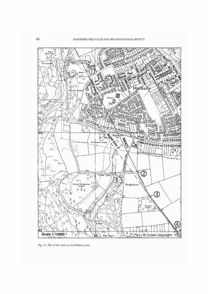
Across Beaulieu Heath to Little Holbury,RR423 traverses difficult country, but it keeps asfar as possible to the crest of the steep E slopes ofthe boggy valley of the Dark Water (Fig. 9.3).RR423 is shown on current OS maps as 'Earth-work' but, where best preserved, it comprises anagger measuring between 5.5 and 6.5m wide, and0.3-0.4m high, with a carriageway about 3.0mwide. There are now no apparent lateral ditches,but quarry-ditches can be seen at intervals withthe best examples on the NE side of the causeway.The course is traceable through Holbury, and a fragment of the agger can be seen crossing a former stream bed S of Holbury Manor at SU4291 0362 (Fig. 10.1). T h e course is thenobscured by housing estates, and there is no traceuntil the N end of Bell Lane, at SU 43425 02600(Fig. 10.2). The agger can then be seen inside the E hedge boundary of Bell Lane, until it finally con-verges on sight-line 2 at an alignment angle in BellLane at SU 4355 0235, grid bearing from DibdenPurlieu, 143.91°, distance 4.57km (Fig. 10.3).Two slight changes of alignment (c. 0.8°) werethen introduced in order to negotiate a tributaryof the Dark Water on the S side of BlackwellCommon. Remains of the agger are visible alongthe E side of Bell Lane (Fig. 10.4), followed by a ve ry well p rese rved section on BlackwellCommon, again described as 'Earthwork' on OSmaps (Fig. 11.1), and continuing as far as a ford atSU 4409 0164 (Fig. 11.2). RR423 is then lostacross housing estates until it reappears as anagger, accompanied by quarry-pits across a horsepaddock (Fig. 11.3). Sight-line 2 from DibdenPurlieu is regained on reaching level ground at
Whitefield Farm Cottages at SU 44703 00770 gridbearing 143.90° (Fig. 11.4). An old bank, shownby hachures on current OS maps, overlies theagger zl a slight angle (Fig. 11.5), and RR423 thenruns along sight-line 2, under or close to the NEhedge of Lepe Road, the boundary of the ancientDomesday manors of Exbury and Stone (Driveret al. 1789) (Fig. 11.6), before disappearing acrossarable land N of Stone Farm (Fig. 12.1).
T h e exact terminus of RR423 has not beenidentified dur ing re-investigation. Marga ry(op.cit.) says the farm road past Stone Farm is onthe line to near Stone [Stansore] Point (Fig. 12.6),where there is an inlet, now silted up. From theDibden Purlieu sighting point, the bearing to theN end of this lane, at SZ 4556 9957, is 144.00°(Fig. 12.2). Crawford (1952, 193-4) thought theterminus was probably on the narrow tongue ofland about a quarter of a mile wide, between theDark Water and an unnamed stream, close to a harbour, now blocked by a shingle bar. He says'the Roman settlement has yielded no positiveevidence unless the old foundations and lumps oflimestone, and banks and hollows on the W bank of the stream just N of the point where it iscrossed by a private road to Stone Farm areevidence of it'. This point is very close to the endof sight-line 2, at SZ 4571 9939, grid bearing143.90° (Fig. 12.3). Williams-Freeman (1914, 42)records 'Both sides of the meadow [betweenStone Farm and the sea -SZ 457 992] show irreg-ularities in the ground, which are suggestive ofold buildings' . There is certainly disturbedground here, together with patches of nettlesusually indicative of former occupation. A con-centration of Roman finds, coins and copperalloy, has been found in an area centred at SZ457 992, that is on the spur between theunnamed stream and the Dark Water (Fig. 12.4).Stone Farm contains building material fromBeaulieu Abbey, and it is probably the site of oneof the two halls recorded at Stone in Domesday(Munby 1982, 69, 54). Stone Farm is situated atthe head of a silted creek, which may have beennavigable to a point some 200m S of the farm, atSZ 458 992. If sight-line 2 is extended, it is aimingat the enigmatic earthworks in Pits Copse, at SZ461 989 (Fig. 12.5 and inset), which Crawfordsaid 'look like ship's docks, and whatever their
48 HAMPSHIRE FIELD CLUB AND ARCHAEOLOGICAL SOCIETY
Scale 1:10000 :
Fig. 10 Plot of the route in the Holbury area

CLARKE: THE ROMAN ROAD ON THE EASTERN FRINGE OF THE NEW FOREST 49
Fig. 11 Plot of the route in the Langley area

50 HAMPSHIRE FIELD CLUB AND ARCHAEOLOGICAL SOCIETY
age and purpose, belong to a period before theestuary was blocked by a shingle bar'.
Lepe was chosen as the site of a dockyard fol-lowing a favourable report to the Navy Board in1744 - that it was 'very commodious for buildingships of war of any rates' (Holland 1971,118).Henry Adams and Moody Janverin built threemen-of-war (HM Ships Greenwich, Fowey andEurope) at Lepe between 1748 and 1765, afterwhich Lepe's brief period as a site for naval ship-building came to an end (Holland 1971, 118-9,132). The exact site of the dockyard was not identi-fied by Holland, but he thought it may have beennear the old coastguard and preventive station(The Watch House- SZ 4504 9855) (Fig. 12.7).
By comparison with nearby contemporarydockyards at Bucklers Hard, Bursledon andHamble, all situated in sheltered positions on theBeaulieu and Hamble Rivers, this seems a strangechoice: it is very exposed to winds funnelling upthe Solent from the SW, and Spithead to the SE.Nevertheless, the name Leap Wharf appears onThomas Milne's Map (surveyed between 1788and 1790), near to Lepe House where a jetty isshown on current OS maps at SZ 4480 9859, thatis close to the point where the Beaulieu River nowflows into the Solent.
If the site of the mid-18th century navaldockyard has been correcdy identified, the PitsCopse earthworks must have served anotherpurpose . T h e y occupy a sheltered estuaryposition on the end of a spur of Plateau Gravel, ator just above former high water mark. MrMaldwin Drummond, owner of the Cadlandestate, has in his possession (undated) clench nailsfound hereabouts. Sanders (1935-7, 39) waspuzzled by these earthworks and, on the basis ofthe large trees growing upon them, he thoughtthey must be at least 300-400 years old, andpossibly gravel pits for ships ballast. This seemsunlikely, however, as they appear to be tooregular for gravel quarries (see inset, Fig. 12).
If RR423 was laid down as part of Vespasian'soperation to capture the Isle of Wight, this shel-tered inlet at the end of the road would haveprovided a suitable embarkation point for assaulttroops. From Lepe to Gurnard is the shortestcrossing to the Island, albeit in the area of thestrongest tidal streams. At the end of the recently
discovered Roman road from Cadnam to Buckland Rings, Hawkes (1935-7) identified possible docksat Ampress Hole, near the highest point to whichnormal tides now flow on the Lymington River.He also suggested there was evidence that theRoman army may have slighted the hillfortdefences by dismantling the main gate (op. cit.,153-4, and Fig. 6).
A full scale survey of the Stone Farm area,including geophysical methods, followed by exca-vation, is required in order to determine (i) theexact position of the terminal of RR423, and (ii)the date and purpose of the Pits Copse earth-works.
DISCUSSION
RR423 is a bona fide Roman road, and any doubtsas to its authenticity can be dismissed. It is almostcertainly a very early military road constructedprobably as part of the operations for the captureof the Isle of Wight by Legio II Augusta underVespasian. The newly discovered Roman roadfrom Cadnam to Buckland Rings, Lymington, mayhave been constructed in support of the sameoperation. Further invesdgation of this road, andthe role of the whole Chichester, Southamptonand Winchester network, in relation to the opera-tions of Legio II Augusta, should be pursued.
Roman roads probably provided convenientaccess routes during the Saxon colonisation ofWessex in the late 5th and the 6th centuries AD.In dealing with this period the Anglo-Saxon Chronicle is fraught with problems as regards dates and his-torical accuracy (Yorke 1995, 32-4). In 495Cerdic and Cynric are said to have landed atCerdicesora, generally thought to be near Stansoreor Stone Point, Lepe (Fig. 12.6), at the end ofRR423. But Coates (1989, 51) says Cerdicesora isunidentified. Cunliffe (1993, 277-9) also expressesdoubt regarding the reliability of the Anglo-Saxon Chronicle's account of the West Saxon colonisationof Wessex. He says multiple landings by Jutishsettlers in the Solent area and the Isle of Wight inthe 5th century are confirmed by setdements andcemeteries, but he considers the West Saxonschose a more westerly landfall, and that the site ofCerdicesora may have been near Christchurch

CLARKE: THE ROMAN ROAD ON THE EASTERN FRINGE OF THE NEW FOREST 51
Scale: 10560 © Crown copyright
„,s:s ^ vr i,,^v
I M WO WO 4QQ W f M r
Fig. 12 Plot of the route at its southern end. Inset: earthworks in Pits Copse

52 HAMPSHIRE FIELD CLUB AND ARCHAEOLOGICAL SOCIETY
Harbour followed by penetration northwardsalong the Avon Valley.
If the identification of Cerdicesora with StonePoint or Lepe is correct, however, Cerdic (andothers) could well have used RR423 and the newroad from Applemore Hill to Old Sarum toadvance from the Solent into Wessex. Crawford(1952, 193-200) suggests that after landing atCerdicesora, Cerdic constructed an 'enclave', orbeach-head, denned by linear earthworks in theBeaulieu area, including that abutting on theprimary sighting point and alignment angle ofRR423 on Dibden Purlieu at SU 4086 0604.This earthwork was of similar dimensions toexamples at Whitley Wood (SU 3013 0601) andSpore Lake (SU 3016 0465) which also facenorth away from the coast, and were strategicallyplaced across the Roman road from Cadnam toBuckland Rings. Other linear earthworks in theNew Forest are also sited across old roads andtrackways, generally face away from the coast,and the ends rest on dense woodland, rivers,streams or bogs. Some may have been of theobstructive type and served to control traffic,others as temporary boundaries whilst rear areaswere consolidated.
The Anglo-Saxon Chronicle records that in 508Cerdic and Cynric fought a batde with a Welshking called Natanleod who was killed with 5000men, in consequence of which the district wascalled Natankaga. Coates (1989, 121-2) says thatthe story the Chronicle gives for the name is purefabrication: natan leaga is not a Welsh personalname but the name of a wood 'wet wood', and heequates it with Netley Marsh, near Cadnam. In519 the Chronicle says Cerdic and Cynric againengaged the Welsh at Cerdicesford and that the
batde was decisive. In company with most otherauthorities Coates (1989, 51) identifies Cerdicesford as Charford on the River Avon.
From RR423 on Applemore Hill, a newly dis-covered Roman road was constructed to Old Sarum. This road proceeds via Cadnam andBramshaw Telegraph to cross the River Avon atDownton. Cadnam, situated at a river crossing,and at the junction of three Roman roads, wouldappear to be a classic situation for die batde ofNatankaga. Cerdic probably then marched alongthe new Roman road from Cadnam as far asGolden Cross (SU 2132 1794) where it is joinedby the Cloven Way (Crawford, 1931, 441-458). Atthis point Cerdic probably turned off the Romanroad and along the Cloven Way, via Hatchet Greenand Hale to Charford on the River Avon, and thebattle of Cerdicesford.
ACKNOWLEDGEMENTSI wish to thank David Stagg for access to his library;and for sharing with me his unrivalled knowledge ofthe New Forest. I am also most grateful to TrevorThomas for his help, advice and encouragementduring many long days in the field.
Editors' Mote Arthur 'Nobby' Clarke ESA was the last ArchaeologyOfficer of the Ordnance Survey. He died suddenly on23 March 2000, shordy after completing this paper. Anobituary by David Stagg is available from the Society ofAntiquaries. The editors of Hampshire Studies are verygrateful to the Ordnance Survey for a grant towards thepublication of this paper, and for permission to repro-duce the detailed route maps, which remain CrownCopyright. Deborah Cunliffe, National MonumentsRecord, Swindon, kindly drew the general map.
REFERENCES
Benson, R and Hatcher, H 1843, in Colt Hoare, R The History of Modern Wiltshire: Old and New Sarum or Salisbury.
Burgess, L A 1975 Cerdic and the West Saxon InvasionOccasional Paper4, Old Friends of Southampton.
Coates, R 1989 The Plaee-Names of Hampshire, Batsford.Crawford, O G S 1931 Cerdic and the Cloven Way
Antiquity 5 441-58.Crawford, O G S 1952 Cerdic's landing place Antiquity
26 193-200.

CLARKE: THE ROMAN ROAD ON THE EASTERN FRINGE OF THE NEW FOREST 53
Cunliffe, B W 1993 Wessex to AD 1000, Longman.Field, N H 1992 Dorset and the Second Legion: new light on a
Roman campaign, Tiverton.Haverfield, F 1900 Romano-British Hampshire, in
Victoria County History, Hants if Isle of Wight 1 325-6.
Hawkes, C F C 1935-7 Excavations at Buckland Rings,Lymington Proc. Hampshire Field Club if Archaeol. Soc. 10 124-64.
Holland, A J 1971 Ships of British Oak: the rise and decline of wooden shipbuilding in Hampshire, David & Charles, Newton Abbott.
Johnston, D E 1984 Excavations at Stoney Cross andFritham, 1983 Hampshire Field Club if Archaeol. Soc., New Forest Section Report 2119-23.
Lawson, A J 1985 The Past in the Pipeline, Trust forWessex Archaeology.
Margary, I D 1973 Roman Roads in Britain, 3rd ed.,Baker, London.
Munby. J (ed) 1982 The Domesday Survey of Hampshire, Phillimore, Chichester.
RCHME 1995 Roman Camps in England, the field archaeol-ogy, HMSO, London.
Sanders, I 1935-7 Ancient road from Purlieu to LepeProc. Hampshire Field Club if Archaeol. Soc. 1035-39.
SofTe, G & Johnston, D 1974 Route 421 and otherRoman roads in South Hampshire Rescue Archaeol. Hampshire 2 99-120.
Stagg, D 1979 (ed) A Calendar of New Forest Docu-ments, 1244—1334 Hampshire Record Series 3.
Williams Freeman, J P 1915 An Introduction to Field Archae-ology in Hampshire, Macmillan, London.
Yorke, B 1995 Wessex in the Early Middle Ages, LeicesterUniv. Press.
MAPS CONSULTED
Greenwood, C & J, Map of the County ofSouthampton, 1826
Geological Survey of Great Britain, 1948, Sheet 315(Southampton)
Geological Survey of Great Britain, 1963, Sheet 330(Lymington)
Milne, Thomas, 1791, Hampshire, or the County of Southampton, surveyed 1788-90, publishedby Wm. Faden, London
OS Maps of Roman Britain, 1978 and 1991Richardson, Thos. 1787 A Plan of Irons Hill Walk, Denny
Walk, and Ashurst Walk, Part oftlie His Maj-esty 's Forest called The New Forest in the County of Southampton
Taylor, Isaac, Map of Hampshire, 1759Surveys of the New Forest by A k W Driver, W King,
and Thos. Richardson, by Order of theCommissioners of Land Revenue, 16 Geo.m. Published by Wm. Faden, London,1789 (commonly referred to as Driver'sMap of the New Forest)
PERAMBULATIONS USED
1217: A copy of a perambulation of 1217-18 (2 Hen.Ill) made for the use of WinchesterCollege (WCM 6146), with fifteenth century names of some bound-marksadded: see Stagg, D J 1974 A perambula-tion of the New Forest 1217-18 Hampshire Field Club if Archaeol. Soc, New Forest Section Rep. 13 26-7.
1297-8: Titchfield Abbey records (BL.Add.70506,fo.13-14). In Stagg, D J 1990 A NewForest perambulation of 1297-8 Hampshire
Field Club if Archaeol. Soc., New Forest Section Rep. 28 8-9; and correction in Stagg, D J 1992 A New Forest Perambulation, a cor-rected dating Hampshire Field Club if Archaeol. Soc, New Forest Section Rep. 30 12.
1670: Forest Proceedings of the Treasury of theReceipt of the Exchequer (E.32/177.m.3)in Stagg, D J 1983 (ed) A Calendar ofNew Forest Documents, the fifteenth tothe seventeenth centuries Hants Record Series 5 233-7.

54 HAMPSHIRE FIELD CLUB AND ARCHAEOLOGICAL SOCIETY
COMPUTATIONS DATA
Applemore Hill SP/AABell Lane, N endBlackwell Common (ford)Brokenford, Bardey Water intersectionButtsash Lane AACalmore Road, Bears Lane End AADale Farm Lane, DibdenDibden Manor, stream diversionDibden Purlieu SP/AAEast Veugles Copse, N edgeEling, bump on trackHedgerow/Downes Copse (OS 6 inch 1872)Holbury Grange, agger Jacobs Gutter (? ford)Jacobs Gutter intersection with primary sight-lineLepe RoadLepe Road, nr. Whitefield FarmLitde Holbury AAManor Farm Lane, DibdenNutchers Copse, E cornerOtterbourne Manor, junction RR42b/RR422Otterbourne Hill?, RR422Park Lane hedgerow, Pooks GreenPits CopseRough Down AA Rudes Copse agger Shorn Hill SP/AAShorn Hill Jet with RR422Stone Farm, Lepe (track)Stone Farm Lane, N end (Margary's line)Tatchbury Mount NE entrance SPTatchbury Mount AATatchbury Mount sight-line SP? (Otterbourne - Wattons Ford)Thatch Cottage, Jacobs Gutter LaneTwiggs LaneWattons Ford, R. AvonWhitefield Farm Cottages AA
SU 3965 0758SU 43425 02600SU 4409 0164SU 35422 12960SU 4177 0552SU 34952 13290SU 39381 07932SU 3929 0805SU 4086 0604SU 3694 1112SU 36655 11492SU 3583 1229 and SU 3576 1237SU 4291 0362SU 3610 1199SU 3623 1193SU 45097 0023SU 44860 00555SU 4279 0386SU 39427 07871SU 38210 09466SU 4603 2298SU 4536 2261SU 37388 10535SZ 4604 9894SU 4355 0235SU 37961 09790SU 3363 15237SU 3348 1523SZ 4571 9939SZ 4556 9957SU 33080 14605SU 3316 1455SU 3302 1446SU3635 1189SU 3821 0946SU 1374 0183SU 44703 00770
BEARINGS
Bearings are calculated using 10m National Grid ref-erences, unless more accurate evidence is availablein the form of the agger, terraceway, etc, to enablesay a lm coordinate to be applied. It follows that a bearing derived from a 10m grid reference is cal-culated from the SW corner of the grid square. If
the SW corners of the grid squares at the ends of analignment fall on the centre line of the road, thenthe bearing will be precise. But if the centre line ofthe road falls elsewhere within the 10m squares,slight variations in the bearing will occur. Overlong distances errors arising from this cause will be

CLARKE: THE ROMAN ROAD ON THE EASTERN FRINGE OF THE NEW FOREST 55
slight; but over short distances they may be appre-ciable. On short lines an adjustment of 1 or 2m innorthings or eastings is usually all that is necessaryto produce exact agreement. For tables showingthe effects of bearing errors, see Appendix.
Over the short distances involved in the sight-
lines and alignments of RR423, and the generalNW-SE direction of the road, distortion arisingfrom the Tranverse Mercator projection used forOS mapping (i.e. the difference between the trueground distance and the grid distance) is negligi-ble, and it may be ignored.
SIGHT-LINES
Sight-line 1
Shorn Hill (SU 3363 1524) to Dibden Purlieu (SU 4086 0604)
Sight-line 2
Dibden Purlieu (SU 4086 0604) to Stone Farm, Lepe (SZ 4571 9939)
Possible primary sight-line: Shorn Hill to Lepe
Shorn Hill SP (SU 33630 15237) to:Rough Down AA {SU 4354 0237)Whitefield Farm Cottages AA (SU 4473 0074)Stone Farm (SZ 4571 9939)
= 141.83° :11.70km
•• 143.87°: 8.23km
= 142.40°: 16.24km= 142.57°: 18.26km: 142.69°: 19.93km
These bearings do not fall within the normal error limits (0.01° or 0.02°) of roads in the Southampton area.They are, therefore, not convincing evidence of a initial single surveyed sight-line from Shorn Hill to Lepe,but are included out of interest. And, in any case, the precise position of the end of the road at Lepe has stillto be determined.
? Sight-line: Otterbourne - Tatchbury hillfort - Wattons Ford
Otterbourne Manor, the junction of RR42b and RR422 (SU 4603 2298) to:Wattons Ford (SU 1374 0183)Tatchbury hill Fort ?SP (SU 3302 1446)Start of Tatchbury-Calmore-Brokenford alignment RR423 (SU 3316 1455), see below
Shorn Hill - Appkmore Hill - Dibden Purlieu
Shorn Hill (SU 3363 1524) to:Brokenford, Bartley Water (SU 35422 12960)Jacobs Gutter intersection (SU3623 1193)Applemore Hill, sighting-point and start of new road to Old Sarum (SU 3965 0758)Dibden Purlieu (SU 4086 0604)
Tatchbury Mount SP (NE entrance to hillfort) (SU 33080 14605) to:Calmore Road, Bears Lane End AA (SU 34952 13290)Brokenford (primary sight-line intersection) (SU 35422 12960)
= 236.78°: 38.60km: 236.78°: 15.55km= 236.77°: 15.38km
= 141.83°: 2.90km= 141.83°: 4.20km= 141.83°: 9.73km
= 141.83°: 11.70km
: 125.09°: 2.288km= 125.08°: 2.862km

56 HAMPSHIRE FIELD CLUB AND ARCHAEOLOGICAL SOCIETY
Tatchbury Mount AA ( at foot of SE defences) (SU 3316 1455) to:Calmore Road AA (SU 34952 13290)Brokenford/sight-line (SU 35403 12980)
= 125.11°: 2.19km= 125.09°: 2.765km
(Tatchbury Mount AA lies exactly a possible sight-line from Otterbourne Manor, RR42b/RR422 (SU4603 2298) to Wattons Ford, River Avon (SU 1374 0183) (see above), but it could be coincidence.)
Calmore Road, Bears Lane End AA (SU 34952 13290) to:Hedgerow. Spicers Hill (OS 6" 1872)(SU 3576 1237)Downes Copse, N end (OS 6" 1872) (SU 3583 1229)Downes Copse, Jacobs Gutter (?ford) (SU 3610 1198)
'Dog-leg' Jacobs Gutter (?ford) - Thatch Cottage (SU 3635 1189)
Thatch Cottage Jacobs Gutter Lane (SU 3635 1189) to:Lane intersection, Eling (SU 36655 11492) (very short line)East Veugles Copse, N (SU 3694 1112) (short line)Trotts Lane hedgerow, Pooksgreen (SU 37338 10535)Rudes Copse agger (SU 37961 09790)Nutchers Copse inclosure bank, E cornerStream diversion, Manor Farm, Dibden (SU 3929 0805)Dale Farm Lane (SU 39381 07932)Manor Lane terraceway. Dibden (SU 39427 07871)Applemoor Hill SP/AA (SU 3965 0758)Dibden Purlieu SP (SU 4086 0604)
Applemore Hill (SU 3965 0758) to:Dibden Purlieu SP/AA (SU 4086 0604)Pits Copse, NW perimeter of earthworks and 5m contour (SZ 4604 9894)
= 138.71°: 1.224km= 138.72°: 1.33km
= 138.72°: 1.743km
= 109.80°: 270m
= 142.54°: 501m= 142.56°: 967m
= 142.57°: 1.707km= 142.57°: 2.645km= 142.56°: 3.06km= 142.56°: 4.84km= 142.56° : 4.98km= 142.56°: 5.06km= 142.56°: 5.43km= 142.37°: 7.39km
= 141.84°: 1.96km= 143.51°: 10.75km
Dibden Purlieu to Lepe
Dibden Purlieu (SU 4086 0604) to:Roughdown AA (SU 4355 0235)Whitefield Farm Cottages (SU 44703 00770)Lepe Road, Whitefield Farm (SU 4486 00555)Lepe Road, E of E hedge) (SU 45097 00230)N end of lane, Stone Farm (Margary's line) (SZ 4556 9957)Stone Farm (SZ 4571 9939?)Pits Copse, NW perimeter of earthworks, and 5m contour (SZ 4604 9894)
Buttsash Lane - Litde Holbury AA (SU 42789 03860)
Little Holbury AA - N end, Bell Lane (SU 43425 02600)Litde Holbury AA - Rough Down AA (SU 4355 0235)
= 143.91°: 4.57km= 143.90°: 6.522km= 143.90°: 6.788km= 143.90°: 7.19km
= 144.00°: 7.997km= 143.90°: 8.23km
= 143.89°: 8.789km
= 153.25°: 1.691km
= 153.25°: 1.41km= 153.25°: 1.691km
Rough Down AA - Blackwell Common Ford (SU 4409 0164) = 143.00°: 0.91km

CLARKE: THE ROMAN ROAD ON THE EASTERN FRINGE OF THE NEW FOREST 57
Blackwell Common Ford - Whitefield Farm Cottages (SU 4473 0074)
Whitefield Farm Cottages AA (SU 44703 00770) - Stone Farm
= 144.65°: 1.063km
= 143.88°: 1.708km
APPENDIX
Bearing errors
On the basis that 1° at 60 miles subtends 1 mile (1760yds/1609.35m):
At: 60 miles V subtends 29.33yds/26.82m 2' subtends 58.67yds/53.64m30 miles 1' subtends 14.67yds/13.41m 2' subtends 29.34yds/26.82m15 miles 1' subtends 7.33yds/ 6.71m 2' subtends 14.66yds/13.42m10 miles 1' subtends 4.89yds/ 4.47m 2' subtends 9.78yds/ 8.94m5 miles 1' subtends 2.44yds/ 2.23m 2' subtends 4.88yds/ 4.46m1 miles 1' subtends 0.49yds/ 0.45m 2' subtends 0.98yds/ 0.90m
And if 1° at 60km subtends 1km (1000m):
At 60km 1' subtends 16.67m50km 1' subtends 13.89m40km 1' subtends 11.11m30km 1' subtends 8.33m20km 1' subtends 5.55m10km 1' subtends 2.78m9km 1' subtends 2.50m8km 1' subtends 2.22m7km 1' subtends 1.94m6km 1' subtends 1.67m5km 1' subtends 1.39m4km 1' subtends 1.12m3km 1' subtends 0.83m2km 1' subtends 0.56m1km V subtends 0.28m
2' subtends 33.33m2' subtends 27.78m2' subtends 22.22m2' subtends 16.67m2' subtends 11.11m2' subtends 5.55m2' subtends 5.00m2' subtends ., 4.44m2' subtends 3.89m2' subtends 3.33m2' subtends 2.78m2' subtends 2.22m2' subtends 1.67m2' subtends 1.11m2' subtends 0.56m

58 HAMPSHIRE FIELD CLUB AND ARCHAEOLOGICAL SOCIETY
Bearing conversions
01'= 0.0167° 21' = 0.35° 41 '= 0.6833°02' = 0.0333° 22' = 0.3666° 42' = 0.70°03' = 0.05° 23' = 0.3833° 43 '= 0.7166°04' = 0.0666° 24' = 0.40° 44' = 0.7333°05' = 0.0833° 25' = 0.4166° 45' = 0.75°06 '= 0.1° 26' = 0.4333° 46' = 0.7666°07 '= 0.1166° 27' = 0.45° 47' = 0.7833°08' = 0.1333° 28' = 0.4666° 48' = 0.80°09' = 0.15° 29' = 0.4833° 49' = 0.8166°10'= 0.1666° 30' = 0.50° 50' = 0.8333°11'= 0.1833° 31 '= 0.5166° 51 '= 0.85°12' = 0.20° 32' = 0.5333° 52' = 0.8666°13' = 0.2166° 33' = 0.55° 53' = 0.8833°14' = 0.2333° 34' = 0.5666° 54' = 0.90°15' = 0.25° 35' = 0.5833° 55' = 0.9166°16' = 0.2666° 36 '= 0.60° 56' = 0.9333°17' = 0.2833° 37 '= 0.6166° 57 '= 0.95°18' = 0.30° 38' = 0.6333° 58' = 0.9666°19' = 0.3166° 39 '= 0.65° 59' = 0.9833°20' = 0.3333° 40' = 0.6666°
Linear conversion factors 1 yd = 0.91442m 1 kilometre = 0.6214 mile1 m = 1.09359yds 1 statute mile = 1609m1 m = 3.2808ft 1 Roman mile = 1480.5m or 1619yds