the project on urban transport improvement for kathmandu ...€¦ · 10/07/2015 · kutmp the...
TRANSCRIPT

1
Introduction of the Project
The Project
on Urban Transport Improvement
for Kathmandu Valley
in Federal Democratic Republic of Nepal
Government of Nepal
Ministry of Physical Infrastructure and Transport (MOPIT)
Department of Roads (DOR)
Ministry of Urban Development (MOUD)
Kathmandu Valley Development Authority (KVDA)
Japan International Cooperation Agency
July, 2015

CONTENTS
Part 1. Outline of the Project
Part 2. Land Use Structure Plan
Part 3. Transport Network Plan
Part 4. Emergency Transport Road Network
2

Part 1. Outline of the Project
1.1 Background of the Project
1.2 Objectives of the Project
1.3 Procedure
3

The Project on Urban Transport Improvement for Kathmandu Valley KUTMP
1.1 Background of the Project
[ Previous Activities by JICA for the Project ]
— Road Development Master Plan in 1993
— Data Collection Survey in 2012
— Detailed Planning Survey in 2013
[ Current Urban Issues ]
• Acceleration of population growth and sprawl of urban area
• Rapid urbanization
• Rapid increase of number of vehicles (from 150,000 to 570,000 in last
10years)
• Heavy traffic jam
⇒ Improvement of Ring Road and widening of roads by GON:
But still insufficient transport infrastructures
4
Seminar on 10 Jul. 2015
This presentation is based on the examination before the earthquake and to be reconsidered.

The Project on Urban Transport Improvement for Kathmandu Valley KUTMP
1.2 Objectives of the Project
To establish Comprehensive Urban Transport Master Plan
• Target year:
Short-term; Year 2020
Mid-term; Year 2025
Long-term; Year 2030
• Sector Programme
1) Land Use Plan 2) Road Plan
3) Public Transport Plan 4) Traffic Demand Management (TDM)
5) Logistic Plan 6) Traffic Safety Plan
7) Non-motorized Transport (NMT)Plan 8) Disaster Management Plan
Implementation of the pilot project
[Expected Outcomes]
Establishment of Comprehensive Urban Transport Master Plan
Implementation of pilot project
Capacity Development of relevant agencies to monitor, maintain and alter the Master Plan
5
Seminar on 10 Jul. 2015
This presentation is based on the examination before the earthquake and to be reconsidered.
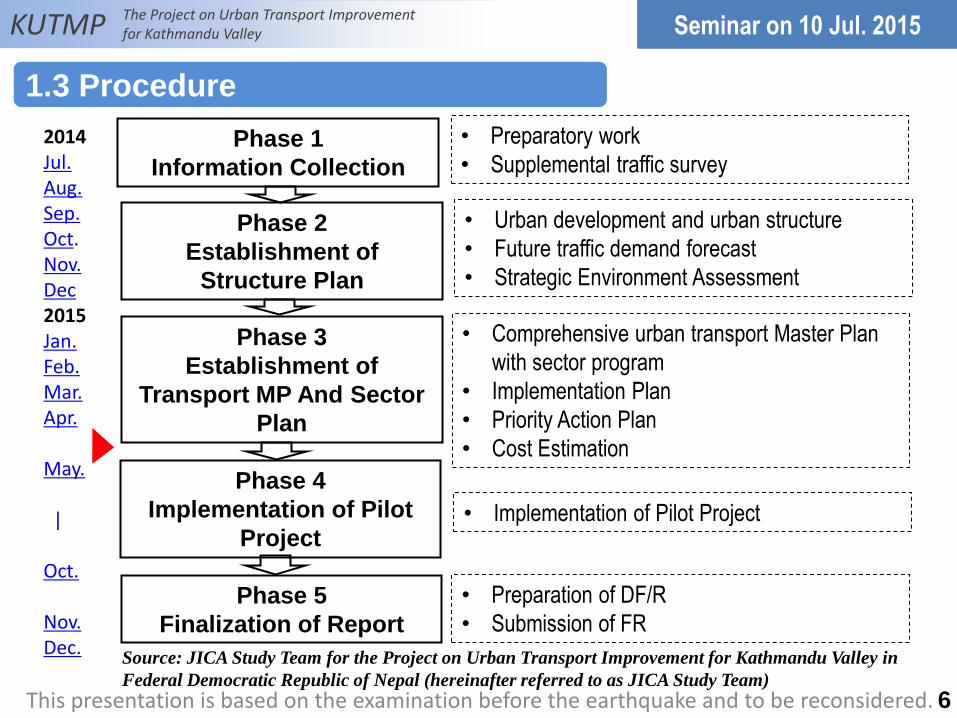
Phase 1
Information Collection
Phase 2
Establishment of
Structure Plan
Phase 3
Establishment of
Transport MP And Sector
Plan
Phase 4
Implementation of Pilot
Project
Phase 5
Finalization of Report
• Preparatory work
• Supplemental traffic survey
• Urban development and urban structure
• Future traffic demand forecast
• Strategic Environment Assessment
• Comprehensive urban transport Master Plan
with sector program
• Implementation Plan
• Priority Action Plan
• Cost Estimation
• Implementation of Pilot Project
• Preparation of DF/R
• Submission of FR
2014 Jul. Aug. Sep. Oct. Nov. Dec 2015 Jan. Feb. Mar. Apr. May. | Oct. Nov. Dec.
KUTMP The Project on Urban Transport Improvement for Kathmandu Valley
1.3 Procedure
6
Seminar on 10 Jul. 2015
This presentation is based on the examination before the earthquake and to be reconsidered.
Source: JICA Study Team for the Project on Urban Transport Improvement for Kathmandu Valley in
Federal Democratic Republic of Nepal (hereinafter referred to as JICA Study Team)
Part 2. Land Use Structure Plan
2.1 Precondition for Discussion
2.2 Alternative Plans of Urban Structure
2.3 Definitive Urban Structure
2.4 Layout of New Urban Area
2.5 Zoning and Characteristics
7

The Project on Urban Transport Improvement for Kathmandu Valley KUTMP
8
2011 2020 2025 2030 Increase
2011-2030
Increase
rate
2030/2011
Lalitpur 424,627 530,000 581,000 627,000 202,373 1.477
Bhaktapur 304,651 370,000 402,000 431,000 126,349 1.415
Kathmandu 1,724,308 2,220,000 2,456,000 2,666,000 941,692 1.546
Total 2,453,586 3,120,000 3,439,000 3,724,000 1,270,414 1.518
According to the population projection by Central Bureau of Statistics, population in
Kathmandu Valley will increase to 3.7 million in 2030 from 2.5 million in 2011. Urban
expansion will be inevitable.
Population projection in Kathmandu Valley
2.1 Precondition for Discussion
Seminar on 10 Jul. 2015
This presentation is based on the examination before the earthquake and to be reconsidered.
Source: JICA Study Team

Structure Land use Transport
Case 0
Monocentric
-Monocentric structure, Overconcentration -Trend pattern of expanding urban area in suburbs as typical sprawl -Assigning sub-city centers on the ring road
-Inner ring road -Outer ring road -Installation of new transport system on both North-South and East-West axis -Installation of BRT on both the Ring road and inner ring road
Case 1
Monocentric and
multipolar
-Monocentric structure -Improving Trend pattern by building planned new towns with high density on the outer ring road in suburb -Assigning sub-city centers on the ring road -TOD plan which develops the areas around the stations of new transport system
-Same as Case-0 except the outer ring road without north and northwest section
Case 2
Compact on east-
west axis with twin
centers
-Twin center structure -Shift from the trend pattern expanding urban area in all directions to the compact pattern aggregating urban area on the east-west axis -Assigning sub-city centers on the ring road -Typical TOD plan which develops new towns on the axis of East-West with a installation of new transport system
-Inner ring road -Outer ring road is not constructed -Installation of new transport system on both North-South and East-West axis -Installation of BRT on both the Ring road and inner ring road
Case 3
Integration of Case-1
and Case-2
-Twin center structure -Integration of Case-1 and Case-2
-Same as Case-1
9
KUTMP The Project on Urban Transport Improvement for Kathmandu Valley
2.2 Alternative Plans of Urban Structure
Seminar on 10 Jul. 2015
Source: JICA Study Team

10
KUTMP The Project on Urban Transport Improvement for Kathmandu Valley
Future Urban Structure Plan (Draft)
- Twin-Center on East-West axis with Multipolar
- Compact unban development in suburb
- TOD with Installation of Mass Transit system
Seminar on 10 Jul. 2015
Long Term Plan Case-0 Long Term Plan Case-1
Long Term Plan Case-2 Long Term Plan Case-3 Integration of Case-1 and Case-2
This presentation is based on the examination before the earthquake and to be reconsidered. Source: JICA Study Team

11
KUTMP The Project on Urban Transport Improvement for Kathmandu Valley
Case-0
Case-3
Case-1
Case-2
Future Urban Structure Plan twin-Center on East-
West axis with Multipolar
- Compact unban development in suburb
- TOD with Installation of Mass Transit system
Seminar on 10 Jul. 2015
This presentation is based on the examination before the earthquake and to be reconsidered. Source: JICA Study Team

Structure Plan Advantage Disadvantage
Case 0 Monocentric
Nothing, but this is the trend of land use
pattern.
Heavy traffic congestion in city center, deteriorating environment in suburb, huge
investment for transport infrastructure and so on
Case 1 Monocentric and
multipolar
This would be a practical solution for urban
development without some socio-economic
inequality between the districts because
development areas are distributed.
Traffic congestion in the city center will be difficult
to improve without huge investment for public
transport and radial arterial roads.
Case 2 Compact on east-
west axis with twin
centers
This is an innovative TOD solution for
increasing future traffic demand if high
capacity transport network is efficiently used
along the east-west corridor.
This has a risk in that large scale development in
the east area would become difficult because there
are rich cultural, natural and agricultural assets. In
addition, If development and investment are
concentrated in the East and West areas, some
socio-economic inequality and disparities between
the districts would be occurred.
Case 3 Integration of Case-
1 and Case-2
This is set up by taking advantages and
overcoming the disadvantages of both Case-
1 and Case-2. Therefore, this can be said as
a relatively better balanced urban structure
than the above tree alternatives.
This would be the same as mono-centric urban
structure like Case-1 if twin centers are not worked
well. Therefore, building a new center on East-west
axis is the key issue for success.
As a definitive urban structure, based on the discussion of WGs Case-3 is recommended.
12
KUTMP The Project on Urban Transport Improvement for Kathmandu Valley
2.3 Definitive Urban Structure
Seminar on10 Jul. 2015 Seminar on 10 Jul. 2015
This presentation is based on the examination before the earthquake and to be reconsidered.
Source: JICA Study Team

The Project on Urban Transport Improvement for Kathmandu Valley KUTMP
13
2.4 Layout of New Urban Area
Seminar on 10 Jul. 2015
This presentation is based on the examination before the earthquake and to be reconsidered.
Source: JICA Study Team

Logistic Center (On-
going) Sub-center of Kathmandu Valley Tourist base
Agriculture and Pharmaceutic area
New Logistic Truck Park Freight traffic center University
Existing Functions of Central Business District (Government, Commercial, Office, Education, Hospital etc.)
The Project on Urban Transport Improvement for Kathmandu Valley KUTMP
2.5 Zoning and Characteristics
14
Seminar on 10 Jul. 2015
This presentation is based on the examination before the earthquake and to be reconsidered.
Source: JICA Study Team

Part 3. Transport Network Plan
3.1 Road Network Development Target
3.2 Concept for Future Road Network System
3.3 Proposed Future Road Network
3.4 Public Transport Development Strategy
3.5 Conceptual Plan of Public Transport Network
15

The Project on Urban Transport Improvement for Kathmandu Valley KUTMP
1. Coordination with Urban Land Use
Plan
2. Improvement of Network System
3. Supply of Road Capacity
4. Improvement of Bottle-neck
5. Provision of appropriate road
facilities including cross section
• Systematic road distribution to new urban area.
• Securement of road space for primary public
transport route
• Conversion to radial-circumferential system from
radial system
• Development of IRR
• Widening of roads where capacity is required.
• Development of off road parking, bus and truck
depot.
• Installation of bridges.
• Improvement of intersections.
• Improvement of river crossing
• Signals
• Pedestrian signals/pedestrian bridges
• Road cross section with appropriate pedestrian
way/bike lane and motorcycle lane.
Target Measures
16
3.1 Road Network Development Target
Seminar on 10 Jul. 2015
This presentation is based on the examination before the earthquake and to be reconsidered. Source: JICA Study Team

KUTMP The Project on Urban Transport Improvement for Kathmandu Valley
Current Road Network System
- Radial Road Network System except Ring Road
Tribhuvan Highway Arniko Highway
Central Business District
(CBD) Densely inhabited area
Issues caused by current network
system
- Vehicles concentrate into CBD.
- Vehicles which do not have
destination in CBD are forced to go
through CBD.
Ring Road
17
3.2 Concept for Future Road Network System
Seminar on 10 Jul. 2015
This presentation is based on the examination before the earthquake and to be reconsidered.
Source: JICA Study Team

Tribhuvan Highway Arniko Highway
Central Business District
(CBD)
Densely inhabited area
KUTMP The Project on Urban Transport Improvement for Kathmandu Valley
Future Road Network System
- Conversion to Radial-Circumferential road network
Ring Road
Inner Ring Road
Outer Ring Road
Development of Inner Ring
Road enables vehicles to
divert congested CBD area.
Outer Ring Road services sub
urban areas
18
Seminar on 10 Jul. 2015
This presentation is based on the examination before the earthquake and to be reconsidered.
Source: JICA Study Team

KUTMP The Project on Urban Transport Improvement for Kathmandu Valley
19
3.3 Proposed Future Road Network
Seminar on 10 Jul. 2015
This presentation is based on the examination before the earthquake and to be reconsidered.
Source: JICA Study Team
KUTMP The Project on Urban Transport Improvement for Kathmandu Valley
– Inside Ring Road
20
Seminar on 10 Jul. 2015
This presentation is based on the examination before the earthquake and to be reconsidered.
Source: JICA Study Team

2 Installation of New Public Transport with high capacity and exclusive space(BRT, AGT etc. ) > to Center from North, South, East and West > Circulation by Ring Road & Inner Ring Road
3 Improvement of Road Network on Bus Route > construction of Inner Ring Road > Improvement of the density of bus routes ( 1km mesh) > Improvement of the width of bus routes ( to ensure as a large/medium bus routes)
4 Promotion of TOD both in new urban area and in existing urban area
5 Promotion of NMT both in new urban area and in existing urban area
Inefficient Bus Operation by many old buses and too many small-sized buses
Low density and low capacity road network
Lack of Transport management
Lack of Off-road Bus terminals and Existing of many Roadside Bus terminals
(Main Causes of Problems) ( Strategies)
1 Reorganization of Public Transport Operation > Routes (hierarchy of network by mobility) > Terminal (reallocation of transport terminals) > Vehicle, Operator, Fare, Priority and so on
21
KUTMP The Project on Urban Transport Improvement for Kathmandu Valley
3.4 Public Transport Development Strategy
Seminar on 10 Jul. 2015
This presentation is based on the examination before the earthquake and to be reconsidered.
Source: JICA Study Team

Clockwise & Counterclockwise Circulation on the Inner Ring Road
Central Business District
District Centre
Urban area with high density
Urban area with low density
New development area with high density
New development area with Medium density
Central Station (Urban Transport Hub)
E,W,N,S Station and new town Station, which have transfer function of traffic mode
Station Bus terminal
Strategic Public Transport Route(SPTR) =Primary Bus Route
Secondary Bus Route
Tertiary Bus Route Outer Ring Road
Inner Ring Road
Ring Road
Inter Regional Bus
【 Image of Strategic Public Transport Routes(SPTRs)】 Clockwise & Counterclockwise Circulation on the Ring Road
22
Seminar on 10 Jul. 2015 KUTMP The Project on Urban Transport Improvement for Kathmandu Valley
3.5 Conceptual Plan of Public Transport Network
This presentation is based on the examination before the earthquake and to be reconsidered. Source: JICA Study Team

North Station
South Station (With Bus Terminal)
Strategic Public Transport Route (Primary route)
Inner Ring Road
Ring Road
Secondary Route
Tertiary Route
airport
New Bus Park
Lagankehel Bus Park
Old Bus Park
Central Station (With Bus Terminal)
East Station (With Bus Terminal)
West Station
West Bus Terminal
Four Off-Road Bus Terminals are Proposed (Central, East, West & South)
23
Development of Terminals
Seminar on 10 Jul. 2015 KUTMP The Project on Urban Transport Improvement for Kathmandu Valley
This presentation is based on the examination before the earthquake and to be reconsidered.
Source: JICA Study Team
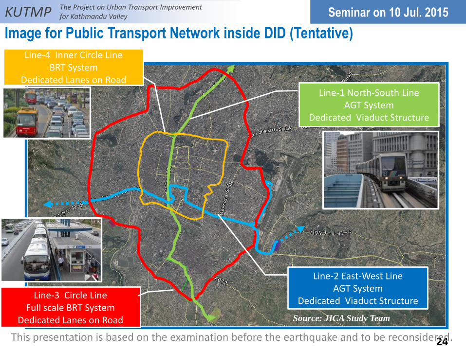
Image for Public Transport Network inside DID (Tentative)
Line-1 North-South Line AGT System
Dedicated Viaduct Structure
Line-2 East-West Line AGT System
Dedicated Viaduct Structure Line-3 Circle Line
Full scale BRT System Dedicated Lanes on Road
Line-4 Inner Circle Line BRT System
Dedicated Lanes on Road
KUTMP The Project on Urban Transport Improvement for Kathmandu Valley
24
Seminar on 10 Jul. 2015
This presentation is based on the examination before the earthquake and to be reconsidered.
Source: JICA Study Team

Part 4. Emergency Transport Road Network
4.1 Introduction of Emergency Road Network (ERN)
4.2 Classification of ERN
4.3 Proposed Definition of First Emergency Road
4.4 Proposed Definition of Second Emergency Road
4.5 Proposed ETRN
4.6 Case Study
4.7 Way Forward
25

The Project on Urban Transport Improvement for Kathmandu Valley KUTMP
26
Before Disaster-prevention measures
Landslide
Bridge fall
After Disaster-prevention measures
Emergency Transportation Road
Emergency Transportation Road
Disaster prevention center
Disaster prevention center
Urban Area
Urban Area
Bank protection work
Seismic strengthening
Relief Supplies
Relief Supplies
4.1 Introduction of Emergency Road Network (ERN)
26
In order to perform smooth emergency transport after the earthquake, ERN shall be necessary to connect each disaster prevention center by highway, arterial road, and sub-arterial road network.
Seminar on 10 Jul. 2015
Source: JICA Study Team based on Ehime Pref. Homepage

The Project on Urban Transport Improvement for Kathmandu Valley KUTMP
National Emergency Road (Ring Road, Arniko Highway) Over 20m road width No block point for building demolition More than 2lanes for ambulance or
heavy equipment traffics after big earthquake
Large open spaces (Airport, Industrial estate etc.) are connected NER
Center area of Kathmandu is connected National Emergency Road
First Emergency Road Over 12m road width Almost roadside buildings under 6
floors (some buildings over 7 floors) Some block points for building
demolition At least 1 lane for ambulance or heavy
equipment traffics after big earthquake Big hospitals, open space, fire stations
and connected NER and FER network
Figure NER (Arniko Highway) Cross Section Image
Figure FER Cross Section Image
27
4.2 Classification of Emergency Road Network (ERN)
Seminar on 10 Jul. 2015
This presentation is based on the examination before the earthquake and to be reconsidered.
Source: JICA Study Team Source: JICA Study Team

The Project on Urban Transport Improvement for Kathmandu Valley KUTMP
Second Emergency Road Arterial road network will be located
1km square interval Over 5m road width roads are chosen
for Second Emergency Roads Many block points by collapsed
building
Concept Emergency Road Existing no road network but necessity
to connect FER or SER To use land pooling, this concept ER
must be constructed
Figure SER Cross Section Image
28
Seminar on 10 Jul. 2015
This presentation is based on the examination before the earthquake and to be reconsidered.
Source: JICA Study Team

The Project on Urban Transport Improvement for Kathmandu Valley KUTMP
Figure Conditions for determining the suitability of ERN (1)
12m No.1 Five Floor (2.7m*5)/3=4.5m No.2 Two Floor (2.7m*2)/3=1.8m and setback 1.0m No.3 Three Floor (2.7m*3)/3=2.7m No.4 Five Floor (2.7m*5)/3=4.5m No.5 Two Floor (2.7m*2)/3=1.8m No.6 Three Floor (2.7m*3)/3=2.7m
No.7 Five Floor (2.7m*5)/3=4.5m
No.8 Three Floor (2.7m*3)/3=2.7m No.9 Two Floor (2.7m*2)/3=1.8m No.10 Two Floor (2.7m*2)/3=1.8m No.11 Seven Floor (2.7m*7)/3=6.3m No.12 Two Floor (2.7m*2)/3=1.8m No.13 Three Floor (2.7m*3)/3=2.7m
12m
Debris Debris
Debris Debris
12m
For Escape
For Rescue
8m (Proposed) 1.5m
29
4.3 Proposed Definition of First Emergency Road
Seminar on 10 Jul. 2015
This presentation is based on the examination before the earthquake and to be reconsidered.
Source: JICA Study Team

The Project on Urban Transport Improvement for Kathmandu Valley KUTMP
Figure Conditions for determining the suitability of ERN (2)
Debris
Debris Debris
Debris
6-8m
For Rescue & Escape
4.5-m (Proposed) 1.5m
6-8m
1-2m Set back
Set Back
30
4.4 Proposed Definition of Second Emergency Road
Seminar on 10 Jul. 2015
This presentation is based on the examination before the earthquake and to be reconsidered.
Source: JICA Study Team

The Project on Urban Transport Improvement for Kathmandu Valley KUTMP
4.5 Proposed Emergency Transport Road Network
31
Seminar on 10 Jul. 2015
This presentation is based on the examination before the earthquake and to be reconsidered.
Source: JICA Study Team
The Project on Urban Transport Improvement for Kathmandu Valley KUTMP
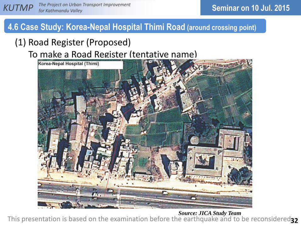
(1) Road Register (Proposed) To make a Road Register (tentative name)
4.6 Case Study: Korea-Nepal Hospital Thimi Road (around crossing point)
32
Seminar on 10 Jul. 2015
This presentation is based on the examination before the earthquake and to be reconsidered. Source: JICA Study Team

The Project on Urban Transport Improvement for Kathmandu Valley KUTMP
(2) Road Register (Proposed) To make a Road Register (tentative name)
4.6 Case Study: Korea-Nepal Hospital Thimi Road – cont.
33
Seminar on 10 Jul. 2015
This presentation is based on the examination before the earthquake and to be reconsidered.
Source: JICA Study Team

The Project on Urban Transport Improvement for Kathmandu Valley KUTMP
(3) Red is blocked area, and green is good condition area for emergency road network.
4.6 Case Study: Korea-Nepal Hospital Thimi Road – cont.
34
Seminar on 10 Jul. 2015
This presentation is based on the examination before the earthquake and to be reconsidered. Source: JICA Study Team

The Project on Urban Transport Improvement for Kathmandu Valley KUTMP
(4) Small Land Pooling system (proposed) Red boundary is LP development site
4.6 Case Study: Korea-Nepal Hospital Thimi Road – cont.
35
Seminar on 10 Jul. 2015
This presentation is based on the examination before the earthquake and to be reconsidered. Source: JICA Study Team

The Project on Urban Transport Improvement for Kathmandu Valley KUTMP
(1) To decide ERN Plan. (2) To strengthen road structure and facilities. (3) To check the condition of all buildings located by Emergency Road
and make a database of ERN. (4) To check how many blockade points will be in each ERN. (5) To make a plan to keep the space on the ERN. 1) Widening of road 2) Reform of building code and zoning system (Standard of building strength or setback) (6) To make a rule of promotion of reconstruction. 1) Tax exemption (rent tax, Inheritance tax etc.) 2) Subsidy (7) To make an evacuation route from World Heritage Site.
36
4.7 Way Forward
Seminar on 10 Jul. 2015
This presentation is based on the examination before the earthquake and to be reconsidered.

The Project on Urban Transport Improvement for Kathmandu Valley KUTMP
37
Seminar on 10 Jul. 2015
This presentation is based on the examination
before the earthquake and to be reconsidered
for Build Back Better.