the history, present, and future of underwater …
TRANSCRIPT

THE HISTORY, PRESENT, AND FUTURE OF UNDERWATER CULTURAL
HERITAGE MANAGEMENT IN JAPAN
A Dissertation
by
RANDALL JAMES SASAKI
Submitted to the Office of Graduate and Professional Studies of
Texas A&M University
in partial fulfillment of the requirements for the degree of
DOCTOR OF PHILOSOPHY
Chair of Committee, Luis Filipe M. Vieira de Castro
Committee Members, Vaughn M. Bryant
Christopher M. Dostal
Di Wang
Head of Department, Darryl De Ruiter
December 2019
Major Subject: Anthropology
Copyright 2019 Randall James Sasaki

ii
ABSTRACT
Japan is an island nation; the ocean and seas influenced the life of its people. Considering
this fact, it is natural to assume that Japan is a leading nation in the field of maritime and nautical
archaeology. However, Japan is one nation that has not developed a strong management system
for researching and protecting its underwater cultural heritage. Waterfront developments, marine
resource extraction projects, and dredging activities are underway, all without proper care of the
cultural heritage located below the waves. In fact, developers have begun these projects without
making any attempt to locate cultural heritage sites beneath them. The ultimate goal or purpose of
conducting this research is to rectify this situation, to promote the study of underwater and
maritime archaeology in Japan to prevent the loss of the important and rich cultural heritage of the
country.
To achieve this goal, the author first examined the history of underwater archaeological
research in Japan and conducted a brief survey of all underwater archaeological research and
maritime disasters. The author next examined how other countries managed their underwater
cultural heritage to compare their activities with those of Japan. This is followed by a discussion
of the possible reasons for the slow development of the field in Japan. Based on the analysis and
the interpretation of Japanese official documents, the author suggests strategies for the protection
of Japan’s underwater cultural heritage.

iii
ACKNOWLEDGMENTS
I would like to thank my committee chair, Dr. Castro, my committee members, and the
staff/faculty at the Department of Anthropology for their support in completing my Dissertation. I
am also grateful for the patience and love of my family, as well as my mother and father, for their
encouragement.

iv
CONTRIBUTORS AND FUNDING SOURCES
Contributors
This work was supervised by a dissertation committee consisting of Professors Louis Filipe
Castro (Committee Chair), Vaughn Bryant, and Christopher Dostal from the Department of
Anthropology, and retired professor Di Wang from the Department of History. Much of the data
analyzed for Chapters three, four, and five were collected while I participated in the research
projects conducted at Kyushu National Museum and the Japanese Agency for Cultural Affairs. All
other work conducted for the dissertation was completed by the student independently. Its contents
are solely the responsibility of the author and do not necessarily represent the official views of the
Kyushu National Museum, nor the Japanese Agency for Cultural Affairs.
v
NOMENCLATURE
ARIUA Asian Research Institute of Underwater Archaeology
ASA The Abandoned Shipwrecks Act
BCE Before Common Era
BP Before Present
CE Common Era
DRASSM The Direction des Recherches Archaeologiques Subaquatiques et Sous-Marines
JACA The Japanese Agency for Cultural Affairs
KNM Kyushu National Museum
NMSA The National Marine Sanctuaries Act
NOAA The National Oceanic and Atmospheric Administration
NRIMCH The National Research Institute of Maritime Cultural Heritage
PEG Polyethylene Glycol
RCE The Dutch Cultural Heritage Agency
ROV Remotely Operated Vehicle
SMAC The Sunken Military Craft Act
SONAR Sound Navigation and Ranging
UCH Underwater Cultural Heritage
UNCLOS The United Nations Convention on the Law of the Sea
UNESCO The United Nations Educational, Science and Cultural Organization
VOC Dutch East India Company

vi
TABLE OF CONTENTS
Page
ABSTRACT .............................................................................................................................. ii
ACKNOWLEDGMENTS ........................................................................................................ iii
CONTRIBUTORS AND FUNDING SOURCES .................................................................... iv
NOMENCLATURE ................................................................................................................. v
TABLE OF CONTENTS .......................................................................................................... vi
LIST OF FIGURES .................................................................................................................. viii
LIST OF TABLES .................................................................................................................... ix
CHAPTER I INTRODUCTION ............................................................................................... 1
Introduction ..................................................................................................... 1
Definition of Underwater Cultural Heritage (UCH) ....................................... 3
Current Status of Research .............................................................................. 4
Outline of the Research ................................................................................... 8
Summary ......................................................................................................... 10
CHAPTER II BRIEF HISTORY OF UNDERWATER ARCHAEOLOGICAL RESEARCH
IN JAPAN ............................................................................................................................... 12
Introduction ..................................................................................................... 12
Stage 1: Early Development ........................................................................... 12
Stage 2: Beginning of Investigation by Municipalities................................... 16
Stage 3: Spread of Underwater Archaeological Research .............................. 22
Underwater Archaeology and the Study of Prehistoric Sites.......................... 33
Takashima Underwater Site ............................................................................ 36
Recent Developments led by JACA ............................................................... 44
Summary ......................................................................................................... 50
CHAPTER III STATUS OF UNDERWATER ARCHAEOLOGICAL SITES....................... 52
Introduction ..................................................................................................... 52
Methodology ................................................................................................... 52
Overall Nature of Sites.................................................................................... 64
Analysis by Region ......................................................................................... 68
Summary ......................................................................................................... 84

vii
Page
CHAPTER IV SURVEY OF RECORDS OF MARITIME DISASTER ................................. 85
Introduction ..................................................................................................... 85
Study of Maritime Accidents across Japan ..................................................... 86
Case Studies: Yamaguchi and Fukuoka Prefectures ....................................... 99
Summary ......................................................................................................... 106
CHAPTER V BRIEF STUDY OF UNDERWATER CULTURAL HERITAGE
MANAGEMENT AROUND THE WORLD ........................................................................... 108
Introduction ..................................................................................................... 108
Development of UCH Management Systems ................................................. 108
Current Management System of UCH ........................................................... 114
Case Studies of Seven Countries .................................................................... 119
Summary ......................................................................................................... 135
CHAPTER VI CONDUCTING ARCHAEOLOGICAL RESEARCH IN JAPAN ................. 137
Introduction ..................................................................................................... 137
Concerns Regarding Protection of UCH......................................................... 137
Related Documents and Acts .......................................................................... 142
The Committee and the JACA Guideline ....................................................... 148
Responsibilities of National, Prefectural, and Local Governments ................ 157
CHAPTER VII CONCLUSIONS ............................................................................................. 161
Summary of the Studies .................................................................................. 161
Concluding Remarks ....................................................................................... 163
REFERENCES ......................................................................................................................... 165
APPENDIX A ........................................................................................................................... 180
APPENDIX B ........................................................................................................................... 181

viii
LIST OF FIGURES
FIGURE Page
1 A Part of a 3D-Model of the Hull Discovered at Takashima Underwater Site ... 7
2 A Map of Japan and the Surrounding Area ......................................................... 11
3 A Photograph Taken During the Research at Lake Suwa in 1908 ...................... 14
4 A Display of Artifacts at Tsuzura-Ozaki Site at the Local Museum ................... 18
5 Artifacts from Kaiyo-Maru Displayed at Esashi Town ....................................... 20
6 Stone Anchor Stocks Found at Ojika Island ........................................................ 27
7 UCH Map of Okinawa ........................................................................................ 29
8 A Map of Takashima and the Kyushu Island ...................................................... 37
9 A Drawing of Anchors Found All Alligned ....................................................... 39
10 A Site Plan of Kozaki Harbor Excavation by ARIUA ....................................... 40
11 A Plan Drawing of the Takashima No.2 Shipwreck Site ................................... 44
12 A Scene from the Boat Tour at Kurakizaki Underwater Site in 2015 ................. 46
13 Some of the Roof Tiles Found at the Isalnd ....................................................... 47
14 The Image of Sea Bottom at van Bosse Shipwreck Site, created using Multi-Beam
SONAR and Sub-Bottom Profiler ...................................................................... 50
15 A Map of Japan with the Names of Prefectures ................................................ 69
16 A Map of the Yamaguchi Prefecture ................................................................. 102
17 A Map of the Fukuoka Prefecture ....................................................................... 105
18 A Photo of Nanhai No.1 Shipwreck at the Museum ........................................... 123
19 A Photo of the Shinan Shipwreck at Dispaly ...................................................... 127
ix
LIST OF TABLES
TABLE Page
1 The Number of Surveyed Sites by Location and Age ........................................ 67
2 The Number of Excavated Sites by Location and Age ....................................... 68
3 Names of Prefectures .......................................................................................... 70
4 Overview of Sites in the Northern Japan Region ................................................ 71
5 Overview of Sites in North Pacific Region ......................................................... 73
6 Overview of Sites in North Sea of Japan Region ............................................... 74
7 Overview of Sites in Central Inland Region ....................................................... 76
8 Overview of Sites in Southwestern Pacific Coast Region .................................. 77
9 Overview of Sites in Southwestern Sea of Japan Region .......................................... 79
10 Overview of Sites in Seto Inland Sea Region ........................................................... 80
11 Overview of Sites in Kyushu Region ........................................................................ 82
12 Overview of Sites in Nansei Islands and Okinawa Region ...................................... 83
13 The Number of Recorded Maritime Accidents in the Top 10 Prefectures ............... 88
14 The List of Port of Origins by Prefectures ................................................................ 93
15 Records of Maritime Accidents Involving Foreign Vessels ..................................... 99

1
CHAPTER I
INTRODUCTION
Introduction
When people gained the ability to explore the seabed, they found remains of our past
buried beneath the seafloor in the form of submerged settlements, scattered remains, and
shipwrecks. The invention of self-contained underwater breathing apparatus (SCUBA) brought
archaeologists to the seas to investigate these underwater sites. They found that these sites offered
great potential to uncover our past. People began to realize the need to protect the historical legacy
located beneath the sea, and the concept of protecting the underwater cultural heritage (UCH) was
born in the mid-20th century, with scientific research and a proper management plan.
The study of UCH was a relatively minor field of scientific investigation for decades, and
some countries did not have a management program for their heritage sites. However, in the past
three decades, the field of the study of UCH has seen major developments. The United Nations
Educational, Science and Cultural Organization (UNESCO) has been promoting the Convention
on the Protection of UCH since 2001 (The 2001 UNESCO Convention); in 2018, the countries
that ratified the Convention had reached 60 in number.1 Nations around the world now have laws
protecting UCH against illegal salvage activities, coastal development projects, and marine
resources exploration works.2
The study of UCH often is associated with the study of our maritime past. This is because
oceans and other bodies of water are where our maritime activities took place. The study of
1 See UNESCO Convention on the Protection of Underwater Cultural Heritage Web Site:
http://www.unesco.org/eri/la/convention.asp?KO=13520&language=E&order=alpha 2 Manders 2017.

2
shipwreck remains often gives us a complete picture of a moment in the past: the life on board a
vessel, a mechanism of commerce in a particular time, and various aspects of the society that built
the hull. Such sites are not commonly found on land. Therefore, without UCH, much of our
maritime history would be unknown to us. UCH is a unique watery window to our past.
As a nation surrounded by the sea and having the world’s sixth-longest coastline, Japan
appears to be the prime location for research, protection, and promotion of UCH. The history and
culture of Japan cannot be discussed without noting the influence of the seas; the waters
surrounding the island influenced nearly every facet of the life of people in Japan. Contrary to the
image, however, Japan is one nation that has not developed a strong management system for
researching and protecting UCH. A few underwater sites have been explored in Japan. Most of
these are submerged prehistoric settlements; maritime or nautical related sites rarely are excavated.
There have been some initiatives in developing a management system. Still, waterfront
development and marine resource extraction projects are being conducted without proper care of
UCH, and such activities may have destroyed many underwater sites.3
The purpose of conducting this research is to help prevent the loss of the rich cultural
heritage of Japan. For this, it is necessary to understand the history of UCH research, assess the
potential of underwater sites, and examine the current status of UCH research in Japan. Also, it is
necessary to have an idea of how other countries are managing UCH. This introductory chapter
offers a definition of UCH and some key terms, an overview of the status of research on UCH, as
well as the outline of this study. Based on this, the research will suggest reasons for Japan’s limited
concern with UCH and possible solutions to the problem of our overlooked and undervalued
cultural resources.
3 JACA 2017.

3
Definition of Underwater Cultural Heritage (UCH)
For the purpose of this study, the definition of UCH follows that of the 2001 UNESCO
2001 Convention:
“Underwater cultural heritage” means all traces of human existence having a
cultural, historical or archaeological character, which have been partially or
totally underwater, periodically or continuously, for at least 100 years.4”
The term cultural heritage should also be defined as well. Archaeologists in Japan use the
word “cultural properties” because some cultural objects are owned as personal property, and the
right to own personal property is respected or guaranteed under the Japanese Constitution.5 Other
countries use the terms “cultural patrimony” or “cultural heritage.” For this study, however, all
these words are used interchangeably. The word “heritage” is used as a general term, but cultural
properties may be used when referring to a specific law, or to the name of an office.
The study of UCH and how it relates to the fields of underwater, maritime and nautical
archaeology is a complex issue of its own. Underwater archaeology is a general term used for
researching underwater sites, but it only refers to the technology and methodology being used, and
it is not the term to distinguish the subject of the study. The field of maritime archaeology
investigates the maritime nature of our past, or how we interacted with the water that surrounds us.
A coastal settlement pattern, the peopling of the islands, and adaptation specific to exploiting
marine resources may be the subjects of maritime archaeology in a larger sense.6
The field of nautical archaeology is a more topical subject, focusing on a vessel and how
water transport was utilized. Ship related infrastructures, such as ports and international trade
4 Maarleveld et al. 2013. 5 Act on Protection of Cultural Properties (Act No. 214 of 1950). 6 Delgado 1998

4
systems, might be studied under this field.7 Because remains, such as shipwrecks and coastal sites,
often are located underwater, “maritime,” “nautical,” and “underwater” archaeology are terms used
interchangeably by non-experts. In fact, maritime and nautical archaeology do not solely use the
evidence found underwater but use various types of evidence. For this study, however, the word
“underwater archaeology” is used to refer to the study of UCH. This is because, in Japan, the terms
“maritime” and “nautical” archaeology are not commonly used.
Current Status of Research
The study of UCH first became popular on the European continent. Discoveries, such as
the 17th-century Swedish warship Vasa and the English King Henry VIII’s flagship Mary Rose, are
some of the great discoveries from the earlier years in the development of the field. The raising of
the two hulls and the following conservation projects, as well as the display of the remains at
museums, are considered some of the best achievements in the field of maritime and nautical
archaeology.8 Treasure-hunters once pillaged UCH in the Caribbean and Southeast Asia, but many
countries have now begun to install proper management systems for protecting UCH.9 Today, the
emphasis is being placed on assessment, or knowing the status of each artifact, through various
survey methods, and on safeguarding those heritage sites.10
People of Japan showed interest in underwater discoveries relatively early; documents
from the 18th and 19th centuries recorded the discoveries of strange stones and ceramics from
underwater. 11 It was as early as 1908 that the first scientific investigation of an underwater site was
7 Kimura et al. 2018. 8 See Catsambis et al. 2011, and McGrail 2004. 9 Maarleveld et al. 2013. 10 Manders 2017. 11 Hayashida 2013.

5
conducted in Japan.12 The early investigators were dredging simply to find objects, but it is
important to note that this reflected public interest in the UCH. Small-scale projects were conducted,
but no major development in the field of UCH research took place until the 1970s. By this time,
the discoveries made in Europe had been revealed, and some scholars began to advocate the need
to develop the field of underwater archaeology in Japan.13 Some of the earliest municipal led
underwater excavations are the development-led project at Lake Biwa, and the excavation of
Kaiyo-Maru, a battleship that the fading Tokugawa Shogun purchased from the Netherlands.14
The most famous underwater archaeological site in Japan is the Takashima Underwater
Site in Nagasaki Prefecture, where divers discovered vessels from the Mongol Emperor Kublai
Khan’s fleet lost during the attempted invasion of Japan in 1281.15 According to historical accounts
from both China and Korea, more than 3,000 vessels were destroyed by the legendary typhoon off
the island of Takashima.16 Research at Takashima began 40 years ago, starting in the 1980s.17
Various researchers from different organizations came to the island in search of the lost fleet, but
all they found were scattered remains.18
The Japanese Agency for Cultural Affairs (JACA), an agency under the Ministry of
Education, Sports, Science, and Technology, is a competent authority in managing cultural heritage
sites in the country. The main task of the agency is to set guidelines for managing cultural heritage
sites. The primary caretaker of archaeological sites in Japan is the Board of Education at the local
12 Mikami 2016. 13 Oye 1982. 14 Sasaki 2017. 15 Sasaki 2015. 16 Delgado 2008. 17 Mozai 1982. 18 Ikeda 2018.

6
municipal level.19 The emphasis is placed on what is important for the local community, and the
central government plays a minor role in managing archaeological sites.
The local Board of Education manages all local cultural affairs, and municipal cultural
officers conduct the majority of the excavations. The local authority decides which sites are to be
protected, and excavation and research are the responsibility of each local government. 20
Approximately 6,000 excavation projects are conducted in Japan annually, more than 95% of them
related to construction.21 The right to make a decision to conduct or not to conduct a survey before
a construction project is given to the local Board of Education; if the cultural officer at the time
believes no survey is required for construction over water, no survey is required. If the cultural
officer knows of UCH, some form of a survey may take place.
In recent years, some avocational research groups, including a non-profit research
organization, Asia Research Institute of Underwater Archaeology (ARIUA), emerged as a leading
institute for underwater archaeological research. 22 ARIUA’s underwater site database project,
initiated in 2009, is considered a breakthrough in the field. This was the Comprehensive Survey of
Japanese Underwater Cultural Heritage Project, funded by the Nippon Foundation. They conducted
an extensive reevaluation of most of the known underwater sites in Japan, and the results, covering
more than 500 underwater sites, were published in a six-volumes of the report.23 There have been
several small-scale underwater archaeological projects in the country, but none appears to have had
a lasting impact. Whenever an underwater archaeological project was started, a new team was
19 JACA 2017a. 20 JACA 2017a. 21 JACA 2017a. 22 ARIUA 2013. 23 ARIUA 2013.

7
organized; when the project was over, the excavation team was dissolved, losing all the know-how
of underwater work.
One discovery made at Takashima changed the situation. In October 2011, a partially
preserved hull of a Chinese vessel was revealed under the silt; the discovery appeared on many
news outlets as a top story. The research continued, and a second vessel was discovered (fig. 1).24
The Takashima Underwater Site, now named Takashima Kozaki Underwater Site, became the first
shipwreck location to be registered as a national historic site in 2011.25
Figure 1. A part of a 3D-Model of the Hull Discovered at Takashima Underwater Site
(Courtesy of University of the Ryukyus, Matsuura Board of Education,
and Tsuyoshi Machimura)
At this time, JACA recognized that something must be done to manage UCH in the
country better. JACA formed the Advisory Committee on the Research of Underwater Sites (The
JACA Committee) in 2013 to determine how JACA and the municipal officials should manage and
protect UCH.26 This five-year committee was an important platform; it would decide the future of
24 Takano 2013. 25 Nakata 2013. 26 JACA 2017b.

8
the UCH management plan. Not all the committee members were familiar with the field of UCH.
JACA entrusted Kyushu National Museum (KNM) to study UCH to provide the committee
members with information regarding the research, protection, and management of UCH sites.
Various projects and case studies were conducted under the committee with KNM, including
several remote sensing surveys, assessing known sites, compiling information about maritime
disasters, and studying the management systems for UCH around the world.27 In 2017, JACA
published “Guidelines for the Protection of the Underwater Archaeological Sites in Japan (The
JACA Guideline) based on this study and discussions.
Outline of the Research
This research reported here is in several sections. First, this project will examine the
history of the field of UCH in Japan (Chapter II). The second part is an examination of the current
status of underwater archaeological sites (Chapter III). The third part is the collection of
information regarding maritime accidents and an analysis of the historical records of possible
shipwreck events (Chapter IV). The fourth part of this project is a brief survey of how other
countries in the world are managing UCH sites (Chapter V). The objective, or the aim, of the
research, is to consider the reasons that Japan has not seen major growth in the field of underwater
archaeology, and the possible future plan for UCH management (Chapter VI).
The first step towards understanding the nature of UCH management in a country is to study
how the field has developed. The history of the field of study will guide the future as well. A brief
history of UCH research and the development of the management system of Japanese UCH will be
discussed. Particular attention is given to different stages of development and the discovery of
27 Annual Reports are published by KNM, see KNM 2014, 2015, 2016, 2017, and 2018.

9
some key sites that led to a better understanding of the nature of UCH in the country. Particular
attention was given to prehistoric UCH sites and Takashima Underwater site, due to the
significance of the discoveries. Also, a project led by KNM is briefly discussed.
To study the evolution of a particular subfield of archaeology, it is necessary to understand
the nature of the sites that have been discovered and investigated. For this study, the author created
a database of Japanese UCH. The information was collected from various sources, but the database
of the ARIUA 2013 Report and the study conducted by JACA were the most useful sources of
information. The author identified 596 UCH sites in Japan. These sites were analyzed by several
criteria, including age and geographical distribution pattern, and status of research.28
The study of UCH, particularly of shipwrecks, often provides a wealth of information
regarding our past maritime culture. It is almost impossible to find a particular shipwreck site from
the middle of the ocean unless some information about the vessel is available. A record of maritime
disasters from historical archives usually is the best place to start searching for the clues to find a
lost shipwreck site. KNM conducted a survey of maritime records throughout Japan; the data were
gathered by requesting all municipal offices to provide information regarding maritime accidents
found in their municipal archives. A total of 5,598 entries of maritime disasters was collected.29
The records were analyzed by date, source of evidence, the port of origin, and ship type. It is beyond
the scope of this research to analyze all the data in detail. Therefore, the researcher focused on the
analysis of Yamaguchi and Fukuoka Prefectures as case studies.
For any field of study, learning from success is important. It is necessary to know how other
countries are managing their underwater legacy to establish a proper management system of UCH
28 See Appendix B. 29 KNM 2018.

10
in Japan. For this study, particular attention was given to how the laws on heritage management,
developed in an international context, led to the development of the 2001 UNESCO Convention.
Every country has had different issues regarding how to manage UCH, and even a quick look at
each country’s situation will end up with a large volume of information. Instead, seven countries
were selected as case studies, and the results are presented. The focus was on what caused the
development of the field, which agency is responsible for managing UCH, and examples of well-
known sites.
The final chapter will discuss the issues regarding how to create a better system of
managing UCH in Japan. The author will illustrate some of the challenges facing the Japanese
archaeological community. The JACA Guideline is an essential document when considering the
future of UCH related issues in Japan. The report presents a guideline that municipal cultural
officers can follow when working to protect the underwater legacy. Also included are several legal
documents relating to the protection of UCH.
Summary
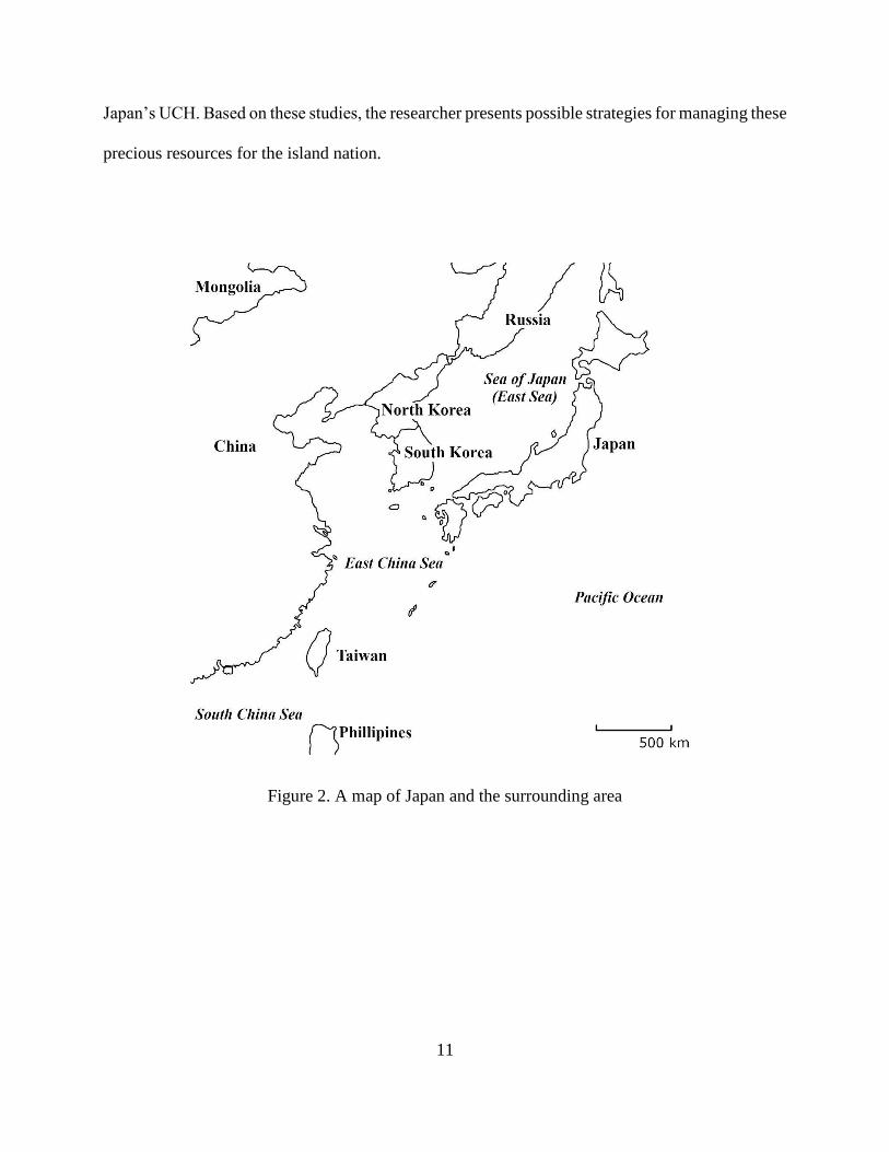
Because Japan is an island nation surrounded by the sea (Figure 2), it is highly likely that
UCH studies will reveal an important aspect of the nation’s history. Japanese archaeologists have
been conducting some scientific research on UCH. However, most of the work was conducted on
isolated projects, and no competent authority has developed in the country. The description of the
history of UCH research, comprehensive data from all underwater sites investigated, and an archive
of marine disasters were brought together under one umbrella for this research. Combined with the
international perspectives on UCH management, previous research, and examples of best practices
in other countries around the world, the research reported here will add to our understanding of
11
Japan’s UCH. Based on these studies, the researcher presents possible strategies for managing these
precious resources for the island nation.
Figure 2. A map of Japan and the surrounding area

12
CHAPTER II
BRIEF HISTORY OF UNDERWATER ARCHAEOLOGICAL RESEARCH IN JAPAN
Introduction
This chapter discusses the history of research and the development of a management system
for Japan’s UCH. The development of UCH research in Japan can be divided into four stages: (1)
an early stage of development (before 1945), (2) the beginning of investigation by municipalities
(1945 to 1990), (3) the spread of underwater archaeological research (1990 to 2012), and (4) the
recent development led by JACA (2012 to present). Some of the key sites will be introduced, with
particular focus on how the projects developed, a brief description of each site, and its contribution
to the archaeological communities.
Stage 1: Early Development
A few historical documents record people finding peculiar objects, such as man-made stone
items and ceramics, from the lakes and seas around Japan.30 Some of these discoveries were
recorded with detailed drawings, but they did not lead to a scientific inquiry. However, as early as
the start of the 20th century, Japanese scholars began asking scientific questions regarding finds
from underwater.
30 Hayashida 2013.

13
Lake Suwa (Sone Underwater Site)
The chance discovery of lithic artifacts from the bottom of Lake Suwa in 1908 shaped the
nascent stage of underwater archaeology in Japan. Fukumatsu Hashimoto was a teacher at a local
primary school located near Lake Suwa, and he happened to join the Tokyo Imperial University
(Today’s Tokyo University) research project at Lake Suwa as an assistant. The purpose of the
research was to study the environment and geology of the lake. While collecting the lake bottom
sediments, he found pieces of small man-made stone objects. The discovery was reported to the
University research team, and the professor in charge contacted Shogoro Tsuboi at the University.
Tsuboi, a professor of anthropology, is considered a father of anthropology in Japan.31
Tsuboi was quick to realize the importance of the discovery. Around the same time, the
discovery of prehistoric lake dwellings from the Alps was reported, and news of the research
reached Japan. Realizing the similarity in the two findings, Tsuboi set out to prove the existence
of lake dwellings, where people drove piles into the lake and created platforms above water.32 His
assumption was that the people of the past had taken a similar evolutionary path, and artifacts, like
those from the Alps, could be found in Japan.33 He was searching for evidence to prove that the
people of Japan and the people of Europe shared a similar course of cultural development.
Lake Suwa, located in a basin surrounded by mountains, is relatively shallow, averaging
only 6 m deep. Stone tools were found at a location known as Sone, approximately 300 m from
the shore. Tsuboi and his team systematically scooped up mud from the bottom of the lake and
carefully examined each scoop, recording the location, types of sediments, depth, and the artifacts
found (fig. 3).
31 Mikami 2016. 32 Tsuboi 1909. 33 Tsuboi 1909

14
Figure 3. A Photograph taken during the research at Lake Suwa in 1908
(Courtesy of Lake Suwa Museum)
The publication of Tsuboi’s article generated debate regarding how the site was formed.
Tsuboi believed that the site formed due to people living directly above the lake there on a built
platform. Other scholars argued that the artifacts were simply eroded from a site located on nearby
land and deposited at the lake bottom. But there was not enough evidence to settle the debate.34
The assumption Tsuobi made about the artifacts was based on the uni-lineal theory of evolution,
which has since been discredited. However, he can be credited with using the scientific method in
this work, as he had a clear research question and tried to gather archaeological evidence from a
site located underwater to answer it. Thus, this research can be considered the first scientific
underwater archaeological project in Japan.
After Tsuboi’s project, a few archaeologists continued searching for artifacts from Lake
Suwa, trying to resolve the mystery of the site formation process at the Sone Underwater Site.
34 Tsuboi 1909 and Hayashida 2013.

15
More organized projects took place in the 1920s and again in the 1960s, involving such scholars
as Ryuzo Torii and Eiichi Fujimori, who are respected scholars in the field of archaeology. They
found a few hundred projectile points. Today, it is believed that the Sone area was once connected
to the present shore, but became isolated as the land began to subside gradually. Some of the
artifacts were more than 10,000 years old. Fujimori has argued the need to conduct an excavation
underwater, but no large scale scientific investigation has been made, and no conclusion has been
reached regarding how the site actually formed.35
Tsuzura-Ozaki Site
The site of Tsuzura-Ozaki is located near the northern tip of Lake Biwa, the largest lake in
Japan. Artifacts have been found along the eastern shore of the Tsuzura-Ozaki Peninsula. The site
was discovered in the 1920s, when local fishermen reported the finding ceramic artifacts, including
a nearly complete pottery jug. These artifacts turned out to be ceramic ware dating from the Jomon
Era (14,000 BCE-300 BCE), the Yayoi period (300 B.C.E- 250 CE), and the Kofun period (250-
550 CE). The area where artifacts were found is the deepest point in the lake, along a steep slope
at 50 to 70 m in depth. The discoveries soon got the notice of archaeologists. At that time, only a
few Jomon Era sites had been found in central Japan; the artifacts from Lake Biwa were some of
the oldest and only known examples of nearly complete Jomon pottery.36
As with the case of Lake Suwa, archaeologists debated how the site was formed. Most of
the finds were complete objects, and many scholars believed that the objects were part of religious
rituals. In the past, this particular area of the lake may have been considered sacred by the people
35 Mikami 2016. 36 Akita 1997, 262.

16
who lived there and who may have made offerings to the lake. However, there is no evidence to
prove this hypothesis.
Summary
At this early stage of development, the study of site formation processes was one of the
major focal points of archaeological research of submerged sites in Japan. Scholars wondered why
and how archaeological sites were created underwater. This is because the earliest underwater
discoveries were mostly submerged sites, and it was not known at the time that changes in sea (and
lake) levels were common when viewing history in a long geologic scale.
The site formation processes of submerged sites in Japan are likely to be caused by two
main factors. One factor is seismic activity, which may provoke land uplifts or subsidence, as well
as mudslides, which rapidly changed the context of a site. Another factor is the long-term process
of climate change and subsequent alteration in the local water level. Cultural factors also may play
a role; a site may be part of a sacred location where people made offerings. Harbors and other
structures built on water may form a site. Shipwrecks and jettisoned cargo may also form
archaeological sites, although, at this early stage of the development of the field, shipwreck sites
were not common. It should be noted that the scholars investigated the artifacts raised from
underwater, but none of them worked directly on the site.
Stage 2: Beginning of Investigation by Municipalities
The turmoil of the Wars during the 1930s and 1940s halted the advancement of
archaeology. After 1945, archaeology in a modern sense, or development-led archaeology, began
to take form. Several underwater sites were investigated, but it was not until the 1980s that the

17
municipalities began to investigate underwater sites on a large scale. Japanese archaeology is based
on a decentralized system; all archaeological projects are supported by the budget of that particular
municipality. Some of the major UCH investigation projects are introduced below. The case for
Takashima Underwater Site (Mongol Shipwreck site) is discussed separately.
Tsuzura-Ozaki Site Revisited
Beginning in the 1950s, Yoshio Oye, an archaeologist who grew up in the village near
Tsuzura-Ozaki Site, began collecting information regarding this underwater area. Based on stories
from local fishermen, he mapped the location where artifacts were found and created a catalog of
the finds (Figure 4).37 He proposed the need to investigate the site underwater with divers. He also
suggested investing in training a younger generation of archaeologists who could dive. Oye was
one of the earliest scholars to call for the establishment of the field of underwater archaeology. He
introduced several books on the subject to Japan, including the translation of foreign books by
George Bass and other scholars.38 However, no systematic survey of a site took place while Oye
was still present.
Today, the investigation at Tsuzura-Ozaki Site is continuing, utilizing new technologies.
Ritsumeikan University is conducting surveys using multi-beam SONAR (Sound Navigation and
Ranging) and an ROV (Remotely Operated Vehicle). In 2017, a map of a section of a site, revealing
the new finds, was created.39
37 Oye 1982. 38 Oye 1982. 39 Yano et al. 2017.

18
Figure 4. A Display of Artifacts at Tsuzura-Ozaki Site at the Local Museum
Shipwreck Site at Wakayama Prefecture
The narrow strait of Kitan, between Shikoku Islands and the main Island of Honshu, has
been known as a major highway of commerce, but it is also known as a difficult area to navigate.
There is a point at which fishermen have found many porcelain and ceramic artifacts. Some of the
finds were offered to the shrine on the island nearby; the oldest offering is dated to the Edo period
(1603-1868 CE). In 1958, archaeologist Koichi Mori took note of the ceramic collection housed
at the shrine. The majority of the artifacts are celadon made in China, dating from the 15th century.
Also found was Hizen ware, made in Kyushu during the Edo period. Based on the findings, it was
suggested that these artifacts came from at least two possible shipwrecks. Mori proposed that an
underwater investigation should be taken.40 Unfortunately, no research has been conducted at the
site, mainly because the area where artifacts had been found is over 70 meters deep, making it
difficult for divers to reach.
40 Wakayama City Board of Education 1997.

19
Kaiyo-Maru
Kaiyo-Maru was the flagship of the Tokugawa shogun. It was a vessel equipped with 26
cannons, the most powerful ship at the time in Japan. The Shogun purchased the vessel from the
Netherlands in 1866 (it arrived the following year) in a futile effort to keep his clan in power.
Unfortunately, the Shogun’s authority as the ruler of Japan had dissipated while waiting for the
vessel to arrive. The vessel sank during the Hakodate (Boshin) war in 1868, off the coast of Esashi
Port of Hokkaido, due to a winter storm. She had little chance to exhibit her firepower.
The story of the sinking of the vessel inside the harbor was not lost in history. Artifacts have
been salvaged from time to time, but, as the years passed, the precise location of the wreck site
was forgotten. The existence of the hull was confirmed during the construction of a breakwater
when renovating a port. Part of the hull was destroyed, but the town realized the importance of the
wreck site and organized an archaeological survey.41
The extent of the site was confirmed by the dive survey in 1974, led by Shinsuke Araki, at
Nara National Research Institute for Cultural Properties. In the same year, an area of 600 ㎡ outside
the jetty, and 2,000 ㎡ inside the jetty was registered as a known site, giving it protection against
further development. It became apparent that part of the site located outside the port was quickly
eroding. The excavation project commenced in 1976. It became the first large-scale excavation of
a shipwreck site led by a municipal authority. The excavation and following conservation efforts
received technical support from the National Institutes for Cultural Heritage (Tokyo National
Research Institute for Cultural Properties and Nara National Research Institute for Cultural
Properties).
41 Ishibashi 2003.

20
Through the years of excavation, 32,905 items were raised. Among them were five cannons,
about 2,500 cannonballs and shots, and various metal and organic remains (Figure 5). The town
did not have a conservation facility, and there was not enough money in the budget to pay for
conservators. To solve these issues, the town created a conservation facility at the local high school
and let the high school students perform the day-to-day conservation work. The hull was left in
situ; a copper mesh netting was used to cover the site, as conservators believed that the copper
mesh would prevent the shipworms from eating the wood.42 Despite being the first large scale
underwater archaeological project in Japan, the excavation, conservation, and construction of the
museum make the Kaiyo-Maru one successful example of underwater archaeological investigation
in Japan.
Figure 5. Artifacts from Kaiyo-Maru being displayed at Esashi Town
42 Esashi Town Board of Education 1990.

21
The Lake Biwa Project
Lake Biwa, the largest inland lake in Japan, has 240 km of coastline and has been an important
waterway for trade and a source of food for thousands of years for the people of central Japan. The
lake became the focal point of submerged cultural heritage management in the 1980s. The
government-led large-scale lakefront development plan began in 1972. With the support of the
Board of Education of the Shiga Prefecture, preliminary investigations were made along the shore,
identifying a total of more than 100 sites.43 The presence of the Tsuzura-Ozaki Site and the work
led by Oye influenced the decision to investigate underwater sites. Following an underwater survey
by divers, almost all of these sites were excavated by inserting cofferdams around them and
pumping out the water to allow for “dry land” excavation.44 The information gleaned through these
excavations is tremendous: archeologists surveyed and recorded sites ranging from midden sites
from the Jomon Era to historic building structures. One important site, dated to the Jomon Era, is
the Awazu-midden Site, which changed the way archaeologists viewed the prehistoric life of
Japan.45 The significance of the Awazu-midden Site is explained in detail in the section titled
“Underwater Archaeology and the Study of Prehistoric Sites” below.
Lake Biwa has seen many earthquakes in the past; some of them are recorded in historical
documents. There are several legends of villages being swallowed by the lake following an
earthquake. Louis Froist, a missionary visiting Japan in the late 16th century, published an account
of an earthquake, describing the event in detail. In 1586, he experienced the Tensho Earthquake
that destroyed part of the Nagahama castle built at the edge of Lake Biwa.46 Furthermore, there is
43 Shiga Prefectural Association for Cultural Heritage 2010, 23. 44 Shiga Prefectural Association for Cultural Heritage 2010. 45 Tsuboi 1994. 46 Nakagawa 2016, 63-6.

22
evidence of landslides and liquefaction in several areas. The earthquakes alone do not explain the
cause of the submergence of all the sites in Lake Biwa. The water level appears to have changed
several times in different periods, and people gradually moved their settlements to new locations.47
The change in water level at Lake Biwa must be investigated further. A most notable
characteristic of Lake Biwa is that it has only one drainage point, at the Seta River, located at the
southern tip of the lake. It has been suggested that the silt accumulation in the Seta River, or
perhaps a localized uplift along the river, may have changed the drainage pattern of the lake.48
When there is an uplift event at this small drainage point, Lake Biwa would be blocked, and the
water level would have slowly begun to rise.49
Summary
Underwater archaeological research, based on development-led projects, began to take form
in Japan in the 1970s and 1980s. While some municipalities were involved with underwater
archaeological excavations, the majority of the municipalities were not. The disparity among the
municipalities in understanding the importance of underwater sites began to be noted by Japanese
scholars and government officials. This will be discussed in the next section.
Stage 3: Spread of Underwater Archaeological Research
The projects at Hokkaido and Lake Biwa, as well as the project at Takashima (discussed
below), contributed to the spread of underwater archaeological investigation in other parts of Japan.
Some of the examples of projects that followed the initial stage of the development will be
47 Akita 1997. 48 Tsuboi 1994, 156-8 49 Shiga Prefectural Association for Cultural Heritage 2010, 44.

23
discussed in the present section. In the 1980s, JACA began to notice the importance of the
country’s UCH. Furthermore, after the mid-1990s, some universities and avocational groups began
to advocate the importance of the study of Japan’s submerged historical legacy.
The JACA Project
As noted previously, the majority of archaeological projects in the nation are conducted
through local municipalities. While the discoveries mentioned above were being made, a few
underwater excavations were taking place across Japan. However, there was little coverage of the
findings. JACA did realize the importance of underwater archaeology. Between 1989 and 1991,
JACA conducted a project to examine how UCH was being managed in Japan. The project was
conducted in cooperation with several groups, including the Kyusyu Okinawa Society of
Underwater Archaeology (Now ARIUA), founded by Kenzo Hayashida, the town of Takashima,
and researchers from various institutes.50 Questionnaires were sent out to local municipalities
asking about the current status of research regarding UCH within their municipality. All 3,245
municipal offices in Japan at the time were targeted for the study. The result of the interviews
identified over 300 sites, but only 216 sites had detailed information for further analysis. The
questionnaire asked the respondents for examples of recovered artifacts, site location, age of the
site, and a brief description of the site.51
Of the 216 sites, 109 were located at sea or in coastal areas, and 88 sites were found in inland
waterways, such as lakes.52 A larger number of marine sites are located in southwestern Japan,
while more freshwater sites are found in eastern and northern Japan. Reported sites range from
50 JACA 2000. 51 JACA 2000. 52 Kimura 2009.

24
simple scatters of artifacts to submerged features, structures, and shipwrecks. Among these
reported sites, eight are from the Paleolithic Era (?-16,000 B.P.), and 70 date to the Jomon Era.
More than 70 sites have no assigned period, meaning that the existence of the site is known, but is
not fully investigated. Only 44 sites had been excavated at the time, and 14 of those sites date to
the Jomon Era.53
The result illustrates the great potential for research of the Jomon Era. The distribution of
sites suggests that the Jomon people utilized inland waters extensively; however, more coastal
sites should be investigated to reveal maritime adaptation patterns of the past. The data show that
some municipalities, including the Shiga and Nagasaki Prefectures, had a large number of sites,
while many of the municipalities showed almost no data regarding UCH. The characteristics of
the UCH sites in Japan are discussed in Chapter III. It is important to note here that JACA began
to recognize the need for UCH management and realized the disparity of research among the
municipalities.
Iroha-Maru
In the mid-19th century, Japan purchased many vessels from foreign countries, and one of
them was Iroha-Maru. This vessel was built in England, equipped with a steam engine, but was
lost at Seto-Island Sea in the year 1867, just prior to the fall of Tokugawa Shogunate. Iroha-Maru
sank after colliding with another ship. This incident led to the nation’s first maritime trial case.
The vessel was operated by Ryoma Sakamoto, one of the most famous figures from the end of the
Edo period. He probably played only a minor role in Japan’s history. However, a series of historical
novels, roughly based on his deeds in the recent past, had made him into a national hero. At the
53 JACA 2000.
25
trial, Sakamoto claimed he had carried various cargo, in the Iroha-Maru, one of the valuable items
being a shipment of 400 rifles. The trial was a landslide victory for Sakamoto; the judge ordered
that he be paid for the lost cargo. Unfortunately, he was assassinated before receiving the
payment.54
In the early 1980s, a local historical group at Tomonoura town, in the Hiroshima Prefecture,
set out to discover the famed vessel, and they found a possible target during a survey. An
excavation was planned to confirm the identity of the vessel. The excavation was led by a non-
profit research group, Underwater Archaeological Society, based in Kyoto. The group requested
the assistance of the local Board of Education, and permission was given to excavate a site.
Excavations were conducted at the site intermittently over the years. The visibility at the site
was close to zero, and the current was strong, making it one of the most difficult underwater sites
to excavate in Japan. The vessel they found was en route from Nagasaki to Osaka carrying
imported items. The vessel had a boiler. This and some of the artifacts, such as a door handle, can
be traced back to England, all confirming the identity of the vessel as Iroha-Maru. Some of the
artifacts were raised and are stored in the local museum at Tomonoura town. It should be
mentioned that no single component or a fragment of a gun has been found at the site.55 Perhaps,
Sakamoto bluffed and won the case at the nation’s first maritime accident trial.
Kurakizaki Underwater Site
The Kurakizaki Underwater Site is located on the western coast of Amami Island, the
second-largest islands of Ryukyus, south of Kyushu. Amami Island is located about halfway
54 Fukuyama-City Tomonoura Rekishi Minzoku Shiryoukan 2008 55 Underwater Archaeological Society 2006.

26
between the main island of Okinawa and Kyushu. The site is found at a narrow channel leading
into the village of Uken at Uwan Bay. While dredging to expand a channel, local residents began
noticing scatters of porcelain fragments. These fragments were imported porcelain from China,
dating to the 12th and 13th centuries.56
Following the discovery, the Board of Education realized the importance of the possible site
and asked Aoyama University of Tokyo to organize an excavation team. From 1997 to 2001,
limited excavation was conducted at the Kurakizaki Underwater Site. The site is located in shallow,
clear, warm and calm water. Over 2,000 pieces of ceramics, mainly bowls, plates, and some storage
jars, all from China, were recorded and raised. The main assemblage resembles or is almost
identical to the assemblages found at the Hakata Bay area of Fukuoka, the main international port
of Japan at the time.57
Yamami Oki Underwater Site and Maegata Bay Underwater Site
The Goto Islands are chains of islands located at West of Kyushu Island. When sailing, they
are the last islands to see (and to stop by) before heading towards China. Starting at least from the
8th century, numerous vessels passed near the Goto Islands, either going or coming from China.
Because of the strategic importance of international commerce, the island has received much
attention from underwater archaeologists. Stone anchors, similar to those associated with Chinese
merchant vessels, have been found around the island (Figure 6). The Board of Education of Ojika
town sent out a request for proposals to conduct a survey around the island, and ARIUA responded
to the call.58
56 Uken Town Board of Education 1999. 57 Uken Town Board of Education 1999. 58 Ojika Town Board of Education 2002.

27
Figure 6. Stone Anchor Stock Found at Ojika Island
A diving survey, begun in 2001, identified over 80 items. The site is now known as Yamami
Oki Underwater Site, dating to the 16th and 17th centuries. Most of the artifacts were identified as
originating in Thailand. Only a limited variety of artifacts was present, and the assemblage
suggests that they are from a cargo of a single shipwreck event. There were only eight artifacts
that originated in China. It is presumed that that vessel started out from Thailand, then stopped
over in China before leaving for Japan.59 Excavators found a lead ingot, probably used for musket
shots.60 This was a single isolated find, and it is highly unlikely that only one small lead ingot was
carried on board; it is believed that more lead ingots may still be buried nearby.
The success of the survey at the Yamami Oki Site led to the planning of additional surveys
of the Maegata Bay. The diving survey was again led by ARIUA. The project started in 2005 and
found a scattering of remains, mainly Chinese in origin. The artifacts are dated to the 12th to 13th
59 Ojika Town Board of Education 2002. 60 Sasaki 2017.

28
centuries. Divers found celadon bowls and porcelain fragments. In addition to ceramic artifacts,
divers found two Chinese style stone anchor stocks.61
Locating scatters of possible international trade cargo was no doubt a success for ARIUA,
but the group took the project further by organizing one of the first underwater site tours in the
country.62 Although by the year 2000, access to a nation’s legacy in an underwater museum was
becoming popular in many parts of the world, this was the first project of its kind in Japan. The
registered visitors followed guide ropes throughout the site, and information boards were installed
underwater, explaining about the site and artifacts found. In addition, an underwater speaker was
used to explain the site. Professional divers carried a camera with a cable, broadcasting the
underwater scenes to the group of people on the diving boat.63
UCH in Okinawa
The Islands of Okinawa, or Ryukyus, have been known for thousands of years for the
passage of a large volume of goods and people by sea transport; it was a watery highway in East
Asia. Diving tourism is one of the major industries in Okinawa, and the presence of UCH has been
noted for years. Many locations are known to have artifact scatters, mainly of ceramics. However,
these sites did not receive proper care and were not registered as known sites to be protected.64
In the late 1990s, municipal cultural property officers in Okinawa Prefecture began to collect
data regarding these UCH sites. They conducted a detailed analysis of historical sources and asked
fishing communities and dive shops for information about possible sites. Once the data were
gathered and plotted, the research team conducted dive surveys to confirm the presence of a site.
61 Ojika Town Board of Education 2007 and Ojika Town Board of Education 2008. 62 Nogami 2007. 63 Nogami 2007. 64 Katagiri 2015.

29
All possible sites were recorded using GPS. This effort encompassed a series of projects, supported
by different organizations, including subsidiary government funding and private research funding
sources.65 As a result, more than 200 sites were recorded, and the results were published in an
official cultural property report from the Prefecture (fig. 7.).66
Figure 7. UCH Map of Okinawa
(From Yamazaki et al. 2015, Figure 5)
Ertugrul
In 1890, one vessel met a typhoon. The water that seeped into the engine room made the
boiler explode, causing the ship to sink near today’s Kushimoto town in Wakayama Prefecture.
65 Katagiri et al. 2014. 66 Okinawa Prefecture Buried Cultural Property Center 2017.
30
The vessel had over 600 people on board, but only 69 of them survived. The vessel was Ertugrul,
a Turkish frigate that was on its return journey to Turkey after the ceremonial first visit of Turkish
officials to Japan. At the time of sinking it is said that the Japanese had helped the sailors, giving
them food and medical attention. Also, money was raised through private fund-raising activities
and was used to help the survivors. The news of the disaster and the warm assistance provided by
the Japanese people moved the heart of the Turkish people. This maritime accident became the
origin of friendship between Turkey and Japan.67
Kushimoto is located at the southernmost point of the Honshu Island, and the warm current,
called Kuroshio in Japanese, runs close to shore. Consequently, the area’s water temperature is
warm, even during the winter months, attracting diving tourists. In recent years, a local dive shop
has found a number of artifacts possibly related to this shipwreck. At the same time, a Turkish
nautical archaeologist was searching for information regarding the Ertugrul wreck site in the hope
of conducting a friendship research project. The town was eager to support the work, and, by the
early 2000s, the project began to take form. A team of archaeologists from the Institute of Nautical
Archaeology in Turkey began to plan a survey, and, in 2007, an international team was formed.68
The surveys and excavations were planned and organized, and the city of Kushimoto became the
program’s host. As of today, more than 8,000 artifacts have been raised from the Ertugrul site and
are being conserved locally.69
A research center was created in the town, using an old school building as the conservation
lab and for storage. The project aims to promote the friendly relationship between Turkey and
Japan. A group of artifacts is being displayed at the renewed Turkish Memorial Museum in
67 Ryo 2013. 68 Lledo and Pulak 2008. 69 Lledo 2016.

31
Kushimoto. The center is active in reaching out to elementary and junior high school students,
hosting conservation workshops, and presentations at schools.70 The excavation of the site did not
follow the Act on Protection of Cultural Properties, but, rather, a salvage law. The finds were
considered to be a property of the Turkish Navy, and, strictly speaking, are not considered cultural
properties by Japanese law. It should be noted that the site is not registered as a known site. The
town and the Prefecture did not know how to deal with a case like this where foreign researchers
came to excavate a foreign-owned vessel.
Nishihama Sengen Site
The village of Nishihama, near Nagahama, is located on the Lake Biwa shore. It is one of
the villages that were swallowed by the water in local folk-tales, but it is not certain when the
village was destroyed, or even if the village actually existed. In 2013, students from Shiga
Prefectural University formed an underwater archaeological group and started researching the
legendary Nishihama village. The group conducted a survey at Nagahama and found the remains
of a possible village. Now known as Nishihama Sengen Site, the site was excavated and revealed
a possible burial ground of a village. Many stone statues and figures were found, typical of a
medieval village cemetery. The significance of the project is that it followed the scientific process
for archeological sites: the site was found, surveyed, excavated, and then a final report was
published by a university student organization.71
70 Lledo 2011. 71 Nakagawa 2016.

32
Recent Developments
Another development that took place in recent years is the growth in the number of academic
municipal and avocational maritime archaeologists. Recognizing the increasing importance of the
field, Tokyo University of Marine Science and Technology became the first university in Japan to
establish a course in maritime archaeology, and Tokai University followed by creating coursework
based on underwater archaeology72 Tokyo University of Marine Science and Technology initiated
a number of survey projects using advanced remote-sensing technologies.73 Some municipalities,
including Okinawa, have developed a strong team of archaeologists that can manage UCH in their
waters. They also have conducted several outreach programs at which the public can access and
see the underwater sites.74
ARIUA emerged as a leading avocational group in Japan for the study of UCH. As
mentioned above, they initiated a project in 2009 to locate known and unknown underwater sites
nationwide, including submerged prehistoric sites and shipwreck sites, and to create a database for
further studies (ARIUA 2013 Report). The members of ARIUA recognize the importance of UCH
management. This led them to plan the first comprehensive study of submerged sites. 75 The
ARIUA study became one of the most valuable sources for obtaining information regarding
underwater archaeology in Japan and will be a foundation for future studies on the subject.
As seen here, a number of other projects were conducted in Japan. The projects were led by
different organizations, including avocational groups, universities, prefectural officials, and a
foreign research group. These organizations worked closely with the local Boards of Education.
However, the research conducted by these groups was sporadic, and, often, the projects were led
72 Sasaki 2018. 73 Kondo and Iwabuchi 2011. 74 Katagiri 2015. 75 ARIUA 2013.

33
by archaeologists who had little project management experience. Their knowledge and
methodologies applied were not easily translated to the Japanese context, and some methodologies
had to be re-invented. Despite this situation, each project has been completed to exceptional
scientific standards and contributes to our understanding of the past.
Underwater Archaeology and the Study of Prehistoric Sites
One area where UCH can contribute greatly to the knowledge of Japan’s past is in the study
of prehistory. For most of Japanese prehistory, the sea level was at least 40 meters below the
current level, and, during glacier advances, sea levels were 120 meters below the present level.76
Tsushima Strait, which separates Japan and Korea, was narrower, making the peopling of Japan
easier.77 Available evidence indicates that people began to collect marine resources intensively
around 16,000 years ago.78 Beginning around 9,000 years ago, or perhaps earlier, there was a
warming trend, and the sea level began to rise.79 This event is known as the Jomon Transgression;
it reached a maximum stage between 6,500 and 5,300 years ago.80 It means that people had lived
on dry land that is underwater today. The changes in sea levels had a major influence on the past
way of life. Yet, there has been no research to locate Paleolithic sites at the Tsushima Strait.
The Takashima Underwater Site in the Nagasaki Prefecture is known as a place where Kublai
Khan of the Yuan dynasty (1279-1368 CE) lost his invading fleet. However, it is less known for
the artifacts from the Jomon Era, discovered below the stratum where the remains from the
invasion were found. The Jomon site was found off the Tokonami harbor; pottery, lithic tools,
76 Bailey and Flemming 2008, 2153. 77 Pope and Terrell 2008. 78 Pope and Terrell 2008, 14. 79 Ishiga et al. 2000, 223. 80 Lutaenko et al. 2007, 343.

34
bones, and some wood and plant remains were found. The date of the Jomon pottery assemblage
corresponds with the results from radiocarbon dating on two different species of intertidal shells.81
The discovery of the Jomon sites at such a depth is unusual in Japan. A few submerged Jomon
sites have been discovered, but they are located at a shallower depth, usually no more than 10
meters deep. There is no clear evidence of mudslide, based on the geologic data of the area, and
Nagasaki is not located on a fault line that might cause mass subsidence of 20 meters or more.82
Geological evidence suggests that, around 8,500 years ago, the sea level was at around 25 meters
below present levels, corresponding with the depth of the site being discussed.83 The discoveries
of similar sites will surely help answer many questions regarding the peopling of Japan.
The most significant potential for the contribution of UCH sites to the study of Japanese
prehistory arises from the fact that waterlogged sites often contain more well preserved organic
materials, as compared to terrestrial sites. Japan is located in an active volcanic zone, and the soil
is predominantly acidic in nature, a feature that is detrimental to the preservation of organic
remains.84 A wide gap exists between our understanding of the past lithic and pottery technologies,
and that of past technologies, based on organic materials. A large cache of basketry was discovered
at a partially inundated Higashimyo Site in Saga Prefecture. The evidence suggests that basketry
was already well developed before 7,000 B.P.85
The inundated sites no doubt provide a significant contribution to the study of past
technologies, based on wood and other organic materials, but it is to the understanding of past
subsistence systems that the study of submerged prehistoric sites can contribute the most. The key
81 Takashima Board of Education 1993, 75-97. 82 Takashima Board of Education 1993, 105-10. 83 Nakada et al. 1994. 84 Hongo 1989, 334. 85 Bleed and Matsui 2010, 362-3.
35
to the study of subsistence patterns lies in shell midden sites, full of discarded artifacts and remains
of food.86 In Japan, more than 2,000 Jomon shell midden sites are known; this number alone
signifies the importance of midden sites for the Japanese archaeological community.87 However,
the data may be skewed, given the differential preservation conditions. A stable isotope analysis
of human skeletal remains suggests that the Jomon people had an extremely diverse diet, relying
on plant products, despite most of the shell middens lacking plant materials. 88 Due to differential
preservation, middens found on dry land alone cannot be used to reconstruct their diet.
The evidence gathered from the waterlogged sites, especially submerged midden sites, can
give a more complete picture of the past subsistence pattern. The best example of a submerged
midden site is the Awazu-midden Site in Lake Biwa, located close to the southern tip of the lake.89
Three shell middens were found, and the smallest midden, dating to around 4,500 B.P. (the Middle
Jomon), has been fully excavated. Another two middens are preserved in situ. 90 The site,
approximately 370 meters x 400 meters in area, was excavated using a cofferdam.91 The shell
midden was found to have thick layers, containing plant remains between the layers of shells. This
suggests that plants were discarded during the fall and shells in the spring, making an annual layer.
92 Such layering has not been detected at dry midden sites.
At the Awazu-midden Site, chestnuts and acorns were the major component of the plant
remains. Surprisingly, the plants discovered included beans, gourds, and edible burdock. These are
cultivated plants, making the Awazu-midden Site one of the earliest sites showing the evidence of
86 Abe 2008, 20. 87 Mizunoe 2008, 58. 88 Yoshida 2008, 51. 89 Tsuboi 1994. 90 Matsui and Kanehara 2006, 263. 91 Shiga Prefectural Association for Cultural Heritage 2010, 148. 92 Matsui and Kanehara 2006, 263.

36
extensive plant utilization, or perhaps horticulture, in Japan.93 The evidence from the Awazu-
midden Site indicates that the subsistence of the Jomon people included diverse strategies. It is to
be noted that the Awazu-midden Site contributed greatly to our understanding of the past, not only
in what pertains to the subsistence patterns but also because the site may revolutionize our
understanding of the use of organic materials. Wood species, such as urushi, or the lacquer tree,
considered to be native plants of China, were found at the site.94 The cultivation and utilization of
urushi require extensive knowledge of the plant. There are many questions yet to be answered
about why and how the Jomon population came to possess such a comprehensive understanding
of the tree not native to Japan.
Takashima Underwater Site
Perhaps the most famous underwater archaeological site in Japan is the Takashima
Underwater Site of the Nagasaki Prefecture, also known as the Mongol Shipwreck site (Figure 8).
The site helped create the foundation of Japanese UCH studies. A detailed chronology of the
project at Takashima best illustrates the development, and, perhaps some problems, of the Japanese
underwater archaeological community. The recent discovery of a Chinese vessel at Takashima has
been reported by popular media but has produced only a few scholarly publications and site
reports.95
Based on historical records and accounts of local fishermen, who found artifacts in their
nets, the initial survey around the island was planned in the late 1970s. The project was led by a
marine engineer, who used an echo sounder he had developed. He located several anomalies and
93 Matsui and Kanehara 2006, 264. 94 Noshiro 2009, 94-7. 95 Takano 2013.

37
sent professional divers to survey those points. They were successful in raising some artifacts.
However, no remains of a vessel were found at the time.96 The greatest discovery, however, came
suddenly from an unexpected source.
Figure 8. A Map of Takashima and the Kyushu Island
Several years before the project commenced, a local fisherman found a metal stamp while
collecting mollusks. The stamp had a script he did not recognize. He decided to keep the item but
had no idea about the value of his find. When he heard the news of the project being conducted
96 Mozai 1982.
38
near his house, he realized what he had found may be related to the Mongol invasion. He showed
the item to the research group, and, to his surprise, it became the most important discovery in
Takashima. It was a bronze seal written in Pagspa-script, an official script of the Mongol Yuan
Empire. It was a seal used by an officer, and this was proof that the invasion took place.97
Although professional archaeologists were not involved directly during this initial stage,
the importance of the site was recognized.98 The area with the highest concentration of artifacts
was registered as a known archaeological site and protected from development under the Act on
Protection of Cultural Properties. Under this law, a site must be thoroughly investigated prior to
any land development. As mentioned above, all known archaeological sites in Japan fall under the
custody of the local Board of Education, and it is the responsibility of the local government to
protect any sites from being destroyed by construction or any other cause. As a result, whenever
there were harbor renovation projects within the protected area, the Board of Education at
Takashima (or the Matsuura City Board of Education) entrusted excavation projects to various
organizations.99 A series of surveys and excavations followed intermittently throughout the 1980s
and 1990s, led by different organizations. Excavations were conducted at Tokonami and Kozai
harbors, and ARIUA became the main research partner of Takashima during the 1990s and early
2000s.100
The rescue excavations for the harbor renovation at Kozaki produced a large number of
artifacts related to the Mongol invasion. Divers found nearly complete wooden anchors with stone
stocks, hull fragments, ceramics, weapons, and armor.101 Four anchors were found all aligned in
97 Delgado 2008. 98 Matsuura City Board of Education 2011. 99 In 2006, the town of Takashima was incorporated into Matsuura city. Thus, the site is managed by Matsuura
City Board of Education. 100 Matsuura City Board of Education 2011. 101 Matsuura City Board of Education 2011.

39
one direction, indicating that they set anchors against the south wind, a typical wind direction of a
typhoon (fig. 9).102 One artifact to be noted was a Tetsuhau, or ceramic ball, packed with scrap
metal and gunpowder; this is the earliest existing example of an explosive weapon ever used in a
naval battle.103 More than 2,000 artifacts were raised, but most of them were single isolated items.
104 The site appeared to be heavily disturbed, looking less like a shipwreck site than a “drift” of
artifacts (Figure 10). The discovery of a hull had to wait for a few more years.
Figure 9. A Drawing of Anchors Found All Aligned
(Adapted from Takashima Board of Education 1996)
102 Takashima Board of Education 1996. 103 Sasaki 2015. 104 Matsuura City Board of Education 2011.

40
Figure 10. A Site Plan of Kozaki Harbor Excavation by ARIUA
(Adapted from Takashima Board of Education 2003)
By 2004, more than 500 wooden artifacts had been raised from the Kozaki harbor area.
However, as these were all single isolated fragments, interpretation of the remains was extremely
difficult. The author conducted an analysis and recorded the timbers in 2004 and 2005.105 Among
the timbers, less than a dozen pieces were found joined together, and only nine timbers were longer
105 Sasaki 2015.

41
than 2 m in maximum dimension. Most of the timbers were heavily deteriorated. Historical
records, such as Yuan Shih, mentions that a few thousand vessels were gathered from various towns
in south China, as well as from Korea. A timber fragment from Takashima may be from any one
of these ships. However, the detailed recording has shown that most of the remains were from
south China, and perhaps only a few types of vessels may have been present at the site. There was
no conclusive evidence of a vessel from Korea.106
The rest of the artifacts, unfortunately, were found in a similar condition. A common
image of an underwater site full of complete artifacts cannot be applied to Takashima. This is a
naval battle site, so the typical artifacts found here are poorly fired storage jars and bowls with no
decorations, as well as bricks and heavily concreted iron nails. In other words, the greatest
underwater discovery in Japan was full of mundane and low-quality products. Furthermore, the
Takashima Board of Education could not allocate sufficient funding for a conservation project.
No one can be blamed for creating this problem; the artifacts had to be raised because the
harbor had to be renovated, and it is the norm that a construction company pays only for the
excavation, and the cost of conservation is borne by the local municipality. It was the first time in
the country that such a large concentration of artifacts was found underwater; the local
municipality simply did not have access to support from experts.
It appeared that the research at Takashima would no longer be continued by ARIUA, and
the city had to find other means to fund the project. A new phase of research came to Takashima,
initiated by the team led by Yoshifumi Ikeda from the University of the Ryukyus, supported by
the Grants-in-Aid for Scientific Research.107 The previous research projects were successful in
106 Sasaki 2015. 107 Ikeda 2018.

42
finding artifacts related to the invasion, but the evidence gathered did not provide an overall picture
of the invasion attempt.
The aim of the new project was to create a basic bathymetric map of Imari-Bay, using a
multi-beam SONAR system. It soon became apparent that the bay had heavy silt accumulation.108
The team added a Sub-Bottom Profiler system to investigate what might be buried beneath the
layers of silt. Based on the results of the survey, researchers identified approximately a dozen
possible anomalies, or areas with possible shipwreck remains. These locations were surveyed by
professional divers and probed using steel poles. In October 2011, a partially preserved hull was
revealed under the silt; the vessel was named The Takashima No.1 Shipwreck.109
Soon after the discovery, JACA was quick to take notice. The Takashima Underwater Site
was registered as a National Historic Site; it is the first shipwreck site to be registered at the
national level.110 The survey project was extended to another five years. With Grant-in-Aid for
Scientific Research, a more complete vessel, the Takashima No.2 Shipwreck was discovered in
2014.111 Brief observations were made at the site before it was covered with sand for preservation
in situ. Only a plan view was made for the Takashima No.1 Shipwreck, but. for the Takashima
No.2 Shipwreck, the research team was more prepared. The hull was recorded in 3D using
photogrammetry, providing a better chance to study the hull structures in detail.112 The two sites
are being monitored at least twice a year, recording parameters, such as dissolved oxygen and
salinity. Municipal officials and experts in archaeological site management are deciding how to
manage these sites best.113
108 Ikeda 2012. 109 Iked 2012. 110 JACA 2017b. 111 Ikeda 2016. 112 Ikeda 2016. 113 Ikeda 2018.

43
The two discovered vessels had hull structures in the Chinese tradition, with bulkheads to
support the hull, double planking, and iron nail fasteners.114 The Takashima No.1 Shipwreck was
found broken at one end. The hull was open and laid flat, with some bulkheads missing. The
surviving length of the keel was 12 meters. Artifacts associated with the wreck were ceramics,
stone shot, and bricks.115 The Takashima No.2 Shipwreck was found buried beneath a thick layer
of silt. The hull was well preserved, compared to the first wreck; the vessel retained a V-shaped
cross-section.116 Bulkheads were installed at nine locations; the first and second rooms were filled
mainly with silt and sand, but the rest of the rooms were filled with boulders.117
As mentioned above, the Takashima No.2 Shipwreck was digitally recorded in three
dimensions, and the recordings can be used for further analysis. The construction features and the
shape of the hull appeared to be similar to that of the Quanzhou ship, discovered in Fujian Province
in China.118 The vessel from Takashima was slightly smaller, but the curve lines of the Quanzhou
ship, generated by Green, proved to be very similar when they were reduced digitally to fit the
cross-section of the Takashima No.2 Shipwreck.119 The result showed that the reconstructed
overall length of the Takashima No.2 was about 20 m, with a maximum breadth of 7.4 m (fig. 11).
The nature of the naval organization in the 13th century China and Korea, as well as other
important questions, may be answered in the coming years with further research. Yet, the discovery
at Takashima already has contributed greatly to the development of the field of underwater
archaeology in Japan. Until the discovery of the two wrecks at Takashima, the study of UCH was
a minor sub-field of archaeology and received little attention from both the general public and
114 Kimura 2016. 115 Ikeda 2012. 116 Ikeda 2016. 117 Ikeda 2016. 118 Green et al. 1998. 119 Green et al. 1998.

44
scholars. Today, the city of Matsuura is seeking ways to promote the site to the public and to
conduct scientific research. The city has established a center for underwater archaeological
research and is beginning to take the initiative to become the leading organization for the study of
UCH in the country.120
]
Figure 11. A Plan Drawing of the Takashima No.2 Shipwreck Site
(From Ikead 2016, p. l 1)
Recent Developments led by JACA
Following the discovery of the intact hull remains at Takashima, JACA formed a committee
to discuss how the Japanese government should act to protect submerged archaeological sites. The
JACA Committee members were selected from a pool of specialists and municipal officials, a
120 Ikeda 2018.

45
vocational archaeologist, university researchers, and a conservator.121 The JACA Committee was
to exist for five years (fiscal years 2013-2017), and its purpose was to publish a set of general
guidelines on preserving the underwater legacy for municipal officials to follow. KNM was
entrusted to collect and analyze data regarding various aspects of UCH management and present
the results to the committee.122 In addition to these fact-finding missions, KNM conducted surveys
around Japan. Some of the sites investigated are discussed below. The results of the surveys are
reported in annual reports published by KNM. The technical difficulties when using survey
equipment, the complexities of required paperwork, and issues of logistics were evaluated.123
Kurakizaki Underwater Site Revisited
One of the first sites that the JACA Committee decided to survey was the Kurakizaki
Underwater Site. As mentioned, excavated items were ceramics made in China, mainly from the
latter half of the 12th century to the 13th century. In 2014, the team from KNM conducted a survey
using a magnetometer, Side Scan SONAR, Sub-Bottom Profiler, and an ROV. The purpose of the
survey was not only to find hull remains but to see how these survey systems can be applied. The
survey revealed no iron remains, and the deposit of the site was extremely shallow, having a thin
sediment layer over the bedrock. It appears that there were no hull remains left on the site. Perhaps
there was never a sunken ship here, and that the ceramics were discarded for some reason unknown
to us.124
In the summer of 2015, an archeological session with a symposium and a guided tour of the
site was planned. The symposium was held on the first day and the site tour the following day. The
121 JACA 2017b. 122 See Chapter I. 123 See KNM Reports 2014 to 2018. 124 KNM 2015.

46
main themes of the symposium were the result of the previous year’s survey at the site, and the
status of Japanese underwater cultural research. The tour of the site was a success, due to the warm
and clear water, and the fact that it is a shallow site, visible from the surface. The visitors used a
glass-box to see underwater from a fishing boat (Figure 12).125
Ai-no-Shima Island
Ai-no-Shima Island, located just east of Hakata Bay, is known as an island that ancient
sailors used as a stopover on a trade route. The island is known to have had a guesthouse for the
Joseon Mission Trips from Korea during the Edo period. The fishermen have found roof tiles in
the sea, and many of them were discarded or were kept as souvenirs (fig. 13). The fishermen had
125 KNM 2016.
Figure 12. A Scene from the Boat Tour at Kurakizaki Underwater Site in 2015

47
been calling these “Korean Roof Tiles” because they thought the tiles were brought from Korea
during the Edo period.126
Figure 13 Some of the Roof Tiles Found at the Island.
One local fisherman realized that these tiles appeared similar to those that been excavated
at ancient sites in Japan. Also, one of the tiles he found had an impression with the character
“Kego.” Kego was the name of an office from the Nara (710-794 CE) and Heian (794-1185 CE)
periods, created to control foreign trade and protect the area against invaders. Archaeologists took
notice of this roof tile because roof tiles with such an impression had been found only at two other
sites. One of these sites is in Fukuoka, where the tiles were made, and the other site is the Imperial
Palace in Kyoto. It is believed that the tiles to be used for the Kego office in Fukuoka, but, for an
unknown reason, the tiles were taken to the capital instead.
126 KNM 2016.

48
It is difficult to explain why a building at the capital had to use the roof tiles with the
provincial office name written on them. Historians suggest that there was an emergency situation,
such as a fire in the capital, and the roof tiles had to be gathered quickly. Packed hastily to be sent
to the capital, some of them may have been lost in transit near the Island. Considering the age of
the kiln site, the style of the roof tiles, and the year in which the Kego office was built, the tiles
may date to the 10th century.127
By detecting the age of the roof tiles, archaeologists in Fukuoka began to contemplate the
possibility of finding a vessel that might have carried these tiles. ARIUA took notice and conducted
a dive survey based on the information from the local fishermen. They were successful in finding
a few tiles. Following the success, in 2015, KNM conducted a survey. A bathymetric map of the
area was generated using a multi-beam SONAR system, and a Sub-Bottom Profiler was used on
selected areas. Data from the sub-bottom profiler suggests that the seafloor had a deposit of loosely
packed coarse grain sand. An ROV was used to check the condition of the sea. During the ROV
survey, several roof tiles were identified on the seafloor.128
Following the 2015 survey, JACA approached the Shingu town authorities to organize an
additional survey of the site, and the town agreed. The town proposed a four-year project. The
proposal was assisted by the KNM and the University of the Ryukyus, with Ikead, the
archaeologist who found the Mongol vessels at Takashima. The cost of the survey was partly paid
with JACA funding to support certain projects every year. The main diving unit was composed of
professional divers. The divers set the grid and searched for the tiles, while archaeologist Ikeda,
and a few other diving archaeologists, who visited the site, recorded the locations. By 2018, close
127 KNM 2016. 128 KNM 2016.

49
to 100 roof tiles had been found and recorded in an area of approximately 50 m by 100 m.129 One
outcome of this project is that the local cultural officer took diving lessons and is now diving with
the team. The project is an excellent example of the local government getting involved with the
archaeological project underwater.
Van Bosse Wreck Site
In 1867, a Dutch merchant vessel on its route from China to Singapore was blown off
course and wrecked in Tarama Island in Miyako province, in the Ryukyus (Okinawa). The wreck
was recorded in the local archive but was almost lost in history because only a brief explanation
was given about the event. It was known locally that many broken porcelain fragments could be
found at Takada beach, on Tarama Island. Archaeologists from Okinawa analyzed the artifacts and
identified them to be mainly of Chinese origin, having characteristics of ceramics exported to
Southeast Asia during the mid-19th century.130 A Japanese historian conducted a brief archival
research of the vessel in the Netherlands’ archive and identified the name of the vessel to be Van
Bosse.131 The local dive shop had found some artifacts scattered over the ocean floor and had been
using the site as a diving point. One prominent artifact is an iron box, approximately 1 meter by 1
meter, which may be the chest that the Dutch carried on board. The site was documented during
the survey conducted by researchers from the Okinawa Prefecture.132
In 2015, KNM initiated a survey using a multi-beam SONAR, and Sub-Bottom profiler
(Figure 14).133 With the help of the local dive shop, an ROV survey was conducted at the location
129 JACA 2017b. 130 Katagiri 2015. 131 Kaneda 2001. 132 Okinawa Prefecture Buried Cultural Property Center 2017. 133 KNM 2016.

50
where they had found some artifacts.134 The following year saw extensive archival research,
interviews of local residents, a walking beach survey, and diving survey using metal detectors.
Through these efforts, a basic outline of the site was created.135 Today, the dive shop has been
assigned as a custodian of the site; the shop is free to use the site as a dive point, but is responsible
for a visual survey of the site, and must report to the authorities if any significant change has been
seen at the site.136
Figure 14. The Image of Sea Bottom at van Bosse Shipwreck Site, created using Multi-
Beam SONAR and Sub-Bottom Profiler (Courtesy of JACA)
134 KNM 2016. 135 Tarama Village Board of Education 2017. 136 KNM 2017.
51
Summary
This chapter offered a brief history of UCH research and management in Japan. The research
on underwater archaeological sites began in the early 20th century, but scholars did not see the sites
directly. Following the methods and processes of land archaeology, underwater archaeological
research became the responsibility of local municipalities, but not many municipalities took the
initiative in trying to locate a site. The central government, or JACA, became aware of the
importance of managing the country’s UCH but did little to create a national system of
management for that legacy. After the 1990s, various groups began to work on different
underwater sites, but no central authority on UCH research emerged. The discovery of Chinese
hull remains at Takashima was the turning point in the development of UCH research in Japan.
JACA formed a committee to discuss how Japan should manage UCH. A new era of UCH
management and research began in Japan. Although it is still too early to see where it may lead,
the results of this initiative are very promising.
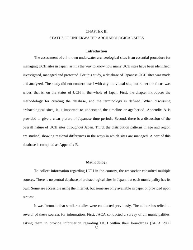
52
CHAPTER III
STATUS OF UNDERWATER ARCHAEOLOGICAL SITES
Introduction
The assessment of all known underwater archaeological sites is an essential procedure for
managing UCH sites in Japan, as it is the way to know how many UCH sites have been identified,
investigated, managed and protected. For this study, a database of Japanese UCH sites was made
and analyzed. The study did not concern itself with any individual site, but rather the focus was
wider, that is, on the status of UCH in the whole of Japan. First, the chapter introduces the
methodology for creating the database, and the terminology is defined. When discussing
archaeological sites, it is important to understand the timeline or age/period. Appendix A is
provided to give a clear picture of Japanese time periods. Second, there is a discussion of the
overall nature of UCH sites throughout Japan. Third, the distribution patterns in age and region
are studied, showing regional differences in the ways in which sites are managed. A part of this
database is compiled as Appendix B.
Methodology
To collect information regarding UCH in the country, the researcher consulted multiple
sources. There is no central database of archaeological sites in Japan, but each municipality has its
own. Some are accessible using the Internet, but some are only available in paper or provided upon
request.
It was fortunate that similar studies were conducted previously. The author has relied on
several of these sources for information. First, JACA conducted a survey of all municipalities,
asking them to provide information regarding UCH within their boundaries (JACA 2000

53
Report).137 Second, ARIUA conducted a major work by collecting information regarding UCH
throughout Japan, compiling information on about 500 sites (ARIUA 2013 Report).138 Third,
KNM, following the style of JACA 2000 Report, requested that all municipalities provide
information about UCH sites (KNM Database).139 Fourth, the Nara National Research Institute for
Cultural Properties has a repository of site reports and archaeological site database (Site Report
Repository).140 This database allows a keyword search for the entire text from site reports. The
institute at Nara also provides a Site Data Base online, which only gives a brief explanation of
almost all known sites in Japan.141
The author also has accessed each Prefecture’s webpage, which has online access to the
archaeological site map. The author has searched the maps, location information, and descriptions
for possible UCH sites. The author conducted Internet searches for other sources of information,
such as published books and articles. Once the information was collected, sites were organized
with the criteria 1) Status of research, 2) Types of Sites, 3) Location, 4) Era, and 5) Time Period.
A brief description of the criteria is provided below.
Status of Research
Excavated Site: Some form of research, based on scientific reasoning, took place. The site
was recorded using archaeological methods, and some soil was removed from the site. Artifacts
137 JACA 2000. 138 ARIUA 2013. 139 KNM 2014, and 2017. 140 Nara National Research Institute for Cultural Properties 2019a Site Reports can be downloaded as PDF. The
database do not cover all archaeological site reports, but it is the largest such repository in the country. The
Database of Archaeological Site Reports in Japan. 141 Nara National Research Institute for Cultural Properties 2019b. Basic information about archaeological
sites excavated is stored in the database.

54
were removed from the site, conserved, and properly stored. The site may be preserved in situ, or
completely excavated, monitored, or left unattended.
Surveyed: A site has been identified visually or by using remote sensing technologies,
including Side Scan SONAR, multi-beam SONAR, and magnetometer. A site may be visually
confirmed by snorkel or diving survey, or with ROV. In some cases, artifacts may be removed
from the site as a sample, but only a limited amount of soil was removed in the process.
Collected: Artifacts were removed from the site without recording, and items were not
properly conserved and stored. Collected items may have been sold, or the current location cannot
be confirmed. The removal may have been made by chance, such as artifacts caught in a net or
found during dredging, or divers brought artifacts to the surface without knowing the significance
of the site.
Salvaged: The site, usually a shipwreck, was removed from the original location. The
purpose of the action was not scientifically based, and items may have been sold or disposed of.
Unidentified: A story or a rumor of an underwater site is known, but the site itself has not
been found or confirmed through archaeological research. Reports of artifacts being raised (but
lost since), or reported by diving communities are the main sources of information. In addition,
the site is included in this category if the existence of an underwater site is suggested by historical
documents or by folklore.
Buried: The existence of a site has been reported but was buried without scientific
investigation. Some artifacts may have been raised.
Known Site: A site has been known through historical documents, folklore, or artifacts being
raised. A site may be visible from the surface, or part of the site may be connected to a site on land.

55
NA (Not Applicable): A site without enough available information. The site may be found
in a municipal site database or mentioned as an underwater site in a credible publication or a
database. This category also includes a site for which the status of research does not fit any of the
descriptions listed above.
Types of Sites
Harbor Site: A harbor with some construction features underwater. A site may refer to the
entire harbor area, or part of a structure, such as jetty, breakwater, or seawall.
Historic Site: A site, usually a settlement or a structure, such as a bridge that is still in its
place and known through historic sources. If there is a record of an event, such as a tsunami or
earthquake, that caused the submergence, the site will be included in this category. A structure
made on a shore or underwater is included in this category.
Midden Site: An ancient dumpsite of domestic waste, usually in the form of a mound, but
found underwater. A midden may be part of a larger submerged site, or perhaps, a dump was
created on a shore.
Shipwreck Site: It is difficult to define a shipwreck site. There are some cases in which a
vessel had been sunk, or cargo removed intentionally, but which are not shipwrecks in the strict
sense of the word. For this study, however, a site with hull remains is considered a shipwreck site.
Also, a large pile of artifacts, without a hull, which may have been an entire vessel, may be
considered a shipwreck site.
Possible Shipwreck: Concentration of artifacts underwater may derive from a shipwreck,
but artifacts may be spread over a large area due to erosion from a submerged site. This category
includes a site that produced a relatively large quantity of items that were likely to have been

56
carried onboard a vessel, but are now widely dispersed. The site may have imported items, or the
same items are found in multiples. Also, the presence of a ship, or maritime related items, including
anchors, is associated with the finds.
Scattered Site: A collection of items is found in an area but without features. The site should
have a clearly defined distribution pattern that indicates a settlement. Also, the collection of items
should be of a domestic nature, and not a cargo.
Submerged Site: A site should have features, such as pits or built structures. The site should
have a clearly defined artifacts distribution pattern. If a submerged village or a settlement can be
associated with a historical source, the site should be considered an Historic Site.
Production Site: A site related to the production of a commercial item or a location set for
producing a specialized item. The site should be distinguished from a domestic site. A salt
production site, fish traps (fish weir), and stone quarry sites are considered production sites.
Isolated Finds: Only a few pieces of artifacts are found below the surface, but without any
features underwater. It may have been part of a shipwreck or a submerged site. Usually, a single
find, such as a single anchor, is not considered a site. However, if a municipality has recorded the
area as a known site, it is included in this category.
NA (Not Applicable): A site without enough available information
Location
Inland Site: A site located on an inland waterway, such as on a river, lake, or pond. A site
submerged under a man-made dam is not considered as a submerged site.

57
Intertidal Site: A site located along the sea, partially submerged, or some part of the site is
submerged at least part of the day. A site located along the beach may be considered to be in this
category.
Shallow Sea: A site located between 0 to 5 m in depth. A part of the site may appear on the
surface, but the main component of the site should be underwater at all times.
Sea: A site at which all components are totally submerged underwater at all times, and is
located 5 m below the surface.
Deep Sea: A site at least 50 m deep.
Era and Time Periods
The purpose of this study is to grasp the nature of Japanese UCH sites, not the overall
nature of Japanese archaeology and history. There are various ways to define time periods,
depending on the school of thought, as well as by geographical area. The time division used for
the study may not reflect any particular school of thought but may provide only a basic idea of the
time frame. The Era represents a rough time frame the author has assigned, and periods represent
the name of the time periods generally used in Japanese history.142 An Era may include several
time periods. A brief explanation of each Era is followed by time periods in chronological order,
but those periods specific to Hokkaido and Okinawa are given at the end.
Paleolithic Era/PL (?-16,000 B.P.): From the earliest time people first arrived in Japan until
the advent of pottery production, or the beginning of the Jomon Era (around 12,000 B.P.). People
living in Japan at this time mainly lived a nomadic lifestyle. The tools that they used were lithic
and probably wood. They probably used logboats for travel, but not enough evidence is available
142 As found in Totman 2005, Mason and Caiger 2011, Walker 2015, and Mizoguchi 2018.

58
to draw this conclusion. Sea levels shifted considerably during this time, and many sites may be
found in unexpected areas, such as the deep sea, or lakes and rivers in the mountainous area.
Jomon Era/JO (12,000-300 BCE): People began producing pottery jars for the storage of
food and other purposes during the Jomon Era. 143 They practiced intensive horticulture and
became increasingly sedentary. More than 100 logboats have been excavated in Japan, indicating
that these were the major means of transport materials across waters.144 Sea level changes were
experienced in the Jomon Era as well. Some Jomon sites with close proximity to the sea are found
inland on higher grounds, while earlier Jomon sites are found below the water table.145
Proto-Historic Era/PH (300 BCE-1185 CE): This Era is from the Yayoi period to the Heian
period, or roughly from 300 BCE to around the 12th century CE. The Kamakura period, starting
around 1185 CE, is included in the next Era. The lifestyle centered on rice cultivation. The
formation of the nation gradually took place, culminating in the establishment of Yamato state.
Various types of vessels were in use. The vessels used for the tributary mission trip to the Continent,
during the Chinese Tang dynasty (618-907 CE), are considered to be one of the best maritime
achievements of the Era. The vessels that crossed the East China Sea may have been based on
Chinese or Korean construction, but only brief descriptions and stylized iconographic evidence are
available for the study.146 There was no major change in the sea level, but the gradual accumulation
of silt in lagoons, as well as coastal erosion, may have caused some changes at the local level.
Middle Age Era/MA (1185-1603 CE): The term Middle Age is a term commonly used to
describe European History, but it may be applied to Japanese history with caution. The term
describes the timeframe alone, and the nature of the societies is much different. For this study, the
143 For more about Jomon Culture of Japan, see Habu, J. 2010. 144 Miyashita 2006. 145 Hayashida et al. 2014. 146 Ishii 2002.

59
term is used for the time starting at the Kamakura period (1185-1336 CE) and ending before the
Edo period at 1603. This is the time when Imperial power in Kyoto had waned, and warlords ruled
the country. Bakufu, a town where the feudal lord, or Shogun, resided, was the seat of the
government. There are iconographic and historical documents regarding the vessels and maritime
practices at the time, but very few physical remains of vessels have been found. At the end of the
Era, European nations began to sail to the shores of Japan, bringing Christianity, scientific ideas,
and guns.147 As this Era stretches only a few hundred years, the change in sea level is considered
to be minimal. There are records of earthquakes and other natural disasters, causing the
disappearance of some villages.
Early Modern/EM (1603-1868 CE): The Early Modern Era corresponds with the Edo period.
The almost 300 years of Tokugawa Shogunate is considered to be the time of peace in which the
essence of modern Japan was formed. There was a ban on foreign travel, but maritime commerce
flourished throughout Japan. The Tokugawa shogun only allowed trade with China and the
Netherlands through the port of Nagasaki. Also, official or formal trade with Korea continued.
Foreign vessels, including those from Russia, England, France, and the U.S., began to approach
Japan at the End of the Era, which led to the opening of Japan known as Meiji Restoration.148
Again, the sea level changed very little, but the period saw several earthquake events. Also, there
were land reclamation and massive flood control projects, which dramatically changed the local
environment in some areas.
Modern Era/MO (1868-Present): For this study, the Modern Era starts at the Meiji
Restoration in 1868. The opening of Japan brought the Industrial Revolution to the country, with
147 Ishii 2002. 148 Ishii 2002.

60
new forms of transportation, including a railway system and Western-style vessels. Wooden hulls
were soon replaced with iron, and later with modern synthetic materials. The large-scale land
reclamation projects transformed the Japanese coastline permanently.149
Unknown/UK: Not enough information was available at some sites, so they could not be
assigned to a specific era. These were given an “Unknown” age.
Yayoi Period/Ya (300 BCE - 300 CE): The Jomon Era came to an end when extensive rice
farming was introduced to Japan from the Continent. It is believed that advanced farming and new
kinds of metal tools were introduced. Pottery that was low fired and usually rich in symbolic
decorations gave way to high-fired utilitarian Yayoi pottery. It appears that a strong connection
between Japan and the Continent grew during this period. A form of Chiefdom, or Proto-state,
emerged, and the famous Himiko, a female ruler of Yamatai-koku, appeared in Chinese historical
documents.150
Kofun Period/Ko (300-538 C.E): The Kofun period is characterized by the emergence of
large tumulus, concentrated in the Yamato region of central Japan, but also found in Western and
Northern Japan. This is the time of proto-history during which the Yamato state developed.151
Asuka Period/As (538-710 CE): Considered to be the time when the Yamato state
consolidated power. The construction of large tumulus declined, and the influence of foreign
countries became more prominent. Buddhism was introduced, along with government
administrative systems, forms of arts, and advanced technologies. Tributary missions to the
Chinese Tang dynasty were sent out to learn about the new political systems and technologies.
149 Ishii 2002. 150 For more about the Yayoi Period, see Mizoguchi 2018. 151 See Barnes, G. 2007. for details

61
Also, conflict with the Silla dynasty (668-935 CE) in Korea led to the dispatch of the Japanese
Navy to the Korean peninsula, where the Japanese forces were defeated.152
Nara Period/Na (710-794 CE): The capital of Japan was firmly established for the first time
at Nara, hence the name of the period. This is the time when the Japanese Imperial court system
was firmly established. The Japanese writing system emerged, and the first historical records of
Japan were written.153
Heian Period/He (794-1185 CE): The new capital was created at Kyoto, and became the
Imperial City for the next 1,000 years. Japanese classical court life formed during this period.
Japan ceased sending missions to China, and foreign influence waned. The original Japanese form
of arts and the way of life had developed. By the end of the period, the central authority declined,
and the military class began to rise in power.154
Kamakura Period/Ka (1185-1336 CE): The power of the Imperial House declined, and
Bakufu, or the military clan’s stronghold, became the seat of power. The Imperial rule, however,
was left in place. The emperor was the symbolic ruler of all Japan, but the Shogun held the real
power. The most significant event from the Kamakura period is the Mongol Invasions of Japan,
which took place in 1274 and 1281. Although the Bakufu were successful in repelling the invaders,
the political power of the house declined following the event.155
Muromachi Period/Mu (1336-1573 CE): The Kamakura Bakufu fell out of favor, and the
Ashikaga clan, based near Kyoto, rose to power, claiming Muromachi Bakufu. It was a time of
152 See Barnes, G. 2007. for details 153 See Barnes, G. 2007. for details 154 For details, see Shively and McCaullough 1999. 155 Ishii 2004 and Hattori 2017.

62
peace, and trade with China was encouraged. However, the regional powers grew steadily. By the
end of the Muromachi period, warlords began fighting for more lands to control.156
Azuchi-Momoyama Period/Am (1573-1603 CE): Warlords fought each other to fill the gap
of Muromachi Bakufu. Certain figures began to take steps to unite Japan once again. Among them,
three of the best known are Nobunaga Oda, Hideyoshi Toyotomi, and Ieyasu Tokugawa. Some
regional clans actively sought out trade with foreign countries, including Portugal, Spain, and the
Netherlands. Japanese were active in trade in Southeast Asia, as well.157
Edo Period/Ed (1603-1868 CE): The Tokugawa clan united Japan under one rule, and
opened Bakufu in Edo, which is today’s Tokyo area. Initially, trade with foreign countries was
encouraged, but gradually the Bakufu began to control and limit the trade. By the mid-17th century,
the Japanese were not allowed to leave the country, Christianity was banned, and trade was limited
to a man-made island of Dejima in Nagasaki. Only China and the Netherlands were allowed to
trade with Japan. It was a time of peace, and economic growth focused internally. By the 19th
century, foreign vessels, including those from Russia, Great Britain, America, and France, began
to approach the Japanese coast. By this time, Tokugawa Bakufu has lost its past glory. With
increased pressure from foreign powers, Bakufu opened Japan for trade. In 1868, Bakufu
relinquished its power to the Emperor, terminating the age of Samurai rule. 158
Periods after Edo: Meiji Period/Me (1868-1912 CE), Taisho Period/Ta (1912-1926
CE), Showa/So (1926-1989 CE): After the fall of Tokugawa Bakufu, the name of the period
became that of the Emperor who reigned at the time. Japan opened its doors to foreign countries
and started modernizing society. Japan began rapid industrialization, strengthening military power
156 Takahashi and Gomi 2019 and Maruyama 2018. 157 Murai 2012. 158 Iwabuchi 2010 and Tsuji 2005

63
as well. Japan went to war with China in 1894 and with Russia in 1904, eventually leading to the
Pacific War. The introduction of the railroad system and the steam-powered iron hull vessels, as
well as heavy industry, changed the nature of commerce rapidly and completely.
Ainu Period/Ai (7th cent CE-1868): The Ainu period is geographically limited to Hokkaido
and also to the sites related to the Ainu population. The Ainu people continued their semi-nomadic
way of life after the Jomon Era gave way to life based on rice cultivation in the Yayoi period. It is
difficult to determine the exact relationship among ancient Japanese people, Ainu people, and
modern Japanese. However, in archaeological records, a new period can be set around the seventh
century CE in Hokkaido. In Southern Hokkaido, people from the Japanese mainland began to
move in, creating the Matsumae colony. The sites related to the Japanese population will be given
the Japanese time period, but for the sites related to the people of native Hokkaido, the Ainu period
was assigned.159
Gusuku Period/Gu (11-16th cent CE): The name of the time period specific to Okinawa and
the Amami Islands. Gusuku is the name for castles in the Ryukyu Islands and can be translated as
the castle period. As the name suggests, many castles were built in this period, but these should
not be confused with European castles. These castles may not have been built for defensive
purposes; perhaps castles were symbolic structures for the local community, and the time period
can be considered an early stage of stage development in which many communities interacted. The
time period ends with the beginning of the united rule of the Ryukyu Kingdom. Although
politically, it was a highly segmented society, sea commerce connected the people, creating a
regional unity within the Ryukyus Islands.160
159 See more for the history of Ainu; Segawa 2007 and 2016. 160 Hokama 1986 and Anzato 2006.

64
Overall Nature of Sites
Through this research, the author has identified 596 UCH sites in Japan. Considering that
the total length of the coastline of Japan is over 29,000 km, there is roughly only one UCH site
every 50 km of coastline. Okinawa Prefecture has the highest number of sites, 132 in number.
Okinawa, with its warm and clear water, makes the identification of sites relatively easy. The
Ryukyu island chain has been a maritime highway throughout history.161 Also, it was through the
efforts of the Prefectural officers and private researchers that the sites were identified.162 Shiga
Prefecture has 116 sites. Almost all of these sites are located along Lake Biwa. They were
discovered due to government-led waterfront development projects. Nagasaki Prefecture, where
the Takashima Underwater Site is located, has 51 sites.
The number of possible UCH sites from these three Prefectures add up to about half of all
known sites in Japan. Hokkaido and Shizuoka Prefectures, both 24 in number, come next. The rest
of the Prefectures have 20 or fewer sites, but most Prefectures have fewer than eight sites. Saitama
and Nara Prefectures reported no UCH sites within their territory. It is understandable that some
of these Prefectures have no UCH sites because these Prefectures are located inland, having no
access to the sea. However, Akita and Miyazaki Prefectures also reported no underwater sites
within their boundaries. These Prefectures are located along the sea, having a combined total of
several hundred kilometers of coastline. On the other hand, Nagano Prefecture, an inland and the
most mountainous Prefecture in Japan, has 18 sites. The discovery of Sone Site at Lake Suwa and
a chance discovery of Paleolithic tools at Lake Nojiri made cultural officers aware of possible
lake-bottom sites. The number of sites reported does not reflect the real nature of the site
161 Hokama 1986. 162 Okinawa Prefecture Buried Cultural Property Center 2017.

65
distribution pattern, but rather the difference is due to how much research has actually taken place
and how aware Prefectural officials are of the presence of such locations.
Types of Sites
There are 33 shipwreck sites in Japan and 57 possible shipwreck sites. There is a gray line
between a shipwreck site and a possible shipwreck site; if all these sites were shipwrecks, then the
number of known shipwreck sites would be 90 in total. Most of the sites, however, are made up of
scattered materials, and only nine of them have been partially excavated. The rest of the sites
remain almost untouched by archaeologists. Despite the lack of interest paid by the Japanese
archaeological community, 90 sites are too great a number to be disregarded. There are 56 harbor
and historic structures, 135 identified submerged sites, and 211 scattered sites.
Location of Sites: There are nearly 400 recognized sites from the sea and intertidal zones,
while only half the number of inland sites are known. Japan does not have large easily navigable
rivers, and traveling inland is a difficult task. The inland sites are all submerged sites, perhaps once
they were settlements. Japanese municipal archaeologists have been conducting limited surveys
and excavations, even inland, whenever they were able. The number of identified coastal sites may
appear small compared to that of other countries, especially considering Japan’s maritime history.
Age of Sites: There are 34 Paleolithic sites. The submerged Paleolithic sites are the key to
understanding the early peopling of the island nation. The underwater sites have made
contributions towards the understanding of early Japanese prehistory. The 232 Jomon Era sites
make up the most numerous age group of UCH sites in the country. The Protohistoric sites are 165
in number. The number of Middle Age sites decreases to 127. The Early Modern Era, with 214
sites, comes in a close second to the Jomon period. The number of maritime-related sites increases

66
as we move towards the more recent Era, while the number of submerged settlements and scattered
sites drops. There are 41 Modern Era sites, many of them maritime related sites, and 37 sites
without a definite age given. Overall, it appears that all ages are represented in the submerged sites,
indicating a great potential for answering many questions regarding the history of Japan.
Status of Research on Sites: Among the total of close to 600 sites, 323 sites have been
surveyed, and 150 sites have been excavated. There are 67 collected sites counts. Most sites are
left unattended, and a construction project may destroy the heritage.
Among 323 sites surveyed, 41 sites were submerged settlement sites, 23 shipwreck sites, 149
scattered sites, and 110 sites were not categorized (Table 1). Close to 30 submerged settlement
sites surveyed were located inland, while a dozen settlement sites surveyed were found along the
coast, including the intertidal zone.
The age distribution follows a similar pattern as the excavated settlement sites. There are 23
surveyed shipwreck sites in Japan. Among 149 scattered sites surveyed, roughly half of them were
found inland, and the over half at sea. This result is important to note. More scattered sites were
found and surveyed at sea, but, as discussed below, a larger number of inland sites are being
excavated than are the sites located at sea. One reason may be that municipalities do not feel the
need to excavate a site located at sea, despite the importance of a site.
There were 110 sites without a category. These include fish traps, salt production centers, and
quarry sites. A large majority of such sites were recorded from Okinawa Prefecture, heavily
skewing the data. Other Prefectures do have fish traps and salt production sites located along the
coast, but these were recognized as land sites and are not reflected in this study.

67
Surveyed Site Submerged Shipwreck Scattered Other
TOTAL 41 23 149 110
Intertidal 6 3 40 93
Lake/Pond 27 0 65 4
River 2 0 3 1
Sea 6 20 41 8
Other 0 0 0 4
Paleolithic 3 0 11 0
Jomon 11 1 71 1
Proto-History 16 1 54 2
Middle Age 10 4 26 22
Early Modern 7 14 28 92
Modern 0 5 3 8
Unknown 7 2 12 0
Table 1. The Number of Surveyed Sites by Location and Age
Among the 600 sites, 150 sites were excavated, partially or fully. The percentage of
excavated sites to the total number of sites is actually high compared to those found in other
countries. Many of the known UCH sites are well documented, largely because those sites had to
be excavated for a number of non-archeological reasons. The percentage of unexcavated, but
known, sites should be much higher. It can be assumed that many sites have been destroyed without
people knowing they even exist. Most were small, submerged sites, found during dredging, or
along a lakeshore during construction.
For excavated sites, 60 of them are submerged sites and settlements, 14 are midden sites, and
45 are scattered sites (Table 2). There are a dozen harbor and historic sites, while less than ten sites
are shipwrecks. One characteristic of Japanese underwater archaeology is that most of the
excavated sites are submerged settlements located inland, and the maritime related sites are rare.
Some harbors and coastal structures are present, but some are still in use and have not been
properly excavated. Some sites are located along the coast, but all are located in shallow waters.

68
Most sites are from the Jomon Era, while some Paleolithic sites are found in lakes. Midden sites
are usually found along lakeshores, but some are found in the intertidal zone. Among the 45
scattered sites, over 30 are located inland. Scattered sites show a wider variation in age, from the
Paleolithic to the Modern Eras. Some Early Modern sites may have been part of the cargo of a
vessel.
Excavated Site Submerged Midden Scattered Other
TOTAL 60 14 45 12
Intertidal 9 4 6 4
Lake/Pond 35 8 31 3
River 4 1 1 1
Sea 11 0 7 2
Other 0 1 0 2
Paleolithic 5 0 5 1
Jomon 34 12 27 2
Proto-History 32 4 26 3
Middle Age 12 4 8 5
Early Modern 5 0 2 7
Modern 0 0 0 2
Unknown 3 0 2 0
Table 2. The Number of Excavated Sites by Location and Age
Analysis by Region
The regional tendency of underwater archaeological sites and the status of research will be
discussed below. For the purpose of this study, seas around Japan have been divided into nine
regions; Northern Japan (Hokkaido and Aomori Prefectures, including Pacific Coast, Sea of Japan,
and sea of Okhotsk), North Pacific (includes the coast of Iwate, Miyagi, Fukushima, Ibaraki, and
China Prefectures), North Sea of Japan (Akita, Yamagata, Niigata, Toyama, Ishikawa, Fukui
Prefectures), Central Inland Region (Tochigi, Gunma, Saitama, Yamanashi, Nagano, Gifu, Shiga,

69
Nara Prefectures), Southwestern Pacific Coast (Tokyo, Kanagawa, Shizuoka, Aichi, Mie,
Wakayama, Tokushima, Kochi Prefectures), Southwestern Sea of Japan Region (Kyoto, Hyogo,
Tottori, Shimane, Yamaguchi Prefectures), Seto Inland Sea Region (Osaka, Hyogo, Okayama,
Hiroshima, Yamaguchi, Kagawa, Ehime Prefectures), Kyushu Region (Fukuoka, Saga, Nagasaki,
Kumamoto, Oita, Miyazaki Prefectures), Nansei Islands and Okinawa Region (Kagoshima and
Okinawa Prefectures) (Figure 15; Table 3).
Figure 15. A Map of Japan with the Names of Prefectures

70
1. Hokkaido 2. Aomori 3. Iwate 4. Miyagi 5. Akita 6. Yamagata
7. Fukushima 8. Ibaraki 9. Tochigi 10. Gunma 11. Saitama 12. Chiba
13. Tokyo 14. Kanagawa 15. Niigata 16. Toyama 17. Ishikawa 18. Fukui
19. Yamanashi 20. Nagano 21. Gifu 22. Shizuoka 23. Aichi 24. Mie
25. Shiga 26. Kyoto 27. Osaka 28. Hyogo 29. Nara 30. Wakayama
31. Tottori 32. Shimane 33. Okayama 34. Hiroshima 35. Yamaguchi 36. Tokushima
37. Kagawa 38. Ehime 39. Kochi 40. Fukuoka 41. Saga 42. Nagasaki
43. Kumamoto 44. Oita 45. Miyazaki 46. Kagoshima 47. Okinawa
Table 3. Names of Prefectures
Northern Japan
There are 32 sites in North Japan. Among them, 18 sites were excavated, four surveyed,
and six collected. Although the sites are not numerous, it should be noted that close to half of them
have been excavated (Table 4). One characteristic of this region is that, when a site is discovered,
it is likely to be surveyed and excavated. A large-scale survey has not been conducted, and the
potential of the region is yet to be recognized. Archeologists know of five shipwreck sites, but
there are still several shipwreck sites waiting to be discovered.163
The age distribution pattern of UCH in this region shows unique characteristics, reflecting
the history of Hokkaido. Most of Hokkaido was inhabited by Ainu, an indigenous population of
Northern Japan, Kyoto was the center of the Japanese government, but its influence did not reach
the island. Thus, the Ainu population maintained their own cultural identity. The large-scale
intrusion of the Japanese population rapidly accelerated during the early Meiji years, instigated by
the need to define the national territory borders as the Western countries, namely Russia, began to
163 KNM 2018.

71
approach the area.164 The main components of UCH found in the region can be divided into two
groups, submerged sites (including log-boats) from the Ainu period and more recent wrecks related
to the colonization of Hokkaido. An isolated Paleolithic site found in deep-water off Aomori is an
interesting find, but archeologists need more information about the site.165 Overall, the results from
Northern Japan are consonant with the history of the region.
Prefecture Number
of Sites
Status Type
Ex Su Co Shi Sub Sct Har
HOKKAIDO 24 13 4 3 4 9 4 1
AOMORI 8 5 0 3 1 3 1 1
32 18 4 6 5 12 5 2
Pre Location Time Period
Sea Int Inl PL JO PH MA EM MO UK
HO 5 6 14 1 5 5 5 6 2 4
AO 4 0 4 2 4 1 1 2 0 0
9 6 18 3 9 6 6 8 2 4
Table 4. Overview of Sites in the Northern Japan Region166
North Pacific
There are 29 total sites in the North Pacific region (Table 5). Only five sites have been
excavated, while 13 sites were surveyed. Artifacts were collected from three sites, and the
remaining eight sites are known, but not enough information currently is available. Compared to
164 Tabata. ed. 2011. 165 The Japanese Paleolithic Research Association 2010 166 Table 5 through table 12 use the same abbreviation. Status: Ex (Excavated), Su (Surveyed), Co (Collected).
Type: Shi (Shipwreck), Sub (Submerged Site), Sct (Scattered Site), Har (Harbor Site). Location: Sea (Sea), Int
(Intertidal Zone), Inl (Inland Water). Time Period (Era): PL (Paleolithic), JO (Jomon), PH (Proto-Historic), MA
(Middle Age), EM (Early Modern), MO (Modern), UK (Unknown). Note that not all types of sites are included
in the table, and there are some sites with overlap in time Periods, thus the total number of sites and the sum of
the sites from the table may not match.

72
the results from Northern Japan, the number of excavated sites appears to be small. The lack of
information is partly due to the way in which the data are collected for this study. The majority of
the information for this study relies on the ARIUA 2013 Report. 167 When the members of
ARIUA’s research team were collecting information, the 2011 Tohoku earthquake and tsunami hit
Japan, and the field research on the Northern Pacific shore had to be canceled.168 As a result, the
report does not have much information about the area.
Many of the sites from the region fall into the category of a s a possible shipwreck, while
only a small number of submerged sites are reported. The North Pacific region is dominated by a
deeply inundated (saw-tooth) coastline; sandy beaches, lagoons, large gulfs, and harbors are rare.
There are not enough flatlands for extensive farming that could support a large population. People
probably lived close to the sea. The sea level also drops suddenly off the coast as well. These
environmental features do not support the formation of well-preserved submerged sites. Combined
with the physical feature of the region, the area has seen a series of tsunamis, including the most
recent catastrophic Tsunami in March 2011. A submerged site may have been destroyed by these
devastating waves or may be covered by earth due to landslides.
The Fukushima Prefecture has 11 sites, all from inland. These are all scattered sites or small,
submerged sites along lakeshores. The result obviously is skewed. On the other hand, Chiba
Prefecture records six shipwreck sites among the total of 10 sites. Chiba Prefecture, located near
Tokyo, projects out towards the ocean and was known as a “difficult sea.” But there are other
locations along the North Pacific coast that are dangerous for shipping, and there should be more
shipwrecks to discover.
167 ARIUA 2013. 168 ARIUA 2013.

73
In the North Pacific, the volume of trade increased during the Edo period. Some of the goods
from the Kitamae trade of the Sea of Japan during the Edo period were brought to the capital at
Edo. They went through the Tsugaru Strait, sailing towards south on the Pacific Coast.169 The
mechanism of trade of the Kitamae trade on the Pacific side is not well understood. The Okitsu
Beach Site in Chiba is one site that produced artifacts from this trade.170
Prefecture Number
of Sites
Status Type
Ex Su Co Shi Sub Sct Har
IWATE 3 2 0 0 1 0 1 1
MIYAGI 2 1 1 0 0 1 1 0
FUKUSHIMA 11 1 8 0 0 4 7 0
IBARAKI 3 0 0 0 3 0 0 0
CHIBA 10 1 4 3 6 1 1 0
29 5 13 3 10 6 10 1
Pre Location Time Period
Sea Int Inl PL JO PH MA EM MO UK
IW 1 0 2 0 0 0 2 0 1 0
MI 0 0 2 0 1 0 1 1 0 0
FU 0 0 11 0 6 4 1 1 2 2
IB 3 0 0 0 0 0 0 1 1 1
CH 6 3 1 0 4 1 1 4 5 0
10 3 16 0 11 5 5 7 9 3
Table 5. Overview of Sites in the North Pacific Region
North Sea of Japan
In the North Sea of Japan, 25 sites are known, a relatively low number, considering the long
coastline of the region. From the region, seven sites have been excavated, nine sites surveyed, and
169 Ishikawa Prefecture History Museum 2017. 170 Okitsu Beach Site Research Club 2010.

74
artifacts were collected from seven sites (Table 6). There are eight possible shipwrecks, 10
submerged sites, and five scattered sites. Only three sites are recorded from inland, while 19 sites
are from the intertidal zone and sea. The result gives the impression that underwater sites found
inland have not been explored, and much more focus has been placed on the maritime tradition of
the area. There appears to be no peak in the age distribution of UCH.
Prefecture Number
of Sites
Status Type
Ex Su Co Shi Sub Sct Har
AKITA 0 0 0 0 0 0 0 0
YAMAGATA 2 1 0 1 1 1 0 0
NIIGATA 7 2 2 2 2 2 3 0
TOYAMA 5 1 4 0 0 4 1 0
ISHIKAWA 7 2 2 2 4 2 1 0
FUKUI 4 1 1 2 1 1 0 1
25 7 9 7 8 10 5 1
Pre Location Time Period
Sea Int Inl PL JO PH MA EM MO UK
AK 0 0 0 0 0 0 0 0 0 0
YA 1 0 1 0 1 1 1 1 0 0
NI 5 0 2 0 0 4 3 2 0 1
TO 3 2 0 0 2 1 1 1 0 0
IS 2 2 0 0 1 0 2 1 1 0
FU 2 2 0 0 1 0 2 1 1 0
0 0 0 0 5 6 9 6 2 1
Table 6. Overview of Sites in North Sea of Japan Region
For this survey, no underwater site was found from Akita Prefecture. From Niigata
Prefecture, over a dozen possible sites are known. In Niigata, reports of fishermen raising artifacts
have been heard for years, and a small but enthusiastic group of scholars formed a research team

75
to conduct interviews to record known locations. The group published a report in 2014, detailing
over 40 known locations. 171 This report also recorded known maritime artifacts, such as anchors,
found along the coast as well. Some of these possible “sites” may be shipwrecks. One characteristic
of the Sea of Japan is that the seafloor drops suddenly off the Japanese coast, reaching close to
1,000 meters just several miles out. It is difficult to conduct visual surveys in the deep sea;
municipal officials in the Sea of Japan should become keen on the use of survey technologies to
examine these sites.
Central Inland Region
Prefectures in the central inland region of Japan have no access to the sea. Despite this
geographical feature, 140 underwater sites have been identified. The number of sites is as great as
that of Okinawa Prefecture. In this region, there are 53 sites excavated and 80 sites surveyed (Table
7). No shipwreck site has been found, except for the occasional longboats. There are 49 submerged
and 78 scattered sites. The Jomon sites are the most numerous. There are some Middle Age and
Early Modern submerged sites; some of them are submerged villages, part of a castle, a bridge, or
harbor.
Among 140 sites, 116 sites are located in Shiga Prefecture at Lake Biwa. Also, there are 18
sites in Nagano Prefecture. Saitama and Nara Prefectures reported no underwater sites. It is
important to note that Nagano Prefecture has a large number of sites. Most of these sites are from
the Paleolithic Era and the Jomon Era, investigated more than 30 years ago. The Sone Site in Lake
Suwa, the first underwater site investigated in Japan in the early 20th century, is located in Nagano
Prefecture. As seen from the example of the Awazu-midden Site discussed in Chapter II,
171 Niigata Underwater Ceramic Research Group 2014.

76
submerged sites provide important clues to the nation’s history. It appears that the success of
Nagano and Shiga Prefecture has not been passed along to the surrounding Prefectures.
Prefecture Number
of Sites
Status Type
Ex Su Co Shi Sub Sct Har
TOCHIGI 1 0 1 0 0 0 0 0
GUNMA 2 1 0 1 0 1 0 0
SAITAMA 0 0 0 0 0 0 0 0
YAMANASHI 2 0 2 0 0 2 0 0
NAGANO 18 4 14 0 0 4 14 0
GIFU 1 1 0 0 0 1 0 0
SHIGA 116 47 63 2 0 41 64 3
NARA 0 0 0 0 0 0 0 0
140 53 80 3 0 49 78 3
Pre Location Time Period
Sea Int Inl PL JO PH MA EM MO UK
TO 0 0 1 0 0 0 0 0 1 0
GU 0 0 2 0 1 1 0 0 0 1
SA 0 0 0 0 0 0 0 0 0 0
YA 0 0 2 0 1 2 1 0 0 0
NA 0 0 18 4 15 1 1 0 0 0
GI 0 0 1 0 0 1 0 0 0 0
SH 0 0 116 2 108 71 26 17 0 13
NA 0 0 0 0 0 0 0 0 0 0
0 0 140 6 125 76 28 17 1 14
Table 7. The Overview of Sites in Central Inland Region
Southwestern Pacific Coast
There are a total of 66 underwater sites in this region; 11 sites have been excavated, 26 sites
surveyed, and artifacts collected from 14 sites (Table 8). The area recorded 17 shipwreck sites, 18
submerged sites, 20 scattered sites, and four historic sites. Close to 50 sites are located at sea and
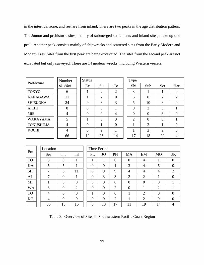
77
in the intertidal zone, and rest are from inland. There are two peaks in the age distribution pattern.
The Jomon and prehistoric sites, mainly of submerged settlements and inland sites, make up one
peak. Another peak consists mainly of shipwrecks and scattered sites from the Early Modern and
Modern Eras. Sites from the first peak are being excavated. The sites from the second peak are not
excavated but only surveyed. There are 14 modern wrecks, including Western vessels.
Prefecture Number
of Sites
Status Type
Ex Su Co Shi Sub Sct Har
TOKYO 6 1 2 2 3 1 1 0
KANAGAWA 11 1 7 0 5 0 2 2
SHIZUOKA 24 9 8 3 5 10 8 0
AICHI 8 0 6 1 0 3 3 1
MIE 4 0 0 4 0 0 3 0
WAKAYAMA 5 1 0 3 2 0 0 1
TOKUSHIMA 4 0 1 0 1 2 1 0
KOCHI 4 0 2 1 1 2 2 0
66 12 26 14 17 18 20 4
Pre Location Time Period
Sea Int Inl PL JO PH MA EM MO UK
TO 5 0 1 1 1 0 0 4 1 0
KA 5 5 1 0 0 1 3 4 6 0
SH 7 5 11 0 9 9 4 4 4 2
AI 7 0 1 0 3 3 2 2 1 0
MI 1 3 0 3 0 0 0 0 0 1
WA 3 0 2 0 0 2 0 1 2 1
TO 4 0 0 1 0 0 1 2 0 0
KO 4 0 0 0 0 2 1 2 0 0
36 13 16 5 13 17 11 19 14 4
Table 8. Overview of Sites in Southwestern Pacific Coast Region

78
Shizuoka Prefecture has nine excavated sites and eight surveyed sites. Kanagawa Prefecture
has seven sites, with only one site excavated. This one site is a harbor from the Kamakura period
at Wakae-jima, which is a national registered historic site. In the region, some submerged villages
appear in historical documents. These villages were said to have been destroyed by tsunamis that
earthquakes caused. The largest number of possible submerged villages is in Kochi Prefecture.
The Japan Agency for Marine Earth Science and Technology, Kochi Institute for Core Sample
Research, has conducted an in-depth study of the past earthquakes from marine core samples, and
also conducted diving research on some possible submerged sites.172 Only a few underwater sites
have been excavated from other Prefectures in the region. However, several sites in the region
were not included in this list because their existence is only rumored. As a result, they have not
received a proper survey and investigation.
Southwestern Sea of Japan
There are a total of 22 sites in the region, three excavated sites, and nine surveyed sites
(Table 9). The total number of sites is the lowest among the regions, with only a few sites reported
from each Prefecture. Three sites have been excavated, and nine sites surveyed. In the region, three
shipwreck sites, four submerged sites, and nine scattered sites are known; 11 sites are known from
the sea, eight sites from the intertidal zone, and three sites from inland. Sites from the Jomon Era
appear to be the most numerous, but this totals only eight sites. The data do not reflect the true
nature of site distribution by age.
As with the Northern Sea of Japan Region, the sea level drops off the coast precipitously.
Traditionally, major ports were found inside lagoons during the Protohistoric and the Middle Age
172 Tanikawa et al 2016.

79
Eras, but gradually the ports were relocated to an area with a deeper gulf. Perhaps shipwrecks may
be found in ancient lagoon areas, now on land deeply buried by sand. Historical records document
foreign shipwrecks, but there is no direct evidence of their existence. There has been no evacuation
in Yamaguchi Prefecture, an important chokepoint for trade connecting the Sea of Japan, the
Pacific Ocean, Seto Inland Sea, and the Kyushu region. It is clear that more research is needed in
the area to illustrate the region’s rich maritime tradition.
Prefecture Number
of Sites
Status Type
Ex Su Co Shi Sub Sct Har
KYOTO 2 1 0 1 1 1 0 0
HYOGO 1 0 1 0 0 0 0 1
TOTTOORI 3 1 0 2 0 1 2 0
SHIMANE 15 1 8 3 2 2 7 3
YAMAGUCHI 1 0 0 1 0 0 0 0
22 3 9 7 3 4 9 4
Pre Location Time Period
Sea Int Inl PL JO PH MA EM MO UK
KY 1 1 0 0 0 2 0 0 0 0
HY 1 0 0 0 0 0 0 1 0 0
TO 0 2 1 0 3 1 0 0 0 0
SH 8 5 2 4 5 2 1 3 1 0
YA 1 0 0 1 0 0 0 0 0 0
11 8 3 5 8 5 1 4 1 0
Table 9. Overview of Sites in Southwestern Sea of Japan Region
Seto Inland Sea Region
The Seto Inland Sea was and still is an important waterway in Japan. Relatively shallow and
calm waters make transport easy, but sailors must watch for shoals and small islands. A total of 62
underwater sites is reported from the region. Excavations have taken place at 19 sites, and surveys

80
took place at 17 sites (Table 10). Artifacts were collected from more than a dozen sites, and there
are many reports of artifacts being raised from the sea by fishermen. Even today, isolated items
raised from the sea are being traded at an on-line auction. There are 22 shipwreck sites, which is
the largest among the regions. In addition, 18 submerged sites, and 10 scattered sites have been
reported. There also are several harbors and historic sites found in the region. Most of the sites are
related to maritime trade, such as shipwrecks, disposed of cargo, and harbors. Only seven sites are
from inland, and the rest of the sites are from the sea. Despite the small sample numbers, the results
are representative of the characteristics of the region.
Prefecture Number
of Sites
Status Type
Ex Su Co Shi Sub Sct Har
OSAKA 3 2 0 1 1 2 0 0
HYOGO 6 1 2 3 4 0 0 2
OKAYAMA 12 1 5 4 3 4 4 1
HIROSHIMA 8 2 2 1 1 1 2 2
YAMAGUCHI 7 3 2 2 2 2 2 0
KAGAWA 9 3 3 3 7 1 1 0
EHIME 17 7 3 4 4 8 1 2
62 19 17 18 22 18 10 7
Pre Location Time Period
Sea Int Inl PL JO PH MA EM MO UK
OS 1 1 1 2 1 2 3 2 0 0
HY 4 1 1 0 0 3 4 2 0 0
OK 7 3 2 2 3 5 5 1 0 1
HI 3 4 1 3 0 0 1 3 0 1
YA 4 2 1 2 3 2 0 2 0 1
KA 7 1 1 0 0 3 3 2 1 0
EH 12 5 0 1 7 6 5 6 1 1
0 0 0 10 14 21 21 18 2 4
Table 10. Overview of Sites in Seto Inland Sea Region

81
The Protohistoric Era and the Middle Age Era have the highest concentration of sites. The
sites from the Jomon Era are, in fact, low in number compared to other regions. The age
distribution of sites looks similar to that of the Southwestern Pacific Coast, except that there are
more modern and Western shipwrecks in the Pacific Coast. The Seto Inland Sea did not see an
influx of foreign trade, and predominantly remained a sea controlled by the Japanese. Osaka
Prefecture has the lowest number of sites, despite being the center of commerce for centuries. The
modern city of Osaka grew by reclaiming the sea, most likely destroying UCH in the process. A
similar case may be seen in Tokyo Bay. More research is needed in the region, perhaps identifying
sites to be investigated from the list of possible site locations made through interviewing fishing
communities.
Kyushu Region
The Kyushu region has acted as the gateway to Japan. Traders, as well as invaders, came to
Kyushu, and it can be assumed that many foreign vessels can be found along the Kyushu coast.
There are 78 known sites in the region, with 27 sites excavated and 38 sites surveyed (Table 11).
The number of sites being investigated is high. Counting the Takashima Underwater Site as one
shipwreck site, archeologists know of 14 shipwreck locations in the region. There are 15
submerged sites, 45 scattered sites, and four harbor and historic sites. Only two inland sites are
known; the rest of the sites are located along the coast and the seas.
Although the majority of the sites are from the sea, the highest concentration is from the
Jomon Era. The next highest concentration is the Protohistoric Era, with 22 sites. The Early
Modern Era comes close with 19 sites. Many submerged sites and scattered sites from the Jomon
Era are found in Nagasaki Prefecture. Although this area has not seen major earthquakes, there has
82
been a gradual submergence of the land, known as hydro-isostasy.173 As seen in Chapter II, an
Early Jomon site was found at Takashima Underwater Site. Kyushu has been the center of
underwater archaeology, and many cultural property officers are aware of the importance of UCH.
However, it appears that they do not have much knowledge of how sites should be investigated
and properly protected. Stone anchors and scatters of ceramics have been found across Kyushu,
except in Miyazaki Prefecture.
Prefecture Number
of Sites
Status Type
Ex Su Co Shi Sub Sct Har
FUKUOKA 9 1 4 2 6 0 3 0
SAGA 6 2 4 0 2 1 2 1
NAGASAKI 51 19 27 1 6 9 33 3
KUMAMOTO 10 5 3 1 0 3 7 0
OITA 2 0 0 0 0 2 0 0
MIYAZAKI 0 0 0 0 0 0 0 0
78 27 38 4 14 15 45 4
Pre Location Time Period
Sea Int Inl PL JO PH MA EM MO UK
FU 8 1 0 0 2 4 4 1 1
SA 4 2 0 0 3 0 1 4 1 0
NA 33 17 1 5 34 16 5 10 1 0
KU 4 5 1 0 9 4 1 1 1 0
OI 2 0 0 0 0 0 2 0 0 0
MI 0 0 0 0 0 0 0 0 0 0
0 0 0 5 46 22 13 19 4 1
Table 11. Overview of Sites in Kyushu Region
173 Nakada et al. 1994.

83
Nansei Islands and Okinawa Region
The Nansei Islands and Okinawa Region is a unique area of Japan. Okinawa, or Islands of
Ryukyus, has maintained independence for centuries by relying on the delicate balance of powers
between China and Japan, before being finally incorporated into the Japanese system of
government.174 The result of this study shows there are 142 sites in the region (Table 12). Surveys
were conducted on 128 sites, but only eight sites have been properly excavated. There are 11
shipwrecks, 3 submerged sites, 29 scattered sites, and 30 harbor and historic sites. There is a record
of 117 sites in the intertidal zone, and most of these sites are fish traps, salt production, and quarry
sites. In other regions, these types of sites usually were not counted or recognized as UCH, and the
disparity in the number of such sites only reflects this fact.
Prefecture Number
of Sites
Status Type
Ex Su Co Shi Sub Sct Har
KAGOSHIMA 10 1 7 1 2 0 7 0
OKINAWA 132 6 121 4 9 3 22 30
142 7 128 5 11 3 29 30
Pre Location Time Period
Sea Int Inl PL JO PH MA EM MO UK
KA 10 0 0 0 0 0 5 7 1 0
OK 14 117 1 0 1 7 28 109 5 6
0 0 0 0 1 7 33 116 6 6
Table 12. Overview of Sites in Nansei Islands and Okinawa Region
174 Kamiya 2003.

84
One point to note in Okinawa is that a large number of sites are identified and visually
surveyed. The locations are recorded, but not all sites are incorporated into the local site map for
protection. Shipwreck sites, with a large number of ceramic remains, usually are recorded. Many
of the sites are simple scatters of artifacts, widely disbursed. Some may have been ancient ports
that have been eroded. A vessel may have wrecked nearby, but no hull has been found. In Okinawa,
it is easy to detect such a site, just by snorkeling. Local communities are also aware of such
locations, and dive shops utilize these sites as diving points. In addition, due to the maritime nature
of Okinawa’s history, archeologists have sought to record these sites. In other regions of Japan,
such as at the Seto Inland Sea, where water visibility is low, it would be difficult to detect a
scattered site. Still, the case of Okinawa should be promoted as an ideal way to manage underwater
archaeological sites elsewhere in Japan.
Summary
In this chapter, the overall characteristics of UCH sites in Japan were illustrated. For this
study, a site database was created using various sources of information. Sites from all over Japan
were analyzed for age, type, and site locations. In addition, the status of the sites was recorded.
The data were first analyzed, looking at the country as a whole, and then region-by-region. The
regional differences in types of sites and age are not due to the differences in how people from the
past interacted with the sea in each region, but the differences are due to the nature of how the data
were collected and the level of interest in UCH by local municipal officers. Despite this, a
preliminary summary of the nature of UCH site management can be seen. The majority of UCH
sites are inland Jomon settlement sites. In some regions where municipal officers are active in
UCH management, maritime sites are recorded, but the further investigations, while needed, are
rare.

85
CHAPTER IV
SURVEY OF RECORDS OF MARITIME DISASTER
Introduction
The study of underwater cultural heritage and maritime archaeological sites can contribute
greatly to the understanding of Japan’s past maritime culture, mainly through the study of
shipwreck remains and harbor sites. However, as mentioned above, the study of shipwrecks and
underwater sites has not been a focus of the Japanese archaeological community until recently.
Underwater archaeology in Japan has focused mainly on submerged prehistoric sites. Moreover,
the number of shipwreck sites discovered so far is small, considering the length of the Japanese
coastline, which ranks sixth in the world. It is, therefore, necessary to focus on finding more
shipwreck sites.
The next logical step for Japan is the study of historical records, which can give us an idea
of how much maritime traffic there was, and an analysis of the record of maritime accidents to
determine patterns and areas where mishaps were more frequent. These areas should then be
surveyed to increase the chances of locating new shipwreck sites.
This chapter includes a study of the records of maritime accidents across Japan. In
addition, two Prefectures, Yamaguchi and Fukuoka, have been selected for further analysis as case
studies to illustrate the potential of investigating accident records on a smaller, regional scale. The
primary data for the analysis used in this chapter are derived from the study conducted by KNM
and JACA in 2017 and 2018.175
175 KNM 2018.

86
Study of Maritime Accidents across Japan
Historical accounts of shipwrecks are an important source of information for searching
for a shipwreck site and for assessing the potential of UCH in a certain area. Record of wreck
events and maritime disasters also can be used to determine the region’s maritime connection with
the sea. A list of maritime disasters has been compiled and studied in the past, but there is no
comprehensive record for all of Japan. Temples, shrines, regional centers, and traditional noble
families may have such archives. However, it is a lifetime’s work to go through all the available
records and the records yet to be discovered, stored deeply within archive materials.
To acquire an overall image of the records that exist in the nation, JACA, together with
KNM, conducted a survey of maritime records throughout Japan. JACA requested all Prefectures
to collect records of maritime disasters; the Prefecture then asked cities and towns to find such
entries in their own municipal records. Usually, Prefectures, cities, and towns have compiled local
archive materials and published them as documents of their local history.
JACA distributed a data sheet to be filled out by the Prefecture, and the Prefectural office
asked the local cultural officers to gather the data. The form asked the officers to list maritime
accidents by 1) year of the event, 2) location where the disaster took place, 3) a brief explanation
(the type of disaster), 4) the original source of the evidence, and 5) additional information. The
data were collected, analyzed by the staff at KNM, and published in 2018.176 This record can be
used as a basis for further research and assessment of UCH around Japan. Using the report, the
author has analyzed the number of records, age of maritime accidents, source of evidence, and port
of origin. The researcher also studied the nature of maritime disasters involving foreign vessels.
176 KNM 2018.

87
Number of Records
There were 5,598 entries of maritime disasters. The average number per Prefecture was
119. Niigata Prefecture had the highest number of records (637), and Shizuoka, with 443, showed
the second greatest number of records. The total of these two Prefectures accounted for 19% of all
records. There were 3,231 disasters from the top 10 Prefectures, which is about half the number of
all records in Japan (Table 13). The number of records varies from Prefecture to Prefecture. This
indicates that some areas are known for a high number of maritime disasters, reflecting the higher
volume of maritime commerce. However, it also suggests how well the records survived or were
kept in some areas. Possible explanations of the outcome are provided below.
Niigata Prefecture lies along the major trade route of the Kitamae trade, or the Sea of
Japan traditional ship route, and flourished in the Edo period. The northern wind during the winter
months may have caused many merchant vessels to wreck. A large number of vessels traveled
through the Ishikawa and Akita Prefectures, but only the Niigata Prefecture shows a large number
of recorded accidents. This probably means that more records were kept (or survived) in the
Niigata Prefecture. In Chapter III, Niigata Prefecture was noted for the study of ceramics found at
sea, led by the Niigata Underwater Ceramic Research Group.177
The Shizuoka Prefecture, with the second-highest number of records, sits at the center of
the trade route between Edo and Osaka, the two largest ports in the nation during the Edo period.
It is not surprising to see a large number of wrecked vessels in the area, especially after the 1600s.
The number of records in the Kanagawa and Aichi Prefectures is surprisingly low. The Nagasaki
Prefecture was the port of call for the Chinese and Dutch ships. It has the third-largest number of
records. It is easy to imagine that the number of recorded wrecks will be high in Nagasaki because
177 Niigata Underwater Ceramic Research Group 2014.

88
of the higher volume of trade. Also, the Edo government kept detailed records of sailing activity
near Nagasaki, in order to get an accurate picture of trading activities with foreigners.
Prefecture Number of Records Percentage of the Total Record
1 Niigata 637 11.4%
2 Shizuoka 443 7.9%
3 Nagasaki 359 6.4%
4 Aichi 322 5.8%
5 Kagoshima 276 4.9%
6 Fukuoka 272 4.9%
7 Aomori 240 4.3%
8 Yamaguchi 235 4.2%
9 Fukui 225 4.0%
10 Mie 222 4.0%
Top 10 Prefectures
/All Prefectures 3231/5598 57.7%
Table 13. The Number of Recorded Maritime Accidents in the Top 10 Prefectures
The number of recorded marine accidents is low in Okayama, Tokushima, and
Fukushima Prefectures. However, the actual number of accidents may not be as low as the
historical documents make us believe. In other words, the numbers are heavily skewed. Okayama,
located along the main sea trade route in the Seto Island Sea, must have had numerous accidents.
It appears that wrecking events were simply not archived, or some of the records are there but

89
logged incorrectly in the municipal historical records. The Osaka Bay must have had many
accidents, but, again, very few records survived. The records in Edo Bay also were few.
In the Fukuoka Prefecture, where the flourishing international port city of Hakata is
located, the majority of the surviving records were from outside the Hakata Bay. Perhaps accidents
that took place in busy port cities were not recorded because they were so common that officials
did not feel a need to document them. Officials usually recorded only unusual events, such as a
vessel lost at open sea, accidents of an official vessel, or a foreign ship entering a harbor.
Records by Date
During the Edo period, increasingly high numbers of marine disasters were recorded. This
can be attributed to the fact that these records simply survived better. The majority of the records
are from the 18th to 19th centuries. There is no doubt that the increase in the number of records
can be attributed to the increase in the volume and the importance of commerce. It is equally
important to note that that returning shipwreck survivors to their hometowns became mandatory
in the Edo period.178 The number of records peaks in the 18th century and the number of records
slightly decreases during the Meiji period. This is due to the activities of Chinese merchants, who
were most active in international trade at the time, although Chinese mercantile activities declined
in the late 18th century.
For earlier time periods, the number of maritime disasters recorded is directly related to
the activities of foreign trading activities. It appears that many of the local accidents were not
documented; records were kept only of the important events, such as when accidents involved
officials or foreigners. The earliest records are official government documents left by the Imperial
178 Kanasashi 1968.

90
and noble families. There were about 100 recorded marine causalities prior to the 17th century
across Japan, while the Kyushu Island alone counted 45 recorded incidents.
The importance of the Kyushu area for foreign trade in the early periods can be seen from
the numbers. Kagoshima Prefecture had the highest number of wrecks along the southern islands
of Japan. The wrecks involved official trading vessels sailing between China and Japan. The
Japanese Yamato rulers sent Tributary missions to Imperial China, and the ships often used the
southern route, going through Kagoshima to reach China. Later, many of the mission trips took
the northern route, passing through the Goto Islands of Nagasaki. 179 With seven entries, the
Nagasaki Prefecture has the second largest number of wrecks in the early periods; many of the
accidents took place near the Goto Islands, the westernmost islands of Japan. It is interesting to
note that the Kurakizaki Underwater Site is located at Amami Island in Kagoshima and that
ARIUA has conducted surveys and limited excavations at Ojika Island (Goto Islands).180 The
archaeological evidence and historical records appear to match well in the reconstruction of the
ancient foreign trade routes.
Source of Evidence
As mentioned above, the data of this particular study were compiled by municipal
cultural officers throughout Japan. The data were mainly gathered using archival records available
at the municipal archive, compiled and archived by the municipal officials in the past. The data
from some of the Prefectures indicate the original, or primary, source, while other records only
reference the name and number of the city archive. Not all records were compiled in the same
manner, and, therefore, this study of sources can provide only a general tendency of the gathered
179 Ueda 2006. 180 See Chapter II for details.

91
data. There were 980 primary sources for this particular research.
The Prefectures with larger numbers of primary sources are not always those with the
larger number of recorded events. With 93 sources, the Shizuoka Prefecture ranked first in the
number of primary sources used. At Shizuoka, people kept good records of marine accidents, and
the actual number of incidents was probably high. On the other hand, although the record of
Kanagawa Prefecture shows a higher number of sources, the recorded number of incidents was not
high. In the Shizuoka Prefecture, some primary sources listed several maritime incidents, while,
in the Kanagawa Prefecture, each primary source had only a few records on maritime accidents.
In contrast. The Niigata Prefecture, with the highest number of recorded marine accidents, had a
low number of sources.
It appears that maritime records had been compiled in the past as one archive document.
The nature of the maritime activities from a region may be revealed by a detailed study of original
documents, considering not only when they were written, but why they were written, the number
of records in each source, and how they were compiled. Such analysis requires a deep knowledge
of local archives and is beyond the scope of this study.
There is a lot of space for improvement in this study. This survey only touches upon the
surface of the historical records. The present inventory only contains the name of the primary
source and a brief description of the accident(s). Sometimes the nature of the accident is not stated,
but the study of a primary source may yield details about the event, such as who was operating the
vessel or even the detailed location of where it sank.
It should be noted that not all the records in this study refer to shipwrecks. Some may be
a simple record of a drift event, a ship-to-ship collision, or a foreign vessel that came into contact
with a local ship. A more detailed study, by professional historians, is needed to acquire a better

92
picture of these marine disasters and events. Nevertheless, this study is a good starting point for
identifying possible shipwrecks in particular areas.
Port of Origin and Types of Ships
When comparing the ports of origin, it is necessary to consider them within an historical
perspective. Certain cities and towns may now belong to the same Prefecture, but, historically,
may have belonged to two separate regions. A detailed study of the records may reveal a certain
region’s history, but this kind of study should be conducted with a vast knowledge of the specific
area. The present dissertation is intended as a seminal work upon which to base further studies.
The main question being asked here is whether a vessel was traveling locally, or if it was
engaged in some form of inter-regional trade. A simple chart was created for comparison. The
chart lists the number of accidents of vessels that originated within the region, vessels not from
the region, vessels of foreign origin, unknown ships, and the total number of accidents. The last
column gives a calculation of a percentage of accidents involving the vessels from within the
region (Number of local vessels plus unknown, divided by the total number of wrecks) (Table
14). In general, the lower the percentage, the greater the amount of foreign and non-local traffic
in the records.
Overall, the data had a wide distribution pattern across the Prefectures. The Gifu and
Shiga Prefectures represent one of the highest concentrations of local vessels, but this is probably
because the Prefectures are located inland. The third in place for the highest concentration of local
vessels was the Toyama Prefecture. This came as a surprise when the data were analyzed. Toyama
is located along the Kitamae trade route, and it was expected to have a higher number of marine
disasters with vessels engaging in inter-regional trade. For example, the Okitsu Beach Site in Chiba

93
produced Hizen porcelain (Imari) from Nagasaki and Saga, traveling all across the Sea of Japan
and sailing down the Pacific Coast.181 Some of the vessels involved in such trade must have had
some troubles in Toyama Prefectures.
Prefecture Local None-
Local Foreign Unknown Total
Local
Traffic
Gifu 1 0 0 6 7 100%
Shiga 8 1 0 9 18 94%
Toyama 32 5 1 5 43 86%
Iwate 73 18 4 58 153 86%
Fukui 108 30 7 80 225 84%
Hiroshima 19 8 0 11 38 79%
Miyagi 23 6 1 2 32 78%
Niigata 293 169 6 169 637 73%
Ehime 67 33 4 13 117 68%
Hokkaido 57 36 22 63 178 67%
Ishikawa 56 35 3 17 111 66%
Okayama 3 4 1 5 13 62%
Kanagawa 46 32 11 10 99 57%
Aomori 91 98 8 43 240 56%
181 Okitsu Beach Site Research Club 2010.
Table 14. The List of Port of Origins by Prefectures

94
Prefecture Local None-
Local Foreign Unknown Total
Local
Traffic
Yamagata 37 49 4 28 118 55%
Ibaraki 80 82 5 16 183 52%
Okinawa 98 27 66 4 195 52%
Wakayama 56 70 7 25 158 51%
Osaka 1 3 0 2 6 50%
Kyoto 83 105 7 24 219 49%
Chiba 12 12 9 7 40 48%
Oita 10 11 5 4 30 47%
Aichi 85 171 1 65 322 47%
Shizuoka 167 219 24 33 443 45%
Kagoshima 103 74 82 17 276 43%
Fukuoka 50 70 91 61 272 41%
Hyogo 17 30 6 7 60 40%
Kagawa 33 53 0 2 88 40%
Akita 7 23 3 7 40 35%
Shimane 30 50 20 6 106 34%
Fukushima 1 2 0 0 3 33%
Yamaguchi 62 103 56 14 235 32%
Miyazaki 32 62 31 12 137 32%
Table 14 Continued

95
Prefecture Local None-
Local Foreign Unknown Total
Local
Traffic
Mie 44 148 6 24 222 31%
Saga 2 6 2 1 11 27%
Tottori 2 16 9 6 33 24%
Kyoto 3 13 6 3 25 24%
Kumamoto 7 7 36 6 56 23%
Tokushima 1 4 4 1 10 20%
Nagasaki 17 52 260 30 359 13%
Kochi 2 16 19 3 40 13%
Tochigi 0 0 0 0 0 0
Gunma 0 0 0 0 0 0
Saitama 0 0 0 0 0 0
Yamanashi 0 0 0 0 0 0
Nagano 0 0 0 0 0 0
Nara 0 0 0 0 0 0
TOTAL 1919 1953 827 899 5598
Table 14 Continued
Overall, the data had a wide distribution pattern across the Prefectures. The Gifu and Shiga
Prefectures represent one of the highest concentrations of local vessels, but this is probably because
the Prefectures are located inland. The third in place for the highest concentration of local vessels

96
was the Toyama Prefecture. This came as a surprise when the data were analyzed. Toyama is
located along the Kitamae trade route, and it was expected to have a higher number of marine
disasters with vessels engaging in inter-regional trade. For example, the Okitsu Beach Site in Chiba
produced Hizen porcelain (Imari) from Nagasaki and Saga, traveling all across the Sea of Japan
and sailing down the Pacific Coast.182 Some of the vessels involved in such trade must have had
some troubles in Toyama Prefectures.
When looking at the geomorphology of the Toyama Bay, the reason for the lack of inter-
regional trade makes sense. The west of Toyama Bay is in the Ishikawa Prefecture, and the
peninsula protrudes out to the sea. The Toyama Bay is a large bay, protected by the peninsula. A
vessel might wait for a good wind at the tip of the peninsula and then sail across the entrance of
Toyama Bay. Even if the merchant decided to sail inside the bay, the waters in that area most likely
were calm.
Some regions appear to have neglected keeping records of their local traffic, while some
Prefectures kept good records of activities by local vessels. The Iwate and Fukui Prefectures are
good examples of the latter. Both also had a high concentration of shipwrecks from within the
Prefecture. It appears that the Prefectures kept a fairly comprehensive record of local incidents,
showing a large number of disasters involving fishing vessels. The Iwate and Fukui Prefectures
may have had a high volume of inter-regional trade, but, because of the high volume of recorded
local accidents, the data appear to be skewed. On the other hand, the Mie Prefecture shows the
opposite case. The overall majority of the recorded accidents involved vessels from other regions.
It is easy to understand why a majority of the records from the Nagasaki Prefecture refers to foreign
vessels because it was the only official port open to foreigners during the Edo period. When
182 Okitsu Beach Site Research Club 2010.

97
comparing the domestic vessels, the local traffic accounted for over 70% of the total vessels
recorded.
The records from the Okinawa Prefecture show almost no accidents of local vessels; the
majority of them are accounts of foreign or official vessels. Some Prefectures, as discussed above,
have recorded a large number of accidents of local fishing vessels. Fishing in Okinawa was
considered a private economic activity, and fishing cooperatives were loosely organized. On the
other hand, fishing was a major industry in Iwate, and the fishing cooperatives acted as an
influential group within a community, selling their product at the capital, Edo. The number and
types of documents consulted also affected the information on what kind of ships appear in this
particular study.183 How people used the sea, social organization, and various other factors affected
the records.
From the current data, it is difficult to create an accurate picture of the types of ships that
sailed along the Japanese coast throughout history. In the form used by JACA to survey Prefecture
officials, the type of ship was not included in the information to be reported. Despite this, many of
the municipal officers added notes on this topic as an additional field. Thus, the data collected are
not complete, and any comparison between the Prefectures must be made with caution. Such a
study may be conducted in the future.
Foreign Vessels
The total number of marine disasters involving foreign vessels counted for this study was
826 (Table 15). Most of the records are accounts of ships coming close to shore or running
aground, and accounts of a total loss of a hull, or wrecking events, appear to be rare. The original
183 Yamaguchi 1957.

98
data also included cases where foreign vessels were sighted but had no direct involvement with
the people. When counting only the accidents that caused some damage to the hull, or had some
direct engagement with the local people, the total number of such cases drops down to 270. Contact
with Western countries was extremely rare. Looking at the age distribution pattern, the 18th century
had the highest number of recorded maritime incidents with foreign ships.
There were 826 marine disasters involving foreign vessels. Most of the records are
accounts of ships running aground. Accounts of the total loss of a hull, or of a shipwreck, appear
to be rare. It can be assumed that marine accidents by foreign ships were unusual events (but not
totally uncommon). A fair number of accounts were kept, representing a reliable representation of
the international relationships and the nature of trade at the time. The large majority of the entries
are found in the Kyushu area, Nagasaki, Fukuoka, and Kagoshima. Most of the reported incidents
involved vessels from China or Korea. The coast along the Sea of Japan had a higher concentration
of ships from Korea, while Kyushu and the Pacific Ocean had ships from a wider variety of
homeports. The Seto Inland Sea was primarily a domestic sea.
The merchants from China were the largest group of sailors coming to Japan. Typically, a
vessel had around two dozen people on board, and appears that not everyone on board spoke
Chinese. There may have been some cases where Chinese ships were owned and operated by
Western merchants, but these vessels were recorded as ships from China. Because the Japanese
were allowed to trade only with China, Korea, and the Netherlands, and were prohibited from
contact with other countries, the local officials were more likely to report a marine accident as
coming from one of these countries, even though they knew the vessel came from elsewhere. There
is a monument in Okinawa with the name of “Dutch Cemetery (Oranda-Haka),” where it is said
that shipwreck sailors from the Netherlands were buried. However, it is known from historical

99
records that the bodies came from an English vessel.184” A detailed study of each account may
reveal a slightly different picture than one produced by this particular study.
KO CH BO RU US BR DU SP SE UK TOTAL
Pre 1600 7 9 10 0 0 0 1 6 0 6 39
1600-1700 23 74 0 0 0 0 6 2 5 11 121
1700-1800 112 179 0 2 0 1 8 1 0 20 323
1800-1868 95 87 0 6 13 15 8 0 2 32 258
After 1868 14 2 0 9 9 20 0 0 2 17 73
Unknown 1 5 0 0 1 1 1 0 0 3 12
TOTAL 252 356 10 17 23 37 24 9 9 89 826
Table 15. Records of Maritime Accidents Involving Foreign Vessels185
Case Studies: Yamaguchi and Fukuoka Prefectures
This study provides a unique examination of the overall nature of maritime incidents in
Japan, but it is necessary to look closer at the regional level. For the purpose of illustrating the
potential in analyzing the available data locally, two Prefectures were selected as case studies. The
researcher selected the Yamaguchi Prefecture, located on the western tip of the Honshu Island,
and the Fukuoka Prefecture in northern Kyushu, just across from the Yamaguchi Prefecture.
184 Katagiri et al. 2014. 185 KO - Korea, CH - China, BO - Northeast Asia (Bohai), RU - Russia, US - United States, BR - Britain, DU
- Netherlands, SP - Spain/Portugal, SE – Southeast Asia, UK – Unknown.

100
Among all the collected records of maritime disasters, the Yamaguchi Prefecture had 235
records, and the Fukuoka Prefecture had 272 records, which add us to 4 % and 5%, respectively,
of the total. In both Yamaguchi and Fukuoka, the records of local, foreign, and inter-regional
vessels are represented. Thus, the records of these two Prefectures appear not to be skewed,
representing good examples to analyze the development and nature of Japan’s maritime tradition.
Rather than selecting two Prefectures from two different regions, these two Prefectures were
selected from the same region, in the Sea of Japan coast, just across from Korea. To understand
the whole of Japan, it is necessary to conduct a similar study of all Prefectures, which is beyond
the scope of this research.
The Yamaguchi Prefecture
The Yamaguchi Prefecture is surrounded by the sea on three sides. Among its 19
municipalities, all except one are located along the sea. The Prefecture is also located at the major
choke point of maritime trade. The vessels traveling in the Sea of Japan, wishing to go into the
Seto Island Sea or into the Pacific Ocean, must go through this narrow channel (fig 16).
The greatest number of records can be seen in Yamaguchi city (78 entries), followed by
Shimonoseki city (64 entries), Hagi city (44 entries), and Nagato city (23 entries). Yamaguchi city
has the largest number of records, probably due to its size. The city grew by absorbing a number
of local communities, becoming the main urban center of the Prefecture. Some local samurai clans
kept good records of maritime disasters that were well maintained at the local archive. The earliest
recorded date of a wreck is in the year 562 CE, and the next record dates from the 16th century.
There is a sharp increase in the number of entries in the 18th century, peaking in the early 19th

101
century. It appears that, after the Meiji period, incidents involving foreign vessels were not
recorded or kept at the local municipal archives.
In the past, when a maritime accident took place, the local villagers took control of the
situation, often salvaging all objects of interest without contacting the original owner of the
properties. Gradually, it became customary to return the cargo and people to the original port, if a
reward was promised. However, it was the local clan that determined the outcome of the event,
and there were no standard procedures or laws in place. Therefore it was not customary to leave
records of maritime disasters, or, what was more likely, the locals decided not to leave such records
as a way to protect their economic interests.
During the Edo period, a new law was passed. It said that every wreck event had to be
investigated and recorded so that the people and the property could be brought back to the original
port and to the owner. The Shogun’s main concern was the maintenance of peaceful maritime
commerce. The bakufu at Edo feared that disputes might arise between clans, and, as a result, made
the system of maritime rescue clear and applicable to all. Moreover, local and regional officials
were involved in checking the communities to ensure that they were adhering to the regulations.186
Yamaguchi is located close to the Korean Peninsula, and the number of recorded incidents
with foreign vessels was expected to be high. In actuality, the percentage of foreign vessels was
23%. The large majority of the records, 46, involved ships from Korea. It appears that most of the
accidents took place in the winter months. Survivors from the Korean Peninsula were likely to be
returned to their home country, but perhaps we believe this because we have more records of such
cases. Korean shipwreck survivors regularly were sent back to the Western provinces, towards
186 Kanasashi 1968.

102
Kyushu, and from there to Korea. In the 1630s, the Tokugawa Bakufu issued an edict that all
foreign shipwreck events had to be recorded, and the survivors sent to Nagasaki.187
Figure 16. Map of the Yamaguchi Prefecture
As mentioned, the greatest number of maritime accidents occurred during the 18th century.
This relates to the increase of Chinese merchants’ activities due to the ending of the maritime ban
in 1684 by the Qing Emperor. At around the same time, Tokugawa Bakufu imposed an annual
limit on the number of vessels that could visit Nagasaki, causing an imbalance in trade activities.
In other words, there was an influx of Chinese vessels around Japan, but only a few of them were
187 Aranno 1988.
103
allowed to enter Nagasaki. This meant that there was a large number of merchant ships wandering
around Japan, trying to find a way to sell their goods. The Tokugawa Bakufu tried to control the
situation by exerting a firm control of the communities along the coast. The Bakufu announced
Uchiharai-Rei, a policy that required the coastal territory leaders to chase away foreign ships,
using force when necessary.188 The result was a sharp decline in trade. In the 19th century, there
was only one case of a maritime accident involving a Chinese vessel.
Records from the Yamaguchi Prefecture come from a number of different sources. The
data for this study were retrieved from municipal archives from 13 municipalities. In addition to
one archive document, 43 historical documents and five published books are cited as source
material. The records from Shimonoseki City specify the sources for each case reported, and
appear to represent a fairly comprehensive record of the past. Other cities do not specify which
historical documents were used, and it is likely that not all available documents were consulted.
In other words, types of sources differ from city to city. Kibe, a historian focusing on the
study of maritime disasters, notes that, during the Edo period, at least 178 cases of maritime
disasters involving Korean ships were recorded in Nagato city alone.189 On the other hand, this
particular study counted 48 accidents with Korean vessels in the entire Yamaguchi Prefecture It
appears, then, that only a small fraction of the incidents reported found their way to the municipal
archive; the others were not included in the present study. The large difference in the number of
records and their dependence on the sources and municipalities was shown to be a relevant factor.
It leads to the conclusion that the records compiled for this study are far from complete. There
were certainly more shipwrecks and accidents than we know of, at least for the time being.
188 Kibe 1997. 189 Kibe 1997.

104
The Fukuoka Prefecture
The Fukuoka Prefecture, located across from the Korean peninsula, is thought to be where
rice cultivation was introduced from the Continent. Additionally, the office of foreign affairs was
located here during the Prehistoric Era (fig. 17).190 The city of Hakata in Fukuoka, developed when
Samurai ruled the country, may be called the gateway to Japan.191 The international nature of
Fukuoka is reflected in the records of maritime disasters. Fukuoka has one of the highest
percentages of maritime accidents involving foreign ships. Most of the foreign vessels came from
the Korean Peninsula. Munakata city, with 98 events, has the highest number of recorded maritime
incidents. There were 42 incidents near Oki-no-shima (Oki Island), the sacred island of the
Munakata shrine, which was recently designated as a UNESCO World Heritage Site.192 Oshima
(literally the Big Island), an island closest to Oki-no-shima, has 37 records. About half of these
entries, 36 to be exact, refer to foreign vessels.
Fukutsu city, located adjacent to Munakata city, also had a high number of records.
Entries for both foreign and domestic accidents were recorded, but the details are missing.
Contrary to what may be expected, the entries of marine accidents around Fukuoka city, where
Hakata is located, are not as high as those from Munakata city. Accidents did take place within the
Bay, and more accidents took place near the islands located around the Bay, such as Shika Island
and Genkai Island. Considering that the bay is relatively shallow, protected from the winds, and
the sailors knew where the dangers lay, the accidents, if they happened, tended to be minor, and
probably were not recorded.
190 Kawazoe ed. 2011. 191 Batten 2005. 192 National Federation of UNESCO Associations in Japan 2018.

105
Compared to the large number of marine accidents in Fukuoka and Munakata cities, only
16 entries are known from Kita-Kyushu city. The Kita-Kyushu area should have more records, as
can be assumed from the larger number of records from Shimonoseki city in the Yamaguchi
Prefecture, just across the narrow straits. A large part of the records from Kita-Kyushu city derives
from a single historical source. A detailed study of other sources, not consulted while compiling a
city archive, may provide a clearer picture of the maritime accidents in the area.
Figure 17. A Map of the Fukuoka Prefecture

106
As seen elsewhere, the records from the Fukuoka Prefecture also note an increase in the
number of accidents at the beginning of the 17th century, due to the requirements to protect the
shipwrecked sailors and return them to the port of origin.193 The number of recorded accidents
peaked in the 18th century, with over 100 entries. The 19th century had 43, and the 17th century had
29 entries. It is interesting to note that the number of records for foreign vessels is higher than that
of domestic vessels during the 17th and 18th centuries.
The data for the Fukuoka Prefecture, as a whole, were compiled using ten historical
documents, seven scholarly published books, and one archive document. Compared to other
Prefectures, the data were compiled from a variety of sources, but the number of sources is not
high. Although Fukuoka and Yamaguchi are Prefectures located next to each other, the number of
shipwrecks from period to period appears different. More in-depth research, based on the study of
local archives, will reveal an accurate picture of the past.
Summary
This chapter reported on a preliminary analysis of maritime accident records all across Japan.
The data were compiled using municipal historical documents collected by KNM and JACA. The
available data, although not a complete record of all wrecks in Japan, has given some insight into
the Japanese maritime tradition. Close to 6,000 entries were collected. Most of the records date to
the Edo period, and the data show a sharp increase in foreign trade in the 18th century. The records
compiled are slightly skewed due to differential preservation, the nature of what was recorded, and
which sources were used to compile the original data. The Yamaguchi and Fukuoka case studies
showed a large number of disasters recorded using various types of sources from different periods.
193 Nofuji 2016.

107
However, it is easy to imagine that more marine accidents took place than has been reported. The
data were compiled by municipal historians, and some data may have been entered incorrectly.
The records show great differences between Prefectures, and even between municipalities. A
detailed analysis of the sources will give a clearer picture of what may be found underwater.

108
CHAPTER V
A BRIEF STUDY OF UNDERWATER CULTURAL HERITAGE MANAGEMENT
AROUND THE WORLD
Introduction
UCH, particularly as it pertains to shipwrecks, is considered an international asset, attesting
to humanity’s common past. Some shipwreck sites contain artifacts from around the globe, and
some sites’ ownership may be claimed by a country thousands of kilometers away from the
shipwreck site. The archaeological community is becoming a global community, and the
management systems, research methods, and intervention theories increasingly are shared and
developed in an international context.
Japan can learn much from other countries. Several have a long history of developing UCH
management systems, and some trials and errors were made along the way. Each country has its
own way of managing its UCH and the issues relating to its study, protection, and disclosure. This
chapter will cover the development of UCH management in the international context, as well as
current trends in UCH management. Case studies of seven countries will be included to illustrate
the discussion.
Development of UCH Management Systems
The management of the world’s UCH in an international framework is a complex matter.
However, for this study, it is not necessary to illustrate all related issues. Rather, the researcher
will present an outline of how UCH management developed on the international stage, with
particular attention given to the 2001 UNESCO Convention.

109
Early Development
Laws on how to dispose of lost ships and recovered cargo can be found in the Code of
Hammurabi, from Ancient Mesopotamia, dating to around 1750 BCE. The principles of the Law
of Salvage can be found in the Rhodian Sea Law (900 BCE), or the Corpus Iuris Civilis of the
Roman Emperor Justinian (533 AD).194 These laws were written to bring lost cargo to the line of
commerce and to rescue troubled vessels at sea. The salvage law has been applied as a legitimate
law for centuries.
In the 20th century, particularly in Europe after the Second World War, this attitude
towards lost ships and cargo was challenged by archaeologists, who viewed the wrecks more in
terms of artifacts, than of freight. The archaeological value of a shipwreck site is now determined
by its antiquity, and, in many countries, the cultural value is considered far more important than
the market value of a shipwreck and its cargo. Contexts became even more important than contents.
One of the earliest laws to protect underwater remains is the Greek Law, “On Antiquities,”
passed in 1932. In this Law, it is declared that antiquities in rivers, lakes, and on the seabed are the
property of the state.195 The protection of UCH did not remain on people’s agenda for long. In the
1950s, the advent of underwater tourism, using newly developed SCUBA, changed the situation.
At the same time, the discovery and recovery of the warship Vasa in Sweden helped create
awareness of UCH. During the 1960s, many countries began to include the protection of
underwater remains in their existing laws for heritage management. Today most states have laws
regulating the submerged cultural heritage within their territorial seas. Beyond this area, however,
binding legal protection of cultural heritage does not exist.196
194 Secci 2011, 116. 195 Agouridis 1998. 196 Elia 2000, 43.

110
Heritage management in an international context must wait until the formation of the
United Nations. One of the earliest examples of an international heritage management rule was the
Recommendation on International Principles Applicable to Archaeological Excavations, adopted
by UNESCO in 1956. The Principles, however, are prescribed for territorial waters and do not
apply to archaeological sites located in international waters.197
The first mention of the protection of UCH in an international treaty was in the United
Nations Convention on the Law of the Sea (UNCLOS).198 It was, and still is, the largest collection
of marine-related international agreements, and it is considered the basis of all maritime laws and
treaties. UNCLOS divided the oceans and seas into territorial waters, contiguous zones, economic
exclusive zones, and the Area – usually called an open sea.199
The UNCLOS may be called the constitution of the world’s seas. Article 149 of UNCLOS
states that “all objects of an archaeological and historical nature found in the area shall be preserved
or disposed for the benefit of mankind as whole, particular regard being paid to the preferential
rights of the State or country of origin, or the state of cultural origin, or the state of historical and
archaeological origin.” Article 303 of UNCLOS says, “States have the duty to protect objects of
an archaeological and historical nature found at sea and shall co-operate for that purpose.200”
Despite the fact that UCH is mentioned in UNCLOS, the document does not provide a
coherent legal platform for the protection or the management of submerged archaeological sites.201
It seems to limit the protection of objects only within the Area, that is, the open sea. In addition,
“objects of an archaeological and historical nature” is vague, and the definitions of “dispose” and
197 Leshikar-Denton 2010, 87. 198 Regarding UNCLOS, see Harrison 2013, for details. 199 Dromgoole 2013. 200 Lynn 2013. 201 Elia 2000, 43-44.

111
“preserve” are not provided. A legal definition “must be broad enough to satisfy the state parties,
specific enough to be clear in its scope, and narrow enough to leave out an especially problematic
regional or historical problem.”202 There clearly was a need for an additional legal framework, in
an international context, for protecting UCH.
The International Law Association aims to study and clarify a variety of international law
issues. In 1988, a Cultural Heritage Law Committee was established within the ILA, and one of
the committee’s projects was to draft a convention on the protection of UCH. Since the committee
was not composed of experts on the subject, they contacted the International Council on
Monuments and Sites (ICOMOS), seeking advice. 203 In response to the request, ICOMOS
established the International Committee of the Underwater Cultural Heritage (ICUCH).204
Meetings were held in the mid-1990s to discuss the principles and procedures for
protecting UCH. Meanwhile, in 1994, the ILA adopted the Buenos Aires Draft Convention on the
Protection of the UCH.205 The outcome of the meetings was the creation of the Charter on the
Protection and Management of UCH, ratified in Sofia, Bulgaria, in October 1995.206 This Charter
details ‘‘best practices’’ in the protection and management of UCH.207 Later it became the basis
of the 2001 UNESCO Convention’s Annex.
The 2001 UNESCO Convention
UNESCO took the lead in creating international standards to protect UCH. The details of
their creation have been written elsewhere, but the standards illustrate a trend in management and
202 Frigerio 2013, 77-80. 203 Workman 2008, 222. 204 Catsambis 2012, 47. 205 Catsambis 2012, 48. 206 Workman 2008. 207

112
preservation that started with UNCLOS, followed by the failed attempt by the Council of Europe
and the ICOMOS efforts.208
The purpose of this section is to describe the principles of the 2001 UNESCO
Convention. The Convention does not discuss property rights, and it does not mention the term
“shipwreck.” The Convention did not include a means to discourage those who do not follow the
rules. It appears to be a set of recommendations, making this Convention weak in enforcing the
principles and ambiguous in its aims. However, the document does put forth the concept that that
establishes a nation’s right to protect its underwater heritage, that is, that UCH should not be used
for commercial gain of a certain individual, but should be utilized for the public good. The 2001
UNESCO Convention came into being at the UNESCO General Assembly in 2001 and became an
International treaty when more than 20 countries ratified it. As of 2019, more than 60 countries
have ratified or adopted the Convention.209
Article 1.1. defines UCH as ‘‘all traces of human existence having a cultural, historical or
archaeological character which have been partially or totally under water, periodically or
continuously, for at least 100 years such as: (1) sites, structures, buildings, artifacts and human
remains, together with their archaeological and natural context; (2) vessels, aircraft, other vehicles
or any part thereof, their cargo or other contents, together with their archaeological and natural
context; and (3) objects of prehistoric character.210’’
Perhaps the most discussed “rule” or “principle” of the 2001 UNESCO Convention, and
often the most misunderstood, is the issue of “in situ preservation.” It is stated that ‘‘the
preservation in situ of UCH shall be considered as the first option before allowing or engaging in
208 Dromgoole, 2013. 209 See UNESCO Website
http://www.unesco.org/eri/la/convention.asp?KO=13520&language=E&order=alpha 210 Official Text of the 2001 UNESCO Convention.

113
any activities directed at this heritage.211’’ This does not mean that sites must be preserved in situ,
but only states that the option should be considered first. Nor does it mean that sites should not be
excavated; rather, it means that scientific research should be encouraged.212
The 2001 UNESCO Convention is accompanied by an Annex. It comprises 36 Rules,
appearing under the headings: General principles; Project design; Preliminary work; Project
objective, Methodology, and techniques; Funding; Project duration—timetable; Competence and
qualifications; Conservation and site management; Documentation; Safety; Environment;
Reporting; Curation of project archives; and Dissemination. 213 The Annex is embraced
internationally as the standard for UCH management, even by the states that did not ratify the 2001
UNESCO Convention.214 By accepting the terms of the Annex Rules, states may comply with the
Convention. Such is the case with the United Kingdom.215
It is easier to accept than actually to implement the law and install management systems
that enforce the spirit of the Convention; some countries have no legislation to control activities
directed towards UCH.216 Furthermore, some countries may not even have a concept of UCH and
must create a new definition before discussing the activities related to it. Article 22 requires states
to establish a competent authority to manage the country’s UCH. Although some have established
a new center for that purpose, for others, it is difficult to create a new authority. The problems of
implementing its rules, or deciding not to ratify the Convention, differ from country to country.
UNESCO provides one working solution for protecting UCH. It should not be ignored when
discussing how a country should manage its submerged history.
211 Official Text of the 2001 UNESCO Convention. 212 Maarleveld et al. 2013. 213 Maarleveld et al. 2013. 214 Frigerio 2013, 323. 215 Lynn 2013, 5. 216 Kirwan 2010, 107.

114
Current Management System of UCH
UCH management strategies can be divided into three phases, defined as understanding,
protecting, and educating.217 The first and fundamental strategic step is understanding the resource
through archaeological research, survey and excavation, inventory, and cataloging. Once the
resources are available, and the significance of the site has been determined, it is time to consider
the protection of the site. It is only after certain protection measures are in place that a site can be
used to educate the public, the cultural growth of the citizen through the education being the final
goal.218 For this study, more attention is given to the museum as a learning institution. The
discussion also focuses on the ways in which UCH otherwise can be utilized for the benefit of the
public.
The core of maritime archaeology today is no longer about excavation and recovery of
artifacts, but about managing UCH.219 The number of known underwater sites is so high that it is
beyond the capacity of most institutions to conduct intensive research on all such sites. For
example, a rough estimate gives about 40,000 underwater sites within Danish territorial waters.220
Therefore, in situ preservation of UCH appears to be the best choice to save money and protect
most sites.
However, the preservation of an underwater site “as is” should not be chosen as a default,
and conservation in situ is not the same as discounting the site. UCH should be managed actively.
This involves creating protection to ensure the lasting survival of that site. Usually, a site is covered
to prevent oxygen from reaching the artifacts directly. Sediment often is used along with cover
217 Secci 2011, 115. 218 Secci 2011. 219 Eriksen et al. 2015. 220 Eriksen et al. 2015, 9.

115
layers, including sandbags, geotextile, or concrete.221 Studies show that wood samples reburied at
a depth of 50 cm of sediment had little deterioration, while wood samples left on the seafloor were
heavily deteriorated.222 However, it is necessary to monitor the site to prevent human interference,
such as anchoring directly above the site, or souvenir hunting.223 The in situ preservation solution
is not, however, a panacea. Some preservation methods have proved ineffective and, in certain
cases, resulted in a loss of the site’s archaeological integrity.224
Protection is not synonymous with safeguarding the resources so that no one can see or
touch them. It is necessary to emphasize the benefits of allowing public access to UCH. The 2001
UNESCO Convention states that each State Party ‘‘shall take all practicable measures’’ to develop
public awareness of the value and significance of UCH.225 This is because it is through the
activities connected to UCH that states can raise awareness of their cultural heritage.226 However,
it often is difficult to determine where to draw a line between protecting the heritage and allowing
access to it. There is no general solution. This must be decided on a case-by-case basis. Historic
shipwrecks are considered a non-renewable heritage that is subject to natural decay and human
impact, including by divers visiting the site.227
For the protection, as well as for the education of the public, the primary concern involves
those people with diving licenses. It is difficult to estimate the number of divers worldwide. The
Professional Association of Diving Instructors (PADI) reports having issued over 21 million
certifications by 2012.228 It is unthinkable not to educate the divers about protecting UCH. It is
221 Björdal and Nilsson 2008, 863. 222 Björdal and Nilsson 2008, 871. 223 Harvey and Shefi 2014, 202. 224 Harvey and Shefi 2014, 191. 225 Secci 2011, 117. 226 Secci 2011, 125. 227 Spennemann and Edney 2015, 142. 228 Spennemann and Edney 2015, 142.
116
safe to say that almost all sports divers understand the need for safeguarding the marine
environment. This is because divers are usually taught at their SCUBA classes that one of the most
important responsibilities of the diving community is to protect the environment. Such practice
came as the result of awareness-raising programs.229 Scott-Ireton makes a good point, accepted by
all heritage managers, when she states that the conservation of the underwater realm should include
UCH as part of the environment.230 The cultural heritage is sometimes defined as the soul of a
landscape. A basic understanding of the importance of protecting UCH among all divers is
necessary to ensure that there is no further damage to this historical legacy.
Education should not be targeted only at the diving community. All people should
understand the benefit and importance of protecting the planet’s UCH. Energy companies, through
constructing wind farms, oilrigs, and pipelines, often destroy UCH. Before such construction takes
place, developers must assess the environment likely to be affected by the proposed project; that
is, “population, fauna, flora, soil, water, air, climatic factors, material assets, including the
architectural and archaeological heritage, landscape and the inter-relationship.”231 Many countries
have established laws to protect or mitigate the damage to their UCH when development takes
place over water.
Fishing communities also must be informed regarding the importance of UCH. In fact, the
fishing community is one of the greatest assets for locating sites. Price conducted a study in Maine
and found that the information the local fishing community possessed accurate information
pertaining to the location of shipwrecks.232 Fisheries are becoming aware that UCH should be
protected and can benefit the local community if it is managed in the right way.
229 Scott-Ireton 2005, 119. 230 Scott-Ireton 2005, 120. 231 Maarleveld and Auer 2008, 69. 232 Price 2013.

117
The public can learn much from visiting archaeological sites and seeing artifacts and
features in a natural setting. Many archaeological sites on land have been made into underwater
museums, open to the public; some famous sites attract thousands of visitors annually, contributing
to the local economy. It has been a challenge to show underwater archaeological sites to the public
at large because divers represent only a fraction of the interested population. Furthermore, not all
sites are accessible due to underwater conditions or site preservation issues. A site must be safe
for divers to visit, and must not be vulnerable to exposure to various environmental factors, such
as salinity, currents, and human impact. Considering the fragile nature of some archaeological
remains, the number of sites that can be opened to the public is not large.
One way to see a site is to build a structure around it, creating an underwater museum. This
method of exhibition is not without technical and logistical problems, despite the fact that it is the
easiest way for the general public to approach an underwater site. It is difficult to construct
structures around an underwater site, and the maintenance cost for such structures may be quite
high. Furthermore, protecting and cleaning both the artifacts and the glass through which the public
is expected to see a site may require technical staff.
A walk-in underwater museum, where an archaeological site is preserved in situ, is the
Baiheliang Underwater Museum in China, which opened in 2009.233 The site is a natural cliff,
where local officials in the past inscribed the changes of the water level of the Yangtze River on
the exposed bedrock. The site records the changes in the water level of China’s main river for over
1,000 years, beginning in the Tang dynasty. However, the site became submerged due to the
construction of the Three Gorges Dam.234 An underwater museum was built around the site;
233 Zan 2009. 234 Ge, X. 2011.

118
visitors go down to the bottom of the river with an escalator and view the rock cliff and stone
statues from the glass window.235
The more common way of exhibiting the site to the public is by encouraging access to
divers and snorkelers. There are several underwater archaeological parks, including the
Underwater Archaeological Park of Baia (Italy), the Underwater Archaeological Park of Caesarea
(Israel), and the Thunder Bay National Marine Sanctuary (U.S.). These parks provide a sensational
experience, not only to see archaeological remains but to see marine species and geological
formations as well.
As mentioned above, most often it is not possible to allow the divers to visit a site while
maintaining its integrity. Organic remains will decay quickly in warm, high-energy waters. Also,
the safety of the divers is of utmost importance, and not all archaeological sites are located in
warm, clear, and shallow areas. Despite the difficulties, underwater parks can be the best way for
the public to observe a site directly, enjoy its history and cultural value, understand the importance
of the past in the process of understanding the present, and learn the importance of protecting the
cultural heritage.
One way to facilitate more public interest is to place replicas of artifacts underwater. At
Baia, replicas of statues are placed underwater for the visitors, along with “real” structures. At the
San Pedro, Florida, Underwater Archaeological Preserve, there are concrete replicas of cannons.236
Sometimes a site may not be located at a place suitable for public access. At San Juan Harbor in
Puerto Rico, two wrecks, the Manuela and Cristóbal Colón, had to be recorded and removed
because the sites were located at a shipping channel, and it was not possible to preserve the sites
235 Zan 2009. 236 Frigerio 2013, 258.

119
in situ. The decision was made to recreate the entire site in a new location, suitable for the divers
to access, even though the process was highly destructive.237
Artificial shipwrecks often are utilized to encourage diving tourism. Most divers agree
that more such wrecks should be created to take the pressure off historic shipwrecks.238 It is
important to promote these underwater sites, along with related maritime sites located along the
shore. The maritime cultural landscape has been a key expression of an area’s history, and the
tourism industry may benefit from this concept. Florida’s Underwater Archaeological Preserves
protect shipwrecks dating from the 18th century to the previous century. At the same time, sites
along the coast have been integrated into cultural trails that people can visit.239 The Florida
Maritime Heritage Trail is divided into six themes: Historic Shipwrecks, Lighthouses, Coastal
Forts, Ports, Coastal Communities, and Coastal Environments.240
Another possible approach is to recreate a site digitally. Recent developments in visual
technologies are making the cost of such operations relatively low, compared to what it was a
decade ago. Virtual reality (VR) technologies can make a site come to life for the people who
cannot dive. The digital reproduction of features and artifacts, or even contexts, can assist or
enhance the understanding of a site. These tools will increase the success of underwater
archaeological parks.241
Case Studies of Seven Countries
To illustrate how others are managing their UCH, seven countries (Australia, China,
237 Frigerio 2013, 258. 238 Spennemann and Edney 2015, 145. 239 Frigerio 2013, 249. 240 Scott-Ireton 2005, 50. 241 Frigerio 2013, 267.

120
France, Korea, the Netherlands, Sweden, and the U.S.) were selected as case studies. The
information on how these countries manage their UCH is used here to compare their models and
practices with the ones used in Japan. For each country, the general management framework, laws,
agencies responsible for the UCH are discussed, together with some case studies.
Australia
Australia is considered one of the leading nations in the field of UCH management. Initially,
however, small-scale treasure or souvenir hunting were widespread. One vessel that changed this
trend was the Batavia shipwreck. The Batavia was a Dutch East India Company (VOC) vessel
wrecked in 1629, representing one of the earliest European contacts with the new continent. In
1963, the site came to the attention of archaeologists when news spread that it was being looted
by recreational divers. Archaeologists at the Western Australia Museum took responsibility for
excavating the wreck site, but, at the same time, they realized the need for a legal framework to
protect Australia’s shipwrecks. Because the vessel was considered to be owned by the Netherlands,
the Dutch government and the Australian Commonwealth government agreed on the ownership
and control of the Batavia wreck in 1972.242 It was one of the first successful international
agreements on how to excavate and manage a vessel with a foreign flag.
After the excavation of Batavia, several survey projects were conducted. They revealed a large
number of shipwrecks around Australia. The Commonwealth and the states began to discuss how
the heritage under the sea should be protected. The Historic Shipwreck Act of 1976 protected
shipwrecks, but not all types of UCH sites.243 When the Act was first put into place, the protection
242 For details regarding the Batavia Shipwreck, see van Duivenvoorde 2009. 243 Staniforth et al. 2009, 6.

121
of a vessel had to be approved on a site-by-site basis. In 1993, the government implemented
blanket protection for shipwrecks more than 75 years old. This includes all the sites found up to
200 miles from the coast. It is estimated that more than 5,000 shipwrecks of various ownership are
protected by this Act.244
The federal government oversees the general management of UCH, but each state has its
own management plan in place. Nevertheless, there appears to be a good deal of cooperation
among the states. The wreck sites are registered on the site map at both national and state levels.
While access to some sites is restricted, most are open to the public. Developments in the vicinity
of designated sites must be reported to the state, and the cost of survey and mitigation is to be paid
from the development project budget. Nonprofit groups, and university institutions, such as
Flinders University, are active internationally.245
China
China has 18,000 km of coastline, more than 6,500 islands, and extensive inland
waterways. The country must have had a wide variety of vessels adapted to the local environments.
The Quanzhou ship, the Southern Song dynasty (1127-1279 CE) cargo vessel, was carrying a large
number of goods from Southeast Asia. It was discovered in a silted canal near the town of
Quanzhou, which was a flourishing center of international trade in the Fujian province during the
Song and Ming dynasties. The vessel was excavated in the 1970s, and it is known as one of the
finest examples of the so-called Chinese “junks” from ancient times.246
However, the public at large did not see the benefit of the findings. The efforts to protect
244 Staniforth et al. 2009, 7. 245 For management system of Australia, see Staniforth and Nash 2006. 246 Green et al 1998.

122
the underwater remains were not widely supported until the discovery and sale of artifacts raised
from the VOC wreck in Indonesia, the Gerdermalsen. This Dutch shipwreck was located by a
British treasure hunter, and the auction that followed an unsystematic excavation resulted in the
wide dispersal of Chinese artifacts.247 The Gerdermalsen was carrying precious cargo from China,
but the Chinese government had no means to intervene in the sale of its contents.
In 1989, the administrative law, "Underwater Remains Protection Ordinance," was passed
by the State Council, and the management of its UCH began in China.248 Around the same time,
the most important shipwreck site in China, the Nanhai No.1 Shipwreck, was discovered off the
coast of Guangdong Province.249 The vessel was filled with cargo from the Chinese golden age of
sail. The Nanhai No. 1 Shipwreck became famous partly due to the major public relations
campaign led by the Chinese government.
It took more than a decade to determine the fate of the shipwreck, but the decision was
made to raise the entire vessel.250 The decision was based on the finding that it was difficult to
protect the site from looting, and, besides, the site was slowly eroding251. Once the decision was
reached, the government was quick to implement the project. A large container was placed around
the site, the container’s bottom inserted underneath, and the entire container was raised with the
soil around the shipwreck undisturbed. The container was then brought to a newly built museum,
the Maritime Silk Road Museum, where the hull is still being excavated in a controlled
environment, and visitors come to see the artifacts excavated from the site (Figure 18).252”
In the past, China used the Japanese system of heritage management as an example to
247 Thorncroft 1987. 248 For details on Chinese laws and management system for UCH, See Liu 2014a. 249 Wei 2011. 250China National Centre of Underwater Cultural Heritage 2017 251 Chinese Academy of Cultural Heritage 2017. 252 China National Centre of Underwater Cultural Heritage 2017.

123
create its own system. The regional governments conduct the excavations and surveys, and they
are responsible for the management of sites and artifacts. The central government provides training
and technical support for the needed area, based on the national interest. The management plan
has been successfully applied to the protection of archaeological sites on land, but it is difficult to
apply the laws to archaeological remains underwater. The local government coordinates with
developers to create a mitigation plan. For a large project, the central government steps in.
Figure 18. A Photo of Nanhai No.1 Shipwreck at the Museum
(Courtesy of the China National Center of Underwater Cultural Heritage, Photographed in 2018)
China’s first government office to manage UCH, the Underwater Archaeology
Department, was established within the National Museum of Beijing.253 In 2009, the Underwater
253 For early years of China’s underwater Archaeology, See Wei 2011.

124
Archeology Laboratory was established as an internal organization of the National Cultural
Heritage Bureau. However, in 2014, the Underwater Archeology Conservation Center was
established as an independent cultural bureau organization. The Center, now being called
China National Center of Underwater Cultural Heritage, has absorbed the Department at the
National Museum, becoming the only underwater archeology organization in China. Underwater
sites fall under the same system that manages archaeological sites on land, but the Center provides
technical support, mainly training in the area of survey, excavation, and conservation.254 Offshore
surveys, or those that occur beyond the local municipal boundaries, are conducted directly by the
Center.255
Unfortunately, most underwater sites are found by non-archaeologists and are usually
disturbed by the time archaeologists see the site. Although it is clearly stated in the law that all
discovered artifacts are owned by the state, some fisheries are not cooperating with the heritage
officials. There is a system for the government to pay rewards for reporting a discovery. There
appears to be a need to promote understanding about the significance of UCH to a larger part of
the population.256
France
France is known as the birthplace of SCUBA diving, and the public retains a strong interest
in the sea. One famous shipwreck site discovered by Jacques-Yves Cousteau, the inventor of
SCUBA, was the Grand Congloue, investigated in 1966.257 The site later proved to contain two
superimposed shipwrecks. This may be the first shipwreck(s) site scientifically researched by a
254 Chinese Academy of Cultural Heritage 2012. 255 China National Centre of Underwater Cultural Heritage 2015. 256 Liu 2014b. 257 L'Hour 2015, 365.

125
national institute. France minister of culture. In 1966, Andre Malraux, established the Direction
des Recherches Archaeologiques Sous-Marines (DRASM), a national research department for the
study and protection of the country’s UCH. The Department changed its name to the Direction des
Recherches Archaeologiques Subaquatiques et Sous-Marines (DRASSM) in 1996. 258 It was
founded to oversee the management of underwater ruins in general. In 1966, only 49 submerged
sites had been recognized in France. Today, close to 6,000 sites have been identified. An estimated
15,000 to 20,000 sites exist along the French mainland coast. There may be 100,000 to 200,000
sites in the French territorial sea and the French EEZ.259 All marine surveys beyond municipal
boundaries are conducted by DRASSM, but surveys in coastal areas and inland waterways are
conducted by other organizations, or by private companies with the permission from DRASSM.260
The French law says that all historical objects for which personal ownership cannot be
identified belong to the state. The law stipulates that the person finding a random object is entitled
to a reward proportional to all the assets found during the subsequent excavations. This law not
only prevented finders from keeping objects for themselves but also helped to alert the proper
authorities of a site location while avoiding the vandalizing of that site for economic purposes.261
Construction companies are required to pay a tax, regardless of whether the historical site is on
land or over water. Tax monies are used to pay for the initial exploration survey and assessment
of the site.262
France ratified the 2001 UNESCO Convention, but already had a comprehensive
management system for underwater sites and did not require major changes in domestic law to
258 DRASSM 2019. 259 L'Hour 2015, 367. 260 DRASSM 2019. 261 Inada 2014. 262 European Archaeological Council 2016a.

126
accept the new UNESCO rules. France is aiming to be an international leader in the field of
maritime archaeology, and the ratification of the 2001 UNESCO Convention is one way of
showing this leadership. DRASSM has the capacity to work in international waters, assisting other
countries, such as Brunei, Gabon, Libya, Pakistan, and Taiwan.263
Korea
The origin of underwater archeology in Korea can be traced to the discovery and
excavation of the Shinan Shipwreck, the Yuan dynasty cargo vessel that was en route to Hakata,
in Japan. The Shinan Shipwreck was accidentally found in 1975 by a local fisherman. The
excavation project took place between 1981 and 1984.264 Because there were no archaeological
divers in the country, and the location of the site had zero visibility with a strong current, the
underwater activities were conducted by the Navy divers. Archaeologists recorded the findings on
the surface. The underwater map is not very detailed, compared to today’s standards, but it
provides a basic outline of where all the artifacts were found. In addition, the site was completely
excavated and recovered, including the hull remains.265 A new conservation center was created,
and, after the conservation was complete, the hull went on display at the National Maritime Relics
Exhibition Hall, which opened in 1994.
The museum later became the National Research Institute of Maritime Cultural Heritage
(NRIMCH), the official organization for conducting underwater archaeological works in Korea.266
The vessel was carrying over 20,000 Chinese ceramics ordered by the temples in Japan. The ship
left Ningbo at the mouth of the Yangtze River in 1323, as suggested by a dated wooden tag
263 L'Hour 2015. 264 Office of the Cultural Property Management 1984. 265 Office of the Cultural Property Management 1984. 266 For overview of Korean underwater archaeology, see NRIMCH 2016.

127
discovered from the wreck.267 The wooden tags and the boxes had writing, showing where the
cargo was to be delivered. Destinations included the Tofukuji Temple and the Hakozaki Shrine in
Japan.268 It is not certain why the vessel was in Korea at the time of the sinking. Perhaps the vessel
was running along the northern coast of China and Korea to reach Japan, avoiding the direct open
sea route. 269
Figure 19. A Photo of the Shinan Shipwreck at Display
(Courtesy of NRIMCH )
In 2010, the Cultural Property Protection Law was amended to include relics found
underwater. The principle is the same as the management frame for archaeological sites on land.
The state claims the ownership of all artifacts found both on land and underwater. A survey is
267 Kim 2016. 268 Yokkaichi 2016, 156-7. 269 Kim 2016.

128
required for every development project of a certain size. It is stipulated in the law that the cost of
surveys and excavations must be paid by the developer, even though some funding is available
from the local governments. Some institutions and organizations are allowed to conduct surveys,
but the right to excavate an underwater site is given only to NRIMCH. Accidental finds must be
reported to the police within seven days from the discovery. In order to encourage the reporting of
underwater remains, compensation is paid to the finder. The law also stipulates penalties for not
reporting discoveries. NRIMCH may investigate an area if there is enough evidence that the site
may be found.270 By 2019, NRIMCH had excavated over a dozen shipwrecks in the country,
mainly from the 10th to 14th centuries.271
The artifacts raised from the sea, including the hull remains, are stored at the conservation
lab at NRIMCH. Until recently, most of the hull remains had been completely excavated and
conserved using Polyethylene Glycol (PEG).272 This strategy has some drawbacks. The wood from
the Shinan shipwreck mentioned above, a Chinese vessel made with an ample supply of iron nails,
began to show some problems as iron sulfide reacted with the PEG.273 Korea was fortunate because
their traditional vessels did not use iron fasteners, solely relying on wooden joinery.274 Thus, there
has been no damage by PEG reacting with iron and causing the degradation of wood. Until
recently, a complete excavation of a site, with all hull remains, was the norm in Korea, but, in
recent years, large wooden remains, such as hull components, have been left in situ after careful
recording.275 NRIMCH, located at Mokpo-city, houses a collection of vessels excavated from both
the south and southwestern Korean coasts. In the past decade, well-preserved vessels have been
270 Moon 2016. 271 NRIMCH 2016. 272 Shina and Kim 2014. 273 See Kim 2019 for Shinan ship, and Almkvist 2019 for Vasa. 274 Sasaki 2015. 275 NRIMCH 2016.

129
being discovered in the Taean area, including the Taean Treasure Ship and a series of ships around
Mado Island.276 A new National Taean Maritime Museum, equipped with a research facility,
opened at Taean in December 2018.277
The Netherlands
The Dutch Cultural Heritage Agency (RCE), under the Ministry of Culture, is the agency
in charge of maintaining the national archaeological site database, establishing quality standards,
and dealing with all issues pertaining to permission for development projects. The RCE can
conduct archaeological research on sites outside of local controlled areas and on national
monuments.278 When construction is to take place, the developer must apply for a permit. This
results in an evaluation of the development’s impact on the cultural heritage site. When officials
determine that a site may be harmed by the construction, it orders an archaeological excavation.
This is directed by a contract archaeology firm, following the standards set by the RCE.279
In the Netherlands, there is no specific law to protect UCH, but all underwater sites are
protected through general heritage laws, primarily by the 1988 Monuments and Historic Buildings
Act. It is stated in the law that all objects created by man, which have scientific, cultural, or artistic
value and are older than 50 years, are eligible for protection.280 This policy followed a public
outcry against the sale of artifacts from the VOC, the Dutch East India trading company vessel,
recovered by looters and treasure hunters outside Dutch waters.
Dutch policy did not result from the initiative of archaeologists or policymakers
276 NRIMCH 2016. 277 See NRIMCH Website for details http://www.seamuse.go.kr/seamuseweb/main/Index.do?mn=EN_01# 278 See RCE Website for details https://www.cultureelerfgoed.nl/domeinen/archeologie 279 European Archaeological Council 2016b. 280 Frigerio 2013, 285.
130
advocating for the protection of such sites. In 1988, a system was created to manage the underwater
sites beyond the municipal boundaries. All developers who plan to conduct offshore development,
including laying pipelines, dredging, or any other underwater work, must secure a permit and file
a mitigation plan. Dutch waters are extremely rich in the number and diversity of its shipwrecks.
As a result, the focus in recent years has been on developing standard methods for in situ
preservation of sites and overall management of UCH.281
The RCE is involved in international research as well, focusing on countries with strong
historical ties with the Netherlands, including Indonesia, Sri Lanka, and Japan.282 It is part of a
broader research project on all types of shared or mutual heritage, organized through the Ministry
of Culture. There are over 300 VOC shipwrecks in the world, but the focus is not only on those
wrecks. The RCE has set one of its main goals on the capacity building of all involved partners,
including the host country. This came through the realization that, in international exchanges, all
countries involved should be equally represented.283 This mutual heritage research is composed of
many small projects on various topics. For example, a study conducted in Japan identified a large
collection of shared heritage sites.284
Sweden
When discussing the history of underwater archaeology in Sweden, it is impossible not to
start with the royal warship Vasa, which sunk in 1628 immediately after its launch. It is the
symbolic find in the fields of underwater and maritime archaeology. The hull was found in nearly
perfect condition (96% preserved) due to the underwater environment in Stockholm Bay, with low
281 Manders 2017. 282 Manders 2010. 283 See Shared Heritage Program for details. https://english.cultureelerfgoed.nl/topics/shared-cultural-heritage 284 Klos and Derksen 2016.

131
dissolved oxygen and low salinity, as well as the absence of shipworms.285
For all its challenges, the desire to reveal this tangible part of Swedish history generated
great public interest. Vasa was raised in 1961. It was conserved using PEG, continuously sprayed
for 17 years with a sprinkler system especially conceived and installed.286 With an overall length
of 69 m and a height of 52 m, Vasa is preserved in a seven-story high museum, which was built
around the vessel, and where a vast collection of artifacts from the wreck is displayed. Since
opening in the 1990s, the Vasa Museum is one of the most visited museums in Northern Europe.287
Most of the visitors are from other countries, and the museum is contributing to the city’s economic
growth.288
The 1988 Heritage Conservation Act is the primary law protecting UCH in Sweden. All
shipwrecks older than 100 years of age are protected as national monuments. 289 In certain
circumstances a single isolated item may be excluded from this protection, any object or collection
of objects from a wreck is subject to the law. All chance discoveries must be reported to the police
or the coastguard. The database for underwater sites is managed by the National Maritime
Museum. Over 1,000,000 sites on land are registered, and more than 8,000 underwater sites are
recorded. Among the registered underwater sites, approximately 3,200 sites are listed as protected
under the Heritage Conservation Act. Recreational divers have access to most shipwreck sites,
except for a few, especially fragile situations. However, they are not allowed to touch anything.290
UCH sites are managed locally, following the same rules applied to archaeological sites on land.
The national government designates historic sites, but local municipalities are
285 Björdal and Nilsson 2008, 862. 286 Hocker 2011. 287 Vasa Museum 2019. 288 Frigerio 2013, 208-212. 289 Heiðarsson 2013, 21. 290 Frigerio 2013, 211.

132
responsible for their day-to-day management, such as corresponding with developers for eventual
mitigation plans. When a development project is planned, a survey is required for all areas with a
high probability of harboring archaeological sites, based on historical records and site location
models. The expenses for the survey, excavation, and conservation are paid by the developers. The
conservation processes must be completed within one year from the excavation. The National
Maritime Museum (the Vasa Museum is part of the organization) acts as an advisor for the
management of Sweden’s UCH. The actual fieldwork is conducted by museums or private
companies approved by County Administrative Boards.291
United States of America
It is estimated that over 50,000 shipwrecks are located in the U.S. waters, and perhaps
5,000 of them could be considered historically significant and warrant protection.292 One of the
most famous vessels is the USS Monitor, the Civil War-era metal-plated battleship; it became the
first protected warship designated as a National Historic Monument in 1975.293 Another famous
vessel being protected is the USS Arizona, sunk during the Japanese attack on Pearl Harbor, in
Hawaii. The National Park Service is entrusted with the care of the vessel and of monitoring the
site.294 Universities, such as West Florida University, East Carolina University, and Texas A & M
University, provide Masters and Ph.D. level courses related to underwater and maritime
archaeology.
There are several laws that affect how the U.S. government protects cultural heritage sites,
but the National Historic Preservation Act of 1966 is the driving force for federal, as well as state,
291 Heidarsson 2013, 22. 292 Workman 2008, 4. 293 See NOAA Maritime Sanctuaries Home Page for details. https://sanctuaries.noaa.gov/ 294 See National Park Service: Pearl Harbor. https://www.nps.gov/valr/index.htm
133
protection of cultural heritage sites. Any time development is planned on national or state lands,
federal or state funds are allocated to a project, or development permission is sought through public
agencies, the proposed area must be studied to prevent the destruction of any cultural heritage sites
that may be present. The agencies allowing for the development are responsible for the protection
of heritage sites. Various agencies in both federal and state governments have established units
that conduct surveys and excavations. In this system, sites on federal and state-owned lands are
protected, but there is little a government can do to protect sites on privately owned lands.295
Although rivers, lakes, and oceans are state or federally owned, the management of UCH
falls into the hands of multiple agencies, and sometimes it is difficult to determine who is
responsible, or who will be the custodian for UCH in any given area. The legal framework
protecting UCH in the U.S. appears complex and lacks cohesion at first glance. The National Park
Service, under the Ministry of the Interior, is responsible for protecting cultural heritage located
in the National Parks. The Park Service also supervises agencies responsible for protecting cultural
properties found on national and state-owned lands.296
The Bureau of Ocean Energy Management, also under the Ministry of the Interior, is in
charge of marine resources development, including extraction of undersea oil and offshore wind
power. The Bureau must respond when development may cause harm to the cultural heritage.297
The National Oceanic and Atmospheric Administration (NOAA), under the Ministry of
Commerce, holds maritime sanctuaries under its jurisdiction. Marine related resources, including
archaeological resources, are subject to conservation. Also, the Naval History and Heritage
Command’s Underwater Archaeology Branch is responsible for archiving and overseeing the
295 Catsambis et al. 2011, 80. 296 See NPS Submerged Resources Center for details. https://www.nps.gov/orgs/1635/index.htm 297 See the Bureau of Ocean Energy Management Historic Preservation Activities for details.
https://www.boem.gov/Historic-Preservation/

134
historical and archaeological resources related to the U.S. Navy. Even some state agency officials
are hard-pressed to offer correct advice regarding jurisdiction within their own states.298
Three laws, The National Marine Sanctuaries Act (NMSA), the Sunken Military Craft
Act (SMAC), and the Abandoned Shipwrecks Act (ASA) will be discussed below in more detail
to illustrate the U.S. management system of its UCH.
The NMSA was enacted in 1972. It designated National Marine Sanctuaries as areas set
aside for protecting the marine environment.299 The nation’s first Sanctuary was created to protect
the wreck of USS Monitor, mentioned above.300 NOAA is in charge of sanctuaries, protecting
“maritime heritage resources,” which are defined as “any shipwreck or other site or object that is
of archaeological, historical, or cultural significance found in, on, or under the seabed of the marine
environment of the U.S.”301
The SMCA was enacted in 2004. It declares sovereign immunity to state-owned
watercraft and mandates the U.S. government to investigate and protect all sunken naval vessels
and aircraft. The Act also declares that the passage of time will not extinguish the title of sunken
state watercraft belonging to either the U.S. or any foreign state.302
The ASA specifically addresses the management of the national UCH, but it is vague and
surrounded by concerns. First, the Act does not provide a clear definition of the term
“abandoned.”303 Second, the ASA only covers historic shipwrecks within the territorial sea. There
is no mention of protection for other types of UCH, and the Act has no authority beyond the
298 Workman 2008, 55. 299 Elia 2000, 48. 300 Scott-Ireton 2005, 57. 301 Catsambis et al. 2011, 120. 302 Catsambis et al. 2011, 57. 303 Catsambis et al. 2011, 171.

135
territorial sea.304 Moreover, the ASA gave each state the autonomy to develop its own policies
regarding historic shipwrecks.305
Some states have addressed their submerged cultural resources specifically by creating a
state underwater archaeology office, while other states decided to include their UCH in general
cultural heritage legislation.306 The excavation of La Belle shipwreck in Texas, the Queens Ann’s
Revenge in North Carolina, and the Confederate submarine Hunley, in South Carolina, are some
of the examples of state-led research projects. Furthermore, several inland states, such as Missouri
and Oklahoma, have conducted archaeological investigations of shipwrecks. The Texas
Antiquities Code, enacted in 1969, was crafted in direct response to the looting of the 16th-century
Spanish shipwreck on state-owned submerged lands off Padre Island. It is one of the earliest such
statutes in the nation, predating any national legislation concerning UCH.307
Summary
Every country has different management frames for understanding, mitigating, protecting,
and promoting its UCH. There appears to be no right practice, but each country has created a
system that best fits its unique situations. In general, management policies for land sites are
extended to underwater sites. Some support is given by the central government, usually in the areas
outside local jurisdiction, or directed at special or important projects. Some countries, such as
Korea and France, appear to have implemented policies requiring a stronger involvement of the
central government, while other countries, such as the U.S., appear to prefer more regional control
of their UCH. In some countries, UCH policies seem to have been triggered by one famous
304 Elia 2000, 43. 305 Workman 2008, 7. 306 Catsambis et al. 2011, 179. 307 Catsambis et al. 2011, 236.

136
discovery, which led to the development of the field of underwater archaeology, as seen with Vasa
in Sweden and the Shinan Shipwreck in Korea. However, countries such as France, or the U.S.,
developed UCH study and protection strategies without any major trigger, except for the
realization that history lies beneath their waters.

137
CHAPTER VI
CONDUCTING ARCHAEOLOGICAL RESEARCH IN JAPAN
Introduction
This chapter discusses the reasons for the limited development of underwater
archaeological research in Japan, and what needs to be done to protect the nation’s submerged
historic sites. The JACA Guideline, published by the JACA Committee, deals directly with these
issues.308 The report provides an outline of what the Japanese archaeological community must do
to preserve the country’s UCH. The main part of this chapter describes the content of this report.
First, the concerns regarding the protection of UCH in Japan will be illustrated, followed by the
legal documents related to the protection of UCH and the archaeological management system of
the country. After providing the data necessary for an understanding of these points, the JACA
Guideline will be described and detailed.
Concerns Regarding Protection of UCH
It is difficult to determine why the field of underwater archaeology was not developed in
Japan. The lack of rules for accidental finds, and the lack of mandatory surveys, before starting
dredging works or other construction projects on water, certainly adds to the problem. Moreover,
the lack of public interest or awareness is a matter of great concern; if people knew more about the
existence and importance of underwater archaeological sites, they would voice their apprehensions
about the destruction of their cultural history.
308 JACA 2017b.

138
However, the real culprit may be the Japanese system of archaeological management,
which likely prevented the growth of underwater archaeology. The country’s heritage management
is based on the principle of a decentralized system, in which all aspects of maritime history, even
the cost of conservation, are the responsibility of the local municipal government.
Management system
The Act on Protection of Cultural Properties regulates all archaeological excavations in
Japan. JACA sets the rules and guidelines for site management, and, in most cases, the local Board
of Education is responsible for managing local sites. Each municipality is responsible for
maintaining a database of known sites. Once a site is listed, any developer seeking to build within
or around a classified (known) site must pay for the excavation.309 The local authority decides
which sites are to be listed, and some municipalities take a step further by conducting land surveys
preemptively.
There are a few universities with programs in archaeology, but academic research on the
subject in Japan accounts for a little more than 5% of the total number of excavation projects in
the country.310 There are a few public archaeology firms, but they mainly work on projects in large
cities. Their archaeological projects also must follow the standards set by JACA.311 The number
of archaeological sites excavated - around 8,000 sites per year - may be surprising to many.312
Although many of the sites are small, the number of artifacts recovered from these sites
309 Kakiuchi 2014. 310 JACA 2017a. 311 JACA published a standard or excavation method booklet for the archaeological site supervisor to follow;
See JACA 2013, 2010a, and 2010b. 312 JACA 2017a.

139
accumulates quickly. Many of the municipalities are struggling to complete the analysis of the
astronomical amount of data that have been gathered.
Still, excavations take place each year in Japan, while the budget and the number of
specialists involved with heritage management has been shrinking.313 In this situation, research
tends to focus on detailed artifact analysis, a field in which Japanese archaeologists are among the
best in the world. Another problem is that the cost of conservation of artifacts must be borne by
the local municipalities. The developer only pays for the cost of excavation and initial artifact
processing and treatment at the site; when an excavation is completed, all responsibilities go to the
local government. Most Prefectures have a conservation center where artifacts are treated and
curated. Some cities have their own conservation laboratories. The cost of conservation of a large
collection of artifacts may be too great for some small municipalities to bear. The knowledge of
conserving waterlogged items does not easily transfer to other municipalities when everything is
completed within a local municipal level.
Lack of Information and interest
The word “underwater” does not appear in the heritage laws, but it does appear in a legal
document, authorized by the secretary of cultural properties protection office (today’s JACA)
dated 1954.314 The document was distributed to all Prefectures at the time as an addendum to the
Act on Protection of Cultural Properties. It notes that objects of ancient origin found below the
water should be considered Buried Cultural Properties, and not as salvaged items. However, it
appears that no further actions on this matter were taken, and the existence of the document was
313 JACA 2017a. 314 JACA 2017b.

140
almost forgotten. This situation translates to the lack of interest in UCH among the cultural
property officers and the general public. The legal framework to protect UCH has been in place
for more than 60 years, but the protection was only on paper, and no action was taken.
The study of UCH still has to reach a wider audience. There are only a few publications
featuring underwater and maritime archaeology in Japan, and there is a lack of written information
in the Japanese language regarding the subject. The public at large simply does not know that
archaeological sites exist underwater. In addition, a somewhat skewed and outdated image of the
field still persists. Not many people in Japan think that underwater sites are common; they believe
that shipwrecks and submerged sites are rare, and finding those sites is extremely expensive and
difficult, if not impossible. The information the Japanese hear about the subject primarily concerns
national projects conducted in China and Korea, led by their national institutes, together with the
stories of raising Vasa and Mary Rose. Furthermore, since it is certain that there are no jobs for a
student with a marine archaeology degree in hand, the study of underwater archaeology cannot yet
be considered a career of choice in Japan.
What Destroys UCH
The two main categories of causes for the destruction of UCH in Japan are the forces of
nature and human impact. Japan is visited often by typhoons; strong winds and waves are known
to change the shoreline, destroying many sites. This is the same for many parts of the world, and
it is not the main reason for Japan’s failure to find underwater archaeological sites. Japan is located
along an active volcanic zone, and tsunamis may have caused some destruction of coastal sites.
On the other hand, tsunamis and earthquakes may cause massive landslides, which may actually
protect submerged sites, or uncover those previously buried.

141
Construction can have negative effects on underwater archaeological sites in several
forms. Land reclamation projects, harbor renovations, dredging operations, laying of pipelines and
cables, off-shore wind-farms, and extraction of natural resources may destroy underwater sites.
For example, large-scale development took place along the Japanese coast, especially in urban
areas, throughout the 1960s and 1980s. Most of the land reclamation projects were conducted
without the assessment of archaeological resources. Magnetometer surveys for finding unexploded
ordinance had been conducted for a few large-scale development projects, but there was no report
of archaeological remains. The only place where extensive survey work was conducted prior to
land reclamation was in the Shiga Prefecture, along the shores of Lake Biwa. Fishing activities,
such as trawling, may have caused damages to archaeological sites in the area. There are sporadic
reports of finds of ancient ceramics and artifacts underwater throughout Japan, and it is likely that
many sites have been destroyed.315
Treasure hunting has been a concern for many parts of the world. However, Japan has
seen very little of these activities. So the problem is not about large-scale treasure hunting activities,
but about small-scale destruction of possible UCH sites. Antique markets do exist in Japan, and
porcelain and other items raised from the sea are being sold. In the past, antique dealers have been
known to go around fishing communities, asking to buy items raised from the sea. People at
Takashima, in the Nagasaki Prefecture, have told the author about dealers who used to come to the
island. Furthermore, one can find artifacts raised from the sea being sold at online auction sites.
Currently, there is no way of regulating such market activities.
315 ARIUA 2013

142
Related Documents and Acts
The current system of Cultural Properties management ultimately derives from the Act on
Protection of Cultural Properties. However, the day-today management of heritage sites is related
directly to the JACA document, the so-called Heisei Year 10 Report.316 This document was
distributed to all municipalities as a manual or guideline for managing archaeological sites. The
document has no legal power, so perhaps it may be called a protocol.317 To understand the current
archaeological management system in Japan, it is necessary to understand this report. In addition
to the Heisei Year 10 Report, some laws may be related indirectly to underwater sites and should
be taken into consideration when dealing with them. These laws are related to fishing, mining, as
well as to salvaging lost items from the sea.
The Heisei Year 10 Report
As mentioned above, this report became the basis for cultural property officers’ procedures.
The report is summarized below. The basic principles and standards for assessment, mitigation,
conservation, storage (archive), and public utilization are discussed separately.
Basic Principle: A buried cultural property is a common (or shared) property of the
citizens, but, at the same time, it is a heritage deeply rooted in a particular locality, its history, and
culture. These cultural properties are an important component of the heritage of the local
community. Based on this idea, the properties should be conserved and enjoyed by the community.
The document further states that the National Government (JACA), Prefecture, city, and local
municipal offices, all should actively assess and register monuments and sites, improve
316 JACA 1998. 317 The Heisei Year 10 Report (JACA 1998) is JACA protocol, or letter to all municipal offices in the country.
Anotehr document, JACA 2004, is considered a standard guideline for archaeological excavation in Japan. In
this Dissertation, Heisei Year 10 Report refers to both of these documents.

143
management strategies, and develop better methodologies for research on buried cultural
properties.
Prior to the start of any development that may impact buried cultural properties, the
importance of protecting the site should be explained to involved parties. Those stakeholders
should understand the significance of the properties, and any activities that involve the area’s
buried heritage must be conducted with the cooperation of all parties. The excavation must take
place with the cooperation of all municipal offices and departments involved in the development
plan.
It often is difficult to locate the extent of a site accurately. Moreover, the nature of the site
will vary significantly from location to location. For these reasons, there are occasions where
standards for excavation and research may not apply. Despite this difficulty, it is necessary to set
practical standards and conduct research so that the public may understand the benefit of UCH and
the project may enjoy the authorities’ support. Activities directed towards cultural properties
should be conducted with wider public backing. In order to achieve this, the public must be
informed of the steps taken to protect the site. Authorities also should publish reports, and promote
the dissemination of the findings and results.
Assessment: Assessing cultural properties in an area is the first and the most important
step in heritage management. Even when a possible site exists and is known locally or by a
researcher, it will not be protected against construction, or any other form of human impact, until
it is registered as a known site. According to Articles 93 and 94 of the Act on Protection of Cultural
Properties, the municipal officials can discuss possible mitigation plans with the developers if the
area being developed is within or near a registered site. In other words, a site must be recorded and
registered, with the extent of the site clearly marked. It is the job of the municipal office to assess,
144
record, and inform the public - and to the developers - where the registered sites are located. Each
municipal office can decide how to inform the public. Some municipalities utilize GIS and the
Internet to inform the public, while other municipalities may rely on paper-based maps.
Mitigation: When a registered site is located within the area where development is to take
place, the developers may make changes in the construction plan so as not to harm the existing
sites. They can also decide to excavate, if necessary. A consensus must be reached between the
developer and the municipal office. Once there is agreement, it is difficult to change the
construction plan. When a site is discovered during construction, the municipal office usually is
blamed for not accurately informing the public (in this case, the developer) regarding a possible
site. It, therefore, is important to make an accurate assessment of any known site, and the
responsibility is upon the municipal office.
A developer and the municipal office may agree to excavate a site, and the cost of the
excavation must be paid by the developer. Local and central governments do provide some
financial support to development projects, especially for individual housing renovation projects.
The excavation must follow standards set by JACA and the local government. Local municipal
rules determine who will excavate the site. Some cities use archaeological firms to conduct
excavations, while others have official archaeologists to conduct all excavation works in their area
of jurisdiction. When an archaeological firm is selected to excavate a site, the municipal office is
still responsible for the project to be completed following the general standards.
Conservation and storage (archive): The local municipality is the primary caretaker of
archaeological remains, and is responsible for the conservation process and storage of artifacts.
The developer only pays for the initial on-site conservation, and, once all materials are handed to
the local office, the care and storage becomes a municipal responsibility. Some large cities have

145
their own conservation centers, but the Prefectures usually have a conservation center. This means
that the cost for the conservation may be divided between the local government and the Prefectural
government. There are several private conservation laboratories in Japan. Artifacts that require
specialized treatment may be sent to such laboratories.
Public Use: The principle that local government is the custodian of archaeological sites is
also applied to the ways in which sites may be utilized for public benefit. Artifacts are usually
stored locally, and there are many small local museums across Japan. The budget must come from
a local source, but often Prefectures support the museums. Heritage tourism is becoming popular,
and some municipalities are hoping to increase tourists’ interest and enjoy their contribution to the
local economy. However, there are many small museums that need to update their displays and
facilities but have no budget for renovation.
Related Legislation
The Fisheries Act and The Fisheries Resources Protection Act: The Fisheries Act
regulates the fishing industry in Japan.318 Fishing rights are given to certain fishing cooperatives,
and these are regarded as exclusive rights to exercise a certain type of fishing within a defined
distance from the shore. The fishery rights are licensed through the governor of the Prefecture. The
fishing cooperatives may make a claim against the disturbance of the right. The rights, however,
do not grant exclusive access to the fishing ground, but rather protect the right to exercise certain
types of fishing within the designated area. It is, therefore, possible to conduct other activities
within an exclusive fishing area.
318 Act No. 267 of 1949

146
The Fishery Resources Protection Act was designed to protect the fisheries’ resources and
to contribute to the development of fishing activities.319 The Prefecture has the authority to regulate
and prescribe restrictions. It may regulate dredging, construction, or other similar activities in its
jurisdiction. A person or an organization that intends to implement a project that affects the fishery
resources must obtain permission from the Prefectural governor. Any activities that may
discourage the growth of fish, seagrass, or any marine creatures considered fishery resources, may
be regulated. There is no list of possible prohibited activities, but each instance is considered case
by case. An excavation (or removal of soil) may, in some rare cases, require permission under the
Act.
It is necessary to consult with the fishing cooperatives and the department in charge of
fisheries at each Prefecture before conducting an excavation or a survey. If the fishing cooperative
finds that the research activities are interfering with fishing in the area, the cooperative may ask
for compensation for the losses. There always is a possibility that the fishing cooperative may not
allow a project to take place, even though access to the fishing ground is not prohibited. If such an
issue occurs, a Prefectural governor must be called to resolve the case. Because it is best to avoid
such procedures, it is highly recommended that the local Board of Education organize meetings
with all fishery cooperatives, explain the activities being conducted, and justify them based on the
importance of the heritage being studied or protected.
The Mining Act: The Mining Act was established to set a basis for mining natural
resources without harming the welfare of the people and society.320 The right to collect and acquire
minerals is regarded as a mining right, which is a separate right from the land ownership. In 2011,
319 Act No. 313 of 1954 320 Japanese Law No.289 of 1952.

147
the law was extended to include the mining activities conducted on the seafloor. Those who intend
to look for mineral resources must ask for permission from the Minister of Economy, Trade and
Industry.
It is to be noted that the regulations were enacted to restrict the form of the action and not
the purpose of the action. In other words, an archaeological exploration that takes the form of a
mining excavation may require a permit. Restricted actions include earth extraction,
electromagnetic surveys, and intensive sample collection. If the excavation entails only the
extraction of surface material, and only over a limited area, this law most likely will not apply.
However, if the survey is extensive, or if core samplings require the use of large equipment, the
project may require a mining permit, following all standing regulations. One positive note of this
law is that, in Article 100 Section 3, there is a provision that the planned exploration should not
damage nor hinder the protection of cultural properties. This act was written concerning mining
activities on land, but the same principle should apply for mining under the seabed.
The Water Relief Act: The Water Relief Act is a law that outlines procedures for
municipalities when encountering a vessel in distress and lost cargo at sea.321 This is the Japanese
version of the salvage law. It describes the processes and compensations for rescued ships and
salvaged cargo. There was a need to codify various practices regarding how to deal with a ship in
peril. The purpose of the act is to put the lost cargo back in the line of commerce and is not intended
for ancient cargoes.
In the past, it was customary for local residents to salvage and claim ownership rights to
items found at sea. The law made it necessary for the finders to report the items to an authority.
When a shipwreck is found, it is necessary to determine, case by case, if the Water Relief Act
321 Japanese Law No. 95 of 1888.

148
applies. If a possible Cultural Property is discovered, the finder must go to the nearest police station,
and the chief of police must determine if the discovered object is a lost personal item or if it is a
cultural property. As described above, it is important to educate the police regarding the possibility
that some of the lost cargo may be of ancient origin. If the chief of police determines that the act
should apply, the artifacts may be sold legally.
There may be cases in which the Water Relief Act may apply, even for artifacts more than
100 years old, for example, when the discovery involves a vessel with a foreign flag. Usually,
Buried Cultural Properties are considered a local affair, and the excavated items will be the
property of the state, requiring an export license when they are sent out of the country. As this is
incompatible with the property rights of the country of origin, JACA alone cannot decide how the
objects should be dispersed. The state of origin should be contacted, asking how the lost property
should be managed. If the property rights are claimed by the flag state, the excavation project may
be conducted, but the items should be kept and perhaps returned to the state of origin, following
the Water Relief Act. When the flag state wishes to relinquish the right of ownership, the recovered
items may become the property of Japan.
The Committee and the JACA Guideline
As mentioned above, the JACA Guideline, published by the JACA Committee, is the
master document containing guidelines that will be the basis for the management of UCH. The
five procedures - assessment, announcement, mitigation, preservation, and utilization - are
discussed, followed by a description of the responsibilities of the governments at local, Prefectural,
and national levels.
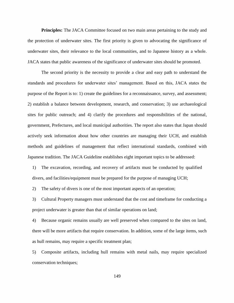
149
Principles: The JACA Committee focused on two main areas pertaining to the study and
the protection of underwater sites. The first priority is given to advocating the significance of
underwater sites, their relevance to the local communities, and to Japanese history as a whole.
JACA states that public awareness of the significance of underwater sites should be promoted.
The second priority is the necessity to provide a clear and easy path to understand the
standards and procedures for underwater sites’ management. Based on this, JACA states the
purpose of the Report is to: 1) create the guidelines for a reconnaissance, survey, and assessment;
2) establish a balance between development, research, and conservation; 3) use archaeological
sites for public outreach; and 4) clarify the procedures and responsibilities of the national,
government, Prefectures, and local municipal authorities. The report also states that Japan should
actively seek information about how other countries are managing their UCH, and establish
methods and guidelines of management that reflect international standards, combined with
Japanese tradition. The JACA Guideline establishes eight important topics to be addressed:
1) The excavation, recording, and recovery of artifacts must be conducted by qualified
divers, and facilities/equipment must be prepared for the purpose of managing UCH;
2) The safety of divers is one of the most important aspects of an operation;
3) Cultural Property managers must understand that the cost and timeframe for conducting a
project underwater is greater than that of similar operations on land;
4) Because organic remains usually are well preserved when compared to the sites on land,
there will be more artifacts that require conservation. In addition, some of the large items, such
as hull remains, may require a specific treatment plan;
5) Composite artifacts, including hull remains with metal nails, may require specialized
conservation techniques;

150
6) For the area of the sea where authority is not claimed by any nearby municipalities, all
involved municipalities should discuss and agree on how to manage the particular site;
7) Several related regulations, other than the Act on Protection of Cultural Properties, may
apply when conducting a research underwater; and
8) When discovering a vessel of foreign origin, negotiations must be made with the flag state;
the ownership of the wreck and cargo has to be established before research may take place.
Assessment: The Heisei Year 10 Report states that the local Board of Education should be
responsible for searching, assessing, and registering the buried cultural properties. In cases in
which the local municipalities do not have a well-established plan to manage archaeological sites,
the Prefecture’s Board of Education should provide logistical and technical support, until the
system and organization mature.
The Board of Education should strive to create a clear picture of the archaeological
resources in its jurisdictional area, through the continuous upgrade of the existing archaeological
site map. Prospective surveys and new information from all related projects should be included in
the archaeological database. When the existence of a new site is suspected, a survey should be
conducted to identify and assess its existence. When a new site is discovered, the local Board of
Education, together with the Prefecture’s Board of Education, must make a decision regarding the
area to be registered and protected. The registered area should be based on empirical evidence and
previous research. The results from new research should always be uploaded into the local
archaeological database and reflected in the site map. The public should have access to updated
information.
A basic and important task of the local government is registering, assessing, and
publishing information about the site. The local Board of Education should always be on the

151
lookout for possible new sites and should collect information about the discoveries made by the
fishermen and the public. Local government also is expected to promote the study of historical
materials for possible wreck events or the existence of other types of submerged sites. When the
presence of an underwater archaeological site is suggested in the historical records, the nature of
the site should be assessed, and the survey location should be narrowed to the smallest possible
area. For example, in a site such as a harbor, which has a component on land and underwater, a
prospective survey on land may give a lead to the area extended seawards. Also, in an area where
the water visibility is clear, a site may be identified from land or from a boat. A careful study of
marine charts and bathometric data also may help identify a possible site.
Finding an underwater site, without any previous clues, is extremely difficult, but usually
there is some information available from historical records, fishing communities, divers, and
developers. The Board of Education should create an archive of historical records regarding
possible shipwreck events and references of submergence or tsunami damages. Locations of
possible shipwreck sites should be marked on the site map.
Perhaps the most reliable information for the possible location of a submerged site comes
from the stakeholders, such as fishery cooperatives and local dive shops. There should be a
straightforward system for reporting finds from the sea. It is commonly understood that, when an
item is raised from the sea, the finding should be reported to a local police officer or to the coast
guard and to be processed as lost property. However, when a historical artifact is raised from the
sea, it can be considered to be buried cultural property, and, as such, it should not be reported as
lost property. The decision to consider whether an artifact is lost property of an individual, or
shared heritage, falls upon the police office. It is advised that the Board of Education explain the

152
importance of UCH to the office in charge of the community; the Board of Education also should
encourage the police to contact the Board if they have any questions regarding an item.
It also is important to reach out to local communities about the importance of UCH, to
encourage the reporting of a possible site or a chance discovery. It may be necessary for the Board
of Education to visit the local marine-related industries and communities to explain the benefit of
protecting the local underwater legacy. Development projects over water often are extensive,
sometimes stretching over several municipalities. For such projects, there must be cooperation
among municipalities and the Prefecture’s Board of Education. Local Boards of Education should
build a strong relationship with the neighboring municipalities, share information, and perhaps
conduct joint reconnaissance surveys encompassing large areas.
Registering/Creating Site Map: The map of protected sites should be made available to
the public permanently, and periodic updates should be announced. In general, the extent of each
site should be clearly marked on the map. There should be periodic activities aimed at making the
public better understand the extent and importance of a site. Considering that the purpose of the
map is to inform the public about the existence of archaeological sites, the sites may be shown as
dots, rather than as an area delimited by a line, in order to avoid ambiguity when planning a
development. Furthermore, a possible location of a wreck site from historical records may be
illustrated, even if a site cannot be located by conducting a remote sensing survey. The location of
chance discoveries of artifacts also may be marked on the map. Any information that may help the
public to view a possible underwater site also should be made available. The local authority may
devise a new way to mark a possible site if it is believed that this would help the public to
understand its location better.

153
Age Criteria for Protection: The Heisei Year 10 Report states that in principle, sites older
than the Early Modern Era (around the year 1600) must be registered for protection, while sites
after the 17th century should be considered for protection if the site is important for the local
community. Sites from the Modern Era (mainly from the Meiji period) may be considered for
protection if they are essential for the understanding of the local community.
It can be assumed that many of the underwater archaeological sites still to be discovered in
Japan postdate the 1600s. Some of them are vessels of foreign origin. Historical sources can
identify the detailed history of commerce and inter-regional relationships and are considered
highly valuable resources for the study of the past. The importance of underwater sites, especially
shipwrecks, should be assessed with inter-regional, or international perspectives in mind and not
solely based on the significance for the local community to which a site belongs.
Mitigation of UCH Sites: The Heisei Year 10 Report mentions that the success of heritage
management policies is achieved through the cooperation of the public, or stakeholders of the land
where the site is located. For public works, it is paramount to establish a strong link between the
different departments responsible for planning. For private development projects, the Board of
Education should intervene at the earliest stage, preferably when the construction plan is first
known. If the nature of the archaeological remains in the area being developed is not clear from
the assessment survey, it is necessary to conduct additional prospective surveys and test trench
excavations. All meetings between the developers and the Board of Education should be recorded.
The final agreement should be made into a contract with a detailed project plan including the time
frame and budget.
To avoid a breach of contract, the Board of Education should make the best use of the
result of its surveys; the initial assessment of sites is thus critical to avoid unwanted costs. New
154
survey and site recording techniques should be used to increase knowledge of underwater sites. It
is particularly important to communicate as often as possible with the developer and all the
stakeholders during the project to ensure that there are no misunderstandings. When construction
is planned within a protected area, the developer must consult with the Board of Education. The
Heisei Year 10 Report recommends that the procedures for mitigation be defined and implemented
in a timely manner.
The stakeholders of the underwater sites often are related to harbor and coast
developments. This means that the municipality should strive to create stronger ties with the
interested departments, such as port authorities, fishing industries, marine authorities, and
departments responsible for dredging and reclamation projects. The Board of Education should
contact these offices and explain the importance of protecting underwater sites, as well as their
responsibilities in the process. They also should open communication channels and check the
procedures when a site is discovered or when construction is being planned. As with the case of
archaeological sites on land, unnecessary excavation of the site should be avoided, and developers
should be encouraged to protect the site in situ. It sometimes is difficult to find an archaeological
site underwater, and it is important that the developers understand the need to supervise their work
with watchful eyes, even after the permit is given for the development.
The Excavation: When recording a site due to construction, the developer should pay for
the cost of the operation. Several considerations have to be made in deciding whether to excavate
a site. Since few municipal officers have experience in underwater excavation techniques and
procedures, the majority of the underwater work should be conducted by hired professional divers.
However, the local officers should be able to see the site, through diving - even for short visits -
or through video, and make the excavation plan based on that evidence. A few municipalities have

155
experienced diver-archaeologists, and perhaps it is a good idea to involve public archaeological
groups and universities in order to develop capacities in the country. The Board of Education
should strive to collect information regarding field methods for underwater archaeology and be
prepared to plan an excavation.
Because there are no official standards or guidelines for excavating underwater sites, JACA
is planning to create a set of guidelines and training programs for research on underwater sites.
Japanese universities should be encouraged to develop courses that teach the subject, thereby
fostering interest in the study of the country’s underwater heritage.
Conservation: The cost of conservation is borne by the municipality; it is the responsibility
of the local community to ensure the survival of its heritage. The municipality can contract private
conservation laboratories for the actual work. When a site is left in situ, a monitoring plan should
be in place, checking for possible degradation of the artifacts and features over time.
Once artifacts are raised from the seabed, conservation must follow the internationally
established standards for waterlogged or wetland sites. Extra care should be taken because the
materials may be more fragile than finds from a land site. Artifacts from marine sites may require
specialized skills, and it may be necessary to use a conservation laboratory with trained personnel,
prepared for the job in hand.
Japan has not had the experience of raising a complete hull from an underwater
archaeological site, but this has been done in other countries, which suggests that this solution is
viable. The hull must be carefully excavated, conserved, and the information from the research
must be shared widely with the public through effective means, such as exhibitions and
publications. In some of these projects, the public has shown a great interest in and willingness to
support the effort. These projects have effectively contributed to the enrichment of society. Despite

156
the fact that there is a possibility of raising a hull, a local municipality cannot fund its conservation;
this requires a national budget. A completely different site management system may be needed
when attempting to raise a hull.
The methods for protecting sites in situ can be studied from research conducted worldwide.
To prevent the erosion and the spread of artifacts, sites may be covered by sediment and protected
with netting. For sites containing organic materials, it is important not to expose the artifacts. These
sites should be fully covered to a sufficient depth, and with protective sheets, such as geotextile
materials, to prevent the loss of sediment. They should be monitored, and their status should be
updated. Depending on the results of the monitoring, it might be necessary to change preservation
techniques. Even for the sites that are protected in situ, limited excavation should be conducted,
and, at the same time, researchers should be considering the methods for protecting such sites. It
is highly advisable that the results of this research be shared among the municipalities to enhance
the knowledge of how to protect underwater sites effectively. The Takashima underwater site in
Japan has experienced success in situ preservation and monitoring. The information that saved this
site should be shared with other municipalities.
Public use of the heritage: One of the missions of the local Board of Education is to
promote the use of the area’s heritage for the benefit of the public. The heritage should be shared
by the communities maintaining the integrity of artifacts and sites. The public use of archaeological
remains may take many forms. These include access to the site itself, the exhibition of artifacts at
a museum, and the publication of the results of the research in scholarly or popular publications.
As discussed above, one reason for the apparent lack of interest in underwater
archaeology in Japan is that the people are not well informed about underwater sites. The
dissemination of research results is essential for the future of the field. There are various ways to

157
broadcast the importance of protecting underwater sites and the historical research they produce,
including public lectures, exhibitions of artifacts and results, and posters (on paper and online).
Access to the facilities is critical. This can be accomplished through tours of conservation
centers, diving tours, and observation of the site from a boat, the shore, or through virtual
representations. In addition to these activities, releasing information through public media is an
important means to educate the public at large. With broader public support, it will be easier to
negotiate a mitigation plan with the stakeholders. It is important that municipal officers remember
that the preservation and protection of the underwater sites is their key responsibility, and the
promotion of the cultural heritage must not undermine this principle.
Responsibilities of the National, Prefectural, and Local Governments
The responsibilities of the National, Prefectural, and local governments in regard to UCH
are outlined in the JACA Guideline. The day-to-day management of UCH is performed by the
local government, and it will create a protection system that best fits local needs. However, it will
take some time for the municipality to create this system because most of the municipalities have
little experience dealing with underwater sites. There are not many trained diver archaeologists in
Japan, and certainly not enough to fill the needs of all the cities.
Some archaeological sites, such as wrecks of foreign origin, cannot be managed through
local municipal offices alone. Local Prefectural and national government offices will have
different roles to play, and all the parties should strive to create a better system of managing these
finite resources. For example, beginning in the 1960s, when the current system of archaeological
site management began to develop, JACA, together with the Nara National Research Institute for
Cultural Properties, supported local municipalities by providing workshops or training programs.

158
A similar supporting program should be created for managing underwater sites. The national
government must provide some financial support for local municipalities and should be
instrumental in organizing programs for professional development.
Local Government
The local government or municipal Board of Education should be the first department to
be consulted when dealing with UCH issues. The surveys for site identification and maintenance
of archaeological site databases should be kept locally. The construction companies should make
arrangements through the local municipal offices when planning for development. The initial
conservation should also be planned and executed locally. The most important task is to create a
reliable and comprehensive site map and database for underwater sites. The initial step in creating
this map is gathering previous research. Local fishing cooperatives and other maritime related
industries may know the locations of possible sites; they may know some anomalies underwater
without being aware that the anomalies may be of great historical significance. Inquiries made to
the local stakeholders are always helpful. This information should be gathered and the data
analyzed at the local level. Usually, many of waterfront development projects are managed at the
Prefectural level. Therefore, it is important for the local municipality to be in regular
communication with the Prefectural government. Local governments must also create a system for
reporting chance discoveries and promote a better understanding of the importance of UCH by
establishing public education programs.
Prefectural Government
Although Prefectural governments are not the primary caretakers, the Prefectural Board of

159
Education plays an important role in protecting UCH. Prefectures should support the local
governments by providing technical advice, as well as financial support. In development projects
that cross municipal boundaries, the Prefectural government becomes the location of the primary
management office. The Prefectural government must decide on the impact of the work, whether
a site should be preserved in situ or excavated, and what type of research must be carried out to
supply information for an exhibition. These are just some of their responsibilities. Final decisions
should be reached, with the developers, stakeholders, and local municipalities agreeing on the
outcome. Prefectural governments should also be responsible for the communication between
JACA and the local stakeholders, acting as a bridge between the local community and the central
authority.
Prefectural governments must create and disseminate clear guidelines and sets of
procedures for maintaining the balance between the interests of developers and local municipalities.
The responsibilities should not be confused as a list of short-term goals, but all programs and rules
should be set with long-term goals in mind. The priority of Prefectural governments is to promote
a better understanding of the nature of a region’s underwater archaeological heritage and to
generate the public’s awareness of UCH. To do so, it is recommended that they create a position
for an underwater heritage officer.
Central Government
The central government should gather information regarding international development
and global trends in the field of underwater archaeology. The central government should establish
clear directives for the Prefectural and local municipalities to follow. To facilitate and improve
research methods, the government should support and encourage research on this subject. The
160
government should secure funding to support the municipalities in need, and to help them improve
the management models to finance research or mitigation projects.
When an important discovery is made, the central government should be ready to facilitate
its registration as a national heritage site. The knowledge gained at the local Board of Education
level must be transmitted to other local municipalities, and the information regarding international
standards also should be made available to them. Finally, the government should direct the creation
of training programs and help by placing underwater archaeological officers in municipalities in
need. In the near future, the national government should create a center or a department for
underwater archaeological research.
161
CHAPTER VII
CONCLUSIONS
Summary of the Studies
Research on UCH in Japan started in the early 20th century, but the field did not grow
rapidly. In the 1970s and 1980s, the need to ensure that construction projects did not damage the
country’s historical legacy appears to have propelled some growth in the field of underwater
archaeology. However, underwater excavation remained a minor sub-field of archaeology, and
little professional development took place. Following the management pattern of land archaeology,
the protection of Japan’s UCH became the responsibility of local municipalities.
JACA was aware of the existence of underwater sites and the need to protect them but did
little to establish a system, or a set of guidelines, for municipal officers to follow. After the 1990s,
several groups became active in UCH research, but still, there was no competent authority for the
protection of UCH. The discovery of the Mongol wrecks at the Takashima Underwater Site
sparked interest in managing the country’s UCH. The JACA Committee was created and published
its Guideline in 2017. JACA has plans to publish a manual for activities directed towards UCH in
the next few years.
As shown in this dissertation, it is important to know the scope and historical context of
UCH in Japan before beginning any research on the topic. For this purpose, the author created a
database of known UCH sites, categorized by age, type, location, and current status. Close to 600
UCH sites have been identified in Japan, but the collected data show large variations in number
and kind of sites from region to region. The regional differences mainly are due to the level of
interest by the local municipal officers.

162
The majority of the registered UCH sites are prehistoric submerged-settlement sites located
inland. Maritime sites, such as shipwrecks along the coast, still are rare. Many of the inland sites
that have been registered were excavated due to lakefront development projects. This situation
reflects the fact that the need for surveys is not yet recognized in the country. Many of the sites are
found accidentally on construction locations, and thus are excavated unscientifically, often by
archaeologists without any special training.
As an island nation, Japan must have thousands of shipwreck sites waiting to be
discovered. However, there has been little study on assessing the potential of this particular type
of UCH site. To find the missing shipwrecks, the researcher compiled marine disaster records and
municipal records from all the Prefectures in the country. Following this effort, future research
must be conducted, but a detailed study of sites must be conducted by scholars with knowledge of
local historical sources.
This study included close to 6,000 entries. Again, the data appear to show some regional
differences in the number of local vessels and ship types, but differences reflect which records
were kept and compiled by the municipal officer responsible for the local archive. The majority of
the records are from the Edo period, but some are much older because the municipalities have kept
records for more than 1,000 years. Foreign trade peaked in the 18th century across Japan. The 19th
century, corresponding to the time when European powers approached Japan, was a time of decline
in maritime trade.
While considering various topics regarding Japan’s UCH, the researcher looked at the ways
in which other countries around the world are managing their UCH. Seven countries were selected
as case studies. In general, their management frameworks for underwater sites are similar and/or
show no difference from the system of managing sites on land. Usually, there is a competent
163
authority in the central government, which provides some technical support and establishes
guidelines. Korea and France have a strong central authority, while the U.S. appears to have little
central control regarding the management of their UCH. The management of UCH in the
international context can be a complex matter, but the 2001 UNESCO Convention provides a
solution that was accepted by many countries.
Japan created a decentralized, but highly effective, management model for the protection
of the buried cultural properties on the land. However, the system is not easily applicable to
underwater sites. The reasons for the lack of such development are not completely clear. In the last
five years, the JACA Committee, using some of the data in this dissertation, published a set of
guidelines recommending that the central government, Prefectural governments, and local
municipalities work together to create a better system for managing Japan’s UCH. The
management system proposed is reasonable, inclusive, functional, and based on the management
model for land archaeological sites. Building awareness about Japan’s Underwater Cultural
Heritage and creating local archaeological maps and databases of on-land and underwater sites are
the first steps to take in implementing this policy.
Concluding Remarks
Despite a long history of interest in underwater relics, the Japanese archaeological
community has largely been indifferent to the necessity of establishing a management system for
the study, preservation, and dissemination of the country’s UCH. This dissertation covers the
history of underwater archaeological research, its current status in Japan, the available maritime
accident records, as well as the systems of UCH management around the world. Based on this, the
research suggests that the best management plan for Japan’s UCH is one in which the main tasks
are conducted by municipal cultural officers at a local level, just like they do with the land sites.

164
JACA‘s responsibility will be to establish policy guidelines and to provide advice to municipalities,
as well as to check the overall management plan. The municipal archaeologists will manage the
underwater sites, according to the principles set by JACA. Their main task will be to register new
sites and, perhaps, to organize surveys and excavations with the help of avocational underwater
archaeological groups or private companies. Small-scale excavations may be conducted through
networks of professional and private archaeologists.
As this scheme is only a proposal and not a complete plan, the details regarding how to
incorporate the non-archaeological community and other stakeholders into the overall heritage
system have not been fully considered. A sudden change in the Japanese archaeological
community may not be possible, but the author believes this study will instigate more interest and
in-depth studies of Japan’s unique and priceless underwater heritage.

165
REFERENCES
Abe, Y. 2008. “貝塚形成と村の成り立ち (The Formation of Shell Middens and
Emergence of Villages.)” Archaeology Quarterly 105: 18-23.
Agouridis, C. 1998 “Greece.” In Encyclopedia of Underwater and Maritime Archaeology.,
edited by Delgado, J., 180-3. New Haven: Yale University Press.
Akita, H. 1997. 琵琶湖湖底の謎 (The Mystery of the Submerged Sites from Lake
Biwa). Osaka: Sogen Shya.
Asia Research Institute of Underwater Archaeology 2013. 水中文化遺産データベース作成と
水中考古学の推進 : 海の文化遺産総合調査報告書 (Promottion for the Study of
Underwater Archaeology and the Creation of Underwater Archaeological Site Database:
The Comprehenisuve Investigation Report of Cultural Heritage of the Seas). Fukuoka:
Asia Research Institute of Underwater Archaeology (ARIUA).
.
Almkvist, G. 2018. “Chemistry and degradation process in the Vasa Wood.” In Proceedings
for International Symposium on Maritime Silkroad: Conservation Science of Maritime
Objects and Shinan Shipwreck., 156-170. Mokpo: NRIMCH.
Anzato, S. 2006. 琉球の王権とグスク (Gusuku and the Royal Power of the Ryukyus).
Tokyo: Yamakawa Publishing.
Arano, Y. 1988. “近世日本の漂流民送還体制と東アジア (East Asia and the System of
Returning Shipwrecked Sailors in Premodern Japan).” In 近世日本と東アジア
(Premodern Japan and East Asia)., edited by Arano, Y., 73-102. Tokyo:Tokyo
University Press.
Bailey, G. and N. Flemming 2008. “Archaeology of the Continental Shelf: Marine Resources,
Submerged Landscapes and Underwater Archaeology.” Quaternary Science Reviews
27: 2153–65.
Barnes, G. 2007. State Formation in Japan: Emergence of a 4th-Century Ruling Elite.
London: Routledge.
Batten, B. 2005. Gateway to Japan: Hakata in War and Peace, 500-1300.
Honolulu: University of Hawaii Press.
Björdal, G., and T. Nilsson. 2008. “Reburial of shipwrecks in marine sediments: a long-
term study on wood degradation.” Journal of Archaeological Science 35(4):862-
72.

166
Bleed, P. and A. Matsui 2010. “Why Didn’t Agriculture Develop in Japan? A
Consideration of Jomon Ecological Style, Niche Construction and the Origins of
Domestication.” Journal of Archaeological Method and Theory 17: 356-70.
Catsambis, A. 2012. “Preserving the Submerged and Coastal Maritime Heritage of the
United States.” Ph.D. Dissertation., Texas A&M University, College Station.
Catsambis, A., B. Ford, and D. Hamilton, eds. 2011. The Oxford Handbook of Maritime
Archaeology. Oxford University Press.
Chinese Academy of Cultural Heritage 2017. Nanhai I Shipwreck: Shipwreck
Excavation in Site Preservation Research (2014-2016). Beijing: China Science
Publishing & Media Ltd.
Chinese Academy of Cultural Heritage 2012, 15 November. SACH Center for
Underwater Cultural Heritage. http://english.cach.org.cn/col/col1581/index.html
China National Centre of Underwater Cultural Heritage 2015. Annals of National Center
of Underwater Cultural Heritage 2014. Beijing: China National Centre of
Underwater Cultural Heritage.
China National Centre of Underwater Cultural Heritage 2017. Archaeological Report on
Nanhai I Shipwreck. Series II: Excavation of 2014-2015. Beijing: Cultural Relics Press.
Chinzei-Cho Board of Education 1989. 赤松海岸遺跡 : 昭和 62・63 年度名護屋漁港
海岸保全施設整備事業に係る発掘調査概要報告査 (Akamatsu Beach Site:
Fiscal Year Showa 62 and 63 Nagoya Fishing Port Renovation Project Report on
Preliminary Excavation). Chinzei-Cho: Chinzei-Cho Board of Education.
Delgado, J. ed. 1998. Encyclopedia of Underwater and Maritime Archaeology. New
Haven: Yale University Press.
Delgado, J. 2008. Khubilai Khan's Lost Fleet: In Search of a Legendary Armada.
Berkley: University of California Press.
DRASSM 2019. Archaeologie sous les eaux.
http://www.culture.gouv.fr/Thematiques/Archeologie/Archeologie-sous-les-eaux.
Dromgoole, S. 2013. Underwater Cultural Heritage and International Law: Cambridge
Studies in International and Comparative Law. Cambridge University Press.
Elia R. 2000. “US protection of underwater cultural heritage beyond the territorial sea:
Problems and prospects.” International Journal of Nautical Archaeology 29(1):43-56.
Eriksen, A.N., G. David, and S. Yvonne. 2015. “Selective attack of waterlogged

167
archaeological wood by the shipworm, Teredo navalis and its implications for in-situ
preservation.” Journal of Archaeological Science 55:9-15.
Esashi Town Board of Education 1990. 開陽丸:海底遺跡の発掘報告 (Kaiyo-Maru:
Excavation Report of Underwater Archaeological Site). Esashi: Esashi Town Board of
Education.
European Archaeological Council 2016a. Archaeological Heritage Management in France.
http://www.old.europeanarchaeologicalcouncil.org/files/archaeological_heritage_manage
ment_in_france.doc
European Archaeological Council 2016b. Archaeological Heritage Management in the
Netherlands.http://www.old.europeanarchaeologicalcouncil.org/files/archaeological_herit
age_management_in_the_netherlands.doc
Frigerio, A. 2013. The Underwater Cultural Heritage: a Comparative Analysis of
International Perspectives, Laws and Methods of Management. Ph.D. Dissertation.,
IMT Institute for Advanced Studies, Lucca, Italy.
Fukuyama-City Tomonoura Rekishi Minzoku Shiryoukan 2008. 坂本竜馬といろは丸
事件 (Ryoma Sakamoto and Iroha-Maru Incident). Fukuyama: Fukuyama-City
Tomonoura Rekishi Minzoku Shiryoukan
Ge, X. 2011. "Baiheliang Ancient Hydrologic Inscription - No.1 Ancient Hydrometric
Station in the World and In-situ Underwater Protection Project." In Proceedings for
2010 International Meeting on Protection, Presentation, and Valorisation of
Underwater Cultural Heritage, Chongqing, China., edited by State Administration of
Cultural Heritage. 309-40. Beijing: Cultural Relics Press.
Green, J., N. Burningham., and Museum of Overseas Communication History. 1998.
“The Ship from Quanzhou, Fujian Province, People's Republic of China.” The
International Journal of Nautical Archaeology 27(4): 277-301.
Habu, J. 2010. Ancient Jomon of Japan (Case Studies in Early Societies). Cambridge
University Press.
Harrison, J. 2013. Making the Law of the Sea: A Study In The Development Of
International Law (Cambridge Studies in International and Comparative Law).
Cambridge University Press.
Harvey, P., and D. Shefi. 2014. “Thirty Years of Managing the Wreck of the Historic
Australian Colonial-Built Schooner Clarence (1841-1850): From Ineffective to Pro-
active Management. ” Journal of Maritime Archaeology 9(2):191-203.
Hattori, H. 2017. 蒙古襲来と神風 - 中世の対外戦争の真実 (The Mongol Invasion
and the Kamikaze – The Truth of Medieval Warfare). Tokyo:Chuokoron-Sha.

168
Hayashida, K. 2013. “日本の水中遺跡 (The Underwater Archaeological Sites of
Japan)” Archaeology Quarterly 123:20-23.
Hayashida, K., J. Kimura, and R. Sasaki. 2014. “State and Perspectives of Submerged
Sites in Japan.” In Prehistoric Archaeology on the Continental Shelf. edited by
Evans, A., Flatman, J., and Flemming, N., 275-90. New York:Springer.
Heiðarsson, D. 2013. “Underwater Heritage in Iceland: Assessment and
Recommendation Regarding Underwater Cultural Heritage.” Master’s Thesis.
University of Southern Denmark, Odense.
Hokama, S. 1986. 沖縄の歴史と文化 (History and Culture of Okinawa). Tokyo:
Chuokoron-Shinsha.
Hongo, H. 1989. “Freshwater Fishing in the Early Jomon Era (Japan): an Analysis of
Fish Remains from the Torihama Shell Mound.” Journal of Archaeological
Science 16: 333-54.
Hocker, F. 2011. Vasa: A Swedish Warship. Stockholm: Medstroms Bokforlag.
Ikeda, Y. 2012. Final Report of 2006-2010 Grant-in-Aid for Scientific Research (S);
Grasping and Analyzing Mongolian-Expedition-Related Archaeological sites
and Remains on the Seabed of Takashima.
Ikeda, Y. 2016 Final Report of 2011-2015 Grant-in-Aid for Scientific Research (S); The
Research and study of the shipwrecks at the Mongol Invasions using the Underwater
Archaeological Method.
Ikeda, Y. 2018. 海底に眠る蒙古襲来:水中考古学の挑戦 (The Mongol Invasion that
Sleeps Underwater: The Challenges of Underwater Archaeology). Tokyo:Yoshikawa
Kobunkan.
Inada, K. 2014. 日本とフランスの遺跡保護-考古学と法・行政・市民運動 (The
Protection of Cultural Heritage in Japan and France – Archaeology, Law, Government,
and Civic Movements.) Tokyo: Iwanami Shoten.
Inoue, T. 2015. 水中考古学 (Underwater Archaeology) Tokyo: Chuo Koron Shin-Sha.
Ishibashi, F. 2003. “徳川幕府最後の軍艦-開陽丸ルネッサンス (The Renaissance of
the Kaiyo-maru, The Last Warship of the Tokugawa Shogunate)” Journal of
Geography 112 (3): 458-61.
Ishiga, H. et al. 2000. “Geochemical Record of the Holocene Jomon Transgression and
Human Activity in Coastal Lagoon Sediments of the Sanin District, Southwest
Japan.” Global and Planetary Change 25: 223-37.

169
Ishii, K. 2002. 日本の船を復元する:古代から近世まで (Reconstructing Japanese
Vessels: From Ancient Times to Premodern Period). Tokyo: Gakken.
Ishii, S. 2004. 日本の歴史 (7) 鎌倉幕府 (The History of Japan [7] Kamakura Bakufu).
Tokyo:Chuokoron-Sha.
Ishikawa Prefecture History Museum 2017. 北前船と日本海海運 (The marine
transportation of kitamae-bune). Ishikawa Prefecture History Museum.
Itano, J. 2012. 日本近代史 (Modern History of Japan). Tokyo: Chikuma shobo.
Iwabuchi, R. 2010. 江戸の都市と文化 (City and Culture of Edo). Tokyo:Yoshikawa
Kobunkan.
JACA 2017a. 埋蔵文化財関係統計資料平成 28 年度 (Data Sheet of Buried Cultural
Properties Related Projects Fiscal Year 2016). Tokyo: JACA.
JACA 2017b. 水中遺跡保護の在り方について (Guidelines for the Protection of the
Underwater Archaeological Sites in Japan) Tokyo: JACA.
JACA 2013. 発掘調査のてびき:各種遺跡調査編(The Manual for Archaeological
Excavation :Excavating Various Types of Sites.) Tokyo:Doseisha..
JACA 2010a. 発掘調査のてびき:整理・報告書編 (The Manual for Archaeological
Excavation: Curation and Report.) Tokyo: Doseisha..
JACA 2010b. 発掘調査のてびき:集落遺跡発掘編 (The Manual for Archaeological
Excavation –Excavating Settlement Site) Tokyo: Doseisha.
JACA 2004. 行政目的で行う埋蔵文化財の調査についての標準(報告):埋蔵文
化財発掘調査などの整備充実に関する調査研究委員会 (The Report of the
Standards for Conducting Archaeological Research on Buried Cultural
Properties by Municipal Office: Research Committee on the Enhancement of
Excavating/Researching Buried Cultural Properties) 2004, Oct 29.
http://www.bunka.go.jp/seisaku/bunkazai/shokai/pdf/hokoku_06.pdf.
JACA 2000. 遺跡保存の検討―水中遺跡 (Discussion on Preserving Archaeological
Site – Underwater Archaeological Site). Tokyo: JACA.
JACA 1998. 埋蔵文化財の保護と発掘調査の円滑化等について :庁保記第七五号
(Regarding the Protection Facilitating Excavation of Buried Cultural Properties:
JACA Secretariat Record Number 75) 1998, Sep. 29.
http://www.mext.go.jp/b_menu/hakusho/nc/t19980929001/t19980929001.html

170
The Japanese Paleolithic Research Association 2010. 日本列島の旧石器時代遺跡 : 日
本旧石器先土器岩宿時代遺跡のデータベース Palaeolithic Sites in the
Japanese Islands : A Database. Tokyo: Meiji University Museum.
Kakiuchi, E. 2014. “Cultural Heritage Protection System in Japan: Current Issues and
Prospects for the Future.” GRIPS Discussion Paper 14-10. Tokyo: National Graduate
Institute for Policy Studies.
Kaminokuni Town Board of Education 1987. 上ノ国漁港遺跡 (Kaminokuni Fishing
Port Excavation Report). Kaminokuni: Kaminokuni Town Board of Education.
Kamiya N. 2003. 琉球と日本・中国 (Ryukyus and Japan, China). Tokyo:Yamakawa
Publishing.
Kanasashi, S. 1968. 近世海難救助制度の研究 (The Study on Premodern Maritime
Rescue Practices). Tokyo:Yoshikawa Kobunkan.
Kaneda, A. 2001. “多良間沖で難破したオランダ商船ファン・ボッセ号の歴史的検
証 (The Historical Analysis of Van Bosse, a Dutch merchant vessel wrecked off
Tarama Island ).” Bulletin of the Japan-Netherlands Institute 26(1): 79-97.
Katagiri, C. 2015. 水中文化遺産-海に沈んだ歴史のカケラ:平成 26 年度沖縄県立
博物館・美術館 博物館特別展 (Special Exhibition 2014: Underwater Cultural
Heritage – Pieces of History in the Ocean – Okinawa Prefectural Museum and Art
Museum.) Naha: Okinawa Prefectural Museum and Art Museum.
Katagiri, C. et al. 2014. 沖縄の水中文化遺産: 青い海に沈んだ歴史のカケラ
(Underwater Cultural Heritage in Okinawa: The Fragments of History Buried in the
Blue Sea) Naha: borderink.
Kawazoe, S. ed. 2011. 福岡県の歴史 (History of Fukuoka Prefecture).
Tokyo:Yamakawa Publishing.
Kibe, K. 1997. 近世期長門における朝鮮人漂着年表について (The Annals of Korean
Drifters in Premodern Nagato). In 漂流・漂着からみた環東シナ海の国際交流 (The
International Exchange in East Asia from shipwrecks and maritime disasters), edited by
S. Kobayashi., 1996 Grants-in-Aid for Scientific Research Project Report.
Kim, B.K. 2016. “The Sailing Route of Shinan Ship and the Cause of Its Sinking.” In
Proceedings of the International Symposium Commemorating the 40th Anniversary of
the Excavation of the Shinan Shipwreck. Asia-Pacific Maritime Network and
Underwater Cultural Heritage., 439-54. Mokpo: NRIMCH.
Kim, Y. 2019. “Preservation and Restoration of Shinan Shipwreck.” In Proceedings for
171
International Symposium on Maritime Silkroad: Conservation Science of Maritime
Objects and Shinan Shipwreck., 16-27. Mokpo:NRIMCH.
Kimura, J. 2017. “Archaeological Explorations on the San Francisco (1609) sunken off
the Coast of Chiba Prefecture.” In Proceedings of the 3rd Asia-Pacific Regional
Conference on Underwater Cultural Heritage., edited by Fahy, B., et al. 923-7.
Kimura, J. 2016. Archaeology of East Asian Shipbuilding. Gainesville: University Press
of Florida.
Kimura, J. 2009. “国内水中遺跡の保護と管理:文化遺産としての問題 (Issues of
Protection and Management of Domestic Underwater Sites as Cultural Heritage.)” In
日々の考古学 2: 東海大学考古学専攻開設 30 周年記念論 (The Collection of
Articles for the 30th Anniversary of the Department of Archaeology at Tokai
University., edited by the Department of Archaeology, Tokai University., 371-81.
Tokyo: Rokuichi Shobo.
Kimura, J., R. Ono, and M. Maruyama. 2018. 海洋考古学入門:方法と実践 (An
Introduction to Marine Archaeology: Methods nd Practice) . Kanagawa: Tokai
University Press.
Kirwan, S. 2010. “Ireland and the UNESCO Convention on the Protection of the
Underwater Cultural Heritage.” Journal of Maritime Archaeology 5(2):105-15.
Klos, M., and L. Derkson. 2016. Shared Cultural Heritage of Japan and the
Netherlands. Amersfoort: Cultural Heritage Agency of the Netherlands.
KNM 2014. 水中遺跡の保存活用に関する調査研究 1:文化庁委託事業成果報告 (The
Study of Protection and Research of Underwater Archaeological Sites No.1: The
Japanese Agency for Cultural Affair Project Report) Dazaifu: KNM.
KNM 2015. 水中遺跡の保存活用に関する調査研究 2:文化庁委託事業成果報告 (The
Study of Protection and Research of Underwater Archaeological Sites No.2: The
Japanese Agency for Cultural Affair Project Report) Dazaifu: KNM.
KNM 2016. 水中遺跡の保存活用に関する調査研究 3:文化庁委託事業成果報告 (The
Study of Protection and Research of Underwater Archaeological Sites No.3: The
Japanese Agency for Cultural Affair Project Report) Dazaifu: KNM.
KNM 2017. 水中遺跡の保存活用に関する調査研究 4:文化庁委託事業成果報告 (The
Study of Protection and Research of Underwater Archaeological Sites No.4: The
Japanese Agency for Cultural Affair Project Report) Dazaifu: KNM.
KNM 2018. 水中遺跡の保存活用に関する調査研究 5:文化庁委託事業成果報告 (The

172
Study of Protection and Research of Underwater Archaeological Sites No.5: The
Japanese Agency for Cultural Affair Project Report) Dazaifu: KNM.
Kondo, H. and A. Iwabuchi 2011. “Deepwater Archaeology off Tobishima Island of
Northern Japan.” In Proceedings of the Inaugural Asia-Pacific Regional
Conference on Underwater Cultural Heritage. edited by Staniforth, M. et al. 923-
7.
Leshikar-Denton, M. 2010. “Cooperation is the Key: We Can Protect the Underwater
Cultural Heritage.” Journal of Maritime Archaeology 5 (2):85-95.
.
Liu, L. 2014a. Underwater Cultural Heritage Protection and Law in China. Beijing:
Intellectual Property Publishing House.
Liu, L. 2014b. “A Chinese Perspective on the International Legal Scheme for the
Protection of Underwater Cultural Heritage.” In Proceedings of the Asia-Pacific Regional
Conference on Underwater Cultural Heritage., edited by Van Tilburg, H. et al., 1063-4.
Lledo, B. 2016. “La Fragata Ertuğrul: un pecio otomano en Japón. Excavación,
materiales, exposición y memoria.” Doctoral Thesis., University of Alicante, Alicante
Spain.
Lledo, B., and C. Pulak. 2008. “The Frigate Ertuğrul: The 2007 Underwater Survey off
Oshima Island, Japan.” INA Annual 2007: 35-41.
Lledo, B. 2011. “Frigate Ertuğrul Project 2011” INA Annual 2011: 73-9.
Lutaenko, K. et al. 2007 “Mid-Holocene Climatic Change and Cultural Dynamics in the
Basin of the Sea of Japan and Adjacent Areas.” In Climate Change and Cultural
Dynamics: a Global Perspective on Mid-Holocene Transition., edited by D. Anderson,
K. Maasch and D. Sanweissm, 331-406. New York: Elsevier.
Lynn, G. 2013. Finding a Middle Ground in the Protection of Underwater Cultural
Heritage. Master's thesis, Texas A & M University, College Station.
L’Hour, M. 2015 “The Department of Underwater Archaeological Research: An
Administrative and Research Organisation Concerned with Underwater Heritage of
French Territorial Waters.” In Shipwrecks Around the World: Revelations of the Past.,
edited by S. Tripati, 365-80. New Delhi: Delta Book World.
Maarleveld, T., U. Guérin, and B. Egger. 2013. Manual for Activities Directed at
Underwater Cultural Heritage – Guidelines to the Annex of the UNESCO 2001
Convention. Paris: UNESCO.
Maarleveld, T., and J. Auer. 2008. “Present Demands and Educating a New Generation
of Maritime Archaeologists.” Journal of Maritime Archaeology 3(2):69-73.

173
Manders, M. 2017. “Preserving a layered history of the Western Wadden Sea Managing
an underwater cultural heritage resource.” Doctoral Thesis., Leiden University, Leiden.
Manders, M. 2010. “Dutch Involvement in Asian Underwater Cultural Heritage
Management: Building Upon Old Connections.” Journal of Maritime Archaeology
5:117-27.
Maruyama, H. 2018. 図説 室町幕府 (Pictorial Atlas of Muromachi Bakufu).
Tokyo:Ebisukosho Publishing.
Mason, R., and Caiger, J. 2011. History of Japan. Clarendon: Tuttle Publishing.
Matsui, A. and M. Kanehara 2006. “The Question of Prehistoric Plant Husbandry during
the Jomon Era in Japan.” World Archaeology 38(2): 259-73.
Matsuura City Board of Education 2011. 松浦市鷹島海底遺跡総集編:松浦市文化財
調査報告書第 4 集 (Matsuura City Takashima Underwater Site Summary of
Investigation. Matsuura City Cultural Property Investigation Report No.4.) Matsuura:
Matsuura City Board of Education.
McGrail, S. 2004. Boats of the World: From the Stone Age to Medieval Times. Oxford
University Press.
Mikami, T. 2016. 諏訪湖底の狩人達 (The Hunters of Lake Suwa). Tokyo: Shinsei Sha.
Miyashita, H. 2006. “Ancient Ships of Japan.” Master’s Thesis, Texas A&M University,
College Station.
Mizoguchi, K. 2018. The Archaeology of Japan: From the Earliest Rice Farming
Villages to the Rise of the State (Cambridge World Archaeology). Cambridge University
Press.
Mizunoe, K. 2008. “貝塚の保存と活用 (Preservation and Utilization of Shell Midden
Sites.)” Archaeology Quarterly 105: 57-60.
Moon, W. 2016. “Protection Policy and Excavation Results on the Underwater Cultural
Heritage in KOREA.” In Proceedings of the International Symposium:
Commemorating the 40th Anniversary of the Excavation of the Shinan Shipwreck., 310-
23. Mokpo: NRIMCH.
Mori, K. 1979. 考古学入門 (Introduction to Archaeology). Tokyo:Hoikusha.
Mozai, T. 1982. “The Lost Fleet of Kublai Khan.” National Geographic 162(5):634-49.
Murai, S. 2012. 世界史のなかの戦国日本 (Warring Period of Japan in Global

174
History). Tokyo:Chikuma Shobo.
Nakagawa, H. 2016. 西浜千軒遺跡 (Site Report of Nishihama Sengen). Hikone: The
University of Shiga Prefecture Underwater Archaeological Research Group.
Nakada, M. et al. 1994 “ハイドロアイソスタシーと西九州の水中遺跡 (Glacio-
Hydro-Isostasy and Underwater Jomon Sites Along the West Coast of Kyushu, Japan.)”
The Quaternary Research 33(5): 361-8.
Nakata, A. 2013. “国指定史跡鷹島神崎遺跡と今後 (National Historic Site
“Takashima Kozaki Site,” now and future)” The Archaeological Journal 641:8-13.
Nara National Research Institute for Cultural Properties 2019a. Comprehensive Database
of Archaeological Site Reports in Japan. https://sitereports.nabunken.go.jp/ja.
Nara National Research Institute for Cultural Properties 2019b. 遺跡データベース
(Archaeological Site Database) http://mokuren.nabunken.go.jp/Iseki/index.html.
National Federation of UNESCO Associations in Japan 2018. 世界遺産年報 2018
(Annual Report on World Heritage 2018). Tokyo:Kodansha.
NRIMCH 2016. Underwater Archaeology in Korea. (40th Anniversary of the Excavation
of the Shinan Shipwreck). Seoul: Gongmyoung.
Niigata Underwater Ceramic Research Group 2014. Underwater Ceramins in the Japan
Sea: Report of the Recovered Ceramics in Niigata Prefecture. Niigata: Niigata
Underwater Ceramic Research Group.
Nofuji, T. 2016. 異国と福岡:江戸時代における長崎警備と対外交流 (Fukuoka and
foreign countries : Nagasaki coastal defense and international exchange in the Edo
period). Fukuoka: Karansha.
Nogami, T. 2007. 2007 年度日本財団助成事業海底遺跡ミュージアム構想:海底遺
跡見学会の開催と水中考古学の推進 (2007 Japan Foundation Project, Underwater
Museum: Underwater Archaeological Site Tour and the Promotion of Underwater
Archaeology). Fukuoka: ARIUA.
Noshiro, S. 2009. “木材種実遺体と古生態 (Paleo-ethnobotanical and Wood Remains,
and Paleo-Ecosystem)” In 縄文時代の考古学 3 (The Jomon Archaeology 3)., edited by
Kosugi, Y: 91-104. Tokyo: Doseisha.
Office of the Cultural Property Management 1984. 新安海底遺物資料編 (Shinan
Underwater Site Artifacts Report) Seoul: Ministry of Culture and Publicity.
Ojika Town Board of Education 2002. Yamami-oki Kaitei Iseki: Ojika-cho Bunka-zai

175
Chosa Hokoku Dai 16 Shu. (Yamami-oki Underwater Site: Ojika Town Cultural
Properties Investigation Report No.16). Nagasaki:Ojika Town Board of Education.
Ojika Town Board of Education 2007. 小値賀島前方湾海底遺跡調査報告書: 小値賀
町文化財調査報告書第 20 集: (Ojika Island Maegata Bay Underwater Archaeological
Site Investigation Repor: Ojika Town Cultural Properties Investigation Report No.20).
Nagasaki:Ojika Town Board of Education.
Ojika Town Board of Education 2008. 小値賀島前方湾海底遺跡調査報告書 II: 小値賀
町文化財調査報告書第 21 集: (Ojika Island Maegata Bay Underwater Archaeological
Site Investigation Repor II: Ojika Town Cultural Properties Investigation Report
No.21). Nagasaki:Ojika Town Board of Education.
Okinawa Prefecture Buried Cultural Property Center 2017. 沖縄県立埋蔵文化財センター
調査報告書 87:沖縄県の水中遺跡・沿岸遺跡 (Okinawa Prefecture Buried Cultural
Property Center Investigation Report 87: Underwater and Coastal Sites of Okinawa
Prefecture.) Naha: Okinawa Prefecture Buried Cultural Property Center.
Okitsu Beach Site Research Club 2010. 千葉県勝浦市興津海浜遺跡調査報告書
(Research Project Report on Okitsu Beach Site, Katsuura, Chiba Prefecture).
Tokyo:Warashibe.
Ono, R. et al. 2016. “幡豆石と社会 (Hazu Stone and the Society)” In 幡豆の海の人々
(Living and Nature of Coastal Community)., Edited by Ishikawa, S., and T.,
Yoshikawa., 3-29. Shimizu: Tokai University School of Marine Science and
Technology.
Oye, Y. 1982. 水中考古学入門 (Handbook for Underwater Archaeology) Tokyo:
NHK Books.
Paine, M. 2016. The Japanese Empire: Grand Strategy from the Meiji Restoration to the
Pacific War. Cambridge University Press.
Pope, K. and J. Terrell 2008. “Environmental Setting of Human Migrations in the
Circum-Pacific Region.” Journal of Biogeography 35: 1-21.
Price H. 2013. “Notes from Mount Desert Island: Interviewing Maine Fishermen to Find
Archaeological Sites.” Journal of Maritime Archaeology 8(1):59-76.
Ryo, M. 2013. エルトゥールル号の遭難:トルコと日本を結ぶ心の物語 (The
Disaster of Ertugrul: The Story of Turkey and Japan) Tokyo: Shogakukan
Creative.
Saga City Board of Education 2012. 幕末佐賀藩三重津海軍所跡: 佐賀市重要産業遺
跡関係調査報告書 (Mietsu Naval Base Site at Saga-han at the end of Bakufu
176
Period: Saga City Significant Industrial Heritage Site Research Report). Saga: Saga City
Board of Education.
Sasaki, R 2018. “諸外国における水中考古学教育とトレーニング (The Training in
Underater Archaeological Methods around the World).” In 水中遺跡の歴史学
(The Historical Study of Underwater Archaeological Site)., Edited by Sato, M.,
147-166. Tokyo: Yamakawa Publishing.
Sasaki, R. 2017. 九州国立博物館特別展示図録:水の中からよみがえる歴史―水
中考古学最前線― (History Revealed from the Deep-The Frontiers of Underwater
Archaeology- Catalogue of Special Exhibition at Kyushu National Museum ).
Dazaifu: Kyushu National Museum.
Sasaki, R. 2015. The origins of the lost fleet of the Mongol Empire. College Station:
Texas A&M University Press.
Scott-Ireton, D. 2005. “Preserves, Parks, and Trails: Strategy and Response in Maritime
Cultural Resource Management.” Ph.D. Dissertation., Florida State University,
Tallahassee.
Secci, M. 2011. “Protection Versus Public Access: Two Concepts Compared within the
Italian Underwater Cultural Heritage Management System.” Journal of Maritime
Archaeology 6(2):113-28.
Segawa, T. 2016. アイヌと縄文: もうひとつの日本の歴史 (Ainu and Jomon:Another
Japanese History). Tokyo: Chikuma-Shobo
Segawa, T. 2007. アイヌの歴史:海と宝のノマド (The History of Aimu:Nomad of the
sea and Treasures). Tokyo:Kodan-sha
Shiga Prefectural Association for Cultural Heritage 2010. 琵琶湖水中考古学の世界 (World of Underwater Archaeology at Lake Biwa). Hikone: Sunrise Publishing.
Shiga Prefecture Board of Education 2014. 琵琶湖の湖底遺跡 調査成果総括編
(The Lake Bottom Sites from Lake Biwa: Summary of Research Results). Otsu: Shiga
Prefectural Association for Cultural Heritage.
Shin, J.K., and H.Y. Kim. 2014. Conservation Manual of Maritime Archaeological
Objects in Korea. Mokpo: NRIMCH.
Shively, D., and W. McCullough. ed. 1999. The Cambridge History of Japan, Volume 2,
Heian Japan. Cambridge University Press.
Spennemann, D., and J., Edney. 2015. “Can Artificial Reef Wrecks Reduce Diver

177
Impacts on Shipwrecks? The Management Dimension.” Journal of Maritime
Archaeology 10(2):141-57.
Staniforth, M., and M., Nash. ed. 2006. Maritime Archaeology:Australian Approaches.
New York: Springer.
Staniforth, M., J. Hunter, and E. Jateff. 2009. “Chapter 1 International Approaches to
Underwater Cultural Heritage.” In Maritime Law Issues, Challenges and Implications.,
edited by Harris, J., 1-25. Hauppauge: Nova Science Publishers.
Tabata, H. ed. 2011. 北海道の歴史 (History of Hokkaido). Tokyo: Yamakawa
Publishing.
Takada, Y. et al. 2008. 大阪城石垣石丁場跡小豆島石丁場跡の海中残石の分布調査
(The Osaka Stone Castle Wall Stone Quarry site investigation of underwater
stone)Nara: Nara National Research Institute for Cultural Properties.
Takahashi, N., and F. Gomi. 2019. 中世史講義 (Lecture on Medieval History).
Tokyo:Chikuma Shobo.
Takano, S. 2013. “Takashima Island: The Research Results of Japanese Underwater
Archaeology.” Archaeology Quarterly 123: 34-6. (in Japanese).
Takashima Board of Education 1993. 鷹島海底遺跡Ⅱ:鷹島町文化財調査報告書第
1集 (Takashima Underwater Site II. A Series Survey Report of Cultural Properties in
Takashima No.1.) Nagasaki: Takashima Board of Education.
Takashima Board of Education 1996. 鷹島海底遺跡 III:鷹島町文化財調査報告書第 2
集 (Takashima Underwater Site III. A Series Survey Report of Cultural Properties in
Takashima No.2.) Nagasaki: Takashima Board of Education.
Takashima Board of Education 2003. 鷹島海底遺跡 VIII:鷹島町文化財調査報告書
第 7 集 (Takashima Underwater Site VIII. A Series Survey Report of Cultural Properties
in Takashima No.7.) Nagasaki: Takashima Board of Education.
Tanikawa, H., M. Masafumi, and Y. Yamamoto. 2016. “A Review on estimation of
subsidence records of Nankai earthquake from the tradition of the submerged village
Kuroda-gori. Rekishi Jishin 31:17-26.
Tarama Village Board of Education 2017. 高田海岸遺跡:多良間村文化財調査報告書
13 集 (Takada Beach Archaeological Site: Tarama Village Cultural Properties
Research Report No.13). Tarama Village Board of Education.
Thorncroft, A. 1987. The Nanking cargo. London : Hamish Hamilton.

178
Totman, C. 2005. A History of Japan (Blackwell History of the World). Hoboken: Wiley-
Blackwell.
Tsuboi, K. 1994. 縄文の湖-琵琶湖粟津貝塚をめぐって (The Lake of Jomon –
Discussions on the Awazu Shell Midden of Lake Biwa). Tokyo: Yuzankaku.
Tsuboi, S. 1909. “石器時代杭上住居の跡は我が国に存在せざるか (Can Old Stone
Age Pile Dwellings Exist in Our Country)” Journal of Anthropological Society of
Tokyo 24(278):286-92.
Tsuji, T. 2005. 日本の歴史 13 - 江戸開府 (The History of Japan [13] Opening of Edo
Bakufu). Tokyo:Chuokoron-shinSha.
Ueda, Y. 2006. 遣唐使全航海 (All voyages of the Japanese Mission Trip to Tang
Dynasty). Tokyo:Soshi-sha.
Uken Town Board of Education 1999. 倉木崎海底遺跡発掘調査報告:文化財調査報
告書第1集 (Excavation Report on Kurakizaki Underwater Site:Cultural Properties
Research Report No.1 ). Uken: Uken Town Board of Education.
Underwater Archaeological Society 2006. 沈没船 19 世紀のイギリス埋没沈船遺跡発
掘調査報告:推定いろは丸 (Summary of Underwater Investigation on Iroha-Maru: An
English Steamship Built in the 19th Century) Kyoto: Underwater Archaeological Society.
van Duivenvoorde, W. 2009. “The Batavia Shipwreck: An Archaeological Study of an
Early Seventeenth Century Dutch East Indiaman.” Australian Archaeology 68:81.
Vasa Museum 2019. Vasa Museum https://www.vasamuseet.se/en.
Wakayama City Board of Education 1997. 和歌山市加太友ヶ島沖出土の陶磁器
(Ceramics from Kata Tomoga Island, Wakayama City) Wakayama: Wakayama City
Board of Education.
Walker, B. 2015 A Concise History of Japan (Cambridge Concise Histories). Cambridge
University Press.
Wei, Z. 2011. "The Origins and Creation of China's Underwater Archaeology." In Proceedings
for 2010 International Meeting on Protection, Presentation, and Valorisation of
Underwater Cultural Heritage., edited by State Administration of Cultural Heritage.,
223-234. Beijing: Cultural Relics Press.
Workman, S. 2008. Preservation, Ownership, and Access: Key Issues for New Federal
Underwater Cultural Heritage Legislation Beyond State Waters. Ph.D. Dissertation.,
Master’s Thesis., East Carolina University, Greenville.

179
Yamaguchi, K. 1957. 日本漁業史 (The History of Japanese Commercial Fishing).
Tokyo: Tokyo University Press.
Yamazaki, T., S. Wakamatsu, and N. Baba. 2015. “Trial Study to add New Information
of the Underwater Cultural Heritage and Properties of Okinawa into the Marine Cadastre
Database.” Report of Hydrographic and Oceanographic Researches 52:132-139.
Yano, K. et al. 2017. “葛籠尾崎湖底遺跡の地形測量 (The Bathymetric Survey of
Tsuzura Ozaki Lake Bottom Site)” Abstract of Annual Meeting of the Japan Society for
Scientific Studies on Cultural Property 34:320-1.
Yokkaichi, Y. 2016. “The Sinan Shipwreck within the Framework of the Maritime Trade
between Japan and China in the Fourteenth Century.” In Proceedings of the
International Symposium Commemorating the 40th Anniversary of the Excavation of the
Shinan Shipwreck. Asia-Pacific Maritime Network and Underwater Cultural Heritage.,
154-63. Mokpo: NRIMCH.
Yoshida, K. 2008. “縄文人の食性と生業 (The Life and Subsistence of the Jomon
People)” Archaeology Quarterly 105: 51-56.
Zan, J. 2009. “Treasure Fathoms Below the Yangtze.” Beijing Review 52(23):42-3.
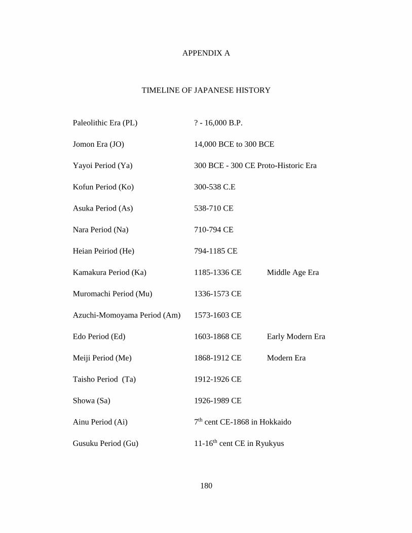
180
APPENDIX A
TIMELINE OF JAPANESE HISTORY
Paleolithic Era (PL) ? - 16,000 B.P.
Jomon Era (JO) 14,000 BCE to 300 BCE
Yayoi Period (Ya) 300 BCE - 300 CE Proto-Historic Era
Kofun Period (Ko) 300-538 C.E
Asuka Period (As) 538-710 CE
Nara Period (Na) 710-794 CE
Heian Peiriod (He) 794-1185 CE
Kamakura Period (Ka) 1185-1336 CE Middle Age Era
Muromachi Period (Mu) 1336-1573 CE
Azuchi-Momoyama Period (Am) 1573-1603 CE
Edo Period (Ed) 1603-1868 CE Early Modern Era
Meiji Period (Me) 1868-1912 CE Modern Era
Taisho Period (Ta) 1912-1926 CE
Showa (Sa) 1926-1989 CE
Ainu Period (Ai) 7th cent CE-1868 in Hokkaido
Gusuku Period (Gu) 11-16th cent CE in Ryukyus

181
APPENDIX B
Name of the Sites, Descriptions, and Japanese Names
Site
ID Name of the Site (Englsih) Description
Site Name in
Japanese
HOKKAIDO
1 Kaiyo-Maru Wreck Site
Tokugawa Bakufu’s Battle ship, purchased from the
Nethelands. Excavated and artifacts conserved. Hull is
preserved in situ. 開陽丸
2 Abashiri Lake Bottom Site Stone tools and pottery found. 網走湖底
3 Kaminokuni Haror Site Mainly Edo period ceramics found in a port. 上ノ国漁港
遺跡
4 Kanrin-Maru Wreck Site Survey is currently being conducted, but no hull has
been found.
咸臨丸(未
確認)
5 Matsumae Town Beach
Collection
Large concentration of porcelain from Kyushu found
along the shore.
松前町海岸
採集品
6 Mori Pier Site Pier posts from the Meiji era, preserved in situ. 森桟橋跡(史
跡)
7 Choyo Maru Wreck Site Tokugawa Bakufu’s battleship. Artifacts raised, and
hull buried for land reclamation. 朝陽丸
8 Asari Hama Granite Rocks A large number of non-local rocks found along the
beach.
あさり浜花
崗岩
9 Nozuke Site and Banya Site Submerged trading port.
野付通行屋
跡・番屋跡
遺跡
10 Yanagisaki No.3 Site Found by local high school students, but the exact
location has been lost since.
柳崎3遺跡
(通称厚沢
部川河口遺
跡)
11 Kitamae Sen Wreck Site Possible shipwreck reported in 1920s; perhaps a wreck
of the Kitamae trade ship. 北前船遺跡
12 Onuma Lake Bottom Site Stone tools and pottery found. 大沼湖岸遺
跡(仮称)
13 Numanohashi Logboat Logboat found underwater. 沼ノ端丸木
舟遺跡
14 Kashiwara Logboat Logboat found underwater. 柏原丸木舟
遺跡
15 Kyu-Abira River Logboat Logboat found underwater. 旧安平川丸
木舟遺跡
16 Shibunotunai Lake Bottom
East Site
シブノツナ
イ湖底東遺
跡
SITE INFORMATION

182
Site
ID Name of the Site (Englsih) Description
Site Name in
Japanese
17 Shibunotunai Lake Bottom
West Site
シブノツナ
イ湖底西遺
跡
18 Tommap River Site トマップ川
沖湖底遺跡
19 Ukimido Site 浮見堂遺跡
20 Akke Lake Logboat Logboat found underwater. 厚岸湖底遺
跡
21 Kotan Beach Site 古潭浜遺跡
22 Touro Lake Bottom Site 塘路湖底遺
跡
23 Komuke Lake Front Site Early Jomon Pottery found. コムケ湖岸
遺跡
24 Kushiro Paleolithic Find Paleolithic tools found offshore. 釧路沖 旧
石器発見地
AOMORI PREFECTURE
25 Wakinosawa Oki Find Ceramics caught in fishnets. 脇野沢沖
26 Tosaminato Site Partially submerged extensive harbor town. 十三湊遺跡
27 Jomon Swamp Site Pottery found. 縄文沼遺跡
28 Ashino Lake Bottom Site 芦野湖遺跡
29 Kodomari Oki Site Paleolithic tools found offshore. 小泊沖遺跡
30 Chogo Oki Site Paleolithic tools found offshore. 長後沖遺跡
31 Ashino Tanabatano Site Pottery found. 芦野七夕野
遺跡
32 Sunazawa Site Pottery found. 砂沢遺跡
IWATE PREFECTURE
33 Boshin War Naval Battle
Site Battleship Takao, lost durig the Boshin War in 1869.
戊辰海戦古
戦場
34 Tosen-Jyo Site Pier posts and foundation found. 渡船場遺跡
35 Goro Swamp Site Pottery found.
五郎沼遺跡
(比爪館跡遺
跡)
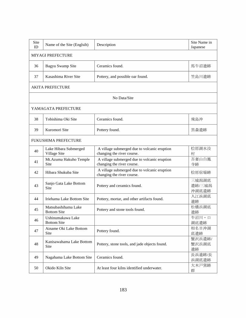
183
Site
ID Name of the Site (Englsih) Description
Site Name in
Japanese
MIYAGI PREFECTURE
36 Bagyu Swamp Site Ceramics found. 馬牛沼遺跡
37 Kasashima River Site Pottery, and possible oar found. 笠島川遺跡
AKITA PREFECTURE
No Data/Site
YAMAGATA PREFECTURE
38 Tobishima Oki Site Ceramics found. 飛島沖
39 Kuromori Site Pottery found. 黒森遺跡
FUKUSHIMA PREFECTURE
40 Lake Hibara Submerged
Village Site
A village submerged due to volcanic eruption
changing the river course.
桧原湖水没
村
41 Mt.Azuma Hakuho Temple
Site
A village submerged due to volcanic eruption
changing the river course.
吾妻山白鳳
寺跡
42 Hibara Shukuba Site A village submerged due to volcanic eruption
changing the river course. 桧原宿場跡
43 Sanjo Gata Lake Bottom
Site Pottery and ceramics found.
三城潟湖底
遺跡/三城潟
沖湖底遺跡
44 Iriehama Lake Bottom Site Pottery, mortar, and other artifacts found. 入江浜湖底
遺跡
45 Matsubashihama Lake
Bottom Site Pottery and stone tools found.
松橋浜湖底
遺跡
46 Ushinumakawa Lake
Bottom Site
牛沼川・口
湖底遺跡
47 Ainame Oki Lake Bottom
Site Pottery found.
相名目沖湖
底遺跡
48 Kanisawahama Lake Bottom
Site Pottery, stone tools, and jade objects found.
蟹沢浜遺跡/
蟹沢浜湖底
遺跡
49 Nagahama Lake Bottom Site Ceramics found. 長浜遺跡/長
浜湖底遺跡
50 Okido Kiln Site At least four kilns identified underwater. 大木戸窯跡
群

184
Site
ID Name of the Site (Englsih) Description
Site Name in
Japanese
IBARAKI PREFECTURE
51 Sharihama Beach Site Very little Information; possible wooden hull reported? 舎利浜海岸
52 Kitaura Oki Site A report of possible shipwreck? 北浦沖
53 KaidoChifune jizo Site Shipwreck reported and a monument has been built
near the site on land.
海道地船越
地蔵・沈没
船
TOCHIGI PREFECTURE
54 Nasusosui Site Industrial heritage site; underground water-duct built in
the Meiji period. 那須疏水
GUNMA PREFECTURE
55 Shimonyunakayama Site 下丹生中山
Ⅰ遺跡
56 Minumaookami Site Bronze Mirror collected. ミヌマオオカミ遺跡
SAITAMA PREFECTURE
No Data/Site
CHIBA PREFECTURE
57 Tateyama Okinoshima Site Whale bones, stone tools, and pottery found from the
shore to sea floor. Partially submered settlement.
館山沖ノ島
遺跡
58 Okitsu Beach Site
A few thousands ceramic fragments found along the
beach. The majority of the finds are poreclain from
Kyushu (early Imari ware) probably carried on
Kitamae Trade Ships, and traveling southward towards
Edo.
興津海浜遺
跡
59 Hermann Shipwreck Site A U.S. built paddle wheel steamer, Herman, wrecked
during a storm carrying troops. Located and recorded. ハーマン号
60 San Francisco (1609)
Shipwreck Site
Manila Galleon San Francisco, wrecked in 1609. A
possible stone canon ball found. Currently survey
project being conducted.
サン・フラ
ンシスコ号
(未確認)
61 Sakaenoura Beach Site
Possibly two sites found together. Ceramics eroded out
from possible shipwrecks found on top of submerged
site with Jomon Pottery. 栄ノ浦海岸
62 Kuriyama River Sites Logboat found underwater. 栗山川流域
遺跡群
63 Futtu Cape Site Ceramics and a gold bell collected. Stories of possible
shipwrecks are known from the area. 富津岬沖

185
Site
ID Name of the Site (Englsih) Description
Site Name in
Japanese
64 Sengoku Vessel Site A vessel carrying stones for Edo castle has been
salvaged in the 1930s.
石材運搬千
石船
65 Kaiho No.1 Site Man-made island for defensive purpose (canon
platform). 第一海堡
66 Kaiho No.2 Site Man-made island for defensive purpose (canon
platform). 第二海堡
TOKYO
67 Inokashira Lake Site Paleolithic tools and Pottery found in a lake. Perhaps
eroded and washed from a nearby land site?
井の頭池遺
跡群
68 Shinagawa Odaiba Sites Man-made island for placing cannons for defense
(canon platform).
品川お台場
第 3 号/第 6
号
69 Kozhu Island Oki Site Iron grapnel anchor and other artifacts raised. Surveyed
in the 1990s.
神津島沖海
底遺跡
70 Dai Ni Iyo Maru Wreck Site A possible wreck of Iyo-Maru, wrecked in 1705. A
local diver reported a finding.
第2伊予丸
沈没地
71 Gold Koban Salvaged Point
Gold Koban (Japanese oval gold coin) found in the
1950s. Part of a cargo from a vessel wrecked in 1603,
1705, or 1737, according to historical records. 小判出土地
72 Okada Harbor Houses and vessels washed away during the Genroku
Earthquake (1703). Artifacts were raised in the past. 岡田港
KANAGAWA PREFECTURE
73 Ishibashi Oki Site
Several large cut stones which were going to be used
for Edo castle can be found at the sea bottom and along
the beach.
石橋沖海底
遺跡(石丁
場跡)
74 Zaimokuza Beach Site
Ceramics from the Kamakura period found on the
beach neare Wakae-Jima site. Some Yayoi Pottery
fragments are also found. 材木座海岸
75 Mito Beach Site Several large rocks, believe to be on the way to be used
for the Edo Castle, found on the beach. 三戸海岸
76 Izu Stone Site A large pile of rocks, perhaps a ballast pile or rocks to
be used for castle wall, found underwater. 伊豆石
77 Yokohama Harbor Area
Harbor complex built in the early Meiji period. Pier,
dock, and some section of the port preserved (and
reconstructed) for the public to view.
横浜港周辺
(象の鼻・
桟橋・台
場)
78 Wakae-jima Site
Stone wall harbor structure built during the Kamakura
period; one of the oldest such structure in the country,
and the first Registered National Historic Site (in 1968)
partially submerged.
和賀江島遺
跡
79 Ashino Lake Bottom Site Ceramics found from the lake bottom. 芦ノ湖底遺
跡

186
Site
ID Name of the Site (Englsih) Description
Site Name in
Japanese
80 Nebukawa Train Station Site Train station platform submerged during the Great
Kaneto earthquake in 1923.
根布川プラ
ットホーム
81 Kaiho No.3 Site
Man-made island for defensive purposes. Destroyed
during the Great Kaneto Earthquake in 1925. Now
utilized for the public to view. 第3海堡
82 Haya-Maru Wreck Site Part of a hull found and partially raised during the early
Showa period. Hull may be still underwater. 早丸
83 USS Oneida Wreck Site Found and partially raised in the early Showa period.
Hull and most of the artifacts still underwater. オネイダ号
NIIGATA PREFECTURE
84 Izumozaki Oki Taraba Site Chinese ceramics, Karatsu ceramics, and other artifacts
were raised. Known site since the Meiji period.
出雲埼沖タ
ラバ (寺
泊)
85 Kakudahama Oki Site A collection of items raised. Shogoro Tsuboi has
conducted a research. 角田浜沖
86 Arahama Oki Site 荒浜沖海底
遺跡
87 Shiiya Oki Site 椎谷沖海底
88 Nadatchi Underwater Site A collection of ceramics found in the late 1950s.
名立海底遺
跡(タラ
バ)
89 Shironohana Site Pottery fragments found. 城の鼻遺跡
90 Torisaki Site Pottery and ceramics found. 鳥崎遺跡
TOYAMA PREFECTURE
91 Himihama Pottery found. 比美浜遺跡
92 Yokata Oki Site A possible stone quarry site. The shore line has moved
700 m inland due to erosion.
四方漁港沖
引き上げ品
93 Karashima Site Part of a shrine complex has submerged. 唐島遺跡
94 Abugashima Site Part of a shrine complex has submerged. 虻ガ島遺跡
95 Uozu Submerged Ancient
Forrest Submerged and petrified forrest dating 2,000 B.P.
魚津・神通
川沖埋没林
ISHIKAWA PREFECTURE
96 Wajima Oki Shipwreck Site Mainly ceramics remains raised. 輪島沖沈没
船?

187
Site
ID Name of the Site (Englsih) Description
Site Name in
Japanese
97 Shibayama Lagoon Midden
Site
Pottery, stone tools, and sea shells found; possible
midden.
柴山潟底(水
底)貝塚
98 Shibayama Midden Site Pottery found from submerged midden site. 柴山水底貝
塚
99 Suzu Oki Site Ceramics found. Multbeam survey conducted but no
wreck has been identified.
珠洲市沖海
底 (姫島礁
など)
100 Fukuura Harbor Ceramics found. Preliminary survey conducted. 福浦港
101 Ansei Gold Koban Salvaged
Point
Gold Koban found in the past. 安政小判引
き揚げ地
102 Unknown Shipwreck Site Possible wooden hull reported, unidentifiable. Little
information available. 沈没船
FUKUI PREFECTURE
103 Yashirohama Site Wood Statue (of Buddha?) wrapped in cloth found
during a dredging project.
小浜市矢代
浜
104 Gentatsuse Site Known locally as a place to find a collection of
ceramics. Several shipwrecks may be present? 玄達瀬
105 Mikuni Harbor Groynes Industrial heritage site. Harbor structure left in situ.
三国港(旧
阪井港)突
堤
106 Kitahori Midden Site Human remains found within partially submered
midden. 北堀貝塚
YAMANASHI PREFECTURE
107 Yamanaka Lake Bottom Site Stone wall identified. Thought to be submerged with
the eruption of the nearby mountain took place in 937?
山中湖底遺
跡
108 Motosu Lake Bottom Site Ceramic fragments found. 本栖湖底遺
跡
NAGANO PREFECTURE
109 Sone Lake Bottom Site
The Nation's first scientifically investigated underwater
archaeological site. Paleolithic tools found underwater.
Believed to be a gradually submerged site. 曽根遺跡
110 Nojiri Lake Bottom Site Research originally conducted in the 1960s. Stone tools
and wood remains found.
野尻湖底遺
跡
111 Nojiri Lake Sugikubo Site Rsearch conducted in 1955. Found one of the oldest
Paleolithic tools in Japan.
野尻湖杉久
保遺跡
112 Nojiri Lake Tachigahana
Site
Submerged site. One of the only site that shows
Naumann elephant and human coexisted in Japan.
野尻湖立ヶ
鼻遺跡
113 Oike Minami Site Stone tools, and pottery fragments found. 大池南遺跡

188
Site
ID Name of the Site (Englsih) Description
Site Name in
Japanese
114 Ebisumahara Site Stone tools found. エビスマ原
遺跡
115 Kawanishikita Site Stone tools found. 川西北遺跡
116 Kumanba Site Pottery and various stone tools found. クマンバ遺
跡
117 Shirahama I Site Pottery found. 白浜Ⅰ遺跡
118 Shirahama II Site Pottery found. 白浜Ⅱ遺跡
119 Shirahama III Site Stone tools and pottery found. 白浜Ⅲ遺跡
120 Ikkenya Site Pottery found. 一軒家遺跡
121 Ienoshita Site Pottery and stone tools found. 家の下遺跡
122 Sasanannba Site Stone tools found. ササナンバ
遺跡
123 Aoki I Site Stone tools found. 青木Ⅰ遺跡
124 Aoki II Site Wide variety of stone tools, pottery, and ceramics
found. 青木Ⅱ遺跡
125 Aoki III Site Stone tools found. 青木Ⅲ遺跡
126 Kizaki Lake Bottom Site Pottery and stone tools found. 木崎湖底遺
跡
GIFU PREFECTURE
127 Fujikake Submerged Site Pottery found on a river bank.
藤掛水没遺
跡(木曽川
中洲)
SHIZUOKA PREFECTURE
128 Niel-gou Shipwreck Site
A French vessel wrecked in 1874. The vessel was
carrying Japanese National Treasures exhibited at Paris
Expo. Hull has been identified and surveyed. It is
registered as a known and protected site.
(伝)ニール
号沈没地点
129 Muragushi Beach Oki Site Pottery found. 村櫛海水浴
場沖遺跡
130 Benten Island Site Potteryand stone tools found. 弁天島遺跡
131 Futo Stone Quarry Site Large stones for building castle found underwater. The
site located off shore from the quarry site on land.
富戸石丁場
群

189
Site
ID Name of the Site (Englsih) Description
Site Name in
Japanese
132 Chojagahara A Site Ceramic remains found, and the site is well preserved. 長者ケ原 A
遺跡
133 Chojagahara B Site Stone tools and pottery found. 長者ケ原 B
遺跡
134 Yoshina Kiln Site Pottery found from a possible submerged kiln site. 吉名古窯跡
135 Tsuboi Town Hamana Lake
Bottom Site Ceramics found.
坪井町浜名
湖底遺跡
136 Fukiage Kita Site Pottery found. 吹上北遺跡
137 Nishi Hamana-Bridge Kita
Site Ceramics found.
西浜名橋北
遺跡
138 Araibenten Oki Site Stone tools and pottery found. 新居弁天沖
遺跡
139 Zezera Site Stone and bone tools found. ゼゼラ遺跡
140 Sutemo Site Stone and bone tools found. ステモ遺跡
141 Hatsushima Shipwreck Site
Hull remains found intct. The vessel was carrying roof
tiles with Tokugawa's clan mark inscribed. ARIUA are
currently condcting recording of the site.
初島沖沈没
船
142 Doutaka Site Pottery and fisihing tools found. 洞高遺跡
143 Higashitometa Underwater
Site
Possible submerged site found during harbor
renovation.
東留田海中
遺跡
144 Nagisaen Site Pottery found. 渚園遺跡
145 Ougonzaki Park Beach Site Possible shipping port for castle stones. 黄金崎公園
ビーチ沖
146 Mera Koura Beach Site Concentration of ceramic fragments on a beach,
perhaps eroded from a shipwreck.
妻良・子浦
海岸遺物散
布地
147 Frigate Diana Shipwreck
Site
Russian Frigate Diana wrecked in 1854. An anchor has
been found and raised.
ディアナ号
沈没地点
(未確認)
148 Atami Oki Site Possible stone anchors and piles of stones found.
熱海沖海底
遺跡(未確
認)
149 Sakume Submereged Site Survey conducted to locate a submerged village, but
yet to be identified.
佐久米沖の
浜名湖湖底
遺跡(未確
認)

190
Site
ID Name of the Site (Englsih) Description
Site Name in
Japanese
150 Futo Stone Wreck Site A Large pile of rocks and wooden remains were once
seen by divers, but now lost.
富戸沖石積
み船(未確
定)
AICHI PREFECTURE
151 Yasaku River Site Submerged forest around 3,000 B.P., and a well from
the 15th century has been found.
矢作河川床
遺跡
152 Stone Quarry Site Large stone for constructing Nagoya castle wall has
been found.
矢穴石・石
切り場
153 Ishigaki Mooring Stones
Mooring posts placed off shore are said to be visible.
Legend of a temple swallowed by Tsunami is also
known in the area.
石垣沖の千
石船係留石
柱
154 Narumi Underwater Site Bronze ritual objects has been collected at sea. 鳴海海底
(遺跡)
155 Hazu Cape Underwater Site Pottery found. 羽豆岬海中
遺跡
156 Yamazaki Site Pottery, stone tools, wood remains found. 山崎遺跡
157 Ikeshita Site Pottery found. 池下遺跡
158 Kurotani A Site Pottery, and stone tools found. 黒谷 A 遺跡
MIE PREFECTURE
159 Taino Island Site Divers located a site? Very little information available. 鍋島(タイの
しま)伝説
160 Jiro-Rokuro Site Stone tools found along the beach. 次郎六郎遺
跡
161 Komidoumae Site Stone tools found long the beach. 小御堂前遺
跡
162 Osaki Site Stone tools found along the beach. 大崎遺跡
SHIGA PREFECTURE
163 Yogo Lake Bottom Site 余呉湖底遺
跡
164 Shiozu Harbor Part of submerged temple foundation. 塩津港遺跡
165 Katayama Lake Bottom Site 片山湖底遺
跡
166 Mukoyama Site 向山遺跡

191
Site
ID Name of the Site (Englsih) Description
Site Name in
Japanese
167 Teragaura Site Stone tools and pottery found. 寺ヶ浦遺跡
168 Tsuzuraosaki Lake Bottom
Site
Found during the Taisho period. The site located at 70
m deep. Many complete pottery and ceramic wares
found.
葛籠尾崎湖
底遺跡
169 Morokawa A Lake Bottom
Site
諸川湖底 A
遺跡
170 Asozu Sengen Site A legend of a submerged land nearby. 阿曽津千軒
遺跡
171 Kido Site 木戸遺跡
172 Ogamihama Site Logboat and wood remains found. 尾上浜遺跡
173 Ogami Casle Site 尾上城遺跡
174 Yogo Rivr Mouth Site Petrified submerged forrest found. 余呉川河口
遺跡
175 Ogami Site 尾上遺跡
176 Imanishi Lake Front Site 今西湖岸遺
跡
177 Enshoji Lake Bottom Site Oar and other wooden remains found. 延勝寺湖底
遺跡
178 Hayasaki Site 早崎遺跡
179 Chikubu Island Site A legend of a submerged land. Also, it is an ancient
ritual (offering) site. 竹生島遺跡
180 Sagami Lake Bottom Site 相模湖底遺
跡
181 Nishihama Sengen Site A part of submerged village. Cemetery site identified.
Submerged due to the earthquake in 1586 or earlier.
西浜千軒遺
跡
182 Nagahama Castle Site The wooden posts (foundation) of Nagahama castle.
Submered during the earthquake in 1819? 長浜城遺跡
183 Toyo Park Beach Site Eroded materials deposited in the lake. 豊公園湖岸
遺跡
184 Hirakata Beach Site Pottery found. 平方湖岸遺
跡
185 Shimosaka Oki Site 下坂沖遺跡
186 Shimosakahama Site A legend of a submereged village. 下坂浜湖岸
遺跡
187 Tsutsikawa Lake Bottom
Site Ceramics found.
土川湖底遺
跡

192
Site
ID Name of the Site (Englsih) Description
Site Name in
Japanese
188 Asatsumaminato Site 朝妻湊跡遺
跡
189 Asatsuma Lake Bottom Site An ancient well has been located underwater. 朝妻沖湖底
遺跡
190 Chikuma Lake Front Site 筑摩湖岸遺
跡
191 Agatsumamikuriya Site 朝妻御厨遺
跡
192 Irie Beach Front Site 入江小学校
前湖岸遺跡
193 Naoe Sengen Site A legend of a submered village. 尚江千軒遺
跡
194 Iso Lake Bottom Site 磯湖底遺跡
195 Iso Lake Front Site Cemetery Stones and potetry found. 磯湖岸遺跡
196 Irienai Site Logboat and various artifacts found; a possible
submerged village.
入江内湖遺
跡
197 Irienai Nishino Site 入江内湖西
野遺跡
198 Yaguragawa Site 矢倉川遺跡
199 Isozaki Site 磯崎遺跡
200 Matsubara Oki Site 松原沖遺跡
201 Matsubaranai Lake
Ajiroguchi Site
松原内湖網
代口遺跡
202 Matsubaranai Lake Koya
Site
松原内湖小
屋遺跡
203 Matsubaranai Lake Kuchi
Site Logboat and submerged site found.
松原内湖口
遺跡
204 Takeshima Site Pottery, metl objects, and other types of artifacts found. 多景島遺跡
205 Sonenuma Site 曽根沼遺跡
206 Kurimidezaike Site 栗見出在家
遺跡
207 Dainakanoko Higashi Site Pottery found. 大中の湖東
遺跡
208 Jyoutou A Site 城東 A 遺跡
209 Jyoutou B Site 城東 B 遺跡

193
Site
ID Name of the Site (Englsih) Description
Site Name in
Japanese
210 Shishibana B Site 獅子鼻 B 遺
跡
211 Ryugasaki A Site A submereged settlement site with storage pits and
other features.
竜ヶ崎 A 遺
跡
212 Bentenjima Site A submerged village. 弁天島遺跡
213 Dainaka Minami Lake Site A part of submerged village. 国史大中の
湖南遺跡
214 Ashkari Site 芦刈遺跡
215 Kawanishi Site 川西遺跡
216 Shiraou Site 白王遺跡
217 Kiritooshi Site 切通遺跡
218 Okishimaakabana Site 沖島赤鼻遺
跡
219 Okishimaakabana Lake
Bottom Site
沖島赤鼻湖
底遺跡
220 Okishima Lake Bottom Site 沖島湖底遺
跡
221 Miyagahama Lake Bottom
Site
宮ヶ浜湖底
遺跡
222 Chomeiji Lake Bottom Site Pottery, and a logboat found. 長命寺湖底
遺跡
223 Oofusa Lake Front Site 大房湖岸遺
跡
224 Maki Lake Front Site 牧湖岸遺跡
225 Suikei B Site A logboat found underwater. 水茎 B 遺跡
226 Suikei C Site A logboat found underwater. 水茎 C 遺跡
227 Shinbatake Lake Bottom
Site
新畑湖岸遺
跡
228 Sahae Lake Bottom Site 佐波江湖岸
遺跡
229 Hino Rivr Mouth Site 日野川河口
230 Nodanuma Site A logboat found underwater. 野田沼遺跡
231 Kihama Lake Bottom Site 木浜湖底遺
跡

194
Site
ID Name of the Site (Englsih) Description
Site Name in
Japanese
232 Akanoi Bay Site A submereged burial site. 赤野井湾遺
跡
233 Akanoihama Site 赤野井浜遺
跡
234 Ozuhama Site 小津浜遺跡
235 Karasumazaki Site A submerged land. Burials, jade workshop, and other
features identified. 烏丸崎遺跡
236 Tsudae Lake Bottom Site A submereged village with storage pits found. 津田江湖底
遺跡
237 Tsudae Iseki 津田江遺跡
238 Shina Lake Bottom Site A submerged burial site. 志那湖底遺
跡
239 Shichijoura Site 七条浦遺跡
240 Kitayamada Lake Bottom
Site
北山田湖底
遺跡
241 Kitagaya Site 北萓遺跡
242 Yabase Lake Bottom Site 矢橋湖底遺
跡
243 Yabase Harbor 矢橋港遺跡
244 Ooe Lake Bottom Site Pottery found. 大江湖底遺
跡
245 Awazu-midden Site One of the most extensive midden site in the nation.
Found layers of sea shells and organic materials.
粟津湖底遺
跡
246 Karahashi Site Foundation of a historic bridge. 唐橋遺跡
247 Hotarudani Site Pottery found. 螢谷遺跡
248 Ishiyama Site Midden site. 石山遺跡
249 Seta River Bottom Site 瀬田川川床
250 Zeze Lake Bottom Site Pottery found. 膳所湖底遺
跡
251 Zeze Castle Site Stone wall structure of a partially castle. 膳所城遺跡
252 Ootsu Castle Site Partially submerged castle site. 大津城遺跡
253 Karasaki Site Pottery found. 唐崎遺跡

195
Site
ID Name of the Site (Englsih) Description
Site Name in
Japanese
254 Sakamoto Castle Site Ceamics and stone tools found. 坂本城跡遺
跡
255 Imakatata Site 今堅田遺跡
256 Kita Komatsu Lake Front
Site
北小松湖岸
遺跡
257 Shiragami Daimyojin Site Stone Structures found underwater. 白鬚大明神
遺跡
258 Oomizo Lake Bottom Site Submerged forrest found. 大溝湖底遺
跡
259 Haginohama Minami Site 萩之浜南遺
跡
260 Haginohama Kita Site 萩之浜北遺
跡
261 Nagatahama Site 永田浜遺跡
262 Mitsuya Sengen Historic
Site
Stone structures partially submereged, and can be seen
from the surface. Said to be part of a village destroyed
during the earthquake in 1662?
伝三矢千軒
遺跡
263 Mitsuya Sengen Site A legend of a submerged village. 三ッ矢千軒
遺跡
264 Shirahama Site 白浜遺跡
265 Fujie Sengen Site A legend of a submerged village. 藤江千軒遺
跡
266 Genjihama Site 源氏浜遺跡
267 Sotogahama Site 外ヶ浜遺跡
268 Fukamizohama Site 深溝浜遺跡
269 Fukamizo Site 深溝遺跡
270 Hariehama Site Submerged settlement site; found evidence of
liquification. 針江浜遺跡
271 Morihama Site Pottery found. 森浜遺跡
272 Kizu Site 木津遺跡
273 Hamawakehama Site 浜分浜遺跡
274 Nishihama Site 西浜遺跡

196
Site
ID Name of the Site (Englsih) Description
Site Name in
Japanese
275 Taishi Site Pottery found. 太子遺跡
276 Yamanoshita Site Pottery found. 山ノ下遺跡
277 Yotsugi Site Pottery found. 世継遺跡
278 Kitafunemachi Site Pottery, roof tiles, and stone statues found. 北船町遺跡
KYOTO PREFECTURE
279 Hakoishihama Site
Coins from the Chinese Xin (9-23 CE) found at the
beach. Part of the site extends towards the sea. Pottery,
jade, and other artifacts found.
史跡函石浜
遺物包含地
280 Urashima Shallows Yayoi pottery raised from the sea. 浦島の瀬
OSAKA PREFECTURE
281 Kitoragawa Site Potery, stone tools, and some porcelain fragments
found. 鬼虎川遺跡
282 Daiho Site Submereged settlemet with pit holes and houses. 大保遺跡
283 Misakimachi Oki Site Same as Wakayama Okinoshima Site. Ceramics and
various artifacts reported.
岬町沖合 (和
歌山イカ場)
HYOGO PREFECTURE
284 Kitancho Oki Shipwreck
Site
Close to 200 Sue bowls raised from the sea. Site has
been destroyed by fishnets?
北淡町沖沈
没船
285 Uozuminotomari Site Large wood structures found at possible ancient river
mouth. Perhaps an ancient harbor site? 魚住泊遺跡
286 Murotsu Harbor Harbor structures found underwater. 室津港
287 Wasen Mooring Point A concentration of mooring posts, pits, and other
harbor facilities preserved in situ along the shore.
和船係留地
(港湾遺跡)
288 Harimamachi Oki Site Fishermen reported various ceramics found in nets 播磨町沖合
289 Awaji Island East Beach
Shipwreck
Fishermen reported various ceramics found in nets and
also found along the shore.
淡路島東海
岸(沈没
船?)
290 Akashi Matsue Oki
Shipwreck Ceramics raised from a possible shipwreck?
明石市松江
沖(沈没
船?)

197
Site
ID Name of the Site (Englsih) Description
Site Name in
Japanese
NARA PREFECTURE
No Data/Site
WAKAYAMA PREFECTURE
291 Wakayama Okinoshima
Underwater Site
Ceramics caught in nets. Known since the Edo period.
Perhaps two shipwrecks may be present.
沖ノ島北方
海底遺跡
292 Ertugrul Shipwreck Site
A Turkish Wooden Frigate wrecked during the storm
in 1890. An International team has excavated the site
and artifacts are being consereved locally.
エルトゥー
ルル号
293 Nachi Katsuura Harbor A possible Harbor Site? Detailed not known. 那智勝浦湾
港施設?
294 Kinokawa Bronze Bell Find An ancient Bronze Bell found. 紀の川銅鐸
出土地
295 Arimoto Bronze Bell Find A Bronze bell and a few ceramic fragment found. 有本銅鐸出
土地
TOTTORI PREFECTURE
296 Nishinada Site Concentration of pottery and animal bones found
during a construction project. 西灘遺跡
297 Kitanada Site The site was discovered during dredging, and a large
collection of artifacts were collected and analyzed. 北灘遺跡
298 Koyamaike Lake Bottom
Site
A site found at the shore of an ancient lagoon. Stone
tools, pottery, and a logboat found.
湖山池湖底
遺跡
SHIMANE PREFECTURE
299 Yunotsu Harbor
(Okidomari) Site
One of the harbors of Iwami Silver Mine. Mooring
facilities found.
温泉津湾内
(沖泊)
300 Yunotsu Harbor (Nakanose
Oki) Site
One of the harbors of Iwami Silver Mine. Cut stones,
roof tiles, and other artifacts found.
温泉津沖
(立鳥瀬・
中ノ瀬沖)
301 Tomonoura (Iwami Silver
Mine) Site
Oldest section of one of the harbors of Iwami Silver
Mine. Site has been surveyed by divers, but no artifacts
identified.
鞆の浦(石
見銀山)
302 Fukuura Underwater Site Pottery and bone tools found while dredging a harbor. 福浦海底遺
跡
303 Irtysh (Russo-Japanese War)
Shipwreck
A part of the Russian Baltic fleet from the Battle of
Tsushima in 1905.
イルティッ
シュ号
304 Ushirodani Iseki 後谷遺跡
305 Shinji Lake Bottom Site 宍道湖底遺
跡
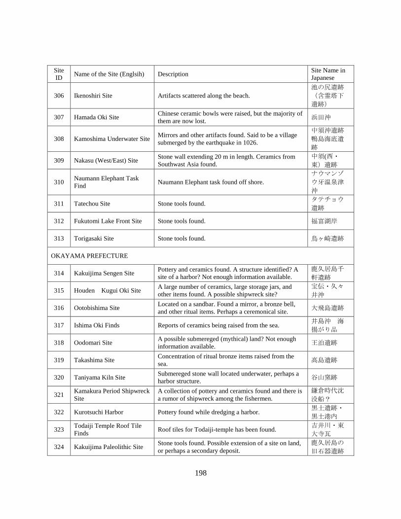
198
Site
ID Name of the Site (Englsih) Description
Site Name in
Japanese
306 Ikenoshiri Site Artifacts scattered along the beach.
池の尻遺跡
(含霊塔下
遺跡)
307 Hamada Oki Site Chinese ceramic bowls were raised, but the majority of
them are now lost. 浜田沖
308 Kamoshima Underwater Site Mirrors and other artifacts found. Said to be a village
submerged by the earthquake in 1026.
中須沖遺跡
鴨島海底遺
跡
309 Nakasu (West/East) Site Stone wall extending 20 m in length. Ceramics from
Southwast Asia found.
中須(西・
東)遺跡
310 Naumann Elephant Task
Find Naumann Elephant task found off shore.
ナウマンゾ
ウ牙温泉津
沖
311 Tatechou Site Stone tools found. タテチョウ
遺跡
312 Fukutomi Lake Front Site Stone tools found. 福富湖岸
313 Torigasaki Site Stone tools found. 鳥ヶ崎遺跡
OKAYAMA PREFECTURE
314 Kakuijima Sengen Site Pottery and ceramics found. A structure identified? A
site of a harbor? Not enough information available.
鹿久居島千
軒遺跡
315 Houden Kugui Oki Site A large number of ceramics, large storage jars, and
other items found. A possible shipwreck site?
宝伝・久々
井沖
316 Ootobishima Site Located on a sandbar. Found a mirror, a bronze bell,
and other ritual items. Perhaps a ceremonical site. 大飛島遺跡
317 Ishima Oki Finds Reports of ceramics being raised from the sea. 井島沖 海
揚がり品
318 Oodomari Site A possible submereged (mythical) land? Not enough
information available. 王泊遺跡
319 Takashima Site Concentration of ritual bronze items raised from the
sea. 高島遺跡
320 Taniyama Kiln Site Submereged stone wall located underwater, perhaps a
harbor structure. 谷山窯跡
321 Kamakura Period Shipwreck
Site
A collection of pottery and ceramics found and there is
a rumor of shipwreck among the fishermen.
鎌倉時代沈
没船?
322 Kurotsuchi Harbor Pottery found while dredging a harbor. 黒土遺跡・
黒土港内
323 Todaiji Temple Roof Tile
Finds Roof tiles for Todaiji-temple has been found.
吉井川・東
大寺瓦
324 Kakuijima Paleolithic Site Stone tools found. Possible extension of a site on land,
or perhaps a secondary deposit.
鹿久居島の
旧石器遺跡

199
Site
ID Name of the Site (Englsih) Description
Site Name in
Japanese
325 Shimoyamada Kajigahana
Site Excavated on shore. Several stone tools found.
下山田梶ヶ
鼻遺跡
HIROSHIMA PREFECTURE
326 Iroha-Maru Shipwreck Site Identified as Ryoma Sakamoto's Vessel. A vessel
purchased from U.K.
沈没船(19
世紀のイギ
リス船)埋
没地点遺跡
327 Tomonoura Harbor The town has preserved the maritime landscape of a
harbor area, using them as a historic site for vistors. 鞆の浦港
328 Mitarai Site Breakwater, lighthouse and other harbor structure
preserved. 御手洗
329 Kusado Sengen Machi Site
Located on river bottom. Excavation began in the
1960s. Extensive colletion of wood remains preserved;
called a Pompei of Japan.
草戸千軒町
遺跡
330 Sakishima Toho Underwater
Site
佐木島東方
海底遺跡
331 Shimomurohama Sie Stone tools found on a beach. 下室浜遺跡
332 Okiura Site Stone tools found on a beach. 沖浦遺跡
333 Tadanoumicho Oki Point Naumann Elephant bones found off shore. 忠海町沖
YAMAGUCHI PREFECTURE
334 Kuroshimahama Site Pottery found during a harbor renovation. 黒島浜遺跡
335 Minogahama Site Artifacts related to salt production found. 美濃ヶ浜遺
跡
336 Tokiwaike Site 常盤池遺跡
337 Shimoninai Oki Shipwreck
Site
A large collection of Hizen porcelain raised in the
1920s.
下荷内沖沈
没船(推定)
338 Hahirajima Oki Site Ceramics raised from the sea. 柱島沖
339 Kamono Site Inoue
Underwater Site Ceramics raised from the sea.
鴨野遺跡・
伊上海中遺
跡
340 Hamazaki Site Several submerged sites expected to be found due to
land subsidence.
尾国遺跡・
浜崎遺跡
341 Sea of Japan Naumann
Elephant Task Find Point Naumann Elephant task found off shore.
ナウマンゾ
ウ牙萩沖日
本海

200
Site
ID Name of the Site (Englsih) Description
Site Name in
Japanese
TOKUSHIMA PREFECTURE
342 Shouhou-Maru Shipwreck
Point
Japanese built Western wooden Warship lost during a
battle. Location has not been identified.
翔鳳丸沈没
地点(翔凰
丸)
343 Fukura Sengen Site Reports of stone monuments raised in the past.
Folklore of sunken village exist in the area.
福良千軒伝
承地
344 Okameiso Submerged Site Record of land swallowed by water during the Ansei
Earthquake (1855).
お亀磯 水
没村伝承
345 Konaruto Strait Underwater
Site Stone tools found scatered in a large area.
小鳴門海峡
海底遺跡
KAGAWA PREFECTURE
346 Mizunoko Iwa Site
A possible shipwreck without a hull remain. More than
200 ceramics excavated. One of the earliest excavated
site underwater. 水の子岩
347 Aji Oki Point Local ceramics raised from the sea. 庵治沖
348 Naoshima Oki Point Local ceramics raised from the sea. 直島沖
349 Naoshima Hayasaki Oki Site Imported ceramics found. Perhaps a shipwreck? 直島早崎沖
350 Houdoujiike Site Building (temple) foundation in a lake. 宝幢寺池
351 Nou Cape Oki Site A wide collection of artifactcs reported from the sea. 及生岬沖
352 Shodo Island Underwater
Site
Large stones for building Osaka castle wall has been
found underwater near the quarry site.
大坂城石垣
石丁場跡 (小
豆島周辺)
353 Clay Brick Shipwreck Site
A hull carrying bricks has been found. Believed to be a
relatively recent shipwreck, perhaps the Meiji or the
Taisho periods. There is a plan to use a site as an
underwater park.
レンガ積載
船
354 Enoura Oki Find Point A pile of large variey of Yayoi pottery found. 江之浦沖弥
生土器
EHIME PREFECTURE
355 Kumaguchi Minato Site Stone tools and pottry found along the beach. 熊口港遺跡
356 Nachi-gun Underwater Sites Not enough Info available, but there is a series of
underwater and beach front sites.
越智郡の水
中遺跡~吉
海町大突間
島遺跡、上
浦町萩ノ岡
Ⅱ遺跡等

201
Site
ID Name of the Site (Englsih) Description
Site Name in
Japanese
357 Minokoshi Ato Iseki Breakwater and harbor structures located underwater,
extends over 100 m off shore.
古波止遺跡
(みのこし
跡)
358 Shimodamizu Harbor
Pottery, stone tools, roof tiles, and various types of
artfacts found. A rumor of submerged stone wall in the
area.
下田水港遺
跡
359 Daimyoujingawa Oki Site Pottery found while dredging. 大明神川沖
遺跡
360 Oosuminohana Site
A fortress of Murakami Pirate. A large stock of
ceramics was once seen by a fisherman. Not enough
Information available. 大角鼻沖
361 Miyakubo Underwater Sites Believed to be a sronghold of Murakami Pirate.
Arifacts from sea are being reported occasionally.
宮窪周辺・
村上水軍関
連(?)海あが
り品
362 Ushima Site A submerged stone wall found off shore. 鵜島
363 Namikata Jomon Site A complete Jomon Pottery found. 波方縄文遺
跡
364 Karatsuzaki Oki Site An extensive collection of ceramics found. Fisherman
using octopus to collect complete jars.
唐津崎沖
(蛸釣陶
器)
365 Mizusaki Site Pottery found on shore and underwater. First
underwater excavation at the Prefecture in 1955. 水崎遺跡
366 Washigasu Underwater Site 鷲ヶ巣海底
遺跡
367 Tsugura Minato Site 津倉港遺跡
368 Michikajima Underwater
Site
見近島海底
遺跡
369 Amazaki Castle Wall Stone Walls and harbor structures. 甘崎城沖
(石垣)
370 Uoshima Minato Site Found a site while dredging a harbor. 魚島港
371 Otatebashima Oki Site A concentration of ceramcs raised from the sea. 大館場島沖
KOCHI PREFECTURE
372 Shimonokae Oki Site A diver found close to 2000 coins. A wood plank was
also found.
下ノ加江沖
遺跡
373 Tsumeshiro Beach Site Submerged harbor structure? Stone structures found.
Submerged due to the earthquake in 1707 or 1854?
爪白ビーチ
沖
374 Tojima Site A site extends from the beach to the sea floor. 戸島遺跡

202
Site
ID Name of the Site (Englsih) Description
Site Name in
Japanese
375 Hakuho Earthquake
Submerged Village
A number of submerged villages known from the
earthquake in 684.
白鳳地震水
没伝承
FUKUOKA PREFECTURE
376 Aishima Underwater Site
Close to 100 roof tiles found underwater. If a hull is
identified, it will be the oldest shipwreck in Japan.
Surveyed by KNM.
相島海底遺
跡
377 Eboshi Rock Shipwreck Site A fisherman has raised imported high-quality ceramics
from China.
中世交易船
推定遺跡
378 Medieval Shipwreck Site
A wooden hull was identified when salvaging a
modern wreck nearby. ARIUA conducted a survey but
was not able to identify the site. 中世交易船
379 Genkai Island Site
Several concentration of ceramics. Diving survey
conducted. At least two shipwrecks may be located
nearby.
玄界島 タ
ケノシタ遺
跡
380 Okagaki Beach Site A few hundered complete Hizen porcelain found on
shore.
三里松原海
岸 (岡垣
浜)
381 Ashiya Underwater Site A local diver found a concentration of Hizen porcelain.
No hull identified.
芦屋沖海底
遺跡
382 Imazu Underwater Site 今津海底遺
跡
383 Okitsushima Site Possible stone wall structure found between two
islands. Some ceramics found. 沖津島遺跡
384 Karadomari Site Bronze ceremonial artifacts collected. 唐泊遺跡
SAGA PREFECTURE
385 Nishi Karatsu Underwater
Site
A large collection of artifacts found during dredging.
Artifacts collected and analyzed. This is the earliest
underwater site discovered in the Prefecture.
西唐津海底
遺跡
386 Ikejiri Underwater Site Ceramics found. 池尻海底遺
跡
387 Akamatsu Beach Site A large collection of artifacts found along the beach. 赤松海岸遺
跡
388 Nanatsugama Underwater
Site
Two different types of sites may be present. An ancient
ritual/offering site, and the Early Modern Era
shipwreck. Part of Ceramic cargo found.
七ツ釜海底
遺跡
389 Mietsu Naval Base Site Industrial Heritage Site. Nation's first dry-dock from
the mid-19th century.
三重津海軍
所跡
390 Hato Cape Stone Anchors At least six anchor stocks identified.
波戸岬西岸
海底碇石集
積地

203
Site
ID Name of the Site (Englsih) Description
Site Name in
Japanese
NAGASAKI PREFECTURE
391 Okita Site Pottery found. 沖田遺跡
392 Okinoshima Site 沖ノ島遺跡
393 Senrigahama Site Korean ceramics and stone tools found. 千里ヶ浜遺
跡
394 Tanegota Site 種子田遺跡
395 Kawachi Harbor
The main port of Hirado Island before the current
Hirado harbor became the official harbor town.
Chinese, Korean, and the Dutch used this port.
川内港内遺
跡
396 Hirado Harbor
One of the trading ports before the Dejima became a
designated port. VOC and the English warehouse were
located
平戸港内遺
跡
397 Chosen Ido Site
Possible ancient submerged settlemement site
extending occupation for over thousands of years.
Trade ceramics from the continent has been found
close to the surface. A well said to have been used by
tributary mission to China located on land nearby.
朝鮮井戸海
岸
398 Ohama Site Site known since the Taisho period. Stone tools,
pottery, and human bones found. 大浜遺跡
399 Nish Kato Site Stone tools and Korean pottery found. 西加藤遺跡
400 Meotoishi Site Stone tools found. Important site for comparing early
stone tool types between Korea and Japan. 夫婦石遺跡
401 Toujin Shallows Legend of Chinese ships using the area in the past.
Collected imported ceramics.
唐人瀬
(未確認)
402 Kanjiga Castle Oki Site Located off the possible Wako's fort. Some ceramics
found?
勘次ヶ城跡
沖 (未確
認)
403 Douzaki Site Microlithic and Pottery found. 堂崎遺跡
404 Douzaki Site Pottery, sea shells, bones,and other artifacts found. 堂崎遺跡
405 Oitabe Cave Site Found inside a cave on an uninhabited small island. 大板部洞窟
406 Kouko Midden Site Pottery, sea shells, animal bones found. 江湖貝塚
407 Takashima Kozaki Site The Mongol Invasion wreck site. Two nearly intact
hull of Chinese vessel found and preserved in situ.
鷹島海底遺
跡(史跡鷹
島神崎遺跡
408 Maegata Bay Underwater
Site Chines stone anchors, imported ceramics found.
前方湾海底
遺跡
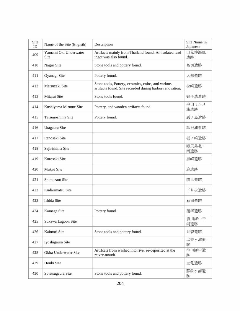
204
Site
ID Name of the Site (Englsih) Description
Site Name in
Japanese
409 Yamami Oki Underwater
Site
Artifacts mainly from Thailand found. An isolated lead
ingot was also found.
山見沖海底
遺跡
410 Nagiri Site Stone tools and pottery found. 名切遺跡
411 Oyanagi Site Pottery found. 大柳遺跡
412 Matsuzaki Site Stone tools, Pottery, ceramics, coins, and various
artifacts found. Site recorded during harbor renovation. 松崎遺跡
413 Mitarai Site Stone tools found. 御手洗遺跡
414 Kushiyama Mirume Site Pottery, and wooden artifacts found. 串山ミルメ
浦遺跡
415 Tatsunoshima Site Pottery found. 辰ノ島遺跡
416 Utagaura Site 歌が浦遺跡
417 Itanosaki Site 板ノ崎遺跡
418 Sejirishima Site 瀬尻島北・
南遺跡
419 Kurosaki Site 黒崎遺跡
420 Mukae Site 迎遺跡
421 Shimozato Site 関里遺跡
422 Kudarimatsu Site 下り松遺跡
423 Ishida Site 石田遺跡
424 Kamaga Site Pottery found. 蒲河遺跡
425 Sukawa Lagoon Site 須川海中干
潟遺跡
426 Kaimori Site Stone tools and pottery found. 貝森遺跡
427 Iyoshigaura Site 以善ヶ浦遺
跡
428 Okita Underwater Site Artifcats from washed into river re-deposited at the
reiver-mouth.
沖田海中遺
跡
429 Houki Site 宝亀遺跡
430 Sotetsugaura Site Stone tools and pottery found. 蘇鉄ヶ浦遺
跡

205
Site
ID Name of the Site (Englsih) Description
Site Name in
Japanese
431 Sukusahama Site 須草浜遺跡
432 Magaribana Site 曲り鼻遺跡
433 Ofunagura Site Industrial Heritage Site. Shipyard/dock built during the
Edo period.
大村藩お船
蔵跡
434 Mieshitamachi Site Stone tools and pottery are found along the beach. 三会下町遺
跡
435 Tawaragaura Ofunae Site Dockyard constructed during the Edo period.
高後崎藩所
の御船江・
跡 俵ヶ浦
御船江跡
436 Shobugawa Site 菖蒲川遺跡
437 Magari Underwater Site 曲海底遺跡
438 Mogi Harbor A large collection of Hizen and Karatsu ceramics
found. Preliminary investigation was made.
茂木港外遺
跡
439 Kitaura Beach Site 北浦海岸遺
跡
440 Hama Underwater Site 浜海中遺跡
441 Arikawa Harbor Pottery and stone tools found. 有川港海中
遺跡
KUMAMOTO PREFECTURE
442 Narukozaki Site Stone tools and ceramics found. 鳴子崎遺跡
443 Eboshi Mine Site Industrial Heritage Site. A coal mine under the sea.
Entance can be seen above water 烏帽子坑跡
444 Shiinokizaki Site Pottery and stone tools found. 椎ノ木崎遺
跡
445 Minami Furusato Site Pottery and ceramics found. 南古郷遺跡
446 Karuwajima Underwater
Site Concentration of pottery found inside a lagoon.
カルワ島海
底遺跡
447 Yanagi Midden Site Pottery and stone tools found. 柳貝塚遺跡
448 Hageshima Site Artifacts from mixed age found. Pottery, ceramics, roof
tiles, and other remains found. 禿島遺跡
449 Kushi Site Ceramics found. 串遺跡
450 Hiiden Sanbank Site Pottery, stone tools and bone tools were collected by
local residents.
ヒイデン洲
遺跡

206
Site
ID Name of the Site (Englsih) Description
Site Name in
Japanese
451 Hiroki Site Stone coffin burial found underwater. 広木遺跡
OITA PREFECTURE
452 Hisamitsujima A legend of a village submerged by a major
earthquake. 久光島
453 Uryujima Site An island submerged by a major earthquake. Exact
location of the site has not been identified. 瓜生島
MIYAZAKI PREFECTURE
No Data/Site
KAGOSHIMA PREFECTURE
454 Kurakizaki Underwater Site A large collection of Chinese ceramics found. Limited
excavation conducted, and KNM has surveyed the site.
倉木崎海底
遺跡
455 Bounotsu Kushiura Site Ceramics and possible wooden remains reported. Sonar
survey conducted
坊津町久志
浦
456 Bounotsu Machi Site Stone anchor stocks, ceramics, and various artifacts
identified. Located near the traditional harbor town. 坊津町
457 Fukiagehama Site More than 3,000 Hizen porcelain fragments found
along the beach. 吹上浜
458 Tomari Beach Site Ceramics found. 泊海岸(泊
浜)
459 Sekibune Rudder Some wooden remains, including a rudder post has
been found. Conserved and being displayed locally
大型関船・
舵身木
460 Minaminohama Harbor Hizen porcelain and other ceramic fragments found. 南之浜港湾
内
461 San Harbor Imported ceramics found. Japanese style anchor stones
has been located. 山港沖
462 Omonawa Harbor Iron grapnel anchors, and some ceramics found. Brief
survey conducted. 面縄港湾内
463 Ushijihama Oki Site Canadian shipwreck in 1890. ウシジ浜沖
海底遺跡
OKINAWA PREFECTURE
464 Kattura Midden Site Midden Site found at a river mouth. カトゥラ貝
塚
465 Ginama Underwater Site Benareth (U.K.) Shipwreck in 1872. 宜名真沖海
底遺跡
466 Emmons Shipwreck U.S. WWII Wreck. Now utilized as a diving Site. エモンズ
467 Ukibarujima Oki Site Unidentified Wreck. Glass and Ceramic collected by
local divers.
南浮原島沖
海底遺跡

207
Site
ID Name of the Site (Englsih) Description
Site Name in
Japanese
468 Indian Oak Shipwreck Site Indian Oak (U.K.) shipwreck in 1840.
インディア
ン・オーク
号の座礁地
469 Maja Underwater Site Unidentified Wreck. Hull fragments found by local
divers.
真謝沖海底
遺跡
470 Yabiji Underwater Site No.1 Providence (U.K.) shipwreck in 1879.
八重干瀬海
底遺跡群第
1地点
(英国船プ
ロビデンス
号)
471 Yoshino Beach Site A wreck of a U.K. vessel, carryinh Foundation Stones 吉野海岸沖
海底遺跡
472 Sekiseishoko Underwater
Site No.3
Ceramics were collected, and hull remains were found
by local divers.
石西礁湖海
底遺跡群第
3地点
473 Takada Beach Site (Van
Bosse)
Van Bosse (Dutch) shipwreck in 1857. Surveyed by
KNM and the site being monitored by a local dive
shop.
高田海岸沖
海底遺跡
474 Nagura Shitadaru Site Large quantity of ceramics found. 名蔵シタダ
ル遺跡
475 Yarabu Oki Underwater Site Anchors and ceramics found by local divers. 屋良部沖海
底遺跡
476 Nohojima Nishi Beach Site Ceramics found.
野甫島西海
岸遺物散布
地
477 Uchihana Beach Site Ceramics found. 内花海岸遺
物散布地
478 Moromi Beach Site Silver cash found. 諸見海岸遺
物散布地
479 Usa Beach Site Blocks of stone and ceramics found. 宇佐浜海岸
遺物散布地
480 Jyashiki Beach Site Blocks of stone and ceramics found. 謝敷海岸遺
物散布地
481 Toubaru Beach Site Pottery, ceramins, and other artifacts found. 桃原海岸遺
物散布地
482 Kijyoka Becah Site Stone tools found. 喜如嘉海岸
遺物散布地
483 Uehara Beach Site Ceramics found. 上原海岸遺
物散布地
484 Minnajima Underwater Site Ceramics found. 水納島沖海
底遺跡
485 Waji Beach Ceramic Site Ceramics found. 湧出海岸陶
磁器散布地
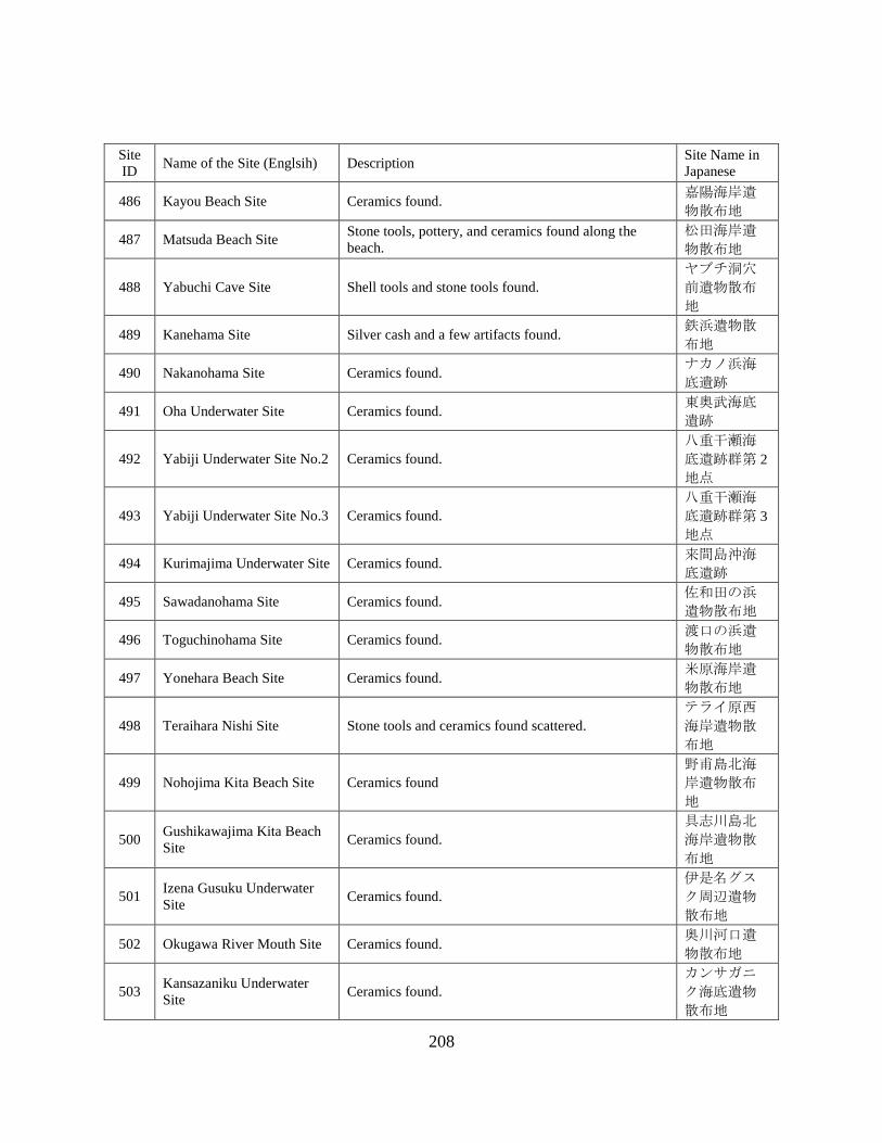
208
Site
ID Name of the Site (Englsih) Description
Site Name in
Japanese
486 Kayou Beach Site Ceramics found. 嘉陽海岸遺
物散布地
487 Matsuda Beach Site Stone tools, pottery, and ceramics found along the
beach.
松田海岸遺
物散布地
488 Yabuchi Cave Site Shell tools and stone tools found.
ヤブチ洞穴
前遺物散布
地
489 Kanehama Site Silver cash and a few artifacts found. 鉄浜遺物散
布地
490 Nakanohama Site Ceramics found. ナカノ浜海
底遺跡
491 Oha Underwater Site Ceramics found. 東奥武海底
遺跡
492 Yabiji Underwater Site No.2 Ceramics found.
八重干瀬海
底遺跡群第 2
地点
493 Yabiji Underwater Site No.3 Ceramics found.
八重干瀬海
底遺跡群第 3
地点
494 Kurimajima Underwater Site Ceramics found. 来間島沖海
底遺跡
495 Sawadanohama Site Ceramics found. 佐和田の浜
遺物散布地
496 Toguchinohama Site Ceramics found. 渡口の浜遺
物散布地
497 Yonehara Beach Site Ceramics found. 米原海岸遺
物散布地
498 Teraihara Nishi Site Stone tools and ceramics found scattered.
テライ原西
海岸遺物散
布地
499 Nohojima Kita Beach Site Ceramics found
野甫島北海
岸遺物散布
地
500 Gushikawajima Kita Beach
Site Ceramics found.
具志川島北
海岸遺物散
布地
501 Izena Gusuku Underwater
Site Ceramics found.
伊是名グス
ク周辺遺物
散布地
502 Okugawa River Mouth Site Ceramics found. 奥川河口遺
物散布地
503 Kansazaniku Underwater
Site Ceramics found.
カンサガニ
ク海底遺物
散布地

209
Site
ID Name of the Site (Englsih) Description
Site Name in
Japanese
504 Imadomari Beach
Underwater Site Ceramics found.
今泊海岸陶
磁器散布地
505 Sesojojima Underwater Ceramics found. 瀬底島沖海
底遺跡
506 Ara Beach Ancient Port Site Ceramics found.
アラ浜の古
港・遺物散
布地
507 Kohenzoko Harbor Scattered ceramics fragments found. 湖辺底港遺
物散布地
508 Jimun Beach Site Anchor Stones and ceramics found. ジムン海岸
遺物散布地
509 Mae Rivermouth Site Ceramics found. 前川河口遺
物散布地
510 Hija Rivermouth Site Some silver coins and ceramics found. 比謝川河口
遺物散布地
511 Miya Gusuku Harbor Ceramics found. 宮城港周辺
遺物散布地
512 Gushi River Gusuku Beach
Site Ceramics found.
具志川グス
ク海岸遺物
散布地
513 Naha Harbor Ceramics found. 那覇港
514 Tonakijima Historic Harbor Ceramics found.
渡名喜島の
古港・遺物
散布地
515 Agonoura Underwater Site Ceramics found. 阿護の浦海
底遺跡
516 Maja Harbor Ceramics found. 真謝港遺物
散布地
517 Ohara Stone Quarry Site 大原の石切
場跡
518 Kitahara Stone Qarry Site 北原の石切
場跡
519 Shirase Rivermouth Site Ceramics found. 白瀬川河口
遺物散布地
520 Onazaki Historic Harbor Ceramics found.
おな崎の古
港遺物散布
地
521 Yonaha Bay Site Ceramics found. 与那覇湾遺
物散布地
522 Nagatamanohama Site Ceramics found. 長山の浜遺
物散布地
523 Ara Beach Site Ceramics found. 安良海岸遺
物散布地
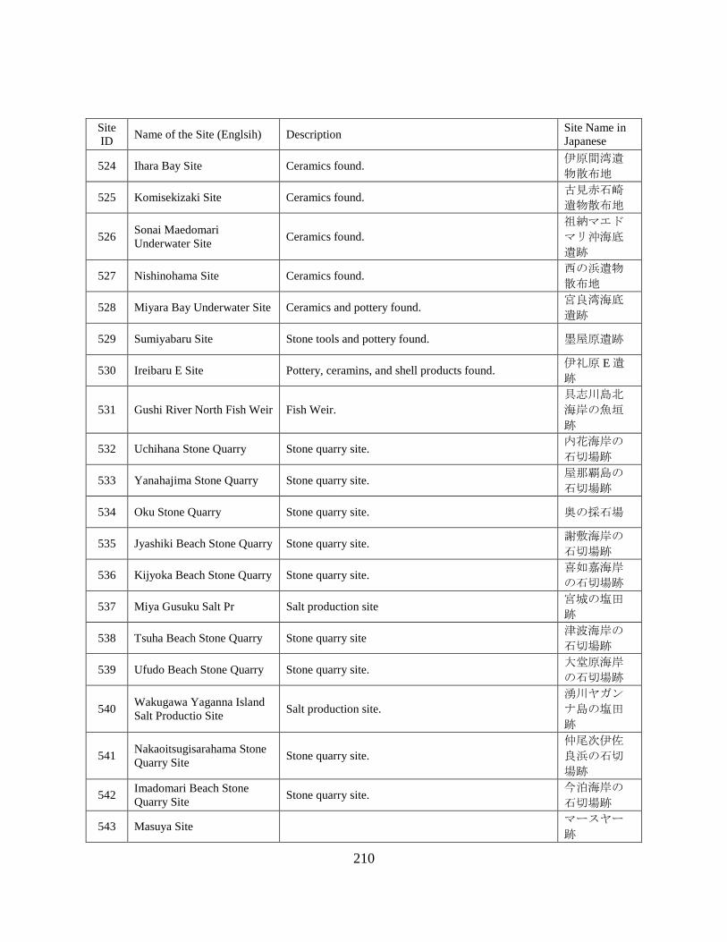
210
Site
ID Name of the Site (Englsih) Description
Site Name in
Japanese
524 Ihara Bay Site Ceramics found. 伊原間湾遺
物散布地
525 Komisekizaki Site Ceramics found. 古見赤石崎
遺物散布地
526 Sonai Maedomari
Underwater Site Ceramics found.
祖納マエド
マリ沖海底
遺跡
527 Nishinohama Site Ceramics found. 西の浜遺物
散布地
528 Miyara Bay Underwater Site Ceramics and pottery found. 宮良湾海底
遺跡
529 Sumiyabaru Site Stone tools and pottery found. 墨屋原遺跡
530 Ireibaru E Site Pottery, ceramins, and shell products found. 伊礼原 E 遺
跡
531 Gushi River North Fish Weir Fish Weir.
具志川島北
海岸の魚垣
跡
532 Uchihana Stone Quarry Stone quarry site. 内花海岸の
石切場跡
533 Yanahajima Stone Quarry Stone quarry site. 屋那覇島の
石切場跡
534 Oku Stone Quarry Stone quarry site. 奥の採石場
535 Jyashiki Beach Stone Quarry Stone quarry site. 謝敷海岸の
石切場跡
536 Kijyoka Beach Stone Quarry Stone quarry site. 喜如嘉海岸
の石切場跡
537 Miya Gusuku Salt Pr Salt production site 宮城の塩田
跡
538 Tsuha Beach Stone Quarry Stone quarry site 津波海岸の
石切場跡
539 Ufudo Beach Stone Quarry Stone quarry site. 大堂原海岸
の石切場跡
540 Wakugawa Yaganna Island
Salt Productio Site Salt production site.
湧川ヤガン
ナ島の塩田
跡
541 Nakaoitsugisarahama Stone
Quarry Site Stone quarry site.
仲尾次伊佐
良浜の石切
場跡
542 Imadomari Beach Stone
Quarry Site Stone quarry site.
今泊海岸の
石切場跡
543 Masuya Site マースヤー
跡

211
Site
ID Name of the Site (Englsih) Description
Site Name in
Japanese
544 Sesoko Island Stone Quarry
Site Stone quarry site.
瀬底島トラ
バーチンの
石切場跡
545 Minnnajima Stone Quarry
Site Stone quarry site.
水納島南海
岸の石切場
跡
546 Serakaki Stone Quarry Site Stone quarry site. 瀬良垣の石
切場跡
547 Toubukuro River Stone
Quarry Site Stone quarry site.
当袋川河口
の石切場跡
548 Tobukurogawa Site Ceramics found. 当袋川河口
遺物散布地
549 Minami Onna Stone Quarry
Site Stone quarry site.
南恩納の石
切場跡
550 Maeda Stone Quarry Site Stone quarry site. 真栄田の石
切場跡
551 Zanpa Stone Quarry Site Stone quarry site. 残波の石切
場跡
552 Toya Stone Quarry Site Stone quarry site. 都屋の石切
場跡
553 Sobe Stone Quarry Site Stone quarry site. 楚辺の石切
場跡
554 Naha Port Site Ceramics found. 那覇港
555 Obujima Stone Quarry Site Stone quarry site.
奥武島南海
岸の石切場
跡
556 Yuhi River Stone Quarry Stone quarry site. 雄樋川河口
の石切場跡
557 Anzera Beach Fish Weir Fish Weir. アンゼーラ
浜の魚垣跡
558 Funakoshibaru Stone Quarry Stone quarry site. 船越原の石
切場跡
559 Kume Island Shimajiri Fish
Weir Fish Weir.
久米島島尻
の魚垣跡
560 Hiyajyo Fish Weir Fish Weir. 比屋定の魚
垣跡
561 Ikema Island FIsh Weir Fish Weir. 池間島の魚
垣跡
562 Karimata Fish Weir Fish Weir. 狩俣の魚垣
跡
563 MIyakoshimajiri Fish Weir Fish Weir. 宮古島尻の
魚垣跡

212
Site
ID Name of the Site (Englsih) Description
Site Name in
Japanese
564 Oura Bay Fish Weir Stone quarry site. 大浦湾の石
切場跡
565 Takano Beach Stone Quarry
Site Stone quarry site.
高野海岸の
石切場跡
566 Yonaha Fish Weir Fish Weir. 与那覇の魚
垣跡
567 Hora Maiba Stone Quarry
Site Stone quarry site.
保良マイバ
の石切場跡
568 Shimoji Island Fish Weir Fish Weir. 下地島の魚
垣跡
569 Kuninaka Fish Weir Fish Weir. 国仲の魚垣
跡
570 Tamaorizaki Fish Weir Fish Weir. 玉取崎の魚
垣跡
571 Sukoji Beach Fish Weir Fish Weir. 底地海岸の
魚垣跡
572 Miyara Bay Ohama Fish
Weir Fish Weir.
宮良湾大浜
の魚垣跡
573 Akayazaki Fish Weir Fish Weir. アカヤ崎の
魚垣跡
574 Hosozaki Fish Weir Fish Weir. 細崎の魚垣
跡
575 Birumazaki Fish Weir Fish Weir. ビルマ崎の
魚垣跡
576 Nishimijidanu Fish Weir Fish Weir.
ニシミジダ
ーヌの魚垣
跡
577 Funaurasura Site 船浦スラ所
跡
578 Hatopanari Nakase Fish
Weir Fish Weir.
ハトパナリ
のナカセの
魚垣跡
579 Ikashi Fish Weir Fish Weir. ナカシの魚
垣跡
580 Indazaki West Fish Weir Fish Weir. インダ崎西
の魚垣跡
581 Indazaki East Fish Weir Fish Weir. インダ崎東
の魚垣跡
582 Tomada Fish Weir Fish Weir. トマダの魚
垣跡
583 Omijya River Fish Weir Fish Weir.
大見謝川河
口付近の魚
垣跡

213
Site
ID Name of the Site (Englsih) Description
Site Name in
Japanese
584 Yutsun River Fish Weir Fish Weir.
ユツン川河
口付近の魚
垣跡
585 onera River Fish Weir Fish Weir.
ホネラ川河
口付近の魚
垣跡
586 Noharazaki West Fish Weir Fish Weir. 野原崎西の
魚垣跡
587 Nusuku Fish Weir Fish Weir. ヌスクの魚
垣跡
588 Komi Akaishizaki Fish Weir Fish Weir. 古見赤石崎
の魚垣跡
589 Komi Akaishizaki Sura Site Fish Weir. 古見赤石崎
スラ所跡
590 Mairagawa Fish Weir Fish Weir.
前良川河口
付近の魚垣
跡
591 Toira Fish Weir Fish Weir. トイラの魚
垣跡
592 Nakama River Fish Weir Fish Weir. 仲間川河口
の魚垣跡
593 Ishabuza Fish Weir Fish Weir. イシャブザ
の魚垣跡
594 Hateruma Stone Quarry Stone Quarry Site.
波照間島北
海岸の石切
場跡
Status, Type, Location, Age (Time Period) and Reference
Site
ID Name of the Site Status Type Location Age Reference
HOKKAIDO
1 Kaiyo-Maru Wreck Site Ex Sh SS EE Site Report 1
2 Abashiri Lake Bottom Site Ex Sc L JO ARIUA 2013
3 Kaminokuni Haror Site Ex PS SS EM Site Report 2
4 Kanrin-Maru Wreck Site Un Sh S EE ARIUA 2013

214
Site
ID Name of the Site Status Type Location Age Reference
5 Matsumae Town Beach Collection Co Sc I EM ARIUA 2013
6 Mori Pier Site Ex Ha NA ME ARIUA 2013
7 Choyo Maru Wreck Site Bu Sh I ME ARIUA 2013
8 Asari Hama Granite Rocks Co Sc I UK ARIUA 2013
9 Nozuke Site and Banya Site Su Su I EM Website 1
10 Yanagisaki No.3 Site Su Sc R JO Website 2
11 Kitamae Sen Wreck Site Un Sh SS EM Heritage List
12 Onuma Lake Bottom Site Kn Su L JO Heritage List
13 Numanohashi Logboat Ex IF L AI Hokkaido Site Map
14 Kashiwara Logboat Ex IF L AI Hokkaido Site Map
15 Kyu-Abira River Logboat Ex IF L AI Hokkaido Site Map
16 Shibunotunai Lake Bottom East
Site Ex Su L JO Hokkaido Site Map
17 Shibunotunai Lake Bottom West
Site Ex Su L AI Hokkaido Site Map
18 Tommap River Site Ex Su L UK Site Database 73294
19 Ukimido Site Ex Su L JO Site Database 76642
20 Akke Lake Logboat Ex IF L AI Hokkaido Site Map
21 Kotan Beach Site Su Su I UK Site Database 74008
22 Touro Lake Bottom Site Su Su L UK Site Database 75465
23 Komuke Lake Front Site Ex Su L JO JACA 2017b
24 Kushiro Paleolithic Find Co IF D PL JPRA 2010
AOMORI PREFECTURE
25 Wakinosawa Oki Find Co PS S ED ARIUA 2013
26 Tosaminato Site Ex Ha S MA-
EM JACA 2017b

215
Site
ID Name of the Site Status Type Location Age Reference
27 Jomon Swamp Site Ex Su P JO-Ya Site Database 319290
28 Ashino Lake Bottom Site Ex Sc L JO Site Database 318685
29 Kodomari Oki Site Co IF D PL Site Database 78178
30 Chogo Oki Site Co IF D PL Site Database 42649
31 Ashino Tanabatano Site Ex Su P JO JPK 1
32 Sunazawa Site Ex Su P JO JPK 1
IWATE PREFECTURE
33 Boshin War Naval Battle Site Kn Sh S ME ARIUA 2013
34 Tosen-Jyo Site Ex Ha R MA ARIUA 2013
35 Goro Swamp Site Ex Sc P He ARIUA 2013
MIYAGI PREFECTURE
36 Bagyu Swamp Site Su Su P Na-
EM Site Database 478705
37 Kasashima River Site Ex Sc R JO Site Database 241210
AKITA PREFECTURE
No Data/Site
YANAGATA PREFECTURE
38 Tobishima Oki Site Co PS S EM ARIUA 2013
39 Kuromori Site Ex Su R JO-He Yamagata Site Map
FUKUSHIMA PREFECTURE
40 Lake Hibara Submerged Village
Site Kn Su L M JACA 2017b
41 Mt.Azuma Hakuho Temple Site Su Su L UK Site Database 400032
42 Hibara Shukuba Site Kn Su L M Site Database 400038
43 Sanjo Gata Lake Bottom Site Su Sc L JO-PH Site Database 94134

216
Site
ID Name of the Site Status Type Location Age Reference
44 Iriehama Lake Bottom Site Su Sc L
JO,
MA-
EM
Site Database 399331
45 Matsubashihama Lake Bottom Site Su Sc L JO Site Database 399333
46 Ushinumakawa Lake Bottom Site Su Sc L UK Site Database 94140
47 Ainame Oki Lake Bottom Site Su Sc L JO Site Database 398998
48 Kanisawahama Lake Bottom Site Su Sc L JO-Ya Site Database 94137
49 Nagahama Lake Bottom Site Su Sc L JO-PH Site Database 94138
50 Okido Kiln Site Ex Su L As-Na JACA 2017b
IBARAKI PREFECTURE
51 Sharihama Beach Site Un PS SS UK ARIUA 2013
52 Kitaura Oki Site Un Sh S EE ARIUA 2013
53 KaidoChifune jizo Site Un Sh S Ed ARIUA 2013
TOCHIGI PREFECTURE
54 Nasusosui Site Su HS NA M Diver Magazine
GUNMA PREFECTURE
55 Shimonyunakayama Site Ex Su P JO, Ko JACA 2017b
56 Minumaookami Site Co IF P UK JACA 2017b
SAITAMA PREFECTURE
No Data/Site
CHIBA PREFECTURE
57 Tateyama Okinoshima Site Ex Su I JO JACA 2017b
58 Okitsu Beach Site Co PS I JO-M Site Report 3
59 Hermann Shipwreck Site Su Sh S EE Inoue 2015
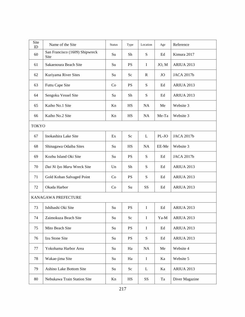
217
Site
ID Name of the Site Status Type Location Age Reference
60 San Francisco (1609) Shipwreck
Site Su Sh S Ed Kimura 2017
61 Sakaenoura Beach Site Su PS I JO, M ARIUA 2013
62 Kuriyama River Sites Su Sc R JO JACA 2017b
63 Futtu Cape Site Co PS S Ed ARIUA 2013
64 Sengoku Vessel Site Sa Sh S Ed ARIUA 2013
65 Kaiho No.1 Site Kn HS NA Me Website 3
66 Kaiho No.2 Site Kn HS NA Me-Ta Website 3
TOKYO
67 Inokashira Lake Site Ex Sc L PL-JO JACA 2017b
68 Shinagawa Odaiba Sites Su HS NA EE-Me Website 3
69 Kozhu Island Oki Site Su PS S Ed JACA 2017b
70 Dai Ni Iyo Maru Wreck Site Un Sh S Ed ARIUA 2013
71 Gold Koban Salvaged Point Co PS S Ed ARIUA 2013
72 Okada Harbor Co Su SS Ed ARIUA 2013
KANAGAWA PREFECTURE
73 Ishibashi Oki Site Su PS I Ed ARIUA 2013
74 Zaimokuza Beach Site Su Sc I Ya-M ARIUA 2013
75 Mito Beach Site Su PS I Ed ARIUA 2013
76 Izu Stone Site Su PS S Ed ARIUA 2013
77 Yokohama Harbor Area Su Ha NA Me Website 4
78 Wakae-jima Site Su Ha I Ka Website 5
79 Ashino Lake Bottom Site Su Sc L Ka ARIUA 2013
80 Nebukawa Train Station Site Kn HS SS Ta Diver Magazine

218
Site
ID Name of the Site Status Type Location Age Reference
81 Kaiho No.3 Site Kn HS NA Me Website 3
82 Haya-Maru Wreck Site Un Sh S Me ARIUA 2013
83 USS Oneida Wreck Site Un Sh S Me ARIUA 2013
NIIGATA PREFECTURE
84 Izumozaki Oki Taraba Site Co PS S
Ya,
MA-
EM
ARIUA 2013
85 Kakudahama Oki Site Co Sc S MA-
EM ARIUA 2013
86 Arahama Oki Site Su Sc S Na Niigata Site Map
87 Shiiya Oki Site Su Sc S UK Niigata Site Map
88 Nadatchi Underwater Site Co PS S Ka-Mu JPK 1
89 Shironohana Site Ex Su L Ya Site Database 62518
90 Torisaki Site Ex Su L Ya-Ko Site Database 62524
TOYAMA PREFECTURE
91 Himihama Ex Sc SS As-Na ARIUA 2013
92 Yokata Oki Site Su Su S Ed Website 6
93 Karashima Site Su Su I MA Toyama Site Map
94 Abugashima Site Su Su I JO Toyama Site Map
95 Uozu Submerged Ancient Forrest Su Su S JO Website 7
ISHIKAWA PREFECTURE
96 Wajima Oki Shipwreck Site Co PS D He,
Mu-Ed ARIUA 2013
97 Shibayama Lagoon Midden Site Ex Mi L JO Site Database 66873
98 Shibayama Midden Site Ex Mi L Ya Site Database 66876
99 Suzu Oki Site Su PS S UK ARIUA 2013

219
Site
ID Name of the Site Status Type Location Age Reference
100 Fukuura Harbor Su Sc S EM ARIUA 2013
101 Ansei Gold Koban Salvaged Point Co PS SS Ed JACA 2017b
102 Unknown Shipwreck Site Kn PS S UK ARIUA 2013
FUKUI PREFECTURE
103 Yashirohama Site Co IF SS MA ARIUA 2013
104 Gentatsuse Site Co PS S MA-
EM ARIUA 2013
105 Mikuni Harbor Groynes Su HS NA Me Heritage List
106 Kitahori Midden Site Ex Mi I JO Site Database 68295
YAMANASHI PREFECTURE
107 Yamanaka Lake Bottom Site Su Su L PH-
MA ARIUA 2013
108 Motosu Lake Bottom Site Su Sc L JO-Ko Diver Magazine
NAGANO PREFECTURE
109 Sone Lake Bottom Site Su Su L PL-JO Mikami 2016
110 Nojiri Lake Bottom Site Su Su L PL JPK 2
111 Nojiri Lake Sugikubo Site Su Sc L PL JPK 2
112 Nojiri Lake Tachigahana Site Su Su L PL JPK 2
113 Oike Minami Site Su Su L JO JACA 2017b
114 Ebisumahara Site Su Sc L JO JACA 2017b
115 Kawanishikita Site Su Sc L JO JACA 2017b
116 Kumanba Site Ex Sc L JO JACA 2017b
117 Shirahama I Site Ex Sc L JO JACA 2017b
118 Shirahama II Site Ex Sc L JO JACA 2017b
119 Shirahama III Site Ex Sc L JO JACA 2017b
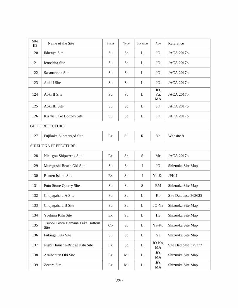
220
Site
ID Name of the Site Status Type Location Age Reference
120 Ikkenya Site Su Sc L JO JACA 2017b
121 Ienoshita Site Su Sc L JO JACA 2017b
122 Sasanannba Site Su Sc L JO JACA 2017b
123 Aoki I Site Su Sc L JO JACA 2017b
124 Aoki II Site Su Sc L
JO,
Ya,
MA
JACA 2017b
125 Aoki III Site Su Sc L JO JACA 2017b
126 Kizaki Lake Bottom Site Su Sc L JO JACA 2017b
GIFU PREFECTURE
127 Fujikake Submerged Site Ex Su R Ya Website 8
SHIZUOKA PREFECTURE
128 Niel-gou Shipwreck Site Ex Sh S Me JACA 2017b
129 Muragushi Beach Oki Site Su Sc I JO Shizuoka Site Map
130 Benten Island Site Ex Su I Ya-Ko JPK 1
131 Futo Stone Quarry Site Su Sc S EM Shizuoka Site Map
132 Chojagahara A Site Su Su L Ko Site Database 363625
133 Chojagahara B Site Su Su L JO-Ya Shizuoka Site Map
134 Yoshina Kiln Site Ex Su L He Shizuoka Site Map
135 Tsuboi Town Hamana Lake Bottom
Site Co Sc L Ya-Ko Shizuoka Site Map
136 Fukiage Kita Site Su Sc L Ya Shizuoka Site Map
137 Nishi Hamana-Bridge Kita Site Ex Sc L JO-Ko,
MA Site Database 375377
138 Araibenten Oki Site Ex Mi L JO,
MA Shizuoka Site Map
139 Zezera Site Ex Mi L JO,
MA Shizuoka Site Map

221
Site
ID Name of the Site Status Type Location Age Reference
140 Sutemo Site Ex Mi L JO,
MA Shizuoka Site Map
141 Hatsushima Shipwreck Site Su Sh S Ed ARIUA 2013
142 Doutaka Site Ex Su I JO-Ko Site Database 42464
143 Higashitometa Underwater Site Ex Su S JO Site Database 42702
144 Nagisaen Site Su Sc L JO Site Database 375153
145 Ougonzaki Park Beach Site Su Sc I EM-M Shizuoka Site Map
146 Mera Koura Beach Site Co PS I EM-M Shizuoka Site Map
147 Frigate Diana Shipwreck Site Un Sh S Me Shizuoka Site Map
148 Atami Oki Site Co Sc S UK Shizuoka Site Map
149 Sakume Submereged Site Un Su L Ka ARIUA 2013
150 Futo Stone Wreck Site Un PS S UK Shizuoka Site Map
AICHI PREFECTURE
151 Yasaku River Site Su Su R JO,
MA Diver Magazine
152 Stone Quarry Site Su Pr S Ed Ono et al. 2016
153 Ishigaki Mooring Stones Kn Ha SS EM-M Ono et al. 2016
154 Narumi Underwater Site Co IF S PH Site Database 244032
155 Hazu Cape Underwater Site Su Sc S JO Site Database 49188
156 Yamazaki Site Su Su S Ko-
MA JACA 2017b
157 Ikeshita Site Su Sc S Ya, Ko JACA 2017b
158 Kurotani A Site Su Sc S JO JACA 2017b
MIE PREFECTURE
159 Taino Island Site Co IF S UK ARIUA 2013
160 Jiro-Rokuro Site Co Sc I PL JPRA 2010

222
Site
ID Name of the Site Status Type Location Age Reference
161 Komidoumae Site Co Sc I PL JPRA 2010
SHIGA PREFECTURE
162 Osaki Site Co Sc I PL JPRA 2010
163 Yogo Lake Bottom Site Su Su L JO Lake Biwa Report
164 Shiozu Harbor Su Ha L Mu Lake Biwa Report
165 Katayama Lake Bottom Site Su Sc L Ko Lake Biwa Report
166 Mukoyama Site Su Su L MA-
EM Lake Biwa Report
167 Teragaura Site Su Su L UK Lake Biwa Report
168 Tsuzuraosaki Lake Bottom Site Su Sc L JO-He Lake Biwa Report
169 Morokawa A Lake Bottom Site Su Sc L JO Lake Biwa Report
170 Asozu Sengen Site Su Su L MA-
EM JACA 2017b
171 Kido Site Su Ha L EM Lake Biwa Report
172 Ogamihama Site Ex Sc L JO-He Lake Biwa Report
173 Ogami Casle Site Su HS L MA Lake Biwa Report
174 Yogo Rivr Mouth Site Su Sc L JO-He Lake Biwa Report
175 Ogami Site Ex Sc L Ya-He Lake Biwa Report
176 Imanishi Lake Front Site Ex Sc L JO-He Lake Biwa Report
177 Enshoji Lake Bottom Site Ex Sc L JO-He Lake Biwa Report
178 Hayasaki Site Ex Su L JO-Ya Lake Biwa Report
179 Chikubu Island Site Su Su L PH-
MA Lake Biwa Report
180 Sagami Lake Bottom Site Ex Su L Ya-
MA Lake Biwa Report
181 Nishihama Sengen Site Ex Su L MA-
EM Lake Biwa Report
182 Nagahama Castle Site Ex HS L EM Diver Magazine

223
Site
ID Name of the Site Status Type Location Age Reference
183 Toyo Park Beach Site Ex Su L Ya,
EM Lake Biwa Report
184 Hirakata Beach Site Su Sc L Na-He Lake Biwa Report
185 Shimosaka Oki Site Su Sc L UK Lake Biwa Report
186 Shimosakahama Site Su Su L Ya-Ko Lake Biwa Report
187 Tsutsikawa Lake Bottom Site Su Sc L JO-Ka Lake Biwa Report
188 Asatsumaminato Site Su Sc L Na-He Lake Biwa Report
189 Asatsuma Lake Bottom Site Su Sc L UK Lake Biwa Report
190 Chikuma Lake Front Site Su Sc L Ko-
MA Lake Biwa Report
191 Agatsumamikuriya Site Su Su L Na-He Lake Biwa Report
192 Irie Beach Front Site Su Sc L Ya-
MA Lake Biwa Report
193 Naoe Sengen Site Ex Su L Ko-
MA Lake Biwa Report
194 Iso Lake Bottom Site Ex Su L JO Lake Biwa Report
195 Iso Lake Front Site Su Sc L Ya-Ko,
Mu Lake Biwa Report
196 Irienai Site Su Su L JO-He Lake Biwa Report
197 Irienai Nishino Site Su Su L Ya-Ko Lake Biwa Report
198 Yaguragawa Site Su Sc L JO-He Lake Biwa Report
199 Isozaki Site Su Sc L Ko Lake Biwa Report
200 Matsubara Oki Site Su Sc L JO Lake Biwa Report
201 Matsubaranai Lake Ajiroguchi Site Su Sc L Ko-He Lake Biwa Report
202 Matsubaranai Lake Koya Site Su Sc L Ko-He Lake Biwa Report
203 Matsubaranai Lake Kuchi Site Su Sc L JO-
MA Lake Biwa Report
204 Takeshima Site Ex Sc L Ya-Ed Lake Biwa Report
205 Sonenuma Site Su Su L He Lake Biwa Report

224
Site
ID Name of the Site Status Type Location Age Reference
206 Kurimidezaike Site Su Sc L UK Lake Biwa Report
207 Dainakanoko Higashi Site Su Sc L JO Lake Biwa Report
208 Jyoutou A Site Su Sc L JO-Ya Lake Biwa Report
209 Jyoutou B Site Su Sc L JO-Ya Lake Biwa Report
210 Shishibana B Site Su Su L JO-Ya Lake Biwa Report
211 Ryugasaki A Site Ex Su L JO Lake Biwa Report
212 Bentenjima Site Ex Su L JO Lake Biwa Report
213 Dainaka Minami Lake Site Ex Su L JO-He,
Mu Lake Biwa Report
214 Ashkari Site Su Sc L JO-Ya Lake Biwa Report
215 Kawanishi Site Su Su L Ya-He Lake Biwa Report
216 Shiraou Site Su Sc L Ya Lake Biwa Report
217 Kiritooshi Site Su Sc L JO Lake Biwa Report
218 Okishimaakabana Site Co IF L Na Lake Biwa Report
219 Okishimaakabana Lake Bottom Site Su Sc L JO-Ya Lake Biwa Report
220 Okishima Lake Bottom Site Su Sc L JO-Ya Lake Biwa Report
221 Miyagahama Lake Bottom Site Su Sc L PL Lake Biwa Report
222 Chomeiji Lake Bottom Site Ex Sc L Jo-Ya Lake Biwa Report
223 Oofusa Lake Front Site Ex Sc L JO-Ya Lake Biwa Report
224 Maki Lake Front Site Ex Sc L JO-Ya Lake Biwa Report
225 Suikei B Site Su Sc L JO Lake Biwa Report
226 Suikei C Site Su Sc L JO-Na Lake Biwa Report
227 Shinbatake Lake Bottom Site Ex Sc L Ya Lake Biwa Report
228 Sahae Lake Bottom Site Ex Sc L Ya-Ko Lake Biwa Report

225
Site
ID Name of the Site Status Type Location Age Reference
229 Hino Rivr Mouth Site Su Sc L UK Lake Biwa Report
230 Nodanuma Site Ex Su L JO-Ko Lake Biwa Report
231 Kihama Lake Bottom Site Co IF L Mu Lake Biwa Report
232 Akanoi Bay Site Ex Su L JO-Ko Lake Biwa Report
233 Akanoihama Site Su Su L JO-Ya Lake Biwa Report
234 Ozuhama Site Ex Su L Ya-Ko Lake Biwa Report
235 Karasumazaki Site Ex Su L JO-He Lake Biwa Report
236 Tsudae Lake Bottom Site Ex Sc L JO-Ko Lake Biwa Report
237 Tsudae Iseki Su Sc L JO-Ya Lake Biwa Report
238 Shina Lake Bottom Site Ex Su L JO-Ko Lake Biwa Report
239 Shichijoura Site Ex Sc L Ya Lake Biwa Report
240 Kitayamada Lake Bottom Site Ex Sc L JO-Ed Lake Biwa Report
241 Kitagaya Site Ex Sc L JO-Ka Lake Biwa Report
242 Yabase Lake Bottom Site Ex Sc L JO Lake Biwa Report
243 Yabase Harbor Ex Ha L Ed Lake Biwa Report
244 Ooe Lake Bottom Site Ex Sc L JO-
MA Lake Biwa Report
245 Awazu-midden Site Ex Mi L JO, Ko Lake Biwa Report
246 Karahashi Site Ex Sc L Ya Lake Biwa Report
247 Hotarudani Site Ex Mi L JO,
MA Lake Biwa Report
248 Ishiyama Site Ex Mi L JO Lake Biwa Report
249 Seta River Bottom Site Ex Sc L PL Lake Biwa Report
250 Zeze Lake Bottom Site Su Sc L Ya Lake Biwa Report
251 Zeze Castle Site Kn HS L Ed Lake Biwa Report

226
Site
ID Name of the Site Status Type Location Age Reference
252 Ootsu Castle Site Kn HS L AM Lake Biwa Report
253 Karasaki Site Ex Sc L Ya Lake Biwa Report
254 Sakamoto Castle Site Ex HS L MA-
EM Lake Biwa Report
255 Imakatata Site Su HS L EM Lake Biwa Report
256 Kita Komatsu Lake Front Site Su Sc L He Lake Biwa Report
257 Shiragami Daimyojin Site Su Su L UK Lake Biwa Report
258 Oomizo Lake Bottom Site Ex Sc L UK Lake Biwa Report
259 Haginohama Minami Site Su Sc L Na-He Lake Biwa Report
260 Haginohama Kita Site Su Sc L MA-
EM Lake Biwa Report
261 Nagatahama Site Su Sc L Na-He Lake Biwa Report
262 Mitsuya Sengen Historic Site Kn Su L EM Lake Biwa Report
263 Mitsuya Sengen Site Ex Su L MA Lake Biwa Report
264 Shirahama Site Su Sc L Ko-
MA Lake Biwa Report
265 Fujie Sengen Site Kn Su L UK Lake Biwa Report
266 Genjihama Site Su Sc L UK Lake Biwa Report
267 Sotogahama Site Ex Sc L UK Lake Biwa Report
268 Fukamizohama Site Ex Sc L Na-He Lake Biwa Report
269 Fukamizo Site Ex Su L UL Lake Biwa Report
270 Hariehama Site Ex Su L JO-Ya Lake Biwa Report
271 Morihama Site Ex Su L Ya-Ko Lake Biwa Report
272 Kizu Site Su Su L UK Lake Biwa Report
273 Hamawakehama Site Su Su L Ed Lake Biwa Report
274 Nishihama Site Ex Su L MA-
EM Site Report 6

227
Site
ID Name of the Site Status Type Location Age Reference
275 Taishi Site Su Sc R Ya JACA 2017b
276 Yamanoshita Site Su Sc L Ya JACA 2017b
277 Yotsugi Site Su Su L JO-Ka JACA 2017b
278 Kitafunemachi Site Su Sc L UK JACA 2017b
KYOTO PREFECTURE
279 Hakoishihama Site Ex Su I JO-Ya Kyoto Site Map
280 Urashima Shallows Co PS D Ya ARIUA 2013
OSAKA PREFECTURE
281 Kitoragawa Site Ex Su I PL-
EM Site Database 345320
282 Daiho Site Ex Su R Na-
MA Site Database 106117
283 Misakimachi Oki Site Co PS D
PL,
MA-
EM
Mori 1979
HYOGO PREFECTURE
284 Kitancho Oki Shipwreck Site Su PS S PH-
MA ARIUA 2013
285 Uozuminotomari Site Su Ha R Na-
MA ARIUA 2013
286 Murotsu Harbor Ex Ha NA EM ARIUA 2013
287 Wasen Mooring Point Su Ha SS Ed ARIUA 2013
288 Harimamachi Oki Site Co PS S Ya JACA 2017b
289 Awaji Island East Beach Shipwreck Co PS S MA-
EM JACA 2017b
290 Akashi Matsue Oki Shipwreck Co PS S Ka JACA 2017b
NARA PREFECTURE
No Data/Site

228
Site
ID Name of the Site Status Type Location Age Reference
WAKAYAMA PREFECTURE
291 Wakayama Okinoshima
Underwater Site Co PS D EM-M Site Report 4
292 Ertugrul Shipwreck Site Ex Sh SS M Lledo and Pulak 2008
293 Nachi Katsuura Ha Kn Ha SS UK JACA 2017b
294 Kinokawa Bronze Bell Find Co IF R Ya Wakayama Site Map
295 Arimoto Bronze Bell Find Co IF R Ya Wakayama Site Map
TOTTORI PREFECTURE
296 Nishinada Site Co Sc I JO ARIUA 2013
297 Kitanada Site Co Sc I JO ARIUA 2013
298 Koyamaike Lake Bottom Site Ex Su L JO-Ko Tottori Site Map
SHIMANE PREFECTURE
299 Yunotsu Harbor (Okidomari) Site Su Ha S EM-Ed ARIUA 2013
300 Yunotsu Harbor (Nakanose Oki)
Site Su Ha S EM-Ed ARIUA 2013
301 Tomonoura (Iwami Silver Mine)
Site Su Ha S EM ARIUA 2013
302 Fukuura Underwater Site Co Sc I JO-Na Shimane Site Map
303 Irtysh Go (Russo-Japanese War)
SHipwreck Su Sh S M Website 9
304 Ushirodani Iseki Su Sc L JO Shimane Site Map
305 Shinji Lake Bottom Site Su Sc L JO Shimane Site Map
306 Ikenoshiri Site Kn Sc I JO Shimane Site Map
307 Hamada Oki Site Co PS S JO ARIUA 2013
308 Kamoshima Underwater Site Kn Su SS He Site Database 198851
309 Nakasu (West/East) Site Kn Su SS MA Shimane Site Map
310 Naumann Elephant Task Find Co IF S PL Shimane Site Map
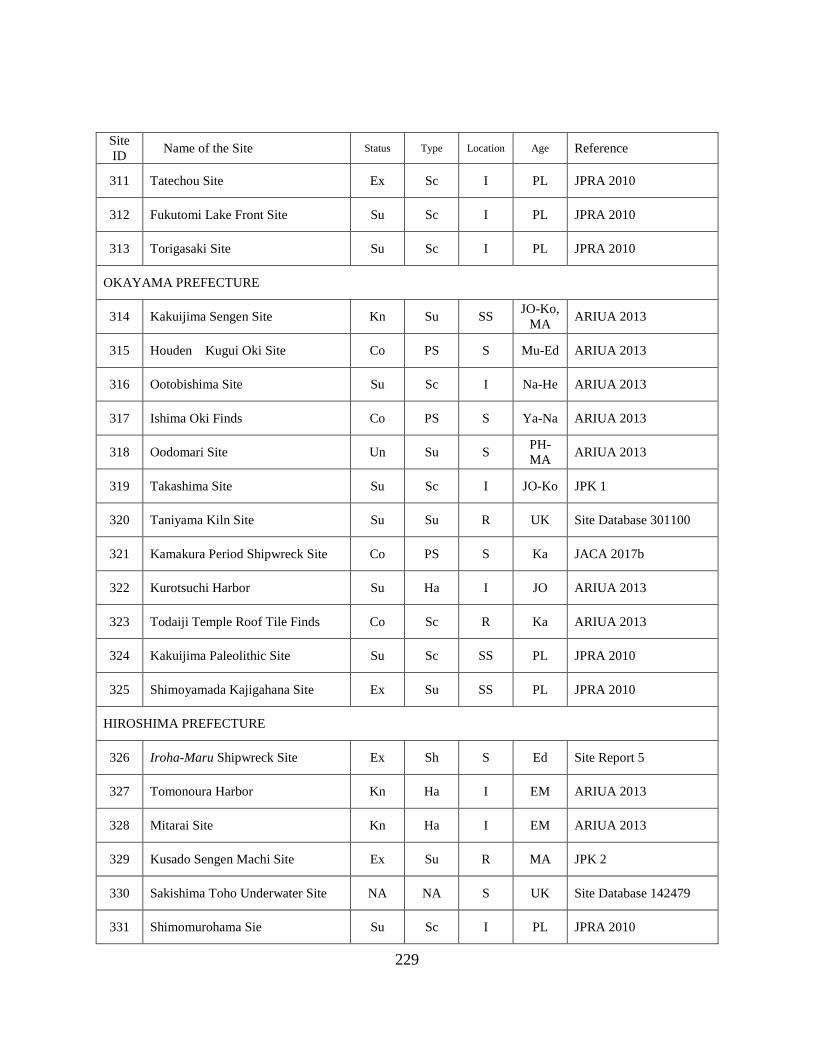
229
Site
ID Name of the Site Status Type Location Age Reference
311 Tatechou Site Ex Sc I PL JPRA 2010
312 Fukutomi Lake Front Site Su Sc I PL JPRA 2010
313 Torigasaki Site Su Sc I PL JPRA 2010
OKAYAMA PREFECTURE
314 Kakuijima Sengen Site Kn Su SS JO-Ko,
MA ARIUA 2013
315 Houden Kugui Oki Site Co PS S Mu-Ed ARIUA 2013
316 Ootobishima Site Su Sc I Na-He ARIUA 2013
317 Ishima Oki Finds Co PS S Ya-Na ARIUA 2013
318 Oodomari Site Un Su S PH-
MA ARIUA 2013
319 Takashima Site Su Sc I JO-Ko JPK 1
320 Taniyama Kiln Site Su Su R UK Site Database 301100
321 Kamakura Period Shipwreck Site Co PS S Ka JACA 2017b
322 Kurotsuchi Harbor Su Ha I JO ARIUA 2013
323 Todaiji Temple Roof Tile Finds Co Sc R Ka ARIUA 2013
324 Kakuijima Paleolithic Site Su Sc SS PL JPRA 2010
325 Shimoyamada Kajigahana Site Ex Su SS PL JPRA 2010
HIROSHIMA PREFECTURE
326 Iroha-Maru Shipwreck Site Ex Sh S Ed Site Report 5
327 Tomonoura Harbor Kn Ha I EM ARIUA 2013
328 Mitarai Site Kn Ha I EM ARIUA 2013
329 Kusado Sengen Machi Site Ex Su R MA JPK 2
330 Sakishima Toho Underwater Site NA NA S UK Site Database 142479
331 Shimomurohama Sie Su Sc I PL JPRA 2010

230
Site
ID Name of the Site Status Type Location Age Reference
332 Okiura Site Su Sc I PL JPRA 2010
333 Tadanoumicho Oki Point Co IF S PL JACA 2017b
YAMAGUCHI PREFECTURE
334 Kuroshimahama Site Ex Su I PL-JO JPRA 2010
335 Minogahama Site Ex Pr SS Ya-Ko JACA 2017b
336 Tokiwaike Site Su Sc P PL-JO JACA 2017b
337 Shimoninai Oki Shipwreck Site Co PS S Ed ARIUA 2013
338 Hahirajima Oki Site Co PS S Ko,
EM ARIUA 2013
339 Kamono Site Inoue Underwater
Site Su Sc S UK Site Database 143091
340 Hamazaki Site Ex Su I JO Yamaguchi Site Map
341 Sea of Japan Naumann Elephant
Task Find Point Co IF S PL Tottori Site Map
TOKUSHIMA PREFECTURE
342 Shouhou-Maru Shipwreck Point Kn Sh S Ed ARIUA 2013
343 Fukura Sengen Site Un Su SS MA ARIUA 2013
344 Okameiso Submerged Site Un Su SS Ed ARIUA 2013
345 Konaruto Strait Underwater Site Su Sc SS PL Site Database 421980
KAGAWA PREFECTURE
346 Mizunoko Iwa Site Ex PS S Mu ARIUA 2013
347 Aji Oki Point Su PS S Mu ARIUA 2013
348 Naoshima Oki Point Co PS S Ed ARIUA 2013
349 Naoshima Hayasaki Oki Site Su PS S Ka ARIUA 2013
350 Houdoujiike Site Ex Su P PH ARIUA 2013
351 Nou Cape Oki Site Co Sc S Ya-He ARIUA 2013

231
Site
ID Name of the Site Status Type Location Age Reference
352 Shodo Island Underwater Site Ex PS I Ed Site Report 7
353 Clay Brick Shipwreck Site Su Sh S M Diver Magazine
354 Enoura Oki Find Point Co PS S Ya ARIUA 2013
EHIME PREFECTURE
355 Kumaguchi Minato Site Ex Pr I PL-Ko ARIUA 2013
356 Nachi-gun Underwater Sites Ex Su S UK Website 10
357 Minokoshi Ato Iseki Kn Ha S MA ARIUA 2013
358 Shimodamizu Harbor Ex Ha I JO-
MA ARIUA 2013
359 Daimyoujingawa Oki Site Ex Su S JO ARIUA 2013
360 Oosuminohana Site Co PS S MA-
EM ARIUA 2013
361 Miyakubo Underwater Sites Co PS S Ya-
EM ARIUA 2013
362 Ushima Site Un Su I EM ARIUA 2013
363 Namikata Jomon Site Su Sc S JO Website 10
364 Karatsuzaki Oki Site Co PS D EM ARIUA 2013
365 Mizusaki Site Ex Su I JO JPK 1
366 Washigasu Underwater Site Su Su S Ya Site Database 147627
367 Tsugura Minato Site Su Su S JO Site Database 417230
368 Michikajima Underwater Site Ex Su S Ya Site Database 417054
369 Amazaki Castle Wall Kn HS I EM-M Website 10
370 Uoshima Minato Site Ex Su SS Ya ARIUA 2013
371 Otatebashima Oki Site Co PS S MA-
EM ARIUA 2013
KOCHI PREFECTURE
372 Shimonokae Oki Site Co Sh SS Ed Kochi Site Map
232
Site
ID Name of the Site Status Type Location Age Reference
373 Tsumeshiro Beach Site Su Su S EM ARIUA 2013
374 Tojima Site Su Sc S Ya,
MA Kochi Site Map
375 Hakuho Earthquake Submerged
Village Un Su S PH Tanikawa et al. 2016
FUKUOKA PREFECTURE
376 Aishima Underwater Site Ex PS S He KNM 2018
377 Eboshi Rock Shipwreck Site Co PS D MA ARIUA 2013
378 Medieval Shipwreck Site Un PS S MA ARIUA 2013
379 Genkai Island Site Su PS S MA,
Ed ARIUA 2013
380 Okagaki Beach Site Co PS S MA-
Me ARIUA 2013
381 Ashiya Underwater Site Su PS S Ed ARIUA 2013
382 Imazu Underwater Site Su Sc SS UK Site Database 153529
383 Okitsushima Site Su Sc I EM ARIUA 2013
384 Karadomari Site Co Sc S PH Site Database 244870
SAGA PREFECTURE
385 Nishi Karatsu Underwater Site Ex Su S JO ARIUA 2013
386 Ikejiri Underwater Site Su PS S Ed Site Report
387 Akamatsu Beach Site Su Sc I JO Site Report 10
388 Nanatsugama Underwater Site Su Sc S
JO,
MA,
EM
ARIUA 2013
389 Mietsu Naval Base Site Ex Ha I Ed-Me Site Report 9
390 Hato Cape Stone Anchors Su PS S EM ARIUA 2013
NAGASAKI PREFECTURE
391 Okita Site Su Sc SS JO ARIUA 2013

233
Site
ID Name of the Site Status Type Location Age Reference
392 Okinoshima Site Su Sc I JO ARIUA 2013
393 Senrigahama Site Ex Sc I Jo-Ya ARIUA 2013
394 Tanegota Site Su Sc I JO Site Database 255905
395 Kawachi Harbor Su Sc I Ed ARIUA 2013
396 Hirado Harbor Kn Ha SS EM ARIUA 2013
397 Chosen Ido Site Su Sc SS
PL-JO,
MA-
EM
ARIUA 2013
398 Ohama Site Ex Su SS Ya-Ko ARIUA 2013
399 Nish Kato Site Ex Sc I JO ARIUA 2013
400 Meotoishi Site Ex Sc I JO, Ko ARIUA 2013
401 Toujin Shallows Co PS S Ed Site Database 255224
402 Kanjiga Castle Oki Site Un Sh SS EM ARIUA 2013
403 Douzaki Site Ex Sc SS JO-Ya Site Database 255238
404 Douzaki Site Ex Su I JO ARIUA 2013
405 Oitabe Cave Site Ex Mi Cave JO ARIUA 2013
406 Kouko Midden Site Ex Mi I JO ARIUA 2013
407 Takashima Kozaki Site Ex Sh S Ka ARIUA 2013
408 Maegata Bay Underwater Site Ex PS S PH-
MA ARIUA 2013
409 Yamami Oki Underwater Site Ex PS S EM-M ARIUA 2013
410 Nagiri Site Ex Su SS PL-JO ARIUA 2013
411 Oyanagi Site Su Sc SS JO ARIUA 2013
412 Matsuzaki Site Ex Su I
PL-JO,
MA-
EM
Site Database 254473
413 Mitarai Site Su Sc I Ko ARIUA 2013

234
Site
ID Name of the Site Status Type Location Age Reference
414 Kushiyama Mirume Site Ex Mi I JO-Ya JACA 2017b
415 Tatsunoshima Site Su Sc S Ko ARIUA 2013
416 Utagaura Site Su Sc S JO ARIUA 2013
417 Itanosaki Site Su Sc S JO ARIUA 2013
418 Sejirishima Site Su Sc S JO ARIUA 2013
419 Kurosaki Site Su Sc S JO ARIUA 2013
420 Mukae Site Su Sc S JO ARIUA 2013
421 Shimozato Site Ex Sc S JO ARIUA 2013
422 Kudarimatsu Site Su Sc S JO ARIUA 2013
423 Ishida Site Su Sc S JO Site Database 255240
424 Kamaga Site Ex Su SS JO Site Database 220763
425 Sukawa Lagoon Site Su Sc S Ya Site Database 255224
426 Kaimori Site Ex Sc S JO-Ya Site Database 169789
427 Iyoshigaura Site Su Sc S JO-Ya ARIUA 2013
428 Okita Underwater Site Su Sc S Ya-KO Site Database 255049
429 Houki Site Su Sc I JO Site Database 255906
430 Sotetsugaura Site Su Sc I PL-JO Site Database 255643
431 Sukusahama Site Su Sc I JO-Ya Site Database 255620
432 Magaribana Site Su Su I MA ARIUA 2013
433 Ofunagura Site Kn Ha NA Ed ARIUA 2013
434 Mieshitamachi Site Ex Sc S PL-Ya Site Database 255035
435 Tawaragaura Ofunae Site Kn Ha NA Ed ARIUA 2013
436 Shobugawa Site Su Sc SS JO ARIUA 2013

235
Site
ID Name of the Site Status Type Location Age Reference
437 Magari Underwater Site Su Sc SS JO-KO ARIUA 2013
438 Mogi Harbor Ex PS S EM ARIUA 2013
439 Kitaura Beach Site Su Sc S JO Nagasaki Site Map
440 Hama Underwater Site Su Sc SS JO Site Database 253989
441 Arikawa Harbor Su Sc S JO-Ya Site Database 253988
KUMAMOTO PREFECTURE
442 Narukozaki Site Ex Sc I JO, Ko ARIUA 2013
443 Eboshi Mine Site Kn HS NA Me ARIUA 2013
444 Shiinokizaki Site Ex Su S JO ARIUA 2013
445 Minami Furusato Site Su Sc I JO, Ko ARIUA 2013
446 Karuwajima Underwater Site Ex Sc I JO Site Database 173592
447 Yanagi Midden Site Ex Mi I JO ARIUA 2013
448 Hageshima Site Su Sc I
JO,
MA-
EM
ARIUA 2013
449 Kushi Site Su Sc S JO-Ko ARIUA 2013
450 Hiiden Sanbank Site Co Sc SS JO ARIUA 2013
451 Hiroki Site Ex Su L JO-Ya JPK 1
OITA PREFECTURE
452 Hisamitsujima Un Su S MA ARIUA 2013
453 Uryujima Site Un Su S MA ARIUA 2013
MIYAZAKI PREFECTURE
No Data/Site

236
Site
ID Name of the Site Status Type Location Age Reference
KAGOSHIMA PREFECTURE
454 Kurakizaki Underwater Site Ex Sc SS MA Site Report 8
455 Bounotsu Kushiura Site Un PS S MA,
Ed ARIUA 2013
456 Bounotsu Machi Site Su Sc S MA-
EM ARIUA 2013
457 Fukiagehama Site Su Sc S Ed ARIUA 2013
458 Tomari Beach Site Su Sc SS MA-
Me ARIUA 2013
459 Sekibune Rudder Co IF SS Ed ARIUA 2013
460 Minaminohama Harbor Su Sc SS EM ARIUA 2013
461 San Harbor Su Sc SS MA-
EM ARIUA 2013
462 Omonawa Harbor Su Sc SS MA-
EM ARIUA 2013
463 Ushijihama Oki Site Su PS SS EM ARIUA 2013
OKINAWA PREFECTURE
464 Kattura Midden Site Ex Mi R PH OPBCPC 2017
465 Ginama Underwater Site Ex Sh S EM OPBCPC 2017
466 Emmons Shipwreck Su Sh S M OPBCPC 2017
467 Ukibarujima Oki Site Co Sh S EM OPBCPC 2017
468 Indian Oak Shipwreck Site Ex Sh SS EM OPBCPC 2017
469 Maja Underwater Site Su Sh S EM? OPBCPC 2017
470 Yabiji Underwater Site No.1 Ex Sh S EM OPBCPC 2017
471 Yoshino Beach Site Su Sh S EM OPBCPC 2017
472 Sekiseishoko Underwater Site No.3 Co Sh S EM? OPBCPC 2017
473 Takada Beach Site (Van Bosse) Su Sh S EM OPBCPC 2017
474 Nagura Shitadaru Site Ex Sc SS GU OPBCPC 2017

237
Site
ID Name of the Site Status Type Location Age Reference
475 Yarabu Oki Underwater Site Su Sc S EM OPBCPC 2017
476 Nohojima Nishi Beach Site Su Sc I GU OPBCPC 2017
477 Uchihana Beach Site Su Sc I EM OPBCPC 2017
478 Moromi Beach Site Co IF I EM? OPBCPC 2017
479 Usa Beach Site Su Sc I EM? OPBCPC 2017
480 Jyashiki Beach Site Su Sc I EM? OPBCPC 2017
481 Toubaru Beach Site Su Sc I PH,
EM OPBCPC 2017
482 Kijyoka Becah Site Su Sc I PH? OPBCPC 2017
483 Uehara Beach Site Su Sc I EM OPBCPC 2017
484 Minnajima Underwater Site Su Sc I GU OPBCPC 2017
485 Waji Beach Ceramic Site Su Sc I GU OPBCPC 2017
486 Kayou Beach Site Su Sc I EM OPBCPC 2017
487 Matsuda Beach Site Su Sc I JO-EM OPBCPC 2017
488 Yabuchi Cave Site Su Sc I PH OPBCPC 2017
489 Kanehama Site Co IF I EM? OPBCPC 2017
490 Nakanohama Site Su Sc I GU OPBCPC 2017
491 Oha Underwater Site Su Sc I GU OPBCPC 2017
492 Yabiji Underwater Site No.2 Su Sc I EM OPBCPC 2017
493 Yabiji Underwater Site No.3 Su Sc I EM OPBCPC 2017
494 Kurimajima Underwater Site Su Sc I GU OPBCPC 2017
495 Sawadanohama Site Su Sc I EM OPBCPC 2017
496 Toguchinohama Site Su Sc I EM OPBCPC 2017
497 Yonehara Beach Site Su Sc I GU OPBCPC 2017

238
Site
ID Name of the Site Status Type Location Age Reference
498 Teraihara Nishi Site Su Ha I PH-
EM OPBCPC 2017
499 Nohojima Kita Beach Site Su Ha I EM OPBCPC 2017
500 Gushikawajima Kita Beach Site Su Ha I GU-
EM OPBCPC 2017
501 Izena Gusuku Underwater Site Su Ha I GU OPBCPC 2017
502 Okugawa River Mouth Site Su Ha I EM OPBCPC 2017
503 Kansazaniku Underwater Site Su Ha I GU OPBCPC 2017
504 Imadomari Beach Underwater Site Su Ha I GU-
EM OPBCPC 2017
505 Sesojojima Underwater Su Ha SS EM OPBCPC 2017
506 Ara Beach Ancient Port Site Su Ha I EM OPBCPC 2017
507 Kohenzoko Harbor Su Ha I GU OPBCPC 2017
508 Jimun Beach Site Su Ha I EM OPBCPC 2017
509 Mae Rivermouth Site Su Ha I EM OPBCPC 2017
510 Hija Rivermouth Site Su Ha I EM OPBCPC 2017
511 Miya Gusuku Harbor Su Ha I EM OPBCPC 2017
512 Gushi River Gusuku Beach Site Su Ha I GU OPBCPC 2017
513 Naha Harbor Ex Ha I GU-
EM OPBCPC 2017
514 Tonakijima Historic Harbor Su Ha I GU-
EM OPBCPC 2017
515 Agonoura Underwater Site Su Ha S GU-
EM OPBCPC 2017
516 Maja Harbor Su Ha I GU-
EM OPBCPC 2017
517 Ohara Stone Quarry Site Su Pr I EM OPBCPC 2017
518 Kitahara Stone Qarry Site Su Pr I EM OPBCPC 2017
519 Shirase Rivermouth Site Su Ha I GU-
EM OPBCPC 2017
520 Onazaki Historic Harbor Su Ha I EM OPBCPC 2017

239
Site
ID Name of the Site Status Type Location Age Reference
521 Yonaha Bay Site Su Ha I GU-
EM OPBCPC 2017
522 Nagatamanohama Site Su Ha I EM OPBCPC 2017
523 Ara Beach Site Su Ha I EM OPBCPC 2017
524 Ihara Bay Site Su Ha I GU-
EM OPBCPC 2017
525 Komisekizaki Site Su Ha I GU-
EM OPBCPC 2017
526 Sonai Maedomari Underwater Site Su Ha I GU-
EM OPBCPC 2017
527 Nishinohama Site Su Ha I EM OPBCPC 2017
528 Miyara Bay Underwater Site Su Ha SS GU-
EM OPBCPC 2017
529 Sumiyabaru Site Su Su I PH Site Database 252669
530 Ireibaru E Site Su Mi I
PH-
GU-
EM
Site Database 415368
531 Gushi River North Fish Weir Su Pr I EM OPBCPC 2017
532 Uchihana Stone Quarry Su Pr I EM OPBCPC 2017
533 Yanahajima Stone Quarry Su Pr I EM OPBCPC 2017
534 Oku Stone Quarry Su Pr I M OPBCPC 2017
535 Jyashiki Beach Stone Quarry Su Pr I EM OPBCPC 2017
536 Kijyoka Beach Stone Quarry Su Pr I EM OPBCPC 2017
537 Miya Gusuku Salt Pr Su Pr I EM OPBCPC 2017
538 Tsuha Beach Stone Quarry Su Pr I EM OPBCPC 2017
539 Ufudo Beach Stone Quarry Su Pr I EM OPBCPC 2017
540 Wakugawa Yaganna Island Salt
Productio Site Su Pr I EM OPBCPC 2017
541 Nakaoitsugisarahama Stone Quarry
Site Su Pr I EM OPBCPC 2017
542 Imadomari Beach Stone Quarry
Site Su Pr I EM OPBCPC 2017

240
Site
ID Name of the Site Status Type Location Age Reference
543 Masuya Site Su Pr I EM OPBCPC 2017
544 Sesoko Island Stone Quarry Site Su Pr I M OPBCPC 2017
545 Minnnajima Stone Quarry Site Su Pr I EM OPBCPC 2017
546 Serakaki Stone Quarry Site Su Pr I EM OPBCPC 2017
547 Toubukuro River Stone Quarry Site Su Pr I EM OPBCPC 2017
548 Tobukurogawa Site Su Pr I GU OPBCPC 2017
549 Minami Onna Stone Quarry Site Su Pr I EM OPBCPC 2017
550 Maeda Stone Quarry Site Su Pr I EM OPBCPC 2017
551 Zanpa Stone Quarry Site Su Pr I EM OPBCPC 2017
552 Toya Stone Quarry Site Su Pr I EM OPBCPC 2017
553 Sobe Stone Quarry Site Su Pr I EM OPBCPC 2017
554 Naha Port Site Su Ha I GU-
EM OPBCPC 2017
555 Obujima Stone Quarry Site Su Pr I EM OPBCPC 2017
556 Yuhi River Stone Quarry Su Pr I EM OPBCPC 2017
557 Anzera Beach Fish Weir Su Pr I EM OPBCPC 2017
558 Funakoshibaru Stone Quarry Su Pr I EM OPBCPC 2017
559 Kume Island Shimajiri Fish Weir Su Pr I EM OPBCPC 2017
560 Hiyajyo Fish Weir Su Pr I EM OPBCPC 2017
561 Ikema Island FIsh Weir Su Pr I EM OPBCPC 2017
562 Karimata Fish Weir Su Pr I EM OPBCPC 2017
563 MIyakoshimajiri Fish Weir Su Pr I EM OPBCPC 2017
564 Oura Bay Fish Weir Su Pr I EM OPBCPC 2017
565 Takano Beach Stone Quarry Site Su Pr I M OPBCPC 2017

241
Site
ID Name of the Site Status Type Location Age Reference
566 Yonaha Fish Weir Su Pr I EM OPBCPC 2017
567 Hora Maiba Stone Quarry Site Su Pr I M OPBCPC 2017
568 Shimoji Island Fish Weir Su Pr I EM OPBCPC 2017
569 Kuninaka Fish Weir Su Pr I EM OPBCPC 2017
570 Tamaorizaki Fish Weir Su Pr I EM OPBCPC 2017
571 Sukoji Beach Fish Weir Su Pr I EM OPBCPC 2017
572 Miyara Bay Ohama Fish Weir Su Pr I EM OPBCPC 2017
573 Akayazaki Fish Weir Su Pr I EM OPBCPC 2017
574 Hosozaki Fish Weir Su Pr I EM OPBCPC 2017
575 Birumazaki Fish Weir Su Pr I EM OPBCPC 2017
576 Nishimijidanu Fish Weir Su Pr I EM OPBCPC 2017
577 Funaurasura Site Su Pr I EM OPBCPC 2017
578 Hatopanari Nakase Fish Weir Su Pr I EM OPBCPC 2017
579 Ikashi Fish Weir Su Pr I EM OPBCPC 2017
580 Indazaki West Fish Weir Su Pr I EM OPBCPC 2017
581 Indazaki East Fish Weir Su Pr I EM OPBCPC 2017
582 Tomada Fish Weir Su Pr I EM OPBCPC 2017
583 Omijya River Fish Weir Su Pr I EM OPBCPC 2017
584 Yutsun River Fish Weir Su Pr I EM OPBCPC 2017
585 onera River Fish Weir Su Pr I EM OPBCPC 2017
586 Noharazaki West Fish Weir Su Pr I EM OPBCPC 2017
587 Nusuku Fish Weir Su Pr I EM OPBCPC 2017
588 Komi Akaishizaki Fish Weir Su Pr I EM OPBCPC 2017

242
Site
ID Name of the Site Status Type Location Age Reference
589 Komi Akaishizaki Sura Site Su Pr I EM OPBCPC 2017
590 Mairagawa Fish Weir Su Pr I EM OPBCPC 2017
591 Toira Fish Weir Su Pr I EM OPBCPC 2017
592 Nakama River Fish Weir Su Pr I EM OPBCPC 2017
593 Ishabuza Fish Weir Su Pr I EM OPBCPC 2017
594 Hateruma Stone Quarry Su Pr I EM OPBCPC 2017
Status Ex: Excavated Site, Su: Surveyed, Co: Collected, Sa: Salvaged, Un: Unidentified,
Bu: Buried, Known Site: Kn, Not Applicable: NA.
Type Ha: Harbor Site, HS: Historic Site, Mi: Midden Site, Sh: Shipwreck Site,
PS: Possible Shipwreck, Sc: Scattered Site, Su: Submerged Site,
PS: Production Site, IF: Isolated Finds, NA: Not Applicable.
Location Inland Site (L: Lake, R: River, P: Pond, and Cave: Cave), I: Intertidal Site,
SS: Shallow Sea, S: Sea, D: Deep Sea, NA: Not Applicable.
Age PL: Paleolithic Era, JO: Jomon Era, PH: Proto-Historic Era,
MA: Middle Age Era, EM: Early Modern Era, MO: Modern Era, UK: Unknown,
Ya: Yayoi Period, Ko: Kofun Period, As: Asuka Period, Na: Nara Period,
He: Heian Period, Ka: Kamkura Period, Mu: Muromachi Period,
Am: Azuchi-Momoyama Period, Ed: Edo Period, Me: Meiji Period,
Ta: Taisho Period, So: Showa Period, Ai: Ainu Period, Gu: Gusuku Period.
Reference See Below

243
List of References (for Appendix B)
Prefecture Site Map
Hokkaido Site Map
http://www2.wagamachi-guide.com/hokkai_bunka/
Yamagata Site Map
https://www.pref.yamagata.jp/bunkyo/bunka/bunkazai/6700015yamagataiseki.html
Niigata Site Map
http://www.pref.niigata.lg.jp/bunkagyosei/1356894579804.html
Toyama Site Map
http://wwwgis.pref.toyama.jp/toyama/Default.aspx
Shizuoka Site Map
https://www.gis.pref.shizuoka.jp/?p=1&bt=1&mt=0&mp=4011&z=17&ll=34.9791,138.3831&
Kyoto Site Map
https://g-kyoto.gis.pref.kyoto.lg.jp/g-kyoto/PositionSelect?mid=671&mtp=pfm
Wakayama Site Map
https://www.pref.wakayama.lg.jp/prefg/500700/maizou/maizou.html
Tottori Site Map
http://www2.wagmap.jp/pref-tottori/top/agreement.asp?dtp=6&dtpold=&npg=/pref-
tottori/top/select.asp&npr=dtp=6/pl=3
Yamagata Site Map
http://www.y-maibun.jp/iseki/
Shimane Site Map
http://webgis.pref.shimane.lg.jp/shimane/G0304C?IsPost=False&MapId=10812&RequestPag
e=http%3a%2f%2fweb-gis.pref.shimane.lg.jp%2fshimane%2fG0303G%3fmid%3d10812
Kochi Site Map
http://bunkazaimap.kochinet.ed.jp/
Nagasaki Site Map
https://www.pref.nagasaki.jp/jiten/map.html
Miscellaneous Internet Sources
Site Database
Nara National Research Institute for Cultural Properties Site Data Base
http://mokuren.nabunken.go.jp/scripts/strieveW.exe?USER=ISEKI&PW=ISEKI

244
Heritage List
fields.canpan.info/report/download?id=3545
Diver Magazine
https://www.diver-online.com/column/detail/id/5472/
Website 1
Hokkaido Style Travel Guide
http://hokkaido-travel.com/unknown-hokkaido/kiraku/
Website 2
Assabu Cultural Heritage Blog
https://assabu.exblog.jp/16277954/
Website 3
Tokyo Bay Waterway Office
https://www.pa.ktr.mlit.go.jp/wankou/history/
Website 4
Yokohama-City Vistors’ Guide
www.welcome.city.yokohama.jp/ja/tourism/spot/details.php?bbid=734
Website 5
JACA Historic Site Database
https://kunishitei.bunka.go.jp/bsys/maindetails.asp
Website 6
Toyama Prefecture Buried Cultural Property Center
http://www.city.toyama.toyama.jp/etc/maibun/center/topics/y-kaitei/y-kaitei.htm
Website 7
Uozu Buried Forest Museum
https://www.city.uozu.toyama.jp/nekkolnd/
Website 8
Kasamatsu City
http://www.town.kasamatsu.gifu.jp/
Website 9
Asahi Shinbun Digital (2007, Nov. 01)
http://www.asahi.com/komimi/OSK200710240041.html
Website 10
Ehime Prefecture Lifelong Learning Center
http://i-manabi.jp/

245
Archaeological Site Reports
Site Report 1
Esashi Town Board of Education 1990
Site Report 2
Kaminokuni Board of Education 1987
Site Report 3
Okitsu Beach Site Research Club 2010
Site Report 4
Wakayama City Board of Education 1997
Site Report 5
Underwater Archaeological Society 2006
Site Report 6
Nakagawa 2016
Site Report 7
Takada et al. 2018
Site Report 8
Uken Town Board Education 1999
Site Report 9
Saga City Board of Education 2012
Site Report 10
Chinzei-Cho Board of Education 1989
Encyclopedia
JPK 1
JapanKnowledge Lib,http://japanknowledge.com
日本歴史地名体系 (Encyclopedia of Japan Historic Place Names) Tokyo:Heibonsha
JPK 2
JapanKnowledge Lib,http://japanknowledge.com
日本大百科全書 (Comprehensive Encyclopedia of Japan) Tokyo: Shogakukan
Published Database
ARIUA 2013
Asia Research Institute of Underwater Archaeology 2013.
JPRA 2010
The Japanese Paleolithic Research Association 2010.

246
Lake Biwa Report
Shiga Prefecture Board of Education 2014
OPBCPC 2017
Okinawa Prefecture Buried Cultural Property