texas conservation action plan · pdf filesee links on texas parks and wildlife...
TRANSCRIPT
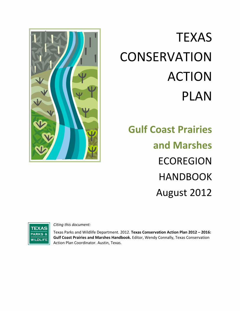
TEXAS CONSERVATION
ACTION PLAN
Gulf Coast Prairies
and Marshes ECOREGION HANDBOOK
August 2012
Citing this document:
Texas Parks and Wildlife Department. 2012. Texas Conservation Action Plan 2012 – 2016: Gulf Coast Prairies and Marshes Handbook. Editor, Wendy Connally, Texas Conservation Action Plan Coordinator. Austin, Texas.
Page | ii * Table of Contents
Contents SUMMARY ..................................................................................................................................................... 1
HOW TO GET INVOLVED ............................................................................................................................... 2
OVERVIEW ..................................................................................................................................................... 3
RARE SPECIES and COMMUNITIES .............................................................................................................. 15
PRIORITY HABITATS ..................................................................................................................................... 15
ISSUES ......................................................................................................................................................... 26
CONSERVATION ACTIONS ........................................................................................................................... 41
CONSERVATION PARTNERS AND PROGRAMS ............................................... Error! Bookmark not defined.
RESOURCES AND REFERENCES ....................................................................... Error! Bookmark not defined.
ECOREGION HANDBOOK FIGURES Figure 1. GCPM Ecoregion with County Boundaries ..................................................................................... 6 Figure 2. GCPM EDUs, HUC 8s, and ESSS – 6 maps ....................................................................................... 9
ECOREGION HANDBOOK TABLES Table 1. Crosswalk of GCPM Ecoregion with Other Conservation Plan Units .............................................. 5 Table 2. GCPM EDUs with Ecologically Signifcant Stream Segments and Reservoirs ................................... 7 Table 3. GCPM Priority Habitats ................................................................................................................. 17 Table 4. Shared Habitat Priorities with Adjacent State – Louisiana............................................................ 25 Table 5. GCPM Priority Issues Affecting Conservation ............................................................................... 27 Table 6. GCPM Conservation Actions ......................................................................................................... 43
See links on Texas Parks and Wildlife Department’s Texas Conservation Action Plan 2012 website
http://www.tpwd.state.tx.us/landwater/land/tcap/
or the Wildlife Diversity Program website
http://www.tpwd.state.tx.us/huntwild/wild/wildlife_diversity/
for additional references and supporting documents related to this handbook.
Page | 1 of 51 * SUMMARY
“Action that grows out of urgency, frustration, or even determination is missing a critical ingredient. For action to be effective, for action to be meaningful, it must also grow out of respect and a deep sense of connection to the things and people that surround us.” – Orion Magazine Editors, March/April 2011
SUMMARY
The Gulf Coast Prairies and Marshes (GCPM) Handbook is one of the Texas Conservation Action Plan (TCAP) thirteen handbooks, available on the Texas Parks and Wildlife Department’s Texas Conservation Action Plan website1::
an Overview – background information about how this Plan came about and was revised; a Statewide/Multi-region handbook – broad resource concerns and opportunities; and 10 other ecoregion handbooks like this one for different areas of Texas with more local
information. This handbook provides insight into specific GCPM resources and conservation issues, including a list of Species of Greatest Conservation Need (SGCN), rare communities, and important habitats that support these unique features. The GCPM handbook also presents a compiled list of issues – things that prevent us from doing our best conservation work here – and proposed solutions or actions. Throughout this document, there are resources – web links, programs, incentives, and contacts – to help you participate in implementation and learn more about the natural resources this region of Texas has to offer.
The TCAP GCPM Ecoregion Handbook takes advantage of many different perspectives to understand local changes and identify actions that will reduce threats to specific natural resources: SGCN, rare communities and the habitats on which they rely. The Plan aims to ensure that we are able to share our natural heritage with future generations of Texans and that they understand what we did to make progress toward that goal.
It’s important to prioritize where we need to work to the degree that we can: human and financial resources are limited, certain issues demand more immediate resolution, and some species and habitats are simply more in need. The TCAP 2012 taps into a broad network of conservation service providers, natural resources managers, alliances and working groups, policy makers, stakeholders and the public to define what’s at risk, what issues are most important, where we need to work, how to best engage the right partners to solve the problems, and what to do.
This handbook is divided into sections to guide priority setting and actions:
resources at risk - SGCN, rare communities, and the habitats on which they rely; issues that are most important, which could benefit from targeted stakeholder involvement; and conservation actions to benefit resources and make progress toward solving issues.
Certain resources also have a statewide context – riparian areas, grasslands – and additional actions at that level are proposed in the Statewide/Multi-region handbook. For more information about how content was developed for all handbooks of the Action Plan, please see the Overview handbook.
1 TPWD. 2012. Texas Conservation Action Plan – all handbooks and supporting documents can be found online at
http://www.tpwd.state.tx.us/landwater/land/tcap/
Page | 2 of 51 * HOW TO GET INVOLVED
HOW TO GET INVOLVED
This handbook contains a list of partners and programs that provide conservation services and/or information in this area. Additionally, certain conservation actions at the end of this handbook may help you connect with partners working on specific issues.
There are many wonderful, energetic public and private conservation providers in Texas who have active volunteer networks, strategic needs, and programs. For more information, check the Natural Resource Conservation Programs and Services for Texas Landowners.2 In addition, work with the Texas Land Trust Council to find a local lands and waters conservation organization near you: http://www.texaslandtrustcouncil.org/
If you have questions about the TCAP content and cannot find what you need on the TPWD Texas Conservation Action Plan website or in one the handbooks,3 please contact the TCAP Coordinator at the TPWD Headquarters in Austin, Texas:
Phone (512) 389-4800
Email [email protected]
2 TPWD. 2007 Natural Resource Conservation Programs and Services for Texas Landowners. http://www.tpwd.state.tx.us/publications/pwdpubs/media/pwd_bk_w7000_1198.pdf 3 TPWD. 2012. Texas Conservation Action Plan – all handbooks and supporting documents can be found at this website: http://www.tpwd.state.tx.us/landwater/land/tcap/
Page | 3 of 51 * OVERVIEW
OVERVIEW
The final stretch for almost all Texas rivers is our Gulf Coast Prairies and Marshes (GCPM) ecoregion, where the drop of rain that started in the Panhandle can, with some imagination and probably a “lifetime,” become one with the Gulf of Mexico. The ecoregion eases to the coast from the Pineywoods, the Post Oak Savanna, the Blackland Prairie, the South Texas Plains … expansive, shallow gradient, rolling over brushlands and prairies, through bottomland hardwoods and thick marshes, dunes and sandy shoreline. The Texas coast is one of the most ecologically complex and biologically diverse regions of the state. It includes nine major bays lower-to-upper coast are lower and upper Laguna Madre, Corpus Christi and Aransas Bays, San Antonio, Matagorda and Galveston Bays and Sabine Lake; as well as the Texas Territorial Sea, an area that extends from the Gulf of Mexico beach seaward nine nautical miles. More than one-third of Texas’ population and about 70% of its industrial base, commerce and jobs are located within 100 miles of the coastline. More than half of the nation’s chemical and petroleum production are located on the coast and the coastal waters support major commercial and recreational fishing industries. Texas leads the nation in marine commerce and the beaches, bays, marshes, coastal prairies and other fish and wildlife habitats of the coast provide numerous recreational opportunities.
Texas has approximately 365 miles of open Gulf shoreline and contains 2,361 miles of bay-estuary-lagoon shoreline. This is the most biologically rich and ecologically diverse region in the state and supports more than 601,000 acres of fresh, brackish and salt marshes, although that’s just a mere fraction of the marsh extent just 50 years ago. Of the marshes described, saline and brackish marshes are most widely distributed south of Galveston Bay, while intermediate marshes are the most extensive marsh type east of Galveston Bay. The lower coast has only a narrow band of emergent marsh, but has a system of extensive bays and lagoons.
From the Louisiana border to Galveston, the coastline is comprised of marshy plains and low, narrow beach ridges. From Galveston Bay to the Mexican border, the coastline is characterized by long barrier islands and large shallow lagoons. Within this estuarine environment are found the profuse seagrass beds of the Laguna Madre, a rare hypersaline lagoon, and Padre Island, the longest undeveloped barrier island in the world. The Gulf Intracoastal Waterway (GIWW), a maintenance dredged channel, extends from the lower Laguna Madre to Sabine Lake. Dredging of the channel has created numerous spoil banks and islands adjacent to the channel. And, numerous navigational waterways and ports connect to this facility.
Seagrasses are recognized as a dominant, unique habitat in many Texas bays and estuaries. They provide nursery habitat for estuarine-dependent species, are a major source of organic biomass for coastal food webs, are effective natural agents for stabilizing coastal erosion and sedimentation and are major biological agents in nutrient cycling and water quality processes. They form some of the most productive communities in the world. Because seagrasses are sensitive to nutrient enrichment, water quality problems and physical disturbance, distribution of seagrasses is used as an indicator of the health of an environment.
Coastal wetlands are an integral part of Texas estuarine ecosystems and have tremendous biological and economic values. Coastal wetlands serve as nursery grounds for shrimp species and many recreational and commercially important fish species found in the Gulf; provide breeding, nesting and feeding grounds for many imperiled species; and provide permanent and seasonal habitat for a great variety of wildlife.
Coastal marshes in Texas can be divided into two major ecosystems; the Chenier Plain Ecosystem from the Texas-Louisiana border to East Bay (Texas) and the Texas Barrier Island Ecosystem from Galveston
Page | 4 of 51 * OVERVIEW
East Bay to the Texas-Mexico border. Salt marshes near Texas estuaries are typically dominated by cordgrass, although black mangrove (Avicennia germinans) predominate in certain areas. They are subject to intermittent inundation due to tidal action and high levels of freshwater inflow. The broadest distribution of salt marshes is found south of the Galveston Bay area, where they are common on the bayward side of barrier islands and peninsulas and along the mainland shores of narrow bays, such as West Galveston Bay. Although salt marshes occur on bay-head deltas, their biological plant communities change rapidly from brackish to intermediate and fresh marshes.4
Editor’s Note: Although this handbook addresses the Gulf Coast Prairies and Marshes as one ecoregion, the TPWD Coastal Fisheries Division requested splitting the ecoregion during workshops (see Overview Handbook) in the way that most of the regional conservation partners and TPWD programs actually work in the ecoregion. To that end, the Gulf Coast Prairies and Marshes information, including the SGCN list, is occasionally split into three subregions based on bay systems:
Upper Sabine Lake; Galveston Bay
Middle Matagorda Bay, San Antonio Bay, Aransas Bay, Corpus Christi Bay, Upper Laguna Madre
Lower Lower Laguna Madre
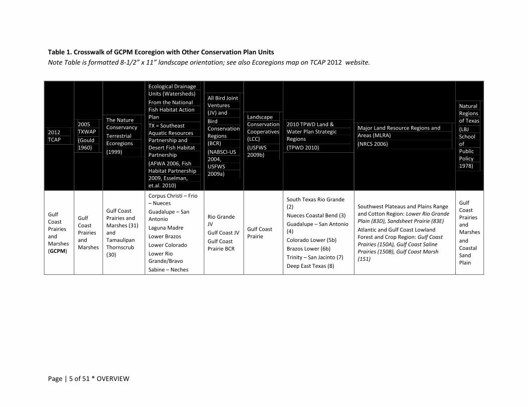
Table 1 crosswalks this ecoregion with other conservation planning units.5
Figure 1 illustrates the location and extent of this ecoregion in Texas.
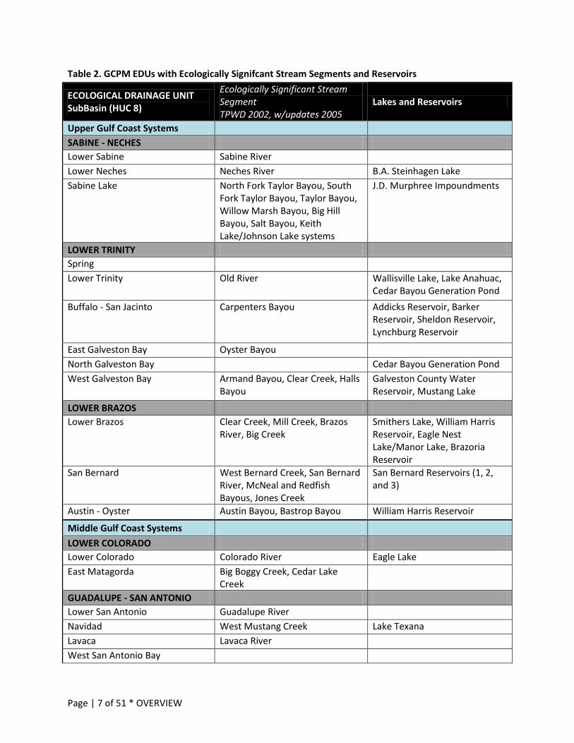
Table 2 documents the Ecological Drainage Units (EDU) and Hydrologic Units (“HUC 8”, finer scale watersheds within EDUs), Reservoirs and Ecologically Significant Stream Segments6 (ESSS) which occur in this area.
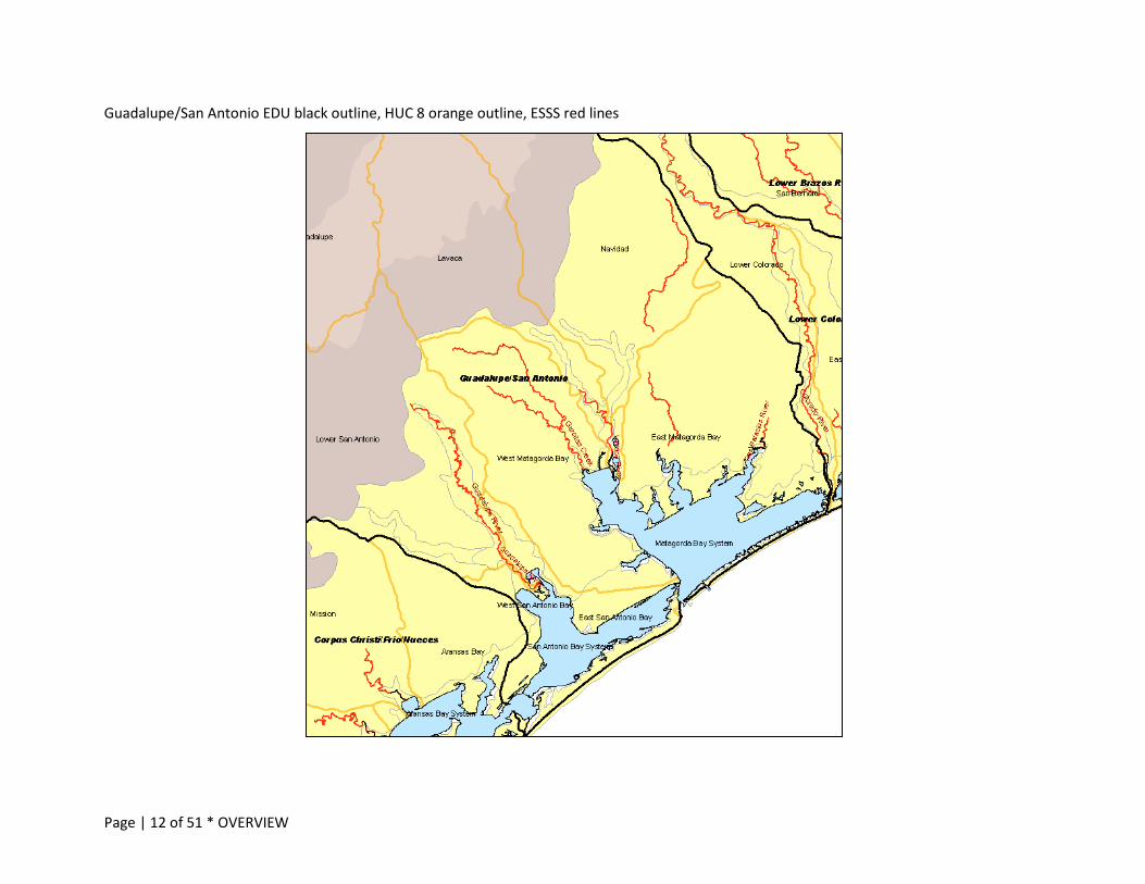
Figure 2 shows those EDUs, HUC8s and ESSS by ecoregion.
4 Griffith, G. 2010. Level III North American Terrestrial Ecoregions: United States Descriptions. Prepared for the North American Commission for Environmental Cooperation (www.cec.org), version May 11, 2010. Corvallis, Oregon. Griffith, G.E., S.A. Bryce, J.M. Omernik, J.A. Comstock, A.C. Rogers, B. Harrison, S.L. Hatch and D. Bezanson. 2007. Ecoregions of Texas. R.S. Geological Survey, Reston VA. http://www.epa.gov/wed/pages/ecoregions/tx_eco.htm (accessed May 2009). TPWD. 2005. Texas Comprehensive Wildlife Conservation Strategy (other citations are included in that document). 5 For more information about planning boundaries, see the Overview handbook on the TCAP 2012 website http://www.tpwd.state.tx.us/landwater/land/tcap/ 6 TPWD. 2002/2005. Ecologically Significant Stream Segments. http://www.tpwd.state.tx.us/landwater/water/environconcerns/water_quality/sigsegs/
Page | 5 of 51 * OVERVIEW
Table 1. Crosswalk of GCPM Ecoregion with Other Conservation Plan Units Note Table is formatted 8-1/2” x 11” landscape orientation; see also Ecoregions map on TCAP 2012 website.
2012 TCAP
2005 TXWAP (Gould 1960)
The Nature Conservancy Terrestrial Ecoregions (1999)
Ecological Drainage Units (Watersheds) From the National Fish Habitat Action Plan TX = Southeast Aquatic Resources Partnership and Desert Fish Habitat Partnership (AFWA 2006, Fish Habitat Partnership 2009, Esselman, et.al. 2010)
All Bird Joint Ventures (JV) and Bird Conservation Regions (BCR) (NABSCI-US 2004, USFWS 2009a)
Landscape Conservation Cooperatives (LCC) (USFWS 2009b)
2010 TPWD Land & Water Plan Strategic Regions (TPWD 2010)
Major Land Resource Regions and Areas (MLRA) (NRCS 2006)
Natural Regions of Texas (LBJ School of Public Policy 1978)
Gulf Coast Prairies and Marshes (GCPM)
Gulf Coast Prairies and Marshes
Gulf Coast Prairies and Marshes (31) and Tamaulipan Thornscrub (30)
Corpus Christi – Frio – Nueces Guadalupe – San Antonio Laguna Madre Lower Brazos Lower Colorado Lower Rio Grande/Bravo Sabine – Neches
Rio Grande JV Gulf Coast JV Gulf Coast Prairie BCR
Gulf Coast Prairie
South Texas Rio Grande (2) Nueces Coastal Bend (3) Guadalupe – San Antonio (4) Colorado Lower (5b) Brazos Lower (6b) Trinity – San Jacinto (7) Deep East Texas (8)
Southwest Plateaus and Plains Range and Cotton Region: Lower Rio Grande Plain (83D), Sandsheet Prairie (83E) Atlantic and Gulf Coast Lowland Forest and Crop Region: Gulf Coast Prairies (150A), Gulf Coast Saline Prairies (150B), Gulf Coast Marsh (151)
Gulf Coast Prairies and Marshes and Coastal Sand Plain

Page | 6 of 51 * OVERVIEW
Figure 1. GCPM Ecoregion with County Boundaries
Page | 7 of 51 * OVERVIEW
Table 2. GCPM EDUs with Ecologically Signifcant Stream Segments and Reservoirs
ECOLOGICAL DRAINAGE UNIT SubBasin (HUC 8)
Ecologically Significant Stream Segment TPWD 2002, w/updates 2005
Lakes and Reservoirs
Upper Gulf Coast Systems SABINE - NECHES Lower Sabine Sabine River Lower Neches Neches River B.A. Steinhagen Lake Sabine Lake North Fork Taylor Bayou, South
Fork Taylor Bayou, Taylor Bayou, Willow Marsh Bayou, Big Hill Bayou, Salt Bayou, Keith Lake/Johnson Lake systems
J.D. Murphree Impoundments
LOWER TRINITY Spring Lower Trinity Old River Wallisville Lake, Lake Anahuac,
Cedar Bayou Generation Pond Buffalo - San Jacinto Carpenters Bayou Addicks Reservoir, Barker
Reservoir, Sheldon Reservoir, Lynchburg Reservoir
East Galveston Bay Oyster Bayou North Galveston Bay Cedar Bayou Generation Pond West Galveston Bay Armand Bayou, Clear Creek, Halls
Bayou Galveston County Water Reservoir, Mustang Lake
LOWER BRAZOS Lower Brazos Clear Creek, Mill Creek, Brazos
River, Big Creek Smithers Lake, William Harris Reservoir, Eagle Nest Lake/Manor Lake, Brazoria Reservoir
San Bernard West Bernard Creek, San Bernard River, McNeal and Redfish Bayous, Jones Creek
San Bernard Reservoirs (1, 2, and 3)
Austin - Oyster Austin Bayou, Bastrop Bayou William Harris Reservoir
Middle Gulf Coast Systems LOWER COLORADO Lower Colorado Colorado River Eagle Lake East Matagorda Big Boggy Creek, Cedar Lake
Creek
GUADALUPE - SAN ANTONIO Lower San Antonio Guadalupe River Navidad West Mustang Creek Lake Texana Lavaca Lavaca River West San Antonio Bay
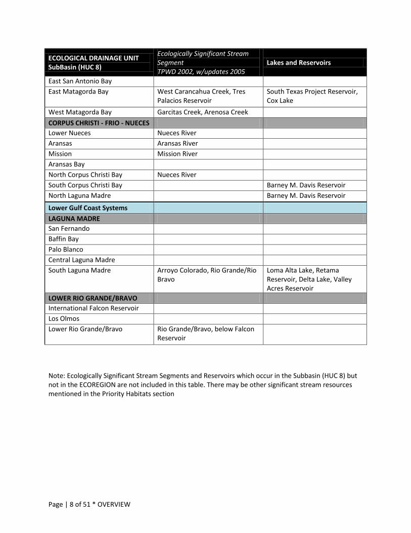
Page | 8 of 51 * OVERVIEW
ECOLOGICAL DRAINAGE UNIT SubBasin (HUC 8)
Ecologically Significant Stream Segment TPWD 2002, w/updates 2005
Lakes and Reservoirs
East San Antonio Bay East Matagorda Bay West Carancahua Creek, Tres
Palacios Reservoir South Texas Project Reservoir, Cox Lake
West Matagorda Bay Garcitas Creek, Arenosa Creek CORPUS CHRISTI - FRIO - NUECES Lower Nueces Nueces River Aransas Aransas River Mission Mission River Aransas Bay North Corpus Christi Bay Nueces River South Corpus Christi Bay Barney M. Davis Reservoir North Laguna Madre Barney M. Davis Reservoir
Lower Gulf Coast Systems LAGUNA MADRE San Fernando Baffin Bay Palo Blanco Central Laguna Madre South Laguna Madre Arroyo Colorado, Rio Grande/Rio
Bravo Loma Alta Lake, Retama Reservoir, Delta Lake, Valley Acres Reservoir
LOWER RIO GRANDE/BRAVO International Falcon Reservoir Los Olmos Lower Rio Grande/Bravo Rio Grande/Bravo, below Falcon
Reservoir
Note: Ecologically Significant Stream Segments and Reservoirs which occur in the Subbasin (HUC 8) but not in the ECOREGION are not included in this table. There may be other significant stream resources mentioned in the Priority Habitats section
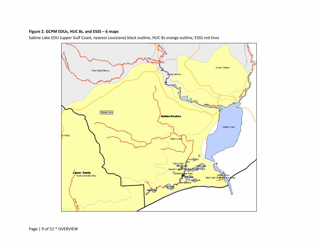
Page | 9 of 51 * OVERVIEW
Figure 2. GCPM EDUs, HUC 8s, and ESSS – 6 maps Sabine Lake EDU (upper Gulf Coast, nearest Louisiana) black outline, HUC 8s orange outline, ESSS red lines
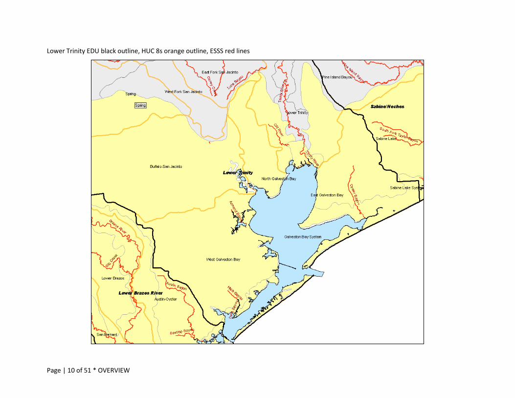
Page | 10 of 51 * OVERVIEW
Lower Trinity EDU black outline, HUC 8s orange outline, ESSS red lines

Page | 11 of 51 * OVERVIEW
Lower Brazos River and Lower Colorado River EDUs black outline, HUC 8s orange outline, ESSS red lines
Page | 12 of 51 * OVERVIEW
Guadalupe/San Antonio EDU black outline, HUC 8 orange outline, ESSS red lines

Page | 13 of 51 * OVERVIEW
Corpus Christi/Frio/Nueces EDU black outline, HUC 8s orange outline, ESSS red lines
Page | 14 of 51 * OVERVIEW
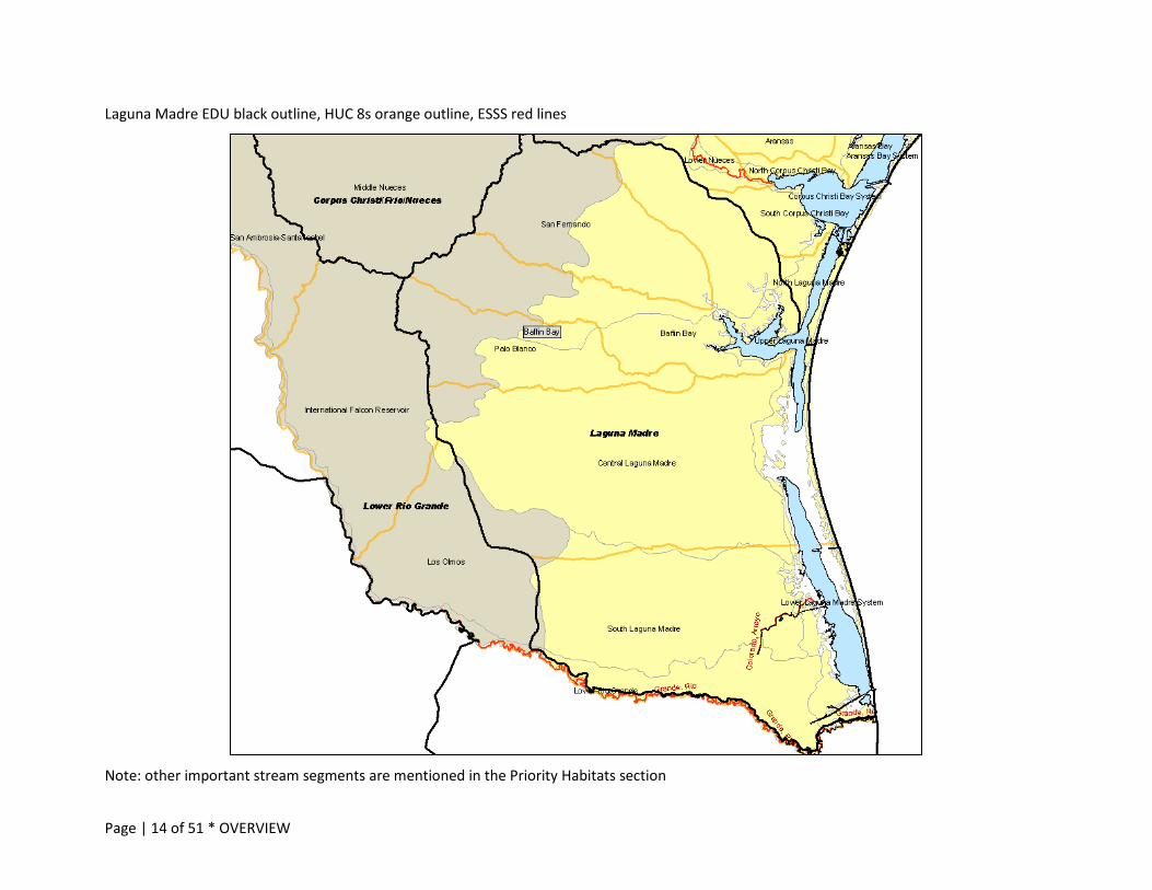
Laguna Madre EDU black outline, HUC 8s orange outline, ESSS red lines
Note: other important stream segments are mentioned in the Priority Habitats section

Page | 15 of 51 * RARE SPECIES and COMMUNITIES
RARE SPECIES AND COMMUNITIES
While most conservation work is done at the habitat level to address issues and threats, Action Plans’ stated primary purpose is to improve and sustain species’ populations and prevent the need to list species as federally or state threatened or endangered.7 The Species of Greatest Conservation Need (SGCN) list, one of the Eight Required Elements in all states’ Action Plans, is the foundation for the habitat- and issues- based actions in the Plan. In Texas, we’ve also identified Rare Communities for this planning process. For more information about how the SGCN and Rare Communities lists were developed, including the changes from the 2005 list, see the Overview Handbook.8
Species and rare communities included in the 2012 TCAP Final SGCN and Rare Communities lists are supported by current science, peer-reviewed references and/or other dependable, accessible source documentation, and expert opinion.9 Each species has a NatureServe calculated state and global conservation rank, which accounts for abundance, stability and threats.10 Additionally, several species have federal11 and/or state12 listing (endangered, threatened, candidate) status. See the key to conservation status and listing ranks13 on the TPWD TCAP 2012 website. The revised lists for TCAP 2012 are substantial and representative of conservation targets needing attention in this Plan and are sorted into the following categories:
Mammals Freshwater Fishes Birds Marine Mammals Bay and Estuary Fishes Invertebrates Reptiles and Amphibians Marine Fishes Plants Marine Reptiles Plant Communities
Both the SGCN and Rare Communities Lists are on the TCAP 2012 website as large-but-sortable Microsoft Excel files: http://www.tpwd.state.tx.us/landwater/land/tcap/sgcn.phtml
Once you open this webpage, you can choose to look at the SGCN or Rare Communities lists. In each workbook, the first bottom tab is the complete final statewide compiled list, with habitat information and additional references where available; each ecoregion tab in the workbook provides an excerpt of the statewide list, sorted to contain just the ecoregion’s species or communities.
PRIORITY HABITATS
Nationally, an SGCN list forms a basis for every Action Plan; however, species conservation cannot be successful without defining the lands and waters species need to survive and thrive. If it was only important to know about individuals or even populations, we could put representatives in zoos or herbaria or other curated collections and that would be enough; but, it’s not …. It’s important to
7 Association of Fish and Wildlife Agencies. 2011. State Wildlife Action Plans. http://www.wildlifeactionplans.org/ 8 TPWD. 2012. Texas Conservation Action Plan: Overview Handbook. http://www.tpwd.state.tx.us/landwater/land/tcap/documents/tcap_draft_overview.pdf 9 TPWD. 2012. Texas Conservation Action Plan: Species of Greatest Conservation Need List and Rare Communities Lists. http://www.tpwd.state.tx.us/landwater/land/tcap/sgcn.phtml 10 NatureServe. 2011. A network connecting science and conservation (online resources). http://www.natureserve.org/explorer (accessed 2011). 11 USFWS. 2011. Endangered Species List, by state and county. http://www.fws.gov/southwest/es/EndangeredSpecies/lists/ListSpecies.cfm (accessed 2011). 12 TPWD. 2011. State Listed Species. http://www.tpwd.state.tx.us/landwater/land/maps/gis/ris/endangered_species (accessed 2011) 13 TPWD. 2011. Texas Conservation Action Plan: Key to Conservation Status and Listing Ranks. http://www.tpwd.state.tx.us/landwater/land/tcap/documents/species_key_tcap_2011.pdf
Page | 16 of 51 * PRIORITY HABITATS
conserve populations in the context in which they thrive, to the best of their abilities, where they can contribute to and benefit from the systems in which they live.
Broad habitat categories were developed to organize all ecoregional handbooks.14
See also the Statewide/Multi-region handbook for habitats that are of broader importance – shared with many other regions and/or other states or nations (e.g. riparian or migratory species’ habitats as a general category).
See documentation for Ecoregions of Texas and the Texas Ecological Mapping Systems Project.15
Priority habitats in these ecoregions which support SGCN were identified through workshops, surveys and other ecologists’ and/or literature and are listed in Table 3.
14 http://www.tpwd.state.tx.us/landwater/land/tcap/documents/habitat_categories_tcap_2011.pdf 15 Griffith, G. 2010. Level III North American Terrestrial Ecoregions: United States Descriptions. Prepared for the North American Commission for Environmental Cooperation (www.cec.org), version May 11, 2010. Corvallis, Oregon. Griffith, G.E., S.A. Bryce, J.M. Omernik, J.A. Comstock, A.C. Rogers, B. Harrison, S.L. Hatch and D. Bezanson. 2007. Ecoregions of Texas. R.S. Geological Survey, Reston VA. http://www.epa.gov/wed/pages/ecoregions/tx_eco.htm (accessed May 2009). TPWD, Missouri Resources Assessment Partnership, and Texas Natural Resources Information Service. In progress, 2005 – 2012. Ecological Systems Classification and Mapping Project http://www.tpwd.state.tx.us/landwater/land/maps/gis/tescp/index.phtml (accessed 2010). Austin TX.
Page | 17 of 51 * PRIORITY HABITATS
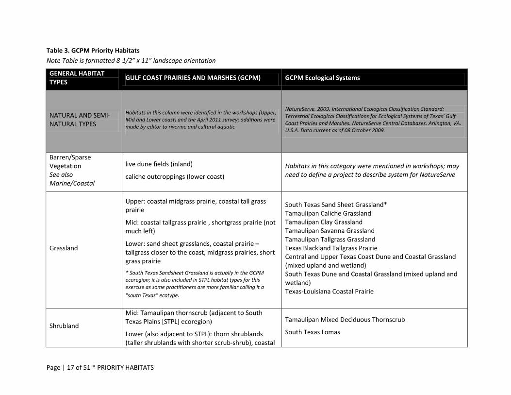
Table 3. GCPM Priority Habitats Note Table is formatted 8-1/2” x 11” landscape orientation
GENERAL HABITAT TYPES GULF COAST PRAIRIES AND MARSHES (GCPM) GCPM Ecological Systems
NATURAL AND SEMI-NATURAL TYPES
Habitats in this column were identified in the workshops (Upper, Mid and Lower coast) and the April 2011 survey; additions were made by editor to riverine and cultural aquatic
NatureServe. 2009. International Ecological Classification Standard: Terrestrial Ecological Classifications for Ecological Systems of Texas’ Gulf Coast Prairies and Marshes. NatureServe Central Databases. Arlington, VA. U.S.A. Data current as of 08 October 2009.
Barren/Sparse Vegetation See also Marine/Coastal
live dune fields (inland)
caliche outcroppings (lower coast) Habitats in this category were mentioned in workshops; may need to define a project to describe system for NatureServe
Grassland
Upper: coastal midgrass prairie, coastal tall grass prairie
Mid: coastal tallgrass prairie , shortgrass prairie (not much left)
Lower: sand sheet grasslands, coastal prairie – tallgrass closer to the coast, midgrass prairies, short grass prairie
* South Texas Sandsheet Grassland is actually in the GCPM ecoregion; it is also included in STPL habitat types for this exercise as some practitioners are more familiar calling it a "south Texas" ecotype.
South Texas Sand Sheet Grassland* Tamaulipan Caliche Grassland Tamaulipan Clay Grassland Tamaulipan Savanna Grassland Tamaulipan Tallgrass Grassland Texas Blackland Tallgrass Prairie Central and Upper Texas Coast Dune and Coastal Grassland (mixed upland and wetland) South Texas Dune and Coastal Grassland (mixed upland and wetland) Texas-Louisiana Coastal Prairie
Shrubland
Mid: Tamaulipan thornscrub (adjacent to South Texas Plains [STPL] ecoregion)
Lower (also adjacent to STPL): thorn shrublands (taller shrublands with shorter scrub-shrub), coastal
Tamaulipan Mixed Deciduous Thornscrub
South Texas Lomas
Page | 18 of 51 * PRIORITY HABITATS
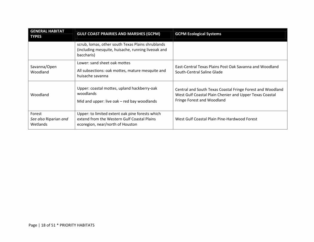
GENERAL HABITAT TYPES GULF COAST PRAIRIES AND MARSHES (GCPM) GCPM Ecological Systems
scrub, lomas, other south Texas Plains shrublands (including mesquite, huisache, running liveoak and baccharis)
Savanna/Open Woodland
Lower: sand sheet oak mottes
All subsections: oak mottes, mature mesquite and huisache savanna
East-Central Texas Plains Post Oak Savanna and Woodland South-Central Saline Glade
Woodland Upper: coastal mottes, upland hackberry-oak woodlands
Mid and upper: live oak – red bay woodlands
Central and South Texas Coastal Fringe Forest and Woodland West Gulf Coastal Plain Chenier and Upper Texas Coastal Fringe Forest and Woodland
Forest See also Riparian and Wetlands
Upper: to limited extent oak pine forests which extend from the Western Gulf Coastal Plains ecoregion, near/north of Houston
West Gulf Coastal Plain Pine-Hardwood Forest
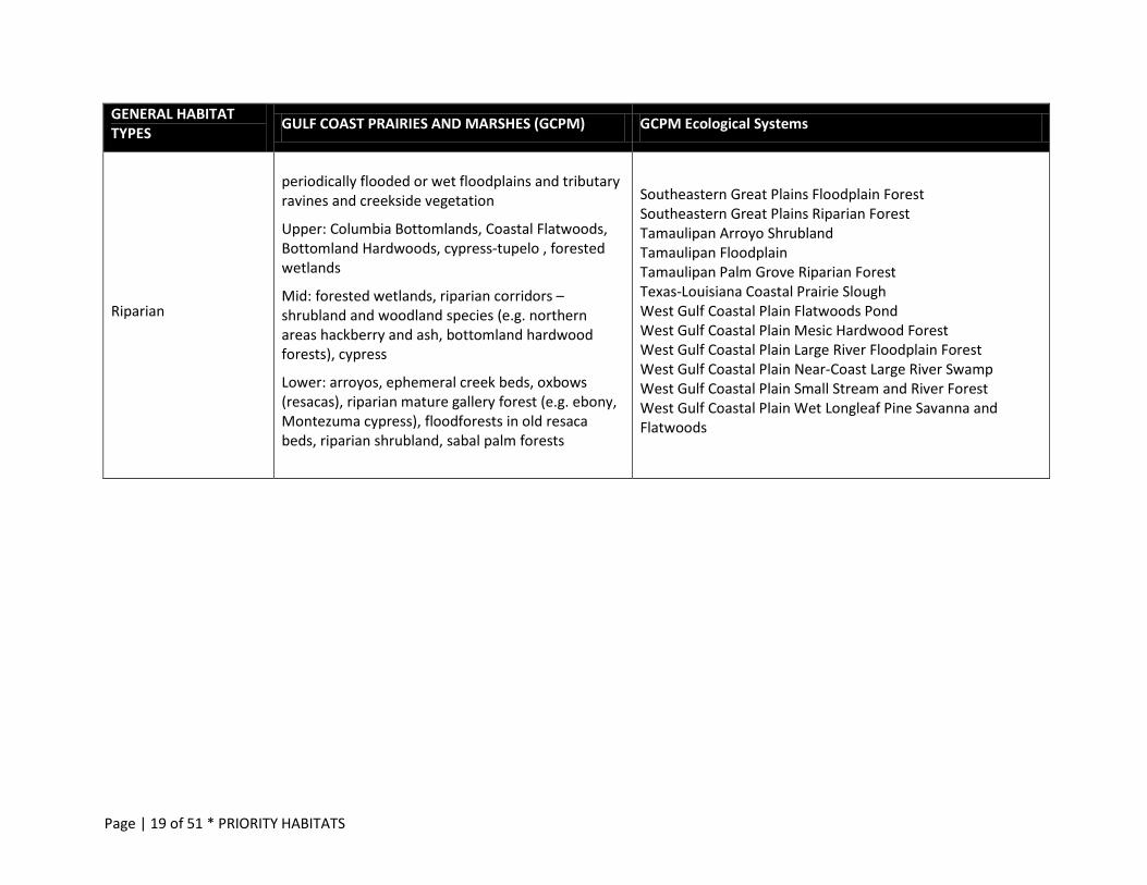
Page | 19 of 51 * PRIORITY HABITATS
GENERAL HABITAT TYPES GULF COAST PRAIRIES AND MARSHES (GCPM) GCPM Ecological Systems
Riparian
periodically flooded or wet floodplains and tributary ravines and creekside vegetation
Upper: Columbia Bottomlands, Coastal Flatwoods, Bottomland Hardwoods, cypress-tupelo , forested wetlands
Mid: forested wetlands, riparian corridors –shrubland and woodland species (e.g. northern areas hackberry and ash, bottomland hardwood forests), cypress
Lower: arroyos, ephemeral creek beds, oxbows (resacas), riparian mature gallery forest (e.g. ebony, Montezuma cypress), floodforests in old resaca beds, riparian shrubland, sabal palm forests
Southeastern Great Plains Floodplain Forest Southeastern Great Plains Riparian Forest Tamaulipan Arroyo Shrubland Tamaulipan Floodplain Tamaulipan Palm Grove Riparian Forest Texas-Louisiana Coastal Prairie Slough West Gulf Coastal Plain Flatwoods Pond West Gulf Coastal Plain Mesic Hardwood Forest West Gulf Coastal Plain Large River Floodplain Forest West Gulf Coastal Plain Near-Coast Large River Swamp West Gulf Coastal Plain Small Stream and River Forest West Gulf Coastal Plain Wet Longleaf Pine Savanna and Flatwoods
Page | 20 of 51 * PRIORITY HABITATS
GENERAL HABITAT TYPES GULF COAST PRAIRIES AND MARSHES (GCPM) GCPM Ecological Systems
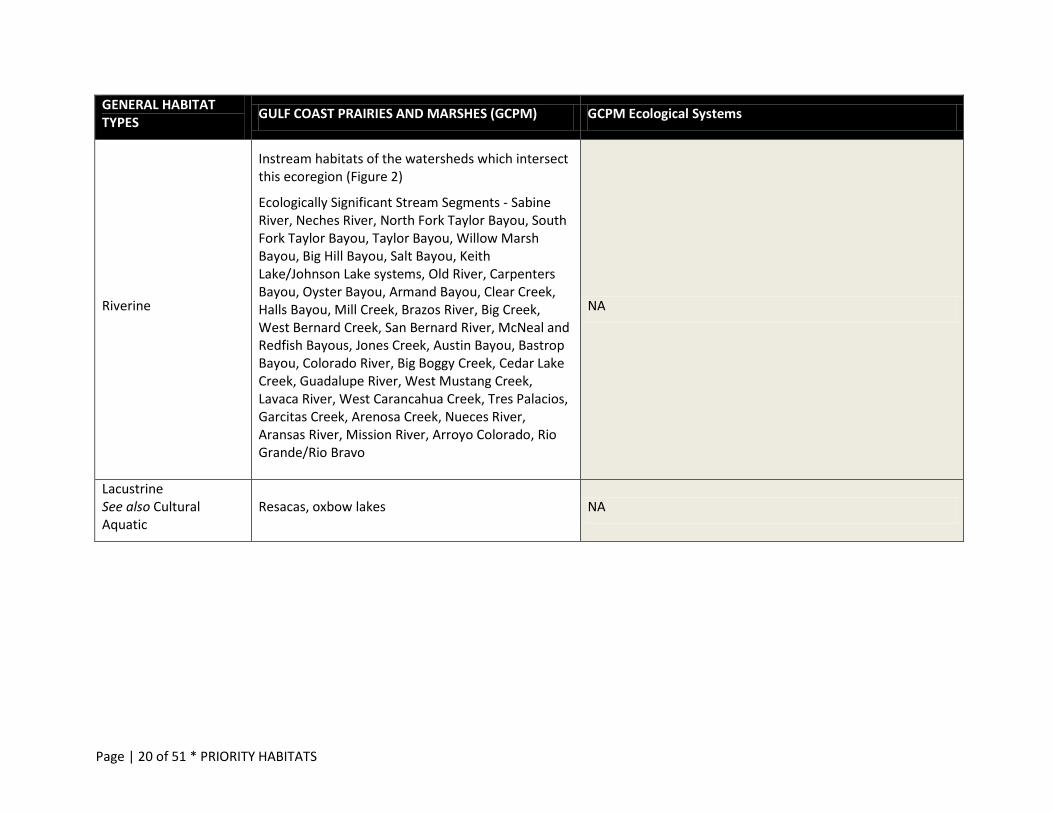
Riverine
Instream habitats of the watersheds which intersect this ecoregion (Figure 2)
Ecologically Significant Stream Segments - Sabine River, Neches River, North Fork Taylor Bayou, South Fork Taylor Bayou, Taylor Bayou, Willow Marsh Bayou, Big Hill Bayou, Salt Bayou, Keith Lake/Johnson Lake systems, Old River, Carpenters Bayou, Oyster Bayou, Armand Bayou, Clear Creek, Halls Bayou, Mill Creek, Brazos River, Big Creek, West Bernard Creek, San Bernard River, McNeal and Redfish Bayous, Jones Creek, Austin Bayou, Bastrop Bayou, Colorado River, Big Boggy Creek, Cedar Lake Creek, Guadalupe River, West Mustang Creek, Lavaca River, West Carancahua Creek, Tres Palacios, Garcitas Creek, Arenosa Creek, Nueces River, Aransas River, Mission River, Arroyo Colorado, Rio Grande/Rio Bravo
NA
Lacustrine See also Cultural Aquatic
Resacas, oxbow lakes NA
Page | 21 of 51 * PRIORITY HABITATS
GENERAL HABITAT TYPES GULF COAST PRAIRIES AND MARSHES (GCPM) GCPM Ecological Systems
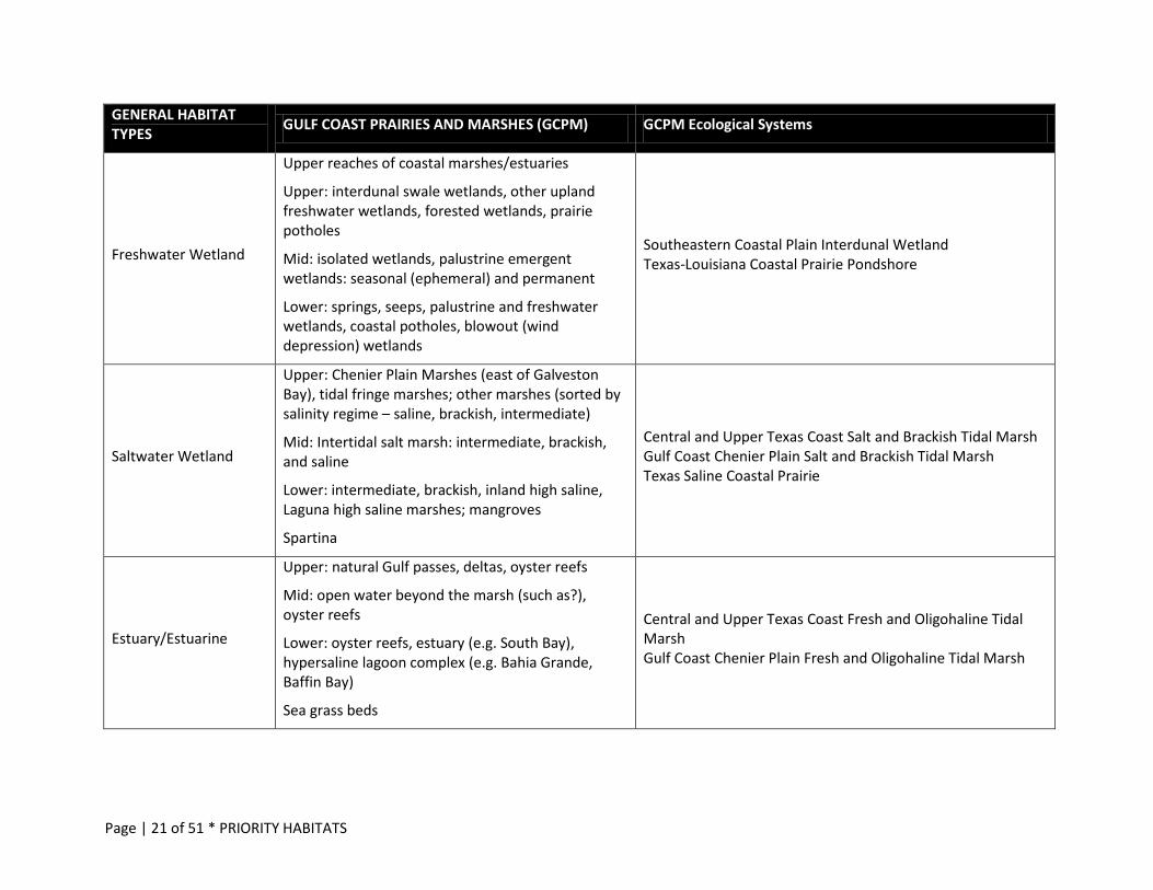
Freshwater Wetland
Upper reaches of coastal marshes/estuaries
Upper: interdunal swale wetlands, other upland freshwater wetlands, forested wetlands, prairie potholes
Mid: isolated wetlands, palustrine emergent wetlands: seasonal (ephemeral) and permanent
Lower: springs, seeps, palustrine and freshwater wetlands, coastal potholes, blowout (wind depression) wetlands
Southeastern Coastal Plain Interdunal Wetland Texas-Louisiana Coastal Prairie Pondshore
Saltwater Wetland
Upper: Chenier Plain Marshes (east of Galveston Bay), tidal fringe marshes; other marshes (sorted by salinity regime – saline, brackish, intermediate)
Mid: Intertidal salt marsh: intermediate, brackish, and saline
Lower: intermediate, brackish, inland high saline, Laguna high saline marshes; mangroves
Spartina
Central and Upper Texas Coast Salt and Brackish Tidal Marsh Gulf Coast Chenier Plain Salt and Brackish Tidal Marsh Texas Saline Coastal Prairie
Estuary/Estuarine
Upper: natural Gulf passes, deltas, oyster reefs
Mid: open water beyond the marsh (such as?), oyster reefs
Lower: oyster reefs, estuary (e.g. South Bay), hypersaline lagoon complex (e.g. Bahia Grande, Baffin Bay)
Sea grass beds
Central and Upper Texas Coast Fresh and Oligohaline Tidal Marsh Gulf Coast Chenier Plain Fresh and Oligohaline Tidal Marsh
Page | 22 of 51 * PRIORITY HABITATS
GENERAL HABITAT TYPES GULF COAST PRAIRIES AND MARSHES (GCPM) GCPM Ecological Systems
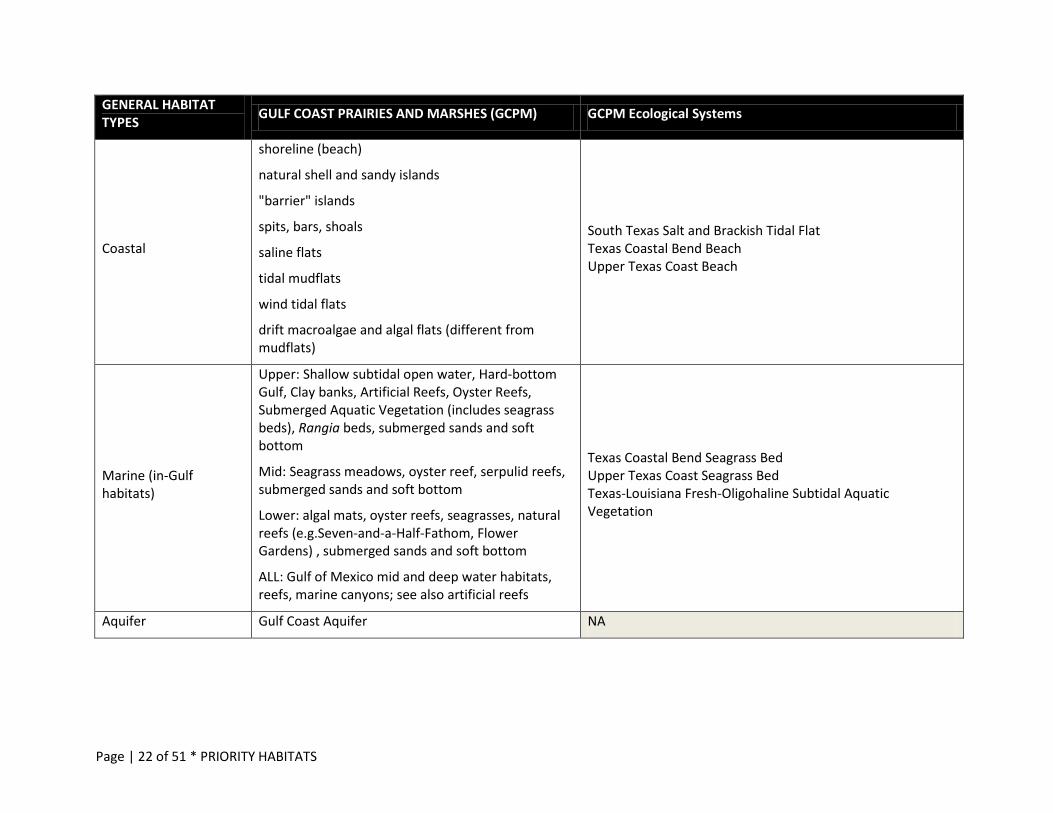
Coastal
shoreline (beach)
natural shell and sandy islands
"barrier" islands
spits, bars, shoals
saline flats
tidal mudflats
wind tidal flats
drift macroalgae and algal flats (different from mudflats)
South Texas Salt and Brackish Tidal Flat Texas Coastal Bend Beach Upper Texas Coast Beach
Marine (in-Gulf habitats)
Upper: Shallow subtidal open water, Hard-bottom Gulf, Clay banks, Artificial Reefs, Oyster Reefs, Submerged Aquatic Vegetation (includes seagrass beds), Rangia beds, submerged sands and soft bottom
Mid: Seagrass meadows, oyster reef, serpulid reefs, submerged sands and soft bottom
Lower: algal mats, oyster reefs, seagrasses, natural reefs (e.g.Seven-and-a-Half-Fathom, Flower Gardens) , submerged sands and soft bottom
ALL: Gulf of Mexico mid and deep water habitats, reefs, marine canyons; see also artificial reefs
Texas Coastal Bend Seagrass Bed Upper Texas Coast Seagrass Bed Texas-Louisiana Fresh-Oligohaline Subtidal Aquatic Vegetation
Aquifer Gulf Coast Aquifer NA
Page | 23 of 51 * PRIORITY HABITATS
GENERAL HABITAT TYPES GULF COAST PRAIRIES AND MARSHES (GCPM) GCPM Ecological Systems
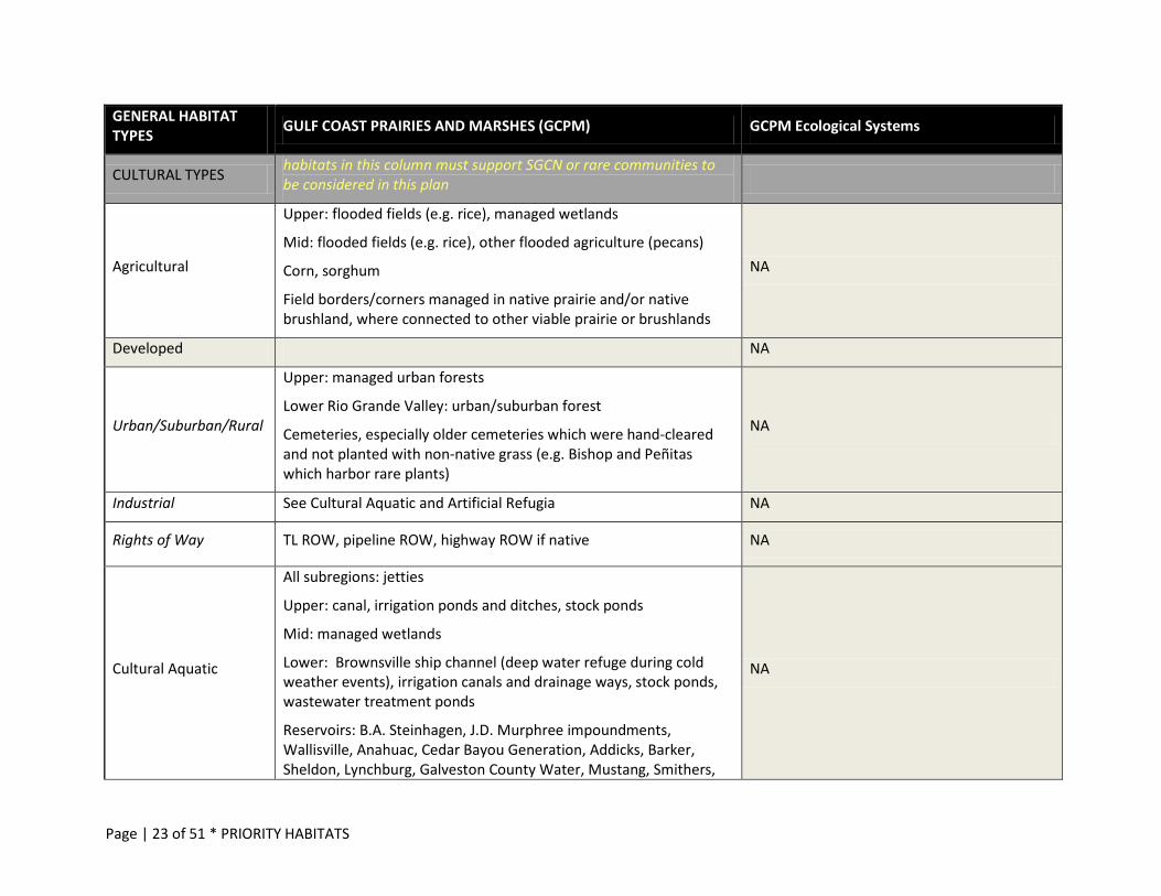
CULTURAL TYPES habitats in this column must support SGCN or rare communities to be considered in this plan
Agricultural
Upper: flooded fields (e.g. rice), managed wetlands
Mid: flooded fields (e.g. rice), other flooded agriculture (pecans)
Corn, sorghum
Field borders/corners managed in native prairie and/or native brushland, where connected to other viable prairie or brushlands
NA
Developed NA
Urban/Suburban/Rural
Upper: managed urban forests
Lower Rio Grande Valley: urban/suburban forest
Cemeteries, especially older cemeteries which were hand-cleared and not planted with non-native grass (e.g. Bishop and Peñitas which harbor rare plants)
NA
Industrial See Cultural Aquatic and Artificial Refugia NA
Rights of Way TL ROW, pipeline ROW, highway ROW if native NA
Cultural Aquatic
All subregions: jetties
Upper: canal, irrigation ponds and ditches, stock ponds
Mid: managed wetlands
Lower: Brownsville ship channel (deep water refuge during cold weather events), irrigation canals and drainage ways, stock ponds, wastewater treatment ponds
Reservoirs: B.A. Steinhagen, J.D. Murphree impoundments, Wallisville, Anahuac, Cedar Bayou Generation, Addicks, Barker, Sheldon, Lynchburg, Galveston County Water, Mustang, Smithers,
NA
Page | 24 of 51 * PRIORITY HABITATS
GENERAL HABITAT TYPES GULF COAST PRAIRIES AND MARSHES (GCPM) GCPM Ecological Systems
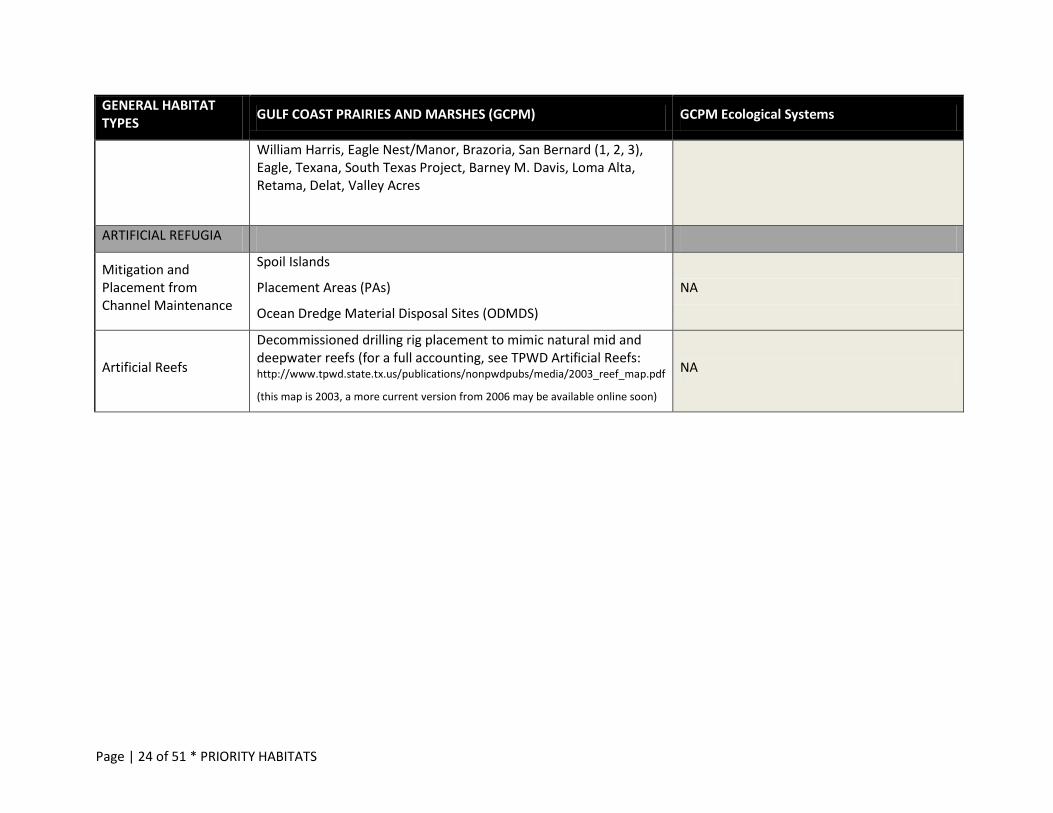
William Harris, Eagle Nest/Manor, Brazoria, San Bernard (1, 2, 3), Eagle, Texana, South Texas Project, Barney M. Davis, Loma Alta, Retama, Delat, Valley Acres
ARTIFICIAL REFUGIA
Mitigation and Placement from Channel Maintenance
Spoil Islands
Placement Areas (PAs)
Ocean Dredge Material Disposal Sites (ODMDS)
NA
Artificial Reefs
Decommissioned drilling rig placement to mimic natural mid and deepwater reefs (for a full accounting, see TPWD Artificial Reefs: http://www.tpwd.state.tx.us/publications/nonpwdpubs/media/2003_reef_map.pdf
(this map is 2003, a more current version from 2006 may be available online soon)
NA

Page | 25 of 51 * PRIORITY HABITATS
SHARED HABITAT PRIORITIES WITH ADJACENT STATES
Texas shares its border with four states – New Mexico, Oklahoma, Arkansas, and Louisiana. GCPM crosses into Louisiana at the northern end of the region in Texas. Table 4 identifies habitat priorities which have been identified in the Louisiana Wildlife Action Plan which may be adjacent to the GCPM. Every adjacent state’s Action Plan mentions the importance of intact native riparian zones and floodplains, high quality instream habitats, wetlands of all types, and native grasslands. These habitat types are also found in the GCPM and are priorities for conservation in this ecoregion. See Statewide/Multi-region handbook for broadscale Conservation Actions for these priorities and those in the Gulf of Mexico.
Table 4. Shared Habitat Priorities with Adjacent State – Louisiana Adjacent States
Ecoregions Shared with Texas Habitat Priorities Shared with Texas16
Louisiana (LA)
Western Gulf Coastal Plain Gulf Coast Prairies and Marshes
bottomland forests coastal live oak-hackberry forest (chenier) cypress swamp seeps, bogs, other wetlands prairies, glades and barrens coastal marshes upland coastal grasslands ephemeral and perennial tributaries and mainstem of the Sabine River, and associated riparian zones and floodplains Marine habitats beyond the Gulf Intracoastal Waterway to three miles TX – LA HUC 8 at high risk: Sabine Lake
16 Priorities were determined by reviewing the state’s Action Plan online (Louisiana Wildlife Action Plan. 2006. http://www.wlf.louisiana.gov/wildlife/wildlife-action-plan-details) and National Fish Habitat Risk Assessment Viewer online (NBII and USGS. 2011. http://fishhabitat.org/index.php?option=com_content&view=category&layout=blog&id=42&Itemid=61).
Page | 26 of 51 * ISSUES
ISSUES
There are activities and conditions which may negatively affect the SGCN populations, rare communities, and the habitats on which they depend in this region. These issues can include direct or indirect harm (e.g. inappropriate mining reclamation which uses non-native vegetation or indirectly provides an opportunity for non-native invasive vegetation, streambed gravel mining that directly removes spawning habitat and/or indirectly creates poor water quality downstream) plus basic “gaps” that prevent us from acting most effectively (e.g. lack of information, lack of coordination to share current data, incompatible practices among land managers, lack of funding). For information about how this list was developed, see the Overview Handbook and the descriptions of the broad issue categories.17
Habitat fragmentation and habitat loss, including open-space land conversion, are always going to be broad issues that need to be addressed, at various scales – local, regional, statewide, interstate, and international. These are such broad categories and, depending on the scale of the problem, these three issues can be symptoms or causes of many other issues. These three issues are not specifically included in the Issues list, although they may be implied in many of the categories presented.
The issues covered in the GCPM Ecoregion Handbook in Table 5 attempt to present more of the specific causes of SGCN, rare communities, and habitats’ decline, providing appropriate context to help target our actions, identified later in this handbook. Several of the habitat types in this handbook are also considered priority habitats in the Statewide/Multi-region handbook.
Special Note:
In this ecoregion, perhaps more than any other, the disruption of natural processes is fairly well-understood, critical to all SGCN and rare communities’ conservation, and tied to many other issues or impacts.
In addition to coastal prairie and other priority terrestrial habitats, marsh and estuary health and function are one of the keystone elements for conservation in this plan (see also Statewide Handbook), dependent on freshwater inputs from the river systems that drain the lands of Texas to the Gulf of Mexico.
Estuary vegetation, bottoms and shorelines are all affected by lack of instream flows, saltwater intrusion and tidal influence changes, erosion and human disturbances which contribute to these other factors through transportation and navigation projects and practices, non-jurisdictional wetlands vulnerability, upstream reservoir and dam operations, oil and gas development and delivery and stormwater runoff from upland activities. In the table below, many of these issues are discussed as are their impacts. Be mindful that many of these are all related to estuary health and need to be addressed in conservation actions in a related way to be effective in changing the condition and sustainability of our important natural resources of this region.
17 TPWD. 2012. Texas Conservation Action Plan: Broad Issues Categories http://www.tpwd.state.tx.us/landwater/land/tcap/documents/broad_issues_categories.pdf
Page | 27 of 51 * ISSUES
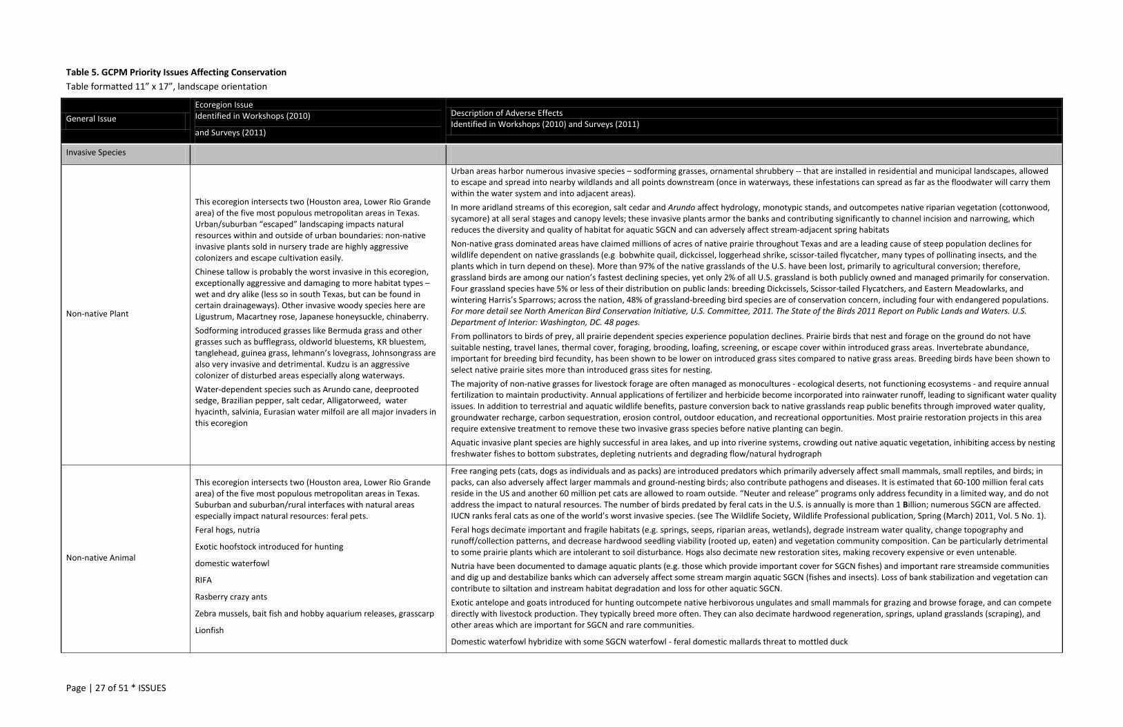
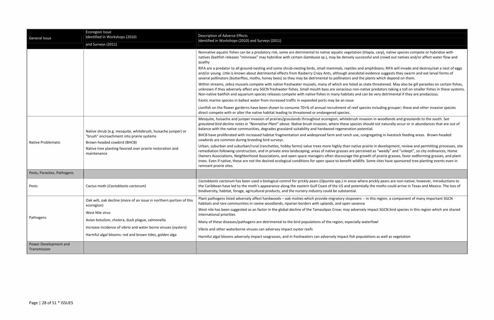
Table 5. GCPM Priority Issues Affecting Conservation Table formatted 11” x 17”, landscape orientation
General Issue Ecoregion Issue Identified in Workshops (2010)
and Surveys (2011)
Description of Adverse Effects Identified in Workshops (2010) and Surveys (2011)
Invasive Species
Non-native Plant
This ecoregion intersects two (Houston area, Lower Rio Grande area) of the five most populous metropolitan areas in Texas. Urban/suburban “escaped” landscaping impacts natural resources within and outside of urban boundaries: non-native invasive plants sold in nursery trade are highly aggressive colonizers and escape cultivation easily. Chinese tallow is probably the worst invasive in this ecoregion, exceptionally aggressive and damaging to more habitat types – wet and dry alike (less so in south Texas, but can be found in certain drainageways). Other invasive woody species here are Ligustrum, Macartney rose, Japanese honeysuckle, chinaberry. Sodforming introduced grasses like Bermuda grass and other grasses such as bufflegrass, oldworld bluestems, KR bluestem, tanglehead, guinea grass, lehmann’s lovegrass, Johnsongrass are also very invasive and detrimental. Kudzu is an aggressive colonizer of disturbed areas especially along waterways. Water-dependent species such as Arundo cane, deeprooted sedge, Brazilian pepper, salt cedar, Alligatorweed, water hyacinth, salvinia, Eurasian water milfoil are all major invaders in this ecoregion
Urban areas harbor numerous invasive species – sodforming grasses, ornamental shrubbery -- that are installed in residential and municipal landscapes, allowed to escape and spread into nearby wildlands and all points downstream (once in waterways, these infestations can spread as far as the floodwater will carry them within the water system and into adjacent areas). In more aridland streams of this ecoregion, salt cedar and Arundo affect hydrology, monotypic stands, and outcompetes native riparian vegetation (cottonwood, sycamore) at all seral stages and canopy levels; these invasive plants armor the banks and contributing significantly to channel incision and narrowing, which reduces the diversity and quality of habitat for aquatic SGCN and can adversely affect stream-adjacent spring habitats Non-native grass dominated areas have claimed millions of acres of native prairie throughout Texas and are a leading cause of steep population declines for wildlife dependent on native grasslands (e.g bobwhite quail, dickcissel, loggerhead shrike, scissor-tailed flycatcher, many types of pollinating insects, and the plants which in turn depend on these). More than 97% of the native grasslands of the U.S. have been lost, primarily to agricultural conversion; therefore, grassland birds are among our nation’s fastest declining species, yet only 2% of all U.S. grassland is both publicly owned and managed primarily for conservation. Four grassland species have 5% or less of their distribution on public lands: breeding Dickcissels, Scissor-tailed Flycatchers, and Eastern Meadowlarks, and wintering Harris’s Sparrows; across the nation, 48% of grassland-breeding bird species are of conservation concern, including four with endangered populations. For more detail see North American Bird Conservation Initiative, U.S. Committee, 2011. The State of the Birds 2011 Report on Public Lands and Waters. U.S. Department of Interior: Washington, DC. 48 pages. From pollinators to birds of prey, all prairie dependent species experience population declines. Prairie birds that nest and forage on the ground do not have suitable nesting, travel lanes, thermal cover, foraging, brooding, loafing, screening, or escape cover within introduced grass areas. Invertebrate abundance, important for breeding bird fecundity, has been shown to be lower on introduced grass sites compared to native grass areas. Breeding birds have been shown to select native prairie sites more than introduced grass sites for nesting. The majority of non-native grasses for livestock forage are often managed as monocultures - ecological deserts, not functioning ecosystems - and require annual fertilization to maintain productivity. Annual applications of fertilizer and herbicide become incorporated into rainwater runoff, leading to significant water quality issues. In addition to terrestrial and aquatic wildlife benefits, pasture conversion back to native grasslands reap public benefits through improved water quality, groundwater recharge, carbon sequestration, erosion control, outdoor education, and recreational opportunities. Most prairie restoration projects in this area require extensive treatment to remove these two invasive grass species before native planting can begin. Aquatic invasive plant species are highly successful in area lakes, and up into riverine systems, crowding out native aquatic vegetation, inhibiting access by nesting freshwater fishes to bottom substrates, depleting nutrients and degrading flow/natural hydrograph
Non-native Animal
This ecoregion intersects two (Houston area, Lower Rio Grande area) of the five most populous metropolitan areas in Texas. Suburban and suburban/rural interfaces with natural areas especially impact natural resources: feral pets. Feral hogs, nutria
Exotic hoofstock introduced for hunting
domestic waterfowl
RIFA
Rasberry crazy ants
Zebra mussels, bait fish and hobby aquarium releases, grasscarp
Lionfish
Free ranging pets (cats, dogs as individuals and as packs) are introduced predators which primarily adversely affect small mammals, small reptiles, and birds; in packs, can also adversely affect larger mammals and ground-nesting birds; also contribute pathogens and diseases. It is estimated that 60-100 million feral cats reside in the US and another 60 million pet cats are allowed to roam outside. “Neuter and release” programs only address fecundity in a limited way, and do not address the impact to natural resources. The number of birds predated by feral cats in the U.S. is annually is more than 1 Billion; numerous SGCN are affected. IUCN ranks feral cats as one of the world’s worst invasive species. (see The Wildlife Society, Wildlife Professional publication, Spring (March) 2011, Vol. 5 No. 1). Feral hogs decimate important and fragile habitats (e.g. springs, seeps, riparian areas, wetlands), degrade instream water quality, change topography and runoff/collection patterns, and decrease hardwood seedling viability (rooted up, eaten) and vegetation community composition. Can be particularly detrimental to some prairie plants which are intolerant to soil disturbance. Hogs also decimate new restoration sites, making recovery expensive or even untenable. Nutria have been documented to damage aquatic plants (e.g. those which provide important cover for SGCN fishes) and important rare streamside communities and dig up and destabilize banks which can adversely affect some stream margin aquatic SGCN (fishes and insects). Loss of bank stabilization and vegetation can contribute to siltation and instream habitat degradation and loss for other aquatic SGCN. Exotic antelope and goats introduced for hunting outcompete native herbivorous ungulates and small mammals for grazing and browse forage, and can compete directly with livestock production. They typically breed more often. They can also decimate hardwood regeneration, springs, upland grasslands (scraping), and other areas which are important for SGCN and rare communities.
Domestic waterfowl hybridize with some SGCN waterfowl - feral domestic mallards threat to mottled duck
Page | 28 of 51 * ISSUES
General Issue Ecoregion Issue Identified in Workshops (2010)
and Surveys (2011)
Description of Adverse Effects Identified in Workshops (2010) and Surveys (2011)
Nonnative aquatic fishes can be a predatory risk, some are detrimental to native aquatic vegetation (tilapia, carp), native species compete or hybridize with natives (baitfish releases “minnows” may hybridize with certain Gambusia sp.), may be densely successful and crowd out natives and/or affect water flow and quality RIFA are a predator to all ground-nesting and some shrub-nesting birds, small mammals, reptiles and amphibians; RIFA will invade and destroy/eat a nest of eggs and/or young. Lttle is known about detrimental effects from Rasberry Crazy Ants, although anecdotal evidence suggests they swarm and eat larval forms of several pollinators (butterflies, moths, honey bees) so they may be detrimental to pollinators and the plants which depend on them. Within streams, zebra mussels compete with native freshwater mussels, many of which are listed as state threatened. May also be gill parasites on certain fishes, unknown if they adversely affect any SGCN freshwater fishes. Small mouth bass are voracious non-native predators taking a toll on smaller fishes in these systems. Non-native baitfish and aquarium species releases compete with native fishes in many habitats and can be very detrimental if they are predacious. Exotic marine species in ballast water from increased traffic in expanded ports may be an issue
Lionfish on the flower garderns have been shown to consume 70+% of annual recruitment of reef species including grouper; these and other invasive species direct compete with or alter the native habitat leading to threatened or endangered species.
Native Problematic
Native shrub (e.g. mesquite, whitebrush, huisache juniper) or "brush" encroachment into prairie systems Brown-headed cowbird (BHCB) Native tree planting favored over prairie restoration and maintenance
Mesquite, huisache and juniper invasion of prairies/grasslands throughout ecoregion, whitebrush invasion in woodlands and grasslands to the south. See grassland bird decline notes in “Nonnative Plant” above. Native brush invasion, where these species should not naturally occur or in abundances that are out of balance with the native communities, degrades grassland suitability and hardwood regeneration potential. BHCB have proliferated with increased habitat fragmentation and widespread farm and ranch use, congregating in livestock feeding areas. Brown-headed cowbirds are common during breeding bird surveys. Urban, suburban and suburban/rural (ranchettes, hobby farms) value trees more highly than native prairie in development, review and permitting processes, site remediation following construction, and in private area landscaping; areas of native grasses are perceived as “weedy” and “unkept”, so city ordinances, Home Owners Associations, Neighborhood Associations, and open space managers often discourage the growth of prairie grasses, favor sodforming grasses, and plant trees. Even if native, these are not the desired ecological conditions for open space to benefit wildlife. Some sites have sponsored tree planting events even in remnant prairie sites.
Pests, Parasites, Pathogens
Pests Cactus moth (Cactoblastis cactorum) Cactoblastis cactorum has been used a biological control for prickly pears (Opuntia spp.) in areas where prickly pears are non-native; however, introductions to the Caribbean have led to the moth’s appearance along the eastern Gulf Coast of the US and potentially the moths could arrive in Texas and Mexico. The loss of biodiversity, habitat, forage, agricultural products, and the nursery industry could be substantial.
Pathogens
Oak wilt, oak decline (more of an issue in northern portion of this ecoregion)
West Nile virus
Avian botulism, cholera, duck plague, salmonella
Increase incidence of vibrio and water borne viruses (oysters)
Harmful algal blooms: red and brown tides, golden alga
Plant pathogens listed adversely affect hardwoods – oak mottes which provide migratory stopovers -- in this region, a component of many important SGCN habitats and rare communities in ravine woodlands, riparian borders with uplands, and open savanna West nile has been suggested as an factor in the global decline of the Tamaulipas Crow; may adversely impact SGCN bird species in this region which are shared international priorities
Many of these diseases/pathogens are detrimental to the bird populations of the region, especially waterfowl
Vibrio and other waterborne viruses can adversey impact oyster reefs
Harmful algal blooms adversely impact seagrasses, and in freshwaters can adversely impact fish populations as well as vegetation
Power Development and Transmission
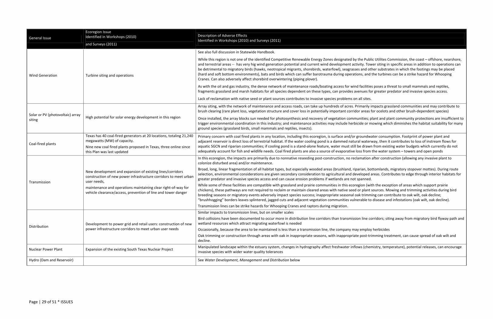
Page | 29 of 51 * ISSUES
General Issue Ecoregion Issue Identified in Workshops (2010)
and Surveys (2011)
Description of Adverse Effects Identified in Workshops (2010) and Surveys (2011)
Wind Generation Turbine siting and operations
See also full discussion in Statewide Handbook.
While this region is not one of the identified Competitive Renewable Energy Zones designated by the Public Utilites Commission, the coast – offshore, nearshore, and terrestrial areas -- has very hig wind generation potential and current wind development activity. Tower siting in specific areas in addition to operations can be detrimental to migratory birds (hawks, neotropical migrants, shorebirds, waterfowl), seagrasses and other substrates in which the footings may be placed (hard and soft bottom environments), bats and birds which can suffer barotrauma during operations, and the turbines can be a strike hazard for Whooping Cranes. Can also adversely affect shorebird overwintering (piping plover).
As with the oil and gas industry, the dense network of maintenance roads/boating access for wind facilities poses a threat to small mammals and reptiles, fragments grassland and marsh habitats for all species dependent on these types, can provides avenues for greater predator and invasive species access.
Lack of reclamation with native seed or plant sources contributes to invasive species problems on all sites.
Solar or PV (photovoltaic) array siting High potential for solar energy development in this region
Array siting, with the network of maintenance and access roads, can take up hundreds of acres. Primarily impacts grassland communities and may contribute to brush clearing (rare plant loss, vegetation structure and cover loss in potentially important corridor areas for ocelots and other brush-dependent species)
Once installed, the array blocks sun needed for photosynthesis and recovery of vegetation communities; plant and plant community protections are insufficient to trigger environmental coordination in this industry; and maintenance activities may include herbicide or mowing which diminishes the habitat suitability for many ground species (grassland birds, small mammals and reptiles, insects).
Coal-fired plants
Texas has 40 coal-fired generators at 20 locations, totaling 21,240 megawatts (MW) of capacity. Nine new coal fired plants proposed in Texas, three online since this Plan was last updated
Primary concern with coal fired plants in any location, including this ecoregion, is surface and/or groundwater consumption. Footprint of power plant and adjacent reservoir is direct loss of terrestrial habitat. If the water cooling pond is a dammed natural waterway, then it contributes to loss of instream flows for aquatic SGCN and riparian communities; if cooling pond is a stand-alone feature, water must still be drawn from existing water budgets which currently do not adequately account for fish and wildlife needs. Coal fired plants are also a source of evaporative loss from the water system – towers and open ponds
Transmission
New development and expansion of existing lines/corridors construction of new power infrastructure corridors to meet urban user needs, maintenance and operations maintaining clear right-of-way for vehicle clearance/access, prevention of line and tower danger
In this ecoregion, the impacts are primarily due to nonnative reseeding post-construction, no reclamation after construction (allowing any invasive plant to colonize disturbed area) and/or maintenance. Broad, long, linear fragmentation of all habitat types, but especially wooded areas (brushland, riparian, bottomlands, migratory stopover mottes). During route selection, environmental considerations are given secondary consideration to agricultural and developed areas. Contributes to edge through interior habitats for greater predator and invasive species access and can cause erosion problems if wetlands are not spanned. While some of these facilities are compatible with grassland and prairie communities in this ecoregion (with the exception of areas which support prairie chickens), these pathways are not required to reclaim or maintain cleared areas with native seed or plant sources. Mowing and trimming activities during bird breeding seasons or migratory events adversely impact species success; inappropriate seasonal oak trimming can contribute to oak wilt, oak decline; “brushhogging” borders leaves splintered, jagged cuts and adjacent vegetation communities vulnerable to disease and infestations (oak wilt, oak decline). Transmission lines can be strike hazards for Whooping Cranes and raptors during migration.
Distribution Development to power grid and retail users: construction of new power infrastructure corridors to meet urban user needs
Similar impacts to transmission lines, but on smaller scales Bird collisions have been documented to occur more in distribution line corridors than transmission line corridors; siting away from migratory bird flyway path and wetland resources which attract migrating waterfowl is needed Occasionally, because the area to be maintained is less than a transmission line, the company may employ herbicides Oak trimming or construction through areas with oak in inappropriate seasons, with inappropriate post-trimming treatment, can cause spread of oak wilt and decline.
Nuclear Power Plant Expansion of the existing South Texas Nuclear Project Manipulated landscape within the estuary system, changes in hydrography affect freshwater inflows (chemistry, temperature), potential releases, can encourage invasive species with wider water quality tolerances
Hydro (Dam and Reservoir)
See Water Development, Management and Distribution below
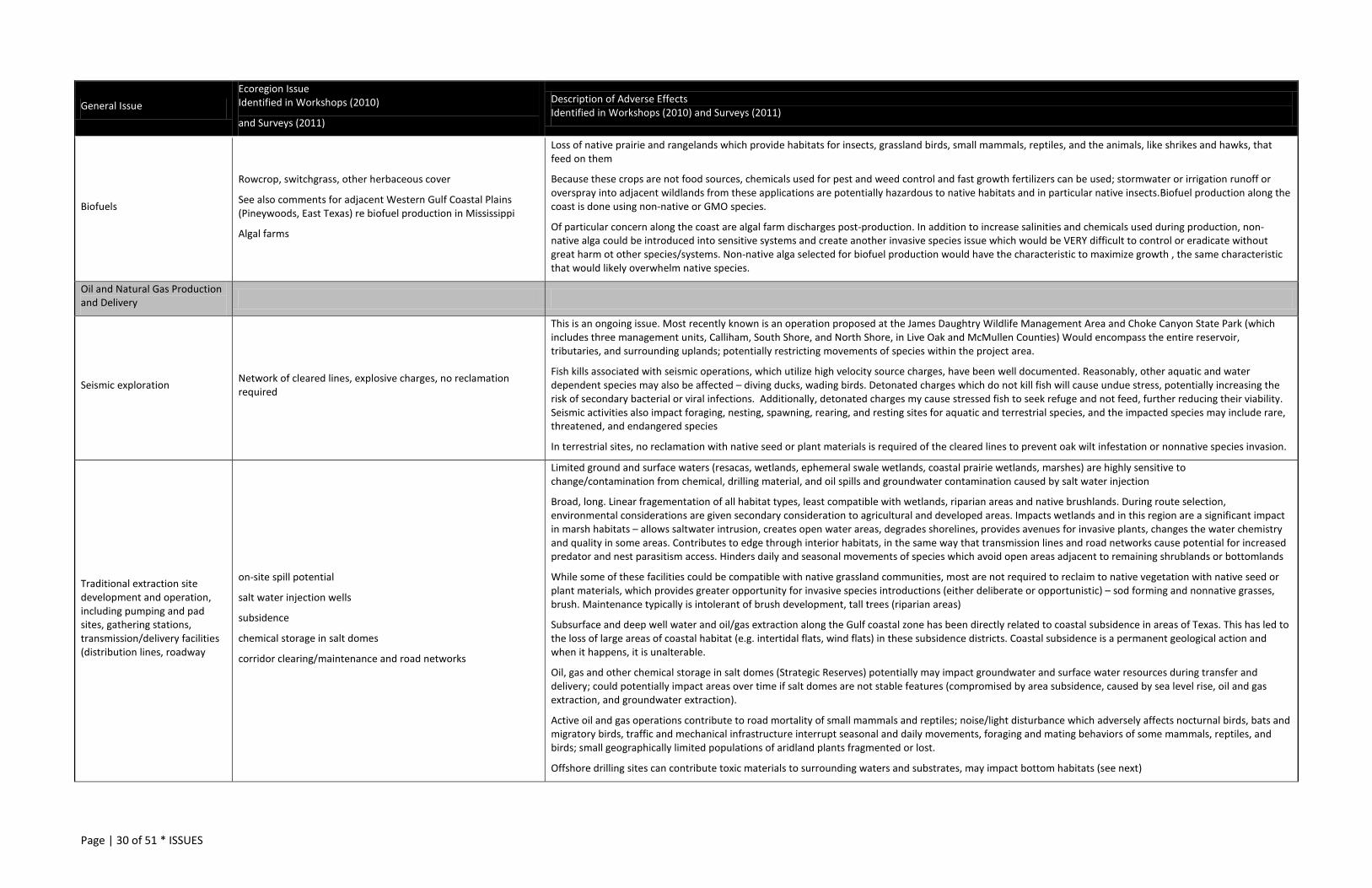
Page | 30 of 51 * ISSUES
General Issue Ecoregion Issue Identified in Workshops (2010)
and Surveys (2011)
Description of Adverse Effects Identified in Workshops (2010) and Surveys (2011)
Biofuels
Rowcrop, switchgrass, other herbaceous cover
See also comments for adjacent Western Gulf Coastal Plains (Pineywoods, East Texas) re biofuel production in Mississippi
Algal farms
Loss of native prairie and rangelands which provide habitats for insects, grassland birds, small mammals, reptiles, and the animals, like shrikes and hawks, that feed on them
Because these crops are not food sources, chemicals used for pest and weed control and fast growth fertilizers can be used; stormwater or irrigation runoff or overspray into adjacent wildlands from these applications are potentially hazardous to native habitats and in particular native insects.Biofuel production along the coast is done using non-native or GMO species.
Of particular concern along the coast are algal farm discharges post-production. In addition to increase salinities and chemicals used during production, non-native alga could be introduced into sensitive systems and create another invasive species issue which would be VERY difficult to control or eradicate without great harm ot other species/systems. Non-native alga selected for biofuel production would have the characteristic to maximize growth , the same characteristic that would likely overwhelm native species.
Oil and Natural Gas Production and Delivery
Seismic exploration Network of cleared lines, explosive charges, no reclamation required
This is an ongoing issue. Most recently known is an operation proposed at the James Daughtry Wildlife Management Area and Choke Canyon State Park (which includes three management units, Calliham, South Shore, and North Shore, in Live Oak and McMullen Counties) Would encompass the entire reservoir, tributaries, and surrounding uplands; potentially restricting movements of species within the project area.
Fish kills associated with seismic operations, which utilize high velocity source charges, have been well documented. Reasonably, other aquatic and water dependent species may also be affected – diving ducks, wading birds. Detonated charges which do not kill fish will cause undue stress, potentially increasing the risk of secondary bacterial or viral infections. Additionally, detonated charges my cause stressed fish to seek refuge and not feed, further reducing their viability. Seismic activities also impact foraging, nesting, spawning, rearing, and resting sites for aquatic and terrestrial species, and the impacted species may include rare, threatened, and endangered species
In terrestrial sites, no reclamation with native seed or plant materials is required of the cleared lines to prevent oak wilt infestation or nonnative species invasion.
Traditional extraction site development and operation, including pumping and pad sites, gathering stations, transmission/delivery facilities (distribution lines, roadway
on-site spill potential
salt water injection wells
subsidence
chemical storage in salt domes
corridor clearing/maintenance and road networks
Limited ground and surface waters (resacas, wetlands, ephemeral swale wetlands, coastal prairie wetlands, marshes) are highly sensitive to change/contamination from chemical, drilling material, and oil spills and groundwater contamination caused by salt water injection
Broad, long. Linear fragementation of all habitat types, least compatible with wetlands, riparian areas and native brushlands. During route selection, environmental considerations are given secondary consideration to agricultural and developed areas. Impacts wetlands and in this region are a significant impact in marsh habitats – allows saltwater intrusion, creates open water areas, degrades shorelines, provides avenues for invasive plants, changes the water chemistry and quality in some areas. Contributes to edge through interior habitats, in the same way that transmission lines and road networks cause potential for increased predator and nest parasitism access. Hinders daily and seasonal movements of species which avoid open areas adjacent to remaining shrublands or bottomlands
While some of these facilities could be compatible with native grassland communities, most are not required to reclaim to native vegetation with native seed or plant materials, which provides greater opportunity for invasive species introductions (either deliberate or opportunistic) – sod forming and nonnative grasses, brush. Maintenance typically is intolerant of brush development, tall trees (riparian areas)
Subsurface and deep well water and oil/gas extraction along the Gulf coastal zone has been directly related to coastal subsidence in areas of Texas. This has led to the loss of large areas of coastal habitat (e.g. intertidal flats, wind flats) in these subsidence districts. Coastal subsidence is a permanent geological action and when it happens, it is unalterable.
Oil, gas and other chemical storage in salt domes (Strategic Reserves) potentially may impact groundwater and surface water resources during transfer and delivery; could potentially impact areas over time if salt domes are not stable features (compromised by area subsidence, caused by sea level rise, oil and gas extraction, and groundwater extraction).
Active oil and gas operations contribute to road mortality of small mammals and reptiles; noise/light disturbance which adversely affects nocturnal birds, bats and migratory birds, traffic and mechanical infrastructure interrupt seasonal and daily movements, foraging and mating behaviors of some mammals, reptiles, and birds; small geographically limited populations of aridland plants fragmented or lost.
Offshore drilling sites can contribute toxic materials to surrounding waters and substrates, may impact bottom habitats (see next)
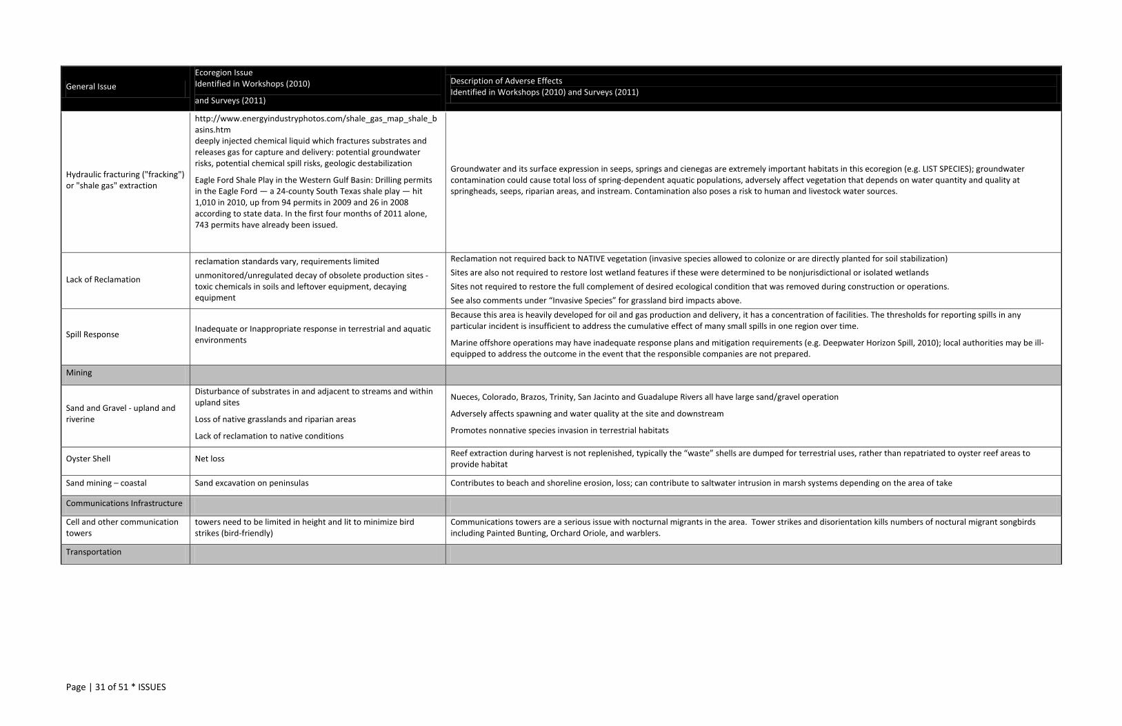
Page | 31 of 51 * ISSUES
General Issue Ecoregion Issue Identified in Workshops (2010)
and Surveys (2011)
Description of Adverse Effects Identified in Workshops (2010) and Surveys (2011)
Hydraulic fracturing ("fracking") or "shale gas" extraction
http://www.energyindustryphotos.com/shale_gas_map_shale_basins.htm deeply injected chemical liquid which fractures substrates and releases gas for capture and delivery: potential groundwater risks, potential chemical spill risks, geologic destabilization
Eagle Ford Shale Play in the Western Gulf Basin: Drilling permits in the Eagle Ford — a 24-county South Texas shale play — hit 1,010 in 2010, up from 94 permits in 2009 and 26 in 2008 according to state data. In the first four months of 2011 alone, 743 permits have already been issued.
Groundwater and its surface expression in seeps, springs and cienegas are extremely important habitats in this ecoregion (e.g. LIST SPECIES); groundwater contamination could cause total loss of spring-dependent aquatic populations, adversely affect vegetation that depends on water quantity and quality at springheads, seeps, riparian areas, and instream. Contamination also poses a risk to human and livestock water sources.
Lack of Reclamation
reclamation standards vary, requirements limited unmonitored/unregulated decay of obsolete production sites - toxic chemicals in soils and leftover equipment, decaying equipment
Reclamation not required back to NATIVE vegetation (invasive species allowed to colonize or are directly planted for soil stabilization) Sites are also not required to restore lost wetland features if these were determined to be nonjurisdictional or isolated wetlands Sites not required to restore the full complement of desired ecological condition that was removed during construction or operations. See also comments under “Invasive Species” for grassland bird impacts above.
Spill Response Inadequate or Inappropriate response in terrestrial and aquatic environments
Because this area is heavily developed for oil and gas production and delivery, it has a concentration of facilities. The thresholds for reporting spills in any particular incident is insufficient to address the cumulative effect of many small spills in one region over time.
Marine offshore operations may have inadequate response plans and mitigation requirements (e.g. Deepwater Horizon Spill, 2010); local authorities may be ill-equipped to address the outcome in the event that the responsible companies are not prepared.
Mining
Sand and Gravel - upland and riverine
Disturbance of substrates in and adjacent to streams and within upland sites
Loss of native grasslands and riparian areas
Lack of reclamation to native conditions
Nueces, Colorado, Brazos, Trinity, San Jacinto and Guadalupe Rivers all have large sand/gravel operation
Adversely affects spawning and water quality at the site and downstream
Promotes nonnative species invasion in terrestrial habitats
Oyster Shell Net loss Reef extraction during harvest is not replenished, typically the “waste” shells are dumped for terrestrial uses, rather than repatriated to oyster reef areas to provide habitat
Sand mining – coastal Sand excavation on peninsulas Contributes to beach and shoreline erosion, loss; can contribute to saltwater intrusion in marsh systems depending on the area of take
Communications Infrastructure
Cell and other communication towers
towers need to be limited in height and lit to minimize bird strikes (bird-friendly)
Communications towers are a serious issue with nocturnal migrants in the area. Tower strikes and disorientation kills numbers of noctural migrant songbirds including Painted Bunting, Orchard Oriole, and warblers.
Transportation

Page | 32 of 51 * ISSUES
General Issue Ecoregion Issue Identified in Workshops (2010)
and Surveys (2011)
Description of Adverse Effects Identified in Workshops (2010) and Surveys (2011)
road and bridge construction (new)
This ecoregion intersects two of the five most populous metropolitan areas in Texas. Urban/suburban impacts to conservation activities and natural resources even outside of these “boundaries” are particularly relevant. There are several issues, one of which is transportation improvements and new construction
Trans Texas Corridor 35 and Interstate 69+: expansion of exisiting interstate and state highway system and creation of new auxillary facilities to regional ports (Laredo, the Valley, Corpus Christi, Houston) and other surface improvements to existing facilities to widen and upgrade capacity between the Ports of Corpus Christi and Brownsville up to Dallas and Texarkana. While some of these facilities have been completed since the last Action Plan was written, several additional facilities are planned and programmed in Regional Transportation Plans. See also (http://www.fahwa.dot.gov/planning/nhs/hipricorridors/hpcor.html) Texas Department of Transportation coordinates with TPWD regarding potential natural resources impacts to listed species; however, during construction and mitigation there is little accommodation for sensitive habitats unless those features are federally protected (federally listed species habitat, critical habitat, jurisdictional wetlands). State-listed species habitats, SGCN, rare communities and the habitats on which they rely are for the most part unprotected. The transportation improvements proposed under regional upgrades of existing facilities and new construction may create barriers to fish and wildlife resources’ daily and seasonal movements through armored culverts and concreted drainageways, vectors and opportunities for nonnative species invasions, water quality impacts through stormwater runoff, loss of nonjurisdictional wetlands, and important riparian, bottomland, prairie and savanna habitats that are not protected under regulation. In addition to these larger facilties, local connection transportation projects may also contribute to the same kinds of losses and may require even less coordination regarding environmental impacts from planning to implementation if no federal money is used. Mitigation for these large primary and smaller connector projects typically does not replace ecological function where it is lost. Nonnative invasive grasses are used in reclamation, nonnative trees are planted in sites where prairie is the desired ecological condition, and riparian areas are allowed to recolonize without direct restoration to prevent invasive species. See comments under “Invasive Species” above.
right of way maintenance
maintaining clear right-of-way for vehicle clearance/access, minimizing fire danger, and maintaining driver visibility are all important; however, several rare species and habitats occur in or adjacent to these corridors
Mowing, trimming timing (season, frequency) inhibit natural regeneration of grassland plant species and don’t provide key habitats (structure, seedheads) at best times of year to accommodate grassland animal and insect needs; brushogging woody species adjacent to grassy ROW can provide vectors for plant pathogens. Most roadsides are reseeded after construction with nonnative species or plant materials and regular maintenance activities also provide additional ground disturbance favorable to invasives; see comments under “Invasive Species” above regarding grasses and grassland birds. Herbicide application runoff can adversely affect very sensitive aquatic features and aquifer conduits which harbor SGCN Some rare plants are known only from sites in ROW; these are not always adequately protected as staff changes occur, management plans are filed away, information not passed through entire chain of command - needs better communication and standard operation procedures in some areas
Navigation
Channel deepening, widening
Maintenance dredging for waterway channels and port facilities
Redevelopment and new ports and waterways
The primary navigation waterway along the coast is the Gulf Intracoastal Waterway (GIWW); however, there are other channels off of the GIWW which tap into ports along the coast, Brownsville to Beaumont; see http://www.charts.noaa.gov/OnLineViewer/GulfCoastViewerTable.shtml
Maintenance dredging to widen or deepen channels or to add capacity to port facilities and channels disturbs soft and hard bottom (benthic organism, reefs), contributes to saltwater intrusion, tidal water access changes, and vegetation loss through increased shipping traffic and wave action or direct removal of vegetation, and can contribute to shoreline erosion in other areas. The side effects may also include marsh and coastal habitat loss for bulkheading, jetties, cuts and passes (closures and openings) and other construction to shore up ports. Nearly every manipulated waterway contributes some level of degradation to the shores and marshes most adjacent to it. These changes are not independent from instream flow recommendations – these need to be considered together as inputs from “both sides” of the estuary systems.
Border Security
Border Fence Built environment – fence structure, monitoring stations, roads - adjacent to the river along certain segments of the border to prevent illegal traffic crossing
The Rio Grande is an important corridor and habitat connection between Mexico and Texas. We share management of the water quality and quantity; terrestrial and aquatic species do not abide the political boundary. Unlike in the Chihuahuan Desert ecoregion, collaboration on natural resources conservation has been less of a focus than collaboration on economic development and settlement. Built next to the Rio Grande, the wall removes important riparian and brush habitats for breeding birds (e.g. (Summer Tanager, Yellow-billed Cuckoo, Gray Hawk) and wide-ranging species which use these corridors for daily and seasonal movements, riparian loss can destabilize banks and degrade water quality and temperature with loss of riparian areas and adversely affect instream SGCN, creates a barrier to genetic diversity and fragment larger stable populations into smaller unstable populations, provides opportunities for invasive plant colonization (no reclaimation of cleared areas even to native vegetation), impedes daily and seasonal movements for many species which are intolerant of travel in open areas The Gulf Coast has been identified as an ecoregion severely impacted by the Border Fence (Lasky, J.R., W. Jetz, and T.H. Keitt. 2011. Conservation biogeography of the US–Mexico border: a transcontinental risk assessment of barriers to animal dispersal. Diversity and Distributions 17(4): 673–687, July 2011)

Page | 33 of 51 * ISSUES
General Issue Ecoregion Issue Identified in Workshops (2010)
and Surveys (2011)
Description of Adverse Effects Identified in Workshops (2010) and Surveys (2011)
Roadways and Levees Network of roads and levees which are routinely dragged, driven, and monitored
Roads and levees are installed parallel and adjacent to the Rio Grande/Rio Bravo corridor. These surface changes impede natural surface runoff, contribute to localized erosion issues, and degrade water quality. Roads are routinely dragged to be able to detect foot and other trespass traffic, creating soil disturbance and repeat vehicle traffic which contributes to road mortality of small reptiles, mammals, ground birds. Light is installed on these sites and disturbs natural daily and seasonal movements, foraging for some species. Roadways and levees form barriers to daily and seasonal movements for small mammals, reptiles, and some fossorial insects which cannot surmount the obstacle or avoid daily traffic; these open corridors also fragment habitat for many thick brush-dependent species and provide edge advantages for predators.
Land & Water Mgmt: FARM See also Water Development section
Conversion Cultivation of remaining prairie remnants Conversion of wet prairie
Coastal prairie remnants are few, far between and relatively small landscapes. Native grasslands are one of the most threatened habitat types in North America. Conversion is difficult to overcome, even with resources (see “Invasive Species” section above). Aside from the loss of native seed and plant sources, soil horizon disturbance creates unfavorable conditions for some species ever recovering. Chemicals may be latent in lands used for production. More than 97% of the native grasslands of the U.S. have been lost, primarily to agricultural conversion; therefore, grassland birds are among our nation’s fastest declining species, yet only 2% of all U.S. grassland is both publicly owned and managed primarily for conservation. Four grassland species have 5% or less of their distribution on public lands: breeding Dickcissels, Scissor-tailed Flycatchers, and Eastern Meadowlarks, and wintering Harris’s Sparrows; across the nation, 48% of grassland-breeding bird species are of conservation concern, including four with endangered populations. For more detail see North American Bird Conservation Initiative, U.S. Committee, 2011. The State of the Birds 2011 Report on Public Lands and Waters. U.S. Department of Interior: Washington, DC. 48 pages. Wet prairie areas are all but gone; a few remnants remain along the Trinity River, but few if any are present in uplands. As these ephemeral wetlands have disappeared, so have a number of native amphibian species although this is not well-documented in published literature as these sites were not well known outside of local resources prior to their conversion.
“Clean” and intensive agricultural practices
Little to no field border habitat
Herbicide use
Intensive haying practices
Indiscriminate pesticide use, especially adjacent to or within overspray area of native grasslands, rangelands, woodlands
Agricultural field borders benefit agricultural practices in wind barriers and filtering field runoff; however, they are also very beneficial to SGCN and rare communities (perennial bunchgrasses, woodland and grassland birds, migratory birds, pollinators) by providing cover, seeds and insects Herbicide use reduces herbaceous resources necessary for breeding birds. Pesticides reduce high protein insect forage for grassland birds and affect all insects in the community, including pollinators. Not much is understood about the collapse of certain pollinators. Overspray can decrease or completely wipe out native insect fauna, important pollinators in native grassland and prairie systems Haying practices are commonly detrimental to many SGCN and the rare prairie communities. In the short term, ground-nesting birds are directly impacted through nest destruction or removal of nesting cover during the breeding seasons. In the long term, the historical climax tallgrass community composed of the big 4 grasses is replaced by low quality habitat and forage. Haying generally starts in early spring to remove cool season grass production. This takes place before offspring are mobile and ground nesting birds have fledged young. Often, the structure necessary to nest is removed before migratory birds arrive or residents initiate nesting activities. Repeated haying takes place throughout the growing season on numerous properties, large and small. Undoubtedly, many pastures are hayed only to retain open space agriculture tax valuation. Haying mines fields of nutrients and often costs more than it yields. Also, repeated haying at the same time every year reduces many grasses that are required components of prairie wildlife habitat. Haying in the late summer and fall removes herbaceous structure for winter migrants; thus, thermal and escape cover is unavailable for most overwintering species. That said, some winter migrants (plovers, hawks) find these cleared areas for resting favorable to invaded grasslands, woodlands or riparian areas; so, some may serve a purpose. Overall, however, the bottom line is that over utilization of herbaceous resources through mechanical cutting or non rotational, overstocked grazing has and continues to be a negative factor causing declines of SGCN.
Lack of soil and water management/conservation practices
Chemical-laden (pesticide, herbicide, fertilizer) irrigation water runoff Lack of streamside management zones
Insufficient stormwater controls between agricultural production and waterways (or dry drainages that lead to waterways during rain events) adverse lead to chemical impacts to sensitive aquatic insects, freshwater mussels, riparian invertebrates, freshwater fishes, amphibians, and eventually bay and estuary systems – invertebrates, fishes, and birds. Streamside Management Zones are important buffers between agricultural practices and aquatic impacts, and these riparian areas serve as important habitats in their own right for many forest and woodland dependent SGCN. Riparian and floodplains are frequently cleared for agricultural production because they are relatively flat, have access to water, and soils are productive. Many SGCN breeding birds, river margin fishes, and amphibians rely on intact riparian areas.
Landowner/land management incentive programs working at cross-purposes
Conservation Reserve Program, other Farm Bill Conservation Title incentives, Farm Bureau and Farm Service Agency programs, and technical guidance on wildlife issues from private individuals as well as TPWD resource specialists may work at crosspurposes inappropriate herbicide application for mesquite control
Native grasslands are a key ecosystem in this ecoregion; land management and restoration assistance in this region typically centers on brush removal and grass planting. Unfortunately, brush removal is not always recommended on sites where this practice is appropriate (may be too steep, highly erodible, or not enough cover remaining to retain ground) and nonnative grasses are recommended for reseeding, farmland to pasture conversion, and even “restoration.” Additionally, certain herbicides recommended may not be appropriate for all sites and may cause more harm to aquatic surface and groundwater resources than benefits to terrestrial systems.

Page | 34 of 51 * ISSUES
General Issue Ecoregion Issue Identified in Workshops (2010)
and Surveys (2011)
Description of Adverse Effects Identified in Workshops (2010) and Surveys (2011)
Farm Bill programs not competitive (conservation vs. ethanol) Farm Bill penalty insufficient to deter short term conversion
See also grassland conservation comments under “Invasive Species” above. See Biofuel section Using Farm Bill programs can be one of the best tools to engage private landowners in longterm conservation practices; however, must be market-competitive and contract-savvy to be effective as a conservation tool.
Clearing and loss of important natural sites/habitats
Local surface water development: small impoundments on tributary creeks, streams, springs, seeps to form stock tanks, ponds, private lakes
Similar to reservoir development on mainstem rivers, negative impacts caused by impoundments on creeks and springs are just at a smaller scale: loss of instream habitats, loss of wetlands, loss of riparian habitats and natural floodways. The replacement value – still deeper water for flowing waters, pond for stream – is not ecologically synonymous. This may be more of an issue in the emerging “urban/suburban” areas. See grassland comments in “Cross Purposes” above See grassland and wet prairie comments in “Conversion” above
Economy – Farm Market forces incompatible with natural resources conservation incentives
Recently, small grain crops have been replaced by cotton and corn due to demand and market prices. Relative to many other land uses, row crops are more compatible with managing for grassland birds and could be enhanced more easily than introduced grass pastures or overgrazed pastures. However, low adoption rates for practices and programs that benefit natural resources and SGCN need exist for our area relative to other parts of the Texas and other states, such as Kansas and Nebraska. Farm Bill Conservation Title programs and other landowner conservation incentive programs are not competitive, monetarily, with values gained from other land uses.
Nutrient Loading Fertilizers, CAFOs, other agricultural runoff without stormwater pollution prevention controls or plans
Nutrient loading and pollution in bays can shift the entire vegetation community, aquatic life community, water chemistry; can have long term effects on benthic communities as many chemicals are latent in sediments; TMDL recommendations need to account for wildlife and fisheries needs
Land & Water Mgmt: RANCH See also Water Development section
Incompatible stocking practices
In some areas, working lands are still recovering from historic uses, out-of-date stocking and grazing practices (prior to soil, native vegetation, and water conservation knowledge we have today) on the advice of county tax appraisers rather than range scientists or ecologists
historic and/or current range-intensive livestock operations “continuous” even if rotational; out of sync with land capacity
landowners may not be aware of potential benefits of wildlife valuation for recovery, rest, or native habitat conversion
non-native hoofstock for hunting operations
Grazing can be a helpful tool in grasslands restoration in certain areas and in capacity with the native vegetation. Overstocking, overgrazing or intensive non-rotational grazing, concentrated supplemental feeding, and improperly placed supplemental water sites can contribute to the decline of native grasslands, introduction of nonnative grasses and brush invasion in sites where desired ecological condition is grassland. On some sites, excessive brush (e.g. thornscrub) clearing to enhance grass cover where brush is native-adapted and important for SGCN, loss of that cover changes the suitability for some rare plants and animals. Overstocking and overgrazing can also quickly degrade riparian integrity sometimes to the point where full recovery is untenable in a lifetime. These practices can also contribute to a shift in the overall vegetation community, microclimate of the site (drier), and decreased recharge (recent science indicates that brush clearing is not always site-appropriate for increased water yield or recharge). Introduction of non-native hoofstock (hogs, axis, others), primarily for hunting recreation, depletes resources for native wildlife, has the potential to damage every habitat type important to native resources, and can contribute disease to native populations … see Invasive Species comment above
Landowner/land management incentive programs working at cross-purposes
Conservation Reserve Program, other Farm Bill Conservation Title incentives, Farm Bureau and Farm Service Agency programs, and technical guidance on wildlife issues from private individuals as well as TPWD resource specialists may work at crosspurposes – reseeding, restoration, brush control, streamside and wetland buffers
Native coastal prairie, brushlands, and wetlands of all types are key ecosystems in this ecoregion; land management and restoration assistance in this region typically centers on brush removal and grass planting. Unfortunately, brush removal and sendero cutting (brush fragmentation) may be recommended on sites where this practice is inappropriate (too steep, highly erodible, native adapted for brush and important to rare species) and nonnative grasses may be recommended for reseeding, farmland to pasture conversion, and even “restoration.” Additionally, certain herbicides recommended may not be appropriate for all sites and may cause more harm to aquatic surface and groundwater resources than benefits to terrestrial systems. Streamside, wetland buffers in many areas are insufficient to meet ecological objectives or contribute meaningfully to both upland and instream conservation values.
Fencing high game fencing High game fencing reduces genetic viability in all species inside the fence (depending on construction), fences in non-natives and can degrade natural habitats quickly without VERY intensive management to control hogs and other destructive non-natives, makes management of a public resource onerous on the landowner, requires intensive planning and is not suitable for most wildlife species or the longterm financial condition of most ranches
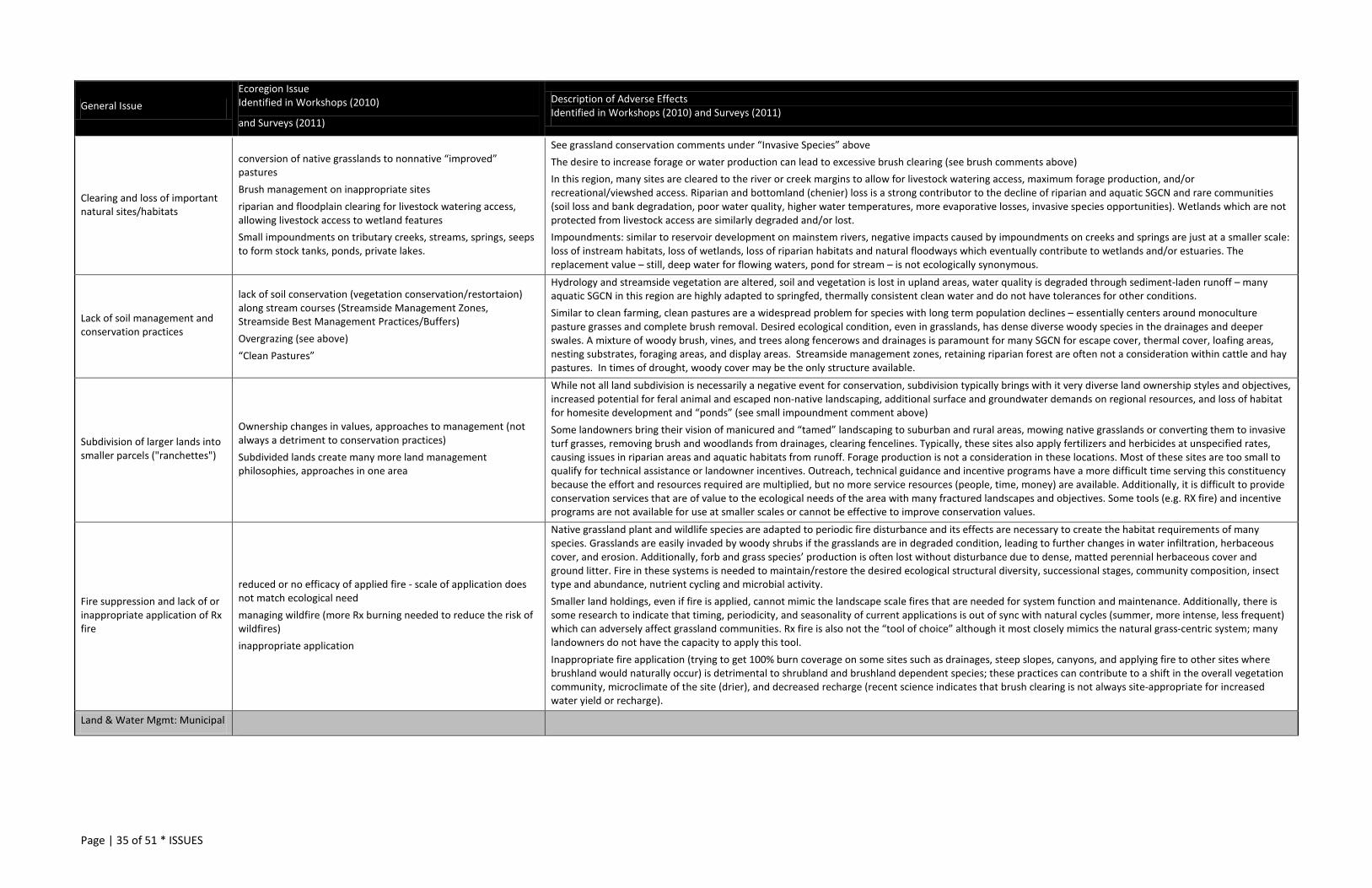
Page | 35 of 51 * ISSUES
General Issue Ecoregion Issue Identified in Workshops (2010)
and Surveys (2011)
Description of Adverse Effects Identified in Workshops (2010) and Surveys (2011)
Clearing and loss of important natural sites/habitats
conversion of native grasslands to nonnative “improved” pastures Brush management on inappropriate sites riparian and floodplain clearing for livestock watering access, allowing livestock access to wetland features Small impoundments on tributary creeks, streams, springs, seeps to form stock tanks, ponds, private lakes.
See grassland conservation comments under “Invasive Species” above The desire to increase forage or water production can lead to excessive brush clearing (see brush comments above) In this region, many sites are cleared to the river or creek margins to allow for livestock watering access, maximum forage production, and/or recreational/viewshed access. Riparian and bottomland (chenier) loss is a strong contributor to the decline of riparian and aquatic SGCN and rare communities (soil loss and bank degradation, poor water quality, higher water temperatures, more evaporative losses, invasive species opportunities). Wetlands which are not protected from livestock access are similarly degraded and/or lost. Impoundments: similar to reservoir development on mainstem rivers, negative impacts caused by impoundments on creeks and springs are just at a smaller scale: loss of instream habitats, loss of wetlands, loss of riparian habitats and natural floodways which eventually contribute to wetlands and/or estuaries. The replacement value – still, deep water for flowing waters, pond for stream – is not ecologically synonymous.
Lack of soil management and conservation practices
lack of soil conservation (vegetation conservation/restortaion) along stream courses (Streamside Management Zones, Streamside Best Management Practices/Buffers) Overgrazing (see above) “Clean Pastures”
Hydrology and streamside vegetation are altered, soil and vegetation is lost in upland areas, water quality is degraded through sediment-laden runoff – many aquatic SGCN in this region are highly adapted to springfed, thermally consistent clean water and do not have tolerances for other conditions. Similar to clean farming, clean pastures are a widespread problem for species with long term population declines – essentially centers around monoculture pasture grasses and complete brush removal. Desired ecological condition, even in grasslands, has dense diverse woody species in the drainages and deeper swales. A mixture of woody brush, vines, and trees along fencerows and drainages is paramount for many SGCN for escape cover, thermal cover, loafing areas, nesting substrates, foraging areas, and display areas. Streamside management zones, retaining riparian forest are often not a consideration within cattle and hay pastures. In times of drought, woody cover may be the only structure available.
Subdivision of larger lands into smaller parcels ("ranchettes")
Ownership changes in values, approaches to management (not always a detriment to conservation practices) Subdivided lands create many more land management philosophies, approaches in one area
While not all land subdivision is necessarily a negative event for conservation, subdivision typically brings with it very diverse land ownership styles and objectives, increased potential for feral animal and escaped non-native landscaping, additional surface and groundwater demands on regional resources, and loss of habitat for homesite development and “ponds” (see small impoundment comment above) Some landowners bring their vision of manicured and “tamed” landscaping to suburban and rural areas, mowing native grasslands or converting them to invasive turf grasses, removing brush and woodlands from drainages, clearing fencelines. Typically, these sites also apply fertilizers and herbicides at unspecified rates, causing issues in riparian areas and aquatic habitats from runoff. Forage production is not a consideration in these locations. Most of these sites are too small to qualify for technical assistance or landowner incentives. Outreach, technical guidance and incentive programs have a more difficult time serving this constituency because the effort and resources required are multiplied, but no more service resources (people, time, money) are available. Additionally, it is difficult to provide conservation services that are of value to the ecological needs of the area with many fractured landscapes and objectives. Some tools (e.g. RX fire) and incentive programs are not available for use at smaller scales or cannot be effective to improve conservation values.
Fire suppression and lack of or inappropriate application of Rx fire
reduced or no efficacy of applied fire - scale of application does not match ecological need managing wildfire (more Rx burning needed to reduce the risk of wildfires) inappropriate application
Native grassland plant and wildlife species are adapted to periodic fire disturbance and its effects are necessary to create the habitat requirements of many species. Grasslands are easily invaded by woody shrubs if the grasslands are in degraded condition, leading to further changes in water infiltration, herbaceous cover, and erosion. Additionally, forb and grass species’ production is often lost without disturbance due to dense, matted perennial herbaceous cover and ground litter. Fire in these systems is needed to maintain/restore the desired ecological structural diversity, successional stages, community composition, insect type and abundance, nutrient cycling and microbial activity. Smaller land holdings, even if fire is applied, cannot mimic the landscape scale fires that are needed for system function and maintenance. Additionally, there is some research to indicate that timing, periodicity, and seasonality of current applications is out of sync with natural cycles (summer, more intense, less frequent) which can adversely affect grassland communities. Rx fire is also not the “tool of choice” although it most closely mimics the natural grass-centric system; many landowners do not have the capacity to apply this tool. Inappropriate fire application (trying to get 100% burn coverage on some sites such as drainages, steep slopes, canyons, and applying fire to other sites where brushland would naturally occur) is detrimental to shrubland and brushland dependent species; these practices can contribute to a shift in the overall vegetation community, microclimate of the site (drier), and decreased recharge (recent science indicates that brush clearing is not always site-appropriate for increased water yield or recharge).
Land & Water Mgmt: Municipal
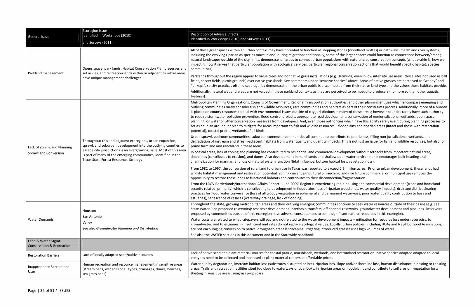
Page | 36 of 51 * ISSUES
General Issue Ecoregion Issue Identified in Workshops (2010)
and Surveys (2011)
Description of Adverse Effects Identified in Workshops (2010) and Surveys (2011)
Parkland management Opens space, park lands, Habitat Conservation Plan preserves and set asides, and recreation lands within or adjacent to urban areas have unique management challenges.
All of these greenspaces within an urban context may have potential to function as stepping stones (woodland mottes) or pathways (marsh and river systems, including the evolving riparian as species move inland) during migration; additionally, some of the larger spaces could function as connections between/among natural landscapes outside of the city limits, demonstration areas to connect urban populations with natural area conservation concepts (what prairie is, how we impact it, how it serves that particular population with ecological services, particular regional conservation actions that would benefit specific habitat, species, communities).
Parklands throughout the region appear to value trees and nonnative grass installations (e.g. Bermuda) even in low intensity use areas (those sites not used as ball fields, soccer fields, picnic grounds) over native grasslands. See comments under “Invasive Species” above. Areas of native grasses are perceived as “weedy” and “unkept”, so city practices often discourage; by demonstration, the urban public is disconnected from their native land type and the values those habitats provide. Additionally, natural wetland areas are not valued in these parkland contexts as they are perceived to be mosquito producers (no more so than other aquatic features).
Lack of Zoning and Planning Sprawl and Conversion
Throughout this and adjacent ecoregions, urban expansion, sprawl, and suburban development into the outlying counties to escape city jurisdictions is an evergrowing issue. Most of this area is part of many of the emerging communities, identified in the Texas State Forest Resources Strategy
Metropolitan Planning Organizations, Councils of Government, Regional Transportation authorities, and other planning entities which encompass emerging and outlying communities rarely consider fish and wildlife resources, rare communities and habitats as part of their constraints process. Additionally, more of a burden is placed on county resources to deal with environmental issues outside of city jurisdictions in many of these areas; however counties rarely have such authority to require stormwater pollution prevention, flood control projects, appropriate road development, conservation of nonjurisdictional wetlands, open space planning, or water or other conservation measures from developers. And, even those authorities which have this ability rarely use it during planning processes to set aside, plan around, or plan to mitigate for areas important to fish and wildlife resources – floodplains and riparian areas (intact and those with restoration potential), coastal prairie, wetlands of all kinds. Urban sprawl, bedroom communities, suburban commuter communities all continue to contribute to prairie loss, filling non-jurisdictional wetlands, and degradation of instream and stream-adjacent habitats from water qualityand quantity impacts. This is not just an issue for fish and wildlife resources, but also for prime farmland and ranchland in these areas. In coastal areas, lack of zoning and planning has contributed to residential and commercial development without setbacks from important natural areas, shorelines (contributes to erosion), and dunes. Also development in marshlands and shallow open water environments encourages bulk-heading and channelization for marinas, and loss of natural system function (tidal influence, bottom habitat loss, vegetation loss).
From 1982 to 1997, the conversion of rural land to urban use in Texas was reported to exceed 2.6 million acres. Prior to urban development, these lands had wildlife habitat management and restoration potential. Zoning current agricultural or ranching lands for future commercial or municipal use removes the opportunity to restore these lands to functional habitats and contributes to their disconnection/fragmentation. From the LRGV Borderlands/International Affairs Report - June 2009: Region is experiencing rapid housing and commercial development (trade and homeland security related, primarily) which is contributing to development in floodplains (loss of riparian woodlands, water quality impacts), drainage district clearing practices for flood water conveyance (loss of all woody vegetation in ephemeral and permanent waterways, poor water quality contribution to bays and estuaries), senescence of resacas (waterway drainage, lack of flooding).
Water Demands
Houston San Antonio Valley See also Groundwater Planning and Distribution
Throughout the state, growing metropolitan areas and their outlying emerging communities continue to seek water resources outside of their basins (e.g. see State Water Plan proposed reservoirs): reservoir development, interbasin transfers, off channel reservoirs, groundwater development and pipelines. Reservoirs proposed by communities outside of this ecoregion have adverse consequences to some significant natural resources in this ecoregion. Water costs are related to what ratepayers will pay and not related to the water development impacts – mitigation for resource loss under reservoirs, to groundwater, and to estuaries, is insufficient and rates do not replace ecological values. Locally, urban policies, including HOAs and Neighborhood Associations, are not encouraging conversion to native, drought-tolerant landscaping; irrigating introduced grasses uses high volumes of water. See also the WATER sections in this document and in the Statewide handbook
Land & Water Mgmt: Conservation & Recreation
Restoration Barriers Lack of locally adapted seed/cultivar sources Lack of native seed and plant material sources for coastal prairie, marshlands, wetlands, and bottomland restoration: native species adapted adapted to local ecotypes need to be collected and increased at plant material centers at affordable prices.
Inappropriate Recreational Uses
Human recreation and resource management in sensitive areas (stream beds, wet soils of all types, drainages, dunes, beaches, sea grass beds)
Water quality degradation, instream habitat loss (substrates disrupted or lost), riparian loss, slope and/or shoreline loss, human disturbance in nesting or roosting areas; Trails and recreation facilities sited too close to waterways or overlooks, in riparian areas or floodplains and contribute to soil erosion, vegetation loss; Boating in sensitive areas: seagrass prop scars

Page | 37 of 51 * ISSUES
General Issue Ecoregion Issue Identified in Workshops (2010)
and Surveys (2011)
Description of Adverse Effects Identified in Workshops (2010) and Surveys (2011)
The land stewardship community provides technical training opportunities in various forms to a wide variety of practitioners; however, parkland managers are not frequently included in these discussions as they primarily deal with recreational issues. These are all related and there are opportunities to learn from all land managers.
Recreation lands managers typically have to deal with more of the urban-wildland interface issues (trespass, feral cats, vandalism) rather than spending resources on habitat restoration or management. Additionally, some tools may be limited in their utility – discomfort or public concern about applying prescribed fire near urban areas, cutting down trees (even if those are nonnative and will be replaced with natives)
Public users intolerant of less manicured or xeriscaped areas – intensive mowing, brush clearing, and herbicide applications to remove “undesirable” vegetation near recreation sites and intensive watering to “green” recreation fields and parklands
Need for Conservation Lands Lack of conservation lands – public or private – for certain habitat types at a meaningful scale, longterm Connectivity
While there has been a greater emphasis in the last several years to identify intact remaining habitat in this region for ecotourism and “connect” the values of these properties for economic purposes, this region still lacks some important ecological functionality which could be improved by connectivity (stepping stones for migratory birds, corridors for terrestrial wildlife movement, riparian restoration to improve continuous habitat suitability for freshwater fishes) While there are many National Wildlife Refuges, Wildlife Management Areas and State Parks In this ecoregion especially by comparison to other ecoregions, there is little representation in coastal prairies and some sites would benefit from greater buffers from the impacts of development, connectivity to the functional landscape. Riparian corridors and bottomland hardwoods, wetlands with rare communities are all needed at scale/duration that is meaningful for longterm sustainability and resiliency of these community types While fee-title or easement protections “fenceline to fenceline” are not necessarily needed in this region, largescale conservation benefits could be realized by mapping existing conservation lands and practices, reviewing opportunities to share resources and improve land management through shared guidance, and identifying landowners and sites which could benefit landscape and conservation management connectivity in the long term through landowner incentive programs – riparian, prairie.
Water Development, Management and Distribution SEE ALSO STATEWIDE HANDBOOK
Surface Water Planning
This ecoregion intersects two of the five most populous metropolitan areas in Texas. Urban/suburban impacts to conservation activities and natural resources even outside of these “boundaries” is particularly relevant. There are several issues, one of which is surface water demand, use, development and distribution – all addressed through various water planning processes. Natural resources not well-defined or required as a use in Regional Water Planning (RWP) processes TMDLprocesses need to consider natural resources also
Natural resource professionals, both terrestrial and aquatic, are not consistently involved in RWP processes Large municipalities' demands in this region and from outside this region affect surface and groundwater development here through regional water planning efforts exploring on channel and off channel reservoir solutions. All upstream decisions affect this ecoregion. Environmental flow recommendations need to be stepped out from headwaters to estuaries to influence all regional water planning processes TMDL's are developed by TCEQ staff or independent contractors working for the agency through a scientifically rigorous process of intensive data collection and analysis. Implementation plans are the basis for initiating local, regional and state actions that reduce pollutant loads to levels established in TMDL’s. These plans include making wastewater permit limits more stringent. This may require wastewater treatment plants for communities and industry to implement additional and sometimes costly new treatment technology. Alternatively, farmers and ranchers may be asked to use new practices that prevent fertilizers, manure and pesticides from reaching lakes and rivers. Cities may be required to control and treat runoff from their streets. Local input in the TMDL process is essential to determining which controls will be the most effective to implement. Additional water sampling will also be required to determine the effectiveness of the chosen controls. In Texas, as in many states, estuarine water quality standards are based on standards prepared for freshwater rivers and streams. This approach fails to deal with natural processes unique to estuaries such as tides and seasonal stratification. These processes can drastically affect estuary water quality. The disconnect between standards and environmental conditions necessary for aquatic productivity becomes more severe as greater amounts of waste are added to the system from point and non-point sources. LRGV Borderlands/International Affairs Report - June 2009 – states that reduced Freshwater Flows and pollution abatement are priorities: reduce BOD, nutrients, heavy metals in Arroyo Colorado watershed to meet federal standards, enhance existing water treatment wetlands, and contribute higher quality water to Laguna Madre
See also Reservoir Construction and Groundwater Planning below.

Page | 38 of 51 * ISSUES
General Issue Ecoregion Issue Identified in Workshops (2010)
and Surveys (2011)
Description of Adverse Effects Identified in Workshops (2010) and Surveys (2011)
Reservoir Construction and Operation (ties in with Surface Water Planning above)
Creation of new and modification (expansion) of existing reservoirs; At least one new reservoir proposed in the Texas State Water Plan 2007: Nueces Off Channel – construction, impoundment, and operations would adversely affect an Ecologically Significant Stream Segment (see Figure 2, map 2)
Unregulated small stream impoundments on private lands
Timing/Periodicity/Intensity of Water Releases releases are unnaturally intense, in the "wrong" season to mimic natural flooding processes, and change water chemistry and sediment load in all areas downstream, to the estuaries
Shoreline development - vegetation removal to water’s edge for viewshed, recreational access; hardening and armoring banks (bulkheading), on-site septic leakage or non-compliance, development on steep sites.
Invasive species
Reservoir construction: Several streams in this region are of high quality (Ecologically Signficant); riparian zones (some are ancient gallery forests, rare communties) are important to instream aquatic and stream-adjacent SGCN habitats and environmental flow quality to our estuaries; ES and high quality riparian are rarely considered during site selection for new reservoirs or operations. Reservoir construction and operation creates a barrier to SGCN movement, changes water chemistry and quality for contributions to estuary and bay systems, completely inundates important and irreplaceable riparian zones and bottomlands, spring systems, and instream habitats. Impoundments: similar to reservoir development on mainstem rivers, negative impacts caused by impoundments on creeks and springs are just at a smaller scale: loss of instream habitats, loss of wetlands, loss of riparian habitats and natural floodways. The replacement value – still deeper water for flowing waters, pond for stream – is not ecologically synonymous. This may be more of an issue in the emerging “urban/suburban” areas. Unnatural hydrograph from reservoir operations/dam releases scours instream and stream-adjacent habitats, shifts vegetation communities out of sync with other riparian communities where flooding is more "natural", rare communities and instream SGCN (invertebrates and fishes) cannot "rely" on the seasonal changes under which they evolved and decline Lakeside Shoreline Development: In addition to the loss of instream and riparian habitat following inundation, the now-“riparian” and upland habitats surrounding the lake edge is at risk from development. In this region, these habitats were usually cliff edges, recharge features, upland shrubland, canyonlands – many of these sites support SGCN and rare communities. Regional reservoir managers do not reserve much in the way of “setback” from the inundation pool level in their easements. This allows residential development (water withdrawals and septic installation), bulkheading shorelines, clearing and “landscaping” to the water’s edge. These lakeside activities contribute fertilizers and other chemicals (e.g. boat gas/oil), untreated or poorly treated human waste (some lake authorities actually have permitting programs to manage/reduce this factor, but not all), and sedimentation to the lake, which eventually impacts in-lake and downstream habitats. Typically, residential development in these areas is also a vector for invasive aquatic and terrestrial plants and feral pets. See Invasive species section above.
Flood Control Changes to natural stream courses to block or convey floodwaters
Levees, bank armoring, culverts all remove instream and stream adjacent habitats, contribute to unnatural sediment and nutrient loading downstream and to estuaries
Other Water Source Developments and Technologies
Interbasin Transfers (Surface and Groundwater) Reuse Water Treatment Wetlands
Interbasin transfers are a significant concern with several of the large urban areas in Texas seeking water outside of their basins Water Reuse reduces available water at any particular time (needs to account for instream flows) and can change the chemistry (temperature, oxygen, and other characteristics) from the discharge. While a useful tool and potentially a benefit to some wildlife and fish resources, Water Treatment Wetlands are not typically managed as natural systems (e.g. vegetation homogenous, not natural habitats for local wetland dependent SGCN)
Water Treatment and Discharge
Throughout the region, waterways and estuaries are the “end of the line” – all water use and wastewater practices eventually end up in this region
From untreated waste in the Rio Grande/Rio Bravo system to water that has been used and reused from headwater to Gulf, not always with complete toxin removal (e.g. endocrine disrupters, prescription medications), there is little known with certainty about the effects of these end of the line discharges to our invertebrate estuarine communities and the speces which rely on them for food, influences on harmful algal blooms, or reproduction disruption in for rare and important species. TMDL recommendations are very important in this regard for human water uses; however these recommendations rarey address fish and wildlife resource needs for water quality.
Lack of Information & Resources
Lack of Processing Existing Data
Where census, survey, records and collections are documented, this information is frequently not forwarded to centralized collection databases (Texas Natural Diversity Database, Texas Natural History Database, Texas Fishes databases) OR if it is forwarded to these entities, there are inadequate staff or other resources to enter the data in a timely way.
Species and rare communities information is key to be able to detect trends and causes for upward or downward shifts.
Without this information, it is difficult to focus or prioritize management objectives or share information with private landowners about the importance of some sites, populations or communities. Sharing this information with landowners is crucial as most of Texas is privately owned and conservation must occur with their stewardship help.
If we don’t know where important priorities lie, we cannot effectively use the resources we have to reverse downward trends, recover and delist species, and ensure that we are making conservation progress.
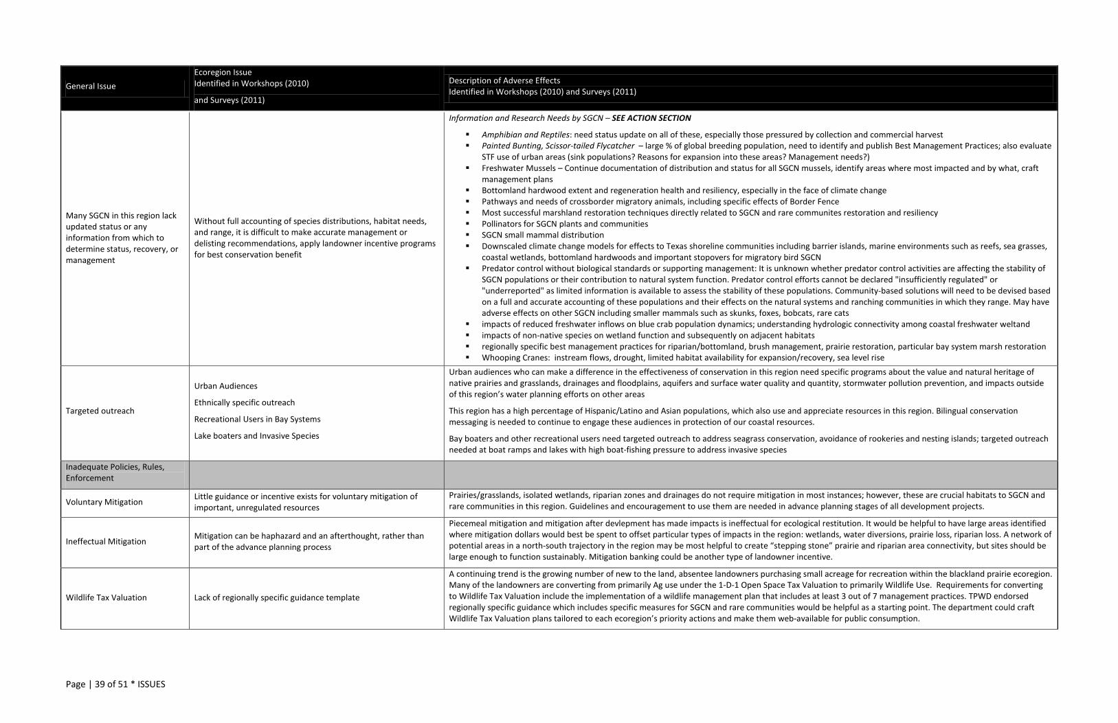
Page | 39 of 51 * ISSUES
General Issue Ecoregion Issue Identified in Workshops (2010)
and Surveys (2011)
Description of Adverse Effects Identified in Workshops (2010) and Surveys (2011)
Many SGCN in this region lack updated status or any information from which to determine status, recovery, or management
Without full accounting of species distributions, habitat needs, and range, it is difficult to make accurate management or delisting recommendations, apply landowner incentive programs for best conservation benefit
Information and Research Needs by SGCN – SEE ACTION SECTION
Amphibian and Reptiles: need status update on all of these, especially those pressured by collection and commercial harvest Painted Bunting, Scissor-tailed Flycatcher – large % of global breeding population, need to identify and publish Best Management Practices; also evaluate
STF use of urban areas (sink populations? Reasons for expansion into these areas? Management needs?) Freshwater Mussels – Continue documentation of distribution and status for all SGCN mussels, identify areas where most impacted and by what, craft
management plans Bottomland hardwood extent and regeneration health and resiliency, especially in the face of climate change Pathways and needs of crossborder migratory animals, including specific effects of Border Fence Most successful marshland restoration techniques directly related to SGCN and rare communites restoration and resiliency Pollinators for SGCN plants and communities SGCN small mammal distribution Downscaled climate change models for effects to Texas shoreline communities including barrier islands, marine environments such as reefs, sea grasses,
coastal wetlands, bottomland hardwoods and important stopovers for migratory bird SGCN Predator control without biological standards or supporting management: It is unknown whether predator control activities are affecting the stability of
SGCN populations or their contribution to natural system function. Predator control efforts cannot be declared "insufficiently regulated" or "underreported" as limited information is available to assess the stability of these populations. Community-based solutions will need to be devised based on a full and accurate accounting of these populations and their effects on the natural systems and ranching communities in which they range. May have adverse effects on other SGCN including smaller mammals such as skunks, foxes, bobcats, rare cats
impacts of reduced freshwater inflows on blue crab population dynamics; understanding hydrologic connectivity among coastal freshwater weltand impacts of non-native species on wetland function and subsequently on adjacent habitats regionally specific best management practices for riparian/bottomland, brush management, prairie restoration, particular bay system marsh restoration Whooping Cranes: instream flows, drought, limited habitat availability for expansion/recovery, sea level rise
Targeted outreach
Urban Audiences
Ethnically specific outreach
Recreational Users in Bay Systems
Lake boaters and Invasive Species
Urban audiences who can make a difference in the effectiveness of conservation in this region need specific programs about the value and natural heritage of native prairies and grasslands, drainages and floodplains, aquifers and surface water quality and quantity, stormwater pollution prevention, and impacts outside of this region’s water planning efforts on other areas
This region has a high percentage of Hispanic/Latino and Asian populations, which also use and appreciate resources in this region. Bilingual conservation messaging is needed to continue to engage these audiences in protection of our coastal resources.
Bay boaters and other recreational users need targeted outreach to address seagrass conservation, avoidance of rookeries and nesting islands; targeted outreach needed at boat ramps and lakes with high boat-fishing pressure to address invasive species
Inadequate Policies, Rules, Enforcement
Voluntary Mitigation Little guidance or incentive exists for voluntary mitigation of important, unregulated resources
Prairies/grasslands, isolated wetlands, riparian zones and drainages do not require mitigation in most instances; however, these are crucial habitats to SGCN and rare communities in this region. Guidelines and encouragement to use them are needed in advance planning stages of all development projects.
Ineffectual Mitigation Mitigation can be haphazard and an afterthought, rather than part of the advance planning process
Piecemeal mitigation and mitigation after devlepment has made impacts is ineffectual for ecological restitution. It would be helpful to have large areas identified where mitigation dollars would best be spent to offset particular types of impacts in the region: wetlands, water diversions, prairie loss, riparian loss. A network of potential areas in a north-south trajectory in the region may be most helpful to create “stepping stone” prairie and riparian area connectivity, but sites should be large enough to function sustainably. Mitigation banking could be another type of landowner incentive.
Wildlife Tax Valuation Lack of regionally specific guidance template
A continuing trend is the growing number of new to the land, absentee landowners purchasing small acreage for recreation within the blackland prairie ecoregion. Many of the landowners are converting from primarily Ag use under the 1-D-1 Open Space Tax Valuation to primarily Wildlife Use. Requirements for converting to Wildlife Tax Valuation include the implementation of a wildlife management plan that includes at least 3 out of 7 management practices. TPWD endorsed regionally specific guidance which includes specific measures for SGCN and rare communities would be helpful as a starting point. The department could craft Wildlife Tax Valuation plans tailored to each ecoregion’s priority actions and make them web-available for public consumption.
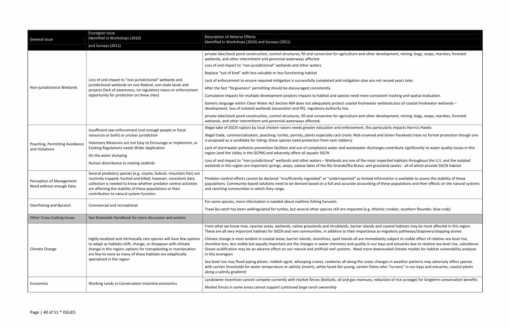
Page | 40 of 51 * ISSUES
General Issue Ecoregion Issue Identified in Workshops (2010)
and Surveys (2011)
Description of Adverse Effects Identified in Workshops (2010) and Surveys (2011)
Non-jurisdictional Wetlands
Loss of and impact to "non-jurisdictional" wetlands and jurisdictional wetlands on non-federal, non-state lands and projects (lack of awareness, no regulatory nexus or enforcement opportunity for protection on these sites)
private lake/stock pond construction, control structures, fill and conversion for agriculture and other development, mining: bogs, seeps, marshes, forested wetlands, and other intermittent and perennial waterways affected Loss of and impact to "non-jurisdictional" wetlands and other waters
Replace “out of kind” with less valuable or less functioning habitat
Lack of enforcement to ensure required mitigation is successfully completed and mitigation sites are not reused years later.
After the fact “forgiveness” permitting should be discouraged consistently.
Cumulative impacts for multiple development projects impacts to habitat and species need more consistent tracking and spatial evaluation.
Generic language within Clean Water Act Section 404 does not adequately protect coastal freshwater wetlands;loss of coastal freshwater wetlands – development, loss of isolated wetlands (excavation and fill), regulatory authority loss
private lake/stock pond construction, control structures, fill and conversion for agriculture and other development, mining: bogs, seeps, marshes, forested wetlands, and other intermittent and perennial waterways affected;
Poaching, Permitting Avoidance and Violations
insufficient law enforcement (not enough people or fiscal resources or both) or unclear jurisdiction
Voluntary Measures are not Easy to Encourage or Implement, or Existing Regulations needs Wider Application
On the water dumping
Human disturbance to nesting seabirds
Illegal take of SGCN raptors by local chicken raisers needs greater education and enforcement, this particularly impacts Harris's Hawks
illegal trade, commercialization, poaching: turtles, parrots, plants especially cacti (note: Red-crowned and Green Parakeets have no formal protection though one is proposed as a candidate for listing; these species need protection from nest robbers)
Lack of stormwater pollution prevention facilities and out of compliance water and wastewater discharges contribute significantly to water quality issues in this region (and the Valley in the GCPM) and adversely affect all aquatic SGCN
Loss of and impact to "non-jurisdictional" wetlands and other waters – Wetlands are one of the most imperiled habitats throughout the U.S. and the isolated wetlands in this region are important springs, seeps, oxbow lakes of the Rio Grande/Rio Bravo, wet grassland swales - all of which provide SGCN habitat
Perception of Management Need without enough Data
Several predatory species (e.g. coyote, bobcat, mountain lion) are routinely trapped, hunted and killed; however, consistent data collection is needed to know whether predator control activities are affecting the stability of these populations or their contribution to natural system function.
Predator control efforts cannot be declared "insufficiently regulated" or "underreported" as limited information is available to assess the stability of these populations. Community-based solutions need to be devised based on a full and accurate accounting of these populations and their effects on the natural systems and ranching communities in which they range.
Overfishing and Bycatch Commercial and recreational For some species, more information is needed about realtime fishing harvests
Trawl by-catch has been wellregulated for turtles, but several other species still are impacted (e.g. Atlantic croaker, southern flounder, blue crab)
Other Cross-Cutting Issues See Statewide Handbook for more discussion and actions
Climate Change
highly localized and intrinsically rare species will have few options to adapt as habitats shift, change, or disappear with climate change in this region; options for transplanting or translocation are few to none as many of these habitats are edaphically specialized in the region
From what we know now, riparian areas, wetlands, native grasslands and shrublands, barrier islands and coastal habitats may be most affected in this region. These are all very important habitats for SGCN and rare communities, in addition to their importance as migratory pathways/stopovers/stepping stones
Climate change is most evident in coastal areas; barrier islands, shorelines, spoil islands all are immediately subject to visible effect of relative sea level rise, shoreline loss; less visible but equally important are the changes in water chemistry and quality in our bays and estuaries due to relative sea level rise, subsidence. Ocean acidification may be an adverse effect on our natural and artificial reef systems. Need more downscaled climate models for habitat vulnerability analyses in this ecoregion
Sea level rise may flood piping plover, reddish egret, whooping cranes, rookeries all along the coast; changes in weather patterns may adversely affect species with certain thresholds for water temperature or salinity (inverts, white faced ibis young, certain fishes who “nursery” in our bays and estuaries, coastal plants along a salinity gradient)
Economics Working Lands vs Conservation Incentive economics Landowner incentives cannot compete currently with market forces (biofuels, oil and gas revenues, reduction of rice acreage) for longterm conservation benefits
Market forces in some areas cannot support continued large ranch ownership
Page | 41 of 51 * CONSERVATION ACTIONS
CONSERVATION ACTIONS
“Like the resource it seeks to protect, wildlife conservation must be dynamic, changing as conditions change, seeking always to become more effective.” – Rachel Carson
To make conservation progress, we need to work with the information we have, document our progress, share lessons learned, and adapt our approach when necessary. Conservation actions in this handbook are aimed at reducing the negative effects of issues that affect SGCN, rare communities and their habitats at various scales. Broad actions categories are defined to help organize handbooks. For information about how the Actions framework was developed and for definitions of Action categories, see the Overview Handbook.18
Actions proposed for the GCPM Ecoregion (Table 6) state what we need to work on, where, and why (what problem we can solve with that action). Actions lay out how that work contributes to a specific desired effect –progress and success.
It is important to acknowledge that one conservation action typically does not solve one conservation problem. There may be several actions employed over time to achieve a conservation goal. In some instances, defining the conservation goal is the action – for some things, we don’t yet know enough to define what successful conservation looks like for that SGCN population, rare community, or habitat.
It has become increasingly important to determine if the work we do is actually leading to the overall conservation outcomes we desire – restoration, recovery, sustainability, and resiliency. As conservation practitioners, we can use milestones (or intermediate results) and reporting to communicate our progress and leverage future conservation action, partnerships, policy changes, and funding.
From project inception, well-crafted monitoring and evaluation (cost effective, answers key questions) informs management and allows conservation practitioners to “course-correct” as necessary for effective conservation.19 With the need for Action Plans to take advantage of several “pots of conservation money,” the people we serve and those who govern private and public conservation funds demand reporting, transparency, and demonstration that projects are positively impacting the conservation of species and habitats. To get beyond reporting that money was spent and projects were done, AFWA TWW convened a committee in 2009 to craft “effectiveness measures” for the conservation actions across all Plans. A toolkit for classifying and measuring conservation action effectiveness was produced in 2011, approved by AFWA TWW Executive Committee comprised of state
18 TPWD. 2012. Texas Conservation Action Plan: Broad Action Category Definitions. http://www.tpwd.state.tx.us/landwater/land/tcap/documents/action_categories_tcap_2011.pdf The category “Data Collection, Analysis, and Management” meets Action Plan Required Element 3 – “priority research and survey”. Many of the proposed actions include a monitoring component (Action Plan Required Element 5) and all actions are encouraged to follow the Effectiveness Measures to assist with adaptive managment. 19 Conservation Measures Partnership. 2010. http://www.conservationmeasures.org/wp-content/uploads/2010/04/CMP_Open_Standards_Version_2.0.pdf Salzer, D. and N. Salafsky. 2006. Allocating resources between taking action, assessing status, and measuring effectiveness of conservation actions. Natural Areas Journal 26(3): 310-316.
Page | 42 of 51 * CONSERVATION ACTIONS
fish and wildlife agency directors and others.20 These measures will be an important part of moving the plans and conservation forward.
With this revision, the TCAP becomes more involved in a national movement to track conservation actions and progress across local, state, regional and national levels. As with the 2005 Plan, actions presented in this edition vary in detail, scale, and duration; however, this edition encourages the use of the incremental measures of success for conservation projects’ development, implementation, and tracking. To that end, the toolkit in Measuring the Effectiveness of State Wildlife Grants21 is strongly recommended to define conservation projects, target audiences and partners, identify desired step-wise intermediate results, and collect the “right” data to report our conservation achievements.
20 Association of Fish and Wildlife Agencies Teaming with Wildlife. Measuring the Effectiveness of State Wildlife Grants (conservation actions). 2011. http://www.fishwildlife.org/files/TWW-Effectiveness-Measures-FULL-Report-Appendices.pdf 21 Same as above
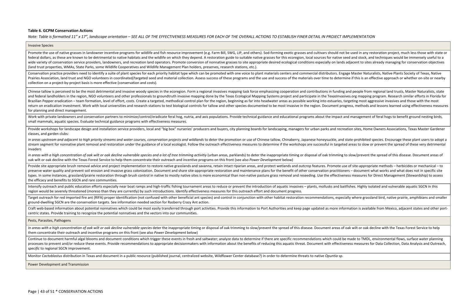
Page | 43 of 51 * CONSERVATION ACTIONS
Table 6. GCPM Conservation Actions Note: Table is formatted 11” x 17”, landscape orientation – SEE ALL OF THE EFFECTIVENESS MEASURES FOR EACH OF THE OVERALL ACTIONS TO ESTABLISH FINER DETAIL IN PROJECT IMPLEMENTATION
Invasive Species
Promote the use of native grasses in landowner incentive programs for wildlife and fish resource improvement (e.g. Farm Bill, SWG, LIP, and others). Sod-forming exotic grasses and cultivars should not be used in any restoration project, much less those with state or federal dollars, as these are known to be detrimental to native habitats and the wildlife on which they depend. A restoration guide to suitable native grasses for this ecoregion, local sources for native seed and stock, and techniques would be immensely useful to a wide variety of conservation service providers, landowners, and recreation land operators. Promote conversion of nonnative grasses to site appropriate desired ecological conditions especially on lands adjacent to sites already managing for conservation objectives (land trust properties, WMAs, State Parks, some Wildlife Cooperatives and Wildlife Management Plan holders, preserves, research stations, etc.).
Conservation practice providers need to identify a suite of plant species for each priority habitat type which can be promoted with one voice to plant materials centers and commercial distributors. Engage Master Naturalists, Native Plants Society of Texas, Native Prairies Association, land trust and NGO volunteers in coordinated/targeted seed and material collection. Assess success of these programs and the use and success of the materials over time to determine if this is an effective approach or whether on-site or nearby collection on a project-by-project basis is more effective (conservation and costs).
Chinese tallow is perceived to be the most detrimental and invasive woody species in the ecoregion. Form a regional invasives mapping task force emphasizing cooperation and contributions in funding and people from regional land trusts, Master Naturalists, state and federal landholders in the region, NGO volunteers and other professionals to groundtruth invasive mapping done by the Texas Ecological Mapping Systems project and participate in the TexasInvasives.org mapping program. Research similar efforts in Florida for Brazilian Pepper eradication – team formation, level of effort, costs. Create a targeted, methodical control plan for the region, beginning as far into headwater areas as possible working into estuaries, targeting most aggressive invasives and those with the most return on eradication investment. Work with local universities and research stations to test biological controls for tallow and other species documented to be most invasive in the region. Document progress, methods and lessons learned using effectiveness measures for planning and direct management.
Work with private landowners and conservation partners to minimize/control/eradicate feral hog, nutria, and axis populations. Provide technical guidance and educational programs about the impact and management of feral hogs to benefit ground nesting birds, small mammals, aquatic species. Evaluate technical guidance programs with effectiveness measures.
Provide workshops for landscape design and installation service providers, local and “big box” nurseries’ producers and buyers, city planning boards for landscaping, managers for urban parks and recreation sites, Home Owners Associations, Texas Master Gardener classes, and garden clubs: in areas upstream and adjacent to high priority streams and water courses, conservation projects and wildlands to deter the promotion or use of Chinese tallow, Chinaberry, Japanese honeysuckle, and state-prohibited species. Encourage these plant users to adopt a stream segment for nonnative plant removal and restoration under the guidance of a local ecologist. Follow the outreach effectiveness measures to determine if the workshops are successful in targeted areas to slow or prevent the spread of these very detrimental invaders in areas with a high concentration of oak wilt or oak decline vulnerable species and a lot of tree trimming activitiy (urban areas, parklands) to deter the inappropriate timing or disposal of oak trimming to slow/prevent the spread of this disease. Document areas of oak wilt or oak decline with the Texas Forest Service to help them concentrate their outreach and incentive programs on this front (see also Power Development below) Provide site appropriate brush removal advice and project implementation to restore native grasslands and savanna, retain intact riparian areas, and protect wetlands and outcrop features. Promote use of site-appropriate methods – herbicides or mechanical – to preserve water quality and prevent soil erosion and invasive grass colonization. Document and share site-appropriate restoration and maintenance plans for the benefit of other conservation practitioners – document what works and what does not in specific site types. In some instances, grassland/prairie restoration through brush control in native to mostly native sites is more economical than non-native pasture grass removal and reseeding. Use the effectiveness measures for Direct Management (Stewardship) to assess the efficacy and benefits to SGCN and rare communities.
Intensify outreach and public education efforts especially near boat ramps and high-traffic fishing tournament areas to reduce or prevent the introduction of aquatic invasives – plants, mollusks and baitfishes. Highly isolated and vulnerable aquatic SGCN in this region would be severely threatened (moreso than they are currently) by such introductions. Identify effectiveness measures for this outreach effort and document progress.
Target outreach for red imported fire ant (RIFA) proper identification (not confused with other beneficial ant species) and control in conjunction with other habitat restoration recommendations, especially where grassland bird, native prairie, amphibians and smaller ground-dwelling SGCN are the conservation targets. See information needed section for Rasberry Crazy Ant action. Craft web-based information about potential nonnatives which could be most easily transferred through port activities. Provide this information to Port Authorities and keep page updated as more information is available from Mexico, adjacent states and other port-centric states. Provide training to recognize the potential nonnatives and the vectors into our communities.
Pests, Parasites, Pathogens
In areas with a high concentration of oak wilt or oak decline vulnerable species deter the inappropriate timing or disposal of oak trimming to slow/prevent the spread of this disease. Document areas of oak wilt or oak decline with the Texas Forest Service to help them concentrate their outreach and incentive programs on this front (see also Power Development below)
Continue to document harmful algal blooms and document conditions which trigger these events in fresh and saltwater; analyze data to determine if there are specific recommendations which could be made to TMDL, environmental flows, surface water planning processes to prevent and/or reduce these events. Provide recommendations to appropriate decisionmakers with information about the benefits of reducing this aquatic threat. Document with effectiveness measures for Data Collection, Data Analysis and Outreach, specific to regional SGCN improvement.
Monitor Cactoblastus distribution in Texas and document in a public resource (published journal, centralized website, Wildflower Center database?) in order to determine threats to native Opuntia sp.
Power Development and Transmission
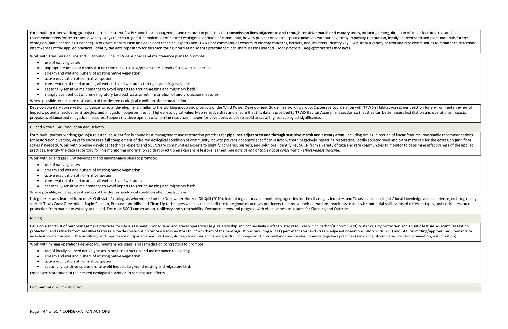
Page | 44 of 51 * CONSERVATION ACTIONS
Form multi-partner working group(s) to establish scientifically sound best management and restoration practices for transmission lines adjacent to and through sensitive marsh and estuary areas, including timing, direction of linear features, reasonable recommendations for restoration diversity, ways to encourage full complement of desired ecological condition of community, how to prevent or control specific invasives without negatively impacting restoration, locally sourced seed and plant materials for the ecoregion (and finer scales if needed). Work with transmission line developer technical experts and SGCN/rare communities experts to identify concerns, barriers, and solutions. Identify key SGCN from a variety of taxa and rare communities to monitor to determine effectiveness of the applied practices. Identify the data repository for this monitoring information so that practitioners can share lessons learned. Track progress using effectiveness measures.
Work with Transmission Line and Distribution Line ROW developers and maintenance plans to promote: • use of native grasses • appropriate timing or disposal of oak trimmings to slow/prevent the spread of oak wilt/oak decline • stream and wetland buffers of existing native vegetation • active eradication of non-native species • conservation of riparian areas, all wetlands and wet areas through spanning/avoidance • seasonally-sensitive maintenance to avoid impacts to ground-nesting and migratory birds • siting/placement out of prime migratory bird pathways or with installation of bird protection measures
Where possible, emphasize restoration of the desired ecological condition after construction.
Develop voluntary conservation guidance for solar development, similar to the working group and products of the Wind Power Development Guidelines working group. Encourage coordination with TPWD’s Habitat Assessment section for environmental review of impacts, potential avoidance strategies, and mitigation opportunities for highest ecological value. Map sensitive sites and ensure that this data is provided to TPWD Habitat Assessment section so that they can better assess installation and operational impacts, propose avoidance and mitigation measures. Support the development of an online resources mapper for developers to use to avoid areas of highest ecological significance.
Oil and Natural Gas Production and Delivery
Form multi-partner working group(s) to establish scientifically sound best management and restoration practices for pipelines adjacent to and through sensitive marsh and estuary areas, including timing, direction of linear features, reasonable recommendations for restoration diversity, ways to encourage full complement of desired ecological condition of community, how to prevent or control specific invasives without negatively impacting restoration, locally sourced seed and plant materials for the ecoregion (and finer scales if needed). Work with pipeline developer technical experts and SGCN/rare communities experts to identify concerns, barriers, and solutions. Identify key SGCN from a variety of taxa and rare communities to monitor to determine effectiveness of the applied practices. Identify the data repository for this monitoring information so that practitioners can share lessons learned. See note at end of table about conservation effectiveness tracking.
Work with oil and gas ROW developers and maintenance plans to promote: • use of native grasses • stream and wetland buffers of existing native vegetation • active eradication of non-native species • conservation of riparian areas, all wetlands and wet areas • seasonally-sensitive maintenance to avoid impacts to ground-nesting and migratory birds
Where possible, emphasize restoration of the desired ecological condition after construction. Using the lessons learned from other Gulf states’ ecologists who worked on the Deepwater Horizon Oil Spill (2010), federal regulatory and monitoring agencies for the oil and gas industry, and Texas coastal ecologists’ local knowledge and experience, craft regionally specific Texas Coast Prevention, Rapid Cleanup, Preparation/drills, and Clean Up techniques which can be distribute to regional oil and gas producers to improve their operations, readiness to deal with potential spill events of different types, and critical resource protection from marine to estuary to upland. Focus on SGCN conservation, resiliency and sustainability. Document steps and progress with effectiveness measures for Planning and Outreach.
Mining
Develop a short list of best management practices for site assessment prior to sand and gravel operations (e.g. relationship and connectivity surface water resources which harbor/support SGCN), water quality protection and aquatic feature adjacent vegetation protection, and setbacks from sensitive features. Provide conservation outreach to operators to inform them of the new regulations requiring a TCEQ permit for river and stream adjacent operations. Work with TCEQ and GLO permitting/approval requirements to include information about the sensitivity and importance of riparian areas, wetlands, dunes, shorelines and islands, including nonjurisdictional wetlands and swales, to encourage best practices (avoidance, stormwater pollution prevention, minimization).
Work with mining operations developers, maintenance plans, and remediation contractors to promote:
• use of locally sourced native grasses in post-construction and maintenance re-seeding • stream and wetland buffers of existing native vegetation • active eradication of non-native species • seasonally-sensitive operations to avoid impacts to ground-nesting and migratory birds
Emphasize restoration of the desired ecological condition in remediation efforts.
Communications Infrastructure
Page | 45 of 51 * CONSERVATION ACTIONS
Provide conservation outreach to regional communications providers to inform them of areas of highest significance for avoidance – migratory bird pathways (especially nocturnal; also known impacted species such as Yellow-billed Cuckoo, Painted Bunting, Summer Tanager) and areas adjacent to bat roost sites (tree groves, in the Valley predominately) -- and potential areas to concentrate mitigation dollars and projects in the event avoidance is not feasible or prudent. Identify non-compliant communications towers work collaboratively to bring into compliance (lighting, height); outreach to communications companies about the local hazards of communiation towers and recommendations to improve practice to improve conditions for all
Transportation
Form multi-partner working group(s) to establish scientifically sound best management and restoration practices for roadways adjacent to and through sensitive marsh and estuary areas, including timing, direction of linear features, appropriate culvert design for aquatic and terrestrial animal passage, reasonable recommendations for restoration, ways to encourage full complement of desired ecological condition of community, how to prevent or control specific invasives without negatively impacting restoration, locally sourced seed and plant materials for the ecoregion (and finer scales if needed). Work with roadway developer technical experts and SGCN/rare communities experts to identify concerns, barriers, and solutions. Identify key SGCN from a variety of taxa and rare communities to monitor to determine effectiveness of the applied practices. Identify the data repository for this monitoring information so that practitioners can share lessons learned. See note at end of table about conservation effectiveness tracking.
Identify specific areas for TXDOT Districts, county road managers to improve right-of way (ROW) restoration and management:
After construction, restore sites with native seed sources and materials Remove invasive species and restore prairie on existing ROW Terms of ROW easement need to include native vegetation restoration and management (landownwer cannot convert these areas to nonnative grasses for grazing), riparian protection and wetland protection On roadways, enforce public right of way (prevention of private maintenance, overmowing, clearing) When mowing along roadways, mow approximately 15 feet from the shoulder within undeveloped areas In areas beyond 15 feet and on ROW through rural lands, do not mow between April and October in order to allow ground nesting birds to produce and native prairie plants to seed out.; mow on a 4-year cycle at an 8-inch height (if roadway, both sides of
the road are not mowed in the same year, saves significant dollars for mowing costs and reduces accidents). For areas specifically protecting rare plant or animal habitat, provide District and State level documentation of approved maintenance procedures, interpretive signage re these practices and outreach to neighboring properties so this can serve as a
demonstration site for protection and discourage private maintenance of public ROW. Identify monitoring sites which can serve as mitigation as long as information is shared through a public database and conservation practice networks
In areas with a high concentration of oak wilt or oak decline, vulnerable species and/or a lot of tree trimming activitiy (e.g. ROW) deter the inappropriate timing or disposal of oak trimmings to slow/prevent the spread of this disease. Follow Texas Forest Service Guidelines for tree trimming timing, cut treatment, equipment protocols and trimming disposal. Avoid the use of brush-hogging vertically to trim back ROW edges. Document areas of oak wilt or oak decline with the Texas Forest Service to help them concentrate their outreach and incentive programs on this front Provide TXDOT with native grass species lists, seed sources and restoration technique guides to encourage use of natives in ROW remediation following construction and restoration if the opportunities for conversion arise. Native grasses have improved drought tolerance and are adapted to Texas’ soils and climates. Economic analysis comparing introduced grass to native grass in a commercial cow-calf production system has estimated greater returns for native grasses when fertilizer costs are $40- 50 per acre. Native grass seeding also requires less water inputs which would reduce remediation costs. Provide outreach to landowners adjacent to TXDOT ROW in areas where TXDOT has implemented native restoration (native grasses used) or conservation (rare plant protection plans, maintenance plans to protect rare communities or features) to support SGCN recovery or protection to further understanding of these important resources and their site-appropriate management, reduce landowner maintenance in these areas, and promote SGCN recovery. Use outreach effectiveness measures to document progress. Maintenance dredging recommendations by waterway need to be crafted based on navigation districts’ needs to widen or deepen channels or to add capacity to port facilities and channels and based on ecologically desired conditions, avoidance areas, and mitigation measures before projects come to USACE and other entities’ environmental review. Recommendations could include best timing, duration, etc to avoid/minimize effects to soft and hard bottom (benthic organism, reefs), saltwater intrusion, tidal water access changes, and vegetation loss; areas to avoid bulkheading, jetties, cuts and passes (closures and openings) and other construction to shore up ports. Manually move sediments from upshore sedimentation areas to downshore areas that need it. This is already being done by the Galveston District of USACE at the Old Colorado River Channel. Work on designing new systems that allow sediment transport at ship channel entrances. Pre-identify basin-specific mitigation areas to improve opportunities to retain ecological function. Identify areas which would be best for beneficial spoil use to support SGCN. Share these site recommendations with TPWD Environmental Review, Texas Department of Transportation, US Army Corps of Engineers, Drainage and Navigation Districts.
Land & Water Mgmt: FARM
A North Carolina State University study of linear and block field borders on 24 farms found that quail populations almost doubled on farms where 2-3 percent of the cropland edge was allowed to go fallow. It also found that blocks of fallow habitat (one quarter acre to 6 acres in size) produced twice the number of quail as narrow (10-foot) linear field borders. While this study targeted quail production, other SGCN grassland birds, small mammals, reptiles, some plants and insects would also benefit from these practices:
• Leave brushy or grassy borders around fields. These borders can help with erosion and if left un-mowed can provide nesting areas • Leave jagged edges on fields. Fields with straight edges appear to provide less habitat • Preserve or restore woody draws (cover in draws will re-establish naturally if left unplowed or un-mowed; invasive nonnative plants should be removed). • Alternating crops in the same field is an excellent way to reduce erosion and build soil fertility. Planting row crops followed by wheat or other small grains the next year provides habitat diversity for quail. Planting legumes or grass every third or fourth year
is a good rotation for soil conservation and SGCN. • Remove dense sod-forming monoculture grasses. Thick mats of grass hinder movement and make feeding difficult. Native warm-season grasses, properly managed, provide cover and food. Mixing legumes with grasses improves habitat for young quail.
Farmland “rest” incentives should promote the installation of native grasses and forbs which are more beneficial to SGCN in this region. Where possible, especially if adjacent to currently managed conservation lands, more permanent conservation options should be incentivized and documented. Encourage and incentivize voluntary stormwater pollution prevention control to catch field runoff in treatment wetlands, native streamside buffers, or catchment with filtration substrates prior to discharge to local waterways. Document voluntary compliance and efficacy of this approach in waterway segments with SGCN (fishes, invertebrates, amphibians) where farmland runoff has adversely impacted water quality (sedimentation, turbidity, chemical).

Page | 46 of 51 * CONSERVATION ACTIONS
Landowner Incentive and Education Priorities:
Identify key areas for the restoration and protection of coastal prairie, riparian buffers and streamside management zones, thornscrub corridors, freshwater wetlands and marsh restoration, and connectivity in a network of managed lands (public and private) throughout the region (these are areas for your target audiences)
Conservation easements – specify management (prescribed burn intervals, rotational grazing, patch burn grazing, field borders, streamside management zone protection, or share cropping), development levels and protections, and monitoring targets/frequency/reporting
Prescribed fire or brush management – large sites or cooperatives with willingness to commit to appropriate term management Management Plans – in addition to landowner objectives, review opportunities for SGCN and rare community habitat conservation; data collection; and monitoring (see effectiveness comments) Riparian Conservation and Restoration – Ecologically Significant Stream Segments to their headwaters, streams and rivers with groundwater interconnectivity, undammed stretches with direct contribution to estuaries Other conservation instruments – Safe Harbor Agreements, Candidate Conservation Agreements, others – to dispel myths about regulatory constraints. Showcase specific studies and examples from the region (or adjacent ecoregions) for better relationship
building. Document through conservation practice and partner surveys over the course of three to five years whether the workshops increase opportunities for these tools to be used and the SPECIFIC barriers to their use Urban/suburban landowners – specific programs which can connect urban users of resources to native wildland resource conservation efforts outside of urban areas to maximize conservation benefits; if in schools, create curricula for instructors to deliver.
Monitoring of key species (to be identified) must be a part of these projects. Information about methods, short and longterm success (or failure) need to be shared through conservation networks. Use Effectiveness Measures.
Land & Water Mgmt: RANCH
Landowner Incentive and Education Priorities:
Identify key areas for the restoration and protection of coastal prairie, riparian buffers and streamside management zones, thornscrub corridors, freshwater wetlands and marsh restoration, and connectivity in a network of managed lands (public and private) throughout the region (these are areas for your target audiences)
Conservation easements – specify management (prescribed burn intervals, rotational grazing, patch burn grazing, field borders, streamside management zone protection, or share cropping), development levels and protections, and monitoring targets/frequency/reporting
Prescribed fire or brush management – large sites or cooperatives with willingness to commit to appropriate term management Management Plans – in addition to landowner objectives, review opportunities for SGCN and rare community habitat conservation; data collection; and monitoring (see effectiveness comments) Riparian Conservation and Restoration – Ecologically Significant Stream Segments to their headwaters, streams and rivers with groundwater interconnectivity, undammed stretches with direct contribution to estuaries Other conservation instruments – Safe Harbor Agreements, Candidate Conservation Agreements, others – to dispel myths about regulatory constraints. Showcase specific studies and examples from the region (or adjacent ecoregions) for better relationship
building. Document through conservation practice and partner surveys over the course of three to five years whether the workshops increase opportunities for these tools to be used and the SPECIFIC barriers to their use Urban/suburban landowners – specific programs which can connect urban users of resources to native wildland resource conservation efforts outside of urban areas to maximize conservation benefits; if in schools, create curricula for instructors to deliver.
Monitoring of key species (to be identified) must be a part of these projects. Information about methods, short and longterm success (or failure) need to be shared through conservation networks. Use Effectiveness Measures.
Promote the use of native grasses in landowner incentive programs for wildlife and fish resource improvement (e.g. Farm Bill, SWG, LIP, and others). Sod-forming exotic grasses and cultivars should not be used in any restoration or improvement project as these are known to be detrimental to native habitats and the wildlife on which they depend. Properly managed native grasses do not require annual fertilization; highly palatable native grasses provide high protein levels required for livestock and hay production. These factors make native grasses a sustainable option for Texas’ rangeland and SGCN benefits. Native grasses have improved drought tolerance and are adapted to Texas’ soils and climates. Economic analysis comparing introduced grass to native grass in a commercial cow-calf production system has estimated greater returns for native grasses when fertilizer costs are $40- 50 per acre. In addition to terrestrial and aquatic wildlife benefits, pasture conversion back to native grasslands reap public benefits through improved water quality, groundwater recharge, carbon sequestration, erosion control, outdoor education, and recreational opportunities. A restoration guide to suitable native grasses for this ecoregion, local sources for native seed and stock, and techniques would be immensely useful to a wide variety of conservation service providers, landowners, and recreation land operators. Promote conversion of nonnative grasses to site appropriate desired ecological conditions especially on lands adjacent to sites already managing for conservation objectives (land trust properties, WMAs, State Parks, some Wildlife Cooperatives and Wildlife Management Plan holders, preserves, etc.). Provide site appropriate brush removal advice and project implementation to restore native grasslands and marshes, retain intact riparian areas, and protect wetlands and outcrop features. Promote use of site-appropriate methods – prescribed fire, herbicides or mechanical – to preserve water quality and prevent soil erosion and invasive grass and woody colonization. Document and share site-appropriate restoration and maintenance plans for the benefit of other conservation practitioners – document what works and what does not in specific site types. In some instances, prairie restoration to control brush is more economical than non-native pasture conversion back to native grasses. Encourage appropriate-season prescribed marsh burn to enhance accretion and decrease probabilities of catastrophic marsh fires and/or woody invasion.Use the effectiveness measures for Direct Management (Stewardship) to assess the efficacy and benefits to SGCN and rare communities.
Provide guidance to the General Land Office Purchase of Development Rights (PDR) Program to identify areas where their farm and ranchland priorities overlap SGCN and rare communities’ habitat conservation needs. Identify collaborative landowner incentive programs that could work hand in hand with PDR program to secure perpetual protection of important ecological areas, landowner tax incentives and access to technical guidance programs for restoration to improve longterm resiliency of these sites.
Conservation easements and landowner incentive programs (e.g. Farm Bill Conservation Title, USFWS Partners Program, Grazing Lands Conservation Initiative, TPWD Landowner Incentive Program …) are the best instruments for landowner participation in this region. Landowners with intact grasslands (especially those within priority grassland areas identified by Rio Grande Joint Venture, Gulf Coast Prairies Joint Venture, The Nature Conservancy, USFWS Partners Program, NRCS Farm Bill wildlife biologists, TPWD biologists), grasslands with restoration potential for little investment, dense diverse thornscrub suitable for rare plants and ocelots, riparian corridors along Ecologically Significant Stream Segments (and to their headwaters), and/or wetlands, marshes or resacas and adjacent to or along natural system corridors/watersheds related to well-managed conservation lands should be first-eligible. Monitoring of key SGCN from a variety of taxa must be a part of these projects. Information about methods, short and longterm success (or failure) need to be shared through conservation networks
Host local and absentee landowner workshop series related to SGCN and habitat “target areas” (see Effectiveness Measures for training and technical guidance), add a focus module on conservation instruments – Safe Harbor Agreements, Candidate Conservation Agreements, conservation easements – to dispel myths about regulatory constraints and promote benefits in preventing the need to list and promoting recovery. Showcase specific studies and examples from the region (or adjacent ecoregions) for better relationship building. Document through conservation practice and partner surveys over the course of three to five years whether the workshops increase opportunities for these tools to be used and the SPECIFIC barriers to their use. Share lessons learned in an annual conference through the Land Trust community.

Page | 47 of 51 * CONSERVATION ACTIONS
Land & Water Mgmt: Municipal
Focus outreach to core urban Metropolitan Planning Organizations, Councils of Government, Regional Transportation authorities, International Boundary Water Commission and other planning entities which encompass urban and emerging/outlying communities to consider SGCN, rare communities and habitats - native coastal prairies, riparian areas to floodplain extents and all wetland features, urban forest where appropriate --as part of their first-round constraints process in development, zoning, and permitting.
Key issues may be:
Shoreline protection and development setbacks from dunes, beaches, rookeries, floodways, … Park and open space planning for habitat connectivity (daily and seasonal movements), coastal prairie restoration, riparian and streamside protection, water quality protection, floodplain conservation, mitigation banks for in-jurisidiction projects Water quality protection through stormwater pollution prevention plans and facilities even where not required by regulation, leaving natural floodways intact rather than armoring Coastal prairie conservation and mowing practices Water conservation Invasive species prevention and removal in public land, rights of way, planned developments (e.g. encourage native plant use in new housing areas, incentives for landscape conversion to natives especially in areas near waterways) Collaboration with counties for environmental protections (stormwater, invasive species, reclamation, dumping, other?) Tax incentives or disincentives for open land conversion, restoration, conservation planning Seek agreement with International Water and Boundary Commission and various water districts to limit brush eradication within floodways Support counties authority to require stormwater pollution prevention, floodplain buyouts, appropriate road development, conservation of nonjurisdictional wetlands, open space planning, or water or other conservation measures from developers.
Identify sources of volunteers and/or funding which could help municipalities employ conservation practices. As with any outreach program, these efforts need to have reporting objectives and monitoring to determine effectiveness, share lessons learned and hone approaches for future and emerging areas which will be experiencing these issues in the future. Efforts for this Plan must focus on improvements for SGCN and rare communities, not just environmental outreach in general.
Work with decision-makers and developers urban areas, emerging communities, and adjacent larger ranches with desirable habitats in and adjacent to High and Very High Risk HUC 12 watersheds identified on the National Fish Habitat Action Plan viewer (http://www.nbii.gov/far/nfhap/) to reduce human-induced, identified pollution risks and improve/protect water quality. Focus on those watersheds which also have an intersection with SGCN aquatic species and/or intact streamside rare communities. Identify specific measures that can be implemented and establish monitoring to determine if outreach and coordination with planning entities is effective
Develop best management practices to post online to target outreach to urban areas, emerging communities and adjacent larger ranches with desirable habitats focused on the significance of native grasslands and shrublands, intact floodplain-extent riparian habitat, sensitive hydrologic features including nonjurisdictional wetlands which host SGCN rare plants and communities, drainage and floodway protection, and water use conservation related to SGCN specific to their community. Include information on programs available to them for guidance, conservation incentives, and restoration (e.g. FEMA floodplain buyouts, stormwater pollution prevention plans, open space planning). Monitor the targeted outreach effectiveness and determine if the approach could be successfully implemented in other areas (e.g. adjacent ecoregions with similar issues).
Land & Water Mgmt: Conservation & Recreation
Wintering range of the Whooping Crane is currently limited to Calhoun and Aransas counties and is expected to increase in winter range to Refugio and Matagorda counties if populations continue to increase. By protecting these habitat complexes, the habitat for additional species of concern would be protected including Reddish Egret,B rown Pelican, White-faced Ibis, Wood Stork, Bald Eagle, White-tailed Hawk and Peregrine Falcon. Other species that make up the ecological food web in coastal systems will be protected as well. Economically important species, such shrimp, crabs, oysters, redfish, spotted seatrout and left-eye flounder will also benefit from conserving the area that Whooping Cranes require and will require as well. Conservation Goal: The overarching goal is to delist the endangered Whooping Crane at 1000 individuals (following Alternative Criterion 1B), and to achieve this goal a significant amount of coastal habitat will be needed to support wintering territories (approximately 100,000 ac) (CWS and FWS, 2006). Currently, federally protected lands at Aransas National Wildlife Refuge (ANWR) can support up to 500 individuals (Tom Stehn, pers. comm.). Therefore, additional habitat proportional to the areal extent and habitat diversity protected at ANWR will be needed to accomplish the delisting criteria. The collaboration among several federal, state, and nongovernmental organizations will be needed to achieve this goal and are currently working together to achieve this goal. Agencies which have been primarily involved in habitat acquisition/protection in coastal Texas include the U.S. Fish and Wildlife Service, U.S.D.A. Natural Resource Conservation Service, Texas Parks and Wildlife Department, and Mission-Aransas National Research Reserve (NOAA program). Nongovernmental organizations have secured additional funding, including The Nature Conservancy, Coastal Bend Bays & Estuaries Program, Inc., and Whooping Crane Conservation Association. Other organizations have actively been involved in the protection process including Ducks Unlimited and International Crane Foundation. Each of these entities collectively are committed to preserving the ecological integrity of the coastal environment in the wintering area of the Whooping Crane. Timeline for Goal and this Action: The unprotected habitats needed to achieve this goal are highly vulnerable to development pressure, as this section of the coast is currently experiencing land sales in large tracts to interested developers. Additional issues that should be addressed include Target areas that are needed for whooping crane conservation include lands adjacent national wildlife refuge, state parks and wildlife management areas, and conservation easements in the San Antonio-Nueces, Lavaca-Guadalupe, Colorado-Lavaca river basins and within the coastal counties they encompass. Since the expansion of whooping crane territories will increase with increasing population size, the acquisition/protection of these habitats is essential now to secure those habitats for the future. Therefore, all efforts to achieve this goal must be prioritized within the next 10 years. Supporting Information: The recovery plan for the Whooping Crane delineates delisting criteria, as well as describing management and research actions ongoing and proposed to ensure recovery. Funding level, time schedules, and priorities have been established that serve as a overall strategy to accomplish the goals. In addition, The Nature Conservancy has drafted a Conservation Action Plan encompassing the results of a stakeholder workshop conducted in February 2010 that will provide additional guidance and details for the winter range issues and resolutions. The International Crane Foundation has secured funding for a Whooping Crane Conservation Biologist housed at U.S. Fish and Wildlife Service, Ecological Service office in Corpus Christi that is developing a database of all activities pertinent to the recovery of the Whooping Crane which can be used to assess progress of this goal. References: Canadian Wildlife Service and U.S. Fish and Wildlife Service. 2006. International recovery plan for the whooping crane (revised). Ottawa: Recovery of Nationally Endangered Wildlife (RENEW) and U.S. Fish and Wildlife Service, Albuquerque, NM.
Designate serpulid reefs as a conservation area or state scientific area for protection. Use Conservation Area Designation effectiveness measures.
Work with Texas land trusts and other public and private lands partners to identify coastal prairie, thornscrub, and marsh priority conservation areas for long-term rotating and/or perpetual conservation that have high native prairie species diversity, documented SGCN and/or rare community occurrences, are large blocks which could be networked for system function, could serve as a seed source for local restoration projects, are adjacent to existing managed conservation lands. Restoration sites on agricultural lands need to be identified and networked to existing conservation lands to enhance the sustainability of the restoration and the resiliency of the intact prairies. Given the regional growth and pace of development, conservation easements, Purchase of Development Rights, or other conservation instruments need to be high priority. High priority bird species conservation goals using Gulf Coast BCR/Gulf Coast Joint Venture where they overlap with SGCN and/or rare communities from this Plan could provide the best first estimate for a conservation acreage target starting point in coastal prairie, freshwater wetland, and estuaries for the next ten years. Another criteria may be for geographical locations within 1 hour of urban areas so they could serve as locations for education, outreach or
Page | 48 of 51 * CONSERVATION ACTIONS
demonstration. See urban recommendations. Use Conservation Area Designation and/or Lease/Easement/Acquisition effectiveness measures.
Technical Guidance and Documentation FOR/WITH Conservation Service Providers (Audubon, NRCS, TPWD, TNC, NPAT, NPSOT, FWS, NWTF, GCJV and NBCI ) specific to the issues and resources of this region:
Land conservation tools: conservation easements, fee title, donations, mitigation banking, Safe Harbor, Candidate Conservation Agreements, Candidate Conservation Agreements with Assurances, stewardship/management incentive programs; include how priorities for action are determined, which are most successful and why, best practices – timelines, documentation, monitoring; lessons learned; and how to measure effectiveness of the tool used.
Wildlife Tax Valuation – benefits, best practices to benefit SGCN and priority habitats; barriers to implementation and lessons learned to overcome barriers; monitoring recommendations Landowner Education: how to deliver the best message, what kinds of tools and support landowners expect, how to select and target your audience, levels of response based on type of outreach, how to measure effectiveness and application of the training,
costs-benefit analysis, lessons learned. Prescribed Fire: technical training requirements, time, and costs for an effective program; how to develop a program and what partner resources are available; how to engage private landowners in Rx fire application; how to best deal with urban – wildland
interface issues (what stakeholders need to be involved); how to generate interest in burn cooperatives to enhance the scale of fire application; lessons learned over time in this region; how to measure effectiveness of Rx Fire application (site specific and programmatically).
Brush Management: where appropriate/inappropriate, current state of the science and practice, best tools for certain soils/substrates and brush species, how to develop a program and roll it out to private landowners, potential partners; lessons learned over time in this region; how to measure effectiveness of brush treatment application (site specific and programmatically).
MARSH RESTORATION Same kinds of training programs for prairie restoration and riparian restoration. See Best Management Practice development recommendation above.
Identify a host website to share ecoregional practitioner (not novice, not landowner, but professional) cross-training opportunities and documentation for RX fire, stream rehabilitation, reintroductions, brush management, GIS and corridor identification, other …
Establish a regional public lands management cooperative to evaluate conservation effectiveness on sites and the connectivity of the landscape, identify restoration needs and sites, invasive species removal priorities, trail development and recreation planning improvement, and management practice improvement opportunities. Work together to pursue restoration funding and volunteers to share (e.g. burn teams, burn trailers/equipment, trail teams, riparian restoration teams, go in together on equipment and/or plant materials, schedule) among priority projects to benefit SGCN and rare communities, improve water quality, and provide demonstration areas for public and private landowner outreach. See also public lands management recommendations in the Statewide Handbook.
Water Development, Management and Distribution
See http://www.twdb.state.tx.us/wrpi/rwp/map.asp for a current map of Regional Water Planning Groups that intersect this ecoregion.
Surface water management is a key issue in this ecoregion, which covers many municipalities and watersheds and directly impacting estuary and Gulf of Mexico health. Identify a coalition or natural resources advisory group of terrestrial and aquatic ecologists across natural resources management entities for the ecoregion by basin. Craft SPECIFIC recommendations based on available science and regionally specific information about terrestrial and aquatic concerns, instream flow needs for fish and wildlife (including estuary health), sensitive and unique areas to avoid reservoir development, opportunities for water quality improvement (TMDL) to conserve SGCN and rare communities and priority habitats related to surface water management.
Support the conversion or transfer of existing unused water rights to the Texas Water Trust to protect instream uses. Develop a means to aid in funding the transfer of unused water rights to TWT.
Study current water use and rates paid in large urban areas, versus the cost of longterm ecological loss from reservoirs or other water development projects. Convey the findings to regional surface water planning groups and make recommendations for changes to accommodate realistic mitigation.
Additional recommendations for accurate and complete water accounting would be useful for all planning processes. Given small budgets for time and travel, elect a spokesperson (or rotating spokesperson) to attend and participate in Regional Surface Water Planning meetings and convey the group’s recommendations.
See http://www.twdb.state.tx.us/gwrd/gcd/gcdhome.htm for a current map of Groundwater Planning Districts that intersect this ecoregion; see also http://earip.org for information about Edwards Aquifer Recovery Implementation Plan progress and contributions from aquifer sourced streams to estuary systems in this ecoregion.
Groundwater management is a key issue in this ecoregion, which covers many municipalities and watersheds, related to surface waters which contribute to our coastal estuaries.
Support the establishment of groundwater conservation district(s) that align most closely with the aquifer boundaries and use areas in and out of these basins to support management for conservation, preservation, recharging, and prevention of waste of groundwater resources.
Identify a coalition or natural resources advisory group of terrestrial, aquatic and coastal ecologists across natural resources management entities for the ecoregion by aquifer. Craft SPECIFIC recommendations based on available science and regionally specific information about terrestrial and aquatic concerns, groundwater-surface water connection for environmental flow needs for fish and wildlife including estuarine health, sensitive and unique areas which may be adversely affected by groundwater withdrawals (subsidence) to conserve SGCN and rare communities and priority habitats related to groundwater management. Additional recommendations for accurate and complete water accounting would be useful for all planning processes. Given small budgets for time and travel, elect a spokesperson (or rotating spokesperson) to attend and participate in Regional Surface Water Planning meetings and convey the group’s recommendations. Evaluate the effectiveness of this activity and share lessons learned in other regions which could benefit from this experience..
Work with International Boundary Waters Commission, appropriate state and federal officials, Falcon Reservoir operators, local municipalities, irrigation users, and ecologists with specific knowledge of flood-affected and flow-affected Rio Grande/Rio Bravo species to manage instream flows above and below Falcon Reservoir, including flood releases to mimic natural river system flushing, provide necessary hydrograph for SGCN aquatics, decrease invasive aquatic species, and support estuary health in Laguna Madre.
Page | 49 of 51 * CONSERVATION ACTIONS
Develop New Water Quality Standards - In Texas, as in many states, estuarine water quality standards are based on standards prepared for freshwater rivers and streams. This approach fails to deal with natural processes unique to estuaries such as tides and seasonal stratification. These processes can drastically affect estuary water quality. Wastewater discharge affects end of the line invertebrate estuarine communities and the speces which rely on them for food, influences harmful algal blooms, and may disrupt reproduction disruption for rare and important species. Many states assess water quality conditions based upon measurements taken at the surface, or at five ft (1.5 m) depths or mid-depth, whichever is less. This approach does not deal with conditions and processes in the deeper estuarine areas. Support and monitor the Arroyo Colorado Watershed Project – determine if this kind of approach would work in other areas along the coast to improve estuary health:
• funded by EPA to reduce BOD, nutrients, and heavy metals in watershed to meet federal standards • 4-City Wetlands Project: San Benito, San Juan, La Feria, Harlingen; enhancement of each city’s existing treatment wetlands for water improvement, human recreation (trails and observation decks), and wildlife habitat • Regional Wetland will be developed (currently in process of choosing site) • Aims to decrease salinity in Laguna Madre due to siltation of Mansfield Pass and increasing human demands of river water
Marine Resources Protection/Restoration
Artificial reefs are important biologically, sociologically and economically. From a biological perspective, artificial habitat can function to: 1) redistribute biomass; 2) increase exploitable biomass by aggregating previously unexploited biomass; and 3) improve aspects of survival and growth, creating new production. Continue the artificial reefs program at TPWD with the aim to improve resiliency to climate change effects. Implement conservation effectiveness measures for specific species to determine and document benefits to marine systems.
Continue to support scientific management of fisheries and establish and enforce appropriate fishing regulations. Use conservation effectiveness measures for regulation to document progress, adapt management as needed, and share lessons learned.
Limit commercial fishing and stabilize shrimp and crab stocks, change harvesting practices to environmentally friendly methods. Incentivize fisherman to use it once it is available. Protect fishery nursery habitat (e.g. eastern arm of Matagorda Bay); document relationship of commercial fishing practices and changes to SGCN resiliency and recovery. Use regulation and outreach effectiveness measures.
Lack of Information & Resources
Little is documented in scientific publications about the potential or specific effects of “fracking” on surface or groundwater resources, although this is a fast-growing area of concern. More published information is needed, specifically about the effects to SGCN aquatic resources dependent on groundwater, springs and seeps, and wetlands in this area. From that information, collaborative work is needed among ecologists and extraction companies to prevent and minimize the adverse effects to habitats and SGCN which depend on them. Documentation is key.
Conservation practice providers need to identify a suite of native plant species for each priority habitat type which can be promoted with one voice to plant materials centers and commercial distributors. Engage Master Naturalists, Native Plants Society of Texas, Native Prairies Association, land trust and NGO volunteers in coordinated/targeted seed and material collection. Assess success of these programs and the use and success of the materials over time to determine if this is an effective approach or whether on-site or nearby collection on a project-by-project basis is more effective (conservation and costs).
Form multi-partner working group(s) to establish scientifically sound best management practices for prescribed fire application for the ecoregion (timing/season, period/duration, intensity, parameters for RX) for the restoration of prairie grasslands and marshes
Work with Rx fire technical experts and SGCN/rare communities experts to identify concerns, barriers, and solutions. Explore the barriers to applying this tool on private lands and make recommendations to overcome these barriers (policy? Targeted outreach? Technical workshops? Where are the most important areas, audiences?).
Review existing successful practices: The Western Navarro County Bobwhite Quail Restoration Initiative and Red River County Eastern Turkey Coop are both models for deployment of a fire initiative within the blackland prairie. Landowners enrolled in programs such as CRP, PUB, EQIP or WHIP that have native prairie habitats would be prime candidates for prescribed burn management. The FWS, NBCI, NRCS, NPAT, TPWD, NWTF, TFS, TNC, and OPJV are organizations tackling this issue within parts of the state. Funding needs to be directed towards this initiative.
Identify key SGCN from a variety of taxa and rare communities in the recommendations for monitoring to determine effectiveness of the applied practices. Identify the data repository for this monitoring information so that practitioners can share lessons learned. See note at end of table about conservation effectiveness tracking.
Form multi-partner working group(s) to establish scientifically sound site-appropriate best management practices for brush control for the ecoregion and specific watersheds. Work with brush control technical experts and SGCN/rare communities experts to identify concerns, barriers, and solutions. Identify key SGCN from a variety of taxa and rare communities to monitor to determine effectiveness of the applied practices. Identify the data repository for this monitoring information so that practitioners can share lessons learned. See note at end of table about conservation effectiveness tracking.
Form multi-partner working group(s) to establish scientifically sound best management practices for riparian restoration, including timing, water needs, reasonable recommendations for initial planting diversity, ways to encourage full complement of desired ecological condition of community, how to prevent or control specific invasives without negatively impacting restoration, locally sourced seed and plant materials for the ecoregion (and finer scales if needed). Work with riparian restoration technical experts and SGCN/rare communities experts to identify concerns, barriers, and solutions. Identify key SGCN from a variety of taxa and rare communities to monitor to determine effectiveness of the applied practices. Identify the data repository for this monitoring information so that practitioners can share lessons learned. See note at end of table about conservation effectiveness tracking.
Work with the Native Prairies Association’s ongoing current effort to identify scientifically sound best management practices for coastal prairie restoration, including timing, water needs, reasonable recommendations for initial planting diversity, ways to encourage full complement of desired ecological condition of community, how to prevent or control specific invasives without negatively impacting restoration, locally sourced seed and plant materials for the ecoregion (and finer scales if needed). Work with prairie restoration technical experts and SGCN/rare communities experts to identify concerns, barriers, and solutions. Identify key SGCN from a variety of taxa and rare communities to monitor to determine effectiveness of the applied practices. Identify the data repository for this monitoring information so that practitioners can share lessons learned. See note at end of table about conservation effectiveness tracking.
Page | 50 of 51 * CONSERVATION ACTIONS
Create a multi-disciplinary multi-partner regional ecology committee to identify three to five years of highest priority research projects (actual projects, not just concepts) that can be rolled out to educational and research institutions, NGOs and agencies to collect information most needed at the PRACTICAL level for management and conservation improvement on the ground. Some priorities for consideration identified in the TCAP process:
• monitor the status of key suite of breeding and wintering coastal prairie birds, shorebirdsand waterfowl to support the Rio GrandeJoint Venture and Gulf Coast Prairies Joint Venture goals and definitions of stable populations • use LIDAR and the methods of the Texas Ecological Mapping Systems project to determine the potential full extent of the rarest SGCN and opportunities for downlisting/delisting, targeted recovery efforts, , landowner incentive programs with longterm or
permanent conservation easements and purchase of development rights, Safe Harbor and Candidate Conservation Agreements, and SGCN rank updates • longterm monitoring of regional scale summer wildfire sites to document vegetation community and animal assemblage recovery, timing, compared to areas which have not been burned in 5, 10, 15 years, and compared to areas which are burned in
different seasons • monitor relative sea level rise, Gulf temperatures and acidification relevant to SGCN and their forage/prey • phenology studies related to insect fauna, particularly pollinators in rare plants/communities, and the documented and potential effects of climate change in grassland, wetland, various marsh types, and geologically isolated plant communities; • Research on effects of managed flows (dam releases), including sediment dynamics and water quality, and their effects on SGCN fishes and aquatic invertebrates, especially those in vulnerable watersheds, by coastal basin. • Evaluate the role of predators in priority habitats in this Plan; using existing data and a protocol for collecting additional data, identify the frequency, extent, and effects of predator control activities on the stability of certain predators’ populations and their
contribution to natural system function; based on findings and other western states’ successful management strategies, identify community-based and community-supported solutions to balance predator control effects with ecological needs. • Identify and map the most critical brushlands and connectivity corridors for a suite of SGCN – all taxa – to focus landowner incentive programs • Study application of hydraulic fracturing and the effects to specific groundwater and surfacwater dependent SGCN; make management and mitigation recommendations for use by the Texas Parks and Wildlife Habitat Assessment section for project review • Alligator Gar distribution and conservation requirements • Collaborate with Louisiana and Mexico conservation programs, the Gulf Coast Landscape Conservation Cooperative, and the Gulf Coast JV to prioritize species (not just birds, but representative keystone species by priority habitat type across taxa)
monitoring needs and implement a longterm monitoring program with centralized data collection and/or data sharing agreements. • Map areas of high migratory bird diversity, stopover and overwintering use areas, rookeries, and shorebird congregations…. including times of year, to share with TPWD Environmental Review staff that they can use to guide voluntary compliance in wind
development projects and minimization/avoidance in regulated projects. • Freshwater Mussels – Additional distribution and habitat requirements information are needed to identify instream flow standards, recommendations for water conservation areas, sites to protect from reservoir development, outreach and activities to
prevent zebra mussel spread, greater water quality protections in mussel watersheds to prevent pollution and sedimentation
Many SGCN in this region lack distribution and POPULATION status information. This lack of information can contribute to “false rarity” determinations; more information and cooperation from private landowners may reduce the risk of listing, enhance recovery options, and contribute to conservation of many sensitive habitats just through awareness and documentation. Prioritize population health and distribution studies for those SGCN which are not yet listed, are candidates or have been identified as imminently threatened. Document findings in published literature, including specific conservation recommendations, and the Texas Natural Diversity Database.
Inadequate Policies, Rules, Enforcement
Shoreline erosion, saltwater intrusion, loss of vegetation, creation of open water are a result (in part or wholly in some areas) of shipping traffic. Enforcement of shipping traffic laws may be beneficial to curb some of these losses. In certain critical areas, outreach to encourage voluntary slower speeds would be helpful. If outreach with effectiveness measures are implemented for voluntary compliance, and results are insufficient, consider working with Port Authorities to craft workable legislation to curb damages to SGCN and rare communities, and their habitats. Use effectiveness measures for regulation.
Develop and promote voluntary conservation measures for all nonjurisdictional wetlands, including site appropriate buffer protection recommendations, restoration options, and desired ecological condition for mitigation. Document development projects which do and do not choose to implement voluntary measures, visit with developers to assess reasons for choices, and craft recommendations for TPWD Habitat Assessment to improve voluntary protection of unregulated resource. Support USACE enforcement of Clean Water Act through permit review, avoidance recommendations, mitigation suggestions, and compliance monitoring (spatially would be best) where these regulations can still protect wetland resources. See Effectiveness measures for Environmental Review.
Craft and promote specific measures to improve the effectiveness of the Coastal Zone Management Program from the Office of Ocean and Coastal Resource Management (NOAA)
Identify monitoring protocols (see effectiveness measures) for voluntary avoidance of rookeries, barrier and spoil islands, and other colonial waterbird sites to determine if signage, law enforcement presence or other deterrents are effective to protect these sites. Make recommendations to share ith other conservation practice providers based on these findings.
Other Cross-Cutting Issues
Determine market values that are driving agricultural conversion (biofuels? crop prices?), livestock production, hunting and other recreation, and land subdivision in this region. Craft a recommendation to landowner incentive program providers that can be used to index conservation practice incentives in ecoregions. Monitor whether this approach was effective to change the conservation program values AND landowner participation in those programs before & after the change.
Climate Change: Use downscaled climate models to conduct vulnerability assessments on habitats for SGCN and rare communities, understand effects of sea level rise, shoreline erosion, saltwater incursion, loss of cold water habitat, increase in and more frequent catastrophic natural events (flooding, hurricanes?); develop adaptation strategies that offset impacts or foster adaptive capacity to minimize projected vulnerabilities. Specific activities may include increasing habitat heterogeneity at local and landscape scales to increase resilience, improving connectivity across large landscapes by eliminating bottlenecks and barriers to dispersal in terrestrial and aquatic systems, protect climate refugia and other unique geological features across the landscape, etc. Work in partnership to ensure strategies are consistent and compatible across state and ecoregion boundaries. Form a working group with adjacent ecoregions’ aquatic and terrestrial ecologists to identify river rehabilitation goals in/adjacent to undammed stretches below Falcon to the estuaries to evaluate/implement instream flow recommendations; improve the quality, timing, and seasonality of releases, improve riparian restoration, and increase connectivity to improve resilience to climate. For example, establishment of no-new-development zones or coastal land buy-back programs are preferable to hardened shorelines. Develop public programs that encourage or incentivize practices to facilitate climate change adaptation, such as removal of structures within predicted inundation zones as well as marsh restoration in these newly-relinquished areas. Form a working group with adjacent Texas Blackland Prairie, South Texas Plains and Western Gulf Coastal Plains aquatic and terrestrial ecologists to identify river rehabilitation goals in/adjacent to undammed stretches below last impoundment to the estuaries to evaluate/implement instream flow recommendations; improve the quality, timing, and seasonality of releases, improve riparian restoration, and increase connectivity to improve resilience to climate
Page | 51 of 51 * CONSERVATION ACTIONS
NOTE: Almost all of these actions would benefit from more regular cooperation among conservation practitioners in the region. A share-site for conservation practice would be a useful tool. See Statewide/Multi-region handbook AND the Effectiveness Measures report’s evaluation of existing conservation practice sharing tools (Appendix IV). This will go a long way toward landscape-level planning and shared priorities.
