geus/manell conservation action planning workshop ... · geus/manell conservation action planning...
TRANSCRIPT

Guam Coastal Management Program, Bureau of Statistics and Plans
Geus/Manell Conservation Action Planning Workshop (September 2010) Overview of Results Updated with 2013 Merizo community input
Romina P. King

Geus/Manell Conservation Action Planning Workshop (September 2010) Overview of Results Geographical Location Guam is an organized, unincorporated territory of the United States in the Pacific Ocean that lies between 13.2°N and 13.7°N and between 144.6°E and 145.0°E, has an area of approximately 212 square miles (549 km2), has a maximum elevation of approximately 405 m and a total shoreline length of 244 km. Guam is the largest, most populated and southernmost of the Mariana Islands and is also the largest and most populated island in Micronesia. The island of Guam is 30 miles (48 km) long and 4 mi (6 km) to 12 mi (19 km) wide. The relatively flat northern half of the island, which is primarily composed of uplifted limestone, is the site of the Northern Guam Lens, the island’s principle aquifer and main source of drinking water. In contrast, the southern half of the island is comprised mainly of volcanic rock and is mountainous, with areas with high erosion potential. The hilly topography on the southern half of the island creates numerous watersheds. The climate of Guam is characterized by a dry season that runs from December through June, and a wet season from July through November. Annual rainfall is high, averaging 90 to 110 inches of precipitation. Temperatures average 81 °F annually, with the coolest and least humid period being December through February. Guam is in “Typhoon Alley”, and has been impacted by sixteen typhoons since 1970 and was devastated by four typhoons since 1960. Guam is surrounded by a highly valued reef system that contributes to one of the most species-rich marine ecosystems among U.S. jurisdictions. Over 5,100 marine species have been identified from Guam’s coastal waters, including over 1,000 nearshore fish species and over 300 species of scleractinian coral. Guam’s coral reef resources support numerous cultural and traditional uses, tourism, recreation, fisheries, and shoreline and infrastructure protection. The Manell and Geus watersheds lie in the southernmost portion of Guam (see map) and encompass the village of Merizo. The Manell watershed drains into the Achang Reef Flat Marine Preserve. No fishing, collecting, or harvesting of organisms is permitted in this preserve. However, fishing for seasonal fish (i.e., manahak, atulai, and achemson) is authorized by special permit from the Department of Agriculture Division of Aquatics and Wildlife Resources. Merizo is a homogenous community. The majority of people identify themselves as Chamorro, Catholic, and speak Chamorro within their homes. According to the U.S. Census, the majority of the population (approximately 44% of the population) has attained a high school diploma, the highest level of educational attainment. Also, the mean family income, according to the 2000 Census, was approximately 49,187 USD. Furthermore, approximately 72% of the population disposes of their sewage via public sewer, while 25% have a septic tank or cesspool. Currently, population is Merizo is estimated to be 2,525.

A community household survey was conducted during the summer of 2010 by Romina King that attempted to measure attitudes, perceptions, beliefs, and land/marine use patterns in the Manell/Geus (King, in press). Approximately 350 surveys were returned and tabulated. Data was analyzed using SPSS. Of the 350 respondents, approximately 58% perceived threats to the Manell/Geus watershed; 38% did not think there were any threats to the watershed; and 4% declined to answer (King, in press). Of the 58% of respondents (203) felt that flooding was a ‘threat’ to the watershed (King, in press). With regard to vision, results from the survey indicate that respondents are most desirous of
• stopping floods; • fixing the roads and bridges; • increasing the number of community functions and activities for kids; and • fixing the schools (King, in press).
Of the 350 respondents, approximately 52% were not familiar with the term “watershed”; 40% felt they could not define the term ‘watershed’; 46% did not know the term “Ridge to Reef” (King, in press). This is an important finding and indicates that environmental education and outreach needs to continue and address the unfamiliarity with this term. In September 2010, the first iteration of the conservation action planning process was conducted with key government agency partners (see list) to define conservation targets, threats, and strategies for addressing them.

Target Ratings
Geus/Manell Conservation Targets Status
Overall Target Ranking Fair
Coral Reef Ecosystem (Coral Cover) Fair
Forest ecosystem (Tree Canopy cover) Poor
Freshwater Ecosystem (Presence/absence of common native species) Good
Healthy & safe human communities (Happiness index) Fair
Native crabs (Number of adult crabs) Good
Reef fish& edible inverts (Food fish biomass) Fair
Seagrass Ecosystem (Areal extent) Fair
Turtles (number of turtles nesting/season) Fair
Target Descriptions Coral Reef Ecosystem: The Achang Reef Flat Preserve (4.8 km2) is located in the village of Merizo adjacent to the Manell Watershed. It includes a wide variety of habitats including mangroves, seagrass, sand, coral, and channel. The seagrass, mangrove, and estuarine areas of this preserve are important nursery area for a number of fish species. Manell channel, the largest channel included in the preserve, is an important congregation site for green sea turtles as the surrounding areas include rich foraging habitat including dense sea grass beds. The Cocos Lagoon also adjacent to the watershed has a predominantly sand bottom with numerous small patch reefs scattered throughout. This sheltered area has delicate staghorn coral communities that provide safe refuge for Convention of International Trade of Endangered Species (CITES) listed juvenile humphead wrasse (Cheilinus undulatus) and other reef fish species of concern. The lagoon is also home to soft coral stands that provide unique habitat found in few locations. Forest Ecosystem: Protecting upland & riparian areas; re-vegetation is not focused on native species but whatever species that can be used to revegetate badland. After establishing trees on site, the strategy calls for efforts to shift from non-native to native forest. In 1973 the 45.2% of Geus watershed was covered by forest. In 2001, the forest cover has increased by 0.36%. The forest system in Geus has remained relatively stable in the past 30 years as compared to the Manell watershed. In 1973, only 28.46% of the Manell watershed was covered by forest. In 2001, 9.4% of the forest has been converted to urban area and 13.8% to grassland. Southern Guam, where the two watersheds are located, has several distinct forest types: limestone forest, scrub forest, ravine forest, broken forest, and strand forest. 1. Limestone forest includes species of trees such as Ficus sp., Intsia bijuga, Artocarpus marianensis, Elaeocarpus joga, etc. 2. Scrub forest is a degraded by still diverse limestone forest.

3. Ravine forest usually occurs in river valleys and other topographic depressions. It may contain some of the native species such as Ficus prolixa, Glochidion mariannensis, Hibiscus tiliaceus, Pandanus tectorius, and Premna serratifolia. Freshwater Ecosystem: Freshwater habitats including marshes, rivers and man-made reservoirs all support freshwater plants and animals, including the Mariana common moorhen. Native Wildlife: Coconut & land crab; birds (Guam rail, White throated ground dove, Mariana Fruit dove, Island Swiftlet, Micronesia Kingfisher), and bats (Mariana fruit bat, Pacific sheath tailed bat) were historically present in the watershed. Most native bird species and the two bat species are no longer present in the area due to pressure from invasive species – primarily the brown tree snake – and harvest pressure. Land crabs, or "pång'lao" as they are known in Chamoru, are among Guam's most common and heavily-harvested animals. The most common species, Cardisoma carnifex is called "pång'lao echong" or "crooked crab". It has extremely large claws, often with one larger than the other. There are at least two other, less common and smaller-clawed species known in Chamoru as "pång'lao tunas", which means "straight crab". Land crabs are burrowers that prefer to live near rivers where they go when they are ready to shed their shells. This is called molting. Like all crustaceans, land crabs require sea water to reproduce. The male can fertilize the female's eggs only immediately after she molts, when her new shell is still soft. The eggs are then released in sea water, usually near a river mouth. Seagrass Ecosystem: Only three species of seagrasses occur in Guam waters: Enhalus acoroides, Halophila minor, and Halodule uninervis. The largest species, Enhalus acoroides, inhabits the sandy-silt areas near the mouths of rivers in the southern half of Guam. Halodule uninervis is abundant in Cocos Lagoon; a few patches can also be found on the shallow sandy reef flats near shore in the southern bays. Halophila minor can be found in shallow sandy reef flats and deeper lagoon environments. Reef Fish and Edible Invertebrates: Of the fisheries catch in the coastal waters, crustaceans make up a large portion of non-finfish catch. There are several hundred species of crustaceans on Guam's coral reefs, but only about nine species of crab are targeted, including land and marine crabs. Carpilius maculatus (the “7-11 crab”) and Etisus splendidus (the splendid pebble crab) are well fished. Spiny lobsters (Panulirus pencillatus and other species) and slipper lobsters (Scyllarides squamosus and Parribacus antarcticus) catches are also highly prized. Mantis shrimp and freshwater shrimp (Macrobrachium lar) are also harvested. Echinoderms harvested include two species of sea urchins, the priest-hat urchin or hairy pincushion urchin (Tripneustes gratilla) and the Rock boring or math sea urchin (Echinometra mathaei), as well as two species of sea cucumbers, the warty Selenka's sea cucumber (Stichopus horrens) and the black sea cucumber or lolly fish(Holothuria atra). The introduced marine gastropod, Trochus or top shell (Tectus niloticus), is one of the larger edible shellfish that can be found on Guam's fringing reefs and reef flats. Species of octopus, including the common reef octopus (Octopus cyanea) and the Hawaiian night octopus (Octopus ornatus) are also popular mollusk food items. Shore-based finfish harvesting is by cast nets, surround nets, spear-fishing, hook and line, hooks and gaffs, and gill netting. The principal fishes caught by these methods are surgeonfishes, jacks, rabbitfishes, goatfishes, snappers, emperors, and rudderfishes. Boat-based fishing adds barracudas and mackerels to this list.

Turtles: Three of the seven species of the world's marine turtles have been reported from the coral reefs of the Mariana Archipelago: the green turtle (Chelonia mydas), hawksbill turtle (Eretmochelys imbricate), and leatherback turtle (Dermochelys coriacea). Harvesting of sea turtles for food was legal on Guam until 1976, when numbers were so low that the government chose to ban fishing of turtles. Yet, even with a ban in place, poaching remains a significant problem in Guam and continues to contribute to the decline of turtle populations in this region. Healthy and safe Human communities: This is an overarching social target that depends on the health of the conservation targets. Ensuring that healthy ecosystem and abundant resources for which the communities depend upon remain viable will lead toward achieving this social target. Threat Ratings Threat descriptions:
Invasive species: Guam’s increasing population, growing economy, and strategic location has contributed to the escalating rate of intentional and accidental introductions of alien species.
Threats \ Targets
Coral Reef Ecosystem
Forest ecosystem
Freshwater Ecosystem
Healthy & safe
human communiti
es
Native wildlife
Reef fish& edible inverts
Seagrass Ecosyste
m
Turtles Summary Threa
t Ratin
g
Over-harvesting
Medium Medium High Very High
High
Sedimentation
High High Medium High
Invasive species
High Low Medium Very High
High
Fire High Medium Medium
Flooding High Medium
PCB Medium Low
COTS Medium Low
Physical damage
Low Low Low
Summary Target Ratings:
Medium High Medium Medium High Medium Low High High

The native wildlife populations are vulnerable to introduced predators such as brown treesnakes, rats (Rattus sp.), and feral cats (Felis catus). In the 1940s, the brown treesnake was accidentally introduced to Guam after World War II. The ecological damage caused by this snake to the island environment is well documented. The snake is largely responsible for the extirpation or decline of the island's resident bird species. Invasive plant species have changed the composition of Guam’s native forests. After World War II, the US military reseeded the island’s barren landscape with tangantangan (Leucaena leucocephala). This species has continued to out-compete many native plants and is slowly changing the soil composition, making reforestation efforts more difficult. The chain of love (Antigonon leptopus) and dodder (Cuscuta campestris) are extremely aggressive vines that block sunlight and compete for water with native plants, smothering them altogether. Agalondi or “aghao manila” (Vitex parviflora) is a non-native tree that is now one of the most dominant trees on Guam, crowding out native plants and preventing recruitment in native forest. COTS: The crown-of-thorns starfish (COTS or Acanthaster planci) is a large, voracious predator of coral reefs throughout the Indo-Pacific. It feeds on the polyps of several species of stony corals. In moderate numbers, COTS play an important role in maintaining high biodiversity on coral reefs by keeping fast growing corals from overwhelming slower growing corals. However, periodic population explosions of COTS have been blamed for widespread reef destruction. A crown-of-thorns starfish feeding on coral polyps (Photo: Konrad Hughen, Woods Hole Oceanongraphic Institution)Guam has been affected by widespread outbreaks of COTS since at least 2004. A local COTS population is considered in “active outbreak status” when densities reach or exceed 30 individuals/11,960 square yards (10,000 square meters). Manta tow surveys in some areas revealed COTS densities at greater than 1,000/11,960 square yards (10,000 square meters) with extensive COTS-related coral mortality. Persistent COTS outbreaks have had and will probably continue to have a severe impact on many of Guam's coral reefs. Sedimentation: Increased sedimentation associated with runoff from coastal development and other causes of soil erosion are growing universal threats to coral reefs. Freshwater runoff from landscape altering or clearing activities, such as the construction of houses, hotels, resorts, golf courses, marinas, other recreational facilities, piers, roads, bridges, and waste treatment plants has taken a terrible toll on some close-to-shore-reef areas. Sediment runoff settles on coral reefs, smothering them or increasing the turbidity of the water, which reduces both the amount of light reaching corals and the level of photosynthetic activity by corals's zooxanthellae. This, in turn, can cause diminished coral productivity and growth, enhanced macroalgal growth, and, ultimately, a communal shift on the reef from corals to macroalgae. Physical damage: Water sports and activities such as snorkeling, scuba diving, jet skiing, and charter fishing can stress and damage coral reefs, the organisms that live on and associate with the reefs, and adjacent habitats. Residents, military personnel, and occasional tourists add to that reef destruction and stress by “harvesting” stony corals, black corals, sea fans, mollusk shells, etc. for decorations and souvenirs. Fire: Unintentional setting of fires and setting of fires to clear land for farming and or deer hunting.

Overharvesting: Fishing methods used on Guam coral reefs include hook and line, cast nets, spear fishing, gill net, surround net, trolling, drag net, jigging, hooks and gaffs, spin casting, and bottom fishing. The use of scuba and underwater flashlights for spear fishing, as well as monofilament gill nets, has caused concern among Guamanians and throughout other peoples in the region. These techniques seemed to have led to visible changes in species composition, including the near disappearance of large groupers and overall decline in a number of other fishes, including wrasses, parrotfishes, snappers, and small groupers. Abandoned gill nets also increase the damage to reefs. PCB: Soil tests from Cocos Island in late 2005 showed levels of polychlorinated biphenyls (PCBs) contamination 4,900 times higher than the federally recommended level. Tests on twelve species of fish in the lagoon showed all but one of those species had high levels of PCBs Flooding: Heavy rains result in high runoff and can cause flooding. Hydrologists have calculated that the bulk of water flowing in streams and rivers of southern Guam comes from rainfall, and between 20 and 50 percent is supplied by groundwater. Alteration of stream flow, man-made structures, and blockage due to debris often lead to flooding during high rainfall events.

Conceptual Diagram
This conceptual diagram describes the linkages between the contributing factors that leads to a certain threat and how that the threat can affect multiple targets. The diagram helps us understand the most strategic entry points to address factors that contribute to threats so that threats can be effectively mitigated.
Strategies
Item Rating Who* Progress Details

Item Rating Who* Progress Details Wildfire Reduce southern wildfires from 1670
average per year to 835/year by 2012.
Best farming practices
By 2015, at least 50% of farmers in Merizo are implementing best farming practices.
Capacity to implement
By 2014, at least 80% of engineers and contractors (public & private) are trained in storm water management.
Community watch
By 2013, a community watch group has been established in Merizo to help reduce incidence of fires.
Erosion control
By 2015, at least 10% of bad land as identified in red areas in SWARS has either re-vegetation activity and or erosion control measure being implemented.
Hydrology study
Rain gardens By 2013, at least 5 pilot rain garden projects have been successfully implemented in Merizo.
Trained officers
By 2015, at least 4 new conservation officers have been hired.
Awareness increased
By 2014, at least 80% of engineers and contractors (public & private) are trained in storm water management.
Enforcement By 2013, EPA has adequate capacity to enforce storm water regulations.
Hydrology study
By mid 2012, hydrology study to determine vulnerability of Merizo community to flooding has been implemented.
Rain gardens By 2013, at least 5 pilot rain garden projects have been successfully implemented in Merizo.
Storm water regulations
By end of 2011, EPA board have passed storm water regulations
Local champion
By 2011, DAWR has at least 1 community liaison officer who is from Merizo based in Merizo.
Attendees Agency/Company Email Telephone

Romina King GCMP [email protected] 929-6714 Dave Burdick GCMP [email protected] 472-4201 Nathaniel Martin Dept. of Ag/DAWR [email protected] 735-3982 Trina Leberer TNC [email protected] 789-2228 Elaina Todd GCMP [email protected] 475-4468 Justin Santos Dept. of Ag/DAWR [email protected] 735-3949 Steven Victor TNC [email protected] 680-488-2017 Umiich Sengebau TNC [email protected] Peggy Denney iRecycle [email protected] 483-9415 Tammy Jo Taft GCMP [email protected] 988-7582 Esther Taitague GCMP [email protected] 475-9670 Vangie Lujan GCMP [email protected] 475-9672 Margaret Aguilar GEPA [email protected] Jesse Cruz GEPA [email protected] Brent Tibbatts Dept. of Ag/DAWR [email protected]
Draft Agenda Geus Manell CAP Workshop
Dates: August 31 & September 1, 2010 Venue: Mariott

Proposed Goals for the CAP workshop: 1. Introduce Geus/Manell participants to Conservation Action Planning (CAP)
process. 2. Complete a credible first iteration of a conservation action plan. 3. Determine whether Geus/Manell State requires a resource management plan
and agree on process to draft a management plan.
Expected Workshop Outputs: 1. Preliminary list of focal conservation targets, including an assessment of their
viability, for Geus/Manell’s Natural and Cultural Resources. 2. Identification and ranking of critical threats affecting the focal targets 3. Preliminary list of strategic objectives and actions that abate critical threats and
/or enhance the viability of targets 4. Practical success indicators for threats and/or targets 5. Strength, Weakness, Opportunity, and Threats (SWOT) analysis of
Geus/Manell’s readiness / capacity to implement this conservation action plan 6. Identification of a clear process to incorporate the results of the CAP into
management plans 31 August, Tuesday 9:00 am -10:00 am Participant introductions (15 minutes)
Introduction to the CAP process & Miradi and how the CAP results can be integrated into the Management Plan for Geus/Manell (60 minutes)
Steven - PowerPoint presentation Team exercise
10:00 am-10:45 What are the special features and resources that makes Geus/Manell a special place? Why are we working here? What do we want Geus/Manell and its natural resource to look like in 3-5 years and how are we going to get there? Develop our Vision and Identify and Map Conservation Targets
Steven - PowerPoint presentation on targets & threats Team exercise
10:45 am -11:00 am Break 11:00 am -12:00 am Continue mapping targets & vision 12:00 pm -1:00 pm Lunch 1:15 pm -2:30 pm Initial Situation /Stakeholder Analysis
(i.e. what are the socio-economic and environmental factors affecting the resource?) Create Conceptual diagram using Miradi
2:30 pm – 2:45 pm Break 2:45 pm -4:30 pm Assessing the Viability of our
Conservation Targets Define Key Ecological Attributes and indictors
Break out groups (Terrestrial & Marine)
4:30 pm – 4:45 pm Review Day 1 and Prep for Day 2 Plus / delta feedback exercise
(What works and what needs to improve?)
1 September, Wednesday 9:00 am -9:30 am Review of Target Ranking from Day 1
conceptual diagram (refine if necessary) Steven -PowerPoint presentation
9:30am -11:30 am Threat Ranking using Miradi Team exercise 11:30 am – 12:00 pm Open discussion 12:00 – 1:00 pm Lunch 1:00 pm – 3:00 pm Create Results Chain & develop
“SMART” objectives and Strategic Actions to address key threats
Team exercise with Miradi
3:00 pm -3:15 pm Break 3:15 pm -3:45 pm SWOT Analysis Team exercise 3:45 pm -4:30 pm Next steps
How are we going to use this work to develop a management plan? How are we going to share this work with the community? Developing a process and timeline for completing a management plan for Geus/Manell
Team exercise
4:30 pm -4:45 pm Plus Delta Review and evaluate process End of workshop!
Plus / delta feedback exercise (What works and what needs to improve?)

References
King, R (in press) Vulnerability of small island communities to climate change- A vulnerability assessment of the Manell-Geus watershed on Guam with regard to freshwater resources. Ph.D Dissertation. University College Cork, Cork, Ireland.

Manell-Geus Conservation Targets: Comparison of government and public perception
Geus/Manell Conservation
Targets
status (govt.) 2010
status (Merizo) 2013
Overall Target Ranking Fair
Coral Reef Ecosystem (Coral Cover)
Fair
Poor-Fair
Forest ecosystem (Tree Canopy cover)
Poor
Poor-Fair
Freshwater Ecosystem (Presence/absence of common native species)
Good
Poor
Healthy & safe human communities (Happiness index)
Fair
Poor
Native crabs (Number of adult crabs)
Good Mixed
Reef fish& edible inverts (Food fish biomass)
Fair
Fair -good
Seagrass Ecosystem (Areal extent)
Fair
Poor
Turtles (number of turtles nesting/season)
Fair
Fair

WATER SHED C.A.P . L-GEUS MANEL

PERTINENT FINDINGS OF THE
HOUSEHOLD SURVEY MEASURING
ATTITUDES, PERCEPTIONS AND KNOWLEDGE
OF THE
RESIDENTS OF THE
MANELL-GEUS WATERSHED
CONDUCTED IN 2010
Romina King, Ph.D candidate University College Cork, Cork, IRE Email: [email protected]

BACKGROUND
PERTINENT FINDINGS
DISCUSSION

Perceptions of the watershed.
The forests are filled with native vegetation. strongly disagree
2
do not care
2
strongly agree
16
do not know
37
disagree agree
13 28
native animals are abundant. strongly disagree
3
do not care
2
strongly agree
10
do not know
42
disagree agree
18 25
there is erosion. strongly disagree
1
do not care
1
strongly agree
33
do not know
24
disagree agree
4 27

Perceptions of the watershed.
the rivers are clean. strongly disagree
17
do not care
2
strongly agree
3
do not know
37
disagree
27
agree
16
there are many wildland fires. strongly disagree
5
do not care
2
strongly agree
15
do not know
33
disagree
16
agree
30
it floods often. strongly disagree
2
do not care
1
strongly agree
41
do not know
24
disagree
4
agree
27

Perceptions of the watershed.
there should be more forest clearing. strongly disagree
16
do not care
2
strongly agree
15
do not know
33
disagree
14
agree
19
there are more non-native animals than native animals. strongly disagree
2
do not care
2
strongly agree
30
do not know
36
disagree
3
agree
26
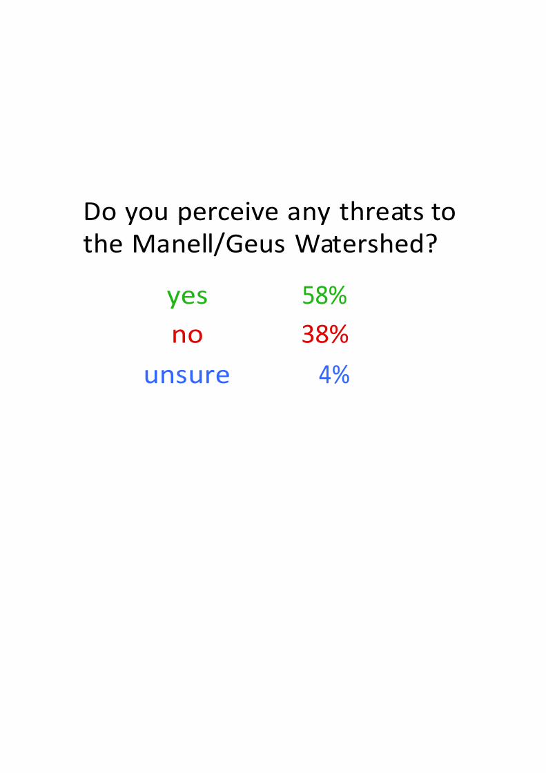
Do you perceive any threats to the Manell/Geus Watershed?
yes no
unsure
58% 38%
4%

Threat Perceptions Strongly disAgree
Don't Care
Strongly agree
Don't know disAgree agree
Pollution 2% 1% 2% 28% 49% 18%
Development 2% 3% 3% 26% 33% 32%
Wildland fires 3% 6% 3% 30% 31% 29%
Off-roading 3% 7% 5% 29% 21% 34%
Invasive Species 2% 5% 3% 30% 24% 36%
Lack of awareness 2% 7% 2% 28% 30% 31%
Lack of rainfall 4% 19% 3% 19% 20% 36%
Overfishing 7% 12% 4% 19% 16% 41%
Land clearing 2% 4% 2% 27% 40% 25%
Coastal erosion 1% 2% 1% 25% 50% 9%
Climate change 4% 6% 3% 27% 27% 34%
Overpopulation 5% 10% 3% 27% 25% 30%
Military build-up 4% 7% 3% 22% 28% 36%
Poor infrastructure 2% 3% 2% 27% 40% 26%
Flooding 2% 0% 1% 22% 57% 19%
Other

Some other alarming findings
52% of respondents were not familiar with the term watershed
40% of respondents felt they could not define the term ‘watershed.
46% of respondents were not familiar with the term ‘ridge to reef’.
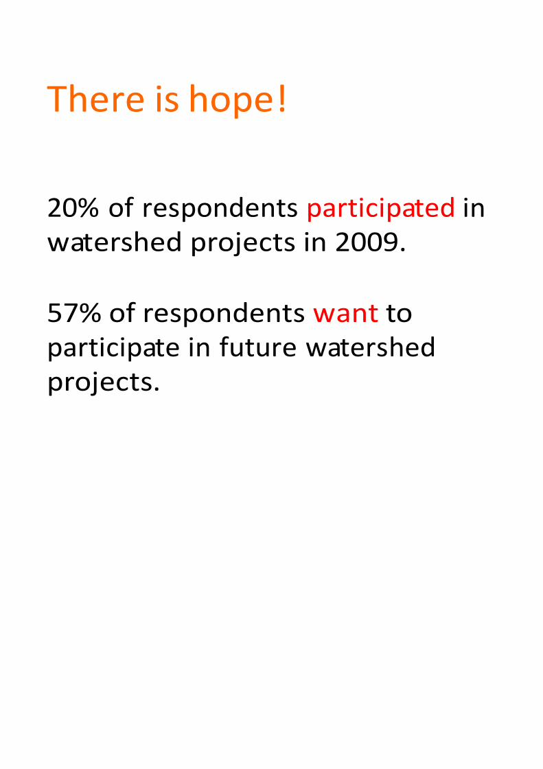
There is hope!
20% of respondents participated in watershed projects in 2009.
57% of respondents want to participate in future watershed projects.

Support for Achang Marine Preserve
14% 5% 6%
18% 23% 30%
Oppose Strongly oppose Do not care Support Strongly support Do not know
19%
41%

Desire...
Respondents wanted
CD To stop the flooding;
® Fix the roads and bridges;
@ Increase the number of activities for kids; and
@ Fix the schools.

Picture 1 - David Burdick
Si Yu'os Ma'åse'
Further questions? Contact me!
Photo Credits Romina King Picture 2 - David Burdick Email. [email protected]
T. 671 92958 (Guam until 23 Sept) T. 353.858348086