technical guidelines for irrigation suitability land …...technical guidelines for irrigation...
TRANSCRIPT
U.S. Department of the Interior Bureau of Reclamation Technical Service Center June 2005
Technical Guidelines for Irrigation Suitability Land Classification
Technical Guidelines for Irrigation Suitability Land Classification June 2005 U.S. Department of the Interior Bureau of Reclamation Technical Service Center Land Suitability and Water Quality Group Denver, Colorado

iii
Table of Contents Page Chapter I: Basic Requirements .............................................................................................I-1 I.A Purpose and Objectives...............................................................................................I-1 I.B Authority and Justification..........................................................................................I-2 I.C Definitions of Terms ...................................................................................................I-3 I.D Principles.....................................................................................................................I-7 I.D.1 Prediction ........................................................................................................I-8 I.D.2 Economic Correlation .....................................................................................I-9 I.D.3 Permanent-Changeable Factors ......................................................................I-9 I.D.4 Arable-Irrigable Analysis..............................................................................I-10 Chapter II: Factors of Land Classification ........................................................................ II-1 II.A General...................................................................................................................... II-1 II.B Economic Factors...................................................................................................... II-1 II.B.1 Productive Capacity ...................................................................................... II-2 II.B.2 Cost of Production ........................................................................................ II-3 II.B.3 Irrigation Development Costs ....................................................................... II-3 II.B.4 Interactions.................................................................................................... II-4 II.B.5 Management.................................................................................................. II-4 II.C Physical and Chemical Factors ................................................................................. II-5 II.C.1 Soil .............................................................................................................. II-5 II.C.2 Soil Quality ................................................................................................... II-5 II.C.3 Soil Characteristics ....................................................................................... II-6 II.C.4 Topography................................................................................................. II-10 II.C.5 Drainage...................................................................................................... II-13 II.C.6 Water Supply .............................................................................................. II-17 II.C.7 Climate........................................................................................................ II-21 Chapter III: Land Classification Specifications and Basic Land Classes................... III-1 III.A Land Classification Specifications........................................................................... III-1 III.A.1 Development of Specifications ................................................................. III-1 III.A.2 Specification Factors................................................................................. III-4 III.A.3 Specifications and Investigation Detail .................................................... III-6 III.A.4 Review of Specifications .......................................................................... III-8 III.B Basic Classes.......................................................................................................... III-18 III.B.1 Arable Area Classes................................................................................ III-24 III.B.2 Special Use Classes................................................................................. III-28 III.B.3 Basic Subclasses ..................................................................................... III-29 III.B.4 Informative Appraisals............................................................................ III-29 III.C Irrigable Land Classes............................................................................................ III-31
iv
Table of Contents
Page Chapter IV: Types of Land Classification Investigations ............................................. IV-1 IV.A General ................................................................................................................... IV-1 IV.B Preconstruction Land Classification ........................................................................ IV-3 IV.C Levels of Detail........................................................................................................ IV-4 IV.C.1 Reconnaissance Level Investigation ......................................................... IV-4 IV.C.2 Semi-Detailed Investigation...................................................................... IV-7 IV.C.3 Detailed Investigation ............................................................................. IV-11 IV.D Postconstruction Land Classification Investigation Types .................................... IV-14 IV.D.1 Irrigable Area Determinations ................................................................ IV-15 IV.D.2 Productive Area Determinations............................................................. IV-16 IV.D.3 Land Classification on Operating Projects ............................................. IV-17 IV.D.4 Land Classification and Class 1 Equivalency......................................... IV-21 IV.D.5 Unapproved Land Classification............................................................. IV-22 Chapter V: Land Classification Techniques ...................................................................... V-1 V.A General ................................................................................................................. V-1 V.B Preinvestigation Activities and Coordination ........................................................... V-1 V.B.1 Developing Scope of Work and Data Quality Objectives ......................... V-3 V.B.2 Available Land Data .................................................................................. V-4 V.B.3 Gross Investigation Area............................................................................ V-5 V.B.4 Study Guidelines........................................................................................ V-6 V.B.5 Informative Appraisals............................................................................... V-7 V.B.6 Productivity and Land Development ......................................................... V-8 V.B.7 Soils............................................................................................................ V-9 V.B.8 Land Use .................................................................................................. V-10 V.B.9 Farm Water Requirement......................................................................... V-10 V.B.10 Drainage................................................................................................... V-11 V.B.11 Present Land Characteristics.................................................................... V-12 V.B.12 Additional Informative Appraisals .......................................................... V-13 V.B.13 Base Maps and Equipment....................................................................... V-13 V.B.14 Personnel.................................................................................................. V-18 V.B.15 Coordination ............................................................................................ V-19 V.B.16 Mapping Symbol...................................................................................... V-20 V.C Field Investigations................................................................................................. V-22 V.C.1 Field Orientation ...................................................................................... V-23 V.C.2 Field Operation ........................................................................................ V-24 V.C.3 Water Quality........................................................................................... V-30 V.C.4 Clay Type................................................................................................. V-30 V.C.5 Additional Factors Affecting Infiltration ................................................. V-31

v
Table of Contents
Page V.C.6 Additional Factors Affecting Available Water ........................................ V-32 V.C.7 Evaluation for Predicted Level ................................................................ V-35 V.C.8 Leaching................................................................................................... V-36 V.C.9 Soil Reclamation and Crop Selection ...................................................... V-36 V.C.10 Prediction of Anticipated Soil Quality..................................................... V-39 V.C.11 Topographic Appraisal............................................................................. V-40 V.C.12 Irrigation Method and Topography.......................................................... V-47 V.C.13 Substratum Hydraulic Conductivity ........................................................ V-53 V.C.14 Water Table Observations........................................................................ V-54 V.C.15 Return Flows............................................................................................ V-55 V.C.16 Water Quality........................................................................................... V-57 V.C.17 Field Notes ............................................................................................... V-62 V.C.18 Designations of Land Classes .................................................................. V-65 V.C.19 Project Irrigable Area Determinations ..................................................... V-70 V.D Supplemental Procedures........................................................................................ V-79 V.D.1 Representative Soils................................................................................. V-81 V.D.2 Infiltration Rate........................................................................................ V-81 V.D.3 Available Water ....................................................................................... V-85 V.D.4 Soil Permeability...................................................................................... V-87 V.D.5 Land Reclamation .................................................................................... V-89 V.E Data Correlation...................................................................................................... V-94 V.F Field Review ........................................................................................................... V-96 Chapter VI: Presentation of Results .................................................................................VI-1 VI.A General.....................................................................................................................VI-1 VI.B Maps .........................................................................................................................VI-1 VI.B.1 Arable Area Field Maps............................................................................VI-2 VI.B.2 Irrigable Area Maps ..................................................................................VI-5 VI.B.3 General Maps ............................................................................................VI-7 VI.C Data Processing........................................................................................................VI-8 VI.D Reports .....................................................................................................................VI-9 VI.D.1 Reconnaissance .......................................................................................VI-11 VI.D.2 Semi-Detailed .........................................................................................VI-11 VI.D.3 Preconstruction Planning Report (Detailed) ...........................................VI-11 VI.D.4 Postconstruction......................................................................................VI-12 VI.D.5 Land Classification Reports for Classification or Reclassification Pursuant to the Reclamation Project Act of 1939...................................VI-12
vi
Table of Contents
Page Chapter VII: Interpretation and Approval......................................................................VII-1 VII.A Interpretation and Use of Results............................................................................VII-1 VII.A.1 Irrigable and Productive Land ..............................................................VII-1 VII.A.2 Water Management...............................................................................VII-2 VII.A.3 Land Use and Size of Farm...................................................................VII-2 VII.A.4 Land Development................................................................................VII-2 VII.A.5 Payment Capacity .................................................................................VII-3 VII.A.6 Irrigation Benefits .................................................................................VII-3 VII.A.7 Irrigation and Drainage Systems...........................................................VII-3 VII.A.8 Land Appraisal......................................................................................VII-3 VII.A.9 Irrigation Assessments ..........................................................................VII-4 VII.A.10 Environmental Assessment...................................................................VII-4 VII.A.11 Return Flow Assessment.......................................................................VII-4 VII.A.12 Miscellaneous Uses...............................................................................VII-4 VII.B Land Classification Approval .................................................................................VII-5 VII.B.1 Preconstruction Land Classification .....................................................VII-5 VII.B.2 Submission and Scheduling ..................................................................VII-8 VII.B.3 Type of Acreage Data Used..................................................................VII-8 VII.B.4 Field and Report Reviews.....................................................................VII-9 VII.B.5 Supporting Documents..........................................................................VII-9
Appendices 1 Economics Guidebook, Chapter 5, “Economic Analysis for Land Classification” 2 Land Classification Report or Appendix and Land Resources Chapter Outlines 3 References 4 Technical Checklist Procedures
Tables Table Page II-1 Guidelines for Interpretations of Water Quality for Irrigation .................................. II-19 II-2 General Effects of Trace Element Toxicity on Common Cultivars........................... II-20 II-3 Recommended Maximum Concentrations of Trace Elements in Irrigation Water..................................................................................................... II-21 III-1 Contributing Land or Water Factor............................................................................. III-5

vii
Table of Contents
Tables (continued)
Table Page III-2 Irrigation Suitability Land Classification Specifications Sample Project – Gravity Irrigation ................................................................................................ III-10 III-3 Irrigation Suitability Land Classification Specifications Sample Project – 1980..... III-12 III-4 Detailed Land Classification Specifications – Gravity-Type Irrigation ................... III-13 III-5 Detailed Land Classification Specifications – Sprinkler Irrigation .......................... III-14 III-6 Detailed Land Classification Specifications – Gravity-Type Irrigation ................... III-16 III-7 Land Classification Specifications (Preliminary) – Belle Fourche Project, South Dakota....................................................................................................... III-17 III-8 Symbols for Basic Land Classes and Subclasses...................................................... III-20 III-9 Substratum Permeability – Specification for Informative Appraisal Sample Project .................................................................................................... III-30 III-10 Farm Water Requirement (Gravity Irrigation) Specifications for Informative Appraisal – Sample Report ............................................................. III-30 IV-1 Normal Minimum Requirements and Average Coverage for Levels of Detail for Irrigation Suitability Land Classification ............................................. IV-2 VI-1 Arable Area Tabulation – Semi-Detailed Classifications...........................................VI-4 VI-2 Data Assembly Requirements by Specific Investigation Type...................................VI-8
Figures Figure Page IV-1 Study type versus level of detail - new land and developed areas.............................. IV-3 V-1 Reclamation land classification work performance network....................................... V-2 V-2 Example of a nomogram............................................................................................ V-68 VI-1 Arable area land classification map ............................................................... follows VI-6 VI-2 Irrigable area land classification map ............................................................ follows VI-6

I-1
Chapter I Basic Requirements
I.A. PURPOSE AND OBJECTIVES These Irrigation Suitability Land Classification Technical Guidelines (Technical Guidelines) are intended to be a practical reference for conducting economics-based irrigation suitability land classification investigations. Their use will aid in establishing a uniform approach to the variable conditions for which a land classification may be necessary and in providing an accurate appraisal of the land resource for irrigation suitability. Irrigation suitability land classification investigations are an integral part of multi-objective planning for the development and operation of Bureau of Reclamation (Reclamation) water resource projects with an irrigation component. They support planning and management by identifying land resource potentials or problems through the collection, evaluation, and presentation of land resources data. The primary objective of irrigation suitability land classification is to support irrigation project development by characterizing and delineating the lands suitable for sustained irrigated agricultural production under a given project setting. Some important land classification investigation contributions to an irrigation project planning study include assistance in determining: (1) proper land and water uses, (2) farm unit size, (3) establishment of repayment assessments, (4) benefits and costs, (5) land development needs, (6) irrigable area, (7) design of irrigation and drainage systems, (8) appraised value of land, (9) return flow water quality, and (10) irrigation requirements. Data collected and analyzed during irrigation suitability land classification investigations may also contribute to other land and water use studies. These may include irrigation scheduling, irrigation water requirements, suitability of water for other uses, existing soil and water conditions, potential impacts to soil, and analysis of the quality of irrigation return flows as a result of irrigation development. Land use inventories, suitability for uses other than irrigation, modified soil surveys, and other land resource investigations that may be requested by other Federal and State agencies often do not require economic

Technical Guidelines for Irrigation Suitability Land Classification
I-2
correlation, but many of the procedures presented in these Technical Guidelines will be useful for such studies as well.
I.B. AUTHORITY AND JUSTIFICATION Classification of lands for irrigation purposes began with the passage of the Reclamation Project Act of 1902 (32 Stat. 388) as a vital element in the Federal reclamation program. However, early classifications relied primarily on land elevation, with respect to water supply and topographic conditions. After several years of project development, a number of requests for repayment relief from water user organizations led to the formation of a group of special advisors to study causes of the problem and make recommendations for corrective action. The special advisors made recommendations that resulted in the Fact Finder’s Act of December 5, 1924. Reclamation’s current system of land classification for irrigation suitability evolved from the activities of the “Fact Finders” and stems from the following provision of the Act (Subsection D, 43 Stat. 702; 43 U.S.C. 462):
The irrigable lands of each new project and new division of a project hereinafter approved shall be classified by the Secretary with respect to their power, under a proper agricultural program, to support a family and pay water charges, and the Secretary is authorized to fix different construction charges against different classes of land under the same project for the purpose of equitably apportioning the total construction cost so that all lands may as far as practicable bear the burden of such cost according to their productive value.
The Reclamation Project Act of August 4, 1939 (53 Stat. 1192, 43 U.S.C. 485g) was enacted for the purpose of providing Reclamation irrigation projects a feasible and comprehensive plan for an economic and equitable treatment of repayment problems. Section 8 of this Act provides for the classification or reclassification of lands “from time to time” that “have been, are, or may be included within any project,” but not more often than at 5-year intervals. The Reclamation Manual Policy, WTR P06, dated January 29, 2004, “Determination of Irrigation Suitability of Proposed Project Lands, and Identification of Lands That May Receive Project Irrigation Water on Operating

Chapter I Basic Requirements
I-3
Projects,” established requirements for irrigation suitability land classification associated with Reclamation activities and specifies characteristics of lands to which Reclamation has authority to deliver project irrigation water regardless of classification status. Reclamation Manual Directives and Standards, WTR 06-01, dated January 29, 2004, “Irrigation Suitability Land Classification for New Projects or Operating Projects,” established requirements for irrigation suitability land classification procedures associated with various Reclamation activities. In planning for Reclamation projects with an irrigation component, it is a general requirement that lands be classified as arable, and determined to be irrigable, in order to be eligible to receive a Reclamation project water supply for irrigation purposes. However, on operating projects, the policy, WTR P06, should be reviewed to determine those lands that are eligible for irrigation water service.
I.C. DEFINITION OF TERMS Several terms important to land resources investigations and, particularly, to irrigation suitability land classification, are defined in this section. Soil is the unconsolidated material on the surface of the earth, consisting primarily of mineral and organic matter and containing pore space occupied by air and water that has been subjected to and influenced by genetic and environmental factors of parent material, climate, living organisms, and topography. These factors interact over time to develop soil that differs from the material from which it was derived in many physical, chemical, biological, and morphological properties and characteristics. Soil Survey is the systematic examination, description, classification, and mapping of soils in an area. A soil survey refers to a genetic and morphological classification performed in accordance with soil taxonomy. These surveys are normally accomplished by cooperating agencies with the National Cooperative Soil Survey (NCSS), but primarily the Natural Resources Conservation Service (NRCS). Soil surveys may also provide information on soil mapping units related to their productive capacity including ranges of chemical and physical properties and expected yields.

Technical Guidelines for Irrigation Suitability Land Classification
I-4
Land is the total natural and cultural environment within which production takes place; a broader term than soil. In addition to soil, its attributes include other physical conditions such as substrata properties, drainage conditions, mineral constituents, climate, topography, plant cover; location in relation to centers of commerce, populations, and other land; the size of the individual tracts or holdings; and improvement works. Irrigation Suitability Land Classification is the systematic evaluation of lands and their designation by categories or classes based on similar physical and chemical characteristics and related economic conditions, with respect to suitability for sustained agricultural production under irrigation and irrigation service under a plan for water and land resource development. Irrigation farming suitability connotes a reasonable expectancy of permanent, profitable production under irrigation and is measured as anticipated return to farm labor, management, and capital including onfarm irrigation development costs. The primary purpose of irrigation suitability land classification is to establish the extent and degree of suitability (arability) of lands for sustained irrigation farming to serve as a basis for selecting lands to be included in an irrigation project. Arable Land is land that, when farmed in adequate size units for the prevailing climatic and economic setting and provided with the necessary onfarm improvements, will generate sufficient income from the commercial production of crops under irrigation to pay all farm production expenses; provide a reasonable return to the farm family's labor, management, and capital; and at least pay the operation, maintenance, and replacement (OM&R) costs of associated project irrigation and drainage facilities. The arable area comprises all land delineated in the land classification that will provide sufficient income to warrant consideration for irrigation under project conditions. Examples of onfarm improvements include vegetation and other cover removal, land leveling, soil reclamation, drainage, and irrigation-related facilities. In project development planning, the arable area generally remains constant with alternate project plans unless economic conditions change sufficiently to require revised classification or land use changes to preclude irrigation purposes.

Chapter I Basic Requirements
I-5
Irrigable Land or Irrigation Service Area is arable land under a specific Reclamation project plan for which a water supply is or can be made available and is provided with or planned to be provided with irrigation, drainage, flood protection, and other features as necessary for sustained irrigation. The irrigable lands are determined from the arable lands by considering potential economic benefits, limitations imposed by water supply, irrigation return flow water quality, cost of facilities and service to specific tracts, rights-of-way, and other nonproductive purposes. The irrigable area acreage will be used in Reclamation reports and in contracts with water users organizations. The irrigable area may vary with each alternative plan for irrigation development for a specific irrigation project. The official project irrigable area is typically determined at the end of the development period after project construction. Changes in the irrigable area involving irrigation suitability land classification or reclassification after the official irrigable area determination are accomplished through procedures authorized by the Reclamation Project Act of 1939, Reclamation Manual Policy, WTR P06, and Directives and Standards, WTR 06-01, for irrigation suitability land classification. Irrigated Land, not to be confused with irrigable area or acreage, describes land that is in an irrigation rotation regardless of the water supply source and/or eligibility for irrigation by Reclamation project water. Payment Capacity is the estimated residual net farm income of irrigators available for payment of both federally and non-federally assessed water costs, after deduction for onfarm production and investment expenses, as well as appropriate allowances for management, equity, and labor. Productive Land is that portion of the irrigable area actually subject to cropping under irrigation. The productive area of a project will be less than the irrigable area. In order to determine the productive land or area, the irrigable acreage is reduced by the acreage that is uncultivated when irrigation development is completed, including areas such as farm roads, farm laterals and other irrigation structures, farm drains, and fence rows. Productive land area provides a basis for determining water requirements, canal capacity requirements, and production totals for farm budgeting in determining land classes and payment capacity.

Technical Guidelines for Irrigation Suitability Land Classification
I-6
Productive Capacity refers to the capability of lands or soils to accommodate growth of a variety of crops and sustain yields relative to the required inputs for production. Costs of Production include annual crop production costs such as labor, soil amendments, equipment, and water. These costs are important to the development of irrigation suitability land classification specifications. Irrigation Development Costs are those onfarm costs associated with the initial preparation of the lands for agricultural production under irrigation and the acquisition and installation of an irrigation system. These costs are governed largely by topography, soils, substrata characteristics, and cover. Such costs include those for clearing the land surface of rocks and vegetative cover, grading, and construction of farm laterals and drains. The irrigation development costs are costs for which the landowner is responsible and, therefore, are a factor in the land classification determination. Full Irrigation Service Land is irrigable land now receiving, or which will receive, its sole and generally adequate irrigation supply through works and facilities constructed, rehabilitated, or replaced by Reclamation. Supplemental Irrigation Service Land is irrigable land that is now, or will be, receiving an additional or reregulated supply of irrigation water through facilities constructed by, or to be constructed by, Reclamation. Such supply, together with the supply from nonproject sources, will normally make up an adequate supply. Land Class is a designation for a body of land within a specific project that has soil, topography, and drainage characteristics that result in a similar economic level of suitability for irrigation. Land classes represent relative levels of payment capacity. The same land classes are applicable to both arable and irrigable areas. The range of classes covers both suitable and unsuitable lands. The biological, chemical, and physical characteristics of lands within a land class may differ as long as they have economic similarity. Payment capacity ranges for land classes are variable between different areas of investigation, due to differences in climatic and geographic setting. Land classes used by Reclamation are described in Chapter III.

Chapter I Basic Requirements
I-7
Subclass is a category within a land class that identifies the general type(s) of deficiencies such as soil, topography, and drainage (e.g., 2 s or 3 st). Further subdivision is common with the designation by a symbol of specific deficiencies within the general categories (e.g., 2 s - h or 3 st - hg). See table III-8, in Chapter III, for an explanation of symbols. Informative Appraisal is an evaluation of selected land-related parameters designed to provide additional information for planning, developing, or operating irrigation projects. Table III-8 provides a listing of symbols used for informative appraisal.
I.D. PRINCIPLES Reclamation=s irrigation suitability land classification procedures have been developed for the purpose of equitably apportioning the allocated construction cost in order that all lands may, as far as practicable, bear the burden of repaying the apportioned cost according to their productive capacity. They are also designed to provide definitive, sound, and relatively permanent basic data that are essential to solving agronomic, economic, and engineering problems associated with Reclamation's irrigation projects. The most important phase of a land classification investigation is the separation of the lands that are considered satisfactory for irrigation development from the lands that are not satisfactory (arable from nonarable). The measurement of the suitability of lands for irrigation is made in terms of payment capacity. Unless the land is capable of attaining a minimum payment capacity (that which would cover its per-acre share of annual operation, maintenance, and replacement costs under typical management, specific land use, and farm organization for the geographic and climatic setting), it is considered unsuitable (nonarable) for development under a Reclamation irrigation project. Four basic principles are of primary importance in structuring the land classification to meet the needs and goals of specific areas: (1) prediction, (2) economic correlation, (3) permanent-changeable factors, and (4) arable-irrigable analysis. These principles are considered unifying factors in Reclamation's irrigation suitability land classification system. The principles of permanent-changeable factors and arable-irrigable analysis are closely related to the principle of economic correlation, since nearly all land characteristics may be

Technical Guidelines for Irrigation Suitability Land Classification
I-8
altered at some cost, and since determination of the irrigable area within the arable area is a process for delineating the lands that are eligible to receive project water in planning a Reclamation irrigation project.
I.D.1. Prediction Under the prediction principle, the classes in the system express the land-water-crop and economic interactions expected to prevail after project development. Changes that will result with irrigation development must be identified and evaluated. Land selected for irrigation should be capable of sustained productivity under irrigation after appropriate development. The introduction of irrigation shifts the natural balance established over time between water, land, fauna, flora, and man. Therefore, irrigation project planning should identify and evaluate expected changes and formulate plans that ensure successful, sustainable agriculture. Irrigation development induces changes in the physical, chemical, and biological characteristics of land. Many of the changes are interrelated and complex. Soil structure and texture may be modified by physical and chemical processes. Important chemical changes may occur in the composition and concentration of dissolved constituents in the soil solution. Irrigation water may introduce or remove phytotoxic ions. Land development activities such as land forming, rock and brush removal, and contour benching may alter the land's macro-relief and micro-relief. Leaching, use of additives such as gypsum, deep plowing, and land grading may change the soil profile characteristics. Irrigation may also cause land subsidence and increased erosion. The prediction principle involves consideration of irrigation water quality; soil, subsoil, and substrata characteristics and conditions; drainage; impacts upon irrigation return flow quality; and land use and management for specific plans. In prediction, the classification will also consider water requirements, expected soil profile modification practices, soil productivity following land-forming, flood hazard, soil erosion, quality of return flow, and crop production inputs and outputs.
Chapter I Basic Requirements
I-9
I.D.2. Economic Correlation The economic correlation principle involves relating the physical factors of soil, topography, and drainage with associated economic factors within a given geographic setting. Ultimate productivity of the land in a specific project setting is defined in terms of net farm income or payment capacity. Net farm income measures the benefits directly accruing to the farmer, while payment capacity represents the residual available to defray the cost of water after making allowances for return to the farm family for labor, management, and equity. With land classes defined as economic entities, a set of land classification specifications (see section III.A, “Land Classification Specifications,” for a discussion of land classification specifications) has been developed that correlates economic factors with the characteristics of the lands to be investigated. The land class-determining range of these characteristics varies with the economic, ecological, technological, and institutional factors expected to prevail in the area. Consequently, land classes express the ranking of land value for irrigation farming under expected project conditions (i.e., best suited, moderately suited, marginally suited, and unsuited). Due to the possibility of wide variation in project settings (climate and economic parameters), lands of similar physical characteristics may be nonarable in one setting and arable in another.
I.D.3. Permanent-Changeable Factors Although most land factors are changeable at a cost, there are land features for each setting that may or may not change appreciably under irrigation. Typical changeable land features include: soil factors such as salinity, sodicity, structure, acidity, exchangeable aluminum, and soil depth resulting from land grading; topographic factors such as brush and tree cover, rock cover, and micro-relief; and drainage factors such as the depths to water table, surface ponding, and flood hazard. Through economic correlation and establishment of specifications, the permanent-changeable factors will be identified to ensure uniform appraisal of land conditions in making the land classification investigation. The land classification investigation must deal with whether the change can be
Technical Guidelines for Irrigation Suitability Land Classification
I-10
accomplished and the degree of change that is economically feasible. However, with time and development, permanent changeable factors may be modified based on management practices, preferences, and available technology. Limitations imposed by economics establish the degree of changes that are possible within the project setting.
I.D.4. Arable-Irrigable Analysis Although the arable-irrigable area analysis is closely related to economic correlation, it is a separate process involving many disciplines. Arable area determination by an irrigation suitability land classification investigation is the initial step of the arable-irrigable analysis. Subsequently, the irrigable area to be included in the plan of development is selected from within the arable area. This selection is influenced by plan formulation goals. Detailed instructions on determination of the irrigable area are covered in Section IV.D., “Postconstruction Land Classification Investigation Types,” in Chapter IV. The application of plan formulation and evaluation criteria generally leads to successive deletion of identifiable increments of arable lands from the plan of development. Typical adjustments include:
• Exclusion of noneconomic increments such as those that are too costly to serve, drain, or manage
• Conformance of land area to serviceability, manageability, and
drainability
• Deletion of isolated segments, irregular-shaped tracts, and severed areas that cannot be fitted efficiently into the farm unit pattern
• Deletion of proposed public rights-of-way
• Exclusion of land areas that would contribute excessive salinity or
hazardous concentrations of trace elements to return flows

Chapter I Basic Requirements
I-11
• Inclusion of small bodies of land originally classified as nonarable that lie within large bodies of arable land and that would be developed more advantageously in conjunction with the arable lands than by exclusion from the project
• Exclusion of land areas that are zoned or planned for early urban,
industrial, or public use development.

II-1
Chapter II Factors of Land Classification
II.A. GENERAL Irrigation suitability land classification is based primarily on economic considerations. Although delineation of land classes in the field is based on physical land characteristics, the mapping specifications that express these differences are developed on the basis of economic factors. The pertinent factors of soil, topography, drainage, climate, and water quality of the specific area to be investigated must be correlated with economic factors to formulate land classification specifications. Normally, specifications are developed within the framework of the anticipated method of irrigation; e.g., gravity irrigation, pressure systems (sprinkler or drip irrigation). When the classification specifications are limited to sprinkler or drip irrigation methods, special use classes are used in the land classification. Special use specifications may also be developed for land classification investigations where land characteristics restrict cropping to particular crops or crop types (e.g., orchards in general, avocados or rice). Section III.B.2 in chapter III provides more detailed information on special use classes. The specifications provide the guidelines by which lands are mapped for irrigation suitability. Social, environmental, and other factors may also affect the selection of arable lands; however, they usually affect all lands of a project equally and normally are not included in specifications as individual items. The irrigable area may be affected by additional economic, cultural resources, environmental, social, and engineering considerations involved in project formulation.
II.B. ECONOMIC FACTORS
The basic economic factors considered in establishing the specifications for the land classification include: productive capacity, costs of production, and costs of irrigation development onfarm. These factors may be influenced for a specific area by the economic setting, prevailing cultural practices, social customs, environmental considerations, irrigation methods, management practices, and

Technical Guidelines for Irrigation Suitability Land Classification
II-2
many other factors. Therefore, it is necessary that conditions for the specific determination be defined when integrating these factors into a defined land class
II.B.1. Productive Capacity Productive capacity refers to crop adaptability and crop yields. The value of any farmland depends largely on its ability to sustain the production of crops of use to mankind. Climate; land features such as soil, topography, and drainage; water supply quantity and quality; environmental restrictions; and accepted cultural practices may influence the level of productivity. Productivity is also influenced by the management level. Because of the inability to measure accurately the actual level of management in the area over an extended period of time, a constant or typical level must be assumed in establishing specifications for an irrigation suitability land classification investigation. Climate is the single most important factor in productivity. Length of the growing season or frost-free period; frequency and type of storms; humidity; prevailing winds; and precipitation have a major influence on kinds of crops grown and their yields. Cultural practices may also be influenced by climate. Soil, topography, and drainage are influenced indirectly by past and present climatic conditions. Soil conditions are probably second only to climate in importance. Permeability, infiltration rate, available water, phytotoxic elements, fertility, and erosion hazard are some of the soil factors influencing productivity. Topographic factors influencing productivity are gradient relief (slope and method of irrigation), and cover (amount of surface cobble and/or stone). If cover removal is required before normal farming operations may take place, then the removal is considered an irrigation development cost. Drainage conditions that must be considered include onfarm surface flooding and control, subsurface (farm drainage outlets, depth to water table, permeability of substrata, depth to restrictive layer), and flooding from sources off the land. Other factors that may influence productivity include:

Chapter II Factors of Land Classification
II-3
• The total water supply and its characteristics. • Lack of adequate marketing facilities, lack of suitable labor, and other
economic factors that may limit crops grown or delay cultural and harvesting practices.
• Environmental regulations restricting the use of certain pesticides and the
discharge of toxic or harmful return flows into natural streams.
II.B.2. Cost of Production
The costs associated with production are important to the development of land classification specifications. Experience has shown that annual production costs such as those for labor, soil amendments, equipment, and water are related to the type of crop, water quality, and land. Factors that influence the choice of crop, crop yields, frequency of irrigation, irrigation method, cultural practices, drainage requirements, and local economic conditions can affect production costs. These factors can be influenced by soil, topography, drainage, climate, or the water supply. Other cost factors may be local price levels, marketing facilities, quality and availability of labor, and environmental regulations. A farm smaller than the optimum size may also increase per unit costs of production.
II.B.3. Irrigation Development Costs
The suitability of lands for irrigation is related directly to irrigation development costs. Land classes reflect not only productive capacity and costs of production, but also the costs assumed by the owner/operator (onfarm costs) to initially prepare the lands for irrigation. Irrigation development costs are long-term investments in land improvements needed for successful and sustained crop production under irrigation. The cost of irrigation development is governed largely by topographic characteristics, although soil and substrata characteristics, cover, and other factors may be significant. Development costs, such as land leveling, may be reduced or eliminated by using alternative irrigation methods, which usually results in a tradeoff of annual production costs for development costs. Clearing the land surface of rocks and vegetative cover, grading, constructing permanent farm ditches and drains, adding soil amendments to
Technical Guidelines for Irrigation Suitability Land Classification
II-4
improve soil structure, and deep plowing are the most common development costs. It is important to establish early in an irrigation suitability land classification investigation which drainage costs will be the direct responsibility of the landowner (onfarm) and which will be considered to be project costs. The onfarm costs are a factor in determining the arability of the lands; while project costs (e.g., costs for providing project drainage facilities) primarily influence irrigability determinations. However, it should be noted that project facilities likely also affect OM&R costs, which are a factor of arability. The maximum or allowable development cost for each arable land class must be established for the proper placement of lands into classes for irrigation suitability. These maximum costs are related to the specific costs for which the owner/operator is responsible. Procedures for determining the maximum allowable irrigation development costs can be found in Appendix 1, AEconomic Analysis for Land Classification,@ revised December 2001.
II.B.4. Interactions
There usually are tradeoffs among the three economic factors of productive capacity, cost of production, and irrigation development costs on a specific piece of land. The choice of a sprinkler or drip system instead of surface irrigation usually will reduce the development costs and increase annual costs. Land grading to improve the field size and shape will result in a higher development cost and lower operating costs. The grading in some instances could reduce the effective rooting depth and, thus, reduce the productivity of the land. The possible tradeoffs must be considered in establishing the criteria for an investigation.
II.B.5. Management
Management plays a major role in the success of irrigation farming. The irrigation method, crops grown, cultural practices, and many other choices are management decisions. The success or failure of an operation may depend upon the manager's ability to make appropriate decisions. Under normal circumstances, specifications for land classification are developed assuming a
Chapter II Factors of Land Classification
II-5
level of management that will be typical of the area at the end of the development period. The subsequent level of management for specific farm units may be better or worse than that assumed to be typical, and may result in failures on lands considered suitable for irrigation or result in successes on lands considered unsuitable for irrigation.
II.C. PHYSICAL AND CHEMICAL FACTORS
The distinction between various classes of land and their delineation in the field will be made through consideration of the land and water characteristics, which have economic significance in relation to sustained irrigated agriculture. The specifications developed for each investigation indicate the ranges in physical characteristics that are nearly equal in payment capacity. An individual physical factor may influence one or more of the economic factors. The basic physical factors are soil, topography, drainage, water quality, and climate. Water and climate differ from the others in that they are usually uniform throughout the specific area to be investigated. The specifications are normally constructed on the assumption that water and climate will influence all lands equally.
II.C.1. Soil
The soil is a major factor in the suitability of land for sustained irrigation. Its primary influence is on the productive capacity, but it may also influence production and development costs. Some irrigation systems are capable of alleviating certain soil deficiencies, such as low available water-holding capacity, a high infiltration rate, etc. Sprinkler and drip irrigation systems often provide better control over water applications and permit more frequent applications than gravity systems. Better control and management of water applications can reduce drainage volumes and maintain a more uniform soil moisture content.
II.C.2. Soil Quality
The most desirable soil qualities for diversified crop production under sustained irrigation include: (1) a water-holding capacity adequate to retain and provide optimum moisture for crops between irrigations with the proposed irrigation

Technical Guidelines for Irrigation Suitability Land Classification
II-6
system; (2) an internal drainage adequate to maintain an aerated root zone and an acceptable salt level; (3) an infiltration rate adequate to replenish soil moisture depleted from evapotranspiration without excessive losses with the proposed irrigation system; (4) an adequate depth to allow optimum root development; (5) a tillable surface; (6) noninjurious amounts of exchangeable sodium, or soluble phytotoxic substances; and (7) amendable by an adequate supply of plant nutrients. Production of some crops, however, may require or tolerate specific soil characteristics that are not necessarily conducive to diversified cropping. Desirable soil conditions for rice production, for example, include a relatively slow internal drainage rate that will maintain optimum soil submergence but be adequate to permit maintenance of low levels of salinity, toxic ions, and reduction products. Slow internal drainage is not a favorable soil quality for most crops. Conversely, grapes and some citrus crops can be successfully produced under drip irrigation on soils with rapid infiltration and internal drainage with minimal water-holding capacity. Such conditions are not favorable to most diversified cropping. Therefore, the soil characteristics and their ranges (specifications) established for suitability must relate to the expected cropping and irrigation method and should either exist prior to irrigation or be capable of improvement within the established economic limits.
II.C.3. Soil Characteristics
Several soil characteristics must be evaluated to determine soil suitability for irrigation. The primary factors are soil-moisture relationships, toxicity, fertility, depth to gravel and cobble, depth to soil horizons that restrict root development or water movement, and the erosion hazard.
a. Soil-Moisture Relationship Internal drainage, infiltration, and available water-holding capacity are key soil-moisture characteristics and are influenced by soil properties. Internal drainage

Chapter II Factors of Land Classification
II-7
(hydraulic conductivity) may be influenced by texture, structure, density, sodicity, salinity, layering, organic matter, moisture content, and water quality. Extent and size of pore space, which are directly related to the rate of water movement in soil, are closely associated with soil texture. Soil structure, soil density, salinity, sodicity, and organic matter can further modify pore size and distribution. Within a given textural class, the permeability usually is related inversely to the bulk density. Soils with a stable structure are the most permeable. Soil structure stability may vary with degree and type of development, organic matter, salinity, and/or sodicity. Organic matter and salinity contribute to the flocculation and stability of the soil structure, while sodium has the opposite effect. Clay type influences permeability, chiefly by its swelling and shrinking qualities with changes in soil moisture. Soils with montmorillonitic clays usually form cracks when drying. Their initial rates of water movement are high but reduce appreciably as the soil becomes moist. The permeability of kaolinitic/illitic clays is affected more adversely by high sodium content than single-layer types. This is because of the effect of high sodium content on the dispersion and swelling of the different types of clays. In situations where a very permeable soil horizon occurs below a more slowly permeable horizon, the movement of water into the lower soil layer is restricted and a higher water content accumulates in the upper soil horizon. The influence of water quality on the soil permeability usually is related to its salt and sodium content. A relatively dry soil usually has a higher initial permeability rate than more moist soils because of the expansion of the soil restricting the pore space when it takes in moisture. Infiltration (the rate at which water enters the soil) is influenced primarily by characteristics of the surface soil. Other factors that influence infiltration include vegetation, tillage practices, salt content of the water, suspended sediment content of the water, organic matter, slope, surface drainage, water head, irrigation method, and management skills. When the infiltration capacity greatly exceeds the permeability of the subsoil, the permeability will greatly influence the basic intake rate of the soil. The infiltration rate may influence selection of the irrigation method, length of irrigation runs, field size, irrigation development costs, crop selection, and many other management decisions. Adequate estimations of hydraulic conductivity (permeability) can be made by using field observations, laboratory data, results of field site studies, and by observing similar lands under irrigation. Because of soil variability that may occur within short distances, it is usually impractical to measure the complete range of variation with
Technical Guidelines for Irrigation Suitability Land Classification
II-8
field site studies (see Section V.C., “Field Investigations,” in Chapter V for more information on guidance for field investigations). The available water relates to that part of soil water that is available to most crops. It is important in determining the frequency of irrigation, which may influence the irrigation method, crop adaptability, and other management factors. Available water is related primarily to pore and particle size as affected by soil texture. Soil depth, soil layering, and depth to an anticipated water table are also major factors that must be considered when determining the amount of available water a soil profile can hold. Generally, fine-textured soils (clay, clay loam, or silty clay loam) will have a higher available moisture at field capacity than coarser-textured soils. However, soils with an extremely high clay content may actually have less available water than some medium-textured soils (sandy clay loam, loam, or silt loam). A soil horizon with an appreciably lower permeability than the horizon immediately below will usually retain more water than if permeability is uniform throughout the depth of wetting. The material above a water table usually will contain more available water than a similar soil not influenced by a water table. Soil structure, soil density, clay type, and sodicity have some effect on available water, but these may be difficult to evaluate accurately by observation. See Section V.C., “Field Investigations,” in Chapter V. A number of methods are available to alleviate or correct soil-moisture relationship deficiencies under an irrigation regime. Their application is controlled primarily by economic feasibility. Irrigation systems that permit precise and/or frequent water application may overcome or lessen deficiencies of available water, soil permeability, and soil infiltration. Amendments (sources of calcium or magnesium) to replace sodium in the soil may improve soil structure and permeability. Deep plowing procedures are available to break up and mix hard pans, clay pans, or other restricting horizons with more suitable materials. In developing specifications, soil improvement procedures should be considered, their cost determined, and their economic relationship to arability delineated.
b. Soil Toxicity
Some naturally occurring trace elements such as boron, lithium, and selenium may reach phytotoxic concentrations in the soil solution upon irrigation, thereby influencing land suitability for irrigation (arability).

Chapter II Factors of Land Classification
II-9
High concentrations of chlorides, sodium, and sulfates may also be factors with specific crops. Their effect varies greatly with crop, soil characteristics, drainage conditions, and management level. Selenium toxicity affecting crop production is limited to a relatively few areas in the United States. Permissible limits of potentially phytotoxic ions or trace elements may vary greatly depending on crops grown, climate, management, and the availability of economical mitigating measures (see Ayers and Westcot, 1985). Guidelines for maximum concentrations of ions or trace elements in irrigation supplies or soil water should be considered in specifications for irrigation suitability, where applicable, as they affect productive capacity or perhaps costs of production. However, soluble trace elements may also concentrate in drainage return flows and result in downstream water quality degradation. Irrigation-induced water quality contamination has become a problem in some areas of the West, resulting in increased emphasis on the investigation of trace elements and the impacts resulting from irrigated agriculture. Usually, water quality degradation, including toxic or hazardous levels of trace elements, induced by irrigation is considered an irrigability issue. In other words, the lands contributing to the problem may be arable (have sufficient payment capacity), but their irrigation results in significant contamination of water supplies that cannot be satisfactorily (technically or economically) mitigated such that they are removed from irrigation consideration. Such lands would be considered arable but not irrigable. During the land classification investigation, soil trace element levels should be determined relative to limits affecting arability and irrigability. More detailed discussion of this analysis may be found in Section V.C.15., “Return Flows,” in Chapter V.
c. Soil Fertility
The initial plant nutrient content of a soil generally is not a major factor in the suitability of land for irrigation. The primary consideration is whether or not an adequate supply of nutrients can be provided to crops under a reasonable program of fertilization. Generally, a fertilization program to provide one or more nutrients is necessary with irrigation farming. Fertilization is a cost of production,
Technical Guidelines for Irrigation Suitability Land Classification
II-10
and the need for a continued intensive fertilization program may result in a lowering of land class. Cation exchange capacity is a measurement of the ability of a soil to exchange and hold ions important to soil fertility. A low cation-exchange-capacity (CEC) reflects an inability of the soil to hold and provide adequate nutrient elements. This condition may limit production and will probably be costly to correct. Clay type and soil texture contribute to this condition. Estimation or measurement of the CEC, as well as observation of results from comparable areas, can be used to evaluate soil fertility and establish specification limits relative to the costs of production.
d. Erosion
The potential erosion hazard generally is not a limiting factor in irrigation suitability; however, it should not be ignored. Soil characteristics, topography, climate, and management practices are major factors contributing to erosion. Erosion may result from improper irrigation practices or from natural causes, each of which may intensify the other. Cultural or irrigation practices that may contribute to erosion are crop type, irrigation method, length of run, head of irrigation stream, and other management factors. The amount, intensity, and timing of storms are also major factors. Land factors such as the infiltration and slope are also significant. Control of erosion may be enhanced by irrigation. Maintaining a better vegetative cover, which is possible with irrigation, may reduce water and wind erosion. Allowance, usually addressed as an irrigation development cost, should be made in developing specifications for adequate control of erosion to prevent destruction of the land and to hold pollution of streams receiving runoff waters to a minimum.
II.C.4. Topography
The principal topographic characteristics determining suitability of land for irrigation are slope, relief, and cover. These factors may influence method of irrigation, land development, design of onfarm irrigation systems, erosion hazard, drainage requirements, water use practices, crop, and other management and production costs. Specific irrigation factors related primarily to topography include gradient, land grading requirements, onfarm surface drains, field size and shape, and cover removal costs.

Chapter II Factors of Land Classification
II-11
a. Topographic Quality
The topographic characteristics most favorable for sustained irrigation may vary with a number of factors, including the type of irrigation system selected for use. The best features for a gravity system are: (1) a gradient that facilitates uniform water distribution, allows optimum length of runs, and permits adequate control; (2) relief that is economically feasible to correct without permanent damage to the land and that will permit uniform water distribution for optimum production, salinity control, minimal drainage problems, and water conservation; (3) relief that allows field size and shape to be tilled efficiently, permits water conservation and, when irrigated, results in a minimal nonproductive area; and (4) no rock or vegetative cover, or cover that can be removed readily without permanent damage to the land within limitations imposed by prevailing economic conditions. Selection of the proper irrigation system may minimize or eliminate many of the limitations imposed by topography. The trend is to more automated irrigation systems (such as sprinkler or drip irrigation systems) to conserve water and reduce labor requirements. These systems minimize the effects of steep gradient, reduce or eliminate the need for most land grading, and usually eliminate restrictions on field size. Where there is a choice of irrigation systems, land characteristics may be the major factor in selecting a particular system.
b. Topographic Characteristics
Land classification factors most affected by topographic qualities are gradient, land grading, field size and shape, and cover. They greatly influence the suitability of land for irrigation. Position of the land is a more important factor for irrigable area determination. (1) Gradient. The length of the irrigation run, crop adaptability, erosion control practices, cultural practices, and irrigation method may be influenced by the land gradient. With surface irrigation, the following adverse effects occur as the gradient increases: erosion hazard increases, water control becomes more difficult, the practical length of irrigation runs decreases, crop selection becomes more limited, and cover crops may be necessary to reduce erosion and permit water conservation. In extreme cases, gradient may dictate the irrigation method used. Selection of the best adapted irrigation method, selection of crops that
Technical Guidelines for Irrigation Suitability Land Classification
II-12
provide protection from erosion, bench leveling, and good management practices are several means by which deficiencies of steep gradient can be overcome or modified. Bench leveling requires deep soil, is expensive, and requires a nonproductive berm between benches. These factors intensify as the gradient increases. Steep gradients usually result in lower productivity and/or higher costs of production. Permissible slope ranges for arable lands are set within ranges established by the U.S. Department of Agriculture (USDA), State universities, etc., for the general area under investigation.
(2) Land Grading. All lands that are developed for surface irrigation (and some being developed for sprinkler irrigation) require grading to ensure uniform water distribution and water conservation. The extent of grading may depend on the land relief, soil depth, anticipated crop, irrigation system (corrugation, border-dike flooding, bench, etc.), water quality, drainage conditions, and desirable field size. The relief of the land is probably the most important factor in determining land grading requirements. It not only dictates what should be graded within the economic limits imposed for the area, but it also influences the irrigation system, drainage conditions, and field size. Corrugations and flooding usually require less precise grading. Border-dike and contour bench require the most precise grading. Normally, sprinkler and drip systems require only sufficient grading to permit efficient cultural operations. Precise grading is desirable when using saline water so that uniform leaching can be achieved throughout the field. Greater precision will be required in grading the land when it is necessary to maintain a given depth to the water table. Shallow soil depth over incoherent sands and gravels, concentrated lime zones, glacial till, bedrock or pans that restrict root growth, and permeability may impose limitations on allowable depth to which soil can be removed during grading operations.
(3) Field Size and Shape. Topography may be a major factor in determining the field size and shape, particularly with surface irrigation. The infiltration rate of the soil, gradient, nonarable bodies of land interspersed in the irrigable area, ownership boundaries, and project features such as ditches and drains may also restrict field size and shape. However, ownership boundaries and proposed irrigation features may not be available when determining the arable area. The proportion of nonproductive area usually increases with a decrease in field size. Costs for cultural practices, irrigation, and the farm irrigation system vary inversely with field size. The field size for sprinkler and drip systems usually is not greatly influenced by the topography; however, an inverse relationship

Chapter II Factors of Land Classification
II-13
between system cost per acre and the total acreage under an individual system frequently exists. Determining the optimum field size should be correlated closely with estimating land grading requirements, irrigation efficiency objectives, and irrigation methods.
(4) Cover. Vegetation and rock are the most common cover types that require removal for successful irrigation. Rocks may also be a factor in construction of farm distribution and drainage systems and in land grading operations. Lands with cover which limit irrigation can be managed in one of two ways: (1) leave the cover and limit use and productivity of the land, or (2) remove the cover (at a higher development cost) so that normal cultural practices are possible. Because cover primarily affects tillage practices, it may have little effect on the choice of irrigation method for a specific area. (5) Position. The position of the land in relationship to the location of the water distribution system has little influence on the arable area determination. It is, however, a factor in determining the land area to be investigated. The area to be investigated should be determined by the study team, but may be modified by the field classifier if necessary. Without knowing specific water delivery elevations, ownership boundaries, and many other factors, it is impractical (and may be misleading) for land classifiers to indicate potential inability to provide service to lands under investigation. Also, criteria for a suitable land position may change with formulation of alternative plans, which is a part of multi-objective planning. However, position is an important factor in the irrigable area determination.
II.C.5. Drainage
Drainage can be defined as the removal of excess water and salt from the soil at a rate and to a depth that will permit normal plant growth. Prediction of the drainage requirement is a critical element in selecting land for irrigation, particularly with diversified upland crop production. Arable land must be drainable land. The selection of arable lands will, therefore, encompass drainability evaluations. These evaluations include investigating the substrata as well as the root zone. Some lands are endowed with adequate natural drainage to sustain irrigation. However, this must be confirmed by investigations. Adequate drainage is essential to ensure sustained productivity and to allow efficiency in farming operations. Under irrigation, consideration must be given to additional

Technical Guidelines for Irrigation Suitability Land Classification
II-14
facilities to permit adequate removal of the excess water and salts added by irrigation. Because of the difference in the quality and volume of water applied through irrigation when compared to a natural rainfall situation, the current drainage condition often is not a valid indication of what the drainage conditions will be under project irrigation conditions. In selecting lands for irrigation, several drainage assessments must be made. These include surface drainage, drainage of depressions, flooding from off-land sources, and subsurface. These conditions are frequently inter-related. The drainage situation of projects considered during a land classification investigation may vary. Correction of drainage problems that are the landowner’s responsibility are considered onfarm costs and, consequently, are a determining factor in classifying the lands. Costs for providing drainage, which are to be allocated among all irrigated project lands for repayment, are considered project costs. Construction costs for providing project drainage normally are considered to influence irrigability, rather than arability; however, the OM&R costs associated with project drainage influence arability. Maximum or allowable irrigation development costs, including those for drainage, must be identified in the land classification specifications. These limits are correlated with predicted productivity and costs of production. Evaluation of internal drainage or drainage within the root zone is usually the responsibility of the soil scientists, while subsurface or deep drainage is the responsibility of the drainage engineer. Specific farm drainage items with their ranges of suitability will be a part of the specifications. The control of subsurface water arising within the farm unit, frequently is considered to be an irrigation development cost; however, facilities to remove surface waters from the farm's edge to natural drains are often required and are usually developed as part of other project facilities. Control of excess water arising as a result of project development and moving onto the farm or into underlying substrata from adjacent lands generally is considered a project cost. Both types of drainage (project and farmer developed) can usually be found on most projects, but their relative importance and treatment will vary. Subsurface or deep drainage systems usually are considered project costs because of difficulty in assigning responsibility, generally high costs, and the need to coordinate their design and construction with other project facilities.

Chapter II Factors of Land Classification
II-15
a. Farm Drainage Drainage performed or installed by the water user on his or her farm usually is identified as an onfarm cost and is considered in determining the suitability of land for irrigation. It is the drainage required for the removal or control of excess surface water accumulating as a result of precipitation and irrigation on the water user's farm unit. Sometimes, expenditures for subsurface drainage may be considered onfarm or irrigation development costs; however, they are often undertaken as project costs during project formulation. The decision as to which drainage construction costs will be onfarm or project should be made as early in the project formulation process as possible so that the costs can be applied appropriately in the arable or irrigable determinations, as the case may be. Control of excessive surface waters onfarm may be handled by one of three options relative to the land classification process: (1) provide no control and assume reduced productivity; (2) build drainage facilities that provide protection to crops and permit optimum yields; or (3) use a combination of (1) and (2). The choice depends on the cost of providing control and the effect of each option on economic returns, land characteristics, and management. Use of option (1) would result in reduced yield, limit crop adaptability, and would normally be applicable only where the problem is slight, low income crops are grown, and correction costs are relatively high. Providing complete protection from accumulation of surface waters, option (2), would probably be used only where high-income crops are grown or with crops that are very sensitive to inundation by water. Option (3) is the most frequently is used. Beyond a certain point, the benefits from surface drainage do not equal the additional drainage costs. Control of surface water may affect the subsurface drainage system. Greater length and larger capacity field drains (whether open drains or pipe drains are used) may be required if surface waters are allowed to stand and percolate down to the water table. Development of the farm drainage system must be coordinated with the distribution system, land grading, and project drainage system. The estimate of the development cost should reflect consideration of these three items, as well as any additional items such as cover clearing. The project drainage system usually is not planned before the land classification investigation is made. Therefore, in evaluating surface drainage, it is necessary to assume an outlet will be provided
Technical Guidelines for Irrigation Suitability Land Classification
II-16
for each one-quarter section or other appropriate sized farm unit area. Farm distribution and drainage systems and land grading usually are coordinated and achieved concurrently. The extent of a surface drainage system depends on the topography, soil, crop, irrigation system, and management practices. Topography that results in small fields generally requires more complex and expensive surface drainage systems. Adequately graded lands permit uniform water application with less wastewater. Deep percolation may increase directly with the soil permeability. Less runoff occurs with more permeable soils, and with some highly permeable soils, no surface drainage may be necessary. Irrigation systems that permit precise control of water applications reduce and may eliminate the need for an onfarm surface drainage system. Crops that provide a good ground cover usually reduce surface runoff. Management practices that permit greater water conservation may reduce the requirements for surface drainage. When subsurface drainage is included as a farm cost, its evaluation must be coordinated closely with development of the project drainage system. It is necessary to base subsurface drainage cost estimates on the drainability of the substrata.
b. Project Drainage All drainage, except farm drainage necessary to establish and maintain productivity of irrigable lands and to provide protection for nonproject lands, will be considered project drainage. Project drainage consists of facilities necessary to maintain a water table at a determined depth, remove harmful concentrations of salt, provide adequate removal of surface water, provide outlets for farm drains, control movement of surface and subsurface irrigation water onto nonirrigated lands, and remove irrigation wastewater. The costs of project drainage normally do not influence land classes. However, a reasonable range of subsurface drainage costs for the arable land must be established. Other project costs usually limit the justifiable drainage costs that may be used in a given project situation. The maximum drainage cost for arable land should fall within this justifiable limit. Because the arable area is determined before the drainage system is designed, arable land drainage limits initially will be

Chapter II Factors of Land Classification
II-17
based on the hydraulic conductivity of the substrata, depth to barrier, and the area's location and position. Lands that are obviously infeasible to drain because of location, isolation, or position should be eliminated from an arable classification.
II.C.6. Water Supply The quality and quantity of the water supply are equally as important as land and other factors to the success of an irrigation project. Reclamation hydrologists usually are responsible for studies relating to the quantity and quality of the proposed supply. Because the land and other agronomic factors are equally as important as water characteristics in determining the suitability of water for the particular situation, the soil scientist should assume responsibility for determining the suitability and limitations of the water supply for use in irrigation. Therefore, collection of water quality data by hydrologists or others for project planning purposes must be coordinated with the soil scientist's needs. Generally, the quality of an irrigation water supply for Reclamation projects may influence leaching requirements and other irrigation management or land reclamation considerations. In some instances, there may be sufficient concentrations of specific ions or trace elements that may be toxic to certain plants and affect crop selection and productivity. Sufficient data on water quality are usually available at the early stages of an investigation to indicate its influence on a project. Before finalization of land classification specifications, it must be determined if the available water will preclude irrigation, will limit crops to be grown, or may require specific practices. If adequate water quality data are lacking, additional data on water quality and its interpretation will be required for the land classification investigation. The influence of water quality should be well defined by the time a feasibility study is initiated. Because a similar water supply is normally used throughout a project, water quality factors usually are not specific items in the land classification specifications. However, water quality factors may influence the ranges, or even other factors, included in the specifications. If waters with significant differences in quality are used on the same project, their effects on crop production must be evaluated. If significant differences in production are predicted, changes in the specifications may be necessary. Differences in irrigation water quality within a
Technical Guidelines for Irrigation Suitability Land Classification
II-18
project may result from reuse of return flows and surface wastes; different supply sources, such as ground and surface water; or blending of such supplies. The suitability of an irrigation water supply depends on what can be done with the water if it is applied to a given land area under a particular set of circumstances. The soil solution and exchange aspects, which influence plant response within the specific environment, are important. Factors other than the chemical composition of the irrigation water that contribute to suitability include: (1) climate (e.g., precipitation, temperatures, relative humidity, solar radiation, and wind; (2) land; (3) crop tolerance to phytotoxic substances and salinity; (4) irrigation and crop management; and (5) adequacy of water supply. Rhoades et al. (1992) and Ayers and Westcot (1985) provide information for evaluating the suitability of water for irrigation. Table II-1, adapted from Ayers and Westcot (1985) provides information for the interpretation of water quality for irrigation. At certain concentrations, trace elements or specific ions in the irrigation water (that may be made soluble in soils upon irrigation) can be toxic to plants and reduce production and/or affect cropping patterns. Trace element concentrations in irrigation return flows (surface or subsurface drainage) may be hazardous or toxic to biota in receiving bodies of water. Generally, levels of trace elements or specific ions in soils or irrigation water that impact productivity are land class determining (i.e., affect whether or not the lands are arable). Specifications can be developed to indicate whether the presence or absence of a parameter at a specific concentration will result in an arable or nonarable classification.
The presence of soluble trace elements in soils and irrigation water, which would result in concentrations in return flows that are unacceptable, are more likely considered in the irrigability analysis and environmental compliance. In other words, the land classification investigation might result in an arable class, but if irrigation of the lands can be shown to result in unacceptable concentrations of trace elements in return flows, then a nonirrigable designation might be given to the lands, particulary where an acceptable solution to the problem cannot be found. Tables II-2 and II-3 provide information relative to trace element toxicity to plants
and criteria for acceptable concentrations of trace elements in irrigation waters.
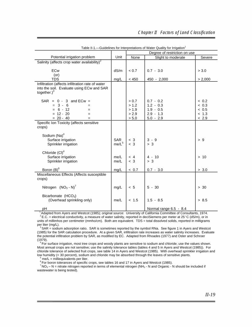
Chapter II Factors of Land Classification
II-19
Table II-1.—Guidelines for Interpretations of Water Quality for Irrigation1 Degree of restriction on use
Potential irrigation problem
Unit None Slight to moderate Severe Salinity (affects crop water availability)2 ECw (or) TDS
dS/m mg/L
< 0.7 < 450
0.7 - 3.0 450 - 2,000
> 3.0 > 2,000
Infiltration (affects infiltration rate of water into the soil. Evaluate using ECw and SAR together.)3 SAR = 0 - 3 and ECw = = 3 - 6 = = 6 - 12 = = 12 - 20 = = 20 - 40 =
> 0.7 > 1.2 > 1.9 > 2.9 > 5.0
0.7 - 0.2 1.2 - 0.3 1.9 - 0.5 2.9 - 1.3 5.0 - 2.9
< 0.2 < 0.3 < 0.5 < 1.3 < 2.9
Specific Ion Toxicity (affects sensitive crops) Sodium (Na)4 Surface irrigation Sprinkler irrigation Chloride (Cl)4
Surface irrigation Sprinkler irrigation Boron (B)6
SAR me/L5 me/L me/L mg/L
< 3 < 3 < 4 < 3 < 0.7
3 - 9 > 3 4 - 10 > 3 0.7 - 3.0
> 9 > 10 > 3.0
Miscellaneous Effects (Affects susceptible crops) Nitrogen (NO3 - N)7 Bicarbonate (HCO3) (Overhead sprinkling only) pH
mg/L me/L
< 5 < 1.5
5 - 30 1.5 - 8.5 Normal range 6.5 - 8.4
> 30 > 8.5
1 Adapted from Ayers and Westcot (1985); original source: University of California Committee of Consultants, 1974. 2 E.C. = electrical conductivity, a measure of water salinity, reported in deciSiemens per meter at 25EC (dS/m), or in units of millimhos per centimeter (mmho/cm). Both are equivalent. TDS = total dissolved solids, reported in milligrams per liter (mg/L). 3 SAR = sodium adsorption ratio. SAR is sometimes reported by the symbol RNa. See figure 1 in Ayers and Westcot (1985) for the SAR calculation procedure. At a given SAR, infiltration rate increases as water salinity increases. Evaluate the potential infiltration problem by SAR, as modified by EC. Adapted from Rhoades (1977) and Oster and Schroer (1979). 4 For surface irrigation, most tree crops and woody plants are sensitive to sodium and chloride; use the values shown. Most annual crops are not sensitive; use the salinity tolerance tables (tables 4 and 5 in Ayers and Westcot (1985)). For chloride tolerance of selected fruit crops, see table 14 in Ayers and Westcot (1985). With overhead sprinkler irrigation and low humidity (< 30 percent), sodium and chloride may be absorbed through the leaves of sensitive plants. 5 me/L = milliequivalents per liter. 6 For boron tolerances of specific crops, see tables 16 and 17 in Ayers and Westcot (1985). 7 NO3 – N = nitrate nitrogen reported in terms of elemental nitrogen (NH3 - N and Organic - N should be included if wastewater is being tested).

Technical Guidelines for Irrigation Suitability Land Classification
II-20
Table II-2.—General Effects of Trace Element Toxicity on Common Cultivars1 Element Symptoms Sensitive crop
Al (Aluminum) Overall stunting, dark green leaves, purpling of stems, death of leaf tips, and coralloid and damaged root system
Rice, wheat, barley, oats, rye, sorghum, millet
As (Arsenic) Red-brown necrotic spots on old leaves, yellowing or browning of roots, depressed tillering
Legumes, onion, spinach, cucumbers, apricots, peaches
B (Boron) Margin or leaf tip chlorosis, browning of leaf points, decaying growing points, and wilting and dying-off of older leaves
Rice, wheat, corn, barley, oats, sorghum, millet, potatoes, tomatoes, cucumbers, sunflowers, mustard
Cd (Cadmium) Brown margin of leaves, chlorosis, reddish veins and petioles, curled leaves, and brown stunted roots
Legumes (bean, soybean), spinach, radishes, carrots, and oats
Co (Cobalt) Interveinal chlorosis in new leaves, followed by induced iron chlorosis and white leaf margins and tips; damaged root tips
None
Cr (Chromium) Chlorosis of new leaves, injured root growth None Cu (Copper) Dark green leaves, followed by induced iron
chlorosis; thick, short, or barbed-wire roots; depressed tillering
Rice, wheat, corn, barley, oats, rye, sorghum, millet, soybeans, beans, peas, spinach, citrus seedlings
F (Fluoride) Margin and leaf tip necrosis, and chlorotic and red-brown points of leaves
Grapes, fruit trees
Fe (Iron) Dark green foliage, stunted growth of tops and roots, dark brown to purple leaves of some plants (e.g., “bronzing” disease of rice)
Rice
Hg (Mercury) Severe stunting of seedlings and roots, leaf chlorosis and browning of leaf points
Sugarbeets, maize
Li (Lithium) Chlorotic and necrotic spots on leaves and injured root growth
Citrus
Mn (Manganese Chlorosis and necrotic lesions on old leaves, blackish-brown or red necrotic spots, accumulation on Mn02 particles in epidermal cell, drying tips of leaves, and stunted roots
Rice, wheat, corn, barley, oats, rye, sorghum, millet, soybean, beans, peas, potatoes, cabbage
Mo (Molybdenum)
Yellowing or browning of leaves, depressed root growth, depressed tillering
Rice, wheat, corn, barley, oats, rye, sorghum, millet
Ni (Nickel) Interveinal chlorosis in new leaves, gray-green leaves, and brown and stunted roots
Rice, wheat, corn, barley, oats, rye, sorghum, millet
Pb (Lead) Dark green leaves, wilting of older leaves, stunted foliage, and brown short roots
None
Se (Selenium) Interveinal chlorosis or black spots at Se content of 4 parts per million, and complete bleaching or yellowing of younger leaves at higher content; pinkish spots on roots
None
Zn (Zinc) Chlorotic and necrotic leaf tips, interveinal chlorosis in new leaves, retarded growth of entire plant, and injured roots resembling barbed wire
Rice, wheat, corn, barley, oats, rye, sorghum, millet, spinach
1 Adapted from Kabata-Pendias and Pendias (2001).

Chapter II Factors of Land Classification
II-21
Table II-3.—Recommended Maximum Concentrations of Trace Elements in Irrigation Water1
Element
Recommended Maximum
Concentration (mg/l) Remarks
Al (Aluminum) 5.0 Can cause nonproductivity in acid soils (pH <5.5), but more alkaline soils at pH > 7.0 will precipitate the ion and eliminate any toxicity
As (Arsenic 0.10 Toxicity to plants varies widely, ranging from 12 mg/l for Sudan grass to less than 0.05 mg/L for rice
Be (Beryllium 0.10 Toxicity to plants varies widely, ranging from 5 mg/l for kale to 0.5 mg/L for bush beans
Cd (Cadmium 0.01 Toxic to beans, beets and turnips at concentrations as low as 0.1 mg/L
Co (Cobalt) 0.05 Toxic to tomato plants at 0.1 mg/L
Cr (Chromium) 0.10 Not recognized as an essential growth element
Cu (Copper) 0.20 Toxic to a number of plants at 0.1 to 1.0 mg/L
F (Fluoride) 1.0 Inactivated by neutral and alkaline soils
Li (Lithium) 2.5 Tolerated by most crops up to 5 mg/l. Toxic to citrus at < 0.075 mg/L
Mn (Manganese)
0.20 Toxic to a number of crops at a few tenths to a few mg/L, but usually only in acidic soils
Mo (Molybdenum)
0.01 Not toxic to plants at normal concentrations in soil and water
Ni (Nickel) 0.20 Toxic to a number of plants at 0.5 mg/L to 1.0 mg/L
Pb (Lead) 5.0 Inhibits plant cell growth at very high concentrations
Se (Selenium) 0.02 Toxic to plants at concentrations as low as 0.025 mg/L
Sn (Tin) ---- Effectively excluded by plants; specific tolerance unknown
Ti (Titanium) ---- Effectively excluded by plants; specific tolerance unknown
W (Tungsten) ---- Toxic to many plants at relatively low concentrations
V (Vanadium) 0.10 Toxic to many plants at relatively low concentrations
Zn (Zinc) 2.0 Toxic to many plants at widely varying concentrations; reduced toxicity at pH> 6.0 and in fine-textured or organic soils
1 From Ayers and Westcot (1985).
II.C.7. Climate
Climate exerts important influences on the suitability of lands for irrigation. The characteristics of the soil, drainage conditions, distribution of native vegetation, and crop adaptation are related to climate. To a lesser extent, climate also influences the relief of the land surface.
Technical Guidelines for Irrigation Suitability Land Classification
II-22
Interactions of climate, land, economic, and social factors operating over time express themselves in broad patterns of irrigation farm types. While climate and, to a lesser extent, land lend stability to these patterns, economic and social factors cause dynamic pattern shifts over time. Thus, the physical environmental factors (including climate) determine what will or will not grow, while economic and social factors determine what is grown. Therefore, fundamental considerations in planning an irrigation project involve deriving a proper set of assumptions regarding the cropping pattern and management systems. The choice may affect: (1) quality of lands suitable for irrigation, (2) water requirements and irrigation efficiency, (3) design and capacity of the project water distribution system, (4) selection of farm irrigation methods, (5) design and capacity of the onfarm irrigation system, (6) surface and subsurface drainage requirements, (7) minimum depth to which the groundwater table is to be controlled, (8) leaching requirement and salt balance, (9) farm inputs and outputs, and (10) project feasibility and justification. Considerable data, analyses, and sound judgment will be required to fit the project to the climatic and economic setting. Where a wide range of crop adaptability exists, the distribution and drainage systems must be designed to allow for the possible shift in the cropping pattern. Climatic factors are not included as specific items in the land classification specifications, although they are a major consideration in the value of land for irrigation. Normally, climatic conditions do not vary appreciably within a project area and can be covered adequately with one set of specifications. However, an exception may occur where extremes in elevation within a project may result in appreciable differences in the climate. If these differences are sufficient to affect land suitability/crop selection appreciably, it may be necessary to prepare two sets of specifications or a single set reflecting climatic variations. In isolated situations, the microclimate may be significant. In such situations, items covering microclimate can be included in the specifications. The most common example of a significant microclimatic factor is the effect of air drainage on the frost hazard in growing frost-sensitive crops. Situations may exist where the frost hazard is lower on sloping and elevated lands because the colder air settles in the lower and flatter lands. Although climate has had a distinct effect on land characteristics, its most important influence on irrigation suitability is the range and type of crops permitted by the climate in a specific project. These effects greatly influence the net income from land under an irrigation regime. Land classes and the lower limit

Chapter II Factors of Land Classification
II-23
for arable land are dependent on the net income. Some of the most important climatic features that influence irrigation suitability are: (1) length of growing season; (2) temperature; (3) amount, intensity, and distribution of precipitation; (4) wind velocities; (5) hail and windstorms; (6) humidity; and (7) daylight hours.

III-1
Chapter III Land Classification Specifications and
Basic Land Classes
III.A. LAND CLASSIFICATION SPECIFICATIONS Land classification mapping must be based upon carefully determined and documented criteria or specifications to achieve the objectives of land classification and ensure comparability within a particular project area. The specifications array the physical land factors (characteristics of soil, topography, and drainage) into ranges that have similar economic significance in relation to irrigation suitability. The physical factors are those that can be observed and evaluated by land classifiers (typically soil scientists) through field observations, laboratory analysis, and special studies. Specifications for informative appraisals may also be required. All types of land classification studies require documented specifications. The specifications for project planning must be based on the anticipated agricultural regime (including limited cropping or particular irrigation method) under the expected project conditions including water supply, engineering plans, and economic and climatic setting. The specifications shall reflect significant soil, topography, and drainage conditions expected to prevail when the lands reach equilibrium under irrigation (e.g., soil salinity, water table levels, concentrations of phytotoxic elements) or conditions that affect the ability and cost to develop the land for irrigation (e.g., slope, depth to a barrier).
III.A.1. Development of Specifications Specifications are developed primarily through the cooperation of agricultural economists, soil scientists, and drainage engineers. This cooperation is essential when specifications are borrowed and adjusted (as in reconnaissance studies), as well as when they are initiated for a new area. This expertise may be available in Reclamation’s regional offices and is also available in Reclamation’s Technical Service Center, Denver, Colorado (contact the Land Suitability and Water Quality Group, D-8570). If specifications are developed through private contractors, they should be reviewed for technical adequacy by Reclamation experts prior to initiation of land classification activities.

Technical Guidelines for Irrigation Suitability Land Classification
III-2
There are several prerequisites to the development of specifications. These include:
• Identification of farm and project costs
• Limitations imposed by water quality or supply
• Anticipated irrigation method
• Anticipated agricultural economy
• Land characteristics or limitations
• Environmental limitations
• Other physical or economic limitations on payment capacity or net farm income typical to the area, and estimated OM&R.
Because water of similar quality is usually used throughout a project, its characteristics are normally not factors included in the specifications. Neither is the supply of water normally a factor in the land classification specifications. However, certain water quality characteristics may result in lower productivity, higher costs of production, or higher irrigation development costs, thereby influencing the range or even the items included in the specifications. Seasonal or yearly fluctuations in the water supply could affect the agricultural economy, and a limited water supply usually limits the land served (irrigability analysis). However, those factors would not affect the development of the land classification specifications. Minimal levels for a number of factors that determine arability are influenced by irrigation methods. These factors may include the permissible development cost, gradient, available water, infiltration, internal drainage, and surface runoff. The anticipated agricultural economy—influenced primarily by climate, land characteristics, and economic setting—is significant to the net income. Costs identified as project costs do not influence the specifications for arability, since they are not land class determining. However, project costs do have

Chapter III Land Classification Specifications
III-3
tremendous effect on project or incremental feasibility and, therefore, have an effect on irrigability. Specifications have been developed for most Reclamation project areas in the Western United States and usually are available as preliminary specification models, with some adjustments for economic changes and addition or deletion of items to meet special requirements of an area. Specifications for completed land classification investigations can normally be located in land resources chapters of, or appendices to, project planning reports or definite plan reports. However, there may be cases where land classifications are documented in stand-alone reports. In establishing specifications, each significant land feature of the area under investigation should be related to the economic factors of productivity, cost of production, and irrigation development costs to determine the allowable physical ranges for the individual land classes. Farm budgeting of representative farms and representative land characteristics, based on the anticipated agricultural economy, is the most common method of estimating the payment capacity and for establishing land classification specifications. Crop enterprise budgets are equally valid, if assumptions and methods generally comparable to those employed in the farm budget method are used in the analysis. The relationship of physical factors to productivity and cost of production is an essential consideration in establishing land classification specifications. The economics of production must be correlated with factors that can be readily evaluated, such as soil texture, soil permeability, etc. If representative irrigated tracts of the basic productivity exist, it may be necessary to examine and compile ranges in the physical criteria associated with productivity and production cost factors for each class. Since this is not always practical, existing data must be utilized as much as possible. Sources of such data may include statistics on yields from similar irrigation projects, State agricultural colleges and cooperative extensions, irrigation specialists, and agricultural census data. Appendix 1, Economic Analysis for Land Classification, provides details for economic analyses required for establishing ranges of land classes and permissible irrigation development costs necessary for development of specifications. Land development performed at the expense of the individual landowner to bring his or her land into production may include land preparation, as well as construction of the farm distribution and drainage system, and soil improvement or profile modification.
Technical Guidelines for Irrigation Suitability Land Classification
III-4
The maximum permissible irrigation development cost incurred by the landowner is estimated by capitalizing that portion of the payment capacity available for repayment with an established interest rate (Appendix 1). This total, divided by the number of classes, will provide the range for each class. The permissible or allowable irrigation development cost should be translated into physical construction data such as the number of cubic yards of excavation of earth per acre for grading, cubic yards of rocks which can be cleared, amount and depth of deep plowing, etc. Data on past or prevailing costs may be obtained from other Reclamation projects, government agencies engaged in land development activities, and local contractors or farmers. The number of major factors and land classes included in the specifications should be appropriate for the area. Factors such as subsurface drainage which will be constructed with project funds should be included only if necessary to identify them as a project responsibility. Items that are considered project costs are not land class determining. Only those factors that may have a significant effect on the net income or payment capacity should be listed in the specifications.
III.A.2. Specification Factors The three major specification categories are soil, topography, and drainage. Microclimate has been considered as a fourth category; however, since air drainage (which is influenced greatly by the topography) is normally the only subheading, it is included as a topographic factor. Permissible development costs applicable to a number of factors may be listed as a separate item in the specifications. Table III-1 is a list of the potential items which may be needed in land classification specifications and for which minimum levels must be established: Each specific factor utilized in a land classification investigation must be defined in terms of its limit (minimum condition or level) for each land class as other factors remaining at optimal levels. Therefore, consideration of the cumulative effect of significant factors is essential. For example, slope, cover, and infiltration rate are the significant drainage factors utilized in a particular investigation. During the investigation, it is determined for a particular land area that the level

Chapter III Land Classification Specifications
III-5
or condition for each of these factors is at the limit for a class 1 designation. The classifier may then place the area into class 2, due to the overall effect of the levels of the three factors.
Table III-1.—Contributing Land or Water Factor Item Contributing land or water factor
Infiltration Soil texture, bulk density, and structure; sodicity; vegetation; cultural practices; gradient; and water quality
Internal drainage Soil texture, bulk density, and structure; sodicity; salinity; and water quality Available water Soil depth and texture contrast in texture between horizons, structure, and depth
to water table Texture Importance is related to effect on the above three items, as well as fertility and
management practices Salinity Water conductivity and internal drainage Sodicity Affects infiltration and internal drainage, toxic to some crops, and sodium
adsorption ratio of water Toxicity Boron, sodium, sulfates, and chlorides in water; and soil arsenic, selenium,
manganese, and aluminum Fertility Cation exchange capacity, which is influenced by texture and clay type Erosion hazard Infiltration; soil structure, texture, and organic matter content; gradient;
precipitation; and cultural practices
Soil
Stoniness Presence of gravel or cobble or other rock in the surface soil Gradient Land slope and method of irrigation Land grading Land relief, permissible development cost, and method of irrigation Field configuration Land relief, land ownership, permissible development cost, and method of
irrigation Cover Vegetative cover and surface rocks and permissible development costs
Topography
Air drainage Land slope, position in relation to surrounding lands, and frost control options Surface Infiltration, topography, drainage outlets, method of irrigation, precipitation,
wastewater volume, and cover Outlets Land relief and elevation of land over drain outlets, topography, farm layout, and
other project facilities Water table Subsurface outlets, depth to barrier and permeability of substrata, adequacy of
surface drainage, contributing areas, precipitation, anticipated crops and adequacy of irrigation management
Subsurface drainage (usually a project cost)
Outlets, thickness of and permeability of substrata, precipitation, adequacy of surface drainage, contributing land area, method of irrigation, salinity, type of delivery system, barrier depth, and amount of stream control provided by project facilities
Flooding Land position in relation to streams, contributing area above land, stream capacity, and precipitation
Drainage
Permissible development cost
Provides maximum cost for permanent land improvements which may include grading, drainage, clearing of rocks and vegetation, deep plowing, and other investments in the land
In field studies, it is often impractical or difficult to observe and map relatively minor changes in land characteristics that influence irrigation suitability. Thus, delineations and classification should be governed by the most dominant land
Technical Guidelines for Irrigation Suitability Land Classification
III-6
characteristics. As minimal conditions for a land class are approached in the dominant land features, less dominant land features must be considered in determining the proper class. Proper interpretation of land classification specifications requires good judgment based on experience, adequate data, and a keen observation of field conditions. Items such as texture and exchangeable sodium are important primarily in their effect on the infiltration rate and hydraulic conductivity rate of the soil. Because these items are readily recognized and evaluated in the field or through laboratory analysis, and are important management factors, they are usually included as a part of the guidelines.
III.A.3. Specifications and Investigation Detail The detail and amount of support provided for irrigation suitability specifications vary with the level of detail of the land classification investigation and the land and water characteristics. The detail and support required will increase with the intensity of the investigation and the complexity of the land characteristics. Land classes at the reconnaissance level of detail usually are limited to 1, 2, and 6. However, only arable and nonarable classes may be used if the lands are uniform, data are lacking or infeasible to compile because of time or money constraints, or there is no useful purpose for more classes. Reconnaissance studies may not require true economic correlation. Specifications from areas with similar climatic and geographic settings may be modified and utilized, as reconnaissance studies generally require only a low degree of accuracy. Some level of economic analysis and correlation may be necessary when no previously developed specifications are appropriate. Specifications for initiating a reconnaissance investigation may be developed in three ways: (1) consultation with irrigation specialists, (2) borrowed from an investigation of a similar area, or (3) developed through normal farm budgeting. If option (1) or (2) is used, confirmation of the economic correlation must be achieved before a semi-detailed or detailed irrigation suitability land classification investigation for project feasibility is initiated. Land classification specifications for a semi-detailed investigation should be adequate for both the semi-detailed investigation and subsequent detailed studies. Although specifications from recent studies of similar areas may be used as
Chapter III Land Classification Specifications
III-7
references, specifications that are adapted to the particular area under consideration should be developed. Farm budgeting using current agricultural economic data for the area, a specific method of irrigation, adapted crops and their yields, applicable farm management practices, and estimated project OM&R should be used. Consultation with local irrigation specialists may be helpful in establishing local practices, costs, and minimum levels for arable land classes. Schedules may not permit confirmation of economic correlation before initiating field studies, but budgeting should be completed early in the investigation so that adjustments to the classification, based on preliminary standards, will not be excessive. The specifications may provide for the maximum number of land classes, but three arable classes are most common. The number of arable land classes used depends largely on the range of payment capacity among the arable lands. Land classes should have a significant difference in repayment ability and be based on factors that can be evaluated readily. The number of classes usually increases with the size of the repayment spread. For classifications or reclassifications on operating projects, lands may be classified as arable (class A) without further delineation into the specific classes. Further delineation is necessary when land classes are utilized to determine acreage limitations for class 1 equivalency, water allocations or assessments, or for project payment capacity. While it is also permissible to designate only arable and nonarable in low-income areas limited to the production of forage, etc., it may still be necessary to identify land characteristics for other purposes. Lands with relatively uniform characteristics may require fewer classes. More complex land areas may require more numerous delineations to identify the land characteristics and provide information for farm management and other studies. Numerous informative appraisals result in additional segregation. Although class 5 may be mapped, the specifications will only include a statement that they are lands that will require additional investigation (e.g., for drainage or for leaching of harmful salts) to resolve arability. If applicable, a statement on class 6W and H (suburban) should be included in the specifications. Typically, the specifications developed for the semi-detailed investigation should be used for the subsequent detailed investigation for preconstruction planning activities. However, these specifications should be reviewed and revised as necessary if the authorizing document dictates major changes in the project,

Technical Guidelines for Irrigation Suitability Land Classification
III-8
changes in the specification criteria are indicated by the semi-detailed investigation, or the objectives of the investigation have been changed. Tables III-2 through III-7 are examples of land classification specifications for several types of studies, special use classes, and different methods of irrigation.
III.A.4. Review of Specifications An important phase of land classification is the review of specifications. Preliminary specifications formulated for initial field use are often constructed on the basis of specifications from similar areas, judgment of irrigation specialists, and preliminary data provided by the investigation team. The review of the preliminary specifications by the entire investigation team is essential. This review should cover land classes and subclasses that must be recognized because of controlling economic factors, productive capacity and production cost criteria for subclasses, and permissible land development cost limits. Examination and adjustment of the physical mapping criteria may be made to indicate the above determinations. Except for a reconnaissance level investigation, constant atten-tion is necessary to reconfirm preliminary specifications and ensure that adequate land data will be available to meet the objectives of the general investigation. As firm data relating to the agricultural economics and project OM&R costs become available, budgets reflecting these data should be completed to finalize the specifications. Team members should be contacted to ensure there are no new requirements for land data. The soil scientist and drainage engineer should reassess their needs and coordination if land characteristics not discovered previously are noted in the initial field studies. If the preliminary specifications are constructed properly, significant changes in the specifications will not be necessary. Because of the inability to make precise determinations and delineations in field studies, only those revisions in the specifications that are significant and can be evaluated readily by field investigations should be made. For reclassifications or classifications on existing projects, detailed original specifications should be reviewed and revised as necessary to reflect current conditions, for example, changes in irrigation method from gravity to sprinkler may allow a greater permissible slope for arable classes.
Chapter III Land Classification Specifications
III-9
Land classifications specifications are critical to successful planning and land classification for Reclamation irrigation projects. As stated in section III.A.1, land classification specifications developed by private contractors must be reviewed by Reclamation experts to ensure their technical adequacy. The Technical Service Center (TSC), Land Suitability and Water Quality Group, D-8570, is available to assist in the development or review of specifications prior to land classification field activities for preconstruction planning. Unless difficult or complex conditions are involved, a field review at this stage usually is not required. With cooperative studies, other involved agencies should have an opportunity to participate in the development and a review of the final specifications. Personnel from the local NRCS office and the Cooperative Extension Service may be of assistance in providing review of specifications and may be sources of useful land factor data.

Table III-2.—Irrigation Suitability Land Classification Specifications Sample Project - Gravity Irrigation
Symbols Basic
subclass
Deficiency Class 1 - arable
gravity Class 2 - arable
gravity Class 3 - arable
gravity
SOILS s
Texture Sandy loam through clay loam, except as noted below.
Loamy sand through permeable clay.
Loamy sand through permeable clay.
Coarse V Sand permitted below 3 feet. Loamy coarse sand or sand permitted below 2 feet.
Loamy coarse sand or sand permitted below 12 inches.
Fine H No clay, silty clay, or sandy clay in upper foot.
Permeable clay permitted below 1 foot.
Entire profile may be permeable clay if drainage is adequate.
Available water-holding capacity
Q Six inches or more in the upper 4 feet.
Greater than 4.5 inches in the upper 4 feet.
Greater than 3 inches in the upper 4 feet.
Depth over incoherent clean gravel or sand
K Thirty-six inches of sandy loam or finer (perhaps 30 inches if gravel contains some fines), must meet minimum water- holding requirements for class.
At least 24 inches of sandy loam or finer, or 30 inches of loamy fine sand, must meet minimum water- holding requirements for class.
A minimum of 18 inches of sandy loam or finer, or 24 inches of loamy fine sand, must meet minimum water- holding requirements for class.
Exchangeable sodium
A Exchangeable sodium will not be a problem in the presence of adequate drainage. Less than 2 meq per 100 g of soil or an Exchangeable Sodium Percentage (ESP) less than 15 at equilibrium.
Permeability may be somewhat impaired, but sodium will not be a major problem in the presence of adequate drainage.
Permeability may be impaired by exchangeable sodium, but under equilibrium there will not be more than 3 meq per 100 g or an ESP greater than 20 for finer soils. There must be at least 0.2 inch per hour of permeability in the top 2 feet.
Salinity S Average root zone ECe can be maintained at a level not to exceed 2 mmhos/cm at equilibrium.
Average root zone ECe can be maintained at a level not to exceed 4 millimhos per centimeter at equilibrium.
Average root zone ECe can be maintained at a level not to exceed 8 millimhos per centimeter at equilibrium.
TOPOGRAPHY t
Gradient G 0 to 2 percent in general gradient.
2 to 3.5 percent in general gradient.
3.5 to 5 percent in general gradient.
Irrigation pattern J Minimum of 12 acres in size and runs of 500 feet or longer.
Minimum of 8 acres in size and runs of 400 feet or longer.
Minimum of 5 acres in size and runs of 300 feet or longer.

Table III-2.—Irrigation Suitability Land Classification Specifications Sample Project - Gravity Irrigation Symbols
Basic subclass
Deficiency
Class 1 - arable gravity
Class 2 - arable gravity
Class 3 - arable gravity
Leveling requirements
U 0 to 400 cubic yards of excavation per acre when soil permits.
400 to 800 cubic yards of excavation allowed where soils permit.
800 to 1,250 cubic yards of excavation allowed where soils permit.
Stone and cobble removal
R Up to $80 per acre for clearing, allowing $4 per cubic yard of stone removal.
Allow up to $160 per acre for clearing.
Allow up to $250 per acre for clearing.
DRAINAGE d Surface (onfarm)
O Allow up to $80 per acre for surface outlet excavation.
Allow up to $160 per acre for surface outlet excavation.
Allow up to $250 per acre for surface outlet excavation.
Subsurface W Surface outlets for each farm and all deep drainage will be provided as a project expense. The final determination of drainability will be made by the Drainage Branch. Lands otherwise arable but considered nondrainable will be designated by a 6D in front of the regular land classification symbols in parentheses.
Total permissible development cost
$0 to $80 per acre, which would include cost of grading, farm laterals, drains, structures, clearing, and soil amendments.
$80 to $160 per acre. $160 to $230 per acre.
Class 6 - nonarable
Lands that do not meet the minimum requirements for arable land.
Stone and cobble removal
R Up to $80 per acre for clearing, allowing $4 per cubic yard for stone removal.
Allow up to $160 per acre for clearing.
Allow up to $250 per acre for clearing.
DRAINAGE D Surface (onfarm)
O Allow up to $80 per acre for surface outlet excavation.
Allow up to $160 per acre for surface outlet excavation.
Allow up to $250 per acre for surface outlet excavation.
Subsurface W Surface outlets for each farm and all deep drainage will be provided as a project expense. The final determination of drainability will be made by the Drainage Branch. Lands otherwise arable but considered nondrainable will be designated by a 6D in front of the regular land classification symbols in parentheses.
Total permissible development cost
$0 to $80 per acre, which would include cost of grading, farm laterals, drains, structures, clearing, and soil amendments.
$80 to $160 per acre. $160 to $230 per acre.
Class 6 - nonarable
Lands that do not meet the minimum requirements for arable land.

Table III-3.—Irrigation Suitability Land Classification Specifications Sample Project - 1980
Special use - avocado, citrus1
Land characteristic Class F1 – arable Class F2 - arable
SOILS
Texture Depth of workable soil Sodicity (at equilibrium) Salinity (at equilibrium) Available water-holding capacity Internal drainage
sl, l, sil, or cl 30 inches or more Less than 10 percent Exchangeable Sodium (ES) Less than 2 mmhos/cm (average root zone ECe) Greater than 3 inches in rooting depth Adequate to maintain well-aerated root zone
fs, ls, sl, l, sil, or cl 12 inches or more Less than 10 percent ES Less than 2 mmhos/cm Less than 2 inches in rooting depth Adequate to maintain well-aerated root zone with proper irrigation practices
TOPOGRAPHY
Slope Boulders and rock outcrops Air drainage
Up to 25 percent Will permit 75 percent of normal planting Adequate to minimize damage from local frosts
Up to 50 percent or greater if limited in extent and surrounded by lesser slopes Will permit 50 percent of normal planting Area may be susceptible to some frost damage, but will not cause death of trees, may be limited to citrus fruits
DRAINAGE
Subsurface drainage Surface drainage
Natural conditions adequate to prevent formation of water table in the root zone Runoff will not accumulate on land
Same as Class 1 but may be improved with drainage development Surface water can be removed with a minimum of construction
1 Specifications are based on the growing of avocados or citrus fruit by drip or similar irrigation methods that permit precise water control. Note: Class 6 (nonarable) includes lands that do not meet the minimum requirements for class 2 land.
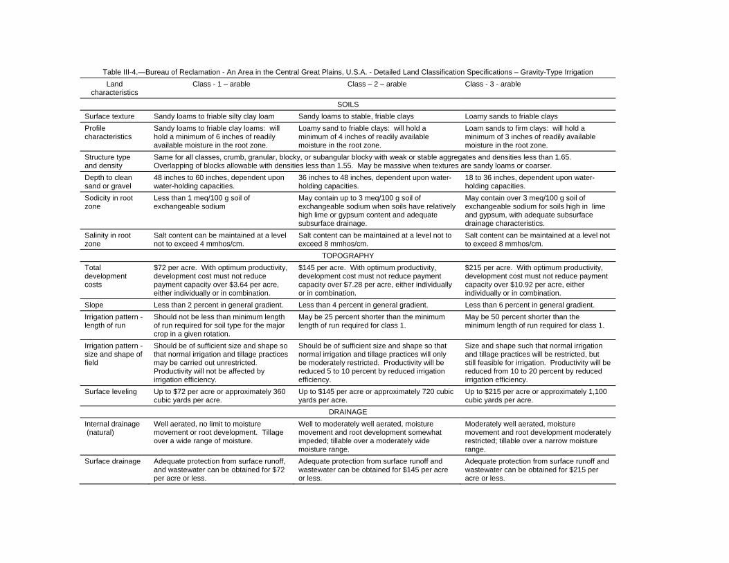
Table III-4.—Bureau of Reclamation - An Area in the Central Great Plains, U.S.A. - Detailed Land Classification Specifications – Gravity-Type Irrigation Land
characteristics Class - 1 – arable Class – 2 – arable Class - 3 - arable
SOILS Surface texture Sandy loams to friable silty clay loam Sandy loams to stable, friable clays Loamy sands to friable clays Profile characteristics
Sandy loams to friable clay loams: will hold a minimum of 6 inches of readily available moisture in the root zone.
Loamy sand to friable clays: will hold a minimum of 4 inches of readily available moisture in the root zone.
Loam sands to firm clays: will hold a minimum of 3 inches of readily available moisture in the root zone.
Structure type and density
Same for all classes, crumb, granular, blocky, or subangular blocky with weak or stable aggregates and densities less than 1.65. Overlapping of blocks allowable with densities less than 1.55. May be massive when textures are sandy loams or coarser.
Depth to clean sand or gravel
48 inches to 60 inches, dependent upon water-holding capacities.
36 inches to 48 inches, dependent upon water-holding capacities.
18 to 36 inches, dependent upon water-holding capacities.
Sodicity in root zone
Less than 1 meq/100 g soil of exchangeable sodium
May contain up to 3 meq/100 g soil of exchangeable sodium when soils have relatively high lime or gypsum content and adequate subsurface drainage.
May contain over 3 meq/100 g soil of exchangeable sodium for soils high in lime and gypsum, with adequate subsurface drainage characteristics.
Salinity in root zone
Salt content can be maintained at a level not to exceed 4 mmhos/cm.
Salt content can be maintained at a level not to exceed 8 mmhos/cm.
Salt content can be maintained at a level not to exceed 8 mmhos/cm.
TOPOGRAPHY Total development costs
$72 per acre. With optimum productivity, development cost must not reduce payment capacity over $3.64 per acre, either individually or in combination.
$145 per acre. With optimum productivity, development cost must not reduce payment capacity over $7.28 per acre, either individually or in combination.
$215 per acre. With optimum productivity, development cost must not reduce payment capacity over $10.92 per acre, either individually or in combination.
Slope Less than 2 percent in general gradient. Less than 4 percent in general gradient. Less than 6 percent in general gradient. Irrigation pattern - length of run
Should not be less than minimum length of run required for soil type for the major crop in a given rotation.
May be 25 percent shorter than the minimum length of run required for class 1.
May be 50 percent shorter than the minimum length of run required for class 1.
Irrigation pattern - size and shape of field
Should be of sufficient size and shape so that normal irrigation and tillage practices may be carried out unrestricted. Productivity will not be affected by irrigation efficiency.
Should be of sufficient size and shape so that normal irrigation and tillage practices will only be moderately restricted. Productivity will be reduced 5 to 10 percent by reduced irrigation efficiency.
Size and shape such that normal irrigation and tillage practices will be restricted, but still feasible for irrigation. Productivity will be reduced from 10 to 20 percent by reduced irrigation efficiency.
Surface leveling Up to $72 per acre or approximately 360 cubic yards per acre.
Up to $145 per acre or approximately 720 cubic yards per acre.
Up to $215 per acre or approximately 1,100 cubic yards per acre.
DRAINAGE Internal drainage (natural)
Well aerated, no limit to moisture movement or root development. Tillage over a wide range of moisture.
Well to moderately well aerated, moisture movement and root development somewhat impeded; tillable over a moderately wide moisture range.
Moderately well aerated, moisture movement and root development moderately restricted; tillable over a narrow moisture range.
Surface drainage Adequate protection from surface runoff, and wastewater can be obtained for $72 per acre or less.
Adequate protection from surface runoff and wastewater can be obtained for $145 per acre or less.
Adequate protection from surface runoff and wastewater can be obtained for $215 per acre or less.

Table III-5.—Land Class Specifications for Detailed Irrigation Suitability Land Classification for Sprinkler Irrigation Sample Project - Land Class Requirements for Fruit - (Apple) Land
Land characteristics Class 1F - arable Class 2F - arable Class 3F - arable Class 6 - nonarable
SOIL
Texture Medium sandy loam to friable clay loam.
Loamy sand to friable clay loam in upper 30 inches.
Fine sand to friable clay in upper 30 inches.
Sand to slowly permeable clay.
Depth1
To permeable substrata
36 inches or deeper 24 inches or more of sandy loam or finer material. 30 inches or more of loamy sand.
18 inches or more of sandy loam or finer material. 24 inches or more of loamy sand.
Less than 18 inches of sandy loam or finer or less than 24 inches of loamy sand.
To tight or compact clayey zones
Below 5 feet unless evident internal drainage or aeration problems are present or likely to develop.
Below 3 feet unless evident internal drainage or aeration problems are present or likely to develop.
Below 18 inches unless no evidence of severe root restriction.
Poorer than class 3.
Salinity and Alkalinity Soil and topographic conditions such that any harmful salts present are removable through normal irrigation.
Soil and topographic conditions such that any harmful salts present are removable through normal irrigation.
Soil and topographic conditions such that any harmful salts present are removable through normal irrigation.
Salinity and alkalinity problems are not correctable by normal irrigation.
Arsenic levels Arsenic levels in the soil profile less than 50 ppm and no soil removal required.
Arsenic in the 0-1 foot depth can be greater than 50 ppm if concentrations are less than 5 ppm below 1 foot depth. Removal and replacement of upper foot of soil contemplated to rehabilitate orchard.
Arsenic 50 ppm or more in and below 1-foot depth. Removal and replacement of all contaminated soil contemplated to rehabilitate orchard.
Not a factor.
TOPOGRAPHY
Slope Up to 25 percent for long slopes on the same plane. Less for complex or short slopes.
Up to 35 percent for long uniform slopes on the same plane. Less for short slopes. Increased costs of cultural practices affected by slope not to exceed those of 1F lands by more than $13 per acre.
Up to 35 percent for nonuniform irregular slopes.
Slopes may be in excess of 35 percent.
Relief Not a factor with sprinkler method of irrigation.
Not a factor with sprinkler method of irrigation.
Not a factor.
Size and shape 200-foot minimum width. Four-acre minimum size.
100-foot minimum width. Two-acre minimum size.
Less than 100-foot minimum width or less than 1-acre minimum size.

Table III-5.—Land Class Specifications for Detailed Irrigation Suitability Land Classification for Sprinkler Irrigation Sample Project - Land Class Requirements for Fruit - (Apple) Land (continued)
Land characteristics Class 1F - arable Class 2F - arable Class 3F - arable Class 6 - nonarable
Surface stone Up to 50 cubic yards requiring removal; or where not removed, annual operating costs increased not more than $5 per acre.
Up to 125 cubic yards requiring removal; or where not removed, annual operating costs increased not more than $18 per acre.
Up to 200 cubic yards requiring removal; or where annual operating costs are increased, not more than $31 per acre.
Brush Removal cost insignificant. Removal cost insignificant. Removal cost insignificant. Not a factor.
Air drainage Slope and position of land such that air drainage not impeded.
Slope and position of land such that adequate air drainage seems probable.
Slope and position such that some restriction of air drainage likely. Heating essential for frost protection and profitable production.
Air drainage very poor.
DRAINAGE
Water Soil and topographic condition such that no problem anticipated.
Soil and topographic condition such that good soil aeration can be maintained to at least 4 feet. Farm drainage outlet construction not to exceed 400 feet of shallow open or tile drains per acre of area served. May include land with a few slightly chloric trees in orchard.
Soil and topographic condition such that good soil aeration can be maintained to at least 3 feet.
Good soil aeration cannot be maintained to a 3-foot depth.
Class H
Irrigation district lands now in suburban use, which are in small holdings of less than 1 acre, located within or near town or lakeshore of the project.
Class 6 – nonarable
6W - Lands presently irrigated with water provided by the Lake Chelan Reclamation District, but which do not meet the minimum specifications for the arable classes above. 6I - Indian allotment lands having a maximum annual water charge of $2 per acre. 1 Depths specified apply to very open material. They may be less where underlying material are sands with fines in which tree roots freely grow.

Table III-6.—Bureau of Reclamation - An Area in the Central Great Plains, U.S.A. - Detailed Land Classification Specifications - Gravity Type Irrigation
Land characteristics Class 1 – arable Class 2 - arable Class 3 - arable
SOILS
Texture Sandy loams to friable clay loam. Loamy sand to clay. Loamy sand to clay.
Depth to sand, gravel, or cobble 36 inches plus - good free working soil of fine sandy loam or finer; or 42 inches of sandy loam.
24 inches plus - fine sandy loam or finer; or 30 to 36 inches of sandy loam to loamy sand.
18 inches plus - fine sandy loam or finer; or 24 to 30 inches of coarser textured soil.
Depth to bedrock 96 inches or 90 inches with minimum of overlying solid material or sandy loam throughout.
Same as class 1. Same as class 1.
Exchangeable Sodium Exchangeable sodium not to exceed 8 percent. May be slightly higher in subsoil under good internal drainage conditions.
Exchangeable sodium not to exceed 8 percent in the surface foot and not to exceed 12 percent in upper 30 inches.
Exchangeable sodium not to exceed 12 percent in the surface foot and not to exceed 15 percent in upper 30 inches.
Salinity Conductivity of the saturation extract not to exceed 4 mmhos/cm at equilibrium conditions with irrigation.
Conductivity of the saturation not to exceed 4 mmhos/cm in surface foot. May exceed 8 mmhos/cm below 30 inches, but no higher than 12 mmhos/cm. All values to be at equilibrium with irrigation.
Conductivity of the saturation not to exceed 4 mmhos/cm in surface foot and not to exceed 12 mmhos/cm in the profile. These values to be at equilibrium with irrigation.
TOPOGRAPHY
Slope 0 to 2 percent. 0 to 2 percent. 0 to 2 percent.
Length of irrigation run 500 feet or more. 300 to 500 feet. 100 to 300 feet.
Undulation Grading not exceed 800 cubic yards per acre or $125 per acre.
Grading required between 800 and 2,000 cubic yards per acre or $300 per acre.
Grading required totaling between 2,000 and 3,700 cubic yards per acre or $550 per acre.
DRAINAGE
Surface Little or no surface drainage required. Shallow surface drains required not to exceed $175 per acre. Combined development costs shall not exceed $300 per acre.
Shallow surface drains required, but not to exceed $425 per acre. Combined development costs shall not exceed $550 per acre.
Subsurface No subsurface drainage required. Subsurface tile drains required, but not to exceed a cost of $175 per acre or a total development cost of $300.
Subsurface tile drains required, but not to exceed a cost of $425 per acre or a total development cost of $550.
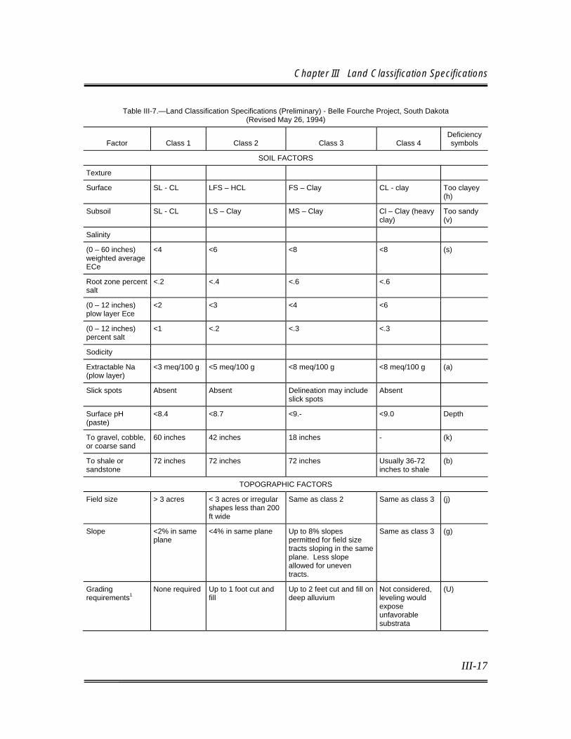
Chapter III Land Classification Specifications
III-17
Table III-7.—Land Classification Specifications (Preliminary) - Belle Fourche Project, South Dakota (Revised May 26, 1994)
Factor
Class 1
Class 2
Class 3
Class 4
Deficiency symbols
SOIL FACTORS
Texture
Surface SL - CL LFS – HCL FS – Clay CL - clay Too clayey (h)
Subsoil SL - CL LS – Clay MS – Clay Cl – Clay (heavy clay)
Too sandy (v)
Salinity
(0 – 60 inches) weighted average ECe
<4 <6 <8 <8 (s)
Root zone percent salt
<.2 <.4 <.6 <.6
(0 – 12 inches) plow layer Ece
<2 <3 <4 <6
(0 – 12 inches) percent salt
<1 <.2 <.3 <.3
Sodicity
Extractable Na (plow layer)
<3 meq/100 g <5 meq/100 g <8 meq/100 g <8 meq/100 g (a)
Slick spots Absent Absent Delineation may include slick spots
Absent
Surface pH (paste)
<8.4 <8.7 <9.- <9.0 Depth
To gravel, cobble, or coarse sand
60 inches 42 inches 18 inches - (k)
To shale or sandstone
72 inches 72 inches 72 inches Usually 36-72 inches to shale
(b)
TOPOGRAPHIC FACTORS
Field size > 3 acres < 3 acres or irregular shapes less than 200 ft wide
Same as class 2 Same as class 3 (j)
Slope <2% in same plane
<4% in same plane Up to 8% slopes permitted for field size tracts sloping in the same plane. Less slope allowed for uneven tracts.
Same as class 3 (g)
Grading requirements1
None required Up to 1 foot cut and fill
Up to 2 feet cut and fill on deep alluvium
Not considered, leveling would expose unfavorable substrata
(U)

Technical Guidelines for Irrigation Suitability Land Classification
III-18
Table III-7 Land Classification Specifications (Preliminary) Belle Fourche Project, South Dakota (Revised May 26, 1994) (continued)
Factor
Class 1
Class 2
Class 3
Class 4
Deficiency Symbols
Cover removal2 (tree and brush clearing)
None required Minor clearing < 5 trees per acre
Same as class 2 None required (c)
DRAINAGE FACTORS
Depth to water table
No sign of wetness in top 5 feet
Water table 4 -5 feet Water table 2.5 feet to 4 feet
No water table permitted in top 5 feet
(w)
Flooding None Tract on unprotected floodplain
Same as class 2 Not subject to flooding
(f)
Note: Class 4 description: This land class included rolling and uneven tracts with residual clay soils that are at least 3 feet deep to shale bedrock. Maximum slope of 8%. These lands must have a history of successful irrigation and currently produce satisfactory forage crops. These lands are best suited for pasture. Soil salt content must not exceed native conditions (.6% salt). No evidence of downslope offsite damage is apparent. 1 Only minor leveling was considered in this classification, since the lands were already developed for irrigation. Undesirable substrata materials such as gravel and shale preclude heavy leveling operation on most district lands. 2 Cover removal is not based on economics. Development of new lands was not considered in this reclassification survey. Riparian forest was not considered for an arable land class unless land development operations were already completed or were currently in progress. The land classification symbol “6t/16uc” was uniformly applied to all riparian woodlands.
III.B. BASIC CLASSES Land classes are based on the economics of production and those irrigation development costs assumed to be the responsibility of the landowner (as opposed to irrigation development costs, which may be treated as a project costs; e.g., project drainage construction costs dispersed as a per-acre charge to each landowner). In Reclamation's land classification system for diversified agriculture, each arable class reflects a range of payment capacity. Similar land classes from different projects may have different ranges of payment capacity; e.g., class 1 lands in one project may have a much higher range of residual net farm income than in another project. However, the residual net farm income from lands of the same class in a specific project should fall within the same range, even though the physical land characteristics may differ. Land classes include those that identify: (1) the arable lands in groups according to their suitability for irrigation, (2) the nonarable lands, and (3) a provisional class. Normally four land classes (1 through 4) are available to represent lands suitable for irrigation in project planning investigations. Class 1 has the greatest repayment ability within a given project area, with progressively less ability to

Chapter III Land Classification Specifications
III-19
repay project construction costs as class designation numbers increase. Lands identified as arable have adequate payment capacity to at least cover OM&R costs. Class 5, the provisional land class, represents lands that may be arable but that require additional specific investigation for a final determination. Class 6, the class for nonarable land, represents lands that have insufficient payment capacity to meet OM&R costs. The number of arable classes used in an investigation depends on the range of payment capacity and the investigation’s level of detail. For example, for a reconnaissance investigation or when range of payment capacity of the lands is small, the arable lands may be divided into only one or two classes. More detailed investigations and large differences in payment capacity between lands likely require three or more classes to adequately characterize the lands. For class 1 equivalency purposes, only three arable classes are utilized (classes 1, 2, and 3). The ranges between land classes are approximated by dividing the difference between the payment capacity that just meets the OM&R cost and the payment capacity of the best land by the number of arable land classes required for a given investigation. Table III-8 provides an example of a standard land classification mapping symbol. Also, Section V.C.18, “Designation of Land Classes,” in Chapter V provides more detailed information concerning land classification designations. Land classification documentation and maps (or their location) for operating Reclamation irrigation projects, normally may be found in land classification sections or as appendices of the project preconstruction planning report (definite plan report or feasibility study).

Technical Guidelines for Irrigation Suitability Land Classification
III-20
Table III-8 (page 1 of 4) Symbols for Basic Land Classes and Subclasses
Example of Standard Mapping Symbol
Symbols for Basic Land Classes and Subclasses
Arable Deficiencies Class 1 – 1 s – soils Class 2 – 2s, 2t, 2d, 2st, 2sd, 2td t – topography Class 3 – 3s, 3t, 3d, 3st, 3sd, 3td, 3std d – drainage Class 4 – 4s, 4t, 4d, 4st, 4sd, 4td, 4std Class A – used when only differentiating arable from nonarable Class AA – Administratively arable ______________________________________________________________________________________ Special Use Arable F – Fruit or orchard S – Sprinkler R – Rice U – Subirrigation P – Pasture H – Urban V – Truck Tentatively nonarable Class 5 – 5s, 5t, 5d, 5st, 5td, 5std [Example: 5d(3st/Cp2u2) Nonarable Class 6 – 6s, 6t, 6d, 6st, 6sd, 6td, 6std Water right – 6W Note: The special use symbol may be used with any arable land class or subclass: 1F, 2Ps, 3Pst, S2 (the sprinkler symbol is placed before the land class to avoid confusion between special use symbol and deficiency symbol), etc.
Land Use
ProductivityLand Development
CostFarm WaterRequirement
SubstratumPermeability
HydraulicConductivity
Degree of Deficiency
GradingRequirement
Flooding
Land Class
Soils Deficiency
TopographicDeficiency
DrainageDeficiency
p2 u2 f2

Chapter III Land Classification Specifications
III-21
Table III-8 (page 2 of 4) Symbols for informative appraisals
Land Use C – Irrigated cultivation B – Brush or timber L – Nonirrigated cultivation H – Suburban or homestead P – Irrigated permanent grassland W – Waste or miscellaneous G – Nonirrigated permanent grassland ROW – Right-of-way Productivity and land development 1, 2, 3, 4, or t denoting land class level of factor, such as: Class 2 productivity, class 2 development cost – “22” Farm water requirement A – Low B – Moderate C – High Note: Specific ranges should be established for the area under investigation. Substratum permeability X – Highly permeable Y – Moderately permeable Z – Relatively impermeable Note: Specific ranges should be established for the area under investigation. Deficiency appraisals Soils k – Shallow depth to coarse sand, gravel, or cobble b – Shallow depth to impermeable or root-restricting bedrock or substrata z – Sallow depth to concentrated zone of lime v – Very coarse texture (sands, loamy sands) h – Very fine texture (clays) q – Limited available moisture-holding capacity i – Infiltration p – Hydraulic conductivity x – Stoniness y – Soil fertility a – Sodicity s – Salinity t – Toxic elements

Technical Guidelines for Irrigation Suitability Land Classification
III-22
Table III-8 (page 3 of 4) Symbols for informative appraisals (continued)
Topography g – Gradient c – Brush or tree cover u – Surface undulations r – Rock cover j – Irrigation pattern l – Air drainage Drainage f – Surface drainage – flooding w – Subsurface drainage – water table o – Drainage outlet Note: The deficiency appraisals may be defined further by use of subscript letters and numerals, such as k2, k3 indicating ranges of depth or degree of severity. A deficiency appraisal shown in parentheses will indicated a present land condition that will be altered under cultivation.
Conventional and Special Map Symbols
Texture Designations st – stones and stony sl – sandy loam cb – cobbles and cobbly fsl – fine sandy loam gr – gravel and gravelly vfsl – very fine sandy loam vcos – very coarse sand l – loam cos – coarse sand si – silt s – sand sil – silt loam fs – fine sand scl – sandy clay loam vfs – very fine sand cl – clay loam lcos – loamy coarse sand sicl – silty clay loam ls – loamy sandy sc – sandy clay lfs – loamy fine sand sic – silty clay cosl – coarse sandy loam c – clay

Chapter III Land Classification Specifications
III-23
Table III-8 (page 4 of 4) Symbols for informative appraisals (continued)
Reaction to Dilute HCL
+ very slightly effervescent ++ slightly effervescent +++ strongly effervescent ++++ violently effervescent
Example of Standard Profile Note
Location: 100’ N., 300’ E. of S.1/4 Corner Vegetation: Brush
Remarks: Surface soil subject to erosion, vegetation indicates a droughty condition, length of irrigation run
will be short because of high Infiltration rate.
Explanation: 0.41, 0.53, and 0.29 are conductivity of the saturation paste extract (dS/m) at 1:5 dilution; 7.6, 7.8, and 8.0 are pH values; 2.7, 3.4, and 5.9 are the hydraulic conductivity of the fragmented sample in inches/hour; 19, 18, and 15 are the soil texture determined by “feel” or by a mechanical analysis; + is the effervescence with HCL. The profile represents a depth of 60 inches (150 cm), with hash marks at 12-inch (30 cm) increments and horizontal lines as the division between soil layers. [If the profile represents less than 60 inches (150 cm), place an X at the bottom of the profile.] Note: The dilution of the sample analyzed for conductivity of the extract and the pH should be stated on the map legend.
+
â
0.41 7.6
0.53 7.8
0.29 8.0
2.7 19
3.4 18
5.9 15
fsl
sl
lfs
EC
pH

Technical Guidelines for Irrigation Suitability Land Classification
III-24
III.B.1. Arable Area Classes In addition to the arable classes indicated previously, other classes that may be used for designating arable lands when investigating lands of operating projects are described in the following sections. Except for class 1, AA (administratively determined) and A (arable), these classes are usually divided into subclasses for providing additional data on land suitability or informative appraisals. The number of arable land classes mapped will depend on the land characteristics, irrigation method proposed, anticipated crops, relative level of farm income, type of classification (level of detail), and other factors. While separation of the lands into three arable land classes is most common, four arable land classes may be used occasionally where land conditions are complex, land variations are wide and in large parcels, and high-value crops are grown. When the objectives of a land classification investigation are limited, such as in an appraisal level investigation, arable/nonarable determinations or the use of only two arable classes may be adequate to select areas to be investigated in greater detail for project development planning.
a. Class 1 – Arable Class 1 land meets the various parameters and specifications established for that class within a particular agricultural economic setting having the highest level of suitability for continuous, successful irrigation farming, measured in terms of net income generated. Net income reflects productivity (productive capacity minus the cost of production) and the cost of irrigation development. As such, class 1 lands have the highest potential payment capacity for a particular project setting. Such lands are typically capable of producing sustained and relatively high yields of a wide range of climatically adapted crops at a reasonable cost. They can be irrigated readily and efficiently with the proposed irrigation system. The soil should be easily tilled and have a good, stable structure that allows easy penetration of roots, air, and water, and has adequate internal drainage. The available water-holding capacity of the soil should be adequate for the proposed irrigation system to supply moisture for optimum plant growth and irrigation scheduling. The soil should be free from harmful accumulations of soluble salts or, if salts are present, they can be readily leached. Minimal or no specific farm

Chapter III Land Classification Specifications
III-25
drainage requirements are anticipated, minimal erosion will result from irrigation, and land development can be accomplished at a relatively low cost.
b. Class 2 – Arable The class 2 designation is used to identify land in the same project setting as described for class 1, but having a lower (or moderate) level of suitability for continuous, successful irrigation farming in terms of potential net income generated. This class comprises lands that generally are lower in productive capacity, more expensive to prepare for irrigation, or more costly to farm than class 1 lands. The soil may have a lower available moisture-holding capacity; be more slowly permeable to water, air, and roots; or be moderately saline under irrigation, which may limit productivity or involve moderate costs for leaching. Possible topographic limitations include uneven surface requiring moderate costs for grading, relief that results in smaller fields, or steeper slopes necessitating special care and greater costs to properly irrigate and prevent erosion. Farm drainage may be required at a moderate cost, or loose rock or woody vegetation may have to be removed from the surface. Any one limitation may be sufficient to reduce the lands from class 1 to class 2, but occasionally a combination of two or more limitations are contributing. Class 2 lands have intermediate payment capacity, except when only two arable land classes are mapped, in which case their payment capacity ranges from intermediate to low, and they have some of the marginal characteristics usually associated with class 3 lands.
c. Class 3 – Arable Class 3 is used when a third land class is required. It represents land in the same project setting as described for classes 1 and 2, but having a lower level of suitability than class 2. When mapped, these lands are usually of the lowest arable land class, except when class 4 use is necessary. Lands in this class are suitable for irrigation development, but are approaching minimal quality for irrigation and have distinct soil, topographic, or drainage deficiencies that are more severe singly, or in combination, than those described for class 2. Because of a severe single defi-

Technical Guidelines for Irrigation Suitability Land Classification
III-26
ciency or a combination of two or more less severe deficiencies, class 3 lands have a lower productive capacity, higher production costs, higher development costs (or any combination of these three deficiencies) than do class 2 lands. Although a greater risk may be involved in farming class 3, they are expected to have adequate payment capacity to meet OM&R costs under proper management and in units of adequate size. In evaluating this land class, the interaction between deficiencies may be important and should receive close attention
d. Class 4 – Limited Arable
A designation of class 4 should be used only in rare or unique situations. Class 4 land generally is of limited suitability for irrigation, due to certain excessive deficiencies, but is arable, as evidenced by special economic and engineering studies. If mapped, class 4 should represent the lowest quality arable land. Lands in this class may have certain excessive deficiencies that result in restrictive utility, but that have been shown to meet the minimal requirements for arable land under the proposed project plan. They may also be similar to lands of other arable classes but have more severe deficiencies. In any case, they would have a lower productivity, higher production costs, higher development costs, or more severe combinations of these than class 3 land. A fourth arable class should be used only when needed to adequately identify and characterize lands with marginal arability. It is usually applicable only to studies where high income and/or specialized crops are grown. Its identifying features should be readily recognized to permit adequate evaluation in the investigation. Class 4 land should not be used for a reconnaissance investigation.
e. Class 5 – Nonarable Lands in this class are nonarable under existing conditions but have potential value to warrant tentative segregation for special investigation before completion of the classification. The designation of class 5 is tentative and is normally changed to the proper arable class or class 6 prior to completion of the land classification. If questions regarding these lands are not resolved, they should be assumed nonarable for project formulation purposes. They may have a specific soil deficiency such as excessive salinity, very uneven topography, inadequate

Chapter III Land Classification Specifications
III-27
drainage, excessive rock or tree cover, or other severe land deficiency that requires special agronomic, economic, or engineering studies to determine their arability. Class 5 lands usually are segregated when existing conditions require consideration of such lands for the competent appraisal of the project possibilities, such as when an abundant supply of water or a shortage of better lands exists. Designation of class 5 lands is also a useful tool for designating problem areas and to encourage the resolution of those problems. Normally, class 5 would not be used in a reconnaissance investigation. Lands should not be placed in this class because of their location or position.
f. Class A – Arable
Under certain circumstances, classifying lands as arable (class A) without further delineation into the specific classes is permissible. These circumstances include appraisal level investigations for project planning, if the lands are generally homogeneous, or for operating projects after construction when it is unnecessary to distinguish between arable classes. Circumstances which would likely require delineation of the lands into respective arable classes include determinations of project repayment capability, class 1 equivalency determinations, water allocation by land class, or water cost or repayment assessments by land class, and when such information is desired for farm operations.
g. Class AA – Administratively Arable
Within an operating project, a tract of land of 5 acres or less requested for reclassification may be administratively designated as arable (class AA) if it is has a current 5-year history of irrigation and is contiguous to, or part of, an existing arable farm unit. More details are provided on the procedure for utilizing the AA designation in Section IV.D.3, “Land Classification on Operating Projects,” in Chapter IV.
h. Class 6 – Nonarable Class 6 lands include those considered nonarable under the existing project or project plan because of failure to produce returns sufficient to cover OM&R costs, as required for arable classes of land. Lands temporarily designated class 5 shall
Technical Guidelines for Irrigation Suitability Land Classification
III-28
be redesignated class 6 when the extent of such lands, or the detail of the particular investigation, does not warrant additional investigation. Class 6 lands are not considered eligible for irrigation service with a project water supply for project planning and development purposes. However, Reclamation has authority to deliver project water to lands of operating projects, regardless of classification status, if certain land characteristics are met, (Reclamation Manual, Policy, WTR P06, January 29, 2004). During land classification investigations for a supplemental irrigation project, it may occur that irrigated land with existing water rights is determined to be class 6. Class 6 irrigated land with existing water rights will be delineated and designated as class 6W. Every effort should be made to obtain consent for the retirement of class 6W lands from irrigation and release or transfer of any water right to which it may be entitled. If this cannot be accomplished, such land will be shown as class 6W and provision will be made for supplying, under project operation, the amount of water normally available to it under existing rights. Generally, class 6 land comprises steep, rough, broken, or badly eroded lands; land with soils of very coarse or very fine texture; shallow soils over gravel, shale, sandstone, till, or hardpan; and lands that have inadequate drainage and high concentrations of soluble salts or sodium, which are infeasible to remove.
III.B.2. Special Use Classes Frequently, lands may be suited only to a specific use under irrigation. In such cases, the normal land classes and subclasses will be used, but the specifications will be developed on the basis of the special use indicated. Examples of special use may be the irrigation method utilized (e.g., sprinkler) or specific crops such as orchards or rice. The requirement that lands in the same land class have relatively equal payment capacity applies to the special use classes also. Normally each special use classification would require a separate map; however, if the land classes for a routine classification and special use classification can be correlated, both may be included on the same map. Difficulties usually arise in correlating the land classes between two special uses. Field mapping for two or more uses can be done concurrently. However, if more than one use is included on the same map, each use must be represented by an identifying symbol. An example would be 1R for rice, or 1F for fruit or orchards, to designate classification for specific
Chapter III Land Classification Specifications
III-29
crops. When lands are classified for pressure irrigation (sprinkler or drip), the classification should include a designation of the irrigation method (e.g., S1 for class 1 sprinkler).
III.B.3. Basic Subclasses
Subclasses with informative symbols normally are used on all land classification studies. An exception may be when only an arable/nonarable determination is being mapped for a reconnaissance investigation, or when administrative determinations or technical checklist procedures are utilized for classifications or reclassifications on operating projects. Subclass designations should be used to provide basic information concerning land characteristics and irrigation suitability. Information provided by subclasses is used primarily for economic studies, irrigation return flow studies, farm managers and other disciplines who need information on the land resources characteristics. The subclasses are used to indicate deficiencies in the three basic land factors of soil, topography, and drainage. The reasons for placing areas in a class lower than class 1 will be indicated by appending the letters “s,” “t,” and “d” to the class number to show whether the deficiency is in “soils,” “topography,” or “farm drainage.”
III.B.4. Informative Appraisals Informative appraisal symbols identify and quantify land class determining parameters. Informative appraisals are a requirement for the documentation of the land classification designation for feasibility level investigations. Two examples of informative appraisal symbols would be: (1) the capitalized letter C incorporated into the land classification symbol in the land use position indicates that an area is irrigated and cultivated, or (2) a road rights-of-way labeled as ROW. Table III-8 presents informative appraisal symbols. The informative appraisals may include land use, farm water requirements, land drainability, substrata permeability estimate, present land characteristics, landownership, and others. Each appraisal may require additional delineations and data. Other informative appraisals such as development costs, productivity, and inputs for irrigation scheduling are routine considerations in the conduct of land classification investigations and usually do not require additional evaluations

Technical Guidelines for Irrigation Suitability Land Classification
III-30
and delineations. If informative appraisals are deemed essential to the general investigation, specifications for each will be required, which normally can be incorporated into the general specifications. The discipline most concerned with the specific appraisal should take the lead in developing the specifications. Tables III-9 and III-10 are examples of specifications for informative appraisals.
Table III-9.—Substratum permeability - Specification for Informative Appraisal Sample Project
Appraisal General description
X – Highly permeable Hydraulic conductivity generally greater than 1 inch per hour. Y - Moderately permeable Hydraulic conductivity 0.1 to 1 inch per hour. Z - Relatively impermeable Hydraulic conductivity less than 0.1 inch per hour, or slope and position preclude
lateral movement.
Note: Field estimate of effective hydraulic conductivity in 5- to 10-foot zone of profile. The values shown are illustrated only and do not have general applicability.
Table III-10.—Farm Water Requirement (Gravity Irrigation) Specifications for Informative Appraisal - Sample Project
Appraisal General Description Land Classes and Subclasses
Class 2s, 2st, 2sd, 2std, 3s, 3st, 3sd, 3std
So classed because of clay loam or clay soils having restricted hydraulic conductivity and infiltration, or surface susceptible to leveling.
Class 4Ps, 4Psd So classed because of clay soils of low hydraulic conductivity and/or salinity.
A – Low (<1.5 acre-feet/acre)
6 inches or more available moisture capacity in upper 4 feet of profile; may be less if water table varies within about 3 feet of surface during irrigation season. Less than 5-percent slope. Hydraulic conductivity moderate to slow (less than about 1 inch per hour). Diversified cropping, largely small grains or fruit. Limited hay, forage, or pasture.
Class 2d, 2td, 3d, 3td, 4Pd, 4Ptd
So classed because of noncorrectable drainage deficiencies, topography susceptible to leveling, and low lying position.
B – Moderate (1.5-3 acre-feet/acre)
Class 1
3 to 6 inches of available moisture capacity in upper 4 feet of soil. Less than 10-percent slope. Moderate to good hydraulic conductivity (about 1 to 3 inches per hour). Diversified cropping, including hay, forage, and pasture in rotation.
Class 2t, 2st, 2td, 3t, 3st, 3td
So classed because of leveling requirements, correctable drainage, and slope with soils of moderate hydraulic conductivity. Soils must have good available water capacity.
C – High (>3 acre-feet/acre)
Class 2s, 2st, 3s, 3st, 4Ps, 4Pst
So classed because of coarse textured or shallow soils or uneven topography.
Less than 3 inches of available moisture capacity in upper 4 feet of soil. Steeper slopes above 5 percent, or uneven surface not susceptible to leveling. Excessive hydraulic conductivity (3 inches per hour or more). Hay and forage crops, permanent grassland predominating.
Class 2t, 2st, 3t, 3st So classed because of slopes greater than 4 percent, uneven surface not susceptible to leveling, and shallow or coarse-textured soils.

Chapter III Land Classification Specifications
III-31
III.C. IRRIGABLE LAND CLASSES Irrigable lands are those arable lands that are, or will be, provided water service for commercial irrigation within the project. The same classes generally are carried over from the arable area for the irrigable land class designation. However, sometimes adjustments must be made in the arable land class to compensate for the proposed irrigation system, ownership boundaries, and changes in land use. Situations that affect the payment capacity appreciably may require a change in the land class when delineating the irrigable area from within the arable area. See Section IV.D.1, “Irrigable Area Determinations,” in Chapter IV for a detailed discussion of adjustments to arable area to determine irrigable and productive lands.

Chapter IV Types of Land Classification
Investigations
IV.A. GENERAL Types of irrigation suitability land classification investigations used by Reclamation include investigations for project planning, authorization and construction (preconstruction), and addressing land classification changes or inclusion of land areas after project construction and development (postconstruction). Each investigation type is related to the objectives of the study and requires a particular level of investigatory detail. Terms such as “appraisal,” “feasibility,” and “advanced planning” relate to the objectives of the study; whereas “reconnaissance,” “semi-detailed,” and “detailed” relate to the level of effort necessary to meet the precision and accuracy requirements of the study objectives. The type of land classification conducted, amount of detail, and accuracy required should be consistent with the purpose of the investigation. The relationships of study objectives to the required level of detail is shown in table IV-1 and figure IV-1. Minimum requirements for the intensity of observations and analysis of soil, topographic, and drainage factors will vary, primarily with the complexity of land conditions and the objectives of the study. Intensity of observations and analysis of factors may be further modified by method of irrigation and type of agriculture anticipated, present land conditions, and requirements for land data by other members of the study team. Although the study objective will be similar for an entire project, the intensity of the land classification investigation to achieve the objective may vary from area to area as land characteristics vary. Complex areas and land areas with significant irrigation suitability deficiencies normally require greater information to segregate classes of land or to resolve classification problems. Less topographic appraisal is needed when sprinkler or drip systems are planned for use. Farm managers need more data when an intensive type of agriculture is anticipated and a larger number of classes are permissible. More intensive data collection may be necessary when considerable data are requested for environmental purposes or for management uses such as irrigation scheduling. Environmental or social factors may dictate that present land conditions be more precisely identified. Experience over the years has established general minimum requirements for meeting the accuracy objective for each type of investigation. Usually, the minimum needs increase with the detail of the investigation. The minimum and average requirements are summarized in table IV-1.

Table IV-1.—Normal Minimum Requirements and Average Coverage for Levels of Detail for Irrigation Suitability Land Classification Reconnaissance Semi-detailed Detailed
Minimum Average Minimum Average Minimum Average Land classes recognized Arable-
nonarable 1-2-3-6 1-2-6 1-2-3-6 1-2-6 1-2-3-6
Scale of base maps 1:62,500 1:24,000 1:24,000 1:12,000 1:6,000 1:4,800 Field traverse distance Two sides of
each section On all sides of each section
0.5 mile 0.25 mile 0.25 mile 0.2 mile
Precision - study results related to finalized detailed acreage determination
75 percent* 90 percent* 90 percent* 95 percent* 100 percent
100 percent
Minimum area of class 6 to delineate from arable1
40 acres 20 acres 5 acres 2.5 acres 0.5 acre 0.2 acre
Minimum area of class 6 subclasses to delineate in nonarable area
None None 320 acres 80 acres 40 acres 40 acres
Minimum area for change to higher or lower class of arable land
80 acres 40 acres 25 acres 10 acres 10 acres 5 acres
Minimum soil and substrata examinations per square mile
Visual exposure or probes2
1 3 5 10 10 40
Borings (5 feet deep) Characterize each soil group of area
1 4 16 16 20
Deep holes (10 feet or more)
None None 1 or number required for drainage investigations
Same as minimum
Same as semi-detailed
Same as semi-detailed
Pits None None None Equal to number of profiles sampled for representative soil types
Same as average semi-detailed
Same as average semi-detailed
*Refers only to the determination between arable and nonarable. 1 Small areas should be delineated based on practicality and the amount of detail expected with each type of classification. 2 Surface soil evaluations.

Chapter IV Types of Land Classification Investigations
IV-3
Figure IV-1.—Study type versus level of detail - new land and developed areas.
IV.B PRECONSTRUCTION LAND CLASSIFICATION
An appraisal land classification investigation is a prefeasibility or preproject authorization study that helps determine the desirability of seeking congressional authority to proceed to a feasibility study. Appraisal land classification investigations provide a general delineation of lands suitable for irrigation and are the basis for selecting areas to be investigated in greater detail for project development. The detail of mapping must be sufficient to achieve, as a minimum, separation of arable lands for general farming or specialty crop areas from nonarable areas. Typically, reconnaissance level studies are sufficient in detail to
STUDY TYPELEVEL OF DETAIL
DETAILED RECONNAISSANCE SEMIDETAILED
FEASIBILITY(PRELIMINARYIRRIGABILITYDETERMINATION)
NEW LAND
DEVELOPED
APPRAISAL(PREAUTHORIZATION)
NEW LAND
DEVELOPED
ADVANCED PLANNING(PRECONSTRUCTIONACTIVITIES)
NEW LAND
DEVELOPED

Technical Guidelines for Irrigation Suitability Land Classification
IV-4
achieve appraisal objectives, particularly on lands previously developed for irrigation. However, low-level, semi-detailed studies may be necessary for appraisal purposes on undeveloped lands. Feasibility studies are specifically authorized by law to determine the desirability of seeking congressional authorization for implementation. Feasibility land classification investigations help determine if a project is worthy of construction. They should provide land resource data of sufficient reliability and accuracy to make sound judgments and recommendations needed for proceeding with project authorization and development. These investigations require sufficient detail to identify and delineate, with reasonable accuracy, the arable classes and nonarable lands. Depending on the complexity of the physical factors of the land and whether they have been previously developed or are undeveloped, the level of detail required for feasibility investigations is normally high level reconnaissance or semi-detailed (see table IV-1 and figure IV-1). Advanced planning land classification investigations are preconstruction investigations that provide information (e.g., final design data) required for project construction and serve as the basis for the Secretary of Interior’s approval of the land classification prior to initiation of project construction. Typically, these studies require a somewhat higher level of detail to meet the accuracy and precision requirements for project construction. These studies provide a sound basis for developing water charges, irrigation benefits, and information needed to support final design and construction of the project, such as farm unit sizes and delivery system requirements.
IV.C. LEVELS OF DETAIL
IV.C.1. Reconnaissance Level Investigation Reconnaissance level land classification provides a general delineation of lands suitable for irrigation. Existing data should be utilized to the extent possible with a minimum of field investigation. The factors considered in a reconnaissance land classification investigation are generally the same factors considered in semi-detailed studies, but the quantity of available data is less, delineations are less precise, and the allowable degree of accuracy is lower. A reconnaissance

Chapter IV Types of Land Classification Investigations
IV-5
investigation should have at least a 75-percent accuracy in segregating arable land from nonarable land (preferably 80 to 90 percent accuracy). At times, a land inventory may be substituted for a reconnaissance land classification investigation. In some investigations, it may be desirable to inventory lands in a given area that are capable of sustained production under irrigation without substantial economic correlation. This inventory may be based upon physical and chemical characteristics, with only general economic considerations. In these cases, arability implies only that the land, if served with irrigation water, is capable of sustained production of crops adaptable to the area at a level of yield considered normal for other irrigated lands of the general area. An inventory is useful in locating the areas with potential for development prior to applying specific engineering and economic studies for project formulation. In an inventory, land with the highest potential for meeting the objectives of the plan can be identified. Except for site-specific economic correlation of the specifications, procedures similar to those used for an economic land classification will be followed. Economic correlation will follow when the area has been narrowed down to a reasonable project area and economic data become available. Information in the Natural Resources Conservation Service (NRCS) soil surveys may be used to rank and delineate soil complexes or series from most to least suitable, based upon data provided (e.g., yield potentials and irrigation capability class) and map units. The minimum requirements for land inventories are similar to those for reconnaissance level classifications (table IV-1). The major difference is the lack of typical economic correlation in developing specifications. Specifications from recently mapped similar areas may be used, with necessary modifications, for a reconnaissance land classification investigation. They should be correlated with economic criteria applicable to the specific project. If adequate data are not available, the investigation may have to proceed on the basis of a land inventory using preliminary specifications, subject to adjustments following the economic correlation. However, unless the adjustments are significant, changes for economic correlation should be kept to a minimum. The irrigation method should be clearly stated for each set of specifications. Where one objective of the investigation may be to establish the most desirable irrigation method, a special or limited arable class could be established for lands

Technical Guidelines for Irrigation Suitability Land Classification
IV-6
suited only for a specific irrigation method, such as sprinkler or drip irrigation. Lands mapped for surface irrigation can usually be assumed suitable for service by other methods. Water suitability, along with drainage and return flow factors, should be correlated with the specifications. For reconnaissance level studies in uniform or developed areas, or where few problems are anticipated, field activities should be limited to establishing gross areas to be investigated, filling gaps in available data, and converting it to conventional Reclamation format. An important objective of a reconnaissance land classification may be to provide data for delineating the area to be investigated for subsequent, more detailed investigations. Soil surveys, accomplished by the NRCS as well as some other Federal and State agencies, are an important source of land data. Other sources may include geological studies, land use investigations, land inventories, topographic maps, photographic interpretations, and other sources compiled by agencies or individuals outside Reclamation. Local farm managers and irrigation specialists may also provide useful data. Previous Reclamation land classification investigations should be used, making adjustments to update and correlate them with the existing specific project situation. Data should be integrated into conventional Reclamation land classification form and symbolization, adapted to a uniform scale, and adjusted to uniform coverage. Maps or photographs having a minimum scale of approximately 1:63,000 (1 inch equals 1 mile) may be used, but base maps with a larger scale (such as USGS 7-1/2 minute series) or aerial photographs with a scale of 1:24,000 are preferred. If possible, the map scale for the investigation should be compatible with the scale used by other disciplines. If no soil profile descriptions or data on soil chemistry exist, this data could be obtained by field investigation. Field traverses normally should be confined to section lines when necessary. Land data should be adequate to ensure identifica-tion of major soil problems and general suitability of the major land types encountered. Evaluation of the substrata for drainage investigations should be coordinated with drainage engineers to ensure adequate consideration of drainage conditions. Collection of supplemental information, including environmental

Chapter IV Types of Land Classification Investigations
IV-7
data, should be kept to a minimum; however, to ensure the greatest efficiency and accuracy, collection of supplemental data should be coordinated with study team requirements. Results and data from a reconnaissance investigation should be available to other disciplines on the study team. Copies of maps, showing the arable area at a scale consistent with the field investigation, should be available for making layouts of the irrigation system and for drainage studies. Smaller scale maps may be required for the report. If a significant difference occurs between arable and irrigable areas, irrigable area maps may also be required (these can be marked-up arable area maps). Tabulation of land classes for each township or equivalent area is adequate. Use of templates for measuring acreage to the nearest acre will provide adequate accuracy. Documents on methodology and results should be assembled for future reference. Reconnaissance investigations are not normally sufficient for Secretarial approval of land classification for advanced planning studies.
IV.C.2. Semi-Detailed Investigation A semi-detailed investigation may be critical in determining whether or not a project is worthy of construction. A semi-detailed land classification provides land resource data of sufficient reliability and accuracy to make good judgments regarding potentially irrigable area or, in complex or difficult situations, may be required to judge the prospects for proceeding with authorization and development. A semi-detailed investigation need not provide accuracy down to 40-acre subdivisions, but it should provide a reasonably accurate estimate of the overall acreage of an entire project or of separate segments of larger projects. The overall accuracy of delineations of arable and nonarable lands should be 90 to 95 percent. If practical, these studies should follow reconnaissance investigations in a timely manner. Detail of the investigation will depend upon the irrigation suitability problems encountered. Uniform areas with few problems and of generally high quality may require a limited amount of data, but complex land areas with severe deficiencies may require considerable detail to meet the objectives of the investigation.
Technical Guidelines for Irrigation Suitability Land Classification
IV-8
Sufficient detailed data, addressing problems and ensuring integrity of the plan, should be collected. Available information should be utilized fully; however, additional data will likely be needed. The investigation should be scheduled so that it is completed early enough to avoid delaying other planning studies. Semi-detailed land classification specifications should be developed in anticipation of their use in subsequent, more detailed, studies of the same area. A maximum of four arable land classes may be used, but three classes is generally adequate. Although separation of arable from nonarable lands is the main objective, delineations of arable land classes should be sufficiently accurate for generalized evaluations of repayment, benefits, water requirements, and drainage requirements. Special use classes and class 5 may be used. At this stage of planning, the method of irrigation proposed for the project should be established, and the specifications should be based on this method. Base maps for the field studies should have a minimum scale of 1:24,000 (somewhat larger would be preferable). Aerial photographs, USGS 7-1/2-minute series topographic maps, or other suitable maps (singly or in combination) are used frequently. Classes, subclasses, and informative appraisals should be considered, mapped, and symbolized as required to meet the objectives of a semi-detailed land classification investigation. No general rule can be established for the intervals between traverses, but they rarely should be more than one-half mile. Very small bodies of non-arable land occurring in generally arable areas should be delineated only if it is practical or necessary to avoid irrigating and farming them while conducting normal irrigation cultural practices. Generally, there should be a minimum of four 5-foot borings per section. The number of borings needed to meet the objectives may vary between sections or areas within each project. Evaluation of the substrata should be correlated with drainage engineers to ensure that adequate deep borings are completed to identify and provide data for resolution of drainage problems. There must be laboratory data supporting the field investigation. Adequate routine soil data are required to identify and evaluate soil problems. Each significant type of soil occurring in the area under investigation should be sampled and analyzed for irrigation suitability. Laboratory screening and the indicated followup analysis of routine samples collected by field personnel should be sufficient to support a semi-detailed land classification.
Chapter IV Types of Land Classification Investigations
IV-9
Special studies are appropriate if necessary to separate the arable from the nonarable areas, but generally not appropriate to distinguish between arable land classes. There may be requirements for land resource data other than for appraising the irrigation suitability. These requirements may include data input into computer programs for predicting quality of return flows, changes in soils as a result of irrigation, and others. There are several modeling programs developed by Reclamation for predicting the quality of return flows, including Salt Pro, Salt EQ, and Chem EQ. These requirements will vary from project to project. Data for input to programs related to management, such as irrigation scheduling, generally are needed at this stage of planning. (Also see Reclamation’s Inventory of Hydrologic Models, Reclamation, 1991). Because of the multipurpose planning approach and development of alternative plans, evaluation of land suitability for uses other than irrigation may be required. These evaluations should be limited to those uses and specific areas designated by the planning team. Special attention should be given to nonarable lands with respect to alternative land uses. Consideration of other land uses need not be limited to the area studied for irrigation suitability. Environmental considerations are frequently a part of the land classification program, with much of the data being collected while the classifiers are in the field. Semi-detailed investigation data must be available to all disciplines on the investigative team. Reproducible maps of the irrigation suitability investigation, at a scale suitable for use by other disciplines and acreage tabulations, should be prepared shortly after completion of the field classification. Preliminary results may be used if no major changes are anticipated. Time may not permit final drafting of soil profile logs, but field logs should be made available for others' needs immediately after field checking and correlation. Measurement of the arable areas should be in line with the accuracy objective of the investigation and needs of the investigation. Measurements to full acres by templates are usually adequate. Tabulations by subclass for each section (640 acres) should satisfy most needs at this planning stage. Soil scientists should be involved in establishing study guidelines and land classification specifications. Field reviews are important to ensure consistency and accuracy of the classification, particularly when the investigation covers a large and complex area. Soil scientists can provide objective review relative to

Technical Guidelines for Irrigation Suitability Land Classification
IV-10
the established guidelines and specifications. The field review normally is made near or at the end of the field investigation, but an in-progress review may be necessary if unusual problems are encountered. The field review ensures consistency in the classification and adherence to the specifications, particularly when more than one classifier is involved. When establishing guidelines for a semi-detailed investigation, there is an opportunity for minimizing the gross investigation area. Based on data provided by the reconnaissance investigation, and with the assistance of drainage engineers, layout engineers, economists, hydrologists, and other planning team members, areas obviously infeasible for irrigation development should be excluded from the investigation area. The quality of data in prior reconnaissance (appraisal) studies must be evaluated in any exclusion decision. Reasons for exclusion from further investigation include: (1) excessively high cost of providing irrigation service, (2) isolated from service because of distance and elevation, (3) a limited water supply, and (4) infeasible to drain. An approximation of the irrigable area for semi-detailed level studies can be determined by a percentage reduction of the arable area within general areas that have been selected for service by project formulation procedures. This reduction should be adequate to cover project facility rights-of-way, isolated areas within farms and those due to anticipated project construction, or areas that are economically or physically infeasible to serve, either from the farm or project standpoint. There may be a close relationship between the arable and irrigable areas if the initial determination of the gross area to be investigated was well correlated by the entire team. The irrigable area can be presented on marked-up arable area sheets and on small-scale general maps. A chapter on lands and an appendix report are usually required for semi-detailed studies. The chapter should briefly describe the land characteristics, acreage, and suitability for the uses considered in the development. Supporting data should be assembled and bound together for quick retrieval. The appendix should expand on the report chapter on lands, summarize investigation methodology and results, and discuss both problems and favorable attributes of the area.

Chapter IV Types of Land Classification Investigations
IV-11
Semi-detailed studies, with some refinements, will often suffice for the total requirement in supplemental irrigation service projects. If this method is contemplated before the investigation begins, required refinements should be incorporated into the guidelines for the investigation. In these cases, the investigation must be adequate to meet land classification approval requirements (see Reclamation Manual, Policy, WTR P06, and Directives and Standards, WTR 06-01).
IV.C.3. Detailed Investigation
A detailed irrigation suitability land classification investigation must be completed on new (undeveloped) lands during the postauthorization period and approved by the Secretary of the Interior prior to initiation of project construction. It is important that sufficient time and funding be allowed after project authorization for early completion of the detailed investigation, so that other planning activities can be completed in a timely manner. The semi-detailed investigation (when compared to a detailed land classification) may be only 90-percent accurate on the general arable acreage, is less accurate on delineations between arable classes, and location of land class boundaries is generally less exact and lack special studies and laboratory support. A semi-detailed land classification on undeveloped lands does not generally have the accuracy and detail necessary for providing a sound basis for developing water charges, irrigation benefits, irrigation efficiencies, farm delivery requirements, farm unit sizes, sizing of closed-pipe delivery systems, and other appraisals needed to support the final design and construction of a water resource project. As indicated in Section IV.C.2, “Semi-Detailed Investigation,” semi-detailed land classification may be appropriate for supplemental irrigation projects on lands that are already developed for irrigation. The amount of data collected for determining irrigation suitability and multi-objective planning largely depends on land characteristics and planning objectives. Collection of unnecessary data and use of small, impractical delineations should be avoided. Only data needed and used for formulating the plan for construction and OM&R purposes should be obtained. The type and quantity of data to be collected should be discussed and coordinated with the other members of the study group. Land data needed for objectives other than

Technical Guidelines for Irrigation Suitability Land Classification
IV-12
irrigation suitability may include quantifying present land characteristics, predicting return flow quality, drainage, and water requirements for other land use. The accuracy of the investigation should be adequate to specifically identify irrigation suitability within each 40-acre subdivision. Less detail would be required for other land data needs. Specifications from the semi-detailed studies frequently are used for detailed investigations. However, specifications should be reviewed for possible refinements because of: (1) changes in economic criteria; (2) changes dictated by the authorization document, or by findings of the feasibility study; or (3) modifications in the objectives of the investigation. Refinements should be made only if the changes are significant and can be properly evaluated in the investigation. The mapping should be done on base maps normally having a minimum scale of 1:6,000 to 1:4,800. The map scale should be coordinated with other disciplines of the study team to provide an acceptable scale for their use. Base maps should be selected based on their value for field orientation, adequacy for identifying and delineating distinct land areas, and cost, availability, and accuracy of scale. Aerial photographs, topographic contour maps, or a combination of the two, are usually used for mapping. A transparency with the contour mapping overlaying an aerial photograph makes an excellent base map. Use of topographic maps is desirable but is not a prerequisite to a detailed investigation, except for areas with complex terrain which are being mapped for gravity irrigation. The number and intensity of field traverses will vary with complexity of land characteristics and the objectives of the investigation. A more thorough inspection is usually needed for lands irrigated by gravity irrigation systems because of the greater significance of topography in gravity irrigation. Although less intense coverage may be sufficient when land conditions are uniform and generally favorable, a traverse approximately every one-quarter mile usually is considered the minimum. Placement of borings need not be on a rigid grid system, however, since identification of delineations frequently are based on changes in physical or chemical properties related to land form or position. With very uniform conditions, 16 recorded profiles per square mile may be adequate;

Chapter IV Types of Land Classification Investigations
IV-13
however, borings should normally average about 20 per square mile. Eight recorded profiles per square mile may be used for a modified detailed classification and 16 profiles for areas without a history of irrigation and little to no development. Complex and questionable soil areas should be observed and sampled more frequently. Small bodies of land that do not meet the minimum requirements for arable land occurring in generally arable areas should be delineated only if it is necessary and practical to manage them differently under normal irrigation and cultural operations. Sufficient detailed analysis should be obtained to adequately categorize each major soil difference, confirm irrigation suitability, and provide input for special determinations such as prediction of soil and water quality changes, environmental evaluation, and irrigation scheduling. Special studies required to determine arability and appropriate land class, and to meet other investigation objectives, must be made during the detailed investigation. Although available data from previous reconnaissance or semi-detailed studies should be used, a substantial amount of additional data will probably be required. Classes, subclasses, subfactors, and informative appraisals should be designated for all delineated areas. Separations within class 6 areas may, however, be more general than in arable areas. Because land classification investigations are time consuming and the results are needed by other disciplines early in the planning process, scheduling of the land classification investigation and designation of high-priority areas should allow adequate lead time for providing results to the planning team for use in other preliminary studies. Preliminary results, if no great changes are anticipated, may be provided initially. The preliminary results should include maps showing general arability, and arable sectional maps at the scale mapped in the field. It is important that copies of these maps be readily available. The final measured acreage should be accurate to 0.1 acre. This requires that base maps be adjusted to the official Bureau of Land Management land surveys, county assessor maps, or other accurate maps during the mapping stage, or at least prior to measurement of the final acreage. If necessary, maps with less dimensional control may be used for preliminary results.

Technical Guidelines for Irrigation Suitability Land Classification
IV-14
During this stage of planning, an accurate irrigable acreage is necessary for sizing the distribution system and for establishing individual water charges. The irrigable area should be based on the designed irrigation system. After the location of farm delivery structures has been established, the area to be served under each turnout should be reviewed to confirm that service to each arable tract within each farm unit is physically and economically feasible. Some arable lands may have to be designated as nonirrigable if unusual farm costs for service are involved. Unless the area involved is large, adjustments in the land class should not be made at this stage. Because of their familiarity with the land and other project conditions, soil scientists should take a leading role in the irrigability determination. Cooperative establishment of guidelines for the detailed investigation before its initiation is essential. Representatives of the TSC, region, area office, and a responsible planning group should be involved. Regional and area office review should be made as often as needed to ensure accurate results. The final review should take place shortly before, or immediately after, completion of the field activities so that needed adjustments can be made prior to finalizing the maps and measurement of land areas. If practical, reviews should involve the soil scientists who conducted the field studies and are individually responsible for the mapping results. The standard field review by the TSC usually will be adequate for a detailed land classification investigation. However, if several years have elapsed since the original review, another review may be required to assess the importance of changes in conditions since the original review and the need for additional investigation for updating the investigation.
IV.D. POSTCONSTRUCTION LAND CLASSIFICATION INVESTIGATION TYPES
Postconstruction investigations for land classification or reclassification are normally conducted to adjust land classification after the project development period; to support inclusions or exclusions of land for eligibility to receive a Reclamation project water supply for irrigation; or to support class 1 equivalency purposes.

Chapter IV Types of Land Classification Investigations
IV-15
IV.D.1. Irrigable Area Determinations
The official irrigable area must be determined at the end of the project development period. The irrigable area acreage is that portion of the arable land subject to irrigation service under a specific plan for which a water supply is or can be made available. The specific plan must include facilities that provide water service, drainage, flood protection, and other services necessary for sustained irrigation. Irrigable acreage constitutes the official project acreage. In most cases, project water legally cannot be supplied to nonirrigable land. The irrigable area is determined within the arable area by considering: (1) limitations imposed by the water supply; (2) cost of facilities and service to specific tracts {irrigable land must have sufficient remaining payment capacity, after meeting farm production expenses and providing a reasonable return to labor, management, and capital, to cover operation and maintenance costs and their assigned share of the construction costs.}; (3) land required for project right-of-way; (4) limitations imposed on return flow quality; (5) restrictions imposed by local and State laws; and (6) provisions of compacts for water regulation. The selection of the irrigable area is typically divided into two phases. The first phase (project irrigable area determination) is selection of general land areas containing reasonable quantities of arable land for which irrigation service is feasible. The second phase (farm irrigable area determination) involves adjustments of the irrigable area within farm units after farm unit boundaries, water delivery points, and water service elevation have been established in the project area. The initial phase should involve the entire study team, whereas the second phase involves primarily farm layout specialists and land classification personnel. Defining the irrigable area is usually a multidisciplinary procedure requiring the participation of economists, drainage engineers, layout engineers, agricultural engineers, hydrologists, water quality experts, soil scientists, and others. The overall responsibility for its completion may vary between regions or projects. Regardless of who has ultimate responsibility, soil scientists should be involved throughout the process. Because of their familiarity with the lands of the project, acquired while mapping and through contacts with local people, the soil scientist's knowledge of the project extends beyond the subject of irrigation suitability. This

Technical Guidelines for Irrigation Suitability Land Classification
IV-16
knowledge, often not available to other disciplines, is valuable in the irrigable area determination. Specific details for performing irrigable area determinations can be found in Section V.C.19, “Project Irrigable Area Determinations,” in Chapter V. Land classification personnel are responsible for compiling and recording acreage and maps delineating irrigable acreage. They have authorization to make changes in the land classification, which may be necessary as a result of alignment of the irrigation system, ownership boundaries, or other factors. The productive acreage is based on irrigable acreage, less land normally used for nonproductive uses such as farm roads, farm laterals, farm drains, and fence rows. The productive acreage is used primarily for determination of irrigation water requirements and farm budgeting to determine payment capacity and benefits.
IV.D.2 Productive Area Determinations
The productive area is the basis for crop production for farm budgeting, project water requirements, and canal capacities. The maximum irrigable area actually cropped is considered the productive area. The nonproductive portion may include irrigation system structures, farm roads, farmsteads, feedlots, idle lands, woodlots, and other areas not in the irrigation rotation. Before irrigation development is complete, the productive area typically is estimated by applying a percentage reduction to the irrigable area without actually identifying the nonproductive lands. The rate of reduction should be determined for each project based upon mapping criteria, irrigation method, farm type, farm management, status of farmsteads, field size, land gradient, location and extent of farm irrigation structures, land development, and other factors. There is no single method to determine the percentage reduction applied when calculating productive acres. The percentage will likely be unique to a project area. One procedure is to select a representative number of digital orthophoto quads to characterize the area addressed in the land classification investigation. The amount of land covered by the features (e.g. farmsteads, feedlots, etc), and depicted on the photographs or maps, can be measured. That acreage figure,

Chapter IV Types of Land Classification Investigations
IV-17
compared to the number of irrigable acres within the photograph or map, will provide a percentage specific to the investigation area. Each investigation area will have unique characteristics, and the nonproductive feature most significant to a specific area can be selected. On undeveloped lands, farmsteads usually are considered a part of the irrigable area. However, where farmsteads are established with permanent buildings, shelter belts, and other features, it may be more equitable to delineate them as nonarable and, therefore, nonirrigable. A breakdown of the productive area by land class usually is not necessary, but the characteristics of individual subclasses may result in variations in productive area (i.e., smaller field sizes and steeply sloping lands usually have a higher ratio of nonproductive land). Features affecting the productive area must be analyzed prior to establishment of the specifications. Additional symbols may be used to show important soil and land features that are peculiar to a particular project or geographical area.
IV.D.3. Land Classification on Operating Projects
The methods and procedures used to accomplish land classifications or reclassifications on operating projects may vary with the level of detail required, considering the acreage involved, the history of irrigation of the lands in question, changes in irrigation method, changes in cropping patterns, and the objectives of the classification investigation (e.g., class 1 equivalency determinations). Lands of operating projects will normally be classified or reclassified under the provisions of the Reclamation Project Act of 1939 (53 Stat. 1187). Classification activities performed in accordance with section 8 of the Reclamation Project Act of 1939 (39 Act) are performed at intervals of not less than 5 years. Classifications or reclassifications are made if the Regional Director determines that a classification is necessary prior to entering into a contract with a water users organization; reclassifications are made at the request of a water users organization, which must furnish a list of lands to be reclassified. If the request to the Secretary is approved, one-half of the anticipated expense must be paid in advance by the contracting water users organization.

Technical Guidelines for Irrigation Suitability Land Classification
IV-18
Land classifications or reclassifications may be warranted due to deterioration of lands under irrigation or to improvement through rehabilitation programs, water conservation programs, construction of drainage facilities, introduction of new irrigation technology, etc. Implementation of a reclassification is at the discretion of the Regional Director unless delegated to the area office managers. Approval of classifications or reclassifications on operating projects is the responsibility of the Regional Director. When classifications or reclassifications of lands pursuant to the 39 Act are performed, the methods and results of the classification investigations must be documented, including revisions to the official arable area and irrigable area maps. The comprehensiveness of the documentation may vary with the extent and intensity of the classification investigation. For example, in cases where a large portion of the land within a district or districts is involved, a comprehensive documentation must be prepared. However, the documentation may be minimal in situations involving only a few scattered parcels of land. In either case, a summary must be prepared, consisting of a short narrative of work performed, methods used, and a tabulation of acreage changes by project divisions, units, irrigation districts, or other appropriate entities. Refer to the Reclamation Manual, Policy WTR P06, Directives and Standards, WTR 06-01, for further instructions regarding the land classification approval authority and process. Several basic procedures are available for use in classifying or reclassifying lands on operating projects. They are discussed in the following sections of this chapter.
a. Administratively Arable Utilizing the procedures in this section, lands may be classified as administratively arable. If a tract (5 acres or less) of unclassified or class 6 land is to be considered for classification or reclassification, respectively, pursuant to a request by a water users organization under the Reclamation Project Act of 1939, the tract is contiguous to and part of an existing irrigated farm unit, and it has a current 5-year history of irrigation, it may be designated as class AA. If the conditions above are not met, classification or reclassification of the tract must be accomplished by typical procedures.

Chapter IV Types of Land Classification Investigations
IV-19
Classification actions utilizing this procedure may be documented on a parcel-by- parcel basis by memorandum, signed by the Regional Director, to the water users organization. If this procedure is utilized in the context of a more typical land classification or reclassification investigation, the results and acreage designated as class AA will be documented in the land classification report. Official arable and irrigable area land classification maps should be revised appropriately. Copies of the memorandum and the revised maps will be sent to the Regional Director and the water users organization.
b. Land Classification Checklist A checklist land classification procedure provided in Appendix 4 may be used for classifying lands on operating projects. The classifier must have a technical background with an understanding of soils, crops, irrigation, and drainage. At least 5 years must have passed since a classification or reclassification was undertaken in the district. The total combined areas being classified must not exceed 500 acres or 10 percent of the irrigable acreage of the water user organization, whichever is less. Any individual parcel of land must be no larger than 160 acres if irrigated or 40 acres if nonirrigated. Checklist classifications will be approved as provided in the Reclamation Manual, Policy, WTR P06, and Directives and Standards, WTR 06-01. Copies of the checklist should be transmitted to the water users organization. Appropriate revisions that reflect the classification or reclassification results should be made to the official arable and irrigable area maps. The checklist and the maps may serve as the report for the reclassified lands. See appendix 4 for a copy of the land classification checklist.
c. Arable/Nonarable Determinations When criteria are not met for use of administrative or technical checklist procedures, typical land classification or reclassification and reporting requirements will be used. However, there may be circumstances when the delineation of the arable lands into respective classes is unnecessary, in which case only a determination of arable or nonarable needs to be made. The following
Technical Guidelines for Irrigation Suitability Land Classification
IV-20
three situations may prohibit the use of an arable/nonarable determination because the differentiation of arable classes would be necessary: (1) class 1 equivalency applications, (2) areas where repayment assessments are based upon land classes, or (3) where water allocation is based upon land classes. When an arable/nonarable determination may be made, the land class symbols to be used are AA@ for arable and A6" for nonarable.
d. Economic Analysis Requirements for Land Classification on Operating Projects
The original project land classification specifications without additional economic correlation may be used to determine arability of lands on operating projects where the total area being considered for inclusion is less than or equal to 500 acres and the basic irrigation method is unchanged. For cases in which the total area for classification is more than 500 acres, no updated economic correlation is required if all three of the following conditions can be documented for the lands being considered:
• A history of sustained productivity under irrigation for the previous 10 years.
• No significant additional water costs or onfarm investment costs for
irrigation development, machinery, or land will be incurred.
• The irrigation methodology (e.g., gravity or sprinkler) for which the original specifications were developed is in use.
Economic studies may be required for contracting purposes for the circumstances above, but would not be a requirement of the land classification investigation. When the total request for classification is greater than 500 acres and the lands in question have not been previously irrigated or all the three conditions above are not met, some degree of economic correlation will be required. However, even if economic studies are required for land classification purposes on operating projects, the level of detail will vary, depending on the size of the area under consideration and how much deviation from the above three conditions exists. Generally, lower level studies may reflect generalized secondary data such as use

Chapter IV Types of Land Classification Investigations
IV-21
of existing farm budget or farm enterprise studies, rather than detailed site-specific analysis. The Manager, Economics Group, Technical Service Center (D-8270) should be consulted to determine the appropriate level of detail before initiation of the economic studies.
IV.D.4. Land Classification and Class 1 Equivalency Section 207 of the Reclamation Reform Act of 1982 (RRA) (Public Law 97-293, 96 Stat. 1266), and section 11 of 43 CFR Part 426 (Acreage Limitation Rules and Regulations) provide conditions under which districts may request class 1 equivalency determinations. Such determinations establish for the district the acreage of land with lower productive potential (classes 2, 3, and 4) that would be equivalent in productive potential to the class 1 lands in the local agricultural economic setting. Once the determination is made, landowners and lessees who are subject to the discretionary provision of the RRA in that district and who have class 2, 3, or 4 lands will have the right to increased acreage entitlement by utilizing class 1 equivalency factors. Adequate land classification is essential for both the class 1 equivalency factor determinations and the associated determination of individual acreage entitlement. Normally, the land classification data from semi-detailed or detailed land classification conducted for project authorization and construction will be adequate for such determinations. When the determination of class 1 equivalency factors is the sole purpose of the land classification, only a reliable, high-quality reconnaissance land classification is required. Determinations of individual acreage entitlement require semi-detailed or detailed land classification for supporting documentation. Lands classified AA (checklist procedure) or A (administratively arable) normally are considered class 1 for acreage entitlement purposes. If a district disagrees with an adequate approved classification due to changes in productivity (i.e., irrigation methods, cropping pattern changes, or other improvements in irrigated agricultural technologies), they may request a reclassification pursuant to the Reclamation Project Act of 1939.
Technical Guidelines for Irrigation Suitability Land Classification
IV-22
For specific details regarding the funding and application of land classification to class 1 equivalency, refer to 43 CFR Part 426.11 and the RRA Reference Manual, section 11.
IV.D.5. Unapproved Land Classification Regional Directors are responsible to ensure all land classifications performed in their Regions are performed in a technically adequate manner and conform to the requirements of Reclamation policy and directives and standards for approval (Reclamation Manual Policy, WTR P06). Section five of WTR P06 lists characteristics of lands that may be provided project water for irrigation purposes regardless of the lands classification status. One should refer to section five to help determine if an unapproved land classification must be completed in order for the lands involved to be eligible to receive project water for irrigation. For further information, Reclamation’s Office of Program and Policy Services, Water and Environmental Resources Office, D-5500, Denver, Colorado should be contacted. Unapproved land classification generally involves incomplete investigations, incomplete documentation, or simply failure to request approval. These situations should be addressed on a case-by-case basis. If it is determined, pursuant to Reclamation policy, that an approved land classification is necessary in order to deliver project water to lands for irrigation purposes, a technical review should be made to determine if historic records and data relative to the project are adequate to support land class determinations and approval or that additional investigation is necessary. If unavailable in the regional office, technical assistance for land classification review can be provided by the Land Suitability and Water Quality Group, D-8570, of the Technical Service Center.

V-1
Chapter V Land Classification Techniques
V.A. GENERAL
The general procedure for land classification investigations is followed regardless of whether new land, supplemental service land, rehabilitation, or other types of programs are involved. The level detail necessary and specific procedures employed depend largely upon the nature of the area and objectives of the particular investigation. The general approach may vary between land classifica-tions for planning projects and reclassification for operating projects. Figure V-1 provides a work performance network for conducting Reclamation land classification investigations. All items are not required for any particular investigation; however, the network does provide a list of possible activities.
V.B. PREINVESTIGATION ACTIVITIES AND COORDINATION
Adequate pre-investigation activities and coordination are essential to the success of a land classification investigation. Investigation policies, guidelines, and work assignments should be established by the land classification investigation team. These may include: (1) type of investigation, (2) anticipated irrigation method or methods, (3) guidelines or policy in relation to farm versus project costs, (4) specific land data needs of other disciplines, (5) investigation schedule, and (6) financial arrangements. An estimate of project OM&R should be provided unless a land inventory is planned initially. Most of these data are the responsibility of the investigation team or are administrative functions of the Bureau of Reclamation. Necessary activities prior to field mapping may include establishing investigation policy and guidelines, assembling available and applicable land data, defining the gross area to be investigated, developing preliminary specifications, selecting land classification personnel, coordinating drainage investigations, arranging for laboratory support, and contacting local, State, and Federal agencies interested in the investigation. Each of these activities is discussed separately.
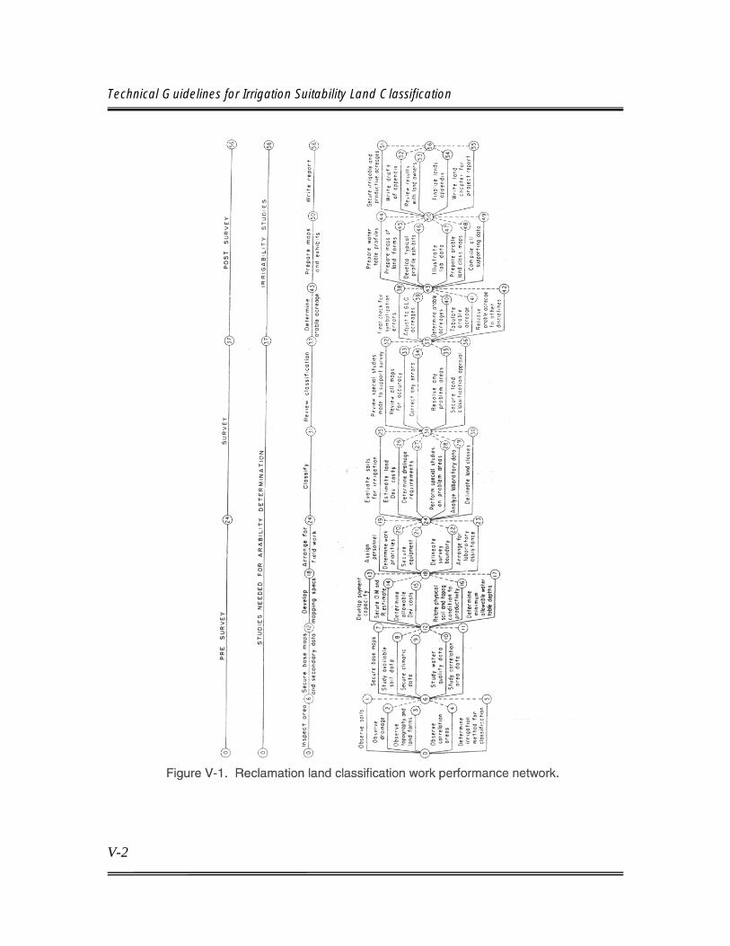
Technical Guidelines for Irrigation Suitability Land Classification
V-2
Chapter V Land Classification Techniques
V-3
V.B.1. Developing Scope of Work and Data Quality Objectives
The planning team administrators, usually an interdisciplinary team, have responsibility for making policy decisions affecting land classification procedures. The type and objectives of the general investigation probably are the most important decisions.
Land classification needs vary greatly between project objectives of irrigation, municipal and industrial water, recreation, etc. As discussed previously in chapter IV, the intensity, objectives, and support for a land classification vary appreciably with the investigation type. The method of irrigation to be considered may influence the classification investigation in terms of the gross area, project distribution and drainage systems and costs, land classification specifications, and economic criteria. The available water supply influences the extent of land and specific areas investigated. Since the land classification investigation often is a prerequisite to the final disposition of other phases of the investigation, and field operations often are dependent on weather conditions, investigation schedules and financing should consider the weather factor and schedule field work to permit completion of the classification ahead of deadlines established for other studies. Preliminary maps and tabulations, if sufficiently accurate, may be made available for use in other phases of the investigation. In establishing schedules, the following factors must be considered: (1) land characteristics and extent of investigation area; (2) need for special field and laboratory studies; (3) experience and availability of qualified land classifiers, soil scientists, and other personnel; (4) season; (5) number of informative appraisals required; (6) investigation objectives; (7) working conditions such as accessibility to area, travel required, etc.; (8) amount and adequacy of available data; (9) availability of adequate equipment such as truck-mounted power probes; and (10) other factors influencing investigation time and cost. All reasonable requests and suggestions for shortening the investigation time and cost should be con-sidered; however, adequate results should not be jeopardized in order to meet an arbitrary deadline or schedule.
Technical Guidelines for Irrigation Suitability Land Classification
V-4
V.B.2. Available Land Data Existing information may occur in the form of soil surveys, geologic surveys, land suitability studies, economic studies, special studies of specific land problems, land use studies, and previous land classification investigations. The most useful (and most often available) are NRCS soil surveys and previous Reclamation land classifications. Particularly in the early stages of an investigation, soil surveys provide a wealth of information relative to physical characteristics of the land, which is useful to land classifiers. County soil surveys frequently give the soil scientist his first insight into the character of the land relative to landforms, origin, and nature of soil parent material; degree of soil development; indication of suitability for various land uses, etc. Previous Reclamation classifications can provide valuable assistance; however, adjustments may be needed when irrigation methods and the agricultural economy have changed. Although other types of investigations may provide much useful information and provide the basis for formulating an investigation plan, in practically all cases they must be reinterpreted, reformulated, and supplemented to meet the needs of a standard Reclamation study for development of water and land resources. NRCS soil surveys are limited in usefulness for semi-detailed and detailed land classification investigations because they:
(1) Lack economic correlation (2) Are based on existing and not predicted conditions (3) May lack adequate laboratory and special field investigation support (4) Do not give specific attention to factors related to irrigation suitability (5) Have delineations based on genetic soil characteristics which may not correspond with those for irrigation suitability (6) Have insufficient data on the substrata for drainage evaluation (7) Occasionally have insufficient soil data for rooting depth of anticipated crop

Chapter V Land Classification Techniques
V-5
(8) May have undelineated variations which may be important to irrigation suitability (9) Sometimes include ranges in characteristics for lands which are broad enough to encompass more than one land class. Additionally, the approach to most other land studies is mapping of lands on the basis of observable characteristics that may not relate to use suitability or cannot be readily interpreted for a specific use suitability. Informative appraisals may also not be available with other land studies. Therefore, mapping unit boundaries from other types of land studies should not be used as delineations for land classes unless confirmed by field studies or observations. The field checking and correlation required to bring other surveys to Reclamation standards may equal the effort required to complete a land classification investigation without the aid of other sources of data, particularly as the level of detail necessary for the land classification studies investigation increases.
Regardless of their limitations, soil surveys and other types of land studies can provide valuable data, which may shorten the investigation time and increase the quality of a land classification investigation. Beneficial features include description and distribution of soil types, preliminary interpretations for various uses, and statistical data relating to climate, agriculture, and other features of the area.
V.B.3. Gross Investigation Area
The general gross investigation area should be defined with the help of the investigation team. Initially, the area may be defined on the basis of available data, but the investigation team should confirm the area by conducting a field inspection. A properly defined area can reduce the time and costs of the land classification investigation and ensure assembly of adequate land data to meet the needs of the investigation. The area to be investigated should be held to the smallest area that can provide the necessary information, but should be large enough to cover all lands that can be expected to be served by the planned project. Other team members who can provide valuable assistance in outlining the area to be investigated include economists, hydrologists, layout engineers, drainage
Technical Guidelines for Irrigation Suitability Land Classification
V-6
engineers, water quality specialists, and administrators. The economist can evaluate the economic feasibility of service for individual areas, land types that cannot meet the economic requirements for arable land, and areas that will produce insufficient benefits. Potential isolated areas may be delineated by the layout engineers. The hydrologist can indicate water supply limitations. Water quality experts can provide an appraisal of return flow considerations that could indicate elimination of saline lands from the investigation. Drainage engineers may be able to identify lands that are infeasible to drain. Land classifiers have the responsibility for eliminating lands that are unsuited for sustained irrigation. This applies when the lands are unsuited because of their characteristics or because the lands and anticipated crops are not compatible with the water to be used. Administrators can define areas such as parks, Indian reservations, town sites, or other land uses that are to be excluded from the project area. Areas that are unsuited for irrigation, but that may be useful for other functions of the project, may be included in the survey area. The extent and detail of land data required for functions other than irrigation must be determined as a part of the preliminary appraisal. The more data that become available, such as from reconnaissance level land classifications, the more closely the area to be investigated can be adjusted to the ultimate arable area. One use of a reconnaissance investigation is to establish investigation boundaries for subsequent, more detailed, land classifications. The goal in defining the investigation area should be to define all class 6 lands, except those that occur as internal areas or those along the outer edge of the area. Elimination of large internal areas of class 6 land also should be attempted. The preliminary investigation area determined by the entire investigation team may be adjusted by the soil scientist to delete areas that provide no useful information and to add areas that may be an asset to the project.
V.B.4. Investigation Guidelines The land classification specifications developed in cooperation with agricultural economists and drainage engineers are the most important guidelines. Suggested procedures for developing specifications are discussed in Chapter III, “Land Classification Specifications and Basic Land Classes.” Preliminary specifications usually can be established on available data, which will permit initiation of field studies prior to their confirmation by economic studies. The existing information
Chapter V Land Classification Techniques
V-7
used in developing preliminary specifications should be sufficiently current to ensure no major adjustments requiring extensive field review of areas mapped as a result of the preliminary guidelines. A delay in initiating field studies may be preferred to using temporary guidelines, which may later be found to be inadequate. Unless specific changes are planned, use of the semi-detailed investigation specifications as preliminary guidelines for the detailed investigation usually is satisfactory, at least until the final economic correlation studies have been completed.
During the prefield activities, specifications identified by the investigation team for informative appraisals should be developed. Persons using these data should indicate the ranges and detail required in these appraisals. The land classifier should review the requested appraisals to determine their practicality and the additional effort required to gather the data for them. Land and water problems requiring special investigation normally should be identified before initiating the field studies. Guidelines and procedures for conducting these studies should be established at an early date. Although land classification specifications and other guidelines should be developed before field activities begin, they should be reviewed periodically to ensure proper data are being accumulated. However, guidelines should not be changed without fully evaluating effects of the changes on the completed studies and evaluating whether the results justify the additional cost and effort.
V.B.5. Informative Appraisals
An essential part of a land classification is collection of land data for determining land classes and data useful to others but not required for the determination of irrigation suitability. These data can be divided into two major groups: (1) data that can be evaluated on the basis of observations and studies normally made for an economic land classification, and (2) data requiring additional observations for evaluation. Whether related specifically to land classification or not, each factor may require an appropriate character or symbol for its identification. There is a practical limit to the detail and number of these informative appraisals made during a field investigation. Important considerations in selecting informative appraisals for a specific investigation are the time required; the appraisal’s value in relation to the effort required for evaluation; the limitations imposed by map

Technical Guidelines for Irrigation Suitability Land Classification
V-8
scale, delineations, and mapping symbol; the need for the data; and the cost of mapping. Informative appraisals selected should cover needs of planning, construction, and operational phases of water resource projects. Productivity, development costs, and support for irrigation scheduling are informative appraisals that can be quantified on the basis of data gathered on land characteristics for a routine land classification. Unless their ranges vary from those of the land classes, additional delineations usually are not required. These conditions can be determined from information provided by the standard symbol. Land use or vegetation, farm water requirements, and permeability of the substrata are informative appraisals that usually require additional evaluations and could result in further delineations. Table III-8 in Chapter III provides the appropriate symbolization for most informative appraisals. Symbols for factors not shown should be developed as needed, documented in the land classification report, and included in the map legend .
V.B.6. Productivity and Land Development
Estimates of the level of productivity and development costs associated with specific tracts of land are made by the land classifiers in evaluating and placing land into land classes and subclasses. As used here, the term “productivity” means the combined effects of the productive capacity of the land and costs of production. Land development consists of the preparation of land for irrigation or permanent improvements necessary to attain the anticipated productivity, the cost of which is borne by the farmer and relates specifically to the land benefited. Productivity and irrigation development costs represent the criteria on which land classes are determined. Unless irrigation development costs are minimal and productivity is in the maximum range, their cumulative effect on payment capacity, not the most prominent deficiency, determines the land classes. Soil has the greatest effect on the productivity rating because of its influence on yields, crops that can be grown, fertilizer requirements, and cultural factors. The productivity rating for surface irrigation is also affected by higher costs for spreading water and the greater proportion of non-productive land resulting from irregular fields and greater than optimum slopes. Many of the mechanical methods of irrigation minimize or eliminate the effects of these factors.

Chapter V Land Classification Techniques
V-9
Automatic sprinkler and drip systems minimize or eliminate limitations imposed by low available water in the soil, adverse infiltration rate, and the internal drain-age of the root zone. Additionally, field size becomes less significant, and steep gradient is less hazardous, with sprinkler or drip systems. With surface irrigation, irrigation development costs are influenced primarily by the need for land grading, which usually includes smoothing the land surface and earthwork for the farm distribution and surface drainage systems, and removing surface rock or vegetative cover. Other procedures contributing to development costs, which occasionally occur, are leaching of residual salts, reduction of soil exchangeable sodium, deep plowing to break up clay-pans and to mix soil horizons, placement of high-quality soil around new tree plantings, and construction of contour benches. Costs for land grading usually are eliminated when sprinkler and drip systems are used, but total costs may remain relatively equal. If precise productivity ratings and irrigation development costs are useful and the additional effort to symbolize and tabulate is justified, numbers representing their respective levels may be included on the symbol. If these numbers are not included on the symbol, they can be estimated for individual areas using the deficiency ratings for each subclass shown in the denominator of the land classification symbol.
V.B.7. Soils The available water-holding capacity of the soil is an important factor in irrigation suitability and is essential to irrigation scheduling. It is the amount of water retained by a soil after irrigation and the portion of water that may be readily available for use by crops, which influence irrigation practices and determine farm water requirements. It is also related primarily to the depth of soil over incoherent material like coarse sand and coarse gravel (the Ak@ factor), coarse soil textures throughout the profile (the Av@ factor), layering of very coarse-textured material beneath a finer-textured horizon, and nearness of a permanent water table to the root zone. These factors are evaluated by the soil scientist in his activities to estimate the soil's ability to retain water available to plants. The approximate level of available water for the soil of each delineated area can be estimated from the data recorded in the land classification symbol, which includes the deficiency symbols “k” and “v” if the level is less than the minimum for class 1 land. If the

Technical Guidelines for Irrigation Suitability Land Classification
V-10
ranges mapped for irrigation suitability also meet the needs for irrigation scheduling, no additional delineations are necessary for this purpose. Occasionally, there are situations where more precise breaks between the minimum and maximum levels of available water are needed for scheduling purposes. In these situations, the appropriate breaks should be discussed with operation and maintenance (O&M) personnel to determine O&M needs and to develop practical field procedures for collecting additional data, while mapping irrigation suitability. Additional breaks generally require new delineations on the map and use of separate letters on the symbol; or, it may be more practical to record them on a separate map.
V.B.8. Land Use
Limited mapping of present land use may provide basic data for land use investigations, unless adequate data are available from other sources or a separate investigation is contemplated. The separation and tabulation of irrigated lands, dry croplands, permanent pastures, homesteads, and urban lands are usually a part of a land classification investigation. Other possible categories of land use or vegetation include brush or timber, wastelands, suburban lands, parks and recreational areas, marshes, and established rights-of-way. Additional land use data can be included in the soil profile notes. Land use designations can be incorporated into the land classification symbol or be presented as a separate map. Where there is a need for mapping a great number of land uses or vegetative cover requiring numerous categories, or where land use is required for areas not covered by the land classification investigation, many delineations and small areas not significant to the land classification usually result, and a separate investigation and map are necessary. Only when a limited number of land use categories are needed, and the delineations generally correspond to the delineations for irrigation suitability, should land use be entered on the land classification map.
V.B.9. Farm Water Requirement
The reliability of project water requirements is becoming increasingly important with development of, and competition for, water resources in most stream basins.

Chapter V Land Classification Techniques
V-11
Overestimates may result in exclusion of good lands that could be irrigated. Underestimates could result in severe water shortages. Basic data, including available water, infiltration rate and hydraulic conductivity of soils, slope of field, length of run, hydraulic conductivity of subsoils and substrata, and general water table conditions obtained in the land classification investigation are usable by the hydrologist for project water requirement investigations. Occasionally, a hydrologist may be able to group land classes and subclasses into farm water requirement categories. The difficulties of serving areas of complex land conditions and critical water supply may best be overcome by an informative appraisal of land factors that affect water delivery requirements. Actual specifications are established at the request of, and cooperatively with, persons who have the primary responsibility for determining water requirements.
Theoretically, lands can be rated according to their water requirements under a given situation. Because the spread between the least and the greatest requirement usually is relatively small and there are management practices which minimize the difference, informative appraisals for water requirements are seldom practical or requested.
V.B.10. Drainage
Participation of soil scientists in drainage studies may vary from little involvement to performing most of the drainage investigation. Regional policy, personnel limitations, different land conditions within and between projects, and investigation objectives determine the extent of their participation. Regardless of the soil scientists' participation in drainage investigations, mapping the permeability of the substratum usually can be achieved efficiently and accurately concurrent with the land classification investigation. Generally, deepening the soil profile observations to a depth and at a frequency compatible with needs of the drainage investigation is adequate, provided the profiles are logged properly. Attention must be given to the soil's hydraulic conductivity, and barrier depths must be determined. See the Drainage Manual (Reclamation, 1993). This provides uniformity in appraisals between drainage and land classification investigations and essentially eliminates one field operation. The land classes and subclasses generally can be grouped readily into substratum permeability categories without the need for subdelineations. Guidelines on the number and values of categories should be developed in cooperation with the drainage

Technical Guidelines for Irrigation Suitability Land Classification
V-12
engineers. This appraisal can sometimes be used as a basis for eliminating extensive areas from further project considerations. The informative appraisal for drainage is presented as a character in the denominator of the land class symbol.
V.B.11. Present Land Characteristics
There are a number of uses for a record of the present land characteristics. Because Reclamation's land classification is based on anticipated land conditions when it reaches equilibrium with irrigation, the standard symbol is not representative of preirrigation land characteristics. Therefore, the status of present land characteristics is useful as a base condition for appraising changes resulting from irrigation for return flow studies, identification and evaluation of wildlife habitat areas, defense of damage claims or other litigation, and other purposes. Land factors, which may be altered through project development and cannot be identified and quantified with the standard land classification symbol, are soil and substrata sodicity and salinity, vegetation, land use, water table depths, general drainage conditions, deep plowed areas, and soil hydraulic conductivities that may be altered through leaching of sodium and harmful salts or by profile modification activities. Recording the vegetation and land use is considered a separate item. The other features and factors considered in an investigation, and standard symbols to indicate deficiencies at equilibrium with irrigation, are listed in table III-8 in Chapter III. Where applicable, the standard symbol placed in parenthesis can be used to represent present conditions. This may require a repeat of some symbols, as well as some additional symbols. The limits of factors shown for current conditions should be the same as shown in the land classification specifications. Because other people use this information in their studies, they should be consulted to determine the extent and kind of data to be recorded. The present land status generally can be constructed from soil profile data and other notes following completion of the investigation. However, if the need is known before the investigation, it is much more efficient if the investigation is done in the field while mapping for irrigation suitability, and while supported by laboratory and special studies. Normally, a minimum of additional data and delineations is required.

Chapter V Land Classification Techniques
V-13
Adequate data on present land characteristics is essential when making studies relating to the prediction of return flow water quality. A careful examination of factors such as quantity and quality of residual salts, sodium status, infiltration, and hydraulic conductivities is required for an accurate prediction of return flow water quality. Although soil scientists are responsible for the collection of these land data, they must maintain close coordination with hydrologists, engineers, environmentalists, and other interested team members.
V.B.12. Additional Informative Appraisals Additional informative appraisals may be desirable under special conditions. However, because of the cost and time required, a complete physical inventory cannot be justified. Furthermore, the limitations of the classifier in making the innumerable delineations and evaluations must be recognized. There are data which can be observed and recorded only by those who traverse an area, and soil scientists are probably the only members of a planning team who have the opportunity to traverse all areas considered under a planning study that has an irrigation component. Soil scientists not only observe the land, they develop many contacts with local residents, and the data they collect need not have agronomic significance. Data collected may include information on special types of flora and fauna, historical and archeological sites, wildlife habitat, and unusual geologic conditions. Specific guidelines will not be developed for each category, but the specialist in that field could provide guides to identification of the peripheral factors to be observed and recorded. The soil scientist normally would provide only a general description and location and leave the classification and the determination of significance to the responsible specialist. Where the feature occurs frequently, a special symbol to locate each site can be adopted for use on the map.
V.B.13. Base Maps and Equipment Adequate base maps and equipment are essential factors for conducting an efficient and accurate land classification investigation. Since these items constitute a small portion of the total budget, the difference in cost between

Technical Guidelines for Irrigation Suitability Land Classification
V-14
inferior and adequate maps and equipment is relatively insignificant. Inadequate and poorly maintained supplies can increase costs and investigation time appreciably and may result in a less accurate product.
a. Base Maps Suitable base maps, consistent in form and accuracy and conforming to established cartographic standards, are of primary importance in making land classification investigations. The primary purposes of base maps are to: (1) provide orientation on the ground, (2) provide clues to the characteristics of land types significant to irrigation suitability, (3) provide clues to the boundaries between significant land types, (4) indicate the location of prominent manmade and natural features, and (5) provide a base for accurately recording land classification data, so that acreage of each delineation can be measured correctly. Classification boundaries, location of soil borings, land class symbols, and other symbols for specific land characteristics are plotted on the base map or on a transparent overlay, which becomes the primary record of field studies. Soil profile notes may be recorded on the margins of the base map or in notebooks. Reproducible maps and soil profile notes will be drafted from the base map or overlay. The ultimate uses of land classification data, as well as the use of the maps for other purposes, determine the accuracy and type of maps required for a particular investigation. Except for scale, similar maps may be used for any type of investigation. Acceptable types may include maps having only horizontal control and principal cultural features, topographic maps, aerial photographs, or combinations of these. Selection of base maps should be based on how well they meet the needs of the investigation and enhance field investigation accuracy and efficiency, cost, and availability. Good base maps are important for all types of investigations. High-quality base maps are particularly essential with more general investigations, where close inspection of individual land areas is not possible and mapping must be projected to broad areas on the basis of visual observations and map interpretation. In contrast, detailed investigations where lands are evaluated primarily by close

Chapter V Land Classification Techniques
V-15
examination actually may benefit less from good base maps. However, a more accurate scale is required for detailed studies to ensure accurate acreage measurement. (1) Aerial Photographs. Conventional black and white aerial photographs usually provide adequate assistance to field personnel, are relatively inexpensive, and usually are available at the desired scale and size. In nearly all cases, orientation is possible without reference to ground measurements. Innumerable surface features are discernible, which provide location and assist in establishing classification boundaries. This increases progress and improves the accuracy of the classification delineations. Photographs may have variations in scale within the individual print or between prints. For reconnaissance or semi-detailed studies, this usually can be overcome by selecting the center portions of prints where minimum distortion occurs. A more accurate scale is needed for detailed investigations, from which the final measurement of acreage used for assessments and charges are made. An accurate scale can be achieved through rectification of the basic photograph or overlay. There are many good sources of aerial photography, including the U.S. Geological Survey EROS Data Center, Sioux Falls, South Dakota, and the U.S. Department of Agriculture, Farm Service Agency, in Salt Lake City, Utah.
(2) Topographic Maps. Topographic maps may serve as base maps. Because of high cost and length of time to produce, topographic maps generally should not be prepared specifically for a land classification investigation. Since aerial photography usually is readily available at reasonable costs, topographic maps are primarily used only when they are available or are being prepared for general use in a planning study. In areas that have complex topography and will be surface irrigated, topographic maps may be a valuable aid in mapping. If available, topographic maps may be used to rectify mapping done on overlays over aerial photographs. They are superior to photographs in accuracy and uniformity of scale, for identification and location of certain features that may not show up on photographs, for most topographic features, and for location of boundaries established by land surveys. They are inferior to photography in identifying and defining land types, land use, vegetation, and other land features. If topographic maps and photography are available at this same scale, the combination can provide a useful base map. The topographic map may be used as a transparent overlay on the aerial photograph or kept separately for reference. The

Technical Guidelines for Irrigation Suitability Land Classification
V-16
U.S. Geological Survey is the best source of maps; however, other agencies (both State and Federal) may have topographic maps prepared for a specific purpose, which can be adapted for land classification uses. The USGS 7-1/2 minute series of maps, at a scale of 1:24,000, are very useful for either reconnaissance or semi-detailed studies and often are used as a base for general maps in all planning studies. Topographic mapping at a scale of 1:4,800, for use in developing the definite plan, is often obtained by Reclamation. If possible, a topographic map should be scheduled for completion to permit its use in the land classification investigation.
(3) Geographic Information Systems (GIS). GIS is a useful tool for creating drawings for the presentation of land classification results which may be substituted for displaying information on topographic drawings and aerial photographs. Using GIS to produce land classification drawings may be cost prohibitive for small areas; however, for large complex areas, this tool may be used at a cost savings when it comes to acreage tabulation, readily reproducible drawings, ease of revision, and use as a layer for other land resource purposes. (4) Digital Orthophoto Quads. Orthophoto quads are rectified aerial photographs. The rectification process removes image displacements in aerial photography caused by camera lens distortion, camera tilt and tip, terrain relief, and scale. A digital orthophoto is a uniform scale photographic image and can be considered a photographic map. The uniform scale makes it possible to use the orthophoto as a base map to make direct distance, area, or position measurements. Sources of orthophoto quads can be readily found by internet searches on “digital orthophoto quads.” The field of remote sensing is developing rapidly and may, in the near future, develop maps superior to those now used as base maps. Soil scientists should be aware of developments in this field. However, before adopting other materials for base maps, the added expense and delay should be justified. Some sources of digital soils data sets include: The Natural Resources Conservation Service’s Soil Survey Geographic (SSURGO) (http://www.ncgc.nrcs.usda.gov/products/datasets/ssurgo/index.html). The State Soil Geographic (STATSGO) (http://www.ncgc.nrcs.usda.gov/products/datasets/statsgo/index.html)

Chapter V Land Classification Techniques
V-17
A Compendium of On-line Soil Survey Information – Digital Soil Geographic Databases: North and Central America (http://www.itc.nl/~rossiter/research/rsrch_ss_digital_na.html)
b. Equipment Progress in field mapping may vary considerably with the type of equipment used. It is important that equipment used, including hand tools, is in good condition and suited for the specific investigation. Basic hand tools generally include a spade or probe for inspections of the upper soil horizons, soil augers to observe and sample the soil and substrata, a hand level, a geographical positioning system for determining coordinate locations, a rubber mallet, a canvas or plastic strip for laying out soil samples, and writing material. There should be a reserve supply of these items. Also, water containers, bags for samples, marking pencils, map boards, a backpack, a camera, and a measuring tape are standard equipment. There are a number of mechanical drills and diggers that reduce the time required for sampling the soil and making deeper borings. Screw-type power augers break up and mix soil horizons more than hand augers, but coring machines with push tubes usually provide a relatively undisturbed view of a soil profile. A backhoe is excellent for excavating observation pits. Large-diameter drills may also be used for observation pits; however, these drills are large, cumbersome, and expensive to operate. Although mechanical equipment may sometimes be more efficient, there frequently are situations when use of hand equipment is best. Lands with a standing crop, with wet areas, or with rough terrain restrict the use of mechanical equipment. Push drills are inoperable in coarse sands, gravel, and in finer materials containing cobble or coarse gravel. Equipment should be tested in an area before field operations are initiated, and only equipment that is found satisfactory should be supplied to field crews. Safety should not be overlooked in the field or when selecting equipment. Tool box safety meetings should be held at regular intervals. A safety checklist is a good mechanism to use to emphasize safety concerns. Vehicles utilized should be able to traverse the terrain easily and safely. Training in safe operation of vehicles and mechanical equipment should be provided. Also, first aid kits and
Technical Guidelines for Irrigation Suitability Land Classification
V-18
other safety equipment needed for a particular area should be provided. In rough terrain or during adverse weather conditions, cell phones or two-way radios are recommended.
V.B.14. Personnel
Selection of key personnel, including a lead soil scientist and other appropriate disciplines, to conduct a land classification investigation should be done at the earliest possible time. Agricultural economists should conduct the economic analysis necessary for drafting the land classification specifications. Drainage engineers should be consulted. If potential drainage conditions in the investigation area are already known, a decision can be made about whether, or when, an engineer should accompany the soil scientist during field investigations. If conditions are unknown, a drainage engineer should investigate the investigation area. They should participate in planning discussions and be responsible for preliminary activities. Overall responsibility for an investigation should be assigned to the investigation team leader. The team leader should have responsibility for assigning individuals to specific areas or specific duties, acquiring equipment and supplies, preparing base maps, assembling and evaluating available land data, coordinating field and laboratory studies, coordinating with drainage investigations, and reviewing completed mapping. To provide continuity and reduce orientation time, personnel changes should be held to a minimum. Assigning the least number of people necessary to meet the investigation schedule will contribute to uniformity of the results. The best qualified and most experienced individual should be assigned to reconnaissance and semi-detailed studies, since interpretation from information provided by maps and fewer observations of the soil are required. Field parties may consist of one soil scientist or a soil scientist with one or more aides. Land conditions, the mechanical equipment used, and the soil scientist's preference determines the number of aides per crew. It is possible that an aide can be alternated between two crews as the need arises. Where lands are acces-sible, uniform, and require a minimum number of profiles, one individual may work efficiently. Some mechanical equipment may require a specially trained operator. In isolated or inaccessible areas, the need to provide assistance for safety reasons may be justification for two-person field parties.

Chapter V Land Classification Techniques
V-19
Field aides or technicians should be encouraged and trained to undertake all tasks within their capabilities. This allows the soil scientist maximum time for observing and evaluating the land. Duties for aides or technicians may include driving, operating mechanical equipment, auguring holes and displaying samples, marking bags, sampling soils, listing samples on laboratory sheets, maintaining equipment, and reconnoitering areas for access. Some experienced aides or technicians may become quite proficient in sampling, determining textures, completing profile descriptions, and examining the area for specific features. While the aide performs his duties, the soil scientist should use his time traversing the area on foot, probing the soil, watching for indicator plants, observing land conditions, selecting locations for observing and sampling the soil and substrata, and evaluating land characteristics that influence irrigation suitability. In the office, aides should assume much of the responsibility for measuring and tabulating acreage and other routine tasks.
V.B.15. Coordination Good coordination between all members of a planning team is essential. For land classification studies, close coordination and cooperation should exist between field crews and the laboratory staff and between soil scientists and drainage engineers. Coordination of laboratory studies should begin before initiation of field activities. It is important to establish what laboratory support will be required, the specific tests anticipated, sampling and processing procedures for soil samples, rate of sampling, time allowed for processing, and channels of communication between the field parties and laboratory personnel.
Because land classification and drainage investigations are interrelated and may sometimes overlap, it is imperative that ground rules for the coordination of land classification and drainage investigations be established early to ensure greater accuracy and efficiency in both studies. This is applicable whether both investigations are conducted by land classification personnel or the investigations are divided between soil scientists and drainage engineers. The development of guidelines for the evaluation and mapping of substratum permeabilities and responsibility for conducting the studies is an essential decision before field work begins. Land classification and drainage studies should normally progress

Technical Guidelines for Irrigation Suitability Land Classification
V-20
concurrently; however, in areas having severe drainage problems, the total area to be classified may be reduced appreciably by first doing the drainage investigation and identifying nondrainable lands. When other land problems are more severe, drainage investigations can be reduced by doing the land classification first. Coordination required for land classification and drainage investigations may include decisions on allowable depth of water table, minimum barrier depth, specific data each discipline is to collect, schedule for each investigation, definition of drainable land, outline of gross area for each investigation, and methods for conducting the investigation. Although responsibilities of both lands and drainage disciplines for a resource investigation usually are well defined, it may be useful to review them as they relate to an individual investigation. Support activities, such as soil and water laboratories for each activity, should be coordinated. Both disciplines should use the USDA soil textural classes. Although it is a joint responsibility of the entire team, it is especially important that soil scientists and drainage engineers cooperate in defining the gross area to be investigated and make reasonable adjustments as the investigation progresses. Communications should be maintained throughout the investigation. It is also the joint responsibility of the land classifier and drainage engineer to identify potential and existing drainage problems. The Drainage Manual (Reclamation, 1993) provides a ready reference and guide for the methodology of making accurate field tests and for making estimates of drainage requirements.
V.B.16. Mapping Symbol The map with the land classification delineations and symbols provides the results of a land classification investigation and other useful data on land features. It is essential that proper symbolization be used to provide accurate and complete data collected for irrigation suitability, as well as data collected for informative appraisals. A symbol should be included in all areas that delineate irrigation suitability, significant informative appraisals, or other factors. The symbol, along with the measured acreage, provides a means of summarizing project land suitability and other data essential to the investigation. Table III-8 in Chapter III shows an example of a standard land classification mapping symbol.

Chapter V Land Classification Techniques
V-21
Basically, the numerator should include the land class and subclass. The content of the denominator may vary between studies but should contain characters for identifying and quantifying informative appraisals portrayed on the map and the dominant land deficiency or deficiencies associated with irrigation suitability. Section III.B.4, “Informative Appraisals,” in chapter III, describes informative appraisals and identifies the ones that are most frequently studied. The deficiency appraisal characters identify the land faults, which resulted in the downgrading of lands into subclasses. The symbol may contain information that will be useful during the planning process and throughout operation of a water resource project. Complete symbols should be placed in all delineations for the four arable classes, class 5, and class 6 when used for reconnaissance, semi-detailed, or detailed land classification studies. The exception may be when lands are being segregated into only arable or nonarable categories; however, even in those circumstances, it is often desirable to use symbols that identify critical land characteristics, especially if more detailed studies may be undertaken at a later date. The denominator characters adopted for the land classification symbol and their ranges should be consistent for any individual investigation. The most important features should emphasized and the number of deficiencies shown should be kept within reasonable limits. Denominator characters normally are not used with class 1 land, except for informative appraisals. One or two deficiency symbols may be used with class 2 land. Normally, a maximum of three deficiency symbols are used to represent lands in classes 3, 4, 5, and 6. Characters used in a symbol should be standard. Table III-8 in Chapter III provides a list of characters for use in the land classification symbol. The list should meet most needs; however, if additional characters are needed, their use and meaning should be explained in the report documenting the land classification investigation results. Informative evaluations may be portrayed with the specific letters listed or they may be interpreted from the land classification symbol. Symbols are provided for land use, farm water requirements, and substratum permeability. The characters listed for land use probably should be supplemented if vegetative cover and the land are considered nonarable. Other map symbols shown in table III-8 may be useful to identify specific land features. They are not indicative of the land class, but the features they represent may have contributed to the definition of the land class. These symbols are useful
Technical Guidelines for Irrigation Suitability Land Classification
V-22
to land developers, farm managers, for the performance of other studies, and to record present land conditions. Other map symbols for specific land features may be added as the need arises and should be documented on the mapping legend.
V.C. FIELD INVESTIGATIONS The basic decisions for determining the location, extent, and quality of land suitable for irrigation, as defined by the land classification specifications, are based on field observations. The factors and ranges for the preliminary specifications are often based on field assessments. Other activities such as laboratory analysis, special field studies, and consultation with irrigation specialists supplement and support decisions made in the field. Even the most uniform lands may have observable variations within short distances. However, because of the cost and length of time required to analyze them and the minimal effect they may have on irrigation suitability, special analysis cannot be made of each variation. Most special field and laboratory studies cannot duplicate precisely the natural processes they are designed to measure. Therefore, results are only accurate within limits. The significance of test results may vary between situations. Conditions or features analyzed through certain procedures may not be observed readily and must be identified in the field through association with observable characteristics. The need for supplemental investigations, the type of investigation to conduct, and its location depend primarily on field observations. Field activities fall into five general categories. They include: (1) initial orientation inspection of the area, (2) traversing the land and mapping the preliminary classification, (3) conducting special studies, (4) correlating laboratory and special investigation data with field observations into a final land classification, and (5) reviews by supervisors and higher authorities. Although these activities generally are completed in the order presented, there may be overlap between them, or they may be done concurrently. These activities are discussed in sections V.C. through V.F below.

Chapter V Land Classification Techniques
V-23
V.C.1. Field Orientation Classifications generally begin with an inspection of the proposed area to be investigated after compilation and review of available land resource data. The adequacy and efficiency of a land classification investigation may depend on the initial field inspection. The field inspection should be conducted by the responsible soil scientists, a drainage engineer, an agricultural economist, and the investigation team leader. A second orientation trip may be scheduled for other interested team members, in order to keep the initial orientation party small. Primary objectives of the field orientation are to:
• Define the area to be investigated
• Establish priorities for mapping specific areas
• Become familiar with the land area
• Determine the adequacy of available land data
• Make tentative decisions on supplemental investigation needs and general location
• Appraise the economic potential
• Review preliminary specifications
• Determine the best adapted equipment
• Appraise need for laboratory support
• Determine if exploratory studies to resolve pertinent questions will be
necessary prior to the routine field mapping. These factors are applicable to all types of land classification studies; but, because of available data, some of these activities will require less time for a detailed land classification.

Technical Guidelines for Irrigation Suitability Land Classification
V-24
The initial orientation field trip consists primarily of crossing major areas on existing roads. Observations of the soil generally are limited to viewing exposed soil profiles in road cuts, gravel pits, etc. Soil samples for laboratory analysis are collected only if no chemical data exists for the area of investigation. Supplemental investigation sites are located within a general area, necessitating a followup trip to locate the site more precisely. Any area requiring drainage investigations prior to land classification should be identified at this time, in order to accurately delineate the potentially arable areas. In many cases, such a procedure could result in an appreciable reduction of the land to be covered by a land classification investigation. Orientation with specific disciplines may be useful in establishing mapping criteria for informative appraisals. Consideration should be given to specific factors of critical importance to only one discipline.
V.C.2. Field Operation Field mapping may be initiated as soon as the necessary base maps and equipment are assembled, the preliminary specifications are accepted, guidelines are established for conduct of the general investigation, available land data are assembled and evaluated, the area is defined, coordination with other disciplines is established, and personnel assignments are made. Landowner and/or renter=s permission should be obtained before entering their land. If several field crews will be working in the area at the same time, permission may be obtained by one person for all Reclamation field crews. The precise methodology of covering the ground, examining and sampling soil and substrata material, and transferring land information to maps must be developed in the field and tailored to fit the specific area in question. Methods vary from place to place, depending on the adequacy of base maps, complexity of land conditions, and specific objectives of the investigation. The field inspection consists primarily of identifying, evaluating, and delineating bodies of land having significant differences in relation to irrigation suitability, making notifications on significant observations, selecting sites and collecting soil samples, and collecting and evaluating data for informative appraisals. The types of data gathered, and the general methods for gathering them, are similar for reconnaissance, semi-detailed, or detailed studies, but the intensity of data

Chapter V Land Classification Techniques
V-25
collection varies with the level of investigation, and operations may be modified to meet the objective of the particular investigation.
a. Field Traverses Generally, the investigation area is traversed systematically, beginning on a section line or map boundary and at right angles to the drainage. With uniform land conditions, the traverses may be in a straight line, but deviation is usually desirable when mapping complex land conditions, base maps are inferior, or access is restricted. Making traverses on foot, particularly in the more detailed studies, provides the best opportunity for observing land conditions. Observations of the land surface may provide clues to the land=s general characteristics. Their importance relates primarily to the initial identification of a problem and identification of similar areas after the condition has been confirmed by additional field observations and investigation. The appearance and kind of vegetation may indicate the nature and variation in the soil, presence of a water table, variations in the land surface, and flooding frequency. Indicator plants are invaluable in detecting soil problems such as sodicity, salinity, restricted permeability, selenium, and droughty conditions. The significance of individual plants may vary with the climatic setting. In observing the significance of vegetation, the difference in the soil-moisture regime between present conditions and conditions under irrigation must not be disregarded. The appearance of the soil surface may provide clues to the soil profile below. A dispersed crusted surface may indicate a sodic or highly dispersed condition. Fine-textured soil with predominantly swelling-type clays often develops wide, deep cracks. A gravel blanket on the surface can indicate excessive erosion has occurred. The evaluation of topography is based almost exclusively on observations of the land surface. It could be misleading and very time consuming to attempt the listing of surface indications and their significance to irrigation suitability. The recognition and evaluation of visual signs must be developed through experience and confirmation by other observations or studies in the immediate area or in similar areas. Their significance must be confirmed and correlated for each locality because important land factors may have different effects on productivity under different local

Technical Guidelines for Irrigation Suitability Land Classification
V-26
conditions. Today, ground position systems are becoming prevalent and economical, making them a useful tool for accurately locating a field site. Soil, topographic, and drainage conditions and their interactions must be observed and evaluated during the field inspection. Field traverses should be thorough enough to establish boundaries between land classes and subclasses and any additional boundaries needed for informative appraisals. Evaluating surface factors, probing to establish significant soil conditions, selecting and evaluating sites for recorded soil profiles, and sampling soils for laboratory analyses should be a part of the initial field traverse. Required boundaries, location and identification of recorded soil profiles, complete land classification symbolization, and any other applicable mapping character adopted for the investigation should be recorded on the map before leaving the investigation area. Normally, no significant revisions are made in the mapping unless changes are indicated by laboratory analysis results or supplemental studies, errors are discovered, or mapping criteria changes. Complete and relevant notes concerning land suitability should be made during these initial field activities.
b. Soil Appraisal Soil appraisal starts with the review and interpretation of available soil information, but soils evaluation of an area begins with the field inspection. The general nature of the area soils and problems usually are identified before going into the field. The field inspection of soils should consist of traversing the area and observing the surface for clues to soil properties, probing the surface soil and the subsoil to define areas with similar characteristics, selecting sites having representative soils, examining soils and substrata to the desired depth at selected sites, and delineation of similar land bodies and their identification by an appropriate symbol. Selection of representative sites for observation and sampling usually follows the visual inspection and probing of the area. When limited knowledge is available about the soils, additional holes are frequently required. (1) Influence of Soil Characteristics. The soil-moisture relationship of a soil is important in making decisions for the design, construction, and operation of an irrigation project. This relationship may influence choice of irrigation methods,

Chapter V Land Classification Techniques
V-27
design and layout of the irrigation and drainage systems, evaluation of suitability of land for irrigation, selection of crops, and cultural practices. Specifically, the irrigation method selected may be influenced by the water intake rate and movement within the root zone. Surface irrigation normally is preferred on slowly or moderately permeable soils that hold reasonable amounts of available water. Surface irrigation of coarse-textured soils frequently results in the following soil-moisture problems: excessive deep percolation losses; stressing of crops, due to the low available water and inability to replace it as needed; excessive water use; and higher labor requirements because of frequent irrigations and shorter irrigation runs. Additionally, land grading required on the surface may do irreparable damage to the land by moving all or portions of the suitable soil from high areas to low areas. Sprinkler systems permit the irrigation of soils with a higher infiltration rate and lower available water-holding capacity, as well as lands on steeper slopes or topography which would require excessive grading for surface irrigation. Other sophisticated systems (like the drip method, which can apply water frequently or continuously) apply fertilizer with the water, maintain the soil moisture at a uniform level, and place fewer limitations on soil quality. Salt balance and aeration of the root zone depend on soil permeability. Soil permeability must be adequate to permit practical replacement of soil moisture depleted through evapotranspiration, maintain an adequate oxygen supply for plant growth, and allow leaching of excess soluble salts below the root zone. The minimum hydraulic conductivity necessary to achieve these conditions varies with the method of irrigation, quality of water, adequacy of subsurface drainage, crops grown, climate, and consumptive use. Tolerance to salinity varies between crops. Water high in salt usually requires a higher leaching fraction and, therefore, greater soil permeability. (2) Soil-Moisture Relationship. The suitability of a soil for irrigation is correlated to the soil-moisture relationship. This relationship includes three phases: (1) infiltration, (2) internal drainage, and (3) available water. Infiltration relates to the downward entry of water into the soil, while internal drainage relates to water movement within the root zone. Available water is that portion of water in the soil that can be extracted by plant roots. These three factors can be influenced by similar soil factors, but to different degrees.

Technical Guidelines for Irrigation Suitability Land Classification
V-28
(3) Soil Texture and Structure. Texture is one of the most basic of the soil characteristics considered in appraising the suitability of land for irrigation, and it is one of the most influential characteristics in the soil-moisture relationship. Texture also influences nutrient retention, drainage, tilth, and susceptibility to erosion. It is easy to observe and evaluate during field studies. The effect of texture on the soil-moisture relationship may be modified by soil structure, nature of the clay minerals, organic matter content, and other factors. Texture is best determined in the field by "feel," usually by an experienced soil scientist and, infrequently, supported by particle size analysis. Other signs such as surface soils with deep, wide cracks (which indicate a fine-textured soil) may be useful in determining texture. Particle size analysis is the primary method of supporting the land classifier's field evaluation of soil texture. Textural classes defined by Soil Taxonomy (USDA, 1999), are to be used. This information is also available on the Web at http://soils.usda.gov/technical/taxonomy. Because coarse-textured soils vary greatly in their ability to retain water, it is desirable to further refine the coarse-textured and gravelly soils into designations that indicate the size of sand particles and percent of silt and clay. The hydraulic conductivity rate of a soil is usually related inversely to the clay content; that is, the higher the clay content, the lower the hydraulic conductivity. There are a number of soil factors, however, that can be observed in the field that may alter or minimize this relationship. Most relevant of these is soil structure. Generally, soils with aggregates of a spheroidal or angular blocky shape have more pore space and are more rapidly permeable than soils that are massive, coarsely blocky, or prismatic in structure. Usually, soil structure is more pronounced in finer-textured soils. In classifying soils for irrigation suitability, it is necessary to identify structural classes, grades, and types in order to evaluate relative permeabilities. Porosity, the percentage of the bulk volume not occupied by solid particles, is related closely to soil texture and structure. Its bearing on the movement and storage of air and water in the soil is important to soil suitability. Also, porosity and bulk density are closely related. Pore size and distribution have much more significance than total porosity. As an example, clay soils may have many small pores with a rather large total porosity but drain very slowly. Of significance are large pores, which drain readily under the force of gravity and inherent soil tension. Large pore space usually increases with the coarseness of the texture and the aggregation of the soil particles. Exact values of the total pore space and the

Chapter V Land Classification Techniques
V-29
size distribution cannot be made from field observations; however, by observing the texture, structure, visual pores, density of soil clods, and other signs of restricted water movement (such as mottling), a reasonable estimate can be made of the effective porosity and its effect on soil permeability and moisture-holding capacity. Mottling indicates a poorly drained soil with various shades of gray, brown, and yellow, especially within the zone of a fluctuating water table. (4) Soil Sodicity. Exchangeable sodium may, in some situations, greatly influence the soil permeability. Usually, exchangeable sodium in excess of 15 percent of the exchange capacity and soluble sodium in excess of two-thirds of the cations indicates dangerous levels of sodium. However, caution must be exercised in using these criteria since other factors such as type of clay mineral, cation-exchange capacity, texture, restricted soil layers, other cations, total soluble salt content, and management factors may reduce or compensate the effects of sodium. It is not always easy to recognize a sodium condition in the field. As with other characteristics, the visible evidence may vary from area to area. Some useful signs are dispersed and crusty conditions of the surface soil or of material eroded from exposed profiles along cutbanks, a dense or massive structure, the presence or absence of indicator plants, general condition of vegetation, land use, and evidence of drainage problems. Exchangeable sodium is best confirmed by laboratory tests. Indirect methods, such as measurement of soil structure stability with results of settling volume and hydraulic conductivity of fragmented samples also may be acceptable. The more common analyses today for sodium determination include exchangeable sodium percentage, sodium absorption ratio, and gypsum requirement. Results of laboratory studies are useful only if the samples were gathered at a representative site, which can be projected accurately to areas with similar soil conditions. Consideration also must be given to other factors that can modify the effects of sodium in the soil. There are situations where, through proper management practices, the sodium in the soil can be replaced through leaching, a combination of leaching and soil flocculating additives, and/or profile modification procedures. These considerations would affect the irrigation development costs in addition to the land's productivity. When considering leaching and the use of additives (such as gypsum or other sources of soluble calcium) to replace the sodium, the initial

Technical Guidelines for Irrigation Suitability Land Classification
V-30
hydraulic conductivity of the soil must be adequate to permit profile saturation, and subsurface drainage must be adequate to allow removal of the applied water. In evaluating potential results of leaching and additives, it must be recognized that reduction of the sodium in a soil may not appreciably alter the soil structure. The resulting permeability is the measure of the success of leaching. Further information relative to the reclamation of sodic soils may be found in “Water Quality for Agriculture” (Ayers and Westcot, 1985) or “Agricultural Salinity Assessment and Management” (Tanji, 1990). Deep plowing may improve a soil for irrigation use when a claypan formed under sodic conditions exists and better material occurs above or below that restrictive layer. If the pan is sodic, an additive to replace the sodium is needed if enough free gypsum is not present to replace the sodium. Adequate subsurface drainage is a prerequisite for success with deep plowing. Under conditions ideal for deep plowing, a claypan soil's productivity may be restored to equal that of the best soil in the area; however, in most cases, less than optimum productivity results. Mixing of the surface soil with the other horizons produces a less tillable and fertile topsoil, and some leaching will be required. In estimating the land class for an area that requires deep plowing, consideration must be given to the cost of deep plowing, as well as the anticipated subsequent productivity.
V.C.3. Water Quality The soil permeability and the infiltration rate may also be influenced by the quality of water or the salinity level the soil solution reaches when in equilibrium with the irrigation water. The permeability, within reasonable levels, increases with an increase in the electrical conductivity of the soil. The rate and degree of change depends on the characteristics and drainage conditions. See “FAO Irrigation and Drainage Paper” (Ayers and Westcot, 1985).
V.C.4. Clay Type The kind of clay material present determines many of the physical and chemical characteristics of a soil and, thus, influences its suitability for irrigation. The clay fraction of a soil usually is composed of a mixture of clay minerals. The nature of the clay mineral itself is not, however, a convenient criteria for judging irrigation

Chapter V Land Classification Techniques
V-31
suitability in the field. Knowing the exact proportions of clay minerals present is less important than understanding the general nature of the clay. Sufficient observations should be made to indicate whether clay minerals of the 1:1 layer (kaolinite) or 2:1 layer (montmorillonite, illite, vermiculite) types predominate. In general, soils in which 1:1 layer clay minerals predominate have excellent soil-water relationships with a high degree of aggregation and nonswelling nature; under normal conditions, drainability is good. Most 2:1-type clay minerals expand greatly upon wetting. Soils containing a predominance of 1:1 layer clays are less affected by high exchangeable sodium levels than soils with predominantly 2:1 lattice clay. These characteristics greatly influence the permeability of a soil and modify the influence of texture. Generally, distribution of clay types in the soils of an area under investigation is relatively constant. The most common field observations which can be related to clay type are the feel of the soil and the relative number and size of cracks in a dry soil. Soils that contain mostly nonswelling, 1:1 layer clay minerals have only moderate stickiness and a small amount of shrinkage when drying, while soils with 2:1-type clay minerals have more extreme characteristics. The greater stickiness may result in tillage difficulties, and the shrinking will produce cracking of the soil. Because of the high cost of precise testing to identify clay types and determine their distribution within a soil, these tests are seldom performed. However, there are a number of laboratory procedures that are, in turn, greatly influenced by clay type.
V.C.5 Additional Factors Affecting Infiltration The infiltration rate is a dynamic property of soils, which may change with season and management. Factors affecting the internal drainage of a soil also affect its infiltration rate. Because infiltration is affected primarily by the surface soil, there are factors that should be considered in addition to those that affect permeability. The surface contains the greatest amount of organic matter, which contributes greatly to a more stable and favorable condition for water movement. The topsoil can also be manipulated and improved by cultivation and the use of amendments more readily than can subsurface soil horizons. Because the topsoil is often disturbed and mixed by cultural practices, it can differ greatly in appearance and produce more variable test results than subsurface

Technical Guidelines for Irrigation Suitability Land Classification
V-32
horizons. Since infiltration is related to the surface soil, there are usually more visual indications of a soil's infiltration capacity. For example, a puddled surface could indicate a slow infiltration rate resulting from unstable structure or excess sodium. Large cracks formed upon drying usually result in a high initial infiltration rate that decreases rapidly upon wetting. Although infiltration and internal drainage are often evaluated and tested separately, they are very closely related and often affect each other. The infiltration rate initially may be regulated by the topsoil; however, as time elapses and water moves into the profile, the rate is more dependent on the permeability of subsurface horizons. There may also be situations in which the topsoil has a lower capacity to transmit water than the subsoil. For more information on infiltration rate, see Section V.D.2., “Infiltration Rate,” in this chapter.
V.C.6. Additional Factors Affecting Available Water The available water (that portion of the water in a soil that can be absorbed by plant roots) is influenced greatly by texture, as well as other important features including stratification with contrasting textures and depth of water table. Texture and stratification can be observed and evaluated in the field. As a general rule, the finer soil fractions have the ability to hold greater quantities of water. However, the percentage of water held that is available to plants increases with the size of the soil particles, up to a point, and then begins to decrease. This point is usually somewhere between a loam and a sandy loam. The available water of a particular soil is, therefore, related to the distribution of the various sizes of soil particles. Generally, soils high in silt and very fine sand fractions have the greatest available water. These soils have textures from very fine sandy loam through silty clay. More information on available water can be found in Section V.D.3., “Available Water,” in this chapter. Stratification of the soil with a fine-textured layer over a coarse-textured one will modify the amount of water normally held by a soil. Because the coarse-textured material has less tension, the water may build up in the upper, finer-textured layer until enough head develops to force it out and into the coarse-textured layer. The reverse (a coarse-textured layer over a finer-textured one) may also result in a temporary increase in the available water in the upper layer. This temporary increase can take place if water is applied at a rate faster then the hydraulic

Chapter V Land Classification Techniques
V-33
conductivity of the lower layer. As a result, the water content in the upper layer may be above actual field capacity. Where a water table is anticipated immediately below the root zone, a greater quantity of available water can be expected in the horizons above the water table. This condition is usually difficult to predict and probably would have negative implications of salinity in a saturated root zone. Normally, it is not a situation anticipated in lands classified as arable. The depth of soil that must be examined to determine available soil water depends on the nature of the crops to be grown; but as a general rule, it is desirable that data be collected on all horizons to a depth of about 4 feet. Field observations of the soil texture, layering, and soil depths correlated with special studies provide an adequate estimate of available water. Special investigations, consisting of measuring the field capacity in the field and the wilting point by laboratory procedures, may be necessary to correlate the field appraisal. Some laboratory procedures would include particle size analysis, bulk densities, moisture retention, and hydraulic conductivities. Factors such as organic matter, soil structure, and clay mineral type have some effect on the available water, but it may be too small to readily or easily detect in the field. In cases of saline soils or saline irrigation water, adjustments may be needed to account for the osmotic pressure of the saline soil solution. Also, the significance of available water may be related to drain design and type of crops grown.
a. Minimum Levels Because of factors such as climate, water quality, and management decisions, and the inability to determine precisely their effects on irrigation suitability, it is impractical to establish firm minimum levels for infiltration, hydraulic conductivity, and available water that are applicable over a wide range of conditions. Approximate minimum and maximum ranges may be established for each, based on the particular circumstances of the area under investigation. Internal drainage must be adequate to permit recharge of the soil water lost through evapotranspiration. It must also permit downward movement of water into the drainage area at a rate that results in a well-aerated root zone and

Technical Guidelines for Irrigation Suitability Land Classification
V-34
maintains concentrations of salinity and toxic ions below harmful levels. The rate usually is not below 0.1 inch per hour. The infiltration rate must be adequate to maintain the soil moisture at a level that will not cause stress to crops with the proposed irrigation system. Some systems have the ability to maintain the soil water at a uniform level. The capacity to hold available water in a soil may then become relatively less significant. Permissible levels for each investigation are established through observation of irrigated areas with similar land conditions, consultation with irrigation special-ists, and through review of research data. Careful field observation of factors that influence soil moisture relationships, correlated with special field and laboratory studies, usually provides adequate estimates for most studies.
b. Soil Salinity The amount of soluble salts in a soil may be a negative soil quality in respect to crop growth in arid land irrigation. Their source may be from residual materials where precipitation is not adequate to leach them, or from accumulations resulting from poor drainage. It is fortunate that (due to solubility) such salts are relatively mobile; and when drainage conditions are adequate, they can be leached from the root zone. Accordingly, their presence at the time of the land classification may not be very significant. The effects of soil salinity on productivity should be evaluated on the levels predicted to be in equilibrium under irrigated project conditions. It should be recognized that a development cost may be incurred for reclaiming saline areas.
c. Harmful Effects The primary harmful effect of excessive salinity is that it inhibits the ability of roots to absorb an adequate water supply. Thus, in a saline soil, a plant may die from lack of water although the soil is quite moist. In addition, sodium, chloride, and sulfate ions may be toxic for some crops if present in excessive quantities. Plants vary widely in their ability to flourish under saline conditions. Therefore, the anticipated cropping pattern is of primary importance when evaluating the possible effects of soil salinity.

Chapter V Land Classification Techniques
V-35
V.C.7. Evaluation for Predicted Level The salinity level at the time of the investigation should not be regarded as a stable characteristic, since it is likely to change with irrigation. Important considerations in predicting the soil salinity when it reaches equilibrium with irrigation are: (1) water quality to be used for irrigation, (2) soil permeability, (3) grading requirements needed to provide a smooth surface for uniform leaching, (4) adequacy of subsurface drainage, (5) present level of soil salinity, (6) anticipated cropping system, and (7) applicability to return flow quality. Recognition, evaluation, and prediction of a soil salinity problem under irrigation are complex and often difficult. Identification of present soil salinity and its cause is the logical initial step. It can often be inferred from the kind, distribution, and appearance of vegetation. There are many plants that may indicate unfavorable salinity conditions because they are adapted especially to saline conditions. The sparse stand or stunted appearance of plants adapted to nonsaline conditions may also signify a saline condition. As with most visual signs, the true cause and extent of adverse conditions should be confirmed by additional investigation. Salt accumulations or "crusts" from evaporation on the surface or on exposed profiles provide a ready clue, but their presence frequently depends on an extended period with little or no precipitation. In extreme saline situations, salt crystals or nodules can be observed in the soil. Inadequate surface or subsurface drainage is often connected with the accumulation of salinity in the soil. A soil scientist, by reviewing the available soil and water quality data noting the land's features that encourage the accumulation, or retention, of salinity, and reviewing the analyses of soils from representative sites, usually can make a good approximation of present salinity and predict the level of salinity under irrigation. In very arid climates where many of the native plants are frequently salt tolerant and the rainfall is inadequate to leach or remove the residual salts, the identification of harmful levels of salts may depend much on laboratory analyses. Further information regarding the prediction of salinity conditions under irrigation can be found in “Water Quality for Agriculture” (Ayers and Westcot, 1985) and “Agriculture Salinity Assessment and Management” (Tanji, 1990). The method of irrigation employed may influence the final judgment on salinity. The system used can influence the amount of salt added in the irrigation water.

Technical Guidelines for Irrigation Suitability Land Classification
V-36
Systems that allow precise and frequent water applications permit the maintenance of a high water level in the soil, thereby reducing the salt concentration of the soil solution. Intermittent water applications made possible by sprinklers and other methods are more effective than flooding methods in leaching salts from a soil. Because of the many factors involved, possible variations in land characteristics, inability to analyze each significant variation individually, and inability to determine precise values for the pertinent factors, it becomes obvious that the prediction of salinity levels is an art that requires much experience and use of good judgment.
V.C.8. Leaching Adequate soil permeability and adequate subsurface drainage, coupled with irrigation water quality, are keys to leaching salts from the soil and maintaining a salt level that is not harmful to the crops anticipated under irrigation. Therefore, an approximation of the ultimate salinity requires a careful evaluation of these factors. One aspect of the drainage investigations is directed at eliminating lands that cannot be drained adequately within the specific economic and physical restraints imposed by the project criteria. The soil scientist normally can assume that lands retained after completion of drainage investigations can and will be drained if they are developed. Soil permeability should be adequate to permit leaching of harmful accumulations of salts below the root zone and maintaining a favorable salt balance without saturating the soil for lengthy periods. Permeability requirements for leaching may vary with irrigation waters. Saline waters may need a more permeable situation to achieve the required leaching fraction; however, this may be compensated for by an increase in soil permea-bility resulting from application of saline waters. A high ratio of sodium ions in water ultimately may reduce the soil permeability, whereas the opposite could result from a high ratio of calcium plus magnesium ions.
V.C.9. Soil Reclamation and Crop Selection A successful irrigation project may depend upon the reclamation of saline-alkali soils. Certain lands may be reclaimed for optimum production when amendments
Chapter V Land Classification Techniques
V-37
are applied in conjunction with leaching. Leaching can be used to prevent a problem or correct the problem after recognizing it from plant symptoms. The suitability of water for irrigation and the method of irrigation are important considerations when using soil amendments and leaching as a means for land reclamation. Another course of action is to select salt-tolerant crops or crops that will sustain a yield reduction and yet allow for a reasonable return on the investment. For more information, refer to Ayers and Westcot (1985) and Rhoades et al. (1992). When high sodium levels occur in the soil, sources of soluble calcium such as gypsum may need application. Adequate laboratory data, site-specific hydraulic conductivity tests, drainage costs, and knowledge of the quality of the irrigation water to be applied must be considered in determining total reclamation costs.
a. Soil Toxicity Toxic substances may occur in the soil naturally, or they may accumulate from applying irrigation water, spraying pesticides, air pollution, or other sources. Different plants often vary considerably in their tolerance of specific toxic substances, and the toxicity of a given substance can vary with circumstances; (especially in relation to the levels of other substances in the soil). High levels of boron, sodium, chlorides, and sulfates may accumulate from low-quality irrigation water, poor drainage conditions, or a combination of the two. These are potential problems and should be detected through proper evaluation of water quality, soil, internal drainage, and subsurface drainage requirements. Common toxic elements that may accumulate in the soil naturally or by other means include arsenic, boron, and selenium. Toxic substances that affect wetland rice production include exchangeable aluminum, sulfides, and iron. Toxicity in the soil usually is reflected in the quality of growth or absence of natural vegetation restricted to a particular range of species. A toxic element occurring in the soil or waters of an area may already be identified and researched. If, through a literature search or by field observation, toxicity is suspected, special studies and/or laboratory analyses of soil and plant material may be required.

Technical Guidelines for Irrigation Suitability Land Classification
V-38
b. Soil Fertility Soil fertility is rarely a major problem in arid soils of the Western United States. However, it is normally necessary to apply plant nutrients to agricultural lands to obtain optimum production. When nutrient elements must be added on a continuing basis, their cost should be considered a production cost. Fertility problems may exist when a soil does not have the capacity to retain and supply plant nutrients. This is related closely to a low cation exchange capacity of a soil, generally due to coarse textures or the presence of 1:1 layer clay minerals (kaolinite), which generally have low ranges of cation exchange capacity and a pH dependent charge. Soils of inherently high productivity usually have an exchange complex dominated by calcium and magnesium and contain only minor amounts of potassium and sodium. In very acidic soils, a high proportion of the exchange sites are occupied by exchangeable hydrogen or aluminum ions rather then by nutrient bases. Such soils tend to be unproductive. If such situations are anticipated, literature pertaining to the subject should be reviewed and investigation procedures should be developed for resolving and identifying the problem. Other, rather rare fertility problems (such as nutrient imbalance in poor soils) may be encountered and require special investigation and research. Nutrient imbalances usually can be identified in the field by vegetative signs.
c. Soil Tilth Soil tilth, which can be defined as a surface or near surface physical condition of the soil favorable to plant growth, is largely a product of proper management. Soils that meet basic arability criteria generally have the potential to develop favorable tilth under irrigation. The tilth is a good indicator of the general soil physical and chemical properties.
d. Erosion Erosion may be a serious problem, resulting in damage to the soil and water degradation. It normally can be controlled and held within reasonable limits by proper management practices. Certain factors such as the gradient and climate contribute greatly to the intensity of erosion. Soils that have a loose, single grain
Chapter V Land Classification Techniques
V-39
structure or having a high silt content are the most susceptible to water erosion. Steep gradients and intense rainstorms can increase the incidence and severity of soil erosion. Storm frequency and severity are usually uniform throughout the investigation area. However, during field appraisal, combinations of susceptible soil and steep slopes should be evaluated for possible erosion damage. Other factors, such as the possibility for more intensive management, should also be considered when evaluating erosion hazard. Because a more reliable vegetative cover can be maintained under irrigation, the hazard from wind erosion usually is relatively insignificant, or at least less severe than under average conditions. However, there may be situations in which prevailing winds are strong and destructive during the period when crops are most susceptible to damage from the wind. Wind erosion may then be the predominant factor in the irrigation suitability of an area. Because water and wind erosion generally can be left within acceptable levels through proper management, they normally are not a major factor in irrigation suitability determinations. Several soil erosion models are currently available for soil erosion prediction.
V.C.10. Prediction of Anticipated Soil Quality In addition to noting present conditions during the field appraisal, anticipated changes in soil conditions resulting from irrigation should be identified and approximated. With the exception of deep plowed areas, there are few situations in which the soil texture or the general clay mineral types are appreciably altered. However, other factors such as structure, exchangeable sodium, salinity, and organic matter may be altered significantly under irrigation. These changes are important in the soil-moisture relationship, quality of return flows, and soil physical conditions. Land grading needed for surface irrigation or for benching also may reduce the effective soil depth. Under special conditions, when leaching is necessary to establish soil productivity, or even under normal irrigation practices, the soil salinity and/or exchangeable sodium may be reduced. Conditions that would lead to an increase of salinity or exchangeable sodium to unacceptable levels cannot be tolerated in lands classed as arable. The removal of salts could result concurrently in improved soil productivity, reduced soil permeability, and increased salinity in the return flows. Reduction in exchangeable sodium through leaching and/or amendments frequently results in

Technical Guidelines for Irrigation Suitability Land Classification
V-40
increase permeability and improvement in soil structure. Such improvement may be temporary, however, unless adequate drainage is established.
V.C.11. Topographic Appraisal The topography of an area under investigation for irrigation suitability influences the choice of irrigation methods through its effect on labor requirements, irrigation efficiency, drainage requirements, erosion hazards, range of possible crops, costs of land development, and possible size and shape of the fields. There are four aspects of topography that have a special bearing on irrigation suitability: (1) slope, (2) microrelief, (3) macrorelief, and (4) cover. Position in relation to the distance and elevation of land from the water is another aspect; however, it is related to the irrigability investigation and should not be a major consideration in the arability investigation. The topography should be evaluated concurrently with observation of other land characteristics during field traverses. Except when topographic maps are available, evaluation of topographic factors is based almost entirely on field observations. Topographic maps usually do not provide the detail necessary to completely evaluate land grading requirements for surface irrigation. Competence must be achieved in distinguishing and evaluating topographic features that are significant in the land's suitability for irrigation. Considerable experience is required to achieve acceptable accuracy in estimating the costs of leveling and other development practices from field observations. Guidance and training may be provided by an experienced agricultural engineer engaged in detailed layout studies. Detailed farm layouts of representative areas showing costs for clearing, land grading, and farm structures, and location of surface drainage facilities, field boundaries, and waste areas, provide excellent guidelines and examples to assist in evaluation of project topography. Only a reasonable estimate of ultimate costs can be expected, since the ultimate development may depend on management decisions, land surface may be obscured by vegetation, insufficient information is available to determine precisely the anticipated field boundaries and average cut and fill, and ownership boundaries may change. If done properly, evaluation of the topography based on experience and field layout studies is adequate for most planning studies.

Chapter V Land Classification Techniques
V-41
a. Slope The degree of slope acceptable for irrigation development depends on four factors: (1) anticipated methods of irrigation, (2) intensity and amount of rainfall, (3) susceptibility of the soil to erosion, and (4) planned cropping pattern. Slopes of 50 percent or more have been successfully irrigated with drip or bubble systems and gravity irrigation on slopes greater than about 12 percent is seldom favorable. With sprinkler or drip systems, limitations on slope are related to possible erosion hazard from rainfall, operation of farm machinery, and other cultural and harvesting operations. Slopes of about 20 percent typically are the maximum acceptable for cultivated crops with sprinkler irrigation. In areas that experience severe thunderstorms, the maximum usable slope may be near 6 percent. Land devoted to grass or dense cover crops may permit irrigation of steeper slopes than land permitted for row or field crops. The maximum allowable slope should be developed in consultation with the NRCS, Cooperative Extension, or State resource agencies. Very steep slopes require a permanent and close ground cover to control erosion, and the incidence of rainstorms must be infrequent and mild. Because of the high system investment and high operation costs for drip or bubbler systems on steep slopes, only high- value crops such as grapes, avocado, citrus, and other vineyard and orchard crops produce the necessary returns to make these systems economically feasible. Although excessive slope is the most frequent problem, lack of slope also may limit the land value for irrigation by increasing irrigation development costs. Excessive flatness may result in higher costs for grading and/or the irrigation system to ensure uniform application of irrigation water. It may be necessary to increase the slope and achieve the smooth, level surface required for uniform distribution of irrigation water. Extremely gentle gradients may make irrigation of slowly permeable soils difficult because of possible scalding effects and waterlogging associated with standing water. With very permeable soils, extremely flat topography may prevent uniform irrigation without excessive deep percolation. Sometimes, very flat lands provide an opportunity to use very efficient irrigation methods such as basin and border dike. Because adequate slope usually can be obtained within the limits imposed by the permissible development cost, lands normally are not eliminated solely on the basis of inadequate slope.
Technical Guidelines for Irrigation Suitability Land Classification
V-42
There are few widely accepted or generally feasible means of modifying steeper slopes for more efficient irrigation and erosion control. Contour bench terraces have been used to control erosion with some success. However, as the slope increases, construction costs increase and the nonproductive area used for the berm becomes large in proportion to the crop area. Slope estimation is achieved through visual observation in the field. With experience gained by observing many areas and checking results with a hand level, a soil scientist can estimate slopes within ranges adequate for most planning studies. Slope determinations may be made from available topographic maps. Detailed farm layout studies are also useful in correlating estimates of land gradients.
b. Irrigation Development Irrigation development costs may be a major factor in the arable land class determining process. Microrelief, minor undulations and irregularities of the land surface, greatly influences the amount of development costs for surface irrigation. However, it has a minimal effect on costs for sprinkler or drip systems, which require only that lands can be traversed for movement of mobile systems or needed cultural practices. Some land smoothing or grading to ensure adequate water distribution is required on nearly all lands developed for surface irrigation. The maximum allowable cost for land development should be established before the field investigation begins. The cost of grading is determined primarily by microrelief. In estimating grading costs, field boundaries must first be established and limitations imposed by the soil depth must be determined. There is an inter-relationship between the irrigation field size and amount of land grading. The most nearly optimum field size, within the limits imposed on land grading by permissible development costs, should be considered. If an intensity of grading reduces the soil quality and/or depth below an acceptable level or creates extreme variations in soil characteristics, other development options should be considered. Estimation of land grading is an essential part of a land classification investigation. There are no specific methods or approaches that must be used. The intuition for estimating the required moving of earth is gained primarily through experience. Topographic maps and detailed farm layouts of

Chapter V Land Classification Techniques
V-43
representative areas are valuable for correlating a soil scientist's estimates on similar areas. Estimating the average cut and fill needed within a field and converting it to the estimated volume of material which must be moved is one method. The estimate can be made by evaluating the difference between the microrelief's highs and lows and averaging them for the field. This is often expressed in terms of required "cut and fill." This approach implies an average cut over half of an area with fill in the remaining portion. Tables can be developed to show the volume represented by the various differences. If topographic maps with the elevations recorded for each reading are available, they can provide a good guide to highs and lows. How smooth the surface should be for efficient irrigation may vary with gradient, the less efficient gravity irrigation method (flooding in comparison with border-dike), water quality, anticipated depth to the water table, and crop rotation. Less precise grading usually is needed as the gradient increases, with pressure irrigation systems, with high-quality water, with a water table anticipated to be well below the root zone, and/or with less valuable crops. Also, the volume needed for construction of farm laterals and drains and farm structure placement should be included in the total land grading cost estimate. There may be some cases requiring land grading where land must be lowered to the water elevation in a turnout; however, this cannot be determined until the system has been designed. Although land grading costs are based primarily on total volume of earth to be moved, other factors may influence the total cost. Unit costs for grading vary with the depth of cuts, length of haul, required surface smoothness, soil texture (which affects plasticity and the range of moisture conditions under which soils can be worked), and field size (where it is more difficult to maneuver large equipment).
c. Field Size and Shape Field size and shape for surface irrigation is determined primarily by the land's macrorelief. Other factors that may limit irrigation runs are soils with excessive infiltration rates and steep lands where runs should be kept short to prevent erosion. Land characteristics usually do not affect sprinkler or drip system design and cost profoundly; therefore, this discussion is related primarily to surface irrigation methods. In complex topography where slopes change frequently in

Technical Guidelines for Irrigation Suitability Land Classification
V-44
both lateral and transverse directions, surface irrigation becomes difficult and often impractical. As the field becomes smaller and irrigation runs because shorter, labor requirements increase, a more complex farm irrigation system is needed, machinery operating costs increase, the proportion of nonproductive land increases, and the irrigation efficiencies decrease. The minimum economic field size and length of run established in the specifications are based primarily on these factors. In the field appraisal of topography, estimating the field size must precede estimating the land grading costs. A major factor in estimating field size and shape is the presence of land features such as ridges or drains that cannot be removed because a drain would be essential for removing surface water or wastes from irrigation. Field boundaries usually lie on the more prominent topographic features, and the less prominent relief within may be graded to permit gravity flow of water. However, other features such as section lines, ownership boundaries, bodies of nonarable land, boundaries of land in a use that precludes irrigation, and other features that may interrupt irrigation flow may also define field boundaries. Ownership boundaries may not be known to the soil scientist in the field during the arability investigation, so they usually should not be assumed as field boundaries until the irrigable area determination is made. In the field, appraisal features that determine field size must be defined by observation. This requires considerable experience and judgment. In the more general land classification studies it is not practical to define each field. In such situations, estimating the field size is achieved by associating the landform with similar areas where detailed farm layouts have been completed or with irrigated areas that have similar topography. In the case of soil or gradient deficiencies, appropriate field sizes can be associated for each soil class or gradient range. Extra care should be taken in situations that have an interrelationship between deficiencies.
d. Cover Cover that interferes with normal cultural practices may occur on lands proposed for irrigation. This category includes vegetative cover such as trees, tall brush, and rocks on the surface or in the topsoil that interfere with cultural practices or limit the area that can be planted. Grass and small shrub covers are not serious

Chapter V Land Classification Techniques
V-45
deterrents to development and are only slightly more expensive to develop than cultivated lands. Because most crops require the land to be cleared, the cost of removing the existing cover must be considered in evaluating lands for irrigation development.
e. Rocks Rocks may be handled in three ways: (1) leave rocks in place, which would limit the crop selection and possibly reduce yields; (2) remove rocks completely, which would permit freer land use; and (3) a combination of options (1) and (2), in which the large rocks are removed. In many situations where the proposed crop does not require cultivation, it is more practical to leave the rocks. The extent of rock clearing is primarily an economic consideration related to the cost of removal versus the benefits derived from their removal. Irrigated pasture and orchard are two examples where leaving at least the smaller rock may be the most practical and economically feasible approach. In such situations, the cover should not appreciably reduce the area that can be planted. Bedrock outcrops are difficult and expensive to remove; but because of related deficiencies such as soil depth and drainage requirements, their presence is a problem rarely faced on potential arable lands. In orchard areas, if other conditions for arable land are met where rock outcrops occur, the usable area must be sufficient to permit the planting of a near normal number of trees. The outcrop's effects on picking the fruit, pruning, etc., must also be considered. Crops that rely on mechanical equipment use normally require complete removal of rocks that interfere with cultural practices. These crops include row crops requiring frequent cultivation and small grain crops requiring preparation of a seedbed and that are harvested with large equipment. For alfalfa and other hay crops where cultural practices and working of the topsoil are infrequent, partial removal or removal of surface rocks only may be adequate. There is no set method of estimating the volume of rock to be removed. Visible rocks may be collected from sample areas representative of the various rock densities of an area, and their volume may be estimated. Cost estimates for their removal, using methods and equipment available in the area, can be made. The difficulty of this method is relating the rock volume from the sample to other areas and the development of applicable costs. Observing and evaluating rocks
Technical Guidelines for Irrigation Suitability Land Classification
V-46
that must be cleared from the topsoil after grading is more difficult and less precise than estimating surface rocks. Observation of cutbanks for rocks, probing the topsoil with a spade, observing the vegetation for variations resulting from shallow soil depths over large rocks, noting any areas that are left idle or in native vegetation because of rocks, and noting how numerous rock piles occur on cultivated areas provide some indication of rocks buried in the topsoil. Unit costs for spotting and removing rocks in the topsoil are greater than for visual rocks. Rocks in the soil also may result in higher development costs for grading, farm irrigation system construction, and tree planting. If rock clearing is coordinated with land grading, costs can be held to a minimum.
f. Vegetative Cover Because of its demand for water, shading of the cultivated crop, and interference with cultural practices, vegetative cover (such as tall brush and trees) is usually removed from lands to be irrigated. Removal costs for trees, shrubs, or brush depend on the size, type, and frequency of the vegetation; local cost of labor; type of available equipment; and total area to be cleared. In estimating clearing costs, the soil scientist must identify vegetation type, its density and/or number per given area, and land conditions, all of which may increase or decrease unit costs for clearing. The agricultural economist can then apply local unit costs for clearing. If the cover has value for timber or other uses, its value should be considered in offsetting the estimated clearing cost. Clearing costs of either rock or vegetation usually vary little between different methods of irrigation, although highly sophisticated gravity methods normally require more refined clearing.
g. Position The position of a body of land in relation to elevation, isolation, or distance from the water supply is not normally a factor in the arable area determination. With multipurpose planning and the development of alternative plans, position factors may vary for each alternative. Usually, the exact elevation and location of water delivery is unknown until the arable area is mapped. Therefore, insufficient data are available for classifying lands in relation to their position during the arability investigation. Areas obviously nonirrigable because of position are excluded from the investigated area before the field investigation is initiated.

Chapter V Land Classification Techniques
V-47
V.C.12. Irrigation Method and Topography The effect of topography on land suitability for irrigation varies greatly with the proposed method of irrigation. Topography greatly affects land suitability for surface methods of irrigation. Investigations for surface irrigation, therefore, require a closer examination of the topography to determine requirements for land grading, field size, and costs for the farm irrigation system than investigations for other irrigation methods. With surface methods, most new lands need some land grading to achieve uniform application of water. Frequently, topography dictates the development of fields of smaller than optimum size, that are irregular in shape, and that have short irrigation runs. Since less control over water applications is common with a surface system, land gradient can be an important factor in irrigation suitability. In contrast, relief places much fewer limitations on the use of sprinkler or drip systems. Under sprinkler irrigation, the primary requirement is that necessary cultural practices for the anticipated type of agriculture can be accomplished, or (in case of a mobile sprinkler) topography will not hinder system mobility. With irrigation systems that can apply water with very little runoff, the limits for slope related to water erosion control are determined primarily by storm patterns and soil factors, which influence erosion. The field size for sprinkler systems and drip systems usually is determined by ownership boundaries, graded roads, nonarable areas, and water supply (not by topographic features). Except for clearing, topography imposes fewer and less severe restrictions on sprinkler irrigation methods than on surface methods. Except for areas requiring clearing, it can be anticipated that a greater portion of lands studied for sprinklers probably are arable. Clearing costs for a given piece of land vary little with the irrigation method proposed. However, because relative permissible development costs usually are lower for sprinkler irrigation, less clearing is feasible on lands developed for sprinkler irrigation. Where clearing costs are a major factor, a higher portion of lands could be suited for surface irrigation than for sprinkler irrigation.

Technical Guidelines for Irrigation Suitability Land Classification
V-48
a. Drainage Appraisal Drainage can be defined as the removal of excess surface and subsurface water and soluble salts that would affect adversely land productivity or the integrity and performance of structures and facilities. Some drainage usually is provided under natural conditions; however, under irrigation, consideration must be given to additional requirements for open channels, underground tile lines, or pumped wells. Adequate drainage is essential to ensure sustained productivity and to allow efficiency in farming operations. Therefore, drainage is an important factor in land classification because of its effects on sustained productivity, costs of production, and costs of control measures. Prediction of the drainage requirement is a critical element (particularly as related to diversified upland crop production) in selecting land for irrigation. The adequacy of this prediction and its implementation are among the prime physical determinants of the success of irrigation enterprises. In selecting lands for irrigation, several frequently inseparable drainage conditions must be considered. These include surface drainage to project outlets, drainage of depressions, flooding (both from streams and upslope lands), and surface drainage. The integration of drainage factors into the land classification process may vary between projects. Those factors which are determined to be the landowners' responsibility are usually land class determining and must meet the limits set by specifications. Subsurface or deep drainage systems normally are considered project costs because of the difficulty in assigning responsibility, generally high costs, and the need to coordinate the systems with project construction and operation. Arable land must be drainable land. The selection of arable lands should include the evaluation of drainage characteristics of the substratum or drainage zone in addition to the soil. Some lands have adequate natural drainage to sustain intensive irrigation. This condition must be verified by investigations and never assumed. Unfortunately, areas that are drained naturally occupy only a minor portion of the landscape. Consequently, artificial drainage works to remove excess water, and salts are needed in most irrigated areas.

Chapter V Land Classification Techniques
V-49
b. Drainage Investigation Coordination Land classification and drainage investigations should be well coordinated because of the importance of adequate drainage for sustained irrigation, interrelationship of land factors, and potential for conducting a more accurate and efficient investigation of the land. Coordination and decisions prior to field activities should include allowable minimum depth to maintain the water table under irrigation, specific activities to be conducted by the soil scientist and drainage engineer, criteria to be used, parameters to be measured, and informative appraisals required. The exchange and joint evaluation of pertinent data should continue throughout the investigation. Normally, land classification and drainage investigations should be conducted concurrently. Concurrent investigation does not infer the combining of crews from the two disciplines, or even working concurrently in the same immediate area. However, it does imply coordination of efforts to eliminate duplication and produce an adequate product or schedule for the involved disciplines. There may be times, however, when it is more efficient for one investigation to precede the other. Situations may occur in which large land areas can be eliminated from further investigation on the basis of a single land-related factor. Lands often can be eliminated from the area to be classified (particularly during reconnaissance and early semi-detailed studies) on the basis of inadequate drainage conditions. There may be considerable overlap of responsibilities for the conduct of field investigations for land classification and drainage; however, the responsibility for the technical aspects is well defined for regional and TSC staffs. When soil scientists perform aspects of the drainage investigations for which the drainage engineer has technical responsibility, care should be taken that criteria used, area covered, etc., are coordinated closely with the drainage engineer. The soil scientist's participation in the drainage investigation may range from almost no involvement to doing most of the investigation. Participation may depend on the organization of the planning office, composition of staff, workload of each discipline, and land characteristics.
c. Farm Drainage Integration of drainage factors with the land classification may vary between projects. Normally, factors determined to be the responsibility of the landowners

Technical Guidelines for Irrigation Suitability Land Classification
V-50
are identified as farm drainage and are evaluated by the land classification investigation. The drainage required of the landowner for control and removal of excess surface water resulting from rainfall and irrigation to a natural or constructed drain is the main element of farm drainage. Additionally, removal of surface waters from depressed areas, practices to prevent flooding or reduce its damage to crops, and the provision for conveyance of water from higher lands may be farm drainage situations that need to be evaluated by the land classification investigation.
d. Surface Drainage Evaluation of farm surface drainage requirements is always necessary. The effect of the evaluation may vary from minimal to a predominant factor for the classification. Specific construction for surface drainage may not be necessary with irrigation systems that provide close control over water applications and on lands with very permeable soil. With very permeable soils, however, there may be a need to consider a requirement for additional capacity in the subsurface drainage system. Surface drainage costs may be the predominant factor in irrigation development costs if obstructions exist between the land to be drained and the proposed drain outlet. Surface drainage costs for such situations can be estimated by determining the volume of earth that must be moved to excavate a drain of the length and depth required. The cost should be spread over the lands benefited (unit costs used for land grading may be applicable for approximation purposes). Surface drains normally are built in conjunction with land grading operations. Because a surface drainage system usually is not designed by the time the arability investigation is completed, it generally is assumed that the low point of the area is the probable surface drain outlet.
e. Flooding Floodwaters from an adjacent drain or streams may be a hazard connected with some low-lying lands. The problem can be recognized in the field by land use, relationship of land to the elevation and distance from streams, stream characteristics, appearance of the vegetation, and communicating with local authorities and residents. The effect of flooding on irrigation suitability can be approximated by estimating the cost for providing protection, the reduction in net income resulting from flooding, or a combination of the two approaches. Rarely

Chapter V Land Classification Techniques
V-51
is complete flood protection the most desirable approach. If providing protection is anticipated, the soil scientist will need assistance from the engineering staff in estimating flood protection costs. The severity of the flooding problem in relation to irrigation suitability usually is related to flooding frequency, length of time the area is inundated, depth, velocity, area covered, and season in which it occurs. Soil and subsurface drainage conditions permitting quick restoration of an aerated root zone also are important factors. Flood control that could be provided by the proposed project works should not be overlooked. Where complete protection is not feasible, the effect of the above-mentioned factors on crops and their yields, lands (erosion, etc.), and structures, which would affect net income, must be considered in arriving at an equitable land class for flood-prone lands.
f. Surface Drains for Adjacent Lands A land classification investigation must evaluate the need for drains to accommodate runoff from precipitation on higher lands. The cost of drains for control of irrigation wastes from other lands is usually a project cost. This problem often occurs in areas with frequent thunderstorms and excessive slopes; however, it also may occur in more arid climates. The need for drainways usually can be estimated through observation of local weather conditions and examination of the area contributing to a natural drain. The extent of the slope, vegetation type, soil conditions, and land use of the area contributing runoff to a drain also should be examined. Natural channels usually provide some clues to the volume and velocity of the expected runoff. Structures or excavated drains may not be required, but a strip of land wide enough (when properly managed) to accommodate flows without erosion may be designated as a drainway and the arable land class may be lowered or mapped as nonarable.
g. Farm Subsurface Drainage The subsurface drainage system for draining farmlands rarely is considered a responsibility of the landowner. However, if these drains are determined to be a farm cost, the land classification specifications should indicate that fact. Farm subsurface drainage costs should be limited to those related directly to the land. The main drainage system and structures required for control of drainage waters

Technical Guidelines for Irrigation Suitability Land Classification
V-52
from multiple ownerships should be considered project costs. Usually in the planning stages of a project, a distinction is made between what is project drainage versus farm drainage.
h. Project Drainage Project drainage is all drainage necessary (in addition to farm drainage) to establish and maintain productivity of project lands and protect nonproject lands. Project drainage is considered a project cost and is not land class determining. Project drainage normally consists of a system of outlets for farm surface and subsurface drains, and other protective works for lands affected by the project. Project and farm drainage requirements generally are interdependent. Individual land factors significant in a land classification investigation also may be significant in the drainage investigation. Therefore, it may be more efficient for the soil scientist to perform studies related to both investigations. This facilitates the utilization of skills, equipment, and coverage to obtain some of the data essential to project drainage planning. Data useful to a drainage investigation, which can be obtained readily by the soil scientist in their investigation of land, include the hydraulic conductivity of the substratum, depth of barrier layer, depth to (and fluctuation of) water table, water quality, salinity, and sodicity. These qualities should be evaluated in the soil or root zone depths by the soil scientist. Evaluation to a depth of at least 10 feet (3 meters) requires a minimum of additional effort and could better correlate the data from the two zones. The design and costs of drainage facilities developed for a project are essential to the plan formulation process. Because there usually is a limit on total con-struction costs, and water supply and distribution systems are essential, there is a maximum justifiable drainage cost that may be expended in a given project situation. The cost of project drainage for otherwise arable lands does not influence arable land classes. If justifiable cost is exceeded, the lands will be declared nonirrigable. A preliminary justifiable drainage cost provides one factor in the selection of the area to be classified and the preliminary designation of nonarable land. In using this criteria, it should be recognized that the allowable

Chapter V Land Classification Techniques
V-53
drainage cost may vary between projects, segments of an individual project, alternative plans, and other factors that may affect the cost of the supply and distribution system.
V.C.13. Substratum Hydraulic Conductivity The hydraulic conductivity of the substratum is a useful value in segregating nonarable lands in the preliminary investigation. This value also can be evaluated and recorded readily and efficiently by the soil scientist during the land classification investigation, but it should be accomplished with the technical direction of a drainage engineer. The evaluation of substrata by the soil scientist should be made to a depth of 10 feet (3 meters) and probably should be limited to a depth of about 15 feet (5 meters). The drainage engineer has the main responsibility for investigating deeper materials when such information is needed. The identification and description of barrier zones, which restrict the downward movement of water, and the determination of relative hydraulic conductivity rates of substrata over a general area are of prime importance. The barrier may consist of a slowly permeable layer resulting from fine texture, compaction, exchangeable sodium, or indurated and cemented hardpans. It also may result from the occurrence of impermeable bedrock in the drainage zone. A barrier is defined by Reclamation as a layer having less than one-fifth of the average hydraulic conductivity of the layer above it. See the Drainage Manual (Reclamation, 1993). In evaluating substratum permeability, a soil scientist should observe the same factors as those observed in the overlying soil: texture, structure, color, bulk density, sodicity, salinity, size and number of visual pores, and extent and distribution of the root system. Laboratory data to confirm field observations relating to type of clay minerals, bulk density, content of exchangeable sodium, and other soil factors can assist in making reliable evaluations. The internal soil drainage characteristics that should be carefully observed by the soil scientist are not necessarily definitive in forecasting drainage conditions under irrigation. Clearly, drainage indicators developed under arid conditions may not indicate drainage problems that could develop with a much larger water intake. However, if the internal drainage is poor before irrigation, it can be expected to remain poor with irrigation unless remedial measures are taken. Homogenous, well-structured

Technical Guidelines for Irrigation Suitability Land Classification
V-54
materials are not likely to develop drainage problems under irrigation, even if they are fine textured. The presence of a drainage barrier at a shallow depth, or low permeability values, are warnings of potential drainage problems. Although moisture movement may be retarded across the contact between strata with widely differing moisture tension values (such as a clay loam and a coarse sand), the saturation that may result is usually of such a short duration as to be harmless to crop production. The criteria used in evaluating the permeability of the substratum should be determined in coordination with the drainage engineer.
V.C.14. Water Table Observations The presence or absence of a water table and its fluctuations are observations made by a soil scientist, which may be valuable to a drainage engineer in developing his plans for drainage requirements. The water table may result from a barrier within the root zone, in which case it would be a land classification consideration and could be land class determining. When a soil scientist observes a seasonal water table in wet years or indications of one during dry years, and other signs of a drainage problem under irrigation, the drainage engineer should be informed. Because a water table may be seasonal or related to years of high precipitation, or position in relation to stream levels, its occurrence may have to be confirmed from signs other than its presence when the area is being traversed. The color, size, and frequency of mottles; evidence of salinity accumulation on the surface and in the soil profile; kind, appearance, and density of vegetation; surface soil appearance; land use; and other signs may provide definite clues of the presence and frequency of a high water table. Lands observed to be potential drainage problems outside the responsibility of the soil scientist may be placed in class 5d. This provides a caution flag on lands requiring careful examination by the drainage engineer before they become a part of the arable area. This classifications also preserves the soil scientist's observations and opinions of the land's drainage conditions. Investigative procedures outlined in the Drainage Manual (Reclamation 1993) should be followed.
Chapter V Land Classification Techniques
V-55
V.C.15. Return Flows The Federal Water Pollution Control Act Amendments of 1972 (Public Law 92-500) created national water quality goals relating to the water systems of the United States. The 1977 Amendments gave the Act its current title: the Clean Water Act of 0977 (Public Law 95-217). Policies and enforcement practices of this law may impact irrigated agriculture and influence land selection for irrigation with respect to both arability and irrigability determinations. Return flow water quality from irrigation projects is of concern in project development. Data collection and investigation related to water quality are planning requirements. Factors affecting return flows include: (1) land and water characteristics and conditions; (2) project design, development, operation, and maintenance; and (3) onfarm development and management. Project modifications and onfarm features required to accomplish water quality objectives may be land class determining. Examples are additional project and onfarm capital and operating costs for water conveyance, application, utilization, and drainage. These might include bypassing lands during the planning process that would contribute excess salinity to return flows; project design and operation considerations to reduce evaporation, transpiration, and infiltration; and onfarm land development, including soil profile modification, method of irrigation, and water and land management. Increased onfarm costs and increased project O&M costs affect the arability classification. These costs and increased costs for project features, such as canal lining, would also affect the irrigability determinations. It is vital that land classification principles be considered, and land classification personnel be involved, in efforts to predict and maintain return flow water quality. Return flow water quality determinations and prediction require careful examination of land features, along with basic lands data collection. Cooperation is required between soil scientists, hydrologists, environmentalists, and engineers in collecting, analyzing, and interpreting data for basic information on soil and subsoil conditions, topography, and drainage related to return flow water quality. Prediction of return flow qualities will require considerable land characteristics data from soil scientists. Primary data needs include initial chemical characteristics of the solution in the soil and substrata and, at intervals following irrigation, permeability characteristics, drainage characteristics, the presence of
Technical Guidelines for Irrigation Suitability Land Classification
V-56
lime, and climatic conditions. The soil scientist is responsible for determining the present status of the solution constituents, the presence of lime, the general permeability characteristics, and their distribution throughout the affected lands. The affected area includes both the arable area and adjacent lands that could be influenced by project development. The collection and evaluation of data on present land conditions for water quality prediction is performed concurrently with routine land classification procedures and handled like other informative appraisals. Usually, little additional information is required, but further delineations may be needed to define areas that are predicted to change under irrigation. Additional laboratory data probably will be needed. The criteria for the kind and amount of data and how they are recorded should be correlated with the drainage engineer and hydrologist concerned with water quality. The final result should identify pertinent factors and include a map (or maps) to show their location and distribution. The data from less complex situations may be recorded with appropriate characters on the regular land classification symbol. A map (or maps) may be required to display more complex situations because of the number of factors considered or their distribution or pattern of occurrence. Reclamation's computer program for predicting return flows requires a large amount of chemical data related to the land under investigation. Several models are available for predicting return flow water quality, and they are constantly being updated. For an inventory of hydrologic models, see the U.S. Bureau of Reclamation's Hydrologic Modeling Inventory, located on the Internet at the following Web address: <http://www.usbr.gov/pmts/rivers/hmi/>. The hydrologist in charge of the return flow investigation should provide a listing of chemical data needed. However, the soil scientist, in conjunction with laboratory personnel, should determine the extent of analyses, sites to be sampled, and projection of the results of mapping of similar areas. Because of time constraints and minimal detail mapped, it usually is not feasible to collect such data during a reconnaissance or semi-detailed land classification investigation. The approximate needs of a computer return flow investigation usually are known by the time a detailed investigation is made, and the level of detail permitted will allow their collection. The accuracy in the data collection and the mapping of lands for return flow investigations should be kept in balance with return flow investigation needs. Because of the large area usually involved and the many

Chapter V Land Classification Techniques
V-57
variations within land bodies that cannot be evaluated individually, a detailed return flow investigation provides only an approximation of return flow qualities.
V.C.16. Water Quality Water suitability evaluation normally is achieved prior to field activities and should be considered in development of land classification specifications. In general, water quality evaluations may be approached by analysis of the environmental setting of the project in the context of predicted future water use on the following basis:
a. Salinity An initial determination should be made of the levels at which a particular soil can be expected to equilibrate with the predicted irrigation water applied. The process of evaluating water quality may be found AWater Quality for Agriculture@ (Ayers and Westcot, 1985). Another source for such evaluations is the Agricultural Drainage Planning Program developed by the Bureau of Reclamation. It is a menu-driven computer program that assists in calculating potential salt levels, as well as drainage system design elements. There are numerous sources for salinity evaluation information, and land classifiers should be familiar with the most suitable sources for their current work. On the Web, see ARiverside Accomplishments,@ which has computer programs with and without user-friendly program enhancements. These programs have been, and continue to be, made available directly from the Agricultural Research Service, U.S. Salinity Laboratory, in Riverside, California. See the following Website: http://www.ars.usda.gov/id/riverside/riverside_acc.htm. Such an evaluation requires appraisals of salt tolerance of the crops to be grown, water transmission characteristics of the soil, climatic conditions (particularly as related to evapotranspiration), anticipated ground-water quality, depth at which ground-water levels are to be controlled, and fundamental soil properties (particularly those influencing water transmission under both saturated and unsaturated flow conditions).

Technical Guidelines for Irrigation Suitability Land Classification
V-58
Salinity, the amount of dissolved salts in the irrigation water, is important in determining irrigation water suitability in a specific situation. Even with the best quality water, some leaching of salts below the root zone is required for sustained productivity. Electrical conductivity (EC), expressed in deciSiemens per centimeter, is usually used as a means of indicating the salt content or salinity of a body of water. Saline waters may reduce the available water to plants because of the increased osmotic pressure of the saline soil solution. Except for specific ions with specific crops, salts are not usually toxic to plants. Total salinity and specific ions in irrigation water can affect the quality of return flows, crops grown, land development, irrigation practices, soil permeability, precipitation of soil-water solutes into the soil, and many other factors. Climatic conditions such as precipitation, humidity, and temperatures influence what ranges of salinity in irrigation waters can be used in a particular situation. Land characteristics such as surface and subsurface drainage, soil permeability, available water, infiltration, slope, relief, and cover also influence the evaluation of water relative to salinity.
b. Sodicity Prediction of the anticipated levels at which exchangeable sodium will equilibrate with the applied irrigation water should be made. This involves appraising changes in water quality over time, soil characteristics (particularly clay mineralogy), possibility of calcium carbonate precipitation in the soil, capillary rise of salts from the ground water, plus other essential factors such as climate, cropping systems, and anticipated cropping practices. The balance between ions in solution in an irrigation water is also important to the suitability of a water for use in irrigating a specific land area. Most important is the balance between the sodium, calcium, and magnesium ions. The sodium-adsorption ratio provides a useful indication of the sodic hazard involved in the use of a particular irrigation water. In evaluating the sodium hazard of a water, other factors such as the crop to be grown, climate, and soil characteristics (permeability, available water, clay type, etc.) must be considered. The primary influence of sodium in the irrigation water is the effect it may have on the soil permeability through changes in the exchangeable sodium. Also, sodium, in itself, is toxic to some crops.

Chapter V Land Classification Techniques
V-59
c. Phytotoxic Solutes A determination of toxic influences of specific ions and trace elements on crops should be made. This would involve the soil and the irrigation water for such elements as boron, lithium, and selenium. The analysis should be compared to recommended concentration limits of trace elements in irrigation water sources and plant sensitivity to trace elemental levels in soils. See the following references for more information on trace elements and plant growth: Agricultural Salinity Assessment and Management (Tanji, 1990), “Water Quality for Agriculture (Ayers and Westcot, 1985), and Trace Elements in Soils and Plants (Kabata-Pendias and Pendias, 2001). Further information on trace element impacts on plant growth may be found in a data base of online documents covering water and agriculture at <http://www.nal.usda.gov/wqic/>. Some ions are toxic to crops and may, in specific instances, be a major factor in the suitability of water for irrigation. The principal ion is boron. Although essential in small amounts, it is toxic in concentrations above a few milligrams per liter. Other possible toxic ions include lithium and selenium. Large concentrations of chloride or sulfate ions may also be toxic to specific crops under certain conditions.
d. Other Factors Suspended solids infrequently may influence water use for irrigation. Most irrigation water supplies are relatively low in sediments, since they are released from reservoirs where sediments are trapped. However, where supplies are diverted or pumped directly from streams or contain natural runoff, excessive sediments may be a consideration. Sediments may have a favorable effect, but it is more likely that they will be harmful. Sediments in water may cause excessive wear on pumps and sprinkler systems, clog emitters on drip systems, clog canals and laterals, and leave a deposit on the land surface. Normally, sediment deposits on the land cause damage by slowing infiltration, covering small plants, increasing the soil clay content, and filling water channels and furrows. In sandy areas, the reduction of infiltration and buildup of clay in the soil could be beneficial. Reduced seepage from canals may also be a beneficial effect of sediments in the water.

Technical Guidelines for Irrigation Suitability Land Classification
V-60
The potential for overcoming or minimizing water deficiencies through development and management is as important as the water's characteristics. Limitations imposed by water quality after considering corrective measures must be reflected in the land classification specifications. The specifications also should reflect any limitations imposed by a less than full water supply. Water quality may affect field appraisal of lands. Soil permeability may be affected in opposite ways: (1) saline waters have a tendency to increase the soil hydraulic conductivity, and (2) waters with a high sodium-adsorption ratio may increase the soil exchangeable sodium sufficiently to reduce its hydraulic conductivity. A more permeable soil may be necessary to achieve the leaching factor required for saline water. With the use of saline water, more precise land grading may be necessary to maintain uniform irrigation throughout a field to prevent accumulation of salts in high areas.
e. Leaching Requirement The minimum deep percolation needed to maintain a desired soil salinity level is called the leaching requirement. A discussion of leaching requirement and its application in controlling soil salinity levels may be found in the Drainage Manual (Reclamation, 1993). The leaching requirement (LR) can be calculated with the equation:
LR = (ECiw/ECdw) x 100 where: LR = leaching requirement or the percent of applied water that must pass through and below the root zone to maintain desirable soil salinity levels for plant growth. ECiw = Electrical conductivity of the applied irrigation water in deciSiemens per meter (dS/m). ECdw = The tolerable electrical conductivity of the drainage water at the bottom of the root zone (based on the tolerance of the least salt- tolerant crop grown in the area)
Chapter V Land Classification Techniques
V-61
Another method of estimating the leaching requirement may be found in “Water Quality for Agriculture,” (Ayers and Westcot, 1985). This method indicates the following formula is appropriate for calculating LR:
LR = EC w / (5 (ECe) - ECw); where: ECw = salinity of the applied irrigation water in dS/m. ECe = the average soil salinity tolerated by a particular crop as measured on a soil saturation extract. The value used for the electrical conductivity of the irrigation water should take account of the diluting influence of effective rainfall. The EC of the drainage water commonly is equated with the EC tolerance of the crop or crops that will be grown. Leaching is dependent on adequate internal drainage of the soil and adequate subsurface drainage. Because the normal irrigation efficiency of most irrigation systems results in considerable deep percolation, additional application of irrigation water specifically to achieve the leaching requirement may not be necessary. There are cases, however, where additional water application for leaching may be required. These may include the use of saline waters for irrigation, irrigation of salt-sensitive crops, use of water containing toxic ions, and when the use of highly efficient irrigation systems results in insufficient deep percolation during normal irrigation. Thus, the determination of either land or water suitability for irrigation involves integrating factors pertinent to both. In this process, land classification investigations are used to delineate land classes that would favorably respond to a water supply of a given quality. This selection of land as a potential part of an irrigation development is then tested for feasibility by applying plan formulation criteria. Water quality standards, per se, are not applied in appraising the suitability of water for irrigation. This suitability depends on what can be accomplished with the water if applied to a given soil under a particular set of circumstances. The successful long-term use of any irrigation water depends heavily on rainfall, leaching, irrigation water management, salt tolerance of crops, and land management practices.

Technical Guidelines for Irrigation Suitability Land Classification
V-62
V.C.17. Field Notes Notes covering observations, suggestions for special studies, other pertinent information, and a preliminary map with land classification symbols and delineations should be completed before the soil scientist leaves an area. Unless laboratory or special investigation results differ markedly from field observations, or mapping criteria are changed, it should not be necessary to return to the area to make additions or revisions to notes and maps.
a. Field Map The map should contain, as a minimum, delineations separating lands that have significant differences in relation to irrigation suitability and informative appraisals. This delineation usually requires separating all subclasses and subdividing subclasses that have different deficiencies. Informative appraisals may require additional delineations, but these should be held to a minimum. An appropriate symbol to characterize the area must appear in each delineation. A title block, designation of matching sheets, and other additional information should also be included. This additional information may include special landform or landscape features, classifier's name, investigation type, classification date, project, etc. In addition, temporary delineations and symbols may be appropriate even when the final decision is dependent on laboratory or special investigation results or other consultation. Examples of final drafted land classification sheets (arable area map) are shown in figure VI-1.
b. Profile Notes Complete and accurate field notes are essential for use by the soil scientist in conducting the classification and for reference after the classification has been completed. These notes provide a means of relating an area with known qualities to newly examined lands, assist in the correlation of laboratory data into the final class designation without returning to the field, are useful in selecting representative sites for special studies and the projection of their results to other areas, and provide additional information that cannot be incorporated readily into the land class symbols. After completion of the land classification, these notes remain a primary source of lands information. Field notes may be useful in

Chapter V Land Classification Techniques
V-63
making adjustments in the land classification during the construction and postconstruction periods, in identifying preirrigation land conditions, and for farm managers. Field notes should not be limited to a specific list of items but should be used to describe any land conditions having special significance to the land's suitability for irrigation. The notes may relate to conditions or activities during the planning, construction, and operation of the project. Normally, average conditions do not require notations. Most notes will be on land deficiencies, but outstanding land characteristics should also be noted. The notes should be clear and concise so that they can be understood by individuals not involved in the field investigations. Comments should be made on genetic soil characteristics, as well as physical phenomena closely related to irrigation (such as the soil-moisture relationship). The comments should support the land classification and may be used to explain conflicting data. No limit should be placed on the number and length of notes; however, brevity and the use of abbreviations are suggested. Because space for notes is usually limited on the final drafted sheet, some editing of the original notes may be necessary to permit their drafting in the allotted space. Original comments that are not drafted should be preserved in the field notebook. Care should be taken that notes do not repeat information that can be interpreted from the land classification symbol or profile diagram. Sheets with the profile outline and headings can be reproduced for field use. After the notes have been drafted on a final form, the notebooks should be filed with the supporting data. Diagrams and written comments may be used. The Soil Survey Manual (USDA, 1993) or Soil Taxonomy (USDA-NRCS, 1999) should be used for appropriate terms, abbreviations, and descriptions of land features. When describing present land conditions, terms and ranges given in the above-cited references for drainage, permeability, runoff, erosion, salinity, sodicity, stoniness, rockiness, color, texture, structure, consistence, cementation, roots and pores, pH, and carbonates must be used unless other symbols have been designated by local internal guidelines or by office instructions. Soil textures, depths, carbonates, and routine laboratory data can be shown in a diagram. Table III-8 in Chapter III shows the format and abbreviations suggested for displaying this information. If the soil profile data do not support the land class, an explanation must be provided by the field notes. The notes are useful for conveying information on informative appraisals.

Technical Guidelines for Irrigation Suitability Land Classification
V-64
A diagram is a practical means of portraying a soil profile. If used, it should show the profile number, soil texture as determined in the field (or by a mechanical analyses if the sample has been analyzed), the depths of each layer observed and/or sampled, and effervescence with dilute hydrochloric acid. If samples from the profile are collected for routine laboratory investigation, the results should be displayed for each horizon sampled. When there is not room to display all laboratory or special investigation results, the most significant results should be displayed with the profile diagram, and the remaining results should be included under remarks. Comments to the right of the column displaying the soil profile should include (as a minimum) profile location, predominant vegetation, and significant horizon characteristics not covered in the profile diagram. Master site descriptions are useful for depicting model profiles in an area. Profile location should be shown by the distance in feet and/or meters and the direction from the section corners, quarter corners, or center. If the area is not surveyed, other prominent features may be used for reference points. A geographical positioning system (GPS) unit may be used to determine boring locations. The notes on vegetation should be correlated with the land use designation but may be more definitive than symbolized on the map. Words may be adopted to represent variations in topography. In the case of surface undulations and the need for land grading, "smooth" may be used for lands requiring a minimum of land grading, and "undulating" may be used for lands requiring at least a class 2 level of grading. Terms such as "gentle" or "steep" may be adopted for gradient. Field size deficiencies usually can be defined by the length of the irrigation run. Any significant observations not covered under the other headings may be recorded under a general heading for remarks. Comments may include a description of the kind, appearance, and distribution of vegetation, which indicates soil or drainage deficiencies, and visual soil factors, such as a dispersed surface soil, poor structure, indurated horizons, and erosive surface soils, which may indicate soil deficiencies. Other characteristics that may be recorded are a low position in relationship to a stream, closed contours, a high water table (or signs it is intermittently high), salt crust, or other observations that may indicate drainage deficiencies. It is also appropriate to explain why two or more factors,

Chapter V Land Classification Techniques
V-65
when occurring together, may lessen or increase the total effects on irrigation suitability in comparison to their individual impacts. The soil parent material should be designated if it varies within the investigation area. An example of a diagrammed soil profile and notes is shown in table III-8 in Chapter III. Greater efficiency usually can be achieved by printing blank forms for use in completing soil profile descriptions and associated field notes. These forms can be designed to meet particular land classification investigation needs. Blank forms can be on large sheets or looseleaf notebook sheets. The minimum for each profile would be a blank profile with a space at the top for the profile number and 12-inch increments marked off, as well as headings for location, vegetation, topography, and remarks. Other headings may be added as needed.
V.C.18 Designations of Land Classes Upon completion of the field traverse, which should include visual observations of pertinent land factors; the location, observation, and sampling of representative soil sites; and the separation of areas with differing characteristics; all factors for an individual area must be evaluated and delineations made separating the land into discrete land classes. With all of the factors that must be considered and investigated in designation of land classes, the task appears difficult; however, it can be reduced to simpler terms. The best lands of the area will be placed in class 1. These lands, when related to specifications, have no significant deficiencies. Any land with a single deficiency not meeting the requirements for an arable class automatically should be placed in class 6 (nonarable category). Land with a single deficiency falling into the arable range should be placed in the land class indicated by severity of the deficiency. As a general rule, when three arable classes are mapped, class 2 land should have a single class 2 deficiency, or two less severe class 2 deficiencies. It is impossible to have a class 2 with three class 2 faults. Class 3 land may have one deficiency of class 3 severity, two class 2 faults, or a combination of a class 3 and a class 2 fault. Two faults of a class 3 level normally result in class 6 (nonarable class). If faults are in the more severe portion of their ranges, a combination of a class 2 and a class 3 deficiency probably would result in a nonarable designation. However, for practical purposes and for uniformity, it is best to limit class 2 land to a maximum of two faults, and class 3 land to three
Technical Guidelines for Irrigation Suitability Land Classification
V-66
deficiencies of class 2 severity or a combination of two faults of a class 3 and a class 2 severity level. Land may have a considerable number of very minor deficiencies and still be judged as adequate for an arable class. In these cases, only the most significant, or most severe, faults need to be shown in the land classification symbol. In determining the land class with a combination of deficiencies, the interaction between these deficiencies, the size of the area affected, its location in relationship to other arable lands, and other considerations must be weighed against the severity of the deficiency. Two different faults may have an interactive effect upon one another, which may lessen their severity. For example, very permeable soil and a small field size (both requiring short irrigation runs), when occurring together, may reduce the net income less than if they occurred with other defects. The occurrence of an easily eroded soil with a steep slope has an opposite effect. A small area that must be farmed with adjacent, but different quality, arable lands usually would be combined with the adjacent area and the overall area's class based on consideration of both qualities. Very small land areas that are nonarable on the basis of their characteristics, but which are surrounded by arable lands, may be placed in the lowest arable class to preserve a practical-sized irrigated field. See Section V.C.19.b.(5)ii, “Sprinkler Service,” for specific information regarding the treatment of small nonarable areas within sprinkler-irrigated land areas. The minimum size areas established in table IV-1, in Chapter IV, for segregating arable from nonarable land, and between arable land classes, are based primarily on the practicality of delineating areas with the progress and amount of detail expected with each type of investigation. In actual application where typical farming practices must be considered, and particularly in the irrigability determination, minimum size areas may be larger. A delineation should consist of what is anticipated to be a practical irrigated field, or combination of fields. The field could be divided into different arable classes, but small nonarable areas would rarely be excluded (exceptions would be when there are severe faults that could eventually harm adjacent lands if irrigated, extreme physical deficiencies making normal farming practices impossible, and lands with essentially zero productivity). The land class would then be based on the average or prevailing conditions for the field. Severe deficiencies in small areas can be identified by mapping symbols or by description in the profile notes.

Chapter V Land Classification Techniques
V-67
a. Nomograph A nomograph, which correlates the physical land factors (productivity factors) with production costs (economic factors), can be developed to assist in placing lands in the appropriate class. An example of a nomograph can be found in figure V-2. Nomographs may be particularly useful as a training tool for inexperienced land classifiers. However, use of a nomograph alone has some disadvantages. The nomograph implies a degree of precision usually not attainable in practice. Certain portions of the land classification process are based upon rather imprecise data such as anticipated crop yields, grading levels based upon field observations, and projection of laboratory and special investigation data to other areas. The use of a nomograph can impose a rather mechanical step upon a procedure that is complex and highly dependent on the soil scientist’s judgment and experience, based upon field observations and supported by adequate laboratory and special investigation data. Additionally, the nomograph does not address interactions between deficiencies which, when occurring together, may produce different effects on net farm income than when occurring individually or in different combinations. The use of a nomograph should not become automatic; it should be used in the context of making proper evaluation of pertinent land characteristics and their interactions.
b. Nomogram Instructions Reclamation developed a procedure that resulted in the development of a nomograph for correlating land deficiencies with land class. The two basic steps of the procedure include: (1) developing percentage ratings of the relative influence of various physical soil factors upon soil productivity, and (2) developing a nomograph for reducing them to an overall index of productivity for specific soil conditions. First, a preliminary farm budget analysis is performed to determine the total farm value of water. This sum represents the gross income residual available after deduction of all expense, except the annual expenses of private farm development, annual project construction costs, and annual project OM&R costs. From this analysis, compute the net incremental effect on farm value of water per acre for each incremental change in soil productivity.
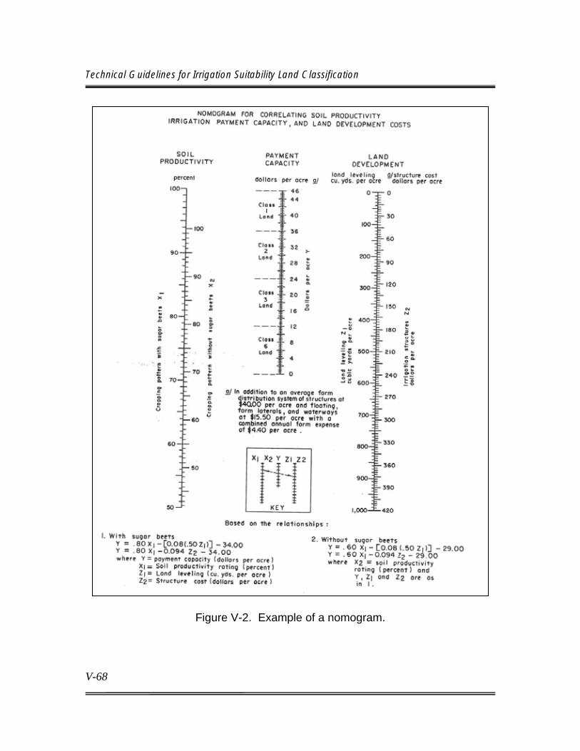
Technical Guidelines for Irrigation Suitability Land Classification
V-68
Figure V-2. Example of a nomogram.

Chapter V Land Classification Techniques
V-69
Next, compute the land development equivalent or the sum of money that would have to be spent per acre for land development to have an annual net effect on farm value of water per acre, equivalent to the effect of each increment of change in soil productivity. Next, develop a nomograph for correlating the incremental effect of soil productivity with the incremental effect of land development upon irrigation payment capacity per acre. Develop technical specifications for land classification by use of the nomographs to establish lower limits for each land class. Classify the land and determine the correct land class, through correlation of its physical and economic characteristics, using the nomographs and specifications. Figure V-2 is an example of a nomograph developed by this procedure. Soil productivity, as used in the nomograph, includes the two factors of productivity and production costs covered earlier in the guidelines. The nomograph is useful as a training tool for inexperienced soil scientists to display correlation of physical land factors and economic factors, for development of specifications, and for assistance in combining two or more land deficiencies into a single land class. However, the nomograph has several disadvantages. Its use can impose a rather mechanical step upon a procedure that is complex and highly dependent on the soil scientist’s judgment, based on observations of land conditions and experience, and supported by adequate laboratory and special studies. Certain portions of the land classification process are based on rather imprecise data such as anticipated crop yields, grading levels based on field observations, projection of laboratory and special investigation data to other areas. The nomogram implies a degree of precision usually not attainable in practice. Additionally, the nomograph does not address interactions between faults which, when occurring together, may produce different effects on net farm income than when occurring individually or in different combinations. A soil scientist must not rely heavily on the nomograph for determining a land class because it may become an automatic step that disregards proper evaluation of pertinent land characteristics, their interactions, and individual land features. The nomograph is less useful when the anticipated irrigation system is not restricted by topographic features. Therefore, nomograph use should be limited and considered only one of several tools used to arrive at an appropriate land class.

Technical Guidelines for Irrigation Suitability Land Classification
V-70
V.C.19 Project Irrigable Area Determinations In defining the project or unit irrigable area, a preliminary irrigable area is established within the arable area. This area should be physically and economically adjusted or refined by including or excluding lands in reasonable blocks until limited by any one of the established project formulation criteria. Lands normally are included until maximum benefits in excess of costs are achieved, the available water supply for irrigation is utilized, or limits established for the specific investigation are met. At this stage, some extra land normally is included to allow for loss of irrigable land during final design of distribution and drainage works. The determination of the irrigable area should start with the arable area as determined by conventional land classification techniques. High or isolated areas, which obviously cannot be served economically, probably were deleted during identification of the arable area. Such deletions expedite the irrigable area determination. Only arable lands having installed facilities, or completed plans to provide necessary facilities to ensure sustained production, should be included in the project area as irrigable lands. Lands requiring additional studies to determine their sustained productivity should be considered nonirrigable (class 5) until necessary studies are completed and the feasibility of ensuring sustained productive capacity of the land is determined. Facilities should be planned or constructed that ensure provision of all the allotted water supply for all lands included in the irrigable area. Whenever the water supply is the limiting factor, the irrigable area also must be limited to ensure an adequate water supply. Where the water supply is limited, lands that maximize net project benefits are chosen for service. These lands are typically the most desirable in terms of quality and location. After the preliminary project area has been selected by project formulation procedures and farm unit boundaries have been established, the final project distribution system layout can be made. Location of project rights-of-way, farm turnouts, and water delivery elevations are determined during the planning of the distribution and drainage system. These are necessary for the determination of irrigable acreage within each farm unit. Close coordination must be maintained between layout planning engineers, land classification personnel, and appropriate water users organizations to ensure service to the best and largest acreage.

Chapter V Land Classification Techniques
V-71
a. Project Irrigable Area The accuracy and abundance of data used in the project formulation procedure probably will vary between planning and preconstruction report studies. Therefore, the accuracy of selecting the project irrigable area will vary accordingly. Generally, involved disciplines include: (1) the soil scientist who provides the location, distribution, and quality of arable land, as well as other land data (such as salinity and sodicity hazards and toxic constituents assessment); (2) the hydrologist who assesses water availability and return flow characteristics; (3) the engineer who provides layouts for delivery systems and estimates their costs; (4) the drainage engineer who assists in defining drainage requirements and drainage costs, (5) the environmentalist who appraises environmental impacts; and (6) the economist who evaluates the plan's economic feasibility.
b. Farm Irrigable Area The irrigable area of individual farm units must be determined for the final official project irrigable area. The farm irrigable area should be selected concurrently or immediately after the design of distribution and drainage systems. This permits some flexibility for adjustments in the project system, which could result in a larger irrigable acreage or a more efficient system. Although similar factors are considered, procedures for estimating the irrigable area for the three types of planning studies will vary (normally individual farm irrigable acreage is not determined in reconnaissance and semi-detailed level studies). Accuracy should be related to overall investigation requirements. For reconnaissance and most semi-detailed investigations, the overall objective is to achieve the desired accuracy on a project-wide basis, and estimates of farm irrigable area based on a percentage of the arable area for similar projects may be sufficient. Once the preliminary project irrigable area is established, the estimation of the farm irrigable acreage can proceed with relatively little additional data. The entire investigation team should participate in the review of the reduction factor. However, this factor should be established primarily through cooperation of the agricultural engineer, economist, and soil scientist. Factors such as rights-of-way, water elevations, turnout locations, etc., usually are not available for these types

Technical Guidelines for Irrigation Suitability Land Classification
V-72
of studies. The reduction factor, therefore, usually is based on experience gained on similar areas developed for irrigation, land characteristics, method of irrigation, anticipated farming practices, and other pertinent factors. It normally is applied to an entire project area; however, in unusual situations, separate factors may be developed for separate units within large projects. The process requires more precise and more numerous data when applied to individual land tracts in postauthorization studies. In addition to the project area, detailed information is necessary on distribution and drainage systems as they relate to the individual farm units. The farm unit is the basic unit used in the irrigable area determination. Each unit must be delineated, or criteria must be provided for delineation. Each ownership usually is considered a unit. The system rights-of-way must be plotted, and the area to be acquired must be measured. Easements are sometimes negotiated, rather than actually acquiring all of the land needed for project purposes. The location of farm turnouts and water surface elevation at each turnout are necessary. Topographic maps with a contour interval related to the land's gradient are essential for the procedure, particularly with surface irrigation (this may be less critical with sprinkler methods). Other criteria, such as the minimum acreage for each turnout, must be established on a project basis. A final official determination of irrigable lands cannot be made until farm unit boundaries are established; farm distribution problems are evaluated; the project laterals, turnouts, and drains are actually constructed; and the project development period is completed. However, "paper layouts" of these facilities usually are used as the basis for the initial irrigable acreage determination prior to construction. Occasionally, some lands considered irrigable in an initial project investigation are found to be nonirrigable; in other instances, service may become feasible for areas previously considered to be nonirrigable. However, if there are no major changes in the "as-built" system from the designed system, only minor adjustments normally are needed in the irrigable area following construction. Changes in the service area between authorization and completion of the project development period usually require adjustments to the irrigable area for irrigable inclusions and exclusions. Factors affecting the irrigable area include changes in the delivery system during construction, irrigation district boundaries, water supply, and land use, which precludes irrigation. Except for the inclusion of very small nonarable areas that may improve field size or shape occasioned by system

Chapter V Land Classification Techniques
V-73
location, inclusions must be composed of arable land. When size and shape of areas are considered, the configuration and location of a tract must permit the operator to farm the area as a field, to irrigate efficiently, and to obtain returns commensurate with the indicated class of land. The size and shape of areas should be considered in light of the type of irrigation contemplated. Exclusions will revert to their original arable class. When determining the irrigable acreage within farm units, it is frequently advisable to prepare an irrigation layout for each farm unit (this may not apply in areas with highly uniform topography or areas that already have a distribution and drainage system). The layout should be based on the irrigation method for which the project distribution system is designed. Farm laterals, drains, structures, and farm pumps, based on the location and elevation of the delivered water and project drain outlets, should be shown. Topographic maps are useful in com-pleting these layouts, and lands identified as isolated because of elevation, topography, or other reasons can either be eliminated from the irrigable area or the land class can be adjusted for additional costs required to provide service to them. In determining the irrigable area within farm units, the following guidelines for exclusions should be observed: (1) Rights-of-Way. Rights-of-way for railroads, highways, other public utilities, or section lines that were established before water was available are excluded. If similar rights-of-way are established after water service is provided, no reduction in the irrigable acreage is allowed unless provision is made by the interested parties for payment of the construction charges on the eliminated area. If a right-of-way is abandoned after water service is provided, the affected area can be restored to the irrigable area by mutual agreement between the owner, Reclamation, and the water users organization. (2) Land Acquisitions. Lands acquired for project canals, laterals, drains, waste ditches, or other project features must be excluded from the irrigable area. Special consideration may be necessary where rights-of-way are acquired through easements. (3) Suburban Lands. Areas already subdivided into home sites, and areas in the process of being subdivided, normally are not included in the irrigable area. If it

Technical Guidelines for Irrigation Suitability Land Classification
V-74
appears part of the irrigable area will be subdivided for such development, provision should be made in the repayment contract for converting the charges from agricultural to municipal and industrial use. This adjustment involves the repayment of a proportionate part of the irrigation. (4) Public Facilities. Public school lots and other public facilities will be excluded from the irrigable area, even though water may be furnished for these lots. Accordingly, when a project contractor or end user is itself the one who continues to use untreated, raw project water that is converted from the irrigation of commercial crops to the irrigation of other vegetation (including, but not limited to, lawns and ornamental shrubbery used in residential and commercial landscaping; gardens; golf courses, parks, and other developed recreational facilities; commercial nurseries; and pasture for animals raised only for personal pleasure and use), then such a conversion is not a "change in the type of use" of project water and is, therefore, not a "transfer of project water" subject to this policy. (5) Farmsteads. Criteria for handling farmsteads usually are established for the arability investigation. Generally, well-established farmsteads are excluded from the irrigable area. Anticipated farmsteads on undeveloped areas are not excluded if their location and size are not established prior to completion of the classification. The information below contains guidelines for determining irrigable area for advanced planning studies for project construction. i. Gravity Service. Criteria must be developed for the allowable elevation of irrigable land relative to the water delivery surface for gravity irrigation. The irrigable land after grading preferably should be at least 0.5 foot below the water delivery surface. If the use of 0.5 foot results in a significant loss of irrigable land, 0.3 foot is acceptable. A gradient of 0.1 foot per 100-foot distance from the turnout to the upper edge of the irrigable area should be allowed. If using a 0.001 slope encroaches upon irrigable land, a slope of 0.0005 may be used. Arable lands with an elevation above the water delivery point may be included as irrigable land if the cost of land grading, necessary to reduce the elevation to permit water service, plus the other development costs are within the permissible limit for arable land. The permissible development cost must be reduced if land grading permanently reduces the soil fertility.

Chapter V Land Classification Techniques
V-75
Arable lands above project delivery elevations or lands isolated because of topographic features or distance from the delivery point also may be included as irrigable land when water is available and the annual cost to the farmer for providing the lands with water (farm pump installation, pipelines, etc.), plus OM&R costs, are within the payment capacity of the land. Downgrading of the land classes usually is required where high costs are necessary to provide service or where a substantial pump lift is required. ii. Sprinkler Service. Criteria must be developed relative to irrigable land to be served by sprinkler or drip irrigation. Elevation and location of arable areas from the delivery point, as well as their size and shape, play an important part in determining the irrigability of sprinkler lands. If water delivered to each farm is not under pressure, adjustment in the land class should be considered for areas elevated sufficiently above the delivery elevation to appreciably affect the farmers' pumping costs. Size of the area to be served by a sprinkler system is critical to the investment cost per acre. The minimum area to be served by a sprinkler system should be established. This normally would be part of the land classification specifications for arability delineations, but dividing areas along ownership boundaries may result in areas smaller than the minimum size. With sprinklers, it is exceedingly difficult to avoid irrigating small nonarable areas occurring within large arable areas. Therefore, these areas normally are combined with the arable area during field classification (this may result in a lower overall land class). The criteria for combinations resulting in arable land units should be defined early in the land classification investigation and documented in the specifications. Economic analysis can identify the percentage of nonarable land that may be allowed under a sprinkler unit for the unit to remain arable or to require changing the classification of the unit to a lower arable class. During land classification investigations for project planning and construction, the procedure for small tracts described above would not normally be accomplished until the end of the development period. However, determinations for including small nonarable tracts as arable where the lands are currently under irrigation can be made during the arable land class investigation This type of situation is most often encountered on operating projects during classification or reclassification investigations, when landowners desire to switch

Technical Guidelines for Irrigation Suitability Land Classification
V-76
from a gravity method of irrigation to sprinkler. See sections III.A. through III.A.3, in chapter III, for the development of land classification specifications. Procedures. The cost of serving arable areas within a farm unit should be estimated in the farm irrigability determination process. The cost is added to the affected area's farm development cost, and the irrigable land class is adjusted as necessary. If the cost of serving these isolated lands (plus related development costs) exceeds the maximum for arable land, the lands should be placed in a nonirrigable land class. A minimum irrigable acreage to be served by a turnout should be established for each project. In determining this minimum acreage, anticipated land use, cultural practices, land use of the surrounding dryland area, and total amount of irrigable land held by the owner should be considered. For assessment purposes, the irrigable area within each farm unit should be determined after farm unit boundaries, the water delivery point and elevation, and the farm distribution system have been established for each farm. Farm unit boundaries and irrigation delivery requirements are based on ownership boundaries. A cutoff date should be established, after which changes in ownership will not require a change in the number and location of farm turnouts. Each ownership may not constitute an efficient farm unit, but under actual operating conditions, several small units may be combined under one operator or rain-fed agriculture on dry lands may supplement the income from the smaller irrigable units. The irrigable area is not final until the end of the development period. Revisions in the irrigable area may result from changes in the system design, land ownership, or land development prior to the end of the development period. These changes are usually minor, and additions and deletions frequently balance out over a total project area. Official action is necessary to change the irrigable acreage if significant revisions are necessary after construction or early in the development period. The irrigable area, as determined during the feasibility or preconstruction planning studies, should be reviewed at the end of the development period. Necessary adjustments should be made in the irrigable area because of changes in land ownership, land development, or "as-built" changes in the system. Most
Chapter V Land Classification Techniques
V-77
necessary changes can be made during a field review process with the aid of specifications for the lateral and drainage system and recent land ownership maps. The field review should check for the following:
(1) Alignment of distribution system (2) Location of turnouts and delivery water surface (3) Feasibility of serving all irrigable areas within the farm units (4) Additional arable lands that can be served with farm pumps, siphons, or by other structures (5) Changes in the irrigable area as a result of land development (6) Changes in the irrigable area necessary as a result of changes in the project rights-of-way (7) Changes in ownership, which alter the location and/or number of turnouts necessary.
The final step in the determination of the irrigable area is preparation of irrigable area sheets. For reconnaissance and semi-detailed studies, separate irrigable area sheets are probably not necessary. Arable area sheets with the nonirrigable area marked out and acreage tabulations adjusted to the irrigable acreage usually are adequate. Similar sheets may be prepared for a detailed investigation prior to construction, but it is usually necessary to have irrigable area sheets (with a tabulation of the irrigable land classes by 40-acre tracts) available prior to water delivery. These sheets should be prepared concurrently with (or immediately after) construction, since they provide the basis for assessments by the water users organization and OM&R charges. The irrigable area should be shown on sectional maps (usually having the same scale as the land classification maps) and should contain the following information:
(1) Section, township, and range or other appropriate legal description (2) Right-of-way lines for public roads, railroads, canals, laterals, drains, and other utilities

Technical Guidelines for Irrigation Suitability Land Classification
V-78
(3) Points of water delivery and elevation (4) 40-acre subdivisions (5) Boundaries of irrigable land classes and acreage of each delineation within the 40-acre subdivision (6) Boundary of water users organization (7) A table showing the acreage for each irrigable land class, classes 6 and 6W, and rights-of-way for each 40-acre subdivision, quarter section, and section.
Features such as fences, farm roads, etc., that may change frequently need not be included on the area sheet. Figure VI-2 in Chapter VI, shows a typical irrigable area sheet for the postconstruction period. Preparation of the irrigable area sheets should be funded with construction monies. These sheets should be available at the time water is made available to the irrigable lands. The irrigable land class boundaries usually can be traced from the arable area sheets or worksheets used in determining the irrigable area. If the arable areas were divided and measured to the needed accuracy (by 40-acre subdivision), the arable acreage can be transferred to the initial (preconstruction) land area sheets. On new lands where land development is completed, the irrigable area boundaries can be adjusted when the irrigable area is being field-checked following construction. However, many of these changes occur during the development period following construction, and adjustments are made for these changes shortly before the end of the development period. Except for large changes, adjustments in the irrigable area should not be made before most of the lands are developed, since greater efficiency can be achieved by making most changes at once. The final adjustment in the irrigable area can best be performed with very recent aerial photographs showing the developed field boundaries. When such photographs are available, a survey to determine the field boundaries usually is not necessary.
Chapter V Land Classification Techniques
V-79
V.D. SUPPLEMENTAL PROCEDURES The judgment and experience of the soil scientist in appraising the agronomic and economic significance of the observable physical features are the most crucial factors determining the validity and accuracy of the land classification. Data compiled from experience on comparable irrigated lands and the mapping specifications are the primary components for the exercise of judgment. Special field or laboratory procedures involving or simulating irrigation practices on the land under investigation provide important additional factual data for establishing specifications, planning the investigation, and making classification decisions. Special studies may provide data and assist in evaluations in three general areas: (1) recording and interpretation of unique land conditions; (2) selection, description, sampling, and detailed laboratory analyses of representative soils; and (3) specific problems that cannot be resolved with routine procedures and field observations and that may require special procedures for resolution. Specific problems may include permeability, availability of water, infiltration, prediction of exchangeable sodium and salinity levels in the soil with irrigation, and estimating irrigation development costs and field layouts. Other investigation team members may require land data, which can be obtained only through special studies. Such studies may be required for investigation of return flows, subsurface drainage, land use, land use suitability for other than irrigation, irrigation management services, etc. Data from field procedures, which are designed to duplicate natural processes, are preferable to laboratory tests designed to measure similar properties. Most field test procedures used by Reclamation are designed to provide information leading to appraisals of productivity and land development; however, the data are also useful in determining water requirements, drainage design, developing soil and water management programs, etc. Special studies should be scheduled concurrently with other field studies so that data are available to field crews before they complete classification of an area. This is not always possible because of limitations in personnel and funds, unseasonal weather, other priorities, magnitude of the problems, etc. Some data on a particular situation must be available before a reasonable investigation plan can be formulated. Except during reconnaissance level studies, there are usually

Technical Guidelines for Irrigation Suitability Land Classification
V-80
adequate data available to organize a special investigation program; however, selection of specific sites may depend on field mapping. If data are inadequate for organizing an investigation program and are needed before mapping can proceed, it may be necessary to conduct tests at sites selected randomly or with little firm information. If this occurs, a supplemental investigation program usually is necessary to fill in gaps in the original program. The scheduling, type, procedures followed, and number of special studies should be closely coordinated with routine field and laboratory studies. Separate crews may be used to conduct the studies, but personnel conducting routine activities should participate in problem identification, selection of test sites and procedures, and projection of results to other land areas. A procedure that provides an accurate answer, is relatively easy to conduct, and can be repeated at numerous sites is preferred to one that gives a precise answer but is expensive or time consuming to perform. Selection of test sites is of primary importance. They must be representative of the problem to be studied, and there must be means (such as visual features or routine laboratory tests) by which they can be correlated to similar untested areas. The exact location of test sites may be determined by probing and observing surface signs. Suitable sites usually can be selected after gaining some experience from mapping in the area. Reasonable projection of data beyond the test site depends largely on the adequacy of test site selection. For purposes of correlating the results, routine laboratory analyses should be completed that most nearly portray the natural process. Although there are many helpful test procedures for resolving land classification problems, none can duplicate exactly the natural process under investigation (it is common for the process to vary within a similar appearing area). Therefore, investigation results should be recognized as approximations or representative of a range of values. Standard procedures have been established for most special investigation efforts. The factors most frequently requiring special evaluation include representative profiles, infiltration rate, hydraulic conductivity, available water, reclamation of saline and sodic soils, and detailed farm layouts. A general discussion of procedures for each factor follows. Instructions on specific procedures may be found in Methods of Soil Analysis, volume 2 (American Society of Agronomy et al., 1986) and the Drainage Manual (Reclamation, 1993).

Chapter V Land Classification Techniques
V-81
V.D.1. Representative Soils The investigation and identification of each soil or land type having significant differences in relation to irrigation suitability are required for a semi-detailed or detailed land classification investigation. These data are useful in characterizing soils of the project, assist in correlation of land classification results with soil surveys and other types of soil studies, and are representative of present soil quality. Following procedures used by the National Cooperative Soil Survey soil profile from each major soil type (arable or nonarable) should be described. For large areas, more than one profile from each type may be desirable. A minimum of 10-foot depth should be analyzed. The profile can be described best if a pit is dub by hand or by a backhoe. If a pit is not practical below 5 feet, an auger may be used. Cooperation by the NRCS and State universities in taxonomic placement of the soil profile may be requested. The topography, drainage conditions, vegetation, and other pertinent information about the surrounding area should be included with the profile description. In addition to the profile description, significant horizons can be sampled and analyzed. Representative sites should be correlated with other special studies where possible.
V.D.2. Infiltration Rate Infiltration, the downward entry of water into the soil, may have an important bearing on the irrigation method, irrigation practices, irrigation system design, water requirements, productivity, erodibility, and drainage needs under irrigation. For more detailed information on infiltration and permeability, see Reclamation’s Drainage Manual (Reclamation, 1993). Its significance in a particular situation depends on the irrigation method. It may be very significant with surface irrigation but relatively unimportant with sprinkler and drip methods. Infiltration rate is the rate at which water enters a soil (in a given condition and at a given time). In addition to the influence of the topsoil, the rate may vary with time. A soil containing swelling-type clays, which form cracks upon drying, produces a high initial rate that diminishes as the soil becomes saturated and swells. If a less permeable layer occurs immediately below the topsoil, it may be the controlling factor after the initial flow.

Technical Guidelines for Irrigation Suitability Land Classification
V-82
There are three methods generally used to determine the infiltration rate: (1) the basin method, (2) the furrow method, and (3) the cylinder method. The choice of method depends upon the nature of the area, type of investigation, and personnel and fund limitations. Because of the possible influence of land use, cultivation methods, alterations to the soil structure, compaction from field equipment, etc., more variation is expected in the results of infiltration tests than the results from tests of deeper layers, which normally are not manipulated. Because of this, a simple method that can be repeated frequently is preferred over a more complicated procedure that is more difficult to repeat. The rate should be expressed in inches per hour, and frequent measurements should be made initially so that the rate of decrease with time and equilibrium rate can be plotted. Additional information may be obtained by excavating the site to determine the wetted pattern. The stabilized infiltration rate frequently reflects less permeable horizons lower in the profile. The surface soil within the area being tested should not be disturbed or puddled. If possible, the anticipated irrigation water (or a close facsimile) should be used.
a. Basin Method The basin method for determining the infiltration rate is adapted to relatively level land and may be easily coordinated with tests for leaching, reclamation, and available moisture studies. The objective of the method is to measure the subsidence rate of ponded water. Plots should be replicated. Control of evaporation is not practical, but corrections for evaporation will be desirable under conditions where evaporation rates are high. Basin method advantages include a more realistic infiltration rate obtained by flooding a larger area and more accurate results for conjunctive leaching and available water studies. Disadvantages include relatively high cost and time consumption, difficulty in repeating frequently, lack of control over water movement, and potential error caused by excessive evaporation.
b. Furrow Method The furrow method for determining infiltration is designed for use on nearly level to sloping land and for joint studies involving length of run, irrigation efficiencies, and water requirements. The purpose of the method is to measure the water input

Chapter V Land Classification Techniques
V-83
and output for a system of furrows and obtain infiltration by difference. The furrows should be replicated at least three times, with the spacing anticipated for future irrigation. The furrow method, when properly performed, provides a good measure of the soil's infiltration rate and most nearly duplicates normal irrigation practices with surface irrigation. It has the disadvantage of being difficult and expensive to conduct.
c. Cylinder Method The cylinder method for determining infiltration can be adapted to many land conditions. It is a more rapid, economical, and versatile method than the other procedures. It is subject to more variables, however, and the data may be more difficult to interpret. The purpose of the method is the measurement of the rate of subsidence of water ponded over the soil and contained by a cylinder imbedded in the soil. In addition to estimating the infiltration rate, measurements can be made of available water, leaching, and an approximation of the hydraulic conductivity if the tests are designed adequately. There are many variations in the design of the test, such as whether one or two cylinders are used, whether or not the initial or "dry" run is followed by a "wet" run, and whether a constant or variable head is used. The infiltration velocity measured by a ring infiltrometer depends on the hydraulic conductivity of the saturated soil in the ring, the unsaturated conductivity of the soil between the wetting front and base of the ring, and the pressure head. Knowledge of procedures used is important when interpreting the results into reasonable estimates of comparative performance of areas under irrigation. The use of two cylinders is preferred to reduce the lateral movement of water. The outside cylinder minimizes lateral movement of water from the inner measured cylinder. The "dry" run (if it is concluded on a stable rate) most nearly duplicates an actual irrigation application. Usually the stable rate is determined by the hydraulic conductivity of the least permeable layer, either the surface or a buried horizon. The use of a constant or variable head depends on factors such as available equipment, water supply, available labor, etc. A constant head is desirable, but not absolutely essential, since other factors that cannot be measured precisely (such as lateral movement of the water and soil variations) affect results at least as much as the difference between a constant or variable head. The chief

Technical Guidelines for Irrigation Suitability Land Classification
V-84
advantage of the cylinder method is its simplicity and relatively low cost, which permits the investigation of more sites representing similar soils or soil variations. Because the method measures a smaller area, results may be less accurate than the other two methods. However, this disadvantage is more than offset by the possibility of conducting more tests. Also, its accuracy is well within the necessary range needed for estimating irrigation suitability of a soil.
d. Interpreting Results Infiltration has direct economic implications in irrigation. It determines the amount of water that can enter the soil in a given period and, thus, the time required to bring the soil up to field capacity. Infiltration rates may be undesirably high or low. The extreme rates affect design of irrigation and drainage systems, labor requirements, and water requirements. Criteria for infiltration rates that are permissible for arable land classes may need to be established with respect to climate, crop, quality of water, and method of irrigation. With surface irrigation, the length of run is tied closely to infiltration rates. Present factors and possible future practices that may be applied to modify the soil must be considered in evaluating rates obtained from field tests. Infiltration rates less than 0.1 inch per hour almost always require special irrigation practices (in some cases 0.5 inch per hour may be a minimum), such as frequent light irrigations, use of sprinkler or drip systems, extensive surface drainage systems, conservation practices to control runoff and erosion, or land use limited to paddy rice, permanent cover, and shallow rooted crops. Infiltration rates that exceed 6 to 12 inches per hour are associated with excessive onfarm seepage and conveyance losses, and rapid buildup in groundwater levels unless sprinkler or drip irrigation methods are used. Infiltration and available water usually are interconnected and negatively correlated. Infiltration test data may be used to estimate the appropriate irrigation practices and type of irrigation, noncorrectable deficiencies on crop adaptability and crop yields, effect on farm water delivery requirements, and annual production and irrigation development costs. Correlations of infiltration test results with other soil properties more adaptable to routine observations or measurements (such as soil texture and bulk density) may be established to permit some projection of test results over a broad area.
Chapter V Land Classification Techniques
V-85
V.D.3. Available Water The amount of water retained by a soil after irrigation, and the portion of that water that may be readily available for use by crops, determine irrigation practices and necessary farm water requirements. For additional information on available water, many publications, such as the Drainage Manual (Reclamation, 1993) are available. Field measurements of moisture retention are conducted to obtain estimates of the soil's available water and correlations with other soil properties. The purpose of any testing method is to determine the range between field capacity (the percentage of water remaining in a soil 24 to 48 hours after having been wetted and after free drainage is negligible) and the permanent wilting percentage. The permanent wilting percentage is defined as the water content of a soil when indicator plants growing in that soil wilt and fail to recover when placed in a humid chamber. It is often approximated by the 15-bar moisture percentage. This is accomplished by direct sampling at definite intervals following saturation and drainage of the profile and the determination of soil moisture at 15-bar tension. The field test should simulate, insofar as possible, conditions and practices anticipated under irrigation. Available water in a soil can be estimated most accurately by a combination of field and laboratory procedures. Because substantial variations in the permeability between soil horizons in a profile can affect the total soil water, field capacity is best determined by field procedures. The site selected should be free from a water table to a level well below the depth to be tested. The profile should be saturated well below the test zone and allowed to drain. The time for adequate drainage varies for each site, depending on the soil's permeability; however, sampling usually can be performed between 24 and 72 hours following draining. The sampling time when the soil water approximates field capacity can be estimated based on experience and knowledge of the soil or by frequent sampling to determine the approximate time water movement stabilizes. This also requires considerable judgment, as there is no precise point at which soil water can be defined as the field capacity. Soil samples obtained following saturation and drainage should be weighed immediately to determine the percent of moisture, or sealed to prevent water loss and weighed later in the laboratory. After weighing, the percent of soil water at

Technical Guidelines for Irrigation Suitability Land Classification
V-86
15-bars tension, determined by laboratory methods, will establish the lower level of available water. The formula requires the soil bulk density, which usually can be estimated by relating it to soil textures. Allowance must be made for gravel or cobble in the sample. In saline soils or when using water containing large quantities of soluble salts, the osmotic effect of the soil solution must be considered. Available water should be estimated for each significant horizon in total inches. If available moisture is a critical factor, the values obtained by special studies should be correlated with other soil properties more readily observed or measured (such as soil texture) to extend the findings to other areas. The total available water in the 48-inch depth is adequate for general use. However, many crops obtain nearly all their water from the upper part of the soil profile. Therefore, irrigation practice and design of the irrigation system may depend mainly upon the available water in the upper rooting zone, rather than in the normal 48-inch depth. The objective of irrigation is to replenish soil moisture to field capacity with sufficient frequency to maintain a readily available moisture level. If the proposed system cannot meet this requirement under the type of farming anticipated, practical alternatives must be found or the lands must be excluded from the arable area. The test data can be used to estimate the irrigation frequency in evaluating the ability of a system to meet irrigation needs. This requires an estimate of the available moisture in the root zone of the proposed crop and the average daily peak evapotranspiration rate. In actual practice, soil moisture depletion is not uniform throughout the profile; generally, the upper layers will approach wilting conditions more rapidly. Under such conditions, irrigation frequency is determined by the depletion rate of surface horizons, time of irrigation, amount of depletion, and irrigation efficiency. In some situations, the soil layer that approaches the wilting point first is not the top of the root zone. In layered soils, the second and third quarters of the root zone often control irrigation. The minimum acceptable level for available soil water depends on the irrigation system used, the rate of water application, and the frequency of area coverage. With systems providing a constant or nearly constant water supply (such as drip systems), the minimum available water may be very low; however, with gravity
Chapter V Land Classification Techniques
V-87
irrigation methods, generally anything less than 3.0 inches in the upper 4 feet is unacceptable. For permanent orchard crops (e.g., citrus and grapes) under drip irrigation, the available water may be as low as 2.0 inches. The available water requirement should be determined for each project, considering irrigation methods and cropping patterns to be employed.
V.D.4. Soil Permeability Soil permeability, the ease with which gases, liquids, or plant roots penetrate or pass through a bulk mass of soil or a layer of soil, is evaluated best by field measurements of rate of water movement through the soil profile and substrata. By interpreting rates of movement and boundary conditions, estimates of permeability (as measured in terms of hydraulic conductivity) can be obtained. The following three questions are paramount in irrigation, with respect to rates of water movement through the soils and substrata:
(1) Will vertical rates of water movement be adequate to drain excess water and soluble salts from the root zone before damage to crops can occur (2) Are there strata of such low hydraulic conductivity (or abrupt changes in hydraulic conductivity) within the soil profile and substrata which will lead to perched water tables or rise of ground-water levels into the root zone during the irrigation season (3) Where high ground water exists or can develop, is the hydraulic conductivity adequate to permit practical measures for lowering the ground-water level? These factors are related closely and their evaluation crosses boundaries of responsibility between the soil scientist and drainage engineer. Therefore, any special studies related to soil and substrata hydraulic conductivity must be coordinated closely between land classification and drainage investigations.
The soil scientist's primary responsibility concerns permeability in the root zone and vertical water movement. Permeability of the soil profile is important in selecting the method of irrigation, water requirements, subsurface drainage

Technical Guidelines for Irrigation Suitability Land Classification
V-88
requirements, farm drainage systems, suitability of the water supply, land development practices, and many management decisions. Hydraulic conductivity rates should normally exceed 0.1 inch per hour in any significant layer of the root zone for sustained profitable production under irrigation. Soils of lesser rates generally take water too slowly and may have limited crop adaptability unless special management practices are initiated and are practical. Although excessive and minimal rates are equally important, the emphasis of field studies usually is on the minimal rates, since excessive hydraulic conductivity rates can be related to soil texture and other easily observed features. Excessive rates are less likely to be the controlling factor in determining arability, but they can be important in making management decisions. As with most special studies, a balance must be maintained between the need for accuracy and the number of tests which can be completed under a specific investigation. Except under unusual circumstances, or where more precise data are needed by others, tests that give estimates within reasonable ranges, are inexpensive, and are easy to perform are preferred over expensive and time-consuming procedures that may give a more precise answer.
a. Field Methods There are five commonly accepted methods for testing hydraulic conductivity of the soil and substrata: (1) auger-hole method, (2) piezometer test, (3) shallow well pump-in test, (4) ring permeameter test, and (5) test pit method. A description and other discussions on each method are presented in Reclamation's Drainage Manual. Accuracy requirements, schedules to be met, and availability of soil scientists should be considered in selecting the suitable procedure. The auger-hole test measures the average horizontal hydraulic conductivity of the material from the static water table to the bottom of the hole, whereas the piezometer test measures individual soil layers below a water table. The shallow well pump-in tests provide a rate for the depth of the hole being tested above a water table. The ring permeameter test is a method of obtaining vertical hydraulic conductivity of a critical zone. The test pit method is less accurate than the others and is occasionally used for determining the hydraulic conductivity of very coarse-textured soils above a water table. These methods were developed

Chapter V Land Classification Techniques
V-89
primarily for drainage investigations and, except for the ring permeameter test, measure primarily lateral water movement rather than vertical water movement in the soil. However, with proper test data evaluation and correlation with other observations, these tests can be valuable in providing estimates adequate for land classification purposes.
b. Preferred Method Of the five tests listed, the ring permeameter test is the most useful in land classification investigations pertaining to problems of impermeable or restrictive layers in the root zones. The rings may be driven into the surface soil, similar to the procedure for an infiltration test, or they may be placed in a critical horizon that has been exposed by excavation of the upper layers. Tensiometers and piezometers are used to confirm existence of saturated conditions, absence of a perched water table, and movement of water into the test zone. When the rings are placed on the surface and the test is allowed to reach a stable rate, a fair representation is made of how the soil will react to irrigation. The stabilized rate generally represents the hydraulic conductivity of the least permeable layer in the test zone. When, through observation, a specific horizon appears to have a slow permeability, which could interfere with percolation and cause a temporary perched water table in the root zone, it may be desirable to test that layer. This can be achieved by excavating down to the layer in question and placing the cylinder directly on or into that layer. When a layer below the test zone is less permeable than the one containing the cylinders, the steady-state flow probably represents the permeability of this layer rather than the test layer. However, this may be an advantage, since the initial rate and subsequent changes may be indicative of the changes in the percolation rates of water downward in the soil profile under actual irrigation conditions.
V.D.5. Land Reclamation Soils in the arid and semi-arid regions generally contain soluble salts in varying concentrations. The amounts may exceed the limits that crops can tolerate and, thus, restrict crop yields and crop quality. Irrigation water also carries dissolved

Technical Guidelines for Irrigation Suitability Land Classification
V-90
solids, which may accumulate in the soils as a result of evapotranspiration or poor drainage conditions. Therefore, leaching is essential in almost all irrigation situations. In some areas, irrigation water quality, natural land drainage, anticipated irrigation practices, and effective precipitation are such as to maintain salt balance without special practices. There are many areas, however, where the soils contain excessive concentrations of soluble salts or are highly alkaline prior to irrigation and require special leaching, often referred to as reclamation leaching. Salt concentrations may have developed (or may develop) from seepage, inadequate drainage, or use of saline or sodic irrigation water. In many cases, it is physically possible to accomplish reclamation leaching, but costs may exceed benefits. Therefore, the land and water of each project must be evaluated with respect to reclamation requirements, salt balance, and the effect on return flow quality. There is little need for special studies to determine reclamation needs in areas where soils are relatively permeable, present drainage is adequate (or there are plans to provide for adequate drainage), and water quality is good. Under these conditions, normal irrigation practices generally reclaim the soil in a few years with little or no additional expense for leaching. When it is not clear (through analyses of the data and field observations) if reclamation is possible and feasible, the response of soils to leaching and the quality of water needed for reclamation should be determined by field tests or laboratory leaching trials with water of a quality similar to the anticipated irrigation water supply. Laboratory procedures probably are adequate when the soil permeability and drainage have been appraised as adequate. Leaching results can be obtained in conjunction with hydraulic conductivity, infiltration, and available water field tests. There are three types of land reclamation studies: (1) leaching of soluble salts, (2) displacement of exchangeable sodium, and (3) profile modification. There are several references on land reclamation, including “The Use of Saline Water for Crop Production” (Rhoades, et al., 1992) and “Agricultural Salinity Assessment and Management” (Tanji, 1990). Computer models are also available for estimating potential salinity. The ESAP model developed by USDA-Agricultural Research Service is a statistical software package for estimating field-scale spatial salinity patterns from electromagnetic signal data, and SALT is a model which analyzes crop salt tolerance response data.

Chapter V Land Classification Techniques
V-91
The cost for land reclamation is normally incurred by the land owner or operator and is, therefore, considered to be an irrigation development cost and a factor in land classification.
a. Saline Soils Leaching of a saline soil requires an adequate soil permeability to permit movement of water through the root zone and adequate drainage to prevent buildup of a water table in the root zone. In reality, leaching studies are hydraulic conductivity tests that are extended to permit leaching of salts below the anticipated root zone and to permit observation of any appreciable changes in the soil permeability resulting from displacement of the soil water with the leaching water. The procedure should simulate the anticipated method of irrigation. Greater efficiency in water use can sometimes be achieved by alternate wetting and drying periods, possible with sprinkler irrigation, as compared to continuous flooding by surface methods.
b. Sodic Soils The objective of reclamation studies on sodic soils is to determine the feasibility of replacing the exchangeable sodium and to improve the soil permeability to a level suitable for sustained irrigation. This procedure usually requires use of additives, such as gypsum, to provide a source of calcium ions to replace the sodium ions. Additives may not be necessary if the leaching water contains sufficient calcium ions or the soil contains adequate free gypsum as a source of calcium ions. As with leaching a saline soil, adequate drainage is a prerequisite to reclamation; however, initially the soil permeability need only be adequate to permit the saturation of the soil as a source of calcium ions for displacing sodium ions. A well designed and executed test depends on the extent of the improvement in soil permeability, the amount of additives required, and the depth of water applied. Methods for determining the required amount of gypsum as an amendment for reclamation of sodic soils are discussed in “Agricultural Salinity Assessment and Management” (Tanji, 1990) and “Water Quality for Agriculture” (Ayers and Westcot, 1985).

Technical Guidelines for Irrigation Suitability Land Classification
V-92
To provide an indication of the movement of salts, sampling and analyses of soil are necessary initially, at intervals during the test, and at the conclusion. Relatively complete results are needed initially and at the conclusion of the test to identify the ratio of ions in the solution and on the exchange complex.
c. Profile Modification Deep plowing may provide a means of reclaiming lands. Other than through relatively inexact laboratory procedures where a profile is reconstructed and leached, there is no quick inexpensive field method of estimating the results of deep plowing. If irrigation water is available, the investigation area is relatively large, and the development schedule permits, representative fields could be deep plowed and leached by normal irrigation methods. This would take several years and considerable soil analyses to chart the movement of the soluble salts. Because of the small area deep plowed for test purposes, costs would not be representative for plowing under normal conditions.
d. Farm Layouts Topographic features must often be appraised without the use of topographic maps or other aids. The relative importance of topography varies greatly with the anticipated irrigation method. With the exception of very steep gradients, the main requirement for sprinkler and drip systems is terrain that permits the required cultural practices and movement of the system. Topography places greater restrictions on surface irrigation systems with respect to field size, irrigation development costs, and slopes. Therefore, detailed farm layout studies for the various types of topography common to the area under investigation help the soil scientist in evaluating topography and estimating approximate development costs for surface irrigation. The only useful purpose of layout studies of sprinkler or drip systems is to aid in estimating system costs. Layouts may be prepared by experienced agricultural engineers, but soil scientists should provide guidance on limitations that may be imposed by area soils. Detailed layouts should provide a fairly accurate estimate of field boundary locations; cost and volume of earth moved for land grading; the gradient, volume, and cost of clearing rocks and vegetation; location and cost of farm structures; cost and volume of earth moved for farm laterals and drains; and other factors that
Chapter V Land Classification Techniques
V-93
may be unique to the investigation area. The size, number, and location of layouts depend on the nature of the topography, type of investigation, and present ownership patterns. Because reconnaissance and some semi-detailed studies are based primarily on separation of arable and nonarable lands, they require less detail, and they emphasize project-wide land conditions rather than conditions on a particular ownership, detailed layouts are usually not required. The number of layouts made depends on the complexity of the topography, experience of the soil scientists, investigation schedule, and funding. The investigation area size and shape should be representative of the anticipated farms on the project. It need not be as large as the anticipated farms, but it should represent an area large enough so that optimum size fields for the area can be developed and the economy in grading larger areas is achieved. Farm layouts should be located on sites that have topography representative of the project. The emphasis, however, should be placed on complex situations that are difficult to evaluate. A specific site may encompass more than one land type. Because no two areas are exactly alike, results of a detailed farm layout should not be projected to other areas with similar features. They should be used by soil scientists to improve their ability to evaluate specific factors that contribute to development costs, productivity, and production costs. Field layouts may be useful in estimating field boundaries by identifying ridges and lows, average cut and fill by land grading required within each field for adequate water distribution, relationship of farm structures to field size, cost of drainage surface depressions, surface rocks relative to clearing volume and cost, number and size of trees relative to clearing costs, etc.
e. Laboratory Studies Although field studies usually are more representative of natural processes and are most often used to characterize a soil, there are many cases where special laboratory studies may provide an adequate answer at a more reasonable cost. The primary value of laboratory studies is that they provide an explanation of phenomena that have been observed through routine or special field studies. Laboratory studies for estimating in-place soil permeability and infiltration usually do not provide answers that can be used directly. Obtaining a suitable undisturbed core for measurement of hydraulic conductivity in the laboratory is difficult and may be very expensive. Rates from tests on disturbed samples

Technical Guidelines for Irrigation Suitability Land Classification
V-94
usually do not relate to the true condition of the soil in the field (except for very coarse-textured material, which may have about the same hydraulic conductivity in both the disturbed and undisturbed states). The tests do, however, indicate qualities that are useful in estimating field conditions. Because of the effect of layering on available water (which cannot be duplicated in the laboratory) and the inability to determine precisely the relationship between tension and field capacity, laboratory procedures usually are not adequate for measuring available water. Laboratory procedures are useful for identifying soil characteristics that influence or determine in-field processes. These may include: (1) cation-exchange-capacity, (2) exchangeable sodium, (3) clay mineral type, (4) soluble cations and anions, (5) sodium adsorption ratio, (6) particle size distribution, (7) bulk density, (8) specific surface, (9) surface charge density, (10) organic matter, and (11) pore size distribution and specific yield. Supplemental laboratory studies should be selected based on their value in solving a specific problem, cost, and time required to perform them. It is more economical, and just as useful, to measure secondary reactions rather than directly measure many factors. The identification and measurement of a particular characteristic often is not as important as measurement of the influence that characteristic may exert on soil processes that affect land suitability. General relationships and correlations have been developed for estimating soil characteristics. Hydraulic conductivity of fragmented sample and settling volume may be used to identify exchangeable sodium and structural stability status of a soil. With some soils, the saturation percentage and percent moisture at 15-bars tension provide an indication of the exchange capacity of a soil. The specific surface of clay minerals provides some clues to the predominant clay type. The regional laboratory staff should be well informed on relationships applicable to the area. The laboratory staff normally takes a leading part in selecting applicable laboratory procedures. These studies should be well coordinated with the conduct of the related field studies and designed to answer pertinent questions. A good reference for soil analysis is the Soil Survey Laboratory Information Manual (USDA, 1995). Also, see Methods of Soil Analysis (American Society of Agronomy et al., 1982).
V.E. DATA CORRELATION The final land classification is not achieved until field observations are correlated with routine laboratory data, as well as results of special studies. In some
Chapter V Land Classification Techniques
V-95
situations, special investigation results and some laboratory data may be available before field operations are completed; however, normally the data are not available until the field party has completed its field traverses. Initial correlation consists of determining applicable routine laboratory procedures, frequency of sampling, handling of samples, reporting procedures, and methods to correlate special laboratory and field studies. The basic purpose of laboratory data is to support and confirm the field classification. In addition, there may be situations, such as saline soils, where laboratory data may be the primary means of problem identification. Laboratory data are also useful for correlation of soil properties with visual signs. As laboratory results become available, they should be checked against the preliminary classification. With experienced field soil scientists, there usually are few minor conflicts between field and laboratory data. If there is agreement, the classification can be considered final and ready for review. If there is a conflict or a significant difference between field and laboratory data, the soil scientist must review his field notes for a possible explanation. Correlation of the two sets of data may require a return to the field. In the "second look" field review, an attempt should be made to resolve the differences by observing field conditions that may correlate with laboratory data and which may have been overlooked in the first traverse. If the difference remains unresolved, and the soil scientist wishes to rely on his field observations rather than other data, an explanation must be provided in the profile notes. Projection of data from special studies may differ from results of routine laboratory analyses. Special studies require caution when interpreted, and when results are projected to similar areas, because they are conducted at representative sites and not on all problem areas and they are limited in number, compared to routine laboratory data. Consequently, close correlation of field observations and laboratory data of similar features at the investigation sites and in the area under investigation is necessary. Problem areas should have been identified in field notes and related to specific investigation sites. If special investigation results differ from the preliminary field classification, it is necessary to review the field notes and make another trip to the field. There may not be a special investigation site that nearly duplicates all areas in question. Therefore, considerable judgment must be used, and data must be evaluated to fit specific investigation site results

Technical Guidelines for Irrigation Suitability Land Classification
V-96
to problem areas. In complex situations, data from several different special investigation sites may be applicable to corresponding factors of a given single problem area.
V.F. FIELD REVIEW Specifications and procedures should be interpreted and applied uniformly to ensure consistency and accuracy of results. To accomplish this, the full cooperation and interest of the participating personnel at all levels is necessary. Technical guidance extends from the TSC through the regional land classification specialists to any intermediate supervisory specialists or the soil scientist in charge of the action group. See the Reclamation Manual, Policy, WT P06 and Directives and Standards, WTR 06-01. The regional soil scientist or their assistant should hold conferences with each of the intermediate supervisors or the specialists in charge of action groups before field investigations are initiated and during the field operations. Consideration should be given to: (1) discussion of the progress made and problems encountered, (2) matching of adjoining field sheets completed by different soil scientists, (3) adequacy of field and laboratory data and their interpretation, and (4) field review of selected field sheets with field soil scientist participation. These conferences should be arranged to permit maximum participation of the field parties. With adequate technical guidance provided by the regional office, the supervisor/soil scientist in the field must assume the responsibility for the accuracy and progress of the land classification investigation. This involves frequent field consultations and review of results. Field reviews by the supervisor are important to: (1) maintain an adequate level of accuracy; (2) establish uniformity between field crews in their interpretation and application of guidelines and procedures; (3) develop new techniques; (4) institute new studies, if needed; and (5) acquaint the supervisor with the lands under investigation. The frequency of reviews or field consultations varies with the type of classification, experience and ability of the soil scientist, number of field parties, and land characteristics. Field reviews by the supervisor for less detailed studies usually are limited to specific problem areas, or interesting or unique areas selected by the field parties. To be effective, this procedure will require good communication between the supervisor and field parties. An office review is suggested upon completion of a field appraisal investigation to ensure:

Chapter V Land Classification Techniques
V-97
(1) complete coverage of the area investigated; (2) adequacy of map symbols, delineations, and profile notes; and (3) the classification meets the investigation objectives. As the intensity of an investigation increases, it may be necessary to increase the frequency of reviews to ensure accuracy and uniformity. Because results may be used for assessments and construction charges, more frequent reviews are needed in detailed postauthorization studies. As the number of crews increase, the need for reviews to maintain uniformity may increase. The need for closer supervision usually increases with the complexity of land characteristics, and the number and severity of problems encountered. It is usually desirable to schedule a review of each field party's work to establish proper techniques and interpretations early in an investigation. However, a review should be delayed until routine laboratory data are available for the area to be reviewed. If the investigation extends over a long period, subsequent reviews can be scheduled as needed. Intensity and coverage of a review vary with each classifier, the type of investigation, and complexity of an area. The immediate supervisor’s review should take place before reviews by personnel from the region or the TSC. Reviews with other agencies are sometimes desirable when the land classification is performed under a cooperative agreement. The initial review would be concerned primarily with criteria and guidelines used in conduct of the investigation. In situations where Reclamation is responsible for conduct of the investigation, a review by other participants normally is not scheduled until the mapping is finalized. For more information on scheduling and reviews, see the Reclamation Manual, Policy, WTR P06 and Directives and Standards, WTR 06-01. It is customary for Reclamation to provide information to landowners on land classification results. Unless a serious question arises, the results may be provided by informal means, such as question and answer periods at informal meetings or discussions between individual landowners and soil scientists. A field review should be arranged with individual landowners if there are serious differences and it is a detailed investigation.
VI-1
Chapter VI Presentation of Results
VI.A. GENERAL The results and conclusions of a land classification investigation usually are made available through maps, data assembly, a chapter in the planning report, and an appendix. Maps, tabulations, and a report chapter are prepared for each type of land classification. However, an appendix should be completed only for semi-detailed and preconstruction planning report investigations. The appendix for a semi-detailed investigation report should be brief. Backup data should be assembled and bound for all types of investigations.
VI.B. MAPS Maps showing land classification results and included soils data are a primary source of land information for an investigation team. It is important that reasonably accurate maps are available early in the investigation, particularly those for project planning. This may require the reproduction of preliminary maps for use until final ones are available. Preliminary maps do not provide exact results, but major changes would not be expected. Because early studies on other facets of the investigations are also in the preliminary stages, minor changes in the maps usually will not affect results. Four types of maps that may be prepared for showing the results of an investigation are: (1) large-scale maps of the field classification with profile notes, (2) irrigable area maps, (3) general maps showing the arable and irrigable area by land class, and (4) general maps showing a specific land feature that is a significant factor in the land classification investigation or a feature that required special investigation. Adequate copies of each map should be made available for use in the investigation and for information purposes. Generally, these maps are prepared for each type of investigation except (4), which is prepared only for special situations. The official record copy of land classification maps is a permanent record that may not be transferred to a non-Federal entity; however, copies should be provided to the water users organizations that are part of the project. Refer to Reclamation Manual, Records and Information Management Directives and Standards (RCD 5-01) for more information concerning official records.
Technical Guidelines for Irrigation Suitability Land Classification
VI-2
VI.B.1. Arable Area Field Maps
The detailed information assembled during a land classification investigation should be recorded on a permanent arability map. These maps should be revised only as a result of approved new classifications or reclassifications pursuant to Reclamation policy and directives and standards. Arable area maps shall be produced from base maps or photography at a scale consistent with the type of investigation. Arable area maps should be drafted in a form that will enable copies to be made quickly and economically. As a permanent record, retention, storage, and identification (assignment of drawing number(s) of arable area maps) should conform to requirements of Reclamation’s Information Management Handbook, Volumes II and III. Questions concerning drawing numbers and records retention may be addressed to the Regional Records Officer or the Director, Chief Information Office, Attention: D-2230.
a. Acreage Measurements Acreages of arable and irrigable areas provide information used by other investigation team members; therefore, the final maps should include acreage measurements. A preliminary acreage may be provided concurrently with preliminary maps. The accuracy of the final acreage measurement should correspond to the accuracy of the land survey. The quickest and most economical method that provides the needed accuracy should be employed. A template with the scale of the field map usually is adequate for planning studies and preliminary maps of detailed studies. Most acreages measured with a template should be recorded to full acres; however, small-scale appraisal maps may be rounded to the nearest 10 acres. With reconnaissance and semi-detailed mapping, the arable area measurements, with the needed adjustment for excluded areas, are adequate for the irrigable acreage. The two types of studies are usually tabulated by land class for each section; but if a small map is used for the reconnaissance investigation, tabulation by township may be adequate. The use of automatic data processing techniques is desirable, since it provides a ready means to array subclasses, ownership data, and other mapping information.

Chapter VI Presentation of Results
VI-3
Measurement of the arable area in detailed investigations requires an accuracy to 0.1 acre, since these measurements are used frequently for assessments for water charges, final irrigable area determinations, and often for water rights application. To achieve this accuracy, a planimeter or computer-oriented method and an accurate map scale that corresponds to the latest official land survey are needed. If aerial photographs are used for base maps, they should be rectified before field mapping is initiated. No adjustments are needed if accurate topographic maps serve as base maps. There may be instances where less accurate measurements are acceptable on preliminary maps released for interim use. Examples include cases in which the arable area greatly exceeds the anticipated irrigable area, or when the schedule or personnel limitations do not permit time for more accurate measurements. In any event, the final irrigable acreage will require accurate measurements to the nearest 0.1 acre. Acreages on the detailed investigation will be measured for each delineation within each 40-acre subdivision and ownership. The 40-acre subdivisions shall be based on established boundaries in the field, which may be indicated by fence lines, land use, etc. If there is no physical evidence on the photograph or in the field, standard procedures for subdividing the section shall be used. If all land in the 40-acre subdivision is in one class, the acreage measurement listed on official land survey plats or calculated from measurements on these plats must be used. In any case, acreages should be adjusted to official plat acreages. Tabulations should be made on the basis of delineations made for land class, subclass, deficiencies, informative appraisals for each 40 acres, and ownership. Table VI-1 is an example of tabulations made for a feasibility type of investigation.
b. Map Content When preparing the final arable area map, its ultimate use should be considered. Data that may be useful during the planning, construction, and operation stages of a project should be included. Arable area maps for the three types of studies are similar and vary only on map scale and size of area covered by each map. For reconnaissance (and some semi-detailed) mapping, a township and/or one-half township or their equivalent presented on each map may be acceptable. If a large-
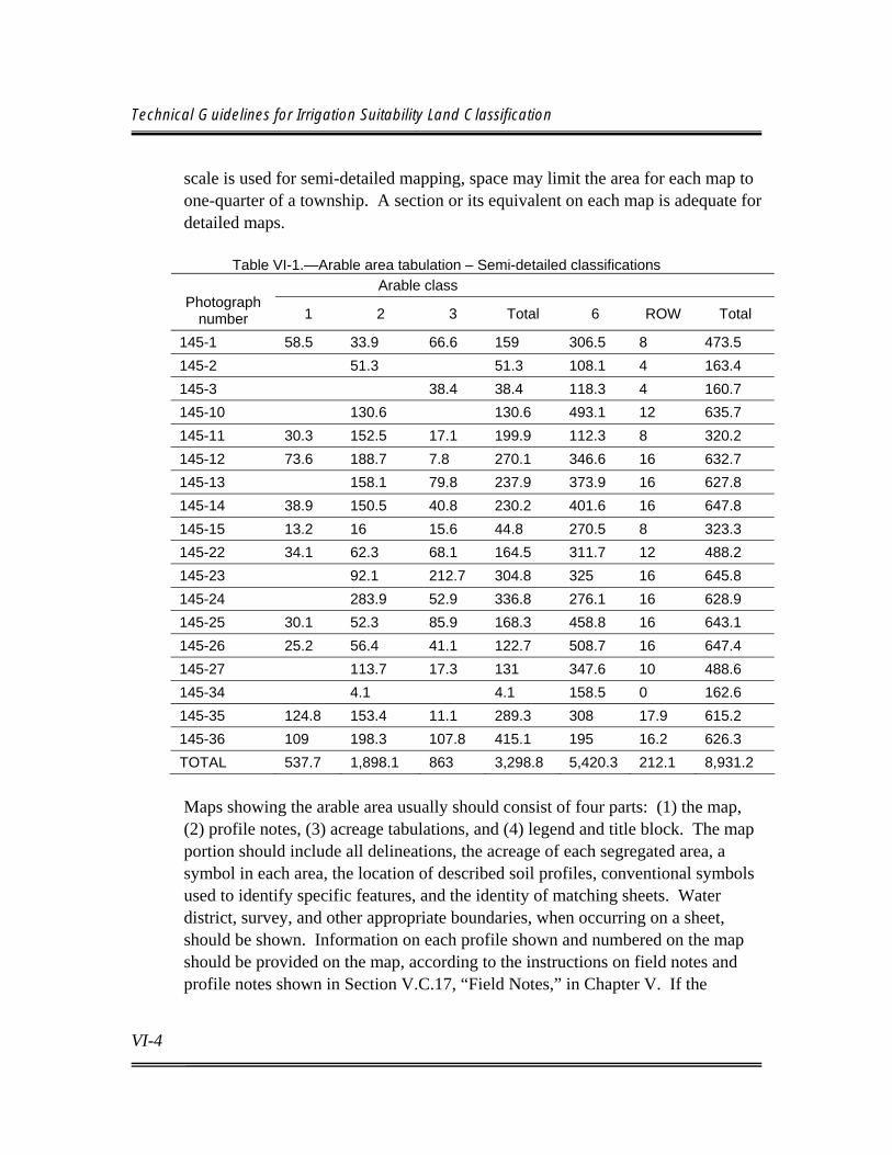
Technical Guidelines for Irrigation Suitability Land Classification
VI-4
scale is used for semi-detailed mapping, space may limit the area for each map to one-quarter of a township. A section or its equivalent on each map is adequate for detailed maps.
Table VI-1.—Arable area tabulation – Semi-detailed classifications Arable class
Photograph number 1 2 3 Total 6 ROW Total
145-1 58.5 33.9 66.6 159 306.5 8 473.5 145-2 51.3 51.3 108.1 4 163.4 145-3 38.4 38.4 118.3 4 160.7 145-10 130.6 130.6 493.1 12 635.7 145-11 30.3 152.5 17.1 199.9 112.3 8 320.2 145-12 73.6 188.7 7.8 270.1 346.6 16 632.7 145-13 158.1 79.8 237.9 373.9 16 627.8 145-14 38.9 150.5 40.8 230.2 401.6 16 647.8 145-15 13.2 16 15.6 44.8 270.5 8 323.3 145-22 34.1 62.3 68.1 164.5 311.7 12 488.2 145-23 92.1 212.7 304.8 325 16 645.8 145-24 283.9 52.9 336.8 276.1 16 628.9 145-25 30.1 52.3 85.9 168.3 458.8 16 643.1 145-26 25.2 56.4 41.1 122.7 508.7 16 647.4 145-27 113.7 17.3 131 347.6 10 488.6 145-34 4.1 4.1 158.5 0 162.6 145-35 124.8 153.4 11.1 289.3 308 17.9 615.2 145-36 109 198.3 107.8 415.1 195 16.2 626.3 TOTAL 537.7 1,898.1 863 3,298.8 5,420.3 212.1 8,931.2 Maps showing the arable area usually should consist of four parts: (1) the map, (2) profile notes, (3) acreage tabulations, and (4) legend and title block. The map portion should include all delineations, the acreage of each segregated area, a symbol in each area, the location of described soil profiles, conventional symbols used to identify specific features, and the identity of matching sheets. Water district, survey, and other appropriate boundaries, when occurring on a sheet, should be shown. Information on each profile shown and numbered on the map should be provided on the map, according to the instructions on field notes and profile notes shown in Section V.C.17, “Field Notes,” in Chapter V. If the
Chapter VI Presentation of Results
VI-5
allotted space does not allow reproduction of all field notes, the most important notes should be reproduced. Reproduction of data from special studies may also appear under the profile information. A brief explanation of the land class symbol, conventional symbols, profile characters and abbreviations, and land classes should be included on each map in order for it to be individually useful. A standard Reclamation title block should be used that identifies the project, type of land classification, legal description of the area portrayed, classifier, the date field work was completed, type of area identified (arable), and standard drafting information. Because Reclamation now conducts more than one type of land classification, the mapping should designate the particular type of land classification. Figure VI-1 is an example of an arable area map. A tabulation of the arable acreages by land classes for the area covered by the map normally is included. Totals for each section are adequate for all studies, except detailed studies, which typically provide totals for each 40 acres. Copies of arable area maps typically are not required as part of the report covering the investigation unless one is used as a sample. An exception would be small-scale mapping for a reconnaissance investigation. The location and reference number for each drawing should be indicated in the report.
VI.B.2. Irrigable Area Maps Irrigable area maps (figure VI-2) are a necessary product of land classification investigations for project planning and construction. They are required for each investigation, but the area covered and the detail required varies with each type of investigation. The scale and the coverage on each irrigable area map should correspond with the arable area maps. Special irrigable area maps need not be prepared for reconnaissance and most semi-detailed studies; marked up arable area maps usually provide adequate information. Revisions to the arable area field sheets should include designating the arable area that is nonirrigable with an appropriate symbol, adjusting the tabulation to include only the irrigable acreage, and revising the title block to identify it as irrigable
Technical Guidelines for Irrigation Suitability Land Classification
VI-6
area rather than arable area. If a farm irrigable acreage is necessary, the acreage tabulation must be footnoted to indicate whether or not the reduction factor for nonirrigable areas within the farm boundaries was applied to arrive at that figure. This information is necessary for the irrigation and drainage system design, which includes sizing, etc. During preconstruction studies, large-scale irrigable area sheets must be prepared. For new lands, it may be prepared on the basis of a detailed land classification for the preconstruction planning report. When less detailed mapping has been completed for supplemental water projects, individual irrigable area sheets may be delayed until the construction period. If delayed until the construction period, temporary sheets (similar to those prepared for a semi-detailed investigation, described above, but based on the detailed land investigation) can be used. Acreages within land class delineations on the final irrigable area sheet must be accurate to 0.1 acre. Often, the measurements of arable areas meet this criteria and can be used for the irrigable area measurements, unless changes have been made. The map boundaries between land classes usually can be traced directly from the arable area maps. Subclass boundaries should be excluded, and boundaries for rights-of-way, ownership, district boundaries, etc., should be added. Revisions may be made on the irrigable area maps during the development period to conform the service area to "as-built" conditions and to land development. A cutoff time, usually toward the end of the development period, should be established when the final official irrigable acreage is fixed and the final maps are released. These maps are the official record, displaying the lands that receive irrigation service, and are the basis for contract provisions for construction charges and water allotments. Changes in the arable status of lands, due to classifications or reclassifications performed pursuant to the Reclamation Project Act of 1939, may require revisions of the official irrigable area maps to reflect the arable or nonarable status.


Chapter VI Presentation of Results
VI-7
As with arable area maps, irrigable area maps are a permanent record whose retention, storage and identification (assignment of drawing number(s) should conform to requirements of Reclamation’s Information Management Handbook, Volumes II and III. Questions concerning drawing numbers and records retention may be addressed to the Regional Records Officer or the Director, Chief Information Office, Attention D-2230.
VI.B.3. General Maps General maps of the arable and irrigable area usually are utilized for reports, design of distribution system and drainage layouts, information purposes, and other uses. If the arable and irrigable areas are nearly identical, a general irrigable area map need not be prepared. A single map also may be prepared to show both arable and irrigable lands. The scale of these maps varies, depending on their use. Only land classes must be shown, identified by the following characters on black and white maps and the designated colors on colored maps:
Land class Character Color 1 þþþþþþþ Yellow 2 %%%%%%% Green 3 WXWXWXW Blue 4 BBBBBBBBBB Brown 5 °°°°° Pink 6 (no character) (usually left blank) H H Red
Presently irrigated lands may be indicated by hatching. This type of map may be needed for many types of studies and can be made by reducing individual sheets by any method that produces the required accuracy. These maps should not be used for measuring acreages or for identifying classification factors at specific sites. In certain situations, general maps showing the project distribution of specific land features may be useful. Their use generally is limited to showing the location, extent, and severity of a particular land problem or to show present land conditions, such as soil salinity for land reclamation and return flow studies. These maps also may be used in reports for showing the distribution of various
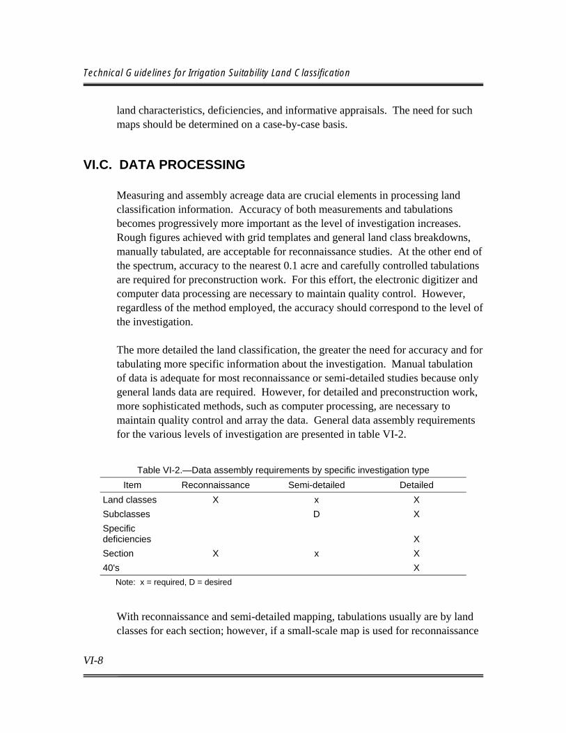
Technical Guidelines for Irrigation Suitability Land Classification
VI-8
land characteristics, deficiencies, and informative appraisals. The need for such maps should be determined on a case-by-case basis.
VI.C. DATA PROCESSING Measuring and assembly acreage data are crucial elements in processing land classification information. Accuracy of both measurements and tabulations becomes progressively more important as the level of investigation increases. Rough figures achieved with grid templates and general land class breakdowns, manually tabulated, are acceptable for reconnaissance studies. At the other end of the spectrum, accuracy to the nearest 0.1 acre and carefully controlled tabulations are required for preconstruction work. For this effort, the electronic digitizer and computer data processing are necessary to maintain quality control. However, regardless of the method employed, the accuracy should correspond to the level of the investigation. The more detailed the land classification, the greater the need for accuracy and for tabulating more specific information about the investigation. Manual tabulation of data is adequate for most reconnaissance or semi-detailed studies because only general lands data are required. However, for detailed and preconstruction work, more sophisticated methods, such as computer processing, are necessary to maintain quality control and array the data. General data assembly requirements for the various levels of investigation are presented in table VI-2.
Table VI-2.—Data assembly requirements by specific investigation type Item Reconnaissance Semi-detailed Detailed
Land classes X x X Subclasses D X Specific deficiencies
X
Section X x X 40's X Note: x = required, D = desired
With reconnaissance and semi-detailed mapping, tabulations usually are by land classes for each section; however, if a small-scale map is used for reconnaissance

Chapter VI Presentation of Results
VI-9
studies, tabulation by township may be adequate. Subclass and specific deficiency information for these two types of studies can be approximated for the entire project or investigation area. For preconstruction land classification investigations, considerably more data are required. Data accuracy must be higher, since the data are used for water rights, repayment contracts, and district assessments. Maintaining accuracy of these tabulations is very difficult because of the many changes that occur while formulating plan elements. Computer processing is essential to array the many combinations of data required. Computer processing can be used very effectively for all studies, from recon-naissance to preconstruction. Quality control is enhanced, and it is much easier to assemble the mapped information. Very often, considerably more data are mapped, particularly for semi-detailed and detailed studies, than can be tabulated by hand methods. It should be noted that acreage discrepancies may arise between map acreages that are redrawn by computer assisted methods from hand-drafted and hand-planimetered original map sheets. In these cases, the official acreage should not be changed unless an actual error in measurement is determined. In regard to computer processing, careful consideration must first be given to the type of output required for all intended users of the data - planners, designers, construction engineers, and district managers. Once the requirements have been determined, the format for the input data form can be developed. It may be desirable to include all available land information, even though it is not likely to be used in later tabulations. In most cases, it is not possible to predict all tabulation needs. The time involved in making an initial entry is minor compared to adding an entry at a later date. In most cases, commercially available spreadsheet software can be used to developed and display the data.
VI.D. REPORTS A land classification report is required for all types of land classification or reclassification investigations. However, the amount of detail and extent of the

Technical Guidelines for Irrigation Suitability Land Classification
VI-10
report may vary, depending on the type and purpose of the land classification investigation. It is important to keep in mind the significance of the report as a permanent record of the investigation and be aware that the quality of the report influences the opinions of report users as to quality of the field and laboratory work. Basic assumptions must be stated clearly. Critical factors controlling the validity of the classification must be given special attention in the report. The most important sections of a land classification or reclassification report are sections that present the basis for the land classification specifications, the field and laboratory procedures followed, interpretations made, and the procedures for determining the arable area. Good maps and illustrations often are more effective than the narrative and increase the understanding of the report. The cost of useful refinements, such as colors on maps, is normally relatively small compared to the cost of base maps and the field and laboratory work. Parties responsible for the land classification field activities should prepare the initial draft of the report. The draft can then be reviewed by Reclamation soil scientist(s), economists, and drainage engineers who are responsible for technical oversight and review for of technical adequacy. Sufficient variability in the type and objective of land classification investigations exists to justify flexibility in report format and review requirements. The degree of emphasis on a particular phase or phases of the classification varies. It is desirable to submit an informal or rough draft of the lands appendix for peer review and possible revision before the regional report and supporting appendixes are submitted for formal review. For any technical review of land classification reports conducted by the Technical Service Center, Denver, three copies should be sent to the Director, Technical Service Center, Attention: D-8570 with a transmittal memorandum requesting the review. For approval of land classifications for new projects, the Director, Program and Policy Services , Attention: D-5500 should be consulted as to the number of copies of the report and any supporting documentation that should be forwarded along with the approval request (See Chapter VII, Section VII.B.2). Suggested outlines for the report chapter and the lands appendix are shown in appendix 2. The appendix outline is very comprehensive and contains subjects
Chapter VI Presentation of Results
VI-11
that may not be applicable to every situation. It can best be used as a checklist for factors that are applicable to the specific investigation and that should be included in the report.
VI.D.1. Reconnaissance A chapter or section in the planning (appraisal) report should be devoted to land resources and include a brief explanation of the land classification performed and its results. Supporting appendixes are not required, but documentation of methodology and results are needed for future reference.
VI.D.2. Semi-Detailed For planning reports requiring semi-detailed lands investigations, a brief appendix is required, along with a chapter for the planning report that describes the land, its suitability for the uses contemplated in the development, and results of the land classification investigation. Backup data should be assembled and bound together for quick retrieval. The appendix should summarize the methodology used, including results, and discuss problems as well as favorable attributes of the area. It should contain less detail than an appendix developed in support of a preconstruction planning report used as the basis for Secretarial approval. The appendix has limited distribution.
VI.D.3. Preconstruction Planning Report (Detailed) A comprehensive lands appendix and a chapter for the report are required for a preconstruction planning activity, and usually for a definite plan report. The appendix provides support for any postauthorization planning studies and for approval. A report meeting the requirements for the investigation should also be adequate for approval. The appendix should be prepared following the general guidelines provided in the appended outline (appendix 2), with emphasis on the items most applicable to the specific area of project development. The appendix often receives wide distribution within and outside Reclamation.

Technical Guidelines for Irrigation Suitability Land Classification
VI-12
VI.D.4. Postconstruction There may be a need to document project changes at the end of the development period. Normally, project changes in the period between the postauthorization land classification investigation and the end of the development period are minor and consist of small irrigable acreage changes (see Section V.C.19, “Project Irrigable Area Determinations,” in Chapter V). Such changes usually are recorded by a memorandum (see Section, VII.B.1.b., “Supplemental Approval and Reapproval,” in Chapter VII), and any necessary revisions are made on the irrigable area maps, establishing the final project acreage. Substantial additions or deletions usually require an addendum to the lands appendix. Acreage revisions will be sufficiently supported if the affected lands have been adequately covered. An addendum may be necessary if the added lands have not been pre-viously described.
VI.D.5. Land Classification Reports for Classification or Reclassification Pursuant to the Reclamation Project Act of 1939
A report is necessary to document the results of classifications or reclassifications performed pursuant to Section 8 of the Reclamation Project Act of 1939, August 4, 1939. Its length and detail will vary with the extent of the reclassifica-tion and the land characteristics. The general outline included in appendix 2 should be followed, but very little detail may be needed for some headings, or some headings may be omitted entirely. This is especially true where total acreage is small and tracts are scattered, or where a previous detailed report on the original classification is available. As a minimum, the report should include a: (1) brief history of the area; (2) description of the soils, topography, and drainage characteristics of the area; (3) narrative of previous land classifications or reclassification performed; (4) summary of present reclassification studies (including extent of field and laboratory studies, and a copy of the specifications used); (5) map (or maps) showing general location, and location of lands reclassified; (6) summary tabulation of acreage by project, division, or other appropriate delineation.

VII-1
Chapter VII Interpretation and Approval
VII.A. INTERPRETATION AND USE OF RESULTS Land classification personnel are responsible for consultation, collaboration, and review to ensure that complete and proper use is made of available basic data. Engineers, economists, and others are, in turn, responsible for applying all the available land classification data in order to successfully plan, develop, and operate irrigation projects. Beginning with the appraisal investigation, the extent and character of the arable lands are used in conjunction with investigations on water supply and construction features, economic analysis of benefits and costs, and an environmental assessment determining the need for more detailed investigations. In the project investigations that follow, land classification information is used with other data, to develop project plans and, particularly, with economic data to determine the estimated project payment capacity and appraisal of irrigation benefits. After authorization, and during and after construction, land classification information is used in the development and operation of the project. The specific information used from the classification depends on the problem under consideration. The principal uses that are made of land classification information are discussed below.
VII.A.1. Irrigable and Productive Land The identification and location of arable land are basic to, and a prerequisite for, determining the irrigable and productive area. The basic information for the arable area is shown on appropriate general land classification maps and individual field maps. Irrigable and productive area determination and documentation are covered under Section IV.D.1, “Irrigable Area Determinations,” in Chapter IV, and in Section V.C.19, “Project Irrigable Area Determinations,” in Chapter V.
Technical Guidelines for Irrigation Suitability Land Classification
VII-2
VII.A.2. Water Management
The irrigable land, its characteristics and location, influence water and irrigation management. To a considerable extent, land characteristics influence the type of irrigation, cultural practices, and kind and distribution of crops grown. Crops differ in their water management requirements. Soils also vary widely in their infiltration and hydraulic conductivity rates and in their available moisture capacities. Such factors not only affect water requirements and management directly and indirectly, they also affect system losses. Whenever the type of land use or soil conditions differ materially from normal in a way that significantly affects water requirements and management, informative appraisals should be made, as described in Section V.B.5, “Informative Appraisals,” in Chapter V, to facilitate unit estimates, determine farm delivery requirements, and provide a basis for more reliable computation of project water requirements.
VII.A.3. Land Use and Size of Farm In project investigations that involve developing public lands, projection of land use patterns provides the basis for interpreting crop adaptability by land classes and subclasses. Through application of yield, price, and farm production cost data, acreage of different land classes required to provide the desired net farm income are determined, and the number of farms that may be developed or accommodated under the proposed plan is ascertained. On privately owned lands, where an individual ownership is accepted as a farm unit, each unit may not produce the desired net farm income. However, there are usually rain-fed lands, farmed in conjunction with irrigated lands, which supplement the income, or small units are combined or absorbed into larger ones, resulting in farm operators of a suitable size. Additionally, the basic land classification data, as shown on the field sheets, frequently are used by farmers in planning their operations.
VII.A.4. Land Development An appraisal of farm development costs on lands under investigation is essential in determining payment capacity. This is recognized in mapping the various land

Chapter VII Interpretation and Approval
VII-3
classes and subclasses. This same land classification information subsequently may be used as a basis for setting up detailed land development surveys and in other land development activities.
VII.A.5. Payment Capacity Results of the land classification investigation are essential in determining project payment capacity. The irrigable land classes, which represent payment capacity levels for lands designated as suitable for irrigation and which are included under the plan, provide the basic factors for estimating project payment capacity. A project irrigable acreage summary, by class and payment capacity for each class, provides essential data for this determination.
VII.A.6. Irrigation Benefits Land classification information is also essential in determining irrigation benefits for projects under investigation. Such information provides the basic data for establishing the projected land use pattern and for estimating increased production.
VII.A.7. Irrigation and Drainage Systems The location, quality, and extent of arable land shown by general project land classification maps and field sheets are used in developing preliminary layouts for the irrigation and drainage systems. These maps provide basic soil, topographic, and drainage data upon which detailed project drainage investigations are made. This, in turn, is the basis of the design and layout of the project drainage system. The classification also is used in determining the size and number of farm units and, thus, the number and location of required turnouts.
VII.A.8. Land Appraisal Preliminary estimates for right-of-way costs for projects under investigation may be based on information provided by the land classification. Subsequently, land
Technical Guidelines for Irrigation Suitability Land Classification
VII-4
classification information is used in appraising the land for purchase. Also, it may be used in establishing the extent and value of excess lands and in appraising lands to determine fair market value in connection with control of speculation in the sale of excess land.
VII.A.9. Irrigation Assessments The aggregate payment capacity for the total irrigable acreage by land classes establishes the limit for irrigation assessment for the project. Subsequent adjustments on operating projects are based on reclassification investigations and related engineering and economic investigations.
VII.A.10. Environmental Assessment The basic data (particularly data related to soils and drainage) collected in land classification are a vital part of predicting and appraising ecological interactions within the environmental setting, as affected by water and land resource development.
VII.A.11. Return Flow Assessment Basic data regarding soil and subsoil conditions and characteristics, topography, and drainage provide data required for return flow studies. Return flow is the excess water (including surface runoff and deep percolation) that is not held by the structure of the soil or used by the crops.
VII.A.12. Miscellaneous Uses There are many observations made and recorded by soil scientists during the land classification that are not available from other sources or are available in reduced quantity. These data may include characteristics of surface and subsurface material along canal alignment, areas that may require canal lining, buried

Chapter VII Interpretation and Approval
VII-5
obstructions such as rocks that might interfere with construction activities, ownership information, archeological sites, unusual vegetation, etc.
VII.B. LAND CLASSIFICATION APPROVAL
VII.B.1. Preconstruction Land Classification Secretarial concurrence with the Commissioner=s approval/determination of the adequacy of irrigation suitability land classification before initiation of project construction is a continuing requirement. Concurrence signifies (and identifies supporting data for the finding) that the lands to be irrigated are susceptible to sustained production of agricultural crops by means of irrigation. For project planning and construction purposes, the Regional Director and Area Manager are responsible for scheduling and accomplishing adequate land classification and initiating approval action in accordance with Reclamation Manual, Policy, WTR P06 and Directives and Standards, WTR 06-01. Expertise is maintained in the Technical Service Center, Land Suitability and Water Quality Group, D-8570, to conduct or to provide technical oversight for irrigation suitability land classification investigations.
a. Approval and Secretarial Concurrence - Preconstruction Land Classification
Commissioner’s approval and Secretarial concurrence of irrigation suitability land classifications in support of authorization and construction of Reclamation irrigation projects is required in accordance with Reclamation Manual Policy, WTR P06. These requirements also apply to those lands to be provided project irrigation water for commercial irrigation under the loan provisions of the Distribution Systems Loan Act (Public Law 84-130) or the Small Reclamation Projects Act (Public Law 84-984) as amended. Although the intensity of investi-gations required for each Act may differ, irrigation suitability land classifications for both full service and supplemental service lands (regardless of previous irrigation history) must be approved. Native American lands included in projects funded through Reclamation require the same approval as other lands of the project, and this normally is accomplished
Technical Guidelines for Irrigation Suitability Land Classification
VII-6
by Reclamation. However, projects funded through the Bureau of Indian Affairs, even though they may be constructed by Reclamation, may not require approval by Reclamation. Although actual approval of Native American Indian lands may be completed by the Bureau of Indian Affairs, Reclamation should provide assistance in establishing specifications for arable land and ensure that adequate guidelines are followed in the conduct of the investigation. Lands served from U.S. Army Corps of Engineer structures with no Federal funds expended on the irrigation system normally do not require Reclamation approval. When questions exist on the need for approval, the Departmental Solicitor should be consulted.
b. Supplemental Approval and Reapproval When lands not included in the original approval are added to a project, division, unit, or feature prior to the initiation of construction, the Regional Director will submit a Anotice of acreage change@ and supporting land classification documentation for the new lands to the Commissioner through the Office of Program and Policy Services, Water Resources Office, D-5500. A decision will then be made as to whether a supplemental action, reapproval action, or no action is required, depending largely on the significance and size of the added area. The original approval action may need to be supplemented when minor project formulation changes (Division, Unit, feature) necessitate adding previously unclassified or unapproved lands to the project service area prior to construction. A reapproval action may be required when the entire project is reformulated (e.g., in terms of water supply, a drastic revision in the plan of development has made simple addition of land area impractical. It may also be required when drastic change in the land classification has resulted from changes in the land classification criteria or specifications. In such cases, the new or reapproval supercedes the original. Supporting documents prepared for the "notice of acreage change" vary, depending upon circumstances. No specific procedure would fit all cases; however, the basic objective is to clearly show the changes in location and extent of area and to provide the requisite supporting material. Various techniques may
Chapter VII Interpretation and Approval
VII-7
be used, such as: (a) separate report or addendum that covers only the new area to be added (to be used if necessary to supplement the supporting document of the original approval); (b) submission of revised pages for the land appendix; and (c) submission of a revised lands appendix. New land classification maps, showing the added land classes, and a new summary data sheet should be provided. New descriptions of the land and the details of the land classification work are not needed if land classes and subclasses and the land classification investigation are the same as that described in the original approval. The memorandum presenting the "notice of acreage change" is particularly important. The letter should include: (a) justification for making the change; (b) statement of the effect of the change in area or on other factors involved in the plan and repayment; (c) a breakdown of acreage data, showing the original approval, new additions, and resulting new totals; (d) dates of field review and approval of additional land classification; and (e) type of lands to be approved. Five copies of the supporting documents should be transmitted to the Office of Program and Policy Services, Water Resources Office, D-5500, along with the memorandum of request.
c. Exclusions Generally, work performed with rehabilitation and betterment funds is not defined as "new construction" for land classification purposes, and any land classification activity would normally be performed to accomplish inclusions/exclusions of land for irrigation service (land classification on operating projects pursuant to Section 8 of the Reclamation Project Act of 1939). In these instances, Secretarial concurrence is not applicable. This is based on the requirement that such funds must be used strictly and exclusively for rehabilitation and maintenance work on existing established systems, and that development for irrigation of substantial new areas will not occur. When rehabilitation work results in an increase of water supply for new lands, an appraisal should be made to determine what level of land classification and approval is required. This appraisal generally is made with participation by the Office of Program and Policy Services, Water Resources Office, D-5500, the Regional Director=s staff, and the Office of the Solicitor.

Technical Guidelines for Irrigation Suitability Land Classification
VII-8
VII.B.2. Submission and Scheduling Pursuant to Reclamation Manual Directives and Standards, WTR 06-01, the Regional Director must submit a memorandum to the Commissioner of Reclamation to request approval of land classification determinations requiring Secretarial concurrence, at least 60 days before the anticipated start of construction. Except when specified otherwise, approval and Secretarial concurrence of land classification for new land projects are based on an advanced planning land classification investigation supported by the project lands appendix of an approved definite plan or preconstruction report. For those situations where such reports are not prepared, an equivalent supporting appendix and approved plan are prerequisites for the approval action. On supplemental water service areas, a less detailed land classification may be adequate. However, physical land conditions, ecological setting, and quantity and suitability of supplemental water to be supplied, in some cases, may result in the need for more detail. Prior to initiation of the investigation, agreement on scope and detail required should be established with the TSC.
VII.B.3. Type of Acreage Data Used For most projects, approval is made by division, unit, or other identifiable feature as officially defined, and approval is made on the basis of arable area. The approved lands need not be restricted to the exact arable area from which the irrigable lands covered in the given plan were selected. Approval may include lands that have been classified and shown to be susceptible to the production of agricultural crops by means of irrigation under any reasonable extension or modification of the proposed plan. In the letters and memorandums of approval, the acreage approved should be identified as arable if it is the same as the arable area related to a particular plan and as "potentially irrigable" if less than the arable area. The letter requesting approval and the related supporting documents should make clear the type of acreage to be approved.

Chapter VII Interpretation and Approval
VII-9
Supplemental approvals should be made on similar acreage categories as the original approval. Reapprovals should be made using the arable or "potentially irrigable" acreage as described above. The requirement to approve arable or "potentially irrigable" acreage does not eliminate the need to specify the irrigable acreage. The total irrigable area is given in the memorandum to the Commissioner and must, therefore, be shown in the supporting documents.
VII.B.4. Field and Report Reviews Because of the many diverse circumstances that arise, field review and review of land classification reports for technical adequacy prior to initiation of approval are a continuing requirement. Arrangements should be made with the appropriate Regional or Technical Service Center expertise (i.e., soil scientist, drainage engineer, and agricultural economist) for such reviews well in advance of the contemplated approval actions.
VII.B.5. Supporting Documents The actions and documents that satisfy the requirements of a preconstruction land classification are the requirements for approval. The approval action is supported by the project lands appendix or other comprehensive report, covering Reclamation-type land classification investigations. These documents are maintained in the TSC and the Washington Office. The basic supporting document is the project lands appendix of an approved report. Appendix 2 is an outline for preparation of the lands appendix. This outline should be used by soil scientists having responsibility for preparation of technical appendixes. Because of the diversity of land conditions within and between projects, the outline should be used as a guide only, and a format should be developed that meets the needs of each particular situation. The outline, however, can serve to provide a checklist of the factors to be addressed.

Technical Guidelines for Irrigation Suitability Land Classification
VII-10
a. Termination of Approval Actions Supplemental and reapproval actions normally are not required following completion of construction and the beginning of the development period. Major changes in the irrigable area are unlikely after that date, except in the case of project extensions, which should be approved in the normal manner. At some point near the end of the development period, a reevaluation of the irri-gable area should be made to conform the acreage to the "as-built" conditions and to the land development. The revised acreage then becomes the official irrigable acreage for use in water rights and irrigation assessments, as well as crop census reports, program and budget documents, official correspondence, and related purposes. A notice of the official project acreage should be sent to the Commissioner, Attention: Office of Program and Policy Services, Water Resources Office D-5500. Where applicable, the notice should be issued for divisions, units, blocks, or features, depending upon project organization. This action would be taken as soon as practicable after completion of construction and irrigable lands have been developed. This usually occurs toward the end of the development period. The acreage notice is in letter form and should include: (a) tabulation of the irrigable area by land classes; (b) land classification map, showing location of the irrigable area, preferably with the layout of the distribution system; and (c) explanation of any changes that relate to approval requirements outlined herein and that have not been reported previously. In regard to item (c), changes usually occur in acreage as a result of the selection of the final location and water surface delivery elevations of the farm turnouts, construction of new roads, expansion of rights-of-way, changes in farm unit boundaries, severance, expansion of suburban areas, and similar and often unpredictable causes. Such changes should be regarded as normal and should not be considered until the "as-built" irrigable area determination is made. However, major changes in the original design of the system or the irrigation district boundaries following initiation of construction could result in a need for submitting a “notice of acreage change.”

1-1
Appendix 1 Economics Guidebook, Chapter 5
“Economic Analysis for Land Classification”
(Revised, December 2001) Purpose To provide a standardized procedure for the economic analysis required in land classification. The most crucial determination is the division (break-point) between arable and non-arable lands (arable lands provide sufficient returns to support a farm family and to pay water operation, maintenance, and replacement charges [OM&R]). This instruction also addresses the economic methodology to distinguish between final arable land classes (classes 1, 2, and 3). Both the arability determination and the division of arable lands into classes are based on the correlation of physical factors (such as soil characteristics, drainage parameters, and topography) to farm income. The economic correlation is accomplished by farm budgeting in which physical factors are translated into yield potentials and land development costs necessary for sustained irrigation. The development of economic correlations requires interdisciplinary coordination to ensure that technical information analyzed by soil scientists and drainage engineers is applied by economists in a consistent manner. Certain elements involved in land classification, such as determination of crop yield potential, will involve input and concurrence from all disciplines. Aside from exceptions noted herein, all farm budgeting should be consistent with payment capacity analysis, rather than benefit analysis. Refer to Reclamation=s Technical Standards for Irrigation Payment Capacity (November 30, 1998). The steps required for the economic analysis along with an example and a recommended format for displaying results follows:
Step 1: Establish the Minimum Crop Yields for Arability.
A "with project" farm budget is developed with crop yields set at levels which result in zero remaining net farm income after deductions for estimated OM&R and a reasonable family living allowance. For lands not currently irrigated, the budget should value land investment at current non-irrigated market value; i.e., no irrigation development costs should be included in the investment value. For lands which are currently irrigated, land investment should be set at current irrigated market value and all existing irrigation development and system costs should be included in total farm investment, either in land
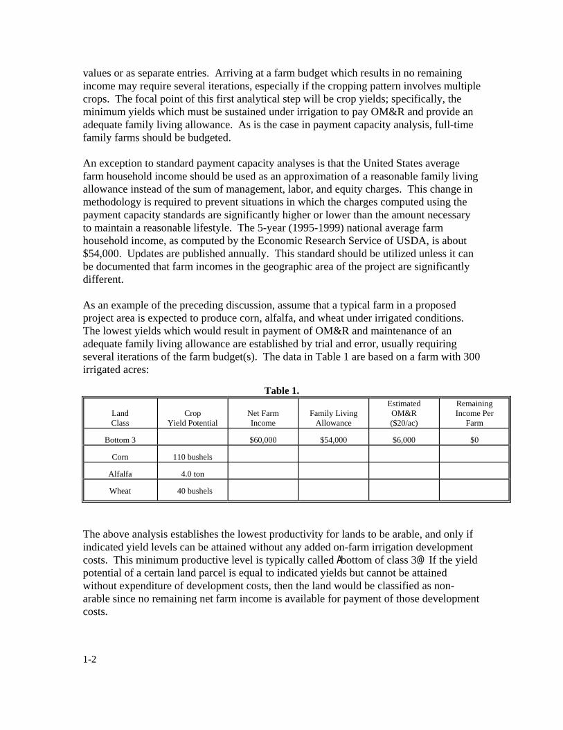
1-2
values or as separate entries. Arriving at a farm budget which results in no remaining income may require several iterations, especially if the cropping pattern involves multiple crops. The focal point of this first analytical step will be crop yields; specifically, the minimum yields which must be sustained under irrigation to pay OM&R and provide an adequate family living allowance. As is the case in payment capacity analysis, full-time family farms should be budgeted. An exception to standard payment capacity analyses is that the United States average farm household income should be used as an approximation of a reasonable family living allowance instead of the sum of management, labor, and equity charges. This change in methodology is required to prevent situations in which the charges computed using the payment capacity standards are significantly higher or lower than the amount necessary to maintain a reasonable lifestyle. The 5-year (1995-1999) national average farm household income, as computed by the Economic Research Service of USDA, is about $54,000. Updates are published annually. This standard should be utilized unless it can be documented that farm incomes in the geographic area of the project are significantly different. As an example of the preceding discussion, assume that a typical farm in a proposed project area is expected to produce corn, alfalfa, and wheat under irrigated conditions. The lowest yields which would result in payment of OM&R and maintenance of an adequate family living allowance are established by trial and error, usually requiring several iterations of the farm budget(s). The data in Table 1 are based on a farm with 300 irrigated acres:
Table 1.
Land Class
Crop Yield Potential
Net Farm Income
Family Living Allowance
Estimated OM&R ($20/ac)
Remaining Income Per
Farm Bottom 3
$60,000
$54,000
$6,000
$0
Corn
110 bushels
Alfalfa
4.0 ton
Wheat
40 bushels
The above analysis establishes the lowest productivity for lands to be arable, and only if indicated yield levels can be attained without any added on-farm irrigation development costs. This minimum productive level is typically called Abottom of class 3@. If the yield potential of a certain land parcel is equal to indicated yields but cannot be attained without expenditure of development costs, then the land would be classified as non-arable since no remaining net farm income is available for payment of those development costs.
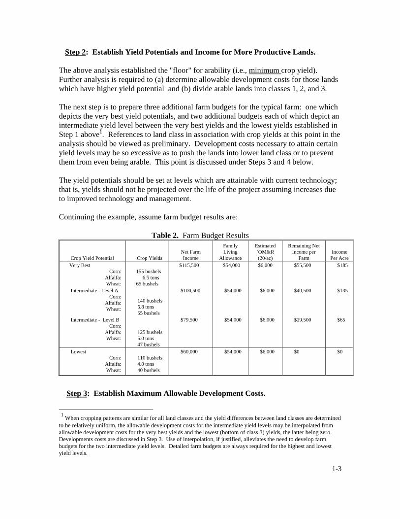
1-3
Step 2: Establish Yield Potentials and Income for More Productive Lands.
The above analysis established the "floor" for arability (i.e., minimum crop yield). Further analysis is required to (a) determine allowable development costs for those lands which have higher yield potential and (b) divide arable lands into classes 1, 2, and 3. The next step is to prepare three additional farm budgets for the typical farm: one which depicts the very best yield potentials, and two additional budgets each of which depict an intermediate yield level between the very best yields and the lowest yields established in Step 1 above1. References to land class in association with crop yields at this point in the analysis should be viewed as preliminary. Development costs necessary to attain certain yield levels may be so excessive as to push the lands into lower land class or to prevent them from even being arable. This point is discussed under Steps 3 and 4 below.
The yield potentials should be set at levels which are attainable with current technology; that is, yields should not be projected over the life of the project assuming increases due to improved technology and management. Continuing the example, assume farm budget results are:
Table 2. Farm Budget Results
Crop Yield Potential Crop Yields
Net Farm Income
Family Living
Allowance
Estimated `OM&R (20/ac)
Remaining Net
Income per Farm
Income
Per Acre Very Best
Corn: Alfalfa: Wheat:
155 bushels 6.5 tons 65 bushels
$115,500
$54,000
$6,000
$55,500
$185
Intermediate - Level A
Corn: Alfalfa: Wheat:
140 bushels 5.8 tons 55 bushels
$100,500
$54,000
$6,000
$40,500
$135
Intermediate - Level B
Corn: Alfalfa: Wheat:
125 bushels 5.0 tons 47 bushels
$79,500
$54,000
$6,000
$19,500
$65
Lowest
Corn: Alfalfa: Wheat:
110 bushels 4.0 tons 40 bushels
$60,000
$54,000
$6,000
$0
$0
Step 3: Establish Maximum Allowable Development Costs.
1 When cropping patterns are similar for all land classes and the yield differences between land classes are determined to be relatively uniform, the allowable development costs for the intermediate yield levels may be interpolated from allowable development costs for the very best yields and the lowest (bottom of class 3) yields, the latter being zero. Developments costs are discussed in Step 3. Use of interpolation, if justified, alleviates the need to develop farm budgets for the two intermediate yield levels. Detailed farm budgets are always required for the highest and lowest yield levels.

1-4
The remaining annual net farm incomes developed in the above analysis are available for the added costs of any development to make the lands suitable for irrigation (e.g., leveling, stone removal, clearing brush, on-farm ditches, and irrigation system sprinklers). As shown in Table 3, these annual amounts are capitalized using an interest rate appropriate for long term farm real estate borrowing to derive maximum allowable development costs. It is presumed that all of the development costs will be borrowed capital, rather than partially from farmer's equity. The interest rate should be the most current 5-year average real estate rate described on page 8 of the Technical Standards for Irrigation Payment Capacity. In this example, the rate is assumed to be 10 percent with a 50-year project life.
Table 3. Maximum allowable development costs Crop Yield Potential
Remaining Net Farm Income
Per Acre
Capitalization
Factor (10%, 50 years)
Maximum Allowable Development Costs
(dollars/acre) Very Best
$185
9.9148
$1,880
Intermediate Level A
$135
9.9148
$1,340
Intermediate Level B
$65
9.9148
$640
Lowest
$0
9.9148
$0
Table 3 shows the maximum development costs that can be expended to attain yield potentials and remain arable. For example, if a block of land can achieve the very best yields after correctable deficiencies are removed, then no more than $1,880 can be expended to correct those deficiencies for the lands to remain arable. If more than $1,880 is expended, those lands could not pay OM&R and support a farm family. As another example, if more than $640 per acre is required for a block of land to attain yields indicative of Intermediate Level B, then that land would be classified non-arable. No added money could be spent to develop lands with the lowest yield potential for those lands to be arable.
Step 4: Establish Final Land Classes. Table 3 correlates yield potentials and maximum development costs to the arability determination. As shown in Table 4, this data is manipulated to derive the final land classes (i.e., the "break-points" among arable land classes).

1-5
Table 4. Range of Allowable Development Costs to be in a Particular Land Class
Range of Allowable Land Development Expenditures2
Yield Potential
Very Best
Yield Potential Intermediate A
Yield Potential Intermediate B
Yield Potential
Lowest Final Land Class 1
$1-$540
$0
N/A
N/A
Final Land Class 2
$541-$1,240
$1-$700
$0
N/A Final Land Class 3
$1,241-$1,880
$701-$1,340
$1-$640
$0
Nonarable
>$1,880
>$1,340
>$640
>$0
2The values $1,880, $1,340, and $640 are from the farm budget results. The value $540 is calculated as $1,880-$1,340. The value $1,240 is calculated as $1,880-$640. The value $700 is calculated as $1,340-$640. N/A: not applicable. Table 4 would be utilized by the classifier to determine final land classes. The first step in applying the table is to determine the yield potential of the land block in question. Once the yield potential is assessed, the ceiling in development costs for each final land class is read from the table.
As an example, assume a land block had yield potential consistent with the intermediate level A. The land could be classified in final class 1 if added development costs are zero; if development costs up to $700 per acre are required, the land would be classified in final class 2; if development costs are greater than $700 per acre, but less than $1,340 per acre, the land would be classified in final class 3; and if development costs are greater than $1,340 per acre, the land would be classified non-arable. Of course, the classifier must make (or have) cost estimates for the various land development corrections which are required (soil improvements, leveling, etc.) in order to properly use the table. The example used for these guidelines maybe somewhat simplistic compared to possible "real world" situations; for example, there may be multiple farm types, many different crops, lack of reliable yield data, and other associated problems. Nonetheless, although a considerable degree of professional judgment may be necessary to overcome some of these problems, the preceding methodology and format used to display results should generally be adhered to. The determination of the "break point" between arability and non-arability is more crucial than the demarcation among arable land classes and should, therefore, entail a higher level of technical effort.

2-1
Appendix 2 Land Classification Report or Appendix and
Land Resources Chapter Outlines Semi-Detailed and Post-Authorization (Detailed) Planning-Grade Investigations I. INTRODUCTION A. Purpose, Nature, Extent, and Date of Lands Resource Investigations B. Summary of Findings and Conclusions C. Recommendations D. Summary Data Sheet E. Names of Land Classifiers Participating in the Investigation II. GENERAL DESCRIPTION A. Location and Extent of Area to be Investigated 1. Include region, major river basin, states, counties, and towns 2. Any division of project area into units B. Geology and Geomorphology of the Area 1. Short geologic history of the area, presenting, if available, profiles of the
important geologic formations and their areal distribution. 2. Description of the surficial geology in relation to the landforms occurring in
the area. Describe prominent landforms occurring in the area and the nature of the understrata immediately below the soils.
3. Soil derivation - loessal, aeolian, lacustrine, residual, etc. C. Climate as Related to Irrigation Agriculture 1. Source of weather data (include location of station, length of record, the years
used to compute mean values, and relationship between weather at station and at area of investigation)
2. Temperature characteristics a. Mean number of days above 32 oF, after mean and minimum b. Frost hazards as influenced by air drainage c. Mean number of days temperature equals or exceeds 90 oF d. Mean annual temperature

2-2
e. Usual and historical mean minimum and maximum temperatures 3. Precipitation characteristics a. Mean annual precipitation and recorded fluctuations b. Mean precipitation for growing season 4. Other climatic characteristics a. Wind velocity b. Humidity c. Hail frequency 5. Effect of weather on irrigation practices, crops, and other management
practices D. Agricultural Development 1. History 2. Present land use 3. Native vegetation 4. Rainfed farming a. Crops b. Yields 5. Irrigation development a. Crops b. Yields c. Cultural practices d. Water supply e. Water suitability f. Drainage g. Problems h. Extent III. PRINCIPAL NATURAL LAND BODIES (repeat items for each principal body) A. Soils 1. Describe Natural Resources Conservation Service’s Soil Series 2. Parent material 3. Genesis 4. Associated landform

2-3
5. Description of typical profiles a. Color b. Texture c. Stoniness d. Gravel e. Depth f. Structure g. Consistency h. Mottling i. Density j. Pans 6. Soil-moisture relationships a. Water intake b. Permeability c. Water retention 7. Chemical characteristics a. Soil reaction (pH) b. Salinity c. Sodicity d. Acidity e. Cation-exchange capacity f. Mineralogy g. Toxic constituents h. Fertility 8. Location and extent 9. Variability 10. Suitability for irrigation 11. Representative profiles or master sites B. Topography 1. General description of main topographic features a. Position and extent (relief in relation to surroundings) b. Slope c. Surface - macrorelief and microrelief d. Elevations e. Irrigation field sizes and shapes f. Cover (i.e., tree or brush and rock removal needs)

2-4
2. Suitability of topography for gravity, sprinkler, and drip methods or irrigation a. Slope b. Field configuration c. Land grading d. Cover e. Air drainage 3. Specific problems associated with the topography, in relation to the proposed
irrigation method(s) C. Drainage 1. General discussion of drainage conditions a. Describe present water table condition, water table gradients, and
conditions of the understrata, which are thought to cause present or anticipated future drainage problems.
b. Location of areas where future subsurface and surface drainage relief will
be most urgently needed c. General nature of flood problems, if any d. Construction requirements with development e. Responsibilities for drainage construction (project versus farm) 2. General suitability of the area for irrigation from standpoint of surface and
subsurface drainage 3. Effect methods of irrigation will have on anticipated drainage problems D. Salinity and Sodicity 1. General discussion of present salinity 2. Specific areas affected a. Extent b. Type, distribution, and amount of salts
c. Source of accumulations d. Possibility for change 3. General suitability of the area for irrigation from the standpoint of salinity or
sodicity

2-5
4. Impact of irrigation development or other land uses and special investigations,
where needed
5. General statement on effects of land salinity on return flow quality IV. WATER A. Sources - Stream Diversion, Impoundments, or Groundwater B. Characteristics 1. Analysis of anticipated water quality - include total dissolved solids
(milligrams per liter), pH, electrical conductivity, cations (milliequivalents per liter), anions (milliequivalents per liter), Sodium Adsorption Ratio (SAR), and boron (milliequivalents per liter)
2. Discuss anticipated variations in chemical composition C. Leaching Requirements 1. Anticipated leaching requirement for specific crops 2. Salinity anticipated at equilibrium conditions 3. Anticipated leaching fraction in meeting leaching requirement 4. Water management considerations D. Suitability for Irrigation 1. Statement summarizing suitability of the water for irrigation, in relation to the
lands, cropping, and management. 2. Anticipated Exchangeable Sodium Percentage (ESP) and salinity levels at
equilibrium (cite basis for these predictions) E. Quality of Return Flows 1. Characteristics including physical, chemical, and biological over time 2. Impacts V. LAND CLASSIFICATION A. General Description of Land Classification Investigation 1. Objective 2. Factors considered

2-6
3. Segregations involved 4. Type of survey 5. Previous soil and land classification investigations and dates, including
evaluation 6. Cooperation with other agencies B. Land Classification Specifications 1. Irrigation method anticipated and factors influencing selection 2. Correlation with economic, drainage, and water quality factors
3. General description of land classes 4. Specifications chart C. Methods 1. Personnel and equipment 2. Base maps 3. Field procedures for establishing and identifying delineations a. Traverses of the area b. Type and frequency of borings 4. Role of drainage 5. Role of economics 6. Laboratory support a. Screenable testing procedures b. Detailed site analyses c. Source of laboratory procedures (may be included in appendix) 7. Special investigations a. Land development b. Special soil studies such as water-holding capacity, leaching, infiltration, hydraulic conductivity, and other c. Quality of return flows d. Master site selection D. Results of Land Classification Investigation 1. Detailed descriptions of land classes and subclasses* a. Arable lands - Classes 1, 2, and 3, and subclasses b. Class 5 and its disposition

2-7
c. Nonarable land - Classes 6 and 6W d. Urban and suburban developments - Class "H" *(These data should include the characteristics and qualities of soil,
topography, and drainage features that will affect land use or management factors under irrigation. Such data may be advantageously set forth in a tabular form. It should be noted that this is one of the most important portions of the report, so care should be used in developing these descriptions.)
2. Arability results a. Sample of typical land classification sheet b. General and arable area map c. Tabulation of arable land classes, subclasses, and deficiencies VI. DETERMINATION OF IRRIGABLE AREA A. Basis for Irrigable Area B. Factors Affecting Selection of General Land Areas or Subareas of the Project 1. Feasibility of water service 2. Adequacy of water supply to serve arable land 3. Feasibility of drainage service 4. Effects of return flow quality 5. District boundaries C. Factors Affecting Onfarm Irrigability 1. Elevation and location 2. Topographic or natural barriers 3. Rights-of-way 4. Ownership boundaries 5. Others
D. Tabulation of Irrigable Land Area 1. Unit or subdivision of project 2. Land classes 3. Irrigated and nonirrigated 4. Method or irrigation to be used E. Map of Irrigable Land, if Significantly Different than Arable Acreage
F. Productive Acreage and How Derived

2-8
VII. SPECIAL PROBLEMS In this portion, briefly discuss any problems relating to land classification that may affect the ultimate suitability of the area for irrigation development. Suggested solutions to the problem should be given, together with the effect these problems have had on land classes and total arable acreage. Typical items for inclusion in this portion are slick spots; low-cation exchange capacity; high or low infiltration rates; low water-holding capacity; need for amendments; high grading, clearing, or stone picking costs; bedrock outcrops; numerous isolations; lack of drainage outlets; or poor surface drainage conditions. If all factors are favorable, this chapter may be omitted. It is suggested this discussion be organized as follows. Delete items that are not pertinent. A. Soil Problems
1. Fertility 2. Salinity 3. Sodicity 4. Acidity 5. Toxicity (e.g., boron and selenium) 6. Pans 7. Water retentivity
B. Topographic C. Drainage D. Water Quality E. Land Development
VIII. APPENDED MATERIAL AND SUPPORTING DATA A. Master Site Descriptions and Method of Location B. Description of Analytical Procedures (may be filed with Supporting Data) 1. Particle size 2. Textural class (laboratory) 3. Hydraulic conductivity 4. Settling volume 5. Moisture retentivity 6. Soil reaction 7. Organic carbon 8. Available phosphorus 9. Saturation extract with constituents 10. Exchange acidity 11. Total titratable acidity 12. Exchangeable bases

2-9
13. Cation-exchange capacity 14. Gypsum 15. Gypsum requirement 16. Insoluble carbonates 17. Other C. Supporting Data (In all cases, a description of the data used is required; however, actual data need only be filed in the project, area, or district office) 1. Examples a. Tabulations of acreage by sections b. Detailed report of physical and chemical analysis c. Detailed description of procedures and special studies d. Profiles of deep borings e. Land classification maps f. Common and scientific names of crops referred to in this appendix g. Glossary of terms h. Symbols and abbreviations i. Conversion formulas and factors j. Bibliography

2-10
LAND RESOURCES CHAPTER OUTLINE I. Introduction II. Review and Evaluation of Available Data III. Description of Resources A. Soils B. Topography C. Drainage D. Geology E. Quality of Water F. Land Use IV. Investigation A. General Discussion B. Mapping Specifications C. Land Characterization D. Field and Laboratory Characterization of Soil Profiles E. Findings 1. Water suitability for irrigation 2. Land suitability for irrigation development 3. Land use including special cultural considerations 4. Impacts of development on other uses 5. Special problems F. Conclusions G. Recommendations
Relation of land classes and subclasses to irrigated crop adaptability and management
Land class
Principal
subclasses
Descriptive characteristics of soil, topography,
and drainage
Gross area
(acres)
Percent
of arable
Crop adaptability
Management factor
3
3st vg 22
Smooth, steeply sloping alluvial fans of loamy fine sand underlain by gravelly, cobbly sandy loam. Well drained.
840
6.2
Apples and peaches with ground cover should be most profitable. Alfalfa and pasture would do well. Clean cultivated not recommended.
Light, frequent irrigations needed. Soils are erosive and have high intake rates. Sprinkle irrigation or gated pipe with drop structures best. Frequent fertilization required.
Note: Information shown above is an example of detail desired.

3-1
Appendix 3 References
American Society of Agronomy, Inc., and Soil Science Society of America, Inc., 1986. Methods of Soil Analysis, Physical and Mineralogical Properties. Agronomy No. 9, Part 1, 1986, second edition. American Society of Agronomy, Inc., and Soil Science Society of America, Inc., 1982. Methods of Soil Analysis, Chemical and Microbiological Properties. Agronomy No. 9, Part 2, 1982, second edition. Ayers, R.S., and D.W. Westcot. 1985. “Water Quality for Agriculture.” Food and Agriculture Organization of the United Nations (FAO), Irrigation and Drainage Paper No. 29, revised 1985. Bernstein, Leon, 1967. “Quantitative Assessment of Irrigation Water Quality.” Water Quality Criteria, ASTM STP 416, American Society of Testing Materials. Bower, C.A., G. Ogata, and M. Tucker, 1968. Sodium Hazard of Irrigation Water as Influenced by Leaching Fraction and by Precipitation or Solution of Calcium Carbonate. Soil Science Volume 106, No. 1, Williams and Wilkins Co., Baltimore, Maryland. Bower, C.A., 1961. “Prediction of the Effects of Irrigation Water on Soils.” Salinity Problems in the Arid Zones. Proceedings of the Teheran Symposium, United Nations Educations, Scientific and Cultural Organization, Place de Fontenoy, Paris -7e. Bureau of Reclamation, 2004. Determination of Irrigation Suitability of Proposed Project Lands, and Identification of Lands That May Receive Project Irrigation Water on Operating Projects. www.usbr.gov/recman/wtr/wtrp06.htm. Reclamation Manual/Policy WTR P06. Bureau of Reclamation, 2004. Irrigation Suitability Land Classification for New Projects or Operating Projects. www.usbr.gov/recman/wtr/wtr06-01.htm. Reclamation Manual/Directives and Standards WTR 06-01. Bureau of Reclamation, 1993. Drainage Manual, A Water Resources Technical Publication. U.S. Department of the Interior. Fireman, Milton, 1960. “Quality of Water for Irrigation.” University of California Extension Service, Davis. Gangwer, D.N., “Updated Computer Processing of Data from Land Classification and

3-2
Other Land Inventories.” U.S. Bureau of Reclamation, Pacific Northwest Region, Boise, Idaho. Kabata-Pendias, Alina and Henry K. Pendias, 2001. Trace Elements in Soils and Plants. Third edition, CRC Press LLC. Kinney, Shirley L., 1996. Using a Geographic Information System for Processing and Presenting Irrigation Suitability Land Classification Data. U.S. Bureau of Reclamation, R-96-02, August 1996. Lunin, Jessee, 1967. “Water for Supplemental Irrigation.” Water Quality Criteria, ASTM STP 416, American Society of Testing Materials. Maas, E.V., and G.J. Hoffman, 1977. “Crop Salt Tolerance - Current Assessment.” Journal of the Irrigation and Drainage Division, ASCE, Volume 103, No. IR2, June 1977, pp. 115-134. Nielson, Aldon N. “A Procedure for Correlating the Economic Significance of Physical Factors in Land Classification.” Oster, J.D., and F.W. Schroer, 1979. “Infiltration as Influenced by Irrigation Water Quality.” Soil Science Society of America Journal 43:444-447. Rhoades, J.D., A. Kandiah, and A.M. Mashali. 1992. “The Use of Saline Waters for Crop Production.” FAO Irrigation and Drainage Paper No. 48. Rhoades, J.D., 1977. “Potential for Using Saline Agricultural Drainage Waters for Irrigation Proc.” Water Management for Irrigation and Drainage. ASCE, Reno, Nevada, July 20-22, 1977, pp. 85-116. Rhoades, J.D., 1972. “Quality of Water for Irrigation.” Soil Science Volume 113, No. 4. Rhoades, J.D., 1972. “Leaching Requirement for Exchangeable Sodium Control.” Soil Science Society of America Proceedings, Vol. 32 Rhoades, J.D. 1968. “Mineral-Weathering Correction for Estimating the Sodium Hazard of Irrigation Waters.” Soil Science Society of America Proceedings, Vol. 32, American Society of Agronomy, Madison, Wisconsin.

3-3
Rhoades, J.D., D.B. Krueger, and M.J. Reed, 1968. “Effect of Soil-Mineral Weathering on the Sodium Hazard of Irrigation Waters.” Soil Science Society of America Proceedings, Vol. 32. Tanji, Kenneth K (ed.), 1990. Agricultural Salinity Assessment and Management. ASCE Manuals and Reports on Engineering Practice No. 71. University of California Committee of Consultants, 1974. “Guidelines for Interpretation of Water Quality for Agriculture.” University of California Extension Service, Berkeley, California. U.S. Department of Agriculture, 1999. Soil Taxonomy. Agriculture Handbook 436. Website: <http://soils.usda.gov/technical/classification/taxonomy>. U.S. Department of Agriculture - Natural Resources Conservation Service, Soil Survey Staff. U.S. Department of Agriculture, 1995. Soil Survey Laboratory Information Manual. Soil Survey Investigations Report No. 45, version 1.0, May 1995. USDA NRCS, National Soil Survey Center, Soil Survey Laboratory, Lincoln, Nebraska. U.S. Department of Agriculture, 1993. Soil Survey Manual. USDA Handbook No. 18, U.S. Department of Agriculture, Soil Survey Staff. Government Printing Office. van Schilfgarde, J., 1975. “Water Management and Salinity.” Contribution by the U.S. Department of Agriculture, Salinity Laboratory, Riverside California. Presented at the Expert Consultation on Prognosis of Salt-Affected Soils, June 3-6, 1975, FAO, Rome Italy. van Schilfgarde, J., et al., 1974. “Irrigation Management for Salt Control.” Journal of the Irrigation and Drainage Division, ASCE, Volume 100, No. IR3, Proc. Paper 10822, September, 1974, pp. 321-338.

Appendix 4 Technical Checklist Procedures
These procedures may be used for classifications or reclassifications pursuant to the Reclamation Project Act of 1939 or in support of water service contracting, when the total acres for classification or reclassification are 500 or less. Lands may be classified either as arable (A) or non-arable (class 6) by use of the technical checklist. The technical checklist, where it may be used, serves as the official reporting and approval document for land classification determinations. Official land classification and irrigable area maps should be revised accordingly to reflect the land classification or reclassification actions documented by technical checklist. A brief letter of transmittal should be used to summarize and transmit the findings and conclusions of technical checklist land classifications to the water user=s organization. Regional Directors have the authority to approve technical checklist land classifications. Checklist for Land Classification Requests of Less Than or Equal to 500 Acres for Operating Projects This checklist procedure may be used to classify or reclassify parcels of land as requested by water user contractors pursuant to Section 8 of the Reclamation Act of 1939. The checklist procedure is designed for use by a qualified Soil Scientist (equivalent to a GS-7 grade or higher) or by a Soil Conservationist with the Natural Resources Conservation Service (NRCS) for the classification/reclassification of relatively small parcels of land. Other professional disciplines that provide an understanding of soils, crops, irrigation, and drainage would also be qualified to use the checklist. Examples of such disciplines could include Agronomist, Natural Resource Specialist, and Agricultural Engineer. Please note that parcels of less than 10 acres may be subject to Reclamation policy for delivery of irrigation water to small tracts (contact the Office of Program and Policy Services, D-5000). This checklist, along with a map that documents the classification and the acreages of arable and non-arable land, should be used to update the official project irrigable area sheets and land classification maps and records. Any questions on the use of this checklist should be directed to the Land Suitability and Water Quality Group, Technical Service Center, Denver (Attention D-8570, telephone 303-445-2453).
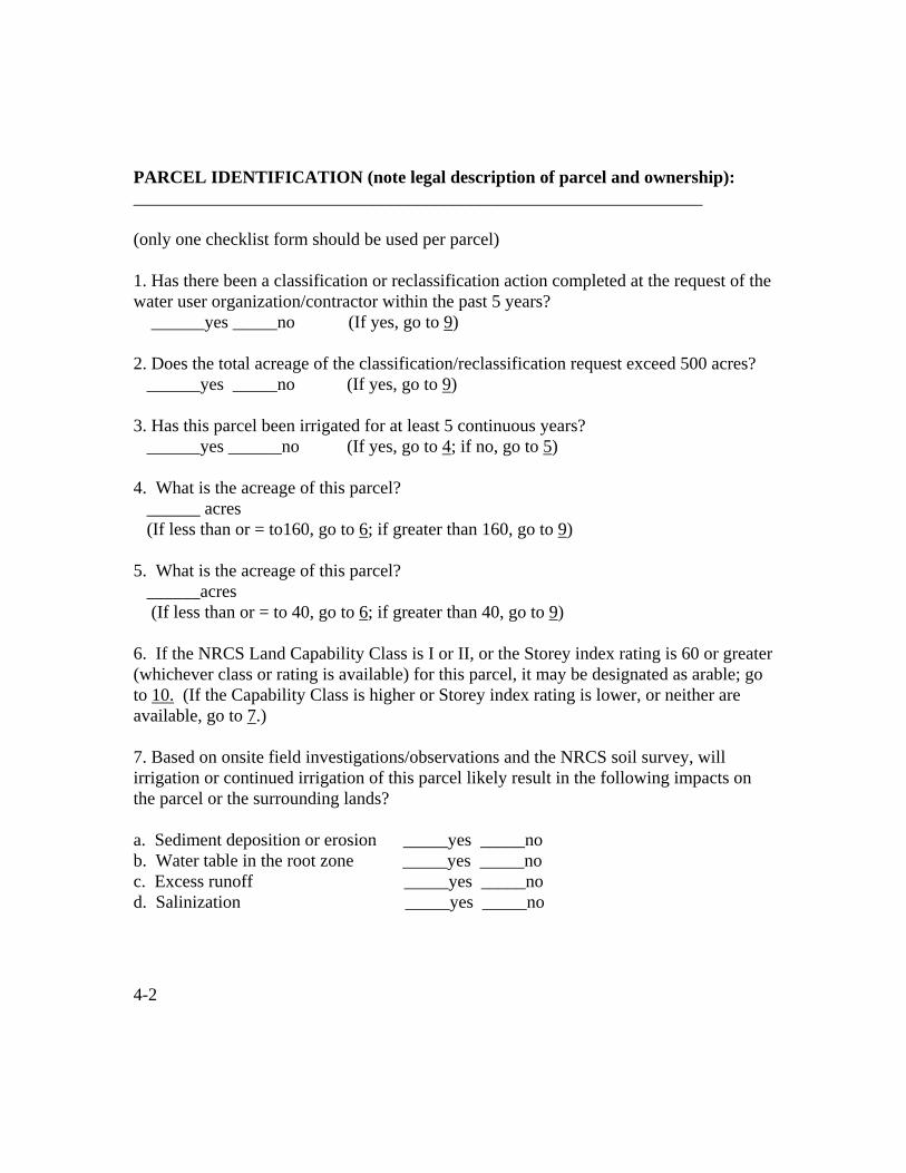
4-2
PARCEL IDENTIFICATION (note legal description of parcel and ownership): ________________________________________________________________ (only one checklist form should be used per parcel) 1. Has there been a classification or reclassification action completed at the request of the water user organization/contractor within the past 5 years? ______yes _____no (If yes, go to 9) 2. Does the total acreage of the classification/reclassification request exceed 500 acres? ______yes _____no (If yes, go to 9) 3. Has this parcel been irrigated for at least 5 continuous years? ______yes ______no (If yes, go to 4; if no, go to 5) 4. What is the acreage of this parcel? ______ acres (If less than or = to160, go to 6; if greater than 160, go to 9) 5. What is the acreage of this parcel? ______acres (If less than or = to 40, go to 6; if greater than 40, go to 9) 6. If the NRCS Land Capability Class is I or II, or the Storey index rating is 60 or greater (whichever class or rating is available) for this parcel, it may be designated as arable; go to 10. (If the Capability Class is higher or Storey index rating is lower, or neither are available, go to 7.) 7. Based on onsite field investigations/observations and the NRCS soil survey, will irrigation or continued irrigation of this parcel likely result in the following impacts on the parcel or the surrounding lands? a. Sediment deposition or erosion _____yes _____no b. Water table in the root zone _____yes _____no c. Excess runoff _____yes _____no d. Salinization _____yes _____no
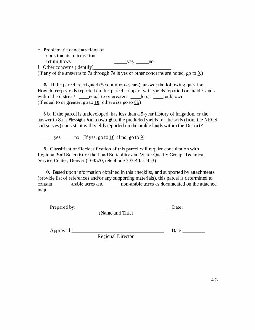
4-3
e. Problematic concentrations of constituents in irrigation return flows _____yes _____no f. Other concerns (identify)_______________________________ (If any of the answers to 7a through 7e is yes or other concerns are noted, go to 9.) 8a. If the parcel is irrigated (5 continuous years), answer the following question. How do crop yields reported on this parcel compare with yields reported on arable lands within the district? ____equal to or greater; ____less; ____ unknown (If equal to or greater, go to 10; otherwise go to 8b) 8 b. If the parcel is undeveloped, has less than a 5-year history of irrigation, or the answer to 8a is Aless@ or Aunknown,@ are the predicted yields for the soils (from the NRCS soil survey) consistent with yields reported on the arable lands within the District? _____yes _____no (If yes, go to 10; if no, go to 9) 9. Classification/Reclassification of this parcel will require consultation with Regional Soil Scientist or the Land Suitability and Water Quality Group, Technical Service Center, Denver (D-8570, telephone 303-445-2453) 10. Based upon information obtained in this checklist, and supported by attachments (provide list of references and/or any supporting materials), this parcel is determined to contain _______arable acres and ______ non-arable acres as documented on the attached map. Prepared by: ____________________________________ Date:________ (Name and Title) Approved:_____________________________________ Date:_________ Regional Director