evaluating the suitability of groundwater for irrigation ... · pdf fileevaluating the...
TRANSCRIPT

Al-Azawi and Al-Shamma'a Iraqi Journal of Science, 2016, Vol. 57, No.4C, pp: 2898-2908
____________________________ *Email: [email protected]
8282
Evaluating the Suitability of Groundwater for Irrigation uses at
Al-Salhubia Area, Al-Muthana Governorate, Southern Iraq
Ali A. Obeed Al-Azawi1*, Ayser Mohammed Al-Shamma'a
2
1General Commission for Groundwater, Baghdad, Iraq.
2Department of Geology, College of Science,
University of Baghdad, Baghdad, Iraq.
Abstract
Al-Salhubia, area is located within the arid region in southern Iraq. Although no
surface water is available in this area, the groundwater is considered the basis in the
area, it is available in both good quality and quantity. For that reason, it is of prime
importance to examine water type in the unconfined aquifer to determine suitability
of groundwater for irrigation purposes. The groundwater type in the studied area is
Ca-Mg dominant SO4 facies according to Piper and Stiff diagrams. Based on SAR,
Na%, RSC, EC, and PI, the groundwater quality in the study area is suitable for
irrigation in general.
Keywords: groundwater suitability, irrigation, groundwater type, Al-Salhubia
جنوب العراق المثنىمحافظة منطقة آلسلحوبية مياه الجوفية ألستخدامات الري فيتقييم مدى مالئمة ال
2أيسر محمد الشماع ،*1علي عبد الرحيم عبيد العزاوي
، العراقبغداد ، الهيئة العامة لممياه الجوفية1 ، العراقبغداد، جامعة بغداد ،كمية العموم ،قسم عموم االرض 2
الخالصةولعدم توفر المياه السطحية، تعتبرالمياه .تقع منطقة السمحوبية ضمن المنطقة القاحمة في جنوب العراق
الجوفية األساس في المنطقة وهي متوفرة بصورة جيدة نوعا وكما. لهذا السبب فان من المهم دراسة نوعية المياه مة المياه الجوفية ألغراض الري. تتميز المياه الجوفية في منطقة الدراسة ئفي الخزان غير المحصور لتحديد مال
,EC, RSC استنادا الى. Stiff و Piper لمخططات كبريتات الكالسيوم والمغنيسيوم وفقابسيادة سحنة Na%, SAR و PIلدراسة هي مناسبة لمري بشكل عام.تبين أن نوعية المياه الجوفية في منطقة ا
Background
In southern Iraq, semiarid and arid regions with low precipitation and high potential of
evapotranspiration are abundant. Rapid investment growth through last years, increased irrigation, and
industrial development during the past decades have caused an increasing demand on water resources
in semiarid and arid regions [1].
ISSN: 0067-2904

Al-Azawi and Al-Shamma'a Iraqi Journal of Science, 2016, Vol. 57, No.4C, pp: 2898-2908
2899
The increased knowledge of geochemical processes that control groundwater chemical composition
could lead to improve the understanding of hydrochemical systems in such areas. Such understandings
like rock-water interactions, aquifer lithology, and dissolution and residence time of groundwater may
be helpful to improve the groundwater quality. The hydrochemical of groundwater is an important
factor in determining its use for different patterns such as agriculture, industry, livestock ranches and
household activities. Water quality has an individual pattern of physical and chemical characteristics,
which are determined largely by the climatic, geomorphological and geochemical conditions
prevailing in the drainage basin and the underlying aquifer [2].
Al-Salhubia area is considered one of the good areas in Al-Samawa Governorate, where it depend
on groundwater in possessing different economic activities such as agriculture, industry, and livestock
breeding for pastoral purposes. Groundwater is regarded as the only essential source for water in the
area and is available in both good quality and quantity. Water users in that region have been dependent
on groundwater quality and use to meet their needs for water-related irrigation [3].
Some previous investigations were conducted in this region. The authors, Parsons Company (1957)
[4] and GEOSURV (1983) [5] carried out some of the hydrogeological and hydrochemical studies for
southern desert, which include the Salman basin. These studies covered the evaluation of some
hydrochemical properties of the water springs, the discharge measurement and suitability of available
water in the area, and the reasons for the presence of springs along the western edge of the Euphrates
river. They reported that the reason for this amount of water was due to the presence of faults in Al-
Furat fault zone, which is of great importance. These authors were not able to break out historical
groundwater use patterns across the various uses such as agriculture, industry, livestock ranching, and
domestic uses. This important gap motivates the current investigation.
AL-Shamma`a (2000) [6] focused on investigating the origin of the spring water in south of
Euphrates river. She studied the water chemistry for some wells and springs in an approach to find the
relationship between the compositional structure of the basin and spring water.
A comprehensive study of Al-Rehab area located southwest of Samawa city was carried by Al-
Shamari (2006) [7]. He found that the groundwater use patterns have exceeded the amount of
groundwater recharge at the basin.
Despite these achievements described above, important gaps remain in the search for suitability of
groundwater in different uses including agriculture. Therefore, the present study aims to evaluate the
suitability of groundwater in Al Salhubia for agricultural activities.
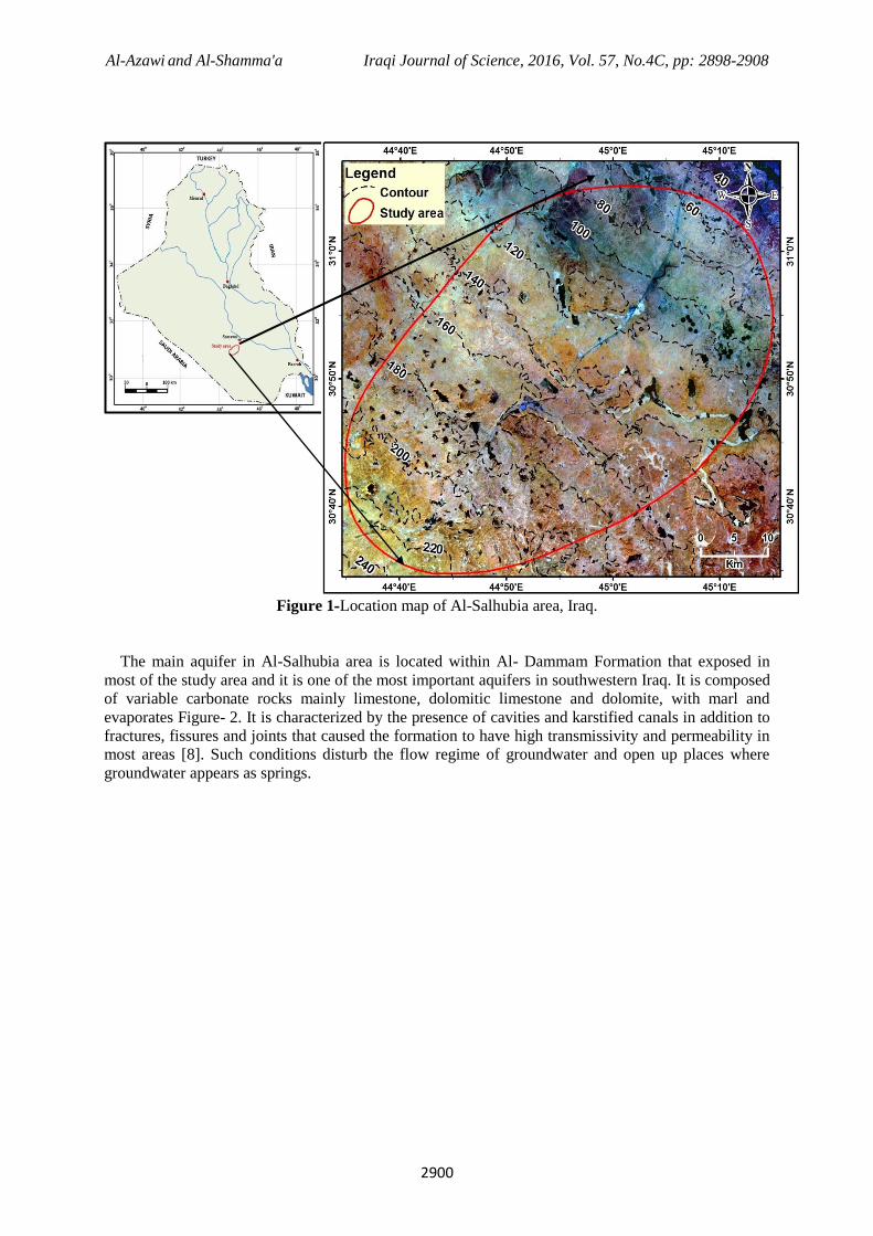
Study Area
The study area is located in the stable zone of Iraq southwest Al-Samawa city in a distance of about
70 km. It occupies an area over 3,000 km2 (80km in length and 37.5km in width). The surface of the
study area is nearly flat and generally slopes in a southwest where the elevation reaches 200 m above
sea level while towards the northeast; the elevation is less than 110m with low degrees of slope as seen
from the main direction towards the Euphrates river Figure-1.
Al-Azawi and Al-Shamma'a Iraqi Journal of Science, 2016, Vol. 57, No.4C, pp: 2898-2908
2900
Figure 1-Location map of Al-Salhubia area, Iraq.
The main aquifer in Al-Salhubia area is located within Al- Dammam Formation that exposed in
most of the study area and it is one of the most important aquifers in southwestern Iraq. It is composed
of variable carbonate rocks mainly limestone, dolomitic limestone and dolomite, with marl and
evaporates Figure- 2. It is characterized by the presence of cavities and karstified canals in addition to
fractures, fissures and joints that caused the formation to have high transmissivity and permeability in
most areas [8]. Such conditions disturb the flow regime of groundwater and open up places where
groundwater appears as springs.

Al-Azawi and Al-Shamma'a Iraqi Journal of Science, 2016, Vol. 57, No.4C, pp: 2898-2908
2901
Figure 2-Geological map of Al- Salhubia area (Modified from GEOSURV, 1996) [9].
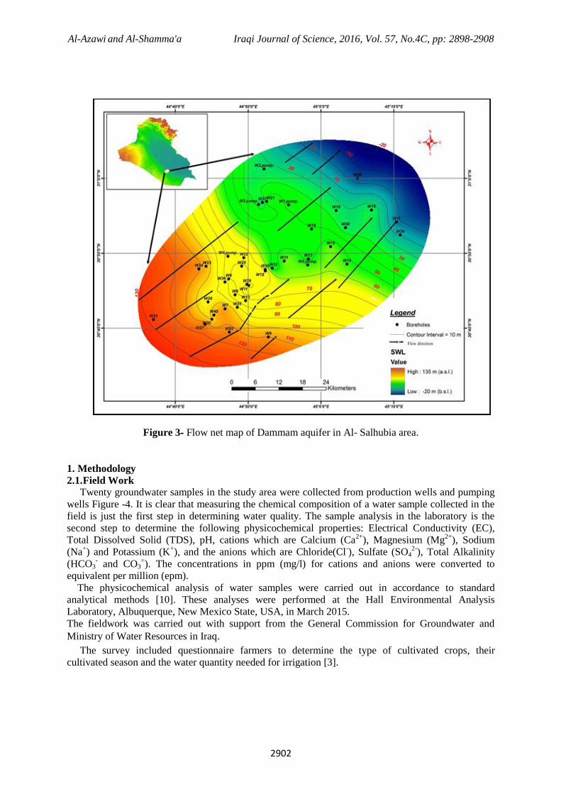
Dammam Formation is considered the main invested reservoir in the area through existing wells. This
aquifer is unconfined and inhomogeneous. The thickness of the aquifer increasing from southwest to
northeast direction and the aquifer is gently dipping in the same direction, the movement of
groundwater from the west and southwest towards the east and northeast Figure-3.
Al-Azawi and Al-Shamma'a Iraqi Journal of Science, 2016, Vol. 57, No.4C, pp: 2898-2908
2902
Figure 3- Flow net map of Dammam aquifer in Al- Salhubia area.
1. Methodology
2.1. Field Work
Twenty groundwater samples in the study area were collected from production wells and pumping
wells Figure -4. It is clear that measuring the chemical composition of a water sample collected in the
field is just the first step in determining water quality. The sample analysis in the laboratory is the
second step to determine the following physicochemical properties: Electrical Conductivity (EC),
Total Dissolved Solid (TDS), pH, cations which are Calcium (Ca2+
), Magnesium (Mg2+
), Sodium
(Na+) and Potassium (K
+), and the anions which are Chloride(Cl
-), Sulfate (SO4
2-), Total Alkalinity
(HCO3- and CO3
=). The concentrations in ppm (mg/l) for cations and anions were converted to
equivalent per million (epm).
The physicochemical analysis of water samples were carried out in accordance to standard
analytical methods [10]. These analyses were performed at the Hall Environmental Analysis
Laboratory, Albuquerque, New Mexico State, USA, in March 2015.
The fieldwork was carried out with support from the General Commission for Groundwater and
Ministry of Water Resources in Iraq.
The survey included questionnaire farmers to determine the type of cultivated crops, their
cultivated season and the water quantity needed for irrigation [3].

Al-Azawi and Al-Shamma'a Iraqi Journal of Science, 2016, Vol. 57, No.4C, pp: 2898-2908
2903
Figure 4 - Location map of groundwater samples, Al-Salhubia area
2.2 Groundwater Used in Irrigation
Water quality analysis is one of the most important aspects in groundwater studies. Hence, the
hydrochemistry of groundwater is an important factor in determining its use for different aspects such
as agriculture, industry, livestock ranches and household activities. The suitability of groundwater for
irrigation depends on the plant's ability to withstand the groundwater salinity. Therefore, the water
quality plays a significant role in agriculture.
There are many problems, which may originate during the use of water for irrigation, such as
salinity, infiltration and permeability due to other factors effect on sensitive crops, so, the groundwater
that contain high ratio of salt will effects on crop growth. As well as, the pH, Sodium, and trace
elements also effect the suitability of water for irrigation [11]
2.3 Results and discussion
Classification of Groundwater in the study area
The classification of the groundwater depends on Piper (1944)[12]and Stiff (1951)[13] diagrams. It
shows that the groundwater has a secondary salinity due to Piper classification (Figure-5), while
according to stiff diagram; the groundwater in the study area is of a single source and not
from different sources Figure-6. Depending on the above classifications, the hydrochemical
facies are Ca–Mg dominant SO4facies with a same source.

Al-Azawi and Al-Shamma'a Iraqi Journal of Science, 2016, Vol. 57, No.4C, pp: 2898-2908
2904
Figure 5- Piper diagram for groundwater samples that showing hydrochemical facies, Al-Salhubia
area.
Figure 6- Stiff diagram for the ionic concentrations in groundwater samples Al-Salhubia area.
Al-Azawi and Al-Shamma'a Iraqi Journal of Science, 2016, Vol. 57, No.4C, pp: 2898-2908
2905
The main results of groundwater chemical analysis in the study area are given in Table -1. The
interpretation of the groundwater quality data for irrigation has been carried out through measuring
Sodium Adsorption Ratio (SAR), Sodium percentage(%), Residual Sodium Carbonate (RSC),
Electrical conductivity (EC) and Permeability Index (PI).The following explain and describe the
classifications in details:
1-Sodium Adsorption Ratio (SAR)
SAR is an important parameter for the determination of soil alkalinity or alkali hazard in the use of
groundwater for irrigation purposes. Calculation of SAR value for a given groundwater provides a
useful index of the sodium hazard in water for soils and crops. The value of SAR can be calculated
using the following equation [14]:
√
----- ----- (1)
The value of SAR in the groundwater samples of the study area ranged from 2.2 to 8.2 epm with an
average 4.4 epm (Table 1), which represent low alkali hazard and is suitable for any type of crops to
be cultivated. Don (1995) [15] has classified water for irrigation purposes depending on the values of
pH, EC, TDS, SAR, and Na% Table- 2. Accordingly, all groundwater samples fall under the
classification of good.
Table 1- Concentration of ions and important irrigation water classifications, Al-Salhubia area.
Parameters, Ions and
classifications Units Minimum Maximum Average
pH ----- 7.5 7.9 7.7
TDS ppm 3760 6460 4834
Ca+2
epm
26.5 33.5 30.5
Mg+2
13.2 18.2 16.0
Na+ 9.6 52.2 22.8
K+ 0.4 1.1 0.7
Cl- 8.7 50.7 22.2
SO4= 43.8 56.3 50.1
HCO3- 0.4 3.0 1.5
SAR 2.2 8.2 4.4
Na% 19.0 53.0 32.0
RSC -50.0 -37.5 -45.0
EC µs\cm 4000 7800 5635
PI epm 20.8 51.9 34.7
2- Sodium percentage (Na %)
The sodium concentration is very important in assessing groundwater with respect to
suitability as irrigation water [16]. The high content of sodium ion in irrigation water will be
dangerous on soil since it leads to decrease its porosity as a result of ionic exchange of
calcium and magnesium in the soil with sodium. Ordinarily, either type of sodium-saturated
soil will support little or no plant growth. Na% value can be calculated by the following
equation [14]:
---------------- ------- (2)
Table -1 shows that Na % lies within the permissible limits and do not exceeds 60% according to
Don classification (1995) Table- 2 .
3-Residual Sodium Carbonate (RSC)
Eaton (1950) [17] has suggested a formula to the residual sodium carbonate (RSC). Where the
concentration of bicarbonate and carbonate used in assessing groundwater quality also influences the
suitability of water for irrigation purpose. RSC can be calculated using the following equation:

Al-Azawi and Al-Shamma'a Iraqi Journal of Science, 2016, Vol. 57, No.4C, pp: 2898-2908
2906
RSC = [(CO32-
+ HCO3-) – (Ca
2+ +Mg
2)] --- ------------- (3)
Richard (1954) [18] classified the water on the basis of RSC Table- 3. Based on this classification,
results indicate that the groundwater in the study area is good for irrigation.
Table 2- Classification of Don (1995) for irrigation water.
EC
µs\cm
TDS
Ppm SAR Na% pH Water Quality
250 175 3 20 6.5 Excellent
251−750 175-525 3-5 20-40 6.5-6.8 Good
751−2000 525-1400 5-10 40-60 6.8-7.0 Permissible
2001−3000 1400-2100 10-15 60-80 7-8 Doubtful
>3000 >2100 >15 >80 >8 Unsuitable
Table 3-Richard classification (RSC) for irrigation water (1954).
Range Water quality
< 1.25 Good
1.25-2.5 Medium
>2.5 Bad
4- Electrical conductivity (EC)
Electrical conductivity (EC) is important in assessing groundwater quality that affecting on crop
productivity. Don, (1995) [15] classified water for irrigation purposes, which depends on EC values
Table- 1. Based on this classification, results indicate that the groundwater in the study area is
unsuitable for irrigation, because the water of the Dammam unconfined aquifer is excessively
mineralized water. Todd classification (2007) [14], which depends on electrical conductivity for the
plants tolerance difference show that the groundwater of the study area is suitable for all kinds of
crops Table- 4.
Table 4-Todd classification for tolerance crops by relative salt concentrations for agriculture (2007).
Crops
Division
Low salt tolerance
crops
Ec (µs /cm)
Medium salt tolerance
crops
Ec (µs /cm)
High salt tolerance
crops
Ec (µs /cm)
Fruit Crops
0 ─ 3000
Limon, Apricot, Pear,
Orange, Apple, Peach
3000 ─ 4000
Olive, Figs, Cantaloupe,
Pomegranate
4000 ─ 10000
Date palm
Vegetable
Crops
3000 ─ 4000
Green beans,
Celery, Radish
4000 ─ 10000
Cucumber, Onion,
Carrot, potatoes, Lettuce,
Tomato, Cauliflower
10000─12000
Spinach, beets
Field Crops
4000 ─ 6000
Fields beans
6000 ─ 10000
Sunflower, Flax,
Corn, Rice
10000─ 16000
Cotton, Sugar beet, Barley
(grains)

Al-Azawi and Al-Shamma'a Iraqi Journal of Science, 2016, Vol. 57, No.4C, pp: 2898-2908
2907
5- Permeability Index (PI)
The soil permeability is influenced by long-term use of irrigation water and sodium, calcium,
magnesium, bicarbonate content of the soil [19]. Doneen (1964) [20] has evolved a formula for
permeability index (PI) to measure the soil permeability for assessing suitability of groundwater for
irrigation purpose. This index is depended on Ca, Na , Mg, and HCO3 ions, which can be calculated by
the following equation:
PI= √
--------------- ------------ (4)
Doneen (1964) [20] has divided this classification, the Permeability Index (PI) values less than
25% falls into Class-I and Class-II includes PI values that range between 25% and 75% are classified
as good for irrigation, as for Class-III includes PI values greater than 75% is unsuitable for irrigation
[21]Table- 5. Based on this classification, results indicate that the groundwater in the study area is
under class-II, and class-I, which represents 5% and 75% respectively, which considered as good for
irrigation.
Table 5-Doneen classification for Permeability Index(PI) for irrigation water(1964), Al-Salhubia area.
PI class Range Sample no. Total no. Percentage (%)
Class-I < 25 3,6,10,18,22 5 25
Class-II 25-75 1,2,4,5,7,8,9,11,12,
13,14,15,16,17,19,20 15 75
Class-III >75 ------------- ----------- -----------
2.5 Conclusions
The Dammam unconfined aquifer is considered the most important regional aquifer in the studied
area. According to the type of groundwater, the water type shows that the hydrochemical facies are
Ca–Mg dominant SO4 facies of the same source.
The suitability of groundwater for irrigation has been assessed based on SAR, Na%, RSC, EC, and
PI. According to these classifications, the groundwater quality in the study area is suitable for
irrigation in general. During the fieldwork, flood irrigation methods are the only irrigation method
used in the area, which may lead to increase in levels of water use as well as increased soil salinity.
Therefore, it may be more suitable to irrigate by modern irrigation methods such as drip irrigation or
sprinkler systems, especially in conditions where these methods will save water and protect soils.
Acknowledgments The authors express appreciation to the General Commission for Groundwater, Ministry of Water
Resources, Iraq for the help in the fieldwork survey.
References 1. Elaine, D., Kristina, D., Roland, M., Geoffroy, P., and Tetsuya, U. 2008. Sustainable Water
Strategies for Jordan, International Economic Development Program Gerald R. Ford School of
Public Policy, University of Michigan.
2. Sen, A. Z. 2015. Practical and Applied Hydrogeology, Elsevier, Inc. First edition, 407p.
3. Directorate of Al-Samawa Agriculture, 2015. Data of Agricultural production in Al-Salhubia,Iraq.
4. Parsons, R. M., Eng. Co. 1957. Groundwater Resources of Iraq-Ministry of development,
Government of Iraq. Unpublished report- Engineering co.
5. GEOSURV.1983. Final report on key well No.5 Al-Salhubia Hydrogeological and Hydro-
technical exploration in block1,2,3,Vol. (8-5).
6. Al-Shamma′a, A. M. 2000. The Source of Water Springs along the faulted zone of Southern
Euphrates River. Iraqi Geological Journal, vol. 33, pp:129-145.
7. Al-Shamari, A. N. 2006. Hydrogeology and Hydrochemistry of Rehab area/South and South-West
of Samawa city. M.Sc. Thesis, University of Baghdad, College of Science (un published). 110p.
(In Arabic).
8. Jassim, S. Z. and Goff, J. C. 2006. Geology of Iraq, Dolin Prague and Moravian Museum , Brno,
341p.
9. GEOSURV, 1996. Geological map of Iraq, scale1:1,000,000 Baghdad, Iraq.

Al-Azawi and Al-Shamma'a Iraqi Journal of Science, 2016, Vol. 57, No.4C, pp: 2898-2908
2908
10. USEPA (United State Environmental Protection Agency),2012: 2012 Edition of the Drinking
Water Standards and Health Advisories, Report EPA 820-R-11-002, Office of Water U.S.
Environmental Protection Agency Washington, DC.
11. Todd, D.K. 2005. Groundwater Hydrology, 3rd ed., Wiley and Sons Inc., New York, U.S.
12. Piper, A. M. 1944. A graphic procedures in geochemical interpretation of water analysis. Trans.
Am. Geophys. Union 25, pp: 914 – 923.
13. Stiff, H. A. 1951 :The interpretation of chemical water analyses by means of Patterns', Jour.
Petroleum Technology, 3(10), Section1, 15-17; Section 2,3.
14. Todd, D. K. 2007. Groundwater hydrology, second edition, John Wiley and Sous, Third Reprint.
Inc. India. 535p.
15. Don, C.M. 1995. A grows guide to water quality. University college station, Texas.
16. Khodapanah, L., Sulaiman, W.N.A., and khodapanah, N. 2009. Groundwater quality assessment
for different purposes in Eshtehard District, Tehran, Iran. European Journal of Scientific Research,
36(4), pp:543-553.
17. Eaton, E.M. 1950. Significance of carbonate in irrigation water. Soil. Sci., 69, pp: 123-133.
18. Richards, L.A. 1954. Diagnosis and Improvement of Saline and Alkali Soils. USDA and IBH Pub,
Coy Ltd., New Delhi, India. Agric. Handbook 60, pp: 98-99.
19. Raju N. Janardhana., 2007. Hydrogeochemical parameters for assessment of ground water quality
in the upper Gunjanaeru River basin, Cuddapah District, Andhra Predesh, South India,
Environmental Geology, 52, pp: 1067-1074.
20. Doneen L. D. 1964. Water Quality in Agriculture, Water Science and Engineering Paper 4001,
California, Department of Water Science and Engineering, University of California.
21. Nagaraju, A., Suresh, S.,Killhan, K.,and Hudson-Edwards,K. 2006. Hydrogeochemistry of waters
of management barite mining area, Cuddapah Basin, Andhra Pradesh, India. Turkish Journal of
Engineering Sciences, 30, pp: 203-219.