tasmanian subdivision guidelines - lgat · october 2013 tasmanian subdivision guidelines an...
TRANSCRIPT

OCTOBER 2013
Tasmanian Subdivision Guidelines
An engineering design and construction resource
A joint project of Tasmanian Local Government Authorities

The local government authorities listed below are participating councils:
REGIONAL SUBDIVISIONAL GUIDELINES Approval Date: October 2013 Version: 1.0
CONTENTS Clause: Page No: 1. Background ........................................................................................................... 1
2. Abbreviations & Interpretations .............................................................................. 1
3. General Design Requirements ............................................................................... 2
4. Services ................................................................................................................. 2
5. Geometrical Design - Urban Roads ....................................................................... 3
6. Geometrical Design - Rural Roads ......................................................................... 4
7. Provisions for Heavy Traffic and Climbing Lanes ................................................... 4
8. Crossfall ................................................................................................................. 4
9. Pavement Design .................................................................................................. 4
10. Wearing Course ..................................................................................................... 5
11. Kerb and Channel, Footpaths and Crossings ......................................................... 5
12. Road Verge, Cutting and Embankments ................................................................ 6
13. Drainage System ................................................................................................... 7
14. Variations ............................................................................................................... 8
15. Landscaping of Public Open Spaces, Reserves and Road Reservations ............... 8
16. Erosion and Sediment Control during Construction ................................................ 9
17. Easements ........................................................................................................... 10
18. Design and Construction Generally ...................................................................... 10
19. Submission of Design Plans for Approval & Fee Structure ................................... 11
20. Postponement and Timing of Works .................................................................... 11
21. Supervision of Works and Council Audit Inspections............................................ 12
22. Practical Completion ............................................................................................ 13
23. Sealing Final Plans of Survey .............................................................................. 14
24. Final Inspection & Hand-over ............................................................................... 15
25. Further Information .............................................................................................. 15
Appendix 1: Participating Councils and Contact Details ....................................... 16
Appendix 2: Specified Departures for Individual Councils .................................... 18
Appendix 3: Approved Materials for Stormwater Pipelines ................................... 24
Appendix 4: Fee Structure for Engineering Plan Approval and Audit Inspections . 25
Appendix 5: Sample Certification Statement from Supervising Engineer. ............. 27
Appendix 6: Works to be completed prior to Practical Completion ....................... 28
Appendix 7: Soil and Water Management Plans - Information ............................. 29
Amendment Table ............................................................................................... 32
Disclaimer: This document will be periodically updated by a Committee co-ordinated by the Local Government Association of Tasmania (LGAT) including representatives from the local government regions. Please ensure that you are using the most current version of this document.

REGIONAL SUBDIVISIONAL GUIDELINES Approval Date: October 2013 Version: 1.0
1
1. Background
Most subdivision developments involve the construction of significant public infrastructure which becomes the Council’s responsibility to maintain and replace.
These guidelines provide information on the minimum standards required by the participating Tasmanian Councils listed in Appendix 1 for the design and construction of roads and utilities as per the relevant statutory requirements (including Drains Act 1954 and Local Government Act Highways 1982). Additionally this document outlines the process to be followed during the construction of civil works; audit inspections, practical completion of works, defects liability period and final take-over of the roads and civil works. It is intended that this guide be used by developers, construction contractors, design/supervising engineers as well as Council officers and senior management.
The Council’s Engineering Department is required to determine the engineering merits of development proposals and these guidelines specify the information required to be able to properly consider an application for approval of a plan of subdivision.
In certain circumstances the development of an area wide outline development plan may be required, particularly where connectivity between areas of land is important or not clear. It is important that these issues are discussed with the Council’s planning and engineering departments at an early stage. 2. Abbreviations & Interpretations
2.1 Abbreviations SD Council Standard Drawings & Specifications IPWEA Institute of Public Works Engineering Australia
2.2 Interpretations
‘A Speed Limited Area’ has the meaning assigned to it in regulation 22 of the Road Rules 2009.
‘Applicant’ means an applicant for sub-division approval or for the carrying out the construction and civil works.
‘Council’ means a council established under s18 Local Government Act 1993.
‘Council Standard Drawings’ means the engineering drawings and specifications adopted by the Council for the construction and maintenance of new and existing works and infrastructure.
‘DIER’ means the Department of Infrastructure Energy and Resources.
‘Local Area Traffic Management (LATM)’ means the use of physical devices, streetscaping treatments and other measures (including regulations and other non-physical measures) to influence vehicle operation, in order to create safer and more liveable local streets.
‘Local highway’ has the meaning assigned to it in the Local Government (Highways) Act 1982.
‘Planning Permit´ means a permit granted pursuant to Division 2 of Part 4 of the Land Use Planning and Approvals Act 1993.
‘Public Services’ means electricity, telecommunications, sewage, water, stormwater and gas services.
'Major drainage network' means a system which includes stormwater originating from a public road, public reserve or from land external to the subdivision.

REGIONAL SUBDIVISIONAL GUIDELINES Approval Date: October 2013 Version: 1.0
2
3. General Design Requirements
3.1 The geometric layout of roads in a Council area is to be in accordance with Austroads Guide to Road Design Parts 1-8 as varied from time to time.
3.2 The design requirements for a proposed Highway may vary depending on the proposed traffic speed. The design standards for highways with differing traffic speeds will be determined in accordance with the appropriate Austroads Standard. The traffic speed for a proposed road should accord with the prevailing speed limits in the area where the road is to be constructed. Final approval for a proposed speed limit is to be sought from DIER.
3.3 The use of any proposed Local Area Traffic Management (LATM) device is subject to the approval of DIER. Fully dimensioned plans of any proposed LATM device must be submitted to Council for endorsement prior to submission to DIER. Any plans submitted to the Council that do not comply with the aforementioned standards must be accompanied by a detailed explanation of the reason for the variation.
3.4 All construction works and design details shall comply with the Council Standard Drawings.
3.5 Where any variation is proposed the approval of the Council is to be obtained in writing prior to the approval of the engineering design plans and specifications.
4. Services
4.1 Every lot within a subdivision shall be provided with:
An underground stormwater discharge connection, generally at the low point of every lot, being DN100 unless otherwise specified in Appendix 2 or the relevant planning permit for the subdivision.
A fully constructed vehicular crossing from the edge of the road pavement to the property boundary. In industrial and commercial subdivisions the vehicular crossing and apron shall be subject to detailed design or in accordance with Council's Standard Drawing for heavy vehicle access.
4.2 All public services that are to be installed within a road reservation are to be located underground and to be in accordance with the requirements of the Council’s Standard Drawings.
4.3 Where it is proposed to install services that do not comply with the Council's Standard Drawings the Council may approve a variation from those Standard Drawings provided that the clearance between pipelines shall not be less than -
Horizontally – 300mm or if diameter >200mm then 500mm
Vertically – 150mm or if diameter > 200mm then 300mm
Services may share a common trench provided that stormwater, water & gas services are vertically offset to allow horizontal extensions.
4.4 Electrical cables and conduits shall have a minimum 400mm clearance of which 300mm shall be undisturbed ground. The Applicant shall be responsible to comply with all conditions of the approval as given.
4.5 Where it is proposed to make a connection to an existing Council stormwater main an application with detailed drawings must be lodged with the Council for approval.
4.6 No work is to take place in existing public road reserves or existing Council easements without obtaining the prior written consent of the Council.

REGIONAL SUBDIVISIONAL GUIDELINES Approval Date: October 2013 Version: 1.0
3
4.7 The materials to be used for stormwater pipelines are to be as specified in Appendix 3.
4.8 If the installation of services requires the replacement of a stormwater main which is located on property adjacent to the area where the services are to be installed, the Council may issue any notice that is required under the Drains Act 1954 for the purpose of constructing and/or replacing a stormwater main. The Applicant shall be responsible for the following:
i) The cost of constructing or replacing the stormwater main including the costs necessary to enter the adjacent land.
ii) All Council charges and incurred costs for work that the Council is required to do as part of a replacement or installation of a stormwater main.
iii) The Applicant is to indemnify the Council for any compensation it must pay to owner of land which has been entered for the purpose of replacing or constructing a stormwater main. The compensation is to be determined as provided for s25 of the Drains Act 1954
5. Geometrical Design - Urban Roads
5.1 Unless otherwise approved by the Council the minimum pavement and reservation width of any road to be constructed will be as shown in Council's Standard Drawings.
5.2 Unless otherwise approved by the Council any gully or low point on the land on which a road is to be constructed shall be contained within a road reservation, drainage easement or public reserve.
5.3 The minimum dimension of the pavement of any turning circle and road reservation in any residential cul-de-sac will be as shown in Council's Standard Drawings. The Council may approve the use of "Y" or other shape turning head as an alternative to a full circle within a road reservation for residential subdivisions unless otherwise specified in Appendix 2.
5.4 Cul-de-sacs in industrial subdivisions shall be designed to allow 21.0m long semi-trailers and adjacent on-road passenger vehicle parking unless otherwise specified in Appendix 2.
5.5 An alternative design to what is provided for in part 5 of these Guidelines may be considered by the Council. If an alternative design is proposed then a detailed submission is to be lodged with the Council including detailed design specification and plans.
5.6 If a road is designed for one-way traffic the Council may, subject to detailed design, agree to reduce the width of the trafficable pavement.
5.7 In exceptional circumstances, the Council may approve variations to the requirement of Council's Standard Drawings. Before a Council will consider any such variation an Applicant must lodge with the Council a detailed submission including plans and specifications. Such plans must, where appropriate, take account of the movement of service and transport vehicles, the likelihood of public bus routes, on street parking and any other relevant traffic issues.
5.8 The longitudinal gradient of the pavement is to conform to the maximum and minimum grades as shown for kerb and channel in Clause 11.3.1.

REGIONAL SUBDIVISIONAL GUIDELINES Approval Date: October 2013 Version: 1.0
4
6. Geometrical Design - Rural Roads
6.1 Unless otherwise approved by the Council and subject to Clause 7, the minimum pavement width of a rural road is as shown in Council's Standard Drawings.
6.2 The minimum dimension of the pavement of any turning circle and road reservation in any residential cul-de-sac will be as shown in Council's Standard Drawings.
6.3 The longitudinal gradient of the pavement is to conform to the maximum and minimum grades as shown for kerb and channel in Clause 11.3.1. This allows table drains to be constructed at an appropriate grade to allow satisfactory stormwater flow.
7. Provisions for Heavy Traffic and Climbing Lanes
7.1 If the Council determines that a road requires additional pavement width for bus traffic, climbing lanes, parking clear of traffic lanes or because of the nature and volume of expected traffic, the Council may determine a greater road width than provided in Council's Standard Drawings.
7.2 In cases where the road will become part of a bus route or may be subject to regular use by heavy vehicles, the longitudinal gradient along the pavement centre line is not to exceed 10%.
8. Crossfall
8.1 The surface of the road pavement is to have a crossfall as shown in Council's Standard Drawings except when required to suit super-elevations and transitions.
8.2 Turning heads are generally to be within the 3% to 5% range.
9. Pavement Design
9.1 The structural design of the pavement of a road is to be certified by a suitably qualified engineer, having taken into account an appropriate geotechnical investigation of the sub-grade. The geotechnical report upon which the engineer relies shall, as a minimum:
be certified by an appropriately qualified engineer
show the location of the test results
a minimum of three tests with a maximum spaces of 80 metres between test locations.
provide CBR results
provide Atterberg limits
Where specified in the Planning Permit a more comprehensive report shall be required.
9.2 Any design plans and specifications submitted for approval by the Council are to be accompanied by pavement design calculations to demonstrate that the design is appropriate. All design reference material should be specified.
9.3 Notwithstanding the results of the analysis in Clause 9.2, the minimum pavement thickness is not to be less than that specified in Council's Standard Drawings.

REGIONAL SUBDIVISIONAL GUIDELINES Approval Date: October 2013 Version: 1.0
5
9.4 All pavement materials used or intended to be used in the sub-base and base courses are to conform to the requirements of Council's standard specification for fine crushed rock.
9.5 Clauses 9.3 and 9.4 do not apply for rigid road pavements that primarily involve full depth asphalt or concrete.
10. Wearing Course
10.1 Subject to Clause 10.2 the wearing course:
a) For urban roads to consist of bituminous concrete of a compacted thickness as specified in the Council's Standard Drawings.
b) For rural roads the Council may determine that the wearing course is any of the following:-
(i) the standard for urban roads; or
(ii) an application of primer followed by one application of bituminous binder and one application of aggregate; or
(iii) one application of bituminous binder and one application of aggregate followed by a further application of bituminous binder covered in turn by smaller sized aggregate.
10.2 The Council may allow the use of an alternative type of material in the pavement or wearing course provided it is not of a lesser standard than that specified in Clauses 9 and 10.
11. Kerb and Channel, Footpaths and Crossings
NOTE: For the purposes of this clause the term footpath shall include cyclepaths and shareways.
11.1 All concrete for construction works shall comply with Council's Standard Drawings and where appropriate shall comply with AS3600 for coastal and salinity affected areas.
11.2 Subject to Clause 14, footpaths and kerb and channel are not required in rural roads.
11.3 Subject to Clause 14, kerb and channel may be substituted with appropriate WSUD systems.
11.4 If kerb and channel access crossings, footpaths and footpath crossings are required then each is to be formed to the following minimum requirements:-
11.4.1 Kerb and channel (i) Kerb and channel is to be formed using a continuous forming
machine in accordance with the dimensions shown on the Council's Standard Drawing. Kerb & channel profile 'KC' shall be used unless otherwise specified in Appendix 2 or otherwise approved by the Council.
(ii) Except as provided in Clause 7, the kerb and channel is to have a longitudinal gradient not flatter than 0.5% (except for instantaneous grade) and not steeper than 14% except that in special circumstances the Council may permit a grade of 20% for short lengths of road up to 70m;
(iii) The aggregate length of road at a grade steeper than 14% is not to exceed;
a total length of 100m, or
REGIONAL SUBDIVISIONAL GUIDELINES Approval Date: October 2013 Version: 1.0
6
20% of the total road length, whichever is the greater.
11.4.2 Vehicular crossings (i) Residential accesses shall be constructed in accordance with
Council's Standard Drawing and be installed in the location as shown on the approved plans;
(ii) Commercial and industrial accesses shall be constructed in accordance with the Council's Standard Drawing for heavy vehicle access. Where variations to the road width have been sought, detailed vehicle turning diagrams are to be submitted to the Council.
(iii) On proposed lots with a slope>20%, a longitudinal section shall be provided along the centre line of the driveway between the kerb line and the proposed house site. Unless a variation has been granted the maximum slope shall be:
as shown in the Council's Standard Drawings for urban driveways and
25% within the property boundary.
11.4.3 Footpaths, Pedestrian Ramps and Tactile Indicators (i) Footpaths are to conform to the dimensions and construction
details shown on the Council's Standard Drawings. (ii) If footpaths are constructed across a driveway crossing then the
common section shall be constructed to the same standard as the driveway and of the same material as the footpath as shown in Council's Standard Drawings
(iii) If footpaths and/or kerb and channel are to be constructed, footpath crossings and/or driveway crossings are to be constructed at the same time for each and every lot having access to or from that section of the road.
(iv) Pedestrian kerb ramp crossings shall be located to take into account an appropriate pedestrian travel path; the building/fence line and the appropriate traffic site distance.
(v) When required by the Council, tactile ground surface indicators placed on footpaths for the Vision impaired shall be installed in accordance with the Australian Standard AS 1428.4.
12. Road Verge, Cutting and Embankments
12.1 A cutting or embankment is to have a slope no greater than those specified in Council's Standard Drawings.
12.2 Road verge treatment shall be in accordance with the Council's Standard Drawings. The Council may require the construction of retaining walls.
12.3 Slopes flatter than those specified in the table may be required wherein the opinion of the Council, the cutting or embankment constructed to the slope specified in that table would not be stable.
12.4 All road construction and associated retaining walls are to be fully contained in the road reservation.
12.5 If the Council determines that any road, or land adjoining a road, or access to a road, requires support, retaining walls, batters and/or other structures, then such supports, retaining walls, batters and other structures are to be constructed in accordance with plans that have been certified by a suitably qualified engineer and in accordance with any conditions imposed by the Council.

REGIONAL SUBDIVISIONAL GUIDELINES Approval Date: October 2013 Version: 1.0
7
13. Drainage System
13.1 Unless the Council otherwise approves, the alignment of the major drainage system shall be within road and public reserves. The designer shall provide justification if a portion of the major drainage network is to be located across private property.
13.2 A drainage system of sufficient capacity to drain the road and all land draining on to the road is to be designed in accordance with the following:-
(i) The requirements of the current edition of 'Australian Rainfall and Runoff' produced by Engineers Australia;
(ii) Unless specified otherwise in Appendix 2 the design annual recurrence interval shall be :-
Residential (lot < 2 ha) - 5 years.
Rural and Residential (lot > 2 ha) - 2 years with the approval of the Council.
Business, Commercial and Industrial areas - 20 years and 80 percent impervious surface.
Central Business District - 50 years.
(iii) Provision shall be made to allow stormwater flow up to a 100-Year ARI storm, to flow overland without undue inundation of any properties. Flow paths are to be shown on the submitted engineering drawings.
(iv) Concrete side entry or gully pits conforming to the Council's Standard Drawings for the collection of water from the kerb and channel are to be constructed at each low point, tangent point and at other locations required for the satisfactory drainage of the road.
(v) The total length of kerb and channel draining to an entry pit is not to exceed 90m and the depth of entry pits is generally not to exceed 1.5m. A relaxation of this requirement may be permitted along the high side of one-way crossfall pavements.
(vi) Concrete manholes conforming to the Council's Standard Drawings are to be constructed at the end of pipelines and at locations where pipelines intersect or change direction or change gradient. If the end of the Council pipeline is within 30m of a manhole then the terminating manholes may be an inspection pit constructed using a DN600 RCP, a DN600 gatic manhole cover and benched floor.
(vii) The maximum distance between any two connected manholes is to be 90m.
(viii) The minimum internal diameter of pipes used for the drainage of stormwater from any road is to be 300mm.
(ix) Calculations upon which the design is based including details of sub-catchment areas are to be submitted with the engineering drawings and specifications.
(x) Where practicable, drainage systems are to be designed so that all the relevant land continues to drain to the catchment into which it naturally drains.
(xi) Stormwater entry pits may be required on the upstream side of pedestrian kerb ramps where high stormwater flows are expected.
13.3 A property stormwater connection shall be provided to the underground stormwater system at a point to adequately drain the lot.

REGIONAL SUBDIVISIONAL GUIDELINES Approval Date: October 2013 Version: 1.0
8
13.4 Unless otherwise specified in Appendix 2, the property connections are to be constructed of an approved material and to be DN100 from the lot boundary to the underground drainage system. Where connection to the kerb is permitted it is to terminate through the kerb via a prefabricated metal kerb adaptor.
13.5 The Council may require:- (i) cut-off drainage to be constructed to intercept surface or ground water; (ii) sub-surface drainage to be constructed to intercept sub-surface water.
13.6 Stormwater discharge from the subdivision shall be connected into (i) a public water course or (ii) an existing Council underground drainage system
If the second option is chosen then it may be necessary to:-
include a stormwater detention basin/system to control the discharge rate to be equivalent to a rate calculated on runoff from undeveloped land and a storm with an 1 Year ARI and the volume of the system being the maximum volume for the 100-Year ARI period, or
provide hydraulic calculations to confirm that the Council's underground hydraulic system (between the development and a downstream public water course) has capacity based on an ARI as specified in 14.2 (ii).
13.7 The developer may be required to upgrade any existing drainage system where it has been determined that system does not have the capacity to accept the discharge from the subdivided land. The cost of the upgrade is to be borne by the developer.
13.8 Open drains or open channels shall be designed so that the water flow based on a 100-Year ARI shall be:
Velocity (m/s) x Depth (m) < 1.5
All open drains or channels shall:- (i) be constructed of materials to minimise erosion if the potential water
velocity is in excess of 0.5 m/s (bare earth) and (ii) have provision to generally allow vehicle access along both sides. The work necessary to comply with this sub-clause shall be in accordance with Table 5.1 of 'Managing Urban Stormwater' NSW Department of Housing.
14. Variations
14.1 The Council may at its discretion permit the construction of a road that does not comply in whole or in part with these guidelines and/or the Council’s Standard Drawings.
14.2 The Council may at its discretion require a rural road to contain footpaths and/or kerb and channel on one or both sides of the pavement.
14.3 The Council may at its discretion permit the construction of appropriate Water Sensitive Urban Design elements in lieu of kerb and channel and other components/sections of the drainage system. Such elements are to be designed and constructed in accordance with the 'Water Sensitive Urban Design Engineering Procedures for Stormwater Management in Tasmania' produced by the Tasmanian Government, unless otherwise specified.
15. Landscaping of Public Open Spaces, Reserves and Road Reservations
All areas within the subdivision which will become future Council maintained land – i.e. road reservations, public open space, reserves - require the preparation of a landscape plan for approval by the Council.

REGIONAL SUBDIVISIONAL GUIDELINES Approval Date: October 2013 Version: 1.0
9
Generally the landscaping will be the planting of street trees, developing and planting garden beds, sowing pervious areas with grass, construction paths and installing barriers and other landscape furniture, however Council may consider a higher standard of landscaping. Water Sensitive Urban Design elements which form part of the drainage system may be incorporated into the landscaping.
The concept landscape plan must be submitted with the application for a planning permit for a subdivision. The Council may reject all or any part of the plan and require amendments to be made.
All detailed landscape plans for installation should include the following:
General
Title, address of the property, applicant's name and Landscape Architect or approved designer’s name and address.
Scale, north point and drawing date.
Existing Elements
Site boundaries, fences, driveways, retaining walls and any other structures.
Trees and vegetation with a height greater than 3 metres (including plant name, trunk position and canopy spread).
Natural landscape features such as existing natural vegetation, rocky outcrops or water courses.
Details of services or utilities.
Proposed Elements
All new works including structures, fences, retaining walls, steps, paving, mounding, services, utilities, drainage system, lighting, irrigation system, surface materials and grass areas.
The status of existing trees, and whether they are to be retained or removed.
The location of each proposed plant. The plant schedule is to include the botanical name, common name, container/pot size and quantity.
Street tree size will be determined for each application, however generally must be a minimum of 2.5m high at planting.
The design and implementation of the landscape plan must be in conjunction with the Department responsible for Council's parks and recreation areas. Council may specify a liaison officer for this matter.
16. Erosion and Sediment Control during Construction
A Soil and Water Management Plan (SWMP) is to be submitted detailing how soil and water is to be managed on the site during the construction process. Reference should be made to the Tasmanian Government publication 'Soil & Water Management on Building & Construction Sites' in preparing the plan. The management plan is to include the following:
Allotment boundaries, contours, approximate grades of slope and directions of fall.
The location of adjoining roads, impervious surfaces, underground services and existing drainage.
The location and types of all existing natural vegetation, the proposed location of topsoil stockpiles and the limit of clearing, grading and filling.
Details of the critical natural areas such as drainage lines, cliffs, wetlands and unstable ground.
The estimated dates for the start and completion of the works.

REGIONAL SUBDIVISIONAL GUIDELINES Approval Date: October 2013 Version: 1.0
10
The erosion control practices to be used on the site including cut off drains, fencing off areas to be undisturbed and revegetation program.
The sediment control practices to be used including silt fencing, stabilised site access, filter screens for inlets to the drainage system, sediment traps and details of any sediment control device.
The timing of the site rehabilitation or landscaping program.
An outline of the maintenance program for the erosion and sediment controls.
Work must not begin prior to the approval and implementation of the SWMP.
The soil and water management measures are to be maintained on site for the duration of the construction period and until such time as the site has been revegetated to ensure there are no erosion issues from the site.
17. Easements
17.1 Easements shall be created in favour of Council (or other public authority as required) over any public infrastructure systems located in private property. Infrastructure includes but is not limited to stormwater, sewer, water supply, gas, electricity and telecommunications networks.
17.2 The widths of the easements required specified in Tables 17.1.1 and 17.1.2 below assumes pipe is singular and centrally located. If not then easement width increases so that a minimum of half easement width exists on either side of outer edge of pipeline(s). The width shall be rounded-up to the next 0.5m and shall be the wider of the two widths shown.
Table 17.1.1 Easement Width based on Pipe Diameter
Pipe Internal Diameter Easement Width
Up to 450mm 3m
475mm – 900mm 4m
925mm – 1200mm 5m
1200mm + 6m
Table 17.1.2 Easement Width based on Pipe Depth
Pipe Excavation depth Easement Width
1.2m 3m
1.5m 4m
1.8m 5m
2.1m 6m
2.1m + Subject to detail design
17.3 The Council may at its discretion permit easements less than the widths
specified in Tables 17.1.1 and 17.1.2 where a lesser width is determined to have no detrimental effect on the ability of Council to manage and maintain the assets.
18. Design and Construction Generally
18.1. The construction details of specific components of the works shall comply with the Council's Standard Drawings. Refer to Appendix 2 for variations applicable to individual councils.
18.2. The materials used for road works are to be in accordance with the DIER General Specification for Roadworks. Prior to or after approving plans and specifications, the Council, may require test results from a National Association

REGIONAL SUBDIVISIONAL GUIDELINES Approval Date: October 2013 Version: 1.0
11
of Testing Authorities approved laboratory with respect to any materials used in the road works.
18.3 The Council may approve new materials and methods of construction to those set out in this guideline, provided full details including certification are submitted to the Council to substantiate that such new materials and methods will provide an equivalent standard of construction and level of service.
18.4 The design and construction details of Water Sensitive Urban Design elements, where approved, shall comply with the 'Water Sensitive Urban Design Engineering Procedures for Stormwater Management' produced by the Tasmanian Government.
18.5 The Council may reject all or any part of any works which do not comply with the approved plans and specifications and may require the removal and replacement of all or any part of non-complying works.
19. Submission of Design Plans for Approval & Fee Structure
The approved planning permit will specify the level of civil and infrastructure works required for the subdivision.
The applicant will be required to engage a suitably qualified and experienced engineer to prepare design plans and specifications for submission for Council approval.
The engineer is encouraged to submit one full set of the plans (A1 size) and specifications to the Council for initial comment.
Then 2 sets of the final plans and specifications for approval and 1 set of the design documentation must be provided for formal Council approval. A complete electronic set to be provided also.
The Council will set its fees to cover:
Assessment of the design plans and specifications,
Attendance at 'specified' audit inspections, (each follow-up inspection due to non-compliances may incur additional fees) and
A complete inspection at Practical Completion and Final Inspection after the defects liability period.
The fee shall be as periodically set by Council and is given in Appendix 4 for each Council. Additional inspections required over and above the specified audit inspections may be charged to the Developer at an hourly rate.
20. Postponement and Timing of Works
20.1 The Council may require the postponement of any road works to enable other works to be undertaken within the road reservation by the Council or other public authority.
20.2 Where no restrictions have been imposed by a planning permit then works may only occur:-
i) between 7.30am and 6pm Monday to Friday and 8am and 4pm Saturday if the works are within 200m of existing residential buildings;
ii) within daylight hours in other areas; or iii) at any other times or subject to any restrictions imposed by the Council.
Significant restrictions will apply in or near the CBD and existing collector and arterial roads.

REGIONAL SUBDIVISIONAL GUIDELINES Approval Date: October 2013 Version: 1.0
12
21. Supervision of Works and Council Audit Inspections
21.1 The developer shall appoint a qualified and experienced supervising engineer (or company registered to provide civil engineering consultancy services) who will be required to certify practical completion of subdivision construction works. The appointed supervising engineer (or their representative) shall be the primary contact person on matters concerning the subdivision.
21.2 The supervising engineer (or their representative) is required to fully inspect, oversee and call for tests of works and materials to be used in construction to determine compliance with the Council's Standard Drawings and the approved plans and specifications, namely:-
i) Soil and Water Management Plan implementation and maintenance;
ii) Laying pipelines for stormwater;
iii) All gully pits and manholes;
iv) CBR testing or proof rolling of sub-grade
v) Compaction testing and construction of sub-base course;
vi) Compaction testing and construction of base course;
vii) Construction of base for kerb and channel;
viii) All string lines prior to laying kerb and channel;
ix) Application of wearing course;
x) Construction of footpaths and verges, cuttings and embankments; and
xi) Construction of road crossings and accesses prior to pouring or sealing;
xii) Foundation or footing depth and construction for retaining structures;
xiii) Water Sensitive Urban Design elements
21.3 Water Sensitive Urban Design elements will be subject to the inspection and testing regime specified in the letter of approval accompanying the approved engineering drawings.
21.4 The Supervising Engineer (or their representative) shall be responsible to advise the Council of predetermined 'hold-points' to allow Council to undertake audit inspections. A period of 2 working days' notice is required or by mutual agreement for such inspections. Work on the audit components shall not proceed until a Council Officer inspects the work or the agreed inspection time has expired. The Council Audit Inspector must be accompanied by the Supervising Engineer (or their representative) during each and every mandatory audit inspection. The Council will provide the Supervising Engineer (or their representative) with an Audit Inspection Record sheet for certification after each inspection - it is necessary that this record sheet be available on site for completion
21.5 The following mandatory audit inspection notifications for road construction are required:
i) Before stripping top soil Purpose: to inspect implemented 'Soil and Water Management Plan'
ii) Formation/subgrade level (each 200 m section) Purpose: to inspect stringlines and tolerances, to view the CBR in-situ tests and density test results where fill is present
iii) Compacted sub base and K&C stringline Purpose: to sight K&C stringlines and confirm widths, view compaction results and certification that the gravel meets the DIER specification.

REGIONAL SUBDIVISIONAL GUIDELINES Approval Date: October 2013 Version: 1.0
13
iv) Footpath & Driveways (pour-ready) Purpose: to ensure base compaction and concrete boxing and reinforcement are in place, to check manhole levels in footpaths and driveway and view compaction results for industrial asphalt driveways.
v) Final base course (prior to asphalt/bituminous seal) Purpose: to confirm acceptable soil moisture content, sight K&C stringlines and confirm widths, view compaction results and certification that the gravel meets the DIER specification.
21.6 The following mandatory audit inspection notifications for stormwater infrastructure construction are required:
i) Pipelines Purpose: to inspect trench width, bedding material, pipe type and diameter.
ii) Manholes and Side Entry Pits Purpose: to inspect the connection type, benching, drops (internal or external)
iii) Connections Purpose: to inspect the connection type, benching, drops (internal or external).
iv) Headwalls Purpose: to inspect scour protection and discharge alignment
v) Pump Stations (where applicable) i. Attend the factory acceptance testing of the switchboard prior to the
delivery to site. ii. View construction after the installation of the wet well units but prior to
the benching of the floor and installation of the lid Purpose: to confirm layout of pumps, location of switchboard, the correct orientation of the lid, extent of the benching and the general arrangement of the site works.
vi) Gross Pollutant Traps Purpose: to inspect location, grating and access arrangements
21.7 In the event that any work is undertaken without the required audit inspection being undertaken then proof shall be provided to the Council that such work complies with the approved plans and specifications and Council's Standard Drawings. The Council may specify what proof or tests are required to satisfy this requirement.
21.8 Work is not to be commenced on any works until the Council has given written approval of the plans and specifications.
22. Practical Completion
22.1 At the point of Practical Completion of all subdivision works the Supervising Engineer shall request a joint inspection by the Council. The request must be accompanied by the following documentation:
i) 'As constructed' drawings produced in accordance with Council's requirements,
ii) The Supervising Engineers certification that the works comply with the Council’s Standard Drawings and specification and the approved plans and specifications, A sample of the certification statement is provided in Appendix 5,

REGIONAL SUBDIVISIONAL GUIDELINES Approval Date: October 2013 Version: 1.0
14
iii) A civil engineer's certification that any site filling that exceeds a depth of 300mm complies with the provisions of AS3798 'Guidelines on earthworks for commercial and residential development' 2007,
iv) A surveyor's certification that property boundary pegs are in the correct position after the completion of the construction works,
v) A closed circuit television (CCTV) camera survey of all public stormwater pipelines,
vi) The provision of operation and maintenance manuals and associated training for:-
Pump stations
Stormwater detention systems
Gross pollutant traps
Any other item that requires an operational and/or maintenance regime exceeding that normally required;
22.2 If an operation and/or maintenance manual is required the Supervising Engineer shall arrange a joint training session with the relevant Council asset owner. The training session shall be arranged as soon as practical after commissioning.
22.3 If a pump station is constructed as part of a subdivision or development, and will become a Council asset, the Supervising Engineer (or their representative) to organise a pump station site acceptance meeting (and testing) and training for the future operators.
22.4 Upon the successful completion of all mandatory audit inspections, the lodgement of the required construction documentation and the Practical Completion inspection the Council will issue a Certificate of Practical Completion, which may include a list of minor defects. Works which must be complete to enable the issue of the Certificate of Practical Completion are listed in Appendix 6.
22.5 The date of the Certificate of Practical Completion shall be the latest onsite inspection or the date of receipt of the completed documentation, whichever occurs last.
23. Sealing Final Plans of Survey
23.1 Final plans of survey shall not be sealed until all conditions on the Planning Permit pertaining to the subdivision works have been satisfactorily completed, or a formal agreement for the deferment of the works has been entered into by the Developer and the Council.
23.2 The satisfactory completion of the public infrastructure works shall mean when a Certificate of Practical Completion has been issued by the Council and a Bond and Bank Guarantee has been lodged (where required by Council) with Council for the defects liability period.
23.3 The Council shall be entitled to draw funds from the Bank Guarantee (where held) if outstanding or defective works are not completed or remedied by the developer within the timeframe specified in a written notice to do so.
23.4 Upon notification of the acceptance of the Sealed Plan of Survey by the Recorder of Titles, all road lots and public open space lots contained on the plan are to be transferred unencumbered to Council. All costs involved in this process are to be met by the Developer, including the partial discharge of any mortgages affecting the road or public open space lots.
REGIONAL SUBDIVISIONAL GUIDELINES Approval Date: October 2013 Version: 1.0
15
24. Final Inspection & Hand-over
24.1 The Supervising Engineer shall request the Council to jointly inspect the subdivision works and confirm that defects identified at Practical Completion have been rectified, and identify any other defects that have subsequently developed during the defects liability period.
24.2 All outstanding defects shall be rectified within14 days of Council's request to do so and may be subject to a further 12 months defects liability period.
24.3 When all outstanding Practical Completion items and subsequent defects are satisfactorily completed the Council will issue a Certificate of Final Takeover and release any financial surety (Bank Guarantee) held in relation to the works.
24.4 Where works or documentation remains outstanding at the end of the defects liability period Council may draw on the Bank Guarantee (where held) to undertake such works at the Developers cost, in which case only that portion of the Bank Guarantee remaining shall be returned to the Developer.
25. Further Information
If you have queries on any matter raised in these guidelines or any other technical questions then please contact the relevant Council’s Engineering Department as listed in Appendix 1.
REGIONAL SUBDIVISIONAL GUIDELINES Approval Date: October 2013 Version: 1.0
16
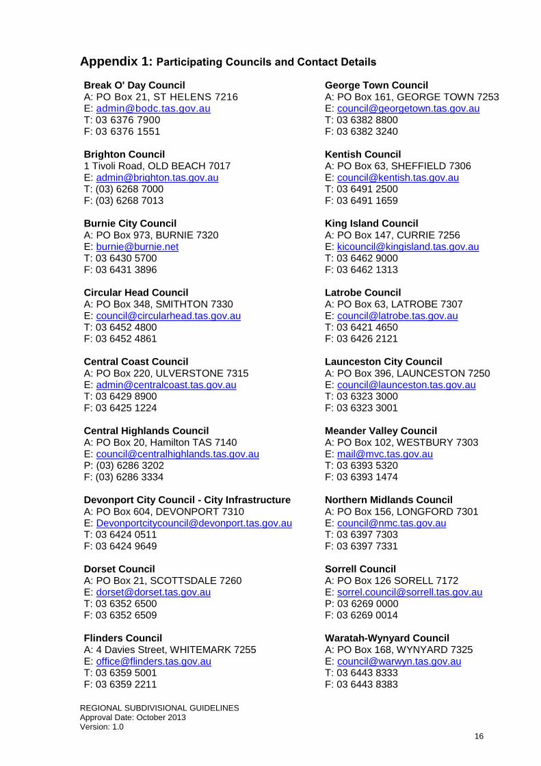
Appendix 1: Participating Councils and Contact Details
Break O' Day Council A: PO Box 21, ST HELENS 7216 E: [email protected] T: 03 6376 7900 F: 03 6376 1551 Brighton Council 1 Tivoli Road, OLD BEACH 7017 E: [email protected] T: (03) 6268 7000 F: (03) 6268 7013
Burnie City Council A: PO Box 973, BURNIE 7320 E: [email protected] T: 03 6430 5700 F: 03 6431 3896 Circular Head Council A: PO Box 348, SMITHTON 7330 E: [email protected] T: 03 6452 4800 F: 03 6452 4861 Central Coast Council A: PO Box 220, ULVERSTONE 7315 E: [email protected] T: 03 6429 8900 F: 03 6425 1224 Central Highlands Council A: PO Box 20, Hamilton TAS 7140 E: [email protected] P: (03) 6286 3202 F: (03) 6286 3334 Devonport City Council - City Infrastructure A: PO Box 604, DEVONPORT 7310 E: [email protected] T: 03 6424 0511 F: 03 6424 9649 Dorset Council A: PO Box 21, SCOTTSDALE 7260 E: [email protected] T: 03 6352 6500 F: 03 6352 6509 Flinders Council A: 4 Davies Street, WHITEMARK 7255 E: [email protected] T: 03 6359 5001 F: 03 6359 2211
George Town Council A: PO Box 161, GEORGE TOWN 7253 E: [email protected] T: 03 6382 8800 F: 03 6382 3240 Kentish Council A: PO Box 63, SHEFFIELD 7306 E: [email protected] T: 03 6491 2500 F: 03 6491 1659 King Island Council A: PO Box 147, CURRIE 7256 E: [email protected] T: 03 6462 9000 F: 03 6462 1313 Latrobe Council A: PO Box 63, LATROBE 7307 E: [email protected] T: 03 6421 4650 F: 03 6426 2121 Launceston City Council A: PO Box 396, LAUNCESTON 7250 E: [email protected] T: 03 6323 3000 F: 03 6323 3001 Meander Valley Council A: PO Box 102, WESTBURY 7303 E: [email protected] T: 03 6393 5320 F: 03 6393 1474 Northern Midlands Council A: PO Box 156, LONGFORD 7301 E: [email protected] T: 03 6397 7303 F: 03 6397 7331 Sorrell Council A: PO Box 126 SORELL 7172 E: [email protected] P: 03 6269 0000 F: 03 6269 0014 Waratah-Wynyard Council A: PO Box 168, WYNYARD 7325 E: [email protected] T: 03 6443 8333 F: 03 6443 8383

REGIONAL SUBDIVISIONAL GUIDELINES Approval Date: October 2013 Version: 1.0
17
West Coast Council A: PO Box 63, QUEENSTOWN 7467 E: [email protected] T: 03 64 714 700 F: 03 64714720
West Tamar Council A: PO Box 59, BEACONSFIELD 7270 E: [email protected] T: 03 6383 6350 F: 03 6327 4826

REGIONAL SUBDIVISIONAL GUIDELINES Approval Date: October 2013 Version: 1.0
18
Appendix 2: Specified Departures for Individual Councils
Break O' Day Council
Clause Specified departure or additional reference information
22.5 A 12 month defect liability period applies to allow a full set of seasonal changes.
Brighton Council
Clause Specified departure or additional reference information
4.1 Stormwater property connections are to be sized to manage the acceptable peak flow rate. Methodology for calculation of the acceptable peak flow rate is outlined in the Brighton Council Guidelines for Stormwater Design.
4.2 Electricity reticulation may be installed overhead in rural areas at the discretion of Council.
10.1 (b) (ii) Brighton Council will not accept 10.1 - Primer seal or single coat prime and seal
11.3.3 (i) Footpath to be constructed to driveway standard where adjacent to mountable or semi mountable kerb.
14.2 (ii) In accordance with Council's Guidelines for Stormwater Design, the drainage system shall be designed to manage an annual recurrence interval of 20 years.
14.4 Stormwater property connections are to be sized to manage the acceptable peak flow rate. Methodology for calculation of the acceptable peak flow rate is outlined in the Brighton Council Guidelines for Stormwater Design.
21.2 (iii) Replace (iii) with: CBR testing and construction/preparation of sub-grade
21.2 (iv) Replace (iv) with: Compaction testing and construction of sub-base and base course.
21.7 A ‘Start Works’ notice must also be submitted prior to commencement.
22.5 A 12 month defect liability period applies to allow a full set of seasonal changes.
24.4 At the discretion of the municipal engineer works not deemed acceptable at the end of the defects period are to be rectified by the developer at no cost to Council and may be subject to a further 52 week defect liability period.
Burnie City Council
Clause Specified departure or additional reference information
14.2 (viii) Pipe size may be DN225
13.4 Stormwater kerb connections are to be installed in accordance with BCC standard drawing 3D13441
22.1 Applies to mains greater than DN225
Circular Head Council
Clause Specified departure or additional reference information
No departures specified

REGIONAL SUBDIVISIONAL GUIDELINES Approval Date: October 2013 Version: 1.0
19
Central Coast Council
Clause Specified departure or additional reference information
8.2 Cross fall for turning heads shall be a minimum of 1.5%
10.1 (a) A wearing course as defined in 10.1 (b) (iii) may be accepted for urban roads, at the discretion of the Council's Director Engineering Services or his representative
11.3.1 (i) Standard kerb & channel profile KCS Specific mountable kerb and channel profile
11.3.2 (i) Specific residential vehicular crossing profile
13.2 (ii) Rural and residential (lots > 4000m2) - 5 year ARI
Residential (lots < 4000m2) - 10 year ARI
Commercial - 20 year ARI and 80% impervious surface
Industrial - 20 ARI and 80% impervious surface
13.2 (v) A lesser distance of kerb & channel draining to an entry pit may be required along the low side of one-way crossfall pavements
13.2 (vi) The acceptance of alternatives to standard manholes or pits is at the discretion of the Council's Director Engineering Services or his representative. Sewer Maintenance shafts (MS) or Sewer Terminal Maintenance Shafts (TMS), or similar.
13.4 Connections to the kerb are to be DN100 via an approved plastic kerb connector
19 A3 size plans and drawings are acceptable.
22.1 (v) Applicable to pipelines of size DN225 or greater.
Central Highlands Council
Clause Specified departure or additional reference information
4.2 Electricity reticulation may be installed overhead in rural areas at the discretion of Council.
10.2 CHC Will allow for new gravel roads – remove "provided it is not of a lesser standard than that specified in Clauses 9 and 10."
Devonport City Council
Clause Specified departure or additional reference information
4.1 The minimum stormwater property connection size is to be 150mm
9.1 A Geotechnical assessment may be requested at the planning permit stage or not at all at the discretion of the municipal engineer. If it is determined that a Geotechnical assessment is required, all requirements of Clause 9.1 are to be met.
10.1 (a) Council may accept asphalt concrete and/or two coat bitumen seals on urban roads at the discretion of the municipal engineer.
11.4.1 (ii) At the discretion of the municipal engineer, allowable maximum grades may be 16%.
13.2 (ii) Storm return periods specified in Council's Stormwater Strategy are to be applied.
13.4 Minimum stormwater property connection size is to be 150mm, stormwater connection to kerb outlets are to be approved by the municipal engineer.
17.2 Delete line 1, add <300mm = 2m; 300mm-450mm = 3m. All other widths /depths remain the same as shown for all sizes.
21.2 Replace (iv) with: CBR testing and construction of sub-grade.
21.7 It is highly probable that proof and testing supplied that does not satisfy the municipal engineer will require rework that may involve re-excavation and

REGIONAL SUBDIVISIONAL GUIDELINES Approval Date: October 2013 Version: 1.0
20
installation.
24.4 At the discretion of the municipal engineer works not deemed acceptable at the end of the defects period are to be rectified by the developer at no cost to Council and may be subject to a further 52 week defect liability period.
Dorset Council
Clause Specified departure or additional reference information
10.1 b) Council will specify.
14.2 (ii) Residential (lot < 2ha) - 10 years. Rural and Residential (lot > 2ha) - Council will specify.
14.4 Connection size is DN100 where residential lot size is < 1500m2.
21.3 Council will notify the developer of the appropriate inspection regime.
22.1 All public pipes greater than DN150
Flinders Council
Clause Specified departure or additional reference information
No departures specified
George Town Council
Clause Specified departure or additional reference information
Kentish Council
Clause Specified departure or additional reference information
10.1 (a) Council may accept asphalt concrete and/or two coat bitumen seals on rural and urban roads at the discretion of the municipal engineer.
14.4 Connection size is DN100 where residential lot size is < 1500m2.
22.5 A 12 month defect liability period applies to allow a full set of seasonal changes.
24.4 At the discretion of the municipal engineer works not deemed acceptable at the end of the defects liability period are to be rectified by the developer at no cost to Council and may be subject to a further 52 week defect liability period.
King Island Council
Clause Specified departure or additional reference information

REGIONAL SUBDIVISIONAL GUIDELINES Approval Date: October 2013 Version: 1.0
21
Latrobe Council
Clause Specified departure or additional reference information
10.1 (a) Council may accept asphalt concrete and/or two coat bitumen seals on rural and urban roads at the discretion of the municipal engineer.
13.4 Connection size is DN150 where residential lot size is > 1500m2.
22.5 A 12 month defect liability period applies to allow a full set of seasonal changes.
Launceston City Council
Clause Specified departure or additional reference information
13.1 Connection size is DN150 where residential lot size is > 1500m2
13.2 The design principles and pipe velocities shall comply with LCC 'Hydraulic Design Guidelines'. The pipe velocity range shall be 0.7m/s to 6.0m/s for RCP & FRC or 10.0m/s for other pipe types.
17.2 Reference document: 'How close can I build to a Council Service' (18-Rf-004)
22.5 12 month defects liability period in accordance with the LCC Subdivision Bonds & Guarantee Policy (18-Pl-015)
Meander Valley Council
Clause Specified departure or additional reference information
Northern Midlands Council
Clause Specified departure or additional reference information
3.1 … or varied to the acceptance of Council.
4.7 Not applicable
9.1 Insert at the beginning of clause 'Where required by Council'
11.4.1 (ii) At the discretion of the municipal engineer, allowable maximum grades may be 16%.
11.4.1 (iii) At the discretion of the municipal engineer, allowable maximum grades may be 16%.
11.4.1 (iv) All kerb and gravel to be constructed on 150mm deep compacted base.
13.2 (ii) Residential (lot <2Ha) – 10 years. Rural and residential (lot >2Ha) – 5 years.
13.2 (iv) Design calculations may be required for stormwater gully pit size, location and spacing.
13.2 (vi) Pipelines must terminate in a manhole.
13.4 Property connections must be installed to provide for the site discharge with DN100. Calculations to be provided when required by Council. The stormwater connection to be provided to the lowest point on the lot.
13.6 Discharge to an existing Council Drainage System may require:
A stormwater detention storage system to hold the volume exceeding the capacity of the connecting downstream stormwater provision, taking into account the catchment served, and increased discharges due to changes in land use and the design ARI as per Clause 13.2 (ii)
Hydraulic calculations to confirm that the receiving drainage system has the capacity to accept the discharge from the proposed development

REGIONAL SUBDIVISIONAL GUIDELINES Approval Date: October 2013 Version: 1.0
22
based on the ARI accepted by Council.
15 Landscaping of road reservations: Landscaping in road reservations may include surface treatments, planting and street trees as required by Council. Tree species and spacing to Council requirements.
16 All site erosion and sediment control shall be installed to the satisfaction of Council.
22.1 (i) … and as certified by the Supervising Engineer.
22.1 (v) … where required by Council.
22.5 Where required by Council.
24.5 At the discretion of the municipal engineer works not deemed acceptable at the end of the defects period are to be rectified by the developer at no cost to Council and may be subject to a further 52 week defect liability period.
Sorrell Council
Clause Specified departure or additional reference information
9.1 Same comments as Devonport Council
10.1 (b) (ii) Sorell will not accept primer seal or single coat prime and seal
11.3.1 (ii) Sorell will accept no flatter gradient than 0.67% (instead of 0.5%) and no steeper than 16% (instead of 14%)
11.3.1 (iii) As for (ii) above ie 16%
14.4 Delete “prefabricated” for Sorell Council
21.2 (iii) CBR testing and construction/preparation of sub-grade
21.2 (iv) Same comment as Devonport Council
21.5 (iv) add “and grouting of upstream headwall around inlet pipe.”
21.7 A ‘Start Works’ notice must also be submitted prior to commencement.
22.1 (v) CCTV camera survey of all public stormwater pipelines equal to or greater than 225mm.
24.4 At the discretion of the municipal engineer works not deemed acceptable at the end of the defects period are to be rectified by the developer at no cost to Council and may be subject to a further 52 week defect liability period.l
Waratah-Wynyard Council
Clause Specified departure or additional reference information
No departures specified
West Coast Council
Clause Specified departure or additional reference information
REGIONAL SUBDIVISIONAL GUIDELINES Approval Date: October 2013 Version: 1.0
23
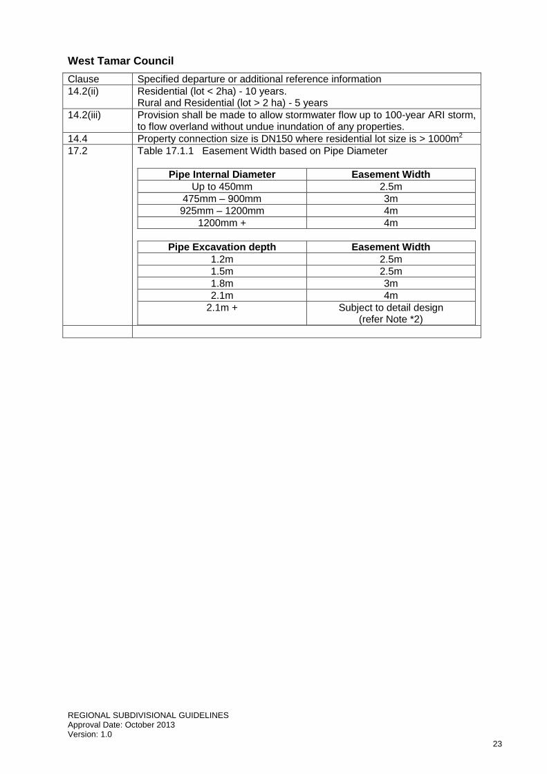
West Tamar Council
Clause Specified departure or additional reference information
14.2(ii) Residential (lot < 2ha) - 10 years. Rural and Residential (lot > 2 ha) - 5 years
14.2(iii) Provision shall be made to allow stormwater flow up to 100-year ARI storm, to flow overland without undue inundation of any properties.
14.4 Property connection size is DN150 where residential lot size is > 1000m2
17.2 Table 17.1.1 Easement Width based on Pipe Diameter
Pipe Internal Diameter Easement Width
Up to 450mm 2.5m
475mm – 900mm 3m
925mm – 1200mm 4m
1200mm + 4m
Pipe Excavation depth Easement Width
1.2m 2.5m
1.5m 2.5m
1.8m 3m
2.1m 4m
2.1m + Subject to detail design (refer Note *2)

REGIONAL SUBDIVISIONAL GUIDELINES Approval Date: October 2013 Version: 1.0
24
Appendix 3: Approved Materials for Stormwater Pipelines
Pipes Trenchless Technology Methods uPVC Riblok – spirally wound PVC DICL (ductile iron concrete lined) Sliplining – PVC / PE MSCL Pipe Bursting – PE Polyethylene Insituliner – Structural cured in place
liner RCP FRC Hobas Blackmax ™ Stormpro ™
REGIONAL SUBDIVISIONAL GUIDELINES Approval Date: October 2013 Version: 1.0
25
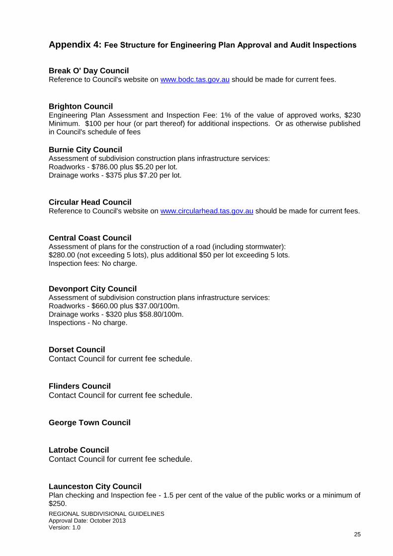
Appendix 4: Fee Structure for Engineering Plan Approval and Audit Inspections
Break O' Day Council Reference to Council's website on www.bodc.tas.gov.au should be made for current fees. Brighton Council Engineering Plan Assessment and Inspection Fee: 1% of the value of approved works, $230 Minimum. $100 per hour (or part thereof) for additional inspections. Or as otherwise published in Council's schedule of fees
Burnie City Council Assessment of subdivision construction plans infrastructure services: Roadworks - $786.00 plus $5.20 per lot. Drainage works - $375 plus $7.20 per lot. Circular Head Council Reference to Council's website on www.circularhead.tas.gov.au should be made for current fees. Central Coast Council Assessment of plans for the construction of a road (including stormwater): $280.00 (not exceeding 5 lots), plus additional $50 per lot exceeding 5 lots. Inspection fees: No charge.
Devonport City Council Assessment of subdivision construction plans infrastructure services: Roadworks - $660.00 plus $37.00/100m. Drainage works - $320 plus $58.80/100m. Inspections - No charge. Dorset Council Contact Council for current fee schedule. Flinders Council Contact Council for current fee schedule. George Town Council Latrobe Council Contact Council for current fee schedule. Launceston City Council Plan checking and Inspection fee - 1.5 per cent of the value of the public works or a minimum of $250.

REGIONAL SUBDIVISIONAL GUIDELINES Approval Date: October 2013 Version: 1.0
26
Re-inspections of failed works - $50.00 per hour.
Kentish Council Contact Council for current fee schedule.
King Island Contact Council for current fee schedule. Meander Valley Council Plan checking and final inspections for privately supervised works (only applies to works that have been certified by a qualified engineer approved by the Director Infrastructure Services) 1.5% of value of public works with a minimum fee of $350. Inspection of failed works $120 per hour for contracted inspections or re-inspections of works that failed a previous inspection.
Northern Midlands Council $285 payable up front for all subdivisions. An additional $105 per lot for subdivisions over the 3 lots which is charged at the plan checking stage but also covers practical completion inspections etc.
Waratah-Wynyard Council Reference to Council's website on www.warwyn.tas.gov.au should be made for current fees.
West Coast Council Contact Council for current fee schedule. West Tamar Council Plan checking and final inspections for privately supervised works (only applies to works that have been certified by a qualified engineer approved by the Director Infrastructure Services) 1.25% of value of public works with a minimum fee of $350. Inspection of failed works at $80 per hour of contracted inspections or re-inspections of works that failed a previous inspection.
REGIONAL SUBDIVISIONAL GUIDELINES Approval Date: October 2013 Version: 1.0
27
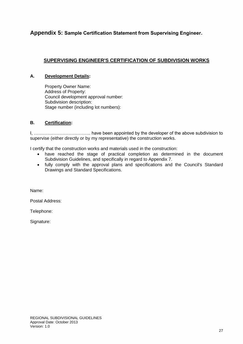
Appendix 5: Sample Certification Statement from Supervising Engineer.
SUPERVISING ENGINEER'S CERTIFICATION OF SUBDIVISION WORKS A. Development Details: Property Owner Name: Address of Property: Council development approval number: Subdivision description: Stage number (including lot numbers): B. Certification: I, ……………………………….. have been appointed by the developer of the above subdivision to supervise (either directly or by my representative) the construction works. I certify that the construction works and materials used in the construction:
have reached the stage of practical completion as determined in the document Subdivision Guidelines, and specifically in regard to Appendix 7.
fully comply with the approval plans and specifications and the Council's Standard Drawings and Standard Specifications.
Name: Postal Address: Telephone: Signature:

REGIONAL SUBDIVISIONAL GUIDELINES Approval Date: October 2013 Version: 1.0
28
Appendix 6: Works to be completed prior to Practical Completion
Item Description Mandatory
1 Stormwater Infrastructure a) Stormwater mains Yes b) Property connections Yes c) Manholes/pits Yes 2 Road Network a) Kerb & channel/lintels Yes b) Sub-grade & base pavement Yes c) Impervious seal Yes d) Footpath/pedestrian crossings Yes e) Driveways & crossings Yes f) Signs & line marking Note 1 g) Public street lighting Note 2 h) Street trees Note 3 i) Nature strips Note 4 3 Other Authority's Services - provide statement a) Water supply and sewerage Yes b) Telecommunications Yes c) Electrical power Yes d) Gas (if applicable) Yes 4 Certification & Construction Documentation a) Copy of Council's Audit Inspection record Yes b) Submission of certified 'as constructed' drawings Yes c) Asset data sheets Yes d) A certified statement from the Supervising Engineer of
compliance with the approved plans and Council's Standard Drawings & Specifications
Yes
e) A certified statement from a Civil Engineer of compliance with AS3793 'Guidelines on earthworks for commercial and residential development' 1996 (where site filling exceeds 300mm).
Yes
f) Surveyor's statement that property boundary pegs are in the correct position after completion of works
Yes
g) CCTV Survey of stormwater pipelines Yes h) Operation and maintenance manuals (where applicable) Yes i) Where operation and maintenance manuals required - asset
owner training session Yes
j) If pump station involved - site acceptance / testing meeting and operators training
Yes
Notes: 1. Must be completed within 6 weeks of date of certificate. 2. Must provide proof, before issue of PC, from Aurora Energy that public lighting installation
committed. 3. Must be completed by end of initial Defects Liability Period. A further 2 year Defects Liability
Period applies. 4. Majority of fill and top-soil must be in place. Screening, levelling and establishment of grass
must be completed by end of Defects Liability Period.

REGIONAL SUBDIVISIONAL GUIDELINES Approval Date: October 2013 Version: 1.0
29
Appendix 7: Soil and Water Management Plans - Information
The information contained in this appendix has been provided by NRM North to assist developers, engineers, designers and contractors in the preparation and design of soil and water management plans and ensure soil and water are appropriately managed during the construction phase. Introduction Subject to Clause 16 in the Subdivision Design and Construction Guidelines, a Soil and Water Management Plan (SWMP) is to be submitted detailing how soil and water is to be managed on the site during the construction process. This Appendix outlines the level of detail required by Council for SWMPs. Once approved by Council, all construction works need to be conducted in accordance with the SWMP. Soil and Water Management Plans Soil and Water Management Plans are specific site plans or drawings that detail sediment and erosion control measures on building and construction sites. The SWMP shows the type, location, design, installation and maintenance schedule for all these measures and should be considered as the blueprint for controlling all anticipated erosion and for preventing sediment from leaving a site. Clause 16 in the Subdivision Design and Construction Guidelines states that reference should be made to the Tasmanian Government publication 'Soil & Water Management on Building & Construction Sites' in preparing a SWMP. Soil & Water Management on Building & Construction Sites - Tasmanian Guidelines The Tasmanian Guidelines include 19 Fact Sheets which outline current best practice soil and water management for building and construction sites. The guidelines include a suite of sediment and erosion control measures which cover all aspects of soil and water management through the building and construction phase; and include tips for design, sighting, installation and maintenance of such measures. Contact your local Council, or visit www.nrmnorth.org.au for a copy of the guidelines. Developing a Soil and Water Management Plan The SWMP must be approved by Council prior to the commencement of works. A SWMP can easily be developed by overlaying information on a copy of the engineering site drawings. The SWMP must detail the site development and all the systems intended to minimise erosion and trap sediment. The table below outlines the acceptable standard of SWMPs for the North and North Western participating Councils listed in Appendix 1. Additional details may be required depending on the specific requirements of the site, scale of the development and level of ground disturbance.

REGIONAL SUBDIVISIONAL GUIDELINES Approval Date: October 2013 Version: 1.0
30
GENERAL INFORMATION Item Detail required
Date and author Name of person who developed SWMP, and date published.
North point and scale Description of the site size and orientation.
Site contours and slope Initial and final contours, approximate grades of slope and directions of fall.
Subdivision layout Property boundaries and construction details.
The limit of clearing, grading and filling.
Soil description General information about soil type (i.e. clay, loam, sand) present on site.
Topographic features General information about features on or near the site.
The location and types of all existing natural vegetation.
Details of the critical natural areas such as drainage lines (i.e. creeks, rivers), cliffs, nature reserves, wetlands and unstable ground.
Stormwater infrastructure All existing and proposed stormwater infrastructure.
Staging of works Start and completion dates for each stage of the subdivision.
SEDIMENT AND EROSION CONTROLS Item Detail required Relevant Fact Sheets
Stabilised site access Location of stabilised access point including diversion hump, and installation details:
Date
Responsible person
Method/designs/drawings where appropriate
No. 12 ‘Stabilised Site Access’
Retained vegetation Location of vegetation (trees, shrubs and grassed areas) to be retained on site throughout the entire construction phase.
No. 5 ‘Minimise Soil Disturbance’ No. 6 ‘Preserve vegetation’
Temporary drainage control measures
Location of all proposed temporary drainage control measures and installation details:
Date
Responsible person
Method/designs/drawings where appropriate
No. 7 ‘Divert Up-Slope Water’ No. 10 ‘Early Roof Drainage Connection’ No. 11 ‘Scour Protection – Stormwater Pipe Outfalls & Check Dams’
Sediment control measures Location of all proposed sediment control measures and installation details:
Date
Responsible person
Method/designs/drawings where appropriate
No. 12 ‘Stabilised Site Access’ No. 13 ‘Wheel Wash’ No. 14 ‘Sediment Fences & Fibre Rolls’ No. 16 ‘Manage Concrete, Brick & Tile Cutting’ No. 17 ‘Sediment Basins’
REGIONAL SUBDIVISIONAL GUIDELINES Approval Date: October 2013 Version: 1.0
31
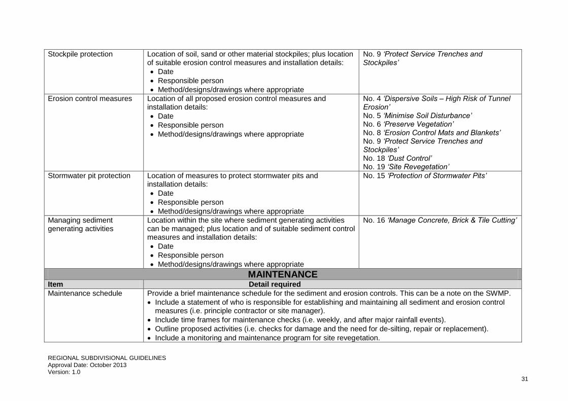
Stockpile protection Location of soil, sand or other material stockpiles; plus location of suitable erosion control measures and installation details:
Date
Responsible person
Method/designs/drawings where appropriate
No. 9 ‘Protect Service Trenches and Stockpiles’
Erosion control measures Location of all proposed erosion control measures and installation details:
Date
Responsible person
Method/designs/drawings where appropriate
No. 4 ‘Dispersive Soils – High Risk of Tunnel Erosion’ No. 5 ‘Minimise Soil Disturbance’ No. 6 ‘Preserve Vegetation’ No. 8 ‘Erosion Control Mats and Blankets’ No. 9 ‘Protect Service Trenches and Stockpiles’ No. 18 ‘Dust Control’ No. 19 ‘Site Revegetation’
Stormwater pit protection Location of measures to protect stormwater pits and installation details:
Date
Responsible person
Method/designs/drawings where appropriate
No. 15 ‘Protection of Stormwater Pits’
Managing sediment generating activities
Location within the site where sediment generating activities can be managed; plus location and of suitable sediment control measures and installation details:
Date
Responsible person
Method/designs/drawings where appropriate
No. 16 ‘Manage Concrete, Brick & Tile Cutting’
MAINTENANCE Item Detail required
Maintenance schedule Provide a brief maintenance schedule for the sediment and erosion controls. This can be a note on the SWMP.
Include a statement of who is responsible for establishing and maintaining all sediment and erosion control measures (i.e. principle contractor or site manager).
Include time frames for maintenance checks (i.e. weekly, and after major rainfall events).
Outline proposed activities (i.e. checks for damage and the need for de-silting, repair or replacement).
Include a monitoring and maintenance program for site revegetation.

REGIONAL SUBDIVISIONAL GUIDELINES Approval Date: October 2013 Version: 1.0
32
Amendment Table
Date Summary of amendments/changes