tanah (soil turbah - official portal of · pdf filesoil texture (tekstur tanah)...
TRANSCRIPT

Tanah (soil / turbah)
dwzwy-geologi-2008 1
Assoc Prof Dr. Wan Zuhairi Yaacob
Program Geologi
UKM
Definasi
• Geologist
• Engineer
• Soil scientist
• Pedologist
dwzwy-geologi-2008 2

Soil Scientist
dwzwy-geologi-2008 3
Geologist !!!

dwzwy-geologi-2008
The importance of soil (tanah)
• Natural resource for plant growth
• Erosion – environmental degradation
• Source of sediment
• Filter for groundwater
• Bearing material
• Construction material
• Land-use planning
• Waste Management
• Evaluate natural hazards
4

dwzwy-geologi-2008
KISAH PEMBUNUHAN PERTAMA
• Kenapa mayat manusia di tanam dalamtanah?
• Kisah QABIL membunuh HABIL (semak Al-
Quran, Al Maidah ayat 31)
“kemudian Allah menyuruh seekor burung gagak menggali-gali dibumi untuk memperlihatkan kepada Qabil bagaimana diaseharusnya menguburkan mayat saudaranya”
-- manusia banyak belajar dari alam
-- jangan segan mengambil pelajaran dari yang lebih rendahtingkatan pengetahuannya.
5

dwzwy-geologi-2008
SOILROCKweathering
The breaking down of various
types of rocks into smaller pieces
through mechanical and chemical
processes.
RESIDUAL SOIL
-formed in place
-cover the rock surface
-cold / cool area
= fairly thin; slow weathering
-hot / warm area
= thick; rapid weathering.
TRANSPORTED SOIL
1. Alluvial or fluvial = running water
(estuarine deposits)
2. Glacial = glacier
3. Aeolian = wind action
NON-INDURATED (SOFT) ROCKS
-referred as soil by engineers
-Eg. Oxford clay; Kajang Formation
(Primary minerals)
(Secondary minerals)
6
Physical
Biological
chemical

dwzwy-geologi-2008 7
NON-INDURATED (SOFT) ROCKS
“soil to me but rock to you”

dwzwy2007 8
Fresh Granit (Grade I)
Weathered Granit
(Grade III-IV)

dwzwy2007 9

dwzwy2007 10
Kadar luluhawa beberapa mineral pembentuk batuan
• S.S. Goldich (1938)
– Mencadangkan siri
luluhawa mineral
pembentuk batuan
– Di permukaan bumi; olivine
dan Ca-plagioclase
feldspar sangat mudah
terluluhawa
– Quartz dan muscovite mica
adalah sukar terluluhawa
(inert)
dwzwy-geologi-2008
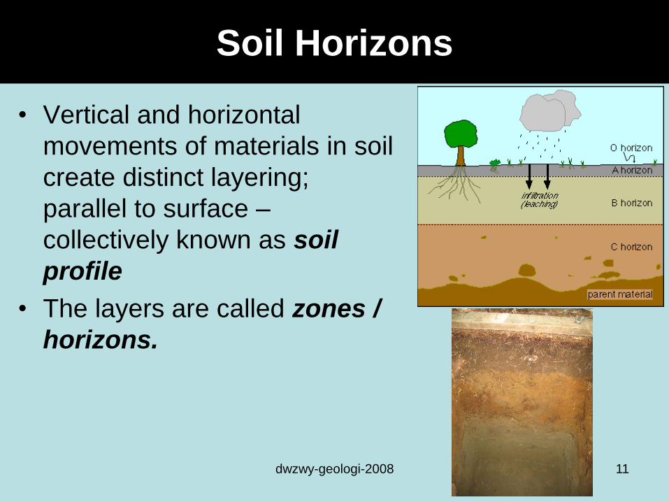
Soil Horizons
• Vertical and horizontal
movements of materials in soil
create distinct layering;
parallel to surface –
collectively known as soil
profile
• The layers are called zones /
horizons.
11

dwzwy-geologi-2008 12

dwzwy-geologi-2008
Soil
horizons
Descriptions Colour
O Highly concentrated organic matter
(Plant litter and other organic material)
Dark
brown/black
A Zone of leaching (eluviation)
•Contains both organic and resistant mineral material
•Leaching – process of dissolving, washing, or draining earth
materials by water.
•Moves clay and other material such as iron & calcium to B
Light
black/brown
E Zone of leaching
•Resulting from leaching of clay, Ca, Mg, Al2O3 and Fe2O3 to B
•Light in colour; less organic material than O & A
Light
colored
(white)
B Zone of accumulation (illuviation)
Enriched in clay, iron oxides, Si, CO3
Red
(iron/Al
oxides)
C Parent material partly altered by weathering process
R Unaltered parent material
13

dwzwy-geologi-2008
Soil Profile
14

Soil chronosequences
(kronojujukan tanah)
• Sama seperti kronojujukan
batuan (penentuan usia
relatif batuan)
• Penentuan usia relatif
berdasarkan kepada
pemerhatian di lapangan
• Digabungkan dengan C
dating (14C) – numerical
dating
dwzwy-geologi-2008 15

dwzwy-geologi-2008 16
the leached
zone thickens
with time
a redder color
and becomes
dark red in
10,000 years
(zone of
accumulation –
iron)
Soil chronosequences
(kronojujukan tanah)

Penkelasan tanah
(Soil classification )
• Soil Science
– Soil taxonomy
– US Dept. of Agriculture triangle
• Engineering
– Unified soil classification (USC)
dwzwy-geologi-2008 17

• Soil Science
– Soil taxonomy
– US Dept. of Agriculture textural triangle
dwzwy-geologi-2008 18
Loam: 40% silt ; 40% sand; 20% clay
US Dept. of Agriculture standard textural triangle

• Engineering– Unified soil
classification
(USC)
dwzwy-geologi-2008 19

dwzwy-geologi-2008 20

dwzwy-geologi-2008
Engineering properties of soils
• The most important : Soil = solid + liquid + gas
1. Texture (Tekstur – saiz butiran tanah)
2. Plasticity (keplastikan) - water content of soil
3. Strength (kekuatan); resistance to deformation
- Bergantung kpd “cohesion” & “friction”
4. Sensitivity (kesensitifan); change in soil
strength from disturbances (vibration /
excavation) – liquifaction
5. Compressibility (Kebolehpadatan); soils
tendency to consolidate (decrease in volume);
settlement
21

Plastic limit
dwzwy-geologi-2008 22
PI = LL – PL
PI (<5%) = cause problems; easily change from solid to liquid state
PI (>35%) = potential to expand and contract
Panos
Paolo

6. Erodibility (hakisan);
7. Permeability (ketertelapan); finer grained
materials are less permeable
8. Corrosion potential (kekaratan); tendency to
corrode materials and structures, esp. metals,
laid in the ground
9. Ease of excavation (pengorekan)
- Common excavation ; rippable ; blasting / rock cutting
10.and shrink-swell potential (kembang-kecut).clays absorb water and expand "fat clays.“
Eg. Montmorillonite; bentonite; smectite
dwzwy-geologi-2008 23
Engineering properties of soils

Soil texture (Tekstur tanah)
• Bergantung kepada peratusan bahagian
pasir; lodak dan lempung.
• Boleh ditentukan di lapangan & makmal
dwzwy-geologi-2008 24
Stones and cobbles are bigger than 64 mm
Gravel is from 2 mm to 64 mm
Sand is from .05 to 2 mm
Silt is from .002 to .05 mm
Clay is less than .002 mm.

dwzwy2004
Soil Classification Calculator
http://www.tulsamastergardeners.org/black
box/soil_clas_calc.htm
dwzwy2004
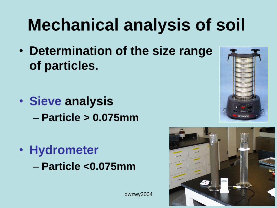
Mechanical analysis of soil
• Determination of the size range
of particles.
• Sieve analysis
– Particle > 0.075mm
• Hydrometer
– Particle <0.075mm

Sedigraph
• Particle Size Analyser (micromeritics SediGraph III)
dwzwy-geologi-2008 27

dwzwy2004
Sampel
(Wet sieving 2mm; 63 um; pan)
> 63um <63um
Sieve analysis Sedimentation
analysis
Pasir kerikil Lempung/clay
lodak/silt
Ayakan basah
Ayakan kering
(dry sieving)hydrometer

dwzwy2004
Sand and Gravel
Sand & fine gravel
Silt, Sand and gravel
Silt and fine sand
Silt = 95-31 = 64%
31% clay
5% sand
* Name the fractions for soil A, B, C and D?
** What is the percentage of silt for soil D?
*** Which one is poorly graded curve?
**** Which one is well graded curve?
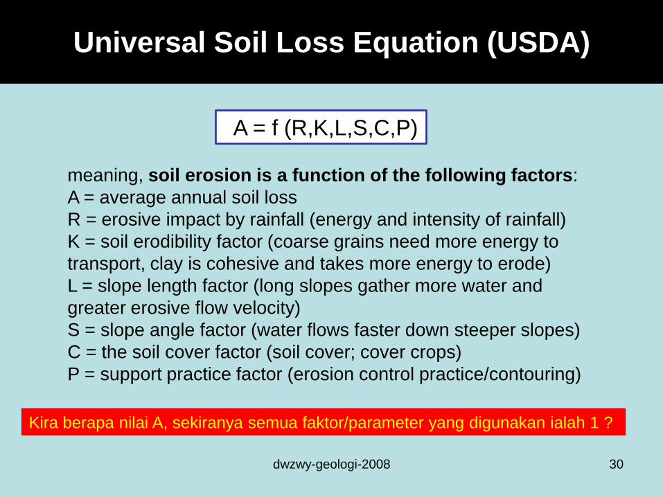
Universal Soil Loss Equation (USDA)
dwzwy-geologi-2008 30
meaning, soil erosion is a function of the following factors:
A = average annual soil loss
R = erosive impact by rainfall (energy and intensity of rainfall)
K = soil erodibility factor (coarse grains need more energy to
transport, clay is cohesive and takes more energy to erode)
L = slope length factor (long slopes gather more water and
greater erosive flow velocity)
S = slope angle factor (water flows faster down steeper slopes)
C = the soil cover factor (soil cover; cover crops)
P = support practice factor (erosion control practice/contouring)
A = f (R,K,L,S,C,P)
Kira berapa nilai A, sekiranya semua faktor/parameter yang digunakan ialah 1 ?

dwzwy :: 2009-2010
Your good friend has the opportunity to buy this riverside land in a beautiful
canyon at a good price. She wants to build a log cabin on the site. Knowing
some geology. What should you tell her?
31
Latihan Berkumpulan
(Boleh print dari website)
25hb Januari 2010
(sebelum jam 11am)

TAMAT
dwzwy-geologi-2008 32