sustainable urban extension joint delivery statement
TRANSCRIPT
1
Sustainable Urban Extension
Joint Delivery Statement
Evidence Topic Paper for
Lincoln North East Quadrant (NEQ)
April 2016
Central Lincolnshire Local Plans Team
c/o North Kesteven District Council
Council Offices
Kesteven Street
SLEAFORD
Lincs NG34 7EF
Telephone: 01529 414155 Email: [email protected]

2
Topic Paper: Sustainable Urban Extension 3; Lincoln North East Quadrant –
Land at Greetwell, including former Greetwell Quarry
Short Summary and Current Status
Summary: A SUE to Lincoln which will deliver 1,400 homes during the plan
period, including up to 5ha of employment land, a neighbourhood centre,
primary school and green space.
Current Status: An outline planning permission (subject to signing of s106)
for Phase 1 of this SUE, comprising a residential development of up to 500
dwellings, was granted by the planning committee of West Lindsey District
Council on 16 December 2015.
A land use masterplan is in place for the wider site, including an indicative
layout for the remainder of the SUE. Approx. 180 dwellings are expected to
be delivered on Phase 1 in the first 5 years (assuming completions at the rate
of 50 per annum from late 2017/18 onwards).
This topic paper will be updated as development of the SUE progresses and
as pre-application discussions evolve for additional future phases. At present
there is a higher level of detailed site information held for the part of the site
included in phase 1. This will increase further as additional parts of the site are
brought forward in coming years and additional site investigations are
completed for the remainder of the SUE.
Scheme Preparation Date Comp Application Date Comp Implementation Date Comp
Vision and Key Objectives Agreed
2013 Detailed viability assessment
Phase 1 Phase 1 x
Constraints Identified PHASE 1
2015
Application Submitted
Phase 1 Discharge of Conditions
x
FURTURE PHASES x
Access and movement Strategy agreed
Phase 1 Dec 2015
Application under consideration
Summer 2015
Site Marketed x
Infrastructure Requirements Identified Affordable Housing Highways Health Education Others
Phase 1 Only Dec 2015
Approved Dec 2015
Site Developer Secured
x
Section 106 Agreed
Underway at Feb ‘16
x Reserved Matters x
Start on Site x
High level viability assessment
Phase 1 Only
Completions x
Public Consultation undertaken
Phase 1 only
Strategic Framework Plan Developed
Phase 1 Only
3
1.0 INTRODUCTION TO THIS TOPIC PAPER AND OUTLINE OF THE SUE
The purpose of this joint delivery statement is to set out information about the SUE
and how it will be delivered. The following sections provide:
Information on who is delivering it, a description of the opportunity and who else
is involved;
the vision and objectives for what will be delivered;
any current issues and constraints with the site that will need to be addressed;
and
what will be delivered and when.
1.1 Who is delivering the SUE:
a) The local planning authority
The site is split between the administrative areas of the City of Lincoln and West
Lindsey District Council. The outline planning permission granted in December 2015
(subject to signing the s106) covers the entirety of the part of the SUE that lies within
West Lindsey district. The remaining site area (i.e. all of the land within the SUE not
covered by the 2015 outline planning permission) is within the City of Lincoln
boundary.
b) Principal site promoter(s) /lead developer
The Church Commissioners and in due course their developers, City of Lincoln
Council, West Lindsey District Council, Lincolnshire County Council
c) Other Key Delivery Partners
d) Land Ownership
The site is in the single ownership of the Church Commissioners for England.
1.2 The Opportunity
Lincoln City has tight administrative boundaries, and since the late 1990s the City
has worked with adjoining districts and the County Council to plan how the city’s
growth can be accommodated in the most sustainable manner. The North East
Quadrant (NEQ) lies on the north east edge of Lincoln between the existing
residential area at Bunkers Hill and the predominantly industrial area of Allenby
Road.
The site lies within the line of the proposed Lincoln Eastern Bypass and at its closest
the site is within 1.5 miles (2.4 km) of the City Centre. It is one of the most
sustainable locations for the city’s future growth. The site is 85 hectares in extent
and is dominated by the former Greetwell Quarry and ironstone mine. It offers the
opportunity to create a new community in a unique setting and to not only link to the
existing residential area of Bunkers Hill, but also to the employment opportunities to
the west, providing particularly small premises for offices and light industry
compatible with the location.
As site location map is shown in figure 1.
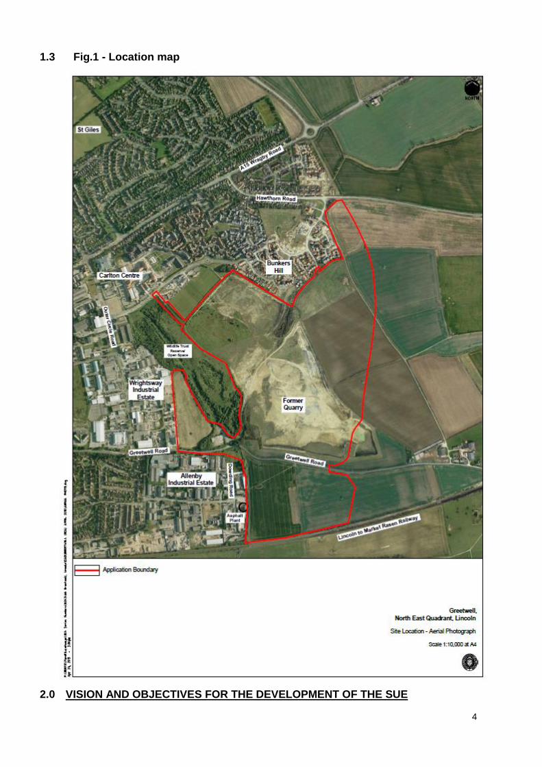
4
1.3 Fig.1 - Location map
2.0 VISION AND OBJECTIVES FOR THE DEVELOPMENT OF THE SUE

5
2.1 The vision identifies the priorities for this SUE as follows:
The NEQ scheme will be well integrated with existing communities and
facilities in the area as well as providing additional facilities including a
primary school and local neighbourhood centre. The development will be
served with appropriately located retail facilities to meet locally arising needs
without prejudicing established local centres nearby. There will be a hierarchy
of movement allowing choice for all modes of travel and priority given to
walking, cycling and public transport.
The NEQ will have a network of green spaces that provide opportunities for formal and informal recreation to the site. Existing features of note, including the exposed quarry faces and views of Lincoln Historic Core, will be retained and exploited to help provide a development of unique character.
The site will link with existing industrial areas to the south and west at Allenby and Wrightsway Industrial Estates. Complementary employment uses (of an appropriate scale and taking account of market demand) will be developed to assist in regeneration of the Allenby Estate. A mix of housing in terms of size and tenure will be provided in a high quality environment.
The development will have a distinct physical identity respectful of the character of the city and capitalising on key views of the Cathedral, but unique to the site’s setting and nature.
2.2 Key Objectives: The Church Commissioners have defined the following objectives in
planning for this SUE:
To create a sustainable mixed use development respectful of its unique setting;
To ensure the development is financially viable (taking account of the achieving competitive returns to a willing land owner and willing developer for the development to be deliverable) and thus capable of being delivered;
To remediate damaged land within Greetwell Quarry so as to bring it forward for appropriate use;
To protect the Wildlife Reserve at Greetwell Hollow and low-lying land at Willingham Fen West, part of which is designated as a Local Wildlife Site;
To ensure that development south of Greetwell Road, that is designated as a ‘Green Wedge’, respects its contribution to the landscape character and setting of the City;
To capitalise on site views of Lincoln cathedral and the historic hilltop City;
To ensure an appropriate transition between built development and open countryside to the east and south;
To avoid any encroachment on the high voltage power lines that cross the site;
To provide community facilities, including a primary school and open space;
To create a new quarter with a sense of local distinctiveness and with good connectivity to surrounding areas; and
To provide facilities that are accessible to new residents as well as to those already living at Bunkers Hill.
2.3 How Vision and Objectives were formulated:
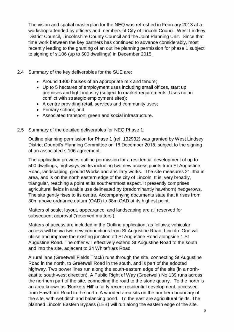
6
The vision and spatial masterplan for the NEQ was refreshed in February 2013 at a
workshop attended by officers and members of City of Lincoln Council, West Lindsey
District Council, Lincolnshire County Council and the Joint Planning Unit. Since that
time work between the key partners has continued to advance considerably, most
recently leading to the granting of an outline planning permission for phase 1 subject
to signing of s.106 (up to 500 dwellings) in December 2015.
2.4 Summary of the key deliverables for the SUE are:
Around 1400 houses of an appropriate mix and tenure;
Up to 5 hectares of employment uses including small offices, start up premises and light industry (subject to market requirements. Uses not in conflict with strategic employment sites);
A centre providing retail, services and community uses;
Primary school; and
Associated transport, green and social infrastructure.
2.5 Summary of the detailed deliverables for NEQ Phase 1:
Outline planning permission for Phase 1 (ref. 132932) was granted by West Lindsey
District Council’s Planning Committee on 16 December 2015, subject to the signing
of an associated s.106 agreement.
The application provides outline permission for a residential development of up to
500 dwellings, highways works including two new access points from St Augustine
Road, landscaping, ground Works and ancillary works. The site measures 21.3ha in
area, and is on the north eastern edge of the city of Lincoln. It is, very broadly,
triangular, reaching a point at its southernmost aspect. It presently comprises
agricultural fields in arable use delineated by (predominantly hawthorn) hedgerows.
The site gently rises to its centre. Accompanying documents state that it rises from
30m above ordnance datum (OAD) to 38m OAD at its highest point.
Matters of scale, layout, appearance, and landscaping are all reserved for
subsequent approval (‘reserved matters’).
Matters of access are included in the Outline application, as follows; vehicular
access will be via two new connections from St Augustine Road, Lincoln. One will
utilise and improve the existing junction off St Augustine Road alongside 1 St
Augustine Road. The other will effectively extend St Augustine Road to the south
and into the site, adjacent to 34 Whitefriars Road.
A rural lane (Greetwell Fields Track) runs through the site, connecting St Augustine
Road in the north, to Greetwell Road in the south, and is part of the adopted
highway. Two power lines run along the south-eastern edge of the site (in a north-
east to south-west direction). A Public Right of Way (Greetwell) No.139 runs across
the northern part of the site, connecting the road to the stone quarry. To the north is
an area known as ‘Bunkers Hill’ a fairly recent residential development, accessed
from Hawthorn Road to the north. A wooded area sits on the northern boundary of
the site, with wet ditch and balancing pond. To the east are agricultural fields. The
planned Lincoln Eastern Bypass (LEB) will run along the eastern edge of the site.
7
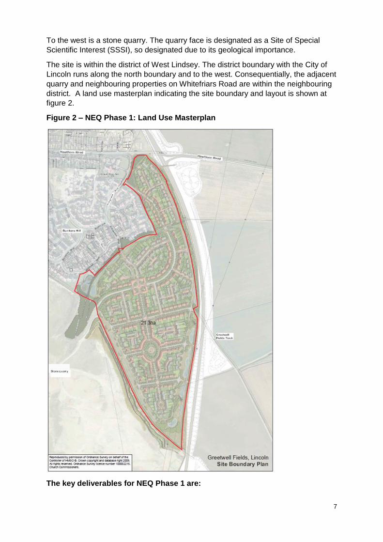
To the west is a stone quarry. The quarry face is designated as a Site of Special
Scientific Interest (SSSI), so designated due to its geological importance.
The site is within the district of West Lindsey. The district boundary with the City of
Lincoln runs along the north boundary and to the west. Consequentially, the adjacent
quarry and neighbouring properties on Whitefriars Road are within the neighbouring
district. A land use masterplan indicating the site boundary and layout is shown at
figure 2.
Figure 2 – NEQ Phase 1: Land Use Masterplan
The key deliverables for NEQ Phase 1 are:

8
To provide 10% of the dwellings on the site as Affordable Housing. Of that 10% of dwellings, 80% are to be Affordable Rented units (rents capped at 80% of OMR) and 20% are to be Shared Ownership Units (NPPF definitions);
The provision of not less than 10% of the total site area dedicated for use as Public Open Space and measures to ensure its ongoing management and maintenance;
To make the following financial contributions (index linked to Retail Price Index):
(i) Contribution of £892,800 towards the Lincoln Eastern Bypass (LEB). 50% payable prior to the occupation of the 149th unit; 50% payable prior to the occupation of the 301st unit;
(ii) In the event the LEB is not delivered, an alternative traffic mitigation scheme shall be submitted to and agreed with the Local Planning Authority, and include measures to enable the delivery of the agreed scheme in accordance with an agreed timetable;
(iii) A contribution of £110,000 towards Public Transport, payable prior to the occupation of the 301st unit;
(iv) A contribution of £85,000 towards cycling/walking provision, payable prior to the occupation of the 149th unit;
(v) A contribution towards education (primary) provision of £895,700, in lieu of on-site provision. 35% payable prior to the occupation of the 149th unit, 35% payable prior to the occupation of the 301st unit, 35% payable prior to the occupation of the 450th unit; and
(vi) Contribution towards health care provision of £210,800 in lieu of on-site provision, payable prior to the occupation of the 450th unit.
All supporting documents relating to the outline planning permission for NEQ Phase 1, including site investigation reports, can be viewed online at: http://docs.west-lindsey.gov.uk/WAM/showCaseFile.do?appName=planning&appNumber=132932
3.0 SITE ASSESSMENT
The following information describes the site issues and constraints that need to be
addressed:
3.1 Site and Delivery Issues for Consideration:
a) Topography and Soil Condition
The previous use of the site has resulted in mining voids and the quarry is a
designated SSSI for its geological interest. Geotechnical investigations by the site
owners (see Planning History below) have indicated that the quarried site can be
developed providing that suitable foundations are used, and the SSSI features that
are of geological interest can be maintained and enhanced.
Ground investigations undertaken by the owners have found that the quarried area
can be developed by a combination of land stabilisation and suitable foundations,
although costs will be higher than on other sites. In consultation with statutory and
local environmental organisations an Environmental Impact Assessment (EIA)
9
scoping opinion for the whole site was prepared as part of the pre application
discussions circa 2008.
Subsequent to the 2008 site-wide assessment, and as part of the application for
Phase 1, West Lindsey District Council provided a formal scoping opinion in 2014
that the development (at that time proposed for 450 dwellings – ref. 131716 of 19
August 2014) was not EIA development. Due to the increase to 500 dwellings
applied for in the outline application submitted in 2015 the council reviewed this
position but determined that the change did not amount to significant environmental
impact, and accordingly the development was not EIA development.
A scoping opinion will be required for all subsequent phases, but will be provided by
City of Lincoln Council since the reminder of the site lies entirely within that
authority’s administrative boundary.
b) Drainage and Flooding
The site is within Flood Zone 1. Surface water drainage issues have been
investigated and will require the use of Sustainable Urban Drainage Systems (where
practicable) as the site is built out in order to mitigate flood risk in surrounding low
lying areas. Their design will need to be approved by Lincolnshire County Council
as the Lead Local Flood Authority (LLFA), and must be integrated into the design of
the site, forming an integral element of the overall green infrastructure strategy for
the site.
A Drainage Strategy for NEQ Phase 1, agreed by the LLFA, can be found online at:
http://docs.west-
lindsey.gov.uk/WAM/showCaseFile.do?appName=planning&appNumber=132932
c) Utilities
Gas, Electricity & Water Supply
No significant known issues
Sewerage
In relation to this site (and other growth sites in the Lincoln area) Anglian Water have
confirmed that the local sewerage treatment works (STW) at Canwick will need to be
upgraded in order to accommodate the proposed levels of growth within the Local
Plan. However, given the likely development trajectory and the available capacity,
upgrades are unlikely to be required within AMP6 (2015-2020) and are not required
as a direct result of NEQ Phase 1.
Given the above, Anglian Water have stated that they do not envisage any timing or
delivery constraints on this SUE due to STW upgrades. There may be timing
implications due to the necessary network upgrades, however the timescales for
these are much shorter and can be resolved through early engagement by the
developer in the requisition process.
d) Access/Transport
Site Access
10
There will be no direct road access between the SUE and the bypass, and road
access will be from St Augustine Road (Phase 1) and Carlton Boulevard (Phase 2).
Access arrangements are likely to be phased in tandem with development. For
Phase 1 matters of access are included in the Outline application, as detailed in
paragraph 2.4.
Road Construction of the Lincoln Eastern Bypass (LEB) is necessary before this SUE can be fully completed, however a portion of Phase 1 – the first 150 of up to 500 new dwellings – can be delivered before the bypass is complete. In February 2016, The Secretary of State granted the legal orders required for the Lincoln Eastern Bypass progress following a Public Enquiry which took place in August 2015. Construction is expected to start in end of 2016 and is due to take two years. Delivery of completed dwellings is expected to be at a rate of circa 50 units per annum, from 2017/18 onwards. At this rate of delivery, the LEB will be operational before the threshold of 150 units is reached and therefore there is a high degree of confidence that physical construction of the road will not be a barrier to development or impact on the planned delivery/phasing rate. Phase 1 includes; Contribution of £892,800 towards the Lincoln Eastern Bypass (LEB). 50% payable prior to the occupation of the 149th unit; 50% payable prior to the occupation of the 301st unit. Rail There are no direct rail linkages to this site existing or proposed. Public transport, cycling and walking
Cycling links will be expected to connect to National Cycle Route 1 and Sustrans
local routes. There is a need for a network of new cycling and walking routes within
the development and to connect to surrounding areas.
The permission for Phase 1 includes; A contribution of £110,000 towards Public Transport, payable prior to the occupation of the 301st unit; and; A contribution of £85,000 towards cycling/walking provision, payable prior to the occupation of the 149th unit;
e) Affordable Housing/Gypsy and Traveller Provision
The CLLP (Policy LP11 – Meeting Housing Needs) sets out different affordable
housing targets across the plan area ranging from 15 to 25%. A percentage of 20%
Affordable Housing is sought for SUEs inside the Lincoln Strategy Area, and this is
therefore the level applicable to NEQ SUE. However, detailed viability assessments
at the Outline Planning application stage for Phase 1 demonstrated that, at the time
of determination, in view of the other financial obligations imposed the actual
quantum of provision achievable is 10%. Further details are set out in section 2.4 of
this paper.

11
The Submission Draft of the Central Lincolnshire Local Plan set out the need for all Central Lincolnshire authorities to respond to and address the accommodation needs set out in the ‘Gypsy and Traveller Accommodation Assessment 2013’. To ensure this need could be met appropriately the Further Draft CLLP stated that the supply of new pitches should be met through a combination of allocated sites and by the provision of suitable land within each new SUE (Policy 28: Sustainable Urban Extensions, Part C). On Monday 18 January 2016 Members of the Central Lincolnshire Joint Strategic
Planning Committee agreed to amend the policy wording as follows:
“Each new urban extension proposal must, where applicable…Set aside an area of land which is suitable for the provision of gypsy and traveller pitches. The size of the site shall be agreed through negotiation, though is likely to be of a size sufficient to accommodate 5-10 pitches. Such set aside land should be on-site unless the developer can demonstrate circumstances which demonstrates that provision on an alternative suitable site is identified, and is made available and deliverable by the applicant. Such set aside land (whether on the SUE site or off-site) should be provided to the local planning authority at nil cost and be secured through an appropriate legal agreement” It is therefore envisaged that the above policy position, or an agreed amendment of it, will apply to NEQ and all SUEs in Central Lincolnshire. This will be confirmed upon publication of the Submission Draft Local Plan in March 2016.
f) Education
A two form entry (2FE) primary school incorporating extended hours provision will be
provided, a serviced site of approximately 1.8 ha will be expected to be provided by
the developer together with a proportionate financial contribution towards the cost of
providing the school, subject to the level and mix of housing. It is expected that the
masterplan will incorporate provision for a children’s nursery (to be provided by the
private sector) but this could be provided as part of the local centre rather than
additional land being required.
The permission for NEQ Phase 1 included; A contribution towards education
(primary) provision of £895,700, in lieu of on-site provision. 35% payable prior to the
occupation of the 149th unit, 35% payable prior to the occupation of the 301st unit,
35% payable prior to the occupation of the 450th unit
g) Health
Discussions with the NHS are ongoing and some NHS data needs review before the
demand generated by the full development of the site can be accurately assessed.
Dialogue with the Clinical Commissioning Groups has been established, and will
continue as the sites are taken forward. As the need is yet to be firmly established
for the entire SUE it has been assumed that there is no spare capacity in existing GP
and dental surgeries and therefore appropriate provision will be required.
The permission for NEQ Phase 1 includes; Contribution towards health care provision of £210,800 in lieu of on-site provision, payable prior to the occupation of the 450th unit.

12
h) Recreation/Open space
Play areas and open space provision will be required in line with national and local policy, informed by developing evidence. No specific recreational provision has yet been identified, but all open space will be considered as part of the site’s wider Green Infrastructure Strategy as Masterplanning proceeds.
i) Heritage
As part of the application for NEQ Phase 1 an Archaeology Geophysical study was
prepared, and forms part of the supporting information available online, as detailed in
paragraph 2.4 of this paper (including a weblink to the documents).
For the remainder of the site, for the area not covered by the Phase 1 study, whilst it
can be assumed that the extent of the quarrying will have negated any likely
archaeological remains on the quarry proper there is known heritage asset interest
on the adjacent unquarried land, including; a prehistoric triple ditch boundary,
industrial archaeology associated with ironstone mining as well as potential roman
remains.
j) Natural environment / Ecology
The site contains a designated SSSI and Local Geological Site, primarily for the
nationally significant geological interest, and as a Local Wildlife Site for its flora and
fauna interest at a county level.
The Local Wildlife Site designation also includes the neighbouring Greetwell Hollow
Nature Reserve, managed by the Lincolnshire Wildlife Trust. This site also has an
Open Access Land designation under the Conservation and Rights of Way Act 2000.
The 2008 site-wide EIA scoping opinion identified the need for assessments of
ecology, bio diversity opportunity and enhancement, landscape/visual impact and
sustainable access, as well as specific consideration of any impacts and resulting
mitigation measures in respect of the SSSI and Local Wildlife Site designations.
These all formed part of the consideration for NEQ Phase 1 granted permission in
December 2015.
The quarry face is the primary interest with regard to the SSSI status and will be
required to be maintained and enhanced. Discussions with the landowners reflect
that, subject to proper assessment, this is deliverable through suitable design and
layout in liaison with Natural England and other local environmental organisations,
within this context the SSSI designation is not viewed as a constraint to the principle
of development.
Other Critical Natural Assets in the vicinity are Local Wildlife Site at Willingham Fen
West. A Green Wedge allocation south of the railway line below Greetwell Road and
adjacent to the site is identified in The Central Lincolnshire Local Plan Proposed
Submission Draft. Future development proposals will be expected to demonstrate
that they do not adversely impact on the function of the Green Wedge, taking into
account scale, siting design, materials and landscape treatment and that they have
13
considered linkages to and enhancements of the adjacent Green Wedge (Policy LP
22).
All interested partners, including Natural England, Greater Lincolnshire Local Nature
Partnership and the Lincolnshire Wildlife trust have been consulted on the local plan
SUEs and in detail as part of the application for NEQ Phase 1.
k) Community Facilities and Services
As a Sustainable Urban Extension it is expected that once complete, it will include a
neighbourhood centre, primary school, health facilities (if required subject to advice
from the NHS), retail outlets (likely to be small scale in light of the nearby existing
provision at the Carlton Centre, Lincoln) and well as open space and play facilities in
accordance with Policy LP30 in the Central Lincolnshire Proposed Submission Local
Plan.
3.2 Relevant Planning History
As detailed in paragraph 2.4 of this paper, and referenced throughout, Outline
planning permission for Phase 1 (ref. 132932) was granted by West Lindsey District
Council’s Planning Committee on 16 December 2015, subject to the signing of an
associated s106 agreement.
The application provides outline permission for a residential development of up to
500 dwellings, highways works including two new access points from St Augustine
Road, landscaping, ground Works and ancillary works.
4.0 DELIVERY AND IMPLEMENTATION
4.1 Housing Delivery Trajectory and Phasing
The total number of homes the SUE will deliver is 1,400, all of which are expected to
be delivered within the plan period, i.e. by 2036. Phase 1 (up to 500 dwellings) was
granted outline permission in December 2015.
The trajectory of the first phase is set out below:
Phase 1
2016/17 2017/18 2018/19 2019/20 2020/21
Starts 0 50 50 50 50
Completions 0 20 50 50 50
Assumptions This assumes two developers delivering 50 units per annum combined, with reserved matters submitted late 2016 and completed dwellings available from 2017/18.
Longer term the housing phasing proposals are
Phase
Total Number
Estimate Start of Phase
Estimate Completion of Phase
Assumptions
Remainder of Phase 1
330 2021/22 2028/29 Phase 1 is 500 units in total, 170 in first 5 years (2017-2022)

14
– after first 5 years
2+ (no. of phases tbc)
900 2021/22 2036 Assumes that in parallel to the north eastern part of the site being completed, the remainder of the site (within City of Lincoln boundary) will come forward at rate of est. 60 dwellings per year.
4.2 Employment Land
Phase
Amount Assumptions
2 onwards Up to 5ha To be delivered from phase 2 onwards as a separate area
4.3 Infrastructure Delivery Trajectory; Infrastructure /Obligations required
Item Description When Estimated Cost
How it will be delivered
Site opening up costs
Early 2017 £300k per net hectare
Developer
Affordable Housing
- 10% Phase 1 - Target 20% for
phases onwards
All phases Developer
Gypsy and Traveller Provision
5-10 Pitches as per final local plan requirement
Phase 2 In line with policy requirements; Either on or off site.
Flooding/Drainage Part of normal site development costs
normal In line with detailed Drainage Strategy
Education Primary School Phase 1 £895,700 Off-site developer contribution, phased payments in s106
Phase 2 + TBC Likely to be on-site, To be assessed once pre-application commences for phases 2 onwards.
Health Off site Phase 1 £210,800 Payable on completion of 450th unit as per s106
On site Phase(s) 2+
tbc To be assessed once pre-application commences for phases 2 onwards.

15
Recreation/ Open Space
Included in site layout
All phases n/a
Access/Transport Movement
Public Transport contribution
Phase 1 £110,000 Prior to occupation of 301st unit
Cycling/Walking provision
Phase 1 £85,000 Prior to occupation of 149th unit
Additional Phases 2+ Tbc To be assessed once pre-application commences for phases 2 onwards.
Heritage None required
Environmental (the site )
None in phase 1
Design criteria To be submitted to council
Reserved Matters
Community Facilities and Services
Multi Use Community Centre
After Phase 1
Utilities Electricity No additional costs known at this stage
Gas As above
4.4 Deliverability
A high level summary the principle of delivery of the SUE is set out in the Whole Plan
Viability report. The site is considered to be deliverable within the plan period.
4.5 Project Plan
Masterplan and vision refresh: COMPLETE February 2013
Pre-application commences for Phase 1: COMPLETE July 2013
Outline planning application submitted for Phase 1: COMPLETE June 2015
Outline Permission Granted for Phase 1: COMPLETE 16 Dec 2015
Signed s.106 for Phase 1: DUE Mar/Apr 2016
Masterplan review for Phase 2 onwards: Planned for Summer 2016
5.0 RISK ASSESSMENT
Significant Risks RAG Mitigation
No developer secured/developers withdraw
Amber Central Lincs authorities continue to work closely with Agents and Landowners. Viability evidence supports delivery on this site.
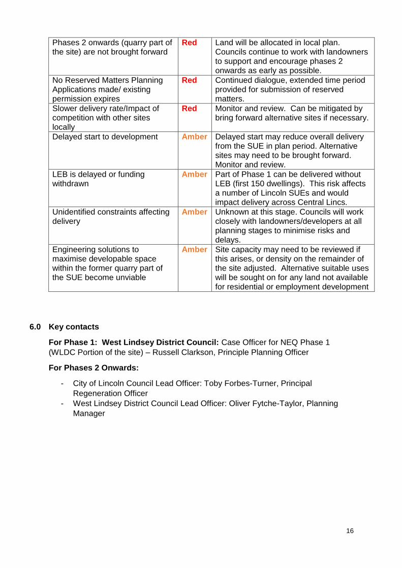
16
Phases 2 onwards (quarry part of the site) are not brought forward
Red Land will be allocated in local plan. Councils continue to work with landowners to support and encourage phases 2 onwards as early as possible.
No Reserved Matters Planning Applications made/ existing permission expires
Red Continued dialogue, extended time period provided for submission of reserved matters.
Slower delivery rate/Impact of competition with other sites locally
Red Monitor and review. Can be mitigated by bring forward alternative sites if necessary.
Delayed start to development Amber Delayed start may reduce overall delivery from the SUE in plan period. Alternative sites may need to be brought forward. Monitor and review.
LEB is delayed or funding withdrawn
Amber Part of Phase 1 can be delivered without LEB (first 150 dwellings). This risk affects a number of Lincoln SUEs and would impact delivery across Central Lincs.
Unidentified constraints affecting delivery
Amber Unknown at this stage. Councils will work closely with landowners/developers at all planning stages to minimise risks and delays.
Engineering solutions to maximise developable space within the former quarry part of the SUE become unviable
Amber Site capacity may need to be reviewed if this arises, or density on the remainder of the site adjusted. Alternative suitable uses will be sought on for any land not available for residential or employment development
6.0 Key contacts
For Phase 1: West Lindsey District Council: Case Officer for NEQ Phase 1
(WLDC Portion of the site) – Russell Clarkson, Principle Planning Officer
For Phases 2 Onwards:
- City of Lincoln Council Lead Officer: Toby Forbes-Turner, Principal
Regeneration Officer
- West Lindsey District Council Lead Officer: Oliver Fytche-Taylor, Planning
Manager