sustainable approach to regenerating residential form and
TRANSCRIPT

Hindawi Publishing CorporationUrban Studies ResearchVolume 2013, Article ID 783792, 12 pageshttp://dx.doi.org/10.1155/2013/783792
Research ArticleSustainable Approach to Regenerating Residential Form andDensity: Case in Dhaka
Quazi M. Mahtab-Uz Zaman and Richard Laing
Scott Sutherland School of Architecture & Built Environment, Robert Gordon University, Aberdeen AB10 7QB, Scotland, UK
Correspondence should be addressed to Quazi M. Mahtab-Uz Zaman; [email protected]
Received 30 May 2013; Revised 28 August 2013; Accepted 9 September 2013
Academic Editor: Cesar Ducruet
Copyright © 2013 Q. M. Mahtab-U. Zaman and R. Laing. This is an open access article distributed under the Creative CommonsAttribution License, which permits unrestricted use, distribution, and reproduction in any medium, provided the original work isproperly cited.
This paper presents principles and praxis of sustainable approach to maintaining targeted “residential regeneration by density”yet achieving innovations in urban form in a contextual scenario of Dhaka City, the capital of Bangladesh. It is evident fromthe context that Dhaka is experiencing a dramatic transformation in residential density due to demographic changes during thepast two decades due the concentration of social, administrative, institutional, recreational, small-scale industries, and associatedhousing facilities. The transformation is visible in residential built footprint, significantly due to the demand-driven and density-led market, originated from low rise and low density and transforming to high density high rise. This transformation has beenconsistently threatening social and environmental realm indicated by depletion of garden houses; reduction of public parks;shrinking walkways; deletion of setback for ventilation and sun shade from trees; slowing down mobility; and obstruction ofphysical and visual permeability. The paper discussed a pragmatic approach that professionals have adopted to control the densityand to introduce scopes for innovative urban forms by way of applying floor area ratio (FAR) methods and further discusses themerits of the methodological process of exercising morphology with a set of new building rules without undermining the marketdemand.
1. Strength of Urban Form andDensity in Regeneration
Regeneration occurs in varying forms and depends on thelevel of urban deterioration; frequency of changing func-tions and land uses; speculative real estate market; andsocioeconomic transformation affected by globalization [1].Regeneration in Dhaka city adopted the method of “transfor-mation by densification” in response to the competitive realestate market; globalization; rising affluent societies; rapiddemographic shift; and deterioration of built forms, whileDhaka has shaped as one of the popular destinations formajor socioeconomic and administrative development. Thistriggers pulling effects of population from the peripheralcities and other districts for job; education; health and judicialservices; administrative support; and for major urban realm[2, 3]; all these have been pushing Dhaka’s growth limit to thenorth (Figure 1).
Dhaka city’s concentration is a one way demographicshift since reciprocal distribution of population to other
districts rarely happens mostly due to other locale beingweakly connected by infrastructure and being less attractivefor job seekers [4, 5]. This phenomenon has caused DhakaCity to have reachedmegacity status, being one of the highestdensities in the world, with over 10.23 million reached in2008, which is about 40% of the urban population and 6%of the national population of the country, having 155 millionpeople [6]. Overcrowding of people in the city has posedthreat to the existing social and physical infrastructures, sig-nificantly deteriorating environmental, social, economic, andpolitical conditions, coupled with inadequacies of capacity ofthe necessary infrastructure, despite Dhaka being the centreof economic activities [7]. Jahan [8] suggests that a significantpart of this urbanisation is taking place in these developingcountries due to the dual process: (a) natural growth withincities and (b) large numbers of rural-urban migrants insearch of jobs and opportunities. Often this happens despitewidespread antiurbanisation policies, which aim to balancedevelopment and to sustain rural economies [9].

2 Urban Studies Research
4
4
3
3
2
2
1
100
Miles
1600 1750 1850 1950 1980
Figure 1: Urbanization in 380 years Dhaka [10].
Jahan [8] and Dewan et al. [11] suggest and furtherendorsed this phenomenon of migration as RUM (rural-urban migration), due to both push and pull factors and dueto gross disparities in socioeconomic opportunity betweenurban and rural areas. Further frequent natural disastersin some regions encourage large flow of migrants fromrural to the large cities. For various reasons, Dhaka is anattractive destination for the rural migrants. Rapid urbangrowth tends to overwhelm cities where the struggle todevelop infrastructure, mobilise, and manage resources hasnegative consequences for the environment [12]. Moreover,Dhaka is dominated by the presence of a huge informal sector,garments industries for global economic activities, which areaccommodated by massive conversion of housing and otherfunctions and further by intensifying the inner urban areas.It has been estimated that about 65% of all employment in thecity is in the informal sector [13].
Regeneration, unlike many other examples in the westbeing a positive intervention [14], is less desirable in Dhakadue to its inherent weaknesses that fail to visualise a biggerpicture of sustainable urban development derived from anappropriate urban form, the consequence of which is a seriesof urban crises. The significant crises are discussed below.
Crisis 1. Over 70% residential development falls underextreme compact condition devoid of any architectural meritand often labeled as “slum.” One way journey creates pressureto housing and associated functions that triggers developersto undertake a series of regeneration from low to high densitythat visibly and measurably dominate Dhaka’s skyline. Thistriggers surplus population, as “symphonic action,” seekingresidential spaces within the compact and closely knittedhousing solutions (Figure 2).
Analysis of Crisis 1. This crisis is inherently rooted in theoutdated building and planning bilaws, which is derived frombuilding to building spatial quality. Due to the old and inap-propriate building bilaws as illustrated in Figure 2, drasticmeasures were required. Building Regulations in Dhaka City(till 2006) essentially existed for the following purposes, withthe Bangladesh National Building Codes (BNBC) activelyrecommending environmental controls through [15].
(a) The Building Construction Act, 1952 guide setbacksbuilding heights and so forth in urban areas; preventshaphazard construction of buildings and excavationof tanks; controls and regulates safety, comfort, appro-priateness of materials, building services, and so forthof proposed building. These controls are imposed bymeans ofmaximum allowable floor area in relation tothe site through road width, building height, and setback from boundary (Figure 3).
(b) The Town Improvement (TI) Act 1953 regulates pro-posed building development on its immediate andthe city environment by preparation of master plans,improvement schemes, their implementations; con-trols development, by improvement and expansionof Dhaka by opening up congested areas; laying outof altering streets; providing open spaces for thepurpose of ventilation or recreation; demolition orconstruction buildings; acquiring land for the saidpurpose; and rehousing of persons displaced by theexclusion of improvement schemes.
(c) Building Construction Rules 2008 seek to controldevelopment plot-by-plot and case-by-case by devel-opment control on setbacks, site coverage, construc-tion of garages, access to plot, provision of lift, landuse of that particular plot, and height of building,restricting the height referring to BC Rules 1996.
(d) Bangladesh National Building Code (BNBC) 2006 en-sures optimum return of substantial portion of na-tional resource invested in building construction, inboth public and private sectors and to achieve satis-factory performance of any construction, which is feltby the stake holders for reasonable modifications forwhich the modifications of the Code began in 1992and was completed by the end of 1993.
(e) Land Development Rules for Private Housing 2004.
As a result of the above bilaws, social and environmentalbenefits were negligible, such as poor ventilation passagebetween buildings for surface cooling effects; poor percentageof greenery compared to hard surfaces resulting in “urbanheat trap” and “heat island effects”; lack of privacy; lack of

Urban Studies Research 3
Figure 2: Increasing density and expanding footprint are supported by weak building bilaws (Photo credit: Quazi M Mahtab-uz-Zaman,2006).
Figure 3:Old set back rules allow ineffective linear spaces (Graphicsby Quazi MMahtab-uz-Zaman, 2013).
immediate social spaces for physical and social activities sincea major proportion of public realm (parks and open spaces)have been converted into built-up areas (Figures 4 and 5).In the paper of Dewan and Yamaguchi [16] as referenced inByomkesh et al. [17], it was revealed that almost 80% of theland in Greater Dhaka that was nonurban in the 1960s (i.e., itcontained vegetation, open spaces, wetlands, and cultivatedlands) has drastically been reduced to about 40% by 2005.
Crisis 2. Urban Confinement and Sedentary Lifestyle Due toLack of Social Space for Children and Elderly People.The densebuilt form as illustrated in Figure 5 causes ill-health effects,especially amongst children and elderly due to their limitedand diminishing mobility pattern. This relates to the WorldHealth Organization’s findings of “Sedentary lifestyle” thatis a major underlying cause of death, disease, and disability.Crowding, poverty, crime, traffic, low air quality, and a lackof parks, sports and recreation facilities, and sidewalks makephysical activity a difficult choice as this is evident in SaoPaulo, where approximately 70% of the population is inactivedue to higher urban density. For Dhaka, it may be even morevulnerable as a growing number of children and elderly haverecorded health ailments. Record shows that air pollution
Figure 4: Densification of residential area (Google Map accessed in2004).
kills 15,000 Bangladeshis each year [18], where World Bank[13] report suggests saving of $200 to $800 million, whichis around 0.2 to 0.3% of GNP (Gross National Product) bycontrolling air pollution, and urban development is one ofthe strategies to respond to this crisis. Current patterns ofurbanization and motorization are also associated with moresedentary lifestyles, diminished space, and opportunities forphysical activity.
Reduction of natural assets like parks, protected greenspace and gardens, street trees, and landscaping reduces theopportunity for vital ecosystem, green lungs absorbing, andfiltering air pollution or as acting as filters for waste water.
Crisis 3. Removal of SustainableMicroclimate in Built Residen-tial Environment. Compact residential morphology reducescross ventilation, heat exchange, and cooling effects. Themicroclimate that generates the level of habitable environ-ment is mostly devoid of natural light, natural ventilation,and privacy as a result of the close property lines and lack

4 Urban Studies Research
Figure 5: Simulation of densification of morphology (Photo credit:Abdullah, 2004).
Figure 6: Densification and urban heat generator (Photo credit:Abdullah, 2004).
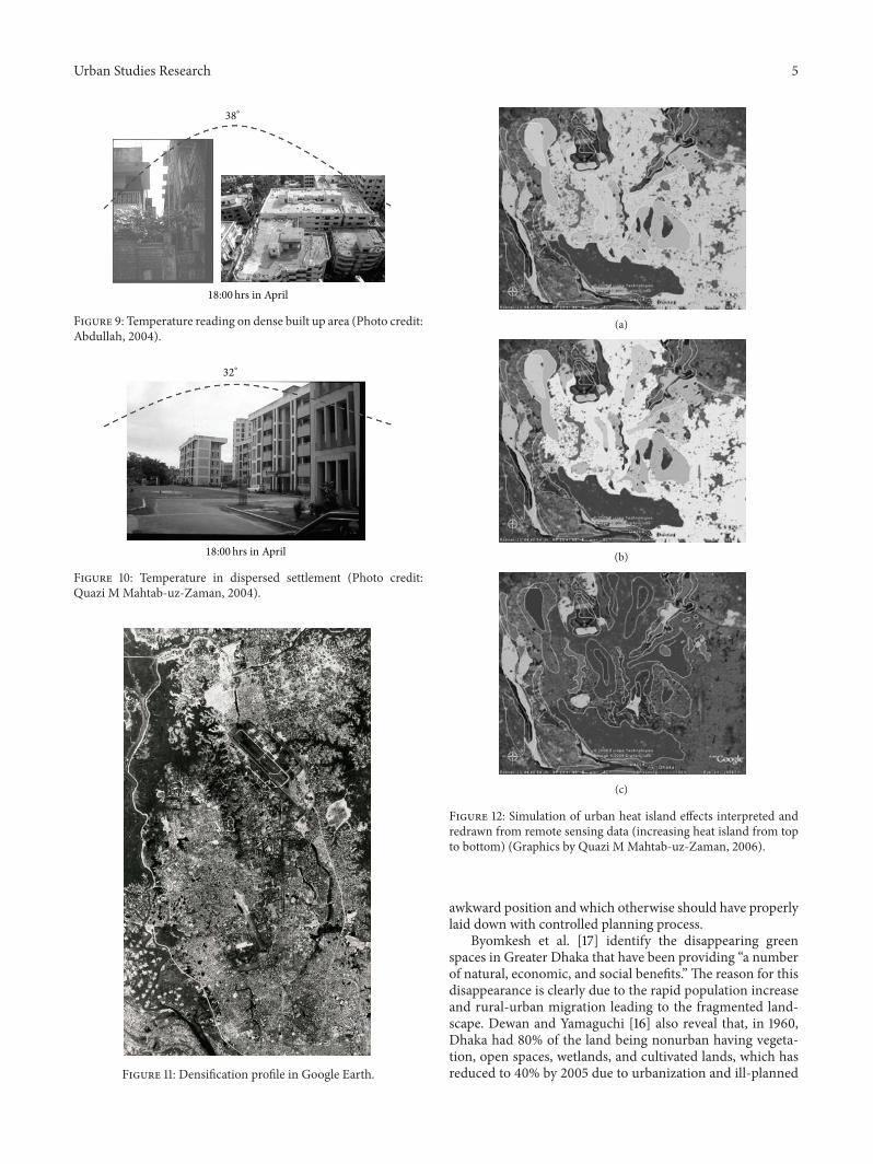
of vegetation (Figures 6 and 7). Urban heat island is amongstother elements of discomfort that forces residences to rely onmechanical cooling and ventilation system. Therefore, urbanheat island (UHI) is seen as a major man-made consequenceof urban morphology, as Tran et al. [19] identifies thatthe rapid urban transition in Asia with large proportion ofpopulation relying on increasing energy consumption signif-icantly affecting the quality of life while further worseningmicro-climatic condition (Figure 8). Moreover, as urbaniza-tion becomes more intense with revised density, urban-ruraltemperature differences also increase as recorded in othermegacities (Figures 9, 10, 11, and 12) [20, 21].
Crisis 4. Reduction of Ground Water Table and Surface WaterFlow due to Increasing Impervious Surface Areas. Bangladeshis a rain dominated country, and Dhaka is no exception.Dhaka receives on average about 448mm of rain in 6 hours,measuring about 2000mm annual rainfall during monsoonseason [23], but the benefit of having such volume of rainis slim due to city’s dense urban development, thus creatingno opportunity for ground water recharging. Dhaka cityhad networks of rivers, ephemeral water bodies, and canalsthat could drain excessive water during rainy season, butdemographic pressure, expansion of built environment andimpervious surfaces, and reclamation of these channels haveresulted in additional problem of water logging and lessenedthe capacity of ground water recharging [23].
Figure 13 illustrates a common scene of surface water flowduring heavy rain causing urban flooding and simultaneous
Figure 7: Awaiting removal of remaining greeneries for densifica-tion (Photo credit: Abdullah, 2004).
Comparison of indoor temperatures in a house in dense Surroundings (figure 12) and open
surroundings (figure 13) in April
20
25
30
35
40
6:00 9:00 12:00 15:00 18:00 21:00 0:00 3:00 6:00Time
House in dense surroundings
House in open surroundingsOutdoor temperature
Tem
pera
ture
(∘C)
Figure 8: Temperature difference between house in dense built upareas versus house with greeneries [22].
fresh water crisis due to lack of underground water recharg-ing. It is estimated byWater and Sewerage Authority (WASA)of Dhaka in 2011 that urban ground water is decreasing at therate of 6 meters in 7 years [24], which means reducing thebenefit of having underground fresh water (Figure 14).This isalso pointing to any future probability of having liquefactionfrom underground porosity created from losing water withinthe geomorphological structure. Therefore, Figures 13 and 14are two extremes of the same cause of natural degradation.
The Haq prediction from the recent Rain Forum [25]suggests that ground water level at central part of Dhaka isreducing 3mmeach year.This postulates the “aquifer” actionsby drying of natural wells and triggering contamination ofwater and a possible land subsidence [26].
Crisis 5. No minimum standard of Public Realm—Pedestrianand Green Space. Densification process forces the publicrealmout of the “zoning” and “space distribution calculation,”resulting in the lack of pedestrian and other public realm.Moreover, the densification of land uses without sustainablemeasures to reduce vehicular traffic volume poses additionalthreat to air pollution leading to health hazards (Figure 15).
A general scene of this negligence is the overflow of socialcontact point and retail anchor areas coexisting with parkingspace (Figure 15), which all get diluted and juxtaposed in an
Urban Studies Research 5
38∘
18:00hrs in April
Figure 9: Temperature reading on dense built up area (Photo credit:Abdullah, 2004).
32∘
18:00hrs in April
Figure 10: Temperature in dispersed settlement (Photo credit:Quazi MMahtab-uz-Zaman, 2004).
Figure 11: Densification profile in Google Earth.
(a)
(b)
(c)
Figure 12: Simulation of urban heat island effects interpreted andredrawn from remote sensing data (increasing heat island from topto bottom) (Graphics by Quazi MMahtab-uz-Zaman, 2006).
awkward position and which otherwise should have properlylaid down with controlled planning process.
Byomkesh et al. [17] identify the disappearing greenspaces in Greater Dhaka that have been providing “a numberof natural, economic, and social benefits.” The reason for thisdisappearance is clearly due to the rapid population increaseand rural-urban migration leading to the fragmented land-scape. Dewan and Yamaguchi [16] also reveal that, in 1960,Dhaka had 80% of the land being nonurban having vegeta-tion, open spaces, wetlands, and cultivated lands, which hasreduced to 40% by 2005 due to urbanization and ill-planned

6 Urban Studies Research
Figure 13: Flood and heavy surface water flow to built-up coverage[27].
Figure 14: Ground water depletion is creating water crisis inneighborhood supply [28].
Figure 15: Traffic and rising air pollution [29].
built environment. Reduction of greeneries is calculated ashaving only 8% tree coverage compared with the standard of20% required for achieving healthy urban environment, andthese reflect on the total loss of greenery of about 8617 ha in 30years (1975 to 2005) [17].These further point to the difficultiesthat residents face in keeping buildings cool naturally.
Urban Auditing. Accumulation of all the above crises (item1 to 5) indicates a set of evidence that is attributed to (a)having lack of appropriate building regulations and urbanplanning agenda; (b) rapid urbanization and increasingdensity without appropriate emphasis to environmental andsocial spatial quality; and (c) can be summarized as having a“shortsighted” approach to density and increasing “amnesiain innovative morphological distribution.” Moreover,
(i) increasing density and its effects on infrastructurehave never been scrutinized, which led to overbur-dening of water and sewerage system in the city, and
that allowed minimum social space in shelter designand development;
(ii) built professional never felt to deal with the elementof “density” and applied to morphological process;
(iii) it was never realised that decisions made on densityprofile can have significant impact on health, urbanenvironment, productivity of cities, and on humandevelopment as a whole [30].
Opportunity for Mitigating Crises. (FAR to recover/recreate/make provision for URBAN SPACE for saving Dhaka). Tocombat the above crises, it is identified that “urban form” hasthe potentiality in its inherent capacity to bring environmen-tal as well as social benefits subject to a proper manipulationand use of formal arrangement within the limited plot area.Integratedmaster plan began to consider formal arrangementwithin Good Governance since 2004 with intervention froma multiprofessional body under the Institute of ArchitectsBangladesh.
It was felt the need for innovative approaches to bring
(i) balance between rapid urbanization, densification [31,32] and socio-environmental qualities, where envi-ronmental plans needed to be integrated with the citymaster plan, as this is significant element which hasalready been established as part of good governanceby many countries (49% of the world’s cities haveestablished urban environmental plans [33]);
(ii) floor area ratio (FAR) has been identified as a criticaltool, which is common formany countries (Figures 16and 17).
The new building regulation 2007 [Mohanagar ImaratNirman Bidhimala (MINB) 2007] [34] was developed withthe help of a multiprofessional team aiming to instigateflexiblemorphology yetmaintaining amandatory open space(or maximum land utilization of 30 to 40% of total lotarea for a residential plot), setback, ground coverage, andfloor area ratio (FAR) (Figures 18, 19, 20, 21, 22, and 23).It eliminates mandatory height limitations of buildings andenables design of more liveable and open spaces allowingdesign flexibility and provision of natural lighting and crossventilation within built spaces.This is an enhancement of thetraditionalmethods of urban development legislationDMDPUrban Area Plan that generated guidelines for developmentmanagement [35]. DMDP recommends that current RAJUKcontinue to develop 6 storey buildings only within theplanned developed; for any high density, development shouldbe scrutinized reflecting on the needs where existing infras-tructure provision is sufficiently higher, aiming to generatehigher density.
2. Morphological Exercise to Restore Socialand Environmental Balance
For more details see, Figures 18–23.

Urban Studies Research 7
Figure 16: Concept of FAR (Graphics by Abdullah, 2004).
Figure 17: Concept and advantage of FAR (Graphics by Abdullah,2004).
Figure 18: Simulation of existing morphology from old buildingregulation (Graphics by Abdullah, 2004).
Figure 19: Actual scenario of existing morphology (Graphics byAbdullah, 2004).
Figure 20: Applying FAR 4.2 by rearranging in 12 storied buildingswith achievable 35% covered area and recouping 65% open area(Graphics by Abdullah, 2004).
Figure 21: Example of FAR 4.2 outcome (Photo credit: Quazi M.Mahtab-uz-Zaman, 2004).
Figure 22: Morphology as generated from existing building regula-tion having FAR 4.2 (Photo credit: Abdullah, 2004).
Figure 23: Simulated morphology as generated from FAR 4.2with injection of social and environmental spaces (Photo credit:Abdullah, 2004).

8 Urban Studies Research
3. Methodology of Morphological Exercise
Floor area ratio (FAR) is the fundamental element of themorphological exercise as FAR allows a variety of builtand open space ratio for greater innovations and therebygenerating opportunity for social and environment spaces.A fixed area of 4 residential blocks having 16 residentialbuildings was chosen, where regeneration would take placeor regeneration would be recommended for future changes.These 16 residential blocks are 6 storied each as per oldbuilding regulation having linear set back rules as illustratedin Figure 2, which generated around 4.2 FAR if calculated indensity. As the target is not to increase the traditional densityper hectare, the new residential morphological footprint hasbeen applied with the same 4.2, but allowing more spatialvariance as the FAR allows generating flexible morphologiesand building footprint.The result of this exercise is a numberof options for variable heights ranging from 10 to 18 storiedbuildings (Figures 18–23), yet recouping more spaces forgardens and other environmental spaces, such as opportunityfor ground water recharging from annual rain water; air flow;sun-shade and sun-casting where ever needed.
4. Environmental Benefits of Morphology
New morphological exercise under the MINB 2007 enablesprovision of essential parking, fire escapes, and mechani-cal spaces for which additional floor areas are permitted.Introduction of FAR of MINB 2007, bylaws, would ensureprovision of mandatory open spaces around the building forsufficient light and ventilation to the building and vegetationto grow and reduce chances of any impacts to the macrocli-mate. By creating 50% of the open space to be unpavedwithineach built up area, the development site would allow morerain water to recharge the ground water table.
In the context of Dhaka, the benefits are no doubtachievable by the following outcomes of FAR method:
(i) creating air circulation passage/tunnel by increasingset back;
(ii) creating direct sun light passage on open areas byreducing building footprint;
(iii) reducing urban heat island by recreating greenerieson open areas, as Mahmood [18] identifies savingforest and promoting plantation can bring ecologicalbalance in the city;
(iv) reducing cost of artificial air cooling method as aresult of increased natural ventilation;
(v) maintaining the existing character of established res-idential neighbourhoods;
(vi) minimizing the out-of-scale appearance of largehomes relative to their lot size and to other homes ina neighbourhood;
(vii) minimizing loss of light and privacy to neighborscaused by the construction of large homes;
(viii) minimizing the environmental damage of tree re-moval and destruction of natural features which may
Figure 24: Rain water gets disperse far away from the sourceand reduction of ground water recharging (Graphics by Quazi MMahtab-uz-Zaman, 2007).
Figure 25: Newmorphology has potential in inviting rain water andallowing ground water recharging (Graphics by Quazi M Mahtab-uz-Zaman, 2007).
result from overbuilding, as environmental hazardsin Dhaka city by deforestation are severe by cuttingdown of trees, encroachment and filling of waterbodies;
(ix) recharging groundwater table as illustrated in Figures24 and 25, which should be urgently tackled due tothe evidence generated from computermodel (MAK-SENS) [36] that water table would further decline 9–25meter by the year 2015 and 18–40meters by the year2025.
As the major proportion of water is generated fromground reserves, Sarkar and Ali [36], increasing permeabilityby manipulating ground coverage for water percolation is theonly choice for reverting city back to nature.
The presence of greeneries, thus created by morpho-logical transformation, would help regain natural processes,significantly by mitigating local temperature extremes, asMcPherson et al. [37] stated that a 10% increase in vegetationreduces cooling and heating energy by between five per centand ten percent. Vegetation and unpaved ground conditionalso decrease storm water dynamics, thus helping cities to
Urban Studies Research 9
Figure 26: Repeating FAR in regeneration areas postulates a biggerchange (http://www.skyscrapercity.com/ accessed on 2 May 2013).
Figure 27: FAR thus would inject social and environmentalspaces yet keeping the same density profile (http://www.skyscrap-ercity.com/ accessed on 2 May 2013).
manage the consequences of heavy rainfall, as in the case ofDhaka city (Figures 26 and 27).
5. Social Benefits of Morphology
A series of catalytic effects would trigger from FAR, signifi-cantly, the social benefits as follows:
(a) generating greenery and healthy spaces for walking;(b) injecting and recreating social space within greener-
ies;(c) achieving psychological benefits and wellbeing from
open spaces;(d) creating opportunity for privacy andpermeability due
to injection of open space.
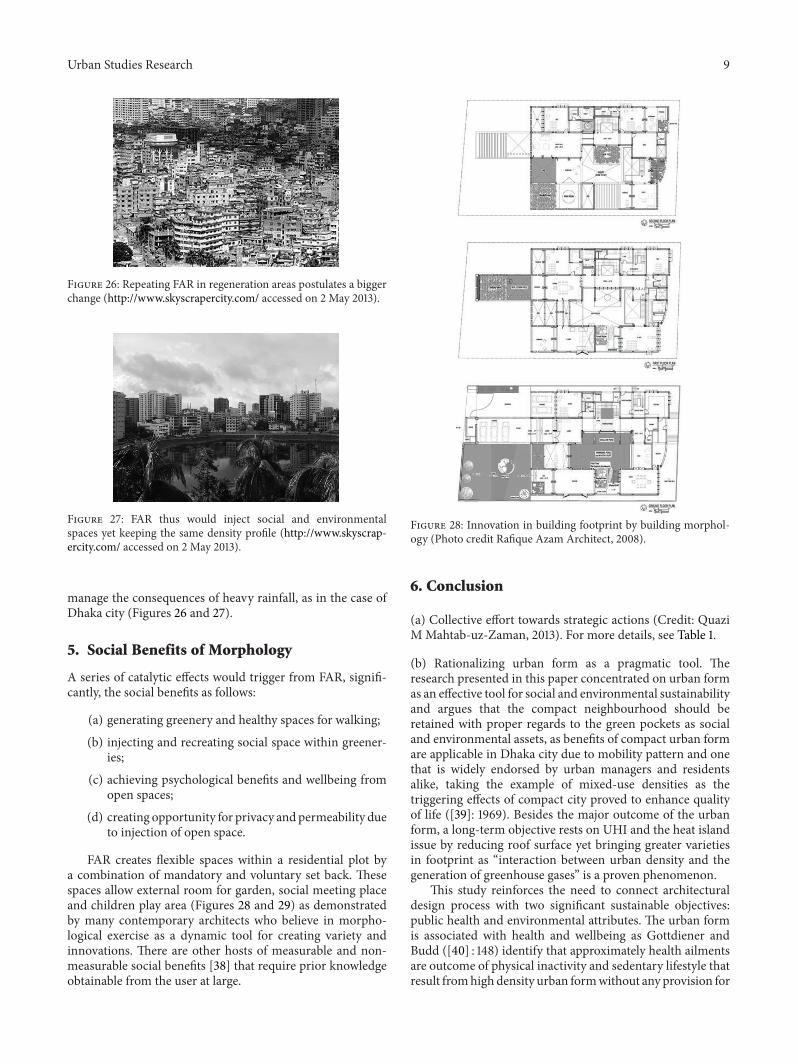
FAR creates flexible spaces within a residential plot bya combination of mandatory and voluntary set back. Thesespaces allow external room for garden, social meeting placeand children play area (Figures 28 and 29) as demonstratedby many contemporary architects who believe in morpho-logical exercise as a dynamic tool for creating variety andinnovations. There are other hosts of measurable and non-measurable social benefits [38] that require prior knowledgeobtainable from the user at large.
Figure 28: Innovation in building footprint by building morphol-ogy (Photo credit Rafique Azam Architect, 2008).
6. Conclusion
(a) Collective effort towards strategic actions (Credit: QuaziMMahtab-uz-Zaman, 2013). For more details, see Table 1.
(b) Rationalizing urban form as a pragmatic tool. Theresearch presented in this paper concentrated on urban formas an effective tool for social and environmental sustainabilityand argues that the compact neighbourhood should beretained with proper regards to the green pockets as socialand environmental assets, as benefits of compact urban formare applicable in Dhaka city due to mobility pattern and onethat is widely endorsed by urban managers and residentsalike, taking the example of mixed-use densities as thetriggering effects of compact city proved to enhance qualityof life ([39]: 1969). Besides the major outcome of the urbanform, a long-term objective rests on UHI and the heat islandissue by reducing roof surface yet bringing greater varietiesin footprint as “interaction between urban density and thegeneration of greenhouse gases” is a proven phenomenon.
This study reinforces the need to connect architecturaldesign process with two significant sustainable objectives:public health and environmental attributes. The urban formis associated with health and wellbeing as Gottdiener andBudd ([40] : 148) identify that approximately health ailmentsare outcome of physical inactivity and sedentary lifestyle thatresult fromhighdensity urban formwithout any provision for

10 Urban Studies Research
Table 1
Actors Actions
The Building Construction Act, 1952 Over all built environment—assessment against natural, social, andneed-based assessment of density
The Town Improvement (TI) Act 1953 Should recreate natural balance by enforcing stricter control on landscape andskyline legislation
Building Construction Rules 2008 Priority in formulating built-open ratio through FAR and set back fromvariable road conditions
Bangladesh National Building Code (BNBC) 2006 Should be revisedLand Development Rules for Private Housing 2004 Should enforce control over natural land conversion
Figure 29: Spatial variance for social and environmental attributes(Photo credit: Rafique Azam Architect, 2008).
urban spaces and greeneries. Physical inactivity is estimatedto be responsible for some 1.9 million deaths globally everyyear, as a result of disease such as heart ailments, cancer, anddiabetes especially vulnerable for children. Urban conditionsshould offer children and young people sufficient level ofchoice, control, and freedom within reasonable boundaries.The child’s right to play is recognized in Article 31 of theUnited Nations Convention on the Rights of the Child, whichwas ratified and adopted by many countries [41, 42].
This paper, thus, concludes by stating that urban formhas strength for maintaining social and environmental sus-tainability. Although it is understood that “different sizes andshapes of cities imply different geographical advantages” [43],Dhaka city deserves high density and innovative urban form
that could embrace greeneries as a mandatory provision.The exercise presented in this paper is an upshot of apragmatic approach to reconstruct sustainable and healthycity by applying building morphology as a tool for urbanregeneration. Further, Dewan and Islam [23] suggest a carefuldecision of settlement design considering flood plain andvarious hazard zones (low to high elevated land) shouldeffectively be taken into consideration while designing builtform, such as elevated structures around the high floodprone areas would not hinder natural water flow and withoutinfilling low lying areas. Any new decisions on land use andbuilt environment should be obtained through scrutinizinghazard map.
Acknowledgments
The authors would like to acknowledge the support fromIDEAS Research Institute of Robert Gordon University forallowing time and financial support to produce this paper,the research of which was originated during 2005 to 2007from a professional study of the Institute of ArchitectsBangladesh and BRAC University, Dhaka; both institutesdeserve acknowledgement too. Lastly, thanks to Abdullah, AQ M from Perkins and Wills, Chicago, USA, for researchingbuilding volumes and generating 3D simulated drawingsfor the research in 2004 and for obtaining residential pho-tographs. Thanks are also due to Rafiq Azam Architect.
References
[1] P. Roberts andH. Sykes,UrbanRegeneration: AHandbook, Sage,Thousand Oaks, Calif, USA, 2000.
[2] N. Islam, Urbanization, Migration and Development in Bangla-desh: Recent Trends and Emerging Issues, Paper I, Centre forPolicy Dialogue, Dhaka, Bangladesh, 1999.
[3] UN Habitat, State of the World’s Cities 2008/09: HarmoniousCities, Routledge, New York, NY, USA, 2012.
[4] Q. Mahtab-uz-Zaman, Accumulated Negligence, Opinion, DailyStar, Dhaka, Bangladesh, 1999.
[5] A. Ishtiaque andM. S.Mahmud, “Migration objectives and theirfulfilment: a micro study of the rural-urban migration of theslums of Dhaka City,” Malaysian Journal of Society and Space,vol. 7, no. 4, pp. 24–29, 2011.
[6] World Bank, Country at a Glance—Bangladesh, 2013, http://www.worldbank.org/en/country/bangladesh.

Urban Studies Research 11
[7] A. M. Dewan, M. H. Kabir, K. Nahar, and M. Z. Rahman,“Urbanisation and environmental degradation in DhakaMetropolitan Area of Bangladesh,” International JournalEnvironment and Sustainable Development, vol. 11, no. 2, pp.118–147, 2012.
[8] M. Jahan, “Impact of rural urbanmigration on physical and soc-ial environment: the case of Dhaka city,” International Journal ofDevelopment and Sustainability, vol. 1, no. 2, pp. 186–194, 2012.
[9] UNFPA, State of World Population 2007, Unleashing the Poten-tial of Urban Growth, The United Nations Population Fund,2007.
[10] Shankland Cox Partnership, Dhaka Metropolitan Area Integra-ted Urban Development Project, Planning Commission, Gov-ernment of Bangladesh, Dhaka, Bangladesh, 1981.
[11] A. M. Dewan, Y. Yamaguchi, and M. Z. Rahman, “Dynamics ofland use/cover changes and the analysis of landscape fragmen-tation in Dhaka Metropolitan, Bangladesh,”GeoJournal, vol. 77,no. 3, pp. 315–330, 2012.
[12] UNEP,Cities-Investing in Energy and Resource Efficiency, UnitedNations Environment Programme, 2011.
[13] World Bank, Towards an Urban Strategy for Bangladesh, Infras-tructure Unit, South Asia Region, World Bank, Washington,DC, USA, 1999.
[14] A. Tallon, Urban Regeneration and Renewal—Critical Conceptsin Urban Studies, Routledge Major Works, London, UK, 2009.
[15] S. Shafi,UnpublishedKeynote Paper onNational BuildingCodeand Its Implementation, RoundTableDiscussion on Implemen-tation of National Building Code, National Press Club, Dhaka,Bangladesh, 2010.
[16] A. M. Dewan and Y. Yamaguchi, “Effect of land cover changeson flooding: example from Greater Dhaka of Bangladesh,”International Journal of Geoinformatics, vol. 4, no. 1, pp. 11–20,2008.
[17] T. Byomkesh, N. Nakagoshi, and A. M. Dewan, “Urbanizationand green space dynamics in Greater Dhaka, Bangladesh,”in Proceedings of the International Consortium of Landscapeand Ecological Engineering, Landscape Ecology Engineering,Springer, 2011.
[18] S. A. I. Mahmood, “Air pollution kills 15,000 Bangladeshis eachyear: the role of public administration and governmentsintegrity,” Journal of Public Administration and Policy Research,vol. 3, no. 4, pp. 129–140, 2011.
[19] H. Tran, D. Uchihama, S. Ochi, and Y. Yasuoka, “Assessmentwith satellite data of the urban heat island effects in Asian megacities,” International Journal of Applied Earth Observation andGeoinformation, vol. 8, no. 1, pp. 34–48, 2006.
[20] T. Ichinose, K. Shimodozono, and K. Hanaki, “Impact of anth-ropogenic heat on urban climate in Tokyo,” Atmospheric Envi-ronment, vol. 33, no. 24-25, pp. 3897–3909, 1999.
[21] J. Boonjawat, K. Niitsu, and S. Kubo, “Urban heat island: ther-mal pollution and climate change in Bangkok,” Report of theSoutheast Asia START Regional Centre, 2000, http://www.start.or.th/heatisland.
[22] F. H. Mallick,Thermal comfort for urban housing in Bangladesh[Unpublished Doctoral Dissertation], Architectural AssociationGraduate School, London, UK, 1994.
[23] A. M. Dewan and M. M. Islam, Evaluating Flood Hazard forLand-Use Planning in Greater Dhaka of Bangladesh UsingRemote Sensing and GIS Techniques, Water Resource Manage-ment, Springer Science, Business Media B.V., 2006.
[24] Daily Star,Dhaka’s Groundwater Drops 6m in 7 Years, Daily Star,Dhaka, Bangladesh, 2011.
[25] A. Haq, “Dialogue onWorldWater Day 2013,” Bangladesh Insti-tute of Planners and WaterAid Bangladesh, Forum for PhysicalDevelopment of Bangladesh, 2013, http://fpd-bd.com/?p=2998.
[26] M. Rahman, “Environmental degradation of Dhaka,” The Uni-versity of Tokyo, Tokyo, Japan, 2010.
[27] Wikimedia, Flood Dhaka—Rezowan, 2013, http://commons.wikimedia.org/wiki/File:Flood Dhaka Rezowan.jpg.
[28] F. Ahmed, “Water Crisis Grips Dhaka,” 2012, http://www.demo-htix.com/news/1367302/water-crisis-grips-dhaka#media-1367212.
[29] F. Ahmed, “Haphazard parking causes more traffic jams inDhaka,” 2012, http://www.demotix.com/news/1354344/haphaz-ard-parking-causes-more-traffic-jams-dhaka#media-1354313.
[30] C. Acioly and F. Davidson, Density in Urban Development,Building Issues (Habitat II), vol. 8, Lund centre for HabitatStudies, Lund University, Lund, Sweden, 1996.
[31] Q. Mahtab-uz-Zaman, S. Lau, and H. M. So, “The compact cityof Hong Kong: a sustainable model for Asia?” in The CompactCities: Sustainable Urban Form for Developing Countries, M.Jenks and R. Burgess, Eds., pp. 255–268, Spon Press, London,UK, 2000.
[32] Q.Mahtab-uz-Zaman and S. Lau, “City expansion policy versuscompact city demand: the case ofDhaka,” inTheCompact Cities:Sustainable Urban Form for Developing Countries, M. Jenks andR. Burgess, Eds., pp. 141–1152, Spon Press, London, UK, 2000.
[33] J. Astrand, “The habitat agenda-urbanisation in developingcountries,” Unpublished lecture paper Housing Developmentand Management, Lund University, Lund, Sweden, 2006.
[34] GoB, Mohanagar Imarat Nirman Bidhimala 2007, Ministry ofHousing and PublicWorks, Government of Bangladesh, Dhaka,Bangladesh, 2007.
[35] DMDP, Dhaka Metropolitan Development Plan, vol. 2, RAJUK,Dhaka, Bangladesh, 1995.
[36] A. Sarkar and M. H. Ali, “Water table dynamics of Dhakacity and its long-term trend analysis using the “MAKESENS”model,”Water International, vol. 34, no. 3, pp. 373–382, 2009.
[37] E. G. McPherson, D. J. Nowak, and R. A. Rowntree, “Chicago’surban forest ecosystem: results of the Chicago urban for-est climate project,” General Technical Report NW-186, U.S.Department of Agriculture, Forest Service, Northeastern ForestExperiment Station, Radnor, Pa, USA, 1994.
[38] Q. Mahtab-uz-Zaman, F. H. Mallick, A. Q. M. Abdullah, andJ. Ahmed, “In search of a habitable urban space-built ratio: acase study of building and planning regulation in Dhaka City,”in Tropical Sustainable Architecture: Social and EnvironmentalDimensions, J. H. Bay and B. L. Ong, Eds., Architectural Press(Elsevier), London, UK, 2007.
[39] E. Burton, “The compact city: just or just compact? A pre-liminary analysis,” in Urban Compact Cities: Sustainable UrbanForms for Developing Countries, p. 9, Spon Press, London, UK,2000.
[40] M.Gottdiener andL. Budd,KeyConcepts inUrban Studies, Sage,London, UK, 2005.
[41] WHO,TheWorld Health Report 2002—Reducing Risks, Promot-ing Healthy Life, World Health Organization, Geneva, Switzer-land, 2002.

12 Urban Studies Research
[42] UNICEF, “FACT SHEET: a summary of the rights under theConvention on the Rights of theChild,” 2013, http://www.unicef.org/crc/files/Rights overview.pdf.
[43] M. Batty, “The size, scale, and shape of cities,” Science, vol. 319,no. 5864, pp. 769–771, 2008.

Submit your manuscripts athttp://www.hindawi.com
Child Development Research
Hindawi Publishing Corporationhttp://www.hindawi.com Volume 2014
Education Research International
Hindawi Publishing Corporationhttp://www.hindawi.com Volume 2014
Biomedical EducationJournal of
Hindawi Publishing Corporationhttp://www.hindawi.com Volume 2014
Hindawi Publishing Corporationhttp://www.hindawi.com Volume 2014
Psychiatry Journal
ArchaeologyJournal of
Hindawi Publishing Corporationhttp://www.hindawi.com Volume 2014
Hindawi Publishing Corporationhttp://www.hindawi.com Volume 2014
AnthropologyJournal of
Hindawi Publishing Corporationhttp://www.hindawi.com Volume 2014
Research and TreatmentSchizophrenia
Hindawi Publishing Corporationhttp://www.hindawi.com Volume 2014
Urban Studies Research
Population ResearchInternational Journal of
Hindawi Publishing Corporationhttp://www.hindawi.com Volume 2014
CriminologyJournal of
Hindawi Publishing Corporationhttp://www.hindawi.com Volume 2014
Aging ResearchJournal of
Hindawi Publishing Corporationhttp://www.hindawi.com Volume 2014
Hindawi Publishing Corporationhttp://www.hindawi.com Volume 2014
NursingResearch and Practice
Current Gerontology& Geriatrics Research
Hindawi Publishing Corporationhttp://www.hindawi.com
Volume 2014
Sleep DisordersHindawi Publishing Corporationhttp://www.hindawi.com Volume 2014
AddictionJournal of
Hindawi Publishing Corporationhttp://www.hindawi.com Volume 2014
Depression Research and TreatmentHindawi Publishing Corporationhttp://www.hindawi.com Volume 2014
Hindawi Publishing Corporationhttp://www.hindawi.com Volume 2014
Geography Journal
Hindawi Publishing Corporationhttp://www.hindawi.com Volume 2014
Research and TreatmentAutism
Hindawi Publishing Corporationhttp://www.hindawi.com Volume 2014
Economics Research International