surrey fraser docks - lupine survey may 21, 2013 (draft)
TRANSCRIPT

8971 Beckwith Road Phone 604 279 2093 Richmond, BC V6X 1V4 Fax 604 279 2047
Offices in Richmond, Terrace, Prince George, Kamloops & Calgary Page 1 www.triton-env.com
V1 June 5, 2013
Reference: 4419/WP
Jurgen Franke, P. Eng.
Fraser Surrey Docks (FSD)
11060 Elevator Rd
Surrey, BC V3V 2R7 Re: Evaluation of Bekaert Access Road Option 2 at Fraser Surrey Docks (FSD)
1.0 Introduction
Triton Environmental Consultants (Triton) was retained by FSD to conduct an environmental
assessment of the proposed Option 1 and 2 Access Road(s) into the Bekaert’s site. We
understand Option 2 was identified for consideration by Port Metro Vancouver (PMV) in May
2013. Option 1 was investigated in 2012 and the results of that investigation were summarized in
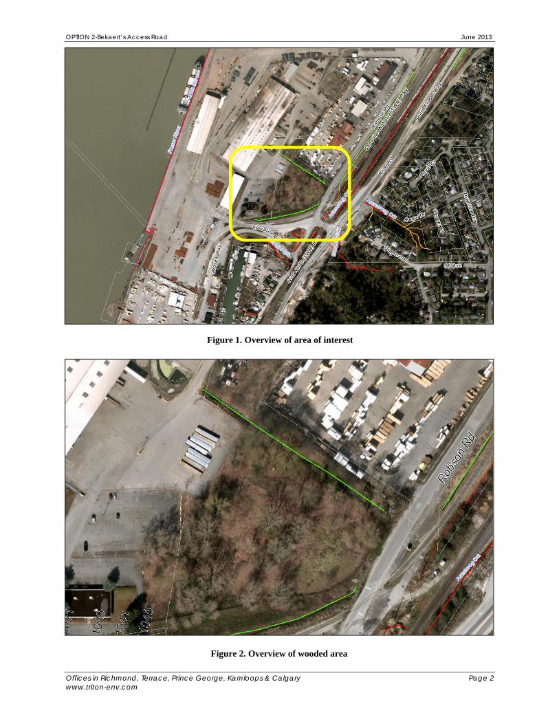
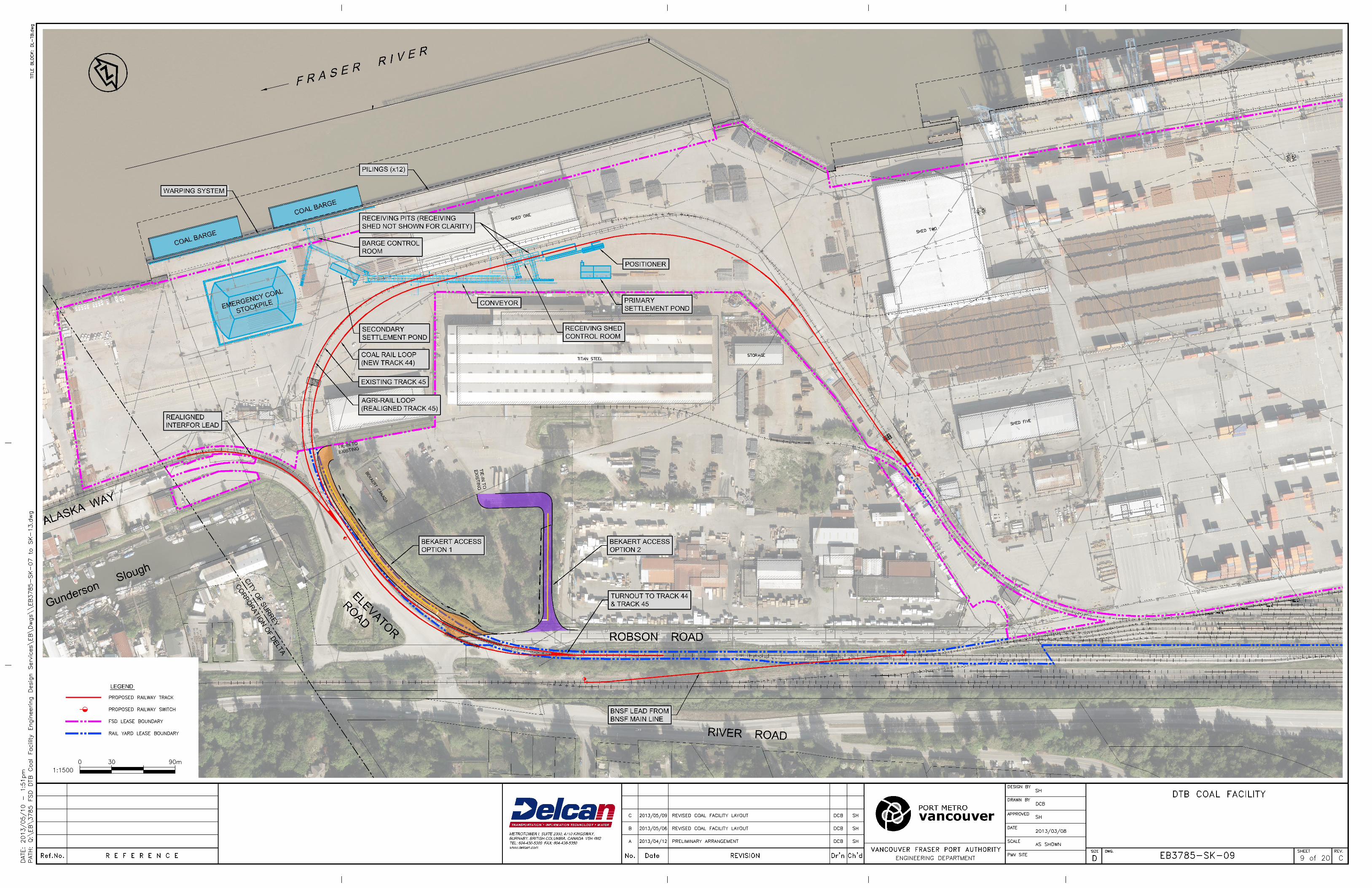
letters to the PMV submitted in April 2013. The proposed road is located directly adjacent to an
existing, roughly 148 m long ephemeral, green coded (non fish-bearing, insignificant nutrients
and flow) ditch and surrounding wooded area (Figures 1 and 2, Delcan Drawing EB3075-SK-
09). The PMV indicated historical records of the Species at Risk Act (SARA) listed Streambank
Lupine (Lupinus rivularis) in the wooded area, although not in the immediate vicinity of the
proposed road (Kim Keskinen, PMV, pers.comm., 2013). The wooded area is isolated in the
landscape, surrounded by railway track to the south and east and active, paved sites to the north
and west.
2.0 Methods
The following tasks were completed in support of the assessment: review of listed species
records at FSD in the Conservation Data Centre (CDC) database and May 2013 field surveys of
the proposed road footprint and adjacent areas (riparian, instream and upland habitats), as well as
the railway Right of Way (ROW) and adjacent areas along the southern and eastern boundaries
of the wooded area and for 100 m on both sides of the Elevator Road entrance into the site. The
timing of the May 2013 survey coincided with Lupine flowering.
OPTION 2-Bekaert’s Access Road June 2013
Offices in Richmond, Terrace, Prince George, Kamloops & Calgary Page 2 www.triton-env.com
Figure 1. Overview of area of interest
Figure 2. Overview of wooded area

OPTION 2-Bekaert’s Access Road June 2013
Offices in Richmond, Terrace, Prince George, Kamloops & Calgary Page 4 www.triton-env.com
3.0 Results
3.1 CDC Records
The following information on Streambank Lupine at FSD was compiled from the CDC Internet
Mapping Service (Appendix 1 –pgs 1 and 2, Streambank Lupine Recovery Team, 2012):
“…Four sub-populations: on the railway bed, opposite 10555 Timberland Road and at
Robson Road; on the roadside in a sand landfill at River Road and along the roadside
and railway track across from 9560 Alaska Way…”
“…2011: 2 flowering plants; 49 seedlings observed across from Alaska Way…”
“…2010: 2 flowering plants and 24 seedlings across from 9560 Alaska Way…”
“…2009: 10 flowering plants, 51+ seedlings across from 9560 Alaska Way …”
3.2 Streambank lupine habitat preferences
Streambank Lupine occurs at lower elevations in open sandy or gravelly, moist riverbank sites
with limited ground cover and will sometimes occur in open canopy sites. Preferred sites are
generally subject to flooding; and like other lupines, this species is often associated with
disturbed but not weedy sites (COSEWIC, 2002)1.
3.3 Partly wooded area and green coded ditch
The partly wooded area shows evidence of disturbance from past land clearing, with Black
Cottonwood (Populus trichocarpa) and Red Alder (Alnus rubra) dominating the tree cover
(Photo 1). Additional species observed in the upland wooded area included: Himalayan
blackberry (Rubus armeniacus), Snowberry (Symhoricarpos albus), Common Horsetail
(Equisetum arvense.),Thistle (Cirsium sp.) and Archangel (Lamium galeobdolon). No
Streambank Lupine specimens (or any lupine specimens) were observed in the partly wooded
area. The green coded ditch channel was dry in May 2013 and characterized by fine sediment
(mud and organics) with no evidence of scour to alluvium (Photo 2). No pool or run habitat units
or functioning large woody debris (LWD) were observed in the channel. Banks were poorly
defined at multiple locations. The riparian community along the green coded ditch also included
Cottonwood, Himalayan blackberry, Horsetail and Red Alder.
1 COSEWIC 2002. COSEWIC assessment and status report on the streambank lupine Lupinus rivularis in Canada. Committee on the Status of Endangered Wildlife in Canada. Ottawa. vi + 36 pp.

OPTION 2-Bekaert’s Access Road June 2013
Offices in Richmond, Terrace, Prince George, Kamloops & Calgary Page 5 www.triton-env.com
ho
Photo 1. Opening in wooded area adjacent to Bekaert’s
Photo 2. Green coded ditch
OPTION 2-Bekaert’s Access Road June 2013
Offices in Richmond, Terrace, Prince George, Kamloops & Calgary Page 6 www.triton-env.com
3.4 Railway ROW survey
No lupine specimens were found in / along the railway bed or in association with surrounding
vegetation communities. Commonly occurring species in the surveyed areas included:
Red-Osier Dogwood (Cornus stolonifera)
Nootka Rose (Rosa nutkana)
Reed Canary Grass (Phalaris arundinacea)
Salmonberry (Rubus spectabilis)
Hardhack (Spiraea douglasii)
Common Rush (Juncus effusus)
Bracken Fern (Pteridium aquilinum)
Himalayan Blackberry
Common Horsetail
4.0 Discussion
Streambank Lupine specimens were not found in the surveyed areas and the PMV indicated
historical records of occurrences in the wooded area do not overlap with the proposed Option 2
Road. Additionally, Lupine was not observed in either 2012 or 2013 in the Option 1 footprint,
which was originally investigated in 2012. The wooded area has been subject to past land
clearing includes a mix of commonly occurring native and exotic plant species. No listed plant
species were observed in this area.
The ephemeral green coded ditch lacks complexity (no pool or deep run cover, no LWD and has
a uniform fine substrate). It is classified as non fish-bearing and would also provide only limited
to suitable habitat for amphibians (e.g. lacking pool cover that may provide breeding habitat).
The riparian community alongside the ditch has limited species diversity and is dominated by
Himalayan blackberry in multiple areas. Some tree cover is available although mature specimens
are lacking.
In the event the Option 2 Access Road is ultimately selected, a new ditch can be excavated
beside the road resulting in no loss of the marginal wetted habitat currently available in the green
coded ditch. Detailed ditch plans will be provided to the PMV once the conceptual design has
been accepted. Similarly, riparian planting can be conducted alongside the west bank of the
relocated ditch to offset riparian changes associated with the Option 2 Access Road.
OPTION 2-Bekaert’s Access Road June 2013
Offices in Richmond, Terrace, Prince George, Kamloops & Calgary Page 7 www.triton-env.com
At this stage we recommend the following planting program adjacent to the relocated ditch: #2
pot Nootka Rose (75), #2 pot Hardhack (75), #1 pot Snowberry (150), #1 pot Scouler’s Willow
(Salix scouleriana) (75) and #2 pot Red Elderberry (Sambucus racemosa) (10). A detailed
planting plan will be provided to the PMV once the conceptual design for Option 2 has been
evaluated by the PMV.
5.0 Closing
If you have any questions, comments or concerns about this letter report, please feel free to
contact the undersigned. Yours truly,
Karla Graf, PM
Bach. Env. Eng.
Dip. Tech. RRM
Cert. Tech. Comm. Triton Environmental Consultants Ltd.

OPTION 2-Bekaert’s Access Road June 2013
Offices in Richmond, Terrace, Prince George, Kamloops & Calgary Page 8 www.triton-env.com
Photo 3. Road access into wooded area
Photo 4. Limited shrub and herb layer in wooded area

OPTION 2-Bekaert’s Access Road June 2013
Offices in Richmond, Terrace, Prince George, Kamloops & Calgary Page 9 www.triton-env.com
Photo 5. Wooded area with opening in background of photo
Photo 6. Green coded ditch channel –dry at time of survey

OPTION 2-Bekaert’s Access Road June 2013
Offices in Richmond, Terrace, Prince George, Kamloops & Calgary Page 10 www.triton-env.com
Photo 7. Green coded ditch –Blackberry in riparian cover
Photo 8. Green coded ditch –Blackberry and horsetail riparian cover

OPTION 2-Bekaert’s Access Road June 2013
Offices in Richmond, Terrace, Prince George, Kamloops & Calgary Page 11 www.triton-env.com
Road between the single rail line and double rail line.
Photo 9. Nootka Rose along Robson Road at the ditch bank
Photo 10. Reed Canary Grass and Himalayan Blackberry along the east side of Robson

OPTION 2-Bekaert’s Access Road June 2013
Offices in Richmond, Terrace, Prince George, Kamloops & Calgary Page 12 www.triton-env.com
Photo 11. Looking towards Elevator Road from the single rail line along Robson Road
Photo 12. Horsetail along the north west shoulder of Robson Road looking towards Elevator Road
OPTION 2-Bekaert’s Access Road June 2013
Offices in Richmond, Terrace, Prince George, Kamloops & Calgary Page 13 www.triton-env.com
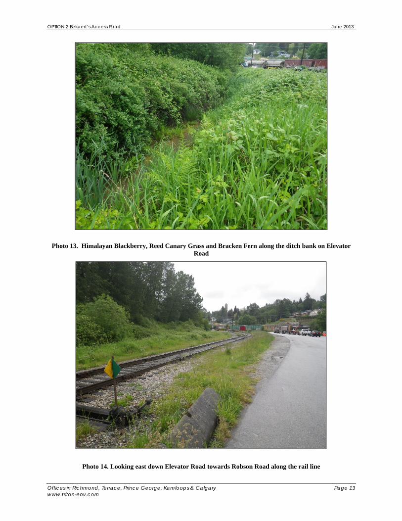
Photo 13. Himalayan Blackberry, Reed Canary Grass and Bracken Fern along the ditch bank on Elevator Road
Photo 14. Looking east down Elevator Road towards Robson Road along the rail line

BC Conservation Data Centre: Occurrence Report ( 3052 ) May 19, 2013 Lupinus rivularis streambank lupine
Field definition document available at http://www.env.gov.bc.ca/atrisk/ims.htm
This is a summary report. For a complete record contact the CDC ([email protected]). Identifiers
Occurrence ID: 4209 Status:
Shape ID: 3052 Global: G2G4 Type: Vascular Pla
nt Provinicial:
S1
COSEWIC:
E (NOV 2002)
BC List:
Red Taxonomic Class: dicots
SARA Schedule: 1 Data Sensitive: N Locators Survey Site: FRASER SURREY DOCKS
Directions: Four sub-populations: on the railway bed, opposite 10555 Timberland Road and at Robson Road; on the roadside in a sand landfill at River Road and along the roadside and railline across from 9560 Alaska Way.
Survey Information
First Obs. Date: 1990-05-17 Last Obs. Date: 2011 Occurrence Data: Lupinus rivularis has been reported from the Fraser Surrey docks since 1990, and four
small sub-populations were identified in 2001 during surveys for a COSEWIC status
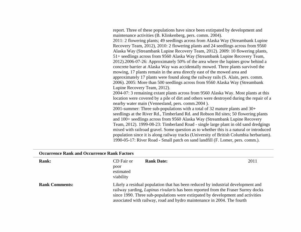
report. Three of these populations have since been extirpated by development and maintenance activities (B. Klinkenberg, pers. comm. 2004). 2011: 2 flowering plants; 49 seedlings across from Alaska Way (Streambank Lupine Recovery Team, 2012), 2010: 2 flowering plants and 24 seedlings across from 9560 Alaska Way (Streambank Lupine Recovery Team, 2012). 2009: 10 flowering plants, 51+ seedlings across from 9560 Alaska Way (Streambank Lupine Recovery Team, 2012).2006-07-26: Approximately 50% of the area where the lupines grow behind a concrete barrier at Alaska Way was accidentally mowed. Three plants survived the mowing, 17 plants remain in the area directly east of the mowed area and approximately 17 plants were found along the railway rails (S. Alain, pers. comm. 2006). 2005: More than 500 seedlings across from 9560 Alaska Way (Streambank Lupine Recovery Team, 2012). 2004-07: 3 remaining extant plants across from 9560 Alaska Way. Most plants at this location were covered by a pile of dirt and others were destroyed during the repair of a nearby water main (Vennesland, pers. comm.2004 ). 2001-summer: Three sub-populations with a total of 32 mature plants and 30+ seedlings at the River Rd., Timberland Rd. and Robson Rd sites; 50 flowering plants and 100+ seedlings across from 9560 Alaska Way (Streambank Lupine Recovery Team, 2012). 1999-08-23: Timberland Road - single large plant in old sand dredgings mixed with railroad gravel. Some question as to whether this is a natural or introduced population since it is along railway tracks (University of British Columbia herbarium). 1990-05-17: River Road - Small patch on sand landfill (F. Lomer, pers. comm.).
Occurrence Rank and Occurrence Rank Factors
Rank: CD Fair or
poor estimated viability
Rank Date: 2011
Rank Comments: Likely a residual population that has been reduced by industrial development and railway yarding, Lupinus rivularis has been reported from the Fraser Surrey docks since 1990. Three sub-populations were extirpated by development and activities associated with railway, road and hydro maintenance in 2004. The fourth

subpopulation is threatened by the same activities but was still extant in 2011 and appears to be reproducing.
Condition of Occurrence 2006: Plants that survived mowing were tiny and in bad shape, suffering from drought and needing water badly. Most plants had dispersed their seeds and only 3-4 had seed pods with seeds still in them (S. Letay, pers. comm. 2006).
Size of Occurrence: 1990: River Rd., small patch. 1999: Timberland Rd., one plant. 2001:Timberland, Robson and River Rds, 32 flowering plants; 30+ seedlings. Alask Way: 50 flowering plants; 100+ seedlings; Alaska Way: 2005- 500+ seedlings; 2009-10 flowering plants, 51 seedlings; 2010: 2 flowering plants; 24 seedlings; 2011: 2 flowering plants; 49 seedlings (Streambank Lupine Recovery Team, 2012).
Landscape Context: Low floodplain of Fraser River, in a heavily industrialized area with railway yards and roads. Maintenance and repair activities associated with the railway, roads and hydro installations all pose a threat to the populations.
Description
General Description: Low floodplain of Fraser River; heavily industrialized, in coarse gravel, silt and
sand along roadside urban railway dock area. Vegetation Zone: Lowland
Habitat: TERRESTRIAL: Roadside
Documentation
References: Alain, S. Personal communication. Fraser River Port Authority. New Westminster,
BC. Klinkenberg, B., and R. Klinkenberg. 2002. Status Report on Streambank Lupine, Lupinus rivularis, in Canada. Unpubl. rep. submitted to the Comm. on the Status of Endangered Wildl. in Can. Ottawa. 40pp. Letay, S. Personal communication. Ecosystems Officer, Ministry of Forests, Lands and Resource Operations. South Coast Region Surrey, BC. Lomer, F. Personal communication. Botanical Consultant. Streambank Lupine Recovery Team. 2012. DRAFT Recovery strategy for streambank lupine (Lupinus rivularis) in British Columbia. Prepared for the B.C.

Ministry of Environment, Victoria, BC. University of British Columbia. Dep. Bot., Dep. Zool., Biol. Sci. Bldg., 6270 Univ. Blvd., Vancouver, BC. Vennesland, R. 2002. Personal communication. Species at risk recovery biologist, Surrey, BC.
Version
Version Date: 30-APR-13
Mapping Information
Estimated Representation Accurac
y: High
Confidence Extent: ? May 19, 20
13