subwatershed selection criteria for demonstration of ... · pdf filesubwatershed selection...
TRANSCRIPT

Subwatershed Selection Criteria for Demonstration of
Streamflow Yield Enhancement through Brush Control
By
Ernest Fish and Ken Rainwater
Texas Tech University Water Resources Center
Box 41023
Lubbock, TX 79409-1023
Submitted to
Johnny Oswald
Texas Soil and Water Conservation Board
622 South Oakes Street, Suite H-2
San Angelo, TX 76903-7013
November, 2007
Subwatershed Selection Criteria for Demonstration of Streamflow Yield Enhancement through Brush Control
Problem Statement
The Texas State Soil and Water Conservation Board (TSSWCB) manages the State of
Texas' program for brush control to enhance surface water flows for urban and rural benefits.
To date, the sites selected have been large watersheds with varying coverages of different high
water use plants, such as salt cedar, juniper, and mesquite. Using conventional techniques
available in the late 1990s, predictions of increased streamflow through brush control were
based on watershed modeling that primarily changed runoff generation and groundwater loss
parameters in each watershed. Unfortunately, there has not been sufficient pre- and post
treatment monitoring to confirm the positive impacts of the selected brush control practices. It
is now apparent that scientific principles from hydrology must be applied to improve the site
selection process to prioritize sites for potential observable enhancement of streamflow yields.
The purpose of this report is to provide a straightforward list of criteria for selection of
sites for streamflow enhancement that will maximize the potential for observation of positive
impacts of brush control. The report includes a brief presentation of the general hydrologic and
watershed management concepts that contribute to possible increases in runoff and
streamflow from a watershed. Next, the proposed criteria are listed. Finally, some general,
observations about the importance of monitoring are summarized. This report is not a
detailed, thoroughly referenced critique of the historical brush control program, but is rather
intended as a useful reference for decision makers in the TSSWCB and the Texas legislature.
The authors plan to participate in a more detailed review of the TSSWCB brush control program
later in this fiscal year.
General Concepts
Runoff generated by a watershed is a reflection of the integrated net effects of all
watershed characteristics as they interact with and reflect the hydrologic cycle. One of the
primary objectives of watershed management is to maintain or improve water yields. To do so
requires an understanding of how a watershed functions in the delivery of water to its outlet. A
complete discussion of the factors involved and their functional relationships is beyond the
scope of this report, but it is possible to summarize the major components and discuss some of
their complexities and interactions.
Texas Tech University Water Resources Center Page 1
Subwatershed Selection Criteria for Demonstration of Streamflow Yield Enhancement through Brush Control
Probably the most significant relationship impacting water yields is the overall ratio of
precipitation to evaporation. In locations where this ratio exceeds 1.0, the likelihood of
enhancing runoff is increased; likewise, when the ratio is less than 1.0 runoff enhancement is
more challenging. If rainfall and evaporation were both uniformly distributed over time, it
would be difficult to have any streamflow at all in locations where evaporation exceeds
precipitation. It must be recognized, however, that the intensity, duration, and seasonality of
precipitation are more important than the annual totals. Intensity of rainfall refers to the depth
of rainfall per unit time, and duration is the time length of the rainfall event. Not all
precipitation events are IIrunoff producingll even when the total amount of precipitation is
identical, as the time between storm events can affect the pre-storm soil moisture. It is
possible at almost any location in the state (except for large sand dunes) to have short-term
storm events that put a lot of water on a watershed quickly enough that runoff can reach
streams and rivers faster than it is lost to evaporation. Seasonal trends in rainfall intensity have
been noted across the state. For example, the western side of the state receives much of its
rainfall from convective thunderstorms in the late spring and summer months, while the coastal
regions can receive major rainfall events during hurricane and tropical storm season.
Land use activities that alter the type or extent of vegetative cover on a watershed can
increase or decrease streamflow yields. The expected outcome from a planned vegetation
adjustment is based on change in evapotranspiration (El) IIl0sses" from the watershed.
Complicating these expectations are variations in precipitation patterns, soil infiltration
capacities, groundwater conditions, watershed area, land surface slopes, and other
characteristics of particular watersheds. For example, Hibbert (1979, 1983) concluded that
vegetative manipulations were likely to enhance water yields only when the watershed
received more than 18 inches of annual precipitation. Residual vegetation was expected to
consume all available precipitation in areas receiving less precipitation.
After accounting for precipitation patterns and amounts, water yields from watersheds
receiving similar inputs are dramatically impacted by soil, elevatiol'1, slope, aspect, climate, and
vegetation. Selection of areas for vegetative manipulation to enhance water yields should
Texas Tech University Water Resources Center Page 2

Subwatershed Selection Criteria for Demonstration of Streamflow Yield Enhancement through Brush Control
therefore be prioritized using a combination of the following factors. In general, storm runoff
and associated streamflow will be greater under these conditions.
• Steeper slopes. Runoff on steeper slopes can produce more erosion. Steeper slopes can
be more difficult to stabilize following vegetative manipulation, as the vegetation likely
helped hold soils in place.
• More uniform slopes with limited soil disturbance. Adding terraces to slopes reduces
runoff yield. Mechanical disturbances that leave the soil surface "cratered" can also
lose runoff to depression storage.
• Soils with lower infiltration capacities. Typically soils with finer textures and with
poorer structure have lower permeability and accept less vertical infiltration.
• South and west facing slopes. These aspects tend to be steeper and have less
vegetative cover in the northern hemisphere.
• Closer proximity of contributing area to stream channels. Runoff flow volume is
diminished by transmission losses to infiltration and depression storage over long flow
routes.
Another important consideration in water yield from a watershed is baseflow, which is
the contribution of groundwater discharge to streamflow. For perennial streams, baseflow
represents the streamflow that takes place between rainfall/runoff events, without the
contribution of storm runoff. It should be noted that ephemeral streams, which have no
baseflow, may still be positively impacted by watershed management in the arid and semi-arid
parts of the state. It is possible that evapotranspiration near the streambed can lower the local
groundwater table and turn a perennial stream into an ephemeral or intermittent stream. In
general baseflow to streams and rivers will be greater under the following conditions.
• Soils with higher infiltration capacity soils near the streambed. Alluvial (eroded and
deposited within the stream channel) soils with coarser textures and mostly large
particle sizes allow faster movement of water from the aquifer toward the stream.
• Higher water table elevation near streambed. If the elevation of the groundwater
table in the alluvial material near the streambed is higher than the elevation of the
water surface in the stream, groundwater will flow toward the "gaining" stream and
Texas Tech University Water Resources Center Page 3
Subwatershed Selection Criteria for Demonstration of Streamflow Yield Enhancement through Brush Control
contribute baseflow. If the groundwater table elevation is lower than the water surface
in the stream, water will from the "Iosing" stream into the alluvial aquifer.
• Replacement of deeper-rooted with shallower-rooted plant species. Typically deep
rooted woody species can be replaced with shallow rooted herbaceous species.
Concern must also be given to the density of the vegetative cover, as replacing a
moderately dense stand of mesquite trees with a heavy cover of switchgrass could in
fact reduce alluvial groundwater storage because of increased vegetative demand on
available soil water.
Statement of Selection Criteria
The TSSWCB desires to maximize its ability to demonstrate the positive impacts of brush
control on streamflow enhancement. The TSSWCB and some of its collaborators have already
realized that it is more appropriate to consider smaller subwatersheds rather than large river
basins. The subwatershed approach should be continued, whether in the existing brush control
treatment sites or in new locations. The following criteria are proposed for consideration in
selection of these sites.
• Soils -low permeability in the watershed catchment area and leading toward the
streambed
• Slope -sufficiently steep to carry runoff to streambed
• Area -large enough to generate measurable flow contribution
• Brush cover distribution - fraction of the area with treatable brush cover and
proximity to stream channel
• Land use -vegetation and land management strategies by land owner
• Streamflow observation -proximity to a stream gauging station, whether installed for
the brush control project or existing for other agency's purposes
• Groundwater conditions -depth to groundwater table, groundwater flow direction,
and aquifer permeability
It should be noted that this list is not given in order of numerical priority. It may not be possible
to maximize all the criteria at the same time in the same subwatershed. Still, the criteria are
based on sound hydrologic principles and conditions that can be observed and mapped.
Texas Tech University Water Resources Center Page 4

Sub watershed Selection Criteria for Demonstration of Streamflow Yield Enhancement throu h Brush Control
Conceptual Application of Criteria
As an illustration of application of some of these criteria in map form, we used the
following illustrations based on the Pecan Creek Watershed, as its delineation was presented by
the TSSWCB (Figure 1). This application is only a "demonstration" of the techniques, and the
arbitrary choices of elements and categories within elements were for illustration only.
Additional elements, additional categories, and different definitions of relative importance are
all possible depending on site specific characteristics and management objectives.
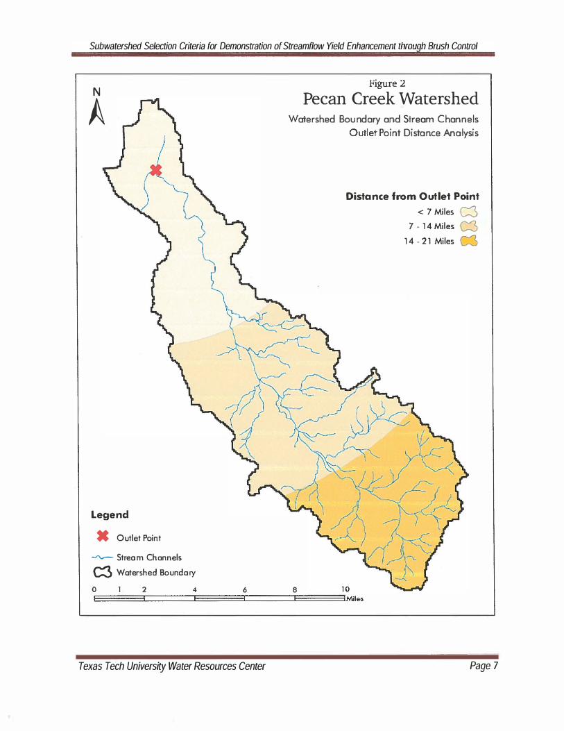
In arid and semi-arid environments, streams typically experience "transmission losses"
as the water moves longer and longer distances from the point of overland flow generation
through the channel to the final watershed outlet. The closer the point of runoff generation is
to the watershed outlet, the greater will be the expected streamflow because channel
transmission losses to seepage and evapotranspiration will be minimized. In this
demonstration, we divided the Pecan Creek Watershed into three zones based on channel
travel lengths: closest to the outlet, furthest from the outlet, and "in between" (Figure 2). The
zones were arbitrarily delineated by a circular buffer from the outlet point of 7, 14, and 21
miles. Each zone was assigned a numerical value (15, 10, or 5), and higher value is associated
with less transmission loss and better streamflow contribution to the outlet.
Proximity to a stream or tributary channel is another variable worthy of consideration.
Brush treatments applied closer to a channel are more likely to produce overland flow or
increase baseflow that reaches a channel than are treatment located further away from the
channel. This concept can also be stated as expecting treatments in riparian corridors to
enhance yields more than similar treatments on upland sites. In this demonstration, we divided
the Pecan Creek Watershed into three zones based on proximity to a stream channel: closest
to the channel, furthest from the channel, and "in between" (Figure 3). The zones were
delineated by linear buffers of 100 and 300 meters to create three zones: < 100 meters from a
channel, 100-300 meters from a channel, and> 300 meters from a channel. Each zone was
assigned a numerical value (20, 10, or 5), and higher value is related to greater proximity to the
channel.
Texas Tech University Water Resources Center PageS

Subwatershed Selection Criteria for Demonstration of Streamflow Yield Enhancement through Brush Control
N
A
Legend
_ Outlet Point
-v"\.r- Stream Channels
c:::3 Watershed Sou "dory
figure 1
Pecan Creek Watershed WO'ershed Boundary and S ream Channels
o 2 4 6 8 0
EI ===3:1 ===::::EI ===3:1 ===:::::EI ===::::IIMi les
Texas Tech University Water Resources Center Page 6
Subwatershed Selection Criteria for Demonstration of Streamflow Yield Enhancement through Brush Control
Figure 2
Pecan Creek Watershed N
A Watershed Boundary and Stream Channels
Outle' Point Distance Analysis
Legend
_ Outlet Point
-..rv- Stream Channels
c:3 Watershed Boundary
o 2 4 6 8
Distance from Outlet Point
< 7 Miles c:3 7 • 14 Miles C3
14 - 21 Miles
EI ===31======::::E1===:::r:1 =======IE==3IMiles
Texas Tech University Water Resources Center Page 7

Subwatershed Selection Criteria for Demonstration of Streamflow Yield Enhancement through Brush Control
N
A
Legend
X Outlet Point
C3 Watershed Boundary
-.rv--- Stream Channels
figure 3
Pecan Creek Watershed Watershed Boundary and Stream Channels
Riparian Distance Analysis
Distance from Ch annels
< 100 Meters c:3 1 00 - 300 Meters 1&
> 300 Meters 1&
o 2 10
E===C===E===3:::===::E===3IMile:; 4 6 8
Texas Tech University Water Resources Center PageB

Subwatershed Selection Criteria for Demonstration of Streamflow Yield Enhancement throu h Brush Control
Soil texture and slope are other variables impacting runoff. For purposes of this
illustration, we selected a combination of soil textures and a slope category to create areas with
an increased likelihood for generation of enhanced runoff following treatment. In this
particular case, soils with textures of clay or clay loam having slopes in the range of 1 to 3
percent were selected to illustrate the methodology (Figure 4). Heavier textured soils with
steep slopes would be expected to have lower infiltration rates than coarse textured soils on
flat slopes. In this demonstration, we divided the Pecan Creek Watershed into two zones based
on a combination variable of soil texture and slope. The zones were delineated by selection of
soil mapping units from Natural Resources Conservation Service (NRCS) county-level soil
mapping data. Each zone was assigned a numerical value (10 or 0) for being in or out of the
preferred SOil/slope zone.
While this process could contin'ue for additional variables, we used these three criteria
for the current illustration. The result is a classification of the Pecan Creek Watershed into 8
possible zones or regions with varying potential to generate enhanced water yields based on
the criteria applied (Figure 5). Numerically, the "scores" range from a low of 10 to a high of 45.
The highest priority areas or sites would be within 7 miles of the watershed outlet, on clay or
clay loam soils with slopes from 1 to 3 percent, and within 100 meters of a defined channel
(Figure 6).
The series of maps was provided to graphically display the process employed, the results
of each criterion application, as well as the final result. It must be remembered that this is
simply a demonstration of the methodology; the weighting values and the zone definitions
within a criteria were arbitrarily chosen to help illustrate the method. Their exact values and
definitions would need to be determined for each individual watershed to which the
methodology is applied based on the best science available for the specific site.
Monitoring Considerations
While preparing this brief report, the authors reviewed existing data for several of the
TSSWCB's treated sites. This information included the reports of the SWAT modeling that
estimated the potential added streamflow from proposed brush control, nearby historical
streamflow measurements when available, and existing monitoring efforts for streamflow and
Texas Tech University Water Resources Center Page 9

Subwatershed Selection Criteria for Demonstration of Streamflow Yield Enhancement throu h Brush Control
N
A
Legend
X Outlet Point
C3 Watershed Boundary
...rv-- St ream Channels
Fibrure 4
Pecan Creek Watershed Watershed Boundary and Stream Channels
Soil Type Analysis
Clay and Clay Loam Soils 1-3 % Slopes
Yes . No C3
o 2 4 6 8 10
EI ===3::===:::E===3:1 ===:::E===3IMiles
Texas Tech University Water Resources Center Page 70

Subwatershed Selection Criteria for Demonstration of Streamflow Yield Enhancement throu h Brush Control
N
A
Legend
X Outlet Point
c:3 W·atershed Boundary
....rv-- Stream Channels
Figure 5
Pecan Creek Watershed Watershed Boundary and S ream Channels
Overlay Analysis Rankings
Overlay Rank
O. 10. 15. 20 25 W 30 35 " 40" 45 "
o 2 10
E===C===:::E===3::===:::E===3IMiles 4 6 8
Texas Tech University Water Resources Center Page 1 1

Subwatershed Selection Criteria for Demonstration of Streamflow Yield Enhancement through Brush Control
N
A
Legend
X Outlet Point
C3 Watershed Boundary
� Stream Channels
Figure 6
Pecan Creek Watershed Watershed Boundary and Stream Channels
Overlay Analysis Top Rankings
Top Rankings
25., 30. 35 C3 40 45.
o 2 4 6 8 10
E====::3I===:::::E1 ======3:===:::E1 ======3IMile:.
Texas Tech University Water Resources Center Page 72

Sub watershed Selection Criteria for Demonstration of Streamflow Yield Enhancement throu h Brush Control
groundwater impacts after brush treatment. It is apparent that the same type of hydrologic
and watershed management concepts used to generate the subwatershed selection criteria are
also pertinent for monitoring considerations.
The major concern of the program is enhancement of streamflow. In order to measure
such flows, it is necessary to install continuous streamflow recorders at the outlets of the
treated subwatersheds. It would be best to have both pre- and post-treatment data to
demonstrate the ranges of flow values. The typical flow recording system would most likely be
a water level sensor, such as a pressure transducer, installed at a fixed channel cross-section,
such as a paved low-water crossing, broad-crested weir, or a fixed measuring flume. The
system would have a relationship between water surface elevation in the stream and flow rate,
and allow continuous data collection so that baseflow and runoff components could always be
observed. Pressure transducers typically come with electronic data loggers that can be
downloaded to laptop computers.
Continuous observation of rainfall is just as important as streamflow, so that the source
of the runoff can be estimated. Multiple recording rain gauges, such as the tipping bucket type
that can sense rainfall to the nearest 0.01 in, should be placed at strategic locations across the
watershed to allow estimation of the areal and temporal distribution of rainfall for each storm
event. These rain gauges can store data in data loggers for occasional downloading to laptop
computers.
Observation of local groundwater conditions should be done through monitoring wells
in the shallow alluvial aquifer in and near the streambed. The elevations of the groundwater
table in the monitoring wells can be compared each other and to the elevation of the water
surface in the stream to demonstrate which way the groundwater is flowing and the changes in
groundwater storage over time. The groundwater levels can be continuously monitored with
pressure transducers, or manually measured less often if readily accessible.
Estimation of evapotranspiration losses through vegetation within the target areas of
the treated subwatershed can be done by using site visits, aerial photography, and satellite
imagery to identify the effectiveness of brush management over the treated areas of the
subwatershed. Potential ET can be estimated with local weather stations that measure and
Texas Tech University Water Resources Center Page 13

Subwatershed Selection Criteria for Demonstration of Streamflow Yield Enhancement throu h Brush Control
record wind speed, relative humidity, net solar radiation, and temperature. Actual ET can then
be estimated as proportional to the potential ET based on plant type and seasonal variations in
water consumption.
The best situation for application of hydrologic monitoring to confirm positive impacts
of brush control would be to have several years of pre-treatment data to compare to several
years of post-treatment data. Unfortunately, this situation is unlikely for the subwatersheds
that have already been or will soon be treated. It is possible that two similar subwatersheds
can be selected, instrumented, and observed with one receiving brush treatment and the other
left untreated. The hydrologic behaviors of the two subwatersheds over several years could
then be later compared to determine the impact of treatment. An example of this type of
situation is in the East and West Grape Creek subwatersheds near San Angelo.
An over-riding concern about hydrologic monitoring for streamflow enhancement, or
any other purpose, is that the longer the observation period is, the more confident we are in
the findings. Installation of equipment to measure streamflow often seems to cause a drought.
We encourage all those concerned with streamflow enhancement, whether through brush
control or other watershed management techniques, to be patient and allow multiple years of
data collection and analyses to observe a reasonable range of weather conditions over time.
References
Hibbert, Alden R., 1979. Managing Vegetation to Increase Flow in the Colorado River Basin.
USDA Forest Service General Technical Report RM-66, 27 p.
Hibbert, Alden R., 1983. Water Yield Improvements Potential by Vegetation Management on
Western Rangelands. Water Resources Bulletin, 19(3):375-381.
Texas Tech University Water Resources Center Page 14