structural character of the terrace zone and implications for crater formation: chicxulub impact...
TRANSCRIPT

Structural character of the Structural character of the terrace zone and implications for terrace zone and implications for
crater formation:crater formation:Chicxulub impact craterChicxulub impact crater
David L. GorneyDavid L. GorneySean GulickSean Gulick
Gail ChristesonGail Christeson
GSA Annual Meeting 2004GSA Annual Meeting 2004

Chicxulub impact craterChicxulub impact crater• Occurred ~65 Ma• Buried by up to 1 km of carbonates• Multi-ring basin, ~190 km diameter
Significance• K/T boundary mass extinction?• Largest well preserved impact structure on Earth
-SRTM topography
Significance of StudySignificance of Study
• Geophysical data can be used to model subsurface crater structure
• Structural data constrain numerical modeling of impact event
• The goal of this study is to reprocess the seismic reflection data, then use those data to image crater structure
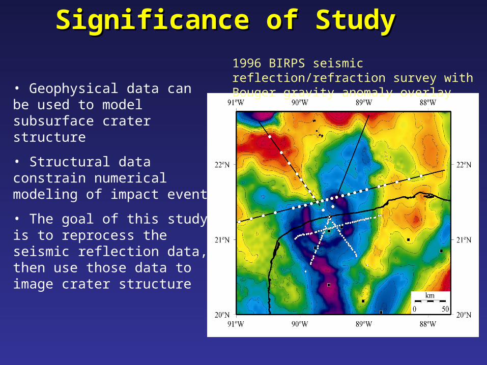
1996 BIRPS seismic reflection/refraction survey with Bouger gravity anomaly overlay
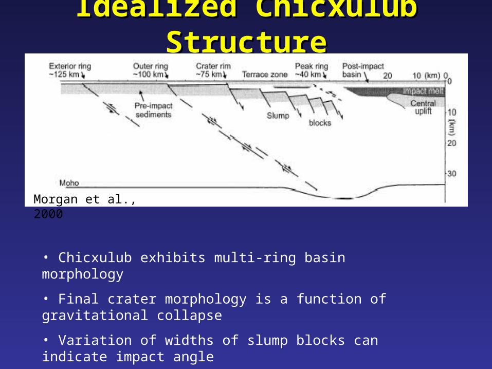
Idealized Chicxulub StructureIdealized Chicxulub Structure
• Chicxulub exhibits multi-ring basin morphology
• Final crater morphology is a function of gravitational collapse
• Variation of widths of slump blocks can indicate impact angle
• narrow terrace zone indicates more intense deformation
Morgan et al., 2000
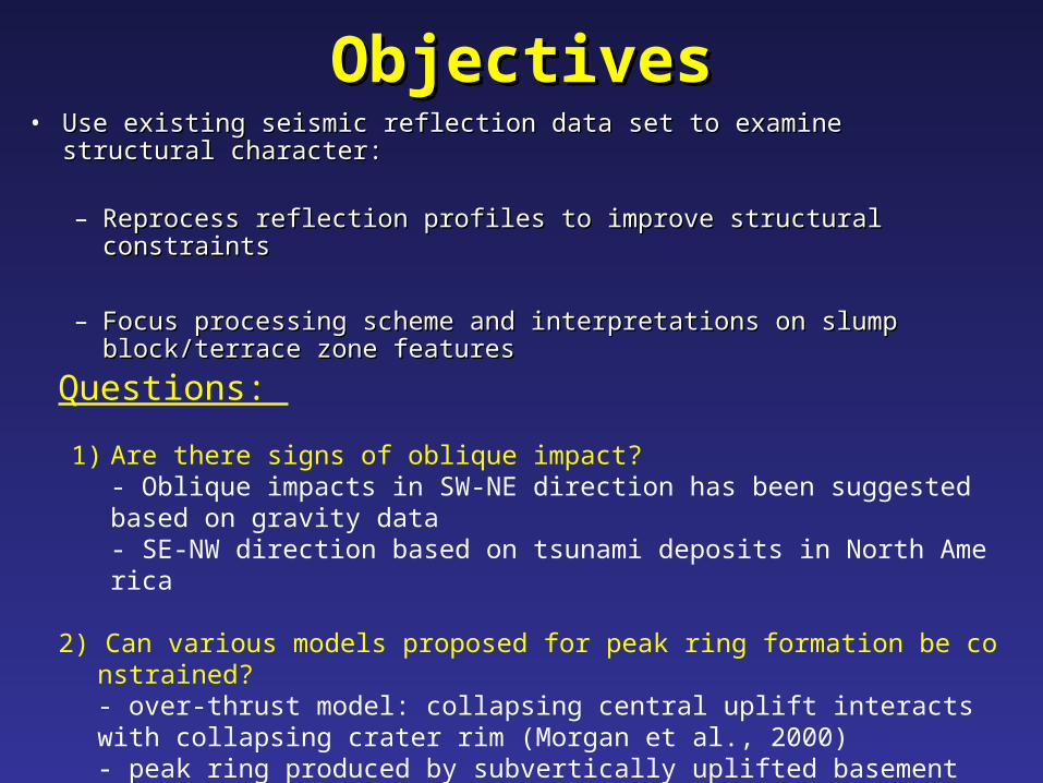
ObjectivesObjectives• Use existing seismic reflection data set to examine structural Use existing seismic reflection data set to examine structural
character: character:
– Reprocess reflection profiles to improve structural constraints Reprocess reflection profiles to improve structural constraints
– Focus processing scheme and interpretations on slump Focus processing scheme and interpretations on slump block/terrace zone features block/terrace zone features
Questions:
1) Are there signs of oblique impact?- Oblique impacts in SW-NE direction has been suggested based on gravity data- SE-NW direction based on tsunami deposits in North America
2) Can various models proposed for peak ring formation be constrained?- over-thrust model: collapsing central uplift interacts with collapsing crater rim (Morgan et al., 2000)- peak ring produced by subvertically uplifted basement (Sharpton et al., 1994)- narrow central uplift, peak ring consists of breccia (Pilkington et al., 1994)

ReprocessingReprocessingTo remove coherent noise:• Caused by reverberation, as a result of shallow water
(~20 m), hard water bottom• In response to guided waves, another noise issue in
shallow water
How?• Velocity analysis• F/K filter
Improve the images:• Post-stack time migration
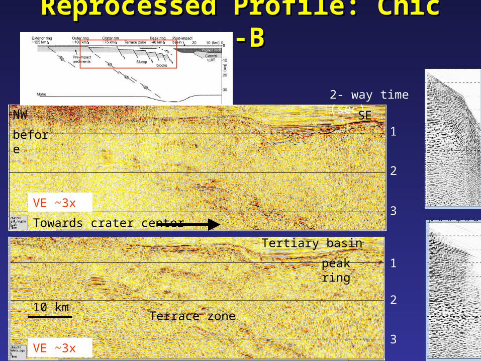
Reprocessed Profile: Chicx-BReprocessed Profile: Chicx-B
before
after
Towards crater center
10 km
VE ~3x
VE ~3x
peak ring
Terrace zone
Tertiary basin
2- way time (sec)
1
2
3
3
2
1
SENW

Terrace ZoneTerrace Zone
• 40 to 80 km radial distance
• no consistent gravity signature
~15 km depth
twt (s)
1
2
3
4
5
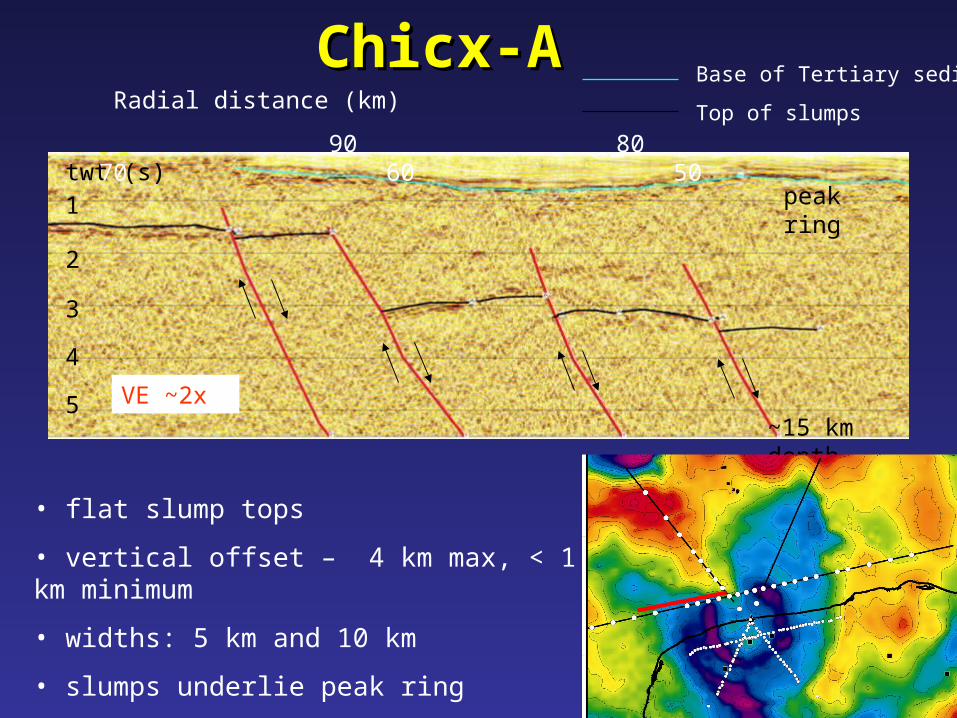
Chicx-AChicx-ABase of Tertiary sediments
Top of slumps
• flat slump tops
• vertical offset – 4 km max, < 1 km minimum
• widths: 5 km and 10 km
• slumps underlie peak ring
peak ring
VE ~2x
Radial distance (km)
90 80 70 60 50

Chicx-BChicx-B
• inward dipping ( < 5°) tops
• widths 8 – 12 km
• slumps underlie peak ring
• individual blocks less distinct - secondary collapse?
Base of Tertiary sediments
Top of slumpsRadial distance (km)
80 70 60 50 40
twt (s) 1
2
3
4
5~15 km depth
peak ring
VE ~2x
Chicx-CChicx-CBase of Tertiary sediments
Top of slumpsRadial distance (km)
80 70 60 50 40twt (s)
1
2
3
4
5~15 km depth
• irregular dimensions – width and vertical offset
• width of blocks: 4 – 7 km
- narrower locus of deformation – oblique impact?
peak ring
VE ~2x

Radial distance (km)
80 70 60 50 40
Chicx-A1Chicx-A1Base of Tertiary sediments
Top of slumps
~15 km depth
twt (s)1
2
3
4
5
• slump tops: tilted inward 1 - 2°
• uniform widths - 9 -11 km
• vertical offsets generally increasing inward: <1 km at outer blocks, up to 2.5 km towards the peak ring
peak ring
VE ~2x
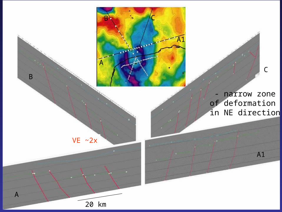
- narrow zone of deformation in NE direction
20 km
VE ~2x
A
A1
CB
A
BC
A1

Conclusions (1)Conclusions (1)Variability of terrace zone
Geometry of slump tops• Width of blocks ranges from 4 km to 12 km • Profiles A1 and B show relatively uniform
widths (within 2 km)• Profiles A and C vary (up to 5 km)• Slump tops dip inward (B), outward (A1), or
flat (A, C)
Normal Faulting• Height of scarps varies from 100’s m up to 4
km
Schrodinger - 320 km diameter lunar crater

Conclusions (2)Conclusions (2) Impact angleImpact angle – Some variations likely
reflect heterogeneities in target material, but may also suggest oblique impact
– If so, the impact direction is SW to NE
Venusian Crater – Proclus LTO Topography
- Proclus (Venusian) displays a compressed zone of deformation downrange
Direction of impact
Narrow zone of deformation to NE
15 km
From Herrick and Forsberg-Taylor, 2003
10 km
Chicx-C
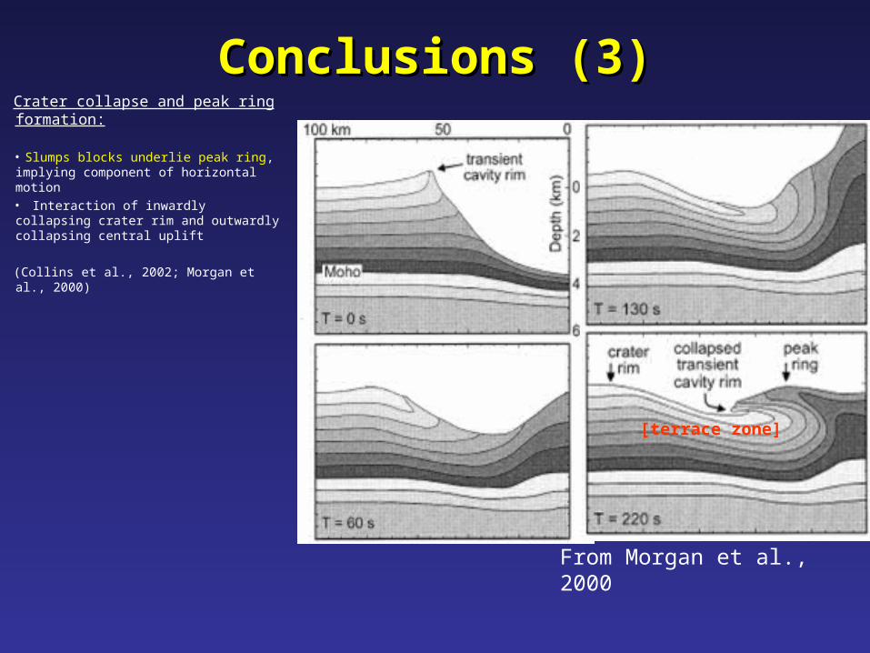
Conclusions (3)Conclusions (3)Crater collapse and peak ring formation:
• Slumps blocks underlie peak ring, implying component of horizontal motion• Interaction of inwardly collapsing crater rim and outwardly collapsing central uplift
(Collins et al., 2002; Morgan et al., 2000)
From Morgan et al., 2000
[terrace zone]
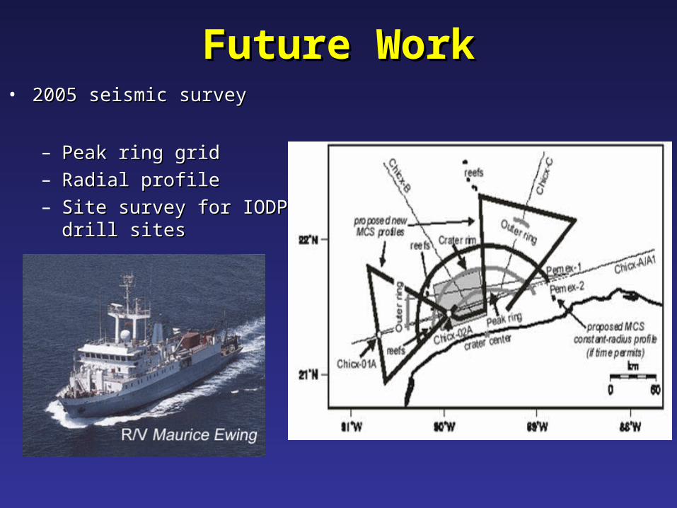
Future WorkFuture Work• 2005 seismic survey2005 seismic survey
– Peak ring gridPeak ring grid– Radial profileRadial profile– Site survey for IODP drill Site survey for IODP drill
sitessites