strategic environmental assessment area 7: hydrocarbon ... · pdf filebritish geological...
TRANSCRIPT
Strategic Environmental Assessment Area 7: hydrocarbon prospectivity, earthquakes, continental shelves and Rockall Trough surficial and sea-bed geology and sea-bed processes
Marine, Coastal and Hydrocarbons Programme Commissioned Report CR/ 06/ 063


BRITISH GEOLOGICAL SURVEY
MARINE, COASTAL AND HYDROCARBONS PROGRAMME
REPORT CR/ 06/ 063
Strategic Environmental Assessment Area 7: hydrocarbon prospectivity, earthquakes, continental shelves and Rockall Trough surficial and sea-bed geology and sea-bed processes
Richard Holmes, Ken Hitchen, Lars Ottemoller
Keywords
Rockall Trough, Hatton Basin hydrocarbons prospectivity, strategic environmental assessment, earthquakes, glacials, interglacials, sea-bed processes, sea-bed stress, sea- bed sediments, sea-bed bedforms, sandwaves, sandbanks, sand transport, deeps, bathymetry, seafloor mapping.
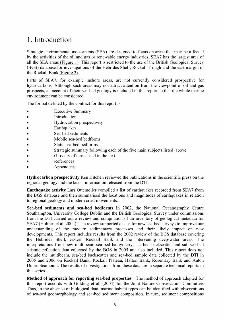
Front cover
The photograph has been taken over a bank on the shelf edge that separates the Hebrides Shelf from the Hebrides Slope. Sand transport by the European Slope Current is to the north. Sometimes known as the ‘Atlantic Conveyor’, the current runs along the whole of the east margin of the SEA7 area. Sand ripples are moving to the north along sand ridges deposited on gravel, (data from NERC Land Ocean Interaction Study, 1995)
Bibliographical reference
HOLMES, R, HITCHEN, K., OTTEMOLLER, L. 2006. Strategic Environmental Assessment Area 7: hydrocarbon prospectivity, earthquakes, continental shelves and Rockall Trough surficial and sea-bed geology and sea-bed processes. British Geological Survey Commissioned Report, CR/06/063
This document was produced as part of the UK Department of Trade and Industry’s offshore energy Strategic Environmental Assessment programme. The SEA programme is funded and managed by the DTI and coordinated on their behalf by Geotek Ltd and Hartley Anderson Ltd.
© NERC2006. All rights reserved
Edinburgh British Geological Survey 2006

Foreword As part of an ongoing programme, the Department of Trade and Industry (DTI) is undertaking Strategic Environmental Assessments (SEAs) prior to United Kingdom Continental Shelf licence rounds for oil and gas exploration and production. Before regional development proceeds, the DTI consults with the full range of stakeholders in order to identify areas of concern and establish best environmental practice. Stakeholders in a strategic environmental assessment include the DTI, the general public, non-governmental organisations (NGOs) (such as the Royal Society for the Protection of Birds and the Worldwide Fund for Nature), local authorities, government agencies (e.g. the Joint Nature Conservation Committee), experts in the field (universities, commercial consultants etc.), the industries wishing to undertake the development and other marine industries. The SEA process is used for predicting and evaluating the environmental implications of a policy, plan or programme and provides a key input to decision making. An SEA is conducted at a strategic level by the DTI - this contrasts with environmental impact assessment (EIA), which is carried out for a specific development or activity by an operator. The SEA aims to define: • key information sources and the current understanding of the natural environment and how
it functions • perceived gaps in understanding of the effects of the activities that would result from oil
and gas licensing • the issues and concerns that the SEA should address This technical report has been produced for the SEA7 area to meet the aims summarised above. It provides a summary of the hydrocarbons prospectivity. This is followed by syntheses of the earthquake activity and an investigation of the function and properties of the sea-bed in relation to the sea-bed and superficial geology. Figure 1 shows the general plan for the SEA programme of investigations. The numbering of the SEA areas indicates the initial order of consultation.
4

Contents
Foreword ........................................................................................................................................ 4
Contents.......................................................................................................................................... 5
Executive summary ....................................................................................................................... 8
1. Introduction ............................................................................................................................... 9
2. Hydrocarbon prospectivity..................................................................................................... 11 1.1 Geological evolution ........................................................................................................ 11 2.2 Hydrocarbon prospectivity............................................................................................... 13 2.3 Strategic overview............................................................................................................ 16
3 Earthquakes.............................................................................................................................. 17 3.1 Detection limits and earthquake distribution patterns...................................................... 17 3.2 Origin of earthquakes....................................................................................................... 17 3.3 Earthquake magnitudes .................................................................................................... 17 3.4 Strategic overview............................................................................................................ 18
4 Sea-bed sediments ................................................................................................................... 19 4.1 Definition of sea-bed and surficial sediments .................................................................. 19 4.2 Distribution of sea-bed sediments .................................................................................... 19 4.3 Regulation of sea-bed sediment properties by tidal currents, wave-orbital currents and residual current circulation..................................................................................................... 20 4.4 Biogenic carbonate in sea-bed sediments ........................................................................ 22 4.5 Regional uplift of sea-bed sediments ............................................................................... 24 4.6 Strategic overview............................................................................................................ 24
5. Mobile bedforms...................................................................................................................... 26 5.1 Properties of shelf current-driven bedforms .................................................................... 26 5.2 Current-driven bedforms.................................................................................................. 26 5.3 Gravity-driven bedforms................................................................................................. 26 5.4 Strategic overview............................................................................................................ 28
6. Static bedforms........................................................................................................................ 29 6.1 Bedrock ............................................................................................................................ 29 6.2 Shelf break ....................................................................................................................... 29 6.3 Glacigenic static bedforms............................................................................................... 30 6.4 Non-glacigenic static bedforms........................................................................................ 31 6.5 Strategic overview............................................................................................................ 34
7. Glossary of terms..................................................................................................................... 35
8. References ................................................................................................................................ 48
9. BGS sea-bed sediment classification scheme ........................................................................ 51
5

10. Figures .................................................................................................................................... 52 Figure 1. SEA7 location and other SEA areas. ........................................................................... 52
Figure 2. BGS data used in this report. ........................................................................................ 53
Figure 3. Locations of Figures 14, 22, 28, 29, 30, 31, 32, 33, 34. ...............................................54
Figure 4. Regional geological setting........................................................................................... 55
Figure 5. Regional geological structure of the Rockall Basin. ....................................................56
Figure 6. Schematic hydrocarbons plays, Rockall Basin. ...........................................................57
Figure 7. Schematic hydrocarbon plays, Hatton Basin. ...............................................................58
Figure 8. Earthquakes and regional sea-bed uplift. ......................................................................59
Figure 9. Sea-bed sediments. .......................................................................................................60
Figure 10. Mean peak spring tidal current speed. ........................................................................ 61
Figure 11. Annual mean significant wave height and estimated wave-orbital current speed. ..... 62
Figure 12. Effects of waves on mobile bedforms formed by tidal and residual currents............ 63
Figure 13. Residual current circulation patterns . ........................................................................64
Figure 14. Bedload sand transport at the shelf break, Barra Fan. ................................................ 65
Figure 15. Percentage biogenic carbonate in sea-bed sediments. ................................................ 66
Figure 16. Sea-bed photographs, Rockall Bank and Rockall Escarpment. ..................................67
Figure 17. Detail from submarine bedrock platform, Outer Hebrides. .......................................68
Figure 18. Outer Hebrides (a) regional geomorphology submarine bedrock platform (b) snapshot of nearshore bedrock hills and coastal carbonate systems. ...............................69
Figure 19. Transverse sediment waves on the shelves, movement and depth of sedimentary overturn.................................................................................................................................. 70
Figure 20. Mobile bedforms and net sand transport.................................................................... 71
Figure 21. Stability model for static sediments on non-deformable substrates. ..........................72
Figure 22. Glacial moraine and post-glacial submarine landslide, Little Loch Broom. .............. 73
Figure 23. Static sea-bed bedforms. .............................................................................................74
Figure 24. Regional geomorphology. ...........................................................................................75
Figure 25. Neogene (4.7Ma to present day) sediment thickness. ................................................ 76
Figure 26. Hebrides Shelf geomorphology. ................................................................................. 77
Figure 27. Schematic model of fan geomorphology and bedforms. ............................................ 78
Figure 28. Sula Sgeir Fan a. slope-front geomorphology. b. sub-sea-bed profile, glacigenic debris flows. ...........................................................................................................................79
Figure 29 Former turbidite channels and iceberg scour. .............................................................80
Figure 30. a. Iceberg plough marks, upper slope b. isolated basin in slope-parallel iceberg plough marks. ........................................................................................................................ 81
Figure 31. Bedforms on a submarine landslide complex. ............................................................82
Figure 32. Profile of elongate sediment drift, moat and scarp, north-east Hebrides Slope......... 83
6

Figure 33. Geological setting and modern sea-bed profile of elongated sediment drift, moat and escarpments, east Rockall Bank. ...........................................................................................84
Figure 34. Pockmarks, NE Rockall Trough. ................................................................................ 85
Figure 35. Sea-bed sediment classification scheme. ................................................................... 86
Table 1 Wentworth grain-size scale used in sediment-size classifications. ................................. 87
Table 2. Sediment wave sizes related to wavelength and mobility, environments dominated by tidal and residual currents...................................................................................................... 88
Table 3. Deep-water static bedforms from persistent currents..................................................... 89
7

Executive summary Investigations of the hydrocarbon prospectivity and earthquake activity include the whole of SEA7 but in this report investigations of the sea-bed sediments are restricted to the Hebrides Shelf, Rockall Trough and east Rockall Bank.
On the Hebrides Shelf, Hebrides Slope, east Rockall Bank and in the deep-water Rockall Trough the modern sea-bed sediments are mainly composed of mixtures of former glacial deposits and grains of modern interglacial biogenic carbonate shell. Former glacial deposits and modern biogenic carbonate are now mainly mixed and transported by wave-orbital currents and residual currents on Rockall Bank and by combinations of wave-orbital currents, tidal currents and residual currents on the Hebrides Shelf and upper Hebrides Slope. Below approximately 300 metres water depth in the Rockall Trough the sea-bed sediments are mainly transported by circulating deep-water residual currents.
Sea-bed sediments with slopes of approximately 3 degrees or more are prone to gravity-driven instability and downslope sea-bed sediment movement. This means that there are large areas on the Hebrides Shelf , Rockall Bank and and other margins around the Rockall Trough where the combined influences of gravity and currents regulate sea-bed sediment movement and composition.
Issues that may block UK hydrocarbon development or which are presented as recommendations for best environmental practice are:
1. Areas of the sea-bed that are beyond the 200nm limit are still under negotiation for rights to license so that the Hebrides Shelf, Rockall Basin and the east parts of Rockall Bank have the only short-term prospects for licences issued by the DTI.
2. An average of 2 to 3 earthquakes per year equal to or larger than 2.5 Richter local magnitude are recorded in the nearshore zone. It is recommended that a detailed analysis of earthquake risk should be completed prior to possible future exploitation of the sea-bed in this zone. 3. A four-component system on the east margin of Rockall Bank (bedrock reef, biogenic carbonate reef, moat and elongated sediment drift) comprises a unique relatively shallow-water fringing reef system that is possibly appropriate for preservation. 4. Proxy data have been used to briefly synthesise the likely bedload-sand transport paths in the shelf seas between the Outer Hebrides and the Scottish Mainland. The proxy data are unsatisfactory and further work should be done to clarify the importance and range of processes affecting bedload-sediment transport in this region.
5. Habitats that have been mainly generated following modern gravity-driven sea-bed failure and sediment transport are under-reported in the scientific literature and they are poorly understood. This report shows that these habitats characterise large areas of the continental shelves and deep-water basins in SEA7. They require systematic investigation and classification so that their function and potential impact on planning decisions is better understood.
Detailed strategic overviews are presented for hydrocarbons prospectivity (page 16), records and patterns of modern earthquakes (page 18) and for habitat diversity tied to the composition of sea-bed sediments (page 24), mobile bedforms (page 28) and static bedforms (page 34).
8
1. Introduction Strategic environmental assessments (SEA) are designed to focus on areas that may be affected by the activities of the oil and gas or renewable energy industries. SEA7 has the largest area of all the SEA areas (Figure 1). This report is restricted to the use of the British Geological Survey (BGS) database for investigations of the Hebrides Shelf, Rockall Trough and the east margin of the Rockall Bank (Figure 2).
Parts of SEA7, for example inshore areas, are not currently considered prospective for hydrocarbons. Although such areas may not attract attention from the viewpoint of oil and gas prospects, an account of their sea-bed geology is included in this report so that the whole marine environment can be considered.
The format defined by the contract for this report is:
• Executive Summary • Introduction • Hydrocarbon prospectivity • Earthquakes • Sea-bed sediments • Mobile sea-bed bedforms • Static sea-bed bedforms • Strategic summary following each of the five main subjects listed above • Glossary of terms used in the text • References • Appendices Hydrocarbon prospectivity Ken Hitchen reviewed the publications in the scientific press on the regional geology and the latest information released from the DTI.
Earthquake activity Lars Ottemoller compiled a list of earthquakes recorded from SEA7 from the BGS database and then summarised the locations and magnitudes of earthquakes in relation to regional geology and modern crust movements.
Sea-bed sediments and sea-bed bedforms In 2002, the National Oceanography Centre Southampton, University College Dublin and the British Geological Survey under commissions from the DTI carried out a review and compilation of an inventory of geological metadata for SEA7 (Holmes et al. 2002). The review supported a case for new sea-bed surveys to improve our understanding of the modern sedimentary processes and their likely impact on new developments. This report includes results from the 2002 review of the BGS database covering the Hebrides Shelf, eastern Rockall Bank and the intervening deep-water areas. The interpretations from new multibeam sea-bed bathymetry, sea-bed backscatter and sub-sea-bed seismic reflection data collected by the BGS in 2005 are also included. This report does not include the multibeam, sea-bed backscatter and sea-bed sample data collected by the DTI in 2005 and 2006 on Rockall Bank, Rockall Plateau, Hatton Bank, Rosemary Bank and Anton Dohrn Seamount. The results of investigations from these data are in separate technical reports in this series.
Method of approach for reporting sea-bed properties The method of approach adopted for this report accords with Golding et al. (2004) for the Joint Nature Conservation Committee. Thus, in the absence of biological data, marine habitat types can be identified with observations of sea-bed geomorphology and sea-bed sediment composition. In turn, sediment compositions
9
are derived from interpretations of sea-bed sample analyses of sediment grain size and composition and are correlated with variations in geophysical and hydrographical data. The results derived from these observations and interpretations are organised into an account of the modern sea-bed properties and the processes that have generated these properties.
Data compilation and presentation The report data have been compiled and presented in the figures from the BGS database using the Arc9 geographical information system (GIS) based on spheroid and datum WGS 84. The ranges of data used are summarised in Figure 2. Owing to the wide geographical spread of the data and the need for presentation clarity, the locations of 10 of the figures within this report are shown separately (Figure 3).
Glossary of terms A glossary has been compiled of technical terms used in the report text and in the report figures.
10
2. Hydrocarbon prospectivity
1.1 GEOLOGICAL EVOLUTION The SEA7 area is located in the north-west part of the European continental tectonic plate and is mostly underlain by continental crust. However the extreme western part of the area is underlain by oceanic crust with the continental crust-oceanic crust boundary located at the Hatton Continental Margin beneath the outer (western) margin of Hatton Bank (Figure 4).
Beneath the Rockall Basin, the continental crust has been stretched, thinned and intruded by igneous rocks. It thins southwards from c. 20 km to c. 6 km beneath the axis of the Rockall Basin whereas ‘normal thickness’ continental crust (25 to 30 km) exists beneath Rockall Bank and the Hebrides Platform. The continental crust is also thinned beneath Hatton Basin but to a lesser extent.
Pre-Cambrian rocks (older than approximately 542 Ma) are divided by the north-west to south-east trending Anton Dohrn lineament in the continental crust. Archaean (older than 2500 Ma) metamorphic Lewisian rocks occur to the north of the lineament and Early Proterozoic age (2500 to 1600 Ma) metamorphic Dalradian rocks are to the south (Figure 4). Other Pre-Cambrian Mid to Late Proterozoic (1600 to 542 Ma) rocks occur in The Minch and comprise Torridonian mainly fluvial sediments, as proved in well 156/17-1.
Cambrian, Ordovician and Silurian rocks (ages ranging from 542 to 416 Ma) are only in the extreme south east part of the area, close to land, between Scotland and Ireland, and around the Isle of Man.
Devonian (416 to 359 Ma) sediments, deposited in arid, mainly continental sub-aerial ‘Old Red Sandstone’ environments, are found only in and around the Firth of Clyde. Some Devonian volcanic rocks are also present in this area. During the Early Devonian, at about 420 – 400 Ma, the region underwent compression during the Caledonian Orogeny. A north-east to south-west regional structural trend was established, which influenced subsequent geological development. Following the Caledonian Orogeny, tensional stresses became re-established due to the break-up of the continental crust.
After the mainly continental arid environments of the Devonian, sediments deposited during the Carboniferous period (359 to 299 Ma) were both marine and non-marine. Their distribution is restricted to areas between Scotland and Ireland, beneath the outer Firth of Clyde and to the north and west of the Isle of Man. In the Rathlin Trough over 1000m of Carboniferous strata may be present and c. 949 m have been proved in well 13/3-1 in the Donegal Basin just outside SEA7 in Irish waters. The Upper Carboniferous sediments include coal-bearing intervals. These have been commercially worked in Ayshire, on the Mull of Kintyre and in Northern Ireland.
A rifting phase occurred during the Permo-Triassic (299 to 200 Ma). In some cases, former Caledonian thrust faults were re-activated as normal faults to create basins simultaneously filled with coarse-grained sediments. Permo-Triassic sediments were deposited during a major regression of the sea and include ‘red-bed’ sediments deposited in arid semi-terrestrial continental environments. They have a widespread occurrence beneath The Minch, the Sea of the Hebrides and the Hebrides Platform. Permo-Triassic sediments may have covered an even wider area, but much of the thickness was removed by erosion during the Jurassic. There is debate as to whether the major south-west to north-east Rockall Basin / Faroe-Shetland Basin rift axis originated at that time, although the main rifting phase was not until the Cretaceous. The Permo-Triassic basins beneath the Hebrides Platform (such as the Flannan, West Flannan and West Lewis basins) are marginal to the main axis of rifting.
11

Lower, Middle and Upper Jurassic rocks (200 to 136 Ma) occur widely onshore, especially in Skye, and offshore beneath The Minch, Sea of the Hebrides and the West Lewis Basin. Non-marine Middle Jurassic mudstones with potential as hydrocarbon source rocks were recovered in a well in the West Lewis Basin. Upper Jurassic muddy sandstones have been drilled in the West Flannan Basin. Jurassic sediments have been proved in similar marginal basins on the eastern side of the Rockall Basin in Irish waters and have also been interpreted to exist on the western side of the Rockall Basin. Rifting, or epeirogenic subsidence, may have allowed Jurassic sediments to accumulate in the Rockall Basin, but any sediments of this age are likely to have been fragmented during later Cretaceous faulting.
Based on evidence from well 132/15-1 (not shown Figure 4), the rifting and main tectonic development phase of the Rockall Basin was during the Early to mid Cretaceous (approximately 136 to 93 Ma). During this time the crust beneath the basin was stretched and thinned and major normal faults developed on the western side of the basin. The direction of dip of similar faults on the eastern side of the basin is more equivocal. This major rifting event was followed by regional subsidence related to crust and mantle cooling and rising sea levels. As a general rule, the syn-rift sediments are sandier and coarser-grained than the younger post-rift basin fill. It is generally assumed that Cretaceous sediments form a large part of the basin fill for both the Rockall and Hatton basins. They have been proved by several commercial wells drilled on the eastern side of Rockall Basin and earliest Cretaceous potential hydrocarbon source rocks have been recovered in shallow boreholes beneath the Hebrides Platform. Cretaceous sediments have also been drilled just below the sea bed on Hatton Bank. The Upper Cretaceous is commonly the host interval for Late Palaeocene igneous intrusions in the Rockall Basin and the Anton Dohrn Seamount may have originated during this time.
The age of the boundary between Cretaceous and the younger Cenozoic is at approximately 65 Ma. At about 56 to 55 Ma (close to the Paleocene - Eocene boundary) extensional forces caused separation of North American continental crust from the North West European continental crust. Oceanic crust began to develop west of Hatton Bank and ridge push began to compress the North West European continental crust. Contemporaneously, the region was uplifted by magmatism, the regional scale of which was related to a mantle plume. The regional uplift occurred with extrusion of widespread and voluminous lavas, the emplacement of numerous igneous complexes in the lower, middle and upper crust and the extrusion of relatively small volcanic features at the contemporary sea bed. The igneous lavas and sills cause strong reflections on seismic-reflection data and degrade the response from deeper horizons so that the pre-65 Ma geology of the affected areas is difficult to investigate.
Igneous activity decreased after the Early Eocene and crust cooling and crust thermal subsidence allowed coarse-grained sediment wedges to accumulate on the basin margins. At about the Eocene - Oligocene boundary (c. 35 to 34 Ma) rapid crust subsidence and deepening of the Rockall and Hatton basins allowed the establishment of persistent deep-water current circulation patterns. Some pre-35 Ma sediments were eroded, but sediment drifts were deposited from the deep-water persistent currents in the northern Rockall Basin, most noticeably during the Miocene (approximately 25 to 5 Ma). A deep-water bathymetry and basin-plan shape, comparable to the modern bathymetry and basin plan shape, began to develop in the Rockall Trough at about this time. Continuing ridge push generated small uplift structures on Hatton Bank and in the northern Rockall Trough and partly regulates the distribution patterns of modern earthquakes (Section 3).
Since the Pliocene (approximately 5 Ma) the mainland continental crust has undergone regional uplift that has fed back into global cyclical climate changes and regional glacial and interglacial events. Erosion by regional land and continental-shelf glaciations has transferred large amounts of sediment to the deeper offshore basins and resulted in thicker sediment accumulations (800 m or more on fans) on the east margin of the Rockall Trough (Musgrove and Mitchener, 1996).
12

2.2 HYDROCARBON PROSPECTIVITY The SEA7 area has been under-explored for hydrocarbons and presently has no producing oil or gas fields.
Very few wells have been drilled and current hydrocarbon exploration licences are restricted to a small area in the NE Rockall Basin (Figure 4). A single gas discovery (named ‘Benbecula’) was made by well 154/1-1, drilled in 2000, but this has yet to be fully appraised (Figure 4). Much of the evidence that hydrocarbons may exist in the SEA7 area is circumstantial although this may change as exploration progresses.
Malin Sea, North Channel and NW Irish Sea The principal potential reservoir targets are the sandstone formations of the Triassic Sherwood Sandstone Group (251 to 240 Ma). These were mainly deposited in fluvial and aeolian environments (although some halite intervals suggest occasional marine influence) and are usually overlain by mudstones and halites of the Mercia Mudstone Group (dated at 240 to 202 Ma) which could seal reservoir rocks. Potential hydrocarbon source rocks are Carboniferous in age, either Namurian marine shales or Westphalian Coal Measures. Carboniferous rocks are widespread onshore, adjacent to the area, in Northern Ireland and Ayrshire and include significant coal-bearing intervals some of which were formerly mined. If Jurassic sources were originally present it is unlikely that they were ever buried deeply enough to generate oil. They have also long since been eroded away. Structural traps, including half-grabens and gentle folds, are likely to have been created in the Jurassic (after 200 Ma) but some may have been breached during at least two periods of uplift and erosion during the Cenozoic (since approximately 65 Ma). These crust movements have resulted in large areas where Carboniferous and Permo-Triassic bedrock crop out at the modern sea-bed. The most prospective areas are where Carboniferous rocks remain deeply buried beneath the Permo-Triassic such as in the Rathlin Trough (beneath the northern end of the North Channel) or south of Arran. However, a former licence in this latter area has now been relinquished without drilling. Only three wells have been drilled in this area: 111/15-1 (1995), 111/25-1A (1996) and 111/29-1 (1994). All were located west or NW of the Isle of Man. No licences have been retained here. Onshore deep boreholes in Northern Ireland, such as Magilligan, Port More and Larne-2, have helped to prove the geology but were not hydrocarbon exploration wells. The Minch and Sea of the Hebrides The principal reservoir targets in this area are Permo-Triassic sandstones deposited in fault-controlled basins under fluvial and aeolian terrestrial environments. Cap rocks may be Triassic or Lower Jurassic mudstones. The presence of hydrocarbon source rocks is more problematic. Carboniferous sediments may be present in the southern part of this area but have not been proved. Their absence beneath The Minch was proved by well 156/17-1 which penetrated 1115m of Triassic sandstones and mudstones directly overlying the Torridonian. There are no significant Carboniferous outcrops on the adjacent land area. Within the Inner Hebrides, and especially on Skye, potential hydrocarbon source rocks have been proved at several intervals within the Jurassic. However, it is doubtful whether these have ever been sufficiently buried to produce commercial hydrocarbons and, if so, whether any hydrocarbons produced could have migrated into an existing trap. Uplift, possibly initially associated with the mid to Late Paleocene volcanism in the Inner Hebrides at approximately 62 to 55 Ma, has resulted in Cenozoic rocks in the area being very restricted in their occurrence.
13

Three wells have been drilled in this area, two offshore: 134/5-1 (1991) and 156/17-1 (1989), and one onshore on Skye in 1989 (Upper Glen-1). No licences have been retained. Rockall Basin The Rockall Basin is the most prospective area for hydrocarbons within SEA7 (Figure 4 and Figure 6). The basin is a failed rift formed by crust extension, mostly in the Hauterivian to Cenomanian (136 to 93 Ma, (Musgrove and Mitchener, 1996). Some authors have suggested that an earlier phase (or phases) of rifting may have occurred (e.g. (Cole and Peachey, 1999); (Nadin et al., 1999); (Smythe, 1989) and if so this increases the basin prospectivity as it may have allowed Jurassic or older source rocks to accumulate, albeit in areas much less extensive than the current basin. However, the idea that Jurassic rocks occur across the whole basin (Naylor and Shannon, 2005) seems unrealistic. The western margin of the Rockall Basin comprises a series of tilted fault blocks that have been thrown down to the east (Figure 5 and Figure 6) (Joppen and White, 1990), but the nature of the eastern margin is less certain because it is masked by the early Palaeogene volcanics (65 to 35 Ma) and the direction of throw on the faults is debated. Sediments within the central part of the basin are generally flat-lying. In particular the Cretaceous (140-65 Ma) section here is affected by igneous intrusions. Palaeogene lavas are extensive, especially in the north of the basin and on the margins. Where present, the volcanic layers mask the deeper structures so that the pre-Cenozoic geology is difficult to explore. This is a major hindrance to hydrocarbon exploration of Rockall Basin. Lower Cretaceous tilted fault blocks, synchronous fault and basin-floor fan sandstones, and Paleocene to Eocene post-fault fan sands are the most likely play types in the Rockall Basin. These are schematically highlighted in Figure 5. The potential for pre-fault Carboniferous to Jurassic plays is highly speculative although the south-eastern part of the basin, in UK designated waters, may contain Westphalian, Permo-Triassic and Middle to Upper Jurassic plays of this type. No hydrocarbon source rocks have been drilled in the Rockall Basin. However numerous potential source rocks have been proved on the Atlantic Margin of the British Isles from south west Ireland (Porcupine) to west of Shetland. Many of these are in smaller basins marginal to the Rockall Basin. Evidence (or implication) that source rocks exist in the Rockall Basin comprises :
1) The Dooish gas condensate discovery by Irish well 12/2-1, probably sourced from Carboniferous shales
2) The Benbecula gas discovery by well 154/1-1 from an, as yet unpublished, source (Carboniferous, Jurassic or Early Cretaceous ?).
The Irish Dooish and UK Benbecula discoveries prove a working petroleum system within the Rockall Basin (Figure 4).
3) The Corrib gas discovery in the Irish Slyne Basin probably sourced from Westphalian Coal Measures (Dancer et al., 2005).
4) Bathonian (Jurassic, 172 to 168 Ma) and Ryazanian (Cretaceous, 146 to 140 Ma) source 5) rocks proved in BGS shallow boreholes in the West Flannan and West Lewis Basins
(Hitchen and Stoker, 1993). 6) The volcanic rocks in well 163/6-1A with a geochemistry that suggests they may have
been derived by part-melting of black organic-rich Cretaceous shales (Morton, 1988).
14
7) The presence of probable natural oil slicks on the sea surface clustered above a sub-basalt possible Mesozoic basin (centred at 57°N, 14°W) on the western margin of the Rockall Basin (Hitchen, 2004).
8) Similar basins in the Irish sector, interpreted from seismic data, with possible Jurassic fill (Naylor et al., 1999).
Eleven deep wells have so far been drilled in, or on the flanks of, the Rockall Basin (Figure5) in UK waters. All are on the eastern side of the basin. Well 154/1-1, drilled in the year 2000, discovered gas in Upper Paleocene deep-water sandstones at 2817 to 2921m below sea level. This discovery is awaiting appraisal. None of the other wells discovered hydrocarbons. Most wells have been targeted at Paleocene or Eocene intervals and were terminated in the Upper Cretaceous. However well 132/15-1 drilled a Cretaceous syn-rift wedge and well 164/7-1 was aimed at a pre-Cenzoic four-way dip closure. Hatton Basin and Hatton Continental Margin area The Hatton Basin is a NE-SW trending, intra-continental basin. It is the most remote potential hydrocarbon-bearing basin of the UK offshore area. There is very little conventional industry seismic data across the basin and most of what exists is very old. Since 1998 the BGS Rockall Consortium has acquired several thousand kilometres of high-resolution data, undertaken gravity and magnetic studies, and drilled two shallow boreholes. Many of the results remain confidential. Consequently the geological history of the basin remains speculative. Recent palaeogeographic reconstructions (e.g. Dore et al., 1999) suggest that the Hatton Basin was possibly initiated during the Cretaceous. However, other studies suggest that a Carboniferous to Jurassic layer up to 3 km thick underlies the basin nearby in the Irish sector (Jacob et al., 1995; Shannon et al., 1995). Two opposing syn-rift half-grabens have been modelled there, separated by a structural high. The Hatton Basin contains Palaeogene (post-65 Ma) volcanic rocks that mask the deeper geology. There are also several large volcanic centres (Figure 4). On Hatton Bank there are areas where the volcanic layer is absent and this allows dipping pre-65 Ma rock to be observed (Keser Neish, 1993); (Hitchen, 2004)). Two BGS shallow boreholes, 99/1 and 99/2A, were drilled here in 1999 and proved sandstones and shales of mid Cretaceous age, approximately 112 to 100 Ma. (Hitchen, 2004). Velocity studies suggest that underlying rocks may be Carboniferous to Jurassic in age. If rocks of Carboniferous to Cretaceous age are present beneath the volcanic layer then the prospectivity of the Hatton Basin is much enhanced. The Hatton Continental Margin is the westernmost sedimentary basin within UK designated waters, lying adjacent to the Continent-Ocean Boundary (Figure 4). (Shannon et al., 1995) modelled the basin as comprising 0.5 km to 1.3 km of heavily intruded Cretaceous sediments. (O’Reilly and Readman: Abstract in P.F Croker and O. O’Loughlin, 1999)) suggested that a Triassic to Jurassic age is also plausible for these sediments. A thin post-rift Eocene to Recent succession unconformably overlies the basin. Possible targets for hydrocarbon exploration drilling in the Hatton Basin are illustrated in Figure 7. Syn-rift tilted fault blocks are an obvious play type but cannot be imaged on sesimic data beneath the volcanic layer so their presence is highly speculative. Prograding nearshore Late Paleocene to Eocene sandstone fans are considered to be widespread around the Hatton Basin (Mcinroy et al., (in press)). Early Cenozoic basin-floor fans may also be present. Some of these sandstones may have a high volcanic content, which may degrade their reservoir potential. There are also questions about the integrity of an overlying seal for some of the sandstones, especially at the basin margins, where the sedimentary overburden is thin.
15

There are no proven hydrocarbon source rocks in the Hatton Basin. Intervals with potential source rocks include the Carboniferous, Jurassic and Cretaceous, but their presence below the volcanic layer of the Hatton Basin is speculative. A single occurrence of a natural oil slick in the northern part of the Hatton Basin has been reported by (Hitchen, 2004) but this is unrepeated. Drilling in the Hatton Basin is restricted to three boreholes: DSDP 116 and 117 and ODP 982 (a re-drill at the same location as DSDP 116). The deepest borehole (DSDP 116) terminated at 854m below sea-bed in Upper Eocene limestones. Hence none of the boreholes yielded geological information about the Mesozoic rocks below the volcanic layer on which the prospectivity of the Hatton Basin depends.
2.3 STRATEGIC OVERVIEW
• Overall scope: Areas beyond the 200nm limit are still under negotiation for rights to license so that the Hebrides Platform, Rockall Basin and the eastern parts of Rockall Bank have short-term prospects for licences issued by the DTI.
• Southern Hebrides Platform (Malin Sea, north North Channel): Prospects are where Carboniferous rocks are deeply buried beneath Permo-Triassic rocks. One former licence area was awarded in the North Channel, but it has been abandoned without drilling.
• Inner Hebrides Platform (The Minch, Sea of the Hebrides): Potential reservoir targets include Permo-Triassic sandstones. The presence of source rocks is problematic because they are unproven (Carboniferous) or are thought to lack potential for maturity (Jurassic). Three wells have been drilled but no licences have been retained.
• Rockall Basin, Rockall Bank: The Irish Dooish gas condensate discovery and the Benbecula gas discoveries prove a working petroleum system in the Rockall Basin. Prospects in the south Rockall Basin are mainly buried on the basin margins as structural and stratigraphic traps in the Precambrian to Lower Eocene.
16
3 Earthquakes
3.1 DETECTION LIMITS AND EARTHQUAKE DISTRIBUTION PATTERNS The BGS operates a network of more than 145 seismic stations to monitor natural seismic activity, earthquakes, in the UK and surrounding waters. The network was improved between 1995 and 1999 with the installation of additional stations on mainland Scotland, Orkney, the Outer Hebrides and the Faroe Islands. This led to a reduction in detection threshold for areas to the north-west of Scotland, which now is about 1.5 ML (Richter Local Magnitude) for the Outer Hebrides, but decreases to about 3.5 ML at the western margins of the SEA7 area. This implies that since 1995, the earthquake catalogue for the entire SEA7 area is complete for earthquakes larger than 3.5ML but that a 2 ML earthquake would not be detected on the western margins of SEA7. While it was expected that the additional stations would detect more earthquakes, this has not been the case as the open continental shelf is less seismically active than the nearshore areas. The earthquake data provided for this report are for events larger than 2.5ML and are divided into historic (1597 to 1970) and instrumental (since 1970). The historic locations and magnitudes are based on macro-seismic reports and have a larger uncertainty than the instrumental data. The data confirm the absence of earthquakes above 3.5ML since 1970 for the open continental shelves distal from the Scottish mainland and for the deep-water areas (Figure 8).
The earthquake data for the offshore area are limited, so that precise determinations of the earthquake stress components have not been possible. Due to gaps in the station instrumental coverage, the accuracy of offshore, instrumental earthquake location is worse offshore than it is onshore. This is a common problem in earthquake seismology where the stations are onshore and the seismicity is offshore. The lack of accurate data for the earthquake positions means that there is even uncertainty whether some coastal historical and instrumental earthquakes were onshore or offshore.
3.2 ORIGIN OF EARTHQUAKES Earthquakes are the response to crustal stresses. Focal mechanisms for most UK mainland earthquakes are consistent with the north-west to south-east oriented compression stresses mainly originating from modern volcanic activity, crustal spreading, or ridge push, on the Mid-Atlantic Ridge situated to the west of SEA7. Consistent with a possible mixed origin, most earthquakes are recorded on the west margin of the British Isles, facing the direction of ridge push and where the rates of post-glacial mainland and coastal uplift have outstripped the rates of modern sea-level rise (Figure 8).
3.3 EARTHQUAKE MAGNITUDES Earthquakes equal to or greater than 4 ML are taken into account as part of the structural design criteria for developments tied to the sea-bed (Musson et al., 1997). The largest earthquakes have occurred nearshore in the areas of fjords and adjacent deeply glaciated valleys. The largest event in historic times was the 5.2 ML Argyll earthquake in 1880. The largest instrumentally recorded earthquake was the 4.4 ML Kintail earthquake in 1974. A further ten historic earthquakes and four instrumental earthquakes of 4.0 ML or more have occurred on the nearshore continental shelf.
In the deep-water oceanic environments, two earthquakes of magnitude 2.9 ML and 3.3 ML occurred adjacent to the Hebrides Terrace Seamount, a former igneous centre separating the
17

Donegal Fan from the Barra Fan (Figure 8). Also, an earthquake of 3.5 ML was located adjacent to the Mammal igneous centre and a magnitude 2.6ML event occurred in the north-east Rockall Trough adjacent to the Sula Sgeir Fan (Figure 8). Earthquakes with magnitude greater than 4.0 ML have not been recorded outside of the nearshore areas since 1970, so that there is a low risk that earthquakes equal to or larger than 4ML will occur in these areas in the future. Since 1970 there has been an average of 2 to 3 earthquakes per year that have been equal to or larger than 2.5 ML in the nearshore. These have not been analysed in relation to possible systematic changes of location with time.
3.4 STRATEGIC OVERVIEW
• Areas at most risk: Neashore earthquakes with < 4ML have averaged 2 to 3 events per
year since 1970 and are restricted to the nearshore inner Hebrides Shelf. The ground accelerations from these pose a risk of triggering sea-bed bedrock and unconsolidated submarine sediment instability in the Scottish fjords.
• Structural-design considerations: Five earthquakes of 4.0 ML or more have been
recorded in the nearshore since 1970 and none recorded on the outer Hebrides Shelf or in the areas further to the west.
• Overall offshore risk: The regional risk of ground-acceleration damage to development
structures on the sea bed on the open shelves, modern slopes and in modern deep-water basin environments is very low.
• Submarine landslides: There are no data to unequivocally link the initiation of the very
large submarine landslides on the deep-water slopes to ground acceleration from earthquakes.
• Knowledge gaps: Further work needs to be done to classify the seismic risk to all the nearshore zone.
18

4 Sea-bed sediments
4.1 DEFINITION OF SEA-BED AND SURFICIAL SEDIMENTS
The sea-bed and surficial sediments were mainly deposited during the modern interglacial period.
A global sea-level rise of more than 120 metres and marine inundation of the continental shelves followed the end of the last major glacial period and formed a regional sedimentary unconformity on the open Hebrides Shelf. The unconformity marks a boundary formed by marine erosion and separates underlying glacial sediments from overlying interglacial surficial and sea-bed sediments. Sediments on the unconformity consist of a lithic sand and gravel and biogenic carbonate sand and gravel. The ages of the sediments on the unconformity vary with the timing of post-glacial marine inundation on the shelf and the timing of submarine erosion by tides, waves and residual currents, or combinations of these. Biogenic carbonates on the unconformity in the outer Hebrides Shelf have yielded radiocarbon ages of 11,300 to 9,560 radiocarbon years (Jones et al., 1986).
Where sea-bed sediments consist of sand and muddy sand deposited from persistent currents in approximately 200-1000m or more water depth on the continental slopes, the well-sorted thin (< 0.5m) sand or muddy sand in the sea-bed and surficial sediments are post-glacial and rest on muds with glacial dropstones (Masson et al., 2002).
Below approximately 1000m water depth a transition from late-glacial to modern interglacial sediments may not be readily identified with changes in physical sea-bed and surficial sediment properties. Instead, the transition is identified with the evidence from the fossil assemblages for the climate change from the glacial to interglacial periods.
4.2 DISTRIBUTION OF SEA-BED SEDIMENTS Glacigenic features, glacigenic sedimentary deposits, cold-water, late-glacial non-glacigenic sediments and bedrock units, all more than approximately 11300 radiocarbon years old, underpin the sea-bed and surficial interglacial sediments on the Hebrides Shelf.
Glacigenic sediments are unconsolidated relative to the underlying sedimentary, metamorphic and igneous bedrock units. The galcigenic sediments are typically poorly sorted and range in grain size from clay and mud (with high proportions of rock flour) to boulder size (Table 1). The bulk of the glacigenic sediments consist of muds with smaller proportions of sand and gravel. Since the beginning of the modern interglacial, rapid glacigenic sedimentation ceased, sedimentary input from rivers to the open shelves was very low, and the main source of new sediment up to the present day has been from biogenic carbonate. Vigorous submarine processes have stirred up and winnowed the mixtures of former glacigenic sediments and new biogenic sediments, particularly on the shelves. Therefore, the modern sea-bed sediments have wide ranges of grain sizes (Figure 9) and the sandy modern sea-bed sediments on the shelves are part of a system of continuous sediment recycling.
The definitions used for the BGS sea-bed sediment classification system are summarised in Section 9. .
The sea-bed environments, sediment grain-size classes and changes of bulk sediment chemical composition are related to the mixing of historical and modern sea-bed properties.
19

Historical sea-bed properties vary in size from regional changes of basin configuration to individual glacigenic cobbles and are, by nature, predominantly static. They mainly influence sea-bed diversity through changes to sea-bed physiography.
Modern sea-bed processes are by nature dynamic. They are cyclical and persistent and shape the composition and structure of the sea-bed in relatively short periods of time compared to the processes that formed the historical sea-bed properties. Changes in modern sea-bed properties mainly originate from shear stresses applied to the sea-bed by cyclical near-bed currents (driven by tides and waves), persistent near-bed currents (driven by regional changes in sea-water gradients) and by relatively local sporadic bulk sediment movement (often driven by gravity). These stresses destabilise and mix up the sea-bed sediments and mobilise sea-bed bedforms.
4.3 REGULATION OF SEA-BED SEDIMENT PROPERTIES BY TIDAL CURRENTS, WAVE-ORBITAL CURRENTS AND RESIDUAL CURRENT CIRCULATION
Tidal currents Except for periods of storm surge, the fastest currents on the inner Hebrides Shelf occur during the peak spring tide flows (Figure 10).
Sediments move across or from areas with very strong peak spring tidal currents and are deposited in areas with weaker peak spring tide currents. Thus, the patterns of coarsening grain sizes in sea-bed sediments on the inner Hebrides Shelf are positively correlated with increasing stress put on the sea-bed by the acceleration of peak mean spring tidal streams around headlands and between islands (Figure 9 and Figure 10), and are not necessarily related to water depth. The peak tidal currents and residual currents also play a major part in the dispersal of biogenic carbonate to the wider sea-bed on the Hebrides Shelf (Section 4.4). Transverse mobile bedforms (Section 5.1 ) are also shaped as part of the sea-bed response to the shear stress put on the sea-bed by the tidal and residual currents.
Wave-orbital currents
The wave-orbital currents are oscillatory and non-linear relative to the underlying sea-bed slope. Maximum near-bed wave-orbital current speeds on the outermost Hebrides Shelf in approximately 200 metres water depth have been estimated as 2.56 metres per second and on mid-shelf in approximately 150 metres water depth as 4.34 metres per second (Pantin, 1991). These values are an order of magnitude higher than mean peak spring tidal currents at the same locations (Figure 10 and Figure 11). The wave-orbital currents can therefore mobilise the sea-bed sediments at times when the tidal currents and the residual currents are too weak on their own to entrain sea-bed sediment grains into suspension (Pantin, 1991).
The wave-orbital currents from long swell waves weakly interact with the sea-bed and begin to lose some of their energy by friction with the sea-bed when the water depth is 2 to 3 times the wavelength. Friction with the sea-bed is rapidly increased when water depths are approximately 1.0 to 0.5 times the wavelength. Sea-bed is below wave base when the water is too deep for the waves to stir up the sea-bed. The loss of wave energy by friction with the sea-bed results in an overall trend for annual mean significant wave heights to decrease across the Hebrides Shelf towards the land (Figure 11) and all the outer and middle Hebrides Shelf is above wave base at times when a longest wave length swells are incoming from the Atlantic Ocean, particularly during storms. A regional positive correlation of coarser-grained sea-bed sediments on the outer Hebrides Shelf and uppermost Hebrides Slope with shallower water depths (Figure 9 and Figure 11) is partly regulated by the impact of wave-orbital currents with the sea-bed.
The interaction of the wave-orbital currents with the sea-bed tends to flatten the bedforms that have been shaped by the linear tidal and residual currents. This process is important because even large unconsolidated banks and mobile sediment waves are rapidly eroded and flattened to
20

wave base during storms, or when there is an unusual wave direction that opens up the sea-bed to new erosion (Figure 12).
Sea-bed stirring by waves particularly influences the distribution patterns of sea-bed sediment grain sizes in the shallower nearshore and coastal environments where open ramps on the continental shelf face long (ocean) wave fetches. In these environments there is a strong positive correlation between shoaling water depth, coarser-grained sea-bed sediments and the amounts of sand and mud that are suspended and transported. The dominance of wave-orbital currents is most likely where the tidal currents are relatively weak in environments that are remote from strong tidal currents emanating from movement around headlands and islands. In these environments the intensity of sea-bed stirring, winnowing and transport forced by waves and wind vary with coastal configuration, sea-bed slope, water depth, tidal-height range and with seasonal weather changes. Exceptionally high rates of sea-bed erosion, sediment transport and sediment deposition occur when storms and the times of the lowest and highest astronomical tides coincide.
The frequency, intensity and coincidence of the storm and tide events determine whether the distribution patterns of grain-size classes of sea-bed sediments return to what may be termed ‘fair weather’ or ‘normal’ states. In this regard, the BGS sea-bed samples have been taken during approximately 50% of the year during relatively calm weather and suitable sea states for safe ship-based operations in the summer (Figure 9). The distribution patterns of the grain-size classes of sea-bed sediments during poor operational weather conditions in autumn, winter and spring are unrecorded and form a significant knowledge gap in our understanding of the variations in the properties of sea-bed sediments with time.
Residual current circulation The main modern residual currents affecting the sea-bed on the Hebrides Shelf are the European Slope Current and Scottish Coastal Water Current (Figure 13). These are mean water flows to the north. They are partly driven by wind, they vary with location and are in addition to tidal flow (Inall and Sherwin, 2006). During the winter months, the European Slope Current crosses the shelf break onto the continental shelf at approximately 56°N where it mixes with the Irish Coastal Current and with the Scottish Coastal Current (Figure 13).
The residual current speeds are reported in ranges from 0.14 to 0.5m/s. The higher ranges are stronger than peak tidal currents on parts of the open outer Hebrides Shelf that are isolated from skerries and islands. In these environments the patterns of sea-bed sediment distribution and mobilisation patterns of sea-bed bedforms are likely to be regulated by combinations of wave-orbital currents and residual currents. Elsewhere on the open shelf, and particularly in areas sheltered from swell and wind waves, the sea-bed sediment distribution patterns are strongly regulated by combinations of tidal currents and residual currents.
The European Slope Current transports bedload sediment in an overall direction to the north along the Hebrides Slope and outer Hebrides Shelf as part of the ‘Atlantic Conveyor’ system. Examples of north-directed sand transport are observed at the Hebrides Shelf break at times when part of mobile bedload sand was moving as sand ripples perched on sand ridges. Ridges formed from drifted sand are sub-parallel to the current and to the local isobaths (Figure 14). Sand movement to the north is indicated by the facing directions of the steeper slopes of the sand ripples. The sand ridges have formed from sand scoured from adjacent sandy gravels. This snapshot is from sea-bed mapped by the BGS as gravel (Figure 14 and Figure 9). The photograph is important because it shows that the Hebrides Shelf edge is abraded and occasionally smothered in abundant mobile sand. This sedimentary environment is unsuitable for flourishing growth of biogenic carbonate species on the gravel or the sands.
Sea-bed sediment analyses show that sheet-like sands drifts occur in more than 340m water depth on the southern Hebrides Slope and in more than 1000m water depth in the NE Rockall Basin (Figure 9). The deeper environments are below wave base and the observations
21
demonstrate that the European Slope Current mobilises sea-bed sand on the shelves and in deep water without assistance from wave-orbital currents or tidal currents.
The effects of the deep-water residual currents on mobile deep-water bedforms are summarised in Section 5.2 and their effects on static deep-water bedforms are summarised in Section 6.4 .
4.4 BIOGENIC CARBONATE IN SEA-BED SEDIMENTS
The sea-bed on Rockall Bank is characterised by patterns of higher modern biological species diversity and species abundance compared to environments in similar depth ranges on the Hebrides Slope (Narayanaswamy et al., 2005). These patterns and the effects of modern seabed reworking of lower proportions of glacigenic input to Rockall Bank (Section 6.3) are reflected by sea-bed sediments with more than 20 weight % of biogenic carbonate being more extensive on Rockall Bank compared to areas of equivalent water depth on the Hebrides Shelf and Hebrides Slope (Figure 15). Thus it is suggested that the regional differences of biogenic carbonate concentration in sea-bed sediments are partly regulated by carbonate species ability to resist smothering by (glacigenic) terrigenous silt and sand (see ahead) and partly by primary sea water biological productivity. Speculatively, modern patterns of carbonate concentration may also be partly regulated by the shorter history and greater operational difficulties of fish trawling on Rockall Bank compared to the Hebrides Shelf and Hebrides Slope. In this speculative scenario it is presumed that prolonged bottom trawling has damaged sources of former high carbonate input to the sea-bed sediments.
Shelf, shelf break and slope, Rockall Bank The north and east slopes of Rockall Bank in approximately 300 to 600m water depth are partly encircled by a zone of more than 60 weight % of biogenic carbonate. This is part of a continuous zone of high biogenic carbonate values measured in the sea-bed sediments that are decoupled from high biogenic carbonate values centred in shallower water on Rockall Bank (Figure 15). The uppermost zone at the shelf edge is centred on the Rockall Escarpment. This zone is below the modern photic zone but was above wave base during periods of low sea level during the glacial periods.
Local parts of the zone can be illustrated by reference to sea-bed photographs showing abundant biogenic carbonate production from epiphytes (Figures 16.2 and 16.4). The epiphytes include coppices of coral rooted on bedrock and gravel. Other biological species such as bryozoans, echinoids, molluscs, calcareous algae and forminifera also contribute to the carbonate biological composition of the sea-bed sediments (see ahead). The carbonate grains and fragments produced from these carbonate biogenic species are bound into frameworks consisting of mixtures of epiphytes, bedrock and gravel. The geological and modern environmental context of this system is summarised in Figure 33 and is more fully explained in Section 6.4. A less extensive bedrock reef and carbonate reef occurs below approximately 1000m water depth (Figure 15 and Figure 33). Together, the observations indicate that the Rockall Escarpment, moat and elongated sediment drift comprises a continuous mixed bedrock reef and carbonate-reef system that fringes the east margin of the Rockall Bank.
These observations are interpreted to suggest
1. the index properties and cohesive and uncohesive properties of the unconsolidated sea-bed and superficial sediments on the reefal zones are likely to be significantly different from those at comparable depth ranges on the Hebrides Slope
2. if 1. above is correct, it will impact on the regional model for sea-bed stability. In general, an interpretations of the data suggest that there is four-component feedback between the geology, biology, hydrography and the modern sea-bed stability.
22

3. the Rockall Escarpment is part of a relatively shallow water fringing reef system that is unique to the region
4. unlike modern tropical fringing reef environments, the physical reworking of the modern seabed sediments within the bedrock reef and carbonate reef systems mainly extend below wave base. This characteristic and other sea-bed functions need to be more fully investigated.
Shelf, shelf break and upper slope, Wyville-Thomson Ridge, Hebrides Slope A zone of slope sediments with > 60% carbonate occurs in the sea bight at the junction of the Hebrides Shelf with the Wyville-Thomson Ridge (Figure 15). The anecdotal evidence is that fishing boats are unable operate in sea bight (Quentin Huggett, verbal communication, July 2006). The regional setting derived from the regional BGS datasets presented in Figure 15, Figure 23 the BGS bathymetry datasets is one of sea-bed bedrock, seabed pinnacles at the seabed and steep slopes. It is suggested that the high values of biogenic carbonate in this area originate from a mixed carbonate reef and bedrock-reef system that has been protected from intensive fishing because of rugged seabed topography. It has also been elevated above environments prone to smothering by mobile sediments .
Rockall Bank, Hebrides Shelf Sea-bed living colonies may occasionally dominate the composition of the biogenic component of the sea-bed sediments. Examples of these colonies are where coppices of cold-water corals are well developed on the deep-water slope and where fields of the bivalve mollusc Modiolus modiolus or calcareous algae are rooted in tidal flows on the Hebrides Shelf sea bed. More commonly, however, the death assemblages of carbonate grains derived from mixtures of foraminifers, molluscs (bivalves and gastropods), calacareous algae, echinoderms, bryozoans, serpulids and scaphopods are the major carbonate biogenic components of the sea-bed sediment on the shelves (Wilson 1979a; Scoffin 1988). Mollusc fragments, predominantly from bivalves, comprise 30–55% of the total carbonate in sea-bed sediments on the open shelves (Wilson 1979a). Calcareous foraminifera provide a significant proportion of the biogenic carbonate in the sand fraction in the deeper waters on the outer continental shelf and on the slopes.
Regional investigations have shown that the large areas of bedrock outcrop and stoney reefs with gravels are major sources of pure biogenic carbonate supplied to the Hebrides Shelf (Farrow, 1984). This is partly because rates of carbonate production from epiphytes with carbonate skeletons are positively correlated with the plan areas with suitable substrates for the epiphytes. For example, spreads of relict pebbles, cobbles and boulder sand and steep slopes and cliffs covered with carbonate epiphytes have potentially 10-60% or more surface plan area of substrate than can be afforded by a smooth sub-horizontal bedrock.
The platform of mixed sea-bed bedrock and gravel to the west of the Outer Hebrides has the largest isolated plan area of the mixed submarine bedrock and biogenic carbonate environment on the Hebrides Shelf (Figure 9 and Figure 15). The areas of rugged stable submarine bedrock and gravel on the platform provide very diverse sea-bed substrates (Figure 17). As indicated by the concentration gradients of biogenic carbonate, the submarine platform, isles and headlands to the west of the Outer Hebrides are sites of biogenic carbonate production and the adjacent areas are sites of biogenic carbonate dispersal (Figure 15).
The configurations of the coasts have also influenced the distribution patterns of biogenic carbonate. White beaches on the west margins of the Outer Hebrides provide spectacular examples of where the carbonate production rates have been enhanced by the interactions of strong tidal and wave-orbital currents with large areas of bedrock reef, and how the concentrations of marine biogenic carbonate vary with basin configuration and sediment drifting
23

(Figure 18). In the example shown, biogenic carbonate sands have been swept up from the adjacent open submarine bedrock platform and then re-deposited across the coast by processes involving longshore drift and deposition from wind-transported biogenic carbonate. In this environmental setting, some similarities exist between the processes of nearshore and coastal carbonate enrichment around the Scottish islands and skerries and the processes associated with carbonate enrichment associated with fringing reefs and beaches around tropical islands.
The submarine shelves and parts of the upper slopes are being enriched in biogenic carbonate with time during the modern interglacial owing to the processes briefly illustrated above. The highest values of carbonate in the sea-bed sediments are centred around all rock pinnacles, skerries, islands, rock platforms and rock escarpments on the Hebrides Shelf (Ferentinos, 1976; Farrow et al., 1984), Rockall Bank and the shelf edge and upper slope on the east margin of Rockall Bank.
4.5 REGIONAL UPLIFT OF SEA-BED SEDIMENTS Severe late-glacial erosion in the Northwest Scottish Highlands occurred approximately 18,000 to 15,000 years ago. During this time, sediments were transported by glacier ice to the offshore and the crust was depressed under the weight of ice by more than 40 metres. When the ice melted, the crust rebounded. The modern crust is still being vertically elevated. The regions where the rate of rebound of the sea-bed is higher than the rate of modern sea-level rise are centred over the former ice cap. Thus, the nearshore south-east SEA7 has former sea-bed, estuarine, beach and submarine deposits that have been uplifted by much more than 40 metres over the last 16,000 years (Shennan, 2002). The modern rates of nearshore and coast uplift are faster relative to modern sea-level rise in the range of approximately 0.5 millimetres per year to more than 1.0 millimetres per year (Figure 8).
The areas with the highest rates of modern sea-bed uplift map to the areas with the highest frequency of modern earthquakes (Section 3) and the largest fjords (Figure 8). The sea-bed uplift pivots around the inner Hebrides Shelf so that parts of the Outer Hebrides are now submerging at faster rates than the modern rise in sea level. The rates of relative sea-bed subsidence further offshore, possibly to the shelf break, have not been precisely determined.
The strategic importance is that on the mainland coast there is no risk in the short-term from marine flooding due to crust subsidence.
4.6 STRATEGIC OVERVIEW
• Hebrides Shelf, ,Rockall Bank : The distribution patterns of sea-bed gravels, sandy gravels, gravelly sands and percentage carbonate in the total sample are positively correlated with stress put on the sea-bed by currents steered by constricted passages between bedrock, around elevated submarine bedrock platforms, bedrock headlands and between islands, not primarily with water depth. These environments are the main source for modern biogenic carbonate input to the seabed sediment and to the coast. From the overall strategic viewpoint, the zones where high carbonate input is associated with submarine bedrock outcrop can be regarded as fringing reefs. As much as possible should be done to preserve these environments.
• Bedload sediment transport: Hebrides Shelf, Rockall Bank: Long-term sediment bedload transport on the outer shelf and upper slope on the Hebrides Slope is mainly driven by the north-directed European Slope Current or ‘Atlantic Conveyor’. There is also a strong residual current that runs towards the south along the shelf edge of the eastern Rockall Bank. The regional data point to the potential from sediment particles being rapidly carried along-slope and along-shelf to the wider sea-bed by the combined effects of
24

waves and residual currents. This potential should be considered when planning new areas for sea-bed exploitation and development
• Rockall Bank: The Rockall Escarpment on the east flank of Rockall Bank is part of a continuous system of rock-reef and carbonate-reef, moat and carbonate-rich elongated drift that fringes the east flank of Rockall Bank in water depths ranging from less than 200m to more than 600m. This forms part of a unique fringing reef system that is worthy of consideration for preservation.
• Regional sea-bed uplift: There is no risk in the short-term to mainland Scotland and Ireland from marine flooding due to crust subsidence. There are no reliable data to estimate the rate of coastal subsidence relative to modern sea-level rise on the Outer Hebrides.
• Knowledge gaps:
The continuity of the fringing reef system around Rockall Bank is unknown.
The preliminary data indicate that the composition of sea-bed sediments across the components of the fringing reef zone on Rockall Bank are linked. The sea-bed variability of transects across typical variations in the outer shelf edge, Rockall Escarpment, the moat and elongated drifts are unknown and should be investigated for purposes of filling in knowledge gaps and monitoring possible changes.
The sea-bed physiography and sea-bed sediment composition are unknown in conditions when the sea-bed on the Hebrides Shelf and Rockall Bank is stressed during extreme weather events, mainly during autumn, winter and early spring.
25

5. Mobile bedforms
5.1 PROPERTIES OF SHELF CURRENT-DRIVEN BEDFORMS Mobile bedforms are built up and shaped by tidal and residual currents and occur in sediments ranging from sandy gravels to muddy sands. Ripples are the most common form of mobile bedform in the study area. Ripples and larger bedforms with similar overall shapes have crests that are aligned transversely to the direction of travel of the near-bed currents, hence the general term ‘transverse sediment wave’ can be applied to all the size ranges of these types of current-driven bedforms. The steepest slopes of the transverse waves face the direction of travel of the current, the direction of sediment-wave movement and the direction of bedload sediment transport. The height of the transverse sediment waves is related to the depth of sedimentary overturn at the time of survey (Figure 19).
In nature, there is a continuum of transverse sediment wavelengths except at population discontinuities between ripples and small sediment waves reported at around 0.6m wavelength and between very large sandwaves >100m wavelength and sandbanks >5km wavelength. The wavelengths of the asymmetric transverse sediment waves are inversely proportional to their mobility (Table 2). Large sediment banks and ridges consisting entirely of unconsolidated sediments are sinks for sediment particles during the times when they are static bedforms over seasonal to annual or longer periods of time.
5.2 CURRENT-DRIVEN BEDFORMS Ripples are ubiquitous on the shelves, banks and the margins of the Rockall Trough.
The orientations of the sand streaks, sand ribbons and longitudinal sand patches on the Hebrides Shelf are consistent with the tidal and residual currents playing a major part in the net transport of sand along the shelf (Figure 13 and Figure 20).
Except in the south-east of the SEA7 area, the Hebrides Shelf is remarkable for the absence of transverse sediment waves larger than ripples and the lack of bedload-sand transport pathways along the inner shelf. This characteristic is related to
1. Lack of significant modern inorganic sedimentary input from the mainland and islands, rivers and coasts.
2. The Irish Sea is a sink for sediments that are periodically swept out of the North Channel into the Irish Sea (Holmes and Tappin, 2005).
3. Fjords and glacigenic troughs on the Hebrides Shelf are sediment sinks.
4. The effects on the open shelves of wave-orbital currents suppressing or destroying the growth of very large transverse bedforms (Section 4.3)
5. Geomorphological barriers to along-shelf transport are generated by the configurations of the mainland, islands and the glacigenic troughs and fjords on the inner Hebrides Shelf (Figure 23).
5.3 GRAVITY-DRIVEN BEDFORMS
Large active submarine landslides Large areas of modern sea-bed creep and sea-bed flow occur in very large former submarine landslides on submarine slopes of 1° to 3°. They have been described in terms of the flow
26

structures and bedforms generated when the modern sea-bed sediments move downslope on the upper to middle Hebrides Slope and in environments where the sea-bed on the active slides is similar to the slope of adjacent stable sea-bed (Holmes, 2002). When formed in cohesive sediments, the flow structures on the active slides form diverse sharply-defined sea-bed bedforms with metre to several tens of metre wavelength. Some of the sea-bed structures and the headwall scarps are composed of firm to stiff muds and sandy gravelly muds (shear stress 40 to 150 kilo Pascals). The diverse environments characteristic of active submarine landslides on the Hebrides Slope are important because they are isolated in relatively homogeneous and stable sea-bed environments characterised by sand drifts resting on very soft to soft muds (shear stress approximately 5 to 40 kilo Pascals). Little is known about the biological diversity of active submarine landslides.
A reason for the restriction of the large active submarine landslides to the south of SEA7 (Figure 20) has not been put forward. Some of the reasons for non-recognition of small bedforms indicative of active submarine landslides are summarised below. The lack of resolution of small bedforms in deep water leads to a presumption that active submarine landslides are more widespread than presently reported.
Sediment translation and accumulation on slopes Sea-bed till and bedrock exposures are observed where there are no or relatively small sea-bed stresses from tides, waves and small sea-bed stresses from residual currents in fjords, enclosed glacigenic basins in sounds and on the open shelf and the deep-water ocean slopes around the shelves and seamounts. In these environments the unconsolidated sea-bed sediments have become unstable due to the force of gravity so that the sea-bed ‘fails’ and the sea-bed sediments move downslope. Sea-bed failures can completely or partly clear a steeply sloping sea-bed free of unconsolidated sediments. The mobile bedforms form where the sediments are incompletely removed from the slope and where the sediments accumulate or are swept off site. The potential for sea-bed failures is correlated with the steepness of the sea-bed slope and with the sea-bed and sub-sea-bed geotechnical properties of the sediments (Figure 21). Ground acceleration from sea-bed shaking by earthquakes (Section 3) will further assist to destabilise sediments that are marginally stable in the fjords and nearshore areas.
A simplified numerical model for muds (Figure 21) predicts that where muds are accumulating on steep submarine slopes, the sea-bed will eventually fail. Mobile bedforms generated by sea-bed sediment creep, grain flow, small submarine landslides and cascades of sediment grains will be more frequently observed on steep slopes. An interpretation of the model suggests that new mobile bedforms will be generated less frequently, but with larger volumes on lower sea-bed slopes with thicker sediments.
In the absence of sea-bed stresses generated from tides, waves and earthquakes, the times of gravity-driven failure are unpredictable. This is because in low energy submarine environments the sea-bed can remain for a long time in a marginally stable state or even an unstable state before the sea-bed instantaneously fails, often without warning.
Environments with steep sea-bed slopes and mobile bedforms in deep water are likely to be under-reported. This is partly because mobile bedforms formed by sediment translation on the steepest slopes in deep water are often relatively thin (Figure 21) and inextensive. Routine ship-based (sea-surface) multibeam surveys in approximately 1500m water depth return a nominal lateral resolution of 50m if the data have been collected at approximately 11 km per second. (6 knots) in good survey weather conditions. Small failure events associated with sediment creep, cascades and individual rock falls and slumps formed in deep water on rock slopes are therefore less likely to be detected.
The fjord/nearshore sea-bed environments are particularly prone to destabilisation from ground accelerations generated during earthquakes (Section 3). New surveys in the SEA5 and SEA7
27

areas show that post-glacial rock submarine landslides and sediment submarine landslides feature in shelf glacigenic deeps and fjords. Examples include submarine rockslides in glacigenic basins in the Moray Firth (Holmes, 2004) and submarine landslides in Little Loch Broom (Stoker, 2006) (Figure 22). In these relatively shallow-water environments the vertical and lateral resolution of sea-bed topography and backscatter data from ships is nominally better than 50 centimetres. Repeat surveys on the shelf could therefore resolve the frequency, extent and styles of most of the large-scale and small-scale gravity-driven mobile bedforms.
Gravity-driven mobile bedforms will map to unstable environments that are upslope from the elongated sediment drifts. These include the large areas of scarps formed around the seamounts, the Wyville-Thomson Ridge and to the deep water slopes on the east margin of Rockall Bank where thin sediments are underpinned by bedrock. Unstable environments also map to areas on the Hebrides Shelf where bedrock rock was shaped into scarps and basins by moving ice. Thus, paradoxically, the distribution patterns of large-scale, static bedrock crops at or near seabed (Figure 23) can be used to predict where many of the small-scale gravity-driven mobile bedforms are likely to occur.
The high-resolution survey data indicate that there are potentially high risks to cost and safety if pipelines and cables are to be emplaced in steep-sided fjords and glacigenic deeps. A current lack of high-resolution data from fjords and other glacigenic deeps adds to the risks posed to sea-bed operations in these environments on the Hebrides Shelf.
5.4 STRATEGIC OVERVIEW
• Knowledge gaps: Proxy data have been used to synthesise the likely bedload sand transport paths in the shelf seas between the Outer Hebrides and the Scottish Mainland. The proxy data are unsatisfactory and further work should be done to calibrate the sea-bed function in this region.
Gravity-driven bedforms are linked to systems of sea-bed failures on steep slopes. These systems are capable of moving modern sediments that are characteristic of relatively shallow-water environments into deeper-water environments. Further work is required to clarify how the distribution patterns, structures, composition and functions of the gravity-driven bedforms affect the diversity of the deeper-water habitats in these systems.
28

6. Static bedforms Figure 23 summarises the distribution of static bedforms. The static bedforms function to increase the diversity of the sea-bed environment by underpinning variations in sea-bed geomorphology and sediment-size classes.
Static sheeted sediment drifts are almost ubiquitous in the deep sea below the shelf break (Armishaw et al., 1998), but they are not shown in Figure 23.
The scale of data presentation means that while some moats have been omitted from the Figure 23, they always occur up slope of the sea-bed mapped with elongated sediment drift (Figure 23).
6.1 BEDROCK The regional sea-bed geomorphology has mainly been regulated by changes in bedrock structure and hardness. Where bedrock crops out at sea-bed on the seamounts, on the slopes below the shelf break, on platforms connecting the shelves to the coast and in glacigenic basins on the shelf, the elevation and plan configurations of bedrock influence the strengths and directions of residual currents, tidal currents and wave-orbital currents (Section 4.3). The distribution of bedrock can also directly and indirectly regulate the rates of input of modern biogenic carbonate to the sea-bed sediments (Section 4.4).
Figure 24 is a regional digital-terrain model of sea-bed with artificial illumination applied from the west. The figure illustrates the bedrock structures connecting the Hebrides Shelf sea-bed to the Scottish and Irish mainlands and to the elevated platforms and shelf seas on the banks and seamounts, shown in dark pink. The semi-isolation of the deepest waters of approximately 2400m in the southern Rockall Trough and more than 3200m in the Iceland Basin, map to the darker shades of blue.
The Rockall Trough is open to deep north-east Atlantic ocean waters to the south but the elevated bedrock on the Wyville-Thomson Ridge separates the north-east Rockall Trough from the Faroe-Shetland Channel along an east-west axis (Figure 24). The diversity of benthonic biological species in the Faroe-Shetland Channel is lower than the diversity of benthonic biota in the Rockall Trough. One reason advanced for the difference is that the biota in the Rockall Trough were rapidly re-established from areas not affected by the last glaciation. In contrast, the benthonic biota were prevented by the Wyville-Thomson Ridge from doing the same in the Faroe-Shetland Channel (Bett, 2004). Thus the configurations of bedrock regulate the composition of the sea-bed sediments at all scales.
6.2 SHELF BREAK The shelf break (Figure 23) separates the essentially sub-horizontal sea-bed with average regional gradients of less than 0.1 degrees on the outer Hebrides Shelf from sea-bed gradients of approximately 2 degrees to 14 degrees or more on the upper slopes at the margins of the Rockall Trough. The importance of the modern shelf break is that it separates two major modern sea-bed environments:
1. Shelves where modern bedload sediment transport and the biogenic components of sea-bed sediments are regulated by cyclical near-bed wave and tidal currents and by the persistent currents (Section 4.3).
2. Slopes and deep-water basins where patterns of modern bedload sediment transport and biogenic input to slope sediments are mainly regulated by persistent currents (Section 4.3 and Section 4.4).
29
The modern shelf break is very sharply defined in relatively shallow water depths of 140-200 metres where large volumes of sediments have been deposited on the Sula Sgeir Fan, Barra Fan and Donegal Fan over the last 4.7 million years. During this time the shelf break on the Hebrides Shelf had prograded towards the west to its modern position (Figure 25). The sediments that spilled over the shelf break during the development of the fans buried the bedrock so that the compositions of the modern sediments on the fans are mainly unregulated by the bedrock geology. Another effect of historical sediment spillover at the shelf break is that the deep-sea fans locally bulge outwards into the deep water to formvery large static sea-bed bedforms (Figure 24).
Patterns of overall west-east bulk transport of sediment to the shelf break and then across the Rockall Trough are illustrated by the changes in thickness of Neogene sediments (Figure 25). As well as the sediment transport across the shelf break obliterating the influence of bedrock geology on slope sediments, the fans have partly obliterated the sea-bed bedforms formed by persistent currents on the basin floor of the Rockall Trough (Section 6.3).
6.3 GLACIGENIC STATIC BEDFORMS Since approximately 2.7 million years ago, the cyclic expansions of ice sheets on the polar ice caps and the northern hemisphere continents are correlated with severe erosion of land and continental shelves under regional ice sheets and glaciers. At least one of the regional ice sheets engulfed the northern mainland Europe and the British Isles. At other times the largest ice sheets in northern Britain were centred in Scotland, but they also invaded the Hebrides Shelf. Erosion under and adjacent to ice sheets, (glacigenic erosion), was balanced by rapid deposition of sediments (glacigenic deposition). During these times the Rockall Bank was isolated from the extremely rapid rates of glacigenic erosion and deposition occurring on the Hebrides Shelf. As a result, iceberg scour is the only glacigenic static bedform common to both the Hebrides Shelf and the Rockall Bank.
Cycles of glacigenic erosion and glacigenic deposition occurred with the advance and retreat of the ice sheets and formed distinctive suites of static sea-bed bedforms (glacigenic bedforms). The most extensive and complex submarine glacigenic bedforms on the Hebrides Shelf are associated with the fjords, bedrock platforms and pinnacles standing above the surrounding sea-bed and the enclosed troughs eroded into bedrock (Figure 23 and Figure 26). Extensive areas with terminal moraines and iceberg scour on the Hebrides Shelf were mainly formed following ice-sheet retreat and ice-sheet break up. It is presumed that the Rockall Bank could have undergone longer periods of iceberg scour than the Hebrides Shelf.
Fjords and other glacigenic features formed on bedrock
Periodic glaciations have shaped the complex geomorphologies of the Scottish and Irish fjord coasts and glacigenic troughs that remain as deep-water basins on the Hebrides Shelf (Figure 26). The largest glacigenic troughs align with the softer and younger bedrock in basins between the geological platform highs and they connect to the thickest deposits of glacigenic sediments on the Sual Sgeir Fan, Barra Fan and Donegal Fan (Figure 4, Figure 25 and Figure 26). The isolated islands, skerries, rock pinnacles and bedrock platforms on the Hebrides Shelf mainly consist of crops of hard igneous and/or hard metamorphic bedrock that were relatively resistant to glacigenic erosion .
Fans
A schematic model summarises some of the effects on sea-bed topography of the interactions between historical (mainly glacial) and modern (interglacial) processes (Figure 27).
Examples of variations of sea-bed geomorphology tied to glacigenic debris flows, submarine landslides and sediment waves formed from persistent currents are illustrated in Figure 28.
30

Turbidite channels Former turbidite channels are restricted to inter-fan areas on the Hebrides Slope (Figure 23). The turbidites were most active during the last glaciation when sediments were transported downslope by gravity-driven turbidity currents (Knutz, 1999a) but the turbidite channels have been more or less inactive since the start of the modern interglacial.
The outermost shelf moraines are preserved several kilometres landwards from the shelf break at the latitudes of the turbidite channels (Figure 23). Thus, the turbidite channels occur where the inter-fan slopes were not swamped by the deposition of glacigenic debris flows over the shelf break.
The turbidite channels are more than 50m deep from shoulder to axis on the middle slope and branch upslope to channels with shoulder to axis depths of less than 10m. On the uppermost slope, iceberg scour has partly masked the geometry of the channels (Figure 29) but topography formed on very large submarine landslides on the middle slope has also been partly destroyed by erosion by the turbidite channels (Figure 23). On the lower slope the turbidity currents have interacted with the topography formed at the toes of the very large submarine landslides to form large sediment waves composed of turbidites, drifted sediments and hemipelagic sediments (Knutz, 1999a).
Levēes, have been partly deposited from sediment overspill from the channel axes. Below approximately 700m water depth the levēes are larger on the west flank of the channels where they form subtle sediment waves that are sub-parallel to the channel axis (not illustrated). Levēes from adjacent channels merge so that in this study area the levēes form upstanding bedforms only where the channel axes are separated along slope by more than approximately 2 km.
Iceberg plough marks Icebergs originated by their detachment from floating and partly grounded ice sheets. When the icebergs grounded and were moved on, their keels excavated the sea-bed so that the sea-bed was pushed aside to form random patterns of elongated hollows and ridges on the shelves. At locations where the icebergs pivoted around their anchor points they have excavated the sea-bed into pits. Near-bed currents subsequently winnowed the plough marks, leaving complex patterns of gravel that return relatively high sea-bed backscatter on the ridges, and relatively lower sea-bed backscatter from sands and muds deposited in the hollows (Figure 30).
Elongated scour hollows aligned sub-parallel to the slope were formed by former very large icebergs that had grounded on the upper slope. The sub-parallel iceberg plough marks are very abundant in 200-500m water depth and absent in more than approximately 700m water depth. In the deeper waters many of the iceberg keels excavated small basins, some are more than 2 km in length, 20m wide (Figure 30) and 5m deep.
The iceberg plough marks are important because they cover very large areas of the shelves and upper slopes with closely spaced features populated by diverse sea-bed topography and sea-bed sediment types (Figure 23).
6.4 NON-GLACIGENIC STATIC BEDFORMS
Submarine landslides The thickest fan deposits are detached from the slope fronts of the fans on the Hebrides Slope (Figure 25). These fan deposits owe their position and thickness to bulk sediment transfer from the Hebrides Slope towards the west and into deeper water. The sediment was transported by at least four very large submarine landslides and the youngest and uppermost of the very large submarine landslides have formed a rugged topography at sea-bed (Holmes et al., 1998). The locations of the very large submarine landslides on the NW European glaciated margin and the
31
non-glaciated east flank of Rockall Bank are tied to the loci of thick sedimentary deposits rather than glacigenic events (Evans et al., 2005).
Large-scale variations in the sea-bed topography of the uppermost surface of submarine landslides are tied to their headwall scarp (detachment scarp) and their toe (Figure 27 and Figure 31). Large submarine landslides on the Barra Fan also develop sidewall scarps on their sediment chutes. Bedforms at the slide toe, in the compression zone, vary from large outward facing scarps that are 10m or more higher than the surrounding sea-bed and 20 km or more longer (Holmes et al., 1998) to relatively small ridges, often with complex sea-bed geometries (Figure 31). Moats and elongated sediment waves (see below) are tied to the positions of toe scarps where these were big enough to have interacted with persistent currents and sporadic turbidite currents (Knutz, 1999b; Knutz et al., 2002).
Deep-water bedforms formed by persistent currents
The origins of the deep-water bedforms formed by persistent currents are summarised in Table 3.
Sediment waves
Sediment waves have formed with their long axes oblique to the circulation patterns of diffuse residual currents. They have formed from mixtures of diffuse persistent currents and weak turbidity currents that swept over the Barra Fan and adjacent areas. In contrast, deep-water sediment waves adjacent to the Sula Sgeir Fan are mostly shaped by diffuse persistent currents and mainly consist of muds deposited from suspension in hemipelagic environments. Rates of lateral migration of 0.4-0.9m per thousand years have been estimated for the sediment waves adjacent to the Sula Sgeir Fan (Masson et al., 2002). Although they have different origins, the sediment waves on the Barra Fan and adjacent to the Sula Sgeir Fan are geometrically similar and both types of sediment wave are essentially static.
Elongated sediment drifts
Elongated sediment waves were formed from drifted sediments that have been mobilised and shaped by persistent currents. Their long axes are parallel to persistent residual currents that have accelerated around steep slopes and changes in basin plan configuration (Figures 23, Figure 32 and Figure 33). The elongated sediment drifts are essentially static bedforms.
The main physiographical components of the system in which they occur consist of a slope gradient break, an elongated moat and an elongated sediment drift (Figure 30). This system is always observed downslope of steep bedrock slopes around the seamounts, on scarps formed by former submarine landslides, at the junction of the basin plain with slope fronts, against locations where faults crop at sea-bed, and where persistent currents appear to have undermined the slope to form scarps.
Sediments for the elongated sediment drifts are sourced from sediment moving downslope from bedrock or other steep slopes perched above the moats and along slope from sediments winnowed by the persistent currents. The sediment grain sizes and chemical composition of sea-bed sediments on the elongated sediment drifts thus more or less reflect those of the surrounding sediments. Thus, elongated sediment drifts on the Rockall Escarpment are rich in biogenic carbonate and elongated sediment drifts formed against escarpments on the Hebrides Slope have larger proportions of reworked glacigenic sediments and are relatively poor in biogenic carbonate.
Pockmarks and Darwin Mounds Pockmarks were excavated as sea-bed craters following gravity-driven buoyant expulsion of formation fluids from surficial sediments and from the sea bed. Buoyant fluid movement in active pockmarks consists of mixtures of gas, sub-sea-bed liquids entrained with the ascendant
32

gas and sea water entrained with gas and formation fluids. The sea bed is eroded into craters because the fluids entrain sediment grains into suspension and the grains are then transported away from the site of sea-bed fluid expulsion by near-bed currents. Pockmarks typically occur in fields with crater densities of 5-40 per square kilometre in muds, sandy muds and muddy very fine-grained sands. Crater diameters generally vary with sea-bed sediment grain size, the rate of infill after excavation and with the rates of fluid expulsion. Thus, diameters of more than 500m are known in active pockmarks in fine-grained muds, inactive pockmarks with diameters of 100-200m in fine-grained muds are not uncommon and crater diameters of a few centimetres or less have been observed in active pockmarks formed in sands.
Fields of pockmarks occur in the north-east Rockall Trough and in the fjords east of Skye (Figure 23).
The pockmarks in the north-east Rockall Trough occur in muddy sands and sandy mud, they average approximately 0.5-2.0m depth from shoulder to centre and are usually 50m or less diameter. On the Wyville-Thomson Ridge the lower limit of the pockmark field is in approximately 1100m water depth and the upper limit of the pockmark field is its boundary with the Darwin Mounds.
The origin of the Darwin Mounds has been speculatively connected to sand expulsion assisted by fluid expulsion at sea-bed (Masson et al., 2003). The speculation for assistance from buoyant fluid in the growth of the mounds is supported by configuration of the mounds relative to the field of pockmarks and the independent evidence from sub-sea-bed acoustic facies for shallow gas in the NE Rockall Trough (Baltzer et al., 1998). The Darwin Mounds are elongated over a large field which is sub-parallel to the trend of the Wyville-Thomson Ridge in approximately 900 to 1000m water depth. The sea-bed on the mounds is mainly composed of silica sand with minor proportions of coral carbonate.
Biological species in large, active pockmarks include methane-oxidising bacteria. In the North Sea, the bacteria living in active pockmarks have built up boulder-size methane-derived calcium carbonate deposits derived from oxidation of mixtures of biogenic methane gas and thermogenic methane gas originating from more than 300m below sea-bed (Holmes, 2005). 59kHz sidescan surveys of the pockmarks in the north-east Rockall Trough showed that although the pockmarks are small and do not appear to be active, many contain boulders. Photographic surveys with a remotely operated vehicle have demonstrated that the boulders in the pockmarks on the flanks of Wyville-Thomson Ridge originated as dropstones from icebergs, not from bacterial production of methane authigenic carbonate (Holmes, 2001) (Figure 34). Owing to the pockmarks on the Wyville-Thomson Ridge yielding no evidence for modern fluid expulsion at the times of survey, most are thought to be ‘inactive’. Thus, some of the sea-bed craters associated with pockmarks may have been left open due to current scour around the boulders.
Pockmarks in Scottish fjords Pockmarks have been observed during multibeam echosounder and high-resolutiuon sub-sea-bed surveys in Little Loch Broom. The largest pockmarks have more than 5m depth from shoulder to axis and are more than 200m diameter. They were formed in sea-bed muds in approximately 60 to 120m water depth. They are associated with evidence from the sub-sea-bed seismic facies for shallow gas (Stoker, 2006). Their setting over crystalline metamorphic bedrock suggests that, if formed by gas, they were excavated by the expulsion of biogenic methane gas from seabed. To date, they are not reported methane-derived calcium carbonate. An alternative suggestion is that some could have formed over an artesian link connecting land and offshore. In this case, the pockmarks could have formed following expulsion of fresh-water at seabed.
Most of the Scottish fjords in SEA7 are unexplored by high-resolution multibeam sea-bed survey techniques so that the distribution of pockmarks is likely to be much more widespread than previously understood.
33

6.5 STRATEGIC OVERVIEW
• Systems of elongated sediment waves and moats: These bedforms are indicators of very energetic and stable long-term environments in the deep sea. Due care from the viewpoints of geohazards and preservation should be taken if sea-bed exploitation is being considered in these environments.
• Knowledge gaps: Initial surveys of pockmarks in Little Loch Broom show that they are very large and are probably related to expulsion of fluids from the sea bed. The largest pockmarks in the North Sea are actively expelling methane gas . Consideration may be given to further surveys of pockmarks in the Scottish fjords to investigate their distribution, activity and origin.
The deep-water sediments in the Rockall Trough have the highest biological species diversity. Isolated complex sea-bed physiographies and patterns of sea-bed backscatter have formed on active submarine landslides in deep water. Although changes of marine habitat types are identified with observations of sea-bed geomorphology and sea-bed sediment composition, there are no biological data for correlation with the habitat changes.
The large knowledge gaps associated with elongated sediment waves on Rockall Bank are summarised in Section 4.6.
34

7. Glossary of terms Acoustic facies Features observed on seismic reflection records with characteristics that
can be used to diagnose sea-bed and sub-sea-bed properties Aeolian Of or pertaining to deposition of sediments carried by wind Astronomical tide The tide levels and character that would result from the gravitational
effects of the Earth, Sun and Moon without any atmospheric influences Bathymetry Water depth Bed The bottom of any body of water, e.g. sea-bed Bedforms Features on the sea-bed (eg sand waves, ripples) resulting from the
movement of sediment over it, from sea-bed erosion, from deposition of stable sediment
Bedload Sediment particles that travel near or on the seabed Bed-shear stress The way in which waves and currents transfer energy to the sea-bed Benthonic biota Biological species living on or just below the sea-bed Bioclastic (sediments) Sediments derived by processes of derivation from biological species Biogenic Sediments having a biological origin. The biogenic component of shelf Sediments sea-bed sediments commonly consists of shell fragments built from
calcium carbonate Biogenic methane Methane gas having a biological origin. Biogenic gas generation is gas mainly restricted to temperatures below 72 degrees centigrade Boulder Rock that is greater than 256 mm in diameter, larger than a cobble. The
Wentworth grain-size scale includes boulders and cobbles within the gravel grain-size class (Figure 27)
Bryozoans Colonial animals that generally build skeletons of calcium carbonate Calcareous algae Sometimes referred to as coralline algae, any algae that are impregnated
with calcium carbonate. Includes ‘maerl’ which originates from a calcified red seaweed that forms delicate carbonate stick-like frameworks in tidal areas and is an important source of input of calcium carbonate into nearshore areas
35

Clastic Sediments mainly composed of non-biogenic sediments that have been (sediments) produced by the processes of weathering and erosion of rocks cm Centimetres Clay A fine-grained sediment with a typical grain size of less than 0.004 mm
(Figure 27). Clay possesses electromagnetic properties, which bind the grains together to give bulk strength or cohesion
Coast A strip of land of indefinite length and width that extends from the
seashore inland to the first major change in terrain features Coastline The line that forms the boundary between the coast and the shore
Cobble Rounded rocks, ranging in diameter from ~64–256 mm (Figure 27) Cohesive Said of soil that has relatively high shear strength when air-dried or
drained following compression, and has cohesion even when wet, e.g. mud
Cohesive sediment Sediment containing a significant proportion of clays, the electromagnetic properties of which cause the particles to bind together, e.g. muds
Comet marks Sea-bed features that form in the lee of structures as large as wrecks or as small as all size classes of gravel. May result from sediment scour or accumulation
Continental crust The uppermost mainly brittle layers of the earth’s surface consisting of mixtures of igneous, metamorphic and sedimentary rocks underlying the continents, continental shelves and some of the deep-water basins. The continental crust can be distinguished from ocean crust, which mainly consists of igneous (volcanic) rocks
Continental shelf That part of the continental margin and continental crust that is between the shoreline and the continental slope (or, when there is not a noticeable shelf break with the continental slope, a depth of approximately 200 metres). Around the UK the continental shelf is characterised by its very gentle regional slope of 0.1° or less
Continental slope That zone of the continental margin and continental crust situated between the continental shelf and the plateau-like deep-water basin. In SEA7 this zone ranges from approximately 200 metres to 1500 metres or more water depth. Around the SEA7 the average slope varies from approximately 2° to 5° or more.
Contour line A line connecting on the land or under the sea with points of equal elevation. See also isobath
Corals Tiny marine organisms that typically live in colonies with framework skeletons built of calcium carbonate. Cold-water corals in SEA7 mainly live in deep waters below the photic zone (in areas without sunlight) and are not dependant on algae for symbiotic growth. They are slow growing and feed on phytoplankton and zooplankton. See other technical reports in this series for explanations of the diversity of corals and their habitats.
Crest Highest point on a bedform
36
Crust The outmost layer or shell of the Earth, defined according to various
criteria, including source, seismic velocity, density and composition
Current Flow of water generated by a variety of forcing mechanisms (e.g. waves, tides, winds, storm surges etc)
Datum Any position or element in relation to which others are determined
Deep water Water too deep for waves to be affected by the sea-bed (sometimes taken
as half the wavelength) Depth Vertical distance from still water level or other datum, commonly the
lowest astronomical tide, to the sea-bed
Direction of current Direction toward which current is flowing Diurnal Having a period of a tidal day 24.84 hours Dropstones Gravel or coarse-grained sand deposited from icebergs Dyke Intrusion of igneous rock into other bedrock formations. Typically, they
are near-vertical sheets of basalt varying from a few metres to more than 10m thickness
Ebb tide Period of time during which the tidal level is falling Echinoderms Animals that include brittle stars and sea urchins with skeletons built of
calcium carbonate Epeirogenic The process of broad uplift and/or subsidence of the whole or large
portions of ocean basins or continental masses. Epeirogenic movements are usually even in character resulting in little more than tilting, slight warping and minor faulting of the rocks
Epiphytes Biological plant or animal species that rely on growth on or attachment to
other biological species or other stable objects (bedrock and gravel) for physical support
Erosion Wearing away of the land or sea bed by natural forces (wind, waves,
currents, biological processes, chemical weathering)
Extreme The value expected to be exceeded in a given (long) period of time
Facies The sum of features such as sedimentary rock type, mineral content,
sedimentary structures, bedding characteristics, fossil content etc, which characterise sediment as having been deposited in a given environment
37

Fan A sedimentary deposit formed when sediment-laden currents deposit sediments due to the speed of the currents suddenly being checked, usually at a break of slope. Fans are commonly cone-shaped
Fault A fracture in rocks along which some displacement of the sides relative to
one another has taken place Fetch Distance over which the wind acts to produce waves
Flood tide The period of time when tide levels are rising Fluid A flowing gas or liquid, or mixtures of gas and liquid. Examples include
air, methane and seawater. In nature, liquids and gases often mix with solid particles and the mixture also behaves like a fluid
Fluvial Of or pertaining to a river or rivers Foraminifera Organisms mainly with shells composed of calcium carbonate and ranging
in size from less than 1mm to (exceptionally) more than 5mm. They are important contributors to the concentration patterns of calcium carbonate in sea-be sediments on the open continental shelves and in deeper waters
Geographical Information System See GIS below
Geomorphology The investigation of the history of geological changes through the interpretation of topographical forms
GIS Geographical Information System—a system of spatially referencing information, including computer programs that acquire, store, manipulate, analyse and display spatial data
Glacial Ice ages, periods when there are large volumes of ice trapped at the poles, are often divisible into periods of maximum ice advance and periods of ice retreat that are regulated by global climate changes. A period of ice advance and thick ice on ice caps at the latitudes of a modern northern temperate climate zone such as the SEA7 area is referred to as a glacial period
Glacigenic Formed under or adjacent to former grounded and floating ice
(features)
Graben An elongated downthrown block bounded by faults on both sides along its length
Glacigenic Originating from a glacier or an ice sheet
38

Gravel Loose, usually rounded fragments larger than sand but smaller than cobbles. Material larger than 2 mm (Wentworth scale used in sedimentology) or 5 mm (used in dredging industry). This report uses the Wentworth scale (Figure 27). In isolation, the term is not indicative of mineral or organic composition. Thus around the UK the sea-bed gravel is commonly mainly rock, but in many areas of SEA6, the gravel fraction in the pebble to granule size range in the sea-bed sediments commonly consist of 20-100% biogenic carbonate
Half-graben An elongated tilted downthrown block bounded by faults on both sides
along its length but where tilt has been caused by one side having been downthrown further than the other
Halite A mineral mainly composed of sodium chloride (common salt) deposited
at the later stages of evaporating sea-water Highest The highest tide level that can be expected to occur under average Astronomical meteorological conditions and under any combination of astronomical Tide (HAT) conditions. HAT is not an extreme level as certain meteorological
conditions can cause a higher level (see storm surge) High water Maximum level reached by the rising tide
Hydraulic Pertaining to a fluid in motion, or to movement or action caused by water
Hydrodynamic The aspect of hydromechanics that deals with forces that produce water motion
Index properties Geotechnical properties derived from tests on sediments including (sediments) liquid limit, plastic limit, plasticity index, water content, bulk density, dry density, particle-size analyses, activity, degree of saturation, liquidity index
Igneous Rocks formed from the crystallization of lava or magma and the processes involved in the generation of magma, lava and igneous rocks
Inshore Areas where waves are transformed by interactions with the sea-bed
Interglacial Ice ages, periods when there are large volumes of ice trapped at the poles,
are often divisible into periods of maximum ice advance and periods of ice retreat that regulate the global climate changes. A period of ice retreat and almost complete loss of ice from ice caps at the latitudes of a modern northern temperate climate zone such as the SEA7 area is referred to as an interglacial period
Intrusion The process of emplacement of magma in pre-existing rock and also the
igneous rock mass so formed within the surrounding rock Isobath Lines connecting points of equal water depth. Sea-bed contours km kilometres
39

Lava Molten rock material that issues from a volcanic vent or fissure on the surface of the land or on the floor of the ocean consolidating to fine-grained or even glassy rocks
Lithic A term for decribing a significant proportion of rock fragments in a
sediment-size class (lithic gravel) and to distinguish from sediment that may contain a significant proportion of carbonate originating from modern biological species in the same sediment-size class (biogenic carbonate gravel) or mixtures (lithic and biogenic carbonate gravel)
Lithophytes Organisms, for example, some corals, bryozoans and algae, that have
structures made up of calcium carbonate Littoral Pertaining to the benthic submarine environment or depth zone between
high water and low water, also pertaining to the biota of that environment Longshore Parallel and close to the shoreline Longshore drift The movement of sediment driven approximately parallel to the shoreline
by waves breaking at an angle with the shoreline Low tide See low water Low water The minimum height reached by a falling tide Lowest The lowest tide level that can be expected to occur under average Astronomical tide meteorological conditions and under any combination of astronomical (LAT) conditions. LAT is not an extreme level as certain meteorological
conditions can cause a lower level (see storm surge). Admiralty Charts and the SEA6 STI 2004 survey bathymetric data have been reduced to the LAT datum.
m metres Ma Million years ago Magmatism Development and movement of molten igneous rock and its solidification
to igneous rock Mantle A geological layer beneath the earth’s crust Mantle plume Ascending partly molten body of material from the mantle believed to be
responsible for volcanism Mean sea level The average level of the sea over a period of approximately 12 months,
taking account of all tidal effects but excluding storm surge events Megaripples Outdated term for bedforms of wavelength approximately 0.6 to 10 m,
sometimes more and height approximately 0.1 to 5 m. The term ‘megaripple’ was used for a wide variety of transverse bedforms which which were generally smaller than large sand-waves (10-100m wavelength) but larger than ripples (<0.6m wavelength). The definitions
40

used in this report for the wavelengths of transverse bedforms is summarised in Figure 29a
Metadata Text that describes the key points relating to a particular dataset, including
a paper or report Metamorphic Pertaining to or resulting from the process of matamorphism, which is the
change in the mineralogical and structural characterictics of rocks as the consequence of heat and/or pressure
Mineral A naturally occurring inorganic crystalline solid that has characteristic
chemical and physical properties Molluscs Animals with shells built of calcium carbonate, these include bivalves (eg
mussels) and gastropods (eg. whelks) Morphology (a) The shape of the Earth’s surface geomorphology
(b) The external structure, form and arrangement of rocks and sediments in relation to the development of landscapes and seascapes
mm millimetres
Mud An unconsolidated sediment consisting of clay and/or silt, sometimes together with less than 5 weight % material of other dimensions (such as sand), mixed with water without connotation as to composition
Mudstone A consolidated sediment, usually brittle and with the same grain-size range as mud
Nautical mile Equivalent to approximately 1.1 statute miles
Neap tide A tide that occurs every 14.8 days at or near the time of half moon and which displays the least positive and negative deviation from mean sea level
Nearshore The zone which extends from the zone where waves break on the shore (sometimes referred to as the swash zone) to the position marking the start of the offshore zone (approximately 15-20 m water depth around the UK continental shelf). The zone is extended onshore to include areas within approximately 1km of the coast
Normal fault A fracture in rocks along which relative displacement has taken place under tensional conditions. The displaced rocks have moved downwards in relation to the rocks on the other side of the fracture.
Numerical modelling Refers to the analysis of processes using computational models
Oceanic crust The uppermost mainly brittle layers of the earth’s surface consisting mainly of igneous (volcanic) rocks
41

Offshore The zone beyond the nearshore zone where wave-induced sediment
motion effectively has decreased so that the influence of the sea-bed on wave action has usually become small in comparison with the effects of tide
Onshore A direction landward from the sea
Orogeny Large-scale regional mountain-building processes, including folding, faulting, igneous activity and metamorphism, usually associated with crust boundaries. Different periods of orogeny have been given specific names eg. Caledonian Orogeny
Outwash Detritus, sometimes stratified, that has been removed or “washed out” from a glacier by meltwater streams and deposited in front or beyond the end moraine at the the margin of an active glacier or ice sheet. The coarser material (chiefly sand and gravel) is rapidly deposited nearer the ice front of the glacier and large quantities of mud may be rapidly deposited further away
Overburden The upper part of a sedimentary deposit, compressing and consolidating
the material below Overconsolidated When cohesive sediments have shear strengths that are stronger than can (sediments) be produced by the weight of sedimentary overburden the sediments are
overconsolidated. Overconsolidation is usually caused by removal of overburden (ice or sediments) but desiccation and other post-depositional changes in sediment composition can also generate overconsolidated sediments.
Particle size In dealing with sediments and sedimentary rocks, it is necessary that
precise dimensions should be applied to such terms as clay, sand etc. Numerous scales have been developed and the Wentworth scale is widely accepted as an international standard (Appendix 2)
Persistent current A current that runs continuously and is independent of the tides or other forcing mechanisms. Permanent currents include large-scale ocean circulatory flows and the freshwater discharge from rivers. In the submarine environment it is sometimes referred to as a permanent current or residual current
Photic zone The zone in the upper layers of sea water where day light has a major influence on biological activity dependent on daylight. Other things being equal, the depth of this zone varies with water turbidity.
Play The potential, individually or taken together, for source, reservoir and seal rocks to generate hydrocarbon prospects
Plate A major region of the earth’s crust
Quaternary The youngest geological period from approximately 2.6 million years ago to include the present time
Red-bed sequences Sedimentary strata largely composed of sandstone, siltstone and shale with
locally thin units of conglomerate, limestone or marl, they are
42
predominantly red in colour owing to the presence of ferric oxide. The Permian and Triassic Periods are particularly rich in red-bed sequences
Regression (of the sea) A general term used to describe a relative fall in sea level and exposure of
former sea bed as a result of sea level fall or land uplift, or combinations of these
Ridge push Compression generated by the interaction of mid-ocean igneous processes
with continental crust Rifting Development of elongated basins bounded by faults
Ripple Sediment bedform produced when fluid movement shapes unconsolidated
sediments. Oscillatory currents produce symmetric ripples whereas a well defined current direction produces asymmetric ripples. The crest line of a ripple may be straight or sinuous. The characteristic features of these bedforms depend upon current velocity, particle size and the persistence of current direction. Ripples usually have low amplitudes (~ <0.06 to 0.1m)
Rocks An aggregate of one or more minerals that falls into one of three
categories: igneous rock formed from molten material, sedimentary rock formed from the consolidation of sediments and metamorphic rock that has formed from pre-existing rock as a result of heat or pressure or both heat and pressure
Sand Sediment particles, with a diameter of between 0.062 mm and 2 mm
(Wentworth scale), or less than 5mm (dredging industry). Sand is generally classified as fine-, medium- or coarse-grained (Figure 27). The term is not indicative of particle composition. Thus around the UK the sea-bed sand is mainly quartz, but the weight percentages of other minerals and carbonate biogenic grains in the sand fraction of sea-bed sediments varies considerably
Sandstone Consolidated sedimentary rock, usually brittle, formed from sediments
with the same range of grain size as sand Sand patches Sand patches elongated in the direction of net sand transport generally (longitudinal) occur in a weaker range of unidirectional peak mean current speeds than
sand streaks and sand patches. Their long axes are commonly in the range of several hundred metres to more than one kilometre. They are generally larger and more equant than sand ribbons due to higher rates of sediment supply or due to their shaping by waves. Thus sand patches may form after transverse sediment waves have been flattened by waves, after which the transverse waves may build up again. Sand patches may thus have more than one pattern of superimposed sediment waves.
Sand streak/ The most important property of sand streaks and sand ribbons is that they sand ribbon are elongated in the direction of directed near-bed current flow and sand
transport. They generally form in stronger peak current flows than in environments where fields of transverse sediment waves have greater than approximately 1.0 metre wavelength. In gravelly sediments the topography of the underlying sea-bed often protrudes through the sand
43

streaks. Although there is no natural break in their sizes, sand streaks and sand ribbons can be broadly described in relation to relative sizes. At the macro scale they are commonly described as sand streaks up to several tens of centimetres long. Sometimes the sand streaks have accumulated on the lee side of pebbles, cobbles and boulders (when they have also been referred to as ‘comet marks’). Sand ribbons are often described on sidescan sonar records as metre to several hundred metre long bedforms. They may be tied to larger upstanding sea-bed obstacles or to infill in depressions on sea-bed. Sand ripples may form on sand ribbons after periods of peak current speeds
Sand-wave Term used for a bedform, usually asymmetric, with height of up to
approximately 1/3 water depth and wavelength greater than ripples (approximately 0.06 to 0.1 m). Asymmetric sand-waves may be used to give an indication of the predominant direction of sediment transport
Sediment Particulate matter derived from rock, minerals or biogenic matter Sediment drift Sediment deposited from bottom-water currents and elongated in the
direction of current flow Sediment sink A point or area at which sediment is lost for a significant time from an
environmental cell or transport pathway, such as an estuary, deep channel in the sea-bed, areas of open shelf with very little sea-bed stress, banks and ridges formed in areas of sediment convergence or sediment drift in deep-water basins, areas where sediment grains have been permanently preserved as a result of deposition of from sediments suspended in sea water
Sediment source A point or area from which sediment arises such as an eroding cliff, sea-
bed itself, river mouth or biogenic activity Sediment transport The movement of a mass of sedimentary material by the forces of currents
and waves. The sediment in motion can comprise fine-grained material (silt and mud), sand and gravel in suspension and as bedload. Potential sediment transport is the full amount of sediment that could be expected to move under a given combination of waves and currents, so that it is not supply limited
Sediment-transport The route along which net sediment movements occur pathway Semidiurnal Having a period of approximately one half of a tidal day (12.4 hours). For
example, the predominating type of tide throughout the world is semidiurnal with two high waters and two low waters each day
Shelf break An abrupt change in sea-bed slope, marking the boundary between the
continental shelf and the continental slope Significant wave The average height of the highest one-third of the waves for a given height period of time
44

Sill A minor intrusion of igneous rock injected as a tabular sheet between more or less sub-horizontal the bedding planes of the surrounding rock
Silt Sediment particles with a grain size between 0.004 mm and 0.062 mm, i.e.
coarser-grained than clay but finer-grained than sand (Figure 27) Sink A depositional area into which sediment moves and settles out for a long
period of time (see sediment sink) Skerry Low-lying small island or upstanding bedrock, or groups of these features,
exposed in the tidal range. The larger skerries are usually named on Admiralty Charts but many of the smaller individual upstanding submarine bedrock features that are similar to skerries are too numerous to be named. The high percentages of carbonate in sea-bed sediments are often tied to the rock reefs associated with skerries.
Slack water The state of the tidal current when its velocity is virtually zero,
particularly when the reversing current changes direction Sorting Process of selection and separation of sediment grains according to their
grain size, grain shape and specific gravity Source An erosional area (cliffs, intertidal or subtidal) from which sediment is
released for sediment transport or an area where new fragments of biogenic grains are sourced from biota living in sediments and living on sediments and bedrock
Spring tide A tide that occurs every 14.8 days at or near the time of the full or new
moon and which displays the greatest positive and negative deviation from mean sea level
Stillwater level The surface of the water if all wave and wind action were to cease Storm surge A positive or negative storm surge occurs respectively with a rise or fall of
water against the shore, positive sometimes produced by strong winds blowing onshore, negative surge sometimes produced by strong winds blowing offshore. These may interact with or be independent of regional atmospheric pressure gradients that also force the sea level to change and generate storm surge. Storm surges may originate internally or externally to an affected area. Storm surges may cause sea level to rise above highest astronomical tide or below lowest astronomical tide and the currents produced by storm surge can predominate over the speeds and directions of tidal currents, wave and wind-driven currents
Structural trap A trap for oil or gas that is the result of faulting, folding or other form of
deformation Sub-aerial Sedimentary deposits often have mixed origins: fluvial (deposited from (sediments) rivers), aolian (deposited from wind), lacustrine (deposited in lakes). Substrates The substance, or base or the medium, in which an organism lives and
grows, or the surface to which a fixed organism is attached, e.g. soil, rocks. This is usually at sea-bed, but can be below
45

Surf zone The nearshore zone along which waves become breakers as they approach the shore
Surge Changes in water level as a result of meteorological forcing (wind, high or
low barometric pressure) causing a difference between the recorded water level and that predicted by harmonic analysis. The surge may be positive or negative (see also storm surge)
Suspended load The sediment particles that are light enough in weight to remain lifted
above the bottom by turbulent flows Syn-rift Occurring during rifting Syn-tectonic Qualifying phrase for a geological process or event occurring during any
kind of tectonic activity Tectonic activity Processes of mountain, basin and other geological structural building Tectonic plate Part of the earth’s crust identified with a type of tectonic activity
Terrestrial Occurring on the land or continent in a non-marine environment
Thermogenic Methane gas produced by heating organic-rich sediments by more methane gas than approximately 72 degrees Centigrade. Below this temperature biogenic methane gas can be generated.
Thrust fault A low–angle fracture caused by compression on the earth’s crust. The rocks that have moved the most override lower rocks
Tidal current The alternating horizontal movement of water associated with the rise and
fall of the tide
Tide The periodic rise and fall of the water that results from the gravitational attraction of the moon and sun acting upon the rotating earth
Till Dominantly unsorted and unstratified sediment, generally unconsolidated,
deposited directly by and underneath a glacier without subsequent reworking by meltwater, and consisting of a heterogeneous mixture of clay, silt, sand and gravel ranging widely in size and shape. The term is used for a diamicton where the sub-glacial origin of the diamicton has been firmly established.
Topography The form of the features of the actual surface of the earth in a particular
region considered collectively
Trough A long submarine depression with sloping sides, or may refer to the trough of a wave or a sedimentary feature formed between crests
Turbidite A sediment deposited from a turbidity current and exhibiting graded
bedding and moderate sorting
46

Unconformity A break or gap in the geological record where a rock or unconsolidated unit is overlain by another that is not next in the stratigraphical succession
Unconsolidated Sediment grains packed in a loose arrangement Volcanic (rocks) Igneous rocks extruded at or near the surface of the Earth’s crust Volcanism The process of lava generation, eruption and intrusion Water level The elevation of a particular point of a body of water above a specific
point or surface, averaged over a given period of time Wave direction The direction from which the waves are propagating Wave height The vertical distance between the crest and the trough Wavelength The horizontal distance between consecutive wave crests Wave-orbital The flow of water which follows the orbital motion of water particles in a currents wave. These currents are not parallel with the sea-bed. Wave period The time it takes for two successive crests (or troughs) to pass a given
point Wind current A current created by the action of the wind on the water surface
47

8. References
ARMISHAW, J E, HOLMES, R, and STOW, D A V. 1998. Morphology and sedimentation on the Hebrides Slope and Barra Fan, NW UK continental margin. 81-104 in Geological Processes on Continental Margins: Sedimentation, Mass-Wasting and Stability. Geological Society, London, Special Publications, vol 129. STOKER, M S, EVANS, D, and CRAMP, A (editors). (Geological Society, London.) ASHLEY, G M. 1990. Classification of large-scale subaqueous bedforms: a new look at an old problem. Journal of Sedimentary Petrology, Vol. 60, 160-172. BALTZER, A, HOLMES, R, and EVANS, D. 1998. Debris flows on the Sula Sgeir Fan, NW of Scotland. 105-115 in Geological Processes on Continental Margins: Sedimentation, Mass-Wasting and Stability. Geological Society, London, Special Publications, Vol. 29. STOKER, M S, EVANS, D, and CRAMP, A (editors). (London: Geological Society of London.) COLE, J E, and PEACHEY, J. 1999. Evidence for pre-Cretaceous rifting in the Rockall Trough: an analysis using quantitative plate tectonic modelling. The Geological Society, London of the Petroleum Geology of Northwest Europe: Proceedings of the 5th conference, 359-370. DAHLGREN, K I T, VORREN, T O, STOKER, M S, NIELSEN, T, NYGARD, A, and SEJRUP, H P. 2005. Late Cenozoic prograding wedges on the NW European continental margin: their formation and relationship to tectonics and climate. Marine and Petroleum Geology, Vol. 22, 1089-1110. DANCER, P N, KENYON-ROBERTS, S M, DOWNEY, J W, BAILLIE, J M, MEADOWS, N S, and MAGUIRE, K. 2005. The Corrib gas field, offshore west of Ireland -Petroleum Geology: North-West Europe and Global Perspectives. Geological Society, London of the Proceedings of the 6th Petroleum Geology conference, Petroleum Geology: North-West Europe and Global Perspectives, 1035-1046. DORE, A G, LUNDIN, E R, JENSEN, L N, BIRKELAND, O, ELIASSEN, P E, and FICHLER, C. 1999. Principal tectonic events in the evolution of the Northwest European Atlantic margin.of the Petroleum Geology of Northwest Europe; proceedings of the 5th conference, Geological Society of London, Vol. 5, 41-61. EVANS, D, HARRISON, Z, SHANNON, P, LABERG, J S, NEILSEN, T, AYERS, S, HOLMES, R, HOULT, R J, LINDBERG, B, HAFLIDASON, H, LONG, D, KUIJPERS, A, ANDERSEN, E S, and BRYN, P. 2005. Palaeoslides and other mass failures of Pliocene to Pleistocene age along the Atlantic continental margin of NW Europe. Marine and Petroleum Geology, Vol. 22, 1131-1148. HITCHEN, K. 2004. The geology of the UK Hatton-Rockall margin. Marine and Petroleum Geology, Vol. 21, 993-1012. HITCHEN, K, and STOKER, M S. 1993. Mesozoic rocks from the Hebrides Shelf and implications for hydrocarbon prospectivity in the northern Rockall Trough. Marine and Petroleum Geology, Vol. 10, 246-254. HOLMES, R. 2002. Holocene shelf-margin submarine landslides, Donegal Fan, eastern Rockall Trough. in European Margin Sediment Dynamics: Sidescan Sonar and Seismic Images. MEINERT, J, and WEAVER, P P E (editors). (New York: Springer-Verlag.) HOLMES, R, HOBBS, P., BULAT, J. AND JONES, S. 2001. Shelf edge and slope stability west of Hebrides. British Geological Survey, CR/01/20. HOLMES, R, LONG, D, and DODD, L R. 1998. Large-scale debrites and submarine landslides on the Barra Fan, west of Britain. 67-79 in Geological Processes on Continental Margins: Sedimentation, Mass-Wasting and Stability. STOKER, M S, EVANS, D, and A, C (editors). Geological Society, London, Special Publication, 129.
48

HOLMES, R, STOKER, S. J. 2005. Investigation of the origin of shallow gas in the Outer Moray Firth open blocks 15/20c and 15/25d. Strategic Environmental Assessment are 2: Department of Trade and Industry. HOLMES, R, and TAPPIN, D R. 2005. DTI Strategic Environmental Assessment Area 6, Irish Sea, seabed and surficial geology and processes., CR/05/057. INALL, M, and SHERWIN, T. 2006. DTI Strategic Environmental Assessment Area 7 (SEA7)Technical Report: Hydrography. Scottish Association for Marine Science. JACOB, A W B, SHANNON, P M, MAKRIS, J, HAUSER, F, VOGT, U, and O’REILLY, B M. 1995. An overview of the results of the RAPIDS seismic project, North Atlantic. 429-431 in The Petroleum geology of Ireland’s Offshore Basins. CROKER, P F, and SHANNON, P M (editors). The Geological Society, London, Special Publications, 93. JONES, E J W, PERRY, R G, and WILD, J L. 1986. Geology of the Hebridean margin of the Rockall Trough. Proceedings of the Royal Society of Edinburgh, Vol. 88B, 27-51. JOPPEN, M, and WHITE, R S. 1990. The structure and subsidence of Rockall Trough from two-ship seismic experiments. Journal of Geophysical Research, Vol. 95, 19821-19837. KESER NEISH, J. 1993. Seismic structure of the Hatton-Rockall area: an integrated seimsic/modelling study from composite datasets. Geological Society, London of the Petroleum geology of North West Europe: Proceedings of the 4th Conference, 1047-1056. KNUTZ, P C. 1999a. Contourite deposition, mass flows and ice rafting events on the lower Barra Fan, Rockall Troughof the North East Atlantic Slope Processes: Multi-Disciplinary Approaches, Abstract Book. Conference 24-27th January 1999, Southampton Oceanography Centre, Southampton, UK, 46. KNUTZ, P C. 1999b. Late Pleistocene mass flow events on the northern Barra Fan: relationship between seismic facies and lithologyof the North East Atlantic Slope Processes: Multi-Disciplinary Approaches, Abstract Book. Conference 24-27th January 1999, Southampton Oceanography Centre, Southampton, UK., 46. KNUTZ, P K, JONES, E J W, AUSTIN, W E N, and VAN WEERING, T C E. 2002. Glacimarine slope sedimentation, contourite drifts and bottom-current pathways on the Barra Fan, UK North Atlantic margin. Marine Geology, 129-146. MASSON, D G, BETT, B J, BILLETT, D S M, JACOBS, C L, WHEELER, A J, and WYNN, R B. 2003. The origin of deep-water, coral-topped mounds in the northern Rockall Trough, Northeast Atlantic. Marine Geology, Vol. 194, 159-180. MASSON, D G, HOWE, J A, and STOKER, M S. 2002. Bottom-current sediment waves, sediment drifts and contourites in the northern Rockall Trough. Marine Geology, Vol. 192, 215-237. MCINROY, D B, HITCHEN, K, and STOKER, M S. (in press). Potential Eocene and Oligocene stratigraphic traps of the Rockall Plateau, NE Atlantic Margin. in The Deliberate Search for the Stratigraphic Trap: where are they now? ALLEN, M R, GOFFEY, G P, MORGAN, R K, and WALKER, I M (editors). Geological Society, London, Special Publications, 254. MORTON, A C. 1988. Petrology and Geochemistry of igneous rock samples from Hebrides Terrace Seamount and Epsom Shoal, UK Continental Shelf. Stratigraphy and Sedimentology Research Group, British Geological Survey Report, SS/88/15. MUSGROVE, F W, and MITCHENER, B. 1996. Analysis of the pre-Tertiary rifting history of the Rockall Trough. Petroleum Geoscience, Vol. 2, 353-360. MUSSON, R M W, LONG, D, PAPPIN, J W, LUBKOWSKI, Z A, and BOOTH, E. 1997. UK continental shelf seismic hazard. HMSO., Health and Safety Executive - Offshore Technology Report OTH 93 416. NADIN, P A, HOUCHEN, M A, and KUSZNIR, N J. 1999. Evidence for pre-Cretaceous rifting in the Rockall Trough: an analysis using quantitative 2D structural/stratigraphic modelling. 371-378 in Petroleum Geology of Northwest Europe: Proceedings of the 5th Conference. FLEET, A J, and BOLDY, S A R (editors). (London: Geological Society of London.) NARAYANASWAMY, B E, HOWELL, K L, HUGHES, D J, DAVIES, J S, ROBERTS, J M, and BLACK, K D. 2005. DTI Strategic Environmental Assessment Area 7: Photographic Analysis.
49
NAYLOR, D, SHANNON, P, and MURPHY, N. 1999. Irish Rockall Basin region - a standard structural nomenclature system. Petroleum Affairs Division, Special Publication 1/99. NAYLOR, D, and SHANNON, P M. 2005. The structural framework of the Irish Atlantic Margin. Geological Society, London of the Petroleum Geology: North-West Europe and Global Perspectives – Proceedings of the 6th Petroleum Geology conference, 1009-1021. O’REILLY, B M, and P W READMAN ABSTRACT IN P.F CROKER AND O. O’LOUGHLIN, E, THE PETROLEUM POTENTIAL OF IRELAND’S OFFSHORE BASINS: DUBLIN, IRELAND, PETROLEUM AFFAIRS DIVISION, P. 168-170., (editors), 1999. Thermal evolution of the lithosphere: impact on Cretaceous/Early Tertiary sedimentation patterns in the NE Atlantic and hydrocarbon prospectivity. (The petroleum potential of Ireland’s offshore basins: Dublin, Ireland, Petroleum Affairs Division.) PANTIN, H M. 1991. The seabed sediments around the United Kingdom: their bathymetric and physical environment, grain size, mineral composition and associated bedforms. British Geological Survey Offshore Geology Series, Research Report, SB/90/1. R. HOLMES, J B, P. HENNI, J. HOLT, C. JAMES, N.L KENYON, A. LESLIE, D.LONG, C. MORRI, R. MUSSON, S. PEARSON AND H. STEWART. 2004. DTI Strategic Environmental Assessment Area 5 (SEA5): Seabed and superficial geology and processes., CR/04/064N. SHANNON, P M, JACOB, A W B, MAKRIS, J, O’REILLY, B, HAUSER, F, and VOGT, U. 1995. Basin evolution in the Rockall region, North Atlantic. First Break, Vol. 12, 515-522. SHENNAN, I, AND HORTON, B. 2002. Holocene land and sea level changes in Great Britain. Journal of Quaternary Science, Vol. 17, 511-526. SMYTHE, D K. 1989. Rockall Trough - Cretaceous or Late Palaeozoic? Scottish Journal of Geology, Vol. 25, 5-43. STOKER, M S, BRADWELL, T., WILSON, C., HARPER, C., SMITH, D., AND BRETT, C.P. 2006. Pristine fjord landsystem revealed on the sea bed in the Summer Isles, NW Scotland. Scottish Journal of Geology, Vol. 42, 89-99.
50
9. BGS sea-bed sediment classification scheme The BGS interpretations of the regional patterns of sea-bed sediment classes are based on particle size and composition analyses taken of samples 8-10 km apart collected by BGS as part of its UK regional mapping programme for the Department of Energy and subsequently the Department of Trade and Industry between 1970 and 1986. These data have been merged with interpretations of bathymetry derived from single-beam echosounder survey lines spaced 5-10 km apart to produce the BGS series of published digital and hard-copy maps of sea-bed sediments published at 1:250 000 scale. Although maximum resolution at 1:250,000 scale is not high enough for the detailed studies required for this project, the resolution is suitable for a regional review.
Sediment analyses have been derived from samples taken from sea-bed to approximately 10 cm below sea-bed. After laboratory quantitative analysis of dried sediments, the BGS classifies sea-bed sediment textures to accord with modified Folk (1954) classes, which are based on weight % of sediment grains over a range of Wentworth size classes (Table 1). The values of weight % carbonate in the total sediment and in the sediment-size classes are also routinely determined. These values can be interpreted as a measure of the inputs to the sediment from biological sources of calcium carbonate.
1 Grain-size scale
Table 1 summarises the grain-size scale adopted by the BGS for sea-bed sediments.
2 Outline procedures for particle-size analysis
For the BGS regional surveys, the proportions of mud, sand and gravel were quantified by square-mesh wet sieving using a 63micron sieve to determine mud (a mixture of silt and clay) and with a 2mm sieve to determine gravel (in the granular gravel to pebble and larger size classes). The results were presented as percentage dry weight with many samples further quantified at ½ phi intervals.
3 Sea-bed-sediment classification
The BGS system of classification of sea-bed sediments is illustrated in Figure 35.
51
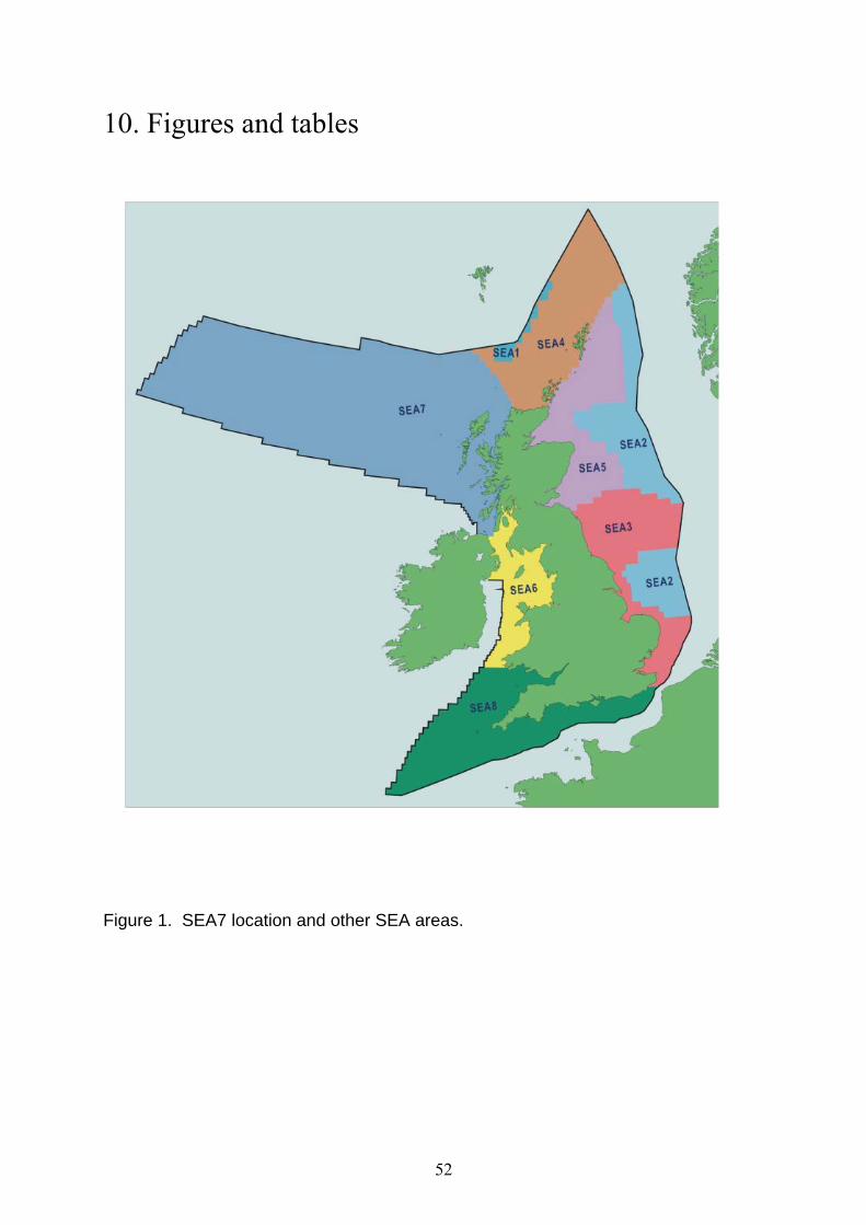
10. Figures and tables
Figure 1. SEA7 location and other SEA areas.
52
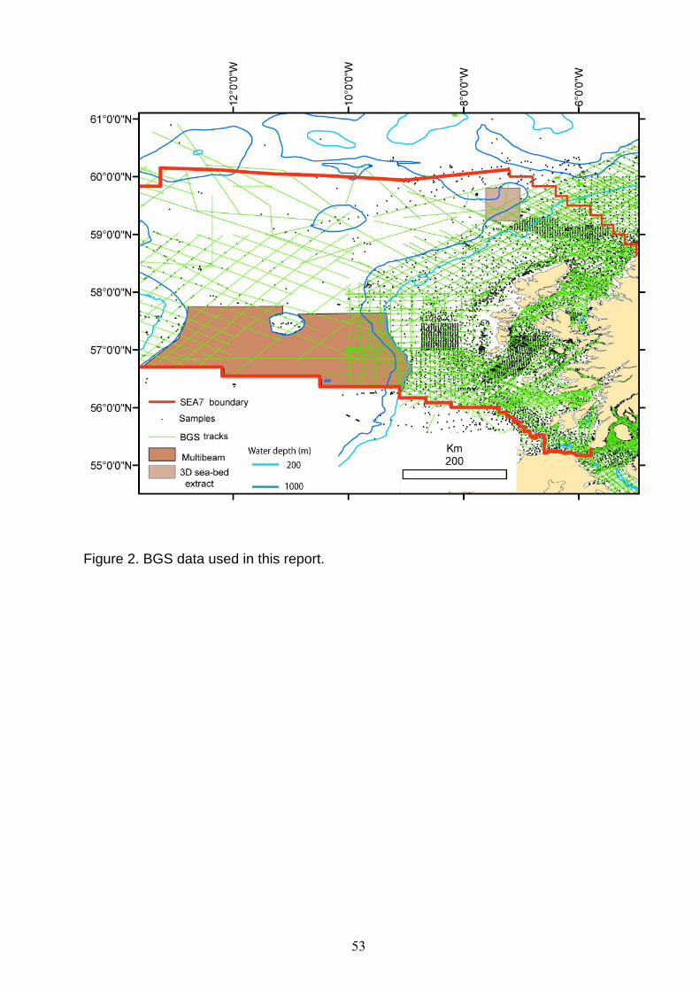
Figure 2. BGS data used in this report.
53

Figure 3. Locations of Figures 14, 18a, 22, 28, 29, 30, 31, 32, 33, 34.
54

Data modified after DTI (2006). Igneous centres: 1. Hebrides Terrace 2. Anton Dohrn 3 .Geikie 4. Drekaeyga 5. Darwin 6. Rosemary Bank 7. East and West George Bligh 8. Swithin 9. Mammal 10. Lyonesse 11. Sandarro 12. Owlsgard 13. Reschora 14. Sandastre 15. Rockall 16. Sigmundur 17. Faroe Bank Channel Knoll 18. Sula Sgeir 19. Mentone 20. Aramassa 21. Blackstones
Figure 4. Regional geological setting.
55

Figure 5. Regional geological structure of the Rockall Basin.
56
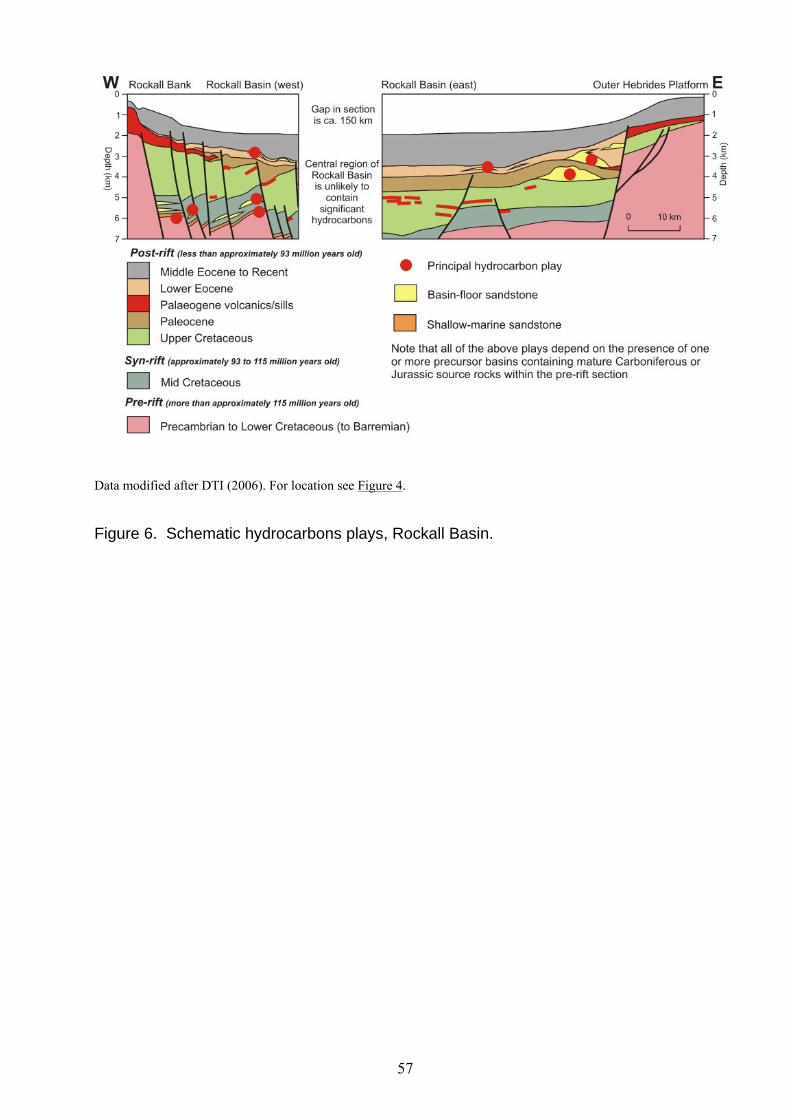
Data modified after DTI (2006). For location see Figure 4.
Figure 6. Schematic hydrocarbons plays, Rockall Basin.
57

Data modified after DTI 2006. For location see Figure 4.
Figure 7. Schematic hydrocarbon plays, Hatton Basin.
58

Modern rates of net land vertical uplift relative to sea level are modified after (Shennan, 2002)
Figure 8. Earthquakes and regional sea-bed uplift.
59

BGS classes of sea-bed sediments are specified in Appendix 2.
Figure 9. Sea-bed sediments.
60

After DTI, 2004.
Figure 10. Mean peak spring tidal current speed.
61
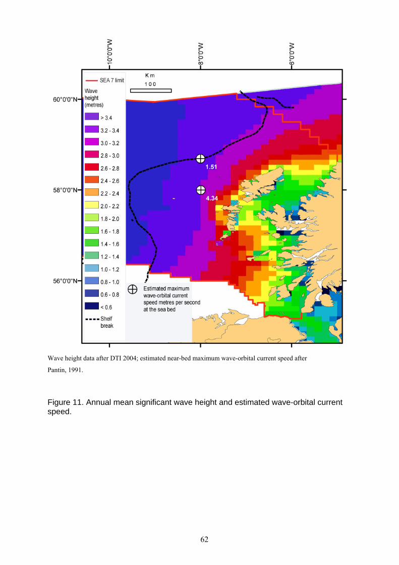
Wave height data after DTI 2004; estimated near-bed maximum wave-orbital current speed after
Pantin, 1991.
Figure 11. Annual mean significant wave height and estimated wave-orbital current speed.
62

Bedform wave height varies from less than 1cm to more than 5m.
Figure 12. Effects of waves on mobile bedforms formed by tidal and residual currents.
63

FSC Faroe-Shetland Channel; RB: Rockall Bank, ADS: Anton Dohrn Seamount, RT: Rockall Trough, HTS: Hebrides Terrace Seamount, HS: Hebrides Shelf, BF: Barra Fan, DF: Donegal Fan, WTR: Wyville-Thomson Ridge,
= Sea-bed photograph, see Figure 14.
The Deep Water Current that moves to the south along the east margin of Rockall Bank is a mixture of currents extended from Faroe-Shetland Channel and diversion of the European Slope Current anti-clockwise by the Wyville-Thomson Ridge (Laberg et al, 2005). All other currents are after SAMS, 2006. Arrow widths and lengths are not proportional to speed.
Figure 13. Residual current circulation patterns .
64

Photograph from the NERC Land Ocean Interaction Study. For location of photograph see Figure 3.
Figure 14. Bedload sand transport at the shelf break, Barra Fan.
65

Map of percentage biogenic carbonate in sea-bed sediments compiled by A. Leslie 2004.
Sea-bed photographs illustrated in Figure 16.
Figure 15. Percentage biogenic carbonate in sea-bed sediments.
66

Photographs 1 to 4 and 6 from Narayanaswamy et al, 2005.
For locations of photographs see Figure 15.
For slope setting of photographs see Figure 33.
Figure 16. Sea-bed photographs, Rockall Bank and Rockall Escarpment.
67

On this sidescan-sonar image the sea bed with very high backscatter and an upstanding sea bed is recorded as black and the sea bed recorded with lower backscatter returned from carbonate sands in intervening valleys and gulleys is recorded as very light yellow. This image illustrates detail from the sea-bed geomorphology illustrated Figure 18a.
Figure 17. Detail from submarine bedrock platform, Outer Hebrides.
68

(a). Sea-bed image of part of the bedrock platform surrounding the Outer Hebrides. Artificial illumination has been applied from the NW. A mainly metamorphic submarine bedrock has been rounded and structured by glaciation. Linear bedrock structures (some consisting of Paleocene volcanic dykes) are often aligned to the NW and are sub-parallel to the onshore bedrock structural trends. The scale of bedrock geomorphology is comparable to that illustrated for the onshore in (b) below.
(b). Photograph of part of the east coast of central Vatersay , south Uist. (BGS registration number P259706 – BGS Solid Geology Sheet 58°E). The view is towards the south. The glaciated hills of Lewisian metamorphic bedrock in the background and sediment-filled valleys in the middle distance are the terrestrial equivalents (at different scales) of the submarine bedrock platform illustrated in Figure 17 and (a) above. Foreground boulders and cobbles are mainly metamorphic rocks and are part of a storm beach. The white sand beach and white sand dunes in the middle distance are composed of carbonate sands that have been transported onshore from the surrounding submarine bedrock-platform and carbonate-reef and carbonate-bioherm systems.
Figure 18. Outer Hebrides (a) regional geomorphology submarine bedrock platform (b) snapshot of nearshore bedrock hills and coastal carbonate systems.
69
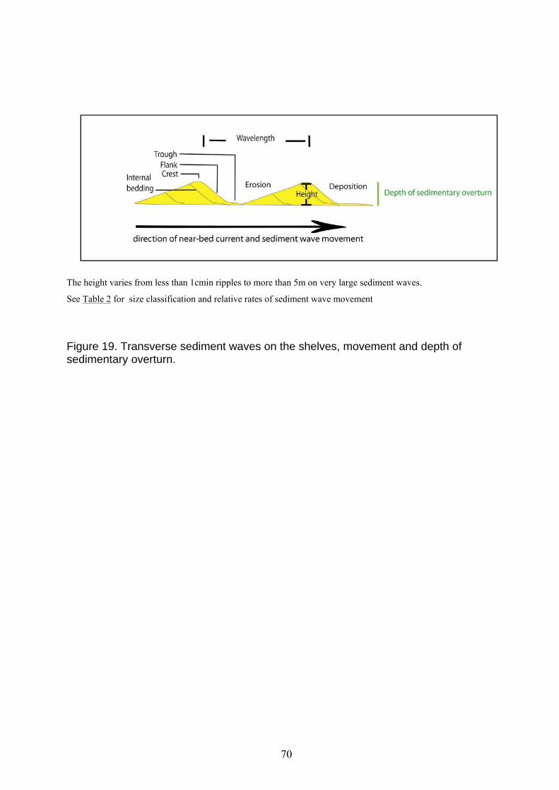
The height varies from less than 1cmin ripples to more than 5m on very large sediment waves.
See Table 2 for size classification and relative rates of sediment wave movement
Figure 19. Transverse sediment waves on the shelves, movement and depth of sedimentary overturn.
70

Location of active submarine landslides after Holmes (2002). Sand (bedload) transport interpreted from transform bedform-facing directions, comet marks and correlation of residual currents with longitudinal sand streaks etc.
Figure 20. Mobile bedforms and net sand transport.
71

Normally consolidated mud, interval bulk density 18kN/m3
Figure 21. Stability model for static sediments on non-deformable substrates.
72

Image from multibeam echsounder survey, artificial illumination from the north west.
For location of figure, see Figure 3.
Figure 22. Glacial moraine and post-glacial submarine landslide, Little Loch Broom.
73

Ro: Rockall, StK: St Kilda; RB: Rockall Bank, Rba: Rosemary Bank; ADS: Anton Dohrn Seamount, RT: Rockall Trough, HTS: Hebrides Terrace Seamount, HSh: Hebrides Shelf, HSlo: Hebrides SlopeBF: Barra Fan, DF: Donegal Fan, WTR: Wyville Thomson Ridge, HSh_WTR_B: Hebrides Shelf-Wyville-Thomson Ridge Bight. Note that the enclosed glacigenic shelf troughs lead to open trough mouths that connect the fans to the inner shelves. Thus the Sula Sgeir Fan, Barra Fan and Donegal Fan are sometimes referred to as ‘trough-mouth fans’ (Figure 27).
Small, inactive submarine landslides, other inactive systems of sea-bed failure and changes of bedrock hardness that have generated static bedforms are not shown. Features from these include former sea bed faulting and former small igneous intrusions. They mainly map to the areas where bedrock is less than approximately 5 metres below sea bed (see above)
Figure 23. Static sea-bed bedforms.
74

Figure 24. Regional geomorphology.
75
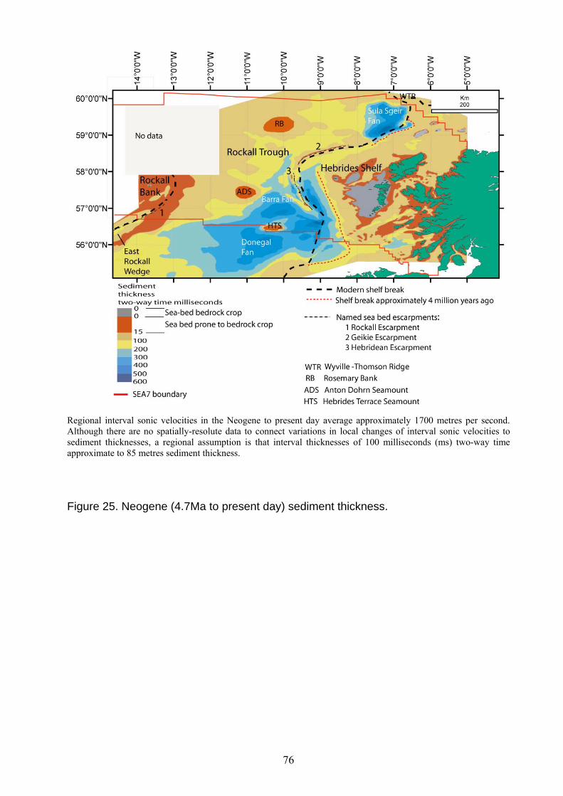
Regional interval sonic velocities in the Neogene to present day average approximately 1700 metres per second. Although there are no spatially-resolute data to connect variations in local changes of interval sonic velocities to sediment thicknesses, a regional assumption is that interval thicknesses of 100 milliseconds (ms) two-way time approximate to 85 metres sediment thickness.
Figure 25. Neogene (4.7Ma to present day) sediment thickness.
76

Image derived from the BGS DigBath database. Troughs and basins formed by sub-glacial erosion are shown in areas with darker shades of blue. The fjordic coasts are located by the boundary separating olive green from red. Areas with elevated rock platforms, skerries and rock pinnacles that were resistant to sub-glacial erosion are shown in shades of yellow and red.
Figure 26. Hebrides Shelf geomorphology.
77

Modified after Dahlgren et al., 2005.
Figure 27. Schematic model of fan geomorphology and bedforms.
78

a. Sea-bed image derived from sea-bed pick of first returns from 3D-exploration data, artificial illumination from the north east
b. Part of BGS sparker profile 84/06/25. The glacigenic debris flows on the slope front on the Sula Sgeir Fan have advanced over the sea-bed sediment waves and partly buried them. The sea-bed sediment waves originated from persistent currents and are stacked over buried sediment waves that are more than 5 million years old.
Image modified after Bulat et al (2003). For location see Figure 3.
Figure 28. Sula Sgeir Fan a. slope-front geomorphology. b. sub-sea-bed profile, glacigenic debris flows.
79

The axes of the former turbidite channels follow the trends of very low backscatter. The shelf break is at approximately 200m water depth. The lower limit of scour by iceberg plough marks is in 300-400m water depth where the iceberg plough marks are sub-parallel to the trend of the 500m bathymetric contour.
For location see Figure 3.
Figure 29 Former turbidite channels and iceberg scour.
80

a. The strings of relatively high backscatter on sidescan-sonar records of iceberg plough marks are correlated with upstanding ridges covered with coarser-grained sediments (sand and gravel) and the areas of relatively low backscatter are correlated with relatively deeper water within the hollows and with deposits of finer-grained sediments. The sea-bed image derived from backscatter varies with sea-bed topography and the direction of travel of the survey vessel. The arrows point to an isolated mid-slope basin created by a former very large iceberg.
b The sea-bed image has been derived from sea-bed pick of first returns from 3D-exploration data. Artificial illumination is from the east.
For location see Figure 3.
Figure 30. a. Iceberg plough marks, upper slope b. isolated basin in slope-parallel iceberg plough marks.
81
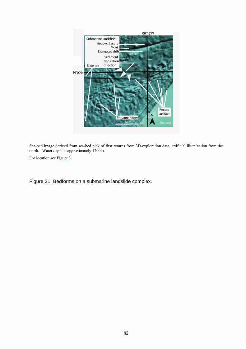
Sea-bed image derived from sea-bed pick of first returns from 3D-exploration data, artificial illumination from the north. Water depth is approximately 1200m.
For location see Figure 3.
Figure 31. Bedforms on a submarine landslide complex.
82

The European Slope Current is moving towards the NE at this location and the profile is across the long axes of the elongated sediment drift and the moat. As the Rockall Trough infills the elongate sediment drift and sediments waves aggrade vertically so that over long geological periods of time they appear to move up slope with time. Figure adapted after (Masson et al., 2002).
For location see Figure 3.
Figure 32. Profile of elongate sediment drift, moat and scarp, north-east Hebrides Slope.
83

a. Historical setting and geological structure of the east margin of Rockall Bank
b. Profile showing the progressive-up-slope migration of pronounced elongated sediment drift from approximately 15 million years ago to the modern sea bed.
For location see Figure 3.
Figure 33. Geological setting and modern sea-bed profile of elongated sediment drift, moat and escarpments, east Rockall Bank.
84
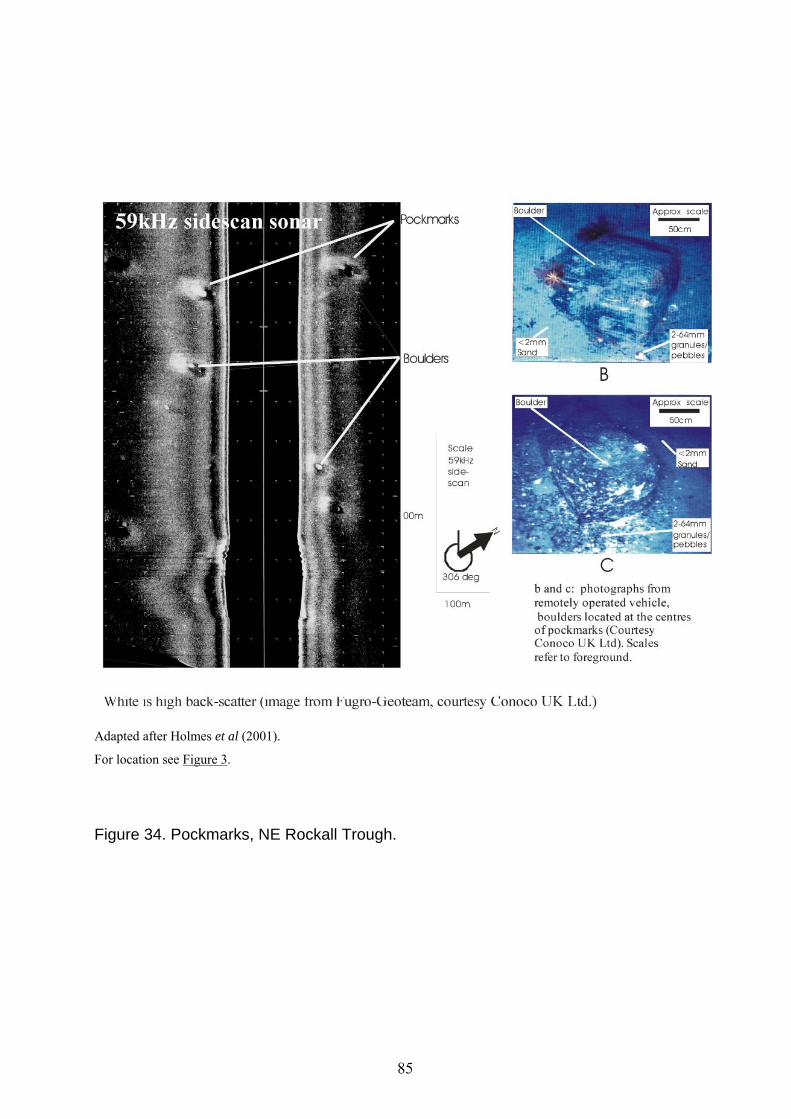
Adapted after Holmes et al (2001).
For location see Figure 3.
Figure 34. Pockmarks, NE Rockall Trough.
85

Figure 35. Sea-bed sediment classification scheme.
86

Table 1 Wentworth grain-size scale used in the BGS classification system for sediments.
87
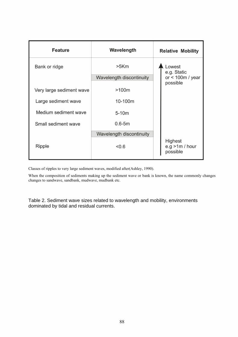
Classes of ripples to very large sediment waves, modified after(Ashley, 1990).
When the composition of sediments making up the sediment wave or bank is known, the name commonly changes changes to sandwave, sandbank, mudwave, mudbank etc.
Table 2. Sediment wave sizes related to wavelength and mobility, environments dominated by tidal and residual currents.
88

Name Origin Components
Elongated sediment drift
Positions and sizes regulated by sediment erosion and transport driven by accelerated persistent currents directed around changes of sea-bed slope then deposition in adjacent areas of less sea-bed stress
Elongated slope change
attached to
elongated moat
attached to
elongated sediment drift
Sediment waves
Positions and sizes regulated by diffuse persistent currents and diffuse periodic turbidity currents
Series of crests and troughs in a sediment wave field
Table 3. Deep-water static bedforms from persistent currents.
89