spatial patterns of residential segregation - umass boston
TRANSCRIPT
Spatial patterns of residential segregation:
A generative model
Flavia F. Feitosa†,∗, Joshua Reyes‡, Walter Zesk§
† Center for Development Research (ZEF), University of Bonn, Bonn, Germany‡Department of Computer Science, University of Massachusetts Boston, 100 Morrissey Blvd,
Boston, MA 02125§Rhode Island School of Design and Architecture, Providence, RI
Abstract. Residential segregation is an explicitly spatial phenomenon that emergesfrom the interaction of many individuals and displays markedly different global patternsdepending on specific socioeconomic contexts. This paper presents a generative modelof socioeconomic segregation that reproduces regular macro-level patterns of the phe-nomenon through the specification of a minimal set of parameters that drive the agents’behaviour. The purpose of these experiments is to provide insights about the emergenceof certain types of segregation patterns that have been identified in many modern citiesand measure the relation between these distinct outputs and the degree of segregationthey produce.
Key words: urban planning; segregation; inequality; agent-based model.
1. Introduction
Residential segregation is a measure of social clumping in an urban environment.It has different meanings depending on the specific form and structure of the city,and its categories include income, class and race. The effects of segregation on citiesare overwhelmingly negative. In particular, socioeconomic segregation limits accessof disenfranchised population groups to infrastructure and job opportunities, whilereinforcing racial and social prejudices. [Cal00] [Ft07] [St01]. The reintegration ofurban populations has proved a complex and at times counterintuitive problem forpolicy makers. It is our hope that an understanding of the underlying mechanicsof segregation, how it emerges and grows, could potentially inform and assist theseefforts.
Residential segregation exhibits many of the characteristic hallmarks of com-plex adaptive systems, particularly emergence and non-linearity. Segregation isperceived as a large-scale urban phenomenon, but emerges from the interactionsbetween individuals at a local level [EA96] [Sch78]. Positive feedback introducea non-linearity into the system. As a result, small differences in socioeconomicand physical context and local behavior can generate large, unexpected and some-times counter-intuitive outcomes that cannot be understood as the simple sumof the constituent parts [Gil08]. Segregation occurs in most large modern cities,including both the developed and the developing word. An examination of thepatterns of segregation in various cities reveals the impact of specific socioeconomicenvironments. For example, most large cities in the United States have poor andnon-white ghettos as a persistent feature of their central areas, whereas the wealthyand mostly white population prefers to live in suburbs [MD93]. In Latin America,wealthy families concentrate in areas that expand from the historical centre intoa single geographical direction, while the poorest population mostly settles in the
∗Corresponding author.Email addresses: [email protected] (F. Feitosa), [email protected] (J. Reyes),[email protected] (W. Zesk).
1

2
roughly equipped peripheries [St01] [Vc01]. These two patterns are common andgenerally recognized, but the structural aspects that cause these distinct patternsremain unclear. What part do individual needs and preferences play in the me-chanics of segregation? How do socio-demographic factors, such as inequality ofincome, impact the emergence of different spatial outcomes?
Generative models have been used to understand the structural characteristics ofurban populations and many, similar complex social systems [Eps07] [EA96]. Mostoften, an agent-based computational model attempts to reproduce certain globalregularities from minimally defined local interactions among individuals within thesystem. Such a model makes it possible to conduct experiments on a simplifiedpopulation of agents in a spatial environment. Agents interact locally accordingto small set of rules, thereby generating global regularity from the bottom up.Simply, the motto of a generative social approach is: ‘If you didn’t grow it, youdidn’t explain it’ [Eps07].
This paper presents a generative model of socioeconomic segregation that re-produces patterns much like those observed in real cities. The rules defining theinteraction of agents are few and simple. The purpose of this experiment is tocreate a stylized, abstract model that is able to provide insight into the mechanicsof emergence and the variety of segregation patterns identified in modern cities. Inaddition, this work understands each pattern in terms of the degree of segregationproduced. Our simulation enables the quantitative comparison of different patternsbased on defined segregation measures: exposure and clumpiness. The remainderof this paper is organized as follows: Section 2 gives a brief introduction to the clas-sical types of segregation patterns that are considered in this work. Sections 3 and4 describe the model’s specification, its fundamental assumptions, and a discussionof results. Finally, Section 5 presents the concluding remarks and directions forfuture research.
2. Classical Patterns of Residential Segregation
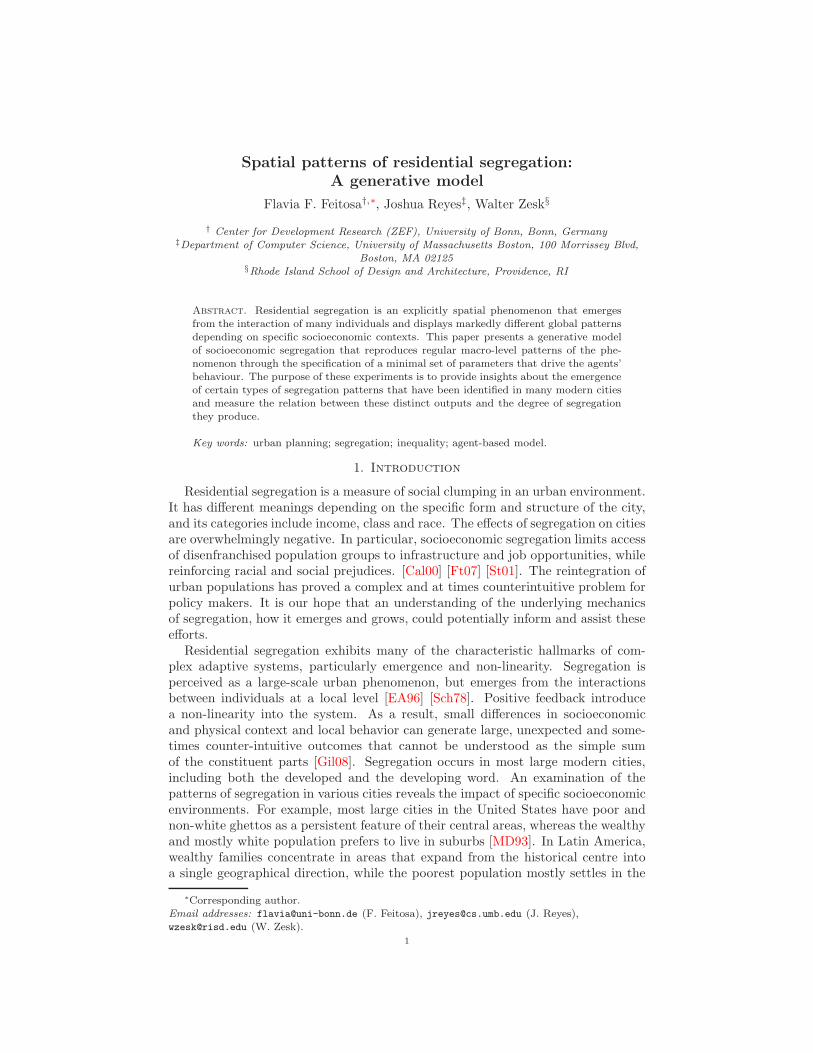
The Chicago School refers to set of urban studies that emerged in Chicago duringthe first half of the 20th century. It became famous for its systematic, formal ap-proach, focused on the city as a social laboratory. The school’s effort to understandthe spatial organization of human activities resulted in classical urban models thatattempt to distinguish and categorize patterns of residential segregation. The con-centric model, proposed by Burgess [Bur24], argues that a city grows outward froma central point in a series of rings. Burgess observed that there was a correlationbetween the distance from this central point (the central business district or CBD)and the wealth of residential areas. Since Burgess’ studies were based on Chicago,he observed that wealthier families tended to live further away from the CBD. Laterexamples also followed the Burgess model, but with an inverse correlation betweenthe CBD and the wealth of neighborhoods. Some Latin-American cities exhibitthis center-periphery pattern, especially until the 1980’s, where wealthier familiestend to concentrate in central areas, while poorer families occupy the outskirts ofthe city.
Hoyt [Hoy39] proposed a second model, known as the sector model, which as-sumes that cities develop in sectors rather than rings. According to this model,if a district is set up for high income residences, any new development in thatdistrict will expand from the outer edge and, therefore, the sector shape emerges.

3
Figure 1. Patterns of residential segregation: concentric orcenter-periphery model of Burgess (left) and the sector model ofHoyt (right).
Figure 1 illustrates patterns of residential segregation based on Burgess’ concentricmodel and Hoyt’s sector model. Burgess’ and Hoyt’s models describe cities at avery high level, disregarding specific geography, culture or history. Moreover theyimpose several other stringent constraints as both models refer exclusively to mono-centric cities built upon static landscapes. Nevertheless, the basic features of thecenter-periphery and sector models are still commonly recognized in cities aroundthe world, and are often accepted as the basis for segregation analyses. This workadopts both models as reference for regular macro-level patterns of segregation thatare expected to emerge from simple interaction rules among individuals.
3. The Model Specification
Our model relies on the premise that socioeconomic segregation is the outcomeof a contest for the most convenient locations in the city. In this model, only twoattributes define how convenient a location is: the quality, which acts as a generalproxy for the public goods available at that location, and its proximity to the CBD.The total environment consists of a two-dimensional 45× 45 grid. Each cell withinthe grid corresponds to a dwelling unit. At the beginning of each run, each cellreceives an equal quality rating. The initial price distribution falls off as the inverseof distance to the CBD. This condition merely prices those locations closest to thecenter of the city highest before any individuals move in. We normalized incomeand prices between 20 and 100 units of currency. Households with incomes thatexceed 100 units have no more purchasing power and political influence than thosewith 100.
Since the aim of our model is to ‘grow’ a city, the grid is initially populatedwith a minimum amount of agents. Each agent corresponds to a single household,which is characterized by its location and income. Incomes are drawn accordingto a Pareto distribution, the skewness of which can be controlled by its exponent,known as Pareto index. The Pareto index regulates the level of income disparity inthe city and can be chosen by the user—higher values describe distributions withhigh disparities between the very rich and the very poor, while lower index valuesresult in more uniform distributions of wealth.
The city is gradually populated by households according to a fixed growth rate.While looking for their residential location, the new inhabitants attempt to maxi-mize the utility derived by a location over some subset of the presently unoccupied

4
cells according to the Cobb-Douglas function:
U =
(
1
D
)1−α
Q1+α,
where Q is the quality index of the cell, D is its distance to the CBD, and α ∈ [−1, 1]is the quality-priority index. The quality-priority index introduces a cultural biasto the model. Households will prioritize locations with high quality indices if α isnear 1, and prioritize cells close to the city’s center for values of α close to −1.For values of α near zero, individuals try to strike a balance between quality anddistance when searching for a place to inhabit. In this way the quality-priorityindex tries to capture the culture of the city. Below we explain how this parametereffects the geometry of the resultant city.
The individuals in this model exhibit boundedly rational behavior. Becausesearch is costly, every household evaluates only a limited number of the total, pos-sible locations to move to. This maximization is constrained by the household’sincome. Unlike other models of segregation, the households choose their new lo-cation without giving consideration their neighbors, their income, or any otherattribute explicitly. The decision-making process relies entirely on the amount ofpublic goods available to potential residence and its distance to the downtown. Ateach update, however, individuals compare utilities among others with similar levelof income. In our model, households with utilities that are much lower than theirfinancial neighbors grow dissatisfied and may repeat the search process and moveto another location.
As individuals choose their residential location, they change the environment.This model assumes that individuals with high income are able to advocate for morepublic goods in their neighbourhood, and therefore slightly increase property value(price) and introduce more public goods, such as improved school systems, police,or public parks (quality). On the other hand, individuals with low income lacksimilar resources, and so property value and public goods in those neighbourhoodsdecrease slightly.
3.1. Measurements. The spatial arrangement of the population is constantlymonitored through segregation indices. Since segregation is not a unidimensionalphenomenon [MD88], we selected segregation indices that are able to capture thesegregation dimensions defined by Reardon and O’Sullivan [RO04]: spatial even-ness/clustering and spatial exposure/isolation (Figure 2). To measure each of thesedimensions, we compute spatial indices of segregation proposed by Feitosa et al.[Ft07].
Spatial evenness/clustering refers to the balance of the distribution of populationgroups, and it is measured by the generalized neighbourhood sorting index GNSI,which calculates how much variances in income between different neighbourhoodscontribute to the total income variance of the city. Generally, higher variancebetween neighbourhoods signifies higher levels of segregation along this axis. Spatialexposure/isolation refers to the likelihood for members from different groups tolive side-by-side. We use spatial the exposure index P(m,n), which measures theaverage proportion of group n in the neighbourhoods of each member of groupm, to measure exposure. Since both these indices are global quantities, we alsocompute local indices of spatial isolation qm that can be displayed as maps and

5
Figure 2. Spatial Dimensions of Segregation.
facilitate the visual interpretation of the simulations. For the computation of group-based measures P(m,n) and qm, we split the population according to income. Thoseindividuals with the income above the median value belong to the group “wealthy,”while those with the income falling below the median belong to the group “poor.”The size of the neighbourhoods considered in the calculation of the indices areestablished according to a user-defined radius.
4. Growing Spatial Segregation Patterns
We ran our simulation several times for varying preferences and economic back-ground. During these runs the quality-priority ranged over the values α = −1,−0.5, 0, and +0.5 for each of scenario captured by the Pareto inequality indicesβ = 0.5, 1, and 1.5—cities with low, moderate, and extreme disparities in wealth.We excluded the extreme case α = 1 because in this culture households do not giveany importance to living near the center of the city whatsoever. When proximityto the CDB is completely disregarded, the resultant ‘cities’ are not cities at all butexpanding and uncoordinated spreads of individuals seeking out untouched land.Each simulation ran until its population exceeded one thousand households. Westopped the runs short to limit unreasonable amounts of noise from the artificial,rectangular boundary of our model. Generally, real cities do not have a hard edgebeyond which they cannot develop. Imposing an early termination nods to thisfact.
Figure 3 presents the distribution of households for two runs in our experiment.The rightmost column depicts the physical distribution of households, colored by in-come, across the model’s landscape. In this picture, red, orange, and blue squarescorrespond to households with low income, moderate, and high incomes respec-tively. In the middle and leftmost columns, we have plotted the spatial isolationof the poor qpoor and of the wealthy qwealthy. Dark patches signify areas that areexceptionally isolated. It is worth remembering that because the isolation indexaverages over neighbourhoods, a cell need not be inhabited for it to be colored inthese plots.

6
Proximity to the CBD preferred to Quality (α = −1)qpoor qwealthy
Household distribution Isolation of Poor Isolation of Wealthy
Quality preferred to Proximity to the CBD (α = +0.5)qpoor qwealthy
Household distribution Isolation of Poor Isolation of Wealthy
Figure 3. Simulation outcomes based on different values for thequality-index α.
We saw that the two parameters in our model, the quality-priority α and Paretoinequality index β, effect two different properties of the emergent city, namely, itsshape and its fill. By varying them appropriately, we were able to recover bothof the classic patterns observed in the Chicago school as well as other commonlyobserved phenomenon such as wealthy suburbs. The quality-priority index steersthe exterior shape of the city. It determines whether the city is compact andcircular or irregular and expansive. This effect is not completely unexpected. Forlarge, negative values of α, inhabitants strongly discount cells far from the CBD.Consequently all households will seek out the available homes closest to downtownregardless of their income. Figure 3 shows examples of both compact and sprawlingcities.
The inequality index controls the interior fill, roughly understood as whetherthe the city grows by rings or by sectors. Both are special cases of a pinchingprocess. Initially very few households inhabit the city. Because all individualsprefer to some extent to live near the CBD, a ring of households circles the city’sdowntown. Because households either increase or decrease the quality and price oftheir neighbourhood proportionally to their income, areas with rich inhabitants willincrease in price and quality, while those with poor inhabitants will decrease in priceand quality without changing the cell’s distance to the center of the city. Theseadjustments render cells adjacent to wealthy households more desirable for other

7
Figure 4. Segregation indices computed for simulation outcomeswith different values for the quality-index α.
wealthy households, while at the same time making them prohibitively expensivefor poor households. If the inequality β is sufficiently low, then there will bemany wealthy households—enough to form a barrier to prevent being surroundedby poorer neighbors. The top row in Figure 3 illustrates the case in point. Thegroup isolation plots sure the clear emergence of the sector pattern commonly seenin Latin American cities where wealthy families do indeed concentrate in areas thatexpand from the center in a single direction. If, however, inequality is very high theadjustment effects incurred by the overwhelming majority of households with lowerthan median incomes permit the wealthy downtown area to be enclosed entirelyby poor individuals. Cities that fall in this part of the parameter space tend toresemble the Burgess model of concentric segregation. When inequality is highand preference is given to quality rather than distance, we witness the spontaneousemergence of wealthy suburbs. The bottom row in Figure 3 gives an example of thiskind of city. In North American cities, where lower transportation costs decreasethe importance of proximity to the CBD, we commonly experience precisely thispattern of urban development.
Figure 4 presents plots of segregation indices measured for simulations conductedwith four different values for the quality-index α. In order to obtain more ro-bust results, we repeated these measurements using five different random-seedsand three different degrees of inequality (presented in different colors). The firstgraphic shows how the index GNSI, which measures the segregation dimensionevenness/clustering, presents a positive correlation with the quality-priority index.The second graphic shows how the exposure of affluent families to poor familiesdecreases with the increase in the quality-priority index. Both results indicate thatas soon as households attribute less value to proximity and more value to quality,the segregation level increased in both dimensions. Therefore, the ‘disperse city’dominated by wealthy suburbs seem to be the segregation pattern that producesthe highest levels of segregation. Regarding inequality, the graphics of Figure 4 re-veal an unexpected result: while higher income inequality increases the segregationin the dimension evenness/clustering (GNSI), it increases the exposure amongstdifferent income groups and therefore decreases the segregation in the dimensionexposure/isolation.

8
5. Concluding Remarks
This paper presents an agent-based model that generates patterns of segregationmuch like those identified in real cities. These patterns emerge despite the extremesimplicity of the model and its parameters. It is an example of how complexity canemerge from just a few parameters and suggests that these parameters are crucialto the underlying dynamics of segregation.
The model demonstrates how the variation of a single parameter, such as quality-priority was able to generate classical patterns of segregation. This is an indicationof how a cultural and economic environment influences segregation patterns. Lowtransportation costs in North American cities minimize the importance of proximityto the center of the city and promote the emergence of dispersed cities with wealthysuburbs. It will be interesting to see the effect of the current energy crisis onsegregation in these cities.
This work includes a quantitative comparison of segregation patterns through theapplication of global segregation indices. This is a particular advantage provided bygenerative models, since indices computed for real cities cannot be compared dueto their susceptibility to the modifiable areal unit problem (MAUP). Our findingsindicate that disperse cities produce higher degree of segregation in both dimen-sions, while unequal cities present higher degree of segregation in the dimensionevenness/clustering, but not in the dimension exposure/isolation.
Segregation remains a remarkably common, persistent and difficult problem forcities of all types. Like many social phenomena, it grows out of simple interactionsbetween individuals, but manifests as a complex resilient phenomena at the scale ofthe city. Agent-based models provide a unique laboratory for experimentation andexamination of these phemonema, stripped down to their essential mechanics. Weview this work as a simple kind of null model upon which urban planners and policymakers may introduce and isolate the effects of legislation, e.g., the social-mixedhousing policies that have been recently instated in some North American cities.
Acknowledgements
This work was partially supported by the Santa Fe Institute whose research andeducation programs are supported by core funding from the National Science Foun-dation and by gifts and grants from individuals, corporations, other foundations,and members of the Institute’s Business Network for Complex Systems Research.
References
[Bur24] E. W. Burgess. The growth of the city: an introduction to a research pro ject. Publicationsof the American Sociological Review, 18:85–97, 1924.
[Cal00] T. Caldeira. City of walls: crime, segregation and citizenship in Sao Paulo. Universityof California Press, Berkeley, 2000.
[EA96] J. M. Epstein and R. Axtell. Growing Artificial Societies: Social Science from the BottomUp. Brookings Institution Press, Washington, DC, 1996.
[Eps07] J. M. Epstein. Generative Social Science: Studies in Agent-Based Computational Mod-eling. Princeton University Press, 2007.
[Ft07] F. d. F. Feitosa and et al. Global and local indicators of urban segregation. InternationalJournal of Geographical Information Science, 21:299–323, 2007.
[Gil08] N. Gilbert. Agent-Based Models. Quantitative Applications in the Social Sciences. SagePublications, 2008.
[Hoy39] H. Hoyt. The Structure and Growth of Residential Neighborhoods in American Cities.Federal Housing Administration, Washington, DC, 1939.

9
[MD88] D. S. Massey and N. A. Denton. The dimensions of residential segregation. Social Forces,67:281–315, 1988.
[MD93] D. S. Massey and N. A. Denton. American apartheid: segregation and the making of theunderclass. Harvard University Press, Cambridge, MA, 1993.
[RO04] S. Reardon and D. O’Sullivan. Measures of spatial segregation. Sociological Methodology,34:121–162, 2004.
[Sch78] T. C. Schelling. Micromotives And Macrobehavior. W. W. Norton, London & New York,1978.
[St01] F. Sabatini and et al. Segregacion residencial en las principales ciudades chilenas: tenden-cias de las tres ultimas decadas y posibles cursos de accion. EURE (Santiago), 27:21–42,2001.
[Vc01] F. Villa¸ca. Segregation in the brazilian metropolis. paper presented at InternationalSeminar on Segregation in the City, Lincoln Institute of Land Policy, Cambridge, 2001.