southern california edison company devers-mirage 115 kv ... · devers-mirage 115 kv...
TRANSCRIPT
Southern California Edison Company
Devers-Mirage 115 kV Subtransmission System
Split Project
FINAL BIOLOGICAL ASSESSMENT FOR THREATENED AND ENDANGERED SPECIES
Prepared by:
EPG, Inc.
Southern California Edison Company
December 2007

THIS PAGE IS INTENTIONALLY BLANK
Biological Assessment Environmental Planning Group Devers-Mirage 115 kV Substransmission System Split Project December 2007
i
TABLE OF CONTENTS 1 Introduction ............................................................................................................. 1 2 Purpose and Need .................................................................................................. 4 3 Project and Site Description.................................................................................... 5 3.1 Project Description ...................................................................................... 5 4 Environmental Setting ............................................................................................. 17 4.1 Existing Vegetation Conditions.................................................................... 17 4.2 Climate ........................................................................................................ 18 4.3 Land Use ..................................................................................................... 18 5 Threatened and Endangered Species .................................................................... 18 5.1 Special Status Plant Species ...................................................................... 19 5.2 Impacts........................................................................................................ 31 5.3 Summary of Impacts to Federally Listed Species ....................................... 33 6 Mitigation................................................................................................................. 36 6.1 Applicant Proposed Measures..................................................................... 36 6.2 Biological (Species-Specific) Mitigation Measures ...................................... 37 6.3 Operation and Maintenance ........................................................................ 40 7 Residual Effects ...................................................................................................... 41 7.1 Coachella Valley Milkvetch.......................................................................... 41 7.2 Coachella Valley Fringe-toed Lizard ........................................................... 41 8 Cumulative Effects .................................................................................................. 41 9 References.............................................................................................................. 42

Biological Assessment Environmental Planning Group Devers-Mirage 115 kV Substransmission System Split Project December 2007
ii
LIST OF FIGURES 1 Proposed Project and Alternatives.......................................................................... 2 2 Bureau of Land Management Sensitive Biological Resources ............................... 3 3A California Natural Diversity Database Sensitive Biological Resources Farrell-Garnet Project Area ..................................................................................... 20 3B California Natural Diversity Database Sensitive Biological Resources Mirage-Santa Rosa Project Area ............................................................................ 21 4 Designated Habitat and Public Lands ..................................................................... 28
LIST OF TABLES 1 Federal and California Listed Plant Species Known to Occur in Riverside County, California.................................................................................... 22 2 Federal and California Listed Wildlife Species Currently Known to Occur in Riverside County, California.................................................................................... 24 3 Summary of Potential Special Status Species Habitat Affected by the Proposed Action...................................................................................................... 32 4 Summary of Potential Special Status Species Habitat Affected by the Proposed Action on Fringe-toed Lizard Critical Habitat .......................................... 32 5 Federally Listed Species in Riverside County and Determination of Effects from the Proposed Project .......................................................................... 34

Biological Assessment Environmental Planning Group Devers-Mirage 115 kV Substransmission System Split Project December 2007
1
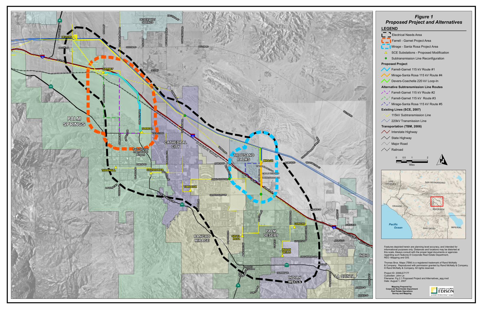
1 INTRODUCTION Southern California Edison Company (SCE) proposes to construct the Devers-Mirage 115 kilovolt (kV) Subtransmission System Split Project (referred to as the Proposed Project as summarized below). The Proposed Project is necessary to maintain electric system reliability, enhance operational flexibility, and serve projected electrical demand in the cities of Palm Springs, Rancho Mirage, Cathedral City, Palm Desert, Indian Wells, and unincorporated areas of Riverside County, including the Thousand Palms community (Electrical Needs Area), as shown on Figure 1. Construction is scheduled to begin by the second quarter of 2009, or immediately following receipt of all project approvals. The Proposed Project is scheduled to be operational by mid-2010 to ensure that safe and reliable electric service is available to serve customer electrical demand in the Electrical Needs Area. The Bureau of Land Management (BLM) will be the federal agency responsible for issuing a right-of-way (ROW) grant across public land for the portion of the Proposed Project on BLM land (Figure 2). Section 7 of the Endangered Species Act of 1973 (ESA), as amended, requires federal agencies to ensure that their actions do not jeopardize the continued existence of threatened or endangered species or result in the destruction of their critical habitat. Federal actions include providing funds for a project or issuing various types of approvals (e.g., permits or easements). To initiate consultation for a project under Section 7(a)(2) of ESA, a federal agency requests a list of endangered or threatened species (or species proposed for listing) from the U.S. Fish and Wildlife Service (USFWS). If a listed species exists in the project study area, the agency or its designee must complete a biological assessment (BA) describing how the project would affect the species. If the BA determines that a listed species or its critical habitat would not be affected, and the USFWS concurs, the consultation process is terminated and no further action is necessary. If the BA determines that a listed species or its critical habitat may be affected but is not likely to be adversely affected, informal consultation with the USFWS is initiated. If the BA determines that the action may adversely affect listed species or their habitat, the federal agency must enter into formal consultation with the USFWS. Formal consultation may not be necessary if, as a result of the preparation of the BA, the USFWS determines that the proposed activity is not likely to affect the listed species or critical habitat adversely. The USFWS must prepare a Biological Opinion (BO) based on the BA and any other information available to USFWS. The BO determines whether the federal action, taken together with cumulative effects, is likely to jeopardize the continued existence of a listed species or result in the destruction or adverse modification of critical habitat. The formal consultation process ensures that the federal action would conserve the species and its critical habitat. As the designated representative for SCE, Environmental Planning Group (EPG, Inc.) has compiled a list of threatened or endangered species that could potentially occur in the vicinity of the Proposed Project. The species of concern are summarized below and in Tables 1 and 2 (shown later in this report).

THIS PAGE IS INTENTIONALLY BLANK
!?
!?
!?
#*
#*
#*
#*
#*
#*
#*
#*
#*
#*
Union Pacific Railroad
Palm SpringsInternational
Airport
LA QUINTAINDIANWELLS
INDIO
PALMDESERTRANCHO
MIRAGE
CATHEDRALCITY
PALMSPRINGS
DESERT HOTSPRINGS
THOUSANDPALMS
§̈¦10
§̈¦10
§̈¦10
·|}62
·|}111
·|}74
·|}111
·|}111
UP RR
OASIS
CLUB
DRVARNER RD
VARNER RD
ADAM
SST
LITTL
EMO
RONG
ORD
P ORT
OLA
AV
20TH AV
MESQUITE
A V
BOB HOPE DR
INDIO BLVD
GENE
AUTR
YTR
AVENUE 40
LAND
AUBL
VD
ELDO
RAD O
DR
WASH
INGT
ONST
AVENUE 42
GERALD FORD DR
DILLON RD
AVENUE 49
COUNTRY CLUB DR
RAMON RD
FRED WARING DR
BOB
HOPE
DR
DILLON RD
SHA DO W
MOUN
TAIN DR
WASHINGTON ST
DILLON RD
RAMON RD
MONT
EREY
AV
LONG
CAN Y
ONRD
RAMON RD
MADI
SON
ST
AVENUE 48
WORS
LEYR
D
DILLON RD
MILES AV
VISTA CHINO
HACIENDA AV
EL PASEO
20TH AV
INDI
ANCA
NYON
DR
DAVA
LLDR
FARRE
LLDR
VARNER RD
POR T OLAAV
ELCI
ELO
RD
PALM CANYON DR
HIGHWAY 111
AVENUE 38
FAIRWAY DR
TOLE
DOAV
THOUSAND PALMS CA
NY ON
RD
MOUN
TAIN
VIEW
R D
SUNR
ISEW
Y
INDI
ANAV
COOK
ST
DATE
PALM
DRDINAH SHORE DR
PALM
DR
LA VER NE WY
HOVLEY LN
MIRAGE
INDIANWELLS
THORNHILL
TAMARISK
SANTAROSA
GARNET
FARRELL
EISENHOWER
DEVERS
CONCHO
Features depicted herein are planning level accuracy, and intended forinformational purposes only. Distances and locations may be distorted atthis scale. Always consult with the proper legal documents or agenciesregarding such features.© Corporate Real Estate Department,REO -Mapping and GIS.
Mapping Prepared by:Corporate Real Estate Department
Real Estate OperationsSurvey and Mapping
Thomas Bros. Maps (TBM) is a registered trademark of Rand McNally & Company. Reproduced with permission granted by Rand McNally & Company. © Rand McNally & Company. All rights reserved.
SAN DIEGO
SAN BERNARDINO
RIVERSIDEORANGE
LOSANGELES
IMPERIALPacific
Ocean
O
Figure 1Proposed Project and Alternatives
Project ID: 2006LE7177Custodian: John LeFilename: Fig 2.1 Proposed Project and Alternatives_epg.mxdDate: August 1, 2007
0 1 20.5
Miles
LEGEND
Proposed Project
Farrell-Garnet 115 kV Route #3Mirage-Santa Rosa 115 kV Route #5
Farrell-Garnet 115 kV Route #1Mirage-Santa Rosa 115 kV Route #4
Alternative Subtransmission Line Routes
Existing Lines (SCE, 2007)
Transportation (TBM, 2006)
State HighwayInterstate Highway
RailroadMajor Road
Electrical Needs AreaFarrell - Garnet Project AreaMirage - Santa Rosa Project AreaSCE Substations - Proposed Modification#*
Subtransmission Line Reconfiguration!?
Devers-Coachella 220 kV Loop-In
220kV Transmission Line115kV Subtransmission Line
CALLE DESIERTOWHITE SANDS DR
VISTA
DE
ORO
CALLE FRANCISCO
Farrell-Garnet 115 kV Route #2

THIS PAGE INTENTIONALLY BLANK

Union Pacific Railroad
GENE
AUT
RY T
R
PALM
DR
SALVIA RD
§̈¦10
Features depicted herein are planning level accuracy, and intended forinformational purposes only. Distances and locations may be distorted atthis scale. Always consult with the proper legal documents or agenciesregarding such features. © Corporate Real Estate Department,REO-Mapping and GIS.
Mapping Prepared by:Corporate Real Estate Department
Real Estate OperationsSurvey and Mapping
Thomas Bros. Maps (TBM) is a registered trademark of Rand McNally & Company. Reproduced with permission granted by Rand McNally & Company. © Rand McNally & Company. All rights reserved.
SAN DIEGO
SAN BERNARDINOLOS
ANGELES
IMPERIAL
ORANGE RIVERSIDE
Pacific Ocean
O
Figure 2Bureau of Land Management
Sensitive Biological Resources
Project ID: 2006LE7177Custodian: John LeFilename: Fig 4.4-3_bio_blmsbr_epg.mxdDate: 06/07/2007
LEGEND
0 1,000 2,000500Feet
Transportation (TBM, 2006)
Sensitive Biological ResourcesCoachella Valley MilkvetchCoachella Valley Fringe-toed Lizard
Coachella Valley Milkvetch HabitatDesignated Habitat
Subtransmission Line Routes
Farrell - Garnet Project AreaBLM Land
Farrell - Garnet 115 kV Route #1Farrell - Garnet 115 kV Route #1 Option A
Interstate HighwayMajor RoadRailroad

THIS PAGE INTENTIONALLY BLANK

Biological Assessment Environmental Planning Group Devers-Mirage 115 kV Substransmission System Split Project December 2007
4
For each of the species listed there are three major areas of concern that need to be addressed in the BA:
1. Level of use of the project study area by the listed species
2. Effect of the project on the listed species’ primary food stocks, prey species, foraging areas, or substrates in all areas influenced by the project
3. Impacts from project construction and/or implementation (e.g., noise levels, increased human activity and/or access, or loss or degradation of habitat), which may result in disturbance to listed species and/or their avoidance of the project study area
Special status species identified as potentially occurring in the project study area include the federally listed Coachella Valley Fringe-toed Lizard, Coachella Valley milkvetch, and Desert Tortoise. One proposed candidate for listing under ESA, the Palm Springs Round-tailed Ground Squirrel, and one former candidate, the Flat-tailed Horned Lizard, are also included in this BA. Coachella Valley milkvetch and Coachella Valley Fringe-toed Lizards were documented in the project study area during surveys in 2006 and 2007; the other species were not observed. For all special status species, a combination of appropriately timed construction activities, species-specific mitigation measures, and biological monitoring will negate the chances that adverse affects would occur. Construction would occur from April to October, when Fringe-toed Lizards are active, thus minimizing the possibility of injuring hibernating individuals. During this time, Coachella Valley milkvetch, a winter annual or semi-perennial, will have flowered and gone to seed, thus reproductive output for the year would not be affected. All construction in special status species habitat will be confined to existing access roads, and construction areas and access roads will be fenced to exclude animals from entering work zones. No permanent loss of habitat would occur, as construction in these areas would consist only of upgrading existing facilities. A biological monitor will be on-hand before and during all construction activities to provide training to work crews, to ensure compliance with mitigation measures, and to monitor movements of special status species as construction proceeds. 2 PURPOSE AND NEED The purpose of the Proposed Project is to relieve existing thermal overload conditions on two 115 kV subtransmission lines and to resolve a forecasted voltage problem on the 220 kV transmission system that would exist by 2009. The Proposed Project is needed to continue to provide safe and reliable electric service to customers in the Electrical Needs Area. Under the rules, guidelines, and regulations of the Federal Energy Regulatory Commission (FERC), North American Electric Reliability Council (NERC), Western Electricity Coordinating Council (WECC), and California Public Utilities Commission (CPUC), electrical transmission, subtransmission, and distribution systems must have sufficient capacity to maintain safe, reliable, and adequate service to customers. The safety and reliability of the systems must be maintained under normal conditions when all facilities are in service as well as under abnormal conditions. Abnormal conditions result from equipment or line failures, maintenance outages, or emergency outages that cannot be predicted or controlled.

Biological Assessment Environmental Planning Group Devers-Mirage 115 kV Substransmission System Split Project December 2007
5
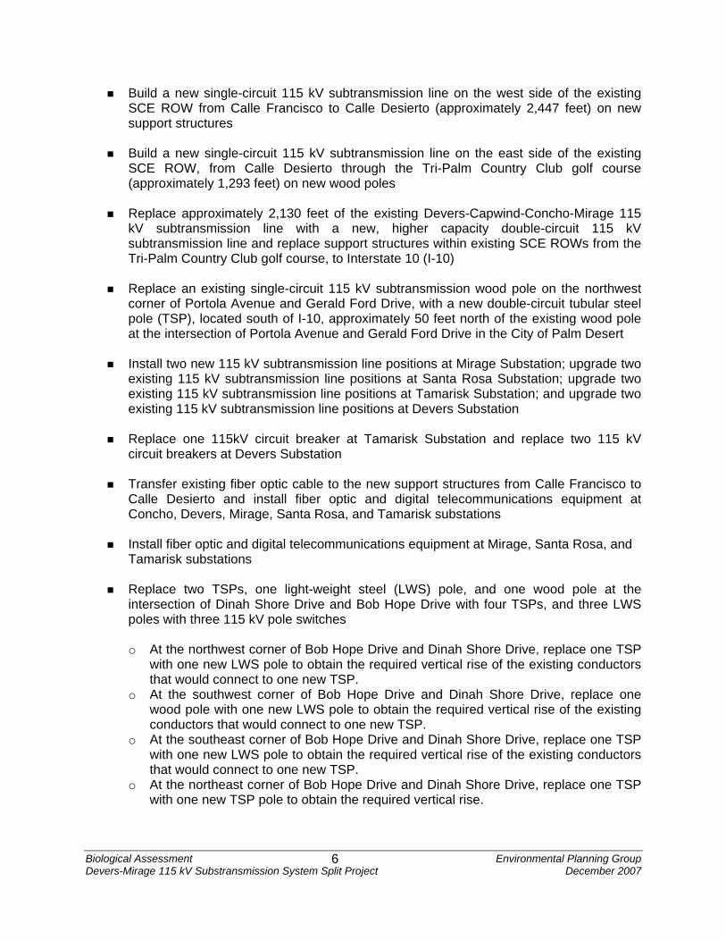
SCE utilizes a multi-step planning process to ensure that any necessary system upgrades are developed in time to meet increased electrical demand and to reliably serve such demand. The planning process begins with the development of a peak demand forecast for each substation. Peak demand forecasts are developed using trends in population data, urbanization data, and meteorological data. Technical engineering analyses are then conducted to determine whether the forecast of peak demand can be accommodated on the existing transmission, subtransmission, and distribution systems. System facilities, such as substations and power lines, have defined operating limits. When projections indicate that these limits would be exceeded within an appropriate planning horizon, a project is proposed to keep the electrical system within specified operating limits. Accordingly, SCE identified the need to split the Devers 115 kV Subtransmission System in its 2003 California Independent System Operator (CAISO) Expansion Plan. SCE also identified the need to loop the existing Devers-Coachella Valley 220 kV transmission line into Mirage Substation by 2009 in its 2004 CAISO Expansion Plan. SCE received approval from CAISO in 2004 to proceed with the split of the Devers 115 kV Subtransmission System and in 2006 to proceed with the loop of the Devers-Coachella Valley 220 kV transmission line into Mirage Substation. Between 2003 and the present, SCE has taken CAISO-approved steps to mitigate (through the implementation of operating procedures and system modifications) the overload and the reliability issues associated with the Devers 115 kV Subtransmission System. Existing mitigation measures are not sufficient to provide reliable electric service under certain projected base case and abnormal load conditions. 3 PROJECT AND SITE DESCRIPTION 3.1 Project Description 3.1.1 Devers 115 kV Subtransmission System Split The portion of the Proposed Project necessary to accomplish a split of the Devers 115 kV Subtransmission System into the Devers 115 kV Subtransmission System and the Mirage 115 kV Subtransmission System includes the elements described below. Mirage-Santa Rosa, Mirage-Santa Rosa-Tamarisk, Mirage-Capwind-Devers-Tamarisk, and Mirage-Concho 115 kV Subtransmission Lines Create the Mirage-Santa Rosa, Mirage-Santa Rosa-Tamarisk, Mirage-Capwind-Devers-Tamarisk, and Mirage-Concho 115 kV subtransmission lines in accordance with the following scope-of-work:
Replace approximately 1,783 feet of the existing Mirage-Tamarisk single-circuit 115 kV subtransmission line with a new, higher capacity double-circuit 115 kV subtransmission line and replace support structures within existing SCE ROWs from Mirage Substation to Calle Desierto, in the community of Thousand Palms
Biological Assessment Environmental Planning Group Devers-Mirage 115 kV Substransmission System Split Project December 2007
6
Build a new single-circuit 115 kV subtransmission line on the west side of the existing SCE ROW from Calle Francisco to Calle Desierto (approximately 2,447 feet) on new support structures
Build a new single-circuit 115 kV subtransmission line on the east side of the existing SCE ROW, from Calle Desierto through the Tri-Palm Country Club golf course (approximately 1,293 feet) on new wood poles
Replace approximately 2,130 feet of the existing Devers-Capwind-Concho-Mirage 115 kV subtransmission line with a new, higher capacity double-circuit 115 kV subtransmission line and replace support structures within existing SCE ROWs from the Tri-Palm Country Club golf course, to Interstate 10 (I-10)
Replace an existing single-circuit 115 kV subtransmission wood pole on the northwest corner of Portola Avenue and Gerald Ford Drive, with a new double-circuit tubular steel pole (TSP), located south of I-10, approximately 50 feet north of the existing wood pole at the intersection of Portola Avenue and Gerald Ford Drive in the City of Palm Desert
Install two new 115 kV subtransmission line positions at Mirage Substation; upgrade two existing 115 kV subtransmission line positions at Santa Rosa Substation; upgrade two existing 115 kV subtransmission line positions at Tamarisk Substation; and upgrade two existing 115 kV subtransmission line positions at Devers Substation
Replace one 115kV circuit breaker at Tamarisk Substation and replace two 115 kV circuit breakers at Devers Substation
Transfer existing fiber optic cable to the new support structures from Calle Francisco to Calle Desierto and install fiber optic and digital telecommunications equipment at Concho, Devers, Mirage, Santa Rosa, and Tamarisk substations
Install fiber optic and digital telecommunications equipment at Mirage, Santa Rosa, and Tamarisk substations
Replace two TSPs, one light-weight steel (LWS) pole, and one wood pole at the intersection of Dinah Shore Drive and Bob Hope Drive with four TSPs, and three LWS poles with three 115 kV pole switches
o At the northwest corner of Bob Hope Drive and Dinah Shore Drive, replace one TSP
with one new LWS pole to obtain the required vertical rise of the existing conductors that would connect to one new TSP.
o At the southwest corner of Bob Hope Drive and Dinah Shore Drive, replace one wood pole with one new LWS pole to obtain the required vertical rise of the existing conductors that would connect to one new TSP.
o At the southeast corner of Bob Hope Drive and Dinah Shore Drive, replace one TSP with one new LWS pole to obtain the required vertical rise of the existing conductors that would connect to one new TSP.
o At the northeast corner of Bob Hope Drive and Dinah Shore Drive, replace one TSP with one new TSP pole to obtain the required vertical rise.

Biological Assessment Environmental Planning Group Devers-Mirage 115 kV Substransmission System Split Project December 2007
7
o Split the existing Garnet-Santa Rosa 115 kV subtransmission line at the intersection of Bob Hope Drive and Dinah Shore Drive by removing the span of wire that connects the southwest and northeast corner poles
o Split the Santa Rosa-Tamarisk at the same intersection by dead-ending and grounding the Santa Rosa leg at the northwest corner pole
o Connect the open Tamarisk leg of the former Santa Rosa-Tamarisk 115 kV subtransmission line to the open Garnet leg of the former Garnet-Santa Rosa 115 kV subtransmission line at the northeast corner pole of Bob Hope Drive and Dinah Shore Drive
o Create the Mirage-Santa Rosa-Tamarisk 115 kV subtransmission line by tapping the former southern segment of the Garnet-Santa Rosa 115 kV subtransmission line to the Mirage-Tamarisk 115 kV subtransmission line at the northwest corner pole
o Create the Reconfigured Mirage-Capwind-Devers-Tamarisk 115 kV subtransmission line by installing a span of conductor between the former north segment of the Garnet-Santa Rosa 115 kV subtransmission line and the former west segment of the Santa Rosa-Tamarisk 115 kV subtransmission line at the northwest corner of Bob Hope Drive and Dinah Shore Drive
Split the existing Garnet-Santa Rosa 115 kV subtransmission line by dead-
ending and grounding the Garnet leg to the new TSP installed east of Date Palm Drive and south of Varner Road
Connect the existing Devers-Capwind-Mirage 115 kV subtransmission line to the former Santa Rosa leg of the former Garnet-Santa Rosa 115 kV subtransmission line at the new TSP installed east of Date Palm Drive and south of Varner Road to form the Reconfigured Mirage-Capwind-Devers-Tamarisk 115 kV subtransmission line
Devers-Eisenhower-Thornhill and the Eisenhower-Tamarisk 115 kV Subtransmission Lines Create the new Devers-Eisenhower-Thornhill and the Eisenhower-Tamarisk 115 kV subtransmission lines by rearranging and modifying the existing Tamarisk-Thornhill and Devers-Eisenhower 115 kV subtransmission line in accordance with the following scope of work:
Install two TSPs inside Eisenhower Substation.
Rearrange the existing Tamarisk-Thornhill 115 kV subtransmission line and attach the Tamarisk tap to the switchrack at Eisenhower Substation to create the Eisenhower-Tamarisk 115 kV subtransmission line.
Attach the Thornhill tap of the existing Tamarisk-Thornhill 115 kV subtransmission line to the existing Devers-Eisenhower 115 kV subtransmission line to create the Devers-Eisenhower-Thornhill 115 kV subtransmission line.
Upgrade one existing 115 kV subtransmission line position at Devers Substation, upgrade one existing 115 kV subtransmission line at Thornhill Substation, upgrade three existing 115 kV subtransmission lines at Eisenhower Substation, and upgrade one existing 115 kV subtransmission line at Tamarisk substation.

Biological Assessment Environmental Planning Group Devers-Mirage 115 kV Substransmission System Split Project December 2007
8
Replace two 115 kV circuit breakers at Devers Substation and replace three 115kV
circuit breakers at Eisenhower Substation.
Install fiber optic and digital telecommunication equipment at Devers, Eisenhower, Tamarisk, and Thornhill substations.
After the split of the Devers 115 kV Subtransmission System, the following work is necessary to relieve a thermal overload condition that will be created on the newly reconfigured Devers 115 kV Subtransmission System and to maintain transformer emergency loading criteria at Mirage Substation. Farrell-Garnet 115 kV Subtransmission Line Create the Proposed Farrell-Garnet 115 kV Subtransmission Line (Route 1) in accordance with the following scope-of-work:
Replace approximately 5.3 miles of the existing Devers-Farrell-Windland1 single-circuit 115 kV subtransmission line with a new higher capacity double-circuit 115 kV subtransmission line and replace support structures within existing SCE ROWs and franchise locations2 between the Farrell and Garnet substations in the City of Palm Springs.
Install a new 115 kV subtransmission line position at Farrell Substation and upgrade an existing 115 kV subtransmission line position at Garnet Substation.
Install a new circuit breaker at Farrell Substation.
Transfer existing fiber optic cable to the new double-circuit support structures for approximately 5.3 miles and install fiber optic and digital telecommunications equipment at the Devers, Farrell, and Garnet substations.
Mirage 220/115 kV Substation
Install one new 280 megavolt amperes (MVA) 220/115 kV transformer, two new 220 kV circuit breakers, and five new 115 kV circuit breakers at Mirage Substation.
1 "Windland" collectively refers to Altwind, Buckwind, Seawest I, Seawest II, Seawest III, and Wintec VI substations. 2 The term franchise location is used to refer to public street ROWs where SCE has a franchise agreement with the local governmental agency.

Biological Assessment Environmental Planning Group Devers-Mirage 115 kV Substransmission System Split Project December 2007
9
Devers-Coachella Valley 220 kV Transmission Line Loop-In The portion of the Proposed Project necessary to resolve a forecasted post-transient voltage problem that would exist by 2009 on the Devers 220 kV Transmission System and interconnected Imperial Irrigation District (IID) and Metropolitan Water District (MWD) facilities includes the following elements: Proposed Devers-Coachella Valley 220 kV Loop-In at Mirage Substation The Proposed Devers-Coachella Valley 220 kV Loop-In at Mirage Substation would include the following work.
Loop the existing Devers-Coachella Valley 220 kV transmission line into the Mirage Substation along the existing ROW, for approximately 0.8 mile, on double-circuit lattice steel towers (LSTs), forming the new Devers-Mirage and Coachella Valley-Mirage 220 kV transmission lines in accordance with the following scope of work.
o Install approximately 7,240 feet of single-circuit 220 kV transmission line on eight
new, LSTs. The new LSTs would be strung with single 1,033 thousand circular mil (kcmil) aluminum-stranded conductors with a steel-stranded reinforced core (ACSR) conductors on new polymer insulators.
o Remove 4 LSTs and 3,770 feet of existing single-circuit 220 kV transmission line in or near the existing east-west 220 kV ROW north of the Mirage Substation.
o Install one new TSP and 1,000 feet of single-circuit 220 kV transmission line at Mirage Substation and rearrange the Julian Hinds 220 kV transmission line from the existing LSTs on the west side of the approximately 0.8-mile ROW to existing LSTs on the east side of the approximately 0.8-mile ROW.
o Install 1,540 feet of single-circuit 220 kV transmission line and remove 820 feet of single-circuit 220 kV transmission line between the 220 kV switchrack located inside Mirage Substation and the three LSTs and one TSP adjacent to the north fence of Mirage Substation.
Install two new 220 kV transmission line positions at Mirage Substation.
Install three new 220 kV circuit breakers at Mirage Substation.
Install digital telecommunications equipment within existing SCE building facilities at Edom Hill Communications Site, Mirage Substation, and Devers Substation.

Biological Assessment Environmental Planning Group Devers-Mirage 115 kV Substransmission System Split Project December 2007
10
3.1.2 Proposed Project and Subtransmission Alternative Routes Transmission The Proposed Devers-Coachella Valley 220 kV Loop-In would run due south for approximately 0.8 mile, from the existing Devers-Coachella 220 kV transmission line ROW to the Mirage Substation. Eight LSTs and 1 TSP would be installed, and four LSTs would be removed, constructed, and reconfigured within the Mirage 220 kV ROW to accommodate the proposed 220 kV transmission line loop-in. Terrain in the area is flat, with elevation only varying by approximately 10 feet. Two unimproved (dirt) roads run south to north; Vista de Oro is adjacent and east of the nearby residences, and an access road is located adjacent to the existing 220 kV transmission lines. Soils are compacted and consolidated. The percent of vegetation coverage in the area is low (25 percent) with the remainder being bare ground. Burrobrush (Hymenoclea salsola) is the dominant native plant, with California croton (Croton californicus), Mojave indigobush (Psorothamnus arborescens), white dalea (Psorothamnus emoryi), sandpaper plant (Petalonyx thurberi), creosote bush (Larrea tridentata), Arizona honeysweet (Tidestromia lanuginosa), and Cryptantha present as well. Sahara mustard (Brassica tournefortii) and Arabian grass (Schismus arabicus) were found in abundance on the site and may have contributed to the soil compaction observed in the area. The existing SCE ROW and areas to the east and north are undeveloped open desert, with the exception of the existing transmission towers and access roads. To the west, large (2 to 3 acres), rural, residential lots border the utility corridor, and a 115 kV subtransmission line runs along the property lines. The large yards are used for several activities, including a tree-trimming operation, a native plants nursery, horses and corrals, and vehicles and heavy machinery. Most are vegetated with a variety of ornamental trees and shrubbery. Subtransmission Proposed Farrell-Garnet 115 kV Subtransmission Line (Route 1) The Proposed Farrell-Garnet 115 kV subtransmission line (Route 1) follows the existing 115 kV ROW for its entirety. From Farrell Substation, the proposed route would head north, following the east side of Gene Autry Trail along flat, unimproved desert land for approximately 1.8 miles, before crossing to the west side of Gene Autry Trail. The route would continue north on Gene Autry Trail, then travel in a northwesterly direction until reaching I-10, where the route would continue on the south side of I-10 to Garnet Substation. The majority of this route is within undeveloped and unpopulated desert land. This route would cross approximately 750 feet of Bureau of Land Management (BLM) land south of the Union Pacific Railroad. There is light commercial development at the intersection of Gene Autry Trail and Vista Chino. The route also would cross the Whitewater River drainage area. Proceeding northwest to Garnet Substation, Alternative Route 1 would be located within the existing Devers-Farrell-Windland 115 kV subtransmission line ROW and would traverse through hilly terrain (i.e., the Garnet Hills). At Garnet Substation and going southeast toward Gene Autry Trail, the area is natural, undeveloped landscape dominated by the creosote bush-white bursage (Ambrosia dumosa)

Biological Assessment Environmental Planning Group Devers-Mirage 115 kV Substransmission System Split Project December 2007
11
series of Sonoran desertscrub. Other plants observed include white dalea, Mojave indigobush, burrobrush, sweetbush (Bebbia juncea), bladderpod (Isomeris arborea), and four-winged saltbush (Atriplex canescens). Mustard is dense in places, and Arabian grass and fanleaf crinklemat (Tiquilia plicata) provide sparse groundcover. Substrates are generally compacted gravel or sand. As the proposed route turns south and crosses the UPRR tracks, much more dune influence becomes evident. Ephemeral sand dunes and swales are the major substrate, and sandpaper plant, creosote bush, white dalea, and Mojave indigobush dominate the vegetation. As the route nears Farrell Substation, soils again become compacted gravel, and sand and vegetation become weedy. Topography is generally flat, with some rolling undulations north of Garnet Hill. Farrell-Garnet 115 kV Subtransmission Line Alternative Route 2 The Farrell-Garnet 115 kV subtransmission line Alternative Route 2 would head south from Farrell Substation on Gene Autry Trail to Vista Chino. The line would then head west and would overbuild existing distribution lines on new support structures for approximately 1.25 miles along Vista Chino. At Sunrise Way, the route would turn north, and the new 115 kV subtransmission line would overbuild existing distribution line on new support structures for approximately 1.0 miles to San Rafael Road. From San Rafael Road to Four Seasons Boulevard, approximately 0.5 mile would be constructed underground.3 From Four Seasons Boulevard to the intersection of the existing Devers-Farrell-Windland 115 kV subtransmission line, for approximately 2.5 miles, the new line would overbuild the existing distribution line on new support structures within existing SCE ROWs. The route would then turn west, and the new line would be constructed with the existing Devers-Farrell-Windland 115 kV subtransmission line on new double-circuit support structures on the south side of I-10 to Garnet Substation. The area east of Garnet Substation and south through the Whitewater Preserve is natural, undeveloped landscape dominated by creosote bush, white bursage, and mustard. As Alternative Route 2 travels south over Garnet Hill it would cross a rugged, rocky, and sometimes steep area for the first 0.25 mile, before dropping into the Whitewater River Floodplain Preserve. Substrates through the preserve alternate between loose or packed sands and gravely soils. At the time of our visit, there were no extensive sand dunes within approximately 300 feet of the easement; however, the landscape is very dynamic, and sand dunes come and go with regularity. Vegetation on Garnet Hill consists primarily of creosote bush with a ground covering of Arabian grass. As Alternative Route 2 crosses the Whitewater River Floodplain Preserve, vegetation becomes dominated by white burrobrush, saltbush (Atriplex canescens and polycarpa), twinbugs (Dicoria canescens), sweetbush, white dalea, and Mojave indigobush. A small mesic area with running water occurs where the transmission crosses the southern boundary of the preserve. Plant coverage here is dense, with fountain grass (Pennisetum setaceum), small willows (Salix sp.), Fremont’s cottonwood (Populus fremontii), fan palms (Washingtonia filifera), and arrow weed (Pluchea sericea). The water source is unknown.
3 Residential developers in this area were required by the City of Palm Springs to underground existing distribution lines. These lines were undergrounded in accordance with SCE’s Rule 20B.

Biological Assessment Environmental Planning Group Devers-Mirage 115 kV Substransmission System Split Project December 2007
12
Farrell-Garnet 115 kV Subtransmission Line Alternative Route 3 From Farrell Substation to San Rafael Road, the Farrell-Garnet 115 kV Subtransmission Line Alternative Route 3 would follow the same route as Alternative Route 2. Alternative Route 3 then would turn west on San Rafael Road and then north on Indian Canyon Drive, to Garnet Substation. As with Alternative Route 2, this alternative route primarily would cross undeveloped and unpopulated desert land and existing low density residential communities. Alternative Route 3 would cross the Whitewater River drainage, adjacent to the Whitewater River Floodplain Preserve, along Indian Canyon Drive. Along much of Indian Avenue, Alternative Route 3 is generally free of development (except for a Granite Construction Co. cement plant at the UPRR tracks) and features a substrate of fine, loose or compacted sand and gravel. Plant species composition along Indian Avenue includes burrobrush, brittlebush (Encelia farinosa), four-winged saltbush, bladderpod, twinbugs, and mustard, with a prevalence of bare ground. Mirage-Santa Rosa 115 kV Subtransmission Line Proposed Mirage-Santa Rosa 115 kV Subtransmission Line (Route 4) The Proposed Mirage-Santa Rosa 115 kV Subtransmission Line (Route 4) would include the replacement of approximately 1.5 miles of existing single-circuit 115 kV subtransmission lines with new, higher capacity double-circuit 115 kV subtransmission lines and the replacement of support structures within existing SCE ROWs and franchise locations between the Mirage Substation and the existing Santa Rosa-Tamarisk 115 kV subtransmission line. SCE would rebuild an existing single-circuit 115 kV subtransmission line to a double-circuit 115 kV subtransmission line on new structures. From Calle Francisco to an area south of White Sands Drive, SCE would install new structures and a new single-circuit 115 kV subtransmission line within the existing ROW. From south of White Sands Drive to the south side of I-10, SCE would rebuild an existing single-circuit 115 kV subtransmission line as a double-circuit 115 kV subtransmission line on new structures. The line would utilize an existing line section to the corner of Portola Avenue and Gerald Ford Drive, where it would intersect the existing Santa Rosa-Tamarisk 115 kV subtransmission line. The new 115 kV subtransmission line would traverse undeveloped desert land on the east of Tri-Palm Estates, between Ramon Boulevard and Calle Desierto. Between Calle Desierto and approximately 0.25 mile north of Varner Road, the line would traverse the Tri-Palm Estates golf course. From where the line exits the golf course to the intersection of Gerald Ford Drive and Portola Avenue, the line route traverses undeveloped, desert land. Topography from Mirage Substation and to the south is flat, with much bare ground. Vegetation is a mix of naturally existing creosote bush, white bursage, smoke tree (Psorothamnus spinosus), and burrobrush, together with ornamental trees, including tamarisk, Eucalyptus, and deliberately planted blue palo verde (Parkinsonia florida). The area is moderately disturbed with off-road traffic and illegal trash dumps. Soils are generally compacted sand, except where some clearing of land has occurred immediately south of East Ramon Road, where sand has been piled by heavy machinery. Route 4 would cross a golf course (Tri-Palm Golf Course) approximately 0.75 mile south of the Mirage Substation and would border Coachella Valley Fringe-toed Lizard critical habitat on its western edge, within an SCE easement. After

Biological Assessment Environmental Planning Group Devers-Mirage 115 kV Substransmission System Split Project December 2007
13
consultation with acknowledged Coachella Valley Fringe-toed Lizard experts (Al Muth and Cameron Barrows), habitat for Fringe-toed Lizards was determined to be nonexistent along this western edge. The proposed Route 4 would cross no other designated preserved lands. Mirage-Santa Rosa 115 kV Subtransmission Line Alternative Route 5 Mirage-Santa Rosa 115 kV Subtransmission Line Alternative Route 5 would include approximately 1.5 miles of underground cable, installed from Mirage Substation, west on Ramon Road to Monterey Avenue, south on Monterey Avenue to Varner Road, then southeast on Varner Road to a point where it would join the Mirage-Concho-115 kV overhead subtransmission line. This portion of Alternative Route 5 would be constructed underground due to the existence of an overhead IID 92 kV line on the south side of Ramon Road and the west side of Monterey Avenue and overhead IID distribution lines on the east side of Monterey Avenue. Alternative Route 5 would cross the I-10 overhead on TSPs and would connect to an existing overhead line south of the I-10. At the corner of Portola Avenue and Gerald Ford Drive, Alternative Route 5 would connect to the existing Santa Rosa-Tamarisk 115 kV subtransmission line. Alternative Route 5 would pass under the middle of three streets that run through light commercial, industrial, and residential neighborhoods. Subtransmission Line Reconfigurations The Proposed Project would include pole reconfigurations at three intersections, as described below. Intersection of Bob Hope Drive and Dinah Shore Drive SCE would create the Mirage-Capwind-Devers-Tamarisk and Mirage-Santa Rosa-Tamarisk 115 kV subtransmission lines by removing four poles and installing seven support structures at the intersection of Dinah Shore Drive and Bob Hope Drive. There, the existing Garnet-Santa Rosa 115 kV subtransmission line would be split by removing a span of wire that connects the southwest and northeast corner poles. The Santa Rosa-Tamarisk 115 kV subtransmission line would be split at the same intersection by dead-ending and grounding a span of wire that connects the northwest and southeast corner poles. SCE would then connect the former southern segment of the Garnet-Santa Rosa 115 kV subtransmission line by installing taps to the Mirage-Tamarisk 115 kV subtransmission line, forming the new Mirage-Tamarisk-Santa Rosa 115 kV subtransmission line. The existing conditions at the intersection of Dinah Shore Drive and Bob Hope Drive consist of urban and ruderal vegetation communities. The southwestern and southeastern corners are urban and developed, with a vacation resort at the southwestern corner and new construction at the southeastern corner. The northwestern and northeastern corners are vacant lots consisting primarily of bare ground and non-native, early successional plants (e.g., mustard, Russian thistle).

Biological Assessment Environmental Planning Group Devers-Mirage 115 kV Substransmission System Split Project December 2007
14
Intersection of Date Palm Drive and Varner Road SCE would split the existing Garnet-Santa Rosa 115 kV subtransmission line by dead-ending and grounding a span of wire at a new TSP installed east of Date Palm Drive and south of Varner Road. The existing Devers-Capwind-Mirage 115 kV subtransmission line would be connected to the Garnet-Santa Rosa 115kV Subtransmission line to form the new Mirage-Capwind-Devers-Tamarisk 115 kV subtransmission line. Five poles would be removed or replaced at this intersection. The existing condition at the intersection of Date Palm Drive and Varner Road consists of ruderal vegetation communities. Soils consist of compacted sands with a source for windblown sand existing 0.25 mile to the west. Non-native mustard and Arabian grass are the dominant species within the project area. The project area is impacted by a high volume of street traffic and contains an abundance of liter. Intersection of Gerald Ford Drive and Portola Avenue South of I-10, an existing idle, single-circuit 115 kV subtransmission line between I-10 and the intersection of Gerald Ford Drive and Portola Avenue would be energized. A wood pole on the northwest corner of Portola Avenue and Gerald Ford Drive would be replaced with a new double-circuit TSP, approximately 50 feet north of the existing wood pole. The existing conditions at the intersection of Portola Avenue and Gerald Ford Drive are urban, developed, and ruderal vegetation communities. Prior to biological surveys, the property owner had graded the project area. The plants present during the surveys consisted of early successional, non-native annuals. Substations The Proposed Project would require the installation, operation, and maintenance of new equipment at 10 substations in the project area. Earth-disturbing activities would be required at Farrell, Eisenhower, and Mirage substations. Most of the proposed substation improvements would be contained within the perimeter fences of the substations, where no species were observed. Mirage Substation Mirage Substation is an unstaffed 220/115 kV low-profile substation located in unincorporated Riverside County, in the general vicinity of the community of Thousand Palms. All upgrade components would be located within the substation’s existing fenced perimeter and staged within the substation wall/fence during construction.

Biological Assessment Environmental Planning Group Devers-Mirage 115 kV Substransmission System Split Project December 2007
15
Concho Substation The Concho Substation is an unstaffed 115/12 kV low-profile substation located in Palm Desert. No major equipment, switchrack configurations, structural steel racks, concrete pads, or ground disturbance would occur at Concho Substation for this project. The proposed work at Concho Substation would involve only the installation of new relays. The relays would be upgraded on the existing Concho-Indian Wells-Santa Rosa 115 kV subtransmission line and the existing Concho-Indian Wells 115 kV subtransmission line. Indian Wells Substation The Indian Wells Substation is an unstaffed 115/12 kV low-profile substation located in the City of Indian Wells. No major equipment, switchrack configurations, structural steel racks, concrete pads, or ground disturbance would occur at Indian Wells Substation. The proposed work at Indian Wells Substation would involve the installation of new relays. The relays would be upgraded on the existing Concho-Indian Wells-Santa Rosa 115 kV subtransmission line, the existing Concho-Indian Wells 115 kV subtransmission line, and the existing 115 kV bus tie position. Santa Rosa Substation The Santa Rosa Substation is an unstaffed 115/33/12 kV low-profile substation located in the City of Rancho Mirage. No major equipment, switchrack configurations, or structural steel racks, concrete pads, or ground disturbance would occur at Santa Rosa Substation for this project. The proposed work at Santa Rosa Substation would include connecting the Mirage-Santa Rosa-Tamarisk 115 kV subtransmission line and the new Mirage-Santa Rosa 115 kV subtransmission line. Additionally, the work would involve the installation of new relays. The relays would be installed on the new Mirage-Santa Rosa-Tamarisk 115 kV subtransmission line and the new Mirage-Santa Rosa 115 kV subtransmission line. Relays would be upgraded for the 115 kV subtransmission line re-arrangements. Devers Substation The Devers Substation is a staffed 500/220/115 kV substation located in North Palm Springs. The proposed work at Devers Substation would include the replacement of two 115 kV circuit breakers for the new Devers-Eisenhower-Thornhill 115 kV subtransmission line and two 115 kV circuit breakers for the Mirage-Capwind-Devers-Tamarisk 115 kV subtransmission line. All components would be located within the substation’s existing fenced perimeter and staged within the substation. Relays would be upgraded for the Devers-Eisenhower-Thornhill 115 kV subtransmission line, the 115 kV Devers-Mirage-Capwind-Tamarisk subtransmission line, and the 115 kV subtransmission line re-arrangements.
Biological Assessment Environmental Planning Group Devers-Mirage 115 kV Substransmission System Split Project December 2007
16
Eisenhower Substation Eisenhower Substation is an unstaffed 115/33/12 kV low-profile substation located in Palm Springs. The proposed work at Eisenhower Substation would include the installation of the new Eisenhower-Tamarisk 115 kV subtransmission line and the new Devers-Eisenhower-Thornhill 115 kV subtransmission line. The work would include one 115 kV circuit breaker replacement, one 115 kV circuit breaker replacement, and one 115 kV circuit breaker replacement. New relays would be provided for the installation of the new Eisenhower-Tamarisk 115 kV subtransmission line and the new Devers-Eisenhower-Thornhill 115 kV subtransmission line, and relays would be upgraded for the 115 kV subtransmission line re-arrangements. All components would be located within the substation’s existing fenced perimeter and staged within the substation wall/fence during construction. Farrell Substation Farrell Substation is an unstaffed 115/12 KV low-profile substation located in Palm Springs. The proposed work at Farrell Substation would include the installation of one 115 kV line position designed with a single-breaker configuration, one 115 kV line circuit breaker replacement, and one 115kV subtransmission line relocation. All components would be located within the substation’s existing fenced perimeter and staged within the substation wall/fence during construction. New relays would be installed for the new Farrell-Garnet 115 kV subtransmission line and would be upgraded for the subtransmission line re-arrangements. A new 16-foot-wide by 30-foot-long paved substation access driveway, with a 16-foot-wide double-drive access gate, would be located along Executive Drive and centered approximately 50 feet from the northeast SCE property corner. The new gate would provide access to the northern portion of the substation during construction of the new 115 kV line and during future construction activities at the substation. The gate would be a secondary access and not used for normal substation operation and maintenance activities. Garnet Substation Garnet Substation is an unstaffed 115/33/12 kV substation located in North Palm Springs. No major equipment, switchrack configurations, structural steel racks, concrete pads, or ground disturbance would occur at Garnet Substation during the project. The proposed work at Garnet Substation would include an upgrade of the existing Farrell-Garnet 115 kV subtransmission line. Thornhill Substation Thornhill Substation is an unstaffed 115/12 kV low-profile substation located in Palm Springs. No major equipment, switchrack configurations, structural steel racks, concrete pads, or ground disturbance would occur at Thornhill Substation for the project. The proposed work at Thornhill Substation would include the installation of the new Devers-Eisenhower-Thornhill 115 kV subtransmission line. New relays would be installed to support the 115 kV subtransmission line re-arrangement.

Biological Assessment Environmental Planning Group Devers-Mirage 115 kV Substransmission System Split Project December 2007
17
Tamarisk Substation Tamarisk Substation is an unstaffed 115/12 kV low-profile substation located in Rancho Mirage. The proposed work at this substation would include the installation of the new Mirage-Capwind-Devers-Tamarisk 115 kV subtransmission line. This would include the replacement of one 115 kV circuit breaker. All components would be located within the substation’s existing fenced perimeter and staged within the substation wall/fence during construction. New relays would be installed to accommodate the new Mirage-Capwind-Devers-Tamarisk 115 kV subtransmission line. Telecommunication System The Proposed Project includes the installation of additional telecommunications equipment for relays at Concho, Devers, Eisenhower, Farrell, Garnet, Indian Wells, Mirage, Santa Rosa, Tamarisk, and Thornhill Substations. No new fiber optic cable would be installed for the Proposed Project. Installation of additional equipment for relays would be installed within the existing SCE building facilities at the Edom Hill Communications Site. 4 ENVIRONMENTAL SETTING 4.1 Existing Vegetation Conditions The biological resources study area lies within the Coachella Valley, in west-central Riverside County, California. The biotic community present in the Coachella Valley is xeric and is considered part of the Lower Colorado River Valley Subdivision of the Sonoran Desert, an area referred to by some as the Colorado Desert (Jaeger 1957; Raven and Axelrod 1978; Turner and Brown 1982). Elevations of the Proposed Project range from approximately 215 to 875 feet (65 to 267 meters). The Lower Colorado River Valley Subdivision characteristically covers broad alluvial valley floors and is dominated by creosote bush, in association with white bursage on gravelly soils, and big galleta grass (Pleuraphis rigida) on finer-textured soils. Washes that dissect valley bottoms of creosote-bush scrub support woodland-like communities of blue palo verde, ironwood (Olneya tesota), and several species of shrubs where soils are coarse and rocky. Where soils are finer-textured, mesquite (Prosopis sp.) may occur as a dominant. Washes may also be inhabited by shrubs such as white burrobrush, smoke tree, and sweetbush. The Coachella Valley receives great influxes of fine sand washed and blown down from drainages in the San Bernardino and San Jacinto Mountains (Griffiths et al. 2002). As a result, the landscape is spatially and temporally dynamic, with sand deposition and erosion occurring almost daily. Sand deposits form on the lee side of shrub hummocks and other obstructions, providing fine-scale topography across an otherwise flat landscape. Vegetation in the resultant sand dunes is sparse and dominated by creosote bush, sandpaper bush, white dalea, and Mojave indigobush. To reduce the infiltration of sandblows across roads, highways, and railroad tracks, windbreaks of tamarisk (Tamarix aphylla) have been planted along major vehicular routes (e.g., I-10 and UPRR tracks). In addition, some established dune areas have retaining fences designed to minimize (or delay) the movement of sand across the landscape.

Biological Assessment Environmental Planning Group Devers-Mirage 115 kV Substransmission System Split Project December 2007
18
4.2 Climate The climate of the biological resources study area is typical of the Colorado Desert, with high daytime temperatures, low humidity, and low average precipitation. Temperatures are high in the summer, with common maximums near 120 degrees Fahrenheit. Winter maximum temperatures average in the upper 60 degrees Fahrenheit range. Daily variations of 30 to 50 degrees are common due to the low cloudiness and lack of vegetation cover to hold the heat. Low relative humidity accompanies the high summer temperatures, with daytime relative humidity readings frequently between 5 to 10 percent. Precipitation occurs primarily in the winter months (from December to February). Because of the high temperatures and low precipitation, the Lower Colorado River Valley Subdivision is the driest of the Sonoran Desert subdivisions (Turner and Brown 1982), with as little as 2 inches of annual rainfall in some places. The City of Palm Springs receives an average of 5.3 inches of rainfall per year (Turner 1994). 4.3 Land Use The Proposed Project follows existing utility ROWs. The project study area is dominated by open space and residential areas, with pockets of commercial development. In both Palm Springs and Thousand Palms there is construction of and plans for new residential developments. Roads in the area receive a great deal of traffic and serve as feeder routes to I-10. 5 THREATENED AND ENDANGERED SPECIES The federal government uses the following definitions in its current or proposed listings of plants and animals under ESA. Endangered: A species that is in danger of extinction throughout all or a significant portion of
its range. Threatened: A species that is likely to become endangered within the foreseeable future
throughout all or a significant portion of its range. Proposed: A species that has been proposed for listing as threatened or endangered, but
the status has not been finalized.
Species of Concern: Species that are believed to be declining in population, but insufficient data exist
for classification as threatened or endangered (includes most species that were listed as candidates under a former classification system).
Additionally, the California Endangered Species Act (CESA) has the following categories: Endangered: A native species or subspecies of bird, mammal, fish, amphibian, reptile, or plant
that is in serious danger of becoming extinct throughout all or a significant portion of its range.

Biological Assessment Environmental Planning Group Devers-Mirage 115 kV Substransmission System Split Project December 2007
19
Threatened: A native species or subspecies of bird, mammal, fish, amphibian, reptile, or plant that, although not presently threatened with extinction, is likely to become endangered in the foreseeable future.
Candidate: A native species or subspecies of bird, mammal, fish, amphibian, reptile, or plant
that the commission has formally noticed as being under review by the department for addition to either the list of endangered species or the list of threatened species, or a species for which the commission has published a notice of proposed regulation to add the species to either list.
Species of Concern: Species that are believed to be declining in population, but insufficient data exist
for classification as threatened or endangered.
EPG performed literature reviews, consulted with the USFWS and California Department of Fish and Game (CDFG), and searched the California Natural Diversity Database (CNDDB) to determine special status species that may be impacted by the Proposed Project (Figures 3A and 3B). EPG biologists conducted reconnaissance-level surveys in May, June, and December 2006 and April and July 2007. Protocol-level surveys were conducted for Desert Tortoises and Coachella Valley Fringe-toed Lizards in May and June 2006. During surveys, biologists also identified Coachella Valley milkvetch plants and habitat. 5.1 Special Status Plant Species Plants currently listed as threatened, endangered, or sensitive and known to occur in Riverside County are listed in Table 1 (CDFG 2006). This list includes state and federally listed threatened and endangered species and species of concern.

!?
#*
#*
INDI
AN C
ANYO
N D
RPA
LM C
ANYO
N D
R
AVEN
IDA
CABA
LLER
OS
SUNR
ISE
WY
FARR
ELL
DR
LAND
AU B
LVD
DATE
PALM
DR
VISTA CHINO
SAN RAFAEL RD
RACQUET CLUB RD
INDI
AN A
V
20TH AV
PALM
DR
MOUN
TAIN
VIE
W D
R
GENE
AUT
RY T
R
VARNER RD
TAMARISK RD
Coachella Valley Milkvetch
Coachella Valley Milkvetch
Coachella Valley Milkvetch
Coachella Valley Milkvetch
Coachella Valley Milkvetch
Coachella Valley Milkvetch
Coachella Valley Fringe-toed LizardCoachella Valley Fringe-toed LizardCoachella Valley Fringe-toed LizardCoachella Valley Fringe-toed LizardCoachella Valley Fringe-toed Lizard
Coachella Valley Fringe-toed Lizard
Coachella Valley Fringe-toed Lizard
Coachella Valley Fringe-toed Lizard
Flat-tailed Horned Lizard
Coachella Valley Fringe-toed LizardCoachella Valley Fringe-toed Lizard
Coachella Valley Fringe-toed Lizard
Coachella Valley Fringe-toed LizardCoachella Valley Fringe-toed LizardCoachella Valley Fringe-toed Lizard
Coachella Valley Fringe-toed LizardCoachella Valley Fringe-toed LizardCoachella Valley Fringe-toed LizardCoachella Valley Fringe-toed LizardCoachella Valley Fringe-toed Lizard
Coachella Valley Fringe-toed Lizard
Coachella Valley Fringe-toed LizardCoachella Valley Fringe-toed LizardCoachella Valley Fringe-toed Lizard
Coachella Valley Fringe-toed LizardCoachella Valley Fringe-toed LizardCoachella Valley Fringe-toed Lizard
Coachella Valley Jerusalem Cricket
Chaparral Sand-verbena
Flat-tailed Horned Lizard
Mountain Yellow-legged Frog
Palm Springs Round-tailed Ground Squirrel
Crissal Thrasher
Parish's Brittlescale
§̈¦10
§̈¦10
Union Pacific Railroad
·|}111
·|}111
GARNET
FARRELL
Features depicted herein are planning level accuracy, and intended forinformational purposes only. Distances and locations may be distorted atthis scale. Always consult with the proper legal documents or agenciesregarding such features. © Corporate Real Estate Department,REO-Mapping and GIS.
Mapping Prepared by:Corporate Real Estate Department
Real Estate OperationsSurvey and Mapping
Thomas Bros. Maps (TBM) is a registered trademark of Rand McNally & Company. Reproduced with permission granted by Rand McNally & Company. © Rand McNally & Company. All rights reserved.
O
Project ID: 2006LE7177Custodian: John LeFilename: Fig 4.4-1_bio_cnddsbr_ab_epg.mxdDate: July 27, 2007
California Natural Diversity DatabaseSensitive Biological Resources
LEGEND
0 0.5 10.25
Miles
SAN DIEGO
SAN BERNARDINOLOS
ANGELES
IMPERIAL
ORANGE RIVERSIDE
Figure 3A
O0 0.5 10.25
Miles
Pacific Ocean
Farrell - Garnet Project Area
Sensitive Biological Resources
Proposed Project
Alternative Subtransmission Line Routes
Transportation (TBM, 2006)
Major RoadRailroad
Farrell - Garnet Project Area
State HighwayInterstate Highway
Farrell-Garnet 115 kV Route #3
Farrell-Garnet 115kV Route #1
Subtransmission Line Reconfiguration!?
SCE Substations - Proposed Modification#*
Animal SpeciesPlant Species
BLM Lands
Farrell-Garnet 115 kV Route #1 Option AFarrell-Garnet 115 kV Route #2

THIS PAGE INTENTIONALLY BLANK

!?
!?
#*
#*
#*
CALLE DESIERTO
CALLE FRAN C ISCO
RAMON RD
DINAH SHORE DR
GERALD FORD DR
BOB
HOPE
DR
MONT
EREY
AV
PORT
OLA
AV
VARNER RD
Union Pacific Railroad
WHITE SANDS DR
VISTA
DE
ORO
Coachella Valley Fringe-toed Lizard
Coachella Valley Milkvetch
Coachella Valley Fringe-toed LizardCoachella Valley Fringe-toed LizardCoachella Valley Fringe-toed LizardCoachella Valley Fringe-toed Lizard
Palm Springs Round-tailed Ground Squirrel
Le Conte's Thrasher
Coachella Valley Fringe-toed Lizard
Flat-seeded Spurge
Coachella Valley MilkvetchUnion Pacific Railroad
§̈¦10
§̈¦10
·|}111
MIRAGE
TAMARISK
Features depicted herein are planning level accuracy, and intended forinformational purposes only. Distances and locations may be distorted atthis scale. Always consult with the proper legal documents or agenciesregarding such features. © Corporate Real Estate Department,REO-Mapping and GIS.
Mapping Prepared by:Corporate Real Estate Department
Real Estate OperationsSurvey and Mapping
Thomas Bros. Maps (TBM) is a registered trademark of Rand McNally & Company. Reproduced with permission granted by Rand McNally & Company. © Rand McNally & Company. All rights reserved.
O
Project ID: 2006LE7177Custodian: John LeFilename: Fig 4.4-1_bio_cnddsbr_ab_epg.mxdDate: August 1, 2007
California Natural Diversity DatabaseSensitive Biological Resources
LEGEND
0 0.5 10.25
Miles
SAN DIEGO
SAN BERNARDINOLOS
ANGELES
IMPERIAL
ORANGE RIVERSIDE
Figure 3B
O0 0.5 10.25
Miles
Pacific Ocean
Mirage-Santa Rosa Project Area
Sensitive Biological Resources
Proposed Project
Alternative Subtransmission Line Route
Transportation (TBM, 2006)
Major RoadRailroad
Mirage - Santa Rosa Project Area
State HighwayInterstate Highway
Mirage-Santa Rosa 115 kV Route #5
Mirage-Santa Rosa 115kV Route #4
Subtransmission Line Reconfiguration!?
SCE Substations - Proposed Modification#*
Animal SpeciesPlant Species
BLM Lands
Devers-Coachella 220 kV Loop In

THIS PAGE INTENTIONALLY BLANK

Biological Assessment Environmental Planning Group Devers-Mirage 115 kV Substransmission System Split Project December 2007
22
TABLE 1
FEDERAL AND CALIFORNIA LISTED PLANT SPECIES KNOWN TO OCCUR IN RIVERSIDE COUNTY, CALIFORNIA
Scientific Name Common Name Status
Probability of
Presence
Pre-Construction Survey
Recommended Rationale for
Exclusion Allium munzii Munz’s onion FE, CT None No No habitat,
outside of range Ambrosia pumila San Diego ambrosia FE None No No habitat,
outside of range Arenaria paludicola Marsh sandwort FE, CE None No No habitat,
outside of range Astragalus lentiginosus var. coachellae
Coachella Valley milkvetch
FE Present Yes
Astragalus tricarinatus Triple-ribbed milkvetch
FE None No No habitat
Atriplex coronata var. notatior
San Jacinto Valley crownscale
FE None No No habitat, outside of range
Brodiaea filifolia Thread-leaved brodiaea
FT, CE None No No habitat, outside of range
Ceanothus ophiochilus Vail Lake ceanothus FT, CE None No No habitat, outside of range
Delphinium hesperium ssp. cuyamacae
Cuyamaca larkspur CR None No No habitat, outside of range
Dodecahema leptoceras Slender-horned spineflower
FE, CE None No No habitat, outside of range
Eriastrum densifolium ssp. sanctorum
Santa Ana River woollystar
FE, CE None No No habitat, outside of range
Erigeron parishii Parish’s daisy FT None No No habitat, outside of range
Eryngium aristulatum var. parishii
San Diego button-celery
FE, CE None No No habitat, outside of range
Ivesia callida Tahquitz ivesia CR None No No habitat, outside of range
Limnanthes gracilis ssp. Parishii
Parish’s meadowfoam
CE None No No habitat, outside of range
Navarretia fossalis Spreading navarretia FT None No No habitat, outside of range
Orcuttia californica California orcutt grass
FE, CE None No No habitat, outside of range
Trichostema austromontanum ssp. compactum
Hidden Lake bluecurls
FT None No No habitat, outside of range
Status Codes: FE = Federally Endangered FSC = Federal Species of Concern CT = California Threatened FT = Federally Threatened CE = California Endangered CR = California Rare Probability of Presence Present – documented during field surveys along preferred alternative site None – no suitable habitat or far from known distribution

Biological Assessment Environmental Planning Group Devers-Mirage 115 kV Substransmission System Split Project December 2007
23
5.1.1 Threatened and Endangered Plants with Potential to Occur in the Project Study Area
Only one plant, the Coachella Valley milkvetch, has the potential to occur in the Proposed Project study area. Other sensitive plant species listed for Riverside County either occur elsewhere in the county, are habitat specialists occurring in different habitat than exists in the Coachella Valley, or both. The one species with potential to occur is discussed below. Coachella Valley Milkvetch (Astragalus lentiginosus var. coachellae) Status: The Coachella Valley milkvetch is federally listed as an endangered species (CDFG 2006; Federal Register 1998). Background: Coachella Valley milkvetch is a short-lived perennial or winter annual with clumped ascending stems up to 30 centimeters (11.8 inches) and leaves from 5 to 11.5 centimeters (2.0 to 4.5 inches) in length, with 7 to 21 leaflets (Hickman 1993). It has a loose raceme of purple flowers, which are produced between February and May, and after flowering it produces two-celled inflated pods. Coachella Valley milkvetch typically grows in loose wind-blown or alluvial sands on dunes or flats (Federal Register 1998) and appears to prefer aeolian or water-washed, non-cohesive sandy soils. It is limited to elevations below 350 meters (1,148 feet) (Hickman 1993). This subspecies is apparently restricted to the Coachella Valley, between Indio and Cabazon, in Riverside County. Approximately 25 occurrences of Coachella Valley milkvetch have been reported in the past 15 years, and 90 percent of these occurrences are located within 5 kilometers (3.1 miles) of I-10 (Federal Register 1998). Primary threats to Coachella Valley milkvetch are extensive urban development, development of wind facilities, and off-highway vehicle (OHV) use (Federal Register 1998). Populations in Study Area: Coachella Valley milkvetch has been found throughout the Coachella Valley (CNPS 2002). During surveys in 2006, this species was found on 1,945 linear feet of fine windblown sands associated with creosote bush and white bursage, west and east of Gene Autry Trail (see Appendix A). It is noteworthy that all individuals of this plant were found growing on the disturbed roadsides bordering Gene Autry Trail. This observation is consistent with unpublished research conducted by SCE biologists in 1983, in which they found that Coachella Valley milkvetch was significantly more abundant on soils disturbed during construction than on adjacent areas of relatively undisturbed soil. Coachella Valley milkvetch is documented to occur approximately 2 miles west of the Proposed Devers-Coachella Valley 220 kV Loop-In. Coachella Valley milkvetch was not observed during general biological reconnaissance surveys in 2007, and habitat was not observed to be present. However, surveys were not conducted during the plant’s flowering period (February to early May), when the plant is much more evident. No milkvetch were documented between Mirage Substation and I-10. Potential Impacts and Determination of Effects: The potential exists that construction activities could damage habitat for Coachella Valley milkvetch through the removal of habitat or compaction of soils. If construction occurs during the growing season, individual plants may be damaged or seed output may be affected. However, a study conducted southeast of North Palm Springs, California, in June of 1983, along an electrical subtransmission line, showed a positive colonization response by the Coachella Valley milkvetch to disturbed soils at the tower sites, when compared with the adjacent undisturbed plots (Stevens and Pearson 1984). Thus, ground

Biological Assessment Environmental Planning Group Devers-Mirage 115 kV Substransmission System Split Project December 2007
24
disturbance related to construction activities may enhance the habitat potential for this species. With the proper timing of construction activities, mitigation, and biological monitoring, construction and operation of the Proposed Project may affect, but is unlikely to adversely affect, the Coachella Valley milkvetch. Critical Habitat: Critical habitat was proposed for the Coachella Valley milkvetch (Federal Register 2004, Figure 4) but after review, USFWS designated no acreage as critical habitat (Federal Register 2005). 5.1.2 Threatened and Endangered Wildlife with Potential to Occur in the Project
Study Area Wildlife species currently listed as threatened, endangered, or sensitive and known to occur in Riverside County are listed in Table 2 (CDFG 2006). This list includes state and federally listed threatened and endangered species and species of concern.
TABLE 2 FEDERAL AND CALIFORNIA LISTED WILDLIFE SPECIES CURRENTLY KNOWN TO OCCUR IN
RIVERSIDE COUNTY, CALIFORNIA
Scientific Name Common
Name Status Probability of Presence
Pre-Construction Survey
Recommended Rationale for
Exclusion INVERTEBRATES
Branchinecta lynchi
Vernal Pool Fairy Shrimp FT None No No habitat
Streptocephalus woottoni
Riverside Fairy Shrimp FE None No No habitat
Euphydryas editha quino
Quino Checkerspot Butterfly
FE None No No habitat
Rhaphiomidas terminatus abdominalis
Delhi Sands Flower-Loving Fly
FE None No No habitat,
outside of range
FISH Oncorhynchus mykiss irideus
Coastal Rainbow Trout FE, CSC None No No habitat
Catostomus santaanae
Santa Ana Sucker FT, CSC None No No habitat
Xyrauchen texanus
Razorback Sucker FE, CE None No No habitat
Cyprinodon macularius Desert Pupfish FE, CE None No No habitat
AMPHIBIANS Ambystoma californiense
California Tiger Salamander FE, CSC None No No habitat,
outside of range Batrachoseps major aridus
Desert Slender Salamander FE, CE None No No habitat,
outside of range
Bufo californicus Arroyo Toad FE, CSC None No No habitat, outside of range
Rana aurora draytonii
California Red-legged Frog FT, CSC None No No habitat,
outside of range Rana muscosa (DPS)
Mountain Yellow-legged Frog FE, CSC None No No habitat,
outside of range

Biological Assessment Environmental Planning Group Devers-Mirage 115 kV Substransmission System Split Project December 2007
25
TABLE 2 FEDERAL AND CALIFORNIA LISTED WILDLIFE SPECIES CURRENTLY KNOWN TO OCCUR IN
RIVERSIDE COUNTY, CALIFORNIA
Scientific Name Common
Name Status Probability of Presence
Pre-Construction Survey
Recommended Rationale for
Exclusion REPTILES
Charina bottae umbratica
Southern Rubber Boa CT None No No habitat,
outside of range
Gopherus agassizii
Desert Tortoise (Mojave population)
FT, CT Low No
No habitat, profound road
traffic and human-related
disturbance
Phrynosoma mcallii
Flat-tailed Horned Lizard
Former ESA candidate,
CSC Low Yes1
Uma inornata Coachella Valley Fringe-toed Lizard
FT, CE Present Yes
BIRDS Charadrius alexandrinus nivosus
Western Snowy Plover FT, CSC None No
No habitat
Coccyzus americanus occidentalis
Western Yellow-billed Cuckoo FC, CE None No
No habitat
Colaptes chrysoides Gilded Flicker CE None No No habitat
Empidonax traillii extimus
Southwestern Willow Flycatcher
FE, CE None No No habitat
Haliaeetus leucocephalus Bald Eagle FT, CE None No No habitat
Melanerpes uropygialis Gila Woodpecker CE None No No habitat
Micrathene whitneyi Elf Owl CE None No No habitat
Polioptila californica californica
Coastal California Gnatcatcher
FT, CSC None No No habitat
Rallus longirostris yumanensis
Yuma Clapper Rail FE, CT None No No habitat
Vireo bellii arizonae
Arizona Bell’s Vireo CE None No No habitat
Vireo bellii pusillus Least Bell’s Vireo FE, CE None No No habitat MAMMALS
Dipodomys merriami parvus
San Bernardino Kangaroo Rat FE, CSC None No No habitat,
outside of range Dipodomys stephensi
Stephen’s Kangaroo Rat FE, CT None No No habitat,
outside of range Ovis canadensis nelsoni (DPS)
Peninsular Bighorn Sheep FE, CT, S None No No habitat
Spermophilus tereticaudus chlorus
Palm Springs Round-tailed Ground Squirrel
FC Low Yes1

Biological Assessment Environmental Planning Group Devers-Mirage 115 kV Substransmission System Split Project December 2007
26
TABLE 2 FEDERAL AND CALIFORNIA LISTED WILDLIFE SPECIES CURRENTLY KNOWN TO OCCUR IN
RIVERSIDE COUNTY, CALIFORNIA
Scientific Name Common
Name Status Probability of Presence
Pre-Construction Survey
Recommended Rationale for
Exclusion Status Codes: FE = Federally Endangered S = BLM Sensitive Species FT = Federally Threatened CE = California Endangered CT = California Threatened CSC = CDGF Species of Concern 1Preconstruction surveys for these species can coincide with those for Coachella Valley Fringe-toed Lizards Of the species listed in Table 2, only the Coachella Valley Fringe-toed Lizard is known to occur in the project study area, having been documented during surveys in June 2006. There are no records for Desert Tortoises in the project study area. Habitat in the construction area is very marginal for Desert Tortoises, and protocol level surveys failed to document any tortoise sign. However, since tortoises are known to be present at the periphery of the Coachella Valley, the species has been included below. Coachella Valley Fringe-toed Lizard (Uma inornata) Status: The Coachella Valley Fringe-toed Lizard is federally listed as a threatened species, and the State of California lists it as endangered (CDFG 2006). Background: The Coachella Valley Fringe-toed Lizard is restricted to areas with fine windblown sand in sandy plains, hummocks, and mesquite dunes, at elevations from sea level up to 490 meters (1,608 feet) (CDFG 2000; Stebbins 2003). The primary threats to this species include loss of habitat to urban and agricultural development, off-road vehicle recreational use, windbreaks to reduce blowing sand, and habitat fragmentation by roads and railroads (CDFG 2000; Thelander 1994). This species is limited to the Coachella Valley, in Riverside County (CDFG 2000; NatureServe 2006). Populations in Study Area: Coachella Valley Fringe-toed Lizards were documented on 1,215 linear feet of subtransmission line west and east of Gene Autry Trail, south of the UPRR tracks, during surveys in June 2006 (see Appendix B). Little suitable habitat exists elsewhere along the project ROWs. The Proposed Devers-Coachella Valley 220 kV Loop-In crosses designated Critical Habitat, and the Proposed Mirage-Santa Rosa 115 kV Subtransmission Line (Route 4) borders it (Federal Register 1980). Constituent habitat components for Coachella Valley Fringe-toed Lizards were not present within survey areas. Individual Coachella Valley Fringe-toed Lizards were not found during the surveys. Potential Impacts and Determination of Effects: The primary threats to this species are agriculture and urban development, with associated loss and fragmentation of habitat, and reduction of windblown sands. Direct impacts to the Coachella Valley Fringe-toed Lizard may result from construction at tower sites in occupied habitat. These lizards are obligates to fine, shifting windblows, resulting in a low potential for lizards to be killed by construction equipment along roads or in other construction areas away from windblown sand. Project construction activities would cause minimal disturbance to sand dunes, and these activities may enhance habitat by creating more windblown sand deposits around tower sites. Towers and access roads

Biological Assessment Environmental Planning Group Devers-Mirage 115 kV Substransmission System Split Project December 2007
27
at the project site already exist, thus replacing towers and using existing access would not cause additional obstruction of natural sand transport. Construction would be timed to occur during the Coachella Valley Fringe-toed Lizard’s active season so that torpid animals would not be affected. With mitigation, monitoring, and timing of work activities to coincide with the Coachella Valley Fringe-toed Lizard’s active season, construction and operation of the Proposed Project may affect, but is unlikely to adversely affect, the Coachella Valley Fringe-toed Lizard. Critical Habitat: Critical habitat has been designated for Coachella Valley Fringe-toed Lizards, through which the Proposed Devers-Coachella 220 kV Loop-In crosses, and which borders the Proposed Mirage-Santa Rosa 115 kV Subtransmission Line (Route 4) north of the Tri-Palms Golf Course (Figure 4). However, Coachella Valley Fringe-toed Lizards were not observed during surveys, and constituent habitat components needed by these lizards were not present in this area. Construction of the Proposed Devers-Coachella 220 kV Loop-In would result in permanent take of 8.75 acres of Critical Habitat and temporary take of 9.12 acres (see section 5.2). Modifications to the Proposed Mirage-Santa Rosa 115 kV Subtransmission Line (Route 4) would consist of upgrades within the existing ROW and would not result in take of Critical Habitat. Desert Tortoise (Gopherus agassizii) – Mojave Population Status: The Mojave population of the Desert Tortoise is federally listed as a threatened species (Federal Register 1990), and a recovery plan has been prepared (USFWS 1994). The State of California also lists the Mojave population as threatened (CDFG 2006). Background: The range of the Mojave population of the Desert Tortoise includes southwestern Utah, southern Nevada, northwestern Arizona, and southeastern California. In California, Desert Tortoises may be found in northeastern Los Angeles County, eastern Kern County, southeastern Inyo County, and throughout most of San Bernardino, Riverside, and Imperial counties. In California, Desert Tortoises are found primarily in Mojave desertscrub but also in the Lower Colorado River Subdivision of Sonoran desertscrub in southeastern California. They are generally associated with plant communities dominated by creosote bush, with other sclerophyllous shrubs and small cacti (Arizona Game and Fish Department [AGFD] 2001). Some areas may contain abundant Joshua trees (Yucca brevifolia). Mojave Desert Tortoises prefer sandy loam or rocky soils in valleys, bajadas, and hills (AGFD 2001). They may be found at elevations below sea level in Death Valley, California, and up to about 1,500 meters (4,922 feet) at Yucca Mountain, Nevada (AGFD 2001). Tortoises are most active in spring following emergence from hibernation. Females also lay eggs lay eggs in the spring when food sources are most abundant. Desert Tortoises are herbivores and eat numerous plant species, showing preference for native forbs and avoiding introduced exotics such as mustards (Brassica spp.), fillaree (Erodium spp.), and Arabian grass (Van Devender et al. 2002). Desert Tortoises face numerous threats to their survival. Heavy livestock grazing, recreational OHV use, infiltration of non-native plants, military training activities, urban development, and increases in predation are some of the factors that affect tortoise health and survival (Howland

!?
!?
!?
#*
#*
#*
#*
#*
#*
Union Pacific RailroadPalm SpringsInternational
Airport
§̈¦10
§̈¦10
§̈¦10
·|}111
·|}111
UP
COOK
MOUN
TAIN
VIEW
20TH
MONT
EREY
MESQUITE
PALM
BOB HOPE
INDI
AN
LAND
AU
CROSSL E Y
GERALD FORD
RAMON
DILLON
FRANK SINATRA
SAN RAFAEL
GENE
AUTR
Y
PORT
OLA
VISTA CHINO
INDI
ANCA
NYON
DAVA
LL
FARR
ELL
VARNER
ELCI
ELO
GO
L F CLUB
PALM CANYON
AVEN
IDAC
ABAL
LERO
S
DILLON
TOLE
DO
30TH
CATH
EDRA
LCAN
YON
SUNR
ISE
MURRAY CANYON
DATE
PALM
DINAH SHORE
TAMARISK
K IRK DOUGLA S
LA VERNE
MIRAGETHORNHILL
TAMARISK
GARNET
FARRELL
EISENHOWER
Features depicted herein are planning level accuracy, and intended forinformational purposes only. Distances and locations may be distorted atthis scale. Always consult with the proper legal documents or agenciesregarding such features. © Corporate Real Estate Department,REO-Mapping and GIS.
Mapping Prepared by:Corporate Real Estate Department
Real Estate OperationsSurvey and Mapping
Thomas Bros. Maps (TBM) is a registered trademark of Rand McNally & Company. Reproduced with permission granted by Rand McNally & Company. © Rand McNally & Company. All rights reserved.
SAN DIEGO
SAN BERNARDINOLOS
ANGELES
IMPERIAL
ORANGE RIVERSIDE
Pacific Ocean
O0 1 20.5
Miles
Project ID: 2006LE7177Custodian: John LeFilename: Fig 4.4-2_bio_dchpl_epg.mxdDate: July 25, 2007
LEGEND
Proposed Project
Farrell - Garnet Project AreaMirage - Santa Rosa Project Area
Alternative Subtransmission Line RoutesFarrell-Garnet 115 kV Route #1 Option A
Designated Habitat
Transportation (TBM, 2006)
Mirage-Santa Rosa 115 kV Route #4
SCE Substations - Proposed Modification#*Subtransmission Line Reconfiguration!?
BLM Lands
Farrell-Garnet 115 kV Route #1
Farrell-Garnet 115 kV Route #3Mirage-Santa Rosa 115 kV Route #5
RailroadMajor RoadState HighwayInterstate Highway
Coachella Valley Fringe-toed LizardUSFWS Designated Critical HabitatCoachella Valley Milkvetch Habitat
Figure 4Designated Habitatand Public Lands
Devers-Coachella 220 kV Loop In
Farrell-Garnet 115 kV Route #2

THIS PAGE INTENTIONALLY BLANK

Biological Assessment Environmental Planning Group Devers-Mirage 115 kV Substransmission System Split Project December 2007
29
and Rorabaugh 2002). Disease and habitat fragmentation also have led to major die-offs and population extirpations throughout the Mojave Desert (Howland and Rorabaugh 2002 and references therein). Additional threats are collection as pets and mortality from vandalism (shooting, crushing, or mutilation) (USFWS 1994). Populations in Study Area: Marginal habitat for the Desert Tortoise is present within the project study area, from Farrell Substation to Garnet Substation and from I-10 to Mirage Substation. During protocol-level surveys in 2006, no scat, burrows, carcasses, or live individuals of this species were found (see Appendix C). Furthermore, there are no CNDDB records of Desert Tortoises in the project study area, and the area is not in designated critical habitat. The project study area is bound by high-speed, heavy-use paved roads (including I-10) and urban infrastructure. Previous workers have documented that tortoises are depleted up to 2.2 miles from highways, and that the effect may increase with the road age and traffic level (e.g., Boarman et al. 1997). Given that the Palm Springs to I-10 area has been developed for a long time and the human population continues to increase, these animals are not expected to be in the project study area. Potential Impacts and Determination of Effects: There is a low probability of Desert Tortoises being present in the Proposed Project corridors, thus there would be no effect from the project on Desert Tortoises. Critical Habitat: Critical habitat does not exist for the Desert Tortoise in the project study area. Therefore, there would be no effect by the Proposed Project on critical habitat for the Desert Tortoise. Palm Springs Round-tailed Ground Squirrel (Spermophilus tereticaudus chlorus) Status: The Palm Springs Round-tailed Ground Squirrel has been proposed as a federal candidate species for threatened or endangered status and is listed as a species of concern by the CDFG (2006). Background: The Palm Springs Round-tailed Ground Squirrel is a subspecies of the wide-ranging Round-tailed Ground Squirrel (Spermophilus tereticaudus). The primary external characteristic that separates the Palm Springs subspecies is pelage color, thus questions exist as to its taxonomic uniqueness. However, genetic analyses are underway to determine the level of genetic differentiation between this and other round-tail ground squirrels. Palm Springs Round-tailed Ground Squirrels are colonial burrowing mammals that generally prefer deep, aeolian, sandy soils associated with the development of hummocks formed by mesquite, creosote bush, or other desert shrubs (CVAG 2006; Hoffmeister 1986). They are closely associated with stands of mesquite (Ball et al. 2005) and also may be found in drainages with coarse sands (CVAG 2006). They are omnivorous, with mesquite (Prosopis spp.) seeds, insects, flowers, bark, and creosote bush fruit comprising their diet at different times of the year (Drabek 1973). In turn, these squirrels are eaten by snakes, mesocarnivores, raptors, and presumably free-ranging dogs and cats (CVAG 2006). Populations in Study Area: The Palm Springs Round-tailed Ground Squirrel is confined to the Coachella Valley. Palm Springs Round-tail Ground Squirrels are documented to occur within 0.5
Biological Assessment Environmental Planning Group Devers-Mirage 115 kV Substransmission System Split Project December 2007
30
mile of the proposed 220 kV transmission line loop-in. No Palm Springs Round-tailed Ground Squirrels or their sign were observed during surveys in 2006 or 2007. Pre-construction surveys, monitoring, and mitigation, as described in the Applicant Proposed Measures (APMs), would reduce the likelihood that individuals of either species, if present, would be affected by construction. Potential Impacts and Determination of Effects: Potential impacts to the Palm Springs Round-tailed Ground Squirrel could include temporary loss of habitat due to clearing and grading activities for access roads, ROW, tower pads, and extra workspace areas. These actions also could cause collapse of burrows and potential crushing of animals in their burrows. Loss of foraging habitat might occur due to clearing of vegetation. However, the project would use existing access roads and tower sites to the greatest extant possible, thus any impacts would be temporary with no permanent loss of habitat. Colonies found during construction would be avoided. The construction and operation of the Proposed Project may affect, but is unlikely to adversely affect, the Palm Springs Round-tailed Ground Squirrel or its habitat. 5.1.3 Former ESA Candidate Species with Potential to Occur in the Project Study
Area Flat-tailed Horned Lizard (Phrynosoma mcallii) Status: The Flat-tailed Horned Lizard was originally proposed for federal listing as a threatened species in 1993. The proposal has been withdrawn and resubmitted several times since then, and this species has no federal status as of June 2006 (Federal Register 2006b). The Flat-tailed Horned Lizard is listed as a species of concern by the CDFG (2006). Background: Like most horned lizards, this species has a flattened, oval body, with large spines on the rear and sides of its head. In addition, it has a distinctive broad, flattened tail (NatureServe 2006). The range of this species includes southeastern California, southwestern Arizona, northeastern Baja California, and northwestern Sonora (Stebbins 2003). In California, this lizard is found throughout the Colorado Desert, from the northern end of Coachella Valley south and east through Riverside and Imperial counties (Jennings and Hayes 1994). The Flat-tailed Horned Lizard is restricted to sparsely vegetated sites in low hills, alkali flats, or areas of small pebbles or desert pavement where surface soils include loose, windblown sand, at elevations from about 50 meters (165 feet) below sea level up to 300 meters (985 feet) (Jennings and Hayes 1994). Typical vegetation in these areas can include creosote bush, white bursage, Emory dalea, saltbush, and ocotillo (Jennings and Hayes 1994; NatureServe 2006). The Flat-tailed Horned Lizard may be restricted to areas of fine sand with little or no vegetation. However, Turner and Medica (1982) found this species in association with the Zebra-tailed Lizard (Callisaurus draconoides), a species found in soft to slightly hard, fine to coarse sands. This association would suggest that the Flat-tailed Horned Lizard occurs not only in windblown sand but also in firmer sands. Turner and Medica (1982) found the Flat-tailed Horned Lizard in the Coachella Valley, although no individuals of this species were observed during the present study, and sightings in the area are rare (Cameron Barrows, personal communication). The primary threats to Flat-tailed Horned Lizards include loss of habitat to urban and agricultural development, recreational off-road vehicle use, energy development, military activities, introduction of non-native plants and animals, and sand and gravel quarry operations (Jennings
Biological Assessment Environmental Planning Group Devers-Mirage 115 kV Substransmission System Split Project December 2007
31
and Hayes 1994). Barrows et al. (2006) found a negative association between the abundance of Flat-tailed Horned Lizards and the proximity of edges, particularly roadways. In their study, very few lizards were found within 450 feet of a roadway. Populations in Study Area: Few records exist in the CNDDB for Flat-tailed Horned Lizards in the Coachella Valley (CNDDB 2006). Turner and Medica (1982) found the Flat-tailed Horned Lizard in the Coachella Valley, although no individuals of this species were observed during surveys in 2006. The proposed Garnet-Farrell subtransmission line route passes through marginal habitat for the Flat-tailed Horned Lizard, given its proximity to urbanized areas and high-velocity vehicular traffic. Moreover, local experts expressed skepticism that Flat-tailed Horned Lizards exist within the area occupied by the Proposed Project (Al Muths, personal communication; Cameron Barrows, personal communication). Potential Impacts and Determination of Effects: Direct impacts to the Flat-tailed Horned Lizard may result from movement of construction equipment along roads or in construction areas. Compaction of sand and infiltration by non-native plants may occur as a result of ground-disturbing activities. A potential outcome of either process is a loss of native ant colonies, the primary food for horned lizards. However, project construction activities would cause minimal disturbance to sand dunes in the Coachella Valley, and minor construction activities may enhance habitat by creating more windblown sand deposits around tower sites. Replacement of existing towers would not obstruct the natural sand transport mechanisms. Construction and operation of the Proposed Project may affect, but is unlikely to adversely affect, the Flat-tailed Horned Lizard or its habitat. 5.2 Impacts Two categories of impacts, direct and indirect, are considered here. Direct impacts are those caused by the proposed action that occur at the same time and place as the action. Thus, direct impacts are the primary effects of the proposed action. Direct impacts from proposed construction, operation, and maintenance may result from surface disturbance at construction sites where new spur roads are created to connect with existing access roads. They also may result from construction at tower sites or at other construction site locations (e.g., staging areas). Conversely, indirect impacts are those impacts caused by the proposed action but which occur later in time or are farther removed in distance. Indirect impacts are considered secondary effects. Indirect impacts may include urban development and other impacts related to changes in the pattern of land use, human population density, or growth rate, and related impacts on air, water, and other natural systems, including ecosystems. The duration of direct and indirect effects may be temporary and short-term or extended and long-term. The impacts discussed in this chapter include surface-disturbing effects, emergency activities, and construction and maintenance activities associated with the project. Proposed mitigation measures were designed to reduce project impacts and include activities during pre-construction, construction, and post-construction periods. Potential impacts to occupied Coachella Valley milkvetch and Coachella Valley Fringe-toed Lizard habitat are shown in Table 3. The summary provided in Table 3 does not include designated Coachella Valley Fringe-toed Lizard Critical Habitat. The impacts to designated Critical Habitat are summarized in Table 4.

Biological Assessment Environmental Planning Group Devers-Mirage 115 kV Substransmission System Split Project December 2007
32
TABLE 3
SUMMARY OF POTENTIAL SPECIAL STATUS SPECIES HABITAT AFFECTED BY THE PROPOSED ACTION
Action Number of Structures or Area
Affected Number of structures to be removed in Coachella Valley Fringe-toed Lizard and milkvetch habitat
81
Area affected by removal of structures Approximately 0.48 acre (temporary) Total number of new structures Approximately 9 Area affected by installation of new structures Approximately 0.54 acre (permanent) Number of pulling/splicing sites 12 14 structures removed west of Gene Autry Trail and 4 structures removed to the east. 2Disturbance for the pulling sites would coincide with the disturbance of the installation of the new structures, resulting in no additional permanent or temporary impacts
TABLE 4 SUMMARY OF POTENTIAL SPECIAL STATUS SPECIES HABITAT AFFECTED BY THE PROPOSED
ACTION ON FRINGE-TOED LIZARD CRITICAL HABITAT Action Number of structures or area affected
Total number of added steel lattice towers 9 Area affected by footprint of added structures Approximately 8.2 acres (permanent) Total number of removed steel lattice towers 4 Area affected by removed structures 3.7 acres (temporary) Area affected by widening access road and spur roads 0.55 acre (1320 ft) (permanent) Total number of laydown areas 4 (temporary) Area affected by laydown areas 0.92 acre (temporary) Total number of pulling/splicing sites 5 (temporary)2
Area affected by pulling/splicing sites Approximately 4.5 acres (temporary) 2 Disturbance for the pulling sites would coincide with the disturbance of the installation of the new structures, resulting in no additional permanent or temporary impacts 5.2.1 Surface Disturbing (Habitat) Effects Direct impacts from construction activities include temporary and/or permanent disturbance, displacement, and/or removal of special status species or their habitat. Permanent disturbance represents long-term impacts that would persist for the life of the project. Long-term effects of transmission and subtransmission lines on most wildlife populations are unknown, because most species adapt to this type of disturbance. Areas of permanent disturbance include access roads, spur roads, and pole bases. Temporary surface-disturbing effects could occur at pole construction sites, wire-pulling and wire-splicing sites, and construction and staging yards. Ground disturbance may affect vegetation through habitat destruction and degradation due to vegetation removal, topsoil removal, soil compaction, or erosion following vegetation removal. Vegetation loss also may affect wildlife dependent on vegetation for food or cover. Direct impacts to wildlife species may occur from ground disturbance and may have a long-term effect resulting from take of wildlife. Direct disturbance to wildlife may cause mortality, lowered reproductive success, abandonment of nesting areas, and increased stress. Indirect impacts to vegetation and wildlife occur from public access associated with site construction areas and new road construction and may impact vegetation by precluding

Biological Assessment Environmental Planning Group Devers-Mirage 115 kV Substransmission System Split Project December 2007
33
vegetative reestablishment in continually disturbed areas. Increased public access may affect wildlife due to harassment, legal and non-legal take, mortality due to vehicles on roads or near roads accessed by construction sites, and general disturbance of wildlife in newly accessible areas. Long-term impacts may result in a loss of vegetation and wildlife due to failed revegetative processes in disturbed areas from erosion or continued road use. 5.2.2 Emergency Activities An emergency condition is defined for this BA as a sudden physical impairment of the Proposed Project facilities that renders the facilities inoperative. Emergency situations could occur at any time or place and may include events such as damage or severing of electrical conductors or the collapse of one or more towers. Emergency situations could arise from natural events such as lightning, flood, high wind, or earthquake or may result from human activities, including fire, sabotage, aircraft collision, or vehicle collision. Emergency conditions require an immediate response to ensure the restoration of power. Repair crews would use existing access roads and construction areas when possible, but emergency situations have the potential to occur at any point along the Proposed Project. As such, additional ground disturbance may occur. Since the extent of disturbance caused by emergency activities is unknown, an impact may be permanent, if it occurs in an undisturbed area, or temporary, if the area of impact had been previously disturbed. 5.2.3 Construction and Maintenance Activities Activities associated with project construction may potentially cause injury or death to various species of plants and wildlife unless proper mitigation measures are followed. Direct impacts from construction vehicles and heavy equipment present the greatest threat to special status species along the Proposed Project. Loss of wildlife may result from changes in habitat conditions created by project construction, such as providing new perch sites for predators (e.g., Common Ravens [Corvus corax]). Post-construction maintenance activities also may present direct threats to special status species, primarily from mortality of individuals on maintained access roads and spur roads. 5.3 Summary of Impacts to Federally Listed Species A total of 39 federally listed, threatened, or endangered species are reported to occur, or have historically occurred, in Riverside County, California (Table 5). In addition, two candidate and one former candidate species are listed from Riverside County. A determination of the potential effects of the Proposed Project on these species is listed in Table 5.

Biological Assessment Environmental Planning Group Devers-Mirage 115 kV Substransmission System Split Project December 2007
34
TABLE 5 FEDERALLY LISTED SPECIES IN RIVERSIDE COUNTY AND DETERMINATION OF EFFECTS FROM
THE PROPOSED PROJECT
Scientific Name Common Name Status
May Affect but Not Likely to Adversely
Affect No
Effect PLANTS
Allium munzii Munz’s onion FE X Ambrosia pumila San Diego ambrosia FE X Arenaria paludicola Marsh sandwort FE X Astragalus lentiginosus var. coachellae
Coachella Valley milkvetch FE X1
Astragalus tricarinatus Triple-ribbed milkvetch FE X
Atriplex coronata var. notatior San Jacinto Valley crownscale FE X
Brodiaea filifolia Thread-leaved brodiaea FT X Ceanothus ophiochilus Vail Lake ceanothus FT X
Dodecahema leptoceras Slender-horned spineflower FE X
Eriastrum densifolium ssp. Sanctorum
Santa Ana River woollystar FE X
Erigeron parishii Parish’s daisy FT X Eryngium aristulatum var. parishii San Diego button-celery FE X
Navarretia fossalis Spreading navarretia FT X Orcuttia californica California Orcutt grass FE X Trichostema austromontanum ssp. Compactum
Hidden Lake bluecurls FT X
INVERTEBRATES Branchinecta lynchi Vernal Pool Fairy Shrimp FT X Streptocephalus woottoni Riverside Fairy Shrimp FE X
Euphydryas editha quino Quino Checkerspot Butterfly FE X
Rhaphiomidas terminatus abdominalis
Delhi Sands Flower-loving Fly FE X
FISH Oncorhynchus mykiss irideus Coastal Rainbow Trout FE X Catostomus santaanae Santa Ana Sucker FT X Xyrauchen texanus Razorback Sucker FE X Cyprinodon macularius Desert Pupfish FE X
AMPHIBIANS Ambystoma californiense California Tiger
Salamander FE X
Batrachoseps major aridus Desert Slender Salamander FE X
Bufo californicus Arroyo Toad FE X
Rana aurora draytonii California Red-legged Frog FT X
Rana muscosa (DPS) Mountain Yellow-legged Frog FE X
REPTILES Gopherus agassizii Desert Tortoise
(Mojave population) FT X
Phryonosoma mcallii Flat-tailed Horned Lizard Former candidate X1
Uma inornata Coachella Valley Fringe-toed Lizard FT X1

Biological Assessment Environmental Planning Group Devers-Mirage 115 kV Substransmission System Split Project December 2007
35
TABLE 5 FEDERALLY LISTED SPECIES IN RIVERSIDE COUNTY AND DETERMINATION OF EFFECTS FROM
THE PROPOSED PROJECT
Scientific Name Common Name Status
May Affect but Not Likely to Adversely
Affect No
Effect BIRDS
Charadrius alexandrinus nivosus Western Snowy Plover FT X
Coccyzus americanus occidentalis
Western Yellow-billed Cuckoo FC X
Empidonax traillii extimus Southwestern Willow Flycatcher FE X
Haliaeetus leucocephalus Bald Eagle FT X Polioptila californica californica
Coastal California Gnatcatcher FT X
Rallus longirostris yumanensis Yuma Clapper Rail FE X
Vireo bellii pusillus Least Bell’s Vireo FE X MAMMALS
Dipodomys merriami parvus San Bernardino Kangaroo Rat FE X
Dipodomys stephensi Stephen’s Kangaroo Rat FE X Ovis canadensis nelsoni (DPS)
Peninsular Bighorn Sheep FE X
Spermophilus tereticaudus chlorus
Palm Springs Round-tailed Ground Squirrel FC X1
Status Codes: FE = Federally Endangered FT = Federally Threatened FC = Federal Candidate 1The combination of appropriately timed construction activities, biological monitoring, use of exclusionary fencing, and other mitigation measures is expected to counter any adverse affect to these species. Of the 15 plant species listed in Table 5, only the Coachella Valley milkvetch is likely to be affected by the Proposed Project. However, the Coachella Valley milkvetch is unlikely to be adversely affected. There would be no effect on the other 14 plant species because they have very limited geographic ranges that do not extend onto the subtransmission line corridors or they have specific habitat requirements that are not met within the corridors. The Proposed Project would have no effect on any of the four invertebrate species in Table 5, because there is no suitable habitat in the corridor, or the corridor is outside the normal geographic range of these species. The Proposed Project would have no effect on any of the four fish species listed in Table 5. The Proposed Project does not cross any rivers or drainages that contain fish habitat. The Proposed Project would have no effect on any of the five amphibians in Table 5. There is no suitable habitat in the project study area for any of these species, and the Proposed Project is outside the normal geographic range of most of these species. Of the three reptiles in Table 5, the Coachella Valley Fringe-toed Lizard may be affected, but is unlikely to be adversely affected. Surveys in June 2006 documented the Coachella Valley Fringe-toed Lizard along the Proposed Farrell-Garnet 115 kV Subtransmission Line (Route 1). To minimize take of this lizard during construction activities, mitigation measures are discussed

Biological Assessment Environmental Planning Group Devers-Mirage 115 kV Substransmission System Split Project December 2007
36
below. The Proposed Project may affect, but is unlikely to adversely affect, the Flat-tailed Horned Lizard. The species is unknown from the specific project sites, and very few have been documented in the greater Palm Springs area. Mitigation measures developed for the Coachella Valley Fringe-toed Lizard (below) also will protect Flat-tailed Horned Lizards, should they be present. The Proposed Project would have no effect on the other reptile, the Desert Tortoise. Desert Tortoises are unknown from the area, and USFWS-protocol-level surveys in early summer of 2006 failed to document any tortoises or sign. Given the marginal habitat quality of the project study area, combined with the project’s proximity to urban centers and I-10, Desert Tortoises would not be affected. Of the seven birds in Table 5, none would be affected by the Proposed Project. Most species are associated with the Colorado River or dense riparian stands. Habitat does not exist for any of the listed birds along the Proposed Project corridors. The Proposed Project may affect, but is unlikely to adversely affect, one mammal of the four listed in Table 5. The Palm Springs Round-tailed Ground Squirrel could be present in suitable habitat in the Coachella Valley near or along the Proposed Project routes, although no squirrels or sign were observed during surveys in 2006 or 2007. Pre-construction surveys, monitoring, and mitigation, as described below, will reduce the likelihood that individuals of this species, if present, would be affected by construction. The Proposed Project is outside the normal geographic distribution of the other mammals in this table. 6 MITIGATION 6.1 Applicant Proposed Measures (APMs) SCE proposes the following APMs to avoid, minimize, correct, reduce, or eliminate impacts to special status species, or to compensate for impacts to wildlife and plant habitat. These measures will be applied throughout the project study area.
BIO-1. Preconstruction surveys. Preconstruction biological clearance surveys will be performed to minimize impacts to special-status plants and wildlife.
BIO-2. Minimize vegetation impacts. Every effort will be made to minimize vegetation removal and permanent loss at construction sites. If necessary, native vegetation will be flagged for avoidance.
BIO-3. Avoid impacts to state and federal jurisdiction wetlands. Construction crews will avoid impacting the streambeds and banks of streams along the route to the extent possible. If necessary, a Streambed Alteration Agreement (SAA) will be secured from the CDFG. Impacts will be mitigated based on the terms of the SAA. No streams with flowing waters capable of supporting special status species will be expected to be impacted by the project.
BIO-4. BMPs. Crews will be directed to use Best Management Practices (BMPs) where applicable. These measures will be identified prior to construction and incorporated into the construction operations.

Biological Assessment Environmental Planning Group Devers-Mirage 115 kV Substransmission System Split Project December 2007
37
BIO-5. Biological monitors. Biological monitors will be assigned to the project in areas of sensitive biological resource. The monitors will be responsible for ensuring that impacts to special status species, native vegetation, wildlife habitat, or unique resources will be avoided to the fullest extent possible. Where appropriate, monitors will flag the boundaries of areas where activities need to be restricted in order to protect native plants and wildlife or special status species. Those restricted areas will be monitored to ensure their protection during construction.
BIO-6. Worker Environmental Awareness Program. A Worker Environmental Awareness Program (WEAP) will be prepared. All construction crews and contractors will be required to participate in WEAP training prior to starting work on the project. The WEAP training will include a review of the special status species and other sensitive resources that could exist in the project area, the locations of sensitive biological resources and their legal status and protections, and measures to be implemented for avoidance of these sensitive resources. A record of all trained personnel will be maintained.
BIO-7. Avoid impacts to active nests. SCE will conduct project-wide raptor surveys and remove trees, if necessary, outside of the nesting season (nesting season is usually February 1 to August 31). If a tree or pole containing a raptor nest must be removed during nesting season, or if work is scheduled to take place in close proximity to an active nest on an existing transmission tower or pole, SCE will coordinate with the CDFG and USFWS and obtain written verification prior to moving the nest.
BIO-9. Avian protection. All transmission and subtransmission towers and poles will be designed to be raptor-safe in accordance with the Suggested Practices for Raptor Protection on Power Lines: the State of the Art in 2006 (Avian Power Line Interaction Committee, 2006).
6.2 Biological (Species-Specific) Mitigation Measures In addition to the APMs, specific measures will be incorporated to mitigate potential impacts to Coachella Valley milkvetch and Coachella Valley Fringe-toed Lizards. Both species are known to occur along the Proposed Farrell-Garnet Subtransmission Line (Route 1).
BIO MIT-1. Coachella Valley milkvetch. Surveys for Coachella Valley milkvetch will be performed within 1 year prior to construction, between February and early May, during the plant’s growing and flowering season. GPS coordinates of plant locations will be recorded with high precision (to within 1 meter) and stored in an electronic database. Plants will be marked conspicuously with pin flags and avoided during construction to the greatest extant possible. Following the completion of construction, areas compacted during temporary construction activities (e.g., lay-down areas, pulling sites) will be scarified, if deemed necessary, to enhance germination of this species.
A compensation fee for habitat loss shall be paid to BLM or a land conservation organization, as approved by the USFWS, for acquisition of replacement habitat. The agreed-upon fee amount will be $5,000 (not to exceed $7,246) per acre for the three acres of temporary impacts ($15,000 total). In addition, there will also be a one-time fee of 15 percent, in the amount of

Biological Assessment Environmental Planning Group Devers-Mirage 115 kV Substransmission System Split Project December 2007
38
$2,250 (not to exceed $3,261) to cover overhead costs associated with habitat acquisition. Total compensation funds will not exceed $25,000 without the written concurrence of SCE, BLM, and the USFWS. These actions shall be coordinated with the BLM or a land conservation agency and approved by the USFWS. Funds shall be paid prior to beginning the Proposed Project and will mitigate both direct/indirect impacts of construction and operations and management.
BIO MIT-2. Coachella Valley Fringe-toed Lizard. Coachella Valley Fringe-toed Lizards are restricted to isolated deposits of loose windblown sand associated with hummocks. west and east of Gene Autry Trail (where the road crosses the UPRR tracks). The Farrell-Garnet easement in this area encompasses approximately 3.35 acres of potential habitat, of which approximately 1.0 acre was occupied by Fringe-toed Lizards in June 2006. While active, Coachella Valley Fringe-toed Lizards flee readily from danger and threats and will be inclined to move as construction activities begin. All construction work within Coachella Valley Fringe-toed Lizard habitat will be performed during the lizards’ active season. Determination of the active season will be based on temperatures being consistently above 80 degrees Fahrenheit and the observation of activity at a nearby reference population. The active season is typically between May and September. Specific protections that SCE will implement for the Coachella Valley Fringe-toed Lizard are summarized as such:
1. Protocol-level surveys will be conducted within 1 year of construction activities to
determine presence or absence of Coachella Valley Fringe-toed Lizards.
2. All construction areas in Coachella Valley Fringe-toed Lizard habitat will be fenced and completely enclosed to keep the lizards from entering active work areas. Fencing will include fences leading up to and encircling the specific subtransmission poles where work will be performed and along the western edge of Gene Autry Trail, north along the overpass (to prevent lizards from entering the road). Silt fencing will be used and buried to a depth of 8 to 12 inches. The access end of the enclosed area shall be kept closed except to allow immediate access to equipment and personnel. An area between the existing tamarisk trees (bordering the UPRR tracks) and the northern-most pole south of the railroad tracks will remain unfenced to allow Fringe-toed Lizards to move back and forth.
3. Qualified biologists shall conduct clearance surveys within the enclosed construction sites. Parallel transects spaced 20 feet apart will be performed within 48 hours before the initiation of construction. Surveys shall provide 100-percent coverage of the entire enclosed construction area. The area underneath shrubs and surrounding large rocks and boulders will be gently raked to expose hidden lizards. Surveys will be repeated and construction not allowed to begin until two consecutive surveys fail to reveal Fringe-toed Lizards.
4. A biological monitor will oversee all construction activities within Fringe-toed Lizard habitat. The monitor will have in their possession a federal 10(a)(1)(A) permit and associated Memorandum of Understanding (MOU) from CDFG. When a Coachella Valley Fringe-toed Lizard is found during surveys, the exclusionary fencing will be opened or lifted, and the lizard will be encouraged to run through the opening to the outside of the work area, after which the fencing will be closed again. Capture of Fringe-toed Lizards will be allowed by net, noose, or by hand only if a lizard is not

Biological Assessment Environmental Planning Group Devers-Mirage 115 kV Substransmission System Split Project December 2007
39
moving out of the fenced project area through encouragement or of its own volition. A new pair of latex or synthetic gloves will be used for each lizard handled.
5. If any Coachella Valley Fringe-toed Lizards are captured as above, they will be released immediately to the west of the project footprint (to a distance of up to 500 feet outside the enclosed area, away from any active roadways) in loose sand contiguous with the area at which construction is occurring. The immediate area will be searched for snakes, and if found, a different microsite will be found. Fringe-toed Lizards will be released in the shade of a shrub. No lizards will be in captivity or in transport for longer than 10 minutes after their initial capture within an enclosed construction area. Lizards will be transported in clean, white, plastic 5-gallon buckets.
6. All movement of construction vehicles outside of the ROW will be restricted to pre-designated access, contractor-acquired access, or public roads.
7. If road stabilization is required for the temporary access roads, the materials used for stabilization will consist of temporary, easily removable material (e.g. mats laid down on sand, rather than gravel).
8. The real limits of construction within the ROW will be predetermined, with activity restricted to and confined within those limits. No paint or permanent discoloring agents will be applied to rocks or vegetation to indicate survey or construction activity limits.
9. Construction and maintenance vehicles will not exceed a speed of 10 miles per hour in Coachella Valley Fringe-toed Lizard habitat.
10. To the extent possible, construction operations within habitat for the Coachella Valley Fringe-toed Lizard shall occur when the air temperatures 1 inch above the ground in the shade are between 96 degrees and 112 degrees Fahrenheit, preferably between April 1 and October 30, contingent upon activity being observed at a nearby reference population. However, if protocol-level clearance surveys have been performed within 48 hours prior to construction, work may proceed (with a biological monitor present) outside of these parameters (e.g., construction during the evening hours).
11. Any spoils will be stockpiled in previously disturbed areas that have been examined for the presence of Coachella Valley Fringe-toed Lizards by a qualified biologist. Those areas will be fenced and cleared of lizards prior to use as in steps 1 through 5 above.
12. Existing sand-retaining lattice fences in the ROW will be repaired or replaced.
13. After construction, compacted soils will be scarified and seeded with twinbugs (Dicoria canescens) in low density.

Biological Assessment Environmental Planning Group Devers-Mirage 115 kV Substransmission System Split Project December 2007
40
14. Clearance surveys will be repeated if more than 72 hours elapse between work sessions, if any portion of a fence is removed or blown down, or if measurable rainfall occurs.
6.3 Operation and Maintenance 6.3.1 Operational The Proposed Project would occur within a long-existing utility line corridors. Within these corridors, in Coachella Valley milkvetch or Coachella Valley Fringe-toed Lizard habitat, access for operational procedures only will be by foot, and all listed species will be avoided. Because the upgrades consist of replacing existing poles, there will be no additional impacts to threatened or endangered species through the operation of the Proposed Project.
Coachella Valley milkvetch. Workers and vehicles will remain on existing access roads when working on Coachella Valley milkvetch habitat, and a compensation fee (above) will mitigate any take of Coachella Valley milkvetch during operation and maintenance of the Proposed Project.
Coachella Valley Fringe-toed Lizard. If needed, workers will walk to poles during operation of the Proposed Project. Because Fringe-toed Lizards are highly motile, they will readily flee, and there will be no take during operation of the Proposed Project.
6.3.2 Maintenance SCE anticipates that the Proposed Project would need only infrequent maintenance, probably on the order of less than once a year. If maintenance is needed, the aforementioned APMs (Section 6.1) will be employed. In Coachella Valley Fringe-toed Lizard habitat, the use of motorized equipment for maintenance activities will be avoided to the extent possible, with workers walking to towers. In Coachella Valley milkvetch habitat, the use of motorized equipment for maintenance activities will remain on existing access roads to the extent possible. If mechanized equipment is necessary, the following mitigation measures, which generally follow BIO MIT-1 and BIO MIT-2 (Section 6.2), will be employed.
Coachella Valley Milkvetch. If motorized vehicles are required off of the existing access roads, surveys for Coachella Valley milkvetch will be performed prior to maintenance activities. Global Positioning System (GPS) coordinates of plant locations will be recorded with high precision (to within 1 meter) and stored in an electronic database. Plants will be marked conspicuously with pin flags and avoided. A one-time compensation fee (Section 6.2) will mitigate any take of Coachella Valley milkvetch during maintenance of the subtransmission line.
Coachella Valley Fringe-toed Lizard. If motorized vehicles are required during maintenance activities in Coachella Valley Fringe-toed Lizard habitat, those areas will be fenced and completely enclosed as described above. Qualified biologists shall conduct clearance surveys within the enclosed maintenance sites, removing Fringe-toed Lizards and releasing them outside the enclosed area according to methods already outlined.

Biological Assessment Environmental Planning Group Devers-Mirage 115 kV Substransmission System Split Project December 2007
41
Surveys will be repeated and construction not allowed to begin until two consecutive surveys fail to reveal Fringe-toed Lizards. Restrictions will be placed on the movement of machinery and equipment, as detailed in BIO MIT-2 above.
With the avoidance and mitigation measures proposed above, the maintenance of the Proposed Project will have no affect on Coachella Valley milkvetch or Coachella Valley Fringe-toed Lizards. 7 RESIDUAL EFFECTS Residual effects are those effects that are expected to remain after construction of the Proposed Project, with the assumption that all recommended mitigation measures are implemented. Residual effects are considered only for those species in Table 3 that have a determination of “may affect.” 7.1 Coachella Valley Milkvetch Mitigation and compensation fees will be effective at removing significant impacts to this species. All milkvetch will be marked and avoided. Construction will occur after plants have gone to seed, thus the available seed-bank for Coachella Valley milkvetch will not be affected. A compensation fee (Section 6.2) will mitigate any potential take of milkvetch or its habitat during any part of construction, operation, or maintenance. Because minor soil disturbances appear to enhance populations of this species, careful construction of the Proposed Project may increase numbers of the plant in the project study area. 7.2 Coachella Valley Fringe-toed Lizard Residual impacts to this species will be minimal because the Proposed Project would be built within existing transmission or subtransmission corridors, and no new access roads will be constructed in occupied Coachella Valley Fringe-toed Lizard habitat. The existing 115 kV Farrell-Garnet subtransmission line has not impacted sand dune habitat where Coachella Valley Fringe-toed Lizards are found, and the Proposed Project will not further impede sand flow through the area. Mitigation and biological monitoring during construction, operation, and maintenance should be effective at minimizing impacts to this species. 8 CUMULATIVE EFFECTS Cumulative effects under ESA regulations are defined as those of future non-federal (state, local government, or private) activities that are reasonably certain to occur during the course of project activity. Future federal actions are subject to the consultation requirements of Section 7 of ESA and, therefore, are not considered cumulative to the proposed action. Cumulative impacts can result from individually minor, but collectively significant, actions taking place over a period of time.

Biological Assessment Environmental Planning Group Devers-Mirage 115 kV Substransmission System Split Project December 2007
42
Impacts of non-federal actions, projects, and activities on the Coachella Valley milkvetch and Coachella Valley Fringe-toed Lizard continue to occur throughout their range. Despite being listed under ESA, both species continue to be impacted by residential and commercial development in the Coachella Valley. County-permitted activities, such as yucca harvesting and sand or gravel mining, continue to affect Coachella Valley Fringe-toed Lizards and are ongoing. OHV use, shooting, and illegal collection of individuals also may continue to impact Coachella Valley Fringe-toed Lizard populations. Realizing these threats, government and non-government agencies have developed a series of preserves and open spaces to conserve the Coachella Valley’s species of concern. A comprehensive multi-species habitat conservation plan has been drafted as well and adopted by most townships in the Coachella Valley (CVAG 2006). Undoubtedly, the human population in the valley will continue to grow and co-opt available land, but the combination of preserves and habitat conservation planning in the Coachella Valley is meant to stem the loss of species and populations in the area. 9 REFERENCES Arizona Game and Fish Department (AGFD). 2001. Gopherus agassizii. Unpublished abstract
compiled and edited by the Heritage Data Management System, Arizona Game and Fish Department, Phoenix, Arizona. 4 p. Http://www. azgfd.com/pdfs/wildlife_ conservation/hdms/Reptiles/Gophagas.fi.pdf. Accessed March 4, 2003.
Avian Power Line Interaction Committee (APLIC). 2006. Suggested Practices for Avian
protection on Power Lines: The State of the Art in 2006. Edison Electric Institute, APLIC, and the California Energy Commission. Washington, D. C. and Sacramento, CA.
Ball, L.C., P.F. Doherty Jr. and M.W. McDonald. 2005. An occupancy modeling approach to
evaluating a Palm Springs Ground Squirrel habitat model. Journal of Wildlife Management 69: 894 – 904.
Barrows, C.W., M.F. Allen and J.T. Rotenberry. 2006. Boundary processes between a desert
sand dune community and an encroaching suburban landscape. Biological Conservation 131: 486 – 494.
Boarman, W.I., M. Sazaki and W.B. Jennings. 1997. The Effect of Roads, Barrier Fences, and
Culverts on Desert Tortoise Populations in California, USA. Pp. 54 – 58 in Proceedings: Conservation, Restoration, and Management of Turtles and Tortoises-an International Conference.
California Department of Fish and Game (CDFG). 2000. California’s Plants and Animals,
Threatened and Endangered Amphibians. Habitat Conservation Planning Branch. Coachella Valley Fringe-toed Lizard. Http://www.dfg.ca.gov/hcpb/species /jsp/ssc_result.jsp?specy=reptiles&query=Uma%20 inornata. Accessed June 3, 2002.
_____. 2006. Natural Diversity Data Base. List of elements and status by scientific name for
Riverside County. Updated as of September 01, 2006. Accessed on September 21, 2006.

Biological Assessment Environmental Planning Group Devers-Mirage 115 kV Substransmission System Split Project December 2007
43
California Native Plant Society (CNPS). 2002. Electronic inventory of rare and endangered vascular plants of California. Special Publication No. 1, Fifth Edition. CNPS, Sacramento, California. 338 pp.
Coachella Valley Association of Governments (CVAG). 2006. Coachella Valley Multiple Species
Habitat Conservation Plan. Http://www.cvmshcp.org/. Accessed September 26, 2006. Drabek, C.M. 1973. Home range and daily activity of the Round-tailed Ground Squirrel,
Spermophilus tereticaudus neglectus. The American Midland Naturalist 89: 287–293. Federal Register. 1980. Rules and regulations. Department of the Interior. Fish and Wildlife
Service. 50 CFR Part 17, RIN 1018-AB35. Endangered and Threatened Wildlife and Plants; Listing as Threatened with Critical Habitat for the Coachella Valley Fringe-toed Lizard. Vol. 45, no. 188, pp.63812 - 63820, September 25, 1980.
_____. 1990. Rules and regulations. Department of the Interior. Fish and Wildlife Service. 50
CFR Part 17, RIN 1018-AB35. Endangered and Threatened Wildlife and Plants; Determination of threatened status for the Mojave population of the desert tortoise. Vol. 55, no. 63, pp. 12178-12191, April 2, 1990.
_____. 1998. Rules and regulations. Department of the Interior. Fish and Wildlife Service. 50
CFR Part 17, RIN 1018-AB75. Endangered and Threatened Wildlife and Plants; Determination of Endangered or Threatened Status for Five Desert Milk-vetch Taxa from California. Vol. 63, No. 193, pp. 53596-53615, October 6, 1998.
_____. 2004. Proposed Rules. Department of the Interior. Fish and Wildlife Service. 50 CFR
Part 17, RIN 1018-AT74. Endangered and Threatened Wildlife and Plants; Proposed Designation of Critical Habitat for Astragalus lentiginosus var. coachellae (Coachella Valley milk-vetch). Vol. 69, No. 239, pp.74468 – 74491, December 14, 2004.
_____. 2005. Proposed Rules. Department of the Interior. Fish and Wildlife Service. 50 CFR
Part 17, RIN 1018-AT74. Endangered and Threatened Wildlife and Plants; Designation of Critical Habitat for Astragalus lentiginosus var. coachellae (Coachella Valley milk-vetch). Vol. 70, No. 239, pp.74112 – 74136, December 14, 2005.
_____. 2006a. Rules and Regulations. Department of the Interior. Fish and Wildlife Service. 50 CFR Part 17, RIN 1018-A458. Endangered and Threatened Wildlife and Plants; Review of Native Species that are Candidates or Proposed for Listing as Endangered or Threatened: Annual Notice of Findings on Resubmitted Petitions; Annual Description of Progress on Listing Actions, Vol. 71, No. 176, pp.53756 - 53835, September 12, 2006.
_____. 2006b. Rules and Regulations. Department of the Interior. Fish and Wildlife Service. 50 CFR Part 17, RIN 1018-A458. Endangered and Threatened Wildlife and Plants; Withdrawal of the Proposal to list the Flat-tailed Horned Lizard as Threatened. Vol. 71, No. 124, pp.36748-36752, June 18, 2006.
Hickman, J.C., Ed. 1993. The Jepson Manual: Higher Plants of California. University of
California Press, Berkeley. 1400 p.

Biological Assessment Environmental Planning Group Devers-Mirage 115 kV Substransmission System Split Project December 2007
44
Hoffmeister, D.F. 1986. Mammals of Arizona. The University of Arizona Press, Tucson, Arizona. 602 p.
Howland, J.M. and J.C. Rorabaugh. 2002. Conservation and protection of the desert tortoise in
Arizona. Pp. 334–354 in The Sonoran Desert Tortoise: Natural History, Biology, and Conservation. T.R. Van Devender, ed. University of Arizona press, Tucson. 388 pp.
Jaeger, E.C. 1941. Desert Wildflowers. Stanford University Press, Stanford, California. 322 p. Jennings, M.R. and M.P Hayes. 1994. Amphibian and Reptiles Species of Special Concern in
California. Final Report to the California Department of Fish and Game, Rancho Cordova, California.
NatureServe Explorer. 2006. An online encyclopedia of life [web application]. Version 5.0.
Arlington, Virginia, USA: NatureServe. Http://www.natureserve.org/. Accessed: Multiple dates 2006.
Raven, P. and D. Axelrod. 1978. Origin and relationships of the California flora. University of
California Publication in Botany, 72:1-134. Stebbins, R.C. 2003. Western Reptiles and Amphibians. Third Edition. Peterson Field Guide
Series. Houghton Mifflin Company, Boston. 533 p. Stevens, D.W. and D.C. Pearson. 1984. Colonization of Disturbed Soils by Astragalus
lentiginosus var. coachellae. Southern California Edison, Environmental Services Division, unpublished internal document, January 18, 1984.
Thelander, C.G., ed. 1994. Life on the Edge. BioSystems Books, Santa Cruz, California. 550 p. Turner, F.B. and P.A. Medica. 1982. The distribution and abundance of the flat-tailed horned
lizard (Phrynosoma mcalli). Copeia 1982: 815 – 823. Turner, R.M. and D.E. Brown. 1982. Sonoran Desertscrub. Pages 181-221 In D.E. Brown,
editor. Biotic Communities of the American Southwestern - United States and Mexico. Desert Plants, Vol. 4, Nos. 1-4.
Turner, R.M. 1994. Sonoran Desertscrub. Pages 181 – 221 In D. E. Brown, editor. Biotic
Communities: Southwestern United States and Northwestern Mexico. University of Utah Press, Salt Lake City.
U. S. Fish and Wildlife Service (USFWS). 1984. Coachella Valley Fringe-toed Lizard Recovery
Plan. USFWS, Portland, Oregon. 60 p. _____. 1994. Desert Tortoise (Mojave Population) Recovery Plan. USFWS, Portland, Oregon.
73 p. + appendices.

Biological Assessment Environmental Planning Group Devers-Mirage 115 kV Substransmission System Split Project December 2007
45
Van Devender, T.R., R.C. Averill-Murray, T.C. Esque, P.A. Holm, V.M. Dickinson, C.R. Schwalbe, E.B. Wirt and S.L. Barrett. 2002. Grasses, mallows, desert vine, and more. Pp. 159-193 in The Sonoran Desert Tortoise: Natural History, Biology, and Conservation. T.R. Van Devender, ed. University of Arizona press, Tucson. 388 p.

THIS PAGE IS INTENTIONALLY BLANK