softcopy automatic digital terrain modeling
TRANSCRIPT

SOFTCOPY AUTOMATIC DIGITAL TERRAIN MODELING
MATCH-T
LABORATORY MANUAL
INSTRUCTOR
DR. HOWARD TURNER P.L.S.
MAPPING SCIENCES CENTER OF EXCELLENCE CALIFORNIA STATE POLYTECHNIC UNIVERSITY, POMONA
3801 W. TEMPLE AVENUE POMONA CA 91768

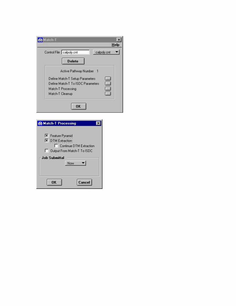
AUTOMATIC DIGITAL TERRAIN MODELING In this exercise, you will learn how to setup Automatic Digital Terrain Modeling. You have set-up a project file with camera data, control data, photo and model data. You have been supplied with two softcopy photogrammetry images of the Cal Poly campus scanned at 22.5 microns. The camera data from the camera calibration report is given in a table in exercise 1. The control data from a filed map is also given in a table in exercise 1 in the Model Setup Manual. The inner orientation was completed in exercise 2 of the Model Setup Manual. The relative orientation was performed in exercise 3 of the Model Setup Manual. The absolute orientation was performed in exercise 4 of the Model Setup Manual. In laboratory exercise 5 of the Model Setup Manual, the student was introduced to stereo-image viewing, and operation of the ISSD software. This laboratory exercise attempts to clearly and concisely convey the information necessary to create and edit digital terrain models automatically for use with the Intergraph ImageStation family of photogrammetric applications. This laboratory does not attempt to cover every tool in the software, but rather discusses the steps necessary to create a new DTM and edit an existing one. OBJECTIVES Upon completion of the exercise you will be able to perform the following functions. ♦ = View images in stereo-mode. ♦ = Learn how to collect a digital terrain model automatically. ♦ = Learn how to view images in roam mode. ♦ = Learn how to triangulate the features ♦ = Learn how to draw contours in the photogrammetric model 1. Select Start>Programs>Photogrammetry>ImageStation Photogrammetric Manager.

The photogrammetric Dialog Box is Opened.
2. Select File>Open Project.
3. Select the Project Name as calpoly. Press Open.

4. In the ImageStation Photogrammetric Manager Window, select the Edit Pull-down menu. Pick Generate Stereo Model.

The Generate Stereo Model Form appears.
5. Complete the Generate Stereo Model Form as follows.
Select Model ID 1~4+1~3 Online Output File Information Type Input Tile Size Input Format Input Input Photo Clipping Area Automatically Determined Overview Resampling Method Averaged Left Epipolar Image File C:\Calpoly\Images\cal1_4.epp Right Epipolar Image File C:\Calpoly\Images\cal1_3.epp

6. Press Submit Job Queue. The following forms appear.
Two epipolar images (cal1_4.epp and cal1_3.epp) are created and stored in the same folder as images cal1_3.cot and cal1_4.cot.

7. In the ImageStation Photogrammetric Manager Window, select the Edit Pull-down menu. Pick Photos.
The following form appears.

8. Select StripID 1, PhotoID 3. Select the Browse button to the right of the Image File keyin window.
The following form appears.
9. Select the file C:\calpoly\images\cal1_3.epp. The path appears in the Image File window. Press Apply.

10. The following form appears. Press Yes.
11. Select StripID 1, PhotoID 4. Select the Browse button to the right of the Image File keyin window. Select Image File c:\calpoly\images\cal1_4.epp. Press Apply.

The following form appears. Press Yes.
12. In the ImageStation Photogrammetric Manager Window, select Models from the Edit pulldown menu.

The following form appears.
13.